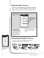
1
User Manual
WARNINGS
FOR SAFETY REASONS, THE DRIVER SHOULD NOT USE THIS DEVICE IN A
VEHICLE WHILE IN MOTION TO ASSIST THE DRIVER TO NAVIGATE.
Please do not try and change any settings on the SporTrak while driving. Come
to a complete stop or have your passenger make any changes. Taking your eyes
off the road is dangerous and can result in an accident in which you or others
could be injured.
USE GOOD JUDGEMENT
This product is an excellent navigation aid, but does not replace the need for
careful orienteering and good judgement. Never rely solely on one device for
navigating.
USE CARE
The Global Positioning System (GPS) is operated by the U.S. Government, which
is solely responsible for the accuracy and maintenance of GPS.
The accuracy of position fixes can be affected by the periodic adjustments to GPS
satellites made by the U.S. Government and is subject to change in accordance
with the Department of Defense civil GPS user policy and the Federal
Radionavigation Plan. Accuracy can also be affected by poor satellite geometry.
USE PROPER ACCESSORIES
Use only Magellan cables and antennas; the use of non-Magellan cables and
antennas may severely degrade performance or damage the receiver, and will
void the warranty.
LICENSE AGREEMENT
Thales Navigation grants you, the purchaser, the right to use the software
supplied in and with Thales Navigation GPS products (the "SOFTWARE") in the
normal operation of the equipment. You may make copies only for your own
personal use and for use within your organization.
The SOFTWARE is the property of Thales Navigation and/or its suppliers and is
protected by United States copyright laws and international treaty provisions;
therefore, you must treat this SOFTWARE like any other copyright material.
You may not use, copy, modify, reverse engineer or transfer this SOFTWARE
except as expressly provided in this license. All rights not expressly granted are
reserved by Thales Navigation and/or its suppliers.
* * *
No part of this guide may be reproduced or transmitted in any form or by any
means, electronic or mechanical, including photocopying and recording, for any
purpose other than the purchaser's personal use without the prior written
permission of Thales Navigation.
© 2002 by Thales Navigation. All rights reserved.
Magellan™ and SporTrak™ are trademarks of Thales Navigation.
Table of Contents
Introduction ............................... 1
SporTrak User Manual ............................. 1
SporTrak GPS Receiver ............................ 2
Getting Started .......................... 3
Installing the Batteries .............................. 3
Proper Handling - Signal Reception ........... 4
Power On .............................................. 4
Initialize ................................................. 5
Initialize for First Time Use ................. 5
Select Language ............................... 5
Key Layout Screen ............................ 6
Initialize Alert................................... 6
Select Approximate Position ............... 6
Getting a Fixed Position ........................... 9
Saving Your Waypoint ............................. 9
Basic Operation ....................... 11
Entering Information .............................. 11
Navigation Screens ............................... 11
Using the Status Screen .......................... 12
Using the Position Screen ....................... 13
Using the NAV 1 Screen ........................ 14
Customizing the NAV 1 Screen ............... 14
Using the Compass Screen ..................... 15
i
Customizing the Compass Screen............ 15
Using the NAV 2 Screen ........................ 16
Customizing the NAV 2 Screen ............... 16
Using the Plot Screen ............................. 17
Selecting PAN-N-SCAN ......................... 18
Setting Track History .............................. 18
Clearing Track History ........................... 18
Setting Up the Plotter ............................. 19
Setting Hide Data/Show Data ................ 20
Using the Road Screen ........................... 21
Customizing the Road Screen ................. 21
Using the Speed Screen ......................... 22
Resetting the Odometer .......................... 22
Resetting the Trip Odometer.................... 23
Setting the Speed Average ..................... 23
Using the Time Screen ........................... 24
Selecting Time Format ............................ 24
Resetting Elapsed Time ........................... 25
Reference ................................ 26
Working with Waypoints........................ 27
Creating a User Waypoint ..................... 28
Editing a User Waypoint ........................ 28
Creating, Editing, Deleting a Message ..... 29
Deleting a User Waypoint ...................... 29
Finding a Non-UserWaypoint ................. 30
Sorting a Waypoint ............................... 30
Projecting a Waypoint ........................... 30
DataSend™ CD (optional) ...................... 31
Using DataSend™ .......................... 31
ii
Working with Routes .............................. 32
Creating/Clearing a GOTO ................... 32
Creating a GOTO on the Plotter Screen ... 32
Creating a Man Over Board Route .......... 33
Creating a Backtrack Route .................... 33
Creating a Multi-Leg Route ..................... 34
Viewing/Editing a Route ................. 35
Inserting a Leg ............................... 35
Changing a Waypoint in a Route ..... 35
Adding a Waypoint at the End of
a Route ......................................... 36
Deleting a Waypoint in a Route ........ 36
Saving a Route ............................... 36
Activating/Deactivating a Route ....... 36
Reversing a Route ........................... 37
Using Plot View in a Route ............... 37
Deleting a Route ............................. 37
Working with TrackRoute........................ 38
Auxiliary Functions .................. 39
Working with Sun/Moon and Fish/Hunt .. 39
Selecting the Simulate Mode................... 40
Selecting Contrast ................................. 40
Selecting Alarm/Message ...................... 41
Accessing the Alarm/Message Menu ...... 41
Selecting Anchor Alarm ......................... 41
Selecting Arrival Alarm .......................... 42
Selecting XTE Alarm .............................. 42
Selecting Proximity Alarm ....................... 42
Selecting GPS Fix Alarm ........................ 43
iii
Viewing the Alarm/MSG Menu .............. 44
Selecting Alarm Defaults ........................ 44
Clearing Alarm Defaults ......................... 44
Selecting Language ............................... 44
Customizing ............................. 45
Selecting Setup ..................................... 45
Selecting Initialize ................................. 45
Disabling NAV Screens .......................... 45
Selecting a Coordinate System ............... 46
Selecting Map Datum ............................ 47
Selecting Elevation Mode ....................... 47
Selecting Time Format ............................ 48
Selecting NAV Units .............................. 48
Selecting North Reference ...................... 48
Selecting Light Timer .............................. 49
Selecting the Beeper .............................. 49
Selecting Personalize ............................. 49
Selecting Clear Memory ........................ 50
Selecting NMEA ................................... 50
Selecting Baud Rate............................... 51
Troubleshooting ....................... 52
Frequently Asked Questions .................... 53
Contacting Magellan ............................. 56
Connecting to the SporTrak ...... 57
WAAS ...................................... 59
Available Datums .................... 60
iv
Specifications ........................... 61
Accessories .............................. 62
Glossary .................................. 63
v
vi
Introduction
Congratulations on your purchase of the Magellan SporTrak GPS
receiver. Since introducing the world’s first commercial, hand-held GPS
receiver in 1989, Magellan has led the way with innovative GPS
products to meet a wide range of positioning and navigation needs.
The receiver is designed to get you out into the “Great Outdoors”
rather than spending hours reading the user’s manual. In order to get
you outdoors quickly, the manual is designed with key sequences rather
than wordy sentences.
Before you begin, make sure that your package includes all of the items
listed on the packing list. Magellan is a trademark name for Thales
Navigation.
SporTrak User Manual
The manual is divided into chapters: Introduction, Getting Started, Basic
Operation, Reference, Customizing, Troubleshooting and Glossary. There
are also subchapters that describe NMEA, Datums and Accessories.
It is very important that you read through the Getting Started chapter
first as it prepares your receiver for use and provides basic instruction.
The Basic Operation chapter describes the features found in your
receiver including step-by-step instructions on their use.
The Reference section contains information to help you navigate using
waypoints, routes and auxiliary functions. Following is the Customizing
chapter, that allows you to establish options you want set in the receiver.
The Troubleshooting chapter gives you a problem and answer series to
guide you. The final chapter, Glossary, defines terms that may be
unfamiliar to you.
.
Magellan SporTrak
1
SporTrak GPS Receiver
QUIT key
cancels the
operation of the last
key press and can be
used to back through
the NAV screens.
NAV key
accesses
the navigation
screens.
MARK key
creates
waypoints
and stores the
current position.
LIGHT key turns
the display
backlight on and off.
2
ENTER
key
confirms data
entries or menu
selections.
GOTO
key
creates a
direct route
to any waypoint
stored in memory.
MENU
accesses
waypoint, route
and setup functions.
POWER key
turns the
receiver on and
off.
Magellan SporTrak
Getting Started
This section shows you how to use your receiver for the first time and
explains:
• Battery Installation
• Primary Usage
• Getting a Fixed Position
Installing the Batteries
The Magellan SporTrak uses two AA batteries that are installed from the
bottom through the battery cover. You can expect to
get up to 15 hours of usage on two AA batteries with
the backlight turned off.
To remove the battery compartment, loosen the
retaining screw at the bottom of the battery
compartment. The battery compartment will come
free from the SporTrak and you can slide it out.
Install two AA batteries observing the correct
polarity. Slide the battery compartment back into
the SporTrak and tighten the retaining screw. Do
not overtighten the retaining screw.
How much time do I have to replace the batteries? Any
waypoints or routes you have created are stored in permanent
memory with the batteries removed. Present position and time
data is not stored in permanent memory but will be held in
memory for at least 12 hours without batteries installed.
Always turn the SporTrak off before removing the batteries
or turning off external power. Failure to do so can cause
loss or corruption of data.
Magellan SporTrak
3
Proper Handling - Signal Reception
Clear View of the Sky. Because the receiver attains
information it needs from satellites orbiting the earth,
the antenna needs to have a relatively unobstructed
view of the sky. This allows the receiver to choose
from all satellites currently available.
If the view of the sky is poor, (large cliffs or buildings, heavy foliage or
other obstructions) the satellite signals can be blocked and the receiver
may take longer to compute a position fix.
Holding the Receiver. The receiver is
designed to fit comfortably in your hand.
Hold the receiver in the palm of your hand
with the antenna pointing towards the sky.
You do not need to initialize your receiver
each time you use it unless the memory has
been cleared or if it has been transported more
than 300 miles while turned off.
Power On
If after powering the receiver on, you do not press
ENTER within 10 seconds, the receiver will shut off automatically.
4
Magellan SporTrak
Initialize
Initialize for First Time Use
The final step in setting up the SporTrak for the first time is to initialize
the receiver . This will help your SporTrak begin computing your
position in the fastest manner possible.
The reason for initialization is to speed up the process for computing
the first position fix when the SporTrak has no last position computed
in memory (i.e., when the SporTrak is brand new or memory has been
cleared). This gives the SporTrak an approximate indication of where it
is located so it can use its satellite almanac (stored in permanent
memory) to estimate what satellites are overhead and which ones it
should be looking for.
Follow these instructions to initialize the SporTrak.
Select Language
The first time you use your SporTrak (or if memory has been
completely erased) you will be asked to select the language that you
want to use. Use the UP/DOWN arrows on the keypad to highlight
the language you desire. With the language highlighted, press the
ENTER button. You can select English, French, German,
Spanish, Italian, Portuguese, Finnish, Norwegian or Swedish.
You can change the language at any time by accessing the Languages
option of the Setup Menu. (See Changing Languages in the Reference
Section of the User Manual.)
Magellan SporTrak
5
Key Layout Screen
A screen is displayed showing the icons and text name for each key.
When the SporTrak prompts you to press a key, it displays the text
equivalent for the key icon. This screen should help you understand
which key the SporTrak is prompting you to press. When you are done
viewing this screen, press
ENTER.
Initialize Alert
A screen is displayed informing you that the SporTrak is not initialized.
Press
ENTER to continue.
Select Approximate Position
Use the Up/Down arrows on the keypad
to highlight your general region.
Press
[ENTER].
REGION
ENTER COORD
USA
AMERICAS
EUROPE
ASIA EAST
ASIA WEST
AUSTRALIA
AFRICA
AREA
Use the Up/Down arrows on the keypad
to highlight your area.
Press
6
[ENTER].
ALABAMA
ALASKA
ARIZONA
ARKANSAS
CALIFORNIA
COLORADO
CONNECTICUT
DELAWARE
Magellan SporTrak
To use the arrow keys to edit a field, follow the simple diagram below.
Editing
moves the cursor block left or right.
Pressing right arrow
results in:
increments the value up or down.
Pressing up arrow
results in:
You are prompted to enter the elevation of your present
position. Use the arrow keys to enter the elevation, if you
know it. If you don’t know your elevation, press
ENTER.
The cursor appears in the time field, waiting for you to input
your local time. Set your local time using the arrow keys. Be
sure that you set the AM/PM indicator.
Note: After the SporTrak starts to pick up signals from any
satellite, it will automatically update the time using the
satellite’s atomic clock.
After you have entered the correct time, press
[ENTER].
Using the arrow keys, enter the present date.
Press
[ENTER].
A screen will be displayed asking your primary use for your
receiver, MARINE or LAND. The default is LAND. Use the
arrow keys to select usage and press
Magellan SporTrak
[ENTER].
7
The following chart shows the terminology that your receiver uses while
in land or marine mode. For purposes of this manual, it will be
assumed that the receiver is in the marine mode.
Land
Marine
Speed
SPD
SOG
Bearing
BRG
BRG
Distance
DST
DST
Heading
HDG
COG
Velocity Made Good
VMG
VMG
Course To Steer
CTS
CTS
Estimated Time of Arrival
ETA
ETA
Time To Go
TTG
ETE
Cross Track Error
XTE
XTE
Recorded Position
Landmark
Waypoint
Units of Measure
MILES/MPH
NM/KNOTS
or KM/KPH
You have completed the Initialization. The
STATUS screen will appear on your receiver.
3D
STATUS
12
25
Note: The “3D” in the upper left corner is
W
displayed when the receiver has begun comput7
ing your position. The “3D” symbol indicated
that the receiver has acquired four or more
001112
satellites and can therefore compute elevation
782385
as well as your position. If “2D” is displayed,
POWER
then the SporTrak is computing your position
but not elevation. This could be either due to
only three satellites have been acquired or you
have set the elevation mode to 2D in the Setup Menu.
8
N
13
8
W
18
Magellan SporTrak
Getting a Fixed Position
Now you should go outside in an area where you can get a clear view of
the sky. The receiver will begin acquiring data from the satellites in
view and will display the progress on the STATUS screen. Once the
receiver has computed a fixed position, the POSITION screen will be
displayed.
Saving Your Waypoint
Once the receiver has computed your current position, you may save
(MARK) this position as a waypoint. You can save up to 500 waypoints
in your SporTrak and refer back to them at any time.
Saving Your Position with a Receiver-Created
Name
This is a fast way to save your position.
Press
Press
Saving Your Position with a User-Created Name
This allows saving a position with a name that is more descriptive,
such as “CAMP” or “HOME”.
Press
Press
Press
Press
Enter
data
Creating a GOTO
A GOTO is a route that guides you from your current position to any
waypoint in the receiver’s memory.
Press
Press
Select
category
Magellan SporTrak
Press
Select
waypoint
9
This completes the Getting Started section.
The following Basic Operation section will familiarize
you with the NAV screens and more detailed
functions.
10
Magellan SporTrak
Basic Operation
Entering Information
Throughout this user manual there are some key presses that will be
used often, so please keep them in mind while setting up and navigating. When entering data...
• Use the
for making selections and moving up or down.
• Use the
to move the cursor to the left or right and page
through menus.
• Press
to return to the previous screen and to exit a
screen or end a process.
Navigation Screens
The nine NAV (Navigation) screens (STATUS, POSITION, NAV 1,
COMPASS, NAV 2, PLOT, ROAD, SPEED and TIME) provide you
with necessary information you will need to use the receiver as a
navigational tool.
NAV screens can be viewed by pressing
viewing any NAV screen, you can use the
the sequence of NAV screens.
from any screen. While
or
to step through
All screens, except STATUS and POSITION screens, can be disabled by
turning them off in the NAV SCREENS portion of SETUP.
Magellan SporTrak
11
Using the Status Screen
The STATUS screen gives you the general well-being of your
receiver by showing you satellite status, signal strengths and
battery life.
Once the
receiver has
computed a
fixed position,
the STATUS
screen will be
replaced by the
POSITION
screen.
3D
Pic
Satellite
Positions
STATUS
12
8
25
W
W
7
WAAS
Satellite
N
13
Satellite Position
Graph
18
Satellite
Signal Chart
001112
782385
Satellite
Numbers
The Battery Life
Indicator was
designed to be
used with AA
alkaline batteries.
With AA lithium
batteries, you will
have more battery
life available than
shown on the
Battery Life
Indicator.
POWER
Satellite Positions
Where the satellite is
located relative to your
position.
will not be solid until
ephemeris is collected.
This takes about 30
seconds if uninterrupted.
Satellite Numbers
Identifies the satellite
shown on the chart and
on the Satellite Position
Graph.
Satellite Position
Graph The two circles
indicate satellite elevation,
the outer circle represents
the horizon and the inner
circle represents 45˚ from
the horizon. The center of
the circle is 90˚.
Battery Life Indicator Shows approximate
remaining battery life for
batteries in the receiver.
Satellite Signal
Chart Displays satellite
signal strengths. When
the receiver first tracks a
satellite, the strength bar
12
Battery Life
Indicator
WAAS Satellite WAAS
is described in the back of
the user manual.
Magellan SporTrak
Using the Position Screen
The POSITION screen displays the coordinates of your last
computed position and basic navigation data. You also have
the option of viewing your position using another coordinate system.
POSITION
Elevation
Date
Speed
Compass
34˚06.52N
117˚49.56W
ELEV 900 FT
11:23:35 PM
23JAN97
EPE 112 FT
SPEED TRIP
5 . 3 8 KT
2 3 8 . 8 NM
Position
Coordinates
Time
Estimated
Position Error
COURSE 150° M
Distance
Traveled
120 150
Course
Position Icon
Position Icon Your current
position on the compass.
Estimated Position
Error May display the
estimated position error
value, WAAS (if WAAS
corrections are being
received), AVERAGING (if
computing a position while
not moving), “DGPS” (if
DGPS is being fed to
S
When you are
stationary, the
receiver begins the
averaging mode.
While averaging,
the receiver
continuously
takes fixes to
create an average.
Once you begin
moving, averaging
stops automatically.
Second
Coordinate
System access
receiver), or “Simulate”
(if in the simulate
mode).
Second Coordinate System
Access Displays
your present position in
a secondary coordinate system. Datums
can be selected under
SETUP.
Viewing the Secondary Coordinate Screen
From the POSITION screen, use the left/right ARROWs to
view the Second Coordinate System access screen.
Magellan SporTrak
13
Using the NAV 1 Screen
The NAV 1 screen displays your destination along with four
customizable navigation data and a graphical compass.
Ideally, when you
are navigating, the
Position Icon and
the Destination
Icon should line
up, one above the
other.
When the bearing
to your destination cannot be
displayed within
the compass, an
arrow will be
displayed to
indicate the
steering direction
you should be
traveling.
Destination
Name
TO: FISH
Destination
Icon
DST 50.2 mn
K
SOG 8.2T
n
XTE 3.80m R
K
VMG 7.2 T
BRG 127m°
Compass
120 150
COG
Customizable
Navigation
Data
S
150 °m
Position Icon
Customizable
Navigation Data You
can change the four
navigational fields. You
can choose from BRG,
DST, SOG, COG, VMG,
CTS, ETA, ETE, XTE,
TRN, ALT, TME and
blank.
Destination Icon This
icon represents where you
want to go.
CUSTOMIZE
WPT NAMES
BRG
OFF 027°m
DST
ON 50.2nm
SOG 8.2KT
COG 056°m
VMG 7.2KT
CTS 028°m
ETA 01:09P
ETE 02H24M
XTE L.2nm
TRN L26°
ALT 83 FT
TME 01:09P
BLANK
Customizing the NAV 1 Screen
The NAV 1 screen can be changed to show the navigation
data that you prefer to view.
Select
CUSTOMIZE
From NAV 1
screen
FIG.
Figure A. Select
the data field to
appear on the
NAV 1 screen.
14
A
Choose
field
Select
data type
Magellan SporTrak
Using the Compass Screen
As well as displaying the customizable navigation data, the
COMPASS screen provides a pointer compass to help you
reach your destination.
Destination
Name
TO: HOME
BRG
DST m
127°m
3.52 I
COG
SOGm
156°m
COG Indicator
N
Moon Icon
2.7 H
+
Compass
E
+
+
W
Sun Icon
+
S
Steering
Indicator
Destination
Icon
Steering Indicator
Displays the bearing of
the destination relative
to the course over
ground.
COG Indicator Displays
direction you are traveling.
The COG indicator always
points up and the compass
rotates according to the COG.
Destination Icon
Shows the general
direction you should be
traveling.
Customizing the Compass Screen
The COMPASS screen can be changed to show the navigation data that you prefer to view.
From COMPASS
screen
Choose
field
Select
CUSTOMIZE
FIG.
B
Change
field
When the COG
Indicator and the
Steering Indicator
point in the same
direction, you are
on course.
The
NorthFinder™
feature displays
sun and moon
icons, above the
horizon, for you
to determine the
direction of north
and your
destination. Align
the sun on the
COMPASS screen
with the sun in
the sky. When
aligned, the
Steering Indicator
will point you in
the direction you
should travel to
reach your
destination.
CUSTOMIZE
WPT NAMES
BRG ---°m
DST ---nm
SOG ---KT
COG ---°m
VMG ---KT
CTS ---°m
BLANK
Figure B. Select
the data field to
appear on the
COMPASS
screen.
Magellan SporTrak
15
Using the NAV 2 Screen
The NAV 2 screen displays four customizable navigation
data. The NAV 2 screen is designed to help you see the
screen when your receiver is mounted at a distance from
you.
Destination
Name
TO: CAMP
14.2˚M
171˚M
SOG
11.2 KT
DST
50.2NM
BRG
COG
CUSTOMIZE
WPT NAMES
BRG
OFF 027°m
DST
ON 50.2nm
SOG 8.2KT
COG 056°m
VMG 7.2KT
CTS 028°m
ETA 01:09P
ETE 02H24M
XTE L.2nm
TRN L26°
ALT 83 FT
TME 01:09P
BLANK
Figure A. Select the
data field to appear
on the NAV 2
screen.
16
Customizable
Navigation Data.
You can change the
four navigational data
fields. You can
choose from BRG,
DST, SOG, COG,
Customizable
Navigation
Data
VMG, CTS, ETA, ETE,
XTE, TRN, ALT, TME and
blank.
Customizing the NAV 2 Screen
The NAV 2 screen can be changed to show the
navigation data that you prefer to view.
Select
CUSTOMIZE
From NAV 2
screen
FIG.
A
Choose
field
Change
field
Magellan SporTrak
Using the Plot Screen
The PLOT screen is a mini map that shows where you have
traveled and where you want to travel. You can view the
active route, your current position and the other waypoints
and destination in the PLOT screen.
Destination
Name
Bearing to
Destination
Destination Icon
TO: FISH
BRG
DST m
351°m 3.52 I
North Indicator
N
FISH
FISH 2
DOCK
Active Route
BUOY
HOME
2.0
Distance to
Destination
Waypoint Icon
Current Position
Icon
Track History
m
I
Plot Scale
Active Route
Indicates the direction
required to reach your
destination.
Plot Scale Can be
changed by using the
left/right arrows. The
scale ranges from .1 to
200 miles.
Magellan SporTrak
Track History
Automatically records
where you have been.
The SporTrak can
store up to 2000 track
points.
PAN-N-SCAN, an
additional feature,
allows you to scroll
through the PLOT
screen enabling you
to create waypoints
and GOTOs.
17
Selecting PAN-N-SCAN
By using PAN-N-SCAN, you can look ahead or review
where you have traveled according to waypoints, routes and
track history.
From PLOT
screen
Select
PAN-N-SCAN
The ARROWs can be used to move the cursor. If the cursor
is over the waypoint icon when MENU is pressed, the menu
will be displayed with WPT INFO added. Moving the
cursor over a waypoint brings up the name, bearing and
distance. Pressing MENU and selecting WPT INFO
displays full information.
In PAN-N-SCAN mode, you can zoom in by pressing the
ENTER key. Once the lowest scale is reached (0.1 mile),
pressing ENTER zooms out to the highest scale (200 miles).
Setting Track History
Using TRACK HISTORY records where you have been by
automatically storing locations, as “dropping bread crumbs”
from your starting point as you travel. This is useful when
you want to return to your starting point.
From PLOT
screen
Select
TRACK HIST
Change
field
Clearing Track History
From PLOT
screen
Select
CLR TRACK
Select
18
Magellan SporTrak
WPT
ORIENT
NAMES
Setting Up the Plotter
This menu allows you to change the orientation, turn the
plot rings on or off, set the course projection and set the
plotter scale.
Setting Plotter Orientation.
Select
PLOT SETUP
From PLOT
screen
FIG.
A
Select
ORIENTATION
Choose
orientation
Turning Plot Rings On or Off. You may want to estimate
the distance to a point on the plotter. To assist you, turn the
PLOT RINGS option on. The distance between each plot
ring is equal to the scale, therefore, at most you will see a
portion of 2 rings at one time.
From PLOT
screen
Select
on or off
Setting Up Course Projection. You may want to know
where you will be after a specified period of time based on
your current speed and heading.
Select
COURSEPROJ
Figure A. You
can choose from
TRACK UP
(direction you
are moving at the
top of the
screen),
COURSE UP
(destination of
the current leg at
the top of the
screen) and
NORTH UP
(north at the top
of the screen).
Select
PLOT SETUP
Select
PLOT RINGS
From PLOT
screen
OFF
TRACK
UP
ON
COURSE
UP
NORTH UP
Select
PLOT SETUP
FIG.
B
Select
time
PROJECTION
WPT NAMES
OFF
1ON
MINUTE
2 MINUTES
5 MINUTES
10 MINUTES
Figure B. You
can choose
from OFF, 1, 2,
5 and 10
minutes.
A solid black line will appear starting from your position
to the projected position.
Magellan SporTrak
19
Setting Up Plot Scales. You can set up the maximum scales
at which the waypoints appear on the plotter screen.
WPT NAMES
PLOT
SCALES
OFF
ON
0.1
0.2
0.3
0.5
0.8
1
2
3
5
8
10
20
50
100
200
Figure A. You may
select the scale for
the waypoint to
appear on the
plotter. The
number you select
is the maximum
scale in which the
icon will appear.
Select
PLOT SETUP
From PLOT
screen
Select
category
FIG.
A
Select
Select *
scale
* Selecting OFF will turn the scales off. If you select either
ICONS ONLY or ICONS/NAMES, you will be prompted
to change the plot scales for a waypoint.
Setting Hide Data/Show Data
You may want bearing and distance to be hidden. You can
choose to either hide these navigation data fields or have the
fields present. Under HIDE DATA/SHOW DATA, you
can turn these fields on or off.
From PLOT
screen
Select
HIDE DATA
or
SHOW DATA
Depending on
which has been
selected previously,
you may need to
select SHOW
DATA to bring the
fields into view.
20
Magellan SporTrak
Using the Road Screen
The ROAD screen displays four customizable navigation
data fields, at the top of the screen, and shows your
position on the desired route.
Destination
Name
TO: FISH
BRG
DST
COG
SOG
127m° 3.52 mn
Customizable
Navigation
Data
156°m 2.7 KT
Destination
Icon
Desired
Route
Position
Icon
Navigation Data
You can change the four
navigation data fields.
You can choose from
BRG, DST, SOG, COG,
VMG, CTS and blank.
When the
destination icon
is straight ahead,
you are on
course. If you are
off course and
the destination
icon is off the
screen, an arrow
will appear to
point you in the
direction to get
back on course.
Desired Route The
direction to travel to
reach your destination.
CUSTOMIZE
WPT NAMES
Customizing the Road Screen
The ROAD screen can be changed to show the navigation
data that you prefer to view.
From ROAD
screen
Choose
field
Magellan SporTrak
Select
CUSTOMIZE
FIG.
B
Change
field
BRG ---°m
DST ---nm
SOG ---KT
COG ---°m
VMG ---KT
CTS ---°m
BLANK
Figure B. You can
choose from BRG,
DST, SOG, COG,
VMG, CTS and
blank.
21
Using the Speed Screen
While using the SPEED screen, you can view the
graphical speedometer, odometer and trip odometer as
well as the numerical bearing, course over ground and
speed over ground.
Destination
Name
TO: CAMP
056°m°m
027°m
Navigation
Data
Average
Speed Icon
COG
BRG
Instantaneous
Speed
10
5 15
0
20
Graphical
Speedometer
SOG 14.2 KT
ODOMETER
2
Odometer
0 5 4 3 mn
Trip
Odometer
0 0 5 4 2 3 mn
TRIP
Graphical Speedometer Scale can be
increased or decreased
by using the right/left
arrows.
2
Instantaneous Speed
A graphical representation
of speed over ground
(SOG).
WARNING
RESET
ODOMETER
TO 000?
YES
NO
Figure A. Select
“Yes” to reset the
odometer.
22
Resetting the Odometer
You may want to reset the Odometer field to zero.
From SPEED
screen
Select
ODOM RESET
FIG.
A
Select
yes or no
Magellan SporTrak
Resetting the Trip Odometer
You may want to reset the Trip field to zero.
Select
TRIP RESET
From SPEED
screen
Select
yes or no
Setting the Speed Average
You may want to reset the Speed Average field in your
receiver.
Select
SPEED AVG
From SPEED
screen
FIG.
B
Select
time
The default is 30 seconds.
Magellan SporTrak
SPEED AVG
TRIP
5 SECONDS
30 SECONDS
1 MINUTE
5 MINUTES
1 HOUR
Figure B. You can
set the timing for
Speed Averaging.
You can choose
from TRIP, 5, 30
seconds, 1, 5
minutes or 1 hour.
TRIP option is for
averaging speed over
the entire trip.
23
Using the Time Screen
The default for
the TIME screen
is off.
The TIME screen displays the current time, estimated
time enroute, time of arrival, and elapsed time in regards
to the route you are navigating in.
TIME
All data shown
on the TIME
screen applies to
the route you are
navigating in.
03:54:21PM
Estimated
Time
Enroute
Time
ETE
01:09:24
OF ARRIVAL
04:34:20PM
ELAPSED
Elapsed
Time
Time of
Arrival
02:24:56
Time Can be customized to correct the
current time and to select
the time format.
Time of Arrival (OF
ARRIVAL)
Elapsed Time
(ELAPSED)
Estimated Time
Enroute (ETE)
Selecting Time Format
You may need to correct the current time or change the
time format.
Select
FORMAT
From TIME
screen
TIME FORMAT
LOCAL 24HR
LOCAL AM/PM
UTC
Figure A. You can
choose from
LOCAL 24HR,
LOCAL AM/PM
and UTC.
24
FIG.
A
Select
format
If LOCAL 24HR or
LOCAL AM/PM
Change
fields
If UTM is chosen you will not be prompted to make the
time change.
Magellan SporTrak
Resetting Elapsed Time
You may want to reset the elapsed time to zero.
From TIME
screen
Select
RESET ELAP
You have completed the basic operation for
your receiver. From the information provided, you can now navigate from place to
place quickly and easily.
The following chapters provide you with
additional information on using your receiver
that build on what you have learned.
Magellan SporTrak
25
Reference
The Reference section contains information that will help
you navigate using your receiver. Now that you have read
the Basic Operation section, you have reviewed the basic
usage. The Reference section will cover waypoints, routes,
and auxiliary functions.
The Working with Waypoints section tells you how to
create, edit, delete, project and sort waypoints. These
functions will guide you in the uses of waypoints. You can
create your own waypoints (known as User waypoints) or
use the waypoints already in the receiver’s memory (NonUser waypoints). You can store up to 500 user positions
which can be used to build routes for navigation.
The Working with Routes section tells you of the four
different types of routes consisting of GOTO, BACKTRACK, MOB and MULTI-LEG ROUTE. A route is a
planned course of travel defined by a series of waypoints
saved in the receiver’s memory. The receiver holds 20
routes with 30 legs. The route function allows you to
create, activate/deactivate, view/edit or delete any one of
the 20 routes.
The Auxiliary Function section tells you how to select the
Sun/Moon and Fish/Hunt options, contrast, simulate
mode and the alarms and message functions. You can
choose from the Anchor alarm, Arrival alarm, XTE alarm,
Proximity alarm and GPS Fix alarm. These alarms can be
reset to the alarm default settings or can be cleared of
defaults.
Following, you will find the Customizing section. Customizing allows you to use the Setup menu to establish
the options you would like to set in your receiver.
26
Magellan SporTrak
Working with Waypoints
This section tells you how to edit, delete, project and sort
waypoints. You can store up to 500 user positions which
can be used to build routes for navigation.
Waypoints consist of two types, User and Non-User. The
User types are made up of waypoints that you can save in
the receiver’s memory. You can edit and delete these
waypoints, if you wish. The Non-User types display
locations, their coordinates and a description. These are
permanently stored in the receiver’s memory and cannot be
deleted unless written over by waypoints downloaded from
the DataSend™ CD.
You can store up to
10 Non-User
waypoint categories.
To help you understand the difference, the chart below
shows the functions of the User and Non-User waypoints.
WPT Types
Available Functions
User
•
•
•
•
•
Non-User
• Find
• Project
• Sort
Magellan SporTrak
Create
Edit
Delete
Project
Sort
27
As you are working with waypoints, you will notice that the
cities (non-user waypoints) are divided into categories. This
division is based on the population of the city using the
following guidelines:
Major city
Large city
Medium city
Small city *
500,000+
100,000 – 500,000
20,000 – 100,000
Less than 20,000
* available with DataSend CD.
MENU
EDIT WPT
SORT WPT
DELETE WPT
PROJECTION
WAYPOINTS
ROUTES
SETUP
SUN/MOON
FISH/HUNT
CONTRAST
ALARM/MSG
Figure A. This menu
allows you to select
the edit waypoint
mode. Only User
waypoints can be
edited.
EDIT WPT
WPT003
34˚06.56N
117˚49.60W
900FT
11:23:35PM
12JUN97
Creating a User Waypoint
A waypoint is a recorded position that can be used in a route
or a GOTO. You can save up to 500 user waypoints in your
receiver. You can create a waypoint with a receiver-generated
name (WPT001, WPT002, WPTxxx) by pressing:
To create a waypoint with a name of your choice or if you wish
to change any data field while entering a waypoint, use the
following:
Editing a User Waypoint
Editing a Selected Waypoint
From any
NAV screen
NO CAMP
FIRES
Select User
category
Select
EDIT WPT
FIG.
A
Editing Waypoint Fields. Follow the instructions on
selecting a waypoint and use the following to edit the
desired fields.
FIG.
B
28
Select
WAYPOINTS
Select
waypoint
SAVE EDITS
CLEAR MSG
Figure B. You may
change any of the
data fields in this
screen.
Make
changes
Select
data field
Select
data field
Make
changes
Magellan SporTrak
Creating, Editing and Deleting a Message
To create a message. Follow the instructions on selecting a
waypoint and use the following to create/edit/delete a
waypoint.
Select
CREATE MSG
Make
changes
To delete a message. Follow the instructions on selecting
a waypoint.
Select
CLEAR MSG
To save your edits. Follow the instructions on selecting a
waypoint.
Select
SAVE EDITS
EDIT WPT
CAMP
34˚06.56N
117˚49.60W
900 FT
11:23:35PM
12JUN97
CREATE MSG
SAVE EDITS
Figure C. Once
you have made
your changes, be
sure to select
SAVE EDITS.
FIG.
C
Deleting a User Waypoint
You may find that you have saved waypoints that you no
longer use. If so, you can delete these unnecessary
waypoints.
DELETE
DELETE
WPT023?
YES
NO
Once these waypoints are deleted, you cannot
undo this process or retrieve these deleted
waypoints.
From any
NAV screen
Select
WAYPOINTS
Select
category
Select
DELETE WPT
Magellan SporTrak
Figure D. This
screen prompts
you to select YES
or NO in
deleting the
waypoint named.
Select
waypoint
FIG.
D
Select
yes or no
29
To find the
waypoint use the
ARROWs to
change the letters.
For example, to
find Dodger
Stadium, use the
ARROWs to
change the first
letter to “D”.
Then use the
ARROWs to find
the second letter,
“O”. Continue
until the name is
found.
WPT SORT
ALPHABETIC
NEAREST
ICON/NAME
Figure A. You can
choose from
ALPHABETIC
(shows all
waypoints),
NEAREST
(shows closest 20
waypoints) and
ICON/NAME
(cannot sort NonUser waypoints).
Finding a Non-User Waypoint
To simplify your search for a waypoint, you can find it using
the smart scroll function.
Select
WAYPOINTS
From any
NAV screen
Select
FIND
Select
category
Find
waypoint
Sorting a Waypoint
You may want to change how the waypoints are sorted.
Select
WAYPOINTS
From any
NAV screen
Select
SORT WPT
A
Projecting a Waypoint
This function allows you to create a waypoint at a certain
distance and direction from an existing waypoint.
Select
WAYPOINTS
Select
field
Select
category
Select
PROJECTION
Select
waypoint
30
FIG.
Select
From any
NAV screen
In the G.C. (Great
Circle) BRG/DST
field, you can
input the bearing
and distance into
the data fields in
order to compute
the projection.
You can also input
information into
the coordinate
fields.
Select
category
Make
changes
You can change any of the three sections in the PROJECTION screen. Once you have the necessary information in
the data fields and the receiver has projected the position,
you can save the position by pressing
[MARK].
Magellan SporTrak
DataSend™ CD (optional)
DataSend™ software contains a database of waypoints that
can be sent to your receiver and are broken down into
multiple categories. The software allows you to select a
geographical area and enable waypoint categories for that
location to be transferred into the receiver.
Using DataSend™
After you have installed DataSend™ you are ready to view
and send waypoints to the receiver. While running
DataSend™ you will see a background map of the world
that you can zoom in to see enabled waypoints.
If you want to send waypoints to your receiver, you must
select the geographic area first, then from the waypoint list
you can make your selection of waypoints to send. The
software will compute the amount of memory required and
whether your selection fits into your receiver. If it exceeds
the available receiver memory, either the geographic area, list
of waypoints selected, or both, can be decreased and the
memory requirements recomputed. The list of waypoints
selected in the specified geographic area can then be saved
under a project name you enter.
You can then send the waypoints to the receiver which
replace all waypoints in the receiver. The default waypoints
that came with the receiver can be restored at any time.
Magellan SporTrak
Don’t worry about
losing the
waypoints that
came with the
receiver, they are
available on the
CD for retransmission to the
receiver.
31
Working with Routes
Creating/Clearing a GOTO
A GOTO is a route that guides you from your current
position to any waypoint in the receiver’s memory. As an
example, you can save a waypoint at your home. No matter
where you go, you will always be able to navigate back home
by using GOTO.
To create a GOTO
GOTO
MOB
USER
STADIUM
GOLF COURSE
HALL
FIG.
A
Select
waypoint
Select
category
To clear a GOTO. The CLEAR GOTO function allows
you to delete an active GOTO route.
Figure A. Your
menu may differ
depending the
waypoints in
memory.
Select
CLEAR GOTO
If there are no active GOTOs, the CLEAR
GOTO will not be displayed in the MENU.
Creating GOTO on the Plotter Screen
A GOTO route can be created by selecting a waypoint on
the plotter screen. While on the plotter screen, follow this
procedure to access PAN-N-SCAN and set a GOTO by:
By selecting the
GOTO destination
waypoint from the
plotter screen, you
can avoid selecting
the wrong
waypoint if its
name is shared
with another
waypoint.
32
From PLOT
screen
Move
crosshair
Select
PAN-N-SCAN
Select
yes or no
When the crosshair is over the waypoint icon, the
waypoint name is displayed at the top of the screen.
Magellan SporTrak
Creating a Man Over Board (MOB) Route
Another type of route is a Man Over Board (MOB). The
MOB route is useful when you want to instantly create and
activate a route to the last computed position.
Select
MOB
MOB waypoints will be created and titled MOB001,
MOB002 and so on. If a MOB already exists, the
receiver will give you the option of replacing the MOB.
To clear a MOB. The CLEAR MOB function allows you to
delete an active MOB route.
While in MOB
screen
Select
CLEAR MOB
Creating a Backtrack Route
Backtrack creates a route that starts from the last point
recorded in track history using the “bread crumbs” saved, to
the first point recorded for track history. By following this
route, you “retrace your steps” back to the starting point.
Select
ROUTES
Select
BACKTRACK
A route will be created and given a name in the format of
BXXPxx. XX is the BACKTRACK number and xx is the
waypoint number ranging from 01 to 31. For example,
your first backtrack will read B01P01. The backtrack
waypoints will be listed in the menu just as other waypoints.
Magellan SporTrak
33
Creating a Multi-Leg Route
CREATE
You may want to create a route with your saved
waypoints. For example, if you want to create a route
from your home, to a campsite and then to a favorite
fishing spot, you can create a route that would take you
to each place.
SAVE ROUTE
LEG
BRG
Select
ROUTES
DST
˚m
n
m
Select
empty route
FIG.
Figure A.
Highlight the first
dotted line to
place the first
waypoint in the
multi-leg route.
MENU
INSERT
SAVE ROUTE
WAYPOINTS
ROUTES
SETUP
SUN/MOON
FISH/HUNT
CONTRAST
ALARM/MSG
Figure B. Use this
menu as an option
for saving your
route.
Select
category *
A
Select
waypoint
* You can combine waypoints of different categories in the
same route.
The receiver will display the selected waypoint in the
starting location and will highlight the destination for leg 2.
Press
for your next selection. Continue this process
until you have completed the route.
To end the creation process:
Select SAVE
ROUTE
or
Select
SAVE ROUTE
FIG.
B
When selecting a navaid for a route, be sure
you are selecting the correct one because
there may be navaids with the same names
in different parts of the world.
34
Magellan SporTrak
Viewing/Editing a Route
MENU
Select
ROUTES
Select route
to edit
Select
VIEW/EDIT
FIG.
C
Inserting a Leg. With the route you have created, from
your home to a campsite, you can insert a leg in the
route. For example, on your way to the campsite, you
find a stream that you want to stop at on your way back.
You can add the waypoint for the stream to your route.
While viewing
route
FIG.
D
ACTIVATE
VIEW/EDIT
REVERSE
DELETE
BACKTRACK
PLOT VIEW
WAYPOINTS
ROUTES
SETUP
SUN/MOON
FISH/HUNT
CONTRAST
ALARM/MSG
Figure C. To view
or edit a route,
highlight View/
Edit.
Select
waypoint
VIEW/EDIT
Select
INSERT
Select
category
HOME
CAMP
Select
waypoint
SAVE ROUTE
LEG
Changing a Waypoint in a Route. Using your home to
campsite route, you want to go to the fishing spot on
the way to the campsite and not stop at the stream.
You can replace the stream waypoint with the fishing
spot.
While viewing
route
Select
category
Select
waypoint
BRG
30˚m
DST
10 MI
Figure D. You
can add to an
already existing
route by
highlighting the
next available
dotted line.
Select
waypoint
or
Select
REPLACE
Select
category
Magellan SporTrak
Select
waypoint
35
VIEW/EDIT
HOME
CAMP
SAVE ROUTE
Adding a Waypoint at the End of a Route. You may be
navigating using the home to campsite route and find a
great picnic spot. You would want to add this to the end of
your route.
While viewing
route
Select first
dotted line
Select
category
LEG
BRG
30˚m
DST
10 MI
Figure A.
Highlight the
waypoint you
want deleted.
Select
waypoint
Deleting a Waypoint in a Route. On your next trip
navigating from the home to campsite route, you find the
campsite has closed. You may want to delete the campsite
leg from your route.
MENU
INSERT
DELETE
REPLACE
SAVE ROUTE
WAYPOINTS
ROUTES
SETUP
SUN/MOON
FISH/HUNT
CONTRAST
ALARM/MSG
Figure B. Use
this menu as an
option for
saving the
changes made to
your route.
MENU
ACTIVATE
VIEW/EDIT
REVERSE
DELETE
BACKTRACK
PLOT VIEW
WAYPOINTS
ROUTES
SETUP
SUN/MOON
FISH/HUNT
CONTRAST
ALARM/MSG
Figure C. The
menu may read
Deactivate,
depending on
which was chosen
previously.
36
FIG.
While viewing
route
Select
waypoint
A
Select
DELETE
Saving a Route. Once you have made changes to your
route, you may want to save those changes.
While viewing
route
Select SAVE
ROUTE
or
FIG.
B
Select
SAVE ROUTE
Activating/Deactivating a Route. While navigating in your
route from home to campsite, you may decide you want to
activate (turn on) the home to campsite route and begin
navigating.
Select
ROUTE
Select
ACTIVATE
Select
route
Abb.
C
Magellan SporTrak
While navigating in your route from home to campsite,
you may decide you want to deactivate (turn off ) the
route and return to it later.
Select
ROUTE
Select
route
Select
DEACTIVATE
Reversing a Route. Once you have reached the end
of your route, you can reverse the route to return
home. For example, Camp...Fish, goes from A to B
to C to D, reversed would read from D to C to B to
A and the title would read Fish...Camp.
Select
ROUTES
FIG.
Select
route
D
Select
REVERSE
Using Plot View in a Route. While navigating in your
route, you can view the entire route in a small screen
overview with the use of Plot View.
Select
ROUTES
Select
PLOT VIEW
Select
DELETE
Magellan SporTrak
2
EMPTY
3
EMPTY
4
EMPTY
5
EMPTY
LEGS
DISTANCE
2
0.00 mn
Figure D. The
route title will
change when you
reverse a route.
Select
route
MENU
FIG.
E
Deleting a Route. After your last trip using your home
to campsite route, you decide you no longer want to
visit those sites. You can delete the route from your
receiver.
Select
ROUTES
ROUTE MENU
1 FISH
...CAMP
Select
route
ACTIVATE
VIEW/EDIT
REVERSE
DELETE
BACKTRACK
PLOT VIEW
WAYPOINTS
ROUTES
SETUP
SUN/MOON
FISH/HUNT
CONTRAST
ALARM/MSG
Figure E. Use this
menu for
accessing Plot
View in a route.
37
Working with TrackRoute
TrackRoute consists of track points collected by the Track
History function. A track can be up to 2000 points in size.
Activating. By activating the TrackRoute at the top of the
ROUTE MENU, you can navigate from the first created
track point to the last track point, making a reverse BACKTRACK. This turns the Track History logging off to keep
from overwriting track points in memory. The top of the
navigation screens will indicate TO: LEGXXXX where
XXXX is between 0 to 2000. As you navigate with the
receiver and pass individual track points, the legs will switch
and countdown until you reach LEG 0 which is your final
destination.
Deactivate. When TrackRoute is deactivated, Track History
logging begins. The track points will be overwritten once
the receiver records new position fixes.
Reverse. This reverses the TrackRoute or the track in Track
History.
Delete. This erases the track points in Track History.
Backtrack. This activates BACKTRACK Route by saving
the Track History as a 30 leg route and activating it.
There may be
some track
points that are
close to each
other causing
the receiver to
skip 1 or more
of these legs.
38
Magellan SporTrak
Auxiliary Functions
Working with Sun/Moon and Fish/Hunt
The Sun/Moon function displays solar and lunar calculations and the Fish/Hunt function displays times for
excellent and good Fishing/Hunting. The default will be
the current position unless the function is accessed from a
waypoint menu or waypoint information screen.
Sun/Moon
From any
NAV screen
Select
SUN/MOON
Change
location
SUN/MOON
AT: POS
ON: 23MAR98
RISE/SET
SUN
RISE 06:55AM
SET 05:08PM
MOON
RISE 07:32PM
SET 01:49AM
PHASE
FIG.
A
Change
date
Figure A. You
can change the
location (AT)
and/or the date
(ON) for the
calculation.
Fish/Hunt
SUN/MOON
From any
NAV screen
Select
FISH/HUNT
Change
location
FIG.
B
Change
date
AT: POS
ON: 23MAR98
FISH/HUNT
EXCELLENT
FROM 06:15AM
TO
07:45 AM
FROM 10:24PM
TO
11:58PM
GOOD
FROM 04:12PM
TO
07:40PM
FROM 06:37AM
TO
10:05AM
Figure B. You can
change the location
(AT) and/or the
date (ON) for the
calculation.
Magellan SporTrak
39
Selecting the Simulate Mode
The Simulate mode will help you become familiar with your
receiver and how it works by generating artificial position
fixes. By utilizing Simulate, the receiver will create a route
and will continue until you end it. In order to end and
delete the created route, you can return to the window
(where you initiated the mode) and select OFF or power the
receiver off.
SIMULATE
OFF
AUTO
USER
Figure A. If USER
is selected, you will
be asked to input
SOG and COG.
Select
SETUP
From any
screen
Select
SIMULATE
FIG.
A
Select
mode
Default setting: OFF
Both AUTO and USER modes generate a route and
simulate navigation using that route. AUTO mode uses a
speed of 25 mph and automatically generates a COG to
follow the route. USER mode allows you to set the speed
and COG to values you enter.
WPT
CONTRAST
NAMES
If your receiver is not computing a position fix
after exiting Simulate mode, you may need to
reset your present position by reinitializing.
This is due to the Simulated position being
more than 300 miles from your actual present
position.
OFF
ON
Figure B. Use the
cursor to adjust
the screen to your
preference.
Selecting Contrast
You may want to change the contrast of your receiver. You
can adjust the brightness depending on your preference.
Select
CONTRAST
From any
screen
FIG.
B
Adjust
contrast
40
Magellan SporTrak
Selecting Alarm/Message
Accessing the Alarm/Message Menu
While navigating, you may decide to set an alarm. The
receiver has five types of alarms: Anchor alarm, Arrival
alarm, XTE alarm, Proximity alarm and GPS Fix alarm. To
access the Alarm/MSG menu:
Select
ALARM/MSG
From any
screen
When the pop-up
window for an
alarm is displayed,
the distance and a
message, if there are
any messages, will
appear.
Select
alarm type
Selecting Anchor Alarm
The Anchor alarm will notify that you have moved from the
set position. For example, while boating, you can set your
Anchor alarm. Once anchored, your boat begins to drift
from the set position, a pop-up window will appear to
notify that you are moving.
While viewing
Alarm/Msg screen
Select
ANCHOR
WPT
NAMES
ATTENTION
P WPT001 IS
OFF
F
ONWITHIN 100 T
ROCKS ON
LEFT
FIG.
C
Select
range
The alarm will sound when the GPS position is at a distance
greater than the distance you have chosen. The alarm will
sound until turned off or the condition is corrected.
WPT
NAMES
ANCHOR
OFF
100FT
ON
250FT
500FT
Figure C. You can
choose from OFF,
100, 250 or 500
feet.
Default setting: OFF
Magellan SporTrak
41
Selecting Arrival Alarm
WPT
NAMES
ARRIVAL
OFF
100FT
ON
250FT
500FT
0.2 MI
0.5 MI
1.0 MI
Figure A. You can
choose from OFF,
100, 250, 500 feet,
0.2, 0.5 and 1.0
miles.
The Arrival alarm will notify you when you are within the
arrival circle of the destination waypoint.
While viewing
Alarm/Msg screen
Select
ARRIVAL
FIG.
A
Select
range
The alarm will sound and a pop-up window will appear
when the GPS position is within the arrival circle you have
chosen. The pop-up window will display the arrival circle
distance as well as any message you have inputted for the
waypoint. The alarm will sound until turned off.
Default setting: OFF
Selecting XTE Alarm
WPT XTE
NAMES
OFF
100FT
ON
250FT
500FT
0.2 MI
0.5 MI
1.0 MI
Figure B. You can
choose from OFF,
100, 250, 500 feet,
0.2, 0.5 and 1.0
miles.
The XTE (Cross Track Error) alarm will notify you when
you have gone off your set course.
While viewing
Alarm/Msg screen
Select
XTE
FIG.
B
Select
range
The alarm will sound when the GPS position is off your set
course by the distance you have chosen. The alarm will
sound until turned off or the condition is corrected.
Default setting: OFF
Selecting Proximity Alarm
The Proximity alarm will sound when you are within the
proximity of any waypoints you have chosen that are not on
the active route.
42
Magellan SporTrak
While viewing
Alarm/Msg screen
Select
PROXIMITY
FIG.
Select
range
D
FIG.
C
Select
field
Select
INSERT, DELETE
or REPLACE *
Continue until
complete
Select
waypoint
WPT
PROXIMITY
NAMES
OFF
100FT
ON
250FT
500FT
0.2 MI
0.5 MI
1.0 MI
Figure C. You can
choose OFF, 100,
250, 500 feet, 0.2,
0.5 and 1.0 miles.
Select
SAVE WPTS
* DELETE and REPLACE will be displayed only if you
select a used waypoint field.
PROX WPTS
REEF
ROCKS
WPT001
WPT002
The alarm will sound and a pop-up window will appear
when the GPS position is within the proximity distance you
have chosen. The pop-up window will display the proximity distance as well as any message you have inputted for the
waypoint. The alarm will sound until turned off.
Default setting: OFF
Selecting GPS Fix Alarm
The GPS Fix alarm allows the Poor GPS alarm to be turned
off. Therefore, when the GPS reception is poor, you will
not be notified.
While viewing
Alarm/Msg screen
Select
on or off
Default setting: OFF
Magellan SporTrak
Select
GPS FIX
Figure D. You can
select any saved
waypoint to list on
the Proximity
waypoint screen.
FIG.
E
GPS ALARM
OFF
ON
Figure E. You can
choose from OFF
or ON.
43
MENU
DEFAULTS
CLEAR MSG
WAYPOINTS
ROUTES
SETUP
SUN/MOON
FISH/HUNT
CONTRAST
ALARM/MSG
Figure A. You can
restore the default
settings or clear all
messages.
Viewing the Alarm/MSG Menu
While viewing
Alarm/Msg screen
FIG.
A
Selecting Alarm Defaults
After a memory clear, you may want to restore the alarm
default settings.
Select
DEFAULTS
While viewing
Alarm/msg screen
FIG.
B
WPT
NAMES
DEFAULTS
OFFRESTORE
ON DEFAULT
SETTINGS?
YES
NO
Select
yes or no
Clearing Alarm Defaults
Figure B. The
screen verifies the
selection you
made.
WPT
CLRNAMES
MSG
OFF CLEAR
ALL
ON
MESSAGES?
YES
NO
Figure C. Once
cleared you cannot
retrieve this
information.
The message buffer may become cluttered with information.
You can use the CLEAR MSG to delete the messages.
While viewing
Alarm/msg screen
Select
CLEAR MSG
FIG.
C
Select
yes or no
Selecting Language
Use the following steps to change the language (English,
Spanish, German, Italian, Swedish, French, Norwegian,
Finnish or Portuguese) of the Magellan SporTrak.
From any
navigation screen
Select
LANGUAGES
Select
language
44
Magellan SporTrak
Customizing
MENU
Selecting Setup
Setup allows you to initialize the receiver and set system
parameters to your preference.
From any
NAV screen
Select
SETUP
FIG.
D
Selecting Initialize
By initializing your receiver, you establish the initial position
for the receiver. This will enable the receiver to search the
sky for available satellites. You will need to reinitialize if you
have traveled more than 300 miles while the receiver is
turned off. To initialize:
Select
SETUP
Select
INITIALIZE
FIG.
E
Follow the steps requested to initialize, as done when the
receiver was initialized the first time (see Getting Started).
Disabling NAV Screens
COORD SYS
MAP DATUM
ELEV MODE
PROJECTION
TRIP RESET
WAYPOINTS
ROUTES
SETUP
SUN/MOON
FISH/HUNT
CONTRAST
ALARM/MSG
Figure D. Refer
to this screen
anytime you want
to access Setup.
SETUP
INITIALIZE
NAV SCREENS
COORD SYSTEM
MAP DATUM
ELEV MODE
TIME FORMAT
NAV UNITS
NORTH REF
LIGHT TIMER
BEEPER
PERSONALIZE
CLEAR MEMORY
NMEA
BAUD RATE
SIMULATE
Figure E. If you
need to initialize
again, make this
selection.
You may find that you do not use one, or more, of the nine
NAV screens provided in the receiver. You have the option
to disable NAV screens, except for the STATUS and
POSITION screens.
The default for
the TIME screen
is off.
Magellan SporTrak
45
Select
SETUP
Select
NAV SCREENS
WPT
NAMES
NAV
1
OFF
OFF
ON
ON
Figure A. You can
turn NAV screens
on or off.
FIG.
Select
on or off
A
The COMPASS screen is displayed next with the same popup menu. You will continue to be prompted for the other
NAV screens.
Selecting a Coordinate System
WPT NAMES
COORD
SYS
PRIMARY
OFF
ON
SECONDARY
Figure B. You can
choose from LAT/
LON, UTM, TD,
OSGB, Irish,
Swiss, Swedish,
Finnish, German,
French, MGRS and
User Grid.
A coordinate system is provided for you. This option allows
you to select primary and secondary coordinates used for
entering and viewing position information. The most
common is LAT/LON.
Select
SETUP
Select
COORD SYSTEM
FIG.
B
FIG.
C
Select
system
Select
format
If a format is required for the coordinate system you have
chosen, a pop-up menu will be displayed.
WPT
LAT/LON
NAMES
OFF
DEG/MIN.MM
ON
DEG/MIN.MMM
DEG/MIN/SEC
Figure C. You
can choose from
DEG/
MIN.MM,
DEGMIN.MMM
or DEG/MIN/
SEC. The
screen will be
different for
other coordinate
systems.
46
The default primary coordinate system will be Lat/Lon in
Degrees/Minutes and the default secondary coordinate
system will be UTM.
You will want the receiver to use position
coordinates in the same map datum that is used
by your maps.
Magellan SporTrak
Selecting Map Datum
You can change the datum the receiver uses to compute
position coordinates. You will want your receiver’s datum to
match the datum on the map or chart you are using. Use
the map “legend” to determine the datum required for the
map or chart. If you are not using a map or chart or are
unsure which datum to use, select WGS84.
Select
SETUP
Select
MAP DATUM
FIG.
D
WPT DATUM
MAP
NAMES
PRIMARY
OFF
ON
SECONDARY
Figure D. Be sure
the map datum
matches the datum
required for the
maps or charts you
are using.
Select primary
or secondary
Select
datum
Default setting: WGS84
WPT NAMES
ELEV
MODE
Selecting Elevation Mode
You have the option of changing your elevation mode to 2D
(2-Dimensional) or 3D (3-Dimensional). You may find 2D
useful if you know the elevation of your position and the
elevation will not change. Your receiver will compute
elevation in 3D mode but will not in 2D mode.
Select
SETUP
FIG.
Select
ELEV MODE
Select
3D or 2D
E
3D
OFF
2D
ON
Figure E. You can
choose from 2D
or 3D.
WPT NAMES
ELEVATION
OFF 0000FT
ON
Figure F. If you
are at sea level, you
can use 2D
because your
elevation is zero.
If you select 3D, the receiver will return to SETUP. If 2D is
selected, the receiver will ask for elevation.
FIG.
F
Input
elevation
Default setting: 3D
Magellan SporTrak
47
SETUP
INITIALIZE
NAV SCREENS
COORD SYSTEM
MAP DATUM
ELEV MODE
TIME FORMAT
NAV UNITS
NORTH REF
LIGHT TIMER
BEEPER
PERSONALIZE
CLEAR MEMORY
NMEA
BAUD RATE
SIMULATE
Figure A. You can
access Time Format
from this menu.
TIME FORMAT
LOCAL 24HR
LOCAL AM/PM
UTC
Figure B. You can
choose from
LOCAL 24HR,
LOCAL AM/PM or
UTC.
Selecting Time Format
You have the option of changing the format for the time.
Select
SETUP
Figure C. You can
choose from
MILES/MPH,
NM/KNOTS and
KM/KPH.
NORTH REF
° TRUE
° MAGNETIC
MILS TRUE
MILS MAG
Figure D. You can
choose from
TRUE, MAGNETIC, MILS
TRUE or MILS
MAG.
48
A
FIG.
Select
TIME FORMAT
Input
time
Select
value
B
If UTC is selected, the receiver will return to SETUP. If
LOCAL 24HR or LOCAL AM/PM are selected, a pop-up
menu will be displayed prompting you to input the correct
time.
Default: Local AM/PM
Selecting NAV Units
You can choose the units of measure used by your receiver.
Select
NAV UNITS
Select
SETUP
FIG.
NAV UNITS
MILES/MPH
NM/KNOTS
KM/KPH
FIG.
C
Select
units
Default setting is MILES/MPH for land use in the United
States and KM/KPH for land use outside the United States.
Default setting is NM/KNOTS for marine use.
Selecting North Reference
The receiver uses magnetic north as a default reference for
all navigation computation. You can change this to true
north (good, if you are using a map) or back to magnetic
north (default, good to use if you are using a compass), or
mils true or mils mag under SETUP.
Select
NORTH REF
Select
SETUP
FIG.
D
Select
reference
Default setting: MAGNETIC
Magellan SporTrak
Selecting Light Timer
The light timer is a power saving function that automatically turns the light off.
Select
SETUP
FIG.
Select
LIGHT TIMER
Select
time
E
Default setting: ALWAYS ON
Selecting the Beeper
You can select the options for when the beeper will sound.
Select
BEEPER
Select
SETUP
FIG.
Select
beeper
F
Default setting: KEYS/ALARM
Selecting Personalize
Select
on or off
If ON is selected:
Figure E. Once the
timer turns the light
off, it can be turned
on with the next
key press. Suppose
you select the timer
setting for 30
seconds. Press the
light key to turn the
light on, it remains
lit. With the next
key press, the light
turns on again for
30 seconds. This
continues until you
turn the light or the
receiver off.
BEEPER
With the personalize function, you have the option of
inputting your name into the receiver.
Select
SETUP
LIGHT
WPT NAMES
TIMER
OFF
ALWAYS ON
ON
15 SECONDS
30 SECONDS
1 MINUTE
2 MINUTES
4 MINUTES
Select
PERSONALIZE
OFF
KEYS ONLY
ALARM ONLY
KEYS /ALARM
Figure F. You can
choose from
OFF, KEYS
ONLY, ALARM
ONLY and
KEYS/ALARM.
Enter
name
Magellan SporTrak
49
Selecting Clear Memory
The Clear Memory function allows you to delete track
history, waypoints and routes as well as reset the settings to
the factory defaults. There is also an option to delete
everything in the receiver’s memory. Use caution when
accessing the Clear Memory function. Once you have
deleted, you cannot undo the process or retrieve this
deleted data.
CLEAR
WPT NAMES
MENU
TRACK HIST
OFF
WPT/ROUTES
ON
BACK WPTS
ROUTES
RESET DFALT
ALL
Figure A. You can
choose from
TRACK HIST,
WPT/ROUTES,
BACK WPTS,
ROUTES,
RESET DFALT
and ALL.
Select
Select
SETUP
FIG.
CLEAR MEMORY
Select item
to clear
A
If you clear all memory, the receiver will clear
everything and power itself off.
Selecting NMEA
Your receiver can be set to output GPS data to interface
with your personal computer.
WPT
NMEA
NAMES
OFF
V1.5
ON APA
V1.5 XTE
V2.1 GSA
Figure B. You can
choose from OFF,
V1.5 APA, V1.5
XTE and V2.1
GSA.
50
Select
Select
SETUP
FIG.
B
NMEA
Select
NMEA
Default setting: OFF
Magellan SporTrak
Selecting Baud Rate
Connection to external devices requires that the baud rate of
the data being sent or received by the receiver be matched to
the baud rate of the external device.
Select
SETUP
Select
BAUD RATE
Select
baud rate
Default: 4800 baud
Magellan SporTrak
51
Troubleshooting
Receiver will not turn on:
1.
Check to see if batteries are installed correctly.
2.
Replace with two new AA alkaline or lithium batteries.
Takes more than 10 minutes to get a position fix:
1.
If there are any obstacles nearby or overhead, move to a new
location.
2.
Make sure that the antenna is pointing up, has a clear view of the sky
and is a reasonable distance away from your body.
3.
Check Satellite Status to see where the satellites are and if the receiver
is acquiring data.
4.
If the receiver still does not get a position fix within 10 minutes, you
may wish to repeat the initialization procedure.
Battery life seems shorter than it should be:
1.
Make sure that you are using two AA alkaline or lithium batteries.
2.
Shorter life span of the batteries can be due to excessive use of the
backlight. Turn the backlight off when not needed.
Position coordinates on your receiver do not match the location on your
map.
1.
Make sure that your receiver is set up to use the same datum as your
map. The map datum is generally shown in the map legend. See
Map Datum under Reference for instructions on selecting the map
datum in your receiver.
2.
Check your LAT/LON format. Make sure that the format selected
in COORDINATE SYSTEM (DEG/MIN/SEC or DEG/
MIN.MM) is in the same format as the map you are using.
Data was not saved or was corrupted.
1.
This can be caused because you removed the batteries or removed
external power while the SporTrak was turned on
SporTrak turns off unexpectedly.
1.
52
This is commonly caused by excessive static electricity. Turn the
receiver back on and it should operate normally. Move the SporTrak
to a different location to avoid a similar occurrence.
Magellan SporTrak
Frequently Asked Questions
General
What is the difference between degrees/minutes/seconds (DEG/
MIN/SEC) and degrees/minutes/minutes (DEG/MIN/MMM or
DEG/MIN/MM)?
There are different ways in expressing the coordinates
computed using Lat/Lon coordinate system. With
DEG/MIN/SEC the final set of numbers (SEC) is
expressed as 0-59 while DEG/MIN/MM expresses the
same value as 0-99 and DEG/MIN/MMM is from 0999. It would be the same as if you had one clock that
expressed time as hour/minutes/seconds and another
clock that expressed the same time as hours/minutes/
decimals. The accuracy for any of the three is the same.
Which you choose is dependent upon your preference
or any chart you are using at the same time. (You
should always make sure that your SporTrak is setup to
be the same as any map or chart you may be using.)
What is 2D vs. 3D?
The difference is primarily how many satellites are used
to compute the position fix and how elevation is
computed. In 2D (two-dimensional) only three
satellites are needed for a position fix and elevation is
not computed. Any elevation displayed by the
SporTrak during 2D operation is the elevation you
entered. In 3D (three-dimensional), a minimum of four
satellites are needed to compute the position and at the
same time, elevation is computed by the SporTrak.
How long can I expect my SporTrak to run on a fresh set of
batteries?
Under normal operating conditions you should get up
to 15 hours of use while the display backlight is turned
off. This duration will drop significantly if you use the
display backlight.
Magellan SporTrak
53
How often do I need to initialize the SporTrak?
Initializing the SporTrak decreases the time it takes to get a
position fix during cold start. What is meant by a cold start
is that the SporTrak has no reference to use as a guide to tell
it what satellites should be overhead. Without a reference to
start with, the SporTrak will have to “search the sky” trying
to find any satellite that may be in “view.” This takes time
and can increase the time it takes to get its first position fix.
(Can take 10 minutes in severe conditions.)
So where does this reference come from? Under normal
operating conditions, the last position fix computed before
the SporTrak was turned off is stored into memory and will
be used as the reference the next time the SporTrak is turned
on. However, if you cleared the memory (see Clearing
Memory - All in the Reference Chapter) this stored reference point is removed from memory and you probably will
want to initialize the receiver again. Also, if you travel with
your SporTrak for more than 500 miles with it turned off, it
will still have the reference point but it may be too inaccurate to be useful and again, you may want to initialize the
SporTrak.
Navigation Screens
Why does my compass not point in the right direction?
The SporTrak computes direction by comparing your
present position to the last position taken, it requires that
you be moving to compute your compass heading. Furthermore, to eliminate error, you must be moving at a minimum
of 0.5 mph.
Routes
What is a backtrack route?
A backtrack route allows you to “retrace” your steps. As you
are moving, the SporTrak automatically creates and stores
hidden waypoints into memory. These waypoints are the
ones that the SporTrak will use to retrace your steps. When
you create a backtrack route, the SporTrak converts these
hidden waypoints into User Waypoints.
54
Magellan SporTrak
How do I know which route is active?
Access the route menu by pressing the MENU button
and select the option Routes. The route menu lists all
of the routes in memory with the active route displayed
in bold characters.
Alarms
Why does my SporTrak not make an audible beep when I have an
alarm active?
Check your setup settings for the Beeper. If the
selection is Off or Keys Only, the beeper will not sound
for alarms.
Output Data
What is NMEA?
NMEA (National Marine Electronics Association) is
the standard used for interfacing marine electronic
devices. This standard has also been adapted for use in
a variety of third-party mapping software programs.
My GPS is not communicating with my computer. What can I
do?
Check your baud rate and check the baud rate that
your software is using. If they don’t match, change
either the software’s or the SporTrak’s baud rate (See
Setup - Changing the Baud Rate.)
Can I interface my SporTrak with a Macintosh computer?
Magellan does not supply cabling or software for the
Macintosh line of computers. For information on a
cable or software that may meet your requirements,
visit GPSy at www.gpsy.com on the internet.
Magellan SporTrak
55
Contacting Magellan
If after using the troubleshooting section, you are still unable to solve your
operation problems, please call Magellan’s Technical Service at (800) 707-9971.
Representatives are available Monday through Friday from 7 AM to
5 PM, PST. Faxes can be sent to Customer Service at (909) 394-7070.
If necessary, you can also return your receiver to Magellan for repair. Before
returning the receiver you must get a Return Materials Authorization (RMA)
from Magellan. To get an RMA, contact a Magellan Technical Service Representative at (800) 707-7845 or you can send an email explaining your reasons to
[email protected]. After receiving the RMA number, ship the
receiver by Parcel Post or UPS. Include a description of the problem, your name,
address, a copy of your sales receipt and print clearly on the outside of the
package the RMA number assigned. If your return ship address is different,
please indicate.
With all correspondence, please state the model of your receiver and if calling,
please have your receiver with you.
Packages should be sent to:
Thales Navigation
Magellan Products
960 Overland Court
San Dimas, CA 91773
ATTN: <RMA Number>
Additional information regarding software updates to your SporTrak can be
found in the Product Support section of the Magellan web site
(www.magellangps.com).
Customers outside of the United States should contact the
Magellan distributor for your country. A detailed address of each
distributor can be found at www.magellangps.com/frames/
frame_stores.htm.
Magellan™ is a trademark of Thales Navigation.
56
Magellan SporTrak
Connecting to the SporTrak
Available as accessories for your GPS receiver are the following cables:
External Power Cable with Cigarette Lighter Adapter, Power/Data
Cable, Data Cable and PC Cable with Cigarette Lighter Adapter. The
instructions given below apply to all cables, unless otherwise stated.
Connecting directly to the SporTrak.
Using the captive screw that is attached to
the plug, tighten into the back of the
receiver.
If you are connecting to the
SporTrak while it is mounted in
the Mounting Cradle, attach the
cable through the back of the
cradle. It is not necessary to
tighten the captive screw to the
SporTrak, although you may do
so for added security.
Magellan SporTrak
57
Connecting to an External Power Source
If using the cable that comes with the cigarette lighter adapter, simply connect
it to the cigarette lighter outlet. If you wish to make a permanent mount to a
power supply, cut the cable between the power supply box and the cigarette
lighter adapter. Attach the red (+) and black (-) wires to your external power
source. The input voltage range for external power is 9-18 VDC.
Caution: Do not bypass the power supply box or you will damage your unit
and void the warranty.
Power Plug
Cigarette Lighter Adapter
Cut Here
Power Supply Box
9-pin Connector
Connecting to a Data Source
Data Connection Pinout (PC and Data cables only)
This is the pinout looking into the 9-pin female connector
Pin 2: Data Out
Pin 3: Data In
Pin 5: Ground
5
9
1
6
Cable Wiring Color Code
Power
Red: Power +
Black: GND
Data (Power/Data, PC cable & Data cable only)
Yellow: Data In
Orange: Data Out
Black: GND
58
Magellan SporTrak
WAAS
Your Magellan GPS receiver has been upgraded to include the latest WAAS
(Wide Area Augmentation System) technology. With WAAS your GPS receiver
can compute position locations with an accuracy never before possible in a
commercial receiver.
What is WAAS? WAAS is a means of improving the accuracy of GPS beyond
the standard civilian signal. WAAS was developed by the FAA to provide the
accuracy needed for aircraft to perform approaches for landings. WAAS
improves the accuracy of GPS by calculating the errors in the GPS signal at
several monitoring stations around the country and then transmitting the error
corrections to special WAAS satellites. In turn, these satellites broadcast the
error corrections to WAAS-capable GPS receivers around the world.
WAAS is a free service and, with the small exception of two additional satellites
displayed on the Satellite Status screen, it will be transparent to you. There is
nothing you need do, it’s all ready to go.
How accurate will my GPS receiver be with WAAS? The FAA reports that
expected accuracy can be improved to around 7 meters vertically and horizontally. Our own testing suggests that Magellan GPS receivers will typically
experience accuracy improvements to around 3 meters. You can expect to see
this level of accuracy for 95% of the time that you are receiving WAAS signals.
What are some of the problems with WAAS? The signal coverage with WAAS
is not global like GPS satellites. In some locations, receiving WAAS signals can
be difficult and intermittent. There are two satellites transmitting WAAS for
corrections in the Americas and two more over Africa and India providing
similar coverage for Europe. These satellites are geostationary, i.e., they stay in
the same spot over the Earth equator. The two satellites for the Americas are
over the Pacific and Atlantic Oceans. Chances are then, they will probably be
near the horizon from where you are using your GPS receiver. This increases
the chance that buildings, foliage, terrain and other obstacles could block the
WAAS signal.
Also WAAS is a relatively new system and is still in its developmental stage. So
on occasion you may experience service outages. Even during these outages,
your GPS receiver will still be working, computing position fixes and helping
you get to where you want to go using the GPS signals. The only difference is
you will not be getting the precision that WAAS was providing. You can expect
to see these outages diminish as the system matures and stabilizes.
For more information on WAAS, you can visit the FAA website’s section on
their WAAS system: http://gps.faa.gov/programs/WAAS/waas.htm
Magellan SporTrak
59
Available Datums
60
Datum
Full Name
Datum
Full Name
WGS84
NAD27
NAD83
ADIND
ALASK
ARC50
ARC60
ASTRO
AUS66
AUS84
BOGOT
BUKIT
CAMPO
CANAD
CAPE
CARTH
CENAM
CHATH
CHUAA
CORRE
CYPRU
DJAKA
EGYPT
EUROP
EUR50
EUR79
GANDA
GEO49
GHANA
GRB36
GUAM
GUNSG
GUNSR
HAWAI
HERAT
HJORS
HUTZU
INDIA
IRAN
World Geodetic System
North America 1927
North American 1983
Adinda
Alaska
Arc 1950
Arc 1960
Camp Area Astro
Australian Geodetic 1966
Australian Geodetic 1984
Bogota Observatory
Bukit Rimpah
Campo Inchauspe
Canada
Cape
Carthage
Central America
Chatham 1971
Chau Astro
Corrego Alegre
Cyprus
Djakarta (Batavia)
Egypt
European 1950 (All of Europe)
European 1950 (W. Europe)
European 1979
Gandajika Base
Geodetic Datum 1949
IRELA
KAUAI
KERTA
KKJ
LIBER
LUZON
MASSA
MAUI
MERCH
MINNA
MONTJ
NAHRW
OAHU
OEGYP
OHAWA
OMAN
PITCA
QATAR
QORNO
RT90
SAM56
Ireland 1965
Kauai
Kertau 1948
KKJ (Finland)
Liberia 1964
Luzon
Massawa
Maui
Merchich
Minna
SAM69
SCHWA
SICIL
SIERR
SWISS
TANAN
Nahrwan, Saudi Arabia
Oahu
Old Egyption
Old Hawaiian
Oman
Pitcairn Astro 1967
Qatar National
Qornoq
RT90 (Sweden)
Provisional So. Am.
1956
South American 1969
Schwarzeck
Sicily
Tananarive Observatory
1925
Ordinance Survey of GB, 1936 THAI
Indian (Thailand,
Guam
Vietnam)
G. Segara
TIMBA
Timbalai
TOKYO
Tokyo
Hawaii
USER DEFINED
Herat North
VOIRO
Hjorsey 1955
WGS72
World Geodetic System
1972
Hu-tzu-shan
YACAR
Yacare
Indian (India, Nepal)
ZANDE
Zanderij
Iran
Magellan SporTrak
Specifications
CHARACTERISTICS
Performance
Receiver
12 parallel-channel technology, tracks up to 12 satellites to
compute and update information with quadrifilar antenna
Acquisition Times (under optimal conditions):
Hot
Warm
Update Rate
approximately 15 seconds
approximately 1 minute
1 second continuous
Accuracy
Position
7 meters, 95% 2D RMS
w/WAAS <3 meters, 95% 2D RMS
Velocity
0.1 knot RMS steady state
Limits:
Speed
951 mph
Altitude
17,500 meters
Physical:
Size
5.6” x 2.2” x 1.15” [h] x [w] x [d]
14.2 cm x 5.6 cm x 2.9 cm
Weight
6 ounces (170 grams) with 2 AA batteries installed
Display
2.2” x 1.33” [h] x [w]
5.59 cm x 3.88 cm
high contrast LCD with EL backlit display
Housing
Weatherproof construction, wraparound rubber armor
Temp. Range
Operating
Storage
14˚F to 140˚F to (-10˚C to 60˚C)
-4˚F to 158˚F (-20˚C to 70˚C)
Power:
Source
2 AA alkaline batteries or 9-18 VDC with power cable
Battery Life
Up to 15 hours
Magellan SporTrak
61
Accessories
Accessories for your receiver are available from your Magellan dealer or
you can order directly from Magellan at (800) 669-4477 (press 3 to
place an order).
Swivel Mounting Bracket: Mounts the receiver on a surface, allowing
for hands-free operation.
Vehicle Mounting Bracket: Full swivel and tilt for easy viewing in any
vehicle.
Bike Mounting Bracket: Mounts the receiver on the handlebars of a
bicycle, motorcycle or off-road vehicle.
Carrying Case: The carrying case provides a way of carrying the
SporTrak on your belt while at the same time protecting it from the
elements.
Power/Data Cable (Bare Wires): Allows you to connect your receiver
to external power and data.
PC Interface Cable with Cigarette Lighter Adapter: Connects your
receiver to your PC for data transfer and to a cigarette lighter for
external power.
External Power Cable with Cigarette Lighter Adapter: Allows you to
connect the receiver to a cigarette lighter for external power.
PC Cable: Allows you to connect the SporTrak to a PC.
DataSend™ CD-ROM: The software contains a database of points of
interest that can be sent to your receiver. You can select from a number
of geographical locations and download them into your receiver.
62
Magellan SporTrak
Glossary
Active Leg
The segment of a route currently being traveled.
Altitude
The current elevation above sea level.
BRG
Bearing. The compass direction from your position
to a destination, measured to the nearest degree.
Buoy
A navigation aid (usually found in marine charts) that
is floating in water. The position can vary due
to the magnitude and direction of the current.
COG
Course Over Ground. The direction the receiver is
moving. COG can be reported in true or magnetic
north values.
Coordinates
A unique numeric or alphanumeric description of the
position.
CTS
Course to Steer. The direction you should be traveling
in order to return to the course while proceeding
towards the destination. It is a “compromise” course
bearing that projects from your current position to a
point on the courseline mid-way between a point
perpendicular to your position and the current leg
destination waypoint.
Datum
Refers to the theoretical mathematical model of the
earth’s sea level surface. Map makers may use a
different model to chart their maps, so position
coordinates will differ from one datum to another. The
datum for the map you are using can be found in the
legend of the map. If you are unsure of which datum
to use, use WGS84.
Default
The value or setting automatically chosen by the unit
unless otherwise directed. Can be changed in Setup.
DST
Distance. Distance from position to destination.
Magellan SporTrak
63
Ephemeris
The position and velocity of the satellites in the
sky. The receiver uses the ephemeris to calculate the
precise distance from the GPS receiver to the satellite.
ETA
Estimated Time of Arrival. The estimated time of day
the leg’s destination waypoint will be reached.
ETE
Estimated Time Enroute. The estimated time
remaining to reach the next waypoint in a route.
Fixed Navaid
A navigation aid (usually found in marine charts) that
has a fixed position and can be found on land or water.
An example is a T.V. tower on land or a Greenday mark
in water.
HDG
Heading. The direction you are facing, defined as an
angle from North.
Latitude
The angular distance north or south of the equator
measured by lines encircling the earth parallel to the
equator from 0˚ to 90˚.
LAT/LON
Coordinate system using latitude and longitude
coordinates to define a position on the earth.
Leg (Route)
A segment of a route that has a starting (FROM)
waypoint and a destination (TO) waypoint. A route
may consist of 1 or more legs. A route that is from
waypoint A to waypoint B to waypoint C to waypoint
D has three legs with the first being from waypoint A to
waypoint B.
D
B
A
64
Leg 1
Leg 2
C
g
Le
3
Magellan SporTrak
LMK
Landmark. A location saved in the unit’s
memory which is obtained by entering data,
editing data, calculating data or saving a
current position. Used to create routes. Same
as a waypoint.
Longitude
The angular distance east or west of the prime
meridian (Greenwich Meridian) as measured
by lines perpendicular to the parallels and
converging at the poles from 0˚to 180˚.
Magnetic North
The direction relative to a magnetic compass
NMEA
National Marine Electronics Association. A
professional organization that defines and
maintains the standard serial format used by
marine electronic navigation equipment and
computer interfaces.
OSGB
A coordinate system describing only Great
Britain, similar to UTMs. Used with GRB36
datum.
Position fix
Position coordinates as computed by the GPS
receiver.
SOG
Speed Over Ground. The speed at which the
receiver is moving.
TRN
Turn. Degrees or direction to turn.
True North
The direction to North Pole from an
observer’s position. The north direction on
any geographical meridian.
TTG
Time To Go. The measurement of how long
it will take you to arrive at your destination.
TTG is based on how fast you are moving
towards the destination and the distance
remaining.
Magellan SporTrak
65
66
UTC
Universal Time Coordinated. Formerly
referred to as Greenwich Mean Time (GMT).
UTM
Universal Transverse Mercator metric grid
system used on most large and intermediate
scale land topographic charts and maps.
VMG
Velocity Made Good. The component of the
velocity that is in the direction of the destination.
Waypoint
WPT. A location saved in the receiver’s
memory which is obtained by entering data,
editing data, calculating data or saving a
current position. Used to create routes.
XTE
Cross Track Error. The distance, left or right,
of the desired courseline. The courseline is a
straight line from your present position to
your destination.
Magellan SporTrak