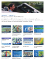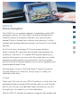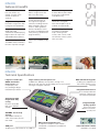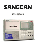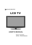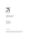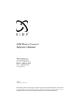
1
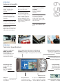
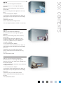
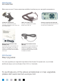
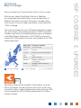
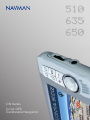
510
635
650
iCN Series
In-Car GPS
Transferable Navigation
Navman: a leader in GPS navigation technology.
And more.
Established in New Zealand in 1988, Navman researches,
designs and builds critical navigation technology, including
GPS navigation devices, commercial fleet tracking
systems and marine electronics instruments.
Employing over 500 staff and with its own manufacturing
facilities, Navman products are researched and developed
in-house, resulting in high quality navigation systems that
are easy to use.
With offices all over the world, Navman is a global GPS
company. In Europe, teams of dedicated individuals
provide localised high quality sales and technical support
to its ever growing user base.
Navman is now an integral part of the Brunswick
Corporation, one of the world’s longest established global
companies. Navman is a rapidly expanding company and
will continue to grow and provide world-leading critical
navigation systems.
GPS technology explained.
The Global Positioning System (GPS) is a satellite-based
navigation system made up of a network of satellites
placed into orbit. GPS works in any weather conditions,
anywhere in the world, 24 hours a day. There are no
subscription fees or setup charges to use GPS.
GPS satellites circle the earth in a very precise orbit and
transmit signal information to earth. GPS receivers take
this information to calculate the user’s exact location. This
location is then passed on to the software, which displays
in real time the maps relevant to the location using the
map data stored on the navigation system.
Once the user’s position has been determined, the GPS
unit calculates other information, such as speed, bearing,
track, trip distance, distance to destination and more.
Today’s GPS receivers with parallel multi-channel design
are extremely accurate. A GPS with a 12 channel parallel
receiver is quick to lock onto satellites when first turned on
and maintains a strong signal whilst driving.
SmartST™ Version 3
The power behind the iCN Series
Included with every iCN is the latest generation of Navman’s navigation software,
SmartST Version 3. Packed with new features and new map data, it is designed to make
your journey as plain and simple as possible. Just see for yourself.
Variable 3D map view with
great colour maps
Detailed 2D complete street
level navigation showing
traffic directional flow and
one-way streets.
Turn-by-Turn navigation
screen incorporating 2D mini
map and next manoeuvre
icon
Instruction Summary page
detailing the next four
manoeuvres en-route
Multi-Stop Route planning:
now plan a trip from A to B,
via C, D – choose from 12
stopovers
European Major Road
Network coverage allowing
continuous navigation
through W. Europe
Enter destination with
the aid of a 5 character
postcode search
High-level topographic style
maps, which alter colour as
you change height above
sea level
Point of Interest Import and
route to a nearest POI
Improved Routing
(preference scale for use of
motorways v local roads)
Tens of thousands of POIs
preloaded to the unit
Enhanced next manoeuvre
icon
SmartST™ Version 3
Main features
Below are some of the key features of SmartST Version 3. All these, and many others,
are included as standard with the iCN 510, the iCN 635 and the iCN 650.
For more information on SmartST Version 3, please visit www.navman-europe.com.
Feature
Description
Back-on-Track™
Automatically recalculates route if you take a wrong turn or deviate from the planned
itinerary.
Voice instructions
Before and when a manoeuvre is required, clear, male or female spoken instructions are
provided.
View modes
Night or day screen modes can be selected according to your traveling conditions, variety of
colour schemes available.
Display
Map Display only, Map and Navigation Instructions or Key Instructions display screen only.
Destination input
By an address to a door, a street name, an intersection or to a selected Point of Interest.
Visual Guidance
Automatic zooming, up to 200 miles. Overlay arrows shows exact turn to take.
Favourites
Navigate to your Home, Office, Restaurant etc… without having to enter the same details
again.
3D Maps
Vivid colour 3D map display, showing street level road details, parks, lakes and rivers.
Avoid Area
Route calculation with avoidable user selected areas. Avoid traffic hotspots.
Postcode Search
Enter destination with the aid of a 5 character postcode search.
Multi-stop routes
New
Navigate a journey via mutiple destinations – now navigate from A to B via C, D, E…
Major roads view
New
Continuous navigation on major European road network.
Points of Interest
importing
New
Create your own points of interest (My POIs) using the SmartST™ Desktop Editor on your
computer
Active Point of Interest New
Proximity alarm can be used to alert you when approaching any personal Point of Interest
(My POI’s)
Nearest Point of
Interest
New
Select the nearest Point of Interest to your current location (service station, hospital,
restaurant, cash machine etc.). Low on fuel ? Navigate to the nearest service station.
Up to date maps
New
Topographic maps
New
High Level Topographic style maps giving a more realistic view of your location
Mini-map
New
2D mini-map on the turn-by-turn navigation screen and icons,making navigation even easier.
Improved routing
New
Improved routing options to include routing via ferries, and percentage preference scale
Next manoeuvre icons New
Latest Summer 2004 Release Map Data from Teleatlas
Improved next manoeuvre arrow icon with distance to manoeuvre incorporated
iCN 510
Mobile Navigation
The iCN 510 is our smallest, sleekest, transferable mobile GPS
navigation solution. Not only does it include all the features of
SmartST Version 3 navigation software, such as active and
nearest Points of Interest and multiple-route planning, it is also
packed with hardware features normally only found in much larger
devices.
Its 3.5 inch colour landscape TFT touch-screen displays
bright coloured 3D maps that can be easily read whatever the
conditions. The built-in 12 channel GPS receiver detects your
position with superior accuracy, and the crystal clear low profile
speaker provides precise voice instructions. Its touch-screen
and multi-function keypad enables you to control operations with
unprecedented ease of use.
And because it is part of the Drive-Away™ family of products,
it works straight out of the box : simply plug it in, enter your
destination and drive.
Or walk.
That’s right. Not only will your iCN 510 guide you on the road, this
lightweight battery-powered GPS will also help you with the last
part of your journey. Its street-level maps will guide you by foot
through busy city streets to your final destination.
With an iCN 510, the last mile need no longer be the hardest mile.
Transferable
Use your GPS in any
vehicle. Transfers from
vehicle to vehicle in
seconds.
Mobile
Lightweight and battery
operated. Designed to work
in and out of the car.
Bright 3.5” TFT touch
screen
Displays bright colour 3D
maps with sharp details.
Expandable
Memory slot allows you to
add map data as and when
required.
Drive-Away™
Works straight out of the
box. Just drive away.
SmartST™ Version 3
All the great features of
our high-end navigation
software, including Door to
door navigation, Back-onTrack™, Voice guidance,
Active and Nearest Points
of Interest and Multiple-stop
route planing (see SmartST
page for details).
Up to date map data
Latest 2004 TeleAtlas map
data.
Street level maps
of Great Britain preinstalled
on memory card (Ireland
supplied on CD).
Major European roads
Continuous navigation
from one European city to
another via major roads
(supplied on CD).
510
iCN 510
features & benefits
Class leading maps
Full colour 3D detailed
maps showing street
names, town names, road
classification, forests, parks,
lakes and rivers.
iCN 510
Technical Specifications
3.5” Landscape Touch
Screen
with crisp display and easy
reading of bright coloured
maps details
Integrated GPS receiver SirFXTrac™ enabled
12 channel parallel with automatic selection for accurate
GPS position
Integrated low profile
speaker
with crystal clear spoken
instructions at every turn
Compact, mobile,
lightweight design
for use in-car or on foot
with complete mobility
SD/MMC slot for map
storage
expandable memory to
store all the maps you will
ever need
Built in rechargeable
battery
for trouble-free everyday
usage with 4hrs battery life
Multi functional key pads
enabling easy operation of
the intuitive graphical user
interface
Audio Out port
for connection to earphones
or audio system
Infra-red port
for optional remote-control
USB port
enabling easy connection to
any USB PC for upgrading
and additional maps
Mini-MCX externalantenna port
for optimum reception if
your vehicle is fitted with
a heated or heat reflective
windshield
iCN 635
Transferable Navigation
The iCN 635 is a high-quality GPS navigation solution. Not only
does it come with our best-selling SmartST Version 3 navigation
software, which includes exceptional features such as active
and nearest Points of Interest and multiple-route planning, it
also boasts an array of enhancements, specifically designed for
comfort, speed and ease of use.
The iCN 635 is a totally transferable device that unplugs in
seconds and can be used in any vehicle, its magnesium-alloy
casing ensuring it withstands even the most demanding users.
For extra visual comfort, its large 3.8 inch landscape TFT
automotive-rated colour screen is in a class of its own, providing
comfortable reading even in the most difficult conditions.
Of course, it is part of our Drive-Away™ family of products, and
works straight out of the box. Plug it in, enter your destination and
drive.
The iCN 635, following in the footsteps of our best-selling
iCN 630, has earned a reputation of a trusted, solid device, one
which provides reliable navigation assistance, year after year.
Transferable
Use your GPS in any
vehicle. Transfers from
vehicle to vehicle in
seconds.
Magnesium alloy case
Housed in magnesium alloy
casing for extra protection.
Bright 3.8” TFT screen
Wide landscape
automotive-rated displaying
bright colour 3D maps with
unprecedented sharpness.
More memory
128 MB of internal memory
for extra map data storage.
Drive-Away™
Works straight out of the
box. Just drive away.
SmartST™ Version 3
All the great features of
our high-end navigation
software, including Door to
door navigation, Back-onTrack™, Voice guidance,
Active and Nearest Points
of Interest and Multiple stop
route planing (see SmartST
page for details).
Up to date map data
Latest 2004 TeleAtlas map
data.
Street level maps
of Great Britain preinstalled
on memory card (Ireland
available on CD).
Major European roads
Continuous navigation
from one European city to
another via major roads.
635
iCN 635
features & benefits
Class leading maps
Full colour 3D detailed
maps showing street
names, town names, road
classification, forests, parks,
lakes and rivers.
iCN 635
Technical Specifications
Large 3.8” Landscape
QVGA automotiverated screen with
crisp display and
easy reading of bright
coloured maps details
Large memory and fast processor
128MB Flash Memory for map data storage. Fast
processor with Intel Xscale technology for fast and smooth
running of navigation software.
Multi functional key pads
enabling easy operation of
the intuitive graphical user
interface
Integrated GPS receiver
12 channel parallel with
automatic selection for
accurate GPS position
Solid design with
magnesium-alloy
casing
for years of troublefree use in different
vehicles
Integrated highquality speaker
with crystal clear
spoken instructions
at every turn
SD/MMC slot for map
storage
expandable memory to
store all the maps you will
ever need
USB port
enabling easy connection to any USB PC
MCX external-antenna port
for optimum reception if your vehicle
is fitted with a heated or heat reflective
windshield
Infra-red remote control
supplied as standard
iCN 650
High-end transferable Pan-European Navigation
The iCN 650 is Navman’s top of the range road navigation
solution. It boasts all the features of the iCN 635, including a
bright, colour, landscape TFT screen, and is the ultimate device
for the European traveler.
Inside its aluminium-alloy housing resides a fast 2 Gigabyte harddisk, containing a huge library of preloaded, up-to-date, streetlevel maps of no less than 16 Western European countries.
Providing voice, turn-by-turn instructions across most of Western
Europe, as well as all the other great features of SmartST Version
3, including Back-on-Track, multiple route planning and extended
Points of Interest, the iCN 650 also offers uninterrupted navigation
assistance whenever you cross geographic regions.
With its slim-line remote control taking ease-of-use at a new level,
this high-end Drive-Away™ GPS solution is the state of the art of
navigation devices and offers functionality only found in high-end,
non-transferable, dedicated units.
The iCN 650 also happens to be transferable to any vehicle. In
seconds.
Transferable
Use your GPS in any
vehicle. Transfers from
vehicle to vehicle in
seconds.
Internal hard drive
Silent, super-fast 2 Gb
hard drive preloaded with
SmartST™ version 3 and
map data
Magnesium case
Housed in magnesium-alloy
casing for extra protection.
Drive-Away™
Works straight out of the
box. Just drive away.
SmartST™ Version 3
All the great features of
our high-end navigation
software, including Door to
door navigation, Back-onTrack™, Voice guidance,
Active and Nearest Points
of Interest and Multiple stop
route planing (see SmartST
page for details).
Maps of 16 European
countries pre-loaded as
standard.
Street level maps of
Western European
countries.
Class leading maps
Full colour 3D detailed
maps showing street
names, town names, road
classification, forests, parks,
lakes and rivers.
650
iCN 650
features & benefits
Up to date map data
Latest 2004 TeleAtlas map
data.
Bright 3.8” TFT screen
Wide landscape
automotive-rated displaying
bright colour 3D maps with
unprecedented sharpness.
iCN 650
Technical Specifications
Large 3.8” Landscape
QVGA automotiverated screen with
sharp crisp display and
easy reading of bright
coloured maps details
Internal hard drive with maps of 16 European
countries including street level maps for detailed,
uninterrupted navigation throughout Western Europe.
Integrated GPS receiver
12 channel parallel with
automatic selection for
accurate GPS position
Integrated highquality speaker
with crystal clear
spoken instructions
at every turn
Solid design with
magnesium-alloy
casing
for years of troublefree use in different
vehicles
USB port
enabling easy connection to
any USB PC
Multi functional key pads
enabling easy operation of
the intuitive graphical user
interface
MCX external
antenna port
for optimum reception if your
Fast processor
vehicle is fitted with a heated
Fast processor with
Intel Xscale technology. or heat reflective windshield
Infra-red remote control
supplied as standard
Take a closer look at the iCN Series.
The only real question remaining is, which one do you want ?
iCN Series
Comparison Chart
Transferable
iCN 510
iCN 635
iCN 650
•
•
•
SmartST Version 3
Screen size
complete feature set (see SmartST page)
standard in all models
3.5”
3.8”
3.8”
320x240
320x240
320x240
•
•
•
•
UK and Ireland
•
UK and Ireland
Western Europe
16 countries
memory card
memory card
2 GB Hard disk
optional
standard
standard
Mains and 12V vehicle power
•
•
•
Internal battery
•
-
-
Map memory on unit
-
128 MB
hard drive
12 parallel
12 parallel
12 parallel
Screen resolution (pixels)
External power
SD and MMC expansion slot
Country maps supplied
Map storage
Remote control
GPS channels
Accuracy of GPS position
Update rate
Dimensions (lenght, height, depth)
Weight
better than 5m 95% of the time under optimum conditions
once every second once fix is established
121x71x26mm
163x75x36mm
163x75x42mm
160g
330g
365g
iCN 510 unit with integral GPS Receiver
SmartST Version 3 In-Car Digital Navigation
Software
Memory card including maps of local country
preinstalled
CD Set including SmartST application and map
data
12V DC vehicle power adapter
100/240V AC mains power pack for in-door use
USB cable for map and application downloading
from a PC
Protective carry case
Vehicle windshield mounting bracket
Infra-red support (remote available as accessory)
iCN 635
iCN 635 with integral GPS Receiver
SmartST Version 3 In-Car Digital Navigation
Software
Memory card including maps of local country
preinstalled
CD Set including SmartST application and
European map data with unlock key for local
country only (additional keys for additional
countries available)
12V DC vehicle power adapter
100/240V AC mains power pack for in-door use
USB cable for map and application downloading
from a PC
Protective carry case and screen cleaner
Vehicle windshield and dashboard mounting
bracket
Infra-red remote control
iCN 650
iCN 650 unit with integral GPS Receiver
SmartST Version 3 In-Car Digital Navigation
Software 4 CD set with application and Map data
for western Europe
2.0GB hard drive with street level maps of Western
Europe preinstalled
12V DC vehicle power adapter
100/240V AC mains power pack for in-door use
USB cable for map and application downloading
from a PC
Protective carry case and screen cleaner
Vehicle windshield and dashboard mounting
bracket
Infra-red Remote control
BOX CONTENTS
iCN 510
iCN Series
Accessories
Below are some of the accessories available to enhance your navigation experience.
In-Vehicle mounting kit
For use in a second car. Comes
complete with bracket and suction cup
for a steady mount.
iCN in car power cable
For use in a second car. Provides
power to the iCN unit.
MCX external antenna for the
iCN 600 series
For vehicles that have heated or heat
reflective windshields. This external
antenna is supplied with a 5m cable
and connects to your iCN via its MCX
connector.
Mini-external antenna for the
iCN 510
For vehicles that have heated or heat
reflective windshields.This external
antenna is supplied with a 5m cable
and connects to your iCN 510 via its
mini MCX connector.
Remote control (for the iCN 510)
Infra-red remote control for the iCN 510
for further ease of operation.
iCN Series
Map Upgrades
You can upgrade your regional map data to the full pan-European set, or purchase
additional maps, such as those of the U.S.A. or Australia.
To purchase any of the above accessories or map upgrades,
please visit www.navman-europe.com
We’ve covered a lot of ground here. And so do our maps.
With the very latest Digital Map Data from TeleAtlas,
our huge street-level map library covers no less than 16
Western European countries. Although coverage varies
from country to country (see map below), most have a 95100% coverage.
The maps included with your iCN Series navigation system
vary according to the model and region. iCN 510 and 635
models come with pre-installed regional maps, as detailed
in the Map Region table below. The iCN 650 comes with
maps of all 16 European countries, pre-installed on its 2GB
internal hard disk.
95-100% coverage
Map region
Countries included
British Isles
UK and Ireland
France
France
D,A,CH
Germany, Austria, Switzerland
Italy
Italy
Iberia
Spain, Portugal
Benelux
Belgium, Netherlands,
Luxembourg
Nordic
Sweden, Denmark, Norway,
Finland
75-95% coverage
40-75% coverage
Tele Atlas maps provide a wealth of information, such as
Points of Interest, House numbers, and much more. They
include 6.5 million miles of streets and roads in Europe, 365
million inhabitants, 68 000 Municipalities and 310 million
house numbers.
MAP COVERAGE & UPGRADES
iCN Series
Map Coverage
Your Navman stockist
Europe
Navman Europe Ltd
4G Gatwick House
Peeks Brook Lane
Horley, Surrey
RH6 9ST
United Kingdom
Tel +44(0)1293 780500
Fax +44(0)1293 782065
www.navman-europe.com
[email protected]
Headquarters
Navman NZ Ltd
13 -17 Kawana Street
PO Box 68, 155 Newton
Auckland
New Zealand
www.navman.com
[email protected]
Copyright© Navman NZ Limited
NAVMAN, SmartS™, Back-on-Track™,
Drive-Away™ are registered trademarks of
Navman NZ Limited.
All rights reserved.
Data source © 2004 Tele Atlas N.V.
Windows® is a registered trademark
of Microsoft Corporation.
All other trademarks and registrations are
the property of their respective owners.
www.navman-europe.com