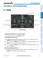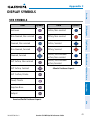
1
G3X
™
Multi Function Display
Quick Reference Guide
Overview
GPS Navigation
Flight Planning
Hazard Avoidance
Additional Features
Appendices
Index
Warnings, Cautions & Notes
WARNING: The indicators represented on the Panel are based on GPS-derived
data and may differ from the instruments in the aircraft.
WARNING: Navigation and terrain separation must NOT be predicated upon
the use of the terrain function. The G3X™ MFD Terrain Proximity feature is NOT
intended to be used as a primary reference for terrain avoidance and does not
relieve the pilot from the responsibility of being aware of surroundings during
flight. The Terrain Proximity feature is only to be used as an aid for terrain
avoidance and is not certified for use in applications requiring a certified
terrain awareness system. Terrain data is obtained from third party sources.
Garmin is not able to independently verify the accuracy of the terrain data.
WARNING: The displayed minimum safe altitudes (MSAs) are only advisory
in nature and should not be relied upon as the sole source of obstacle and
terrain avoidance information. Always refer to current aeronautical charts
for appropriate minimum clearance altitudes.
WARNING: The altitude calculated by G3X MFD receivers is geometric height
above Mean Sea Level and could vary significantly from the altitude displayed
by pressure altimeters. Always use pressure altitude when determining or
selecting aircraft altitude.
WARNING: Do not use outdated database information. Databases used in the
G3X MFD must be updated regularly in order to ensure that the information
remains current. Pilots using any outdated database do so entirely at their
own risk.
WARNING: Do not use basemap (land and water data) information for
primary navigation. Basemap data is intended only to supplement other
approved navigation data sources and should be considered as an aid to
enhance situational awareness.
WARNING: Traffic information is provided as an aid in visually acquiring
traffic. Pilots must maneuver the aircraft based only upon ATC guidance or
positive visual acquisition of conflicting traffic.
Garmin G3X MFD Quick Reference Guide
190-01055-00 Rev. A
Warnings, Cautions & Notes
WARNING: XM® Weather should not be used for hazardous weather
penetration. Weather information is approved only for weather avoidance,
not penetration.
Warning: NEXRAD weather data is to be used for long-range planning
purposes only. Due to inherent delays in data transmission and the relative
age of the data, NEXRAD weather data should not be used for short-range
weather avoidance.
WARNING: The illustrations in this guide are only examples. Never use the
G3X MFD to attempt to penetrate a thunderstorm. Both the FAA Advisory
Circular, Subject: Thunderstorms, and the Aeronautical Information Manual
(AIM) recommend avoiding “by at least 20 miles any thunderstorm identified
as severe or giving an intense radar echo.”
WARNING: The Garmin G3X MFD has a very high degree of functional
integrity. However, the pilot must recognize that providing monitoring and/or
self-test capability for all conceivable system failures is not practical. Although
unlikely, it may be possible for erroneous operation to occur without a fault
indication shown by the G3X MFD. It is thus the responsibility of the pilot to
detect such an occurrence by means of cross-checking with all redundant or
correlated information available in the cockpit.
WARNING: For safety reasons, G3X MFD operational procedures must be
learned on the ground.
WARNING: The United States government operates the Global Positioning
System and is solely responsible for its accuracy and maintenance. The GPS
system is subject to changes which could affect the accuracy and performance
of all GPS equipment. Portions of the Garmin G3X MFD utilize GPS as a
precision electronic NAVigation AID (NAVAID). Therefore, as with all NAVAIDs,
information presented by the G3X MFD can be misused or misinterpreted
and, therefore, become unsafe.
190-01055-00 Rev. A
Garmin G3X MFD Quick Reference Guide
Warnings, Cautions & Notes
WARNING: To reduce the risk of unsafe operation, carefully review and
understand all aspects of the G3X MFD Pilot’s Guide documentation and
the Pilot’s Operating Handbook of the aircraft. Thoroughly practice basic
operation prior to actual use. During flight operations, carefully compare
indications from the G3X MFD to all available navigation sources, including
the information from other NAVAIDs, visual sightings, charts, etc. For safety
purposes, always resolve any discrepancies before continuing navigation.
WARNING: The data contained in the terrain and obstacle databases comes
from government agencies. Garmin accurately processes and cross-validates
the data, but cannot guarantee the accuracy and completeness of the data.
CAUTION: The display uses a lens coated with a special anti-reflective coating
that is very sensitive to skin oils, waxes, and abrasive cleaners. CLEANERS
CONTAINING AMMONIA WILL HARM THE ANTI-REFLECTIVE COATING. It is
very important to clean the lens using a clean, lint-free cloth and an eyeglass
lens cleaner that is specified as safe for anti-reflective coatings.
CAUTION: The Garmin G3X MFD does not contain any user-serviceable
parts. Repairs should only be made by an authorized Garmin service center.
Unauthorized repairs or modifications could void both the warranty and the
pilot’s authority to operate this device under FAA/FCC regulations.
nOTE: All visual depictions contained within this document, including screen
images of the G3X MFD, are subject to change and may not reflect the most
current G3X MFD system and aviation databases. Depictions of equipment
may differ slightly from the actual equipment.
NOTE: This product, its packaging, and its components contain chemicals
known to the State of California to cause cancer, birth defects, or reproductive
harm. This notice is being provided in accordance with California’s Proposition
65. If you have any questions or would like additional information, please
refer to our web site at www.garmin.com/prop65.
Garmin G3X MFD Quick Reference Guide
190-01055-00 Rev. A
Warnings, Cautions & Notes
NOTE: Use of polarized eyewear may cause the flight displays to appear dim
or blank.
NOTE: Temporary Flight Restriction (TFR) data is provided by the FAA and
may not be updated outside of normal business hours. Confirm data currency
through alternate sources and contact your local FSS for interpretation of TFR
data.
NOTE: The purpose of this document is to provide a resource with which to
find operating instructions on the major features of the G3X MFD more easily.
It is not intended to be a comprehensive operating guide. Complete operating
procedures for the G3X MFD are found in the G3X MFD Pilot’s Guide.
190-01055-00 Rev. A
Garmin G3X MFD Quick Reference Guide
Warnings, Cautions & Notes
Blank Page
Garmin G3X MFD Quick Reference Guide
190-01055-00 Rev. A
Table of Contents
Section 1 Overview......................................................................................... 1
1.1 Unit Overview.............................................................................................................1
1.2 Softkeys......................................................................................................................3
MAP Page Softkeys............................................................................................................... 3
Waypoint Page Softkeys........................................................................................................ 4
Weather Page Softkeys (Optional).......................................................................................... 5
XM Audio Page Softkeys (Optional)........................................................................................ 5
Info Page Softkey.................................................................................................................. 6
1.3 Menus..........................................................................................................................6
1.4 Data Entry...................................................................................................................7
1.5 Pages...........................................................................................................................8
1.6 System Settings.........................................................................................................8
Section 2 GPS Navigation............................................................................. 11
2.1
2.2
2.3
2.4
2.5
2.6
2.7
2.8
Panel..........................................................................................................................11
Vertical Navigation (VNAV).....................................................................................12
Using Map Displays..................................................................................................13
Waypoints.................................................................................................................15
Nearest Information................................................................................................16
User Waypoints.........................................................................................................17
Airspace....................................................................................................................19
Direct-to Navigation................................................................................................19
Section 3 Flight Planning.............................................................................. 21
3.1
3.2
3.3
3.4
3.5
Flight Plan Creation.................................................................................................21
Flight Plan Activation..............................................................................................23
Flight Plan Editing....................................................................................................23
Approaches...............................................................................................................26
Activating Vectors-to-Final.....................................................................................27
Section 4 Hazard Avoidance.......................................................................... 29
4.1 XM Weather (Optional)............................................................................................29
4.2 Terrain.......................................................................................................................31
4.3 Traffic Information Service (TIS).............................................................................31
Section 5 Additional Features...................................................................... 33
5.1
5.2
5.3
5.4
SafeTaxi.....................................................................................................................33
FliteCharts................................................................................................................33
AOPA Data.................................................................................................................34
XM® Radio Entertainment (Optional).....................................................................35
Section 6 Appendices.................................................................................... 37
Messages, Alerts & Data Field Options.........................................................................37
Miscellaneous Message Advisories....................................................................................... 37
190-01055-00 Rev. A
Garmin G3X MFD Quick Reference Guide
i
Table of Contents
Airspace Messages.............................................................................................................. 38
Aural Alerts......................................................................................................................... 39
Data Bar Field Options........................................................................................................ 39
Info Page Data Field Options............................................................................................... 40
Utilities.............................................................................................................................43
Flight Log............................................................................................................................ 43
Track Log............................................................................................................................ 43
Heading Line....................................................................................................................... 45
E6B Calculator.................................................................................................................... 45
Weight & Balance............................................................................................................... 46
Proximity Waypoints............................................................................................................ 46
Display Symbols..............................................................................................................49
VFR Symbols....................................................................................................................... 49
IFR Symbols........................................................................................................................ 50
Airspace Symbols................................................................................................................ 52
ii
Garmin G3X MFD Quick Reference Guide
190-01055-00 Rev. A
Overview
Overview
Section 1 Overview
1.1 Unit Overview
Flight Planning
7” WVGA (800x480)
Color Display
SD Card Slot
Hazard Avoidance
Range (RNG) Key
FMS Joystick
Display Bezel
GPS Navigation
The purpose of this document is to provide a resource with which to find operating
instructions on the major features of the G3X MFD more easily. This Quick Reference
Guide is not intended to be a comprehensive operating guide. Refer to the G3X
MFD Pilot’s Guide and the G3X Installation Manual (available at www.garmin.com) for
complete operating and installation procedures.
Additional Features
Hardkeys
Appendices
Softkeys
190-01055-00 Rev. A
Garmin G3X MFD Quick Reference Guide
Index
Unit Overview
1
Overview
Overview
1
2
GPS Navigation
3
4
5
6
Flight Planning
7
8
Hazard Avoidance
9
Index
Appendices
Additional Features
G3X MFD Controls
2
1
RNG Key
Press to increase or decrease the viewing range of the map
2
FMS
Joystick
P ress the FMS Joystick to toggle input focus between user
interaction with the current page and the page navigation bar
Turn the FMS Joystick clockwise to access a dropdown menu within
the highlighted field
Turn the FMS Joystick to change the selected value within the
highlighted field
Move the FMS Joystick to highlight fields or move the map pointer
when interacting with the page
3
ENT Key
Press to confirm menu selection or data entry
Press to acknowledge messages
Press and hold to mark a waypoint
4
CLR Key
Press to cancel an entry, revert to the previous value in a data entry
field or remove menus
Press and hold to return to the default page
Garmin G3X MFD Quick Reference Guide
190-01055-00 Rev. A
Overview
MENU Key Press once to view the Page Menu
Press twice to view the Main Menu
Press a third time to clear the Main Menu
6
FPL Key
Press to display the Flight Plan Page
7
Direct-To
Key
Press to activate the Direct-To function, enter a destination
waypoint and establish a direct course to the selected destination
8
NRST Key
Press to display the Nearest Page for viewing the nearest airports,
intersections, NDBs, VORs, waypoints, frequencies, and airspaces
9
Softkey
Selection
Keys
Press to select softkey shown above the bezel key on the display
Overview
5
GPS Navigation
Flight Planning
Hazard Avoidance
1.2 Softkeys
MAP Page Softkeys
TERRAIN
WEATHER
Additional Features
MAP
PANEL
Enables second-level Map Page softkeys
TERRAIN
Displays/removes terrain awareness information
WEATHER
Displays/removes weather information
PANEL
Displays/removes the Panel
Appendices
MAP
Index
190-01055-00 Rev. A
Garmin G3X MFD Quick Reference Guide
3
Overview
Overview
MAP
Flight Planning
GPS Navigation
Press the BACK Softkey to
return to the top-level softkeys.
VFR MAP
IFR MAP
TOPO
SAT VIEW
BACK
VFR MAP
IFR MAP
LOW AWY
HIGH AWY
BACK
Hazard Avoidance
VFR MAP Softkey selected
IFR MAP
Displays IFR map information and softkeys
TOPO
SAT VIEW
Displays/removes topographical terrain shading
Displays/removes satellite imagery (above 20nm scale)
BACK
Returns to top-level softkeys
Additional Features
IFR MAP Softkey selected
VFR MAP
Displays VFR map information and softkeys
LOW AWY
Low Altitude (Victor) Airways displayed
HIGH AWY
High Altitude Airways (Jet Routes) displayed
BACK
Returns to top-level softkeys
Appendices
Waypoint Page Softkeys
Index
INFO
4
CHART
AOPA
WEATHER
INFO
Displays waypoint information
CHART
Displays optional FliteCharts
AOPA
Displays AOPA information
WEATHER
Displays METAR and TAF text
Garmin G3X MFD Quick Reference Guide
190-01055-00 Rev. A
Overview
PAN MAP
ANIMATE
INFO
Overview
Weather Page Softkeys (Optional)
LEGEND
Activates the map pointer for panning the map
ANIMATE
Animates NEXRAD weather
INFO
Displays XM Information
LEGEND
Displays weather legends
GPS Navigation
PAN MAP
Flight Planning
XM® Audio Page Softkeys (Optional)
INFO
CATEGORY CHANNEL
FAVORITE
VOLUME
Hazard Avoidance
Displays XM Information
CATEGORY
Highlights the Category field
CHANNEL
Highlights the Channels field
FAVORITE
Displays a list of favorite channels
VOLUME
Enables second-level VOLUME softkeys.
Additional Features
INFO
Press and hold to toggle Mute on and off.
VOLUME
Appendices
Press the BACK Softkey to
return to the top-level softkeys.
VOL -
VOL +
MUTE
BACK
Index
190-01055-00 Rev. A
Garmin G3X MFD Quick Reference Guide
5
VOL -
Decreases XM audio volume
VOL +
Increases XM audio volume
MUTE
Toggles XM audio on/off
BACK
Returns to top-level softkeys
Info Page Softkey
MESSAGES
MESSAGES
Displays system status messages
1.3 Menus
Hazard Avoidance
Flight Planning
GPS Navigation
Overview
Overview
Additional Features
Navigating the Page Menu:
1) Press the MENU Key once to display the Page Menu.
2) Turn or move the FMS Joystick to scroll through a list of available options
(a scroll bar always appears to the right of the window/box when the
option list is longer than the window/box).
3) Press the ENT Key to select the desired option.
4) Press the FMS Joystick, the CLR Key, or the MENU Key twice to remove the
menu and cancel the operation.
Index
Appendices
Navigating the Main Menu:
1) Press the MENU Key twice to display the Main Menu.
2) Turn or move the FMS Joystick to scroll through a list of available options
(a scroll bar always appears to the right of the window/box when the
option list is longer than the window/box).
3) Press the ENT Key to select the desired option.
4) Press the FMS Joystick, the CLR Key, the EXIT Softkey, or the MENU Key to
remove the menu and cancel the operation.
6
Garmin G3X MFD Quick Reference Guide
190-01055-00 Rev. A
Overview
GPS Navigation
Flight Planning
Hazard Avoidance
Additional Features
Using the FMS Joystick to enter data:
1) Press the FMS Joystick to activate the cursor.
2) Move the FMS Joystick to highlight the desired field.
3) Begin entering data.
a) To quickly enter a waypoint identifier, turn the FMS Joystick counterclockwise to display a list of recent waypoints (RECENT WPTS), nearest
airports (NRST APTS) or flight plan waypoints (FPL WPTS).
b) Move the FMS Joystick to highlight the desired waypoint from the list
and press the ENT Key.
Or:
a) Turn the FMS Joystick to select a character for the first placeholder.
Turning the FMS Joystick clockwise scrolls through the alphabet (where
appropriate) toward the letter Z, starting in the middle at K (US only), and
the digits zero through nine. Turning the FMS Joystick counter-clockwise
scrolls in the opposite direction.
b) Use the FMS Joystick to move the cursor to the next placeholder in the
field.
c) Repeat, turning the FMS Joystick to select a character and the moving
the FMS Joystick to move the cursor, until the fields are complete.
d) Press the ENT Key to confirm entry.
4) Press the FMS Joystick or the CLR Key to cancel data entry (the field reverts
back to its previous information).
Overview
1.4 Data Entry
Appendices
Index
190-01055-00 Rev. A
Garmin G3X MFD Quick Reference Guide
7
1.5 Pages
Selected Page
GPS Navigation
Overview
Overview
Flight Planning
Input Focus on Current Page
(Page Cursor On)
Selecting a Main Page using the FMS Joystick:
1) If necessary press the FMS Joystick to begin interaction with the Navigation
Bar.
Hazard Avoidance
2)
Turn the FMS Joystick until the desired page is selected (MAP, WPT, WX
(optional), TER, XM (optional), INFO).
Selecting the FPL or NRST Pages:
1) Press the FPL or NRST Key.
2) Press the FMS Joystick to begin interaction with the Navigation Bar.
3) Turn the FMS Joystick until the desired page is selected.
1.6 System Settings
Restoring system setting defaults:
1) Press the MENU Key twice to display the Main Menu.
2) Turn or move the FMS Joystick to highlight ‘System Setup...’ and press the
ENT Key.
3) Turn or move the FMS Joystick to highlight the desired menu option (Data
Bar Fields, Display, Date & Time, Position, or Alarms), and press the ENT
Key.
4) Press the MENU Key.
5) With the ‘Restore Default’ highlighted press the ENT Key.
Index
Appendices
Additional Features
Input Focus on Navigation Bar
(Page Cursor Off)
Active Page Title
8
Garmin G3X MFD Quick Reference Guide
190-01055-00 Rev. A
Overview
Changing the information shown in the data bar fields:
Turn or move the FMS Joystick to highlight ‘System Setup...’ and press the
ENT Key.
3)
With ‘Data Bar Fields’ highlighted, press the ENT Key.
4)
Move the FMS Joystick to highlight the desired ‘Field’.
5)
Turn the FMS Joystick to access the list of options, then turn or move the
FMS Joystick to highlight the desired option and press the ENT Key.
6)
To restore defaults, press the MENU Key. With ‘Restore Default’
highlighted, press the ENT Key.
9
Index
Garmin G3X MFD Quick Reference Guide
Appendices
190-01055-00 Rev. A
Additional Features
Adjusting the color mode:
1) Press the MENU Key twice to display the Main Menu.
2) Turn or move the FMS Joystick to highlight ‘System Setup...’ and press the
ENT Key.
3) With ‘Display’ highlighted press the ENT Key.
4) With the ‘Color Mode’ field highlighted, turn the FMS Joystick to select the
desired color mode (Auto, Day, or Night).
5) Press the FMS Joystick, the CLR Key, the EXIT Softkey or the MENU Key to
remove the menu.
Hazard Avoidance
Adjusting display backlighting:
1) Press the MENU Key twice to display the Main Menu.
2) Turn or move the FMS Joystick to highlight ‘System Setup...’ and press the
ENT Key.
3) With ‘Display’ highlighted press the ENT Key.
4) With the ‘Backlight Intensity’ field highlighted, turn the FMS Joystick to
select ‘Manual’.
5) Move the FMS Joystick to highlight the backlight intensity number, and
turn the FMS Joystick to select the desired intensity (0-10).
6) Press the FMS Joystick, the CLR Key, the EXIT Softkey or the MENU Key to
remove the menu.
Flight Planning
2)
GPS Navigation
Press the MENU Key twice to display the Main Menu.
Overview
1)
Overview
Flight Planning
GPS Navigation
Overview
Changing date & time settings:
1) Press the MENU Key twice to display the Main Menu.
2) Turn or move the FMS Joystick to highlight ‘System Setup...’ and press the
ENT Key.
3) Turn or move the FMS Joystick to highlight ‘Date & Time’ and press the
ENT Key.
4) Move the FMS Joystick to highlight the desired field, and select the desired
option by turning the FMS Joystick.
5) Press the FMS Joystick, the CLR Key, the EXIT Softkey or the MENU Key to
remove the menu.
Index
Appendices
Additional Features
Hazard Avoidance
Entering airport criteria:
1) Press the NRST Key.
2) Turn the FMS Joystick to select the Nearest Airports Page.
3) Press the MENU Key to display the Page Menu.
4) Turn or move the FMS Joystick to select ‘Set Airport Criteria’, and then
press the ENT Key. The Airport Criteria Window appears with the current
settings.
5) Move the FMS Joystick to highlight the desired field and turn the FMS
Joystick to select the desired option from the menu. Press the ENT Key if
necessary to highlight the next field.
6) With ‘Done’ highlighted press the ENT Key.
10
Garmin G3X MFD Quick Reference Guide
190-01055-00 Rev. A
GPS Navigation
Overview
Section 2 GPS Navigation
2.1 Panel
GPS Navigation
- Next Waypoint
-Distance
HSI
Flight Planning
Ground Speed
Altitude
Turn Rate Indicator
Vertical Speed
Hazard Avoidance
Estimated Time Enroute
Panel (Map Page)
CDI Scale
Additional Features
Displaying the panel on the map page:
From the Map Page press the PANEL Softkey.
Appendices
Changing the CDI scale:
1) From the Map Page with the Panel or Compass Arc displayed, press the
MENU Key to display the Map Page Menu
2) Turn or move the FMS Joystick to highlight ‘Set CDI Scale’, and press the
ENT Key. The ‘Set CDI Scale’ Menu appears.
3) Turn or move the FMS Joystick to highlight the desired menu option, and
press the ENT Key.
190-01055-00 Rev. A
Garmin G3X MFD Quick Reference Guide
Index
Setting the Bug Indicator:
1) From the Map Page with the Panel or Compass Arc displayed, press the
MENU Key to display the Map Page Menu
11
Overview
GPS Navigation
GPS Navigation
Flight Planning
Hazard Avoidance
Turn or move the FMS Joystick to highlight ‘Set Bug Indicator’, and press
the ENT Key. The ‘Set Bug Indicator’ Menu appears.
3)
Turn or move the FMS Joystick to highlight the desired menu option, and
press the ENT Key. For the ‘User Selected’ option, turn the FMS Joystick to
select the desired heading reference, and press the ENT Key.
Manually setting a course to the destination waypoint:
1) From the Map Page with the Panel or Compass Arc displayed, press the
MENU Key to display the Map Page Menu
2) Turn or move the FMS Joystick to highlight ‘Set OBS and Hold’, and press
the ENT Key.
3) Turn the FMS Joystick to select the desired course to the destination, and
press the ENT Key.
Returning to automatic sequencing of route waypoints:
1) From the Map Page after manually setting a course, press the MENU Key to
display the Map Page Menu
2) Turn or move the FMS Joystick to highlight ‘Release Hold’, and press the
ENT Key.
2.2 Vertical Navigation (VNAV)
Configuring a VNAV profile:
1) While navigating a flight plan or direct-to, press the FPL Key.
2) Turn the FMS Joystick to select the Vertical Navigation Page.
3) Press the FMS Joystick to activate the cursor.
4) Enter the desired profile into the fields, and press the EXIT Softkey.
Appendices
Additional Features
2)
Index
Enabling/disabling the VNAV indicator:
1) From the Map Page, press the MENU Key to display the Map Page Menu
2) Turn or move the FMS Joystick to highlight ‘Enable VNAV Indicator’ or
‘Disable VNAV Indicator’, and press the ENT Key (must be navigating a
Flight Plan or Direct-to and have the Panel displayed).
Capturing/cancelling VNAV profile:
1) Enter a valid VNAV profile and begin navigation.
2) From the Map Page, press the MENU Key to display the Map Page Menu
12
Garmin G3X MFD Quick Reference Guide
190-01055-00 Rev. A
GPS Navigation
3)
GPS Navigation
2.3 Using Map Displays
Flight Planning
Changing the Navigation Map orientation:
1) With the Map Page displayed, press the MENU Key.
2) Turn or move the FMS Joystick to highlight ‘Set Up Map’ and press the
ENT Key.
3) Turn the FMS Joystick to highlight the ‘General’ Menu.
a) Move the FMS Joystick to highlight the ‘Orientation’ field.
b) Turn the FMS Joystick to access a list of available options.
c) Turn or move the FMS Joystick to highlight ‘North Up’, ‘Track Up’, or
‘DTK Up’, and press the ENT Key.
Or:
a) Move the FMS Joystick to highlight the ‘North Up Above’ field.
b) Turn the FMS Joystick to access a list of available range options.
c) Turn or move the FMS Joystick to highlight the desired range above
which to display North Up orientation.
Or:
a) Move the FMS Joystick to highlight the ‘North Up On GRND’ field.
b) Using the FMS Joystick highlight ‘On’ or ‘Off’, and press the ENT Key.
When ‘North Up On GRND’ is ‘ON’ (default), the map orientation will
change to North Up when the aircraft is on the ground.
Hazard Avoidance
Additional Features
Appendices
Garmin G3X MFD Quick Reference Guide
Index
Panning the map:
1) Press the FMS Joystick (or PAN MAP Softkey on the Weather (WX) Page)
to display the Map Pointer.
2) Move the FMS Joystick to move the Map Pointer around the map.
3) Press the FMS Joystick to remove the Map Pointer and re-center the map
on the aircraft’s current position.
190-01055-00 Rev. A
Overview
Turn or move the FMS Joystick to highlight ‘Capture VNAV Profile’ or
‘Cancel Capture’, and press the ENT Key. Selecting ‘Capture VNAV Profile’
centers the VNAV indicator on the HSI (must be navigating a Flight Plan or
Direct-to and have the Panel displayed).
13
GPS Navigation
GPS Navigation
Overview
Reviewing information for a map feature:
1) Place the Map Pointer on a map feature. If multiple map features are
present at the Map Pointer position (green arrow in the information box),
turn the FMS Joystick to cycle through the list.
2) Press the ENT Key to display the review page for the highlighted feature.
3) Press the FMS Joystick, the CLR Key, or the ENT Key to exit the review
page and return to the Map Page showing the selected waypoint.
Hazard Avoidance
Flight Planning
Measuring bearing and distance between any two points:
1) From the Map Page, press the MENU Key.
2) Turn or move the FMS Joystick to highlight ‘Measure Distance’ and press
the ENT Key. A Measure Pointer is displayed on the map at the aircraft’s
present position.
3) Move the FMS Joystick to place the reference pointer at the desired
location. The bearing and distance are displayed at the top of the map.
Elevation at the current pointer position is also displayed. Pressing the ENT
Key changes the starting point for measuring.
4) To exit the Measure Bearing/Distance option, press the FMS Joystick; or
select ‘Stop Measuring’ from the Page Menu and press the ENT Key.
Additional Features
Displaying/removing topographic data:
1) Press the MAP Softkey on the Map Page. Press the VFR MAP Softkey (if
necessary).
2) Press the TOPO Softkey. Topographic data is displayed.
3) Press the TOPO Softkey again to remove topographic data from the
Navigation Map.
Index
Appendices
Displaying/removing satellite imagery on the map page:
1) Press the MAP Softkey on the Map Page. Press the VFR MAP Softkey (if
necessary).
2) Press the SAT VIEW Softkey. Satellite imagery is displayed on the map.
3) Press the SAT VIEW Softkey again to remove satellite imagery from the
Navigation Map.
To declutter the Map Page:
1) From any Map Page, press the CLR Key. ‘CLEAR-1’ appears below the
map range. The background map detail (such as highways, cities, rivers &
smaller lakes) is removed from the map.
14
Garmin G3X MFD Quick Reference Guide
190-01055-00 Rev. A
GPS Navigation
3)
Press the CLR Key again. ‘CLEAR-3’ appears below the map range. Only
the waypoints and navaids that are part of the current flight plan appear on
the map.
4)
Press the CLR Key again to return ‘ALL’ detail to the map.
GPS Navigation
Press the CLR Key again. ‘CLEAR-2’ appears below the map range and
airspace boundary detail is removed from the map.
2.4 Waypoints
Additional Features
Appendices
Index
Viewing additional information for a frequency:
1) With the Waypoint (WPT) Page displayed, press the INFO Softkey.
2) Press the FMS Joystick to activate the cursor.
Garmin G3X MFD Quick Reference Guide
Hazard Avoidance
Selecting a runway:
1) With the Waypoint (WPT) Page displayed, press the INFO Softkey.
2) Press the FMS Joystick to activate the cursor.
3) Turn the FMS Joystick clockwise to begin entering a waypoint identifier for
the desired runway (turning it counter-clockwise brings up the waypoint
selection submenu - press the CLR Key to remove it), or move the FMS
Joystick to select the facility name, or city field.
4) Press the ENT Key.
5) Move the FMS Joystick to place the cursor in the ‘Runways’ Box, on the
runway designator.
6) Turn the FMS Joystick to display the desired runway (if more than one) for
the selected airport.
Flight Planning
Selecting an airport for review by identifier, facility name, or location:
1) From the Waypoint (WPT) Page, press the INFO Softkey.
2) Press the FMS Joystick to activate the cursor.
3) Turn the FMS Joystick clockwise to begin entering a waypoint identifier
(turning it counter-clockwise brings up the waypoint selection submenu press the CLR Key to remove it), or move the FMS Joystick to select the
facility name, or city field.
4) Press the ENT Key.
190-01055-00 Rev. A
Overview
2)
15
3)
Move the FMS Joystick to place the cursor in the ‘Frequencies’ Box, on the
frequency denoted with an *.
4)
Press the ENT Key to view the Additional Information Window.
5)
To remove the window, press the FMS Joystick, ENT Key, or CLR Key.
2.5 Nearest Information
Viewing nearest information:
1) Press the NRST Key.
2) Turn the FMS Joystick to select the desired Nearest Page (APT, WX, VOR,
NDB, INT, USR, CTY, ATC, FSS, or ASPC. If none are available, “None Within
200 NM” is displayed.
3) Press the NRST Key again or press the FMS Joystick to highlight the first
selection in the list. Turn or move the FMS Joystick to highlight the desired
nearest option.
4) Press the ENT Key to display the associated ‘Information Page’. From the
Airport Information Page and Weather Information Page, press the INFO,
CHART, AOPA, or WEATHER Softkeys for additional information. From
the User Waypoint Information Page, press the DELETE, or EDIT softkeys
to make changes to the selected user waypoint.
5) To return to the Nearest Page, press the FMS Joystick, the ENT Key, or the
CLR Key.
Additional Features
Hazard Avoidance
Flight Planning
GPS Navigation
Overview
GPS Navigation
Index
Appendices
Setting nearest airport criteria:
1) With the Nearest Airports Page displayed, press the MENU Key.
2) Turn or move the FMS Joystick to select 'Set Airport Criteria' from the Page
Menu.
3) Press the ENT Key. The Airport Criteria Window is displayed.
4) Move the FMS Joystick to select the desired criteria to be defined.
5) Turn the FMS Joystick to select the desired option.
6) Press the ENT Key.
16
Garmin G3X MFD Quick Reference Guide
190-01055-00 Rev. A
GPS Navigation
Additional Features
Appendices
Index
17
Hazard Avoidance
Garmin G3X MFD Quick Reference Guide
Flight Planning
190-01055-00 Rev. A
GPS Navigation
Creating user waypoints:
1) To create a user waypoint at the current location, using the Map Pointer, or
from the Main Menu:
a) To create a user waypoint at the current location, press and hold the ENT
Key from any page. The ‘Mark a New User Waypoint? window appears.
b) The ‘Mark a New User Waypoint? window appears.
Or:
a) Press the MENU Key twice to access the Main Menu.
b) Move the FMS Joystick to highlight ‘User Waypoints’ and press the ENT
Key.
c) Enter a user waypoint name (up to 10 characters).
d) Press the NEW Softkey. The message “Create a New User Waypoint?”
is displayed. The current aircraft position is the default location of the new
waypoint..
Or:
a) From a map page, press the FMS Joystick to activate the Map Pointer
(on the WX Page, press the PAN MAP Softkey).
b) Find an empty area without any map features and press the ENT Key.
The message “Create a New User Waypoint?” is displayed.
Or:
a) From a map page, press the FMS Joystick to activate the Map Pointer
(on the WX Page, press the PAN MAP Softkey).
b) Select a map feature using the Map Pointer and press the MENU Key.
c) With ‘Create User Waypoint’ highlighted, press the ENT Key. The
message “Create a New User Waypoint?” is displayed.
2) With ‘Yes’ highlighted, press the ENT Key. The New Waypoint Window is
displayed.
3) Move the FMS Joystick to the User Waypoint Name Field and enter the
waypoint name, if desired.
4) If desired, select the waypoint symbol:
a) Move the FMS Joystick to highlight the Symbol.
Overview
2.6 User Waypoints
GPS Navigation
Overview
b) Turn the FMS Joystick to access the ‘Select Symbol’ Menu.
GPS Navigation
c) Turn or move the FMS Joystick to highlight the desired symbol from the
menu, and press the ENT Key.
5)
If desired, press the POSITION Softkey and enter the latitude, longitude,
name, or altitude for the waypoint or press the REF WPTS Softkey to enter
a bearing and distance from another waypoint or the bearing from two
other waypoints to define the new waypoint location.
6)
With ‘Done’ highlighted, press the ENT Key.
Hazard Avoidance
Flight Planning
Editing or renaming a user waypoint:
1) Press the MENU Key twice to access the Main Menu.
2) Move the FMS Joystick to highlight ‘User Waypoints’ and press the ENT
Key.
3) Move the FMS Joystick to highlight the appropriate waypoint and press the
EDIT Softkey. The Edit Waypoint Window is displayed.
4) Move the cursor to the desired field(s) and make any necessary changes (to
edit the Reference Waypoints, press the REF WPTS Softkey).
5) With ‘Done’ highlighted, press the ENT Key.
Index
Appendices
Additional Features
Deleting user waypoints:
1) Press the MENU Key twice to access the Main Menu.
2) Turn or Move the FMS Joystick to highlight ‘User Waypoints’ and press the
ENT Key. If deleting all user waypoints, go to Step 4.
3) Highlight a User Waypoint in the User Waypoint List, or enter a waypoint in
the User Waypoint field.
4) Press the MENU Key.
5) Select ‘Delete Waypoint’ or ‘Delete All’.
6) Press the ENT Key. ‘No’ is highlighted in the confirmation window.
7) With ‘Yes’ highlighted in the confirmation window, press the ENT Key.
Or:
1) Press the MENU Key twice to access the Main Menu.
2) Turn or Move the FMS Joystick to highlight ‘User Waypoints’ and press the
ENT Key.
3) Highlight a User Waypoint in the User Waypoint List, or enter a waypoint in
the User Waypoint field.
18
Garmin G3X MFD Quick Reference Guide
190-01055-00 Rev. A
GPS Navigation
Press the ENT Key.
5)
Press the DELETE Softkey. ‘No’ is highlighted in the confirmation window.
6)
Highlight ‘Yes’ and press the ENT Key.
2.7 Airspace
Garmin G3X MFD Quick Reference Guide
19
Index
190-01055-00 Rev. A
Appendices
Selecting a waypoint as a direct-to destination using the pointer:
1) From a navigation map page, press the FMS Joystick to display the pointer.
Additional Features
Entering a waypoint identifier, facility name, or city as a direct-to
destination:
1) Press the Direct-to Key. The Direct-to Window is displayed (with the active
flight plan waypoint as the default selection or a blank waypoint field if no
flight plan is active).
2) Turn the FMS Joystick clockwise to begin entering a waypoint identifier
(turning it counter-clockwise brings up the waypoint selection submenu press the CLR Key to remove it), press the RECENT Softkey to display a list
of recent waypoints, or move the FMS Joystick to select the facility name,
or city field.
3) Press the ENT Key.
4) With ‘Activate’ highlighted, press the ENT Key.
Hazard Avoidance
2.8 Direct-to Navigation
Flight Planning
Selecting and viewing nearest airspaces:
1) Press the NRST Key.
2) Turn the FMS Joystick to select the Nearest Airspace Page.
3) Press the FMS Joystick to highlight the nearest airspace. Turn or move the
FMS Joystick to highlight the desired airspace.
4) Press the ENT Key to display the Airspace Information Page.
5) Press the FREQS Softkey (if available) to display frequency and additional
airport information similar to the Waypoint Information Page.
GPS Navigation
User Waypoints can also be deleted by ‘Symbol’ or ‘Distance’ from the User Waypoints
Page Menu.
Overview
4)
GPS Navigation
Overview
GPS Navigation
2)
Move the FMS Joystick to place the pointer at the desired destination
location.
3)
If the pointer is placed on an existing airport, NAVAID, or user waypoint, the
waypoint name is highlighted.
4)
Press the Direct-to Key to display the Direct-to Window with the selected
point entered as the direct-to destination.
5)
Press the ENT Key.
6)
With ‘Activate’ highlighted, press the ENT Key.
Index
Appendices
Additional Features
Hazard Avoidance
Flight Planning
Cancelling a direct-to:
1) Press the Direct-to Key to display the Direct-to Window.
2) Move the FMS Joystick to highlight 'Stop Navigation' or ‘Resume Flight
Plan’ if a flight plan was active.
3) Press the ENT Key. If a flight plan is still active, the G3X MFD resumes
navigating the flight plan along the closest leg.
20
Garmin G3X MFD Quick Reference Guide
190-01055-00 Rev. A
Flight Planning
Overview
Section 3 Flight Planning
3.1 Flight Plan Creation
Appendices
Index
21
Additional Features
Garmin G3X MFD Quick Reference Guide
Hazard Avoidance
190-01055-00 Rev. A
Flight Planning
Creating a stored flight plan:
1) Press the FPL Key.
2) Turn the FMS Joystick to display the Flight Plan List Page.
3) Select the NEW Softkey; or press the MENU Key, highlight ‘New Flight
Plan’, and press the ENT Key to display a blank flight plan for the first
empty storage location.
4) Turn the FMS Joystick to display the Insert Waypoint Window. Turning it
clockwise displays a blank Insert Waypoint Window, turning it counterclockwise displays the a list of recent waypoints (RECENT WPTS), nearest
airports (NRST APTS), or flight plan waypoints (FPL WPTS).
5) Enter the identifier, facility, or city name of the departure waypoint or select
a waypoint from the submenu of waypoints and press the ENT Key.
6) Repeat steps 4 and 5 to enter each additional flight plan waypoint.
7) When all waypoints have been entered, press the FMS Joystick to return to
the Flight Plan List Page. The new flight plan is now in the list.
GPS Navigation
Creating an active flight plan:
1) Press the FPL Key.
2) Press the FMS Joystick to activate the cursor.
3) Turn the FMS Joystick to display the Insert Waypoint Window. Turning it
clockwise displays a blank Insert Waypoint Window, turning it counterclockwise displays a list of recent waypoints (RECENT WPTS), nearest
airports (NRST APTS), or flight plan waypoints (FPL WPTS)
4) Enter the identifier, facility, or city name of the departure waypoint or select
a waypoint from the submenu of waypoints and press the ENT Key. The
active flight plan is modified as each waypoint is entered.
5) Repeat step numbers 3 and 4 to enter each additional flight plan waypoint.
6) When all waypoints have been entered, press the FMS Joystick to remove
the cursor.
Flight Planning
Flight Planning
GPS Navigation
Overview
Adding a waypoint to a stored flight plan:
1) On the Flight Plan List Page, press the FMS Joystick to activate the cursor.
2) Turn or move the FMS Joystick to highlight the desired flight plan.
3) Press the ENT Key.
4) Move the FMS Joystick select the point in the flight plan to add the new
waypoint. The new waypoint is placed directly in front of the highlighted
waypoint.
5) Turn the FMS Joystick to display the Insert Waypoint Window. Turning it
clockwise displays a blank Insert Waypoint Window, turning it counterclockwise displays the a list of recent waypoints (RECENT WPTS), nearest
airports (NRST APTS), or flight plan waypoints (FPL WPTS).
6) Enter the identifier, facility, or city name of the departure waypoint or select
a waypoint from the submenu of waypoints.
7) Press the ENT Key.
Appendices
Additional Features
Hazard Avoidance
Adding a waypoint to the active flight plan:
1) Press the FPL Key.
2) Press the FMS Joystick to activate the cursor.
3) Using the FMS Joystick select the point in the flight plan before which to
add the new waypoint. The new waypoint is placed directly in front of the
highlighted waypoint.
4) Turn the FMS Joystick to display the Insert Waypoint Window. Turning it
clockwise displays a blank Insert Waypoint Window, turning it counterclockwise displays the a list of recent waypoints (RECENT WPTS), nearest
airports (NRST APTS), or flight plan waypoints (FPL WPTS).
5) Enter the identifier, facility, or city name of the departure waypoint or select
a waypoint from the submenu of waypoints and press the ENT Key. The
active flight plan is modified as each waypoint is entered.
Index
Loading an approach procedure into a stored flight plan:
1) Press the FPL Key.
2) Turn the FMS Joystick to select the Flight Plan List Page.
3) Press the FMS Joystick to activate the cursor.
4) Turn or move the FMS Joystick to highlight the desired flight plan and press
the ENT Key.
22
Garmin G3X MFD Quick Reference Guide
190-01055-00 Rev. A
Flight Planning
Press the SEL APPR Softkey.
6)
Turn the FMS Joystick to display a drop down list of available approaches.
7)
Turn or move the FMS Joystick to highlight the desired approach and press
the ENT Key.
8)
With ‘Load Approach’ highlighted, press the ENT Key.
Garmin G3X MFD Quick Reference Guide
23
Index
190-01055-00 Rev. A
Appendices
Adjusting the Active Flight Plan fuel flow:
1) Press the FPL Key and turn the FMS Joystick to display the Active Flight
Plan Page.
2) Press the FMS Joystick to activate the cursor, and move the FMS Joystick to
highlight the ‘Fuel Flow’ field.
Additional Features
3.3 Flight Plan Editing
Hazard Avoidance
Activating a Flight Plan Leg:
1) Press the FPL Key.
2) Turn the FMS Joystick to display the Active Flight Plan Page.
3) Press the FMS Joystick to activate the cursor and move the FMS Joystick to
highlight the waypoint leg to be activated.
4) Press the Direct-to Key twice. The “Activate Leg XXXXX - XXXXX?”
window is displayed.
5) With ‘Yes’ highlighted, press the ENT Key. To cancel the request, press the
CLR Key, the FMS Joystick, or highlight ‘No’ and press the ENT Key.
Flight Planning
Activating a stored flight plan:
1) Press the FPL Key and turn the FMS Joystick to display the Flight Plan List
Page.
2) Press the FMS Joystick to activate the cursor, and turn or move the FMS
Joystick to highlight the desired flight plan.
3) Select the ACTIVATE Softkey; or press the MENU Key, highlight ‘Activate
Flight Plan’, and press the ENT Key.
4) With ‘Yes’ highlighted, select the ENT Key. To cancel the request, press the
CLR Key, the FMS Joystick, or highlight ‘No’ and press the ENT Key.
GPS Navigation
3.2 Flight Plan Activation
Overview
5)
Flight Planning
Overview
3)
Using the FMS Joystick, enter the desired fuel flow, and press the ENT Key.
Flight Planning
GPS Navigation
Adjusting the Saved Flight Plan speed and fuel flow:
1) Press the FPL Key and turn the FMS Joystick to display the Flight Plan List
Page.
2) Press the FMS Joystick to activate the cursor, and turn or move the FMS
Joystick to highlight the desired flight plan, and press the ENT Key. The
Saved Flight Plan Page is displayed.
3) Move the FMS Joystick to the ‘Plan Speed’ field.
4) Using the FMS Joystick, enter the desired speed, and press the ENT Key.
5) Repeat Steps 3 and 4 for ‘Fuel Flow’, and press the DONE Softkey.
Additional Features
Hazard Avoidance
Deleting a stored flight plan:
1) Press the FPL Key and turn the FMS Joystick to display the Flight Plan List
Page.
2) Press the FMS Joystick to activate the cursor, and turn or move the FMS
Joystick to highlight the desired flight plan.
3) Press the CLR Key; or press the MENU Key, highlight ‘Delete Flight Plan’,
and press the ENT Key.
4) With ‘Yes’ highlighted, press the ENT Key to delete the flight plan. To
cancel the request, press the CLR Key, the FMS Joystick, or highlight ‘No’
and press the ENT Key.
Appendices
Deleting the Active Flight Plan:
1) Press the FPL Key to display the Active Flight Plan Page.
2) Press the MENU Key
3) With ‘Stop Navigation’ highlighted, press the ENT Key.
Index
Deleting an individual waypoint from the active flight plan:
1) Press the FPL Key to display the Active Flight Plan Page.
2) Press the FMS Joystick to activate the cursor and turn or move the FMS
Joystick to highlight the waypoint to be deleted.
3) Press the CLR Key. The ‘Remove XXXXX From Flight Plan?’ window is
displayed.
4) With ‘Yes’ highlighted, press the ENT Key. To cancel the request, press the
CLR Key, the FMS Joystick, or highlight ‘No’ and press the ENT Key.
24
Garmin G3X MFD Quick Reference Guide
190-01055-00 Rev. A
Flight Planning
Flight Planning
Hazard Avoidance
Additional Features
Appendices
Inverting a saved flight plan:
1) Press the FPL Key and turn the FMS Joystick to display the Flight Plan List
Page.
2) Press the FMS Joystick to activate the cursor.
3) Move the FMS Joystick to highlight the desired flight plan, and press the
ENT Key. The Saved Flight Plan Page is displayed.
4) Press the MENU Key, highlight ‘Invert Flight Plan?’, and press the ENT Key.
5) With ‘Yes’ highlighted, press the ENT Key. To cancel the request, press the
CLR Key, the FMS Joystick, or highlight ‘No’ and press the ENT Key.
GPS Navigation
Inverting the active flight plan:
1) Press the FPL Key to display the Active Flight Plan Page.
2) Press the MENU Key, turn or move the FMS Joystick to highlight ‘Invert
Flight Plan’, and press the ENT Key. An “Invert the Active Flight Plan?”
confirmation window is displayed.
3) With ‘Yes’ highlighted, press the ENT Key to invert the active flight plan. To
cancel, press the CLR Key, the FMS Joystick, or highlight ‘No’ and press the
ENT Key.
Overview
Deleting an individual waypoint from a saved flight plan:
1) Press the FPL Key.
2) Turn the FMS Joystick to display the Flight Plan List Page if necessary.
3) Press the FMS Joystick to activate the cursor and turn or move the FMS
Joystick to highlight the flight plan to be edited and press the ENT Key.
4) Move the FMS Joystick to highlight the waypoint to be deleted.
5) Press the CLR Key. The ‘Remove XXXXX From Flight Plan?’ window is
displayed.
6) With ‘Yes’ highlighted, press the ENT Key. To cancel the request, press the
CLR Key, the FMS Joystick, or highlight ‘No’ and press the ENT Key.
Index
190-01055-00 Rev. A
Garmin G3X MFD Quick Reference Guide
25
3.4 Approaches
Loading an approach from the active or saved flight plan page:
1) Press the FPL Key.
2) Turn the FMS Joystick to display the Active Flight Plan Page or Saved Flight
Plan Page.
3) Press the SEL APPR Softkey; or press the MENU Key, highlight ‘Select
Approach’ by turning or moving the FMS Joystick, and press the ENT Key.
The Select Approach Window is displayed.
4) Turn the FMS Joystick to access a list of available approaches. Turn or
move the FMS Joystick to highlight the desired approach and press the
ENT Key.
5) With ‘Load Approach’ highlighted, press the ENT Key. To cancel the
request, press the CLR Key or the FMS Joystick.
Flight Planning
GPS Navigation
Overview
Flight Planning
Additional Features
Hazard Avoidance
Viewing a chart for the selected approach:
1) With an approach selected in the Select Approach Window, press the
MENU Key. The Show Chart Menu is displayed.
2) Press the ENT Key. A chart displaying the selected approach is displayed.
3) Press the EXIT Softkey to return to the Select Approach Window.
Index
Appendices
Activating an approach on the Active Flight Plan Page:
1) Press the FPL Key.
2) Turn the FMS Joystick to display the Active Flight Plan Page (if necessary).
3) Press the SEL APPR Softkey; or press the MENU Key, highlight ‘Select
Approach’ by turning or moving the FMS Joystick, and press the ENT Key.
The Select Approach Window is displayed.
4) Turn the FMS Joystick to access a list of available approaches. Turn or
move the FMS Joystick to highlight the desired approach and press the
ENT Key.
5) With ‘Activate Approach’ highlighted, press the ENT Key. To cancel the
request, press the CLR Key or the FMS Joystick.
Or:
1) With an approach loaded on the Active Flight Plan Page, press the MENU
Key.
26
Garmin G3X MFD Quick Reference Guide
190-01055-00 Rev. A
Flight Planning
2)
Overview
Turn or move the FMS Joystick to highlight ‘Activate Approach’, and press
the ENT Key.
Or:
With an approach loaded on the Active Flight Plan Page, press the FMS
Joystick to activate the cursor.
2)
Move the FMS Joystick to highlight the approach, and press the ENT Key.
“Activate XXXXX Approach?” window is displayed.
3)
With ‘Yes’ highlighted, press the ENT Key.
Hazard Avoidance
Additional Features
Removing an approach:
1) Press the FPL Key.
2) Turn the FMS Joystick to display the Active Flight Plan Page or Saved Flight
Plan Page.
3) Press the RMV APPR Softkey; or press the MENU Key, highlight ‘Remove
Approach’ by turning or moving the FMS Joystick, and press the ENT Key.
Flight Planning
Loading/Activating an approach from the Direct-to Window or
Waypoint Page:
1) Press the Direct-to Key or select the Waypoint Page.
2) Press the MENU Key.
3) Turn or move the FMS Joystick to highlight ‘Select Approach’, and press
the ENT Key. If an approach is not already loaded or activated, the cursor
is displayed in the Approach Field. If an approach is already loaded or
activated, ‘Activate’ is highlighted.
4) With ‘Activate’ highlighted press the ENT Key, or select an approach,
highlight ‘Load Approach’ or ‘Activate Approach’, and press the ENT Key.
GPS Navigation
1)
Appendices
3.5 Activating Vectors-to-Final
After an approach has been activated, the VECTORS Softkey is used when being
vectored to the final approach course by Air Traffic Control (ATC).
190-01055-00 Rev. A
Garmin G3X MFD Quick Reference Guide
27
Index
If the VECTORS Softkey is selected, the G3X MFD creates an extension of the
final course, beyond the final approach waypoint in the database (final approach fix
[FAF]). On the Active Flight Plan Page, a Vector to Final symbol appears beside the first
approach waypoint.
The G3X MFD provides no guidance to the inbound course. The course deviation
needle on the graphic HSI remains off-center until established on the final approach
course. The map shows an extension of the final approach course using a bold magenta
line.
If the VECTORS Softkey is not selected, the G3X MFD creates a straight-line course
directly to the first waypoint in the approach.
Loading the approach cancels the Direct-to and initiates a route to the FAF.
Cancelling Vectors-to-Final:
From the Active Flight Plan Page (with an approach activated), press the
VECTORS Softkey.
Or:
1) From the Active Flight Plan Page, press the MENU Key.
2) Turn or move the FMS Joystick to highlight ‘Cancel Vectors-to-Final’ and
press the ENT Key.
Index
Appendices
Additional Features
Hazard Avoidance
Flight Planning
GPS Navigation
Overview
Flight Planning
28
Garmin G3X MFD Quick Reference Guide
190-01055-00 Rev. A
Hazard Avoidance
Overview
Section 4 Hazard Avoidance
4.1 XM® Weather (Optional)
GPS Navigation
Accessing XM Weather information:
From the Weather (WX) Page press the INFO Softkey.
Or:
From the (XM) Audio Page press the INFO Softkey.
Flight Planning
Viewing XM Weather products on the Map Page:
1) Select the Map Page.
2) Select the WEATHER Softkey to display the XM weather products.
Or:
a) Press the MENU Key.
b) Select ‘Show Weather’ and press the ENT Key.
3) Press the FMS Joystick to activate the Map Pointer.
4) Use the FMS Joystick to highlight the desired weather product with the
Map Pointer.
5) With the desired weather product highlighted, press the ENT Key to get
detailed information (if available).
Hazard Avoidance
29
Index
Garmin G3X MFD Quick Reference Guide
Appendices
190-01055-00 Rev. A
Additional Features
Viewing XM Weather products on the Weather (WX) Page:
1) From the WX Page press the FMS Joystick to highlight the weather product
field.
2) Turn the FMS Joystick to select and automatically display the desired
weather product.
3) If necessary, move the FMS Joystick to highlight the type field and turn the
FMS Joystick to scroll through a list of available options.
4) Press the PAN MAP Softkey to get abbreviated information about the
selected weather product or map feature (if available).
5) With the desired weather product selected press the ENT Key to get
detailed information (if available).
Hazard Avoidance
Flight Planning
GPS Navigation
Overview
Viewing legends for displayed weather products:
1) From the Map Page press the MENU Key to access the Map Page Menu.
2) Turn or move the FMS Joystick to select ‘Weather Legend’ and press the
ENT Key to display the Weather Legend Window.
3) Turn the FMS Joystick to view the desired weather legend (Radar, Fronts,
METAR, AIRMET, Turbulence Forecast, or Other).
4) With ‘DONE’ highlighted, press the ENT Key to return to the Map Page.
Or:
1) From the Weather (WX) Page press the LEGEND Softkey to display the
Weather Legend Window.
2) Turn the FMS Joystick to view the desired weather legend (Radar, Fronts,
METAR, AIRMET, Turbulence Forecast, or Other).
3) Press the FMS Joystick, CLR Key, or LEGEND Softkey to return to the
Weather (WX) Page.
Index
Appendices
Additional Features
Hazard Avoidance
Animating XM weather:
1) From the Map Page press the MENU Key to access the Map Page Menu.
2) Turn or move the FMS Joystick to select ‘Animate Weather’ and press the
ENT Key.
3) To stop animation, press the MENU Key again, turn or move the FMS
Joystick to select ‘Stop Animation’ and press the ENT Key.
Or:
1) Select the Weather (WX) Page.
2) Using the FMS Joystick select either the ‘NEXRAD Radar’ or ‘Satellite
Mosaic’ weather product.
3) Select the ANIMATE Softkey to begin animation
Or:
a) Press the MENU Key.
b) Select ‘Animate Weather’ and press the ENT Key to begin animation.
4) To stop animation, press the MENU Key again, turn or move the FMS
Joystick to select ‘Stop Animation’ and press the ENT Key.
30
Garmin G3X MFD Quick Reference Guide
190-01055-00 Rev. A
Hazard Avoidance
Flight Planning
Hazard Avoidance
Enabling/Disabling terrain alerts:
1) From the Terrain Page, press the MENU Key to access the Page Menu.
2) Turn or move the FMS Joystick to highlight ‘Disable Alerts’ or ‘Enable
Alerts’ and press the ENT Key. Disabling terrain alerts is only temporary.
Terrain alerts are automatically enabled when the unit is powered on.
GPS Navigation
Enabling/Disabling Terrain Shading on the Map Page:
From the Map Page with the VFR Map displayed, press the TERRAIN
Softkey.
Or:
1) From the Map Page, press the MENU Key.
2) Turn or move the FMS Joystick to highlight ‘Set Up Map’, and press the
ENT Key.
3) Turn the FMS Joystick to highlight the ‘Map’ Category from the horizontal
list.
4) Move the FMS Joystick to highlight the ‘Terrain Shading’ field.
5) Turn the FMS Joystick to select ‘On’ or ‘Off’, and press the ENT Key.
Overview
4.2 Terrain
Additional Features
Appendices
Setting up the Terrain Page:
1) On the Terrain Page, press MENU to access the Page Menu.
2) Turn or move the FMS Joystick to highlight ‘Set Up Terrain’ and press the
ENT Key.
3) Move the FMS Joystick to highlight the desired field.
4) Turn the FMS Joystick to make changes to the highlighted field.
5) With ‘Done’ highlighted press the ENT Key, or press the CLR Key to accept
the changes and exit the Terrain Setup window.
4.3 Traffic Information Service (TIS)
190-01055-00 Rev. A
Garmin G3X MFD Quick Reference Guide
Index
Setting up and customizing TIS traffic on the map page:
1) From the Map Page press the MENU Key.
2) Turn or move the FMS Joystick to highlight ‘Set Up Map’ and press the
ENT Key.
31
GPS Navigation
Overview
Hazard Avoidance
3)
Turn the FMS Joystick to select the ‘Map’Category from the horizontal list.
4)
Move the FMS Joystick to highlight the ‘TIS Traffic’ Field.
5)
Turn the FMS Joystick to access a list of options for each feature (On/Off,
Auto, or range settings).
6)
Using the FMS Joystick select the desired option and press the ENT Key.
7)
Press the FMS Joystick, the CLR Key, or the EXIT Softkey to return to the
Map Page with the changed settings.
Index
Appendices
Additional Features
Hazard Avoidance
Flight Planning
Displaying TIS information using the map pointer:
1) With traffic displayed on the Map Page, press the FMS Joystick. The Map
Pointer is activated.
2) Move the FMS Joystick to highlight the desired traffic.
32
Garmin G3X MFD Quick Reference Guide
190-01055-00 Rev. A
Additional Features
Overview
Section 5 Additional Features
5.1 SafeTaxi
GPS Navigation
Flight Planning
Enabling/disabling SafeTaxi:
1) With the Map Page displayed, press the MENU Key. The Map Page Menu
is displayed.
2) Turn or move the FMS Joystick to highlight ‘Set Up Map’ and press the
ENT Key.
3) Turn the FMS Joystick to highlight the ‘Airport’ Category from the
horizontal list.
4) Move the FMS Joystick to highlight the ‘Safe Taxi’ Field.
5) Turn the FMS Joystick to access the menu options.
6) Turn or move the FMS Joystick to select ‘On’ or ‘Off’, and press the ENT
Key.
Hazard Avoidance
5.2 FliteCharts
33
Index
Garmin G3X MFD Quick Reference Guide
Appendices
190-01055-00 Rev. A
Additional Features
Displaying FliteCharts:
1) With the Waypoint (WPT) Page displayed, press the CHART Softkey.
2) Press the FMS Joystick to activate the cursor.
3) Move the FMS Joystick to highlight the Airport Identifier Field and use the
FMS Joystick to enter the desired airport.
Or:
a) Move the FMS Joystick to highlight the Chart Field.
b) Turn the FMS Joystick to access a drop-down menu of available charts.
c) Turn or move the FMS Joystick to select the desired chart, and press
the ENT Key.
Or:
1) From the Active Flight Plan Page or the Select Approach Window, press the
MENU Key.
Overview
Additional Features
2)
Turn or move the FMS Joystick to select ‘Show Chart’, and press the ENT
Key. The selected chart is displayed.
3)
Press the EXIT Softkey to return to the previous page.
Flight Planning
GPS Navigation
Or:
1)
From the Map Page or Active Flight Plan Page, use the Map Pointer
to highlight the desired airport and press the ENT Key. The Airport
Information Window is displayed.
2)
Press the CHART Softkey.
3)
With the ‘Chart’ Field highlighted, turn the FMS Joystick to access a dropdown menu of available charts.
4)
Turn or move the FMS Joystick to select the desired chart, and press the
ENT Key.
Changing the chart range:
Or:
To quickly zoom all the way out, press the CHART Softkey. Press it again to
return to the previous range.
5.3 AOPA Data
Viewing AOPA Airport Directory information:
From the Waypoint (WPT) Page, press the AOPA Softkey.
Or:
1) From any map highlight an airport using the Map Pointer, and press the
ENT Key. The Airport Information Window is displayed.
2) Press the AOPA Softkey.
Appendices
Additional Features
Hazard Avoidance
Use the down arrow on the RNG Key to zoom in (decreasing), or the up
arrow to zoom out (increasing). Move the FMS Joystick to scroll the chart
up, down, left, or right.
To return to the map, press the ENT Key, the CLR Key, or the FMS Joystick.
Index
3)
34
Garmin G3X MFD Quick Reference Guide
190-01055-00 Rev. A
Additional Features
Overview
5.4 XM® Radio Entertainment (Optional)
Index
Selecting Favorites:
1) Select the FAVORITE Softkey on the XM Audio Page. The Favorites
category is displayed.
190-01055-00 Rev. A
Garmin G3X MFD Quick Reference Guide
Appendices
To add a channel to Favorites:
1) With the favorites channel selected, press the MENU Key.
2) With ‘Add To Favorites’ selected, press the ENT Key.
3) With ‘Yes’ selected, press the ENT Key.
Additional Features
Selecting a channel from the channel list:
1) From the XM Audio Page, select the CHANNEL Softkey. The Channel Field
is highlighted.
2) Turn the FMS Joystick to highlight the desired channel and press the ENT
Key.
Or:
1) Press the FMS Joystick. Move the FMS Joystick to highlight the Channel
Field (if necessary).
2) Turn the FMS Joystick to highlight the desired channel and press the ENT
Key.
Hazard Avoidance
Press and hold the CATEGORY Softkey to view the ‘All Channels’ Category.
Flight Planning
Selecting a category:
1) Select the CATEGORY Softkey on the XM Audio Page. The Category Field
is highlighted.
2) Turn the FMS Joystick to highlight the desired category.
Or:
1) Press the FMS Joystick to activate the cursor. Move the FMS Joystick to
highlight the Category Field (if necessary).
2) Turn the FMS Joystick to highlight the desired category.
GPS Navigation
Selecting the XM Audio Page:
1) Press the FMS Joystick to interact with the page navigation bar.
2) Turn the FMS Joystick to select the XM Audio Page.
35
Overview
Additional Features
2)
Press the FMS Joystick to activate the cursor.
3)
Move the FMS Joystick to select the desired channel and press the ENT
Key.
GPS Navigation
Or:
1)
Press the FMS Joystick to activate the cursor. Move the FMS Joystick to
highlight the Category Field (if necessary).
2)
Turn the FMS Joystick to highlight the Favorites category.
3)
Move the FMS Joystick to select the desired channel and press the ENT
Key.
Hazard Avoidance
Flight Planning
To delete a channel from Favorites:
1) With the Favorites channel selected, press the MENU Key.
2) With ‘Delete Favorite’ selected, press the ENT Key.
Or:
Highlight ‘Delete All Favorites’ and press the ENT Key to delete all channels
from the Favorites list.
Additional Features
Adjusting the volume:
1) With the XM Audio Page displayed, select the VOLUME Softkey.
2) Select the VOL – Softkey to reduce volume or select the VOL + Softkey to
increase volume.
Or:
Turn the FMS Joystick ‘right’ to increase the volume or ‘left’ to decrease the
volume.
Index
Appendices
Muting XM Audio:
1) With the XM Audio Page displayed, select the VOLUME Softkey.
2) Select the MUTE Softkey to mute the audio. Select the MUTE Softkey
again to unmute the audio.
Or:
Press and hold the VOLUME Softkey to mute and unmute the audio.
36
Garmin G3X MFD Quick Reference Guide
190-01055-00 Rev. A
Appendix A
Overview
Section 6 Appendices
Messages, Alerts & Data Field Options
•Approaching Target Altitude—within 1,000 feet of final VNAV target altitude.
•Arriving at XXX—the aircraft is nearing the destination.
•Can’t Unlock Maps—no applicable unlock code for one or more maps was found. All MapSource maps are not accessible.
•Fuel Tank—a reminder for switching fuel tanks. The reminder message repeats at
the specified interval after the beginning of each trip.
•Memory Full—system memory is full, no further data can be saved.
•Near Proximity Point—you have reached the distance set for a proximity
waypoint.
Additional Features
•Lost Satellite Reception—the system is unable to receive satellite signals.
Hazard Avoidance
•Database Error—internal problem with the system. Contact your dealer or Garmin
Product Support to have the unit repaired.
Flight Planning
•Approaching VNAV Profile—the aircraft is within one minute of reaching the
initial VNAV decent point.
GPS Navigation
Miscellaneous Message Advisories
•Next DTK XXX—the aircraft is nearing a turn in a route.
Appendices
•No XM Signal—the XM antenna is not receiving a signal.
•Proximity Memory Full—no additional proximity waypoints can be saved.
•Proximity Radius Overlaps—the radius of two proximity waypoints overlap.
•Route Already Exists—a route name that already exists has been entered.
•Route Truncated—uploaded route from another device has more than 300
waypoints.
190-01055-00 Rev. A
Garmin G3X MFD Quick Reference Guide
37
Index
•Route Memory Full—no additional routes can be saved.
Appendix A
Overview
•Route Waypoint Memory Full—no additional route waypoints can be saved.
•Saving XM Program Information—an XM Radio channel lineup change has
occurred and the unit is saving the channel lineup to memory.
GPS Navigation
•Steep Turn—approaching a turn that requires a bank angle in excess of 25 degrees
to stay on course.
•Track Already Exists—a saved track with the same name already exists.
•Track Log Full—the track log is full and track recording was turned off. To record
more track points, you need to clear the track log and turn track recording on.
Flight Planning
•Track Memory Full—no more track data can be stored. Delete the old track data
to store the new data.
•Track Truncated—a complete uploaded track will not fit in memory. The oldest
track log points have been deleted.
Hazard Avoidance
•Transfer Complete—data transfer was completed.
•VNAV Cancelled—VNAV function has been cancelled due to a change in the
active route.
•Waypoint Already Exists—a waypoint with the same name already exists.
Additional Features
•Waypoint Memory Full—the unit has stored the maximum number of waypoints.
Airspace Messages
•Inside Airspace—inside the boundaries of the airspace.
Appendices
•Airspace Near and Ahead—within two nautical miles of an airspace and your
current course takes you inside the airspace.
•Airspace Ahead, Within 10 Minutes—the projected course takes you inside an
airspace within the next 10 minutes or less.
Index
•Near Airspace, Within 2 nm—within two nautical miles of an airspace but not
projected to enter it.
38
Garmin G3X MFD Quick Reference Guide
190-01055-00 Rev. A
Appendix A
Overview
Aural Alerts
Traffic
• “Traffic”—TIS traffic alert received.
Terrain
• “Five Hundred”—when the aircraft descends through 500 feet above the destination airport.
Obstacle
Descent Rate
Caution
“caution, terrain”
“caution, terrain
ahead”
“caution, obstacle”
“caution, obstacle
ahead”
“caution, sink
rate”
Warning
“terrain ahead! pull
up!”
“terrain! terrain! pull
up! pull up!”
“obstacle ahead! pull
up!”
“obstacle! obstacle!
pull up! pull up!”
“sink rate, pull
up!”
“pull up!”
Additional Features
Terrain
Hazard Avoidance
Alert Severity
Flight Planning
The following aural terrain alerts are issued when flight conditions meet
parameters that are set within the software algorithms, and are dependent on
the sensitivity level set in the Terrain Setup Menu.
GPS Navigation
• “Traffic Not Available”—TIS service is not available or out of range.
Aural Alerts Summary
•BRG-Bearing to Waypoint: The compass direction from the present position to the
next waypoint.
Appendices
Data Bar Field Options
•DST-Distance to Waypoint: The distance to the next waypoint on a route.
190-01055-00 Rev. A
Garmin G3X MFD Quick Reference Guide
39
Index
•DTK-Desired Track: the desired course between the active “from” and “to”
waypoints.
Appendix A
Overview
•ESA-En Route Safe Altitude: The recommended minimum altitude within ten miles
left or right of the desired course on an active flight plan or direct-to.
•ETA-Estimated Time of Arrival: The estimated time at which the aircraft should
reach the next waypoint, based upon current speed and track.
GPS Navigation
•ETE-Estimated Time En Route: The estimated time it takes to reach the next
waypoint from the present position, based upon current ground speed.
•GS-Ground Speed—the velocity that the aircraft is traveling relative to a ground
position.
Flight Planning
•LCL-Time (Local): The current time and date in 12-hour or 24-hours format.
•MSA-Minimum Safe Altitude: Uses Grid MORAs to determine a safe altitude
within ten miles of the aircraft’s present position.
•TRK-Ground Track: Direction of aircraft movement relative to a ground position.
Hazard Avoidance
•UTC-Time: The current time and date in Universal (UTC) time.
•VSR-Vertical Speed Required: The vertical speed necessary to descend/climb
from a current position and altitude to the previously selected VNAV position and
altitude, based upon current goundspeed.
Additional Features
•WPT-Next Waypoint: The next waypoint in the flight plan or direct-to route.
•XTK-Crosstrack Error: The distance the aircraft is off a desired course in either
direction, left or right.
Info Page Data Field Options
Appendices
•Accuracy—the current accuracy of the GPS determined location.
•Altitude—the current altitude in geometric height above Mean Sea Level (MSL).
•Bearing (BRG)—the compass direction from the present position to a destination
waypoint.
Index
•Course to Steer (CTS)—the recommended direction to steer in order to reduce
cross-track error and return to the course line.
•Crosstrack Error (XTK)—the distance the aircraft is off a desired course in either
direction, left or right.
40
Garmin G3X MFD Quick Reference Guide
190-01055-00 Rev. A
Appendix A
•Desired Track (DTK)—the distance to the next point on a route.
Overview
•Distance (Destination) (DIST DEST)—the distance to the destination waypoint on
a route.
•Distance (Next) (DIST NEXT)—the distance to the next waypoint on a route.
•Estimated Time En Route (Destination) (ETE DEST)—the estimated time it takes
to reach the destination waypoint from the present position, based upon current
ground speed.
•Estimated Time of Arrival (Next) (ETA NEXT)—the estimated time at which the
aircraft should reach the next waypoint, based upon current speed and track.
•Flight Timer (FLT TIMER)—total time in-flight (HH:MM).
•Glide Ratio (G/R)—the estimated distance an aircraft will move forward for any
given amount of lost altitude.
•Ground Track (TRK)—direction of aircraft movement relative to a ground
position.
Appendices
•Ground Speed—the velocity that the aircraft is traveling relative to a ground
position.
Additional Features
•Estimated Time To VNAV (VNAV TIME)—the estimated time it takes to reach the
VNAV waypoint from the present position, based upon current ground speed.
Hazard Avoidance
•Estimated Time of Arrival (Destination) (ETA DEST)—the estimated time at which
the aircraft should reach the destination waypoint, based upon current speed and
track.
Flight Planning
•Estimated Time En Route (Next) (ETE NEXT)—the estimated time it takes to reach
the next waypoint from the present position, based upon current ground speed.
GPS Navigation
•En Route Safe Altitude (ESA)—the recommended minimum altitude within ten
miles left or right of the desired course on an active flight plan or direct-to.
•Minimum Safe Altitude (MSA)—uses Grid MORAs to determine a safe altitude
within ten miles of the aircraft’s present position.
Index
•Next Waypoint—the next waypoint in the flight plan or direct-to route.
•Sunrise—the time at which the sun rises on this day.
190-01055-00 Rev. A
Garmin G3X MFD Quick Reference Guide
41
Appendix A
Overview
•Sunset—the time at which the sun sets on this day.
•Time (UTC)—the current time and date in Universal (UTC) time.
•Time (Local)—the current time and date in 12-hour or 24-hours format.
GPS Navigation
•Vertical Speed Required (VSR)—the vertical speed necessary to descent/climb
from a current position and altitude to the previously selected VNAV position and
altitude, based upon current goundspeed.
Flight Planning
•Vertical Speed (VS)—the rate of climb or descent (GPS-derived).
•Weather (Dew Point) (WX DEW PT)—the dew point at the nearest weather
reporting station.
•Weather (Altimeter) (WX ALTIM)—the altimeter setting at the nearest METAR
reporting station.
Hazard Avoidance
•Weather (Rel. Humidity) (WX HUMIDITY)—the relative humidity at the nearest
weather reporting station.
•Weather (Temperature) (WX TEMP)—the temperature at the nearest weather
reporting station.
Index
Appendices
Additional Features
•Weather (Wind) (WX WIND)—the wind speed and direction at the nearest weather
reporting station.
42
Garmin G3X MFD Quick Reference Guide
190-01055-00 Rev. A
Appendix B
Overview
Utilities
Flight Log
Hazard Avoidance
Additional Features
Track Log
Index
Garmin G3X MFD Quick Reference Guide
Appendices
Displaying/removing the track log on the Map Page:
1) From the Map Page, press the MENU Key. The Map Page Menu is
displayed.
2) Turn or move the FMS Joystick to select ‘Set Up Map’ from the Map Page
Menu, and press the ENT Key.
3) Turn the FMS Joystick to highlight the ‘Line’ options from the horizontal
list.
4) Move the FMS Joystick to highlight the ‘Track Log’ field.
5) Turn the FMS Joystick to select ‘On’ or ‘Off’, and press the ENT Key.
6) Press the FMS Joystick, the CLR Key, or the EXIT Softkey to return to the
Map Page.
190-01055-00 Rev. A
Flight Planning
Deleting flight records:
1) Press the MENU Key twice to display the Main Menu.
2) Turn or move the FMS Joystick to select ‘Flight Log’, and press the ENT
Key.
3) Select the desired flight (if applicable), and press the MENU Key.
4) Turn or move the FMS Joystick to select ‘Delete Flight’ or ‘Delete All’, and
press the ENT Key.
GPS Navigation
Viewing details for a flight:
1) Press the MENU Key twice to display the Main Menu.
2) Turn or move the FMS Joystick to select ‘Flight Log’, and press the ENT
Key. (Hours and minutes can be displayed by pressing the MENU Key and
selecting ‘Show Hours and Minutes’).
3) Turn or move the FMS Joystick to select the desired flight from the list, and
press the ENT Key. Route, date, hours, distance, and actual flight path is
displayed.
4) With ‘Done’ selected, press the ENT Key to return to the previous page.
43
Appendix B
GPS Navigation
Overview
Changing track log settings:
1) Press the MENU Key twice.
2) Turn or move the FMS Joystick to select ‘Track Log’ from the Main Menu,
and press the ENT Key.
3) Move the FMS Joystick to highlight the desired field.
4) Turn the FMS Joystick to select the desired setting.
Hazard Avoidance
Flight Planning
Clearing the track log:
1) Press the MENU Key twice.
2) Turn or move the FMS Joystick to select ‘Track Log’ from the Main Menu,
and press the ENT Key.
3) Move the FMS Joystick to highlight the desired saved track, and press the
CLEAR Softkey. (Or press the MENU Key, with ‘Clear Active Track‘ selected,
press the ENT Key.) The ‘Clear Active Track Log?’ window is displayed.
4) With ‘Yes’ selected, press the ENT Key.
Additional Features
Saving a track log:
1) Press the MENU Key twice.
2) Turn or move the FMS Joystick to select ‘Track Log’ from the Main Menu,
and press the ENT Key.
3) Press the SAVE Softkey. (Or press the MENU Key, with ‘Save Active Track‘
selected, press the ENT Key.) The ‘Save Active Track?’ window is displayed.
4) Turn the FMS Joystick to select ‘Entire Active Track’, ‘Past 24 Hours’, ‘Past 7
Days’, or ‘Specify Dates’.
5)
Move the FMS Joystick to highlight ‘Save’ and press the ENT Key.
Index
Appendices
Editing a track log:
1) Press the MENU Key twice.
2) Turn or move the FMS Joystick to select ‘Track Log’ from the Main Menu,
and press the ENT Key.
3) Move the FMS Joystick to highlight the desired saved track, and press the
ENT Key.
4) Move the FMS Joystick to highlight the desired field.
5) Turn the FMS Joystick to make the desired changes.
6) With ‘Done’ selected, press the ENT Key.
44
Garmin G3X MFD Quick Reference Guide
190-01055-00 Rev. A
Appendix B
Garmin G3X MFD Quick Reference Guide
45
Index
190-01055-00 Rev. A
Appendices
Calculating winds aloft:
1) Calculate or enter the true airspeed into the ‘True Airspeed’ field, and press
the ENT Key.
Additional Features
Calculating true airspeed and density altitude:
1) From the E6B Calculator Page, enter the altitude shown on the altimeter
into the ‘Indicated Altitude’ field, and press the ENT Key.
2) Repeat for ‘Calibrated Airspeed’, ‘Baro Pressure’, and ‘Total Air
Temperature’ fields. (For Calibrated Airspeed, use the speed shown on
the airspeed indicator. Use the current altimeter setting for Baro Pressure.
Total Air Temperature is the temperature of the outside air including the
heating effect caused by speed. For most aircraft, this is the temperature
reading on a standard outside air temperature gauge.) The calculated
figures for True Airspeed and Density Altitude are shown in the designated
fields.
Hazard Avoidance
Accessing the E6B calculator:
1) Press the MENU Key twice to open the Main Menu.
2) Turn or move the FMS Joystick to highlight ‘E6B Calculator’, and press the
ENT Key. The E6B Calculator Page is displayed.
Flight Planning
E6B Calculator
GPS Navigation
Changing the heading line settings on the Map Page:
1) From the Map Page, press the MENU Key. The Map Page Menu is
displayed.
2) Turn or move the FMS Joystick to select ‘Set Up Map’ from the Map Page
Menu, and press the ENT Key.
3) Turn the FMS Joystick to highlight the ‘Line’ options from the horizontal
list.
4) Move the FMS Joystick to highlight the ‘Heading Line’ field.
5) Turn the FMS Joystick to select ‘On/Off’ ,‘Distance’, or ‘Time’ and press the
ENT Key. If necessary, move the FMS Joystick to set the desired time or
distance, and press the ENT Key.
6) Press the FMS Joystick, the CLR Key, or the EXIT Softkey to return to the
Map Page.
Overview
Heading Line
Appendix B
Overview
2)
Enter the aircraft heading shown on the directional gyro or compass into
the ‘Heading’ field, and press the ENT Key. Head Wind, Wind From, and
Wind Speed are calculated.
GPS Navigation
Restoring E6B calculator defaults:
1) From the E6B Calculator Page, press the MENU Key.
2) With ‘Restore Default’ highlighted, press the ENT Key.
Weight & Balance
Additional Features
Hazard Avoidance
Flight Planning
To perform weight and balance calculations:
1) Press the MENU Key twice to open the Main Menu.
2) Turn or move the FMS Joystick to highlight ‘Weight & Balance’, and press
the ENT Key.
3) Move the FMS Joystick to select the desired station.
4) Turn the FMS Joystick to enter the desired weight and press the ENT Key.
5) Repeat Steps 3 and 4 using the FMS Joystick to enter the desired weights.
Press the ENT Key after each entry. The calculated moment, weight, and
CG figures appear at the bottom of the page.
6) To empty the aircraft, press the MENU Key and select ‘Empty Aircraft’, or
press the EMPTY Softkey.
Appendices
To reset weight & balance page:
1) From the Weight & Balance page, press the MENU Key.
2) Turn or move the FMS Joystick to highlight ‘Empty Aircraft’, and press the
ENT Key. “Empty All Stations?” window is displayed.
Or:
Press the EMPTY Softkey. “Empty All Stations?” window is displayed.
3) With ‘Yes’ highlighted, press the ENT Key.
Proximity Waypoints
Index
Defining proximity waypoints:
1) Press the MENU Key twice to open the Main Menu.
2) Turn or move the FMS Joystick to highlight ‘User Waypoints’, and press the
ENT Key.
46
Garmin G3X MFD Quick Reference Guide
190-01055-00 Rev. A
Appendix B
4)
Press the NEW Softkey. The New Proximity Waypoint Window is displayed.
5)
Select ‘Use Map’ or ‘Use Identifier’, and press the ENT Key.
6)
Select the desired waypoint using the Map or Select Waypoint Window, and
press the ENT Key. The ‘Distance’ field is highlighted.
7)
Using the FMS Joystick, enter the desired distance and press the ENT Key.
Index
47
Appendices
Garmin G3X MFD Quick Reference Guide
Additional Features
190-01055-00 Rev. A
Hazard Avoidance
Deleting proximity waypoints:
1) Press the MENU Key twice to open the Main Menu.
2) Turn or move the FMS Joystick to highlight ‘User Waypoints’, and press the
ENT Key.
3) Press the PROXIMITY Softkey. The Proximity Waypoints Page is displayed.
4) Press the CLR Key or MENU Key and select ‘Remove Selected Waypoint’ or
‘Remove All Waypoints’.
5) Press the ENT Key. The ‘Remove Proximity Waypoint for XXXX’ Window is
displayed
6) With ‘Yes’ highlighted, press the ENT Key.
Flight Planning
Setting up and customizing proximity waypoints for the map
page:
1) Press the MENU Key twice to open the Main Menu.
2) Turn or move the FMS Joystick to highlight ‘User Waypoints’, and press the
ENT Key.
3) Press the PROXIMITY Softkey. The Proximity Waypoints Page is displayed.
4) Turn the FMS Joystick to select ‘On’ or ‘Off’, and press the ENT Key.
Or:
1) From the Map Page press the MENU Key.
2) Turn or move the FMS Joystick to highlight ‘Set Up Map’ and press the
ENT Key.
3) Turn the FMS Joystick to select the ‘Point’ from the horizontal list.
4) Move the FMS Joystick to highlight the ‘Proximity Circle’ Field.
5) Turn the FMS Joystick to access a list of options for each feature (On/Off,
Auto, or range settings).
6) Highlight the desired setting and press the ENT Key.
GPS Navigation
Press the PROXIMITY Softkey. The Proximity Waypoints Page is displayed.
Overview
3)
Index
Appendices
Additional Features
Hazard Avoidance
Flight Planning
GPS Navigation
Overview
Appendix B
Blank Page
48
Garmin G3X MFD Quick Reference Guide
190-01055-00 Rev. A
Appendix C
Overview
Display Symbols
VFR Symbols
Symbol
Item
Non-towered, Non-serviced
Military, Non-serviced
Towered, Non-serviced
Civilian, Serviced
Non-towered, Serviced
Military, Serviced
Towered, Serviced
Civilian, Soft/Unknown
Surface, Non-serviced
Soft Surface, Non-serviced
Civilian, Soft/Unknown
Surface, Serviced
Soft Surface, Serviced
Hazard Avoidance
Civilian, Non-serviced
Flight Planning
Unknown
Symbol
GPS Navigation
Item
Additional Features
Atlantic Database Airports
Soft Surface, Private
Paved, Private
Appendices
Seaplane Base
Heliport
Americas/Pacific Database Airports
Index
190-01055-00 Rev. A
Garmin G3X MFD Quick Reference Guide
49
Appendix C
Hazard Avoidance
Flight Planning
GPS Navigation
Overview
Item
Symbol
Item
Intersection
Interstate Highway
Visual Reporting Point
US Highway
LOM (compass locator at
outer marker)
State Highway
NDB (non-directional radio
beacon)
National Highway
VOR
Small City
VOR/DME
Medium City
ILS/DME or DME only
Large City
VORTAC
Symbol
Miscellaneous
Additional Features
TACAN
Navaids
Appendices
IFR Symbols
Index
Item
Symbol
Item
VFR, Soft/unknown Surface,
Non-serviced
Low-Altitude
VFR, Soft/unknown Surface,
Serviced
High- Altitude
Atlantic Database Airports
50
Garmin G3X MFD Quick Reference Guide
Symbol
Airways
190-01055-00 Rev. A
Appendix C
Symbol
Item
LOM (compass locator at
outer marker)
IFR Airport, Non-serviced
NDB (non-directional radio
beacon)
VFR Airport, Serviced
VOR
IFR Airport, Serviced
VOR/DME
VFR, Soft Surface, Nonserviced
ILS/DME or DME Only
VFR, Soft Surface, Serviced
VORTAC
VFR, Soft Surface, Private
TACAN
VFR, Paved, Private
Hazard Avoidance
VFR Airport, Non-serviced
Flight Planning
Intersection
GPS Navigation
Unknown
Symbol
Overview
Item
Additional Features
Navaids
VFR Seaplane Base
VFR Heliport
Appendices
Americas/Pacific Database Airports
Index
190-01055-00 Rev. A
Garmin G3X MFD Quick Reference Guide
51
Appendix C
Overview
Airspace Symbols
Symbol
Class B, Class E,
CTA
Class B, Class E,
CTA
GPS Navigation
Class A, Class C,
TMA
Class A, Class C,
TMA, TRSA
Class D
Class D
Flight Planning
Item
Mode C Veil
MOA
Hazard Avoidance
Item
MOA
Danger, Alert, or
Training Area
Restricted,
Prohibited, or
Warning Area
TRSA
Additional Features
Danger, Alert, or
Training Area
Restricted,
Prohibited, or
Warning Area
Radar Area
ATZ, TIZ
Radar Area
Misc/Unknown
ATZ, TIZ
Appendices
Symbol
IFR Americas/Pacific Database
MATZ
ADIZ
Index
Misc/Unknown
VFR Americas/Pacific Database
52
Garmin G3X MFD Quick Reference Guide
190-01055-00 Rev. A
Appendix C
Symbol
Danger or Alert
Area
Restricted,
Prohibited, or
Warning Area
Item
Symbol
Overview
Item
Training Area
IFR Atlantic Database Exceptions
GPS Navigation
Training Area
VFR Atlantic Database Exceptions
Flight Planning
Hazard Avoidance
Additional Features
Appendices
Index
190-01055-00 Rev. A
Garmin G3X MFD Quick Reference Guide
53
Index
Appendices
Additional Features
Hazard Avoidance
Flight Planning
GPS Navigation
Overview
Appendix C
Blank Page
54
Garmin G3X MFD Quick Reference Guide
190-01055-00 Rev. A
Index
Flight Log 43
Flight Plan
Activation 23
Adding Waypoints 22
Creation 21
Deleting 24
Editing 23
Inverting 25
Storage 21
FliteCharts 33
B
Bug Indicator 11
CDI scale 11
Course Deviation Indicator 28
D
190-01055-00 Rev. A
Map
Feature 14
Orientation 13
Panning 13
Map Page
Declutter 14
Measuring 14
Menus 6
Main Menu 6
Page Menu 6
Messages 37
N
Nearest Information 16
P
Pages 8
Panel 11
Panning 13
Proximity Waypoints 46
Garmin G3X MFD Quick Reference Guide
Index
E6B 45
M
Appendices
E
Heading Line 45
Additional Features
Data Bar 39
Data Entry 7
Date & Time 10
Declutter 14
Delete
Individual waypoint 24, 25
Density Altitude 45
Direct-to 19
Cancelling 20
Display
Backlighting 9
Color 9
H
Hazard Avoidance
C
Flight Planning
Airport Criteria 10
Airspace 19
Alerts 39
Aural 39
AOPA 34
Approach
Activating 26
Chart 26
Loading 26
Vectors-to-final 27
Automatic Sequencing 12
GPS Navigation
F
Overview
A
Index-1
Appendices
Additional Features
Hazard Avoidance
Flight Planning
GPS Navigation
Overview
Index
S
X
SafeTaxi 33
Satellite Imagery 14
Settings 8
Softkeys 3
Symbols 49
Airspace 52
IFR 50
Map 49
VFR 49
XM Radio 35
XM Weather 29
Legends 30
T
Terrain 31
TIS 31
Topographic Data 14
Track Log 43
Traffic 31
U
Unit Overview 1
User Waypoints 17
Deleting 18
Editing 18
Renaming 18
V
Vectors-to-Final 27
Activating 27
Cancelling 28
Vertical Navigation 12
VNAV 12
Index
W
Waypoints 15
Weight & Balance 46
Winds Aloft 45
Index-2
Garmin G3X MFD Quick Reference Guide
190-01055-00 Rev. A
Blank Page
Garmin International, Inc.
1200 East 151st Street
Olathe, KS 66062, U.S.A.
p: 913.397.8200
f: 913.397.8282
Garmin AT, Inc.
2345 Turner Road SE
Salem, OR 97302, U.S.A.
p: 503.391.3411
f: 503.364.2138
Garmin (Europe) Ltd
Liberty House, Bulls Copse Road
Hounsdown Business Park
Southampton, SO40 9RB, U.K.
p: 44/0870.8501241
f: 44/0870.8501251
Garmin Corporation
No. 68, Jangshu 2nd Road
Shijr, Taipei County, Taiwan
p: 886/2.2642.9199
f: 886/2.2642.9099
www.garmin.com
© 2008 Garmin Ltd. or its subsidiaries
190-01055-00 Rev. A