1
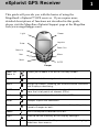
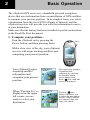
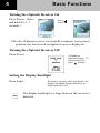
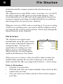
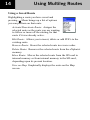
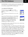
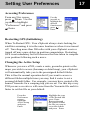
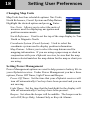
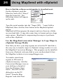
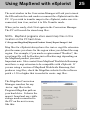
Magellan eXplorist GPS Receiver
Basic User Manual
This manual provides
basic operation
instructions for
Magellan eXplorist 400
GPS Receiver.
WARNINGS
IN THE INTEREST OF SAFETY, DO NOT USE THIS NAVIGATION DEVICE
WHILE DRIVING A VEHICLE.
Please do not try and change any settings on the Magellan eXplorist while driving. Come
to a complete stop or have a passenger make any changes. Taking your eyes off the road is
dangerous and can result in an accident in which you or others could be injured.
USE GOOD JUDGEMENT
This product is an excellent navigation aid, but does not replace the need for careful
orienteering and good judgement. Never rely solely on one device for navigating.
USE CARE
The Global Positioning System (GPS) is operated by the U.S. Government, which is
solely responsible for the accuracy and maintenance of the GPS network.The accuracy of
position fixes can be affected by the periodic adjustments to GPS satellites made by the
U.S. government and is subject to change in accordance with the Department of Defense
civil GPS user policy and the Federal Radionavigation Plan. Accuracy can also be
affected by poor satellite geometry and obstructions, like buildings and large trees.
USE PROPER ACCESSORIES
Use only Magellan cables and antennas; the use of non-Magellan cables and antennas may
severely degrade performance or damage the receiver, and will void the warranty.
LICENSE AGREEMENT
Thales Navigation grants you, the purchaser, the right to use the software supplied in and
with Thales Navigation GPS products (the “SOFTWARE”) in the normal operation of the
equipment.
The SOFTWARE is the property of Thales Navigation and/or its suppliers and is protected
by United States copyright laws and international treaty provisions; therefore, you must
treat this SOFTWARE like any other copyright material.
You may not use, copy, modify, reverse engineer or transfer this SOFTWARE except as
expressly provided in this license. All rights not expressly granted are reserved by Thales
Navigation and/or its suppliers.
* * *
Operation is subject to the following two conditions: (1) this device may not cause
interference, and (2) this device must accept any interference, including interference that
may cause undesired operation of this device.
* * *
No part of this guide may be reproduced or transmitted in any form or by any means,
electronic or mechanical, including photocopying and recording, for any purpose other
than the purchaser’s personal use without the prior written permission of Thales
Navigation.
© 2005 by Thales. All rights reserved. The Magellan Logo, Magellan and eXplorist are
trademarks of Thales.
631243-18 A
eXplorist GPS Receiver
This guide will provide you with the basics of using the
Magellan® eXplorist™ GPS receiver. If you require more
detailed descriptions of functions not described in this guide,
please visit the Magellan eXplorist Support page at the Magellan
web(www.magellangps.com).
Light
Power
Enter
Joystick
Zoom Out
Zoom In
Nav
Menu
Mark
GOTO
Escape
Zoom Out
Zoom In
Allows you to zoom in or out on the Map screen.
Nav
Used to select the navigational screen desired.
Menu
Brings up a menu, allowing you to access other functions
and display customizing.
GOTO
Used to create a route to a destination that is selected
from the list of points of interest (POIs).
Mark
Adds your present position to the list of POIs.
Enter
Accepts inputs and selections.
Escape
Returns you to the last viewed screen. If inputting data,
cancels changes as well.
Power
Turns the eXplorist receiver on or off.
Light
Used to set the intensity of the display backlight.
Joystick
Moves the cursor on the Map screen and used to highlight
selections from menus.
1
2
Basic Operation
The eXplorist GPS receiver is a handheld personal navigation
device that uses information from a constellation of GPS satellites
to compute your present position. In its simplest form, you select
a destination from the list of POI’s (Points of Interest) and the
eXplorist receiver will provide you with the information to arrive
at your destination.
Make sure that the battery has been installed as per the instructions
in the Read Me First document.
1. Compute your position...
Turn the eXplorist on by pressing the
Power button, and then pressing Enter.
Press
With a clear view of the sky, your eXplorist
receiver will begin tracking satellites and
computing your present position.
Your eXplorist begins
acquiring satellite
information and
computes your present
position.
When “Position Fix” is
displayed in the upper
left corner, you are
ready to select your
destination.
You can see the progress
of satellite data
collection by viewing
the Satellite Status
screen shown here.
Press
Nav until this
screen is displayed.
Pressing
Nav
button will allow you
to select the navigation
screen, (Map, Position
or Compass) that best
suits your needs.
Basic Operation
3
2. Select a destination...
Press the GOTO
button.
Press
Next you need to select which major category
the POI you want to go to resides. My Pts of
Interest are POIs you’ve created, Geocache Pts
are POIs that have been uploaded using the
Magellan Geocaching software, and
Background Map contains POIs that were
preloaded into your eXplorist with the
background map..
Browse either the
eXplorist’s internal memory
(or SD card if installed) to
find the POI you want to go
to.
3. Go to your destination.
Use the joystick
to highlight your
desired
destination and
press
Enter.
As you travel you
will notice that your
eXplorist will
continually update
your position as
well as providing
you with the
necessary details to
arrive at your
destination.
4
Basic Functions
Turning the eXplorist Receiver On
Press Power. (Press
and hold for 2 - 3
seconds.)
Press
Enter.
After the eXplorist receiver successfully computes your present
position, the last viewed navigation screen is displayed.
Turning the eXplorist Receiver Off
Press Power.
A shutdown
sequence begins. To
cancel power off,
press
Escape.
Setting the Display Backlight
Press Light.
Each time you press the Light button, the
display backlight changes from low to
high and back to off.
The display backlight is a large drain on the receiver’s
batteries.
Navigational Functions
5
Your eXplorist receiver employs three different navigational
screens to assist you in arriving at your destination. Pressing the
Nav button allows you to cycle through the navigation screen.
The Map screen displays
The Map screen is
your present position using a
customizable. Press
Menu, highlight
map of the area as the
Customize page and
background. You can zoom
press
Enter.
in or out using the zoom in/
out buttons to show just the
portion of the map you need.
The Map screen also displays an indication of where you have
been as a dashed line (track history), as well as a visual indicator
of a route you may be navigating on..
The Position screen displays
your present position using
the coordinate system
selected in Preferences.
Also displayed is your
elevation, accuracy, date and
time, trip odometer and
battery life.
The Compass screen uses a
graphical compass to provide
you with information used to
navigate to your destination.
An icon outside the compass
ring indicates your
You can reset the trip
odometer by pressing
Menu, highlight
Reset Trip and pressing
Enter.
The Compass screen is
also customizable.
Press
Menu,
highlight Customize
page and press
Enter.
6
File Structure
destination and the compass points in the direction you are
heading.
The eXplorist stores data (POIs, routes, track logs, etc.) as ASCII
text files to either an SD card or to its internal memory. Files
saved internally or to an SD card can be opened and viewed on a
personal computer providing you added flexibility in modifying
and storing data to be used in your eXplorist.
Whenever you save a POI, route or track log or if you are creating
a GOTO or a multileg route, you need to tell the eXplorist where
you want the file saved or retrieved from. This is done through the
internal browser in the eXplorist.
File Structure
The eXplorist uses (and creates
automatically on an SD card) a basic
file structure with default folders for
storing the data. You have the
opportunity of creating your own
folders and new ASCII data files.
Those items are covered in greater
depth in the Reference User Guide.
Internal Memory
SD Card
Background Maps
Background Maps
Detail Maps
My POIs
Routes
Detail Maps
My POIs
Routes
Track Logs
Track Logs
Geocaches
Geocaches
When you save or retrieve a file you will be taken to either the
default folder and data file for files of that type or the default
folder and data file that you assign in Preferences > Active Setup.
Points to Remember:
• •All data is saved in files
• •POI and route files can contain multiple items; track log files
contain only one item.
• •You can create new folders and new files to better organize
your data.
File Structure
7
This is a sample of the My POIs folder.
The first item, Up One Level, is used to move around
the file hierarchy.
The second item, New Folder, provides you the tool
to add a new folder at this level.
New POI File is used to create a new ASCII text file
to save your POI’s too. In the sample shown here,
Yosemite is a new POI file that was created for this
sample to save POI’s created while hiking through Yosemite National
Park.
The last item, Default POI File, is the default ASCII text file where
POI’s you save are stored. This is the file that is provided as a default
to save POI’s in until you have created your own POI file.
This sample displays what is shown when you access
the default POI file. There is an Up One Level item
that is again used to move around the file hierarchy.
Below that is a listing of all the files that have been
stored in this POI ASCII file.
ASCII Text Data Files
An advanced feature of saving data in ASCII text files is that it
provides another means of utilizing and modifying data that you have
recorded. Using an external card reader or by connecting your
eXplorist to your personal computer, you can now access the files that
you have saved. All of the information is there to be used as you need
or modified with a simple text editor like Notepad. Keep in mind that
modifying some of the information may cause the POI to be unusable
or have unexpected results.
8
Creating User POI’s
Your eXplorist receiver comes with preloaded POI’s for a variety
of areas. However, you will find that you will want to add your
own POI’s to the database. POI’s that you save are accessed from
the “My Pts of Interest” option of the databas
Saving Your Present Position
From any screen, press
Mark.
You can change the
information in any of
the fields by using
the joystick to
highlight the field
and press
Enter.
Highlight Save and press Enter when done. You then just
need to select or create the data file you want this saved
position saved to.
Some examples of POI’s you might want to save would be your
campsite, a special landmark that you want to visit again at a
future date, fishing hotspots, even your car to help you find it
when your day is done. Anytime you think you might want to
come back to your current location, you should save it to your POI
database and then it will be at your fingertips the next time you
want to return.
You might be familiar with the more common navigation
term of “waypoint” for My Pts of Interest. Waypoints and
My Pts of Interest are exactly the same and the terminology
is interchangeable
GOTO a Destination
You can use your eXplorist receiver to go to (“GOTO”) any
destination in your POI database. This can be one of the POI’s
that was preloaded in your eXplorist receiver, a geocaching point
or a POI that you have saved. Once a GOTO route has been
defined, your eXplorist receiver will guide you in a straight line to
your destination. If you need to move away from the suggested
path, the eXplorist receiver will continuously update the route,
keeping you headed towards your destination.
Setting a GOTO Route
From any screen, press
GOTO
Select the topic in your database where the POI
is located. Highlight the topic that contains the
POI you are looking for is in. Use the left or
right arrows on the joystick, select
Alphabetical or Nearest.
Choose the POI that you want to go to and
press Enter. The information at the bottom
of the screen is the bearing and distance to the
highlighted POI from your present position.
The last viewed Nav screen is displayed and
the eXplorist receiver begins computing the
navigational information required to get you to your
destination.
Some navigational information that is computed
requires that you be moving for it to be calculated.
When that information is not being calculated, the
navigational fields will be filled with dashes.
As you travel with your eXplorist receiver on, it
will continuously record your track. Track is then a history of
everywhere you have gone. At anytime you want to reverse your
direction and head back to where you started, you can create a
9
10
Using Backtrack
Backtrack route. This route will automatically be computed using
the track history stored in your eXplorist receiver.
Creating a Backtrack Route
From any screen, press
Menu. Use the joystick to
highlight “Track Log” and
press
Enter. Highlight
Active Track.
press
Menu.
Active Track is the
active track history
since the last time
track was cleared.
Other Track Logs in
the list are track logs
that you have saved for
future use.
Highlight “BackTrack”
and press
Enter.
You will return to the
Nav screen and begin
seeing information to
guide you along your
track back to your point
of origin.
Your track history may go back further then your intended
destination. You may want to clear your track (from the
Track Log menu above, highlight “Clear Track” and press
Enter) before you begin your travels so when you do a
backtrack route, it is limited to just the track history desired.
You can also save your track history using the Save command
from the “Track Log” option or convert the track to one of your
saved routes with the “Convert to Route” option. This will allow
your eXplorist receiver to guide you over the same path at a future
date.
Using Track Logs
11
As mentioned earlier, your eXplorist receiver records your track
and allows you to use this information to create a route, backtrack
or just to provide you with a visual indication of your journeys.
Accessing Track Logs
From any screen, press
Menu. Use the
joystick to highlight
“Track Log” and press
Enter.
The Track
Log is
divided into
two areas:
Active
Track and
Track Logs.
Active Track
Active Track is the track that is presently being
created by your eXplorist receiver. Highlighting
“Active Track” and pressing
Enter brings up a
menu offering a choice of activities to perform on
your active route.
Stop Logging: Turns the recording of your
track off.
Resume Logging: (Displayed if Track has been stopped).
Continues recording track from the point when it was stopped.
New Track: (Displayed if Track has been stopped). Erases old
track logging and begins recording a new track log.
Save: Allows the present track to be saved as a track log.
BackTrack: Creates a route that traces your track from your
present position back to where the track started.
Clear Track: Erases the active track from memory.
Convert to Route: Changes the track into a route that can be
accessed from the “Routes” menu option.
View on Map: Graphically displays the track on the Map
screen.
12
Using Track Logs
Track Logs
When an active track is saved it becomes one of
your stored track logs. Highlight the desired
track log and press
Enter for a list of track
log options.
Follow Track: Navigates from the start of
the track log to the end.
Reverse Track: Same as Follow track but
navigates from the end of the track log to the starting point.
Delete Track: Removes the selected track log from memory.
Copy Track: Copies the track log to a new file.
Move Track: Moves the selected track log to a new location,
either on the SD card or internally.
Convert to Route: Changes the track into a route that can be
accessed from the “Routes” menu option.
View on Map: Graphically displays the track on the Map
screen.
Using Multileg Routes
If you understand the concept of a GOTO route being a straight
route with a starting and ending point, then you can understand
multileg routes. A multileg route is many GOTO routes linked
together. So instead of having a route that only goes from A to B,
you can create routes that go from A to B to C to D and so on.
Accessing Routes
From any screen, press
Menu. Use the joystick to
highlight “Routes” and
press
Enter.
Any routes
saved will be
displayed
along with an
option to
create a new
route.
New Route
When “<New>” is selected, the Create Route screen is displayed.
Press
Enter with “<Add POI>” to go to the POI database to
select the next POI in the route list. If you highlight an existing
item in the route list and press Menu, you will be given the
choices of inserting a POI before the one highlighted, deleting the
highlighted POI from the route or just replacing it with a new POI.
When you have the route organized like you
want it, use the joystick to highlight Save Route
and press
Enter. Use the keypad to enter a
name for the route, highlight the “OK” button
and press
Enter.
13
14
Using Multileg Routes
Using a Saved Route
Highlighting a route you have saved and
pressing
Menu brings up a list of options
you can perform on that route.
Activate/Deactivate Route: Assigns the
selected route as the route you are wanting
to follow or turns off the routing for that
route if it was already active.
Edit Route: Allows you to insert, delete or add POI’s to the
existing route.
Reverse Route: Stores the selected route in reverse order.
Delete Route: Removes the selected route from the eXplorist
memory.
Move Route: Moves the selected route from the SD card to
internal memory or from internal memory to the SD card,
depending upon its present location.
View on Map: Graphically displays the route on the Map
screen.
The POI Database
The POI database is the place where your saved positions (“My
Pts of Interest”) or any preloaded positions are stored for easy
access when creating a GOTO or multileg route.
Accessing the POI Database
From any screen, press Menu. Use the
joystick to highlight “Pts of Interest” and press
Enter.
A list of POI types are displayed for you to select
from.
If you select “My Pts of Interest,” a list of all the
POI’s you have saved are displayed in the order
you defined. If you highlight one of the
displayed POI’s and press Menu, you will have
the option of editing or deleting the POI.
(Shortcut: pressing Enter with the POI
highlighted goes into the edit mode.)
Geocache Pts provides a path to POI’s that you have added using
the Magellan geocaching software.
From “Background Map,” you will be given a list of topics, such
as cities, highways, airports, waterways and parks. After selecting
one of these topics, a keyboard is displayed if alphabetical listing
is chosen. As the list of POI’s in the database can be enormous,
you can use the keyboard to enter the first few characters in the
POI you are looking for when doing an alphabetical search. With
the first few characters entered, highlight “OK” and press
Enter. This will speed up the search for the POI you are seeking.
When you have the POI selected, pressing
Enter brings up
information about that POI. You can also save it as one of your
user POI’s or view it on the Map screen.
15
16
Need Help?
Your eXplorist receiver has a built-in help function that can
provide you information to help you while using it. This is a
general help function that should answer most of your questions
about the eXplorist receiver and its use.
Accessing Screen Specific Help
From most screens, press Menu. Highlight
“Help” and press Enter to access the help
screens.
About Your eXplorist Receiver
Accessing the About...
screen will provide you
information about the
software version and
memory usage of your
eXplorist GPS receiver.
From any Nav screen,
press
Menu.
Highlight “About...” and
press
Enter to access
the About... screen.
The About...
screen
displays the
software
revision and
date, mapping
detail (if
applicable),
and number of
routes, POI’s, length of active
track and track logs.
The Property of: field will display the information you entered in
the Name field after you have personalized your eXplorist
receiver. (See the section on Preferences for information on
personalizing.)
Setting User Preferences
Accessing Preferences
From any Nav screen,
press
Menu. Use the
joystick to highlight
“Preferences” and press
Enter.
Use the
joystick to
highlight the
desired
function and
press
Enter.
Restarting GPS (Initializing)
When To Restart GPS: Your eXplorist always starts looking for
satellites assuming it is in the same location as when it was turned
off. Traveling more than 500 miles with your eXplorist receiver
turned off may cause delays in position computation. Restarting
GPS is not mandatory but will decrease the time taken to compute
your position following such a move.
Changing the Active Setup
Whenever you save a POI, create a route, geocache points or the
maps you wish to access (basemap or detail map), your eXplorist
will automatically take you to the preassigned default folder.
This is fine for normal operation but if you want to access a
different folder multiple times you may find it easier to set a
personal default folder. For example, you may have created a file
named Yosemite for a camping trip you are on. For this trip every
POI you save or retrieve will come from the Yosemite file and it is
faster to set this file as your default.
From the
Preferences
screen,
highlight
Active Setup
and press
Enter.
Highlight the type
of file desired and
press Enter.
Browse through
the folders to find
the file you want to
set as the default
and press Enter.
17
18
Setting User Preferences
Changing Map Units
Map Units has four selectable options: Nav Units,
North Reference, Coord. System and Map Datum.
Highlight the desired option and press
Enter.
Nav Units: Allows you to select the units of
measure used for displaying navigation and
position measurements.
North Reference: Used to set the top of the map display to True
North or Magnetic North.
Coordinate System (Coord System): Used to select the
coordinate system used to display position information.
Map Datum: Allows you to select the map datum used for
mapping information. If you are using a paper map or chart in
conjunction with your eXplorist receiver, be sure that the map
datum selected matches the map datum for the map or chart you
are using.
Setting Power Management
Power Management options are used to help preserve battery life in
your eXplorist receiver. Under Power Management you have three
options, Power Off Timer, Light Timer and Beeper.
Power Off Timer: Set the time that your eXplorist receiver will
turn off automatically if no keys have been pressed and you are
not moving.
Light Timer: Set the time that the backlight for the display will
turn off automatically if no keys have been pressed .
Beeper: Set when the beeper will be audible. The beeper can be
set to Off, Keys Only, Alarms Only or Keys & Alarms.
Setting User Preferences
Personalizing Your eXplorist Receiver
You can add your name and address information to your eXplorist
receiver. Should you lose your eXplorist receiver, this information
could be used to aid in its recovery. The name you enter here will
also be displayed on the About... screen.
Changing Languages
You can set your eXplorist receiver to display text in any of 10
different languages. You can choose from English, French
(Français), German (Deutsch), Dutch (Nederlands), Finnish
(Suomi), Spanish (Español), Italian (Italiano), Portuguese
(Português), Swedish (Svenska) or Norwegean (Norsk).
Clearing Memory
You have five options for clearing memory. Be very careful when
clearing memory. This cannot be undone and all data selected will
be lost.
Track Hist: Clears all saved track logs.
Reset default: Resets the receiver to its default configuration.
Resets language, preferences and any screen customization
done.
All: Clears all of the memory of your eXplorist receiver and
sets all of the defaults back to factory defaults. The eXplorist
receiver will shut off after all the memory has been cleared.
19
20
Setting User Preferences
Setting Alarms & Beeper
The eXplorist has five alarms that you can use to provide you with
audible alerts when their predefined condition is met.
Anchor Alarm: Set a distance that the alarm will sound when
the eXplorist has moved from its location. (Example: you
have anchored your boat and want to be alerted when it has
drifted from its anchor point.)
Arrival Alarm: Set the distance from your final destination that
the alarm will sound when traveling on a route.
Off Course Alarm: Set the distance that the alarm will sound
when you have moved off of the calculated course that you
should be on when navigating on a route.
GPS Fix: Turn an alarm on or off that will sound whenever the
eXplorist loses its GPS fix.
Proximity Alarm: If using a multileg route, proximity alarm
sets when an alarm will sound as you approach the destination
of each leg in your route.
Setting the Clock
The eXplorist receives constant time information from the atomic
clock in the GPS satellites but you can set how time is displayed as
well as providing information for automatic corrections for
daylight savings.
Format: Time can be format to be displayed in Local 24 Hrs
(military time), Local AM/PM or UTC. When selecting Local
24 Hrs or Local AM/PM, you are given the option of changing
the time.
Daylight Savings: The eXplorist can be set to automatically
change the displayed time to reflect time changes caused by
daylight savings. You can select from United States, European
Union or Customize to set your own start and stop dates.
Using MapSend with eXplorist
What is MapSend®?
MapSend is the Magellan line of detailed digital maps for
Magellan hand held GPS receivers. The core MapSend product
line includes street maps for driving, topographic maps for hiking,
camping, and hunting, and fresh and salt water maps for fishing
and boating. MapSend maps will transform your new eXplorist
into an amazingly powerful solution for outdoor recreation and
travel.
You can find out much more about the growing range of MapSend
products through a Magellan dealer or on-line at
www.magellangps.com under Products/Maps and Software.
Most MapSend products are provided on CD-ROM.
• Typically cover very large areas, allowing the user to cut
smaller regions of the big map to load to the GPS receiver.
• Offer useful trip planning and map analysis functions, such as
the ability to easily create and store lots of waypoints, routes,
map regions, etc.
Some maps regions are available as pre-loaded map regions on SD
cards.
• Plug and play in the eXplorist, but are limited in geographic
area.
The following sections describe how to get MapSend maps from
CD-ROM applications compatible with your eXplorist.
21
22
Using MapSend with eXplorist
Using MapSend maps with eXplorist
eXplorist interfaces with MapSend PC applications differently
from previous Magellan GPS receivers. It uses a USB port to
transfer data, not a serial port, and eXplorist provides a file
management system much like Windows folders, so users
can work with multiple maps and personal data files.
To prepare map regions for eXplorist, you must first save the
map region on your hard drive, and then copy it to an SD card
or internal memory on the eXplorist.
You may use an SD card reader/writer to copy saved maps to SD
cards, but you can also copy maps to eXplorist memory or to an
SD card in the eXplorist. SD card readers are sold at consumer
electronics and office supply stores.
Map region size considerations
MapSend products typically have limited the amount of map data
that could be uploaded at once, mostly because of performance
limitations. eXplorist can handle larger maps, and the eXplorist
file system makes it easier to manage multiple maps on the GPS. If
you make multiple, smaller map regions with existing MapSend
products, you can load them all at once to eXplorist, and easily
switch maps on the eXplorist as needed.
SD cards offer many advantages when working with
maps
Before you get started, you may want to purchase an SD memory
card from your Magellan dealer or from any consumer electronics
retailer. It is possible to store small maps to eXplorist internal
memory, but with SD cards you can save larger maps or more
maps - limited only by the size of SD card you choose. For
reference a MapSend Topo map of the State of Washington will fit
Using MapSend with eXplorist
23
on a 64MB SD card and a MapSend DirectRoute routable street
map of Switzerland should also fit on a 64MB SD Card.
Preparing and storing MapSend map regions on the PC
All MapSend CD-ROM products include a Quick Start Guide that
explains the basics of defining map regions on the PC. Except for
saving and moving maps over to your eXplorist, MapSend PC
applications work the same way for eXplorist as for any other
compatible Magellan GPS receivers. Only the basics of storing a
map region for eXplorist are covered in this section.
In MapSend on the PC, when you have a map region defined and
ready to upload, click the map upload button on the MapSend
toolbar.
You will see this dialog box:
Select "Store on Hard Drive",
and then the "Next" button.
Do not choose "Upload to
GPS Unit" or "Upload to
SD Card Programmer" for
eXplorist.
Next you will see this dialog
box:
Disregard the "Settings" and
"Connect" options.
The first time you use any
MapSend product, you need
to type in the software serial
number for your eXplorist in
the Target GPS Unit serial
number field.
24
Using MapSend with eXplorist
How to find the software serial number is described next:
On the eXplorist, push the
10000000001
Menu key and select "About"
Serial Number
from the menu list. The
following screen will appear
on the unit:
Type this serial number into the "Target GPS…" input field in
MapSend, then click the Next button in the MapSend upload
screen.
MapSend will then prepare the map(s) and save them in a folder
on your hard disk. It may take some time to format and save large
map regions. MapSend is compressing the map so it performs
well on the eXplorist.
Use the Magellan Conversion Manager to Copy Maps to
eXplorist Storage Media
Now that you have your map regions saved on the PC hard drive,
the easy way to transfer maps to eXplorist storage media is to use
the Magellan Conversion Manager. This program can be installed
from your eXplorist welcome disk or you can download it from
the Magellan website at www.magellangps.com.
To transfer stored map
regions to SD cards or
eXplorist memory, click the
Conversion Manager icon on
your desktop or launch it
from the Windows Start
menu. You will see this
dialog box on the PC:
Select "Transfer Map
Regions" and click Next.
Using MapSend with eXplorist
The next window in the Conversion Manager will ask you to insert
the SD card into the card reader or connect the eXplorist unit to the
PC. If you wish to transfer maps to the eXplorist, make sure it is
connected, turn it on, and set it to File Transfer mode.
When you're ready, click Next again in the Conversion Manager.
The PC will search for stored map files.
NOTE: MapSend programs store saved map files in this
location on the PC hard drive:
C:\Programs\Magellan\[Mapsend Product Name]\Export\Images\*.imi
Map files for eXplorist always have the .imi or .mgi file extension
plus the name you chose for the region when you defined the map
region. For example, if you made a region named "Rockies", the
saved map file will be Rockies.imi or Rockies.mgi depending on
the MapSend product you used.
Important note: files created from MapSend Worldwide Basemap
must have a .mgi extension to be compatible with eXplorist. If
you are using a version of MapSend Worldwide Basemap, that
produces .img files, check the Magellan website for the software
patch v.1.30 or higher that is needed to create .mgi files.
The Magellan Conversion
Manager searches for any
.imi or .mgi files in the
Programs\Magellan path on
your hard drive. It shows the
maps it found and any viable
storage media connected to
the PC on the next screen,
like this:
25
26
Using MapSend with eXplorist
If you don't see the map you want to use in the list box on the left
of this screen, you can click the magnifying glass button to search
for maps elsewhere on your PC.
Click the checkbox next to any map image(s) you wish to copy to
eXplorist storage media, and then choose the storage destination
from the drop down list on the right. At the lower right of this
dialog is shown how much data you've chosen to transfer and how
much storage space is available. Click Next to start the map
transfer. Please allow plenty of time for the file to write to an SD
card before removing the card from the card writer.
Activating and Switching between MapSend Maps on
your eXplorist
Now you are ready to use your maps on your eXplorist. You can
store many detail map regions, but only one detail region can be
active at once. To activate a detail map, push the Menu button on
the eXplorist, then select "Preferences" on the Main Menu,
followed by "Active Setup".
You will now see the following screen:
To make your detail map active, select the
"Detail Maps" line and press "Enter". You will be
shown the "Detail Maps" folder containing your
maps. If you decided to place your maps in a
subdirectory, or another directory entirely, move
through the directories until you locate your
map file. Once you select your file, the eXplorist
will ask you to confirm your selection, after which it will load
your map selection. You can go back to "Active Setup" and
change the active map any time you wish to change to
another map you have stored in the eXplorist.
Background Maps
Detail Maps
My Points of Interest
Routes
Geocache Pts
Using MapSend with eXplorist
27
Summary
Following these instructions you will be able to expand the
capabilities of your eXplorist to new levels of detail. Not only will
you be able to view highly detailed mapping information, you will
have the flexibility of switching to different maps, either stored
internally or on SD cards. This provides your Magellan eXplorist the
ability to display and navigate using highly detailed maps, limited
only by the amount of memory you have at your disposal and the
MapSend products you are using.
28
Notes
Contacting Magellan
The following information is provided so that if you need support for
your Magellan eXplorist, you can direct your questions/comments to
the proper person at Thales Navigation.
Technical Support
For Magellan product support in English, French, German, Spanish,
Portuguese, Dutch, Norwegian, Finnish and Danish please dial FREE
PHONE:
00800MAGELLAN* ( 00800 62435526)
from 9 AM to 6 PM GMT & GMT+1 or send an e-mail in English,
French, German, Spanish, Portuguese, Dutch, Norwegian, Finnish and
Danish to: [email protected]
*free of charge phone access available from Eire, UK, Portugal, Spain, France,
Belgium, The Netherlands, Germany, Austria, Switzerland, Norway, Sweden, Denmark
and Finland
For Magellan product phone support in English, French or German
from other Europe, Middle East or African locations please dial:
+33 2 28 09 38 00*
or send an e-mail to: [email protected]
* international communication charge according to opperator.
For Magellan product phone support in other European Middle East or
African Languages please contact our distributors listed in our dealer
locator or send an e-mail to:
[email protected]
Accessories
A complete list of accessories, along with ordering information can be
found on the Magellan web site, www.magellangps.com.
Thales Navigation European Headquarters
Z.A.C de la Fleuriaye - B.P. 60433
44474 Carquefou Cedex - France
631243-18 A