1
·
.' '>
,.
Iiic'
A'
'{
'
.:
AUSTRALIAN
GEOLOGICAL SURVEY
ORGANISATION
▪
•
AUSTRALIAN GEOLOGICAL SURVEY ORGANISATION
DEPARTMENT OF PRIMARY INDUSTRIES & ENERGY
AGS0 RECORD 1997/10
-a^USER'S GUIDE TO MAPPAD AND AGSO FIELDPAD
FOR THE APPLE NEWTON PALMTOP COMPUTER
a
R.S. Blewett & M.S. Haze11
U
a
Minerals Division, Australian Geological Survey Organisation
•
—
111111111
*R9701001*
DEPARTMENT OF PRIMARY INDUSTRIES AND ENERGY
Minister for Primary Industries and Energy: Hon J. Anderson, M.P.
Minister for Resources and Energy: Senator the Hon. W.R. Parer
Secretary: Paul Barratt
AUSTRALIAN GEOLOGICAL SURVEY ORGANISATION
Executive Director: Neil Williams
© Commonwealth of Australia 1997
ISSN: 1039-0073
ISBN: 0 642 25016 2
This work is copyright. Apart from any fair dealings for the purposes of study, research,
criticism or review, as permitted under the Copyright Act 1968, no part may be reproduced by
any process without written permission. Copyright is the responsibility of the Executive
Director, Australian Geological Survey Organisation. Requests and inquiries concerning
reproduction and rights should be directed to the Principal Information Officer, Australian
Geological Survey Organisation, GPO Box 378, Canberra City, ACT, 2601.
••
•
•
•
•
•
•
••
•
•
•••
•
•
••
•
•
•
•
•
••
•
•
•
•
•
•
•
•
•
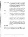
Table of Contents
INTRODUCTION ........................................................................................................................................... 1
THE OZROX DATABASE STRUCTURE ......................................................................................................... 2
FUNCTIONS OF THE ApPLE NEWTON 130 ..................................................................................................... 3
Built-in organisation functions ............................................................................................................................. 3
Built-in communications ...................................................................................................................................... 3
Expandable functions ........................................................................................................................................... 3
RIA MAPPAD ............................................................................................................................................. 3
AGSO FIELDPAD ....................................................................................................................................... 9
Site ............................................................................................................................................ ............ 10
Location of site ...................................................................................................................................... 11
Outcrops for site .................................................................................................................................... 12
Sketch for site ........................................................................................................................................ 13
Rocks for site ......................................................................................................................................... 13
Lithology for sample .............................................................................................................................. 15
Structure for sample .............................................................................................................................. 16
Site search ............................................................................................................................................. 17
Utilities ................................................................................................................................................. 18
TRANSFERRING DATA TO AND FROM TilE NEWTON ................................................................ 19
APPLE NEWTON BACKUP UTILITY ............................................................................................................... 19
CHECKING MEMORY ................................................................................................................................... 19
INSTALLING A PACKAGE .............................................................................................................................. 19
UPLOADING FIELD SITES TO THE PC ............................................................................................................. 19
INSTALLING LOOKUP TABLES ....................................................................................................................... 20
TROUBLE SHOOTING ................................................................................................................................... 21
CREATING MAPPAD MAPS ................................................................................................................ 21
.PRJ Files ........................................................................................................................................................... 21
.LYR Files ......................................................................................................................................................... 22
Creating the MapPad Package ............................................................................................................................ 23
TRICKS AND TIPS ................................................................................................................................ 23
ACKNOWLEDGEMENTS ...................................................................................................................... 24.
REFEREN CES .......................................................................................................................................... 24
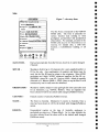
Australian Geological Survey Organisation
APPENDIX 1- TECHNICAL SPECIFICATIONS FOR NEWTON 130 ............................................. 25
Newton Intelligence Newton Recognition Architecture .......................................................................... 25
Newton Information Architecture........................................................................................................... 25
Newton Communications Architecture ................................................................................................... 25
Intelligent Assistance Architecture ........................................................................................................ 25
MessagePad Iiardware Architecture ..................................................................................................... 25
Comll/unications capabilities ................................................................................................................. 25
Size and weight...................................................................................................................................... 26
Operating environment .......................................................................................................................... 26
Power requirellients ........................ ....................................................................................................... 26
Computer connectivity require111ents .......................................•.............................................................. 26
Printer support ...................................................................................................................................... 26
Figure Captions
FIGURE
1 - THE STRUCTURE OF OZROX ........................................................................................................ 2
FIGURE
2-
GUIDE TO SOME OF THE FEATURES OF THE MAPPAD PROGRAMME ................................................... 4
FIGURE 3
- PULLDOWN MENU OF MAPS FOR SELECTION ................................................................................... 5
FIGURE 4
- GPS
ACTIVE SCREEN SHOWING STATUS ........................................................................................ 8
FIGURE 5 - W A YPOINT SCREEN SHOWING POSITION ........................................................................................ 8
FIGURE
6 - AGSO FIELDPAD SELECTION SCREEN ........................................................................................... 9
FIGURE
7 - SITE ENTRY FORM ...................................................................................................................... 10
FIGURE
8 - THE LOCATION OF SITE ENTR Y FORM ........................................................................................... 11
FIG URE
9 - THE OUfCROP FOR A SITE ENTRY FORM ...................................................................................... 12
FIGURE
10 - EXAMPLE OF FIELDPAD SKETCHING .......................................................................................... 13
FIGURE
11 - EXAMPLE OF THE ROCKS ENfR Y FORM ...................................................................................... 14
FIGURE
12 - THE UTHOLOGYFOR SAMPLE ENI"RYFORM ............................................................................... 15
FIGURE
13 - THE STRUCTURES FOR SAMPLE ENTR Y FORM ............................................................................. 16
FIGURE
14 - THE SITE SEARCH FORM ........................................................................................................... 18
FIGURE
15 - THE UTILITIES
FORM ................................................................................................................ 18
Australian Geological Survey Organisation
ii
•
•
U
•
111
Introduction
The Australian Geological Survey Organisation (AGSO), in collaboration with Resource
Industry Associates (RIA) have developed a digital field notebook, called AGSO FieldPad,
for recording data digitally at the field site for downloading into a digital database. The
digital field notebook operates on an Apple Newton Message Pad 120 or 130 Personal
Digital Assistant. The FieldPad design is based on OZROX, AGSO's corporate database
for the storage of geological field data. This guide describes the digital notebook system.
It will not describe all the functions of the Newton, as these can be found in the Newton
operating handbook, but rather some of the most useful functions for geologists. In
particular, we will describe the MapPad and FieldPad systems, and the purpose of the data
description fields in FieldPad. We will also outline the loading of map packages, and the
transfer of data to and from the Newton.
The OZROX field database is a relational database and has been implemented within
AGSO using the ORACLE Relational Database Management System (RDBMS). OZROX
is the pivotal database for AGSO's system of laboratory databases which include
ROCKCHEM (whole rock geochemistry) and OZCHRON (geochronology). By managing
field and laboratory data within a relational database data can be made available in flexible
but standardised formats; e.g., as hard copy reports, or displayed within geochemical
analysis programs or Geographic Information Systems (GIS). More importantly, data
security, integrity and consistency are maintained by data validation procedures that have
been built into the database. Details of OZROX may be found in Ryburn et al. (1993;
1995).
To facilitate the recording and entry of field data into OZROX AGSO developed a
structured field notebook and an associated set of coded attributes (Blewett 1993). The
notebook follows the format and structure of the OZROX database with each field in the
notebook matching a corresponding field in the database forms. Structuring field notes
this way greatly speeds the process of entering the data into the database. An added
benefit was that the notebooks prompted geologists to record all necessary information at
the outcrop. The digital notebook system is a further development and replacement of the
standardised analogue notebook system. The major benefit of using a digital system is that
geological descriptions are encoded digitally at the outcrop thus obviating the need to later
•
hand enter the descriptions into the database. This greatly speeds the digital data capture
process and importantly reduces the possibilities for transcription errors. Other benefits of
a digital system include the ability to display various maps linked directly to a GPS and
have your position displayed in real time, and to digitally record field sketches along with
the field descriptions.
111^
The digital notebook system includes:
• a Newton 120 or 130 running on the 0S2 operating system;
• a Global Positioning System (GPS), e.g., Garmin 45;
• 2 or 4 MB flash card for data storage;
• an RS232 cable or infra-red data transmitter and power pack
• supplementary 6V and 240V power supply;
• a protective cover for the Newton (rubber boot).
The Newton is not waterproof and recommended operating temperatures are 0-40°C. Be careful of
leaving the Newton in the sun in a vehicle as damage may occur. It is recommended that the user consult
the handbook supplied with your Newtown on care and use of the unit. See Appendix 1 for technical
specifications.
I
•
Australian Geological Survey Organisation
The guide will discuss some of the standard functionality of the Apple Newton, and will
provide the user with a manual for the RIA MapPad and AGSO FieldPad software. The
Newton can be switched off anywhere in its programmes and on rebooting, will return to
the last screen. Programmes are exited by pressing the I&l button in the bottom right of the
screen.
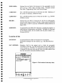
The OZROX database structure
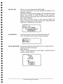
The OZROX Field Geology Database has seven main data tables; SITES, OUTCROPS,
SECTHOLES, INTERIZONS, ROCKS, LITH DATA and STRUCTURES. Currently, the
SECTHOLES and INTERIZONS tables are not accommodated by the FieldPad structure.
All other tables indicated in Figure 1 below are lookup or authority tables used to validate
the classifications and nomenclature used in the main OZROX tables.
The hub of the field database is the SITES table which standardises the way point location
data are recorded and ensures that the accuracy and lineage of coordinates are noted. This
is logically linked to the OUTCROPS and ROCKS tables via the Originator Number and
Site ID. The OUTCROPS table stores data at the outcrop level and includes links to the
STRATDAT biostratigraphic database. The ROCKS and LITHDATA tables record
lithologies and samples descriptions. LITHDATA is an expandable attributes table for
further descriptions of the lithologies and samples described in the ROCKS table.
Figure 1 - The structure of OZROX showing relationships between tables, with 'crows'
feet' at the many end of many-to-one linkages. The rounded boxes represent databases
used to validate the data in OZROX.
Australian Geological Survey Organisation
2
Functions of the Apple Newton 130 2
The Newton was originally designed as a Personal Digital Assistant (PDA). In this role it
has many features and functions which the field geologist will find very useful. Some of
these features and functions are listed below.
Built-in organisation functions
• Helps you plan monthly, weekly, and daily activities using the calendar, and manage
priorities using the To Do List;
• Allows free-form notes, outlines, lists, and phone logs;
• Includes customisable name and address files, using various business-card formats;
• Offers an assortment of information and productivity tools, such as time-zone maps, a
calculator, and currency exchange.
Built-in communications
• Actively assists you in making phone calls, faxing, printing, finding information, and
sending and receiving electronic mail;
• Uses an optional wired or wireless modem to send and receive faxes and electronic
mail;
• Prints formatted letters and notes using Apple printers or serial or parallel printers with
the optional Print Pack;
• Lets you beam notes, messages, packages, schedules, and business cards via built-in
infrared communications;
• Backs up all data onto your personal computer and installs software on your
MessagePad 130 using the included Newton Backup Utility.
Expandable functions
• Using the optional Newton Connection Utilities, lets you import and export information
from your Mac OS- or Windows-based computer, and backs up and synchronises files
with your computer;
• Works with PC cards and serial peripherals such as keyboards, modems, pagers, and
wireless communications and storage products;
• Offers a large selection of productivity, finance, time and billing, information
management, reference, electronic document publishing, and entertainment software.
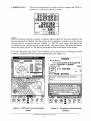
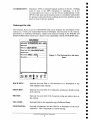
R1A MapPad
Resource Industry Associates (RIA) have developed MapPad to enable digital mapping in
real time and space. It allows full navigation and tracking features. Geological and/or
geophysical interpretations, cultural, cadastral, topographic or drainage maps can be
loaded into MapPad and displayed. The same map can be loaded at various scales to allow
`pseudozooming' to different levels of detail. When linked to a GPS an active position is
presented on screen (Fig. 2). Maps need to be converted to a custom format to be loaded
into MapPad. A Windows '95 programme from RIA called Tsmappad.exe will convert
.dxf format files to the custom format (see section for loading maps).
2
Functions from Apple's Web Site (http://neMoninfo.apple.cominewton/solutions/messagepad130ds.html)
Australian Geological Survey Organisation
3
Current map and scale
" ' - 'Ie -
Hold down pen, wan for
beep and draw thick line
to measure distance
Toggle background map
J
Toggle Backlight
-
p.... wiiil
/
"",wei, ' '112;1.6]1
•• =-0;;;*_ -=a *
we=-
Double tap on map
to create waypoint at
tap position
GPS status window
Single tap on map to
show coordinates
of tap position
7.(l)0.":'
~/'I
GPS posnion indicator
Create way point at
GPS posnion
Draw annotation lines
on map
Toggle GPS
Map view scroller
Other functions menu
Map chooser menu
e
~~'
1$ ~
4· i
~"'~' D~'" _ ~.~""::
---
Quit MapPad
Zoom in/out map view
Show waypoints list
Figure 2- Guide to some of the features of the MapPad programme.
To start MapPad switch the Newton on and from the main screen select the MapPad icon,
or the icon of the map you wish to display (all maps available in MapPad are displayed as
separate icons). To switch between maps when running MapPad (e.g., different scales of
the same region) select the Map Chooser option (Fig. 3). The Map Chooser is accessed by
pressing the title bar at the top of the screen, or the Map icon at the bottom of the screen
(Figure 2). From the Map Chooser select the map you want. Alternatively if you have the
same map loaded at different scales use the up and down arrows next to the Extras icon to
move from one map to another.
Other options are accessed via the Map icon are:
1. A control button to let you move to set positions on the map (e.g., centre, left edge, top
right corner). At the top of the pop-up menu are a group of radiating arrows with a
diamond in their centre. Press any of the arrows to move to that map edge or corner, or
the diamond to move to the centre of the map.
2. A choice to change to a larger scale of the current map or to go to the small scale world
map.
3. Access to the Waypoints List.
Options accessed through the title bar at the top of the screen are:
1. Toggle waypoints on/off.
2. Toggle track log on/off.
3. Location
4. Header information for the map - i.e., map projection, map units, geographical extent of
map boundaries. A thumb nail sketch of the entire map is also displayed with the extent
of the current screen view shown.
Scrolling incrementally about the map is achieved by pressing the diamond-shaped scroll
tool in the lower left corner of the screen (Figure 2). A single press will scroll the map a
single increment. Holding the pen down will scroll the map until the pen is lifted.
Australian Geological Survey Organisation
4
Figure 3 - Pull down menu of maps
for selection.
CO~
Dates
Names
®: ~ p
Extras... Undo
Find
=0/"
Assist
Linking with the GPS
There are a number of preferences that need setting to enable the GPS to communicate
with the Newton. Select the information CD button in the bottom left hand corner, and
then select Prefs from the pop-up menu. The choices available from Prefs include
-General, -Global Positioning System, -Map View, -Waypoints, -Navigation, -Data
Transfer, -Current Location. Pressing anyone of these options will take you straight to
those preferences, however once you are in the MapPad Preferences window you can
scroll through the preferences by pressing the up/down arrow below the bottom of the
main window (screen). Pressing the 'dot' (between the up/down arrow) retrieves the menu
(Fig. 2). This also works for all other menu lists.
GENERAL-
You can restore the default values.
Select the store data on (flash) card option and other start up
options.
General------------"
Restore Default Preferences
[::l Start with map catalo9
[::] Start with About box
[::] Store data on card
GPS -
Serial Port: Select between RS232 and infrared connection
Sound effects: Set the sound you would like for particular
"actions".
Type: NMEA018 is the data communication standard for the
Garmin GPS
Baud: This is usually 9600
Australian Geological Survey Organisation
5
^
Datum: Choose your map datum (e.g., AGD66, WGS84). This
must be the same as the map that you are using in the Newton. For
GIS usage it is critical to record the datum used.
Auto open window: Sets the type of information displayed when
the GPS is switched on. Status will show the number, status, and
signal strength of satellites visible to the GPS. Position will show
the current position as determined by the GPS. There is also a
toggle switch to enable averaging. Navigation shows distance,
velocity and bearing information for navigation to a particular
feature or waypoint.
Timeout: can be selected between never to 1 minute (for battery
saving).
—Global Positioning System
Serial Port^•Type IPS3Q QQ
^RS-232^
+Baud 96 01)
Infra-Red
•Datum WGS84
jf^Sound effects
Bell^Auto open view
^0
Chord^• None
0 Trill^ Status
Xylo^0 Position
0 Click^ Navigation
• Timeout 2 ni incites^
a?!! Check sum
MAP VIEW - ^Select the desired option for showing waypoints, labels, track
information on the map.
Marker: waypoint position markers can display as a small dot or
large dot, or not at all.
D1
Map View
Eig. Show waypoints^Marker
fig. Show labels^r..1 None
Show track^ill Small dot
0 Big dot
WAYPOINTS -^A starting number for your waypoints and also a standard prefix
can be set up. Increase the starting number by pressing on the top
of the number and decrease it by pressing on the bottom of the
number. It is suggested you use a similar number system to the
AGSO Site ID system (see later). You can also clear all
waypoints. The diamond symbol • indicates a pulldown menu for
that field (it also applies for any application in the Newton).
Form: toggles AGSO FieldPad system on and off.
.—Waypoints ^
• Waypoint prefix
wpT
Last waypoint #
1 3 waypoints (3K)
• Form
None
t
AGSO FieldRad
AGSOFieldPad:Softione
Australian Geological Survey Organisation
6
31
Clear Waypoints
TRACK LOG -^Allows you to set preferences for track logging.
Line Style: Sets the size of the track log position indicators to be
displayed in MapPad.
Track Interval: Switches track logging on/off, also sets the interval
between each position fix when operating in track log mode.
Options range from all position fixes received from the GPS unit
up to every 10 minutes.
Clear Track Log: Press button to clear track log entries. The
number of track log fixes recorded and the size of this information
in Kilobytes is displayed above the button.
Track Log
Line style . • :es
*Track interval 1 5 SCCOndS
464 track entries (129K bytes)
I
Clear Track Log
NAVIGATION -^You have the option to show the waypoint flag and route.
Units: Sets distance units to metric, statute or nautical.
Navigation
36 Show waypoint flag
ISK Show route
• Units
metric
[
DATA TRANSFER - Data transfer preferences for transfer to a PC or another Newton.
DataPort: RS-232 or Infra-Red.
Baud: Baud rate.
Format: Comma Delimited for ascii output or Newton Soup for
transfer to another Newton.
—Data Transfer
Data Port
RS-232
• Infra-Red
• Baud
9600
Format
• Comma Delimited
Newton Soup
I*
^Upload^
I
Australian Geological Survey Organisation
7
CURRENT LOC -
Gives the current position (or most recent) in degrees and UTM coordinates, as well as the altitude in metres .
... Current Location
Degrees
Minu1:es
Seconds
[3IlJ:5mHm.[a]~
[1f4141:5JZH213J.[5][!]
[3!2!0!-1-·!8}21
5·!811. !0f4!O!5]
UTM
mE
mN
Zone
AI1:itude
1. ·.. ···I······· .
[5]510
!1·11·1tl
m
[/ I" ] This button activates a number of options which control the way users interact with
the map displayed in MapPad. The flag option is for waypoints. A single tap on the screen
will activate the waypoint notebook. (Figure 5). The XY coord option will display the
coordinates of any location you tap on the screen. The centre option will centre the screen
around the point you tap on. The sketch option allows lines to be drawn on the screen.
From the Waypoint page (Fig. 5) the FieldPad can be accessed by pressing the AGSO
FieldPad. FieldPad will start with the OZROX Sites form (Figure 7).
~
......·..............·. ·....................W·ayp·oi·nt·....·........................·..............·1
~
• Coordinates:
[Stat!!;]
GPS Status
North
-
UTM 32.0,3iS mE, S,81 O,i2.S mN ~
LatiLon -31.83S8, 1lflf.'S8
l
l::tI
-. ......... .
Altitude
...... .
.....
+Code
i
om
Name
sss i
1~.w.~tI!I!L______;:_!
User
~Yf:
~.~P..~. .;. .~~U~JO.g. . . . . . . . . . . . . . . . . . . . . . .
$..Q.!).t.b.....t!.~.J..Q.Q.W.r..!J.~ . ..t..Q.Y.y..!J.................
I
ha 11
~~ 1zJ X ~ ely 1bIn 1m 1, 1; 1 ~ Is\hi~
X
l~GSOFieldPadJ®<
~~®:-~fJ:o/·
I~
~
Names
Names Dates Extras... Undo
Rnd
AsSiSt
, ..................................................................................................................
~
Figure 4 - GPS active screen showing
status.
Da~es
®:- ~ fJ :0/./
Extras . . . Undo
Find
ASSiSt!
Figure 5 - Waypoint screen showing
position.
Australian Geological Survey Organisation
8
AGSO FieldPad
The AGSO FieldPad is a digital notebook for storing field geological data. It can be run
without MapPad but then the GPS position will have to be entered manually. There are a
number of forms or screens that can be scrolled through by using the up or down arrows
located at the bottom of the screen. The dot between the arrows brings up a directory of all
the forms. Pressing on the form name will take you straight to the desired form (Figure 6).
Data entry into the AGSO FieldPad is either via pulldown lists of acceptable values or as
free text. Tapping the diamond beside the name of each field will display either a list of
values or a clean page into which a description can be hand written. Although the FieldPad
will not prevent you from writing as much as you like into the free-text fields it will only
store the number of characters that the OZROX database can store. In most cases this is 64
characters, and therefore any extra characters will be truncated. Where a pulldown list
exists for a field, data entry can only be from the pulldown list. The following descriptions
of the forms state whether the fields are free text or have lists of attributes attached. In the
case of free-text fields, the number of allowable characters is given.
AG50 FieldRad
• Site
• Site Location
• Outcrop
• Sketch
• Rocks
• Lithology Data
• Structures
• Site Search
• Utilities
• About
Figure 6 - AGSO FieldPad selection
screen
,•
0 0: P .g.
Names Dates Extras^Undo^Find
Assist
Australian Geological Survey Organisation
9
Site
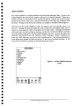
r····································..AGs<)"f'lei·dPad.. ·········· .... ················..·..··1
i Site
! .DatelTime
i
I
Site ID
i
FieldlD
Figure 7 - site entry form
1
14/6/962:43
PM
.........................
_...........................
M................. 1;
2.~.~~.~.9..5..................................................... i
J.J..9.'.;.J~:.!~.w..~t.t.l. R~§.~.............. _.. I
! .Originator
i
I:::::~~~~==~-=~:= I
!•
i
.1
Region .5.~...;...MH.r.p~Y...J.~JJ~.~........................
l • Geog Area
l
1: 1 OOk Ma~···i9...59.·iA§jjR~:·.C.Ri.i:·
l • 1 :250kMap ...................................................................... !
1.
l .Bib.Ref
!
I:p.;.p..,:.9i~~t::===~=~ I
The Site Form corresponds to the OZROX
SITES table. The form is primarily for
surface location data relating to field
geological, geochemical and geophysical
observations. For example, an entry in the
SITES table may be for observations at an
outcrop, for sample data, a drill hole
location, a scintillometer reading, or all
four.
I©~®:~p:o/·I
l Names Dates Extras.. Undo Rnd AsSISt!
.. -....-.....................-...............-....-..............._...._.........•........... _...._...........
~
:
DATEITIME -
Derived automatically from the Newton, however, it can be changed
if desired.
SITE ID -
Mandatory field of up to 16 characters for a user-supplied number or
ID for the site. Any combination of numbers and letters may be
used, but the Site ID must be unique to the originator. Most AGSO
geologists use 8 digit "AGSO" registered numbers for Site ID e.g.,
96834000 - where 96 = year, 83 = project, 4000 = block of numbers
allocated to R. Blewett (4000 c::> 5999). Once set up the Site ID will
increment by one for each new site described.
ORIGINATOR -
Mandatory number unique to each geologist (in some cases also used
for an institution, e.g., 'GSWA', 'RSES'). Once an originator has
been selected it will be the default until changed (Pulldown menu).
COUNTRY -
Default country is Australia (PulidoWll menu).
STATE -
The State in Australia. Mandatory if country is Australia. Once a
state has been chosen it will be the default until changed.(Pulidowll
menu).
REGION -
Geographical regions on the map of Australia, analogous to
geological provinces e.g., Yilgarn Block. As for other defaults, the
province selected from the menu will be the default until changed
(Pulldown menu).
Allstralian Geological Survey Organisation
10
•
••
••
••
•
•
•
••
•
•
••
••
•
••
•
•
••
•
••
••
•
•
••
GEOG AREA -
Optional free-text field of 64 characters for the geographic area the
site is in (e.g., valley, plain, mountain range). Examples include
'Hay Plain', 'Tuggeranong Valley' and 'Selwyn Range'.
1:100K MAP -
The 1:100 000 map sheet-area on which the site falls. Mandatory if
the country is Australia. (Pulldown menu).
1:250K MAP -
The 1:250000 map Sheet area on which the site falls - e.g., 'SF5402'
(Pulldown menu).
BIB REF -
Optional free-text field of 9 characters for the ID of a bibliographic
reference that locates or refers to the site. Codes entered in this field
should exist in AGSO's corporate AGSOREFS database (Ryburn &
Bond 1995).
AIRPHOTO -
An optional free-text field of 36 characters to identify the airphoto on
which the site is located and/or was plotted. The field is for the name
of the airphoto series, the run number and the photo number, e.g.,
'Cloncurry 8/2134'.
Location of site
LOCATION -
An optional free-text field of 64 characters for descriptive
information relating to the site location, e.g., '5 Km SE of Brown's
Bore'.
LOC METHOD - Mandatory field for the method used to obtain the geographic
coordinates of the site. For GPS located sites use the code with the
correct datum (e.g., WGS84). If a standard series map is indicated it
is assumed that the map used was the most up-to-date edition at the
time the observation was made (Pulldown menu).
AG50 FieldPad
Location of site 96496005
• Location
UP THE CREEK WITHOUT.
• Loc Method
i•
1 : GPS observation ...
Coordinates
UM 312,448 rat, 6,05,762 rf1N
Let/Lan -31.9569 , 115.862
Altitude 0.0 rn^ 350
Figure 8 - The location of site entry form.
Australian Geological Survey Organisation
11
COORDINATES - Mandatory UTM or latitudellongitude position of the site. Nothing
need be done if the GPS connection is operating. It is not
recommended, but if have to usc the Newton independently of the
GPS live link, then tap the diamond next to Coordinates and modify
the position values directly by scrolling the previous numbers up and
down to those of the new position.
Outcrops for site
The Outcrops Form covers the OUTCROPS table and is designed for descriptions of the
outcrop as a whole and relationships between lithologies and structures in the outcrop.
Information on individual lithologies, samples and structures belong in the ROCKS and
STRUCTURES tables which have a many-to-one relationship with the OUTCROPS table.
r·······································AGso··ri·eldPitii·······································j
I
j
I
I
!
Vi£W···NORTfi·····. · · · · · . · · · · · · · · · · · · · i
Outcrop for site 96'196005
.RockRels J..ru.B.".~.p.p..~.p.
. .Q~.T..A.M;!. ~
i .Sketches
j
.Photos
! • Veg cOd~···i.:9.·.·~.~·.·.i9.~~·.·.~.i~·$.~·4~.·f.;~~.$.·t.."~.:·~~. . ~ . .
!,
• Vegetation ........................................................................... .
rises
£R2o :
• Land Code ......................................
"A,....•.....•.....................•....
• Landform
Figure 9 - The Outcrop for a site entry
form.
,
I
!
~";
i
i
~.
!
I
., '
i
l~~~~=,=®=:=~=p=:o/~~
i
.. .. .. .. ... ... .
l. ~~.=.~~ ~.~~~.~ ~~~~~.~ ~ ~~.~~ ~~.~ :~~:~: ..1
ROCKRELS -
Optional free-text field of 128 characters for a description of the
rock relations in the outcrop.
SKETCHES -
Optional free-text field of 64 characters noting any sketches made
at the outcrop.
PHOTOS -
Optional free-text field of 64 characters noting any photos taken at
the outcrop.
VEGCODE-
Optional field for the vegetation type (Pulldowll Menu).
VEGETATION -
Optional 64-character free-text field for a description of the site's
vegetation. This is important for remote sensing.
Australian Geological Survey Organisation
12
•
•
•
••
••
•
•
•
•
•
•
•
••
••
•
••
•
•
•
••
••
••
•
•
••
LAND CODE -^Optional field for the landform (Pulldown Menu).
a
LANDFORM -^Optional 64-character free-text field for a description of the
landform features of the site.
Sketch for site
•
S
••
A digital sketch may be attached to a site. Simply draw onto the screen and press the tick
to save the sketch. You can use all the editing features of the Newton. Consult the
Newton manual for tips on deletion etc. The current limit is one sketch per site.
Sketches can include lettering either as raster text (as a graphic using sketches) or as text
using the Newton's character recognition software (with two fonts - Text and Ink Text).
You can also select a Shapes option and the Newton will attempt to draw straight lines and
close polygons. Alternatively, select the Sketches option and a facsimile of what is on the
screen is stored.
AGSO FieldPad
1 Sketch for site 96496005
N
U
A
QUARTZITE BED
Text
61. Ink Text
di Shapes
4- Sketches
ct. •option. cm
III
IC? 0 "•6
III^IcDC•04:;P:01
iv
U
Figure 10 - Example of FieldPad sketching.
1111
•
Rocks for site
•
ii^
Names Dates Extras
•
• 1
Names Dates Extras^Undo^Find f%ssisI
Undo^Find Assist 1
i
..!
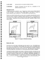
The Rocks Form records data on lithologies and rock samples at a site. The ROCKS table
has a many-to-one relationship with the SITES table and also with the OUTCROPS table
if an outcrop record exists for a site. This is a natural relationship as a number of different
lithologies and samples commonly occur at the one site. The primary key for the Newton
is the Site ID (links the various tables), it is system-generated Site Number in OZROX.
A Sample ID uniquely identifies each sample or lithology description. By default the Site
ID is the basis of the Sample ID. If there is more than one description at a site the Site ID
is typically modified by adding letters (e.g., 96834000A, 96834000B, 96834000C etc).
This is the recommended system, as it ensures the connection between samples and sites is
clear. For each new lithology or sample description press the right hand Index scroll
I
Australian Geological Survey Organisation
13
•
buttons at the top of the screen and the Sample ID will 'increment' from A to B and so on.
It is recommended that all attributes and structural recordings to a lithology be entered
together and that the user return to this screen for subsequent lithologies and their
associated attributes and structures. This is because scrolling down to LITHDATA and
STRUCTURES (see later) will ensure that the link between this data and rocks is
maintained.
SAMPLE ID -^The default Sample ID uses the Site ID as a prefix, followed by a
series of letters for different lithologies at the same site. This can
be overwritten if required.
ROCK TYPE -^An optional field for a first-pass field classification of rock types
(Pulldown Menu).
AGSO FieldPad
Rock for site 96496005
Ill^Index^PI' 1111
• Sample ID
Delete
9 1496005A
1^rnetasedirnent
• Province 6:Murphy Oilier
• Rack Type
• Stratigraphy ^
meto:friET
• Lith Qual 2 garnet : GNI
• Lith Qua! I
• Lith Qual 3
• Lith Name
gOICIfillte : QZT
Figure 11 - The Rock for site entry
form.
1.11, : Proterozoic
• Map Symbol Af:"Metornorphosed f..
• Age
• Mode Of Ott
• Desc
Names
A^
• Other
0 44t
-
P
Dates Extras^Undo^Find
. n -
Ass ist
PROVINCE -^Optional field for the geological province, subprovince or domain
(Pulldown Menu).
STRATIGRAPHY - Optional field for the stratigraphic unit (Pulldown Menu).
LITH QUAL 14,3 - Optional fields for the qualifying term of a lithology e.g.,
'foliated', `porphyritic'. Fill the qualifiers in such a way that you
would expect to read them with the following lithology, so if you
have only one qualifying term use the qualifier 1 field; if two use
the qualifier 1 and 2 fields, and so on (Pulldown Menu).
LITH NAME -^Optional field for the lithology (Pulldown Menu).
AGE -^Optional code for the age of the lithology (Pulldown Menu).
Australian Geological Survey Organisation
14
MAP SYMBOL
Optional field for the map symbol of a lithological unit. This field
should only be entered if there is no formal lithostratigraphic unit.
It is designed for the type of informal units traditionally used for
geological mapping in the Yilgarn Craton and Anmta Province
(Pulldown Menu).
-^
MODE OF OCC
DESC
Optional field for the mode of occurrence of a lithology or sample for example 'xenolith' (Pulldown Menu).
-^
Optional 64 character free-text field for a description of the
lithology.
-^
OTHER
A 64 character optional free-text field that may be used for any
data not covered by the above fields that the user feels are relevant,
such as general remarks.
-^
Lithology for sample
This form allows any number of attributes to be added to the description of the sample
(lithology). Attributes should be added only to the lithology they describe and that is why
you must fill in attributes for each lithology separately (it saves jumping between screens
and ensures internal relationships between the data are maintained).
Five attributes are displayed on a single screen, more can be added by using the scroll
buttons at the bottom. Attributes or data types (e.g., colour, igneous texture, grain size)
have values or subtypes (e.g., green). These are all optional fields. Records can be deleted
by pressing the record number on the left hand side of the record to be deleted.
AGS0 FieldPad
Lithology for sample 96496005A
Type SubType
Description
0
•Type
COL
• Sub Type
G
•• •• •
• Desc ^
CI •Type MAG
• Desc
• Sub Type
^• •••
• Sub Type
:fine
20
• Type
GS : ^
• Desc
MAX : maximum
ME : mean
MIN : minimum
4.. i ype ^ •Sub Type
Figure 12 - The lithology for sample
entry form.
• Desc
141 4N^Scroll P. II* I.4
4C> e
Names Dates Extras^Undo
Find^Assist
Australian Geological Survey Organisation
15
^
^
TYPE -^Types are any attribute included in the pulldown menu, such as
colour, alteration, thickness, texture (Pulldown Menu).
SUBTYPE -^Subtypes are mandatory attribute values unique to each Type
(Pulldown Menu).
DESC -^This is an optional free-text field of 64 characters for any
additional descriptive information relating to the Type/Subtype
record. For example, one may wish to comment on the mode of
occurrence of a mineral in a sample. You can over run onto lines
below, but only 64 characters can be stored on a single line. To get
around this, just repeat the Subtype and carry on writing. Tap the
diamond to open up a clear page for data entry.
Structure for sample
The Structures Form, corresponding to the STRUCTURES table, allows observations of
mesoscopic to macroscopic geological structures to be related to the lithologies and
stratigraphic units in which they are found. The structural readings are linked by a many-toone relationship with ROCKS. This means that structures should be entered with the
lithology in mind. Five attributes are displayed on a single screen, more can be added by
using the scroll buttons at the bottom.
AGSO FieldPad
..-Structure for sample 96496005A^
Type^Sub Type
Az^Ind^DefNo DefSu PRank
fra-1
• Type 1 :
^ •Sub Type 1
300 180 I
0 •Type
•
3 : Fo...
^I^
^ I^
• sub 1
- -
1 : Foliation dipping
2 : Foliation vertical
0 •Type ^ 3 : Foliation horizontal
^I^
^0 •T y pe ^
•Sub Type ^
Figure 13 - The Structures for
^ I ^ 1^ I ^ I ^
0 •Type
•Sub Type ^
^I^ I ^ I^
I 14 44 .4 scroll^Oil
IC>
e g:
Names Dates Extras ^Undo
p
Find^Assist
Australian Geological Survey Organisation
16
sample entry form.
TYPE & SUBTYPE
Structural features are stored as a mandatory type and a subtype
(e.g., bedding that dips is type 1 subtype 1). We use this system
rather than traditional structural systems as it makes map making
easier. For example, S, is the second generation fabric but it may
be a cleavage, crenulation cleavage, mylonitic fabric and so on.
The Type and Subtype system allows the geologist to distinguish
the different fabric elements (Pulldown Menu).
-
AZ -
Azimuth is the direction of dip, between 00 and 359° oriented 90 0
to a strike. This is important as the plotting routines will rotate
(place) the symbols in an incorrect orientation if one uses strike.
INCL -
Inclination is the amount of dip between 00 and 90 0 . The value
provided will be placed along side the relevant symbol in the GIS
plotting routines.
DEFNO -
Optional field to store the deformation number or generation of a
structure (e.g., bedding would be 0 and the first cleavage would be
1). It is particularly useful when the generation of a foliation or
lineation is known (or inferred), for example F3 would have a 3 in
the defno field.
DEFSU -
The deformed surface number is the generation of the surface that
is deformed by a subsequent generation of structure (it is used in
conjunction with defno). For example, a third generation fold of
an second generation surface (F3 2) would be type 3, defno 3,
defsu 2.
PRANK
A positive integer of up to 3 digits indicating the order of
importance in plotting the structure on a map. Where a number of
structures have been measured at the one locality, plot rank
determines which structures will be plotted first. On maps plotted
by computer, only one structure can generally be plotted at any one
point on a map.
Site search
The Site Search Form allows users to search for, delete or create new sites. To search for a
Search
particular site enter the Site ID in the Search for field then press
. To edit a site
select the Site ID and then press the edit Site ID button which is displayed on selection.
Deleting a site is done the same way except by pushing the delete button.
Australian Geological Survey Organisation
17
['"············ ..·····"··AGso·i'iei·jjp·,,if···············,,·"'''''''''''''''!
! -Site Search
~ [Store) [Delete I
I
!
Search for:
iY: I
Search all field5
Search] ......
V' . . . . . . . .
64"6004
96496000
96496005
96,496.001
9t:496006
96,496,002
96.496,003
96496007
Figure 14 - The Site Search
form.
96040056
xt i
!@~®:~p=o/-I
i..~~.~.~: . . .~.:~~.~. . . ~~~~~.~. . ~
Undo
Find
ASSI$t...l
Utilities
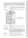
The Utilities Form manages the transfer of site records (Book Entries) to a PC or laptop
and the clearing or indexing of the AGSO FieldPad pulldown lookup tables (these are
sometimes called soups in Newton terminology). On the utilities page there is a scrolling list
of lookup tables. Lookup tables can be cleared individually or all together. To clear them
individually scroll to the required soup and highlight its name, then press the clear soup name
button which pops up below the scrolling list. To clear all lookup tables press the (. Options J
button and then choose Erase All Lookup Tables from the pop-up menu. Large lookup tables
can take some time to clear particularly if available memory is low. With any new lookup table
indexing is required. To index the lookup tables press the (* Options J button and choose Index
All Lookup Tables. Site descriptions can be stored on flash card or within internal memory. It is
recommended to use flash card as they are much safer for storing data than internal memory (tick
box).
Below the lookup table list is a control panel for Upload{ingJ Book Entries. For
information on how to transfer site descriptions to a PC see the section on Uploading field
sites to a PC below.
i·····································AGSi)"f'j·ei·dP·ad· .....................................,
!1,..Utilities
II
,!
!
~
10 book il!!!nt:rie~
fjf Store new entries 0,n_'_._rd_ _......
Clear BookEntries ) (. Options
i
AG50_(ounlrie"M.pp.d
AG50_GooProv.:M.pP ad
AG50_GeoRogion"MapPad
r::i
Seri~1
l'GI:t:I'Il
Figure 15 - The Utilities
form.
Port:
c:; RS·232
•
Infra-Red
.Baud .,800
Upload Book En~ri".
10
it"Q ~
lID!
€I:. . . . .P. . . :0/-1.
i;J
L~~.:.~~. . .~~:~.~. . . =~~~~.~ ~ ~~~.~~ ~~.~ ~~~:~~ ..I
Australian Geological Survey Organisation
18
TRANSFERRING DATA TO AND FROM THE NEWTON
Apple Newton Backup Utility
Install the Apple Newton Backup Utility on your PC or laptop and plug in the Apple Newton
serial cable to both the Newton and the PC or laptop.
•
Checking memory
Start the Newton. Before installing a package on the Newton check that there is enough memory
1111^available, either internally or on the flash card. Memory information is available by pressing the
icon. It may be necessary to remove some packages if there is not enough memory
111^available. To remove a package hold the scribe on the screen until a large dot appears and
•
•
the Newton squeaks, then drag the scribe across the icon to highlight it. Next select the
envelope icon at the bottom right of the screen and choose delete from the pop-up.
To store a package on the flash card open the icon called card. There is a check box in this
window which allows you to choose where you want to store new packages either on the card
or in internal memory.
Installing a package
•
Open the Newton connection icon in Windows. The first time that you use the Connection utility
you may need to set the communications information. Under the Newton menu option on the
menu bar select the settings option. The baud rate should be 9600 and the communications port
will be either comml or comm2.
the communications information is right, then press the connection icon on the Newton, then
rn^Ifpress
the connect icon. When a connection has been established the buttons in the Newton
•
Backup Utility on the PC will no longer be greyed out. Install a package by pressing the install
package button.
111
At times connection can be difficult to establish particularly for non-Pentium computers. If you
have trouble, check the baud rate which should be 9600, and also check which port you are
using. It should be the same one that the serial cable is plugged into. If you still cannot establish a
connection try restarting the Newton and also Windows.
Uploading field sites to the PC
Field sites are uploaded to a PC using the Windows Terminal programme. The Terminal
programme is usually found in the Accessories Group. To communicate with the Newton
Terminal requires a parameter file. Open the parameter file by choosing open file from the File
menu. If a parameter file does not exist create one by choosing new from the File menu. Then
from the setting menu choose communications. In the communications dialog box select the
communications port that you are using and then the baud rate which should be 9600. Next
select save as from the file menu and give the parameter file a name that you will remember like
Australian Geological Survey Organisation
19
Newton. To upload field sites choose receive text me from the transfers pulldown menu. Next
select the directory and file name to which you want to save the uploaded data and press OK.
The PC is now read to receive uploaded site records. On the utilities page in FieldPad press the
Upload8ookEntries
button to commence the data transfer process.
Installing lookup tables
Provided with each Newton is a disk containing lookup tables copied from the ORACLE
database. The lookup tables are stored as tab-delimited files in a directory called data. These files
can be edited, if required, in any text editor to obtain a subset of values.
A tab-delimited text file for loading into FieldPad has the following format.
1. A header with the soup name, and name and format of the data columns.
2. Tab-delimited columns of data, either two columns or three.
3. Each file is terminated by the string BYE!.
If you have more than one table to load they can be appended together into a single file. The
Newton will know when one soup has finished loading when it reads the terminating string
BYE!. It will then interpret the next line as a new table. A batch file has been set up to output the
files containing the lookup tables in the correct format. The following describes the steps in
creating and loading lookup tables.
I. Export tables in tab-delimited format, without any quotes around fields from the Oracle
database. For two-column files the format is code, then description. There are two three
column files, the subtypes for lithdata and subtypes for structures files. These files have the
format: subtype code, datatype code, description.
2. The table files should be stored in the DATA directory with the file extension TAB
3. Run the MERGE ALL batch command from a DOS prompt. The MERGEALL batch file
is in the directory called TABLE. Also in this directory are the headers for all the lookup
table files and a file containing the BYE! string.
4. MERGEALL merges each lookup table file with its header and the terminating string
BYE!. The tables ready to download are created in the DOWNLOAD directory. There
is a .TXT file for each table. A merged. TXT file is also created which contains all the
tables, allowing downloading of all tables in one operation.
5. Ensure the table(s) you are about to download have been removed from the Newton,
otherwise the new table data will be appended to the existing tables.
6. Removing tables from the Newton can be done via the Utilities form in FieldPad, or via
the Newton as. Removing tables via the Utilities form is probably the easiest method
and has been described above.
7. To make the Newton ready to receive text files start Siurpee. When Siurpee is open the
Newton is ready to receive text files. In Terminal under the Transfers pulldown menu choose
send textjile. Select the file that you wish to send and click OK. The file will be transmitted
Australian Geological Sllrvey Organisation
20
•
•
•
•
••
•
••
•
••
•
••
•
••
•
••
•
•
••
•
••
••
••
••
^
U
rn^
and you will be able to see each line displayed by Slurpee as it is loaded. When a table has
finished loading the Newton will make a "werp" sound. Soup loading is a relatively slow
process and will take some time for large soups. Loading rates seem to be about 2 lines per
second.
8. After loading tables INDEX all the soups via the Utilities form as described.
Trouble shooting
Error message when a pop-up list is chosen.
Sm!) is empty or not indexed.
Try indexing the soups. If this doesn't work go to the utilities page and try deleting the
soup. A pop up window will ask if you want to proceed, it will also tell you how many
.
•
•
records are in the soup. If there are no records in the soup, load a new soup and then index
it.
1111^Unable to establish a connection with the Newton.
Check the serial cable is connected to both the Newton and the PC.
111^Creating MapPad Maps
10
1111
This programme converts .dxf maps into MapPad packages for loading into the Newton.
Dxf files can be created from arc coverages by using the arcdxf command. Maps can be any
polygon, line or point coverage. You may wish to load the topography, culture, geology,
geophysical interpretation, sample localities, and/or key sites or traverses. Note that the
size of the image file being created (not the dxf input file) should not be greater than 880Kb
as the Newton operating system is currently unable to create images of a larger size. By
way of example, a sample of Melbourne roads started as a 4.5Mb dxf file and resulted in a
1:26000 scale MapPad image with a size of 880Kb. RIA has frequently converted 15Mb
.dxf files into 800Kb MapPad package files with a scale of 1:15000.
1111^When loading a dxf file, MapPad looks for a corresponding Projection file (.prj) and Layer
control file (.1yr). If no corresponding files are found, DEFAULT.PRJ and DEFAULT.LYR
are searched for in the same directory as the dxf file. If these are not found then default
values are used.
.PRJ Files
011^A .prj describes the map projection of the .dxf file, and contains the default description
information. An example of the file Melbour.prj (UTM projection) is set out below:
1111
111^
Australian Geological Survey Organisation
21
••
•
••
•
•
••
The only lines that need changing to your specific map sheet are ones with the
* symbol.
.LYRFiles
The lyr files control the visibility and style attributes for layers in a dxffile. Note, it is not
necessary to have a .Iyr file to create a map.
Style
Width
TxtFG
TxtBG
*
lCOAST
IDRD
IDRDUS
IFWY
0
1
1
1
1
0
0
0
1
0
0
2
0
0
5
1
1
1
1
1
1 FWYUC
1
1
5
IHWY
1
0
4
IHWYUS
1
1
4
0
0
0
0
0
0
0
0
#Name
Include
1
1
1
Comment lines begin with #, and are ignored.
The file must contain six columns of information for each layer.
The first column contains the layer name, if the layer name is
value for all unspecified layers.
* then this sets the default
The second column determines the specified layer's visibility 0 = Off, 1 = Visible. The
example turns off all layers except those specified.
AUSlralian Geological Survey Organisation
22
••
••
••
•
••
•
••
•
••
•
••
•
•••
••
••
The third and fourth columns specify line style and width. Styles available are
0 Solid
1 Dash
2 Dot
3 Dash Dot
4 Dash Dot Dot
The fifth and sixth columns specify text foreground and background colour.
0 1^is Black text on a clear background
1 0^is White text on a solid black background
Creating the MapPad Package
This programme (Tsmappad.exe) only works on a Windows 95 PC.
Go to File and Open your dxf file and select a custom scale then select custom. Wait while
the map is created. A useful scale is 1024 (equates to a square 1024x1024 pixel map) or for
larger scale try 2048. More than one scale of map can be created and loaded into the
Newton.
Once an image of satisfactory size and scale has been created select Create.
Open File and select from the MapPad subdirectory a template package file (*.pkg) of
similar size (e.g., s1024.pkg for the 1024 scale option) for pasting the map you have just
created. Select Create then Save As with a new name for the map sheet you have created.
Select the sub-directory for the image.pkg you are about to create and SAVE.
Once the package (*.pkg) file(s) have been created they can be loaded into the Newton for
use. See the section on communicating with your Newton above.
Tricks and Tips
To help with hand writing recognition:
• build up a comprehensive dictionary, the Newton operates by trying to match words;
• add extensions (aliases) to common words;
• go through the Newton exercises and read the manual carefully.
To help with entry and editing:
• if the handwriting recognition is working poorly use the keyboard feature (double tap the
screen);
• try making up pro-forma sites and give them names that can be easily distinguished so
they can be retrieved and customised to each unique outcrop. Be careful doing this.
Australian Geological Survey Organisation
23
••
Acknowledgements
We would like to thank David Champion and Sonja Lenz for their critical reviews of early
drafts of the manuscript.
References
Blewett, RS., 1993. The AGSO field geological notebooks - a user's guide. Australian
Geological Survey Organisation, Record, 1993/46.
Ryburn, RJ., Blewett, RS., Stuart-Smith, P.G., & Williams, P.R., 1993. Users' guide to
the NGMA Field Database. Australian Geological Survey Organisation, Record,
1993/47.
Ryburn, RJ., Bond, L.D. & Hazell, M.S. 1995. Guide to OZROX. AGSO's Field Geology
Database. Australian Geological Survey Organisation, Record, 1995179.
Ryburn, RJ. & Bond, L.D., 1995. Guide to AGSOREFS: AGSO's shared bibliographic
reference database. Australian Geological Survey Organisation, Record, 1995/6.
•
•
••
•
•
•
••
•
••
•
•
••
••
•
•
••
Australian Geological Survey Organisation
24
••
••
••
•
••
•
•
•
•
Appendix 1 - Technical Specifications for Newton 130 3
•
Newton Intelligence Newton Recognition Architecture
. Recognises handwriting--printed, cursive, or a mixture of the two--with the assistance of a 93,000-word,
111^built-in word list
• Lets you add up to 1,000 words
III^• Includes four pop-up keyboards: typewriter, numeric, phone, and time/date
• Recognises graphics and symmetrical objects
111^
I
•
Newton Information Architecture
• Object-oriented database stores. finds, and links information and provides a flexible view of this data
•
. Newton Toolkit lets you easily create custom applications using its flexible graphical toolbox
• Architecture lets you easily share data across applications
•
•
Newton Communications Architecture
• Provides built-in support for serial communications, PC card modems, sending and receiving faxes, and
II^electronic mail
• Provides a single interface for modular, object-oriented communications services
111^• Provides improved performance with Internet communications applications and multitasking support
• Supports new communications capabilities through its modular design
II^• Supports Class II Fax
•
111^
I
•
1111
Intelligent Assistance Architecture
• Helps users complete repetitive tasks in multiple categories, including communications, scheduling,
finding, and reminding functions
. Contains smart defaults to reduce complexity
• Works in and between applications
• Supports third-party extensions
MessagePad Hardware Architecture
• ARM 610 RISC processor at 20 MHz
• Apple custom system ASIC
•
• Low-power, transflective LCD display with EL backlight (320 by 240 pixels) 9.6 cm by 7.2 cm.
• Nonglare writing surface
• Telescoping pen
• 8MB of ROM; 2.5MB RAM (1.199K of system RAM; 1,361K of nonvolatile user RAM)
1111^
• One PC Card Type II slot with 325 mA capacity
1111^ LocalTalk and RS-232-compatible serial port
• Low-power. half-duplex. infrared transceiver that works at up to 38.4 Kbits/sec within 1 m.
1111^• Protective, removable lid
•
111
•
Communications capabilities
• Prints using a variety of serial, parallel, and network printers
• Receives and stores wireless messages using optional messaging cards
3 Specifications
from Apple (http://nemon.info.apple.com/newton/solutions/messagepad130ds.html)
111^
111
Australian Geological Survey Organisation
25
•
•
•
•
•
•
Communicates via e-mail or taps into on-line services and the Internet with optional wired or wireless
modem cards and software
Provides faxing with optional fax modem (automatic cover-page generation, post-formatting)
Beams notes, name cards, appointments, and packages at up to 38.4 Kbits/sec within 1 musing highspeed infrared
technology
Automatically dials phone calls with assistance from intelligent auto-dialing (DTMF or modem dialing)
Connects to cellular or GSM phones for wireless data and fax communications
Size and weight
• Length: 20.32 cm
• Width: 10.16 cm
• Height: 2.9 cm
• Weight: 0.48 kg without batteries
Operating environment
• Temperature: 0-40°C
• Storage temperature: -20-47°C
• Transit temperature: -20-65°C for up to 72 hours
• Relative humidity: 20% to 90% noncondensing
Power requirements
•
•
•
•
•
•
•
Power adapter
Universal, 100 to 240 V AC, 50/60 Hz
Four plug configurations: Australia, U.K., Europe, and U.S.A.
Battery type: AA (LR6) alkaline or NiCd Battery Pack
Lithium cell: DL2032 (3 V nominal)
Built-in fast charger for optional NiCd Battery Pack
Power source: four AA alkaline batteries (included), optional power adapter, and optional NiCd
Rechargeable Battery Pack
Computer connectivity requirements
•
Works with PC-compatible computers with 80386DX or later processors running Windows version 3.0
or later
• Works with Mac OS-based computers with 68030 or later processors and system software version 7.1 or
later
Printer support
•
•
•
•
Offers built-in printer support for Apple LaserWriter Plus (and other PostScript-equipped LaserWriter
printers), Personal LaserWriter
LS, and Personal LaserWriter 300, as ,veIl as StyleWriter I and II printers
Works with most popular PC printers, including the Hewlett-Packard LaserJet II DeskJet 500, Canon
BubbleJet 1Oe, and Epson LQ and
FX, using the optional Newton Print Pack
Australian Geological Survey Organisation
26
•
•
•
••
•
•
•
•
••
•
•
•
•
•
••
•
••
•
•
•
•
•
•
•
••
•
•
••