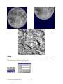
1
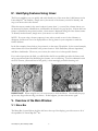
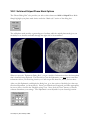
High Resolution Lunar Software
Lunar
Map Pro
TM
Basic Edition
User Guide
™
TABLE OF CONTENTS
I. Getting Started: ...........................................................................................................................4
II. Desktop Icon:..............................................................................................................................5
III. Working With Maps: .........................................................................................................5
III.1 Map Orientations .......................................................................................................................6
North Up ...........................................................................................................................................................6
North Up Reversed............................................................................................................................................6
South Up ...........................................................................................................................................................6
South Up Reversed............................................................................................................................................6
III.2 Changing the Default Map...................................................................................................6
IV. Identifying Features Using Hover:........................................................................7
V. Overview of the Main Window:................................................................................7
V.1 Menu Bar .........................................................................................................................................7
V.2 Tool Bar............................................................................................................................................8
V.3 Status Bar ........................................................................................................................................8
VI. Using The Navigator Window: ................................................................................9
VII. Menu Items and Tool Bar Functions: .............................................................11
VII.1 File Menu ...................................................................................................................................11
Open
......................................................................................................................................................11
Set Default ......................................................................................................................................................11
Redraw ............................................................................................................................................................11
Copy................................................................................................................................................................12
Write Image ....................................................................................................................................................12
Print
....................................................................................................................................................12
Print Setup.......................................................................................................................................................13
Most Recent File List ......................................................................................................................................13
Exit..................................................................................................................................................................13
VII.2 View Menu ...............................................................................................................................13
Toolbar............................................................................................................................................................13
Status Bar ........................................................................................................................................................13
Compass..........................................................................................................................................................13
VII.3 Zoom Menu ..............................................................................................................................14
By Rectangle
Step In
........................................................................................................................................14
..................................................................................................................................................15
Step Out
................................................................................................................................................15
Set Scale..........................................................................................................................................................15
Lunar Map Pro [Basic Edition] 1/2003
1
Reset
....................................................................................................................................................16
VII.4 Pan Menu ...................................................................................................................................16
Center at Click
......................................................................................................................................16
Center … .........................................................................................................................................................17
Drag
......................................................................................................................................................18
Step North / Step South / Step East / Step West
.............................................................19
VII.5 About Tool
...................................................................................................................19
VII.6 Tool Menu .................................................................................................................................20
Labeler Tool - Labeling by Feature Type .............................................................................20
Labeler Feature Designations..........................................................................................................................22
VII.7 Lunar Menu ..............................................................................................................................25
Time ................................................................................................................................................................26
Phases..............................................................................................................................................................26
Ephemeris .......................................................................................................................................................26
Field-of View ..................................................................................................................................................27
Landing Sites (Manned and Unmanned) ...............................................................................28
VIII. Working With Lunar Phases ................................................................................28
VIII.1 Using Automatic Phase Settings ................................................................................28
VIII.2 Solid and Striped Phase Mask Options ..................................................................31
VIII.3 Choosing Your Own Phase Settings ........................................................................32
IX. Using Eyepiece Field-of-View Maps ...............................................................35
X. Adjusting Dialog Boxes: ................................................................................................38
XI. Printing Documents: ........................................................................................................39
Fill Paper.........................................................................................................................................................39
Page Orientation..............................................................................................................................................40
Fit To Paper.....................................................................................................................................................40
Colours............................................................................................................................................................41
MAP FORMAT SAMPLES ...........................................................................................................................41
Appendix: Facts About Lunar Map ProTM [Basic Edition] ..................................43
Copy Protection ....................................................................................................................................44
Why is Lunar Map ProTMBE Copy Protected?................................................................................................44
Glossary of Terms .........................................................................................................................45
Azimuth...........................................................................................................................................................45
Barlow Lens ....................................................................................................................................................45
Colongitude (Solar).........................................................................................................................................45
Crescent Moon ................................................................................................................................................45
Eyepiece Field-of-View ..................................................................................................................................46
First Quarter ....................................................................................................................................................47
Focal Length, Eyepiece...................................................................................................................................47
Lunar Map Pro [Basic Edition] 1/2003
2
Focal Length, Telescope .................................................................................................................................48
Full Moon........................................................................................................................................................48
Gibbous Moon.................................................................................................................................................48
Last Quarter ....................................................................................................................................................48
Libration (Lunar).............................................................................................................................................48
Lunation ..........................................................................................................................................................48
New Moon ......................................................................................................................................................49
Selenography...................................................................................................................................................49
Terminator (Lunar) .........................................................................................................................................49
Transit Time (Lunar).......................................................................................................................................49
Waning (Moon)...............................................................................................................................................49
Waxing (Moon)...............................................................................................................................................49
References: ..............................................................................................................................................50
Lunar Map Pro [Basic Edition] 1/2003
3
I. Getting Started:
Congratulations on your purchase of Lunar Map ProTM [Basic Edition]. Lunar Map ProTMBE, is
the highest resolution lunar application ever developed for WindowsTM, and contains a host of
features that will add to your knowledge of the moon, and increase your enjoyment of the hobby.
Please take the time to read this document, and you will soon be exploring and navigating the moon
like an expert. Clicking on selections in the Table of Contents, will allow you to quickly move to
areas of interest. The User’s Guide can also be printed, if you would like to retain a hard copy
reference manual.
Lunar Map ProTMBE, is a WindowsTM based software product, so if you are already familiar with the
features and protocols of WindowsTM programs, this product should be easy for you to master. The
recommended System Requirements and Settings are:
Operating System:
Speed:
RAM:
Hard Drive Space:
Screen Resolution:
Screen Color:
WindowsTM 98, 98 SE, ME, NT, XP
300 MHz or faster
96 MB or more
130 MB recommended
1024 X 768
At least 16 bit
Now that you have completed the installation procedure, all Lunar Map ProTMBE, data files have
been stored on your hard drive. This insures that your software operates at maximum efficiency.
Since the entire program is downloaded from your CD to your computer, Lunar Map ProTMBE,
incorporates a disc based, copy protection feature. This feature permits you to install your software
on as many computers as you like, but the original CD must be placed in the CD ROM drive in
order to open the program. Once the program is running, the CD may be removed for storage.
(For additional information on our , please consult the Appendix.)
If you have additional questions or comments concerning Lunar Map ProTM[Basic Edition], or you
require technical support, please contact:
Reading Information Technology, Inc.
274 Main Street, Suite 302
Reading, MA 01867 USA
Phone:
Fax:
Email:
Web Address:
1 (781) 942-1655
1 (781) 942-2161
[email protected]
www.riti.com
If you do not require immediate assistance, we recommend that you contact us via Email. Please
provide a brief description of the problem, and our technical support staff will contact you. If you
need to contact RITI technical support by phone, please call us during our normal business hours:
Monday – Friday, 9:00 AM – 5:00 PM Eastern Time
Lunar Map Pro [Basic Edition] 1/2003
4
II. Desktop Icon:
Once the software is installed, the Lunar Map ProTMBE, Icon is placed on your WindowsTM Desktop.
Double-click on the icon when you want to start your software.
III. Working With Maps:
Lunar Map ProTMBE, provides three approaches to working with maps. The most general, displays
the map without regard to phase or field-of-view. The Phase display adds real-time phases to the
map, and the Field-of-View display lets you create custom eyepiece Field-of-View maps, for use at
your telescope.
When you first open Lunar Map ProTMBE, a North Up, full disk image (raster) map, is displayed as
the “default map,” and phase and field-of-view information are not activated. In this state, the
software is useful for general Exploration of the lunar surface. Since you are able to view all of the
lunar features, it is an excellent approach for armchair astronomers and students. The database
contains nearly 1,100 named features, so there is plenty to keep you busy for a long time.
When you add Phases to the map, it becomes a real-time tool for planning an evening of lunar
observing. This display allows you to view the current lunar phase, or any other phase that you
choose. Since the phase mask has been fully adjusted for lunar libration, the map’s terminator
always closely matches the position of the actual lunar terminator. (For more information about
, consult the Appendix.)
The phase display makes it easy for you to determine which features are located near the terminator,
so you will always know the best dates and times to observe your favorite features. In addition, this
display makes it easy for you to determine which features are hidden from view during different
phases. Armchair astronomers will also enjoy using the Phase display to view the terminator
throughout the lunar cycle.
There is also an Ephemeris, (which is discussed later), that provides the lunar rise, transit, and set times,
along with other meaningful data. The Ephemeris makes it simple for you to determine the best
time to begin your observing sessions.
Adding the Field-of View capability to the map provides you with the ability to display or print
custom eyepiece Field-of-View (FOV) maps, for use at your telescope. This unique feature allows
you to match the map view to your visual view, for any telescope-eyepiece combination. When
FOV is displayed in combination with the correct map orientation for your telescope, Lunar Map
ProTM becomes a powerful real-time observing tool, for the easy identification of lunar features.
Lunar Map Pro [Basic Edition] 1/2003
5
III.1 Map Orientations
There are four different map orientations provided by the Lunar Map ProTMBE software.
North Up
The North Up view is the image correct, or (naked eye) view, for Northern Hemisphere observers.
It is also the correct map orientation when observing the moon with binoculars, terrestrial-spotting
scopes, or astronomical telescopes utilizing image correct diagonals. Southern Hemisphere
observers should use this map when observing with Newtonian Reflectors. The North Up map is
also initially opened as the program’s default map.
North Up Reversed
The North Up Reversed view matches the view seen through refractors and compound telescopes,
such as Schmidt-Cassagrains (SCTs), and Maksutovs, utilizing 90-degree star diagonals.
South Up
The South Up view is the correct map when you are observing with a Newtonian Reflector. This
map also provides an image correct, or (naked eye) view, for Southern Hemisphere observers.
South Up Reversed
The South Up Reversed map is designed primarily for use by Southern Hemisphere observers,
using a 90-degree star diagonal with refractors or compound telescopes.
III.2 Changing the Default Map
It is easy to choose a different map orientation to replace the North Up Map as your “default map”.
Just use your mouse to open the “Folder Icon” on the left side of the Tool Bar, and click the desired
map choice.
EXAMPLE: NorthUp_Image.saf
After you open a new map, you can easily make it your default map. Open the File Menu and click
“Set Default.” A confirmation box will appear to confirm the change. Click the OK button to
delete the box. The new map will now be displayed whenever you open Lunar Map ProTMBE. You
can easily change it again by following the same procedure.
NOTE: Be sure you open a map file, and not one of the yellow file folders. If your
computer is set so that it displays file extensions, you will see .saf next to map file names.
Lunar Map Pro [Basic Edition] 1/2003
6
IV. Identifying Features Using Hover:
The Hover capability, lets you quickly and easily identify any of the more than 1,000 features in the
Lunar Map ProTMBE database. Simply move your mouse to the feature you wish to identify, and
stop your mouse above that feature.
When the mouse remains in the same location for more than ½ a second, the software knows you
are interested in feature identification, and identifies the feature via a pop-up box. If more than one
feature is identified at the pointer location, a short menu is displayed listing all of the feature names.
To identify another feature, simply move your mouse to a new location.
NOTE: If you are using a slower computer, it may take a second or two for the old name to
disappear, and the new one to be displayed due to the lag time for your computer to search the
feature database.
In the first example (shown below), the pointer is on the crater, Theophilus. In the second example,
three features have been identified at the pointer location: Palus Putredinus, Montes Apenninus,
and Mons Archimedes. The more you zoom in, the easier it is to isolate specific features.
If you take a laptop into the field, you will find that the Hover capability provides the fastest, and
most convenient method for identifying the features you are observing. Used in combination with
the FOV Feature, (discussed later in this guide), it is an amazingly powerful observing tool.
1
2
IMPORTANT: When using Hover, it is not necessary to click the Mouse. Occasionally the popup box may linger after moving your mouse. If that happens, just move the mouse again.
V. Overview of the Main Window:
V.1 Menu Bar
The Menu Bar, (located below the blue title bar at the top of the display), provides access to all of
the capabilities of Lunar Map ProTMBE.
Lunar Map Pro [Basic Edition] 1/2003
7
Each Menu item provides access to a drop-down submenu. Simply click on one of the Menu Title’s
with your mouse, to access the submenu list.
V.2 Tool Bar
Directly below the Menu Bar, you will see the Tool Bar, which contains some of the more
commonly used Lunar Map ProTMBE tools. The same tools that are located on the Tool Bar can
also be found in the drop-down submenus of the Menu Bar.
V.3 Status Bar
The Lunar Map ProTMBE Status Bar is located at the bottom of the screen display, directly above the
WindowsTM Task Bar. When you look at the right-hand side of the Status Bar, you will see a display
that says: Lat: Lon: Scale:
When your mouse cursor is placed on the map, the lunar latitude and longitude at the cursor
position will be displayed in the appropriate boxes. The readouts are given in degrees, minutes, and
seconds, along with the compass position of the coordinates. The dashes separate degrees from
minutes, and minutes from seconds. The readings in seconds are accurate to three decimal places.
The scale shows you the ratio between the map scale, and the size of the actual moon.
If you look at the left-hand side of the Status Bar, while your cursor is touching one of the Tool Bar
Buttons, you will see a written description of the button’s function.
The description corresponds to a drop-down hint box that will appear on your screen, just below
the selected tool button.
Lunar Map Pro [Basic Edition] 1/2003
8
NOTE: If your Windows TM Task Bar prevents you from seeing the Lunar Map ProTMBE Status Bar,
you can maximize your screen display, by mouse clicking on the center button of the WindowsTM
Icon, on the upper right-hand corner of your screen.
This procedure should place the Lunar Map ProTMBE Status Bar above the Windows TM Task Bar. If
you still cannot see the Lunar Map ProTMBE Status Bar, once the screen is maximized, click “Start”
on the lower left-hand corner of your Windows TM Desktop. Next, click “Settings” and then click on
the sub-directory, “Task Bar and Start Menu.“ Uncheck the box, next to the words “Always on
top,” and click OK.
VI. Using The Navigator Window:
The “Navigator Window” is an exclusive RITI feature that makes finding your way around the lunar
surface faster and easier than ever. The “Navigator Window” contains a full disk vector map that
appears at the lower left-hand corner of your screen, when the program is opened. (see below). It is
a LIVE MAP, so it is able to fully interact with the larger map, and visa versa. It also responds to
the navigation tools on the Tool Bar the same way that the large map does.
Since the Navigator Window draws a box around the area that you are viewing on the primary map,
you always have a bird’s eye view of your map position. In the example below, you can see a box on
the Navigator Window Map that is showing the exact location of the zoomed-in area displayed on
the primary map.
Lunar Map Pro [Basic Edition] 1/2003
9
If you want to jump to a new map location, while the primary map is still zoomed in, nothing could
be easier. Just use the “Centering” tool (as shown below), to click the spot on the Navigator
Window that you want to jump to, and you are done!
For your convenience, the Navigator Window can be dragged to other locations on your screen, and
it can be minimized when it is not being used.
The functions of all the
Lunar Map ProTMBE Navigation Tools, are discussed later in this manual.
NOTE: RITI chose to use a vector map in the Navigator Window for all of the map orientations,
because small vector maps form a cleaner, higher contrast image that makes feature identification
easier. Small raster maps become quite noisy, because of the excessive sub-sampling required to
reduce the map scale. This results in poorer contrast and resolution.
Lunar Map Pro [Basic Edition] 1/2003
10
VII. Menu Items and Tool Bar Functions:
This section provides a detailed description of each Menu Item, and Tool Bar Button. When a
Tool Bar Button performs the same function as a Menu Item, you will find the Tool Bar Button
listed with its associated Menu Item.
VII.1 File Menu
When you open the File Menu, you will find a list of several useful functions.
Open
Clicking on “Open…” or entering Ctrl+O, gives you access to a dialog box, showing all eight map
orientations. Be sure to open a map file, and not a yellow file folder. If your computer has
been set to display file extensions, the map files will show the extension .saf. This Menu Item
performs the same function as the “Open File Tool” button located on the Tool Bar.
Set Default
When Lunar Map ProTMBE is opened, the North Up Map is the displayed default map. If you want
a different map orientation as your default map, open the desired map, and click “Set Default”. A
confirmation box will appear on your screen to confirm the change. Click the OK button to delete
the box. The new map selection will now be your “default” map. You can always change it again by
following the same procedure.
Redraw
There may be occasions when the map graphics on your monitor fail to look the way they should.
This can be caused by an anomalous interaction between Lunar Map ProTMBE and some versions of
Lunar Map Pro [Basic Edition] 1/2003
11
the WindowsTM operating system. If this should happen, click “Redraw.” This will generally correct
the graphics.
Copy
If you click on “Copy”, the map display on your monitor will automatically be copied to your
clipboard. You can then open a program such as Microsoft WordTM, and add the map image to your
document. Simply open the Edit File in the new document, and click, “Paste”. This feature comes
in handy when you want to include graphics in written documents.
Write Image
If you click on, “Write Image”, you can save the monitor display, as a JPEG Image. This is a useful
feature, when you want to create a folder of images for later use. JPEG Images can also easily be
placed into your documents, or sent to friends via the Internet.
Click the “Write Image” Menu Item to display the, “Save As” Dialog Box. The “Save in” Window,
at the top, should display your WindowsTM System “Temp” Directory as the default file folder. The
default file name is “Image.jpg”. To store an image in a folder, name the image in the “File name”
Window, and click the “Save”, Button.
NOTE: If you are not familiar with using a WindowsTM “Save As” Dialog Box, please refer to
WindowsTM Help, for additional assistance.
Print
Clicking “Print…” or using Ctrl+P, will open your Printer Dialog Box, and provide you with basic
printing options. For a complete explanation of the various printing functions, please refer to the
section entitled: Printing Documents.
Lunar Map Pro [Basic Edition] 1/2003
12
Print Setup
This setting will allow you to make changes to your default printer settings. Please refer to the
section entitled: Printing Documents.
Most Recent File List
When you open different map orientations using the Open File Tool, the map file names are
displayed in this Menu Item list. This provides you with an additional location where you can
quickly access and open the maps that you use most often.
Exit
Clicking on Exit will close the Lunar Map ProTMBE program. This Menu Item does the same thing
as clicking the “Close Program X”, on the upper right-hand corner of the screen display.
VII.2 View Menu
Toolbar
If “Toolbar” is unchecked, all Tool Bar Buttons on your display are hidden.
Status Bar
When “Status Bar” is unchecked the Status Bar is hidden, and you will not be able to see the
Latitude/Longitude readouts or the Map Scale information.
NOTE: Hiding the Toolbar and Status Bar maximizes the area available to display the map, so the
moon appears as large as possible. Remember, however, that you are trading the convenience of the
Tool Bar and/or Status Bar data for a small increase in map size.
Compass
When “Compass” is activated, a compass is displayed in the upper left-hand corner of the screen.
Compass directions can be very helpful, especially when you are using features such as zoom. (The
Zoom capability is discussed in the next section of this document.)
Lunar Map Pro [Basic Edition] 1/2003
13
IMPORTANT: Most of the tools will cause the software to draw new graphics on
your screen. Prior to starting a new task, be sure you allow sufficient time for the
software to fully update the screen display, or you may inadvertently freeze the
program.
VII.3 Zoom Menu
These Menu Items make it easy for you to select various lunar regions and features that you want to
explore in more detail.
By Rectangle
This function allows you to select any area of the map and zoom-in as much as you like. Simply
hold down the left key on your mouse, while you drag your mouse over the location that you want
to examine more closely. You will see a rectangle form around the selected region of the map.
When you release the mouse, the selected area will be enlarged. You can perform the same function
by using the “Zoom by Rectangle Tool”, on the Tool Bar. This function can also be used in the
Navigator Window.
Lunar Map Pro [Basic Edition] 1/2003
14
Step In
To zoom-in, without changing what is currently centered in the map field, you can use the more
general Step-In feature. Each time you click on it, you increase the map’s image scale by 50%. The
“Zoom-In by 50% Tool”, on the Tool Bar, will achieve the same result.
Step Out
The Step-Out feature reverses the actions of the Step In feature. Each time you click on it, you
decrease the map’s image scale by 50%. You can use the “Zoom-Out by 50% Tool”, on the Tool
Bar, to perform the same procedure.
Set Scale
The Set Scale feature is designed for those situations when you want the map to be displayed at a
very precise image scale. This may be necessary if you are involved in a project, in which using a
specific map scale is critical to your work. When you click on Set Scale, the following dialog box
appears on the screen.
This box shows you the size ratio between the map display and the actual lunar disk. It contains the
same information that appears on the Lunar Map ProTMBE Status Bar. To precisely increase, or
decrease the size of the map image, type a new value into the window, and click OK.
Lunar Map Pro [Basic Edition] 1/2003
15
Reset
When you click “Reset”, the map always returns to the full disk (default size) image. You can click
the “Show Entire Map Tool” on the Tool Bar, for the same result.
VII.4 Pan Menu
These Menu Items make it easy for you to move around on the surface of the map.
Center at Click
This function allows you to select any feature on the map, and quickly center it on your monitor.
To activate the function, use your mouse to click on the Menu Item, or select the Center-at-Click
Tool, shown above. Now move your mouse to the feature that you want to center in the field of
view, and click on it. The map will be redrawn with the selected feature centered on your screen.
The tool also works extremely well in the Navigator Window.
In the examples below, this tool was used to center the map on the crater, Clavius, located in the
moon’s Southern Hemisphere. Once the crater is centered, you can use the “Zoom-In Tool”, to get
a close-up view of the crater, as shown in the next image.
Lunar Map Pro [Basic Edition] 1/2003
16
Center …
The Center … feature lets you center the map at a very precise Latitude and Longitude. Clicking on
this item brings up the following Dialog Box.
Lunar Map Pro [Basic Edition] 1/2003
17
Type in the coordinates, (as show below), and click OK. The map will be centered at that exact
location. Once done, you can easily zoom-in, to achieve greater image scale at the selected
coordinates. You can also enter decimal points to make the coordinate positions even more precise.
Examples: 10.7N, 25-14.5W, or 73-02-43.75S
Drag
When you use the zoom tool to increase the scale of the map, you may want to examine an adjacent
area, while leaving the map scale fixed. The “Drag” tool makes it possible for you to navigate in any
direction you choose. The “Set Drag” tool, on the Tool Bar performs the same function.
Click on “Drag”, and place your cursor on the map. Next, slowly drag the mouse while holding
down the left button. As long as the button is held down, grid lines will appear on your screen to
aide you with the repositioning of the map. When you release the mouse key, the map is redrawn at
the new position.
Lunar Map Pro [Basic Edition] 1/2003
18
Step North / Step South / Step East / Step West
These four Menu Items collectively perform the same type of function. After your map field is
zoomed in, you may wish to use this set of tools for navigation. When you click on any of these
items, the map field shifts by exactly 50% in the direction indicated. The “Pan by 50%” arrows on
the Tool Bar (shown above), perform the identical function. Just click on the appropriate arrow to
move the map in the desired direction. Using the Pan Tools on the map view is similar to
using slow motion controls when observing with your telescope.
VII.5 About Tool
The “About” Tool displays the (RITI) Reading Information Technology, Inc. Start-up Logo, and
Copyright Infringement Warning for Lunar Map ProTMBE. The same splash display can be activated
from the Help Menu.
Lunar Map Pro [Basic Edition] 1/2003
19
VII.6 Tool Menu
Labeler Tool - Labeling by Feature Type
This tool makes it very easy for you to label various lunar feature groups on your screen display, as
well as on your printed maps. When you open the Labeler, the dialog box, (shown below), appears
on your screen. Simply use your mouse to place check marks next to the feature names that you
want displayed on the map, and click “Apply.”
Unchecking the boxes, and clicking “Apply” again, removes the labels. Labels can be useful, when
exploring the moon on your computer monitor, and they are a necessity if you are printing a set of
maps for use at the telescope.
NOTE: The large Maria are not displayed by the Hover feature (discussed earlier in this manual),
because they cover such huge areas on the lunar surface. To see the names of all the lunar Maria at
one time, place a check in the Maria box on the Labeler, and click the “Apply” button.
The Labeler provides the added flexibility to change label colors, as well as font sizes and styles.
When you click the “Edit” button, after highlighting a feature group, the Edit Label Box opens,
which gives you the ability to make any desired changes. Font Type, and Font Size, are easily
changed by using the arrows on the Edit Label Box. To change font colors, click the “Set Text
Color” button. Click on your new color choice, and click OK.
Lunar Map Pro [Basic Edition] 1/2003
20
Once you select the fonts and colors that you want to use, you have the ability to proportionally
adjust all of the font sizes simultaneously. This allows you to quickly set the best possible label
scale, as you zoom the map in and out. Simply adjust the slider, smaller or larger, and click, Apply.
You have the option of making your new font selections temporary or permanent. The Labeler
always returns to the original software default settings when the Labeler is closed and reopened,
unless you check the “Save Settings on Exit” button, and click, Apply.
NOTE: Once done, the factory default settings are deleted, and replaced by your own
custom settings. Be sure that you prefer the new settings before taking this final step.
After you label the map features, you can minimize, or close, the Label Dialog Box without deleting
the labels from the map. To remove all of the labels simultaneously, place a check in the “Remove
Labels on Exit” box, and close the Labeler.
Lunar Map Pro [Basic Edition] 1/2003
21
Labeler Feature Designations
In order to help reduce map overcrowding, all features types, (with the exception of crater
names), are identified with a two-letter prefix, derived by the IAU (International Astronomical
Union) and used by the USGS (United States Geological Survey). The designations are as follows:
ME (Mare - Large Plains) LC (Lacus - Small Plains)
PA (Palus - Small Plains)
SI (Sinus - Small Plains) OC (Oceanus - Lg. Dark Region) VA (Valles -Valleys)
MO (Mons – Mt. Peak) MOs (Montes - Mountains)
RU (Rupes - Scarps)
NOTE: When large numbers of labels are placed on the map, it may become too crowded,
especially when the map has not been sufficiently zoomed-in.
Below is a good example of effective labeling.
Lunar Map Pro [Basic Edition] 1/2003
22
Surveyor Tool
This unique measurement tool gives you the ability to quickly and accurately measure the length of
valleys, the diameter of lunar craters, the distances between lunar features, etc.
Lunar Map ProTMBE software is built on a “state-of-the-art” (GIS) Geographic Information System,
that “understands” the relationship between the flat map and the spherical surface of the moon.
When features are measured, the software automatically adjusts for the distortion of the spherical
surface, caused by the (flat) projection, and produces an accurate result.
EXAMPLE 1: Measuring the Crater, Maginus.
It is a good idea to zoom-in first, because enlarging the crater will improve the accuracy of your
result. Click on the Surveyor Menu Item, to display the Surveyor Tool Dialog Box, and click on the
button that says: “Get Points to Measure.” Next, click on the outer edge of two sides of the crater.
The software will draw a line connecting the two points, while displaying the Latitude and Longitude
of both points on the Surveyor Tool.
After the software connects your two points, click the “Calculate Distance” Button on the Surveyor
Tool. The feature measurement will be entered in the display window directly below the button,
along with the Azimuth of the line. As you can see, the north/south measurement is about 101
miles. NOTE: If you are unfamiliar with the term: Azimuth, please consult the Appendix.
Lunar Map Pro [Basic Edition] 1/2003
23
If you would like to have the measurement data displayed on the map feature, simply check the
“Display Labels” Box. Click the “Clear” button when you are ready to measure a new feature.
EXAMPLE 2: Measuring the Crater, Ansgarius.
This next example demonstrates just how smart the software is. Ansgarius, is located near the
moon’s eastern limb. Limb craters are extremely difficult to measure because they appear so highly
elongated. This is the result of having to observe the craters at an oblique viewing angle. Lunar
Map ProTMBE uses advanced GIS technology that has the ability to mathematically compensate for
the angle of view, and calculate the dimensions correctly. Despite the crater’s elongated appearance,
you can see from the calculations below, that it is nearly circular, with a diameter of about 58 miles.
Lunar Map Pro [Basic Edition] 1/2003
24
NOTE: If you accidentally click the buttons in the wrong sequence, you may inadvertently freeze
the Surveyor Tool. If that should happen, wait about 30 seconds and you will see the following
message appear. Click OK, and start over again.
VII.7 Lunar Menu
Lunar Map Pro [Basic Edition] 1/2003
25
This Menu contains several important items that are needed to display Phases, and Field-of-View
maps. This section will provide a brief introduction to the Menu Items, and associated Dialog
Boxes, that are specific to these displays. Detailed information about how to effectively use these
tools can be found elsewhere in this document.
Time
When you click this Menu Item, the following Time Dialog Box appears on the lower right-hand
corner of your screen. For a complete explanation of this feature and its functions, please refer to
the section entitled: Working With Lunar Phases.
Phases
When you click this Menu Item, the following Phase Dialog Box appears on the upper right-hand
corner of your screen. For a complete explanation of this feature and its function, please refer to
the section entitled: Working With Lunar Phases.
Ephemeris
When you click this item you see the following dialog box. It contains real-time information, that
will assist you in your lunar observing efforts. For a complete explanation of this feature, and its
function, please refer to the section entitled: Working With Lunar Phases.
Lunar Map Pro [Basic Edition] 1/2003
26
Field-of View
When you click this item, you open a dialog box that allows you to display or print customized
eyepiece (FOV) Field-of-View Maps, that match the views through your own telescope and
eyepieces. This function is discussed in detail, in the section entitled: Using Eyepiece Field-ofView Maps.
Lunar Map Pro [Basic Edition] 1/2003
27
Landing Sites (Manned and Unmanned)
When you click this Menu Item, the dialog box (shown below), will open, making it possible for you
to display the actual landing sites of the manned and unmanned American Lunar Missions, as well as
the unmanned Soviet Lunar Missions.
The missions are arranged in four groups. They include the American Apollo manned landing sites,
the American Surveyor, and Ranger unmanned landing sites, and the Soviet Luna (Lunik) unmanned
landing sites. By checking, or unchecking the individual boxes in each mission category, you can
selectively display the landing locations, mission #s, and landing dates from each mission group.
The mission groups are also color coded for easier identification.
Please note, that checking all twelve boxes at once will tend to overload the map with data, making it
difficult for you to read. It is better to limit the amount of information displayed at one time by
checking fewer boxes. Also, zooming in on the map will improve the accuracy, appearance, and
readability of the display. The image below is displaying the Apollo Missions.
NOTE: By using the Labeler Tool, you can find the location of craters: Armstrong, Collins, and
Aldrin. These craters, located in the Sea of Tranquility, were named after the three members of the
Apollo 11 flight crew. They are the only lunar craters to ever be named after astronauts.
VIII. Working With Lunar Phases
The Lunar Map ProTMBE phase cabability, is one of the most powerful features in the software. This
topic will show you how to get the most out of it.
VIII.1 Using Automatic Phase Settings
This section shows you how to use Lunar Map ProTMBE to display real-time lunar phases. There are
three dialog boxes in the Lunar Menu, (shown below), that you will want to display on your
computer screen. They are: 1. Time 2. Phases 3. Ephemeris
Lunar Map Pro [Basic Edition] 1/2003
28
When you click “Time”, the “Time Dialog Box” (shown below), appears on the lower right-hand
corner of your screen. Whenever the dialog box is opened, it defaults to the current time and
date. Since it uses information taken from your internal computer clock, it can only be as accurate
as your computer clock setting.
If you have the box checked next to “Show local time”, the clock will default to your local time,
each time you open the dialog box. When using local time, be sure that you also place a check next
to “Daylight savings” (when Daylight Savings Time is in effect), or your local time will be off by one hour!
As you can see, time is given in 24 hour, or (Military Time), instead of the AM/PM system. On this
time display, hours between Midnight and Noon have the same values as the time system we use
everyday, but the hours between 1:00 PM and Midnight continue to count upwards, between 12 and
24. The time of 21:15, shown on the display, has the same value as 9:15 PM. The display date
shown is May 19, 2002.
If you uncheck “Show local time”, the display (as shown below) defaults to Universal Time (UT),
which is the time at the Prime Meridian, located at: 0 Degrees Longitude. The local time on the
display (shown above) was set to Eastern Daylight Time, but Universal Time is four hours later. As
a result, the lower display shows, 1:15 AM UT, on May 20, 2002.
In the next example, it is 9:30 PM local time, on May 21, 2002. When you open the Time Dialog
Box, the clock time remains fixed at the displayed clock setting.
Since the lunar terminator moves very slowly, approximately 9 mph (15 km/h), most observers can
view the moon for a long period of time before detecting any changes in the terminator’s position.
For that reason, RITI decided that map updates should not be automatic, but should be left to the
discretion of the observer.
You can refresh your map display at any time, by simply clicking on the button marked, “Current”,
(as shown below). When you click the “Current” button, the software accesses your computer
Lunar Map Pro [Basic Edition] 1/2003
29
clock, and automatically updates both the map terminator, and the data in the dialog boxes entitled,
Time, Phases, and Ephemeris. Keep in mind though, that it will take a few seconds for the
software to redraw the updated map.
As soon as you click “Phases”, the following Phases Dialog Box is displayed on the upper righthand corner of your screen, and Lunar Map ProTMBE adds the lunar phase to the displayed map.
As you can see, the Phase Dialog box is designed to display one Lunation, (a complete monthly
cycle of lunar phases). If you look at the slider (at the cursor position), you can see that the
terminator has moved past First Quarter, and is advancing towards Full Moon. This shows you, at a
glance, that the moon is waxing.
Lunar Map Pro [Basic Edition] 1/2003
30
VIII.2 Solid and Striped Phase Mask Options
The “Phases Dialog Box” also provides you with a choice between a Solid or Striped Phase Mask.
Simply highlight your phase mask choice under the “Mask style” section of the dialog box.
The solid phase mask provides a greater degree of realism, while the striped phase mask gives you
the ability to see features and labels through the night side of the terminator.
When you open the ”Ephemeris Dialog Box”, you get a wealth of information about the lunar phase
that is currently being displayed. The first time you use the Ephemeris, you must input some basic
information about your observing location, or it will not provide lunar rise, transit, and set times.
After you click Ephemeris, and display the dialog box, go to the section of the dialog box that says,
Observer-Dependent, (as shown below). Enter your Latitude and Longitude, and when appropriate,
be sure to place a check in the “Daylight savings” box. Next, click, the “Save” button, so that the
software remembers your settings. Your Ephemeris is now adjusted for your observing location.
Lunar Map Pro [Basic Edition] 1/2003
31
The Ephemeris Dialog Box, (shown below), is showing data for May 16, 2002 at 5:36 AM EDT.
The key factor to understand is: all three of the previously discussed dialog boxes, (
), are totally interdependent. The importance of this will become apparent
in the next section.
VIII.3 Choosing Your Own Phase Settings
There are times when you will be planning an observing session, hours, or even days in advance, so
it is important to know how to input your own time and date settings. You will also find this useful
for those cloudy nights when you are doing your lunar observing on your computer screen.
Making manual phase changes is not very different from the procedure that was already reviewed.
As before, you will need to open the Time, Phases, and Ephemeris Dialog Boxes. The default, as
we already discussed, is the real-time lunar phase. Once the dialog boxes are on your screen, you
will have two different ways to change phases.
The easiest way to make quick phase changes is to use your mouse to drag the slider, on the Phases
Dialog Box. In this example, the slider has been moved to about halfway between New Moon and
First Quarter. When you release the slider, the phase display is changed, along with the information
in the Time, and Ephemeris Dialog Boxes.
Lunar Map Pro [Basic Edition] 1/2003
32
According to the “Time Dialog Box” (shown below), this slider position corresponds to a waxing
crescent on 5/16/02 at 5:36 AM EDT.
The Phases Dialog Box makes an excellent choice when you only want to work with coarse phase
changes. You can achieve accuracy to within about three hours, depending upon how good you are
with your mouse.
In most instances, you will want more precise results, which means using the “Time Dialog Box”.
Place your cursor in the windows displaying the data that you want to change. Type in new values,
and click the “Set” button. The phase display will update, along with the Phases Dialog Box, and
the Ephemeris.
In the above example, the date was changed to November 28, 2002, at 3:10 PM EDT, by just
typing some new time and date information into the Time Dialog Box, and clicking, “Set”.
NOTE: The software permits you to select any time and date between January 1, 1970 and
December 31, 2100.
Lunar Map Pro [Basic Edition] 1/2003
33
To return all dialog boxes to the current computer clock settings, just click the “Current” button, on
the Time Dialog Box, or close the Time Dialog Box, and reopen it.
If you want to set phases based upon Colongitude, you can enter changes to the Time Dialog Box
or Phases Dialog Box, and observe the changes in Colongitude, on your Ephemeris display.
You can then tweak the time and date information, until the Ephemeris shows the Colongitude
setting that you desire. (For more information about Colongitude, please refer to the Appendix.)
When using the phase display, you can still make full use of all the tools that were discussed earlier
in this document. Be sure to take advantage of the ability to perform functions such as: Hover,
Zoom, Drag, Label, etc. These functions will make it possible for you to determine which features
are visible along the terminator, as well as which features are on the night side of the terminator.
MOUSE HINT: The “Tool Bar” buttons that change the way the mouse behaves are
called, “Sticky Buttons”, because they remain depressed after you click on them. If you
want to cancel a function, after you click on a button, just click your Right Mouse Key. This
procedure should return your mouse to its normal operation.
In the following example, we used the Zoom and Label functions to identify craters near the
Southern Hemisphere Terminator, shortly after First Quarter. The striped terminator was used.
Lunar Map Pro [Basic Edition] 1/2003
34
IX. Using Eyepiece Field-of-View Maps
This feature has been designed specifically for telescope use, and will add a whole new dimension to
your lunar observing program. You now have the capability of creating customized Field-of-View
(FOV) Maps that will closely match the view through your various telescope eyepieces.
This capability will make identifying lunar features easier than ever. When used in combination with
the Lunar Map ProTMBE phase display, and the correct map orientation, you will have the most
powerful reference tool that has ever been developed for direct lunar observation. If you are not
sure which map orientation you should be using, you can refer back to the section entitled: Map
Orientations. Once your computer screen is displaying the current phase, with the proper map
orientation, click “Field-of-view” in the Lunar Menu Items List. That will open the Field-of-View
Dialog Box.
In order to calibrate the FOV Tool (shown below), you will have to enter your Telescope Focal
Length, Eyepiece Focal Length(s), and the Apparent FOV of your eyepiece(s). If you are not using
a Barlow, you should have the number “1” displayed in the Barlow Lens window.
You can enter as many telescope focal lengths and eyepieces as you wish. Each time you type a new
value into a box, the “Add” button is highlighted. If you click the “Add” button, the data will be
added to the FOV Manager. If you click the “Apply” button, the information will be added as your
“default” data, and will return to those settings each time you open the FOV Dialog Box.
To delete unwanted data from the display, simply click the “Delete” button. Use the < and >
buttons, to scroll through your telescope list or eyepiece list. If you are unfamiliar with this
terminology, or you do not know the FOV of your eyepieces, you can refer to the Appendix for
further assistance.
Lunar Map Pro [Basic Edition] 1/2003
35
In the following example, we will assume that you are using an 8” f/10 Schmidt-Cassagrain (SCT).
If you are using a star diagonal, you should choose the North Up Reversed Map. The telescope
has a nominal focal length of 2032mm, and we will begin by using a 26mm Plossl eyepiece, in order
to observe the entire lunar disk. Like most Plossls, your eyepiece has an Apparent FOV of about 50
degrees.
When you enter the data in the FOV Dialog Box, and click the “Apply” button, the software, as
shown below, calculates the magnification as 78X, and enters it in the window below the “Apply”
button. At the same time, the moon is redrawn to the correct scale, within the eyepiece field.
Once you are ready to increase your magnification, use the “Centering Tool” to center the same
feature on the map display that you will be centering in your telescope field. In this example, we
clicked on the crater, Longomontanus.
Lunar Map Pro [Basic Edition] 1/2003
36
Now you are ready to add more magnification. Let us assume that you choose a 10mm Plossl, and a
2X Barlow Lens. The Apparent FOV remains 50 degrees. As you can see from the Field-of-View
Dialog Box, the new magnification is 406X, and the map view will now match the view through
your eyepiece. In this case, the phase mask was also changed from solid to striped to allow the
features on the night side of the terminator to be visible.
Lunar Map Pro [Basic Edition] 1/2003
37
One thing that should be pointed out, is that although FOV maps will closely match the view
through your telescope eyepieces, it is unlikely that the maps will match perfectly. The reason for
that is not software related, but equipment related.
While the computer has the luxury of making precise mathematical calculations, you can expect
some variation in the manufacturing tolerances of your optics. If, for instance, we allow for a very
small 1% variation in the manufacturing tolerances of your equipment, a 2032mm focal length SCT,
could actually be a 2052mm focal length scope. A 6.7mm eyepiece could be a 6.6mm eyepiece, and
an 84 degree apparent FOV could actually be 83 degrees. When you consider the cumulative effect
of these minor variations, the reasons for the disparity becomes clear.
If absolute precision is important to you, select one function, the best choice being FOV, and tweak
it until you are fully satisfied with the results.
IMPORTANT: Never use the Zoom Buttons on the Tool Bar, if you are using the FOV
Dialog Box. Using the Zoom Buttons will throw the calculations way off. The only way to
increase or decrease the image scale, is by entering shorter, or longer focal length eyepiece
values into the Field-of-View Dialog Box, or by entering a Barlow factor greater than 1.
As you can see, Lunar Map ProTMBE contains several powerful mapping and feature identification
tools for computer users, but it is not essential to take a laptop into the field. You can still print
beautiful custom maps for use at your telescope eyepiece. Just prepare a set of high-resolution maps
prior to your observing session. Select the correct date, time, and map orientation, and use the
“Phase Manager” to add the correct terminator position. Use the Labeler, to add feature names, and
you will have the most detailed and accurate maps available for your personal observing
X. Adjusting Dialog Boxes:
If you do not want to see open dialog boxes on your screen, you can always minimize them. When
you minimize a dialog box, it continues to remain active, but is reduced to a small button that sits on
the WindowsTM Task Bar. To minimize a dialog box, click the “Underscore” button on the upper
right-hand corner of the dialog box.
To restore the dialog box, just click its button on the WindowsTM Task Bar. If your computer is set
so that the Task Bar is covered by the Lunar Map ProTMBE Status Bar, just click on the appropriate
Menu item or Tool Bar button.
If you want to change the location of a dialog box, you can drag it to a different area of your screen.
Just click on the blue Title Bar at the top of the dialog box, and depress your left mouse key while
moving your mouse. When the dialog box has been moved to the desired position, release the
mouse. If you are not familiar with these WindowsTM protocols, please refer to WindowsTM Help.
IMPORTANT: With most dialog boxes, closing the dialog box, instead of minimizing it,
will cancel out the dialog box function!
Lunar Map Pro [Basic Edition] 1/2003
38
XI. Printing Documents:
The Lunar Map ProTMBE software provides an accurate representation of what you see on your
screen, but makes adjustments where appropriate to enhance the quality of the printed page.
Examples of this can be seen below.
NOTE: If you want to include a compass on your printed maps, be sure to open the
compass in the View Menu, prior to printing.
When you click the Print Button on the Tool Bar the Print Dialog Box, (shown below), opens.
Most of the display settings can be left as they are. In fact, the only items on the Print Dialog Box
that should normally be used by Lunar Map ProTMBE users are the “Copies” window, and the “Fill
Paper” window. The “Copies” window default setting is set for printing one copy, but you can click
on the window arrows to increase the number of printed copies.
If you click the “OK” Button, without making any changes to the dialog box, the displayed map will
be printed in Full Page Portrait Mode, which is the default setting. The area displayed on your
computer monitor will appear at the center of your printed page.
Fill Paper
When the “Fill Paper” setting is changed from “Yes” to “No”, the paper map will display the exact
same area that is displayed on you computer monitor, without any additional map coverage. To
change the default setting in the “Fill Paper” window, click the small circle next to the word “No”
(as shown below), and click the “OK” Button.
Lunar Map Pro [Basic Edition] 1/2003
39
NOTE: When Fill Paper is set to “Yes” your map shows a larger portion of the lunar surface.
When Fill Paper is set to “No” you reduce the map coverage, but you also pick up space on your
maps for writing observing notes. In this mode, the Landscape Setting provides larger map image
scale than using the Portrait Setting. You have to decide which printing options best meet your
personal observing needs.
Page Orientation
Earlier in this section, we pointed out that the default setting for the page orientation is Portrait
Mode. If you would prefer to print in Landscape Mode, click the “Setup” Button on the Print
Dialog Box, and change the page orientation to “Landscape” (as shown below), and click OK.
NOTE: If you find that your printed maps are not centered on the page, open the Printer Dialog
Box that came with your printer. Some printers require that you click “Center”, on their own dialog
box, even though “Center on Page” is already the “default” setting for the Lunar Map ProTMBE Print
Manager.
Fit To Paper
“Fit To Paper”, on the Print Dialog Box, is a highly specialized feature, designed for professional
Cartographers who need to precisely scale their maps. Changing the setting to “No” will initialize
the “Plot Scale” window. This capability should not be used by most Lunar Map ProTMBE users.
Lunar Map Pro [Basic Edition] 1/2003
40
Colours
“Colours”, on the Print Dialog Box, is designed for use with other RITI SICOMTM applications that
require a color scheme for printing that is different from the monitor display colors. Since Lunar
Map ProTMBE does not support additional color files, the “Current Colours” default setting must
always be used.
Your Lunar Map ProTMBE software also includes an ink conservation mechanism. Since the display
background is deep blue, and the Solid Phase Mask and Eyepiece Field-Stop are both black, printing
them in WYSIWYG, would waste an enormous amount of ink. To prevent this, the background
color is never printed, and the solid Phase Mask is printed as a striped overlay. (See sample below)
MAP FORMAT SAMPLES
Screen Display
Printer Output
In addition, the Field Stop for the eyepiece FOV maps is printed as a circular outline, allowing the
lunar features outside the eyepiece FOV to remain visible.
The next set of graphics give you an idea of how the different print formats and map styles look on
paper.
Lunar Map Pro [Basic Edition] 1/2003
41
Full Page Map - Portrait Mode
Screen Display Map - Portrait Mode
Full Page Map - Landscape Mode
Screen Display Map - Landscape Mode
Lunar Map Pro [Basic Edition] 1/2003
42
Appendix: Facts About Lunar Map ProTM [Basic Edition]
This seems like the appropriate time to provide you with some technical information about your
Lunar Map ProTMBE] software. We trust that some of you may consider it to be of value.
The vector data was developed with RITI’s “state-of-the-art” GIS mapping software. The
photographic (raster) maps were created from NASA Clementine Data that RITI reprocessed,
enhanced, and converted into an Orthographic Projection. Raster Maps are aesthetically pleasing,
and provide a realistic representation of the lunar surface. Our proprietary reprocessing techniques
made it possible for us to provide you with higher resolution raster maps than can be offered by
competing software products
The maps contain 1,062 accessible Named Features that are vector data supported. The database
contains 898 Named Primary Craters. Craters smaller than 2 miles in diameter can be viewed on the
maps. The remaining 164 named features include: 23 Maria (Large Plains): 32 Lacus, Palus, Sinus
(Small Plains): 29 Mons (Mountain Peaks): 19 Montes (Mountain Ranges): 9 Rupes (Scarps): 31 Valles
(Valleys): and 21 Manned, & Unmanned Landing Sites.
The moon is displayed at mean libration, meaning that the maps are centered at zero, Selenographic
Longitude and Latitude. They use an Orthographic Projection, since that is the one map projection
that matches the viewing position of earthbound observers
Since an accurate terminator is important for telescopic observation, we fully corrected the
terminator for libration. To accomplish this on a fixed projection, we applied the corrections to the
phase mask instead of the map. As a result, the map terminator always closely matches the position
of the actual lunar terminator. The effect of applying the adjustments to the phase mask is that
when the moon deviates from its mean libration, during a given lunation, the angle of the map’s
terminator looks slightly different than that of the actual lunar phase. Most observers will probably
never notice this difference, except perhaps during a First or Last Quarter. Nevertheless, we believe
that these minor variations in the phase angle are a small concession to make, in exchange for
providing observers with an accurately placed lunar terminator.
When observing with Lunar Map ProTMBE, please keep in mind that the maps are two-dimensional
representations of the moon’s surface. When Lunar Map ProTMBE draws the terminator, it appears
as a smooth, sharp line, while the real lunar terminator is highly irregular in appearance. The reason
is that the actual terminator is passing over a rugged, three-dimensional surface, filled with craters,
mountains, rilles, etc. Additionally, tall, sunlit mountain peaks, and sunlit crater rims can be seen
peaking through the night side of the terminator, while the floors of deep craters on the sunlit side
are often filled with shadows.
That said, your software is the result of extensive research and development (R&D), and uses “stateof-the-art”, Geographic Information System, (GIS), technology that has never before been applied
to a lunar software product. The design team at (RITI) Reading Information Technology, Inc. feels
certain that Lunar Map ProTMBE will bring you many hours of enjoyment.
Lunar Map Pro [Basic Edition] 1/2003
43
Copy Protection
Lunar Map ProTMBE is copy-protected software. The copy protection is disc-dependent. When the
application is started, the disc is checked to ensure that it is the original disc. After the disc is
checked, and the program opens, the CD may be removed from the drive for storage.
Why is Lunar Map ProTMBE Copy Protected?
When RITI made the decision to copy protect Lunar Map ProTMBE it was not because we
do not trust our customers! On the contrary, we value our customers and take our commitment
to you very seriously. RITI had to apply these security measures, because Lunar Map ProTMBE is
built on a powerful (GIS) Geographic Information System Component that we spent several years,
and enormous R&D resources developing. This component is the integral element in our SICOMTM
Development Suite. We simply cannot afford to jeopardize our huge investment in SICOMTM, nor
jeopardize ALL of the software applications that have been developed under SICOMTM, by risking
this valuable, “state-of-the-art” component to the threat of global software piracy!
The copy protection for our commercial software products is computer-dependent instead of discdependent. It requires that our customers send, phone, or fax a string of code, generated during the
installation process, and insert it into a document on their desktop. The customer then has to wait
for us to reply with a unique code string that is generated from their string. They then have to enter
the new string of code using an additional installed application. They are required to complete this
process before their 30 day, temporary license period expires, or their software will no longer
operate, even if they reinstall it! Installing the same software on a new computer, (or possibly even
upgrading the operating system on an existing computer), requires that this entire licensing process
be repeated with a whole new string of code.
For the Lunar Map ProTMBE market, we knew that many of you would want to use your software on
both your desktop and your laptop, and perhaps even bring it to work, school, or your local club
meetings. We also expect that many of our customers will decide to replace their computers in the
next few years. Rather than subjecting our customers to a restrictive licensing process, we chose to
go the way of the majority of the consumer software market, and make the application discdependent.
That way, LMP customers do not have to experience any delays in using their software, and they are
not required to have an Internet connection, an e-mail account, or fax capability. If a customer’s
disc becomes damaged, it can easily be replaced. We believe that disc-dependent protection offers
our customers the greatest degree of independence, since you can simply pop the disc into ANY
appropriate computer, and start using the software.
If you purchased Lunar Map ProTMBE for use at an educational facility, observatory, or planetarium,
or you would simply prefer a computer-dependent license for one, or more of your computers,
please contact RITI Customer Service for details. This will allow you to use the software on a
specific computer, without the need for the disc, while still retaining the flexibility of installing Lunar
Map ProTMBE on as many other computers as you desire.
Lunar Map Pro [Basic Edition] 1/2003
44
Glossary of Terms
Azimuth
This term, as applied to the display window of the “Surveyor Tool”, identifies the two points that
you enter on the map, in relation to selenographic north. The azimuth is the directional
measurement of the line connecting the first reference point to the second reference point. An
azimuth of 0 or 360 is North, 180 is South, 90 is East, and 270 is West.
Barlow Lens
A Barlow Lens is an optical accessory that fits between your telescope and your eyepiece, and
amplifies your eyepiece magnification by the factor specified on the lens barrel. The Barlow Lenses
that are generally available will increase eyepiece magnification by factors of 2X, 3X, and even 5X.
You can also purchase Variable Barlows. They usually increase magnification within an adjustable
range of 2X – 3X.
Colongitude (Solar)
Colongitude is a system of lunar measurement that gives the position of the sunrise terminator,
measured westward along the lunar equator. Zero degrees colongitude is on the lunar Prime
Meridian, which is located at the center of the visible lunar disk, during times of mean libration. The
measurement system encircles the entire moon, from 0 to 360 degrees.
One of the keys to understanding colongitude is to recognize the fact than the moon has two
terminator lines, a sunrise terminator and a sunset terminator. Since we can only see half of the
moon at a time, we never get to see both terminator lines. If you were able to look down at the
moon, from above its north pole, you would see a terminator line running along both sides of the
moon, with half of the lunar sphere experiencing day, while the other half is experiencing night.
Colongitude is closely, but not precisely, related to lunar phase, as described below.
When the sunrise terminator is on the prime meridian, which as we mentioned earlier, is at zero
colongitude, the moon is at First Quarter. As the sunrise terminator continues to advance westward,
it reaches the western limb of the moon. At that point, we are at Full Moon, and the colongitude is
90 degrees. Now it gets a bit trickier, because at this point, the sunrise terminator begins moving to
the far side of the moon. When the moon reaches Last Quarter, the sunrise terminator is on the far
side of the moon, opposite the prime meridian, and the colongitude is 180 degrees. By the time the
sunrise terminator advances to the eastern limb of the moon, we are at New Moon, and the
colongitude is at 270 degrees.
Crescent Moon
A curved lunar phase, revealing less visible area than a First Quarter or Last Quarter.
Lunar Map Pro [Basic Edition] 1/2003
45
Eyepiece Field-of-View
When discussing this topic, we have to think in terms of two different values for Eyepiece Field-ofView (FOV). There is True Field-of-View and Apparent Field-of-View. The True FOV is the field
you see when your eyepiece is in your telescope, at a specific magnification. The Apparent FOV is a
specification provided by the manufacturer, which gives you the FOV of the eyepiece before
magnification is applied. The formula for calculating the True FOV is:
Apparent FOV / Magnification = True FOV
With this formula, if an eyepiece has an Apparent FOV of 50 degrees, and it provides 100X
magnification on your telescope, then the True FOV is ½ degree. (50 / 100 = .5 degrees).
While this well-known formula is theoretically correct, theoretical values are rarely achieved in actual
practice. For real-world eyepieces, the effective FOV is often smaller than the theoretical value, due
to unavoidable factors such as: tolerance variations in the manufacture and specifications of
eyepieces, eyepiece field-stops, eye-relief, and the use of accessories such as star diagonals.
While it would be possible to have users plug-in the additional parameters needed to make the
necessary corrections, the values are not generally available to the average observer. Instead, RITI
has added an empirical correction, developed through our own extensive field-testing. With this
correction in place, LMP users only have to enter the Apparent FOV, which is always available, to
get a True FOV that closely matches the ACTUAL view through the telescope. Lunar Map
ProTMBE also displays this adjusted FOV value in the FOV Dialog Box.
In order to properly display or print Field-of-View Maps with Lunar Map ProTMBE, you will need to
know the Apparent FOV of your eyepieces. If you do not have access to that information, the
following list will provide you with some general guidelines. You can check with the manufacturer
to obtain information about specific eyepiece focal lengths.
If you own a small telescope that uses .965” eyepieces, it is likely that you are using Huygens,
Ramsden, or Symmetrical Ramsden eyepieces. If your eyepiece barrel has the letters H, R, or SR,
you should use 30 Degrees as a starting point. For 1.25” and 2” eyepieces, please consult the
following table.
Lunar Map Pro [Basic Edition] 1/2003
46
EYEPIECE APPARENT FIELD-OF-VIEW TABLE
NAME
Abbe Ortho
Axiom
Brandon
Epic
Erfle
Expanse
Explorer II
Kellner
Konig II
Konig MK-70
Lanthanum
Lanthanum Super Wide
LE
Nagler
Optiluxe
Orthoscopic
Panoptic
Plossl
Radian
RKE
Series 3000
Series 4000
Series 4000 Super Wide
Series 4000 Ultra Wide
SMA
SMC
Ultima
Ultrascopic
COMPANY
Zeiss
Celestron
Vernonscope
Orion
(ALL)
Orion
Orion
(ALL)
University Optics
University Optics
Vixen
Vixen
Takahashi
TeleVue
Orion
(ALL)
TeleVue
(ALL)
TeleVue
Edmund
Meade
Meade
Meade
Meade
(ALL)
Pentax
Celestron
Orion
APPARENT FOV
(in Degrees)
45
70
45
55
60
66
50
40 - 45
52 - 65
70
45 - 50
65
52
82
45 -68
45
68
50 - 52
60
45
50
52
67
84
45
65
50
52
First Quarter
The lunar phase occurring half way between New Moon and Full Moon that shows exactly half of
the lunar disk in daylight.
Focal Length, Eyepiece
The eyepiece focal length appears on the barrel of most commercially available eyepieces. Longer
focal length eyepieces provide lower magnifications and a wider true FOV, then shorter focal length
eyepieces. For example, a 20mm FL eyepiece will deliver ½ the magnification of a 10mm eyepiece,
when it is used on any given telescope. The formula for calculating magnification is: Telescope FL
/ Eyepiece FL = Magnification.
Lunar Map Pro [Basic Edition] 1/2003
47
If a telescope has a Focal Length of 1000mm, and you use a 10mm Focal Length eyepiece, your
magnification is 100X. (1000 / 10 = 100X)
Focal Length, Telescope
In simple terms, telescope focal length is the distance that a light source has to travel from the point
that it first strikes the objective lens or primary mirror of your telescope, until the light converges at
the focus point of your eyepiece.
Although focal length can be provided in inches, most telescope companies measure this distance
using millimeters. You should be able to locate this number in your telescope user’s manual or, in
some cases, on the telescope itself.
Full Moon
The phase when the entire lunar disk, as seen from earth, appears illuminated.
Gibbous Moon
An irregularly rounded lunar phase that is more than half illuminated, but less than full.
Last Quarter
The lunar phase occurring half way between Full Moon and New Moon, that shows exactly half of
the lunar disk in daylight.
Libration (Lunar)
Lunar Libration is a rolling motion of the moon that occurs during the lunar cycle. The motion
causes predictable deviations in the moon’s orientation, relative to the Earth. There are two sources
of libration: physical (or actual) and optical (or apparent). The former, which makes a very small
contribution to the total, is due to an actual rotation of the moon about its mean rotation, while the
latter, which makes up the remainder of the total, is due to the changing relationship between the
Earth and the Moon during the lunar cycle. Specifically, libration in Latitude occurs because the
moon’s axis of rotation is not perpendicular to the plane of its orbit around the Earth, while
libration in Longitude is due to the eccentricity in the lunar orbit.
If not for libration, the same 50% of the lunar surface would face the Earth at all times. As a result
of libration, only about 41% of the lunar surface always faces the Earth. The remaining 9% varies
over time, with portions of the lunar surface rolling into view as other portions disappear from view.
Lunation
Lunation is a term used to describe a complete cycle of lunar phases from New Moon to New
Moon. The average length of one lunation is 29.530589 days, which is, (29 days, 12 hours, 44
minutes, 3 seconds).
Lunar Map Pro [Basic Edition] 1/2003
48
New Moon
The phase when the entire lunar disk, as seen from earth, is in darkness.
Selenography
The science of astronomical motions and measurements related to the surface of the moon.
Terminator (Lunar)
The boundary line separating the daylight side of the moon from the night side of the moon.
Transit Time (Lunar)
The time when the moon crosses your local meridian. This is when the moon reaches its highest
elevation, and it occurs half way between moonrise and moonset.
Waning (Moon)
A waning moon describes the period between Full Moon and New Moon, when the percentage of
the illuminated portion of the moon, as seen from earth, grows continuously smaller.
Waxing (Moon)
A waxing moon describes the period between New Moon and Full Moon, when the percentage of
the illuminated portion of the moon, as seen from earth, grows continuously larger.
Lunar Map Pro [Basic Edition] 1/2003
49
References:
Apollo Landing Site Coordinates.
http://nssdc.gsfc.nasa.gov/planetary/lunar/lunar_sites.html
Arthur, D.W.G. and A. P. Agnieray, Compilers. Lunar Quadrant Maps.
Lunar and Planetary Laboratory, University of Arizona, 1964.
Cherrington Jr., Ernest H. Exploring The Moon Through Binoculars And Small Telescopes.
Dover Publications, Inc., New York, 1984.
Clementine Image Data – Courtesy of NASA
Warped into an Orthographic Projection by (RITI) Reading Information Technology, Inc.
International Astronomical Union: Gazetteer of Planetary Nomenclature - (Moon)
http://planetarynames.wr.usgs.gov/moon/mooncate.html
Kitt, Michael. The Moon: An Observing Guide For Backyard Telescopes.
Kalmbach Books, Wisconsin, 1992.
Meeus, Jean. Astronomical Algrorithms.
Willmann-Bell, Inc., Virginia, 2000.
Moon Map.
Sky Publishing Corporation, Massachussetts.
Unmanned Landing Site Coordinates
http://www.fourmilab.ch/earthview/lunarform/landing.html
Westfall, John E. Atlas Of The Lunar Terminator.
Cambridge University Press, New York, 2002.
Lunar Map Pro [Basic Edition] 1/2003
50