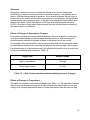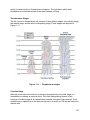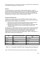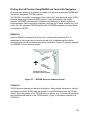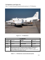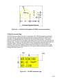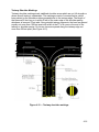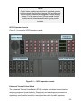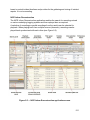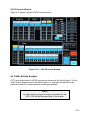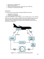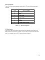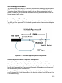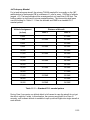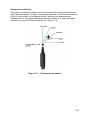
1
NONRESIDENT TRAINING COURSE November 2011 Air Traffic Controller (AC) NAVEDTRA 14342A NAVSUP Logistics Tracking Number FSN 0504-LP-111-1222 Notice: NETPDTC is no longer responsible for the content accuracy of the NRTCs. For content issues, contact the servicing Center of Excellence: Center for Naval Aviation Technical Training (CNATT); (850) 452-9659, Ext. 3247 or DSN: 922-9659, Ext. 3247. DISTRIBUTION STATEMENT A: Approved for public release; distribution is unlimited. PREFACE By obtaining this rate training manual, you have demonstrated a desire to improve yourself and the Navy. Remember, however, this manual is only one part of the total Navy training program. Practical experience, schools, selected reading, and your desire to succeed are also necessary to successfully round out a fully meaningful training program. THE MANUAL: This manual is organized into subject matter areas, each containing learning objectives to help you determine what you should learn along with text and illustrations to help you understand the information. The subject matter reflects day-today requirements and experiences of personnel in the rating or skill area. It also reflects guidance provided by Enlisted Community Managers (ECM) and subject matter experts, technical references, instructions, etc., and either the occupational or naval standards that are listed in the Manual of Navy Enlisted Manpower and Personnel Classifications and Occupational Standards, NAVPERS 18068 (series). THE QUESTIONS: The questions that appear in this manual are designed to help you understand the material in the text. The answers for the end of chapter questions are located in the appendices. THE EVALUATION: The end of book evaluation is available on Navy Knowledge Online located at https://wwwa.nko.navy.mil/portal/home. The evaluation serves as proof of your knowledge of the entire contents of this NRTC. When you achieve a passing score of 70%, your electronic training jacket will be updated automatically. VALUE: In completing this manual, you will improve your military and professional knowledge. Importantly, it can also help you study for the Navy-wide advancement in rate examination. If you are studying and discover a reference in the text to another publication for further information, look it up. i November 2011 Edition Prepared by ENS Shea Bickerstaff ACCM (AW/SW) Scott Swain ACCM (AW/SW) Gordon Carlon ACCS (AW/SW) Loren Brown ACCM (AW/SW) Lance Clark ACCS (AW/SW) Brian Carr ACCM (AW/SW) Tony Corpus ACCS (AW/SW) Dan Davis ACCM (AW/SW) Bill Ellis ACCS (AW/SW/FMF) Ryan Flauta ACCM (AW/SW) Charles Landers ACCS (AW/SW) Patricia Keeler ACCM (AW/SW) Rick Mooney ACC (AW/FMF) Brian Kerns ACCM (AW/SW) Gregory Muffley ACC (AW/SW) Ryun Malcom ACCM (AW/SW) Kelly Smith AG1 (SW) Christopher Lay ii NAVEDTRA 14342A COPYRIGHT MATERIAL Copyright material has been identified, approved and is listed below within this document. Copyright Owner Date Chapter Pages Remarks iii Sailor’s Creed "I am a United States Sailor. I will support and defend the Constitution of the United States of America and I will obey the orders of those appointed over me. I represent the fighting spirit of the Navy and those who have gone before me to defend freedom and democracy around the world. I proudly serve my country’s Navy combat team with honor, courage and commitment. I am committed to excellence and the fair treatment of all." TABLE OF CONTENTS iv CHAPTER PAGE 1. Aviation Weather ..................................................................................................... 1-1 2. Air Navigation and Aids to Air Navigation ................................................................ 2-1 3. Military Aircraft Identification, Performance, and Characteristics ............................ 3-1 4. Airport Lighting, Marking, and Equipment ............................................................... 4-1 5. Air Traffic Control Equipment .................................................................................. 5-1 6. Airspace Classification ............................................................................................ 6-1 7. Flight Assistance Service ........................................................................................ 7-1 8. General Flight Rules and IFR/SVFR Control Procedures ........................................ 8-1 9. Control Tower Operations ....................................................................................... 9-1 10. RADAR Operations ............................................................................................ 10-1 11. Shipboard Operations ........................................................................................ 11-1 12. Facility Operations .............................................................................................. 12-1 APPENDICES I. Glossary ................................................................................................................ AI-1 II. References .......................................................................................................... .AII-1 III. Answers to End of Chapter Questions ............................................................... AIII-1 Index .................................................................................................................... Index 1 v Acronyms The following table contains a list of acronyms that you must know to understand the material in this manual: Acronym Meaning AAFIF Automated Air Facilities Intelligence File AATCC Amphibious Air Traffic Control Center AATCFO Assistant ATCF Officer AC Air Traffic Controller ACDS Advanced Combat Direction System ACE Air Combat Element ACR Adaption Change Request ADCS Air Defense Coordination Section ADF Automatic Direction Finder ADIZ Air Defense Identification Zone ADMACS Aviation Data Management and Control System AFC Automatic Frequency Control AFCS Automatic Flight Control System A/FD Airport/Facility Directory AFLCS Airfield Lighting Control System AFSS Automated Flight Service Station AG Aerographer’s Mate AGL Above Ground Level AICUZ Air Installations Compatible Use Zones AID Automatic Initial Distribution AIM Aeronautical Information Manual AIP Aeronautical Information Publication Air Ops Air Operations AIRAD Airmen Advisory vi Acronym Meaning AIRMET (WA) Airmen’s Meteorological Information ALF Auxiliary Landing Field ALNOT Alert Notice ALO Air Logistics Office AM Amplitude Modulated AOA/AOR Amphibious Objective Area/Area of Responsibility AOE Airports of Entry AP Approach Control APC Approach Control (ATCS rating) APLN Airplane Mode AR Arrival Control ARFF Aircraft Rescue and Firefighting ARINC Aeronautical Radio Incorporated ARTCC Air Route Traffic Control Center ARTS Automated RADAR Terminal System AS Assistant SUA Sector Control ASCS Air Support Control Section ASOS Automated Surface Observation System ASR Airport Surveillance RADAR AT Coach Air Traffic Coach ATAA Air Traffic Activity Analyzer ATC Air Traffic Control ATCF Air Traffic Control Facility ATCFO Air Traffic Control Facility Officer ATCRBS Air Traffic Control RADAR Beacon System ATCS Air Traffic Control Specialist ATCSCC Air Traffic Control System Command Center vii Acronym Meaning ATCT Air Traffic Control Tower ATF Amphibious Task Force ATIS Automatic Terminal Information Service ATO Air Transfer Office AUTO Automated AWN Automated Weather Network AWOS Automated Weather Observation System AWT Airmans Written Test AZ Azimuth BASOPS Base Operations BDA Bomb Damage Assessments BRC Base Recovery Course CAAC Counseling and Assistance Center CAG Carrier Air Group CARF Central Altitude Reservation Function CAS Close Air Support CAT Clear Air Turbulence CATCC Carrier Air Traffic Control Center CATF Amphibious Task Force Commander CC Coordinator Tower CCA Carrier Controlled Approach CCTV Closed Circuit Television CD Clearance Delivery CDC Combat Direction Center CEB Controller Evaluation Board CFA Controlled firing area CFPL Carryover From Previous Log viii Acronym Meaning CFR Code of Federal Regulations CH Compass Heading CHUM Chart Updating Manual CIC Combat Information Center CLF Landing Force Commander COMNAVAIRSYSCOM Commander Naval Air Systems Command CNATRA Chief of Naval Air Training CNO Chief of Naval Operations COA Certificate of Authorization COB Close of Business COD Carrier Onboard Delivery COR Correction CP Control Point (Chapter 11) CP Command Post (Chapter 12) CP Circular Polarization (Chapter 5) CQ Carrier Qualifications CRT Cathode-Ray Tube CSO Combats Systems Officer CTO Control Tower Operator CTAF Common Traffic Advisory Frequency CVIC Aircraft Carrier Intelligence Center CVN Aircraft Carrier Nuclear Powered DA Decision Altitude DA Direct Access DADR Digital Audio Data Recorder DAFIF Digital Aeronautical Flight Information File DAIR Direct Altitude and Identity Readout ix Acronym Meaning DALR Digital Audio Legal Recorder DASI Digital Altimeter Setting Indicator DASR Digital Audio Surveillance RADAR DBRITE Digital Bright RADAR Indicator Tower Equipment DC Departure Control DCB Display Control Bar DF Direction Finder DH Decision Height DLA Defense Logistics Agency DINS Defense Internet NOTAM Service DM Departure Messages DME Distance Measuring Equipment DOD Department of Defense DON Department of the Navy DP Departure Procedure DRR Departure Reference Radial DRT Diversion Recovery Tool DTG Date-Time Group DVFR Defense Visual Flight Rules DVRSN Diversion EAT Expected Approach Time ECN Enroute Change Notice ECS Emergency Communications System EEAT Emergency Expected Approach Time EFB Emergency Final Bearing EFC Expect Further Clearance ESG Expeditionary Strike Group x Acronym Meaning EL Elevation EMCON Emission Control EMO Electronic Maintenance/Material Officer EOD Explosive Ordnance Disposal ESL Emergency Service Level ETA Estimated Time Of Arrival ETE Estimated Time Enroute ETVS Enhanced Terminal Voice Switch FAA Federal Aviation Administration FACMAN Facility Manual FACSFAC Fleet Area Control And Surveillance Facility FACTS FACSFAC Air Control Tracking System FAR Federal Aviation Regulation FB Final Bearing FBI Federal Bureau of Investigations FC Final Control FCCN Foreign Clearance Change Notice FCG Foreign Clearance Guide FCLP Field Carrier Landing Practice FCM Foreign Clearance Manual FD Flight Data – In Tower Branch FDC Flight Deck Control FDIO Flight Data Input/Output FL Flight Level FLIP Flight Information Publication FLYNET Flights, Nuclear Emergency Team FOIA Freedom of Information Act xi Acronym Meaning FP Flight Planning Dispatcher Fpm Feet per minute FS Flight Planning Supervisor FSS Flight Service Station Ft Feet FTC Fast Time Constant FTS Flight Termination System FWO Facility Watch Officer FWS Facility Watch Supervisor GC Ground Control GCA Ground Controlled Approach GEMO Ground Electronics Maintenance Officer GHz Gigahertz GPS Global Positioning System GPW General Purpose Workstation HAR High Altitude Redesign HAT Height Above Touchdown HCS Helicopter Coordination Section HDC Helicopter Direction Center HERO Hazards of Electronic Radiation to Ordnance HIRL High Intensity Runway Lights HIWAS Hazardous Inflight Weather Advisory Service Hr Hour HUMEVAC Humanitarian Emergency Evacuation Hz Hertz IAF Initial Approach Fix IAP Instrument Approach Procedure xii Acronym Meaning ICAO International Civil Aviation Organization ICLS Instrument Carrier Landing System ICN Interim Change Notice to The Foreign Clearance Guide ID Identification IFF Identification Friend or Foe IFLOLS Improved Fresnel Lens Optical Landing System IFR Instrument Flight Rules ILARTS Integrated Launch and Recovery Television Surveillance System ILM Independent Landing Monitor ILS Instrument Landing System IM Inner Marker (relative to the ILS) IMC Instrument Meteorological Conditions in. Inches INREQ Information Request IPART Improved Precision Approach RADAR Trainer IR IFR military training routes ISIS Integrated Shipboard Information System IVCSS Integrated Voice Communications Switching System JETDS Joint Electronics Type Designation System JPALS Joint Precision Approach Landing System kHz Kilohertz KIAS Knots Indicated Airspeed Kn Knots L/MF Low/Medium Frequency LABS Leased A/B System LAN Local Area Network xiii Acronym Meaning LC Local Control LCPO Leading Chief Petty Officer LDO Limited Duty Officer LHA/LHD Amphibious Assault Aviation Ship LIRL Low Intensity Runway Lights LLWAS Low-Level Wind-Shear Alert System LOA Letter of Agreement LOP Lines of Position LQS Local Qualification Standard LSE Landing Signal Enlisted LSO Landing Signal Officer LTG Lesson Topic Guides MATCD Marine Air Traffic Control Detachment MEA Minimum Enroute Altitude MEDEVAC Medical Evacuation METAR Aviation Routine Weather Reports MFR Memorandum for the Record MH Magnetic Heading MHz Megahertz Mi Mile MIRL Medium Intensity Runway Lights MM Middle Marker (relative to the ILS) MOA Military Operations Area MOVLAS Manually Operated, Visual Landing Aid System Mph Miles per hour MSAW Minimum Safe Altitude Warning MSL Mean Sea Level xiv Acronym Meaning MTI Moving Target Indicator MTR Military Training Route MVA Minimum Vectoring Altitude MVAC Minimum Vectoring Altitude Chart MW Mountain Wave NA Not Applicable NAS Naval Air Station NAATSEA Naval Airspace & Air Traffic Control Standardization and Evaluation Agency NAS National Airspace System NATOPS Naval Air Training and Operating Procedures Standardization NAVAID Navigational Aid NAVFIG Naval Flight Information Group NAVMETOCCOM Naval Meteorology and Oceanography Command NAVREP Navy Representative (to the FAA) NAWCAD Naval Air Warfare Center Aircraft Division NDB Non-Directional Beacon NGA National Geospatial-Intelligence Agency NIMA National Imagery and Mapping Agency Nm Nautical mile NMCC National Military Command Center NOAA National Oceanic and Atmospheric Administration NORDO No Radio NOTAM Notice to Airmen NPQ Not Physically Qualified NRP North American Route Program NWS National Weather Service xv Acronym Meaning OJT On-The-Job Training OLF Outlying Field OLS Optical Landing System OM Outer Marker (relative to the ILS) OPAREAS Operating Areas OPNAV Office of the Chief of Naval Operations OSF Operational Support Facility OTC Officer in Tactical Command PALS Precision Approach and Landing System PAPI Precision Approach Path Indicator PAR Precision Approach RADAR PCN Planning Change Notice PDAR Preferential Departure Arrival Route PDR Preferential Departure Route PEB Procedures Evaluation Board PICT Programmable Integrated Communications Terminal PIM Position and Intended Movement PIREP Pilot Weather Report PMS Preventative Maintenance System PPI Plan Position Indicator PPR Prior Permission Required PRF Pulse Repetition Frequency PriFly Primary Flight Control PSS Plans and Support Section RAC Risk Assessment Code RADAR Radio Detection and Ranging RATCF RADAR Air Traffic Control Facility xvi Acronym Meaning RB Relative Bearing RCE Remote Control Equipment RCL Runway Centerline Lights RCR Runway Condition Reading RD Flight Data – In RADAR Branch and FACSFAC RDP RADAR Data Processor REIL Runway End Identification Lights RFC RADAR Final Controller RS RADAR Supervisor RSC Runway Surface Condition RTS Return to Service RVR Runway Visual Range SAFI Semi-Automatic Flight Inspection SAMP Aerial Sampling SAR Search and Rescue SATCC Shipboard Air Traffic Control Communications SC SUA Sector Control SCANTANA Security Control of Air Traffic and Air Navigation Aids SCSC STARS Central Support Facility SESEF Shipboard Electronic Systems Evaluation Facility SFA Single-Frequency Approach SID Standard Instrument Departure SIF Selective Identification Feature SIGMET (WS) Significant Meteorological Information SINS Ship’s Inertial Navigation System SIVCS Shipboard/Scalable Integrated Voice Communications System xvii Acronym Meaning SOS STARS Operational Sites SPECI Aviation Selected Special Weather Reports STAR Standard Terminal Arrival Route STARS Standard Terminal Automation Replacement System STC Sensitivity Time Control SUA Special Use Airspace SVFR Special Visual Flight Rules TAC Terminal Area Chart TACAN Tactical Air Navigation TACC Tactical Air Control Center TACRON Tactical Air Control Squadron TAD Tactical Air Direction TAF Terminal Area Forecast TATC Tactical Air Traffic Controller TB True Bearing TCAS Traffic Alert and Collision Avoidance System TCE Tower Control Equipment TCG Time Code Generator TCN Terminal Change Notice TCW Terminal Controller Workstation TDW Tower Display Workstation TDZL Touchdown Zone Lights TED Touch Entry Device TERPS Terminal Instrument Procedures TH True Heading TPP Terminal Procedures Publication TRACON Terminal RADAR Approach Control xviii Acronym Meaning TRAMAN Training Manual TRSA Terminal RADAR Service Area TS Tower Supervisor TTH Total Training Hours TTS Test and Training Simulator TTSE Test and Training Simulator Equipment UAS Unmanned Aircraft Systems UCN Urgent Change Notice (to FLIP products) UFC Unified Facilities Criteria UHF Ultra High Frequency USAF U.S. Air Force USW Undersea Warfare UTC Coordinated Universal Time UTM Universal Test Message V/STOL Vertical/Short Takeoff And Landing VASI Visual Slope Approach Indicator VDB Visual Display Board VFR Visual Flight Rules VHF Very High Frequency VIDS Video Information Distribution System VIP Very Important Person VISCOM Visual Communications System VMC Visual Meteorological Conditions VOD Vertical Onboard Delivery VOR VHF Omni-Directional Range VORTAC VHF Omni-Directional Range/Tactical Air Navigation VOT VOR Test Facility xix Acronym Meaning VR VFR Military Training Route WCLC Watch Checklist Complete WESS Web Enabled Safety System WSDI Wind Speed and Direction Indicator WST Convective SIGMET Z Zulu Time ZD Zone Description xx CHAPTER 1 AVIATION WEATHER Weather phenomenon, as it affects aviation, is an integral part of your job as an Air Traffic Controller (AC). You will be part of a team that keeps pilots informed of current and forecasted weather conditions that will affect the safety of flight and sometimes the pilots' very survival. As an AC, you must accurately report weather conditions and recognize any differences between the actual weather conditions, as observed from the tower, and those indicated by the current weather report. You must understand how current and developing meteorological conditions affect the decision you and the pilot make, from the preflight planning stage to landing rollout. It is critical that you understand the information in this chapter and realize the impact weather has on the safe, expeditious flow of air traffic. LEARNING OBJECTIVES The material in this chapter will enable you to: Identify standard (sea level) pressure and associated atmospheric terms and their characteristics and effects. Identify the major cloud formations and types, their general characteristics, and the levels at which they occur. Identify the types, effects, designations, and characteristics of fronts. State possible controller operational considerations for certain weather conditions. Identify the activities that provide weather service to pilots, and the methods used to distribute weather information. Decode weather data using standard codes and contractions. State the proper broadcasting procedures and phraseology used to transmit weather information to pilots. Obtain weather information from pilots and relay it to aircraft and area air traffic control facilities. Identify and explain the different types of forecasts, advisories, and warnings issued by the Navy and the National Weather Service (NWS). ATMOSPHERE All of the weather that we experience occurs in the atmosphere. The radiant energy of the sun is the catalyst that causes the different weather and wind patterns that we experience. In this section we will discuss some of the basic characteristics of our atmosphere. 1-1 Earth's Atmosphere The atmosphere is a thin blanket of gases, mostly nitrogen and oxygen, that surrounds the earth and is held in place by the earth’s gravity. All of the weather that we experience occurs within 7 miles of the earth’s surface. In this section, we will discuss some of the basic characteristics of our atmosphere. Layers of the atmosphere The earth’s atmosphere extends upward many hundreds of miles and is divided into five basic layers with narrow boundaries between the bottom four layers (see Table 1-1). Layer or Boundary Remarks Troposhere Extends upwards from the earth’s surface approximately 7 miles. All weather occurs in this layer. Stratosphere Extends upwards to approximately 30 miles. Temperature increases with height. Ozone concentration is heaviest in this layer. Mesosphere Extends upwards from the stratopause approximately 50 miles. Temperature decreases with height. Thermosphere Extends upwards to approximately 70 miles. Temperature increases with height. Exosphere Outermost layer of Earth’s atmosphere. Composed of hydrogen and helium. Tropopause Boundary separating the troposphere and the stratosphere. Height varies, normally found at higher elevations near equatorial regions and at lower elevations near the North and South poles. Jet stream occurs in the tropopause. Stratopause Boundary between the stratosphere and mesosphere, typically at 30 miles. Mesopause Coldest place on Earth with an average temperature of -120o F. Due to cold temperatures, water vapor freezes and forms ice clouds. Table 1-1 — Layers of the atmosphere A vertical cross section of the earth's atmosphere is depicted in Figure 1-1. 1-2 Figure 1-1 — Earth’s atmosphere. Atmospheric Pressure and Temperature The atmosphere is made up of molecules that we call air. These air molecules have weight (approximately 1.2 ounces per cubic foot at sea level), and the amount of weight these air molecules exert on the earth's surface is called atmospheric pressure. You must understand how an aircraft uses atmospheric pressure to determine altitude and how pressure and temperature changes affect the aircraft's instruments. 1-3 Units of Measurement There are two basic units used to measure and report the atmospheric pressure: inches of mercury and millibars. Atmospheric pressure is measured using either a mercurial or aneroid barometer. Air pressure pressing against a mercurial barometer causes mercury to rise in an evacuated glass tube. Air pressure at sea level causes the mercury to rise in the glass tube, on the average, 29.92 inches of mercury (standard sea-level pressure). Mercury is used because it is such a dense, heavy liquid. The same pressure would cause water to rise approximately 400 inches of mercury in the same tube. An aneroid barometer uses a thin metal strip in an evacuated case to measure pressure. In the United States, we report the barometric pressure in inches (for example, 29.92 inches), and this is the unit of measurement that you will be most concerned with. However, a pilot will occasionally ask for the altimeter in millibars which is the scientific unit of measurement. Normally you will have to contact the weather reporting service for your station to obtain this reading. Table 1-2 gives a comparison of inches to millibars. 1-4 Inches of Mercury Millibars 26.58 900 26.87 910 27.17 920 27.46 930 27.76 940 28.05 950 28.35 960 28.64 970 28.94 980 29.24 990 29.53 1000 29.82 1010 29.92 1013.25 30.12 1020 30.42 1030 30.71 1040 Table 1-2 — Units of measurement 1-5 Altimeters Atmospheric pressure is used to indicate the altitude of an aircraft. A barometer (aneroid type), carried onboard an aircraft, is called an altimeter. The altimeter has a scale to indicate altitude instead of pressure. As an aircraft increases altitude, there is less air above the aircraft and therefore less pressure on the altimeter. An aircraft uses surface pressure as a reference point, so the pilot must change altimeter setting when flying a route below 18,000 feet (above 18,000 feet all aircraft altimeters are set at 29.92). It is critical to flying safety that an aircraft have the correct altimeter setting for the area in which it is operating. Effects of Changes in Atmospheric Pressure An aircraft must have the correct altimeter setting for the area in which it is operating, since this is what altitude and vertical separation are based on. Without having the correct altimeter setting the indicated, altitude of the aircraft will not be correct. For example, when an aircraft flies from a high pressure area into a low pressure area and the altimeter setting is not corrected, the altimeter will read too high. Going from a low pressure area to a high pressure area, the altimeter will read too low. A simple rule to help you remember this is shown in Table 1-3. Flying From Altimeter Reads High to low pressure Too high Low to high pressure Too low Table 1-3 — Rule to help remember altimeter reading (pressure changes) Effects of Changes in Temperature The same rule applies to temperature changes (see Table 1-4). The altimeter of a plane flying from a low temperature area into a high temperature area will read too low, and moving from a higher temperature area to a lower temperature area will read too high. 1-6 Temperature Altimeter Reads High to low temperature Too high Low to high temperature Too low Table 1-4 — Rule to help remember altimeter reading (temperature changes) Altimeter Errors The margin of error in the altimeter reading that is due to incorrect altimeter setting can be determined for the lower levels of the atmosphere by applying the corrections in Table 1-5. Pressure Change Altimeter Error 1 inch of mercury 1,000 feet 1/10 inch of mercury 100 feet 1/100 inch of mercury 10 feet Table 1-5 — Altimeter errors Pressure Systems Pressure systems are either high pressure (anticyclonic) areas or low pressure (cyclonic) areas. A basic understanding of pressure systems, their distinguishing characteristics, and the weather phenomena associated with them is necessary for understanding concepts that will be presented later in this chapter. Formation and Movement One of the reasons that high and low pressure areas form is the uneven heating of the earth’s surface. Areas near the equator receive more heat, which causes the air to expand and rise, which produces a low pressure area. The atmosphere tends to maintain equal pressure over the entire earth. When this equilibrium is upset (for example, by the formation of a high pressure area) air flows from areas of high pressure to areas of low pressure attempting to maintain equal 1-7 pressure. The heavier, denser air from the north and south poles moves along the earth’s surface towards the equator while the lighter, warmer air moves towards the poles. As this air moves, it does not travel in a straight line from equator to pole, because it is affected by the following: The earth's rotation Uneven heating over water and land Seasonal and daily temperature changes The earth's rotation causes the air to flow to the right of its normal path in the northern hemisphere and to the left in the southern hemisphere, as seen in Figure 1-2. This explains why in the northern hemisphere weather patterns and high- and low-pressure systems generally move from west to east. Figure 1-2 — Earth’s rotation. Cyclones (Low-Pressure Systems) In a low-pressure system, barometric pressure decreases toward the center. The wind flow around the system is counterclockwise in the northern hemisphere, as shown in Figure 1-3. A low-pressure system is generally associated with unfavorable flying conditions because of low clouds, restricted visibility, and strong gusty winds. Hurricanes, typhoons, and tropical storms are examples of severe low-pressure systems. 1-8 Figure 1-3 — Cyclonic circulation. Anticyclones (High-Pressure Systems) In the northern hemisphere, the wind flow around a high pressure area is clockwise, as shown in Figure 1-4. Flying conditions are generally more favorable in high-pressure systems because of better visibility, less wind, fewer clouds, and fewer areas of concentrated turbulence. The diagrams below depict wind flow around low and high pressure areas. 1-9 Figure 1-4 — Anticyclonic circulation. CLOUDS AND THEIR CHARACTERISTICS Clouds have been called signposts in the sky. They are an indication of what the atmosphere is doing. Understanding cloud types will help predict weather conditions, recognize potential weather hazards, and assist the pilot in the safe handling of their flight. Clouds Composition and Formations Clouds form when the temperature of the surrounding air is between 5°F and 32°F, and they are composed mostly of super cooled water droplets with small amounts of ice crystals. Below 5°F, clouds are composed almost entirely of ice crystals. Cloud Composition Cloud particles (droplets) are extremely small, about one-thousandth of an inch in diameter, and as they become more dense, or clustered together, they become visible as clouds. The average raindrop contains about one million times the water in a cloud droplet. 1-10 Cloud Formations Clouds are arranged in three families—low (surface to 6,500 feet), middle (6,500 feet to 16,500 feet), and high (16,500 feet to 45,000 feet)—and are categorized into 10 basic types that have many different forms and varieties. Two additional types of cloud formations are cumulonimbus mammatus and lenticularis. Cloud Types and Characteristics There are many different types of clouds, each with its own distinguishing characteristics (see Figure 1-5). Figure 1-5 — Cloud types and characteristics. 1-11 Cloud Types Table 1-6 lists some of the more common types of clouds, their characteristics, and some of the hazards associated with each. Type Characteristics Hazards to Aviation Cirrus Fibrous and delicate in appearance. Clouds look like white wisps against the sky. First sign of approaching bad weather. When these clouds become more compact and merge into cirrostratus, it may indicate an approaching warm front. Flying conditions are good. Negligible turbulence. Pure ice crystal composition of these clouds precludes surface icing on the aircraft. Cirrocumulus Appear like fleecy flakes or small white cotton balls. Like the scales on a fish, and often called a mackerel sky. Light to moderate turbulence. No icing on aircraft surfaces. Cirrostratus Smooth, thin-layered cloud covering all Icing and turbulence or most of the sky, giving the sky a milky usually present. No hazard appearance. Produces halo around sun to flying. or moon. When these clouds lower, thicken, and merge into altostratus, the approach of a warm front and bad weather is imminent. Altocumulus Sometimes appear like cirrocumulus, but the balls or flakes are thicker and grayer. Appear similar to a herd of sheep in the sky. The underside of each cloud is dark because of the thickness. Poor visibility within these clouds. Light to moderate turbulence and icing. The icing is usually the clear type. Altostratus Appear as a thick gray or blue-gray smooth overcast. Thicker and less transparent than cirrostratus clouds. Precipitation in the form of light rain or snow. Light to moderate icing (predominantly rime ice). Light turbulence. Visibility within these clouds is 50 to 200 yards. Nimbostratus Thick, dark gray clouds that are formless in appearance. Precipitation is always falling from these clouds (may not always reach the surface). Moderate to heavy turbulence and icing with very poor visibility within and below the cloud. Stratocumulus Occur as an extensive and fairly level layer marked by thick rolls and dark, rounded masses underneath. Precipitation infrequent; when it occurs, it is in the form of very light rain showers Poor visibility within these clouds. Light to moderate turbulence. Moderate icing conditions. May form clear or rime ice. 1-12 Type Characteristics or snow flurries. Hazards to Aviation Stratus Flat, shapeless, dull gray, uniform layer of cloud. Precipitation in the form of drizzle only. Only light turbulence and moderate icing may be present. Visibility is very poor when drizzle occurring. Cumulus Dense clouds with vertical development. The cloud’s upper surfaces are dome shaped and exhibit rounded protuberances, while their bases are nearly horizontal. Strong updrafts occur within and under these clouds. Turbulence and icing of varying intensities are common depending on the extent of vertical development. Cumulonimbus Cumulus clouds with great vertical development that resembles mountains or towers. Tops may extend higher than 60,000 feet and resemble an anvil. Precipitation is violent with intermittent showers. Extreme turbulence and severe icing. Severe up and down drafts. Microbursts and low-level wind shear occur under this type of cloud. Damaging hail is possible. Cumulonimbus Mammatus Large, baggish clouds with protuberances, like udders or pouches, on the undersurface. This type of cloud indicates extreme turbulence. Conditions ideal for tornado development. Lenticularis Clouds have the shape of lenses or almonds. Normally formed by wind flow in mountainous areas. Usually associated with extreme turbulence. Table 1-6 — Cloud types FRONTS AND ASSOCIATED WEATHER In this section, we will discuss the general nature of fronts, how fronts form and move, and the weather patterns associated with the four classifications of fronts (cold, warm, stationary, and occluded). 1-13 Front Classification To understand fronts, we must first define and understand what an air mass is. An air mass is any huge body of air whose physical properties (temperature and moisture) are horizontally and vertically uniform. When air stagnates over certain regions, it acquires properties from the underlying surface (source region) and forms an air mass. The prevailing weather over any area at any given time generally depends on the properties and characteristics of the prevailing air mass. In time, these air masses move out of their source regions because of the general circulation of the earth's atmosphere, the terrain, and other factors. In the northern hemisphere, cold air masses from the Polar Regions tend to move southward while warm air masses from the tropical regions tend to move northward. When two different air masses meet, the boundary or surface that separates these air masses is called a front. Classification Fronts are generally classified according to the relative motions of the air masses involved. The four chief classifications and their descriptions are contained in Table 1-7. The weather associated with fronts and frontal movement is called frontal weather. It is more complex and variable than air mass weather. The type and intensity of frontal weather is determined by a number of things (i.e., slope of the front, water vapor content, and stability of the air mass) and may range from a minor wind shift with no clouds or other visible weather activity to severe thunderstorms accompanied by low clouds, poor visibility, hail, and severe turbulence and icing. Consider each of the frontal categories and the weather pattern each usually produces. Type Description Cold front A front whose motion is such that cold air displaces warm air at the surface Warm front A front whose motion is such that warm air replaces cold air at the surface Stationary front A front that has little or no motion Occluded front A complex front resulting when a surface cold front overtakes a warm front Table 1-7 — Four frontal classifications 1-14 Cold Fronts A cold front occurs when cold air invades a region occupied by warm air. Cold Front Characteristics In a cold front, the cold air wedges under the warm air and pushes the warm air upwards, as seen in Figure 1-6. Figure 1-6 — Cold front characteristics. Certain weather characteristics and conditions are associated with the passage of cold fronts. In general, the temperature and humidity decrease, pressure rises, and the wind shifts clockwise in the northern hemisphere (clockwise movement on the wind direction indicator, usually from southwest to northwest) with the passage of a cold front. When the warm air mass is unstable and moist, showers and thunderstorms occur just ahead of the front, and rapid clearing occurs behind the front. Squall lines and tornadoes are associated with fast moving cold fronts. When the warm air is relatively dry, a cold front may not produce precipitation or clouds. Warm Fronts A warm front occurs when cold air retreats before an advancing mass of warm air. Warm Front Characteristics With a warm front, the warm air slides over the cold air, as seen in Figure 1-7. 1-15 Figure 1-7 — Warm front characteristics. As with a cold front, the weather associated with a warm front varies depending on the degree of stability and moisture of the warm air mass. Certain characteristics and weather conditions are associated with the passage of warm fronts. In the northern hemisphere, the winds veer from southeast to southwest or west, but the shift is not as pronounced as with the cold front. Temperatures are colder ahead of the warm front and warmer after the front passes. Clearing usually occurs after the passage of a warm front, but under some conditions drizzle and fog may occur within the warm sector. Normally, the speed of a warm front is less than that of cold fronts; the average speed of a warm front is about 10 knots. Stationary Fronts Sometimes the opposing forces of different air masses are such that the frontal surface shows little or no movement. Since neither air mass is replacing the other, the front is known as a stationary front. Stationary Front Characteristics The weather conditions occurring with a stationary front are similar to those found with a warm front but are usually less intense. An annoying feature of the stationary front and its weather pattern is that it may persist and hamper flights for several days in the same area. Occluded Front An occluded front occurs when a cold front overtakes a warm front and forces the warm front aloft as the first cold front approaches another cold front. 1-16 Occluded Front Characteristics An occluded front can have the characteristics of both a warm front and a cold front depending on the position of the front and the type of occluded front (warm or cold), as seen in Figure 1-8. Figure 1-8 — Occluded front characteristics. WEATHER HAZARDS In this section, we will discuss some of the more serious weather hazards. A comprehensive knowledge of these hazards and how they affect aircraft is essential to providing good service. This knowledge also enables you to plan ahead and keep pilots informed of known and anticipated weather conditions. Fog and Precipitation Fog is defined as a cloud on the earth's surface. It has sufficient density in the atmosphere to interfere with visibility. Fog consists of visible water droplets or ice particles suspended in the atmosphere. It differs from other clouds in that it exists on the ground or over the surface of bodies of water. It differs from rain or mist in that its water or ice particles are more minute and are suspended (they do not fall earthward). Fog Formation The difference between the dew point (the temperature to which air, at constant pressure, and water vapor content must be cooled for saturation to occur) and the temperature is used to predict fog formation. The smaller the spread between the temperature and the dew point the greater the possibility of fog formation. Dew point depression is the term used to describe the difference, in degrees, between the two. Fog seldom forms when the dew point depression is greater than 4° F. 1-17 Wind is another factor that influences the formation of fog. Table 1-8 shows the various wind conditions and whether or not they are favorable for the formation of fog: Wind Fog Formation Potential Calm Fog will form but is generally very shallow. Light With dust-laden air, is ideal for fog formation. Produces deep layers of fog. Moderately strong Tends to keep fog from forming as it circulates the air too rapidly for fog producing conditions to exist. Strong Will dissipate fog that has already formed. Table 1-8 — Wind conditions Air Mass Fog Fog is divided into two classes: air mass fog and frontal fog. We will discuss each class separately since there are different requirements that govern the formation of each. Air mass fog occurs within a given air mass and is formed when the layer of air closest to the earth's surface is cooled by contact with a colder surface below. There are four types of air mass fog (see Table 1-9). Each type gets its name from the particular manner in which air is cooled to the dew point. The four types are radiation fog, advection fog, upslope fog, and steam fog. 1-18 Type Description Radiation fog More commonly known as ground fog, it is the most common problem for air traffic control. Usually forms at night and dissipates before mid morning. Best conditions for formation are a cool clear night, light wind, and high humidity. Advection fog Because advection fog covers large areas, it is considered the most dangerous to aviation. Forms when air moves over a land or water surface that is colder than the air mass that is passing over it. Upslope fog Forms when air is forced to ascend a gradual slope. Forms in very deep layers and requires considerable time to dissipate. Steam fog Forms when cold air moves over warm water. Evaporation from the surface of the warm water saturates the cold air and causes fog to form. Table 1-9 — Four types of air mass Frontal Fog Frontal fog is another hazard that must be added to the list of weather troubles associated with fronts. There are two classes of frontal fog: warm-front fog and coldfront fog. Each is described in Table 1-10. Class Description Warm-front fog Much more extensive than cold-front fog and a definite hazard to flight operations. Formed by rain falling from warm air into cold air along the frontal surface. Cold-front fog Cold-front fog is rare. It forms in the cold air mass just behind the cold front. This type of fog dissipates rapidly due to the fast movement of cold fronts. Table 1-10 — Two classes of frontal fog 1-19 Precipitation Precipitation includes all forms of moisture that fall to the earth’s surface. Snow, drizzle, and rain are the most common forms of precipitation that cause a restriction to visibility (see Table 1-11). Type Characteristics Snow Usually the most effective in reducing visibility. Heavy snow and blowing snow frequently reduce surface visibility to near zero. Rain Rarely reduces surface visibility to below 1 mile. Has a tendency to wash dust, smoke, and fog out of the air. Drizzle Often accompanied by fog and results in lower visibility than rain. Table 1-11 — Common forms of precipitation Icing A severe weather hazard to flying is airframe icing. Having a thorough understanding of when and how ice forms on aircraft will enable you to lend invaluable assistance to pilots. Icing interferes with the performance of aircraft by increasing drag and weight while decreasing lift, changing the airfoil shape of the wings and tail. There are four types of airframe ice: rime, clear (glaze), mixed, and frost. Icing conditions encountered in flight are a combination of rime and clear ice, with the characteristics of one or the other being dominant. Frost usually forms on aircraft on the ground. For ice to form on aircraft in flight, two conditions are necessary: the aircraft must be flying through rain, drizzle, or cloud droplets, and at the time the water droplets strike the aircraft, their temperature and the temperature of the surface of the aircraft must be 32° F or colder. Heaviest airframe icing generally occurs within the temperature range of 15°F to 32°F provided moisture is available. Engine system icing reduces the effective power of aircraft engines. Not all aircraft have de-icing capability, while others have limited de-icing capability and must avoid icing conditions at all times. Clear Ice Clear ice, sometimes referred to as glaze ice, is considered the most serious of the four types. It is clear, dense, solid, and adheres firmly to the structure upon which it forms. The water droplets strike the aircraft in such rapid succession that none have a chance to freeze before the next strikes in the same place, and it is more difficult to remove with 1-20 de-icing equipment than rime ice. Since it is transparent, clear icing may go undetected until it is too late for de-icing equipment. Clear ice on an airfoil is depicted in Figure 1-9. Figure 1-9 — Clear ice. Rime Ice Rime ice is a rough, brittle, milky opaque deposit of ice formed by the instantaneous freezing of small super-cooled water droplets. Rime ice usually occurs at a lower temperature than does clear ice. Unlike clear ice, rime forms as drops freeze upon striking the airfoil trapping air, giving the ice its opaque appearance and making it porous and brittle. The resulting deposit is tiny pellets of ice frozen together in a spongy mass. Rime ice on an airfoil is depicted in Figure 1-10. Figure 1-10 — Rime ice. The conditions that favor the formation of rime ice are: Very small water droplets such as are found in stratiform clouds A relatively small number of water droplets that are found in clouds that are not dense Temperatures far below freezing 1-21 Rime ice weighs less than clear ice, but rime ice may seriously distort airfoil shape and thereby diminish lift. Mixed Ice Mixed ice is a combination of rime and clear icing. It has a very rough appearance and it forms when snow or ice particles become embedded in clear ice. Frost Frost is light feathery deposits of ice crystals which form when water vapor contacts a cold surface. Frost occurs when the temperature on the surface of the aircraft is below freezing at the time condensation takes place. Frost can form on airborne aircraft if the aircraft flies from a region where the temperature is below freezing to a region where the temperature is slightly warmer and the air is moist. Icing Intensities Aircraft icing is classified into four intensities for reporting purposes. Table 1-12 contains the four intensity categories and a brief description of each. Intensity Ice Accumulation Trace Rate of accumulation slightly greater than sublimation. Ice becomes perceptible. Even if de-icing/anti-icing equipment is not used, nonhazardous unless encountered for more than one hour. Light The rate of accumulation may create a hazard if flight is prolonged in this environment (over 1 hour). Occasional use of de-icing/anti-icing equipment removes/prevents accumulation. It does not present a hazard if the de-icing/anti-icing equipment is used. Moderate The rate of accumulation is such that even short encounters become potentially hazardous and the use of de-icing/anti-icing equipment or flight diversion is necessary. Severe The rate of accumulation is such that de-icing/anti-icing equipment fails to reduce or control the hazard. Immediate flight diversion is necessary. Table 1-12 — Four intensity categories of aircraft icing 1-22 Occurrences of Icing The atmospheric distribution of icing depends on temperature and cloud structures, which vary with altitude, synoptic situation, season, location, and terrain. Icing and Temperature Aircraft icing generally occurs between the freezing level and -22 degrees Celsius/-7 degrees Fahrenheit. Icing can also occur in the upper parts of cumulonimbus clouds. The type and amount of ice varies with each type of cloud. Stratiform Stable air masses often produce stratiform clouds with extensive areas of continuous icing conditions. Icing typically occurs in layers of 3000 to 4000 feet and is found at elevations where the temperatures range from -1 deg C to -15 deg C. It normally forms as rime ice type icing. High-level stratiform clouds contain mostly ice crystals and produce little to no icing. Cumuliform. The zone of icing is smaller horizontally but greater vertically than in stratiform clouds. Expect clear icing at flight altitudes where the temperatures vary from 0 deg C to 8 deg C, mixed icing from -9 deg C to -15 deg C, and rime ice from -15 deg C to -22 deg C. Clear and mixed icing will extend to greater vertical levels in the updraft and in the anvils of building to mature cumulonimbus clouds. Icing in Relation to Fronts Fronts provide the lifting mechanism to form clouds and therefore concentrated areas for icing. All types and intensities may be encountered and are dependent on the instability aloft, speed, and slope of the front. Overrunning warm fronts and shallow cold fronts are extremely hazardous as they may generate large areas of freezing rain/drizzle. Severe clear icing is often associated with this situation. Icing in Relation to Terrain Icing is more likely and more severe in clouds over mountainous regions than over other terrain. The strong upslope flow on the windward side of a range may lift large water droplets upwards to 5,000 feet into subfreezing layers above a peak. If a frontal system moves across a mountain range, the normal frontal lift combines with the orographic effects to create extremely hazardous icing zones. 1-23 Turbulence An unseen but dangerous condition for aircraft is turbulence. The effect of turbulence on aircraft ranges all the way from a few annoying bumps to severe jolts. Some types of turbulence have caused aircraft in flight to break up and disintegrate. Your job requires that you collect data on turbulence and issue advisories as appropriate. Types and Causes of Turbulence Turbulence may exist with or without cloud conditions. Turbulence in clouds, such as that associated with thunderstorms, is extremely dangerous. Turbulence is reported in varying degrees of intensity. The classifications of intensities are light, moderate, severe, and extreme. In general, there are four causes for the development of turbulence (see Table 1-13). 1-24 Type Mechanical Cause Caused by horizontal and vertical wind shear, it is the result of pressure gradient differences, terrain obstructions, or frontal zone shear. Two major types of mechanical turbulence are: Clear Air Turbulence (CAT) includes all turbulence not associated with visible convective activity, includes high-level frontal and jet stream turbulence, and may occur in high-level, non-convective clouds. Mountain Wave (MW) often occurs in clear air in a stationary wave downwind of a prominent mountain range and is caused by the disturbance of wind by the mountain range. Wake Results when a smaller aircraft encounters vortices from a larger aircraft. A vortex is formed at an aircrafts wingtip as air circulates outward, upward, and around the wingtip. The size of the vortex varies with the size and weight of the aircraft. Vortices sink at 400-500 ft/minute and stabilize 900 ft below the flight path where they begin to dissipate. Thermal This type of turbulence is associated with surface heating. As solar radiation heats the surface, the air above it is warmed through conduction. Thermal convection within the boundary layer transports the warm air upward in an uneven and irregular motion, creating eddies and gusts (i.e. turbulence). It is particularly hazardous for takeoff/landings when it happens over a short duration, affects airspeed variations of >10kts, and is within 2000 feet of the ground. Low-Level Wind Shear (LLWS) This is a severe change in either wind speed and/or direction over a short period of time, resulting in an increase or decrease of air across a wing and thus a sudden increase or loss of lift for the aircraft. It is particularly hazardous for takeoffs/landings when it happens over a short duration, effects airspeed variations of >10 knots, and is within 2,000 ft of the ground. Table 1-13 — Four causes of turbulence Degrees of Turbulence As stated earlier, turbulence is classified and reported in degrees or intensities. Table 114 gives a brief description of these intensities to clarify. 1-25 Classification Description Inside Aircraft Light Momentarily causes slight erratic changes in altitude and/or attitude (pitch, roll, or yaw). Occupants may feel a flight strain against seat belts or shoulder straps. Unsecured objects may be displaced slightly. Moderate Similar to light turbulence but of greater intensity, although the aircraft remains in positive control at all times. Occupants feel definite strains against seat belts or shoulder straps. Unsecured objects are dislodged. Severe Causes large abrupt changes in altitude and/or attitude. Aircraft may be momentarily out of control. Occupants are forced violently against seat belts or shoulder straps. Unsecured objects are tossed about. Extreme Causes aircraft to be violently tossed about. Aircraft may be practically out of control. Table 1-14 — Four intensity categories of turbulence NOTE Pilots should report location, altitude or range of altitudes, type of aircraft, air temperature, intensity, duration, type of turbulence, and whether in clouds or clear air. In any case of reported turbulence, relay the information to other pilots in the area and to the station weather office for dissemination. Aircraft type is important when you deal with turbulence reports since intensities are based on aircraft reaction to the turbulence. A report of moderate turbulence by a Cessna 150 would cause little concern to a C5A pilot. Thunderstorms Thunderstorms are an extremely violent and formidable weather hazard. Thunderstorms are almost always accompanied by strong gusts of wind, severe turbulence, and occasional hail. You must relay thunderstorm information to a pilot and occasionally 1-26 advise or assist a pilot on thunderstorm avoidance. The turbulence within most thunderstorms is considered one of the worst hazards of flying. Thunderstorm Stages The life cycle of a thunderstorm cell consists of three distinct stages: the cumulus stage, the mature stage, and the anvil or dissipating stage. These stages are depicted in Figure 1-11. Figure 1-11 — Thunderstorm stages. Cumulus Stage Although most cumulus clouds do not become thunderstorms, the initial stage of a thunderstorm is always a cumulus cloud. The chief distinguishing feature of this cumulus or building stage is an updraft which prevails throughout the entire cell. Such updrafts vary in speed from a few feet per second to as much as 100 feet per second in mature cells. 1-27 Mature Stage The beginning of surface rain with adjacent updrafts and downdrafts initiates the mature stage. By this time, the peak of the average cell has attained a height of 25,000 feet or more. As the raindrops begin to fall, the frictional drag between the raindrops and the surrounding air causes the air to begin a downward motion. The descending saturated air soon reaches the level where it is colder than its environment. At this level, its rate of downward motion is accelerated. This accelerated downward motion is a downdraft. Anvil or Dissipating Stage Throughout the life span of a mature cell, as more and more air aloft is being dragged down by falling raindrops, the downdraft spreads out to take the place of the dissipating updraft. As this process progresses, the entire lower portion of the cell becomes an area of downdraft. Since this is an unbalanced situation and the descending motion in the downdraft affects a drying process, the entire structure begins to dissipate. The high winds aloft have now carried the upper section of the cloud into the anvil form, indicating that the cell is starting to dissipate. Thunderstorm weather It is important that you be familiar with the following information provided on thunderstorm weather. This knowledge will assist you in providing service to pilots that are in or around a thunderstorm. Rain Precipitation in a storm may be ascending if encountered in a strong updraft. The precipitation may be suspended, seemingly without motion yet in extremely heavy concentrations, or it may be falling to the ground. A pilot could enter a cloud and be swamped by rain even though none has been observed from surface positions. Rain is found in almost every case of cloud penetration below the freezing level. Where no rain is encountered, the storm has probably not developed into the mature stage. Hail Various sizes of hail are present within most thunderstorm cells. The presence of damaging hail within the cloud and under the cloud should always be considered with moderate or severe storms. Hail may be encountered up to 25 miles downstream (ahead) of a thunderstorm in the clear air under the thunderstorm anvil. Turbulence Moderate to severe turbulence may be encountered up to 20 miles from the center of severe storms at any altitude and up to 10 miles from the centers of less severe storms. Severe or extreme turbulence is most often found in the anvil cloud 15 to 20 miles 1-28 ahead of the storm center at all altitudes within the cloud. Because of the strong up and downdrafts associated with a thunderstorm, there is always a possibility of severe lowlevel wind shear. Lightning The electricity generated by a thunderstorm is rarely a great hazard to an aircraft from the standpoint of its airframe, but other lightning hazards include temporary blindness, damage to navigational and electronic equipment, and punctures to the aircraft's skin. Lightning occurs within the cloud, including the anvil portion, and is most frequent near the freezing level. Lightning also occurs between adjoining clouds and between the cloud and the ground. Although lightning frequently exits the cloud base, it may exit the side of the cloud and strike the ground up to 12 miles away from the cloud. Icing Both rime and clear icing may be encountered. Clear ice accumulation in thunderstorms above the freezing level can be so rapid that an aircraft may become incapable of maintaining level flight. Effect on Altimeters Pressure usually falls rapidly with the approach of a thunderstorm. It raises sharply with the onset of the first gusts and the arrival of the cold downdraft and heavy rain showers. The pressure then falls back to the original pressure as the rain ends and the storm moves on. This cycle of pressure change may occur in 15 minutes. Of greatest concern are pressure readings that are too high. If you issue an altimeter setting to an arriving aircraft during the peak of a storm, the aircraft could be too high on its approach. Surface Wind A significant hazard associated with thunderstorm activity is the rapid change in surface wind direction and speed immediately prior to storm passage (first gust). The strong winds at the surface that accompany thunderstorm passage are the result of the horizontal spreading out of downdraft currents from within the storm that occurs as these currents approach the surface of the earth. The total wind speed is a result of the downdraft divergence plus the forward velocity of the storm cell. Thus, the wind speeds at the leading edge of the cell are greater than those at the trailing edge. During the passage of a thunderstorm cell, winds shift and become strong and gusty. Also, wind speeds occasionally exceed 55 knots. WEATHER OBSERVATION CODES AND PHRASEOLOGY Accurate knowledge of developing weather conditions within your airfield or ship's area of concern is critical to flying safety. You will base many operational decisions on the current and forecast weather situations. 1-29 ACs are concerned mostly with weather conditions in the immediate vicinity and within 50 miles of the airport. Use weather observations and forecasts regularly for planning purposes. You should be most concerned with present weather conditions and those weather conditions expected within the hour. In this section, we will discuss the weather support products and code forms that you will most frequently encounter and need to interpret. Support Functions Aviation weather support is provided to each naval air station by the Naval Meteorology and Oceanography Command. Aviation Weather Support Most naval air stations are supported by meteorological detachments or facilities staffed with forecasters and observers trained to provide accurate observations of the current weather. These facilities also provide Terminal Area Forecasts (TAF), tailored computer flight plans, general weather forecasts, and Flight Weather Briefings, DD Form 175-1. You will find it necessary to interpret weather observation codes and the TAFs. These code formats are used to report current and forecast conditions at your airfield and surrounding airfields and are also used to report expected conditions recorded on the DD Form 175-1. Aboard ship, the CVNs, LHAs, and LHDs all have a complement of Aerographer’s Mate (AG) assigned to provide similar services. The AGs are available to discuss the weather and any question you may have about the observation or forecast codes. Aviation Routine Weather Reports The two major types of weather observations used in the United States are aviation routine weather reports (METAR) and aviation selected special weather reports (SPECI). To perform effectively as an AC, you must be familiar with weather observation terminology and codes. Pilots rely heavily on weather information in all phases of their flights, and you, as a controller, are responsible for relaying this information. METAR and SPECI Observations Table 1-15 shows an example of a typical METAR or SPECI observation and describes each separate section of the observation. METARs are issued for each station in the U.S. at least once each hour when the airfield is open. Therefore, these observations are sometimes called hourly observations. SPECIs are issued whenever significant changes occur to specific weather elements between observation periods. 1-30 Actual Report Example: METAR KNPA 210955Z COR 07020G35KT 11/2SM R10L/2000FT +RAGR SQ FG SCT015 BKN030 02/M08 A2999 1 2 3 4 5 6 (METAR) (KNPA) (2109552) (COR) (07020G35KT) (1 1/2SM) 7 8 9 10 11 (R10L/2000FT) (+RAGR SQ FG) (SCT015 BKN030) (02/M08) (A2999) Description Section 1 Type of report (METAR/SPECI) 2 Station identifier 3 Date and time of report. Recorded in Coordinated Universal Time (UTC) and based on 24-hour clock 4 Report modifier (AUTO or COR) 5 Wind group 6 Visibility group 7 Runway visual range group (at designated stations) 8 Present weather group 9 Sky condition group 10 Temperature and dew point group 11 Altimeter setting group Table 1-15 — Typical METAR or SPECI observation Type of Report Aviation weather observations are classified as either a METAR or a SPECI taken between 45 – 59 minutes past the hour. A METAR is a routine scheduled report used for reporting surface meteorological data. A SPECI contains all the data elements found in a METAR, but it is an unscheduled report. A SPECI is taken when a significant change in weather occurs between the top of the hour to 44 minutes past the hour or an aircraft mishap has occurred. 1-31 METARs and SPECIs have two sections: the body that consists of a maximum of 11 groups and the remarks that consist of a maximum of three categories of remarks. Station Identifier A four-letter identifier denotes the station sending a METAR or SPECI report. Location identifiers are found in Location Identifiers, Federal Aviation Administration (FAA) Order 7350.8P. International identifiers can be found in ICAO Document 7910. Date and Time of Report Six digits representing the actual date and time of the report followed by Z to denote UTC. The first two digits indicate the day of the month, the second two indicate the hour, and the last two indicate the minutes. Report Modifier A report modifier is not required on every report. The absence of a modifier means that the report is either a manual report or an augmented report. AUTO indicates the information came from an automated station. COR indicates a correction to a previously issued METAR or SPECI. Wind Group Wind information is normally encoded in a five or six-digit group representing the direction and speed of the wind. The wind character, such as a gust, is reported in a METAR or SPECI as the wind changes require. The direction from which the wind is blowing is the wind direction reported. A north wind means that the wind is blowing from the north. Wind direction is reported in tens of degrees starting at true north (360°) and moving clockwise from east to west. When wind direction is encoded, three digits are used: "010" represents 010°, "100" is 100°, "280" is 280°, etc. "000" means a calm or no wind situation. Variable wind direction is encoded in two formats: one for wind speeds of 6 knots or less and one for wind speeds of 7 knots or more, and the direction varies by at least 60 degrees. For example, if the wind direction cannot be determined and the wind speed is variable at 4 knots, the wind is encoded as "VRB04KT." For a wind that varies between 160° to 250° at 12 knots, the wind is encoded as "21012KT 160V250." Wind speed is given in knots. The speed reported is actually the average speed for a period of time, usually 2 minutes. Wind speed is encoded using two or three digits immediately following the wind direction. When the wind is calm, the speed is encoded using "00." The encoded group for a calm wind would be "00000KT" in a METAR or SPECI. 1-32 The character of the wind refers to the increase and decrease or variability of speed in gusts. Gust A gust is a change in speed of 10 knots or more between peaks and lulls. The speed of the gust is the maximum instantaneous wind speed recorded during the most recent 10 minutes of the actual time of the METAR or SPECI. Gusts are encoded by suffixing the letter G to the average speed followed by the peak speed in the gusts. For example, if the wind is from 070°, the average being 20 knots with gusts of 35 knots, this wind group would appear as "07020G35KT." Visibility Group Visibility is an extremely important factor in the decisions you will be making that involve air traffic control. For this reason, your visibility reports must be timely and accurate. Visibility is the greatest distance at which selected objects can be seen and identified. Visibility is reported in statute miles (nautical miles onboard ships) and fractions thereof up to 3 miles, the nearest whole mile from 3 to 15 miles, and the nearest 5 miles beyond 15 miles. Because of horizon limitations, 7 miles is considered unrestricted. Few stations can see beyond 7 miles. When you are assigned to a control tower, you are required to make tower prevailing and sector prevailing visibility observations when the visibility is less than 4 miles. NAVMETOCCOMINST 1500.3G provides procedures to certify control tower personnel to take visibility observations. From the control tower, you are able to observe rapidly changing conditions and inform weather personnel and pilots of deteriorating conditions that may affect the safe operation of aircraft. Prevailing visibility is reported in the hourly aviation weather report or METAR. Prevailing visibility is the greatest distance that you can see throughout at least half of the horizon circle. The half of the horizon circle need not necessarily be continuous. Figure 1-12 indicates how to obtain prevailing visibility from the horizon circle. 1-33 Figure 1-12 — Prevailing visibility. When the prevailing visibility or tower visibility is less than 4 miles and the tower visibility differs from the prevailing visibility, place the tower visibility in the remarks section of a METAR or SPECI. In this case, the tower visibility is used to determine aircraft approach and departure weather minimums. NOTE The tower visibility is a prevailing visibility. The difference is the prevailing visibility in the body of a METAR is the visibility value observed at the surface observation point, whereas the tower visibility is a prevailing visibility observation taken at the tower cab level. Both are prevailing visibilities. Runway Visual Range (RVR) Group The RVR is an instrumentally derived value that represents the horizontal distance a pilot will see down the runway from the approach end. 1-34 Present Weather Group The present weather group is entered in a METAR or SPECI immediately following the RVR group. However, if RVR is not reported, the present weather group follows the visibility group. The present weather group consists of weather phenomena and associated qualifiers. Weather phenomena is broken down into three groups: precipitation, obscurations, and other phenomena. Each type of present weather is treated as its own group. Table 1-16 lists the various weather phenomena by group. 1-35 MISC SIGNIFICANT PHENOMENA MODIFIER Intensity Character WEATHER OR OBSCURATION Precipitation Obscuration Funnel cloud (FC) tornado water spout Light (-) Thunderstorm (TS) Rain (RA) Mist (fog reducing VIS < 7,=> 5/8 mi (BR) Moderate (No symbol) Showers (SH) Drizzle (DZ) Squalls (SQ) Heavy (+) Blowing (BL) Freezing rain (FRRA) Fog (FG) In the vicinity (VC) Low drifting (DR) Freezing drizzle Haze (HZ) Shallow (MI) Snow (SN) Smoke (FU) Partial (PR) Ice pellets (PL) Widespread dust (DU) Patches (BC) Snow grains (SG) Sand (SA) Ice crystals (IC) Spray (PY) Small hail or snow pellets (GS) Volcanic ash (VA) Hail (GR) Dust storm (DS) Unknown precipitation (UP) Sand storm (SS) (FZDZ) Dust or sand whirls (PO) Notes: 1. The weather phenomena groups encoded shall be constructed by considering columns 1 through 5 above in sequence. (i.e., misc. phenomena, intensity, descriptor, precipitation, and obscuration. (Examples: +FC TSRA, TSSN, FZDZ BR). 2. Tornadoes and waterspouts shall always be entered as +FC. 3. UP is only used by ASOS. Table 1-16 — Present weather precedence 1-36 NOTE The code +FC indicates tornadoes and waterspouts. NOTE When an automated weather station is unable to determine the type of precipitation, the station uses the code UP to indicate unknown precipitation. Table 1-17 displays some examples of qualifiers and weather phenomena together. Type of Phenomenon Coding Well developed tornado or waterspout +FC Rain shower SHRA Freezing rain FZRA Freezing drizzle FZDZ Light rain -RA Snow showers SHSN Shallow (ground) fog MIFG Partial fog PRFG Blowing sand BLSA Low drifting snow DRSN Fog in the vicinity VCFG Table 1-17 — Types of weather phenomenon 1-37 Sky Condition Group To help explain the different parts of the cloud group, we will use the example SCT015 BKN030. The numbers in the above example indicate the height of the cloud layer or vertical visibility into the layer. This number is in hundreds of feet above ground level (AGL), so the number 015 would be 1,500 feet AGL and the 030 would be 3,000 feet AGL. Sky cover classifications describe cloud layers or obscuring phenomena. Classifications such as SCT and OVC indicate sky cover. To determine the correct classification, weather personnel divide the sky into eighths, figure out how much of the sky is covered, and then select the correct classification. Table 1-18 provides the classification, its meaning, and the associated amount of sky coverage. Classification Meaning Sky Cover Amount SKC or CLR (1) Clear – Sky without clouds or obscurations FEW (2) A few clouds are present >0/8 to and including 2/8 SCT (2) Scattered clouds are present 3/8 to and including 4/8 BKN (2) Broken – More than half, but not all of the sky is covered 5/8 to and including 7/8 OVC Overcast – The sky is covered by clouds 8/8 VV Vertical visibility – The sky is totally obscured by obscuring phenomena 8/8 0/8 (1) CLR is used by ASOS when no clouds below 12,000 feet are detected; SKC is used when a manual observation determined there are no clouds present. (2) A partial obscuration could make up part or all of these classifications. Table 1-18 — Sky cover classification Temperature and Dew Point Group The temperature and the dew point are encoded to the nearest whole degree Celsius using two digits. If either the temperature or dew point is below zero, it is preceded by a capital letter "M." For example, a temperature of 2°C with a dew point of -8°C is encoded as "02/M08." 1-38 When the temperature is not available, this group is not encoded. When the dew point is not available, the temperature is encoded as "02/." Altimeter The altimeter setting is a measurement of the atmospheric pressure in inches of mercury reported to the nearest hundredth of an inch. This altimeter setting is what the pilot sets into the aircraft altimeter. When properly set, the altimeter will indicate the altitude above mean sea level (MSL) of the aircraft at the location for which the value was determined. An altimeter value of 29.99 is encoded as "A2999." Remarks and Additive Data In addition to the regularly reported data, a METAR or SPECI contains a remarks section at the end of the sequence. The three categories of the entries in the remarks section that you need to be aware of are as follows: Remarks about surface-based obscuring phenomena that identify the type of phenomena obscuring the sky and the amount of the sky covered Remarks made to elaborate on any of the coded data in the observation report. Generally, these remarks are made to amplify significant weather in the observation report. Runway surface condition (RSC) and average runway condition readings (RCR) codes are included in the remarks section whenever conditions on the runway produce less than the normal braking conditions for landing aircraft. Different codes may be combined, and each condition should be followed by a decelerometer value. A decelerometer is a device use to determine braking action. Table 1-19 describes how RCRs relate to braking action and landing roll. RCR Equivalent Braking Action Percent Increase in Landing Roll 02 to 05 Nil 100 or more 06 to 12 Poor 99 to 46 13 to 18 Fair (Medium) 45 to 16 19 to 25 Good 15 to 0 Table 1-19 — Description of how RCR, relate to braking action and landing roll Table 1-20 lists RSC codes used to describe runway conditions and their meanings. 1-39 Reported condition Dry Abbreviation Dry (only entered when parts of runway have other conditions) Wet runway WR Slush on runway SLR Loose snow on runway LSR Packed snow on runway PSR Ice on runway IR Modifiers and other conditions Abbreviation Patchy P Sanded Sanded Base operations closed RCRNR Table 1-20 — Runway surface condition (RSC) These codes can be appended by a capital letter "P" when there are patches of ice, snow, or slush on the runway, or the word "SANDED" when the runway has been treated with sand or other friction enhancing materials. The symbol "//" is used to indicate a runway is wet, slush covered, or that a decelerometer reading is not available. Table 1-21 lists some examples of RSC codes and their meanings. 1-40 Code Meaning PSR10 Packed snow on runway, decelerometer reading 10 IR// Ice on runway, no decelerometer reading available LSR05P DRY Loose snow on runway, decelerometer reading 05, patchy, and rest of runway dry PSR10 HFS IR06 Packed snow on runway, decelerometer reading 10 on touchdown portion. The rollout portion is a high friction surface (HFS) with ice on the runway, decelerometer reading 06. Table 1-21 — Example RCR coding As you can see, aviation routine weather report coding is complex, and there are elements that have not been covered in this section. The Surface METAR Observations User's Manual, COMOCNOPSINST 3141.2, and Surface Weather Observing, FAA Order 7900.5B, should be consulted if you have any questions on entries or codes. Phraseology You must transmit weather information to pilots via radio. Table 1-22 lists examples of weather report coding and the phraseology that you use when you broadcast weather reports using standard FAA voice procedures. For a more extensive listing, refer to Flight Services, FAA Order 7110.10. Example Phraseology 07020G35KT Wind zero seven zero at two zero gusts three five 00000KT Wind calm 31008KT Wind three one zero at eight 27011G20KT 280V350 Wind two seven zero at one one gusts two zero; wind variable between two eight zero and three five zero VRB04KT Wind variable at four 1 1/2SM Visibility one and one-half 1-41 Example Phraseology 1/16SM Visibility one sixteenth 14SM Visibility one four +RAGR Heavy rain, hail -FZRAPL Light freezing rain, ice pellets FEW010 Few clouds at one thousand SCT015 BKN030 One thousand five hundred scattered, ceiling three thousand broken BKN010 Ceiling one thousand broken SCT025 OVC300 Two thousand five hundred scattered, ceiling three zero thousand overcast 02/M08 Temperature two, dew point minus eight 17/15 Temperature one seven, dew point one five A2999 Altimeter two niner niner niner A3017 Altimeter three zero one seven Table 1-22 — Example weather report code phraseology Weather Observation Systems Many airports throughout the National Airspace System are installing automated weather observation systems. These systems use sensors to obtain and broadcast valuable meteorological data to aircraft. This weather information can be extremely important to aircraft operating in and out of uncontrolled airports. Two such systems are the Automated Weather Observing System (AWOS) and the Automated Surface Observing System (ASOS). AWOS AWOS is a real time system consisting of multiple sensors, a processor, a computergenerated voice subsystem, and transmitter to broadcast local minute-by-minute weather directly to aircraft that are operating up to 10,000 ft AGL and 25 nm from the AWOS. AWOS has four operational levels: AWOS A - Reports altimeter settings AWOS I - Reports wind speed, wind gust, wind direction, variable wind direction, temperature, dew point, altimeter, and density altitude 1-42 AWOS II - Same as AWOS I + visibility, variable visibility, precipitation, day/night AWOS III - Same as AWOS II + cloud height and sky condition AWOS Broadcast AWOS information can be transmitted via VHF radio, NBD, or VOR ensuring that pilots on approach have up-to-date airport weather conditions. Transmissions can be continuous or three-minute broadcasts triggered by three clicks of a pilot’s microphone on the AWOS broadcast frequency. Information is also available by telephone so that conditions can be obtained from any location. ASOS ASOS is the primary surface weather observing system in the United States and at selected naval overseas sites. ASOS is designed to support aviation operations and weather forecast activities. This system continuously samples and measures ambient environment and provides a variety of observations, including 1- and 5-minute observations, METARs, and SPECI products. The ASOS consists of three main components and a video tower display. Two types of automated ASOS stations exist: AO1 is for automated weather reporting stations without a precipitation discriminator. AO2 is for automated stations with a precipitation discriminator. NOTE A precipitation discriminator can determine the difference between liquid and frozen (or freezing) precipitation. ASOS Broadcast ASOS information can be transmitted over a discrete VHF radio frequency or the voice portion of a local NAVAID. An aircraft should be able to receive these transmissions up to a maximum of 25 nautical miles (nm) from the ASOS site and a maximum altitude of 10,000 feet AGL. WEATHER FORECASTS, ADVISORIES, AND WARNINGS Airfield operators, pilots, and air traffic control personnel cannot plan flight operations or workloads on existing weather conditions only; they must also rely on predicted weather conditions (forecasts). The following discussion on forecasts, advisories, pilot reports, and warnings will inform you of what is available to assist you in your planning. 1-43 Weather Forecasts In order to plan ahead at your facility, you must know what the current and predicted weather conditions will be. Forecasting is an extremely important tool. In order to plan effectively, you must know what forecasts are available, how to use them, and how the forecasted weather will impact your facility. Forecasts Forecasts come in several forms. Table1-23 lists forecasts to help you understand the different types of forecasts that are available. Type Remarks TAF Terminal aerodrome forecast issued by the NWS for specific locations (terminal) four times a day. A TAF is valid for 24 hours. Each TAF replaces the previous TAF and is amended as needed. FA Area forecast issued by the NWS that covers an entire region, such as the Mid-Atlantic states. Describes anticipated cloud, weather, and icing conditions. FAs are issued four times a day and are valid for a period of 24 hours. FAs start with a synopsis that describes the movements of significant fronts, pressure systems, and circulation patterns. FD Winds and temperature aloft forecast issued by the NWS twice a day. FDs assist pilots in determining estimated times of arrival and fuel consumption. FDs can also give pilots an idea of where their aircraft may encounter icing conditions. Table 1-23 — Types of forecasts Change Groups Change groups indicate a change in any or all TAF elements from the predominant condition. Each change group indicates the time during which the changes are forecast to occur. The TAF uses four change groups as listed in Table 1-24. 1-44 Change Group Meaning RAPID A change in prevailing conditions that will take place during a period of time less than 1/2 hour GRADU A change in prevailing conditions that will take place during a period of time lasting more than 1/2 hour but less than 2 hours TEMPO Used to indicate temporary changes in a prevailing forecast condition. Each change should last less than 1 hour, and if the change is to occur more than once, the total time of all occurrences should not exceed one half the total time covered by the forecast. INTER Used to indicate intermittent changes from a predominate forecast condition. Intermittent changes occur more frequently than temporary changes and last for shorter periods of time. Table 1-24 — Four TAF change groups Weather Advisories In-flight advisories serve to notify enroute pilots of the possibility of encountering hazardous flying conditions that may not have been forecast at the time of the preflight weather briefing. NWS Flight Advisories The NWS issues in-flight weather advisories designated Convective SIGMETs (WST), SIGMETs (WS), and AIRMETs (WA) (see Table 1-25). These advisories are often transmitted to air traffic control facilities via the flight data input/output (FDIO) system. 1-45 Advisory Remarks Convective Convective SIGMETs are issued for any of the following SIGMET SIGMET phenomena: Severe thunderstorms due to: — surface winds greater than or equal to 50 knots — hail at the surface greater than or equal to 3/4 inches in diameter — tornadoes Embedded thunderstorms A line of thunderstorms Thunderstorms greater than or equal to VIP level 4 affecting 40 percent or more of an area at least 3,000 square miles NOTE: Radar weather echo intensity levels are sometimes expressed during communications as VIP levels. VIP is derived from the component of the radar that produces the information, the video integrator and processor. SIGMET AIRMET Since thunderstorms are the reason for issuance, severe or greater turbulence, severe icing, and low-level wind shear are implied and will not be specified in the advisory. Weather advisory issued concerning weather significant to the safety of all aircraft. SIGMET advisories cover: Severe and extreme turbulence or clear air turbulence not associated with thunderstorms Severe icing not associated with thunderstorms Dust storms, sandstorms, or volcanic ash that lower surface or inflight visibilities to below 3 miles Volcanic eruption AIRMETs are issued for all aircraft and specifically light aircraft having limited capability because of lack of equipment, instrumentation, or pilot qualifications. AIRMETs are issued for: Moderate icing Moderate turbulence Sustained winds of 30 knots or more at the surface Widespread area of ceilings less than 1,000 feet or visibility less than 3 miles Extensive mountain obscurement AIRMETs are issued on a schedule basis every 6 hours with unscheduled amendments issued as required. Table 1-25 — NWS in-flight weather advisories 1-46 Pilot Reports Pilot reports of weather conditions encountered in flight are called pilot weather reports (PIREP). PIREPs are a valuable source of weather information that often would not otherwise be available. Reports concerning cloud tops, wind, icing levels, etc., are extremely valuable to weather service personnel and pilots when they are planning and executing their flights. Soliciting PIREPs Part of your job will be to solicit PIREPs. Solicit PIREPs when requested or when one or more of the following conditions exists or is forecast for your area: Ceiling at or below 5,000 feet Visibility (surface or aloft) at or less than 5 miles Thunderstorms and related phenomena Turbulence of moderate degree or greater Icing of light degree or greater Wind shear Volcanic ash clouds Braking action advisories are in effect You should relay weather information you receive from pilots to other aircraft, station weather offices, and concerned air traffic control facilities as soon as possible. PIREPs of tornadoes, funnel clouds, waterspouts, severe or extreme turbulence, hail, severe icing, and wind shears are classified as SEVERE PIREPs. You must immediately relay SEVERE PIREPs to all pilots, station weather offices, and other air traffic control facilities within your local area. For more detailed information on PIREPs, refer to Flight Services, FAA Order 7110.10. Weather Warnings Within the United States, the NWS issues plain language Watch Area statements and Warning Area statements. NWS Severe Weather Watches and Warnings When conditions are favorable for certain dangerous weather conditions to develop (such as flooding, flash flooding, severe thunderstorms, or tornadoes) the NWS issues a Watch. When any dangerous condition has formed and is affecting an area, the NWS issues a Warning. Weather personnel monitor Watches and Warnings and alert you if there is a possibility that they will affect your local area. Weather personnel are also required to brief pilots on any Watches or Warnings and note them on the Flight Weather Briefing Form, DD Form 175-1. 1-47 Military Watches, Warnings, and Conditions Station weather personnel, independently or in conjunction with the NWS, may issue advisories or warnings or may recommend to base operations that various readiness conditions be set. Basic guidance on conditions of readiness is contained in Adverse and Severe Weather Warnings and Conditions of Readiness, OPNAVINST 3140.24F, and more specific guidance can usually be found in amplifying local instructions. Thunderstorm Conditions There are four thunderstorm conditions: Thunderstorm Watch (T2), Thunderstorm Warning (T1), Severe Thunderstorm Watch (Severe T2), and Severe Thunderstorm Warning (Severe T1). Definitions for each are contained in Table 1-26. Condition Definition Thunderstorm Watch (T2) Thunderstorms with winds below 50 knots and/or hail smaller than 3/4 inch are expected to develop within 25 nm of the station within 6 hours. Thunderstorm Warning (T1) A thunderstorm with winds below 50 knots and/or hail smaller than 3/4 inch has developed and is expected to move within 10 nm of the station within the next hour. Severe Thunderstorm Watch (Severe T2) Severe thunderstorms with winds above 50 knots, hail greater than ¾ inch, and/or tornado activity expected within 25 nm of the station or expected within the 6 hours. Severe Thunderstorm Warning (Severe T1) Severe thunderstorms with greater than 50 knots, hail greater than ¾ inch, and/or tornado activity is expected to be within 10 nm of the station or expected within 1 hour. Table 1-26 — Thunderstorm conditions Wind Conditions There are several military conditions of readiness in use when high winds are expected at airfields. Table 1-27 lists the conditions and gives a brief definition of each. 1-48 Condition Definition High-Wind (Advisory) Condition II Non-thunderstorm winds sustained between 18 and 33 knots, or numerous gusts equal to or greater than 24 knots are expected within 24 hours. High-Wind (Advisory) Condition I Non-thunderstorm winds sustained between 18 and 33 knots, or numerous gusts equal to or greater than 24 knots are expected within 12 hours. Gale (Warning) Condition II Non-thunderstorm winds sustained between 34 to 47 knots are expected within 24 hours. Gale (Warning) Condition I Non-thunderstorm winds sustained between 34 to 47 knots are expected within 12 hours. Storm (Force Winds) Condition II Non-thunderstorm sustained winds of 48 knots or greater are expected within 24 hours. Storm (Force Winds) Condition I Non-thunderstorm sustained winds of 48 knots or greater are expected within 12 hours. Table 1-27 — Wind conditions Tropical Cyclone Conditions Tropical Cyclones are systems of cyclonic rotating winds characterized by a rapid decrease in pressure and increase in winds toward the center of the storm, which form during warmer seasons over warm tropical waters. A tropical cyclone can be a tropical storm, tropical depression, typhoon, hurricane etc. Table 1-28 lists applicable conditions and their definitions. Condition Definition Condition V Destructive winds are possible within 96 hours. Condition IV Destructive winds are possible within 72 hours. Condition III Destructive winds are possible within 48 hours. Condition II Destructive winds are anticipated within 24 hours. Condition I Destructive winds are anticipated within 12 hours or are occurring. Table 1-28 — Tropical cyclone conditions 1-49 Tropical Cyclone season typically runs from 1 June to 30 November. Your station has a hurricane or tropical cyclone operation plan that specifies when various readiness conditions are set and specifies what actions personnel are to take during each increased condition. 1-50 END OF CHAPTER 1 AVIATION WEATHER REVIEW QUESTIONS 1-1. All weather occurs in which of the following layers? A. B. C. D. 1-2. Atmospheric pressure is measured using either an aneroid barometer or a __________ barometer. A. B. C. D. 1-3. storm water-based shark oil mercurial What are the two basic units used to measure and report atmospheric pressure? A. B. C. D. 1-4. Stratosphere Troposphere Tropopause Mercurial Inches of mercury and feet Inches of mercury and millibars Millibars and millimeters Inches of mercury and millimeters When an aircraft flying below 18,000 feet flies from a high pressure area into a low pressure area and the altimeter is not corrected, the altimeter reading will be __________. A. B. C. D. too high too low correct for the area the aircraft is in actual height above ground (AGL) 1-51 1-5. An aircraft is flying above 18,000 feet. What should the altimeter setting be? A. B. C. D. 1-6. When an aircraft flying below 18,000 feet flies from a low temperature area into a high temperature area and the altimeter is not corrected, the altimeter reading will be __________. A. B. C. D. 1-7. Cirrostratus Cumulus Altostratus Cirrus What type of cloud appears as a smooth, thin-layered cloud covering all or most of the sky, giving the sky a milky appearance? A. B. C. D. 1-9. too high too low correct for the area the aircraft is in actual height above ground (AGL) What type of cloud appears as white wisps against the sky? A. B. C. D. 1-8. The pressure reported at the time of departure Predicted pressure at the destination airport The pressure reported in the area through which it is flying The standard atmospheric pressure Cirrostratus Cumulus Altostratus Cirrus What type of cloud appears as a thick gray or blue-gray smooth overcast? A. B. C. D. Nimbostratus Stratocumulus Altostratus Altocumulus 1-52 1-10. What type of cloud resembles mountains or towers? A. B. C. D. Cumulonimbus Mammatus Cumulonimbus Lenticularis Stratocumulus 1-11. A front whose motion is such that cold air displaces warm air at the surface is called a/an __________. A. B. C. D. stationary front cold front warm front occluded front 1-12. A front that has little or no motion is called a/an __________. A. B. C. D. stationary front cold front stalled front occluded front 1-13. What is the difference between the actual temperature and the dew point? A. B. C. D. Dew point difference Fog delineator Fog/dew point factor Dew point depression 1-14. Which type of fog is the most common problem for air traffic control? A. B. C. D. Steam fog Radiation fog Advection fog Upslope fog 1-53 1-15. Which is considered the most serious of the four types of airframe ice? A. B. C. D. Rime Clear Frost Carburetor 1-16. Which type of airframe ice forms as each super-cooled water droplet that strikes the airfoil freezes completely before another droplet strikes in the same place? A. B. C. D. Rime Clear Frost Carburetor 1-17. Which type of turbulence occurs because of surface heating? A. B. C. D. Wind shear Mechanical Frontal Thermal 1-18. Which type of turbulence is caused by a severe change in either wind speed or wind direction? A. B. C. D. Low-level wind shear Mechanical Frontal Thermal 1-19. Which of the following terms is frequently used by pilots to report turbulence characterized by rhythmic bumpiness with little attitude change? A. B. C. D. Moderate bumpiness Severe turbulence Cyclic attitude change Light or moderate chop 1-54 1-20. How often are SPECI weather observations issued? A. B. C. D. Daily After every third METAR observation (six times every 24 hours) When a significant change in the weather occurs between the top of the hour and 44 minutes past the hour When a national weather emergence has been issued 1-21. In the sky condition weather group of a weather observation, sky cover of 2/8s would be classified as which of the following? A. B. C. D. Clear Scattered Broken Few 1-22. Which of the following codes means ice on runway, no decelermeter reading available? A. B. C. D. IR10 IR// IR06 IR00 1-23. What type of weather forecast is issued by the NWS for specific locations (terminals)? A. B. C. D. FA TAF FD INTER 1-24. Which military wind condition is issued when non-thunderstorm winds are sustained between 18 and 33 knots or numerous gusts equal to or greater than 24 knots are expected within 12 hours? A. B. C. D. High-Wind Condition I High-Wind Condition II Gale Condition I Gale Condition II 1-55 1-25. Which Tropical Cyclone condition is set when destructive winds are possible within 24 hours? A. B. C. D. Condition I Condition II Condition III Condition IV 1-56 CHAPTER 2 AIR NAVIGATION AND AIDS TO AIR NAVIGATION In this chapter, you will be introduced to basic navigation, air navigation, navigational equipment, charts, and publications used to facilitate air navigation. Understanding this information is an integral part of the knowledge required to perform the duties as an air traffic controller. The more you know about what goes into planning and completing a successful flight, the better equipped you are to provide direction and offer assistance. The material in this chapter will give you a basic understanding of the principles of navigation, air navigation, and the aids that are available to assist the pilot in navigating the aircraft from one point to another. LEARNING OBJECTIVES The material in this chapter will enable you to: Describe the fundamentals and terms of navigation and the fundamentals of plotting a position. Describe the different procedures used to plot a position. Identify the various aeronautical charts and publications used in air navigation, when they are updated, and the factors involved in chart construction and design. Describe the basic components, functions, uses, and limitations of various navigational aids (NAVAIDS) as they relate to air traffic control (ATC). State the minimum standards required for monitors, monitor facilities, and monitoring of NAVAIDS. BASIC CONCEPTS OF AIR NAVIGATION In performing your daily duties, you should have an understanding of the basic fundamentals of air navigation. Navigation is generally defined as the process of directing movement from one place to another. Air navigation is the process of directing the movement of an aircraft from one point to another. Air navigation has borrowed and adapted many of the instruments, practices, and procedures of marine navigation; thus, basic knowledge and skills are the same for marine and air navigation. Position Determination Regardless of the specific method or combination of methods of navigation used by a navigator, the procedures applied must furnish a solution to the three basic problems of navigation. The three basic problems are: 1. How to determine position 2-1 2. How to determine the direction in which to proceed to get from one position to another 3. How to determine distance and the related factors of time and speed Position Of the three problems facing every navigator, determining position is the most important. Unless the aircraft’s position is known, the movements of the aircraft cannot be directed with accuracy. The term position refers to an identifiable location on earth or a point within a man-made system of artificial coordinates. We must have a system for designating any position on the surface of earth; therefore, a map or chart is the primary tool used in navigation. Without a chart, navigation would be impossible. It is important to understand certain facts about the earth’s surface shown on these charts. Some of these facts will be familiar to you, and others may not be. Refer to Table 2-1 for facts about the earth’s surface. Earth Facts Before we begin to examine charts, it is important to understand the following facts about earth itself: 2-2 Facts about Earth Earth is not a perfect sphere. The diameter at the equator equals approximately 6,888 nautical miles (nm). The polar diameter is approximately 6,865 nm, or 23 miles less than the diameter at the equator. Technically, earth is shaped like an oblate spheroid (a sphere flattened at the poles). For the purposes of navigation, we assume that we are working with a perfect sphere. The difference between the two diameters is small enough to be considered insignificant. Nautical charts do NOT take earth's oblateness into account. Table 2-1 — Facts about the Earth Reference Lines on Earth The location of any point on earth may be defined by using a system of geographic coordinates (grid) much like you would use a state or city map. Geographic Coordinates Table 2-2 contains explanations and definitions used in determining position on earth’s ―grid.‖ It should help you understand how position can be determined for any place on earth. 2-3 Term Definition Equator A great circle around the earth dividing the Northern and Southern hemispheres. Starting line for latitude. A great circle is a circle that is the intersection of the surface of a sphere with a plane passing through the center of the sphere. Latitude Parallels of latitude (L) are used to locate points north or south from the equator (0° L) to the poles (90° L). The suffix "north" or "south" is an essential part of the description and must always be included. Parallels of latitude are always parallel to the plane of the equator. Prime Meridian A line running from the North to South Pole through Greenwich, England and the starting line for the measurement of longitude. Longitude Meridians of longitude (LO) are used to locate points east and west. LO is based on great circles passing through the poles. These great circles are divided in half by the poles, with each half being assigned a value of east or west. LO is measured in degrees of arc, from 0° to 180° east or west from the prime meridian. The suffix "east" or "west" is an essential part of the description and must always be included. Example Table 2-2 — Geographic coordinates Using a "grid" composed of lines of latitude and longitude superposed over the earth, you can understand how any point or position on earth can be accurately plotted. 2-4 Direction Direction is the second problem of navigation that we will discuss. Direction is defined as the position of one point in space relative to another without reference to the distance between them. Point System The usual reference point when discussing direction is true north, although others will be used and discussed later in this chapter. The point system for specifying a direction is not adequate for modern navigation. This system was used by simply stating the cardinal point of the compass as the direction to travel. The cardinal points of the compass are north, south, east, and west. When you use the point system, these cardinal points are modified to achieve greater accuracy, for example; northeast, northnorthwest, southeast, etc. Numerical System Today, we use the numerical system for navigation. The numerical system divides the horizon into 360 degrees, starting with north as 000 degrees and continuing clockwise through east 090 degrees, south 180 degrees, west 270 degrees, and back north. Magnetic Compass As its name implies, the magnetic compass uses the force known as magnetism. Earth has a magnetized core, two magnetic poles, and lines of force that form a magnetic field. Like any other magnet, earth also has a north magnetic pole and a south magnetic pole. Although the poles are placed at specific geographic sites on magnetic charts, the locations of the magnetic poles change slightly at times. As in a magnet, the lines of magnetic force running between the North and South Poles create a magnetic field that affects any magnetic substance. As a result, a freely suspended magnetic bar or needle tends to align itself with the earth’s lines of magnetic force. The magnetic compass retains its importance despite the invention of the gyrocompass. While the gyrocompass is an extremely accurate instrument, it is highly complex, is dependent on an electrical power supply, and is subject to mechanical damage. Conversely, the magnetic compass is entirely self-contained, fairly simple, and not easily damaged. Heading Determined by a Compass Compasses are used to determine heading, which is the angle measured clockwise from a reference point to the longitudinal axis of the aircraft. 2-5 When the angle is expressed with relation to true north, it is known as True Heading (TH). When it is measured from magnetic north, it is called Magnetic Heading (MH). If it is measured from compass north, the term would be Compass Heading (CH). In each case, the angle is measured in a clockwise direction from the north reference to the longitudinal axis of the aircraft. You should determine which reference was used, since each reference has a different value, which is why it is important to specify true, magnetic, or compass as shown in Figure 2-1. Figure 2-1 — Designating compass heading. Variation When a magnetized needle is influenced by earth's magnetic field, the direction it points is magnetic north. The direction of the geographic North Pole is called true north. The angle between magnetic north and true north is termed variation. Variation differs at different points on earth. When the needle points to true north, then magnetic north and true north coincide and the variation is zero. When the needle points east of true north, the variation is east; when the needle points west of true north, the variation is west. Deviation A compass, however, is affected by all magnetic fields. A piece of iron close to a compass needle tends to deflect it from magnetic north. Whenever an electric current passes through a wire, a magnetic field is set up around the wire. The combined effect of all the magnetic fields within the aircraft causes deviation. Deviation varies as an aircraft changes headings because the metal structure and electrical devices turn with the aircraft, creating a different alignment relationship. Since deviation may vary with each heading, deviation is determined for each heading that differs by approximately 15 degrees. This is done most commonly on the ground with a large compass rose (a large concrete area) with magnetic headings inscribed at 15-degree increments. Comparing the compass reading to the known magnetic heading yields the deviation. If deviation is present and the north point of the compass points 2-6 eastward of magnetic north, the deviation is east; if it points westward of magnetic north, the deviation is west. NOTE The sum of variation and deviation is termed compass error. Distance Distance is the spatial separation between two points without regard to direction. In navigation, it is measured by the length of a line on the surface of the earth from one point to the other. Units of Measurement Obviously, there must be some way to accurately describe the distance traveled. The customary units are yards, miles, or kilometers. The "mile" used in navigation is the international nm, 6,076 feet, which is longer than the statute mile used in land travel (5,280 feet). Also, 1 minute of arc on the equator is equal to 1 nm, and 1 minute of arc on a meridian (1 minute of latitude) is equal to 1 nm. Time The consideration of time is always of major importance in the flight planning process. Almost every planning action is concerned in some way with timely arrival at the destination and intermediate fixes enroute. Background Understand the concept of time requires a basic knowledge of how time is derived. In the late 1800s, the development of comparatively rapid transit systems, such as the railroad and the steamship, made the development of an accurate method of keeping time a necessity. The concept that a mean solar day was equal to a theoretical mean sun passing completely around earth at the equator once every 24 hours was developed. This concept came to be widely used for marking the passage of time. One mean solar day is 24 hours in length, with each hour consisting of 60 minutes, and each minute, 60 seconds. Since the mean sun completes one circuit of earth (360°) every 24 hours, it follows that it moves at the rate of 15° of arc as measured at the equator, or 15° of longitude, per hour (360° ÷ 24 = 15°). 2-7 Zone Identification Figure 2-2 shows a standard time zone chart of the world. Each sector appears as a vertical band 15° of longitude in width. Notice that each zone on the chart is defined by the number of hours of difference between the time kept within that zone and the time kept within the zone centered on the prime (0°) meridian, passing through Greenwich, England. Each zone is labeled with letters, called time zone indicators that assist in identification of the zones. Time based upon the relationship of the mean sun to the prime meridian is called Coordinated Universal Time (UTC). It is also referred to as ZULU time because of its time zone indicator letter (Z). UTC is accurate to approximately a nanosecond (billionth of a second) per day. The farther west of Greenwich that a time zone lies, the earlier that zone will be in relation to UTC. A plus (+) sign in front of the hourly difference figure indicates that the hours must be added to the local zone time to convert it to UTC. The farther east of Greenwich a time zone is located, the later its time will be relative to UTC. A minus (-) sign indicates that the hours must be subtracted to obtain UTC. The Greenwich zone extends 7 1/2° either side of the prime meridian. A new time zone boundary lies every 15° thereafter, across both the Eastern Hemisphere and the Western Hemisphere, resulting in the twenty-fourth zone being split into two halves by the 180th meridian. The half on the west side of this meridian keeps time 12 hours behind UTC, making its difference + 12, while the half on the east side is -12. These zones are numbered + 1 through + 12 to the west of the Greenwich zone and -1 through -12 to the east. 2-8 Figure 2-2 — Standard time zone chart. Coordinated Universal Time The unit of time that you will be working with is Coordinated Universal Time (UTC). Because UTC is based on scientific computations instead of the rate of rotation and revolution of earth, the increased accuracy has enhanced air navigation. Time Conversions As a general rule, the standard time zone in any particular position on earth can be found simply by dividing its longitude by 15. When the remainder of this division is less than 7 1/2°, the quotient represents the number of the zone; if greater than 7 1/2°, the location is the next zone away from the Greenwich meridian. When there is no remainder, the location lies exactly on the central meridian of a time zone. The sign of the zone is determined by the hemisphere in which the position is located. In the 2-9 Western Hemisphere the sign is positive (+), and in the Eastern Hemisphere it is negative (-). Applying the proper sign to the number found by division yields the zone description (ZD). Determining the standard time zone for Norfolk, Virginia would require dividing its longitude, 76° 18.0' W by 15, to yield a quotient of 5 with a remainder of 1°18'. Norfolk is located in the +5 time zone and has the time zone indicator letter R assigned. Time Signals Time in the countries of the world is determined by national observatories, such as the U.S. Naval Observatory in Washington, D.C. and the Royal Observatory in Greenwich, England. Station WWV at Fort Collins, Colorado and station WWVH on the island of Kauai in Hawaii continuously broadcast signals based on Naval Observatory time. These broadcasts may be heard with any ordinary radio receiver. Complete schedules and information on Navy time signals are in the Flight Information Handbook. ELEMENTARY PLOTTING Plotting is the primary method of determining geographical position. Whether you are working in Air Operations on an aircraft carrier or Base Operations at a shore facility, the principles of plotting are the same. The information in this section is useful in almost all phases of air traffic control. Plotting Lines of Position To understand how a fix or position is determined, you must understand what Plotting Lines of Position (LOP) are and how they work. A fix, or accurate position, can be obtained on a chart by finding a specific landmark. When a NAVAID or RADAR is not used, each fix is established by two or more LOPs. A LOP may be a visible line on the ground, like a highway or another object of known position, but it is not visible until it is drawn on a chart. For an example of how a LOP is obtained, suppose that an aircraft is flying visual flight rules (VFR) over a railroad, but its location along the length of the railroad is not known. If the railroad can be located on the chart, a line of position can be established. Then, a second railroad that crosses the can then be located on the chart. The exact location of the aircraft along the railroad is now known. Remember, a fix is an accurate position. 2-10 Bearings and Headings As an air traffic controller, you need to understand the terms heading and bearing. It is important that you understand the difference between the two and how they are used to determine LOPs, positions, and fixes. Headings Earlier in this chapter we talked about headings. For the purpose of this discussion we will talk about TH only. TH is the angle measured from true north clockwise to the longitudinal (fore and aft) axis of the aircraft, and it is measured in degrees from 0 to 360. Figure 2-3 shows the aircraft to be on a true heading of 210°. Figure 2-3 — True headings. Bearings There are two forms of bearing: true bearing (TB) and relative bearing (RB). For this discussion, we will talk about the aircraft's bearing relationship to the mountain peak depicted in the figures. Relative Bearing RB is the angle measured from the longitudinal axis of the aircraft clockwise to a line passing through an object. Simply put, RB is the position of an object relative to the 2-11 nose of the aircraft. For example, if an object was directly behind an aircraft, its relative bearing would be 180° regardless of the aircraft's heading. In Figure 2-4, the mountain peak's relative bearing is 070°. Figure 2-4 — True headings. True Bearings TB is the relation of an object to the aircraft using true north as the reference point instead of the aircraft’s position. TB is useful when the aircraft is turning and it is difficult to determine the aircraft’s actual heading. Figure 2-5 shows the true bearing (280°) of the mountain peak from the aircraft. 2-12 Figure 2-5 — True bearings. TH, RB, TB Relationship The relationship between TH, RB, and TB is shown in Figure 2-6. Figure 2-6 — Relationship between headings. 2-13 Plotting Aircraft Position Using RADAR and Tactical Air Navigation An aircraft can determine its position and obtain a fix by using its airborne RADAR and Tactical Air Navigation (TACAN) systems. The TACAN is the military counterpart of the civilian VHF omnidirectional range (VOR)/ Distance Measuring Equipment (DME) system. It was developed by the military because VOR/DME systems were considered unsuitable due to specific military or naval operations (like unusual site conditions, pitch and roll of naval vessels, etc.) As a result, the FAA integrated TACAN facilities with VOR/DME programs and called these new facilities VORTAC. RADAR Fix Airborne RADAR is oriented so that the nose of the aircraft represents 360°. A radarscope in the aircraft can be used to provide a fix by determining the relative bearing and the aircraft’s distance from known landmarks. Figure 2-7 gives an example of a RADAR fix for an airborne aircraft. Figure 2-7 — RADAR fix for an airborne aircraft. TACAN Fix TACAN provides bearing and distance information. Using aircraft instruments, the pilot can determine what TACAN radial the aircraft is on and its distance from the TACAN station. Since the position of the TACAN station is known, a fix, or the aircraft's position, can be determined relative to the TACAN station. Figure 2-8 shows an example of a TACAN fix. 2-14 Figure 2-8 — TACAN fix. AERONAUTICAL CHARTS OVERVIEW The availability of up-to-date aeronautical charts and publications at ATC facilities is important. Outdated or incorrect publications have been the source of numerous aircraft accidents. You are required to possess a thorough knowledge of the maintenance and use of the charts and publications required at your facility. The branch chief normally has the responsibility for chart and publication procurement, but all personnel of the branch should be proficient in maintaining and using charts necessary for flight safety. National Geospatial-Intelligence Agency The National Geospatial-Intelligence Agency (NGA) has the overall responsibility for the management and distribution of all Department of Defense (DOD) navigational charts and publications. Chart Information Table 2-3 lists some of the more common NGA products that you will use in your facility. The table is not a complete list of NGA products, and your facility may use other NGA products not listed here. 2-15 Product General Information Catalog of Maps, Charts, and Related Products, Part I, Vol. I Provides a complete listing of NGA aeronautical charts, Flight Information Publications (FLIP), and related products. It is available on CD-ROM or online at EMALL and provides products descriptions, chart indexes, requisitioning procedures, and information on Automatic Initial Distribution (AID). Semiannual Bulletin Digest, Part 1 – Aeronautical Products This digest is published semiannually. It provides a listing of new editions of all aeronautical charts, special purpose charts, and related products. The Semiannual Bulletin Digest also contains current editions of charts and publications, items being deleted, canceled charts and publications, and special notices. A new issue of the Semiannual Bulletin Digest replaces the previous issues and accumulates all changes that have occurred since the most recently issued digest. Aeronautical Chart Updating Manual (CHUM) Provides the chart user with a cumulative listing of all published charts for each chart series and a list of known corrections if any. Also provides chart additions and notices of special interest to be considered when using current editions of published aeronautical charts. The manual is published in three volumes on a semiannual basis and replaces all previous issues of the CHUM Supplement and CHUM. Aeronautical Chart Updating Manual (CHUM) Supplement The CHUM Supplement provides the same information as the CHUM but is published on a monthly basis between the issue months of the CHUM. Each new CHUM Supplement includes all changes that have occurred since the most recently issued CHUM. Table 2-3 — Common NGA products Automatic Initial Distribution Automatic Initial Distribution (AID) refers to the automatic issue of predetermined quantities of new or revised products. AID is the means by which your basic load of maps and charts is kept current with no action required by your command. All products in the NGA Catalog are available through AID. Each user on AID is required to revalidate their requirements annually; a listing of requirements is furnished for this purpose. 2-16 Flight Information Publications Program The Flight Information Publications (FLIP) Program uses the concept that there are basically three separate phases of flight: flight planning, enroute operations, and terminal operations. FLIP Planning The FLIP Planning document is intended primarily for use in ground planning at base operations offices. It is arranged into four sections: (1) General Planning, (2) Area Planning, (3) Special-Use Airspace, and (4) Military Training Routes, North and South America. These books may be revised between publication dates by a Planning Change Notice (PCN) on a scheduled basis or an Urgent Change Notice (UCN) as required. A PCN or UCN may contain a consolidation of various changes and/or corrections to several pages of a book to preclude publishing individual replacement pages. Table 2-4 gives a brief description of the books and charts. 2-17 Book or Chart Description General Planning The General Planning document has general information on all FLIPS, explanations of the divisions of Unites States airspace, terms and abbreviations, operations and firings over the high seas, and aviation weather codes. It also includes information on flight plans and pilot procedures that have common worldwide application, plus information on international civil aviation organization (ICAO) procedures. This book is published every 32 weeks with PCNs issued at the 16-week midpoint. Area Planning (AP/1, 2, 3, and 4) AP/1, 2, 3, and 4 books contain planning and procedural data for a specific region or geographic area. With the exception of AP/4, these books are published every 24 weeks with PCNs issued at the 8 and 16 week interval points. AP/4 is published every 48 weeks with PCNs at the 16 and 32 week intervals. Area Planning (AP/1A, 2A, 3A, and 4A) (Special Use Airspace) AP/1A, 2A, 3A, & 4A books contain information on prohibited, restricted, danger, warning, and alert areas by country. Military operations and parachute jumping areas are also listed. Published every 8 weeks. Urgent Change Notices (UGN) are published as required. Area Planning (AP/1B) (Military Training Routes, North and South America) This publication contains information relative to military training routes and refueling tracks for both fixed-wing aircraft and helicopters. This book is published every 8 weeks. Charts containing graphic depictions of the instrument flight rules (IFR) military training routes (IR), VFR military training route (VR), and slow-speed low-altitude training route (SR) systems throughout the United States and Alaska are also included. Table 2-4 — FLIP planning books and charts NOTE The AP/4 and AP/4A are combined into one booklet. FLIP Enroute and Terminal Publications FLIP enroute and terminal publications are designed to provide airway structure, radio navigation, approach, and landing information for use during the in-flight phase of IFR operations. The DOD Enroute Supplements (IFR/VFR) support these publications with supplemental aerodrome, facility, communication, and procedural information. Table 2-5 lists the most frequently used FLIP enroute and terminal publications. 2-18 Publication Description Enroute Low Altitude Charts Enroute Low Altitude charts portray the airway system and related data required for IFR operation at altitudes below 18,000 mean sea level (MSL). Thirty-six low altitude charts are available labeled L-1 through L-36. Publication cycle is every 8 weeks. Enroute High Altitude Charts Enroute High Altitude charts portray the airway system and related data required for IFR operations at and above FL 180 MSL. Twelve charts are printed on six sheets. Charts 1-11 cover the entire United States, with Chart 12 duplicating data shown on H-9, H-10, and H-11 for those who frequently plan flights North and South along the East Coast within the area of coverage. Publication cycle is every 8 weeks. Enroute IFR Supplement The Enroute IFR Supplement is a bound booklet containing an alphabetical listing of IFR airports and facilities in the United States. Publication cycle is every 8 weeks. Enroute VFR Supplement The Enroute VFR Supplement contains an alphabetical listing of selected United States VFR airports with sketches. This supplement is published every 24 weeks with enroute change notices (ECN) issued at the 12-week midpoint. Flight Information Handbook The Flight Information Handbook is a DOD publication issued every 32 weeks. It contains information not subject to frequent change that is required by DOD aircrews in flight. Sections include emergency procedures, FLIP and notice to airmen (NOTAM) abbreviations and codes, national and international flight data and procedures, conversion tables, standard time signals, and meteorological information. This publication is intended for worldwide use in conjunction with DOD FLIP Enroute Supplements. Area Charts These charts portray the airway system and related data required for IFR Operations in selected terminal areas at altitudes below FL180 MSL. Twelve variable scale charts are printed on one sheet. Publication cycle is every 8 weeks. 2-19 Publication Description Terminal High Altitude Terminal High Altitude publications contain high-altitude instrument approach procedures, airport diagrams, standard instrument departures (SID), and RADAR instrument approach minimums. Terminal High Altitude information for the United States is published in three booklets. Publication cycle is every eight weeks. A High Low Terminal Change Notice (TCN) is published at the 4 week mid-point. Terminal Low Altitude Terminal Low Altitude publications contain approved lowaltitude instrument approach procedures, airport diagrams, SIDs, and RADAR instrument approach minimums. Terminal Low Altitude information for the United States is published in 22 booklets. Publication cycle is every eight weeks. A High Low Terminal Change Notice (TCN) is published at the 4 week mid-point. Table 2-5 — Frequently used FLIP enroute and terminal publications Although action is taken to update charts and supplements during the revision cycle, NOTAMS must be consulted for the latest information on changing data. FLIP Geographic Areas FLIP products are produced for the following geographical areas: Africa Alaska Canada and North Atlantic Caribbean and South America Eastern Europe and Asia Europe, North Africa, and Middle East Pacific, Australasia, and Antarctica United States Automated Air Facilities Intelligence File The Automated Air Facilities Intelligence File (AAFIF) is a text file that contains evaluated information on airport movement surfaces, facilities, support equipment, services, operations, NAVAID/communications, transportation, and other items of airfields worldwide. 2-20 Digital Aeronautical Flight Information File The Digital Aeronautical Flight Information File (DAFIF) incorporates US Military selected aeronautical data similar to data contained within FLIP products. It is used for existing and developing automated applications such as flight planning systems, flight simulators, flight management systems, and various situational awareness programs. The output media CD/DVD is updated every 28 days and is available from DLA and web download via all NGA websites. The following standard outputs are available: Airports Heliports Navigational Aids Waypoints ATS Routes Airspace including SUA, MTR, and Air Refueling Routes Enroute and Terminal data covering high and low altitude enroute structures worldwide Miscellaneous Flight Information Products There are many flight information publications, but we will only discuss Foreign Clearance Guide, Aeronautical Information Manual, and Notices to Airmen. Also, it is important to remember that this section does not list all of the publications that you may deal with. A more extensive list is provided in the Flight Planning chapter of the NATOPS Air Traffic Control Manual, NAVAIR 00-80T-114. Each facility will have a complete listing of all the publications that they use, and you should become completely familiar with that list. Foreign Clearance Manual The Foreign Clearance Manual (FCM) establishes standards for requesting and approving DOD foreign clearances for aircraft diplomatic clearances and personal travel clearances. The FCM is updated daily, and users shall make their primary source for the document the version maintained in the up-to-date electronic version, known as the electronic Foreign Clearance Manual (eFCM). The FCM is organized in four chapters: Chapter 1 – Purpose and applicability of the document Chapter 2 – DOD policy for aircraft and implementing procedures for obtaining DOD Aircraft Diplomatic Clearances, Airports of Entry (AOE) permission, and operations in international and host nation airspace Chapter 3 – DOD Policy for personnel and implementing procedures for obtaining DOD Personnel Travel Clearances and other requirements for foreign travel Chapter 4 – U.S. Government policy and implementing procedures for obtaining Foreign Operating Rights to accomplish DOD actions in foreign countries 2-21 The FCM is further broken down to specific areas: Africa and Southwest Asia Europe North and South America Pacific, South Asia, and Indian Ocean Aeronautical Information Manual The Aeronautical Information Manual (AIM) is designed to provide the aviation community with basic flight information and ATC procedures for use in the National Airspace System of the U.S. You should be familiar with this manual for ready reference when assisting pilots. It contains a wealth of data related to ATC functions. The AIM is complemented by Notices to Airmen and the Airport/Facility Directory publications. The AIM has information of a relatively permanent nature, such as descriptions of aeronautical lighting and airport visual aids; descriptions of various navigation aids with proper use procedures; procedures for obtaining weather, preflight, and in-flight services; arrival, departure, and enroute procedures; emergency procedures; and a pilot/controller glossary. The AIM is published or revised approximately every 6 months. Airport/Facility Directory The Airport/Facility Directory (A/FD) is a seven-volume booklet series that contains data on all open-to-the-public airports, seaplane bases, heliports, military facilities, and selected private use airports specifically requested by the DOD for which a DOD IAP has been published, airport sketches, NAVAIDS, communications data, weather data sources, airspace, special notices, VFR way points, Airport Diagrams, and operational procedures. These booklets cover the conterminous United States, Puerto Rico, and the Virgin Islands. The A/FD also lists data that cannot be readily depicted in graphic form such as airport hours of operation, types of fuel available, runway data, and lighting codes. The A/FD is designed to be used in conjunction with charts and is published every 56 days. The A/FD also contains the Aeronautical Chart Bulletin which provides major changes in aeronautical information that has occurred since the last publication date of each VFR Sectional, Terminal Area, and Helicopter Route Chart listed. Sectional Aeronautical Charts Sectional charts are the primary navigational reference medium used by VFR pilots of slow to medium aircraft. Topographic information consists of visual checkpoints for flight under VFR. Checkpoints include populated places, drainage patterns, roads, railroads, and other distinctive landmarks. Aeronautical information includes visual and radio aids to navigation, airports, controlled airspace, restricted areas, obstructions, and related data. The Sectional Charts are revised semiannually except that most Alaskan charts are revised annually. 2-22 VFR Terminal Area Charts Terminal Area Charts (TAC) depicts the airspace designated as Class B airspace. These charts are similar to sectional charts but have more detail because the chart scale is larger. TACs are intended for pilots operating from airfields within or near Class B and C airspace. TACs are revised semiannually except that Puerto Rico and Virgin Island charts are revised annually. U.S. IFR/VFR Low-Altitude Planning Chart The IFR/VFR Low-Altitude Planning Chart is designed for preflight and enroute flight planning for IFR and VFR flights. This chart depicts low altitude airways and mileage, NAVAIDs, airports, special use airspace, cities, time zones, major drainage, a directory of airports with their airspace classification, and a mileage table showing great circle distances between major airports. Planning charts are revised annually. Terminal Procedures Publication Terminal Procedures Publication (TPP) is published in 26 volumes covering the conterminous United States, Puerto Rico, and the Virgin Islands. TPPs include: Instrument Approach Procedure (IAP) charts Departure Procedure (DP) charts Standard Terminal Arrival (STAR) charts Airport diagrams The ―d-TPP‖ is the same data as the TPP only in digital format. TPPs are updated every 28 days. Digital Aeronautical Chart Supplement The Digital Aeronautical Chart Supplement (DACS) is designed to provide digital airspace data not otherwise readily available for flight planning purposes only and should not be used as a substitute for a chart. DACS are produced every 56 days, coinciding with the airspace cycle and includes a change notice at the midpoint between revisions. The DACS has nine sections: Section 1: High altitude airways, conterminous U.S. Section 2: Low altitude airways, conterminous U.S. Section 3: Selected instrument approach procedure, NAVAID, and fix data (includes 28 day change notice) Section 4: Military training routes Section 5: Alaska, Hawaii, Puerto Rico, Bahamas, and selected oceanic routes Section 6: Standard terminal arrivals (STAR) and profile descent procedures Section 7: Departure Procedures (DP) 2-23 Section 8: Preferred IFR routes (low and high altitude) Section 9: Air route and airport surveillance RADAR facilities NAVIGATIONAL AIDS Various types of air navigation aids are in use today, each serving a special purpose in the total system. Although they have varied owners, the FAA has the statutory authority to establish, operate, and maintain a common system of air navigational facilities and to prescribe standards for the operation of any aids used for IFR flight in controlled airspace. This common system is referred to as the National Airspace System (NAS). Knowledge of the basic theory of radio, applicable to both communications and air navigation equipment, increases your understanding of the uses and limitations of radios and how they interface within the NAS. Radio Theory To understand the information in this section, it is essential to have a basic understanding of radio theory and the principles involved. Frequency Radiated electromagnetic energy suitable for radio communication is called a Hertzian wave. This wave can be represented as a sine curve. The top of the wave represents the maximum positive value, and the bottom represents the maximum negative value (see Figure 2-9.) Either maximum may be called a peak. Wavelength is the distance between corresponding points on consecutive waves, or the distance a wave travels during one cycle. Frequency is the number of cycles that occur per second, stated in terms of hertz (Hz); the thousands of cycles per second, stated in kilohertz (kHz); the millions of cycles per second, stated in megahertz (MHz); or the billions of cycles per seconds, stated in gigahertz (GHz). Figure 2-9 — Sine curve. 2-24 The radio frequency spectrum extends from approximately 10 kHz to 300,000 GHz (see Table 2-6). Frequency range Name of the Range Symbol 30 – 300 kHz Low frequency LF 300 – 3,000 kHz Medium frequency MF 3 – 30 MHz High frequency HF 30 – 300 MHz Very high frequency VHF 300 – 3,000 MHz Ultrahigh frequency UHF Table 2-6 — Radio frequency spectrum A Hertzian wave is an oscillating electromagnetic field. A continuous series of such waves of like characteristics is called a continuous wave (CW) (see Figure 2-10 View A). Such a wave can be used in Morse code transmissions, the code being keyed so that the signal is interrupted when desired (see Figure 2-10 View B). A continuous wave may be modified with some characteristics of an audio frequency signal, such as that produced by the human voice. When used in this way, it is called a carrier wave. The process of modifying the carrier wave in this manner is called modulation. After modulation, the carrier wave may be called a modulated carrier wave (see Figure 2-10 View C). When this form of radio transmission is used, the transmitting station generates the carrier wave and modulates it by the message to be conveyed. The receiver demodulates the incoming signal by removing the modulating signal and converting it to its original form. 2-25 Figure 2-10 — Hertzian waves. Nondirectional Radio Beacon Nondirectional Radio Beacons (NDB) are a class of homing facility. NDB Nondirectional indicates that these facilities provide a signal that is used for homing equally in all directions. Homing essentially means that the pilot is keeping the nose of the aircraft pointed at the radio signal while proceeding toward the sending facility. NDBs are intended for use with airborne direction-finding equipment to provide pilots with bearing information and for aiding approach when installed in the vicinity of an airport. Low- or medium-frequency radio beacons normally operate in the frequency band of 190 to 535 kHz and transmit a continuous three-letter identification except during voice transmission. Voice transmissions are made on radio beacons unless the letter "W" (without voice) is included in the class designator. UHF NDBs operate in the frequency band of 275 to 287 MHz. When the radio beacon is installed in conjunction with the ILS marker, it is normally called a Compass Locator and can be used for navigation at distances of approximately 15 miles or as authorized in an approach procedure. 2-26 NOTE All NDBs are being decommissioned and will be phased out. Automatic Direction Finder The Automatic Direction Finder (ADF) is an aircraft radio navigation system that senses and indicates the direction to an NDB ground transmitter. Direction is indicated to the pilot as a magnetic bearing or as a relative bearing to the longitudinal axis of the aircraft, depending on the type of indicator installed in the aircraft. Limitations of NDBs Radio beacons and receiving equipment are subject to atmospheric disturbances, which can make their use undesirable. The radio compass is subject to signal fade and static during stormy weather, which can result in erratic indicator operation. This can make NDBs unsuitable for homing approaches or for holding during thunderstorms. At night, other distant stations interfere with signal reception in the same way as standard radio receivers. Also, homing normally results in a curved course being flown rather than a straight course because of crosswinds acting on the aircraft. VHF/UHF Omnidirectional Ranges Omni is from the Latin word omnis, which means "all." An omnifacility provides an unlimited number of courses (called radials) in all directions. This is in contrast to the first nationwide system of airway beacons (four-course ranges) which provided guidance in only four directions. Many different types of omnifacilities are in operation today: the VOR facility, the VOR/DME facility, the TACAN facility, and the facility that uses both VOR and TACAN called the VORTAC. VHF Omnidirectional Range The VHF Omnidirectional Range (VOR) is a radio facility that eliminates many of the difficulties previously encountered in air navigation. VOR course information is not affected by weather or other factors common to ADF. With a course indicator, it is possible to select and precisely fly any one of 360 courses to or from a VOR. 2-27 VORs operate on frequencies between 108.0 and 117.95 MHz and are used by all types of aircraft for navigation and approach guidance. Courses produced by VOR facilities compare to the 360° points on a compass. These courses, known as radials, are identified by their magnetic bearing from the station. Regardless of heading, an aircraft on the 090° radial is physically located due east of the station. When an aircraft flies to the station on this radial, its magnetic course is 270°. Since the transmitting equipment is in the VHF band, the signals are free of atmospheric disturbances but are subject to line-of-sight reception. Reception range varies with the altitude of the aircraft. VORs are identified by their Morse code identification or by the recorded automatic voice identification which is always indicated by the use of the word "VOR" following the range’s name. The accuracy of the VOR’s course alignment is excellent, generally ±1°. VOR/DME Some VOR sites are equipped with a DME feature. The VOR/DME site furnishes azimuth information from the VOR and distance information from the DME facility. These are two separate types of equipment located at the same site. A pilot's access to azimuth and distance information from such a site is limited only by the aircraft's equipment. Tactical Air Navigation (TACAN) System Although VOR was a great improvement over earlier navigational systems, a gap still existed in the information presented to the pilot. The TACAN system was developed to fill this gap by providing the pilot with the information needed for precise, geographical fixing of the aircraft’s position at all times. TACAN added a continuous display of range information to the course information already available. An integral part of TACAN is DME, which provides continuous slant range distance information. Like VOR, TACAN provides 360 courses radiating from the station. Also, because the ground equipment is compact and relatively easy to transport, it provides greater versatility in installation and mobility than the VOR system. TACAN operates in the UHF frequency band and has a total of 126 two-way channels. Air-to-ground frequencies (DME) for these channels are in the 1025 to 1150 MHz range, and associated ground-to-air frequencies are in the 962 to 1024 MHz and 1151 to 1213 MHz ranges. Channels are spaced at 1-MHz intervals in these ranges. The TACAN identifies itself aurally through Morse code every 35 seconds. TACAN ground equipment has either a fixed or mobile transmitting unit capable of providing bearing information to an unlimited number of aircraft but is limited to 120 simultaneous replies for distance information. The airborne unit (interrogator), in conjunction with the ground unit (transponder), reduces the transmitted signal to a visual presentation of both azimuth and distance information. TACAN facilities are usually dual-transmitter equipped (one operating and one in standby), fully monitored installations which automatically switch to the standby 2-28 transmitter when a malfunction occurs. The monitor is located in the control tower or RADAR room and provides a warning when an out-of-tolerance condition exists. The TACAN system readily lends itself to unique military and naval requirements, and the Federal Aviation Administration (FAA) has integrated TACAN facilities with the civil VOR/DME program. Although the theoretical or technical principles of operation of TACAN are quite different from those of the VOR facilities, the end result is the same. VORTAC Integrated VOR and TACAN facilities are called VORTACs. A VORTAC provides the following services: VOR azimuth TACAN azimuth TACAN distance (DME) The VOR and TACAN of a VORTAC system are each identified by a three-letter code transmission. In addition, the VOR and TACAN are assigned paired frequency channels so that pilots using VOR azimuth with TACAN distance can be assured that both signals being received are from the same ground station. Distance Measuring Equipment The distance from a known ground point is essential information necessary to accurate navigation. Distance Measuring Equipment The availability of Distance Measuring Equipment (DME) to a pilot depends on whether there is DME associated with the facility being used and whether the equipment needed is onboard the aircraft. The two parts to every DME system are the ground station, called the transponder, and the airborne portion, called the interrogator. Inquiries are sent from the interrogator to the transponder, which replies with data that the interrogator can process and display to the pilot as distance from the transponder site. DME operates on the line-of-sight principle and furnishes information with a high degree of accuracy. Reliable signals may be received at distances up to 199 nm at line-of-sight altitude with an accuracy of better than 1/2 mile or 3 percent of the distance, whichever is greater. DME operates on frequencies in the UHF band between 962 to 1213 MHz. Aircraft equipped with TACAN equipment will receive distance information from a VORTAC automatically, but aircraft equipped with VOR must have separate DME equipment. DME can also be associated with an instrument landing system (ILS). The ILS provides the pilot with distance information from the touchdown point on the runway. In such an arrangement, the DME transponder is located at the ILS glide slope site. 2-29 Omniranges, General You have probably seen several reasons why omniranges are preferable to NDBs. Three that quickly come to mind include: They provide straight courses They are not subject to atmospheric disturbances More accurate fixing is obtainable Through the use of DME, reduced separation standards are possible and holding patterns are tightened up, allowing more air traffic to be compressed into less airspace. It is now routine for a pilot to maneuver from one radial/DME fix to another. The following general information on omniranges will help you become a better controller by providing an understanding of the use and limitations of the equipment at hand. Reception Distance Like all VHF/UHF transmissions, omnirange signals follow a line-of-sight course, which increases reception distance as the altitude of an aircraft increases. To ensure reception at minimum enroute altitude (1,000 feet above terrain), omniranges are spaced sufficiently close together to assure navigation coverage over the airway system (see Figure 2-11). Figure 2-11 — Sine curve. 2-30 Classification VOR, VORTAC, and TACAN NAVAIDs are classified according to their operational use: terminal (T), low altitude (L), or high altitude (H). The use of the facilities beyond the prescribed limitations may result in unreliable indications in the aircraft. You should refer to Flight Services, FAAO 7110.10, and the AIM for specific altitude and distance limitations and associated clearance limitations. VOR Receiver Checks The FAA VOR test facility (VOT) transmits a test signal that provides users a convenient means to determine the operational status and accuracy of a VOR receiver while on the ground where a VOT is located. Airborne use is permitted. Its use is strictly limited to those areas and altitudes specifically authorized in the Airport/Facility Directory or appropriate supplement. Besides the VOT, naval air stations have checkpoints on a taxiway or ramp area marked to indicate the distance and bearing to the TACAN/VOR. Instrument Landing System The most precise enroute navigation system is of little value unless an approach and landing can be successfully completed at the aircraft's destination. Since the early days of instrument flight, approach procedures have been developed and used with a high degree of safety. The Instrument Landing System (ILS) provides an approach path for exact alignment and descent of an aircraft on final approach to a runway. ILS The ILS ground equipment has two highly directional transmitting systems and, along the approach, three (or fewer) marker beacons. The directional transmitters are known as the localizer and the glide slope transmitter. The system may be divided functionally into three parts, as shown in Table 2-7. Information Provided Equipment Guidance Localizer and glide slope Range Marker beacon and DME Visual Approach, touchdown, centerline, and runway lights Table 2-7 — ILS ground equipment 2-31 Each ILS is categorized according to the performance capability of the ground equipment. A Category I ILS is capable of providing acceptable guidance information down to a decision height (DH) (the point where a missed approach is made if the pilot cannot complete the approach visually) of not less than 200 feet. A Category II ILS is capable of providing acceptable guidance down to a decision height of not less than 100 feet. A Category III ILS is capable of providing acceptable guidance information without decision height minima. Localizer Transmitter The localizer transmitter operates on one of 40 ILS channels within the frequency range of 108.10 to 111.95 MHz. Identification is in Morse code and consists of a three-letter identifier preceded by the letter "I". The signal provides the pilot with course guidance to the runway centerline. The localizer antenna is sited at the far end of the runway so that the center of the antenna is in line with the centerline of the runway. The localizer provides course guidance throughout the descent path to the runway threshold for a distance of 18 nm from the antenna between an altitude of 1,000 feet above the highest terrain along the course line and 4,500 feet above the elevation of the antenna site. The course line along the extended centerline in the opposite direction to the front course is called the back course. Glide Slope Transmitter The glide slope transmitter operates on one of 40 ILS channels within the frequency range of 329.15 to 335.00 MHz. The glide slope transmitter is located between 750 and 1,250 feet from the approach end of the runway and is offset 250 to 650 feet from the runway centerline. The glide path feature of the ILS is what makes it a precision approach. The principle of operation is similar to that of the localizer; however, the glide path transmitter provides precision descent information along the final approach course at the desired degree of glide slope. The glide path projection angle is normally adjusted to 3 degrees above horizontal so that it intersects the middle marker (MM) at 200 feet and the outer marker (OM) at about 1,400 feet above the runway elevation. The glide slope is normally usable to a distance of 10 nm. Since the glide path signal is provided for the front course only, the back course is not a precision approach and will have higher minimums. Marker Beacons ILS marker beacons have a rated power output of 3 watts or less and are located along the ILS approach course. Ordinarily, there are two marker beacons associated with an ILS: the OM and the MM. Airports with a Category II or Category III ILS will also have an inner marker (IM). 2-32 The OM normally indicates a position where an aircraft at the proper altitude will intercept the glide path on the localizer course. The MM indicates a position approximately 3,500 feet from the landing threshold. This is also the position where an aircraft on glide path will be at an altitude of approximately 200 feet above the elevation of the touchdown zone. The IM will indicate a point where an aircraft is at a designated DH on a glide path between the MM and landing threshold. Compass Locator A radio beacon used in conjunction with ILS markers is called a compass locator. This beacon transmits nondirectional signals that are used by pilots to determine bearings. The range of a compass locator transmitter is at least 15 miles and is often located at the ILS, MM, and OM sites. Each compass locator transmits a two-letter identification groups. The outer locator transmits the first two letters of the localizer identification group, and the middle locator transmits the last two letters of the localizer identification group. Global Positioning System Global Positioning System (GPS) is a space-based navigation system that relies on multiple satellites to provide input to aircraft systems. It is typically used with a map overlay showing the aircraft’s exact position, within feet or inches, on the surface of the earth. GPS The GPS system is maintained by the United States Air Force and is made up of 24 – 32 satellites located within the earth’s medium orbit. These satellites broadcast signals from space with their exact location within orbit. This information is calculated into distance and time by the aircraft’s receiver, and when utilized in the tri-laterization (or use of at least three satellites) algorithm gives the aircraft its exact location on the earth. Due to the complexities of this system, exact timing is required for navigation. The slightest offset in time can place an aircraft several miles from its intended flight path. Furthermore, the GPS system is also subject to outages that occur due to satellites failing to maintain their appropriate orbit, satellite transmission failure, or the natural offset of orbits by multiple satellites. These outages are usually for a small amount of time, and NOTAMS are automatically generated to inform aviators of the projected lapse in service and associated anomalies. GPS is changing the landscape of air navigation at a phenomenal rate. The use of these systems is increasing dramatically and has even evolved into non-precision instrument approaches at many smaller airfields without any maintenance costs being incurred by those facilities. The Wide Area Augmentation System (WAAS) is being developed to provide precision approaches with a tolerance of 25 feet, both laterally and 2-33 vertically. Though utilized already in some areas, it has not been fully implemented throughout the National Airspace System. Monitoring Navigation Aids The most refined NAVAIDs are of little value when they are not working. Only when the NAVAIDs are in the air and functioning properly can you and the pilot make use of their data. It is essential that you know the status of NAVAID equipment at all times. Remote Monitoring Each facility that is delegated monitoring responsibility is required to continuously monitor a NAVAID that is required or desired to remain on the air. This authority may be delegated to any on-station agency provided (1) there is continuous manning, (2) automatic visual and aural alarms are installed, (3) maintenance personnel are readily available in the event of a malfunction, and (4) NOTAM responsibilities can be met. When these conditions cannot be met, the periods of operation must be published in the appropriate FLIP products, and the NAVAID must be monitored during those periods. Whenever the NAVAID cannot be monitored, it must be put in a non-radiating status or the identification feature must be removed. Site Monitoring During flight operations, a NAVAID's operational status must be continuously monitored. Sometimes the equipment used to monitor the NAVAID's status is located at a site different from its actual location (i.e., in a RADAR room or control tower cab). When the NAVAID's monitor equipment at a remote site malfunctions and the NAVAID cannot be monitored from the remote site, personnel must be sent to the NAVAID's actual site. These personnel monitor the NAVAID's status until the conclusion of flight operations. When a NAVAID is monitored at the site, you must ensure that the monitoring equipment is operating properly and that reliable two-way communications are available between the site and the primary facility. 2-34 END OF CHAPTER 2 AIR NAVIGATION AND AIDS TO AIR NAVIGATION REVIEW QUESTIONS 2-1. What is the most important problem that navigators face? A. B. C. D. 2-2. The diameter at the earth’s equator is approximately how many nautical miles? A. B. C. D. 2-3. 6888 NM 8668 NM 4886 NM 2688 NM The __________ is a great circle around the earth dividing the Northern and Southern hemispheres. A. B. C. D. 2-4. Determining direction Determining distance Determining speed Determining position Prime Meridian equator longitude Greenwich Meridian Meridians of __________ are used to locate points east and west. A. B. C. D. Greenwich Meridian equator longitude latitude 2-35 2-5. The system used to divide the horizon into 360 degrees, starting with north as 000 degrees and continuing clockwise through east 090 degrees, south 180 degrees, west 270 degrees, and back north is called the __________ system. A. B. C. D. 2-6. Expressing the angle in relation to magnetic north is known as __________. A. B. C. D. 2-7. deviation Compass Heading (CH) variation Magnetic Heading (MH) As a general rule, the standard time zone in any particular position on earth can be found simply by dividing its longitude by __________. A. B. C. D. 2-9. Magnetic Heading (MH) Compass Heading (CH) True Heading (TH) Prime Meridian (PM) The combined effect of all the magnetic fields within the aircraft causes an error in the compass known as __________. A. B. C. D. 2-8. point numerical DME national air navigation 10 5 15 20 The relation of an object to the aircraft using true north as the reference point instead of the aircraft’s position is known as the __________. A. B. C. D. Relative Bearing (RB) True Bearing (TB) True Heading (TH) Magnetic Heading (MH) 2-36 2-10. When advising a turning aircraft of an obstacle in its area, you should refer to the __________ of the object to the aircraft. A. B. C. D. Relative Bearing (RB) True Bearing (TB) True Heading (TH) Magnetic Heading (MH) 2-11. Which of the following provides information on the availability and sources of supply for all aeronautical charts, FLIPs, and related products? A. B. C. D. Aeronautical Chart Updating Manual (CHUM) Semiannual Bulletin Digest, Part 1 – Aeronautical Products Aeronautical Chart Updating Manual (CHUM) Supplement Catalog of Maps, Charts, and Related Products, Part I, Vol. I 2-12. Which of the following provides the chart user with a cumulative listing of significant discrepancies that may affect flight safety? A. B. C. D. Aeronautical Chart Updating Manual (CHUM) Semiannual Bulletin Digest, Part 1 – Aeronautical Products Aeronautical Chart Updating Manual (CHUM) Supplement Catalog of Maps, Charts, and Related Products, Part I, Vol. I 2-13. Automatic Initial Distribution (AID) users are required to revalidate their requirements __________. A. B. C. D. monthly quarterly semiannually annually 2-14. Which FLIP planning books/charts contains information on prohibited, restricted, danger, warning, and alert areas by country? A. B. C. D. Area Planning (AP/1B) (Military Training Routes, North and South America) Area Planning (AP/1A, 2A, 3A, and 4A) (Special Use Airspace) Area Planning (AP/1, 2, 3, and 4) General Planning 2-37 2-15. Which publication portrays the airway system and related data required for IFR operation at altitudes below 18,000 Mean Sea Level (MSL)? A. B. C. D. Enroute IFR Supplement Enroute Low Altitude Charts Terminal High Altitude Terminal Low Altitude 2-16. Which publication or chart contains information that is required by DOD aircrews in flight and is not subject to frequent change? A. B. C. D. Flight Information Handbook Enroute Low Altitude Charts Terminal High Altitude Charts Terminal Low Altitude Charts 2-17. The Foreign Clearance Guide (FCG) general information sections and indexes are issued __________. A. B. C. D. monthly quarterly semiannually annually 2-18. Which of the following amendments contains all permanent and temporary changes not yet published? A. B. C. D. Foreign Clearance Change Notices (FCCN) Interim Change Notices (ICN) Foreign Clearance Guide (FCG) Terminal change notice (TCN) 2-19. What information does the Airport/Facility Directory (A/FD) contain? A. B. C. D. Aircraft diplomatic clearance Basic flight information Data on airport and operational procedures Visual navigation of slow- to medium-speed aircraft 2-38 2-20. Which of the following is designed to be used with aeronautical charts for flight planning purposes only? A. B. C. D. Digital Aeronautical Charts Supplement (DACS) Aeronautical Information Manual (AIM) U.S. Terminal Procedures Publication (TPP) Sectional aeronautical charts 2-21. The distance between corresponding points on consecutive waves, or the distance a wave travels during one cycle, is called __________. A. B. C. D. wavelength frequency amplitude cycle 2-22. Which facility provides VOR azimuth, TACAN azimuth, and TACAN distance (DME) services? A. B. C. D. Tactical Air Navigation (TACAN) VHF Omnidirectional Range and Tactical Air Navigation (VORTAC) VHF Omnidirectional Range (VOR) VHF Omnidirectional Range/Distance Measuring Equipment (VOR/DME) 2-23. Localizer transmitter identification is in Morse code and consists of a three-letter identifier preceded by the letter __________. A. B. C. D. H J L I 2-39 2-24. How many degrees above horizontal are glide slope transmitters adjusted? A. B. C. D. 3 degrees 6 degrees 9 degrees 12 degrees 2-25. Which of the following services maintains the Global Positioning System (GPS)? A. B. C. D. FAA U.S. Navy U.S. Army U.S. Air Force 2-40 CHAPTER 3 MILITARY AIRCRAFT IDENTIFICATION, PERFORMANCE, AND CHARACTERISTICS As an Air Traffic Controller (AC), it is essential to have an understanding of aircraft mission, performance, and operating characteristics. You do not need to be a pilot or have a degree in aeronautical engineering, but a basic understanding will enable you to assist the pilot and possibly prevent you from issuing control instructions that the pilot cannot perform. This information is also an integral part of your planning and execution of control procedures. This chapter covers the military aircraft that you will most likely come in contact with as a Navy AC. LEARNING OBJECTIVES The material in this chapter will enable you to: Identify aircraft by their designations Recognize aircraft performance and maneuverability capabilities Recognize aircraft operational characteristics AIRCRAFT DESIGNATION All aircraft of the Armed Forces have tri-service designations; that is, a given aircraft bears the same alphanumeric identification symbol whether it is used by the Navy, Army, or Air Force. The designation system uses a sequence of letters and numbers to identify aircraft by special status, mission modification, basic mission, and design modification. Basic Mission Identifiers One portion of the standard tri-service alphanumeric identification symbol is the basic mission identifier. The basic military designator of an aircraft contains a minimum of a letter and a number, with the letter always being first in the sequence (e.g., C-130, F/A-18, E-2). The letter indicates the basic mission of the aircraft. Table 3-1 lists the basic mission letters used by the Armed Forces and their corresponding missions. 3-1 Basic Mission A Attack P Patrol B Bomber R Reconnaissance C Transport S Anti-submarine E Special electronic installation T Trainer F Fighter U Utility L Laser X Research O Observation Table 3-1 — Basic mission identifiers Vehicle Type (Nonstandard Vehicles Only) This symbol is required only for nonstandard vehicles, such as a helicopter, vertical takeoff and landing (VTOL) vehicle, UAV control segment, etc. It appears to the immediate left of the design number, separated by a dash. A basic mission or modified mission symbol must accompany the vehicle type symbol (see Table 3-2). 3-2 Vehicle Type (Nonstandard Vehicles Only) D UAV control segment G Glider H Helicopter Q Unmanned aerial vehicle S Spaceplane V Vertical Takeoff and Landing (VTOL)/Short Takeoff and Landing (STOL) Z Lighter–Than air vehicle Table 3-2 — Vehicle type (nonstandard vehicles only) Mission Modification Symbol (Aircraft Only – Optional) A mission modification symbol is used in conjunction with the basic mission identifier to indicate the basic mission of the aircraft has been changed or modified. When an aircraft is modified from its original mission, a mission modification letter precedes the basic mission letter. For example: EA-6 KC-130 In the above example, the E represents a special electronic installation on an A-6 and the K indicates a C-130 that is capable of tanking other aircraft. Table 3-3 lists the mission modification symbols and their meanings. 3-3 Mission Modification Symbols A Attack O Observation C Transport P Patrol D Director (for controlling drone aircraft or missiles) Q Drone E Special electronic installation R Reconnaissance F Fighter S Anti-submarine H Search and rescue T Trainer K Tanker U Utility L Cold weather plane V Staff M Multi-mission W Weather Table 3-3 — Mission modification symbols Special Status Identifiers Occasionally, a letter will prefix the basic mission identifier or mission modification symbol. This letter prefix is called a special status identifier and indicates the special use of an aircraft. The special status identifiers are listed in Table 3-4. 3-4 Special Status G Permanently grounded (for instruction and ground training purposes) J Special test, permanent (aircraft whose configuration changes so drastically that returning to its original configuration is not practical or economical) N Special test, permanent (permanently modified for testing) X Experimental (not yet adopted for service use) Y Prototype (model suitable for evaluation of design, performance, and production potential) Z Planning (indicates aircraft is in early stages of planning or development) Table 3-4 — Special status identifiers Design and Design Modifications Symbols The number following the basic mission symbol indicates the design number of the type of aircraft. The designator F/A-18 shows an aircraft to be the 18th fighter design. If a particular design is modified, the design number is followed by another letter (A, B, C, etc.), the alphabetical order of which identifies the number of the modification. For example, the C in E-2C tells us that the original design of this aircraft has been modified three times. Figure 3-1 shows how aircraft designations are used. 3-5 Figure 3-1 — Design and modification symbols. GENERAL AIRCRAFT PERFORMANCE AND CHARACTERISTICS To provide service to aircraft under your control, you must know the characteristics and limitations of the aircraft. This knowledge enables you to appreciate some of the problems that confront the pilot. It also gives you confidence in your ability and makes it easier for you to plan ahead. Often you control several aircraft at once, and it is your responsibility to provide separation between them. Knowledge of the speed, rates of climb and descent, rates of turn, and maneuverability of different aircraft is vital. Field Elevation, Temperature, and Humidity The performance and maneuverability of different aircraft varies since each type of aircraft has its own set of characteristics governing its performance in the air or on the ground. Performance is affected by field elevation, temperature, and humidity. 3-6 Effects of Field Elevation, Temperature, and Humidity Field elevations and runway temperatures are vital elements in the control of jet aircraft. An example of the effect that altitude has on a light aircraft is that an aircraft with a rate of climb of 420 feet per minute (fpm) at sea level has its rate of climb reduced to 225 fpm at 5,000 feet (ft). The distance needed for takeoff is doubled between these two altitudes (see Figure 3-2.) Figure 3-2 — Comparison of takeoff distances with increased altitudes. High temperatures and high humidity have similar effects on aircraft performance. A high-performance jet fighter may not be able to operate from an airfield with short runways on a day in which high runway temperatures prevail, even if the field elevation is only moderately high. Later in the afternoon or at night, the same fighter may be able to affect a takeoff from the same field because the atmosphere cools and becomes denser during night hours. More lift is afforded an aircraft in dense air, regardless of aircraft type. Aircraft Speeds One great concern in air traffic control is aircraft speed. While speeds of conventionaltype aircraft vary, speed differences between conventional and jet aircraft are even greater. You need to be aware of these differences and take them into consideration. 3-7 Traffic Pattern Speeds Traffic pattern speeds are of primary interest since most of your duties are in terminal control facilities. A very important portion of the traffic pattern is the final approach course. That is where most accidents or incidents occur. They are usually the result of an incorrect sequencing technique, failure to issue timely information, or failure to consider approach speeds when a landing sequence is issued. The following example was an actual incident: A T-34C was "cleared touch-and-go‖ by the tower. The T-34C was executing a normal VFR approach at approximately 100 knots. A pilot of a FA-20 was executing a PAR approach. The FA-20 was "cleared to land‖ by the tower via GCA. The T-34C pilot acknowledged the ―clearance for a touch-and-go‖ but failed to hear a second transmission sequencing them behind the FA-20 due to frequency congestion. With both aircraft on final approach, the FA-20 was waved off, passing directly over the T-34C at about 100 feet. The T-34C touched down on the runway and lifted off again after their touch-and-go landing. The two aircraft had dissimilar airspeeds (the FA-20 being much faster) and descent rates. Due consideration must be given to approach speeds and other operational characteristics when initial landing sequences are assigned. Aircraft Climb and Descent Rates Air Traffic Controllers often need to direct pilots to make altitude changes to maintain proper separation between flights. Therefore, you should have some idea of what performance rates are within the capability of certain aircraft. Climb and Descent Rates Conventional-type aircraft climb/descent rates vary from 500 fpm to 2,000 fpm, whereas jets climb/descent rates vary from 3,000 fpm to 5,000 fpm. These rates reflect normal operating ranges and should not be confused with maximum performance rates. Air traffic control (ATC) related factors such as weather, type of flight, and fuel status must also be considered when you are anticipating separation based on the normal climb or descent characteristics of aircraft. Consider a departure controller directing a departing aircraft to a fix where existing conditions require that the aircraft be at a specified altitude before reaching this fix. If the flight were an air evacuation flight with patients aboard, its rate of climb would certainly be lessened. The controller should recognize this fact. Instead of "driving" the aircraft straight to the fix, the controller should determine, by asking the pilot, if the altitude can be reached and should be responsive to any request for more climbing time. It is imperative that you apply good control techniques and judgment and be aware of the operating parameters of the different aircraft that you are responsible for. 3-8 Fuel Consumption An important characteristic of jets is their high rate of fuel consumption, especially at low altitudes and while operating on the ground. Jet Fuel Consumption Ideally, jets should be off the ground as soon as possible after engine startup, especially fighters. Fighter jets normally have a short-range capability that could hamper their missions when coupled with an air traffic control delay. The fuel consumption rate of jets varies, but the following rule of thumb is suggested as a guideline: a typical jet fighter uses fuel at approximately 100 pounds per minute (133.5 pounds equals 20 gallons). Fighter pilots prefer to remain at high altitudes as long as possible, since the fuel consumption rate is greater at low altitudes and fighters often have little fuel left on arrival at their destination. As a controller, you must anticipate such action and plan your activities to prevent undue delays in handling jet traffic. Also, local directives may give jets priority over conventional aircraft except in emergencies. Therefore, your job is to adhere to established base traffic priority procedures as closely as possible and to help a jet conserve fuel by not unduly delaying its operation. If delay is unavoidable, promptly advise the pilot of the situation. Minimum Fuel Occasionally, you may hear a pilot declare "minimum fuel." "Minimum fuel" indicates that the aircraft's fuel supply has reached the state where the pilot can accept little or no delay upon reaching the destination. It is not necessary that you discontinue other approaches or landings and give "minimum fuel" aircraft priority, but you should give "minimum fuel" aircraft preference if you have or anticipate a traffic conflict. Always relay "minimum fuel" information to the controller to whom control jurisdiction is transferred, if applicable. Do not confuse a "minimum fuel" report with a "low or emergency fuel" report. A "low or emergency fuel" report is an emergency and should be given priority. When the remaining usable fuel supply is so low that traffic priority is needed to ensure the aircraft's safe landing, the pilot should declare an emergency with ATC and should report in minutes the amount of fuel remaining. Always relay "low or emergency fuel" information to the controller to who control jurisdiction is transferred, if applicable. SELECTED NAVY AIRCRAFT The remainder of this chapter deals with Navy aircraft. The selected aircraft are the majority of the aircraft you will come in contact with; however, it is not all inclusive. This brief overview will help familiarize you with many of the aircraft with which you will be 3-9 working. Keep in mind that memorizing exact figures is not important; they are used in this text to show the type of comparison that you will make when issuing instructions. The measurements below are rounded to the nearest inch, and the listed approach speeds are "average" and can vary. T-6 Texan II (see Figure 3-3) Table 3-5 contains the general characteristics/descriptions of a T-6 Texan II. Figure 3-3 — T-6 Texan II. T-6 Texan II Wing span 33 ft 5 in Length 33 ft 4 in Height 10 ft 8 in Climb rate 3,100 fpm Ceiling 31,000 ft Descent rate 2,000 fpm Category I Approach speed 110 kn Remarks Manufactured by Beech Aircraft Company. Tandem-seat, turboprop trainer whose mission is to train Navy and Marine Corps pilots and Naval Flight Officers. Table 3-5 — T-6 Texan II characteristics/description 3-10 T-34 Mentor (see Figure 3-4) Table 3-6 contains the general characteristics/descriptions of a T-34 Mentor. Figure 3-4 — T-34 Mentor. T-34 Mentor Wing span 33 ft 3 in Length 28 ft 8 in Height 9 ft 7 in Climb rate 1,150 fpm Ceiling 35,000 ft Descent rate 1,150 fpm Category I Approach speed 120 kn Remarks Manufactured by Beech Aircraft Corporation. Two-seat turboprop used for primary flight training, recruiting, and target spotting for strike fighter aircraft. Not carrier capable. Table 3-6 — T-34 Mentor characteristics/description 3-11 T-39 Sabreliner (see Figure 3-5) Table 3-7 contains the general characteristics/descriptions of a T-39 Sabreliner. Figure 3-5 — T-39 Sabreliner. T-39 Sabreliner Wing span 55 ft 5 in Length 46 ft 11 in Height 16 ft 0 in Climb rate 3,540 fpm Ceiling 45,000 ft Descent rate 1,000 fpm Category III Approach speed 150 kn Remarks Manufactured by North American Aviation Rockwell International. A multipurpose low-wing, twin-jet trainer whose mission is to train undergraduate military flight officer students in RADAR navigation and airborne RADAR-intercept procedures. Table 3-7 — T-39 Sabreliner characteristics/description 3-12 T-44A Pegasus (see Figure 3-6) Table 3-8 contains the general characteristics/descriptions of a T-44A Pegasus. Figure 3-6 — T-44A Pegasus. T-44A Pegasus Wing span 50 ft 3 in Length 35 ft 6 in Height 14 ft 3 in Climb rate 2,000 fpm Ceiling 31,000 ft Descent rate 1,900 fpm Category I Approach speed 120 kn Remarks Manufactured by Beechcraft. Primary Navy Mission is to train student Naval and Marine Corps aviators to fly multi-engine turboprop airplanes. High performance, fixed wing, conventional tail, pressurized, twin engine turboprop trainer. Table 3-8 — T-44 Pegasus characteristics/description 3-13 T-45 Goshawk (see Figure 3-7) Table 3-9 contains the general characteristics/descriptions of a T-45 Goshawk. Figure 3-7 — T-45 Goshawk. T-45 Goshawk Wing span 30 ft 8 in Length 38 ft 9 in Height 13 ft 1 in Climb rate 8,000 fpm Ceiling 50,000 ft Descent rate 2,000 fpm Category I Approach speed 144 kn Remarks Manufactured by McDonnell Douglas/British Aerospace. Primary mission is to provide intermediate and advanced strike fighter training. Aircraft carrier capable. Table 3-9 — T-45 Goshawk characteristics/description 3-14 EA-6B Prowler (see Figure 3-8) Table 3-10 contains the general characteristics/description of an EA-6B Prowler. Figure 3-8 — EA-6B Prowler. EA-6B Prowler Wing span 53 ft Length 59 ft 10 in Height 16 ft 3 in Climb rate 8,600 fpm Ceiling 41,400 ft Descent rate 3,000 fpm Category III Approach speed 126 kn Remarks Manufactured by Grumman Corporation. Carrier- and landbased, twin-engine, mid-wing aircraft. Primary Navy mission is electronic warfare (jamming)/special electronics. Table 3-10 — EA-6B Prowler characteristics/description 3-15 F/A-18 Hornet (see Figure 3-9) Table 3-11 contains the general characteristics/description of an F/A-18 Hornet. Figure 3-9 — F/A-18 Hornet. F/A-18 Hornet Wing span 37 ft 6 in Length 56 ft 0 in Height 15 ft 3 in Climb rate 8,000 fpm Ceiling 50,000 ft Descent rate 6,000 fpm Category III Approach speed 141 kn Remarks Manufactured by McDonnell Douglas Corporation. Carrier- and land-based, twin-engine strike fighter aircraft. Afterburner equipped. The F/A-18A, C, and E are single seat. The F/A-18B, D, and F are two seats. The F/A-18E and F are based on a lengthened and upgraded design. Table 3-11 — F/A-18 Hornet characteristics/description 3-16 EA-18G Growler (see Figure 3-10) Table 3-12 contains the general characteristics/description of an EA-18G Growler. Figure 3-10 — EA-18G Growler. EA-18G Growler Wing span 44 ft 8.5 in Length 60 ft 1.25 in Height 16 ft 0 in Climb rate 8,000 fpm Ceiling 50,000 ft Descent rate 6,000 fpm Category III Approach speed 136 kn Remarks Manufactured by Boeing. Carrier- and land-based, twin-engine electronic warfare aircraft. Its primary mission is airborne electronic attack. Combines the capability of the Super Hornet with the latest AEA avionics suite. Table 3-12 — EA-18G Growler characteristics/description 3-17 AV-8B Harrier (see Figure 3-11) Table 3-13 contains the general characteristics/description of an AV-8B Harrier. Figure 3-11 — AV-8B Harrier. AV-8B Harrier Wing span 30 ft 4 in Length 47 ft 8 in Height 11 ft 8 in Climb rate 5,000 fpm Ceiling 50,000 ft Descent rate 8,000 fpm Category III Approach speed 120 – 140 kn Remarks Manufactured by British Aerospace. The AV-8B is used by the Marine Corps as a vertical/short takeoff and landing (V/STOL) aircraft. Its mission is close support, battlefield interdiction, night attack, and reconnaissance. It is capable of operating from unprepared fields and amphibious assault ships (LHA/LHD). Table 3-13 — AV-8B Harrier characteristics/description 3-18 P-3 Orion (see Figure 3-12) Table 3-14 contains the general characteristics/descriptions of a P-3 Orion. Figure 3-12 — P-3 Orion. P-3 Orion Wing span 99 ft 8 in. Length 116 ft 10 in. Height 33 ft 8 in. Climb rate 1,850 fpm Ceiling 28,300 ft Descent rate 2,000 fpm Category III Approach speed 140 kn Remarks Manufactured by Lockheed Corporation. Primary mission is landbased maritime patrol and undersea warfare. The aircraft can operate for more than 17 hours on two engines. Reversible pitch propellers allow the aircraft to land in a relatively short distance (less than 3,000 ft). Table 3-14 — P-3 Orion characteristics/description 3-19 P-8 Poseidon (see Figure 3-13) Table 3-15 contains the general characteristics/descriptions of a P-8 Poseidon. Figure 3-13 — P-8 Poseidon. P-8 Poseidon Wing span 123 ft 6 in Length 129 ft 5 in Height 42 ft 1 in Climb rate 3,500 fpm Ceiling 41,000 ft Descent rate 500 – 1,000 fpm Category III Approach speed 120 kn Remarks Manufactured by Boeing. Primary mission is long-range antisubmarine warfare, anti-surface warfare, intelligence, surveillance, and reconnaissance. Capable of broad-area, maritime, and littoral operations. Table 3-15 — P-8 Poseidon characteristics/description 3-20 MV-22 Osprey (see Figure 3-14) Table 3-16 contains the general characteristics/descriptions of a MV-22 Osprey. Figure 3-14 — MV-22 Osprey. MV-22 Osprey Wing span 84 ft 6 in rotors turning Length 18 ft 4 in stowed 57 ft 3 in fuselage 63 ft 0 in stowed Height 22 ft 1 in nacelles vertical Climb rate 2,300 fpm 17 ft 9 in stabilizer Ceiling 25,000 ft Descent rate 2,500 – 3,500 fpm Category III Approach speed 170 kn Remarks Manufactured by Boeing. The Osprey is a joint service multirole combat aircraft that uses tilt rotor technology to combine the vertical performance of a helicopter with the speed and range of a fixed wing aircraft. Table 3-16 — MV-22 Osprey characteristics/description 3-21 C-130 Hercules (see Figure 3-15) Table 3-17 contains the general characteristics/descriptions of a C-130 Hercules. Figure 3-15 — C-130 Hercules. C-130 Hercules Wing span 132 ft 7 in Length 97 ft 9 in Height 38 ft 3 in Climb rate 1,500 fpm Ceiling 33,000 ft Descent rate 1,500 fpm Category III Approach speed 140 kn Remarks Manufactured by the Lockheed Corporation. The C-130 is a multi-mission and tactical transport aircraft with four engines and a high wing. A rear ramp provides access to the cargo compartment and can be opened in flight for parachuting troops or equipment. Reversible pitch propellers allow for very short landing distance. Table 3-17 — C-130 Hercules characteristics/description 3-22 C-2 Greyhound (see Figure 3-16) Table 3-18 contains the general characteristics/descriptions of a C-2 Greyhound. Figure 3-16 — C-2 Greyhound. C-2 Greyhound Wing span 80 ft 7 in Length 56 ft 10 in Height 15 ft 5 in Climb rate 1,000 fpm Ceiling 33,500 ft Descent rate 2,200 fpm Category III Approach speed 115 kn Remarks Manufactured by Grumman Corporation. Its primary mission is cargo and passenger transport, or a combination of both, for Carrier on-board Delivery (COD). Table 3-18 — C-2 Greyhound characteristics/description 3-23 E-2 Hawkeye (see Figure 3-17) Table 3-19 contains the general characteristics/descriptions of an E-2 Hawkeye. Figure 3-17 — E-2 Hawkeye. E-2 Hawkeye Wing span 80 ft 7 in Length 57 ft 6 in Height 18 ft 3 in Climb rate 2,690 fpm Ceiling 37,000 ft Descent rate 3,000 fpm Category III Approach speed 115 kn (E-2C) Remarks Manufactured by the Grumman Corporation. The aircraft mission is to serve as an airborne early warning platform and as an airborne platform from which to control aircraft. This carrierbased aircraft is capable of tracking more than 2,000 targets simultaneously and running more than 40 intercepts. The radome above the rear fuselage measures 24 feet in diameter. Table 3-19 — E-2 Hawkeye characteristics/description 3-24 BE-20 Super King Air (see Figure 3-18) Table 3-20 contains the general characteristics/descriptions of a BE-20 Super King Air. Figure 3-18 — BE-20 Super King Air. BE-20 Super King Air Wing span 54 ft 6 in Length 43 ft 9 in Height 15 ft 0 in Climb rate 2,450 fpm Ceiling 35,000 ft Descent rate 2,500 fpm Category II Approach speed 120 kn Remarks Remarks Manufactured by the Beech Aircraft Corporation. Primary Navy mission is passenger/cargo transport. Twin turboprop engines mounted far forward on the low wing. T-tail configuration. Table 3-20 — BE-20 Super King Air characteristics/description 3-25 TH-57 Sea King (see Figure 3-19) Table 3-21 contains the general characteristics/descriptions of an H-3 Sea King. Figure 3-19 — TH-57 Sea Ranger. TH-57 Sea Ranger Main rotor diameter 35 ft 4 in Length 31 ft 8 in Height 10 ft 0 in Max speed 115 kn Climb rate 1,200 fpm Descent rate 1,000 fpm Category I Ceiling 18,900 ft Remarks Manufactured by Bell Helicopter Textron. Primarily used for training, also used for photos, chase, and utility missions. Provides advanced Instrument Flight Rules (IFR) training to aviation students. Table 3-21 — TH-57 Sea Ranger characteristics/description 3-26 H-53 Super Stallion/Sea Dragon (see Figure 3-20) Table 3-22 contains the general characteristics/descriptions of an H-53 Super Stallion/Sea Dragon. Figure 3-20 — H-53 Super Stallion/Sea Dragon. H-53 Super Stallion/Sea Dragon Fuselage width 8 ft 10 in Length 73 ft 4 in Height 17 ft 5 in Max speed 170 kn Climb rate 1,500 fpm Descent rate 1,500 fpm Category I Ceiling 18,500 ft Remarks Manufactured by Sikorsky Aircraft. Navy uses the CH-53E Super Stallion for vertical onboard delivery (VOD) and recovery of damaged aircraft from aircraft carriers and the MH-53E Sea Dragon for mine countermeasures. Marine Corps uses the CH-53E for amphibious assault, heavy equipment and armament transport, and disabled aircraft recovery. Over 1,200-mile maximum range. Generates significant wake turbulence and rotor wash. Table 3-22 — H-53 Super Stallion/Sea Dragon characteristics/description 3-27 H-60 Seahawk (see Figure 3-21) Table 3-23 contains the general characteristics/descriptions of an H-60 Seahawk. Figure 3-21 — H-60 Seahawk. H-60 Seahawk Width 10 ft 8 in Length 40 ft 11 in Height 12 ft 5 in Max speed 146 kn Climb rate 2,000 fpm Descent rate 2,000 fpm Category I Ceiling 12,000 ft Remarks Manufactured by Sikorsky Aircraft. Primary mission is undersea warfare and anti-ship surveillance and targeting. Also provides search and rescue (SAR), medical evacuation (MEDEVAC), planeguard, and VOD. Landing gear is non-retractable. SH-60B is embarked on cruisers, destroyers, and frigates in two-plane detachments from HSL squadrons. SH-60F is combined with two HH-60Hs in six-plane HS squadrons aboard aircraft carriers. Range is 150 nm with 1-hour loiter. Table 3-23 — H-60 Seahawk characteristics/description 3-28 CH-46 Sea Knight (see Figure 3-22) Table 3-24 contains the general characteristics/descriptions of a CH-46 Sea Knight. Figure 3-22 — CH-46 Sea Knight. CH-46 Sea Knight Main rotor diameter 45 ft 7.5 in Length 45 ft 7.5 in Height 16 ft 8 in Max speed 145 kn Climb rate 2,130 fpm Descent rate 2,130 fpm Category I Ceiling 14,000 ft Remarks Manufactured by Boeing. The CH-46 Sea Knight is a medium-lift tandem rotor cargo helicopter. Its primary mission is to provide all-weather, day-or-night assault transport of combat troops, supplies and equipment, and shipboard delivery of cargo and personnel. Other mission includes search and rescue. Table 3-24 — CH-46 Sea Knight characteristics/description 3-29 Predator B (see Figure 3-23) Table 3-25 contains the general characteristics/descriptions of a Predator B. Figure 3-23 — Predator B. Predator B Wing span 66 ft 0 in Length 36 ft 0 in Height 11 ft 8 in Climb rate 800 – 1,500 fpm Ceiling 50,000 ft Descent rate 800 – 1,500 fpm Category I Approach speed 95 - 110 kn Remarks Remarks Manufactured by General Atomics Aeronautical Systems Incorporation. Primary mission is long-endurance, persistent surveillance/strike capability for the new war fighter. Used by USAF, USN, and DHS. Table 3-25 — Predator B characteristics/description 3-30 UNMANNED AIRCRAFT SYSTEMS Unmanned Aircraft Systems (UAS), formerly referred to as ―Unmanned Aerial Vehicles‖ (UAV) or ―drones,‖ are having an increasing operational presence in the NAS (National Airspace System). UASs are flown by a remotely located pilot and crew (see Figure 324). The physical and performance characteristics of unmanned aircraft (UA) vary greatly and encompass virtually any altitude and speed. Figure 3-24 — UAV. The military typically conducts UAS operations within restricted or other special use airspace to ensure segregation of UAS operations from other aircraft. However, UAS operations are now being approved in the NAS outside of special use airspace through the use of FAA issued certificate of waiver or authorizations (COAs) or the issuance of a special airworthiness certificate. Flights within the NAS usually require coordination with an ATC facility and typically require the issuance of a NOTAM describing the operation to be conducted. Flights may be approved at either controlled or uncontrolled airports. UAS operations may be approved for flight within Class A, C, D, E, and G Airspace. 3-31 System Considerations Onboard Cameras/Sensors – Use of onboard cameras/sensors to detect airborne operations for the purpose of de-confliction is still quite limited. These systems may not be considered sole mitigation in see-and-avoid. Lost link procedures – In all cases, the UAS must be provided with a means of automatic recovery in the event of a lost link. The intent is to ensure airborne operations are predictable when a link is lost. Flight Termination System (FTS) – It is highly desirable that UASs have system redundancies and independent functionality to ensure overall safety and predictability of the system. If no redundancy exists, an independent flight termination system that can be activated manually may be required. Operational Requirements Unless operating in an active restricted or warning area, UAS operations must adhere to the following requirements: ―See-and-avoid‖ capability by use of a chase aircraft or ground-based visual observers in compliance with 14 CFR 91.113. UAS pilot must have immediate radio communication with ATC anytime the UAS is 1) operating in Class A, D, or sometimes E airspace 2) being operated under IFR, or 3) it is stipulated under the provisions of any issued COA or special air worthiness certificate. Routine UAS operations shall not be conducted over urban or populated areas. They may be approved in emergency or relief situations if proposed mitigation strategies are found to be acceptable. UAS operations outside of active restricted, prohibited, or warning areas and below flight level (FL) 180 shall be conducted in visual meteorological conditions (VMC) and in accordance with 14 CFR 91.155. Special VFR (SVFR) weather minimums do not apply to UAS operations. Only those UASs that have the capability of pilot intervention, or pilot-on-theloop, shall be allowed in the NAS outside of restricted, prohibited, or warning areas. 3-32 END OF CHAPTER 3 MILITARY AIRCRAFT IDENTIFICATION, PERFORMANCE, AND CHARACTERISTICS REVIEW QUESTIONS 3-1. The letter ―A‖ identifies which of the following basic missions? A. B. C. D. 3-2. The letter ―E‖ identifies which of the following basic missions? A. B. C. D. 3-3. Reconnaissance Utility Special electronic installation Patrol The letter ―R‖ identifies which of the following basic missions? A. B. C. D. 3-4. Anti-submarine Attack Special electronic installation Patrol Reconnaissance Research Special electronic installation Attack The letter ―T‖ identifies which of the following basic missions? A. B. C. D. Trainer Anti-submarine Tanker Patrol 3-33 3-5. The letter ―K‖ identifies which of the following basic missions? A. B. C. D. 3-6. The letter ―X‖ identifies which of the following basic missions? A. B. C. D. 3-7. Special test, temporary Planning Experimental Special test, permanent The letter ―Y‖ identifies which of the following special status identifiers? A. B. C. D. 3-9. Reconnaissance Observation Special electronic installation Research The letter ―J‖ identifies which of the following special status identifiers? A. B. C. D. 3-8. Trainer Tanker Reconnaissance Patrol Special test, temporary Planning Permanently grounded Prototype On the EA-6B aircraft, which letter or number indicates that the design version has been modified? A. B. C. D. E A 6 B 3-34 3-10. Normal operating range of conventional-type aircraft climb/descent rates vary from __________ fpm. A. B. C. D. 400 to 1000 500 to 2000 2000 to 4000 3000 to 5000 3-11. As a rule of thumb, a typical fighter jet uses approximately how much fuel per minute? A. B. C. D. 75 pounds 100 pounds 150 pounds 175 pounds 3-12. Which fuel report indicates that the aircraft’s fuel supply has reached the state at which the pilot can accept little or no delay upon reaching the destination? A. B. C. D. Low fuel Emergency fuel Minimum fuel Maximum fuel 3-13. Which of the following aircraft has the highest approach speed? A. B. C. D. C-130 Hercules P-3 Orion F/A-18 Hornet EA-6B Prowler 3-14. Which aircraft’s primary mission is electronic warfare (jamming)/special electronics? A. B. C. D. AV-8B Harrier BE-20 Super King Air E-2 Hawkeye EA-6B Prowler 3-35 3-15. Identify the aircraft below. A. B. C. D. EA-6B Prowler AV-8B Harrier C-130 Hercules P-3 Orion 3-16. Which of the following aircraft is classified as a category III aircraft? A. B. C. D. H-60 Seahawk BE-20 Super King Air F/A-18 Hornet H-53 Super Stallion/Sea Dragon 3-17. Identify the aircraft below. A. B. C. D. C-130 Hercules P-3 Orion MV-22 Osprey P-8 Poseidon 3-36 3-18. Which aircraft’s primary mission is passenger/cargo transport? A. B. C. D. P-8 Poseidon BE-20 Super King Air E-2 Hawkeye MV-22 Osprey 3-19. Identify the aircraft below. A. B. C. D. TH-57 Sea Ranger CH-46 Sea Knight H-60 Seahawk H-53 Super Stallion/Sea Dragon 3-20. Identify the aircraft below. A. B. C. D. TH-57 Sea Ranger CH-46 Sea Knight H-60 Seahawk H-53 Super Stallion/Sea Dragon 3-37 CHAPTER 4 AIRPORT LIGHTING, MARKINGS, AND EQUIPMENT As an Air Traffic Controller (AC), you must have a thorough knowledge of the airport layout, airfield markings, and airfield lighting equipment to effectively control aircraft and vehicular traffic on and in the vicinity of the airport. The information in this chapter will give you a basic understanding and enable you to make sound decisions based on your airfield's capabilities. This chapter does not cover everything that may confront you. Since improvements and new equipment come out all the time, make sure that you keep current with the equipment and changes at your airfield. LEARNING OBJECTIVES The material in this chapter will enable you to: Identify standard airport markings Identify the standards applicable to airfield lightings systems and indicate the functions of and operating rules for related components Identify the different types of emergency recovery equipment and their uses AIRPORT LAYOUT The layout of each airport is unique. It is important that you become familiar with the location and function of all the different areas of your airfield. The better you know the layout of your airfield, the better service you can provide. Airfield Facilities The Unified Facilities Criteria UFC 2-000-05N (formerly known as P-80) Facility Planning for Navy & Marine Corps Shore Installations, provides facility planning criteria for use in computing quantitative facility requirements. It also provides planning criteria used in the preparation of basic facility requirements, evaluation of existing assets and the determination of specific facility requirements for shore facilities programs. These criteria apply equally to proposed and existing facilities. Their application to existing facilities provides a basis for planning against deficiencies or disposition of excess property as appropriate. Runways Runways are prepared surfaces for the landing and takeoff of aircraft. The number of runways required is determined by the expected traffic density, airfield mission, 4-1 operational procedures, and environmental factors. Runway orientation is determined by analyzing wind data, terrain, noise levels, and planned local development. Runway classification is dependent on the types of aircraft that operate from the runway and is not related to aircraft approach categories. Class A runways are used primarily for small aircraft operations. They do not have the potential or foreseeable requirement to accommodate heavier aircraft. Class A runways are less than 8,000 feet long, and less than 10 percent of the operations involve Class B type aircraft. All other runways are Class B runways except the basic training outlying fields used by T-34 aircraft for which special criteria apply. The standard width for runways built before June of 1981 is 200 feet. For runways planned after June of 1981, the standard width is 200 feet for Class B runways and 75 feet for Class A runways except those Class A runways where T-6, T-34, and T-44 aircraft are operated by the Naval Air Training Command. In this case, the runway width shall be increased to 200 feet in order to simulate the runway conditions found at fleet stations. For detailed runway and width specification, refer to Unified Facilities Criteria (UFC) 2-000-05N (P-80), Facility Planning Criteria for Navy & Marine Corps Shore Installations, and Airfield and Heliport Planning and Design UFC 3-260-01. Air Installations Compatibility Use Zones (AICUZ) The classification of Navy and Marine corps runways is determined as a part of the AICUZ program. This program, which is defined in AICUZ Program, OPNAVINST 11010.36, provides guidelines for achieving compatibility between air installations and neighboring communities. Each Navy air installation designated by the Chief of Naval Operations has an AICUZ study. This study includes a detailed analysis of aircraft noise, accident potential, land-use compatibility, operational alternatives, and potential solutions to both existing and potential land-use problems. Runway Overrun Areas The primary purpose of runway overrun areas is to provide a reasonably effective deceleration area for aborting or overshooting aircraft. This area may also serve as an emergency all-weather access for fire-fighting, crash, and rescue equipment. Some runways have paved overruns; these areas are marked with nonretroflective yellow chevrons. An area with this type of marking is unusable for landing, takeoff, and taxiing. The Apex of the chevrons are painted along the runway centerline with legs at a 45 degree angle to the centerline. The Apex of the first full chevron is located 50 feet from the threshold line. Each chevron leg is 3 feet wide and extends out to the edge of the paved area, but not more than 100 feet each side of the centerline. 4-2 Taxiways Taxiways are paved surfaces on which aircraft move under their own power to and from landing, service, and parking areas. Taxiway length depends upon the specific airfield configuration and layout of support facilities. Taxiways are normally 75 feet wide except for the taxiways that support only Class A runways or helicopter landing pavements. Those taxiways are no less than 40 feet wide. End turn-offs are planned for each Class B runway end and are 150 feet wide except those from parallel runways to the parallel taxiway. End turn-offs from parallel runways to the parallel taxiway are 200 feet wide. Normal intermediate turn-offs are required for all Class B runways. Normal intermediate turn-offs for Class B runways are 75 feet wide and are placed 2,000 feet from each end of the runway and in the remaining runway length at intervals of not more than 3,000 feet or less than 2,000 feet. High-speed turnoffs are provided where traffic studies indicate the requirement. High-speed turn-offs are 100 feet wide at the throat tapering to 75 feet and are a minimum of 1,000 feet long. Taxiways are located to provide adequate clearance between taxiing aircraft, aircraft in adjacent areas, and other obstacles. Parking Aprons Parking aprons are required for parking, servicing, loading, and unloading aircraft. They are connected to the runways by taxiways or tow ways. There is no standard size or configuration for parking aprons. Parking apron sizes are based on the type and number of aircraft to be parked, the requirement for squadron integrity, and 45 versus 90 degree parking. Areas required include: Parking space Wing-tip separation between aircraft Interior taxi lanes Peripheral taxi lanes Compass Calibration Pad An aircraft compass calibration pad is a paved area in a magnetically quiet area where the aircraft compass is calibrated. At least one compass calibration pad is provided at each airport; however, additional pads may be required depending on local demands. There are two types: Type 1 – Used with a magnetic compass calibration set (see Figure 4-1) 4-3 Figure 4-1 — Type I compass calibration pad. Type 2 – Pad includes a compass rose and turntable (see Figure 4-2) and may be used either with or without the compass calibration set (see Figure 4-3) Figure 4-2 — Type II compass calibration pad. 4-4 Figure 4-3 — Compass calibration set. The pad surface is marked every 15 degrees to indicate magnetic bearings beginning with magnetic north (see Figure 4-4). The taxiway to the compass rose is generally placed perpendicular to the taxiway with the least traffic. Brass or bronze is used in the construction of a compass rose since neither metal affects magnetic instruments. Other metal objects should be kept clear of the pad when the compass rose is in use. In the calibration of an aircraft compass, all electrical equipment is turned on and the engines are kept running to simulate actual flight conditions. 4-5 Figure 4-4 — Compass calibration pad. Runway Markings Airfield pavement markings are regulated by the Federal Aviation Administration (FAA) with overall Navy configuration control established by NAVAIRSYSCOM. The following information complies with current facility-design manuals and may differ slightly for some facilities built many years ago, but future construction and modernization of existing facilities will meet these requirements. Airfield marking and lighting requirements for Navy and Marine Corps can be found in General Requirements for Shorebased Airfield Marking and Lighting, NAVAIR 51-50AAA-2. Runway Designation Markings Each runway is numbered according to its inbound magnetic azimuth, rounded off to the nearest 10 degrees. The runway number is the whole number to the nearest one-tenth of the azimuth of the centerline of the runway. If the magnetic azimuth of the runway centerline is 5 degrees or more, the designation is the next higher number. If the whole number is less than 10, the runway designation number is preceded by a zero. For example: 4-6 A runway centerline with a magnetic azimuth of 186 degrees will have the number 19 painted on the runway approach end. The whole number 186 is rounded to 190, and the zero is dropped. The opposite end of this runway will have a 01 painted on the runway approach end. The whole number 006 is rounded to 010, and the ending zero is dropped. At airports that are using parallel runways, L indicates left, R indicates right, and C indicates center. All numbers and letters are painted retroreflective white. Runway Centerline Markings Runway centerline markings consist of a broken line of 100- to 150-foot-long stripes separated by 60-foot minimum blank spaces. The first centerline stripe starts 40 feet from the top of the runway designation marking. The centerline stripes are 12 to 18 inches wide for basic runways and a minimum of 36 inches wide for other runways. Runway centerline markings are retroreflective white. Other Runway Markings Table 4-1 contains other runway markings that you should be familiar with. 4-7 Marking or Marker Description Precision approach instrument runway markings Runway side stripes are painted on the precision instrument runway to further aid takeoff and landing guidance. Runway threshold markings Runways 200 feet wide have 10 stripes marking the landing threshold, each 12 feet wide by 150 feet long. These stripes are 3 feet apart except at the middle space, which has 16 feet between stripes. All threshold markings are retroreflective white. Displaced threshold markings Yellow arrows 120 feet long with 80foot spacing between the arrows are painted on the unused end of the runway pavement and point to the displaced threshold markings. Four yellow chevrons are also located on the approach side and point at a solid white transverse stripe. Displaced threshold markings are painted with nonretroreflective paint. Example 4-8 Marking or Marker Runway distance markers Description Example Runway distance markers consist of a row of black and white vertical markers (signs) along each side of the runway that are spaced 1,000 feet longitudinally to inform pilots of the distance remaining on the runway in thousands of feet. The edges of the markers nearest the runway in each row must form a line not less than 50 feet and not more than 75 feet from the full-strength runway edge. The markers must not be less than 50 feet from the edge of any intersecting runway or taxiway. Table 4-1 — Other runway markings Arresting Gear Signs and Markings Arresting gear signs on both sides of the runway mark the location of arresting gear. These signs have large yellow circles on a black background. Also, a series of 10-footdiameter retroreflective yellow disks that are painted in a line across the runway mark the location of the arresting gear pendant cable (see Figure 4-2). 4-9 Figure 4-2 — Arresting gear signs and markings. Taxiway Markings Taxiway markings are similar to runway markings and are regulated like other airfield pavement markings. Taxiway Centerline Markings Taxiway centerline markings consist of a continuous retroreflective yellow stripe no less than 6 inches wide along the taxiway axis. These markings provide taxiway identification and longitudinal guidance for steering the aircraft. Standard Holding Position Markings Standard holding position markings are painted with retroreflective yellow paint and consist of two solid lines and two dashed lines that are 12 inches wide. They are placed across the width of the taxiway perpendicular to the taxiway centerline except at intersections with large areas for aircraft traffic. When the taxiway is associated with a warm-up pad, however, the holding line may be parallel to the centerline of the runway or taxiway that is intersected. These markings are used for holding aircraft at least 175 feet (250 feet preferred) from runway edge. Ground traffic must not proceed beyond the 4-10 holding line marking without a control tower clearance. Category II holding position markings consist of two parallel continuous strips 12 inches wide and 24 inches apart and perpendicular to the taxiway together with double 12 inch wide connecting lines at 10-foot intervals (see Figure 4-3). Figure 4-3 — Standard holding position markings. Tactical Air Navigation (TACAN) Checkpoint Markings TACAN checkpoint markings should be located on the taxiway centerline near the runway threshold, but far enough away from runway edge for the checkpoint sign to be outside the holding position area. The center of the TACAN checkpoint marking will not be less than 262.5 feet from the runway edge. The circle is 20 feet in diameter with the marking 12 inches wide. The marking is nonretroreflective yellow. An arrow is provided across the circle through the center of the desired azimuth and extends outside the circle for another 20 feet, when aircraft are to be aligned in a specific direction towards the transmitter antenna for the check. The arrow is also nonretroflective yellow with the shaft being 12 inches wide and the arrowhead 6 feet long and 3 feet wide (see Figure 44). 4-11 Figure 4-4 — Tactical Air Navigation (TACAN) checkpoint marking. TACAN Checkpoint Sign TACAN checkpoint signs are used in conjunction with TACAN checkpoint markings. The pilot uses the information that the checkpoint sign provides when verifying the operation of a Navigational Aid (NAVAID) in the aircraft before takeoff. The sign is placed at least 25 feet from the edge of the taxiway and not less than 200 feet from the runway edge. The sign is normally located on the same side of the taxiway as the turn onto the runway. The sign informs the pilot of the identification code and type of NAVAID, radio channel, magnetic bearing, and the distance in nautical miles to the transmitting antenna from the checkpoint. The sign has black characters on a yellow background (see Figure 4-5). Figure 4-5 — TACAN checkpoint sign. 4-12 Closed, Hazardous, and Other Area Markings Where an operational requirement exists, there are provisions for marking closed, hazardous, and other airport areas. Closed Area A closed area may be a runway, taxiway, or any other movement area (for example, parking apron) that was once used but is no longer considered usable. It may be a temporary condition, such as during construction, or permanently closed. Closed Runway Markings Closed runways are marked with crosses at each end near the entrances to intersecting active runways and taxiways and at intervals not greater than 1,000 feet. The crosses are painted with nonretroreflective yellow paint. The arms of the crosses intersect at right angles and are 10 feet wide and 60 feet in overall length (see Figure 4-6). Figure 4-6 — Closed runway markings. The distance of a closed marking cross from the ends of a closed runway or from edges of intersecting active runways or taxiways shall not exceed 10 feet. Permanently closed taxiways have all taxiway markings removed or obliterated and yellow crosses painted on the surface. Temporarily closed taxiways may either have the crosses painted yellow on the surface or formed by tape or plywood secured in place Closed Taxiway Markings Closed taxiways are marked with crosses at each end and at potential entrances and intersections with active runways or taxiways. Crosses also appear at intervals not greater than 1,000 feet apart along the closed length. These crosses are painted with nonretroreflective yellow paint. The arms of the crosses intersect at right angles and are not less than 5 feet wide and 30 feet in overall length (see Figure 4-7). The distance of a closed marking cross from the ends of a closed runway or from edges of intersecting runways or taxiways shall not exceed 10 feet. Permanently closed taxiways have all 4-13 taxiway markings removed or obliterated. Temporarily closed taxiways may either have the crosses painted yellow on the surface or formed by tape or plywood secured in place. Figure 4-7 — Closed taxiway markings. Hazardous Area Markings Hazardous or failed areas of a taxiway are marked to assure avoidance by taxiing aircraft. The hazardous area on the traffic side of the taxiway is outlined with a pair of parallel retroflective yellow lines. The area is also outlined with yellow or orange rectangular flags not less than 18 inches on each side. Orange (or orange and white) cones can also be used. Flags and cones should be 30 inches or less in height and fastened in position to resist movement from taxiing aircraft. Runway Overrun Markings Paved overrun areas could easily be mistaken for a landing area. Therefore, runway overrun markings are used on them. These markings are in the shape of a chevron or partial chevron and are painted with nonretroreflective yellow paint. The apex of each chevron is at the runway centerline and each chevron leg makes an angle of 45 degrees to the centerline. The chevrons are equally spaced at 100-foot intervals through the paved overrun area. The legs of the chevrons are 3 feet wide and extend out to the edge of the paved area but not more than 100 feet on each side of the centerline (see Figure 4-8). 4-14 Figure 4-8 — Runway overrun markings. Runway Shoulder Markings Runway shoulder markings consist of diagonal stripes at 45 degrees to the runway edges uniformly spaced at 100-foot intervals. These stripes should point away from the runway ends with the change in direction at the runway midpoint. Runway shoulder markings are painted with nonretroreflective yellow paint. The stripes are 3 feet wide and extend from the runway edge to not less than 10 feet from the runway edge (see Figure 4-9). Figure 4-9 — Runway shoulder markings. 4-15 Taxiway Shoulder Markings Taxiway shoulder markings mark stabilized shoulder areas which are not full strength or where aircraft taxiing is undesirable. The markings consist of nonretroflective yellow bars painted on the shoulder surface perpendicular to the taxiway edge. The length of the bars are 25 feet long or to within 5 feet of the outer edge of the shoulder paving whichever is less and 3 feet wide. Along straight taxiway segments, the bars are spaced equally not more than 100 feet apart with a bar at the PT of a curve or the end of the taxiway or shoulder paving. On curves, bars are spaced along the taxiway edge not more than 50 feet apart (see Figure 4-10). Figure 4-10 — Taxiway shoulder markings. 4-16 Overhead View Figure 4-11 shows an overhead view of an airfield and its markings and markers. For more information concerning airport markings and markers, refer to General Requirements for Shorebased Airfield Marking and Lighting, NAVAIR 51-50AAA-2. Figure 4-11 — Overhead view of airfield and markings. Carrier Deck Marking Those naval air stations that train pilots ashore for landing aircraft on carriers at sea are equipped with a simulated carrier deck on runway ends selected for field carrier-landing practice (FCLP). The carrier deck's placement depends on the location of the optical landing system (OLS). Carrier deck markings consist of centerline, edge, and ramp athwartship markings. The markings are nonretroreflective white except for the alternating sections of the centerline markings that are nonretroreflective yellow. Carrier deck markings supersede runway markings in areas where they conflict. The carrier deck centerline is parallel to and left of the runway centerline. The length of the simulated carrier deck is 778 feet. AIRFIELD LIGHTING SYSTEMS AND OPERATIONS Airport lighting systems are standardized by the Air Force, Navy, and the Federal Aviation Administration (FAA) to present a uniform and unmistakable appearance. These standards specify the location, spacing, and color of lighting components in use. 4-17 Flight personnel familiar with the standards can readily interpret the lighting aids at any airfield. An airfield lighting system consists of runway lighting and other lighting aids along with their controls and power supplies. This section addresses the major lighting aids that could be installed to support an airport's mission. Procedure Procedures for the operation of airport lighting are in Air Traffic Control (ATC) FAA Order 7110.65. Operation of airport lighting at controlled airports is normally the responsibility of the tower. When the airfield is closed, all associated lighting is shut down with the following exceptions: Navigable airspace obstruction lights as outlined in Federal Aviation Regulation (FAR), Part 77, that are not associated with the closed airport Rotating beacons if used as navigation reference points or visual landmarks Since the airport lighting system is controlled from the tower, you must know how and when to operate the various components. You might think that you turn everything on at sunset and off at sunrise, but that is not the case. Aeronautical Beacons The aeronautical beacon is a visual aid. Beacons indicate the location of an airport, a landmark, a hazard, or an obstruction to air navigation. The principal light in a beacon rotates or flashes and is of relatively high intensity. The color or color combination displayed by a particular beacon indicates whether the beacon marks a landing place, a landmark, a hazard, or an obstruction. The common types of beacons are the airport rotating beacon, the identification or code beacon, and the hazard or obstruction beacons. Airport Rotating Beacons Airport rotating beacons and identification/code beacons are usually used at airfields lighted for flight operations at night. Each lighted Navy airfield, except where one rotating beacon serves more than one airfield in close proximity or for auxiliary landing fields must use high intensity military type beacons. Table 4-2 contains pertinent facts about airport rotating beacons: 4-18 Airport Rotating Beacon Facts Rotation Rotation is 6 revolutions per minute and in a clockwise direction when viewed from above. Rotation speed should be constant in order to produce the effect of flashes at regular intervals. Flashes may be alternately given as one color or two colors. The signal from the beacon must be visible 360 degrees. Location Standard location for airfield rotating beacon or identification beacon shall be: Not less than 1,000 feet from the centerline or centerline extended from the nearest runway Not more than 5,000 feet from the nearest point of the usable landing area, except if surrounding terrain restricts visibility of the beacon or beacon serves more than one airfield. When terrain obstructs viewing the beacon, distance can be increased to no more than 2 miles. Not in the line of sight from the control tower to approach zone of any runway or to within 75 feet vertically over any runway Located 750 feet or more from the control tower. The base must be at least 20 feet higher than the elevation of the floor of the tower cab. Operation Operate the airport rotating beacon as follows: Sunset to sunrise continuously during airfield operations Sunrise to sunset when the reported ceiling or visibility is below basic visual flight rules (VFR) minimums Color scheme The meanings of light colors and color combinations for rotating beacons are as follows: Lighted land military airport – Alternating dual peaked (two quick) white between green flashes Lighted land civilian airport – Alternating white and green Lighted water airport – Alternating white and yellow Table 4-2 — Airport rotating beacon facts NOTE Under certain conditions the beacon may be mounted on the control tower provided. When atmospheric conditions create glare and flashback in the tower, the beacon must be relocated to satisfy the requirements listed above. This change only impacts new construction and demolition of structures that support rotating beacons 4-19 Identification or Code Beacon An identification or code beacon is required when the airport rotating beacon is more than 5,000 feet from the nearest runway or where the rotating beacon serves more than one airfield. This beacon is a nonrotating, flashing omnidirectional light visible 360 degrees. The identification or code beacon flashes a color-coded signal at approximately 40 flashes per minute. The signal is assigned a code of characters to identify a particular airfield. The identification beacon shall be operated whenever the associated airport rotating beacon is operated. Obstruction Lighting Obstruction lighting consists of flashing and steady-burning red lights. Extremely tall structures require high-intensity strobe lights during both day and night. Obstruction lights are used to define the vertical and horizontal limits of objects that are hazardous to aircraft operation. Obstruction objects include permanent construction hazards, natural hazards, fixed equipment, and all installations that encroach on the standard airfield clearance surfaces. When repair or construction constitutes a temporary hazard to air navigation, these areas must be adequately lighted with temporary obstruction lights. Obstructions are defined as those objects that penetrate the imaginary surfaces defined in Airfield Safety Clearances, NAVFAC P-80.3. The requirements for lighting obstructions and other hazards to air navigation are set forth in the General Requirements for Shorebased Airfield Marking and Lighting, NAVAIR 51-50AAA-2. Runway Lighting Various runway lights are installed at airports to provide visual guidance at night and under low-visibility conditions for aircraft during takeoff and landing. Runway Light System Classifications Runway light systems are classified according to the intensity or brightness that they produce: high-intensity runway lights (HIRL), medium-intensity runway lights (MIRL), and low-intensity runway lights (LIRL). Navy requirements indicate that HIRLs shall be used for all new runway edge lighting installations and should be considered for replacement or improvements to existing runway edge lighting systems. Runway Edge Lights Runway edge lights form the outline of the runway for night operations or during periods of reduced visibility. These lights are on both sides of the runway, extending the entire 4-20 length. Runway edge lights are spaced a maximum of 200 feet apart. Runway edge lights are bidirectional white lights. The last 2,000 feet of the runway or one-half of the runway length, whichever is less, is displayed by the lights as aviation yellow on instrument runways. Except at intersections where semiflush runway edge lights are used to maintain uniform spacing or within the area of the arresting gear tape sweep, runway edge lights should be elevated. Threshold Lights Threshold lights are installed so that approaching aircraft can positively identify the beginning of the operational runway surface at night or during periods of reduced visibility. Threshold lights are installed in a straight line at the end of each runway perpendicular to the runway centerline. The outboard lights are unidirectional (toward the aircraft approach path) green lights. The inboard lights are green but may be bidirectional with red beams (toward the runway) for runway end lights. Threshold lights are connected to and from an integral part of the runway edge light circuit. Runway End Identification Lights Runway end identification (identifier) lights (REIL) provide the pilot with rapid, positive identification of the runway threshold during an approach for landing. REILs assist pilots in making landings in VFR conditions and in nonprecision instrument approaches in IFR conditions. REILs consist of flashing light fixtures (strobe lights), one located on each side of the runway threshold. REILs can be either uni- or omnidirectional and flash at a rate of 90 (plus or minus 30) flashes per minute. These lights are installed in line with the threshold lights and are a minimum of 40 feet from the edge of taxiways and runways. REILs are operated when the associated runway edge lights are lighted. Runway Centerline Lights and Touchdown Zone Lights Runway Centerline Lights (RCL) provide visual aid to help the pilot keep the aircraft centered on the runway during takeoff and after landing at night or in reduced visibility conditions. RCL, where installed, consist of a single row of lights at uniform intervals of 25 feet apart (50 feet for FAA type lights) along the centerline of the runway to provide a continuous lighting reference from threshold to threshold of the runway. The lights are semiflush and bidirectional. Centerline lighting may be installed on primary and secondary runways. Runway centerline lights are white from the threshold to a point 3,000 feet from the runway end. They alternate colors of red and white from 3,000 feet to 1,000 feet from the runway end and are red in color from 1,000 feet to the runway end. The intensity should be the same as that of the high-intensity runway lights. Touchdown zone lights (TDZL) provide visual guidance during final approach and landing and indicate the portion of the runway used for touchdown. These are semiflush white unidirectional lights that are located on each side of the runway centerline in a line 4-21 perpendicular to the runway centerline lights. They generally extend from the landing threshold to 3,000 feet down the runway at 100-foot intervals. Taxiway Lighting Taxiway edge lights are blue. Their spacing is variable and depends upon the length of a straight segment of a taxiway or the radius of curvature on a taxiway turn. On straight segments over 300 feet in length with lighting along both edges, lights are placed up to 200 feet apart. On straight segments over 300 feet in length with lights along one edge, lights are placed up to 100 feet apart. On straight segments of 300 feet or less with lights along one or both edges, lights are placed up to 50 feet apart. Taxiway lights that mark a curved edge of a taxiway follow the rule that the sharper the radius of curvature the closer the lights are placed. At some naval air stations, taxiway centerline lights are used to supplement edge lights wherever more positive guidance of aircraft is necessary, such as at complex taxiway intersections or large ramp areas where pilot confusion might occur. They are also used to add directional guidance at high speed taxiway exits. Taxiway centerline lights are green. Approach Lights Approach lighting systems of varying types, colors, and construction have been specifically developed to meet civil and military requirements. These lights are installed in areas extending outward from the threshold of the instrument runway and are usually pilots’ first visual contact with the ground under extremely low-visibility conditions. Electronic landing aids such as ground control approach (GCA) and instrument landing system (ILS) are used to bring the pilot down to approach minimums. Approach lights are required for the pilot's final alignment with the runway, and runway lights are required for completion of the landing. The approach lighting system normally consists of a series of crossbars of white lights in the approach zone immediately ahead of the runway threshold with the standard length being 3,000 feet. The system also includes high-intensity blue-white sequence flashing lights (strobes) placed on the extended centerline from 1,000 feet to 3,000 feet from the runway threshold. The intensity of the approach lights can be varied from the control tower. To be most useful, the lights must be sufficiently bright to penetrate the overcast effectively without blinding the pilot or producing halo effects. The sequenced flashing lights are controlled independently of other lights and are either on or off. They are, however, a component of the approach lights; therefore, the approach lights must be on before the sequenced flashing lights will operate. You should be alert during periods of low visibility and fog because the pilot will often request "strobes off" on short final. When rebounding off the fog, strobe lights can produce a blinding effect for the pilot. Information about the various configurations of approach lighting systems available today is contained in both the Flight Information Handbook and the Aeronautical 4-22 Information Manual. Lighting requirements for air traffic control purposes can be found in Air Traffic Control, FAA Order 7110.65. Miscellaneous Airport Lighting There are a number of other lighting systems that you should be aware of as an air traffic controller. Your facility may have some, all, or none of these systems. Whatever the case, you should become completely familiar with the systems at your facility. Visual Approach Slope Indicator The Visual Approach Slope Indicator (VASI) is designed to provide visual descent guidance information during the approach to a runway. The two-bar VASI system provides one visual glide path normally set at 3 degrees. A three-bar system provides two visual glide paths. The lower glide path is normally set at three degrees, and the higher glide path is normally set ¼ of a degree higher. Local obstruction may cause a facility to have a different glide path angle than listed here. The VASI system consists of red and white lights located beside the runway that provide the pilot with the glide slope information as seen in Table 4-3. Aircraft Position Presentation Above the glide slope White over white On the glide slope Red over white Below the glide slope Red over red Table 4-3 — Visual approach slope indicator The light units are arranged so that the pilot, during an approach, would see one of the combinations in Figure 4-12. 4-23 Figure 4-12 — Visual approach slope indicator light units. For more complete information on the VASI system, refer to the Aeronautical Information Manual (AIM). Precision Approach Path Indicator With the Precision Approach Path Indicator (PAPI), the pilot sees a single row of either two or four lights. PAPI lights are normally installed on the left side of the runway. PAPI lighting configurations and meanings are depicted in Figure 4-13. Figure 4-13 — Precision approach path indicator. If more lights are seen as red by the pilot, the aircraft is too low. If more lights are seen as white by the pilot, the aircraft is too high. Navy requirements indicate that PAPI should be installed when entire VASI systems require replacement. 4-24 Obstruction Lights Obstruction lights are on all elevated obstructions on the airport and all other obstructions within a given glide angle of an airport. Obstruction lighting includes flashing beacons and steady-burning lights; both are aviation red. Some on-airport obstruction lights are manually controlled from the tower; most obstruction lights have automatic photoelectric switches. Optical Landing System Many naval air stations have an Improved Fresnel Lens Optical Landing System (IFLOLS) installed abeam the touchdown point along the left side of a runway used for field carrier-landing practice. The OLS provides glide slope information independent of other visual aids; however, it does not provide centerline alignment information. The OLS is normally turned on whenever the runway is being used. Although the shorebased lens may differ physically from the shipboard lens, the view presented to the pilot is the same in either case (see Figure 4-14). The OLS consists of the following lighting components: Source Lights – Yellow line of lights referred to as the "meatball" or "ball." A red source light is visible to the pilot when the aircraft is too low. Datum Lights – Horizontal bar of green lights that provides a visual reference for determining the aircraft's position in relation to ideal glide path Wave-off Lights – Flashing red lights that inform the pilot to execute a missed approach and are operated by the Landing Signal Officer (LSO) during FCLPs Cut Lights – Green lights above the source lights that are used by the LSO to acknowledge control of a no radio (NORDO) aircraft 4-25 Figure 4-14 — Improved Fresnel Lens Optical Landing System (IFLOLS). Wheels-Up Lights The wheels-up lights are a bar of lights located in the approach area for illuminating the underside of aircraft preparing for landing. This light bar consists of 20 white lights in a line perpendicular to the extended runway centerline. The light beams project upward and toward the runway threshold. The light bar is on the same side of the extended runway centerline as the air traffic control tower. Runway Wave-Off Lights The runway wave-off lights consist of six lights: three along each side of the runway in the touchdown area. These lights present a high-intensity red flashing signal to inform the approaching pilot to execute an emergency wave-off or missed approach procedure. The lights are in pairs outboard of the runway edges (see Figure 4-15). The runway wave-off lights are activated by either the control tower operators or wheels watch. The red strobe lights are used for new installations and as replacements for existing installations. The three-lamp cluster, flashing, red incandescent lights are obsolete. 4-26 Figure 4-15 — Runway wave-off lights. MISCELLANEOUS AIRFIELD EQUIPMENT AND EMERGENCY SYSTEMS There are a number of other systems and pieces of equipment that you should be aware of as an air traffic controller. Wind Cones Wind cones (socks) are often located at a central position on the airfield and in the vicinity of helipads. They provide pilots with visual information of surface wind direction and general indication of wind speed. This information is most useful during takeoff, for orientation to make an approach, and in the final phase of approach prior to touchdown. Air passing through the wind cone aligns the wind cone with the wind to indicate the direction the wind is blowing. The wind cone has an advantage over the wind tee because in addition to indicating wind direction, it also gives an approximation of wind velocity. The velocity of the surface wind can be approximated by comparing the angle of the wind cone in its relation to the ground. The wind cone will stand out parallel with the ground when the wind is 15 to 20 knots. Since the wind cone stands out parallel to the ground with a steady wind greater than 20 knots, the pilot must exercise caution when the wind cone is their only available reference. A gusty wind is indicated when the wind cone alternately rises and falls rapidly. When the wind cone hangs limply at the mast, a calm wind is indicated. Should the wind cone swing from side to side and rise and fall, gusty, shifting wind is indicated. The wind cone may be orange or white. Standard wind indicator is the 12 foot wind cone often called the windsock. An 8 foot cone may be approved for use on small secondary airfields, helipads or if necessary to locate the wind indicator closer than standard to the runway. If night flight operations are conducted, the wind cone shall be lighted. 4-27 Mobile Communications and Control Vans Some air traffic control facilities (ATCF) have a mobile control towers or radio communications vans for the AC to use as temporary operating facilities when the need arises. Mobile Communications and Control Vans These vans are used during periods of equipment outages in the main control tower. They may also be used by the LSO when FCLP is being conducted. This equipment is also used when special on-airfield operations or tests/evaluations require real-time coordination with the controllers in the primary control tower. The mobile control tower provides controllers with the minimum equipment necessary for performing their duties satisfactorily, especially when traffic conditions are relatively light. Normally, local procedures limit the tempo of airport flight operations when these temporary facilities are in use. Emergency Power An emergency generator or other independent power source at each ATCF ensures continuous operation of the facility should the primary power source fail. Responsibility Commanding Officers are responsible for the plans and procedures for ensuring the continuity of air traffic control services and navigational aids during emergency conditions such as power failure, fire, flood, and storm damage. For use in emergency conditions, auxiliary power sources must be maintained in optimum operational condition. To ensure maximum continuity of ATC service, each ATCF has a preventive maintenance program, a periodic load operation, and a no-load operation. Use of Auxiliary Power during Severe Weather Weather reports, advisories, and RADAR are monitored to determine when severe weather activity is approaching the facility. Facilities that lack reliable automatic transfer equipment for auxiliary power must shift to auxiliary power at least 30 minutes before severe weather is expected to arrive. The ATCF Officer directs the use of auxiliary power generators for related facilities and navigational aids. Emergency and Crash Procedures The facilities for fighting fires and aiding personnel involved in crashes are a vital part of airport equipment. 4-28 Emergency procedures cannot always be prescribed for every situation. An emergency includes any situation where an aircraft is in danger, lost, or in distress. When an emergency exists or is believed to be imminent, you as an air traffic controller must select and pursue a course of action that appears to be most appropriate under the existing circumstances. Base your decision on what course of action is needed according to pilot’s requests and the information they provide. Pilots determine what course of action to take. This training manual (TRAMAN) covers only general emergency procedures. Crash/Search and Rescue Bill All air stations maintain a current crash bill that details the duties of personnel handling emergencies. The Crash/Search and Rescue Bill is normally contained in the station's Air Operations Manual. Some air stations have standalone bills. Primary Crash-Phone Circuit The primary crash-phone circuit is a direct-wired intercommunications system that is installed between stations involved in emergency responses. The system’s purpose is to provide an immediate means of communication to primary emergency activities so they may notify all essential supporting activities. The primary crash-phone circuit must be installed at the following locations: Air traffic control tower (initiating agency) Each Aircraft Rescue and Firefighting (ARFF) station Structural fire and rescue dispatch center Air operations duty office Station hospital or dispensary SAR organization (if applicable) NOTE For U.S. Navy airfield fire stations the Primary Aircraft Emergency Alarm shall be wired to provide simultaneous alarm to the Dispatcher and voice notification over the airfield fire station PA system. When activating the crash-phone system, you should give at a minimum the following information, if available: Location Type of aircraft Nature of emergency Fuel state Number of personnel aboard Ordnance stores or other dangerous cargo 4-29 Landing runway and estimated time of arrival Any other pertinent information Secondary Crash-Phone Circuit The secondary crash-phone circuit can be activated from the control tower or from the flight planning desk. This system is utilized for the simultaneous notification of essential support and administrative personnel. As a guide, the following connected stations are recommended: ARFF station Structural fire organization Hospital or dispensary Photographic laboratory Aircraft maintenance department Explosive ordnance disposal (EOD) personnel Aircraft rescue boat house (if applicable) Security office Air Operations office that, in turn, will notify by regular phone or other means, the Aviation Safety Officer and the senior member of the aircraft mishap board Station Duty Officer who will notify by regular telephone those personnel previously designated by the Commanding Officer This system allows the flight planning dispatcher to notify all essential personnel and activities, simultaneously without further interfering with control tower operations. Crash-Phone Circuit Testing The crash-phone is tested daily at all facilities to make sure it operates satisfactorily. This test usually originates at the control tower on the primary crash-phone circuit and is followed by a test of the secondary crash-phone circuit by flight planning. Emergency Radio Communication Systems Two radio networks coordinate crash and fire-fighting activities. The primary network is referred to as the crash network (or crash net). The crash network provides communications between the control tower and necessary mobile units such as crash trucks and ambulances. The other network is used as a standby or spare in case of an outage of the primary network. This secondary network is sometimes referred to as the internal security network. Responses/Personnel Sufficient personnel shall be assigned to perform necessary fire, rescue, support, and administrative functions. 4-30 Emergency Recovery Equipment Emergency recovery equipment is installed at naval airfields to provide a means of bringing tailhook-equipped aircraft to a safe stop whenever normal landing procedures cannot be used. Emergency recovery equipment may be used for an aircraft that has a blown tire or has a partial failure of its hydraulic system. The results of hydraulic system failure could be a possible loss of brakes and, quite frequently, the inability of the aircraft to lower part or all of its landing gear. The ATCF manual for your station will have a detailed diagram and explanation of terms for the gear used at your facility. E-5 Emergency Chain-Type Arresting Gear The chain gear is mostly used as an overrun backup arresting system. The E-5 chaintype emergency arresting gear uses the principle of dragging weight behind an aircraft to stop it. In this instance, the weight is a chain that has been positioned on the runway parallel to and approximately 1 foot inboard from the edges. Two cross-deck pendants (cables stretched across the runway) attached to the ends of the chain permit the aircraft to be arrested. The tailhook catches the cross-deck pendant and drags the chain until the aircraft comes to a stop. E-28 Emergency Runway Arresting Gear The E-28 runway arresting gear is a rotary hydraulic system. It is fast and efficient and needs little maintenance. It can arrest hook-equipped aircraft in all types of landings. The simplicity of the gear's structure and its high reliability make it a superior system. The cycle time for reuse is approximately 80 seconds. 4-31 END OF CHAPTER 4 AIRPORT LIGHTING, MARKINGS, AND EQUIPMENT REVIEW QUESTIONS 4-1. The minimum length of a Class B runway is __________ feet. A. B. C. D. 4-2. What is the standard width for Class B runways? A. B. C. D. 4-3. White Red Blue Yellow End turn-offs from parallel runways to the parallel taxiways are __________ feet wide. A. B. C. D. 4-5. 75 feet 100 feet 200 feet 300 feet What color chevrons are used to mark runway overrun areas? A. B. C. D. 4-4. 6000 7000 8000 9000 100 200 300 400 Parking aprons are connected to the runways by __________. A. B. C. D. taxiways runway overrun areas compass calibration pads runway access routes 4-32 4-6. The compass calibration pad surface is marked every 15 degrees to indicate magnetic bearing beginning with magnetic __________. A. B. C. D. 4-7. All runway numbers and letters are painted retroreflective __________. A. B. C. D. 4-8. red blue yellow white Runway distance markers are spaced every __________ feet longitudinally along the edge of the runway. A. B. C. D. 4-9. east north south west 1000 2000 3000 4000 TACAN checkpoint signs are placed at least __________ feet from the edge of the taxiway. A. B. C. D. 10 15 20 25 4-10. What color are the runway wave-off lights? A. B. C. D. White Green Blue Red 4-33 4-11. How often must the crash-phone be tested? A. B. C. D. Daily Weekly Monthly Yearly 4-12. What is the cycle time for reuse of the E-28 emergency runway arresting gear? A. B. C. D. 60 seconds 80 seconds 90 seconds 120 seconds 4-34 CHAPTER 5 AIR TRAFFIC CONTROL EQUIPMENT Your job as an Air Traffic Controller (AC) is to facilitate the safe, orderly, expeditious movement of aircraft. You must also control vehicular and pedestrian traffic on the airfield. Radios, RADAR, and signaling devices will enable you to provide information and instructions relative to such traffic. This chapter will discuss the tools of your trade. You understand your equipment’s capabilities and limitations, because you cannot perform your duties without a thorough understanding of the equipment available to you. LEARNING OBJECTIVES The material in this chapter will enable you to: Identify and describe the types and functions of various equipment found in most naval control towers State the principle upon which RADAR operates and the general function of major components of a typical RADAR set Identify the types, uses, and operating characteristics of ATC RADAR systems Identify the uses, functions, and capabilities of equipment used by ATC personnel aboard ship JOINT ELECTRONICS TYPE DESIGNATION SYSTEM The Joint Electronics Type Designation System (JETDS), formerly known as the AN nomenclature system, was developed to standardize identification of electronic material and associated equipment within the DOD. Designation System JETDS applies to developmental, preproduction, and production models of systems, groups, components, and subassemblies of electronic equipment for military use. Once assigned, a type designation will never be duplicated. JETDS Nomenclature In the JETDS, nomenclature consists of a name followed by a type designation composed of indicator letters and an assigned number. A type designation assignment for a complete system or set consists of an AN (which is used to identify major items of electronic equipment), a slant bar, a series of three letters, a hyphen, and a number. An 5-1 example of a type designator would be RADAR Set AN/SPN-43, which is an air search RADAR set designed for CATCC use aboard ship. The meanings of the three letters following the slant bar may be found in Table 5-1. Set Indicator Letter 1st Letter 2nd Letter 3rd Letter Installation Class Type of Equipment Purpose A Piloted aircraft A Invisible light, heat radiation A Auxiliary assembly (department control point use only) B Underwater mobile, submarine B Comsec (NSA use only) B Bombing C Cryptographic (NSA use only) C Carrier – Electronic wave/signal C Communications (receiving and transmitting) D Pilotless carrier D Radiac D Direction finder, reconnaissance, and surveillance F Fixed ground E Laser E Ejection and/or release G General ground use F Fiber optics G Fire control or searchlight directing K Amphibious G Telegraph or teletype H Recording/ reproducing M Mobile (ground) I Interphone and public address K Computing P Portable J Electromechanical or inertial wire covered M Maintenance/test assemblies S Water K Telemetering N Navigational aids T Transportable (ground) L Countermeasures Q Special or combination U General utility M Meteorological R Receiving/passa ble detection 5-2 Set Indicator Letter 1st Letter 2nd Letter 3rd Letter Installation Class Type of Equipment Purpose V Vehicular (ground) N Sound in air S Detecting/range and bearing, search W Water surface and underwater combined P RADAR T Transmitting Z Piloted-Pilotless airborne vehicles combined Q Sonar and underwater sound W Automatic flight or remote control R Radio X Identification and recognition S Special or combination Y Surveillance (search, detect, and multiple target tracking) and control T Telephone (wire) Z Secure (NSA use only) V Visual and visible light W Armament (peculiar to armament not otherwise covered) X Facsimile or television Y Data processing or computer Z Communications (NSA use only) Table 5-1 — Set indicator letters ATC COMMUNICATIONS AND COORDINATION EQUIPMENT Some ATC equipment is used in both the control tower and the RADAR room. Controllers must become familiar with this equipment and its function in each ATC branch. 5-3 Communications Consoles Radio is the primary means of communications with aircraft both in the air and on the ground. Different radio frequencies are established for particular types of operation. For example, most Navy towers have the 340.2 MHz, 360.2 MHz, 134.1 MHz, and 126.2 MHz frequencies assigned specifically for airport traffic control purposes. But different operating positions within the same facility may have to share the same frequency for a particular aircraft due to operational necessity or an emergency. A single-pilot IFR aircraft, for example, should be provided a single-frequency approach (SFA) to the maximum extent that communications traffic conditions permit. In this case, the RADAR facility and the control tower may find it necessary to share the same frequency sometime during an aircraft’s approach. Operational requirements at some airfields may dictate that the frequency control authority establish additional frequencies for air traffic control. Additionally, interfacility communications may be necessary for coordinating different operating positions where physical contact between controllers is not possible. To provide you with this capability, communications consoles allow you to select frequencies and intercommunication modes between your position and other operating positions. Integrated Voice Communication Switching System Integrated Voice Communication Switching System (IVCSS) is a digital non-blocking 480-channel microprocessor-controlled ATC communications switching network. Operators have access to multiple radiophone, interphone, and landline channels in any combination as programmed by their supervisors. Other software features include manual ring capability, instructor mode, call forwarding, call transfer, remote door release, speed dialing, split operation, and access to multiple conference nets. Operator positions have a conventional pushbutton design with a dual-tone multifrequency (DTMF) keypad that replaces the conventional dial unit. All position equipment is modular in design, and split operation speaker modules are optional for all operator positions. IVCSS Supervisor and Maintenance Positions Supervisor and maintenance positions do not have conventional pushbuttons. Instead these positions have an interactive touch screen with menu-driven access to all radiophone, interphone, and landline channels. In addition to menu-driven touch screens, these positions have an interactive terminal and computer keyboard that gives access to the system's configuration control, diagnostic, and traffic data collection menus. From these terminals, the supervisor or maintenance technician can assign or change position capabilities and features, check diagnostic alarms, or view historical use data for a particular channel or position during the last 24 hours. All positions have common speaker modules, jack boxes, footswitches, and handsets or headsets. 5-4 NOTE Control tower positions are identical to standard operator positions except that the direct access (DA) modules and special function modules are designed for sunlit working spaces. For this reason tower DA and special function modules are not interchangeable with regular position modules. IVCSS Operator Console Figure 5-1 is a sample IVCSS operator console: Figure 5-1 — IVCSS operator console. Enhanced Terminal Voice Switch The Enhanced Terminal Voice Switch (ETVS) contains centralized communications switching equipment (central switch). Supervisory and maintenance personnel use configuration terminals to configure the switch via a computer. Supervisors can use the supervisory configuration terminal to reconfigure the switch for radio frequency 5-5 availability, landline connections, and functions for each operator position. The switch also supports remotely located configuration terminals and operator positions. Operator position equipment is linked to the switch. Operators select and switch communications channels by using touch entry devices (TED) or hard key panels. ETVS Jacks Two jacks at each position accommodate a headset or handset for both a trainee and instructor. The instructor uses the instructor jack to listen to the trainee's incoming and outgoing radio, telephone, and intercom audio. The instructor can also override the trainee; however, the trainee will still hear the instructor’s communications. ETVS TED A TED is an interface device with a resistive touch-sensitive membrane (see Figure 52). The user selects pages by touching the membrane. Each page displays a matrix of selector keys pre-programmed for specific functions. One set of pages is used for radio communications control and another for telephone and intercom communications control. The touch keys display icons and color bars to provide key status indications. The color bars flash at different cadences to indicate the operational status of each communications circuit. 5-6 Figure 5-2 — ETVS TED. Microphones A microphone converts sound energy into corresponding electrical energy. When you speak into a microphone, the audio pressure waves from your voice strike the diaphragm of the microphone and cause the diaphragm to move in and out. The diaphragm is attached to a device that causes current to flow in proportion to the pressure applied to the diaphragm. NOTE Wireless headsets are not authorized for use in an ATC environment. Types and Techniques There are two types of microphones in use today by ATC facilities: the hand-held type and the headset type. The headset type is considered the easiest and best to use. Most hand-held microphones are relatively inefficient, and the slightest variation of 5-7 microphone position can drastically reduce the intelligibility of the message being transmitted. Proper microphone technique is important in radiotelephone communications. Transmissions should be concise and in a normal conversational tone. Consider the following suggestions for proper technique: Speak clearly and distinctly. Avoid extremes of voice pitch. Be natural. Use standard phraseologies to the maximum extent practical, but do not be afraid to use plain language where no precedence has been set. Shield your mike from outside noises. Keep your mike a sufficient distance from an associated speaker to avoid acoustical feedback. In radiotelephone communications, the operator of the equipment becomes part of the system. Along with the power and efficiency of the equipment, the manner in which the message is delivered determines the effectiveness of the transmitted signal. Voice Recorders and Reproducers Recorders in ATC facilities record conversations between controllers and aircraft. These recordings are used for determining adequacy and accuracy of ATC instructions; conducting aircraft incident/mishap analysis; immediate playback for assistance in search and rescue efforts; periodically evaluating circuit loads; and for voice training, evaluation, and quality control of ATC personnel. The most commonly used recorder at Navy ATC facilities is the Digital Audio Legal Recorder (DALR). NATOPS Air Traffic Control Facilities Manual, NAVAIR 00-80T-114, charges the electronic maintenance division with the maintenance and custody of recorders and tapes. However, you may be assigned to make a written transcript or a re-recording of an original recording. Digital Audio Legal Recorder (DALR) The DALR provides the legal recording capability between air traffic controllers, pilots, and ground-based air traffic control Terminal RADAR Approach Controls (TRACON) and towers. DALR replaces and updates obsolescent equipment at current FAA and DOD sites. It provides additional automation and incorporates the latest requirements for information security, safety, and remote maintenance monitoring. The DALR System is comprised of a number of components, both software and hardware, that work together to deliver the required functionality of the recording system (see Figure 5-3). 5-8 Figure 5-3 — DALR system. In DALR 1, the NICE Inform Server and NICE Call Focus (NCF) III are the same physical platform, whereas in the DALR 2 configuration the Nice Log and NICE Inform Server are separate platforms. The workstation may be a single hardware chassis or up to six units. DALR 2 supports large terminal areas and FAA enroute centers (e.g., Atlanta, O’Hare, and Washington Center) (see Figure 5-4). 5-9 Figure 5-4 — DALR system. The NICE Inform application is the application server and access hub of the system and provides all security functions, account administration, client workstation authentication, and application codes. DALR Configuration DALR 1 configuration supports up to 48 channels. An expansion is available that increases its capabilities. DALR 2 is for channel counts from 72 to 576. Both systems are delivered in increments of 24 channels. NICE Inform NICE Inform is a browser-based suite of applications designed specifically for use in the Public Safety and Air Traffic Control communities. It allows users to build scenarios 5-10 based on actual incident timelines and provides for the gathering and storing of incident reports. It is not a recording. NICE Inform Reconstruction The NICE Inform Reconstruction application enables the search for recordings stored on various underlying logging systems and then replays them as required. A selection of recordings or partial recordings from the results can be selected for playback. When playing back from multiple sources (channels), recordings can be played back synchronized with each other (see Figure 5-5). Figure 5-5 — NICE Inform Reconstruction application screen. 5-11 NICE Inform Organizer The NICE Inform Organizer application enables users to manage incidents, a collection of recordings (located using the NICE Inform Reconstruction application), and other files (such as texts or spreadsheets). Once all data has been collected, it can be stored, edited, and then prepared for distribution. A distribution can be emailed or can be sent to a DVD/CD burner or audio cassette recorder. Maintenance and Custody of Voice/Data Recording Approved recorder performance checks shall be conducted daily, not to exceed 26 hours. Each recording medium (tape, disc, cartridge, etc.) shall be annotated with a unique identification. Voice/data recordings retained for normal periods and for incident/mishap purposes shall be identified in a log maintained by the electronics maintenance officer or equivalent with recorder identification, date/timeframe of recording, and name of technician placing the media into storage. Two certified copies of original recordings shall be made as soon as possible after an incident/mishap and shall contain all relevant data and a time stamp from a period of 5 minutes before the initial contact to 5 minutes after the last contact. A voice announcement containing all information normally furnished at the beginning of a transcription (except abbreviations) shall preface certified copies or separate portions of the copy. The original recording will be impounded; the certified copy will be used in transcribing or analyzing the incident/mishap data. Voice/data recordings or information thereon shall not be released to any party without consent of the appropriate commanding officer. A chain of custody with appropriate signatures obtained, indicating release and assumption of responsibility, shall be established for all voice/data recordings prior to release to appropriately authorized agencies or officials. Standard Emergency Communications System AN/FSC-104(V) The current Standard Emergency Communications System (ECS) is an independent system that provides up to nine separate amplitude modulated (AM), very high frequency (VHF) or ultra high frequency (UHF) radiophone channels for ground-to-air communications. A tenth radiophone channel provides VHF high-band frequency modulated (FM) Crash Net communications. The Standard ECS combines both the standby operational communication and the emergency communication functions into a single system. The central equipment is typically located in the air traffic control tower (ATCT) and provides control, transmitting, monitoring, and switching of the radiophone channels at two operator positions: one in the ATCT and the other in the Instrument Flight Rules (IFR) room. The Standard ECS includes a dedicated recorder, backup batteries, radios, and antennas. The SA-2518 Central Switching Unit switches the Standard ECS from 5-12 the standby function mode (fixed frequency radios and transceivers are available for use by the OCS only) to the emergency function mode (ECS recorder is active and fixed frequency radios and transceivers are available to ECS consoles only). NAVAID Monitors A malfunction of NAVAID equipment could place a pilot in a critical position; therefore, electronic NAVAID monitoring devices (sometimes located in the tower) provide an automatic means for continuously checking a NAVAID system (see Figure 5-6). Figure 5-6 — NAVAID monitor. NAVAID Monitors Most monitor equipment is similar in that it provides both a light and an aural alarm to indicate that a particular NAVAID is malfunctioning. Some monitor equipment provides for an automatic changeover to standby NAVAID equipment when the main system has failed. Other equipment requires that the standby equipment be "dialed" on, which is a method similar to dialing a telephone with certain codes dialed for certain functions (see Figure 5-7). 5-13 Figure 5-7 — NAVAID monitor. When an alarm system of a NAVAID monitoring device goes off, you should receive a non-automatic standby equipment into operation indication. Whether the equipment has changeover features or not you should notify the technician responsible for maintenance of the NAVAID equipment to provide for rapid repairs. If the NAVAID has to be shut down or is unreliable, you should immediately notify the appropriate persons or facilities, which are determined locally. These authorities generally include the duty officer, the associated approach control (if not located in the tower), airborne aircraft, and the ARTCC in whose area of responsibility the station is located. Where an indication of NAVAID status is required at positions other than at the primary (remote) monitor, an additional indicator may be installed to provide a slave indication from the primary (remote) monitor. Visual Communications Visual communication (VISCOM) is installed in virtually all Navy control towers. VISCOM is one means used to coordinate between the RADAR controller and the local controller (see Figure 5-8). 5-14 Figure 5-8 — VISCOM. VISCOM VISCOM (FSA-97) uses push-buttons and a sequence of lights and associated aural signals to supplement interphone circuits and to reduce the number of voice contacts between the tower and RADAR controller. Table 5-2 shows how VISCOM can be used at a typical RADAR and tower facility. Keep in mind that your facility may have different procedures and that the system does not replace all voice coordination. NOTE VISCOM is being incorporated into the VIDS. VIDS will be discussed later in this chapter. 5-15 Example of VISCOM Light Color Meaning White The white light indicates that an aircraft has entered the ATC system and is receiving RADAR service, is on a downwind or base leg, or is 15 miles out on a straight-in approach. Amber The amber light indicates that the aircraft has reached a point 6 miles from touchdown or the end of the runway, and clearance is requested to 3 miles. Green The green light indicates that the aircraft is approaching 3 miles from touchdown or end of runway, and clearance is requested for landing, touch-and-go, or low approach, as applicable. The tower controller clears the aircraft by activating the green light switch, causing the light to become steady in both facilities. Red The red light indicates that the aircraft is to discontinue its approach to the runway. The tower controller activates the red light by depressing the button, causing the light to flash in both facilities, and furnishes the reason for denying or canceling the clearance. Table 5-2 — Examples of VISCOM CONTROL TOWER EQUIPMENT At any location where terminal air traffic control (ATC) operations are conducted, the control tower is the hub of the ATC complex. From this hub, all clearances for landings and takeoffs originate even though the aircraft may be under the direct control of a RADAR approach control or ground controlled approach (GCA) facility. The tower local controller provides final clearance for runway usage. As new methods and equipment are installed at duty stations, every air traffic controller should study diligently—not only the method of operation but also the capabilities and limitations of the equipment and techniques used. Airfield Lighting Control System The Airfield Lighting Control System (AFLCS) (AN/FSN-7) allows control towers to have remote control of airfield lighting circuits. The airfield lighting can be energized either from the tower cab or a remote site (lighting vault). 5-16 NOTE AFLCS is being incorporated into the Video Information Distribution System (VIDS). VIDS will be discussed later in this chapter. AFLCS Description AFLCS interfaces with electrical switchgear at various locations on an airfield to provide ON or OFF and intensity control functions for airfield lighting systems. AFLCS consists of two major groups: Tower control equipment (TCE) – Located in the control tower and displays the status of the airfield lighting systems on a color monitor. The TCE also responds to operator control inputs by sending coded commands to various remote control equipment (RCE) distributed around the airfield. Remote control equipment (RCE) – Responds to commands from the TCE by changing the status of certain airfield lighting circuits and reporting the new status back to the TCE for display. AFLCS Modes of Operation The AFLCS has two operating modes: Tower control mode – In this position, the operator can directly control airfield lighting from the tower cab Local control mode – In this position, the tower/local toggle switch disables tower control of the switches for maintenance purposes. The control mode is determined by the position of a tower/local toggle switch located on each vault control unit. The AFLCS is normally operated in the tower control mode. AFLCS Map Window Figure 5-9 is a typical AFLCS map window: 5-17 Figure 5-9 — AFLCS map window. 5-18 AFLCS Console Window Figure 5-10 shows a typical AFLCS console window: Figure 5-10 — AFLCS consol window. Air Traffic Activity Analyzer ATCF must collect data for AICUZ analysis and the annual Air Activity Report. The Air Traffic Activity Analyzer aids in this data collection. A controller should refer to the technical manual for in-depth analyzer operating procedures. NOTE Air traffic activity analyzer is being incorporated into the VIDS. VIDS will be discussed later in this chapter. 5-19 Air Traffic Activity Analyzer Description The air traffic activity analyzer is a Windows-based operating system consisting of macros arranged on up to six pages with 15 macros per page. These different macros enable the controller to select a variety of different aircraft operations. Main Window The main window enables the controller to select the owner, type aircraft, runway, approach, operation, and departure associated with an air traffic event. The major control groups are listed in Table 5-3. Control Group Function Aircraft selection Selection of the owner and type aircraft Runway selection Selection of the runway Approach selection Selection of the approach Operation selection Selection of the operation Departure selection Selection of the departure Database Record and deletion of air traffic operations Macro Set and recall macro settings Table 5-3 — Main window major control groups Main Window Example Figure 5-11 is a sample of a main window of an air traffic activity analyzer. 5-20 Figure 5-11 — Air traffic activity analyzer main window. Portable Traffic Control Light The portable traffic control light is sometimes used to control the movement of personnel and vehicles on the landing area as well as the landings and takeoffs of aircraft experiencing radio difficulties or not equipped with a radio. It is a directive light that emits an intense, narrow beam. Signals from the light can be clearly seen by the pilot of an aircraft visible to the tower operator. Portable Traffic Control Light Operation The most common portable traffic control light has a mica composition case, a reflector mounted inside at the back, a mechanism for choosing three different colored lights, and a socket for a light bulb. The light selector consists of two filters—one red and one green—mounted vertically on two arms that extend into a horizontal position from the front to the back. These arms are connected to the light selector handle underneath the case, thus enabling you to select the appropriate color. Also, the selector handles aid in aiming the light. Turning the handle fully clockwise puts the red filter in place, giving a red light; turning the handle fully counterclockwise puts the green filter in place, giving a green light. The intermediate position, in which neither filter is in place (both at the side of the case), produces the clear or white light. The switch that controls the light is in a pistol-type grip located toward the rear of the light, underneath the case. It has a spring-loaded toggle 5-21 switch that automatically opens the circuit when released. This feature enables you to flash the selected color or to hold the toggle switch down when a steady color is desired. The portable traffic light is normally installed in control towers from the overhead by means of a cable that is on pulleys and counterbalanced by weights. This feature keeps the light within reach for instant use and out of the way when not in use. Capabilities and Limitations of the Control Light You should be thoroughly familiar with the limitations of the traffic control light and evaluate its capabilities when you anticipate its use. Table 5-4 shows the advantages and disadvantages of the traffic control light. Advantages Disadvantages Requires no radio equipment in the aircraft; therefore, all aircraft can be controlled whether or not they possess a radio The pilot may not be looking at the control tower at the time a signal is given. Provides an emergency method of control in event of radio failure either in the tower or in the aircraft The information transmitted by a light signal is limited. You may transmit only an approval or disapproval of the pilot’s anticipated actions since no explanatory or supplementary information can be transmitted. Table 5-4 — Traffic control light advantages and disadvantages Use of Control Light You should not hesitate to use light signals to control traffic, but you must be careful when using the light gun (see Figure 5-12). You must transmit signals in a deliberate manner so the pilot will know the exact nature of the message. For instance, if the pilot was to start across the runway and you give a fast flashing green light, it might, on occasion, appear as a steady green light. The pilot in that situation would think that you were giving a takeoff clearance instead of a taxi clearance. The result would be a conflict with other traffic on the crossing runway. 5-22 Figure 5-12 — Light gun. Indoctrination courses and local rules that minimize vehicle traffic on aircraft movement areas are established at all ATC facilities. But since vehicular traffic is sometimes necessary, light signals may be used for controlling vehicles when the control tower has a radio outage. Control Light Signals Besides the operation and limitations of the portable traffic light, you must know the meaning of the traffic control light signals used. You can find the signals to use for aircraft, vehicles, and personnel on the ground as well as the signals to use for aircraft in the air in either the Aeronautical Information Manual or Air Traffic Control, FAA Order 7110.65. Portable Traffic Control Light Flight Inspection Procedures Flight inspection procedures for portable traffic control lights are established for both the ground and the air. Ground – Ensure adequate coverage for operational control of ground traffic Air – Three miles in all quadrants at the lowest traffic pattern altitude 5-23 Tower RADAR Display The volume of traffic in the terminal area requires the use of tower RADAR to augment visual control of traffic in the vicinity of major airports. Factors that contribute directly to the requirement are varying visibility conditions, a wide range of approach speeds, and larger airport landing areas. When properly used, tower RADAR systems reduce sequencing and traffic flow problems and give you an earlier, more accurate look at developing traffic situations. By providing you with the exact location of your traffic, tower RADAR indicators enable you to sequence traffic accurately. Tower Display Workstation The Tower Display Workstation (TDW) runs on an open-architecture commercial UNIXbased computer. It has the primary function of displaying RADAR data that has been collected by RADAR sensors and processed by the RADAR Data Processor (RDP). The processed RADAR data is combined with flight plan data and presented on a color monitor (see Figure 5-13). Figure 5-13 — Tower display monitor. The TDW workstation is normally assigned a specific volume of airspace, usually a sector or a combination of sectors, within which flights are meant to be controlled by the TDW controller. The TDW also provides access to Supervisor functions. Access to TDW 5-24 operations is provided through a control panel mounted next to the screen and/or keyboard function keys and display selectable buttons called a Display Control Bar (DCB). A moveable screen cursor is used to select specific RADAR tracks and DCB buttons. The cursor position is controlled by a trackball. The trackball includes three buttons (left, center, and right) that are used for selecting tracks and Display Control Bar buttons. Use of Tower RADAR The primary purpose of the tower RADAR display is to increase efficiency and safety of flight in Class C, D, and E surface areas. Tower RADAR supplements visual reference by correlating RADAR targets to visually observed aircraft and the known reported pilot position. Tower RADAR also serves as an aid in sequencing aircraft. RADAR traffic advisories may be provided to an aircraft under tower control. When the VISCOM system and tower RADAR are used together, the RADAR gives the local controller a quick check of RADAR traffic when coordination is affected. Besides the services listed above, the use of tower RADAR may be expanded to include RADAR separation and vectoring. Tower RADAR displays may be used to ensure separation between successive departures, between arrivals and departures, and between over flights and departures within the surface area for which the tower has responsibility provided the provisions set forth in Facility Management, FAA Order 7210.3 are met. Daily equipment checks must ensure BRITE RADAR Alphanumeric Display System (BRANDS) accuracy and proper display alignment. Video Information Distribution System The Video Information Distribution System (VIDS) is a system designed to consolidate, replace, and automate several ATC systems. VIDS Consolidated Systems VIDS has consolidated the processing control and display of information from the following systems: Master Wind Speed and Direction Indictor (WSDI) Digital Altimeter Setting Indicator (DASI) Airfield Lighting Control System (AFLCS) Automatic Terminal Information Service (ATIS) Facility Time Code Generator (TCG) Automated Surface Observation System (ASOS) Weather vision Flight Data Input/Output (FDIO) System Remote video cameras 5-25 VIDS Replacement Systems VIDS has replaced the following system components in the control tower: Slave WSDIs DASI displays ATIS systems Clock displays Weather vision displays FDIO remote control units, displays, keyboards, and printers Remote video camera displays and controls AFLCS VIDS Automated Systems VIDS has automated the following tower administrative functions using a centralized database: Daily operations logs Position logs VIDS Window Figure 5-14 shows an example of a VIDS ATIS edit window: Figure 5-14 — Examples of VIDS ATIS edit window. 5-26 General Equipment Besides the equipments we have discussed, each Navy control tower is provided the equipment, logs, and diagrams or status boards needed to meet operational requirements. Equipment The following is a list of Control Tower equipment that should be provided to meet operational needs. Baseline Control Tower equipment and quantity is detailed in OPNAVINST 3722.35. 1. Control console 2. Aircraft control communications equipment 3. Interfacility/Interfacility communications equipment 4. Emergency communication system 5. Radio receiver and transmitter controls 6. Flight progress strip holders 7. Digital Altimeter Setting Indicator (DASI) 8. Weather dissemination or display device 9. Wind direction/speed indicator 10. ATIS 11. Digital reading clock 12. FDIO 13. Remote video camera display 14. Navigational aid monitor(s)(unless located in radar room) 15. Airfield lighting and visual landing aids control 16. Counters for recording aircraft operations NOTE Items 7 through 16 may be a part of the VIDS System. 17. Runway waveoff light control 18. VISCOM 19. Air traffic control signal lamp 20. Binoculars (at least two pair of 7x50 power or stronger shall be available) 21. Crash phone, crash alarm, and evacuation alarm controls 22. Tower radar display 23. Tower log (If VIDS is not available, a paper or electronic FAA Form 7230-4 will be used) 24. Crash grid per NAVAIR 00-80R-14 25. Airfield Diagram and status board with pertinent information (elaborated in Table 5-5) 5-27 Airfield Diagram Status Board Runways and their lengths and widths Arresting gear status Taxiways (with direction indicated if not bidirectional) NOTAM and non-NOTAM field conditions Intersection takeoff information Status of communications equipment Arresting gear location and type Outages Location of navigational aids Weather warnings Visual landing aids RADAR equipment status NAVAID status (unless NAVAID monitors are located in the control tower) Other pertinent information Table 5-5 — Airfield diagram and status board information RADAR EQUIPMENT The term RADAR is formed from the words RAdio Detection And Ranging. RADAR systems are integrated into the air traffic control system and are installed at almost all air stations throughout the Navy. In this section, we discuss RADAR as applied in air traffic control. It is an important tool of your trade. Fundamentals of RADAR Operation RADAR depends on the principle that energy emitted from one point and traveling at a uniform rate is reflected by obstructing surfaces in its path. Such obstructions cause small portions of the original energy to return at the same rate of speed to the point of origin. Echo Principle If you shout in the direction of a cliff or some other sound-reflecting surface, you will hear an echo. The sound waves generated by your shout travel through the air until they strike the cliff and are reflected. They return to the originating spot, and you hear them as weak echoes (see Figure 5-15). Time elapses between the instant your shout leaves and the instant you hear its echo. Because sound waves travel through air at a 5-28 relatively slow rate (1,100 feet per second), you notice the time interval. The farther you are from the cliff, the longer this time interval will be. If you are 2,200 feet from the cliff when you shout, about 4 seconds will pass before you hear the echo. It takes 2 seconds for the sound waves to reach the cliff and 2 seconds for them to return. Figure 5-15 — Echo principle. In RADAR, the shout in our sound analogy is a series of short signal pulses from an extremely high frequency transmitter that sends out high-power electromagnetic radio waves. Electromagnetic waves travel much faster than sound waves. The speed of radio energy is the same as that of light. An object in the path of these waves reflects some of the radio energy. The reflected energy, or echo signal, is picked up by the same antenna used by the transmitter and is fed to a receiver. The receiver amplifies the signal, changes it to a usable voltage, and feeds it to an indicator. Distance and Direction The signal pulse is repeated at definite time intervals. There is a very short period during which the transmitter sends out energy. There is a much longer period during which the receiver waits to pick up the reflected signals. The farther away the object, the longer it takes for the energy to reach the target and return. When each echo is received, the time between transmission and return of the echo is measured electronically. Because we know the time it takes to receive a reflection from an object and the speed at which pulses of radio energy travel, we can calculate the distance to an object. Because the energy travels to and returns from an object in straight lines, we also know the target’s direction. 5-29 Echo Display RADAR uses hundreds of pulses per second and receives an indication of each reflected signal. The antenna radiates the pulses and shapes the energy into a narrow beam. As the antenna slowly rotates, an illuminated sweep line from the center of the display to the outer edge moves around the display (called scanning). This sweep line is synchronized with the motion of the antenna. If there is no echo (no object in the path of the RADAR pulse), the sweep line is of uniform intensity on the face of the display. However, if a RADAR pulse is reflected, it causes the sweep line (or sweep) to momentarily brighten at the location of the echo. This process is repeated for each pulse sent out or returned. Echoes from the same object repeatedly brighten the same area, thus making a steady spot of light. Since the rate at which the pulse travels is known, the sweep can be marked off to represent the distance the pulse travels in that length of time. These marks (range marks), assist in determining the echo's (target’s) specific distance from the antenna. The position of the spot of light (if there is a target echo) on the display shows both the direction (azimuth) and the distance (range) of the target. The greater the range of a RADAR set, the slower the antenna rotates. This allows more time for the reflected return of pulses to travel the greater distance. NOTE A term commonly used in the RADAR environment is ―paints.‖ For example, as the RADAR antenna is rotating, the sweep paints an area on the display. RADAR Display There are numerous ways of displaying the RADAR data once it has been obtained. The manner of presentation depends upon the use intended for the data. Plan Position Indicator In ATC, the most frequently used type of Digital Audio Surveillance RADAR (DASR) display is a plan position indicator, commonly referred to as the PPI scope. In this type of RADAR search indicator, the time reference is at the center of the cathode-ray tube face. Bearing information is provided through the use of a compass rose. The compass rose is a circular device. It surrounds the PPI and depicts magnetic bearings from 0 to 350 degrees in 10-degree increments. The DASR has 360 degrees of scan (see Figure 5-16). 5-30 Figure 5-16 — Plan position indicator. PPI Range Information Range information on a PPI scope is provided through the use of range marks. Range marks show up as bright concentric circles on the scope. Their spacing takes various values (1 mile, 5 miles, and so forth), although at any one time the spacing will be uniform throughout the display. The PPI scope may be expanded for short ranges. For example, a 5 mile range may actually cover the same area on the face of the tube as a 30 mile range. Off-Centered PPI Scope When an aircraft makes RADAR approaches, you will often use an off-centered scope. By moving the placement of the antenna sight (the "main bang") on the RADAR scope, you will be able to see a greater area of airspace in one direction. At the same time, this diminishes the airspace area you will be able to view in the opposite direction. For example, suppose 30 miles is the greatest range on a range selector switch. It is possible to extend the sweep out to 60 miles in any desired sector by off-centering the main bang to the edge of the tube face. Whether targets could be seen out to 60 miles depends on the RADAR system itself and the type of target. Figure 5-17 shows two PPI scopes with the same range selected but with one off-centered to increase the area covered to the southeast. 5-31 Figure 5-17 — Examples of off-centered PPI scope. Remember that bearing and range information are relative to the main bang on the offcentered scope just as in a normal-centered presentation. It is very simple to obtain bearing information when you use the centered scope. In the center of the surrounding compass rose is the main bang. It may be used as a reference point until you become more familiar with bearing information. Because off-centering displaces the main bang from the center of the compass rose, imagine a 360-degree compass rose surrounding the main bang wherever you have placed it on the scope. Precision Approach RADAR Indicator (OJ-333) The precision approach RADAR indicator OJ-333 displays azimuth, elevation, and range information and enables the controller to closely observe aircraft position during the approach. The indicator used for this presentation is called the AZ-EL indicator for azimuth and elevation. The elevation presentation appears on the upper portion of the display and the azimuth on the lower portion. On the elevation portion, a bright line indicates the glide path. On the azimuth portion, a bright line indicates the runway course line. The bright lines are commonly called cursors. In addition to these cursors, range marks are also electronically traced on the AZ-EL indicator. These range marks, occurring at one-mile intervals, are spaced in logarithmic relationship. The first mile from touchdown on the display occupies a greater distance than the second mile, and so forth. This has the effect of expanding the display as the aircraft approaches the runway and provides the controller with increasingly precise indications of the aircraft's flight path (see Figure 5-18). 5-32 Figure 5-18 — Precision approach RADAR indicator. Functional Checks Before using your RADAR, you are required to complete functional checks on the equipment. Should you find any discrepancies, these must be brought to the attention of the supervisor. During your watch (traffic permitting) you should periodically check your alignment (see Figure 5-19). RADAR, like other NAVAIDs, requires flight checks. Refer to US. Standard Flight Inspection Manual, NAVAIR 16-1-520, for types and requirements. 5-33 Figure 5-19 — Functional check alignment. Alignment Verification Procedures To check scope alignments, perform the following: NOTE Alignment verification procedures shall be accomplished on both PAR channels at the start of each watch, and on the channel in use at the start of each PAR session and whenever the PAR runway is changed. Notify maintenance personnel immediately if any of the following checks cannot be accomplished or alignment cannot be verified. 1. To facilitate locating reflectors, controllers should adjust azimuth antenna servo (elevation range marks) down and elevation antenna servo (azimuth range marks) on centerline to obtain maximum signal return from the reflectors. MTI video selection will eliminate ground clutter and reduce errors in properly identifying the correct RADAR return. Adjust the IF GAIN control to create the 5-34 smallest possible usable reflector targets. PAR alignment photographs shall be used to assist the controller in ascertaining reflector location. 2. Controllers must then locate the: a. Touchdown Reflector on the elevation scan b. Touchdown and Centerline Reflectors on the azimuth scan. (In the absence of a Centerline Reflector, the controller must locate the two Bracketing Reflectors on the azimuth scan.) NOTE The controller should locate the End-of-Runway Reflector, if installed at the station; however, this reflector is not used to verify PAR alignment. The End-of-Runway Reflector is used only to identify the runway threshold crossing point. Most air stations’ PAR runways have a Centerline Reflector and an End-of-Runway Reflector. When overrun arresting gear is installed, End-of-Runway Bracketing Reflectors are normally used to preclude conflict between an overrun arrestment and the Centerline Reflector. If terrain and/or airport configuration circumstances near the End-ofRunway preclude the installation of an End-of-Runway Reflector or Bracketing Reflectors adjacent to the End-ofRunway, then the PAR alignment photographs should identify appropriate RADAR return in the photographs to assist the controller in making the most accurate ―over landing threshold‖ advisory. 3. Controllers should turn OFF the cursor and range marks by adjusting the CURSOR INTENSITY and RANGE MARK controls on the Indicator ProcessorPower Supply Front Panel Controls (beneath the controller’s shelf/writing surface). 4. Controllers should perform the following to check RADAR antenna alignment accuracy. This check is similar to verifying that a permanent echo is at the correct bearing on a surveillance RADAR system. This test verifies accuracy of the RADAR and shall be accomplished on each PAR indicator. a. Using the ANGLE VOLTAGE TD-OPERATE-6 NMI Switch on the Indicator Power Supply Front Panel Controls (beneath the controller’s shelf/writing surface), select the TD (up) position. The controller should observe a sweep trace on both azimuth and elevation displays. b. Using the ANGLE VOLTAGE TD-OPERATE-6 NMI Switch, select the OPERATE (center) position. The controller should observe and verify that the sweep trace, left on the screen, bisects the touchdown reflector on both the azimuth and elevation displays. Toggling the ANGLE VOLTAGE TDOPERATE-6 NMI switch from TD to OPERATE several times may be necessary. 5-35 5. Controllers should turn the cursor and range marks ON by adjusting the CURSOR INTENSITY and RANGE MARK controls on the Indicator ProcessorPower Supply Front Panel Controls. 6. Controllers should perform the following to check cursor alignment accuracy. This check ensures the aircraft will land on the runway centerline at the approved touchdown point, and the check shall be performed on each PAR indicator. a. On the azimuth display, the controller should observe the Touchdown Range Mark is coincident with the Touchdown Reflector. Servo left or right if necessary to verify alignment. b. On the elevation display, the controller should observe both the Glide path Cursor and Lower Safe Limit Cursor emanating from the center of (bisecting) the Touchdown Reflector. c. On the azimuth display, the controller should observe the Course line Cursor bisecting the Centerline Reflector (or halfway between the two Bracketing Reflectors if they are used instead of a Centerline Reflector). d. On both the azimuth and elevation display, servo the range mark wedges so the five NMI range mark (the intensified range mark) is over the Glide path Cursor on elevation and the Centerline Cursor on azimuth. e. Using the ANGLE VOLTAGE TD-OPERATE-6 NMI Switch, select the 6 NMI (down) position. The controller should observe the cursor (an intensified one inch line on the sweep trace) is coincident with the five-mile range mark (an intensified dot on the sweep trace) on both the azimuth and elevation displays. IMPROVED PRECISION APPROACH RADAR TRAINER (Device 15G33A) Improved Precision Approach RADAR Trainer (IPART) is a standalone PAR proficiency trainer that simulates the appearance and functions of an OJ-333 RADAR scope (see Figure 5-20). The IPART provides a computer-generated pilot voice and RADAR responses to the operator while providing a realistic RADAR display including target returns, ground clutter, weather effects, simulated aircraft, and a site-specific database of all characteristics affecting PAR operations. 5-36 Figure 5-20 — Improved Precision Approach RADAR Trainer (IPART). Special Circuits, Equipment, and Tolerances A basic PPI display shows all types of RADAR echoes—both fixed and moving targets. Ground targets normally displayed as strong echoes and weather echoes could mask echoes from aircraft flying over these areas. Any echo that is undesirable or that prevents the controller from observing aircraft is called clutter. Sometimes it is called noise because it is analogous to static of a radio receiver. When it comes from the ground or sea, it may be called ground return or sea return respectively. Special circuits have been added to the basic RADAR components to eliminate or reduce clutter. Special Circuits Many factors affect RADAR control. As an example, the amount of reflective surface of an aircraft determines the size of RADAR return. Remember there are limitations to 5-37 RADAR service due to equipment limitations. The special circuits listed in Table 5-6 are used to overcome equipment limitations. Circuit Function Automatic frequency control (AFC) Not an adjustable circuit. Keeps the RADAR transmitter and receiver tuned to the same frequency. Adjusts for the effects of frequency drift. Without AFC, many echo signals are lost. Fast time constant (FTC) FTC offsets the effects of heavy precipitation that tends to block aircraft targets. Displays only the leading edge of long-duration returns (precipitation) and allows small-target echoes to get through without change. Sensitivity time control (STC) Assures that targets appear with equal intensity, regardless of range variation. It also prevents blooming of targets nearer the antenna. At the beginning of the sweep, where ground clutter has the most effect, STC makes the gain quite low to reduce the effects of the clutter. Moving target indicator (MTI) Distinguishes between moving and stationary targets and blocks out the stationary targets. Disadvantage to MTI is blind speed (target disappearing at a certain speed); PRF eliminates blind speeds below approximately twice the speed of sound. The figure shows a 20-mile PPI display with MTI adjusted to 10 miles. Clutter-gated video Automatically switches the RADAR system from MTI to normal and from normal to MTI for the best presentation. Table 5-6 — Special circuits 5-38 Standard Terminal Automation Replacement System The Standard Terminal Automation Replacement System (STARS) includes three functionally different systems: STARS Central Support Complex (SCSC) Operational Support Facility (OSF) STARS Operational Sites (SOS) STARS Central Support Complex The SCSC is located at the FAA Technical Center and provides for software development, testing, and field support. Operational Support Facility The OSF is located at NAWCAD St. Inigoes, MD and provides an environment that supports upgrades and modifications and is tasked with distributing software and adaptation data to the STARS Operational Sites. STARS Operational Sites Each operational site is comprised of numerous computers linked with dual Local Area Networks (LAN) that accept RADAR and flight plan data and display aircraft movements on the Tower Display Workstation and Terminal Control Workstation screens. Each Operational Site has two main parts: the Full Service Level (FSL) system and the Emergency Service Level (ESL) system. The FSL system is where air traffic control operations for the Area of Responsibility (AOR) normally take place. The ESL system is used in the event that the FSL system is unavailable or has decreased ability to perform its function. Terminal Controller Workstation/Tower Display Workstation The Terminal Controller Workstation (TCW)/Tower Display Workstation (TDW) runs on an open-architecture commercial UNIX-based computer. It has the primary function of displaying RADAR data that has been collected by RADAR sensors and processed by the RADAR Data Processor (RDP). The processed RADAR data is combined with flight plan data and presented on a color monitor. The TCW/TDW workstation is normally assigned a specific volume of airspace—usually a sector or a combination of sectors—where flights within this airspace are meant to be controlled by the TCW/TDW controller. The TCW/TDW also provides access to Supervisor functions. Access to TCW/TDW operations is provided through a control panel mounted next to the screen and/or keyboard function keys and selectable buttons called a Display Control Bar (DCB). A moveable screen cursor is used to select specific RADAR tracks and DCB buttons. The cursor position is controlled by a trackball. The trackball includes three buttons (left, center, and right). 5-39 ATCoach ATCoach is an advanced, multi-purpose, real-time Air Traffic Control Simulator system used with the STARS. ATCoach supports the generation of data needed to supply automation systems with surveillance, weather, and flight data used for running exercises and developing site and scenario data for the purpose of training and evaluating AT operators and testing STARS. ATCoach can be displayed on STARS Full Service Level (FSL) and Emergency Service Level (ESL) displays. ATCoach is hosted and run on the Test and Training Simulator (TTS) and General Purpose Workstation (GPW). The Test and Training Simulator Equipment (TTSE) serves as the Instructor platform, the GPWs serve as the pseudo pilot platforms, and the TCWs/TDWs serve as the student workstations. A mouse and keyboard are used to select control functions. Video Map Requests Requests for STARS RADAR video maps shall be submitted directly to COMNAVAIRSYSCOM, Code 4.5.9.2 on NAWCAD Form 1 (electronic submission preferred) for production and distribution except MVAC video maps which shall be routed through NAVFIG. Requests for RATCF/DAIR system RADAR video maps shall be sent to NAVFIG on OPNAV Form 13910/9. Instructions for preparing NAWCAD Form 1 and OPNAV Form 13910/9 can be found in the NAVAIR 00-80T-114 Appendix R. Also, as defined and directed by the DOD STARS OSF Team, the following time parameters shall apply for all DOD SOS Adaptation Change Requests (ACR): Prior to the 10th of each month: Priority 3 (Routine) - 20 days (coincides with the monthly GTM update) Priority 2 (Urgent) - 10 days Priority 1 (Safety Critical) - 3 days After the 10th of each month: Priority 3 (routine) - 50 days (to coincide with the next monthly GTM update) Priority 2 (Urgent) - 10 days Priority 1 (Safety Critical) - 3 days Air Traffic Control RADAR Beacon System Secondary surveillance RADAR is the term used for the ATC RADAR beacon system. This is in contrast to primary RADAR that was described during the earlier discussion of the echo principal. Secondary surveillance RADAR is a separate system and is capable of independent operation. In normal ATC use, secondary surveillance RADAR is slaved with DASR. Each associated PPI displays both primary and secondary RADAR targets. Functions The functions of the ATC RADAR beacon are as follows: 5-40 Reinforcement of RADAR target Rapid target identification Extension of secondary RADAR coverage area (up to 200 miles) Transmission of altitude and other data Components The components of the secondary surveillance RADAR are as follows: Interrogator on the ground Transponder in an aircraft Display on an ATC RADAR scope When the word RADAR is used, it refers to a primary RADAR system. Primary RADAR differs from secondary surveillance RADAR in that primary RADAR displays reflected signals and does not display signals that have been transmitted by an airborne transponder. The two systems work together and are displayed on the scope at the same time (see Figure 5-21). Figure 5-21 — Components of the secondary RADAR. 5-41 Secondary Surveillance RADAR Advantages Secondary surveillance RADAR effectively counteracts the following shortcomings of primary RADAR: The limiting effect of aircraft reflection areas that vary with aircraft size and configuration Displays degraded by weather conditions, especially precipitation Impairment of the RADAR display due to ground clutter even though the RADAR is equipped with MTI Blind spots in the antenna coverage pattern IFF/SIF Identification Friend or Foe (IFF) electronically distinguishes between friendly and hostile aircraft. Selective Identification Feature (SIF) is a form of IFF that enables the IFF system to generate many variably coded replies. Interrogator Set The Interrogator Set consists of a beacon-type IFF/SIF system and processing units that provide synthetic video for display on the RADAR PPI. It enhances the RADAR operator's PPI display by replacing the conventional IFF response from the aircraft with a target symbol that represents a variety of aircraft status conditions and with two sets of numbers that provide direct identification and altitude. The targets are continuously refreshed to prevent target fade and to provide the operator with easy-to-read information. Target trail dots are available to portray course history and/or to provide an indication of ground speed. The operator selects the needed information display on the PPI. An aircraft emergency, hijack, or communications failure is automatically displayed in addition to the information displays that the operator selects. Application Modes The IFF/SIF system is known as ATCRBS. The ATCRBS is capable of making interrogations in any four of the six different modes shown in Table 5-7. Mode A is the civil and military air traffic control mode. Since civil mode A is the same as mode 3 in military equipment, this common air traffic control mode is called mode 3/A. Modes 1, 2, 4, and 5 are military tactical modes. Mode 4 provides for positive secure friend identification. Mode 5 provides for enhanced secure friend identification. Each platform is assigned its own unique PIN. Mode B is a civil air traffic control mode but is not used in the United States. Mode C is used for automatic altitude transmissions. Mode D has been established, but its use has not been specified. 5-42 Application Mode 1 Military IFF 2 Military IFF 3/A Common (ATC) 4 Military IFF 5 Military IFF B Civil (ATC) C Civil (Altitude) D Civil (unassigned) Table 5-7 — Application modes Direct Altitude and Identity Readout System Besides receiving altitude information from transponder-equipped aircraft, the DAIR equipment presents digitally derived synthetic display markers and numerical data blocks. These blocks do not fade from the scope as do primary RADAR targets. The data block displayed adjacent to the center mark (aircraft’s actual position) consists of the beacon code that the aircraft is squawking and the altitude at which the aircraft is flying. Altitude is indicated in 100-foot increments from MSL. Altitude data is received through mode C interrogations to aircraft transponders. Interrogations can be filtered to display only aircraft targets within controller-selected altitude levels. Traffic Alert and Collision Avoidance System Traffic Alert and Collision Avoidance System (TCAS) is an airborne collision avoidance system based on RADAR beacon signals that operates independent of ground-based equipment. Currently, two versions exist: TCAS I – Provides proximity warnings only to assist the pilot in the visual acquisition of conflicting aircraft. No recommended avoidance maneuvers are provided. 5-43 TCAS II – Provides traffic advisories and resolution advisories. Resolution advisories provide recommended maneuvers in a vertical direction (climb or descend only) to avoid conflicting traffic. RADAR In this section, we briefly describe RADAR equipment in general use. This information is not all-inclusive or a substitute for familiarity with the equipment in use at your facility. For more detailed information on the capabilities and operating controls of these systems, study the operator’s section of the applicable technical manual. AN/GPN-27 RADAR (ASR-8) The ASR-8 is a solid-state, airport surveillance RADAR system. It is used to detect primary RADAR aircraft targets within 60 miles of the antenna site. The system is reliable and easy to service. Except for the antenna, major assemblies are duplicated to provide dual-channel operation. If one channel fails, the operator can switch to the standby channel. The ASR-8 is interfaced with the TPX-42 system. Also, the ASR-8 uses a staggered PRF to prevent the occurrence of blind speeds caused by MTI. The ASR approach course line must coincide as nearly as feasible with the runway centerline extended. Maximum error left or right of the runway edges must not exceed 500 feet at a point 1 mile from the approach end of the runway. AN/GPN-30 Digital Airport Surveillance RADAR (DASR-11), ASR-11 The ASR-11 is the next generation terminal area surveillance RADAR providing primary surveillance RADAR (PSR) coverage to 60 nm and monopulse secondary surveillance RADAR (MSSR) coverage to 120 nm. It provides the TRACON air traffic controller with improved aircraft detection in clutter; National Weather Service (NWS) calibrated sixlevel weather data; and MSSR (beacon) data combined into a single digital data message. ASR-11/AN/GPN 30 is a fully integrated, secure PSR/MSSR system that interfaces with existing and new FAA/DOD digital automation/display systems such as the STARS. Both the PSR and MSSR are fully solid-state and have improved reliability with automatic fault detection and isolation that reduces support costs. AN/FPN-63 RADAR The AN/FPN-63 PAR is a solid-state unit and can be mounted on a remotely controlled turntable (see Figure 5-22). The coverage of the AN/FPN-63 is 8 degrees in elevation and 20 degrees in azimuth. It allows either a 10 or 20 mile range selection. When MTI is used, the RANGE SELECT switch will choose either 10 or 15 miles. The 5-mile range marks on the AZ-EL scope are brighter than the others. There is also a PAR minimums marker on the elevation scan that marks the decision height (DH) for the runway in use. 5-44 The AN/FPN-63 has a staggered PRF and an MTI velocity offset control. When echoes of bad weather or blocks of trees show on the scope, you may vary the MTI control to block their echoes. On a PAR approach, the course deviation must not exceed 30 feet or 0.2 degrees, whichever is greater, at the runway threshold. The range information given must be accurate within plus or minus 2 percent. Also, the PAR RADAR must be capable of detecting an aircraft on the runway centerline extended at an altitude of 2,000 feet and distance equal to the maximum range of the scope. Figure 5-22 — FPN-63 RADAR. FACSFAC Air Control Tracking System (FYK-17) The FACSFAC Air Control Tracking System (FACTS) is the basic system used to provide air traffic control of the Navy's operating areas (OPAREAS). FACTS is an automated control system that consists of computers, displays, computer programs, peripherals, and internal and external interfaces with associated systems. FACTS provide a multicolor display. Each of the four colors (red, orange, yellow, and green) displays eight levels of intensity. These color differences enable the controller to use vivid color in order to delineate such things as weather, targets, aircraft, "hot areas," and other map data. The FACTS system accepts data from remote long-range and short-range surveillance RADARs. FACTS then processes and displays the RADAR data in various combinations of letters, numbers, symbols, and colors. The FACTS system also 5-45 interfaces with the FAA National Airspace System Enroute Stage A, ARTS facilities, and the Advanced Combat Direction System (ACDS). RADAR Performance Characteristics When a RADAR system is developed that detects only flying aircraft and nothing else, the RADAR controller will have a nearly perfect system for controlling traffic. However, since the perfect RADAR system has yet to be developed, you need to be aware of the limitations of existing systems. Such limitations include target fades, anomalous propagation, false targets, jamming, and electronic interference. Target Fades A property of all RADAR systems with which the controller should become thoroughly familiar is target fading. Target fades varies with the type of equipment, antenna height, tilt angle of the antenna, atmospheric conditions, and the surrounding terrain. Target fades are clear when an aircraft is over the antenna site. The degree and length of such a fade is determined by the amount of antenna tilt. The lower the tilt angles of the antenna, the better the low-angle coverage. Conversely, the higher the tilt angles of the antenna, the better the high-angle coverage. Most antennas are set to give maximum coverage for the particular type of control being employed. The coverage in range, altitude, and azimuth for a particular site is determined by means of a flight inspection evaluation. An FAA flight inspection team conducts this evaluation before a facility is commissioned. When a previously unknown fade area is suspected, another flight inspection should be requested to verify or confirm its existence. The data obtained from the flight inspection gives the controller an indication of coverage and target fades built in the type of equipment being used. To understand the capabilities and limitations of the system, you should become thoroughly familiar with the coverage pattern and fade areas determined by the flight inspection. For further information and a detailed description of the procedures used when flight inspections are performed, refer to the United States Standard Flight Inspection Manual, NAVAIR 16-1-520, and NATOPS Air Traffic Control Facilities Manual, NAVAIR 00-80T-114. Anomalous Propagation The atmosphere surrounding earth is not uniform in density or moisture content. It is possible for local conditions to exist in which RADAR beams are bent upon passage through the atmosphere. Conditions under which the RADAR beam does not travel a straight line are called conditions of anomalous propagation. This condition is most apt to occur on days when there is little wind and when the air temperature is different from the ground temperature. Anomalous propagation is most common over water where water evaporation causes a temperature and moisture gradient. The refraction of dry or dense air is greater than that of moist or less dense air; therefore, RADAR beams are bent in the direction of the 5-46 dry or dense layers. Figure 5-23 depicts two conditions of anomalous propagation: the atmosphere causing a downward bending of RADAR beams and the atmosphere causing an upward bending of RADAR beams. Figure 5-23 — Anomalous propagation. Because of anomalous propagation, targets hundreds of miles away may be detected even though they are far below the horizon. Conversely, relatively close targets may not be detected. False Targets A proficient RADAR controller is quick to recognize a temperature inversion as a false target. Such indications are often secondary reflections of RADAR energy from isolated refracting areas in a temperature inversion level. Correlation of RADAR reports with the National Weather Service records indicates that a temperature inversion is usually present when unidentified flying objects appear on the scope. These inversions often travel across the RADAR at tremendous speeds and in changing directions. Apparently this phenomenon is produced by isolated refracting areas traveling with the wind at or near temperature inversion levels. The exact size, shape, and composition of these isolated areas are not known. It is believed that they may be atmospheric eddies produced by a shearing action of dissimilar air strata. It appears that such eddies may reflect and focus the RADAR energy with a lens effect. This produces a small concentration of ground return with sufficient strength to show up on the RADAR display. RADAR Jamming Jamming, as used in conjunction with RADAR, is defined as an introduction of false radiation into RADAR and RADAR devices. False targets produced by jamming may appear on the scope at varying ranges and bearings. In some cases, they may clutter large portions of the scope. 5-47 Jamming is classified into two main categories: active and passive. Active jammers are those that generate RADAR energy to produce interference. Passive jammers are those that act as parasitic radiators, such as chaff. Chaff is composed of thin strips of aluminum or other metal cut to a particular length. When released from aircraft at high altitudes, the strips float down to the ground slowly. The resultant echoes cause large areas of clutter. Controlled jamming is conducted by the military and regulated by the FAA to preclude interference with air traffic control RADAR. When prior notification has not been received, controllers observing jamming operations should notify the appropriate authority. Procedures are described in Air Traffic Control, FAA Order 7110.65. Electronic RADAR Interference Interference from other RADAR installations that operate on a similar frequency may be encountered when two or more RADAR installations are in close proximity. When this interference is encountered, nearby RADAR installations should be advised to check the frequency calibration of their equipment. Most RADAR installations have dual channels so that a standby channel is always available. At times, the standby channel transmits a signal that produces interference. In most cases, fine tuning the equipment by the technician decreases the amount of interference. SHIPBOARD EQUIPMENT The equipment that you will use to perform your duties in CCA is, in some cases, very different from what you find at a shore facility. Training in CCA on an operator’s position includes equipment operation and control procedures. As we discussed in previous sections, your equipment is essential to your job. Providing safe control depends on your ability to operate the equipment and to monitor it to make sure it operates correctly. Most aircraft carriers have a variety of air-search RADARs on board. Search RADARs Some air-search RADARs are long range (up to 240 miles), and others are mediumrange (50 to 60 miles). Sometimes CDC and CCA share the use of shipboard RADARs: CDC for air tracking, air intercept, and surface tracking and CCA for air traffic control. Shipboard air search RADARs have IFF/SIF RADAR beacon systems that provide the same capabilities as the ATCRBS/DAIR equipment used ashore. This equipment is referred to as CATCC/DAIR. 5-48 The obvious difference between RADARs used on board ships and RADARs used ashore is that shipboard RADARs are on a continuously moving airfield. For this reason, most shipboard RADARs are gyroscopically and/or computer stabilized. These features allow the presentation you see on the RADAR repeater to remain oriented (magnetic north at the top of the scope) even though the ship is in a turn. There is also a ship heading marker/cursor displayed on the RADAR scope that changes automatically as the ship changes course. The RADAR repeaters used aboard ship have the same features as those used ashore: variable range control, off-center sweep and cursor, and range marks. Precision Approach and Landing System Precision approach and landing system (PALS) (formerly called the Automatic Carrier Landing System) includes the AN/SPN-46 and associated systems that enable pilots to perform precision instrument approaches to the aircraft carrier. To provide continuous capability to the pilot and controllers, PALS has a precision tracking RADAR that is coupled to a computer data link. PALS Modes of Operation PALS have three general types of control. They differ on the basis of type of control (automatic or manual) and source of information (display or voice): Fully automatic approach (Mode I/IA) Manual controlled approach with PALS glide slope and lineup information provided by pilot cockpit display (Mode II/IIT) Conventional manual CCA in which the controller provides glide slope, azimuth, and range information by voice (Mode III) AN/SPN-46 The AN/SPN-46 has two consoles, each of which can track (lock on) two aircraft at a time. The SPN-46 also interfaces with the CATCC DAIR. This interface is used to select the display of aircraft being tracked by the CATCC DAIR. This interface causes aircraft symbols and side numbers of DAIR-tracked aircraft to appear on the console display. Automatic Landing System Besides providing precision tracking RADAR, the AN/SPN-46 has the capability of providing a completely automatic landing. When an aircraft approaches a carrier, the precision tracking RADAR monitors the aircraft's progress and feeds the position information to a computer. The computer measures the aircraft's position in relation to a preselected approach path. To maneuver the aircraft to the desired path, the computer determines what corrections are necessary. The corrections are then transmitted by radio to the aircraft. Equipment in the aircraft feeds the commands through an autopilot 5-49 and on to the aircraft's control surfaces and throttle, and the aircraft reacts accordingly. The same corrections are also fed to the CCA operator's console, including information concerning the distance from the ship to the aircraft. SPN-41 ICLS The SPN-41 system is a completely independent guidance/navigation system that— besides providing a means for monitoring—affords the pilot another method of making an instrument approach to the ship. In this system, shipboard transmitters scan coded microwave signals aligned on the desired approach path (see Figure 5-24). On the aircraft's instrument panel, the information from this system is displayed on an ILS-type cross-pointer needles display. A pilot can receive SPN-41 guidance information in excess of 20 miles from a ship. This type of approach requires the pilot to transfer to a visual landing aid such as the fresnel lens system prior to touchdown. Figure 5-24 — SPN-41 ICLS. 5-50 SPN-41 Usage The pilot needs to monitor progress during a manual or fully automatic approach. Table 5-8 shows the SPN-41 capabilities. Capabilities SPN-41 serves as... Extended range A feeder system for the SPN-46 Independent guidance and navigation system An independent landing monitor (ILM) to allow the pilot to monitor and crosscheck SPN-46 performance during a manual or fully automatic approach A backup for when the SPN-46 equipment fails (allows the pilot to continue a precision approach) Table 5-8 — SPN-41 usage ARA-63 The ARA-63 receiver/decoder is used in the aircraft in conjunction with the SPN-41 system. It is used by the pilot to obtain carrier line-up prior to entering the SPN-46 acquisition gate. The ARA-63 is also used to monitor SPN-46 automatic precision approach performance in the aircraft. Ancillary Equipment The ancillary equipment that is normally located in the CCA control room includes the following: Communications consoles – Models of equipment vary, but their function is equivalent to communications consoles used at shore stations. Gyro repeater – Indicates the ship's true course Deck condition lights – Indicate ready or fouled deck Shipboard Air Traffic Control Communications (SATCC) – Shipboard/Scalable Integrated Voice Communications System (SIVCS) that includes Programmable Integrated Communications Terminals (PICT) Integrated Launch and Recovery Television System (ILARTS) and CCTV displays – Used to monitor and record aircraft landings Vertical edge-lighted status board – Used to record and display aircraft missions, fuel states, profiles, etc. 5-51 Integrated Shipboard Information System A new system scheduled for installation onboard CVNs is the Integrated Shipboard Information System (ISIS). This system is designed to replace edge-lighted status boards and automate data entry and the display of flight operations information. Optical Landing Systems Besides CCA equipment, there are optical systems on board a carrier that aid pilots in landing aboard the carrier. Improved Fresnel Lens Optical Landing System The purpose of the Improved Fresnel Lens Optical Landing System (IFLOLS) is to provide the pilot with a visual indication of relative position with respect to a prescribed glide slope (see Figure 5-25). This glide slope, as determined by the lens settings, is designed to bring the aircraft down to the deck within the cross-deck pendant area with a safe clearance above the stern ramp of the carrier. A yellow bar of light is displayed over the full width of the lens box. The lens box may be considered a window through which the pilot views the bar of light. The bar of light appears as though it were located approximately 150 feet beyond the window. When viewed from anywhere on the prescribed glide slope, this bar of light (ball) appears in line with the green datum lights. The ball rises above the datum lights as the pilot rises above the glide slope and eventually slides off the top of the lens box when the pilot is more than 3/4 degree above the glide slope. The same holds true as the pilot drops below the datum lights and the ball finally slides off the bottom of the lens box. At great distances from the lens unit, it is difficult to distinguish the relative position of the ball with respect to the datum lights. The reason is that the ball can be distinguished before the green datum lights become visible. Pilots are therefore provided with a warning of low ball that has a RED lens installed in the bottom cell of the lens box. Thus, regardless of distance, when the ball is RED instead of YELLOW, a pilot will know when the approach is too low or too high. 5-52 Figure 5-25 — Improved Fresnel Lens Optical Landing System (IFLOLS). Manually Operated Visual Landing Aid System Manually operated visual landing aid system (MOVLAS) is an emergency system that is intended to be used when the primary optical landing system is rendered inoperative. The system presents glide slope information to the pilot of an approaching aircraft in the same visual form presented by the IFLOLS. As a substitute for IFLOLS, the MOVLAS has three modes of operation: Mode I has a light box installed directly in front of the IFLOLS lens. It acts as a substitute for the normal ball presentation, but it still uses the datum, waveoff, and cut lights of IFLOLS. Mode II is completely independent of the IFLOLS. It is between 75 and 100 feet aft of the inoperable system. Besides the ball presentation, it consists of reference datum, waveoff, and cut lights. Mode III installation is similar to Mode II but is located on the starboard (right) side of the flight deck aft of the island structure. Integrated Launch and Recovery Television Surveillance System The Integrated Launch and Recovery Television Surveillance System (ILARTS) (formerly PLAT) records aircraft launches and recoveries. Through remote cameras and monitors, ILARTS provides an instant picture of all launches and landings plus the capability of tape recordings for future replays. 5-53 ILARTS Components ILARTS in concert with the ship's closed-circuit television (CCTV) consists of four to six cameras, monitors, control synchronization, a video tape recorder, and associated power and distribution systems. Centerline Camera The centerline camera pickup station is unmanned and consists of two units (primary and backup) that provide instantaneous (real-time) monitoring of aircraft landings. The point-in-space (window) viewed by the centerline cameras is stabilized to compensate for the pitch and roll of the ship. The IFLOLS is gyroscopically stabilized to maintain a constant reference to earth's horizon regardless of the pitch and roll due to sea state, ship maneuvers, and so forth. Both centerline cameras are stabilized from the same source as the IFLOLS. Within the limits of its corrective ability, this stabilization compensates for the camera motion so that the camera's field remains on target regardless of the ship’s pitch and roll. From their centerline position, these cameras follow the aircraft from approach to touchdown. Island Camera The island camera is mounted on the superstructure and is manned by an operator. The operator uses this camera to monitor aircraft side numbers in addition to recording launches, general flight deck activities, and accidents. During landings, the island camera takes over coverage at touchdown and provides final coverage of the landing. Monitors Monitoring units are located in various compartments such as the pilots' ready rooms, CCA, captain's bridge, and the LSO's platform. In this manner, distribution of the "topside activity" provides a convenient observation media for the general situation on the flight deck. Another feature is the availability of the transmitted data to widely dispersed locations and personnel. This feature contributes to a coordinated team effort throughout the ship. All data are simultaneously recorded; the tapes may then be stored for later use as debriefing material and as training aids. AN/TPX-42A(V) The Interrogator Set AN/TPX-42A(V), commonly referred to as Carrier Air Traffic Control Center/Amphibious Air Traffic Control Direct Altitude And Identity Readout (CATCC/AATCC DAIR), is an automatic beacon and RADAR tracking system that provides safe terminal air space control of aircraft operations in a shipboard air traffic control environment. The computer software program of the AN/TPX-42A(V) system provides a real-time DAIR system for automated data gathering, tracking, storage, display, and dissemination of information to assist CATCC and Amphibious Air Traffic 5-54 Control personnel in their duties. Though CATCC/AATCC DAIR normally uses the AN/SPN-43 and associated IFF for controlling air traffic, the Field Change 3 system also uses the AN/SPS-49 RADAR and IFF to create targets by fusing the RADAR and IFF inputs from the AN/SPN-43 and the AN/SPS-49 systems creating the secondary targets. The fusing of targets is performed in the RADAR Data Processor (RDP). Selecting which primary RADAR video to display on the console is controlled at the OD220/TPX-42A(V) consoles and the RADAR via the switchboard. Additionally, the AN/TPX-42A(V) automatically tracks Mode 1, 2, 3/A, and C equipped aircraft and provides the air traffic controller with an alphanumeric display of aircraft identity, altitude, and other amplifying data which is superimposed over the appropriate RADAR video on the plan position indicator consoles. This system is also capable of processing and displaying flight plans, geographic reference points, and map lines for easy association with mission operations. 5-55 END OF CHAPTER 5 AIR TRAFFIC CONTROL EQUIPMENT REVIEW QUESTIONS 5-1. What does the first letter in the Joint Electronics Type Designation System (JETDS) indicate? A. B. C. D. 5-2. Most Navy towers have the frequency __________ MHz assigned specifically for airport traffic control purposes. A. B. C. D. 5-3. 320.6 340.2 144.1 130.2 The Integrated Voice Communication Switching System has how many channels? A. B. C. D. 5-4. Type of equipment Installation class Purpose Type of system 400 420 460 480 What is the most commonly used recorder at Navy ATC facilities? A. B. C. D. Enhanced Terminal Voice Switch Digital Audio Legal Recorder Joint Electronics Type Designation System RD-379(V)/UNH 5-56 5-5. What is the basic function of the DALR system? A. B. C. D. 5-6. Mishap recordings may not be released without consent from the __________. A. B. C. D. 5-7. Amber White Green Red What color light on the VISCOM indicates that an aircraft is to discontinue its approach to the runway? A. B. C. D. 5-9. Air Traffic Controller Air Traffic Control Facility Officer Executive Officer Commanding Officer What color light on the VISCOM indicates an aircraft has entered the ATC system? A. B. C. D. 5-8. Provide legal recording capability Provide access to the internet Provide storage for spares Provide an isolation point for audio Amber White Red Green The air traffic activity analyzer runs on which of the following operating systems? A. B. C. D. Linux UNIX Windows Berkeley Software Distribution (BSD) 5-57 5-10. What method is used to control vehicles when the control tower has a radio outage? A. B. C. D. Hand signals Flag signals Sound signals Light signals 5-11. Sound waves travel through air at __________ ft per second. A. B. C. D. 1000 1100 2000 2100 5-12. What type of RADAR display allows you to increase the maximum range of coverage on a scope face for a selected azimuth sector? A. B. C. D. Moving target indicator (MTI) Plan position indicator (PPI) Identification friend or foe (IFF) Off-centered plan position indicator 5-13. Clutter caused by heavy precipitation can be mitigated by reducing the duration of RADAR pulses. In this situation, what circuit allows small target echoes to be picked up? A. B. C. D. PPI FTC MTI STC 5-14. What circuit of a RADAR system distinguishes stationary targets (clutter) from moving targets? A. B. C. D. AVC PPJ AFC MTI 5-58 5-15. Which Standard Terminal Automation Replacement System (STARS) provides software development, testing, and field support? A. B. C. D. Operational Support Facility (OSF) STARS Central Support Complex (SCSC) STARS Operational Sites (SOS) ATCoach 5-16. Which system generates the data needed to supply automation systems with surveillance, weather, and flight data used for running exercises and developing site and scenario data for the purpose of training and evaluating Air Traffic (AT) operators? A. B. C. D. Operational Support Facility (OSF) STARS Central Support Complex (SCSC) STARS Operational Sites (SOS) ATCoach 5-17. Which of the following equipment groupings identifies the components of a secondary surveillance RADAR system? A. B. C. D. An interrogator on the ground, a transponder in the aircraft, and a display on an ATC RADAR scope An interrogator in the aircraft, a transponder on the ground, and a display on an air traffic control radarscope An interrogator on the ground, a transponder on the ground, and a display on an aircraft radarscope An interrogator in the aircraft, a transponder in the aircraft, and a display on an air traffic control radarscope 5-18. Which of the following airborne collision avoidance systems is based on RADAR beacon signals? A. B. C. D. AFCLS IVCSS TCAS VIDS 5-59 5-19. What feature of the DASR-8 RADAR prevents blind speeds caused by MTI? A. B. C. D. Staggered PRF Curved STC Alternated CPI Straight-line FTC 5-20. When MTI is used on an FPN-63 RADAR, the "Range Select" switch will choose either of which two ranges? A. B. C. D. 5 or 10 mile range 5 or 15 mile range 10 or 15 mile range 10 or 20 mile range 5-21. What factor determines the degree and length of target fades when aircraft pass directly over the antenna site? A. B. C. D. Atmospheric conditions Surrounding terrain Antenna height Tilt angle of the antenna 5-22. You observe apparent RADAR targets traveling at tremendous speeds and frequently changing directions. You would probably be correct in assuming that these observations were caused by which of the following phenomena? A. B. C. D. UFOs Anomalous propagation Temperature occlusion Temperature inversion 5-23. Most shipboard RADARs differ from land-based RADARs in what way? A. B. C. D. They are stabilized by a gyroscope and/or a computer They are orientated with the ship's heading They have cursors They have variable range control 5-60 5-24. Pilots can receive SPN-41 guidance information in excess of __________ miles from a ship. A. B. C. D. 10 15 20 25 5-25. The ILARTS consists of monitors, synchronization control, a video tape recorder, and how many centerline units? A. B. C. D. Five Two Three Four 5-61 CHAPTER 6 AIRSPACE CLASSIFICATION The Federal Aviation Administration (FAA) is responsible for the safe and efficient use of airspace in the United States. Since this airspace includes areas where military aircraft operations take place, Navy air traffic controllers must comply with FAA air traffic rules and regulations. There are two categories of airspace or airspace areas: regulatory and nonregulatory. Regulatory airspace is designated, altered, or revoked by rule, regulation, or order. Within these two categories, there are four types: controlled, uncontrolled, special use, and other airspace. The categories and types of airspace are assigned based on the complexity or density of aircraft movements, the nature of operations conducted within the airspace, the level of safety required, and the national and public interest. This chapter introduces you to those operational requirements and the terms associated with each area of airspace. The information is compiled from the Code of Federal Regulations (CFR), Aeronautical Information Manual (AIM), and Procedures for Handling Airspace Matters, FAA Order 7400.2. LEARNING OBJECTIVES The material in this chapter will enable you to: Recognize the types of airspace Identify the purpose of airways Identify the purpose of jet routes State how airspace is charted Identify rules and restrictions associated with each type of airspace CONTROLLED AIRSPACE As an air traffic controller, you will need to become familiar with controlled airspace, its restrictions and limitations, and the dimensions associated with the different classifications of airspace. VHF Omnidirectional Range and Low/Medium Frequency Airways System and Jet Route System Two route systems have been established for air navigational purposes within the National Airspace System (NAS): The VHF Omnidirectional Range (VOR) and Low/Medium Frequency (L/MF) airways system and the jet-route system. These systems can be viewed as highways in the sky. They are designated routes and are 6-1 depicted on aeronautical charts. Refer to the CFRs, AIM, and FAA Order 7400.2 for more detailed information. VOR and L/MF Airways The VOR and L/MF airways system consists of airways designated from 1,200 feet above the surface up to but not including 18,000 MSL. To the extent possible, VOR and L/MF airways overlap enough to ease the transition between each. VOR airways are depicted in blue on aeronautical charts and are identified by a V (spoken Victor) followed by an airway number (e.g., V11). L/MF airways are identified by color and number (e.g., Green One). Green and red L/MF airways are plotted east and west. Blue and amber L/MF airways are plotted north and south. Except in Alaska, VOR airways are established solely on VOR or VHF Omnidirectional Range/Tactical Air Navigation (VORTAC) facilities. Jet Routes The jet route system consists of routes established from 18,000 feet mean sea level (MSL) (FL180) to 45,000 feet MSL (FL450) inclusive. They are depicted on aeronautical charts and are identified by a J (spoken Jay) for jet route followed by the airway number (e.g., J14). Except in Alaska, jet routes are established solely on VOR or VORTAC navigation facilities. Controlled Airspace A controlled airspace is an airspace of defined dimensions within which air traffic control service is provided to instrument flight rules (IFR) flights and to visual flight rules (VFR) flights in accordance with the airspace classification. There are five classifications of controlled airspace: Class A, B, C, D, and E. Each class of airspace has associated flight services. A sixth class of airspace, Class G, encompasses uncontrolled airspace. Figure 6-1 shows a composite diagram of all the classifications, and the following sections give a brief definition of each class of controlled airspace. Refer to FAA Order 7400.2, AIM, and the CFRs for more detailed information. 6-2 Figure 6-1 — Controlled airspace classifications. Airspace Limits, Rules, and Restrictions Table 6-1 outlines some of the limits, rules, and restrictions associated with each class of controlled airspace. Airspace Class Configuration Height Limits VFR Weather Minimums Flight Visibility A B NA 18,000 ft MSL up to and including FL600— positive control of aircraft and IFR apply Individually tailored Surface to 10,000 ft MSL consisting of a surrounding the busiest surface area and two U.S. airports or more additional areas and is designed to contain all published instrument approaches once aircraft enters the airspace NA 3 statute mi Distance from Clouds NA Clear of clouds 6-3 Airspace Class Configuration Height Limits VFR Weather Minimums Flight Visibility Distance from Clouds C Individually tailored usually consisting of a 5 nm radius core surface area and an outer circle with a 10 nm radius shell Surface to 4,000 ft above the airport elevation (charted in MSL). Core surface area extends from surface to 4,000, and the shelf (outer area) area extends no lower than 1,200 ft up to 4,000 ft above airport elevation 3 statute mi 500 ft below 1,000 ft above 2,000 ft horizontal D Individually tailored and includes published instrument procedures Surface to 2,500 ft above the airport elevation (charted in MSL) 3 statute mi 500 ft below 1,000 ft above 2,000 ft horizontal E Airspace not designated as Class A, B, C, or D Except for an upper vertical limit of 18,000 ft, no defined vertical limit— extends upward from either the surface or a designated altitude to the overlying or adjacent controlled airspace Less than 10,000 ft MSL: 3 statute mi At or above 10,000 ft MSL: 5 statute mi 500 ft below 1,000 ft above 2,000 ft horizontal 1,000 ft below 1,000 ft above 1 statute mi horizontal Table 6-1 — Airspaces limits, rules, and restrictions 6-4 Where Controlled Airspace is Charted Class A airspace is not specifically charted, but Class B, C, D, and E airspace is charted on: Sectional charts IFR enroute low-altitude charts Terminal area charts UNCONTROLLED AIRSPACE Class G airspace encompasses all airspace not considered A, B, C, D, and E. Airspace that is not controlled is classified as Class G airspace. Regulations Concerning Class G Airspace Table 6-2 defines the limits, rules, and restrictions associated with uncontrolled airspace. 6-5 Airspace Class Configuration G Airspace not designated as Class A, B, C, D, or E Height Limits Uncontrolled VFR Weather Minimums Flight Visibility Distance from Clouds 1,200 ft or less above the surface (regardless of MSL altitude): Day – 1 statute mi Clear of clouds Night – 3 statute mi 500 ft below 1,000 ft above 2,000 ft horizontal More than 1,200 ft above the surface but less than 10,000 ft MSL: Day – 1 statute mi 500 ft below 1,000 ft above 2,000 ft horizontal Night – 3 statute mi 500 ft below 1,000 ft above 2,000 ft horizontal More than 1,200 ft above the surface and at or above 10,000 ft MSL: 5 statute mi 1,000 ft below 1,000 ft above 1 statute mi horizontal Table 6-2 — Class G airspace limits, rules, and restrictions 6-6 SPECIAL USE AIRSPACE Special use airspace is airspace in which: Activities in the area must be confined because of their nature Limitations must be imposed upon aircraft operations that are not part of the activities taking place in this area The vertical and horizontal limits of special use airspace areas and their periods of operation are defined. Except for controlled firing areas, the areas and their periods of operation are depicted on aeronautical charts. Prohibited and Restricted Areas As an air traffic controller, you must be familiar with any prohibited or restricted airspace that is in your area of responsibility. Prohibited Areas Prohibited areas are established in CFR, Part 73, and thus are considered regulatory airspace. Prohibited areas are published in Special Use Airspace, FAA Order 7400.8, and FLIP AP/1A and are depicted on aeronautical charts. Prohibited areas contain airspace of defined dimensions within which the flight of aircraft is prohibited. Such areas are established for security reasons or other reasons associated with the national welfare, for example, airspace over the White House. Prohibited areas are identified by the prefix letter P (spoken Papa) followed by a dash, a two-digit number, and a location (city or town or military reservation), e.g., "P-56 District of Columbia." Restricted Areas A restricted area is airspace established under 14 CFR part 73 provisions within which the flight of aircraft, while not wholly prohibited, is subject to restriction. Such areas are established for artillery firing, aerial gunnery, or guided missiles. Restricted areas are considered regulatory airspace, are published in FAA Order 7400.8 and FLIP AP/1A, and are depicted on aeronautical charts. Restricted areas are depicted on the enroute charts for use at the altitude or flight level being flown. For joint-use restricted areas, the name of the controlling agency is shown on the charts. Unless otherwise requested by the using agency, the phrase "NO A/G" is shown on the charts for all prohibited areas and nonjoint-use restricted areas. This phrase indicates that voice communications are not maintained with aircraft operating in these areas. 6-7 Restricted areas are identified by the prefix letter R (spoken Romeo) followed by a dash, a four-digit number, and a location (city or town or military reservation and state), e.g., "R-4813 Carson Sink, NV." A letter suffix is assigned to denote subdivisions, e.g., "R-4803N Fallon, NV." Warning and Alert Areas Warning and alert areas provide airspace for pilots to practice various tactical maneuvers. To provide necessary ATC services, you must know the location of any warning or alert areas in your area of control jurisdiction and the type of aircraft operations conducted in these areas. Warning Areas A warning area is airspace that contains hazards to nonparticipating aircraft. Warning areas are developed with defined dimensions extending 3 miles outward from a coastline. Warning areas may be located over domestic or international waters. Fleet operating areas off the East, West, and Gulf coasts of the United States consist primarily of warning areas under the jurisdiction of a U.S. Navy Fleet area control and surveillance facility (FACSFAC). Warning areas are identified by the prefix letter W (spoken Whiskey) followed by a dash, a two- or three-digit number and a location (city or town or area or military reservation and state), e.g., "W-72 Vacapes, VA." A letter suffix is assigned to denote subdivisions, e.g., "W-72A Vacapes, VA." Warning areas are nonregulatory airspace. Warning areas are published in FAA Order 7400.8 and FLIP AP/1A and are depicted on aeronautical charts. Alert Areas Alert areas are designated to inform nonparticipating pilots of areas that may contain a high volume of pilot training or an unusual type of aerial activity. These are areas where pilots should be particularly alert. All activity within an alert area must be conducted according to CFRs without waiver. Pilots of participating aircraft as well as pilots transiting the area are equally responsible for collision avoidance. U.S. Navy alert areas exist around many outlying fields (OLF) where pilot training and field carrier landing practices take place. Alert areas are identified by the prefix letter A (spoken Alpha) followed by two or more digits, e.g., "A-680 Coupeville, WA." Alert areas are nonregulatory airspace. They are published in FAA Order 7400.8 and FLIP AP/1A and are depicted on aeronautical charts. 6-8 Military Operations Areas A military operations area (MOA) is airspace designated outside of Class A airspace to separate or segregate certain nonhazardous military activities from IFR traffic and to identify for VFR traffic where these activities are conducted. Purpose of Military Operations Area MOAs are designated to contain nonhazardous military flight activities including but not limited to air combat maneuvers, air intercepts, low altitude tactics, etc. Identify a MOA by a name followed by the acronym MOA and the two-letter state abbreviation (e.g., Dome MOA, AZ). MOA subdivisions may be identified by a suffix consisting of a number, letter, cardinal point, or the terms ―High‖ or ―Low,‖ (e.g., Moody 1; Gamecock B; Tiger North; Smoky High). Either the proponent or the service area office selects MOA names. Controlled Firing Areas A controlled firing area (CFA) is airspace designated to contain activities that if not conducted in a controlled environment would be hazardous to nonparticipating aircraft. Purpose of Controlled Firing Areas CFAs provide a means to accommodate certain hazardous activities that can be immediately suspended if a nonparticipating aircraft approaches the area. CFAs should be considered only when necessary to accommodate activities that are capable of being immediately suspended and when it has been specifically determined that the airspace is not warranted a restricted area designation. The responsibility lies totally with the CFA user to terminate activities so that there is no impact on aviation. There is no requirement for nonparticipating aircraft to avoid the airspace, nor are any communications or air traffic control (ATC) separation requirements imposed. Examples of CFA activities include: Ordnance disposal Blasting Static testing of large rocket motors CFAs are not intended to contain aircraft ordnance delivery activities. Operation of observer or surveillance aircraft is permitted. Other activities (e.g., artillery) may be considered if they can meet the criteria and comply with the safety precautions prescribed in this chapter. CFAs may be designated for either military or civil activities. 6-9 OTHER AIRSPACE Airspace that is not controlled, uncontrolled, or designated special use is categorized as other airspace. Military Training Routes To be proficient, the military services must train in a wide range of airborne tactics including "low-level" combat tactics. The required maneuvers and high speeds are such that they may make the see-and-avoid aspect of VFR flight more difficult without increased vigilance. The military training route (MTR) program is a joint Department of Defense (DOD) and FAA venture to ensure the greatest practical level of safety for those flight operations. Additional information concerning MTRs can be found in FLIP AP/1B. Military Training Route Definition Generally, MTRs are established below 10,000 feet MSL for speeds in excess of 250 knots. Routes are developed as follows: Routes above 1,500 feet above ground level (AGL) are developed to be flown to the maximum extent possible under IFR conditions. Routes at 1,500 feet AGL and below are generally developed to be flown under VFR conditions. Routes may be established for descent, climb out, and designated mountainous terrain. Published Information MTRs are published in sectional charts, IFR low-altitude enroute charts, and FLIP Area Planning (AP/1B). Route Designation Route designations are shown in Table 6-3. 6-10 Military Training Route Designation IFR Military Training RoutesIR Operations on these routes are conducted by following IFR regardless of weather conditions. VFR Military Training Routes-VR Operations on these routes are conducted by following VFR. The flight visibility must be 5 miles or more, and the ceiling must be 3,000 feet AGL or greater. Table 6-3 — Route designations Route Identification Routes are identified in Table 6-4. Route Route Identification IR and VR at or below 1,500 feet AGL (with no segment above 1,500 AGL) Four-digit number such as IR1006 or VR1007 IR and VR above 1,500 feet AGL (segments of these routes may be below 1,500 AGL) Three-digit number such as IR008 or VR009 Alternate IR and VR routes or route segments The basic or principle route designation followed by a letter suffix such as IR008A or VR1007B Table 6-4 — Route identification Airport Advisory Areas As a Navy air traffic controller providing approach control service, you may have a satellite airport within your area of jurisdiction that lies within an airport advisory area. Purpose of Airport Advisory Area An airport advisory area is the area within 10 statute miles of an airport where a control tower is not operating but where a Flight Service Station (FSS) is located. At such locations, the FSS provides advisory service to arriving and departing aircraft. 6-11 A local airport advisory program on the common traffic advisory frequency (CTAF) is established at those airports that lie within an airport advisory area. Though pilots are not mandated to participate, they are strongly recommended to do so. Parachute Jump Areas Parachute jump operations have the potential to disrupt the normal flow of air traffic. Knowledge of jump areas will help ensure that you provide safe air traffic service. Purpose of Parachute Jump Area Parachute jump areas identify airspace in which parachute jump operations are routinely conducted. These areas are identified by a nickname from a geographical location or any other common name, e.g., "Coupeville OLF" or "Lewellen Drop Zone." Parachute jump areas are described in terms of location (radial and distance measuring equipment (DME) fix or quadrant), vertical (altitude) extent, and specified period of time (e.g., daily sunrise to sunset). Parachute jump areas are published in FLIP AP/1A and Airport/Facility Directory booklets. 6-12 END OF CHAPTER 6 AIRSPACE CLASSIFICATION REVIEW QUESTIONS 6-1. How many route systems have been established for air navigational purposes within the National Airspace System (NAS)? A. B. C. D. 6-2. Green One is an example of what type of airway or jet system? A. B. C. D. 6-3. VOR airway jet route RNAV route L/MF airway What colors are used to plot north and south L/MF airways? A. B. C. D. 6-4. Two Three Four Five Blue and amber Green and blue Amber and red Green and red What airspace classification requires pilots to operate under instrument flight rules? A. B. C. D. Class A Class B Class C Class D 6-13 6-5. What airspace is defined as the airspace from the surface to 10,000 ft MSL surrounding the busiest airports? A. B. C. D. 6-6. What airspace is defined as the airspace from the surface to 2,500 ft above an airport’s elevation? A. B. C. D. 6-7. Part 71 Part 73 Part 91 Part 99 An area designated to inform nonparticipating pilots of a high volume of pilot training or an unusual type of aerial activity would be designated a/an __________ area. A. B. C. D. 6-9. Class A Class B Class C Class D What CFR part should you use to locate information concerning restricted areas of airspace? A. B. C. D. 6-8. Class A Class B Class C Class D prohibited restricted warning alert A military training route (MTR) is established (a) below what altitude and (b) above what speed? A. B. C. D. (a) 10,000 ft AGL (b) 250 knots (a) 10,000 ft AGL (b) 300 knots (a) 10,000 ft MSL (b) 250 knots (a) 10,000 ft MSL (b) 300 knots 6-14 6-10. An airport advisory area is the area within __________ of an airport where a control tower is not operating but where a Flight Service Station (FSS) is located. A. B. C. D. 5 statute miles 10 statute miles 15 statute miles 20 statute miles 6-15 CHAPTER 7 FLIGHT ASSISTANCE SERVICES As an Air Traffic Controller (AC) assigned to the flight planning branch of an air traffic control facility, the assistance you provide to pilots is very important. Your assistance plays a critical role in the safety of the flight and in providing a smooth transition through the air traffic control system. You will need a thorough understanding of the information presented in this chapter to perform as an Air Traffic Controller. LEARNING OBJECTIVES The material in this chapter will enable you to: Describe the functions of the flight planning branch Identify the assistance given to a pilot by the Air Traffic Controller in planning a flight Identify the conditions that require search and rescue (SAR) operations and state the procedures to be followed in effecting SAR for both instrument flight rules (IFR) and visual flight rules (VFR) flights Identify individual and activity responsibilities for originating and executing procedures under the notice to airmen (NOTAM) system FLIGHT PLANNING BRANCH FUNCTIONS The flight planning branch provides for flight guard; receives and processes inbound and outbound flight information; and provides for planning, receiving, and processing flight plans. Billets and Responsibilities Table 7-1 contains billets and responsibilities of the flight planning branch personnel. 7-1 Billet Responsible Description To: Flight Planning Chief Air Traffic Control Facility Officer (ATCFO) Duties and Responsibilities Flight Planning Supervisor Facility Watch Supervisor Flight Planning Dispatcher Flight Planning Supervisor Procures and maintains required publications, directives, charts, and supplies for pilot and branch personnel reference and use Maintains flight planning facilities Maintains operational continuity between watches Qualifies personnel Apprises ATCFO of equipment readiness Provides flight planning technical assistance to the ATCFO Dissemination of NOTAMs Ensures adequate aeronautical charts, publications, and flight planning materials are available to aircrews Assists aircrews in the planning and proper filing of flight plans Supervising the processing and transmitting of flight plans and movement messages Ensures the FP equipment checklist is completed at the beginning of each shift Receives, processes, posts, and transmits flight plans and movement messages Coordinates with other air traffic control agencies and flight service stations regarding flight plans and movement messages Handles incoming and outgoing communications, aircraft flight guard, and initiates overdue actions Table 7-1 — Billets and responsibilities Duty Priority Because there are many variables involved, it is impossible to provide a list of duty priorities that apply to every situation. Each set of circumstances must be evaluated on its own merit, and when more than one action is required, you must exercise your best judgment based on known facts and circumstances. Action that appears most critical from a safety standpoint should be performed first. 7-2 Order of Priorities The order of duty priorities is shown as a guideline in Table 7-2. Priority Situation Description 1 Emergency Life or property is in imminent danger. 2 In-flight Services Affecting aircraft in flight or otherwise operating on the airport service. Includes delivery of Air Traffic Control (ATC) clearances, advisories, or requests; issuance of military flight advisory messages, NOTAMs, SAR communications searches, flight plan handling, weather observations, Pilot Weather Reports (PIREP), and pilot briefings. 3 Preflight Services Directly affect aircraft operations but are provided prior to actual departure and usually by telephone. Includes pilot briefings, recorded data, flight plan filing and processing, and aircraft operational reservations. Table 7-2 — Order of priorities Flight Planning Branch – Airfield Status Boards Airfield status boards for flight operations personnel and flight data boards for the general public display airfield information. Airfield Status Boards Airfield status boards provide general field information useful to pilots and flight planning personnel when they are planning a flight. Airfield status boards normally include but are not limited to the following: Current weather status (IFR or VFR) Runway in use Radio frequency usage Field navigational aid (NAVAID) status Field RADAR status Field arresting gear status Pertinent remarks (anything that might affect the flight) 7-3 Preflight Planning Policy NATOPS General Flight and Operating Instructions, OPNAVINST 3710.7, states, "Before commencing a flight, the pilot in command shall be familiar with all available information appropriate to the intended operation. Such information should include but is not limited to available weather reports and forecasts, NOTAMs, fuel requirements, alternatives available if the flight cannot be completed as planned, and any anticipated delays." Flight Planning Branch Role Much of a pilot's preflight planning is conducted in the flight planning branch of the facility. Although the overall responsibility for preflight planning rests with the pilot in command, you, as an AC, share the responsibility. You must ensure that charts and publications are up to date and available for the pilots use, and you must also be aware of any recent changes that might affect the safety of the flight. The flight planning branch should have sufficient Flight Information Publications (FLIP), navigation equipment, and related information applicable to the mission of the facility. Table 7-3 lists the information that should be provided by the flight planning branch. Publication/Information Requirements FLIPs (Sufficient quantity for mission) Planning, area charts, enroute low altitude, enroute high altitude, enroute supplements, terminal low altitude, terminal high altitude, standard instrument departures (SID), standard terminal arrivals (STAR) NOTAM Shall be maintained up to date for ready reference and displayed according to Department of Defense (DOD) Notice to Airmen (NOTAM) System, OPNAVINST 3721.20 Publications that shall be made available in limited quantities for reference (where required) Code of Federal Regulations (CFR), Part 91; Aeronautical Information Manual (AIM); Contractions Manual; Location Identifiers; NOTAM Publication; Foreign Clearance Guide; International Flight Information Manual; International NOTAMs; Air Almanac; Catalog of Maps, Charts, and Related Products (Part 1); Bulletin or Bulletin Digest; chart updating manual (CHUM)/CHUM Supplement Information that shall be prominently displayed (appropriate to the mission of the air activity) A general flight planning chart, local area flight planning charts of suitable scale showing VFR arrival and departure corridors, a scaled terrain/obstruction map to include overlays depicting current SID courses, and their proximity to known hazards Table 7-3 — Information provided by the flight planning branch 7-4 FLIGHT PLANNING Pilots in command of naval aircraft or formation flight leaders must prepare and submit flight plans. ACs in the flight planning branch play a vital role in assisting the pilots in preparing and filing flight plans. Flight Plan Forms Policy NATOPS General Flight and Operating Instructions, OPNAVINST 3710.7, states, "A flight plan appropriate for the intended operation shall be submitted to the local air traffic control facility for all flights of naval aircraft except the following: 1. Flights of operational necessity 2. Student training flights under the cognizance of the Chief of Naval Air Training (CNATRA) conducted within authorized training areas. CNATRA shall institute measures to provide adequate flight following service" Weather Considerations Flight plans are filed based on: Actual weather at the point of departure The existing and forecast weather for the route of flight The destination and alternate airfield forecasts for the period of 1 hour before estimated time of arrival (ETA) until 1 hour after ETA NOTE A DD Form 175-1 (Flight Weather Briefing) must be completed for all flights except those conducted under VFR conditions where a VFR certification stamp is an acceptable alternative. This form gives pilots a detailed overview of forecast weather conditions along a planned route of flight. Authorized Signature Except when a daily flight schedule is used in lieu of a flight plan form, the pilot in command or the formation leader shall sign the flight plan for his or her flight. Retention of Flight Plans Copies of flight plans, squadron flight schedules, operations logs, aircraft clearance and arrival reports, and weather forms must be retained on file for 6 months. If a flight plan is 7-5 filed at a civilian airport, the Federal Aviation Administration (FAA) will hold the flight plan for 15 days and then forward it to the home station of the aircraft. Flight Plan Forms for Military Pilots The forms listed below are used to submit flight plans in the circumstances indicated: 1. DD Form 175 Military Flight Plan or DD Form 1801 International Flight Plan – Used for other-than-local flights originating from airfields in the United States that have a military operations department. Completed according to FLIP, General Planning. 2. Abbreviated DD Form 175 or Daily Flight Schedule – May be authorized by the approval authority for use when the flight will be conducted within the established local flying area and adjacent offshore operating/training areas. May be used only if the following requirements are met: Sufficient information relative to the flight is included to satisfy the needs of the local ATC/Flight Service Station (FSS) facility that guards the flight. Facility operations maintain cognizance of each flight plan and are responsible for initiating any overdue action or issuing in-flight advisory messages as specified for handling point-to-point flight plan messages. Termination of local flights at facilities other than the point of departure is authorized only in those cases where local flight plans may be closed out by direct station-to-station communication in accordance with FAA 7110.10. Completed flight schedules are retained in operations files for 3 months. The flight shall not be conducted in instrument meteorological conditions (IMC) within controlled airspace except as jointly agreed to by the local naval command and the responsible ATC agency. When making such agreements, naval commands shall ensure that they do not conflict with policies and directives established by Chief of Naval Operations (CNO). When an abbreviated DD-175 is utilized, items 1 through 4, 6, 7, 9 through 12, 20, 21, 24, and 25 of the flight plan (see FLIP General Planning) shall be completed as a minimum. For VFR flights within the local flying area, the term "local" may be entered as route of flight. For day VFR and IFR flights that penetrate or operate within an ADIZ (unless an authorized exception, see FLIP (enroute) IFR supplement), the estimated time and point of penetration(s) shall be entered in the remarks. 3. FAA Form 7233-1 FAA Flight Plan – May be filed in lieu of a DD-175 at airfields in the United States that does not have a military operations department. 4. International Civil Aviation Organization (ICAO) Flight Plan or DD Form 1801 Used for flights conducted in international airspace according to ICAO rules and procedures. For flights that originate in the US and are conducted in accordance with ICAO rules and procedures, it is not intended that both an ICAO flight plan and DD-175 be submitted. Base operations shall specify the form desired so that flight plan information may be passed to the appropriate ATC/FSS. 7-6 5. The flight plan form specified by the local authorities shall be used for flights originating at points of departure outside the United States. VIP Flight Plan Codes The aircraft commander enters very important person (VIP) codes in the Remarks section of the flight plan. An AC who works in the flight planning branch must be completely familiar with these codes and be able to follow facility notification procedures to preclude embarrassment to the VIP or his or her command and commanding officer. Responsibilities The aircraft commander who is transporting VIPs ensures that the flight plan reflects that VIPs are onboard and what their requirements are. The aircraft commander also gives an advance voice report approximately 15 to 30 minutes before arrival. The AC notifies designated personnel at his or her command of the aircraft commander’s advance report. Format VIP codes are entered in the Remarks section of DD Form 175 and consist of three parts: Service designator letter indicating the branch of service A number code for the highest rank or grade onboard A letter code indicating what honors, if any, the VIP desires Figure 7-1 is an example of a VIP code and the meaning associated with each part of the code. Figure 7-1 — VIP code. 7-7 Service Designator Table 7-4 lists the service designator letters used in VIP codes and their associated meanings: Letter Service Category A Air Force R Army C Coast Guard M Marine Corps V Navy S Civilian F Foreign Civilian or Military Table 7-4 — Service designators VIP Code Number Table 7-5 lists VIP code numbers and personnel associated with each number. This table lists all the code numbers; however, it does not list all personnel associated with each. For a complete list, see FLIP, General Planning, Chapter 4. 7-8 Number Examples of Personnel Associated with VIP Code Numbers 1 President of the United States, heads of state of foreign countries, reigning royalty 2 Vice president of the United States, former presidents, cabinet members, state governors, secretary of the Navy, CNO 3 Special assistants to the president, generals and admirals (4-Star), under secretary of the Navy 4 Lieutenant generals and vice admirals (3-Star), director of the FBI, mayors 5 Major generals, rear admirals upper half (2-Star) 6 Brigadier generals and rear admirals lower half (1-Star) 7 Captains (USN) and colonels (USAF, US ARMY, USMC), comparable rank officers of friendly nations 8 Senior enlisted advisors of the armed services (Master Chief Petty Officer of the Navy) Table 7-5 — VIP code numbers Honor Code Letters Table 7-6 lists the honor code letters and their associated meanings: Honor Code Letter Meaning H Accord honors under Navy regulations as appropriate N Accord no honors, request informal visit with commander O Request nothing Table 7-6 — Honor code letters Service Codes The pilot enters service codes in the Remarks section of the flight plan. These codes alert the destination station of services the aircraft will require upon arrival. 7-9 Codes Table 7-7 lists the service codes that a pilot may use on a flight plan and their respective meanings: Code Meaning PPR Prior Permission Required number (if applicable) S Service required R Aircraft will remain overnight Table 7-7 — Service codes Phraseology When an AC verbally passes a flight plan containing the above codes, he or she should use the phraseology shown in Table 7-8. Code Phraseology S Servicing required R Remain overnight (R2 = remain over two nights) Table 7-8 — Phraseology Recording Flight Data, Control Symbology, and Flight Progress Strips Flight progress strips are used to post current data on air traffic and the clearances required for air traffic control and air traffic services. As the AC, you will be working extensively with flight progress strips and the information posted on them. Misinterpretation of the data on a flight progress strip could be catastrophic; therefore, it is extremely important that a controller be completely familiar with the required reading in this section. Recording Flight Data When recording flight data, use only plain language, abbreviations, or contractions contained in Contractions, FAA Order 7340.1. Additionally, use only the station and NAVAID location identifiers contained in Location Identifiers, FAA Order 7350.6. This 7-10 will help to ensure there is no misunderstanding when the data is read by another controller. International identifiers are contained in Location Indicators, ICAO Document 7910. Additional Information For a complete discussion on recording flight data, control symbology, and flight progress strip procedures, refers to Air Traffic Control, FAA Order 7110.65 and Flight Services, FAA Order 7110.10. FLIGHT HANDLING As an AC who works in the flight planning branch, handling VFR or IFR flights is part of your responsibility. Your actions will ensure that the proper notifications are made throughout the ATC system and that the aircraft will receive VFR or IFR SAR assistance when needed. Flight Notification Message Activate a VFR flight plan when you receive a departure report. A departure report or specific arrangements to activate the flight plan must be received within 1 hour of the proposed departure time. If neither is received, you should consider the flight plan cancelled and file it. The departure station shall transmit a flight notification message to the tie-in FSS (a telephone or interphone may be used for flights of 30 minutes or less). The flight notification message shall contain the following items: Type of flight plan Aircraft identification Aircraft type Departure airport Destination ETA (if more than 24 hours, may use Date-Time Group (DTG)) Remarks If the pilot elects to close the flight plan with a station other than the designated tie-in facility, send the flight notification message to both stations with remarks. NOTE Designation tie-in Automated Flight Service Station (AFSS)/FSS are listed in Location Identifiers, FAA Order 7350.6. 7-11 Enroute Changes Table 7-9 depicts what actions you should take when the pilot of an aircraft on a VFR flight plan notifies you of a major flight plan change. Change Destination Change Information to Obtain from Pilot Flight plan type, aircraft ID, aircraft type, departure airport, old destination, present position, altitude and route, new destination, estimated time enroute (ETE) Controller Action Transmit a flight notification message to departure station as well as to the original and new destination stations Change from IFR A complete new flight plan to VFR Transmit flight notification message to destination tie-in station Change ETE Forward new information to destination station New ETA Table 7-9 — Enroute changes IFR Flight Handling All procedures and reports required for handling VFR flights also apply to IFR flights. Additional flight plan handling is required to provide separation between aircraft operating IFR, and often certain reports must be sent to both flight service and the Air Route Traffic Control Center (ARTCC). Transmitting IFR Flight Plans Federal aviation regulations require, in part, that a pilot file a flight plan and obtain an ATC clearance before operating in controlled airspace according to IFR rules. When a pilot files an IFR flight plan, it must be transmitted to the ARTCC within whose control area IFR flight is proposed to begin. The IFR flight plan proposal is sent to the ARTCC via LABS communications systems when the aircraft’s proposed departure time is 15 minutes or more from transmittal time. When time is critical, the message is transmitted via interphone. 7-12 NOTE When a flight is to depart after 0500 local time on the day following the filing of the flight plan, do not transmit the flight plan to the ARTCC until after 0000 local time. Flight plan storage is zeroed out at midnight. Composite IFR/VFR Flight Plans When a pilot files a composite flight plan that contains both an IFR and VFR portion, the flight plan is transmitted to the ARTCC in the area of responsibility for which the IFR portion of the flight originates. IFR Departure Reports Unless alternate procedures are prescribed in a letter of agreement or automatic departure messages are being transmitted between automated facilities, you should forward IFR aircraft departure times to the facility from which the ATC clearance was received. Normally, Navy ATC facilities use automated departure messages (DM) to activate the IFR handling process. Also, Flight Planning personnel transmit an IFR flight notification message via Leased A/B system (LABS) to the destination airport. IFR Arrival Reports When the destination Flight Planning personnel receive an IFR flight notification message, they hold it in suspense until they receive an arrival time from the control tower. Just as IFR handling is initiated automatically, it is also terminated automatically. Flight planning personnel will send an arrival report via LABS to the departure airport only when requested by the departure airport. Flight Advisory Messages Flight advisory messages are messages that are relayed to both IFR and VFR aircraft in flight. Flight advisory messages are only issued when the aircraft will encounter hazardous conditions or when hazardous conditions may arise. When the aircraft destination is a civil airport, the destination FSS issues the advisories to inbound aircraft. If the destination is a military base, base operations issues the advisories. 7-13 VFR SAR Procedures SAR is a service that seeks missing aircraft and assists those found to be in need of assistance. This lifesaving service is provided through the cooperative efforts of the federal agencies signatory to the National SAR Plan and the agencies responsible for SAR within each state. By federal interagency agreement, the National SAR Plan provides for the effective use of all available facilities in all types of SAR missions. These facilities include aircraft, vessels, pararescue, and ground rescue teams. The services provided include search for missing aircraft, survival aid, rescue, and emergency medical help for the occupants after an accident site is located. The U.S. Coast Guard is responsible for coordinating SAR for the Maritime Region, and the U.S. Air Force is responsible for SAR for the Inland Region. As an AC who works in the flight planning branch, you have important responsibilities regarding SAR procedures. Information pertinent to SAR should be passed through any ATC facility or be transmitted directly to the rescue coordination center (RCC) by telephone. Responsibility for SAR Action Flight service stations serve as central points for collecting and disseminating information on overdue or missing aircraft that are not on IFR flight plans. The departure station is responsible for SAR action until it receives the destination station’s acknowledgment of the flight notification message. Once this acknowledgment is received, the destination station assumes responsibility for SAR action. Upon receiving the acknowledgement, SAR action is initiated for VFR aircraft based on the time frames shown in Table 7-10. Situation Consider Aircraft Overdue Aircraft is on a VFR or DVFR Flight Plan 30 minutes after its ETA and communications or location cannot be established Aircraft is not on a Flight Plan At the actual time a reliable source reports the aircraft to be at least 1 hour late at its destination Aircraft is receiving a "Hazardous Area Reporting Service" Contact lost for more than 15 minutes (alert SAR) Table 7-10 — Responsibility for SAR action 7-14 NOTE Hazardous Area (Lake, Island, Mountain, or Swamp) Reporting Service programs are contained in the AIM. Overdue Aircraft Action As soon as a VFR or Defense Visual Flight Rules (DVFR) aircraft (military or civilian) becomes overdue, the destination station (including intermediate destination tie-in station for military aircraft) shall attempt to locate the aircraft by checking all adjacent airports. Also, the destination station shall check appropriate terminal area facilities and ARTCC sectors. If this communication check does not locate the aircraft, the controller issues the messages in Table 7-11. Time Message Remarks QALQ (Code asking if aircraft has landed or returned to station) Transmit to departure tie-in FSS or FSS where flight plan is on file. 30 minutes after overdue (or sooner if reply to QALQ is negative) INREQ (Information Request) Transmit to departure station, RCC, FSSs, ARTCCs, and flight watch control stations (with communication outlets) along the aircraft route of flight. 1 hour after the INREQ was issued (or sooner if replies to INREQ are negative) ALNOT Immediately after communications check (Alert Notice) Transmit to the Regional Operations Center, RCC, and other facilities within the search area. Table 7-11 — Overdue aircraft action QALQ The destination station transmits a QALQ message to the departure station after the initial communication check fails to locate the aircraft. Upon receipt of the QALQ inquiry, the departure station shall check locally for any information about the aircraft and take the following action: If the aircraft is located, notify the destination station. If unable to locate the aircraft, send all additional information to the destination station, including any verbal or written remarks made by the pilot that may be pertinent. If the aircraft is located, the destination station shall transmit a cancellation message. 7-15 INREQ The destination station transmits an INREQ message to all stations along the route of flight. The INREQ message should include all information that might assist in search activities. Enroute stations receiving an INREQ shall check facility records and all flight plan area airports along the proposed route of flight. Stations shall reply to the INREQ within 1 hour. When a station is unable to complete the search within 1 hour, the station must forward a status report to the destination station followed by a final report when the search is complete. The INREQ originator shall transmit a cancellation message containing the location of the aircraft when the aircraft is located. ALNOT The destination station transmits an ALNOT message to the Regional Operations Center, RCC, and those facilities within the search area. The search area is normally the area extending 50 miles on either side of the proposed route of flight from the last reported position to the destination. The search area may be expanded to the maximum range of the aircraft at the request of the RCC or the destination station. Upon receipt of the ALNOT, immediately conduct a communications search of the flight plan area airports that were not checked during the INREQ. Request the appropriate law enforcement agency to check airports that cannot be contacted otherwise. Reply to the ALNOT within 1 hour. The ALNOT remains current until the aircraft is located or the search is suspended by the RCC. The ALNOT originator shall then transmit a cancellation message with the location of the aircraft, if appropriate. IFR SAR Procedures ARTCCs assure that SAR procedures are initiated for overdue IFR aircraft. ARTCCs serve as the central point for collecting information, coordinating with the RCC, and conducting communications searches for overdue or missing IFR flights. NOTE ARTCCs also ensure that SAR procedures are initiated for overdue or missing special visual flight rules (SVFR) aircraft. VFR/IFR Flights For SAR purposes, ARTCCs consider combination VFR/IFR flights and air-filed IFR flights the same as IFR flights. 7-16 Overdue Aircraft Consider an aircraft to be overdue when neither communications nor RADAR contact can be established with it and 30 minutes have passed since: Its ETA over a specified or compulsory reporting point or at a clearance limit in your area Its clearance void time NOTE If you have reason to believe that an aircraft is overdue before 30 minutes, take appropriate action immediately. Overdue Aircraft Action If an aircraft is considered overdue in the terminal environment, the terminal facility shall forward pertinent information to the ARTCC. If the aircraft is considered overdue in the enroute environment, the ARTCC shall forward pertinent information to the RCC and issue an ALNOT. The ALNOT is issued to all centers and Area B communication circuits, generally 50 miles on either side of the route of flight from the last reported position to destination. At the recommendation of the RCC or at your discretion, the ALNOT may be issued to cover the maximum range of the aircraft. Responsibility Transfer to RCC The ARTCC will transfer responsibility for further search to the RCC when one of the following occurs: Thirty minutes have elapsed after the estimated aircraft fuel exhaustion time The aircraft has not been located within 1 hour after ALNOT issuance The ALNOT search has been completed with negative results ALNOT Cancellation The originating ARTCC shall cancel the ALNOT when the aircraft is located or the search is abandoned. NOTAMS This section provides basic coverage of the DOD NOTAM system, format, and components. 7-17 Purpose and Scope The purpose of the NOTAM system is to provide accurate and timely information to military aviators and flight operations personnel on the establishment of, condition of, or change in any aeronautical facility, service, procedure, or hazard concerning flight operations. NOTAM Responsibility The DOD NOTAM system is a part of the United States Notice to Airmen System (USNS). The U.S. Air Force provides overall management of the DOD NOTAM system and represents the services to the FAA. The U.S. Navy coordinates with the U.S. Air Force on the development of policies and procedures that govern the use of the NOTAM system. The responsibility for originating a NOTAM rests with the commanding officer who has jurisdiction over the facility involved. This responsibility includes ensuring that NOTAM is issued adequately and timely and that NOTAMs are promptly canceled or posted. Providing Service All military aerodromes must have the NOTAM service required by the Department of Defense Notice to Airmen (NOTAM) System, OPNAVINST 3721.20. The timeliness of NOTAM information is critical to the safety of flight operations. The time limit for coordinating, transmitting, and posting NOTAM information is 15 minutes. NOTE Normally, a NOTAM should not be in the system over 90 days. Outages The NOTAM time guidelines for outages can be found in OPNAVINST 3721.20. Transmitting NOTAMs concerning malfunctions of navigational aids (unscheduled outages) may be delayed for up to 1 hour (30 minutes for RADARs) in order to allow for rapid repair, provided the aerodrome meets the following conditions: During daylight hours At least 3000 foot ceiling At least 5 statute miles visibility 7-18 NOTE More restrictive weather minimums may be imposed at any aviation facility for unique climatology or for other safety considerations. Also, extensions of the 1-hour unscheduled maintenance period are not authorized. NOTAM Criteria The effectiveness of the DOD NOTAM system depends on successfully eliminating nonessential information. To minimize transmission times and NOTAM summary sizes, the scope of NOTAM criteria is intentionally limited. Specific NOTAM conditions and restrictions are contained in OPNAVINST 3721.20. Non-NOTAM information that would not prohibit safe aircraft operation can be disseminated through other means such as automatic terminal information service (ATIS), ATC advisories, and Airmen Advisory’s (AIRAD). NOTAM Codes and Format The military uses Q-CODES for the ease of dissemination of NOTAMs. Encoding NOTAMs in this format reduces transmission time over telecommunication channels. Q-Codes The Q-code is a five-letter NOTAM code that standardizes subject and condition text by converting the respective codes into plain language (see Figure 7-2). When the subject/condition text does not exist/apply, complete the Q-code text with "QXXXX." Figure 7-2 — NOTAM Q-code 7-19 NOTAM Code Format The first letter (always Q) indicates that the next four letters are NOTAM codes (see Figure 7-3). Figure 7-3 — NOTAM code format The second and third letters identify the subject or components reported upon; e.g., NN = UHF Omnidirectional Navigational Aid (TACAN) (see Figure 7-4). Figure 7-4 — NOTAM code format The fourth and fifth letters denote the status or condition of operation; e.g., AU = not available. Therefore, QNNAU is NOTAM code for "TACAN not available" (see Figure 75). Figure 7-5 — NOTAM code format Defense Internet NOTAM Service (DINS) Create, Cancel, or Replace (CCR) website has comprehensive Q-code listings. 7-20 NOTAM Code Amplification NOTAM code groups should be amplified as necessary in order to increase clarity. When using free text, both plain language and ICAO approved contractions outlined in FAAO JO 7340.2 should be used to clearly express NOTAM conditions. See OPNAVINST 3721.20 for additional guidance. Transmitting NOTAMs Table 7-12 describes the three different formats used to transmit NOTAM information: Format Use NOTAMN New NOTAM sent as conditions warrant NOTAMR Replacement NOTAM sent to update or correct an existing NOTAM NOTAMC Cancellation NOTAM sent to cancel an existing NOTAM Table 7-12 — Transmitting NOTAMs NOTAM Control Log Comeback copies of NOTAMs should be retained for 15 days following the expiration or cancellation of a published NOTAM. 7-21 END OF CHAPTER 7 FLIGHT ASSISTANCE SERVICES REVIEW QUESTIONS 7-1. Who in the flight planning branch is responsible for qualifying personnel? A. B. C. D. 7-2. What duty priority is assigned to in-flight services? A. B. C. D. 7-3. Priority 1 Priority 2 Priority 3 Priority 4 One of the criteria that flight plans are based on is the weather forecast for destination and alternate airfields. When a flight plan is filed under this criteria, what time frame or time frames are considered for the forecast for these two places? A. B. C. D. 7-4. Flight planning dispatcher Flight planning supervisor Flight planning chief LCPO 30 minutes before the aircraft's ETA only 30 minutes before the aircraft's ETA until 30 minutes after the aircraft's ETA 1 hour before the aircraft's ETA only 1 hour before the aircraft's ETA until 1 hour after the aircraft's ETA What form do military pilots use for other-than-local flights originating from airfields in the United States where a military operations department is located? A. B. C. D. DD Form 175 Abbreviated DD Form 175 FAA Form 7233-1 DD Form 1801-1 7-22 7-5. Which honor codes can be used on a flight plan to request that no honors be accorded? A. B. C. D. 7-6. A departure report must be received within how many minutes of the proposed departure time? A. B. C. D. 7-7. 1445Z 1500Z 1515Z 1530Z The ALNOT search area extends how many miles on either side of a lost aircraft's proposed route of flight? A. B. C. D. 7-9. 15 30 45 60 Aircraft AG 222 is on a VFR flight plan and has an ETA of 1445Z. At what time should you consider the aircraft overdue? A. B. C. D. 7-8. H or A N or O N or H O or H 10 miles 25 miles 50 miles 100 miles Responsibility for further search for an overdue IFR flight is transferred to RCC 30 minutes after what event? A. B. C. D. ETA at the destination Radio contact is lost Estimated fuel exhaustion time Issuing the ALNOT 7-23 7-10. If a piece of airfield equipment is expected to be repaired rapidly, how long can an airport manager delay issuing a NOTAM? A. B. C. D. 1 hour 2 hours 15 minutes 30 minutes 7-24 CHAPTER 8 GENERAL FLIGHT RULES AND IFR AND SVFR CONTROL PROCEDURES Code of Federal Regulations CFR, Part 91, prescribes the basic flight regulations governing the operation of aircraft within the United States. Any agency concerned with the operation of aircraft, such as the Armed Forces and air carrier companies, may write regulations applicable to its own operations. However, such regulations must not be less restrictive than the minimum requirements as set forth in Part 91. Navy pilots must also comply with General Flight and Operating Instructions, OPNAVINST 3710.7 that supplements CFR, Part 91. The majority of military flight directives are patterned after CFRs. Deviations from established Federal regulations that have been authorized or prescribed for Navy pilots are covered in each applicable section. Flight rules are divided into General Flight Rules and two major categories: Visual Flight Rules (VFR) and Instrument Flight Rules (IFR). General flight rules apply to all aircraft operations. Visual flight rules are additional rules governing the operation of aircraft in weather conditions that permit the pilot to see-and-avoid other aircraft. Instrument flight rules are also additional to general flight rules. However, IFR regulates the flight of aircraft in weather conditions that do not permit VFR flight. While operating aircraft in the United States, pilots must adhere to general flight rules and applicable portions of VFR and IFR. Over the high seas, aircraft (military and civilian) of United States registry must comply with still another set of rules. These rules, outlined in Annex 2 of the International Civil Aviation Organization (ICAO), are international. Most countries of the free world comply with the procedures in Annex 2. LEARNING OBJECTIVES The material in this chapter will enable you to: Recognize those general flight rules that govern the operation of aircraft as prescribed in CFR, Part 91 and OPNAVINST 3710.7 Recognize visual flight rules that govern the operation of aircraft Recognize instrument flight rules that govern the operation of aircraft State the rules aircraft must follow when entering Air Defense Identification Zones (ADIZ) Identify the control procedures specified for IFR traffic control State air traffic control (ATC) aircraft vertical separation standards Identify Special Visual Flight Rules and other special related procedures 8-1 GENERAL FLIGHT RULES The most commonly used flying regulations are general flight rules. Both Federal Aviation Administration (FAA) and military directives begin by presenting general flight rules and requirements that apply to the operation of an aircraft in the air and on the ground. NATOPS General Flight and Operating Instructions, OPNAVINST 3710.7, is patterned after civil directives. In some cases, this OPNAVINST places greater restrictions on the operation of Navy aircraft than those placed by the FAA on civil aircraft. An aircraft must be operated at all times in compliance with general flight rules and also in compliance with either visual flight rules or instrument flight rules. Right-of-Way Rules Every state has right-of-way rules for automobiles such as those rules used at major intersections and traffic hubs. Aircraft have similar rules. CFR Rules Whether a flight is conducted under IFR or VFR, each person operating the aircraft must be alert to see and avoid other aircraft despite the weather conditions. CFR, Part 91, makes it very clear who has the right-of-way. The five right-of-way rules (seen in Table 8-1) involve situations that pilots are likely to experience: 8-2 Rule Explanation Distress An aircraft in distress has the right-of-way over all other aircraft. Converging When aircraft of the same category are converging at approximately the same altitude (except head-on or nearly so), the aircraft to the other's right has the right-of-way. If the aircraft are of different categories: (1) A balloon has the right-of-way over any other category of aircraft (2) A glider has the right-of-way over an airship, powered parachute, weight-shift-control aircraft, airplane, or rotorcraft. (3) An airship has the right-of-way over a powered parachute, weight-shift-control aircraft, airplane, or rotorcraft. However, an aircraft towing or refueling other aircraft has the right-of-way over all other engine-driven aircraft. 8-3 Rule Explanation Approaching head-on When two aircraft are approaching head on, or nearly so, each pilot should alter his or her course to the right. Overtaking An aircraft that is being overtaken has the right-of-way. The aircraft that is doing the overtaking, whether climbing, descending, or in level flight, should alter its course to the right to avoid the other aircraft. The aircraft doing the passing is responsible for avoiding a collision. Landing An aircraft on final approach or an aircraft in the process of landing has the right-of-way over other aircraft in flight or operating on the surface. When two or more aircraft are approaching for a landing, the aircraft at the lower altitude has the right-of-way. Table 8-1 — CFR rules 8-4 Navy Rules Concerning Converging with Formations In addition to the five right-of-way rules above, Navy pilots have another rule to follow. When a single naval aircraft is converging with a formation of aircraft at about the same altitude (except head-on or nearly so) the formation flight has the right-of-way. In other cases, the formation is considered a single aircraft and the CFR Part 91 right-of-way rules above apply. Formation Flights Many Navy missions require aircraft to fly in formation. As a Navy controller you should be familiar with some of the general guidelines concerning these type flights. General Formation flying is authorized only for units and types of aircraft that a valid requirement exists. Local commanders issue specific instructions and standard operating procedures that must be adhered to by each pilot who is engaged in formation flying. Formation Flight Leader Responsibilities The formation leader must file one flight plan for the entire flight and sign the flight plan form as pilot in command. Additional formation flight leader responsibilities can be found in NATOPS General Flight and Operating Instructions, OPNAVINST 3710.7. Formation Takeoffs and Flight Section takeoffs for fixed-wing aircraft of similar performance are authorized only for units and types of aircraft whose military missions require formation flying, including pilot training. Lateral separation for minimum interval takeoff must be the separation specified in the local directive for section takeoffs. In instrument conditions, two-plane formation flight is authorized provided the weather (ceiling and visibility) is at or above the published circling minimums for the runway in use. When a circling approach is not authorized, ceiling and visibility must be at least 1,000 feet and 3 statute miles respectively. Aircraft Speed and Lighting To reduce the midair collision hazard associated with high aircraft speeds at low altitudes, the FAA imposes speed limits. The FAA also imposes aircraft position lighting and aircraft anti-collision lighting requirements. Compliance with aircraft speed and lighting is critically important when aircraft operate in close proximity. 8-5 Aircraft Speed Limits CFR, Part 91, imposes the following maximum airspeed limitations: 1. Unless otherwise authorized by the Administrator, no person may operate an aircraft below 10,000 feet mean sea level (MSL) at an indicated airspeed of more than 250 knots. 2. Unless otherwise authorized or required by ATC, no person may operate an aircraft at or below 2,500 feet above the surface within 4 nautical miles of the primary airport of a Class C or Class D airspace area at an indicated airspeed of more than 200 knots. This does not apply to any operations within a Class B airspace area. 3. No person may operate an aircraft in the airspace underlying a Class B airspace area designated for an airport, or in a VFR corridor designated through such a Class B airspace area, at an indicated airspeed of more than 200 knots. 4. If the minimum safe airspeed for any particular operation is greater than the maximum speed, the aircraft may be operated at that minimum speed. Exceptions to Aircraft Speed Limits The regulation grants exception for operations that cannot safely be conducted at airspeeds less than the prescribed maximum airspeed. For example, the FAA has authorized the Department of Defense (DOD) to exceed 250 knots indicated airspeed (KIAS) below 10,000 feet MSL for operations within restricted areas or military operations areas and on mutually developed and published routes such as military training routes. If the airspeed required or recommended in the aircraft NATOPS manual for maintaining safe maneuverability is greater than the maximum speeds, the aircraft may be operated at that speed. However, the pilot must notify the air traffic control facility (ATCF) of that higher speed. Minimum Safe Altitudes Except when necessary for takeoff or landing, no person may operate an aircraft below the following altitudes, expressed by region: 1. Anywhere – An altitude allowing, if a power unit fails, an emergency landing without undue hazard to persons or property on the surface 2. Over congested areas – Over any congested area of a city, town, or settlement, or over any open air assembly of persons, an altitude of 1,000 feet above the highest obstacle within a horizontal radius of 2,000 feet of the aircraft 3. Over other-than-congested areas – An altitude of 500 feet above the surface, except over open water or sparsely populated areas. In those cases, the aircraft may not be operated closer than 500 feet to any person, vessel, vehicle, or structure. Helicopters, powered parachutes, and weight-shift-control aircraft. If the operation is conducted without hazard to persons or property on the surface: 8-6 A helicopter may be operated at less than the minimums prescribed in paragraph (2) or (3) of this section, provided each person operating the helicopter complies with any routes or altitudes specifically prescribed for helicopters by the FAA. A powered parachute or weight-shift-control aircraft may be operated at less than the minimums prescribed in paragraph (3) of this section. Altimeter Settings Each person operating an aircraft shall maintain the cruising altitude or flight level of that aircraft, as the case may be, by referring to an altimeter that is set as follows: 1. Below 18,000 feet MSL The current reported altimeter setting of a station along the route and within 100 nautical miles of the aircraft. If there is no station within the area prescribed above, then the current reported altimeter setting of an appropriate available station. In the case of an aircraft not equipped with a radio, the elevation of the departure airport or an appropriate altimeter setting available before departure is used. 2. At or above 18,000 feet MSL, all altimeters must be set to 29.92 inches. The lowest usable flight level is determined by the atmospheric pressure in the area of operation as shown in Table 8-2. Current altimeter setting Lowest usable flight level 29.92 (or higher) 180 29.91 through 29.42 185 29.41 through 28.92 190 28.91 through 28.42 195 28.41 through 27.92 200 27.91 through 27.42 205 27.41 through 26.92 210 Table 8-2 — Altimeter settings (lowest usable flight level) To convert minimum altitude prescribed under CFR 91.119 and 91.177 to the minimum flight level, the pilot shall take the flight level equivalent of the minimum altitude in feet 8-7 and add the appropriate number of feet specified in Table 8-3, according to the current reported altimeter setting. Current altimeter setting 29.92 (or higher) Adjustment factor None 29.91 through 29.42 500 29.41 through 28.92 1,000 28.91 through 28.42 1,500 28.41 through 27.92 2,000 27.91 through 27.42 2,500 27.41 through 26.92 3,000 Table 8-3 — Altimeter settings (adjustment factor) Compliance with ATC Instructions When an ATC clearance has been obtained, no pilot in command may deviate from that clearance unless an amended clearance is obtained, an emergency exists, or the deviation is in response to a traffic alert and collision avoidance system resolution advisory. However, except in Class A airspace, a pilot may cancel an IFR flight plan if the operation is being conducted in VFR weather conditions. When a pilot is uncertain of an ATC clearance, that pilot shall immediately request clarification from ATC. Except in an emergency, no person may operate an aircraft contrary to an ATC instruction in an area where air traffic control is exercised. Each pilot in command who deviates from an ATC clearance or instruction in an emergency or in response to a traffic alert and collision avoidance system resolution advisory shall notify ATC of that deviation as soon as possible. Each pilot in command who (though not deviating from a rule of this subpart) is given priority by ATC in an emergency shall submit a detailed report of that emergency within 48 hours to the manager of that ATC facility if requested by ATC. Unless otherwise authorized by ATC, no person operating an aircraft may operate that aircraft according to any clearance or instruction that has been issued to the pilot of another aircraft for RADAR air traffic control purposes. 8-8 Airspace Operations Operations on or in the vicinity of an airport in Class A, B, C, D, E, G, and restricted and prohibited airspace are as follows: Class A Airspace Each person operating an aircraft in Class A airspace must conduct that operation under IFR and in compliance with the following: 1. Clearance – Operations may be conducted only under an ATC clearance received prior to entering the airspace. 2. Communications – Unless otherwise authorized by ATC, each aircraft operating in Class A airspace must be equipped with a two-way radio capable of communicating with ATC on a frequency assigned by ATC. Each pilot must maintain two-way radio communications with ATC while operating in Class A airspace. 3. Equipment requirements – Unless otherwise authorized by ATC, no person may operate an aircraft within Class A airspace unless that aircraft is equipped with the applicable equipment specified in CFR 91.215, and after January 1, 2020, CFR 91.225. 4. ATC authorizations – An operator may deviate from any provision of this section under the provisions of an ATC authorization issued by the ATC facility having jurisdiction of the airspace concerned. In the case of an inoperative transponder, ATC may immediately approve an operation within a Class A airspace area allowing flight to continue, if desired, to the airport of ultimate destination (including any intermediate stops) and/or proceed to a place where suitable repairs can be made. Requests for deviation from any provision of this section must be submitted in writing at least 4 days before the proposed operation. ATC may authorize a deviation on a continuing basis or for an individual flight. Class B Airspace Operating rules – No person may operate an aircraft within a Class B airspace area except in compliance with CFR 91.129 and the following rules: 1. The operator must receive an ATC clearance from the ATC facility having jurisdiction for that area before operating an aircraft in that area. 2. Unless otherwise authorized by ATC, each person operating a large turbine engine-powered airplane to or from a primary airport that a Class B airspace area is designated must operate at or above the designated floors of the Class B airspace area while within the lateral limits of that area. 3. Any person conducting pilot training operations at an airport within a Class B airspace area must comply with any procedures established by ATC for such operations in that area. Pilot requirements – No person may take off or land a civil aircraft at an airport within a Class B airspace area or operate a civil aircraft within a Class B airspace area unless: 1. The pilot in command holds at least a private pilot certificate 8-9 2. The pilot in command holds a recreational pilot certificate and has met the following: The requirements of CFR 61.101(d) The requirements for a student pilot seeking a recreational pilot certificate in CFR 61.94 3. The pilot in command holds a sport pilot certificate and has met the following: The requirements of CFR 61.325 The requirements for a student pilot seeking a recreational pilot certificate in CFR 61.94 of this chapter 4. The aircraft is operated by a student pilot who has met the requirements of CFR 61.94 or CFR 61.95 Communications and navigation equipment requirements – Unless otherwise authorized by ATC, no person may operate an aircraft within a Class B airspace area unless that aircraft is equipped with: 1. For IFR operation – An operable VHF omnidirectional range (VOR) or Tactical Air Navigation (TACAN) receiver or an operable and suitable RNAV system 2. For all operations – An operable two-way radio capable of communications with ATC on appropriate frequencies for that Class B airspace area Other equipment requirements – No person may operate an aircraft in a Class B airspace area unless the aircraft is equipped with: 1. The applicable operating transponder and automatic altitude reporting equipment specified in CFR 91.215 (a), except as provided in CFR 91.215 (e) 2. After January 1, 2020, the applicable Automatic Dependent SurveillanceBroadcast Out equipment specified in CFR 91.225 Class C Airspace Unless otherwise authorized by ATC, each aircraft operation in Class C airspace must be conducted in compliance with this section and CFR 91.129. For the purpose of this section, the primary airport is the airport where the Class C airspace area is designated. A satellite airport is any other airport within the Class C airspace area. Traffic patterns – No person may take off or land an aircraft at a satellite airport within a Class C airspace area except in compliance with FAA arrival and departure traffic patterns. Communications – Each person operating an aircraft in Class C airspace must meet the following two-way radio communications requirements: 1. Arrival or through flight – Each person must establish two-way radio communications with the ATC facility (including foreign ATC in the case of foreign airspace designated in the United States) providing air traffic services prior to entering that airspace and thereafter maintain those communications while within that airspace. 2. Departing flight – Each person: From the primary airport or satellite airport with an operating control tower must establish and maintain two-way radio communications with the 8-10 control tower and thereafter as instructed by ATC while operating in the Class C airspace area From a satellite airport without an operating control tower must establish and maintain two-way radio communications with the ATC facility having jurisdiction over the Class C airspace area as soon as practicable after departing Equipment requirements – Unless otherwise authorized by the ATC having jurisdiction over the Class C airspace area, no person may operate an aircraft within a Class C airspace area designated for an airport unless that aircraft is equipped with the applicable equipment specified in CFR 91.215, and after January 1, 2020, CFR 91.225. Deviations – An operator may deviate from any provision of this section under the provisions of an ATC authorization issued by the ATC facility having jurisdiction over the airspace concerned. ATC may authorize a deviation on a continuing basis or for an individual flight, as appropriate. Class D Airspace Unless otherwise authorized or required by the ATC facility having jurisdiction over the Class D airspace area, each person operating an aircraft in Class D airspace must comply with the applicable provisions of this section. In addition, each person must comply with CFR 91.126 and 91.127. For the purpose of this section, the primary airport is the airport that the Class D airspace area is designated. A satellite airport is any other airport within the Class D airspace area. Deviations – An operator may deviate from any provision of this section under the provisions of an ATC authorization issued by the ATC facility having jurisdiction over the airspace concerned. ATC may authorize a deviation on a continuing basis or for an individual flight, as appropriate. Communications – Each person operating an aircraft in Class D airspace must meet the following two-way radio communications requirements: 1. Arrival or through flight – Each person must establish two-way radio communications with the ATC facility (including foreign ATC in the case of foreign airspace designated in the United States) providing air traffic services prior to entering that airspace and thereafter maintain those communications while within that airspace. 2. Departing flight – Each person: From the primary airport or satellite airport with an operating control tower must establish and maintain two-way radio communications with the control tower and thereafter as instructed by ATC while operating in the Class D airspace area From a satellite airport without an operating control tower must establish and maintain two-way radio communications with the ATC facility having jurisdiction over the Class D airspace area as soon as practicable after departing 8-11 Communications failure – Each person who operates an aircraft in a Class D airspace area must maintain two-way radio communications with the ATC facility having jurisdiction over that area. 1. If the aircraft radio fails in flight under IFR, the pilot must comply with CFR 91.185. 2. If the aircraft radio fails in flight under VFR, the pilot in command may operate that aircraft and land if: Weather conditions are at or above basic VFR weather minimums Visual contact with the tower is maintained A clearance to land is received Minimum altitudes when operating to an airport in Class D airspace: 1. Unless required by the applicable distance-from-cloud criteria, each pilot operating a large or turbine-powered airplane must enter the traffic pattern at an altitude of at least 1,500 feet above the elevation of the airport and maintain at least 1,500 feet until further descent is required for a safe landing. 2. Each pilot operating a large or turbine-powered airplane approaching to land on a runway served by an instrument approach procedure with vertical guidance, if the airplane is so equipped, must: Operate that airplane at an altitude at or above the glide path between the published final approach fix and the decision altitude (DA), or decision height (DH), as applicable Operate that airplane at or above the glide path, between the point of interception of glide path and the DA or the DH if compliance with the applicable distance-from-cloud criteria requires glide path interception closer in. 3. Each pilot operating an airplane approaching to land on a runway served by a visual approach slope indicator must maintain an altitude at or above the glide path unless a lower altitude is necessary for a safe landing. 4. Paragraphs (2) and (3) above do not prohibit normal bracketing maneuvers above or below the glide path that are conducted for the purpose of remaining on the glide path. Approaches – Except when conducting a circling approach under part 97 of this chapter or unless otherwise required by ATC, each pilot must: 1. Circle the airport to the left, if operating an airplane 2. Avoid the flow of fixed-wing aircraft, if operating a helicopter Departures – No person may operate an aircraft departing from an airport except in compliance with the following: 1. Each pilot must comply with any departure procedures established for that airport by the FAA. 2. Unless otherwise required by the prescribed departure procedure for that airport or the applicable distance from clouds criteria, each pilot of a turbine-powered airplane and each pilot of a large airplane must climb to an altitude of 1,500 feet above the surface as rapidly as practicable. Noise abatement – Where a formal runway use program has been established by the FAA, each pilot of a large or turbine-powered airplane assigned a noise abatement 8-12 runway by ATC must use that runway. However, consistent with the final authority of the pilot in command concerning the safe operation of the aircraft as prescribed in CFR 91.3(a), ATC may assign a different runway if requested by the pilot in the interest of safety. Takeoff, landing, and taxi clearance – No person may, at any airport with an operating control tower, operate an aircraft on a runway or taxiway or take off or land an aircraft unless an appropriate clearance is received from ATC. A clearance to taxi to the takeoff runway assigned to the aircraft is not a clearance to cross that assigned takeoff runway, or to taxi on that runway at any point, but is a clearance to cross other runways that intersect the taxi route to that assigned takeoff runway. A clearance to taxi to any point other than an assigned takeoff runway is clearance to cross all runways that intersect the taxi route to that point. Class E Airspace Unless authorized or required by the ATC facility having jurisdiction over the Class E airspace area, each person operating an aircraft on or in the vicinity of an airport in a Class E airspace area must comply with the requirements of CFR 91.126. Departures - Each pilot of an aircraft must comply with any traffic patterns established for that airport. Communications with control towers - Unless otherwise authorized or required by ATC, no person may operate an aircraft to, from, through, or on an airport having an operational control tower unless two-way radio communications are maintained between that aircraft and the control tower. Communications must be established prior to 4 nautical miles from the airport and up to and including 2,500 feet above ground level (AGL). However, if the aircraft radio fails in flight, the pilot in command may operate that aircraft and land if weather conditions are at or above basic VFR weather minimums, visual contact with the tower is maintained, and a clearance to land is received. If the aircraft radio fails while in flight under IFR, the pilot must comply with CFR 91.185. Class G Airspace General – Unless otherwise authorized or required, each person operating an aircraft on or in the vicinity of an airport in a Class G airspace area must comply with the requirements of this section. Direction of turns - When approaching to land at an airport without an operating control tower in Class G airspace: 1. Each pilot of an airplane must make all turns of that airplane to the left unless the airport displays approved light signals or visual markings indicating that turns should be made to the right, in which case the pilot must make all turns to the right. 2. Each pilot of a helicopter or a powered parachute must avoid the flow of fixedwing aircraft. 8-13 Communications with control towers – Unless otherwise authorized or required by ATC, no person may operate an aircraft to, from, through, or on an airport having an operational control tower unless two-way radio communications are maintained between that aircraft and the control tower. Communications must be established prior to 4 nautical miles from the airport, up to and including 2,500 feet AGL. However, if the aircraft radio fails in flight, the pilot in command may operate that aircraft and land if weather conditions are at or above basic VFR weather minimums, visual contact with the tower is maintained, and a clearance to land is received. If the aircraft radio fails while in flight under IFR, the pilot must comply with CFR 91.185. Restricted and Prohibited Areas No person may operate an aircraft within a restricted area (designated in part 73) contrary to the restrictions imposed, or within a prohibited area, unless that person has the permission of the using or controlling agency. Each person conducting, within a restricted area, an aircraft operation (approved by the using agency) that creates the same hazards as the operations for which the restricted area was designated may deviate from the rules of this subpart that are not compatible with the operation of the aircraft. VISUAL FLIGHT RULES A pilot operating as prescribed by VFR is flying according to the see-and-avoid concept. Simply defined, this means pilots are responsible for their own separation from other aircraft under most circumstances. Basic VFR Weather Minimums While flying in weather conditions equal to or better than those required for VFR flight, the pilot has the primary responsibility of avoiding a collision. A flight in minimum or near-minimum weather conditions is only undertaken on a VFR clearance when absolutely necessary. However, pilots sometimes fly VFR in these conditions, and it is during these times you must be extremely alert. Cloud and Visibility Clearance Requirements The minimum distance from clouds and visibility requirements that a pilot must maintain during VFR flight depends upon: Airspace classification Altitude Whether the flight is conducted during night or day 8-14 Tables 8-4 list the VFR clearance from cloud and visibility requirements: Airspace Class VFR Weather Minimums Flight Visibility Distance from Clouds A NA NA B 3 statute miles (mi) Clear of clouds C 3 statute mi 500 ft below 1,000 ft above 2,000 ft horizontal D 3 statute mi 500 ft below 1,000 ft above 2,000 ft horizontal E Less than 10,000 ft MSL – 3 statute mi 500 ft below 1,000 ft above 2,000 ft horizontal At or above 10,000 ft MSL – 5 statute mi 1,000 ft below 1,000 ft above 1 statute mi horizontal G 1,200 ft or less above the surface (regardless of MSL altitude): Day – 1 statute mi Night – 3 statute mi More than 1,200 ft above the surface but less than 10,000 ft MSL: Day – 1 statute mi Night – 3 statute mi More than 1,200 ft above the surface and at or above 10,000 ft MSL – 5 statute mi Clear of clouds 500 ft below 1,000 ft above 2,000 ft horizontal 500 ft below 1,000 ft above 2,000 ft horizontal 500 ft below 1,000 ft above 2,000 ft horizontal 1,000 ft below 1,000 ft above 1 statute mi horizontal Table 8-4 — Cloud and visibility clearance requirements 8-15 Weather Conditions Precluding VFR Flight When weather conditions encountered enroute preclude compliance with VFR rules, a pilot can be expected to do one of the following: Alter the route of flight so as to be able to continue under VFR conditions Remain in VFR conditions until he or she can file a change of flight plan from the air and obtain an IFR clearance Remain VFR and land at an alternate airport Special VFR Operations As an air traffic controller, you must be familiar with Special Visual Flight Rules (SVFR) operations and understand what you can and cannot do in these situations and what to expect from the aircraft. Special Visual Flight Rules There are exceptions to the VFR weather minimums we have discussed. SVFR operations in weather conditions less than basic VFR minima are authorized under the following conditions: At any location not prohibited by 14 CFR Part 91, Appendix D, or when an exemption to 14 CFR Part 91 has been granted and an associated LOA established Only within the lateral boundaries of Class B, Class C, Class D, or Class E surface areas, below 10,000 feet MSL Only when requested by the pilot On the basis of weather conditions reported at the airport of intended landing/departure When weather conditions are not reported at the airport of intended landing/departure and the pilot advises that VFR cannot be maintained and requests SVFR NOTE 14 CFR Part 91 does not prohibit SVFR helicopter operations. Do not assign a fixed altitude when applying vertical separation. Instead, clear SVFR aircraft at or below an altitude that is at least 500 feet below conflicting IFR traffic but not below the minimum safe altitude as prescribed in CFR, Part 91. 8-16 SVFR Priority SVFR flights may be approved only if arriving and departing IFR aircraft are not delayed. Inform an aircraft of the anticipated delay when a SVFR clearance cannot be granted because of IFR traffic. Do not issue an Expect Further Clearance (EFC) or expected departure time. VFR Cruising Altitudes or Flight Level Except while holding in a holding pattern of 2 minutes or less, or while turning, each person operating an aircraft under VFR in level cruising flight more than 3,000 feet above the surface shall maintain the appropriate altitude or flight level prescribed below, unless otherwise authorized by ATC: 1. When operating below 18,000 feet MSL On a magnetic course of zero degrees through 179 degrees, any odd thousand-foot MSL altitude +500 feet (such as 3,500, 5,500, or 7,500) On a magnetic course of 180 degrees through 359 degrees, any even thousand-foot MSL altitude +500 feet (such as 4,500, 6,500, or 8,500) 2. When operating above 18,000 feet MSL, maintain the altitude or flight level assigned by ATC. INSTRUMENT FLIGHT RULES The effectiveness of Navy pilots depends largely upon their ability to operate aircraft in all types of weather conditions. To do this with a reasonable degree of safety, you and the pilot must observe the basic regulations and control procedures that govern IFR flight. Most CFR Part 91 rules apply to both military and civilian operations. The Navy's express goal to decrease the probability of midair collisions requires that Navy pilots operate under IFR to the maximum extent possible without unacceptable mission degradation. To meet this goal, the Navy has added several additional requirements. Applicability To understand and apply IFR flight rules, you must know where and when these rules apply. CFR Requirement CFR 91.173 states "No person may operate an aircraft in controlled airspace under IFR unless: 1. An IFR flight plan has been filed 8-17 2. An appropriate ATC clearance has been received ATC Clearance Requirement Flights shall not be made in IFR conditions within controlled airspace until an ATC clearance has been obtained. IFR Cruising Altitude or Flight Level Unless otherwise authorized by ATC, the following rules apply: 1. In controlled airspace – Each person operating an aircraft under IFR in level cruising flight in controlled airspace shall maintain the altitude or flight level (FL) assigned that aircraft by ATC. However, if the ATC clearance assigns VFR conditions on-top, that person shall maintain an altitude or flight level as prescribed by CFR 91.159. 2. In uncontrolled airspace – Except while in a holding pattern of 2 minutes or less or while turning, each person operating an aircraft under IFR in level cruising flight in uncontrolled airspace shall maintain an appropriate altitude as follows: When operating below 18,000 feet MSL o On a magnetic course of zero degrees through 179 degrees, any odd thousand-foot MSL altitude (such as 3,000, 5,000, or 7,000) o On a magnetic course of 180 degrees through 359 degrees, any even thousand-foot MSL altitude (such as 2,000, 4,000, or 6,000) When operating at or above 18,000 feet MSL but below FL 290 o On a magnetic course of zero degrees through 179 degrees, any odd FL (such as 190, 210, or 230) o On a magnetic course of 180 degrees through 359 degrees, any even FL (such as 180, 200, or 220) When operating at FL 290 and above in non-RVSM airspace o On a magnetic course of zero degrees through 179 degrees, any FL, at 4,000-foot intervals, beginning at and including FL 290 (such as FL 290, 330, or 370) o On a magnetic course of 180 degrees through 359 degrees, any FL, at 4,000-foot intervals, beginning at and including FL 310 (such as FL 310, 350, or 390) When operating at FL 290 and above in airspace designated as Reduced Vertical Separation Minimum (RVSM) airspace o On a magnetic course of zero degrees through 179 degrees, any odd flight level, at 2,000-foot intervals beginning at and including FL 290 (such as FL 290, 310, 330, 350, 370, 390, 410) 8-18 o On a magnetic course of 180 degrees through 359 degrees, any even FL, at 2000-foot intervals beginning at and including FL 300 (such as 300, 320, 340, 360, 380, 400) Vertical Separation Minima Separate IFR aircraft using the following minima between altitudes: 1. Up to and including FL 410 – 1,000 feet 2. 2,000 feet at or above FL 290 between non-RVSM aircraft and all other aircraft at or above FL 290 3. Above FL 410 – 2,000 feet, except: 4,000 feet – In oceanic airspace, above FL 450 between a supersonic and any other aircraft 5,000 feet – Above FL 600 between military aircraft Flight Direction Clear aircraft at altitudes according to information provided in Table 8-7. 8-19 Aircraft Operating On Course Degrees Magnetic Assign Examples Below 3,000 feet above surface Any course Any altitude At and below FL 410 0 through 179 Odd cardinal altitude or flight levels at intervals of 2,000 feet 3,000, 5,000, FL 310, FL 330 180 through 359 Even cardinal altitude or flight levels at intervals of 2,000 feet 4,000, 6,000, FL 320, FL 340 0 through 179 Odd cardinal flight levels at intervals of 4,000 feet beginning with FL 450 FL 450, FL 490, FL 530 180 through 359 Odd cardinal flight levels at intervals of 4,000 feet beginning with FL 430 FL 430, FL 470, FL 510 One-way routes (except in composite systems) Any course Any cardinal altitude or flight level below FL 410 or any odd cardinal flight level above FL 410 FL 270, FL 280, FL 290, FL 300, FL 310, FL 410, FL 430, FL 450 Within an ALTRV Any course Any altitude or flight level In transition to/from or within oceanic airspace where composite separation is authorized Any course Any odd or even cardinal FL 280, FL flight level including 290, FL 300, those above FL 290 FL 310, FL 320, FL 330, FL 340 In aerial refueling tracks and anchors Any course Altitude blocks as requested. Any altitude or flight level can be used. Above FL 410 050B080, FL 180B220, FL 280B310 Table 8-7 — Flight direction 8-20 ATC IFR Clearance A pilot must receive an IFR clearance before flying IFR in controlled airspace. The clearance is given by the ATC facility having IFR authority over the airspace where the flight is to be conducted. Required Items of a Clearance The required items of an IFR clearance are as follows: Aircraft's identification Clearance limit Standard Instrument Departure (SID) Route of flight including PDR/PDAR/PAR when applied Altitude data in the order flown Mach number, if applicable Holding instructions Any special information Frequency and beacon code information SECURITY CONTROL OF AIR TRAFFIC (CFR PART 99) CFR Part 99 prescribes rules for operating aircraft in a defense area or into, within, or out of the United States through an ADIZ. Security Control of Air Traffic National security in the control of air traffic is governed by CFR, Part 99 and Security Control of Air Traffic and Air Navigation Aids (SCATANA), OPNAVINST 3722.30 for the Navy. All aircraft entering domestic U.S. airspace from points outside it must provide identification before entry. To facilitate early identification of all aircraft in the vicinity of the United States and its international airspace boundaries, ADIZs have been established. Pilots must follow specific operational requirements when entering an ADIZ. ADIZ Flight Plan Requirements No person may operate an aircraft into, within, or from a departure point within an ADIZ unless the person files, activates, and closes a flight plan with the appropriate aeronautical facility or is otherwise authorized by air traffic control. Unless ATC authorizes an abbreviated flight plan: 1. A flight plan for IFR flight must contain the information specified in CFR 91.169 2. A flight plan for VFR flight must contain the information specified in CFR 91.153(a) (1) through (6) 8-21 3. If airport of departure is within the Alaskan ADIZ and there is no facility for filing a flight plan, then: Immediately after takeoff or when within range of an appropriate aeronautical facility, comply with provisions of flight plan for IFR or VFR as appropriate Proceed according to the instructions issued by the appropriate aeronautical facility The pilot shall designate a flight plan for VFR flight as a Defense Visual Flight Rules (DVFR) flight plan. The pilot in command of an aircraft for which a flight plan has been filed must file an arrival or completion notice with an appropriate aeronautical facility. Radio Requirements A person who operates a civil aircraft into an ADIZ must have a functioning two-way radio, and the pilot must maintain a continuous listening watch on the appropriate aeronautical facility's frequency. No person may operate an aircraft into, or whose departure point is within an ADIZ unless: The person files a DVFR flight plan containing the time and point of ADIZ penetration The aircraft departs within five minutes of the estimated departure time contained in the flight plan If the pilot operating an aircraft under DVFR in an ADIZ cannot maintain two-way radio communications, the pilot may proceed in accordance with original DVFR flight plan or land as soon as practicable. The pilot must report the radio failure to an appropriate aeronautical facility as soon as possible. If a pilot operating an aircraft under IFR in an ADIZ it cannot maintain two-way radio communications. The pilot must proceed in accordance with CFR 91.185. Position Reporting Deviation from flight plans and ATC clearances and instructions – No pilot may deviate from the provisions of an ATC clearance or ATC instruction except in accordance with CFR 91.123. No pilot may deviate from the filed IFR flight plan when operating an aircraft in uncontrolled airspace unless that pilot notifies an appropriate aeronautical facility before deviating. No pilot may deviate from the filed DVFR flight plan unless that pilot notifies an appropriate aeronautical facility before deviating. No pilot may operate an aircraft penetrating an ADIZ under DVFR unless: 1. That pilot reports to an appropriate aeronautical facility before penetration (The time, position, and altitude that the aircraft passed the last reporting point before 8-22 penetration and the estimated time of arrival over the next appropriate reporting point along the flight route) 2. That pilot reports at least 15 minutes before penetration. If there is no appropriate reporting point along the flight route (estimated time, position, and altitude that the aircraft will penetrate) 3. If the airport departure is within an ADIZ or so close to the ADIZ boundary that it prevents them from complying with paragraphs (1) or (2) immediately above in this section, that pilot has reported immediately after taking off (time of departure, altitude, and estimated time of arrival over the first reporting point along the flight route) In addition to such other reports as ATC may require, no pilot in command of a foreign civil aircraft may enter the U.S. through an ADIZ unless that pilot makes the reports required in CFR 99.17 or 99.19 or reports the position of the aircraft when it is not less than one hour and not more than two hours average direct cruising distance from the United States. 8-23 END OF CHAPTER 8 GENERAL FLIGHT RULES AND IFR AND SVFR CONTROL PROCEDURES REVIEW QUESTIONS 8-1. In a converging situation, which of the following aircraft has the right-of-way priority over all the other types listed? A. B. C. D. 8-2. If the following aircraft are approaching an airfield, which has the priority right-ofway? A. B. C. D. 8-3. An aircraft at 10,000 ft An aircraft at 5,000 ft An aircraft in the break An aircraft on short final approach CFR, Part 91 imposes a maximum airspeed. Flights below 10,000 MSL may not operate in excess of what specified airspeed? A. B. C. D. 8-4. Glider Airship Balloon Helicopter 200 knots true 200 knots indicated 250 knots true 250 knots indicated Pilots flying below 18,000 ft MSL should set their altimeters to an altimeter setting for a station along the route or flight that is within how many nautical miles of the aircraft? A. B. C. D. 25 nm 50 nm 75 nm 100 nm 8-24 8-5. Requests for deviation from any provision of Class A airspace must be submitted in writing at least __________ days before the proposed operation. A. B. C. D. 8-6. A pilot has requested taxiing instructions for takeoff, and the tower has issued a clearance to "taxi to" the runway for takeoff. Which of the following pilot actions indicates correct compliance with taxiing procedures? A. B. C. D. 8-7. Taxiing across intersecting runways and onto the assigned runway and immediately commencing takeoff Taxiing across intersecting runways and turning onto the assigned runway and halting for further instructions from the tower Taxiing across intersecting runways and stops at the entrance to the assigned runway and awaiting further instructions from the tower Halting at each intersecting runway as they taxi to the assigned runway and requesting further tower clearances at each halt If the aircraft radio fails while in flight under IFR in an ADIZ, the pilot must comply with __________. A. B. C. D. 8-8. 2 3 4 5 CFR 91.3 CFR 91.126 CFR 91.185 CFR 91. 127 An F/A-18 operating VFR above FL 290 on a heading of 190o can be assigned which of the following altitudes? A. B. C. D. FL 310 FL 320 FL 330 FL 350 8-25 8- 9. Each person operating an aircraft under IFR in level cruising flight in controlled airspace shall maintain the altitude or flight level assigned to that aircraft by ATC. However, if the ATC clearance assigns VFR conditions on-top, that person shall maintain an altitude or flight level as prescribed by __________. A. B. C. D. CFR 91.127 CFR 91.126 CFR 91.159 CFR 91.185 8-10. Which of the following CFRs governs national security in controlling air traffic? A. B. C. D. Part 65 Part 77 Part 95 Part 99 8-26 CHAPTER 9 CONTROL TOWER OPERATIONS At any location where terminal Air Traffic Control (ATC) operations are conducted, the control tower is the hub of the ATC complex. From this hub all clearances for landings and takeoffs originate. This is the case even though the aircraft may be under the direct control of a RADAR approach control or Ground Controlled Approach (GCA) facility. The tower local controller is the final authority in determining the use of the runway. When both Visual Flight Rules (VFR) and Instrument Flight Rules (IFR) air traffic are arriving and departing, the tower controller takes and coordinates actions needed to blend these operations into an orderly flow of traffic. When working in Tower environment, you will need to know the general information that is outlined in AIR TRAFFIC CONTROL Order 7110.65, Chapter 3 ―Airport Traffic Control – Terminal.‖ Your job as the air traffic controller is to effect the safe, orderly, expeditious movement of aircraft. You must also control vehicular and pedestrian traffic on the airfield. To do these jobs, you use radios and other signaling devices to provide information and instructions relative to the traffic and airport conditions. This chapter introduces you to the primary duties of a tower controller and to the control procedures you must use. LEARNING OBJECTIVES The material in this chapter will enable you to: Identify the operating positions in a basic control tower Identify responsibilities of control tower personnel for each operating position Identify general procedures applicable to control tower operations Identify the component parts of standard traffic patterns State the landing and sequencing information given to pilots TOWER OPERATING POSITIONS AND RESPONSIBILITIES This section covers the operating procedures and responsibilities of control tower personnel. This is basic information; for more detailed information, refer to NATOPS Air Traffic Control Facilities Manual, NAVAIR 00-80T-114. 9-1 Control Tower Responsibilities Establishment of controller positions varies according to local requirements and type of facility, but those included in most control towers are the local control position, ground control position, and the flight data position. Clearance delivery may or may not be located in the control tower. Responsibilities The function of the control tower is to issue clearances and information to aircraft and vehicular traffic operating on runways, taxiways, and other designated areas of the airfield and to aircraft operating in assigned airspace areas. Airborne traffic controlled by the tower includes both VFR and IFR traffic released to local control jurisdiction. Manual (NONRADAR) approach control services may also be provided from the control tower. Functions and responsibilities set forth in NAVAIR 00-80T-114 are applicable to air traffic control facilities and Marine Air Traffic Control Detachments (MATCD) that provide control tower services. Operating positions in accordance with FAAO JO 7110.65 may be added, deleted, combined, or integrated as necessary to meet local requirements. Facility Logs The facility logs that you must familiarize yourself with include: 1. Daily operations log 2. Position log Detailed information regarding the daily operations log and facility log can be found in Chapter 12 of this manual. Operating Initials Each controller shall be assigned two-letter operating initials in order to identify them for record purposes. Unless signatures are specifically requested, controllers shall use assigned operating initials for all operating forms, interphone contacts, and other records. A listing of controller operating initials shall be maintained to prevent duplication of assignment. Daily and Monthly Traffic Tabulation To facilitate completion of certain reports required of the ATC division, a daily and monthly tabulation of aircraft operations is needed. Flight progress strips are a main source of traffic count information. These strips are kept for 6 months before they are destroyed. If any strip contains information on an aircraft involved in an accident or emergency, it is kept for a longer period of time. If installed, another source of traffic count information is the Air Traffic Activity Analyzer (ATAA). 9-2 A compilation of all operations is submitted annually to the Chief of Naval Operations. This report is referred to as the Air Traffic Activity Report. Instructions for completing this report are in the NATOPS Air Traffic Control Facilities Manual, NAVAIR 00-80T114. Operating Positions Navy control towers require several operating positions. Operating positions may be added, deleted, combined, or integrated as necessary to meet local requirements. Brief descriptions of tower operating positions with their responsibilities follow. Refer to NATOPS Air Traffic Control Facilities Manual, NAVAIR 00-80T-114, for more detailed information. Control Tower Chief The tower chief shall possess a Control Tower Chief (CTO) rating for the control tower assigned and be designated in writing by the ATCFO. The function of the tower chief is to assist the ATCFO in managing matters pertaining to control tower functions. Duties, responsibilities, and authority include the following: Maintaining a current library of facility directives and other pertinent regulations pertaining to control tower operations Managing tower equipment, ensuring completion of watch equipment checklist, and recording outages/returns to service with action taken to correct discrepancies Reviewing the branch log daily and maintaining operational continuity between various watch teams and ensuring completion of position relief checklists by tower controllers Qualifying personnel on individual operating positions and recommending personnel for supervisory positions in conformance with this manual and local requirements Ensuring the currency of controllers Providing technical assistance to the ATCFO in development of procedures Tower Supervisor The tower supervisor shall be on duty within the branch at all times during hours of operation and is responsible to the FWS/FWO for operational efficiency of the branch watch team. The tower supervisor position should not be combined with a control position. The tower supervisor shall possess a CTO rating for the tower assigned and be designated in writing by the ATCFO. Duties, responsibilities, and authority include the following: 9-3 Coordinating and directing control of aircraft operating in assigned airspace areas and vehicular traffic operating on runways, taxiways, and other designated areas of the airfield Briefing the control tower watch team on weather conditions, traffic, equipment status, field conditions, and special evolutions Assigning personnel to operating positions according to individual qualifications and training requirements as directed Assigning trainees to qualified controllers for supervision Notifying cognizant Search and Rescue (SAR) agencies of aircraft in distress and providing assistance and advice during emergencies Taking immediate action to suspend VFR operations and inform appropriate authorities at times when the airfield is technically VFR but visual separation cannot be maintained Ensuring the ATC equipment checklist is completed at the beginning of each shift Local Control Local Control (LC) is responsible for maintaining a continuous visual surveillance of the Class B/C/D/E surface area/Class G airspace and airport movement areas. Primary duties of LC include the following: Formulating and issuing clearances and control instructions to accomplish separation between aircraft and between aircraft and vehicles operating under the jurisdiction of the tower Effecting coordination with appropriate operator positions and other facilities Providing flight assistance service to aircraft Operating airport lighting, lighting systems, and visual landing aids Providing initial notification and dispatch of emergency personnel and equipment for aircraft emergencies and mishaps Ground Control Ground Control (GC) is responsible for exercising surveillance of the airport movement area. Primary duties of GC include the following: Formulating and issuing ground movement clearances to aircraft and vehicles operating on the airport Transmitting current weather and field conditions, as required 9-4 Flight Data Duties of Flight Data (FD) are: Operating communications equipment associated with FD Receiving and relaying aircraft movement data Preparing and posting flight progress strips Operating Flight Data Input/Output (FDIO) equipment Operating Automatic Terminal Information Service (ATIS) equipment Monitoring Navigational Aid (NAVAID) alarm systems Clearance Delivery Duties of Clearance Delivery (CD) are: Obtaining, posting, and relaying ATC clearances and advisories Other duties as assigned by Tower Supervisor NOTE This position may be located in the flight planning or RADAR branch when local circumstances warrant, as determined by the ATCFO. GENERAL CONTROL TOWER PROCEDURES This section will provide you with information that you will be required to know and utilize as a tower controller. The information is from the Air Traffic Control, FAA Order 7110.65, however there are other manuals as well as local procedures that you will also be required to use. Advisory Information As a tower controller, you must know when and how to use advisory information to assist the pilot. Advisory information is important because it can make the difference between a safe landing and a tragedy. As an air traffic controller, you provide ATC service based upon observed or known traffic and airport conditions that might constitute hazards. Movement Areas You shall issue specific approval or disapproval for movement of vehicles, equipment, or personnel on the movement area via radio or light signal gun. 9-5 Conditional Phrases You shall not qualify approval of specific situations by conditional phrases such as BEHIND LANDING TRAFFIC or AFTER THE DEPARTING AIRCRAFT. Personnel can interpret movement instructions with conditional phrases in more than one way. This can cause unsafe movement on the airfield. Clearances Air traffic and runway conditions should be the controlling factor in determining whether you deny a clearance to takeoff, land, make a low approach, or make touch-and-go. A closed runway or below weather minimums conditions might also warrant denying a specific aircraft clearance request. However, a landing clearance cannot be withheld indefinitely. If the pilot persists in requesting clearance, quote them the appropriate parts of the Notice to Airmen (NOTAM) applying to the runway and inform them that a clearance cannot be issued. Then, if the pilot insists and in your opinion the intended operation would not adversely affect other traffic, inform them that the operation will be at their own risk. Landing Gear Checks If a pilot is not sure that the landing gear is down and locked, the pilot must notify the control tower. Then, instruct the pilot to perform a low pass in front of the tower for a visual check. Then relay to the pilot the results of the visual check. Should any doubt exist after a visual check, alert the crash and rescue equipment and the pilot. The pilot should then make a precautionary landing. After the landing rollout, the aircraft should not be turned off the runway until ground personnel have made a visual check of the landing gear and installed the gear pins (if applicable). Unusual Maneuvers Do not approve pilot requests or ask a pilot to conduct unusual maneuvers within surface areas of Class B, C, or D airspace if such maneuvers are not essential to the performance of the flight. These unusual maneuvers include unnecessary low passes, unscheduled fly bys, practice instrument approaches to altitudes below specified minima (unless a landing or touch-and-go is to be made), or any so-called "buzz jobs" wherein flight is conducted at low altitude or a high rate of speed for thrill purposes. Such maneuvers increase hazards to persons and property and contribute to noise complaints. 9-6 NOTE EXCEPTION. A pilot's request to conduct aerobatic practice activities may be approved, when operating in accordance with a letter of agreement, and the activity will have no adverse effect on safety of the air traffic operation or result in a reduction of service to other users. Bird Activity Issue advisory information on pilot-reported, tower-observed, or RADAR-observed and pilot-verified bird activity. Include position, species or size of birds, if known, course of flight, and altitude. Do this for at least 15 minutes after receipt of such information from pilots or from adjacent facilities unless visual observation or subsequent reports reveal the activity is no longer a factor. Relay bird activity information to adjacent facilities and to AFSSs/FSSs whenever it appears it will become a factor in their areas. Automatic Terminal Information Service Use the ATIS, where available, to provide advance noncontrol airport/terminal area and meteorological information to aircraft. ATIS Application Identify each ATIS message by a phonetic letter code word at both the beginning and the end of the message. Automated systems will have the phonetic letter code automatically appended. Exceptions may be made where omissions are required because of special programs or equipment. 1. Each alphabet letter phonetic word shall be used sequentially beginning with ―Alpha,‖ ending with ―Zulu,‖ and repeated without regard to the beginning of a new day. Identify the first resumed broadcast message with ―Alpha‖ or the first assigned alphabet letter word in the event of a broadcast interruption of more than 12 hours. 2. Specific sequential portions of the alphabet may be assigned between facilities or an arrival and departure ATIS when designated by a letter of agreement or facility directive. The ATIS recording shall be reviewed for completeness, accuracy, speech rate, and proper enunciation before being transmitted. Arrival and departure messages, when broadcast separately, need only contain information appropriate for that operation. 9-7 ATIS Operating Procedures Maintain an ATIS message that reflects the most current arrival and departure information. Make a new recording when any of the following occur: 1. Upon receipt of any new official weather regardless of whether there is or is not a change in values 2. When runway braking action reports are received that indicate runway braking is worse than that which is included in the current ATIS broadcast 3. When there is a change in any other pertinent data, such as runway change, instrument approach in use, new or canceled NOTAMs/Pilot Weather Reports (PIREP)/ Hazardous Inflight Weather Advisory Service (HIWAS) update, etc. When pilots acknowledge that they have received the ATIS broadcast, controllers may omit those items contained in the broadcasts if they are current. Rapidly changing conditions will be issued by ATC. Broadcast on all appropriate frequencies to advise aircraft of a change in the ATIS code/message. Controllers shall ensure that pilots receive the most current pertinent information. Ask the pilot to confirm receipt of the current ATIS information if the pilot does not initially state the appropriate ATIS code. Controllers shall ensure that changes to pertinent operational information is provided after the initial confirmation of ATIS information is established. Issue the current weather, runway in use, approach information, and pertinent NOTAMs to pilots who are unable to receive the ATIS. Runway Use and Conditions The tower controller provides pilots with runway use authorization and runway condition information. Runway Selection For aircraft operations, you should select the runway most nearly aligned with the wind when the wind velocity is 5 knots or more or the calm-wind runway when the wind velocity is less than 5 knots. An exception to these procedures exists when an airfield has a "runway use" program because of noise abatement or other local restrictions. You must issue both wind direction and velocity when authorizing the use of runways. You must do this even though the wind velocity is less than 5 knots and the calm wind runway is to be used. Since some aircraft are adversely affected by a tailwind or crosswind component, pilots must be aware of the exact wind condition to conduct a safe flight. Therefore, you should describe the wind condition as "calm" only when the velocity is less than 3 knots. 9-8 Use of another runway is permissible if it will be operationally advantageous or if it is requested by a pilot. If pilots prefer to use runways different from that which you specify, they are expected to advise you accordingly. Whenever you clear pilots for operations on a runway other than the advertised active runway, you must state the runway number. Duty Priority Give first priority to separating aircraft and issuing safety alerts as required in this order. Good judgment shall be used in prioritizing all other provisions of this order based on the requirements of the situation at hand. Provide support to national security and homeland defense activities to include, but not be limited to, reporting suspicious and/or unusual aircraft/pilot activities. Provide additional services to the extent possible, contingent only upon higher priority duties and other factors including limitations of RADAR, volume of traffic, frequency congestion, and workload. Operational Priority Provide air traffic control service to aircraft on a ―first come, first served‖ basis as circumstances permit, except the following: 1. An aircraft in distress has the right of way over all other air traffic. 2. Provide priority to civilian air ambulance flights ―LIFEGUARD.‖ Air carrier/taxi usage of the ―LIFEGUARD‖ call sign indicates that operational priority is requested. When verbally requested, provide priority to military air evacuation flights (AIREVAC, MEDEVAC) and scheduled air carrier/air taxi flights. Assist the pilots of air ambulance/evacuation aircraft to avoid areas of significant weather and turbulent conditions. When requested by a pilot, provide notifications to expedite ground handling of patients, vital organs, or urgently needed medical materials. 3. Provide maximum assistance to SAR aircraft performing a SAR mission. 4. Expedite the movement of presidential aircraft and entourage and any rescue support aircraft as well as related control messages when traffic conditions and communications facilities permit. 5. Provide special handling as required to expedite Flight Check aircraft. 6. Expedite movement of NIGHT WATCH aircraft when NAOC (pronounced NAYOCK) is indicated in the remarks section of the flight plan or in air/ground communications. 7. Provide expeditious handling for any civil or military aircraft using the code name ―FLYNET" 8. Provide expeditious handling of aircraft using the code name ―Garden Plot‖ only when Central Altitude Reservation Function (CARF) notifies you that such priority is authorized. Refer any questions regarding flight procedures to CARF for resolution. 9-9 9. Provide special handling for U.S. Air Force (USAF) aircraft engaged in aerial sampling missions using the code name ―SAMP.‖ 10. Provide maximum assistance to expedite the movement of interceptor aircraft on active air defense missions until the unknown aircraft is identified. 11. Expedite movement of Special Air Mission aircraft when SCOOT is indicated in the remarks section of the flight plan or in air/ground communications. 12. When requested, provide priority handling to TEAL and National Oceanic and Atmospheric Administration (NOAA) mission aircraft. 13. IFR aircraft shall have priority over Special Visual Flight Rules (SVFR) aircraft. 14. Provide priority and special handling to expedite the movement of OPEN SKIES observation and demonstration flights. 15. Aircraft operating under the North American Route Program (NRP) and in airspace identified in the High Altitude Redesign (HAR) program are not subject to route limiting restrictions (e.g., published preferred IFR routes, letter of agreement requirements, standard operating procedures). 16. If able, provide priority handling to diverted flights. Priority handling may be requested via use of ―DVRSN" in the remarks section of the flight plan or by the flight being placed on the Diversion Recovery Tool (DRT). Light Gun Signal ATC light signals and their meanings are depicted in Table 9-1. Color and type of signal Meaning with respect to aircraft on the surface Meaning with respect to aircraft in flight Steady green Cleared for takeoff Clear to land Flashing green Cleared to taxi Return for landing (to be followed by steady green at proper time) Steady red Stop Give way to other aircraft and continue circling Flashing red Taxi clear of runway in use Airport unsafe, do not land Flashing white Return to starting point on airport Not applicable Alternating red and green Exercise extreme caution Exercise extreme caution Table 9-1 — ATC light signal meanings 9-10 TRAFFIC PATTERNS Two types of traffic patterns are established at each airfield: The standard traffic pattern The overhead approach pattern Normally, traffic patterns provide for left traffic flows; however, right traffic flows are used when required or deemed necessary by the controller and pilot. Standard Traffic Pattern The standard traffic pattern is used throughout the Navy. The altitudes for this pattern may vary due to the air station's geographic location or the mission of the aircraft assigned. Additionally, aircraft operational requirements may compel a slight modification to pattern entry procedures. However, the basic pattern parts remain the same. Under normal conditions, the flow of traffic is counterclockwise, and the pilot makes left turns in the traffic pattern. Traffic Pattern Components The standard traffic pattern components are the upwind leg, the crosswind leg, the downwind leg, the base leg, and the final approach. The traffic pattern components are depicted in Figure 9-1. Figure 9-1 — Traffic pattern components. 9-11 Traffic Pattern Component Descriptions The following are descriptions of each traffic pattern component: Upwind leg –The upwind leg is a flight path parallel to the landing runway in the direction of landing. Crosswind leg –The crosswind leg is a flight path at right angles to the landing runway off its upwind end. Downwind leg –The downwind leg is a flight path parallel to the components landing runway in the direction opposite to landing. The downwind leg descriptions normally extend between the crosswind leg and the base leg. Base leg –The base leg is a flight path at right angles to the landing runway off its approach end. The base leg normally extends from the downwind leg to the intersection of the extended runway centerline. Final approach –The final approach is a flight path in the direction of landing along the extended runway centerline. The final approach normally extends from the base leg to the runway. An aircraft making a straight-in approach VFR is also considered to be on final approach. Downwind Entry Sometimes due to a traffic situation, an emergency, or other aircraft operational requirements, a pilot must perform a downwind entry. A downwind entry is a pattern entry where the pilot enters the standard traffic pattern at a forty-five degree angle to the downwind leg. A downwind entry is depicted in Figure 92. Figure 9-2 — Downwind entry. 9-12 Overhead Approach Pattern The overhead approach pattern is a series of predetermined maneuvers prescribed for VFR arrival of military aircraft (often in formation) for entry into the VFR traffic pattern. This pattern allows high-performance aircraft, such as fighters and certain types of trainers, to transition into the terminal area simultaneously with slower aircraft that are flying a standard traffic pattern. Overhead Approach Pattern Components The components of the overhead approach pattern are initial approach, break point, "the 180," and final approach. The overhead approach pattern components are depicted in Figure 9-3. Figure 9-3 — Overhead approach pattern components. Overhead Approach Pattern Component Descriptions A description of the component parts of the overhead approach pattern follows: Initial approach – This is a line-of-flight that follows the extended centerline of the landing runway. Initial approach varies in length from 3 to 5 miles. Normally, an aircraft flies the initial approach part of an overhead approach 500 feet above the elevation of the standard traffic pattern for the airfield. Break point – This is a point, normally just above the landing threshold, where the aircraft is turned (left or right, depending on the direction of traffic flow) 180° so as to be on the downwind leg. 9-13 "The 180" – After the downwind leg segment, a second 180° turn is made so as to establish the aircraft on final approach. Up until the time that the second 180° turn is started, the aircraft remains at the traffic pattern altitude. Final approach – Regardless of the type of aircraft or the type of approach, all arriving aircraft must fly at least one common component of a standard traffic pattern—final approach. Visual Holding of VFR Aircraft Often, you will need to hold arriving VFR aircraft to adjust the flow of traffic. When this becomes necessary, clear the aircraft to hold at selected, prominent geographical fixes that are easily recognized from the air. If you have more than one aircraft holding at the same fix, issue traffic information. Issue the following additional landing information to aircraft that will conduct an overhead approach: Traffic pattern altitude and direction of turns. You may omit either or both when they are standard or you know that the pilot is familiar with a nonstandard procedure. If needed, request the pilot to report the "Initial." If required for traffic reasons, request that the pilot report the "Break." Specify the point of break if it is nonstandard or you desire to change the break point for traffic reasons. Ground Traffic Movement Issue by radio or directional light signals specific instructions which approve or disapprove the movement of aircraft, vehicles, equipment, or personnel on the movement area except where permitted in an LOA. 1. Do not issue conditional instructions that are dependent upon the movement of an arrival aircraft on or approaching the runway or a departure aircraft established on a takeoff roll. Do not say, ―Position and hold behind landing traffic,‖ or ―Taxi/proceed across Runway Three Six behind departing/landing Jetstar.‖ The above requirements do not preclude issuing instructions to follow an aircraft observed to be operating on the movement area in accordance with an ATC clearance/instruction and in such a manner that the instructions to follow are not ambiguous. 2. Do not issue unconditional instructions when authorizing movement on a runway/taxiway for the purpose of airfield checks or other airport operations. Instructions must ensure positive control with specific instructions to proceed on a runway or movement area and, as necessary, hold short instructions. 9-14 NOTE The following are examples of unconditional instructions and are not approved for use: ―THE FIELD IS YOURS,‖ ―CLEARED ON ALL SURFACES,‖ ―THE AIRPORT IS YOURS,‖ and ―PROCEED ON ALL RUNWAYS AND TAXIWAYS.‖ 3. Do not use the word ―cleared‖ in conjunction with authorization for aircraft to taxi or equipment/vehicle/personnel operations. Use the prefix ―taxi,‖ ―proceed,‖ or ―hold,‖ as appropriate, for aircraft instructions and ―proceed‖ or ―hold‖ for equipment/vehicles/personnel. 4. Intersection departures may be initiated by a controller or a controller may authorize an intersection departure if a pilot requests. Issue the measured distance from the intersection to the runway end rounded ―down‖ to the nearest 50 feet to any pilot who requests and to all military aircraft unless use of the intersection is covered in appropriate directives. NOTE Exceptions are authorized where specific military aircraft routinely make intersection takeoffs and procedures are defined in appropriate directives. The authority exercising operational control of such aircraft ensures that all pilots are thoroughly familiar with these procedures, including the usable runway length from the applicable intersection. NOTE Some airports publish ―declared distances‖ for a particular runway. These are published in the Airport/Facility Directory (A/FD) or the Aeronautical Information Publication (AIP) and there is no requirement that facility personnel be aware of them. These distances are a means of satisfying airport design criteria and are intended to be used by pilots and/or operators for preflight performance planning only. There are no special markings, signing, or lighting associated with declared distances and they do not limit the actual runway available for use by an aircraft. Therefore, they cannot be used for any air traffic control purpose. If pilots inquire about the existence of declared distances, refer them to the A/FD or AIP. 9-15 5. State the runway intersection when authorizing an aircraft to taxi into position to hold or when clearing an aircraft for takeoff from an intersection. 6. If two or more aircraft call the tower ready for departure, one or more at the approach and one or more at the intersection, state the location of the aircraft at the full length of the runway when authorizing that aircraft to taxi into position and hold or when clearing that aircraft for takeoff. NOTE The controller need not state the location of the aircraft departing the full length of the runway if there are no aircraft holding for departure at an intersection for that same runway. Taxi and Ground Movement Operations Issue the route for the aircraft/vehicle to follow on the movement area in concise and easy to understand terms. The taxi clearance shall include the specific route to follow. When a taxi clearance to a runway is issued to an aircraft, confirm the aircraft has the correct runway assignment. NOTE A pilot's read back of taxi instructions with the runway assignment can be considered confirmation of runway assignment. NOTE Movement of aircraft or vehicles on nonmovement areas is the responsibility of the pilot, the aircraft operator, or the airport management. 1. When authorizing a vehicle to proceed on the movement area, or an aircraft to taxi to any point other than an assigned takeoff runway, absence of holding instructions authorizes an aircraft/vehicle to cross all taxiways and runways that intersect the taxi route. If it is the intent to hold the aircraft/vehicle short of any given point along the taxi route, issue the route, and then state the holding instructions. 9-16 NOTE Movement of aircraft or vehicles on nonmovement areas is the responsibility of the pilot, the aircraft operator, or the airport management. 2. When authorizing an aircraft to taxi to an assigned takeoff runway and hold-short instructions are not issued, specify the runway proceeded by ―taxi to,‖ and issue taxi instructions. This authorizes the aircraft to ―cross‖ all runways/taxiways which the taxi route intersects except the assigned takeoff runway. This does not authorize the aircraft to ―enter‖ or ―cross‖ the assigned takeoff runway at any point. 3. Specify the runway for departure, taxi instructions, and hold-short restrictions when an aircraft will be required to hold short of a runway or other points along the taxi route. 4. Request a read back of runway hold short instructions when it is not received from the pilot/vehicle operator. NOTE Read back hold instructions phraseology may be initiated for any point on a movement area when the controller believes the read back is necessary. 5. Issue progressive taxi/ground movement instructions when: A pilot/operator requests The specialist deems it necessary due to traffic or field conditions, e.g., construction or closed taxiways When visibility is reduced, especially when the taxi route is not visible from the tower NOTE Progressive instructions may include step-by-step directions and/or directional turns. 6. Issue instructions to expedite a taxiing aircraft or a moving vehicle. 9-17 ARRIVAL AND DEPARTURE PROCEDURES As a tower controller, you are responsible for arrival and departure sequencing and separation. To do this properly, you must be familiar with the rules and procedures regarding tower separation and sequencing including traffic patterns and runway usage. The material in this section will not cover all situations. Your facility may have special or unique operations that will be covered in your facility manuals. You should understand and be able to use all the procedures for your field. Not knowing or understanding a procedure while you are controlling usually has a snowball effect that usually has a negative effect on safety. Arrival and Departure Sequencing and Separation Arrival and departure sequencing and separation starts and ends at the runway environment. As a tower controller, you play a vital role in establishing proper separation and sequencing. The rules and procedures that you must follow are contained in Air Traffic Control, FAA Order 7110.65. Remember, your facility may have unique procedures that have special requirements that you must also be familiar with. These special requirements are normally published in air operation and facility manuals. Sequencing and Separation Criteria When working in a control tower, you will need to know the sequencing and separation procedures that are outlined in Air Traffic Control, FAA Order 7110.65, Chapter 3, "Airport Traffic Control." Objectives The information in Air Traffic Control, FAA Order 7110.65, Chapter 3, "Airport Traffic Control" will enable you to: State the minimum separation standards between arriving aircraft State those procedures that pertain to fixed-winged departures State those procedures that pertain to helicopter operations 9-18 END OF CHAPTER 9 CONTROL TOWER OPERATIONS REVIEW QUESTIONS 9-1. Which of the following positions are included in most control towers? A. B. C. D. 9-2. Which code would be use to indicate ―Coordinator RADAR‖ on the position log? A. B. C. D. 9-3. CC CR RS CI Instructions for completing the annual compilation of all operations that is to be submitted to the CNO can be found in the __________. A. B. C. D. 9-4. Ground control and clearance delivery only Clearance delivery and departure control only Local control and flight data only Ground control, flight data, and local control NAVAIP 00-80T-114 NAVAIR 00-80T-106 NAVAIR 00-80T-105 NAVAIR 00-80T-104 Who is responsible for qualifying personnel on individual operating positions and recommending personnel for supervisory positions? A. B. C. D. Tower supervisor Control tower chief Local control Ground control 9-19 9-5. What should a controller do if a pilot persists in an aircraft clearance request when conditions warrant a denial of clearance? A. B. C. D. 9-6. When NOT using a ―runway use program,‖ you should select the duty runway based upon which of the following criteria? A. B. C. D. 9-7. Cleared to land Cleared to takeoff Cleared to taxi Taxi clear of runway in use Which aircraft has the right-of-way over all other aircraft at all times? A. B. C. D. 9-9. The calm wind runway when the wind is less than 10 knots The runway most aligned with the wind when the wind velocity is 5 knots or more Any runway that might be advantageous to a pilot The runway most aligned with the wind when the wind velocity is 3 knots With respect to aircraft on the surface, what does a flashing green light mean? A. B. C. D. 9-8. Request permission from the tower supervisor to grant them clearance Quote them the appropriate parts of the NOTAM Ignore their request Grant them the clearance Presidential aircraft Semi-Automatic Flight Inspection (SAFI) Aircraft that are carrying wounded passengers Aircraft in distress What component of a standard traffic pattern is a flight path at right angles to the landing runway off its upwind end? A. B. C. D. Crosswind leg Downwind leg Base leg Upwind leg 9-20 9-10. The breakpoint for a standard overhead approach pattern for high performance military aircraft is usually over what location? A. B. C. D. A point 3 miles ahead of the approach end of the runway The center of the runway The jet initial point The threshold of the runway 9-21 CHAPTER 10 RADAR OPERATIONS Many of our air stations need to provide continuous service for Instrument Flight Rules (IFR) flight operations. Several facilities have RADAR rooms manned by Navy Air Traffic Controllers (AC) that are capable of providing control for all phases of instrument flight. This chapter introduces you to the operating positions in a standard Navy RADAR room and briefly covers the different types of RADAR services you may provide. Each facility is different. Not everything in this chapter will apply to every Navy Air Traffic Control Facility (ATCF). Letters of Agreement play a role in making operations at a facility unique. You should be familiar with these letters as well as other local directives. LEARNING OBJECTIVES The material in this chapter will enable you to: State the operating positions and responsibilities associated with each position in a standard Navy ATCF State the methods and procedures to be used when RADAR is used to identify aircraft Identify the procedures for transferring RADAR identification Identify what information an Approach Controller (AP) needs to issue to an arriving aircraft Identify when an AP needs to issue information to an arriving aircraft State the appropriate actions for assisting aircraft in given emergency situations State the control instructions used by a final controller on a Precision Approach RADAR (PAR) AIR TRAFFIC CONTROL FACILITY The mission of an ATCF is to provide safe, orderly, and expeditious movement of air traffic. This movement takes place within the facility’s area of control, to and from operating areas, and into and from the national airspace system. 10-1 RADAR Room Equipment The RADAR room contains remote RADAR scopes and control consoles for each of the following pieces of RADAR equipment: Surveillance and precision RADAR display Interphone equipment Altimeter setting indicators Radio receiver and transmitter controls and an emergency communication system Weather dissemination and display devices Wind direction and speed indicators Navigational aid monitor or monitors Air Traffic Control (ATC) RADAR beacon interrogator equipment and display Video mapper Flight progress strip holders/boards Visual Communications (VISCOM) system Flight Data Input/Output (FDIO) Automatic Terminal Information Service (ATIS) Enhanced Terminal Voice Switch (ETVS) Integrated Voice Communications Switching System (IVCSS) Standard Terminal Automation Replacement System (STARS) Video Information Distribution System (VIDS) Terminal Controller Workstation (TCW) Tower Display Workstation (TDW) Air Traffic (AT) Coach RADAR Room Services Services provided in accomplishing this mission include, but are not limited to, the following: Providing departure control service to departing aircraft Transitioning departing aircraft into the enroute flight structure Providing approach control service to arriving aircraft Conducting and monitoring aircraft instrument approaches during periods of IFR weather conditions Assisting aircraft in emergency situations Providing air traffic information to aircraft with established communications Supervisor Positions There are usually two supervisor positions in an air traffic control facility; the RADAR Chief and the RADAR Supervisor. 10-2 RADAR Branch Chief The RADAR Chief shall possess the appropriate Air Traffic Control Specialist (ATCS) certification for the facility assigned and shall be designated in writing by the Air Traffic Control Facility Officer (ATCFO). The function of the RADAR Chief is to assist the ATCFO in managing matters pertaining to RADAR operations. Duties, responsibilities, and authority include the following: Maintain a current library of facility directives and other pertinent regulations pertaining to RADAR operations Manage RADAR branch equipment and ensure completion of watch equipment checklist and records of outages/returns to service with action taken to correct discrepancies Review the branch log daily and maintain operational continuity between various watch teams Ensure completion of position relief checklists by RADAR controllers Qualify personnel on individual operating positions and recommend personnel for supervisory positions in conformance with this manual and local directives Ensure the currency of controllers Evaluate and recommend operational readiness of branch equipment to the facility officer Supervise Federal Aviation Administration (FAA)/military flight checks Provide technical assistance to the ATCFO in development of procedures RADAR Supervisor The RADAR Supervisor shall be on duty within the branch at all times during hours of operation and is responsible to the Facility Watch Supervisor (FWS)/Facility Watch Officer (FWO) for operational efficiency of the branch watch team. The RADAR supervisor position should not normally be combined with a control position. The RADAR Supervisor shall be qualified on all RADAR operating positions, possess the appropriate ATCS rating(s) for the facility assigned, and be designated in writing by the ATCFO. Duties, responsibilities, and authority include the following: Coordinate and direct control of air traffic within assigned airspace Brief the RADAR watch team on weather conditions, traffic, equipment status, field conditions, and special evolutions Assign personnel to operating positions according to individual qualifications and training requirements as directed Assign trainees to qualified controllers for supervision Notify cognizant Search and Rescue (SAR) agencies of aircraft in distress and provide assistance and advice during emergencies Ensure a RADAR equipment checklist is completed at the beginning of each shift 10-3 OPERATING POSITIONS This section describes the functions and responsibilities of ATCFs in providing RADAR ATC services regardless of equipment installation or configuration. Operating positions may, however, be added, deleted, or combined to meet local requirements. RADAR Operating Positions Each facility has its own training program for RADAR operating positions that is designed to fit the needs of the facility. The RADAR operating positions covered in this chapter are representative of what you will find at ATCFs that provide approach control services. Approach Control Approach Control (AP) is responsible for coordination and control of all instrument traffic within the ATCF area of jurisdiction. Primary duties of the AP position include the following: Issuing ATC clearances and advisory information to aircraft under approach control jurisdiction Maintaining RADAR surveillance of assigned areas and providing RADAR service to aircraft as required Determining the separation and sequence to be used between aircraft Initiating/accepting RADAR handoffs to/from adjacent sectors/facilities Providing assistance and priority of services to aircraft in emergency situations Departure Control Departure Control (DC) is responsible for maintaining RADAR surveillance of the assigned area of jurisdiction and providing RADAR ATC services as required. Duties of the DC position include the following: Issuing clearances and advisory information to aircraft under departure control jurisdiction Initiating/accepting RADAR handoffs to and from adjacent sectors/facilities Arrival Control Duties of the Arrival Control (AR) position include the following: Maintaining RADAR surveillance of the assigned area of jurisdiction and providing RADAR ATC services as required Issuing clearances and control instructions to aircraft operating under AR jurisdiction Accepting RADAR handoffs from approach control 10-4 Providing RADAR ATC services to aircraft until the aircraft reaches approach minimums or is handed off to a final controller or adjacent facility Flight Data Duties of the Flight Data (RD) position include the following: Operating communications equipment associated with the RD position Receiving and relaying aircraft movement data Preparing and posting flight progress strips Operating FDIO equipment Monitoring Navigational Aid (NAVAID) alarm systems Final Control Duties of the Final Control (FC) position include the following: Providing instructions necessary for an aircraft to conduct Airport Surveillance RADAR (ASR), PAR, and Precision Approach and Landing System (PALS) approach When required, monitoring approaches as specified in FAAO JO 7110.65 Special Use Airspace Sector Control The function of Special Use Airspace (SUA) Sector Control (SC) is to provide SUA control services to all aircraft within the ATCFs assigned SUA. Duties and responsibilities include: Providing positive control to aircraft requiring/requesting IFR handling to/from SUA Providing RADAR advisory control to Visual flight Rules (VFR) aircraft on a workload permitting basis Coordinating controlled airspace infringement and hot area containment or boundary alerts Providing mission coordination assistance Disseminating weather information Providing SAR/ Medical Evacuation (MEDEVAC)/Humanitarian Emergency Evacuation (HUMEVAC) assistance Ensuring accuracy of information recorded on flight progress strips Coordinating with adjacent facilities 10-5 GENERAL RADAR OPERATING PROCEDURES Certain RADAR procedures apply in almost every RADAR environment. So, when you change duty stations and are assigned to the RADAR branch of an ATCF, you will already know some basic RADAR procedures. RADAR Identification Procedures Before providing RADAR service, you must identify the aircraft involved. The following are the two means you have to do this: By the primary return and associated methods By the secondary beacon return and its associated methods Air Traffic Control, FAAO JO 7110.65, contains a complete listing of RADAR identification methods. Primary RADAR Identification Methods Identify a primary or RADAR beacon target by using one of the following methods: Observing a departing aircraft target within 1 mile of the takeoff runway end at airports with an operating control tower, provided one of the following methods of coordination is accomplished: 1. A verbal rolling/boundary notification is issued for each departure 2. A nonverbal rolling/boundary notification is used for each departure aircraft Observing a target whose position with respect to a fix (displayed on the video map, scribed on the map overlay, or displayed as a permanent echo) or a visual reporting point (whose range and azimuth from the RADAR antenna has been accurately determined and made available to the controller) corresponds with a direct position report received from an aircraft, and the observed track is consistent with the reported heading or route of flight. If a Tactical Air Navigation (TACAN)/ VHF Omni-Directional Range/Tactical Air Navigation (VORTAC) is located within 6,000 feet of the RADAR antenna, the TACAN/VORTAC may be used as a reference fix for RADAR identification without being displayed on the video map or map overlay. Observing a target make an identifying turn or turns of 30 degrees or more, provided the following conditions are met: 1. Except in the case of a lost aircraft, receiving a pilot position report assures you that the aircraft is within RADAR coverage and within the area being displayed. 2. Only one aircraft is observed making these turns. 3. For aircraft operating in accordance with an IFR clearance, either issue a heading away from an area which will require an increased minimum IFR altitude or have the aircraft climb to the highest minimum altitude in your area of jurisdiction before you issue a heading. 10-6 Beacon Identification Methods When using only Mode 3/A RADAR beacon to identify a target, use one of the following methods: 1. Request the aircraft to activate the ―IDENT‖ feature of the transponder and then observe the identification display. 2. Request the aircraft to change to a specific discrete or non-discrete code, as appropriate, and then observe the target or code display change. 3. Request the aircraft to change transponder to ―standby.‖ After you observe the target disappear for sufficient scans to assure that loss of target resulted from placing the transponder in ―standby‖ position, request the aircraft to return transponder to normal operation and then observe the reappearance of the target. 4. ENROUTE – During narrowband operations, an aircraft may be considered identified when the full data block is automatically associated with the beacon target symbol of an aircraft that is squawking a discrete code assigned by the computer. Position Information Inform an aircraft of its position whenever RADAR identification is established by means of identifying turns or by any of the beacon identification methods. Position information need not be given when identification is established by position correlation or when a departing aircraft is identified within 1 mile of the takeoff runway end. Establishing RADAR Identification Inform aircraft of RADAR contact when: 1. Initial RADAR identification in the ATC system is established 2. RADAR identification is reestablished subsequent to loss of RADAR contact or terminating RADAR service Inform an aircraft when RADAR contact is lost. RADAR Service Termination Inform aircraft when RADAR service is terminated. RADAR service is automatically terminated and does not need to be advised of termination when: 1. An aircraft cancels its IFR flight plan, except within Class B airspace, Class C airspace, Terminal RADAR Service Area (TRSA), or where basic RADAR service is provided 2. An aircraft conducting an instrument, visual, or contact approach has landed or has been instructed to change to advisory frequency 10-7 3. At tower controlled airports where RADAR coverage does not exist to within 1/2 mile of the end of the runway, arriving aircraft shall be informed when RADAR service is terminated TERMINAL – An arriving VFR aircraft receiving RADAR service to a tower-controlled airport within Class B airspace, Class C airspace, TRSA, or where basic RADAR service is provided has landed, or to all other airports, is instructed to change to tower or advisory frequency. Transfer of RADAR Identification To provide continuous RADAR service to an aircraft and facilitate a safe, orderly, and expeditious flow of traffic, it is often necessary to transfer RADAR identification of an aircraft from one controller to another. This section describes the terms, methods, and responsibilities associated with this task. Interfacility and intrafacility transfers of RADAR identification shall be accomplished in all areas of RADAR surveillance except where it is not operationally feasible. Where such constraints exist, they shall be: Covered in letters of agreement which clearly state that control will not be based upon a RADAR handoff Coordinated by the transferring and receiving controllers for a specified period of time Terms HANDOFF – An action taken to transfer the RADAR identification of an aircraft from one controller to another controller if the aircraft will enter the receiving controller's airspace and radio communications with the aircraft will be transferred RADAR CONTACT – The term used to inform the controller initiating a handoff that the aircraft is identified and approval is granted for the aircraft to enter the receiving controller's airspace POINT OUT – A physical or automated action taken by a controller to transfer the RADAR identification of an aircraft to another controller if the aircraft will or may enter the airspace or protected airspace of another controller and radio communications will not be transferred POINT OUT APPROVED – The term used to inform the controller initiating a point out that the aircraft is identified and that approval is granted for the aircraft to enter the receiving controller's airspace, as coordinated, without a communications transfer or the appropriate automated system response TRAFFIC – A term used to transfer RADAR identification of an aircraft to another controller for the purpose of coordinating separation action. Traffic is normally issued: In response to a handoff or point out In anticipation of a handoff or point out In conjunction with a request for control of an aircraft 10-8 TRAFFIC OBSERVED – The term used to inform the controller issuing the traffic restrictions that the traffic is identified and that the restrictions issued are understood and will be complied with Methods Transfer the RADAR identification of an aircraft by at least one of the following methods: Physically point to the target on the receiving controller's display Use landline voice communications Use automation capabilities TERMINAL – Use the ―Modify‖ or ―Quick Look‖ functions for data transfer between the TRACON and tower cab only if specific procedures are established in a facility directive. The local controller has the responsibility to determine whether or not conditions are adequate for the use of Automated RADAR Terminal System (ARTS)/ STARS data on the Bright RADAR Indicator Tower Equipment (BRITE)/ Digital Bright RADAR Indicator Tower Equipment (DBRITE)/ TDW. When making a handoff or a point-out or issuing traffic restrictions, relay information to the receiving controller in the following order: The position of the target relative to a fix, map symbol, or RADAR target known and displayed by both the receiving and transferring controller. Mileage from the reference point may be omitted when relaying the position of a target if a full data block associated with the target has been forced on the receiving controller's RADAR display. The aircraft identification, as follows: 1. The aircraft call sign 2. The discrete beacon code of the aircraft during interfacility point-outs only, if both the receiving and the transferring controllers agree The assigned altitude, appropriate restrictions, and information that the aircraft is climbing or descending, if applicable, except when inter/intrafacility directives ensure that the altitude information will be known by the receiving controller When receiving a handoff, point-out, or traffic restrictions, respond to the transferring controller as follows: RADAR contact Point-out approved Traffic observed Unable If any doubt as to target identification exists after attempting confirmation in accordance with this section, apply questionable identification provisions as out lined in FAA JO 7110.65. 10-9 Arrival Information Airfield status and weather information is critical to the aircraft recovery process. As a RADAR controller, you relay this information to arriving aircraft. When working in the RADAR environment, you will need to know the general information that is outlined in Air Traffic Control Order 7110.65, Chapter 5 ―RADAR.‖ Landing Information After you establish radio contact with an arriving aircraft and the pilot requests a RADAR approach, provide the pilot with the following information: Altimeter setting Ceiling and visibility if the ceiling and visibility at the airport of intended landing is reported below 1,000 feet or below the highest circling minimum whichever is greater. Also, if the visibility is less than 3 miles. Advise pilots when weather information is available via the Automated Weather Observing System (AWOS)/Automated Surface Observing System (ASOS) and, if requested, issue appropriate frequency. Special weather observations Airport conditions that may affect flight safety Lost communications procedures when required Lost Communications When weather reports indicate that an aircraft will likely encounter IFR weather conditions during the approach, take the following action as soon as possible after establishing RADAR identification and radio communications (may be omitted after the first approach when successive approaches are made and the instructions remain the same): If lost communications instructions will require the aircraft to fly on an unpublished route, issue an appropriate altitude to the pilot. If the lost communications instructions are the same for both pattern and final, the pattern/vector controller shall issue both. Advise the pilot to do one of the following if radio communications are lost for a specified time interval (not more than 1 minute) on vector to final approach, 15 seconds on a surveillance final approach, or 5 seconds on a PAR final approach: 1. Attempt contact on a secondary or a tower frequency 2. Proceed in accordance with visual flight rules if possible 3. Proceed with an approved NONRADAR approach, or execute the specific lost communications procedure for the RADAR approach being used If the final approach lost communications instructions are changed, if they differ from those for the pattern, or if they are not issued by the pattern controller, they shall be issued by the final controller. If the pilot states that they cannot accept a lost communications procedure due to weather conditions or other reasons, request the pilot's intention. 10-10 Pilot Responsibilities The pilot determines the adequacy of the lost communications procedures you issue. When the pilot states that the procedures provided cannot be accepted, then you should request that the pilot advise you of what will be done if communications are lost. Make sure that you get the entire procedure the pilot will follow, not half the facts. After you have lost radio contact, it's too late to get any more information. SPECIFIC RADAR PROCEDURES The RADAR procedures discussed in this section pertain to the ATC program ashore. Detailed procedures for shipboard operations are contained in the CV NATOPS Manual, NAVAIR 00-80T-105, and the LHA/LPH/LHD NATOPS Manual, NAVAIR 00-80T-106. The basic control procedures apply to all areas of RADAR air traffic control. RADAR Sequencing and Separation As with airport control tower operations, the FAA specifies sequencing and separation criteria that you must use as a RADAR controller. Also, local air operation and facility manuals may require certain airfield unique procedures. Sequencing and Separation Criteria Air Traffic Control, FAA Order 7110.65, (chapters 4, 5, and 6) outlines the majority of the sequencing and separation procedures you will use as a RADAR controller. Objectives The material in Air Traffic Control, FAA Order 7110.65, (chapters 4, 5, and 6) will enable you to: Apply RADAR vectoring methods to typical situations Describe the procedures for issuing holding instructions Identify minimum RADAR separation standards State the control actions that should be taken at given times in PAR and ASR approaches and the procedures used in circling and visual approaches State procedures for handling RADAR departures PAR Approaches In the precision approach, precise control instructions are issued to pilots so that they may align the aircraft on the glide path and course line. 10-11 Procedures Air Traffic Control, FAA Order 7110.65, outlines the procedures and phraseology you will use to conduct a PAR (as well as surveillance) approach. Glide Path and Course Information The RADAR final controller must issue course guidance and inform the aircraft when it is on glide path and on course, and you must frequently inform the aircraft of any deviation from glide path or course. Transmissions with aircraft on precision final approach should occur approximately every 5 seconds. Issue the trend information as required to indicate target position with respect to the azimuth and elevation cursors and to describe target movement as appropriate corrections are issued. Trend information may be modified by the terms ―RAPIDLY‖ or ―SLOWLY‖ as appropriate. PAR Target Interpretation and Glide Path Standards To obtain maximum signal return from aircraft targets, controllers shall adjust the azimuth antenna servo (elevation range marks) on the elevation target and the elevation antenna servo (azimuth range marks) on the azimuth target. To facilitate accurate and precise aircraft target relationship to elevation (glide path and lower safe limit) and azimuth (course) cursors, controllers shall adjust the IF GAIN control to create the smallest possible usable target. WARNING Using exaggerated/blooming targets will result in the issuance of erroneous glide path and course information. The RADAR final controller shall issue precise glide path information for the pilot to establish and maintain a proper rate of descent. The controller shall mentally divide the elevation target into quarters to advise the pilot of any deviation from glide path (see Figure 10-1). 10-12 Figure 10-1 — Glide path information. 10-13 Table 10-1 describes the relationship between the glide path information relayed to the pilot based on the corresponding aircraft target position on the PAR elevation cursor: Glide path information Determined By (Aircraft Target Position) On glide path The elevation target is bisected by the glide path cursor. Slightly above glide path The lower-middle quarter of the elevation target is intersected by the glide path cursor. Slightly below glide path The upper-middle quarter of the elevation target is intersected by the glide path cursor. Above glide path The lower-most quarter of the elevation target is intersected by the glide path cursor. Below glide path The upper-most quarter of the elevation target is intersected by the glide path cursor. Well above glide path The elevation target is completely above (does not touch) the glide path cursor. Well below glide path The elevation target is completely below (does not touch) the glide path cursor. Table 10-1 — Glide path information Safety Limits Exceeded Per FAAO JO 7110.65, prior to an aircraft passing decision height, whenever the completion of a safe approach is questionable because safety limits are exceeded or radical target deviations are observed, the controller shall instruct the aircraft if runway environment not in sight, to execute a missed approach if previously given or climb to or maintain a specified altitude and fly a specified course. If the final controller observes a radical descent deviation at any time, ―LOW ALTITUDE ALERT. CHECK YOUR ALTITUDE IMMEDIATELY‖ shall be transmitted to the pilot. ―TOO LOW FOR SAFE APPROACH‖ – If, after final descent, the aircraft target is well below glide path (not touching the glide path cursor) and touches the lower safe limit cursor. Due to the convergence of the glide path and lower safe limit cursors, ―TOO LOW FOR SAFE APPROACH‖ shall be further defined as: If, at one mile, the aircraft target is not touching and below the glide path cursor. 10-14 ―TOO HIGH FOR SAFE APPROACH‖ – If, at one mile, the aircraft target is not touching and above the glide path cursor. ―TOO FAR RIGHT FOR SAFE APPROACH‖ – If, at one mile, the aircraft target is not touching and right of the centerline cursor. ―TOO FAR LEFT FOR SAFE APPROACH‖ – If, at one mile, the aircraft target is not touching and left of the centerline cursor. ATCFOs may, in the ATC Facility Manual, clearly state other local conditions defining ―TOO HIGH FOR SAFE APPROACH,‖ ―TOO FAR RIGHT FOR SAFE APPROACH,‖ and ―TOO FAR LEFT FOR SAFE APPROACH‖ for PAR approaches conducted at their facilities considering such conditions as tower pattern altitudes, existence of parallel runways, etc. WARNING If, after the pilot is instructed ―DO NOT ACKNOWLEDGE FURTHER TRANSMISSIONS,‖ a missed approach is issued due to safety limits exceeded or radical target deviations observed, obtain a specific acknowledgement from the pilot. EMERGENCY ASSISTANCE A primary duty of any ATC operating position is to provide priority assistance and services to aircraft in emergency situations. This section focuses on those types of emergencies that might normally be encountered by RADAR controllers. However, since potential emergencies defy standardization, the best advice we can present on emergencies is to expect the unexpected. Start assisting an emergency as soon as you obtain enough information to act. Requirements Information requirements vary depending on the existing situation. The minimum required information for in-flight emergencies is shown in Table 10-2. 10-15 Minimum Required Information Aircraft identification and type Nature of the emergency Pilot's desires After Initiating Action, Obtain as Necessary Aircraft altitude Fuel remaining in time Pilot reported weather Pilot capability for IFR flight Time and place of last known position Heading since last known position Airspeed Navigation equipment capability NAVAID signals received Visible landmarks Aircraft color Number of people on board Point of departure and destination Emergency equipment on board Table 10-2 — Emergency assistance requirements Aircraft orientation Orientate an aircraft by the means most appropriate to the circumstances. Recognized methods include: RADAR Direction Finder (DF) NAVAIDs Pilotage Sighting by other aircraft Emergency Frequencies Although the frequency in use or other frequencies assigned by ATC are preferable, the emergency frequencies can be used for distress and urgency communications if necessary or desirable. 121.5 MHz and 243.0 MHz (note that 121.5 is one-half of 243.0) have a range generally limited to line of sight. 121.5 MHz is guarded (monitored) by DF stations and some military and civil aircraft. 243.0 MHz is guarded by military aircraft. Both 121.5 MHz and 243.0 MHz are guarded by military towers, most civil towers, Flight Service Stations (FSS), and RADAR facilities. Normally, Air Route Traffic Control Center (ARTCC) emergency frequency capability does not extend to RADAR coverage limits. 10-16 RADAR Assistance to VFR Aircraft in Weather Difficulty The type of RADAR assistance that can be provided to a VFR aircraft in weather difficulty depends upon whether the pilot is IFR qualified or not and whether the pilot wants to file an IFR flight plan. If a VFR aircraft requests RADAR assistance when it encounters or is about to encounter IFR weather conditions, ask the pilot if they are qualified for and capable of conducting IFR flight. If the pilot states that they are qualified for and capable of IFR flight, request that the pilot file an IFR flight plan, and then issue the pilot clearance to destination airport, as appropriate. If the pilot states that they are not qualified for or not capable of conducting IFR flight, or if they refuse to file an IFR flight plan, take whichever of the following actions is appropriate: Inform the pilot of airports where VFR conditions are reported, provide other available pertinent weather information, and ask them if they will elect to conduct VFR flight to such an airport. If the pilot declines to conduct VFR flight to another airport, provide RADAR assistance if the pilot: 1. Declares an emergency 2. Refuses to declare an emergency and you have determined the exact nature of the RADAR services the pilot desires If the aircraft has already encountered IFR conditions, inform the pilot of the appropriate terrain/obstacle clearance minimum altitude. If the aircraft is below appropriate terrain/obstacle clearance minimum altitude and sufficiently accurate position information has been received or RADAR identification is established, furnish a heading or radial on which to climb to reach appropriate terrain/obstacle clearance minimum altitude. The following shall be accomplished on a Mode C equipped VFR aircraft which is in emergency but no longer requires the assignment of Code 7700: TERMINAL – Assign a beacon code that will permit terminal minimum safe altitude warning (MSAW) alarm processing. ENROUTE – An appropriate keyboard entry shall be made to ensure enroute Minimum Safe Altitude Warning (MSAW) alarm processing. Hijacked Aircraft Aircraft hijacking is a special emergency that constitutes a condition of air piracy, or other hostile act by a person(s) aboard an aircraft, that threatens the safety of the aircraft or its passengers. Hijack attempts or actual events are a matter of national security and require special handling. Policy and procedures for hijack situations are detailed in FAAO JO 7610.4, Special Operations. FAAO JO 7610.4 describes reporting requirements, air crew 10-17 procedures, air traffic procedures, and escort or interceptor procedures for hijack situations. Communications Failure Take the following actions, as appropriate, if two-way radio communications are lost with an aircraft: In the event of lost communications with an aircraft under your control jurisdiction, use all appropriate means available to reestablish communications with the aircraft. These may include but are not limited to emergency frequencies, NAVAIDs that are equipped with voice capability, FSS, Aeronautical Radio Incorporated (ARINC), etc. Broadcast clearances through any available means of communications including the voice feature of NAVAIDs. Attempt to reestablish communication by having the aircraft use its transponder or make turns to acknowledge clearances and answer questions. Request any of the following in using the transponder: 1. Request the aircraft to reply Mode 3/A ―IDENT.‖ 2. Request the aircraft to reply on Code 7600 or, if already on Code 7600, the appropriate stratum code. 3. Request the aircraft to change to ―stand-by‖ for sufficient time for you to be sure that the lack of a target is the result of the requested action. Broadcast a clearance for the aircraft to proceed to its filed alternate airport at the Minimum Enroute Altitude (MEA) if the aircraft operator concurs. If radio communications have not been (re)established with the aircraft after five minutes, consider the aircraft's activity to be possibly suspicious and handle the flight per FAAO JO 7610.4, Chapter 7, Hijacked/Suspicious Aircraft Reporting and Procedures. 10-18 END OF CHAPTER 10 RADAR OPERATIONS REVIEW QUESTIONS 10-1. What air traffic control facility supervisor assists the ATCFO in managing matters pertaining to RADAR operations? A. B. C. D. The FWS The ODO The RADAR branch chief The RADAR supervisor 10-2. What air traffic control position or positions are responsible for determining the separation and sequence to be used between aircraft? A. B. C. D. Arrival controller Approach controller Departure controller Special use airspace sector control 10-3. What air traffic control position or positions are responsible for providing instructions necessary for an aircraft to conduct Airport Surveillance RADAR (ASR), Precision Approach RADAR (PAR), and Precision Approach and Landing System (PALS) approach? A. B. C. D. Final controller Special use airspace sector control Departure controller Approach controller 10-4. The __________ contains a complete listing of RADAR identification methods. A. B. C. D. FAAO 7900.5 FAAO 7400.2 FAAO 7110.1 FAAO 7110.65 10-19 10-5. You may establish secondary RADAR identification of an aircraft by directing the pilot to activate the ―IDENT‖ feature of the transponder and then observing the __________. A. B. C. D. identification display target display changes appearance of the RADAR beacon disappearance of the RADAR beacon 10-6. What method of RADAR identification is used when transferring RADAR identification of an aircraft to another controller, but radio communications will not be transferred? A. B. C. D. Point out Handoff Transfer Traffic 10-7. A pilot is conducting an ASR approach in IFR weather conditions. The pilot should attempt to contact the controller on another frequency if no radio communications are received for over what specified period of time? A. B. C. D. 5 seconds 15 seconds 30 seconds 60 seconds 10-8. What action should the controller take if a pilot cannot accept a lost communications procedure? A. B. C. D. Issue another approach procedure Issue another lost communication procedure Request the pilot state their intentions Instruct the aircraft to hold until weather conditions improve 10-20 10-9. Which of the following information should you request as part of the minimum required information from an aircraft that is experiencing an in-flight emergency? A. B. C. D. Aircraft's altitude, aircraft identification, and fuel remaining only Aircraft's altitude and nature of emergency only Estimated time of arrival, fuel remaining, and nature of emergency Aircraft's identification and type, nature of emergency, and pilot's desires 10-10. Policy and procedures for hijack situations are detailed in __________. A. B. C. D. FAAO 7350.8 FAAO 7400.2 FAAO 7900.5 FAAO 7610.4 10-21 CHAPTER 11 SHIPBOARD OPERATIONS Shipboard operations are one of the most exciting, fast-paced environments in the air traffic control field. Your ability to make a quick, accurate separation decision is vital to aircraft safety at sea. After completing this chapter, you should have an understanding of the complex world of carrier and amphibious air traffic control operations. LEARNING OBJECTIVES The material in this chapter will enable you to: Identify the responsibilities and general operating procedures of the Carrier Air Traffic Control Center (CATCC) during carrier operations Identify the duties of the departure controller Identify the procedures used by arrival controllers Describe tanker operations during a recovery Identify the general operating procedures of the Amphibious Air Traffic Control Center (AATCC) during Amphibious Assault Aviation Ship (LHA/LHD) operations DEFINITIONS Before jumping into the concepts that make up shipboard air traffic control, you must become familiar with the definitions and terminology used on a daily basis on an aircraft carrier, LHA, or LHD. Personnel assigned to an aircraft carrier, LHA, or LHD encounter a different air traffic language. For air operations to function properly, these new terms must be understood. Terms and Definitions Table 11-1 contains definitions that pertain to shipboard operations. Term Advisory Control Definition A form of air traffic control that the controlling agency monitors RADAR and radio contact with the aircraft under its control and provides traffic advisories. The individual pilot is responsible for traffic separation with the assistance from the control agency. 11-1 Term Definition Air Operations The section of the operations department that coordinates all matters pertaining to air operations including the proper functioning of the CATCC or AATCC AATCC The centralized air traffic control agency for LHA/LHD responsible for maintaining the status and operational control of aircraft departing the ship and recovery of inbound aircraft after a mission is completed. AATCC is responsible for providing Instrument Meteorological Conditions (IMC) approach and departure control services. Also, AATCC is responsible for maintaining the status and tactical control of airborne helicopters in support of amphibious assaults as directed by Tactical Air Control Center (TACC) Helicopter Coordination Section (HCS). Amphibious Assault Aviation Ship An LHA and LHD Amphibious Task Force Commander (CATF) The officer designated in the initiating directive as commander of an amphibious task force Angels Altitude in thousands of feet Approach Control A control position in CATCC or AATCC responsible for providing positive control of aircraft on approach during Case II and III. Also, makes holes for bolter/waveoff traffic and maintain appropriate interval. CATCC has two approach control positions, Approach A and Approach B. Ball A pilot report indicating that the visual landing aid is in sight Base Recovery Course (BRC) The ship's magnetic heading during flight operations Bingo An order to proceed to and land at the field specified by the use of a bingo profile. The aircraft is in an emergency or fuel critical situation. Bullseye A term referring to the Independent Landing Monitor (ILM) Buster An order given to an aircraft to proceed at maximum speed 11-2 Term Definition CATCC The centralized agency responsible for the status-keeping of all carrier air operations and the control of all airborne aircraft under the operations officer's cognizance except those being controlled by Combat Direction Center (CDC) and the air officer. Comprised of three work centers, Air Operations (Air Ops), Carrier Controlled Approach (CCA), and Air Transfer Office (ATO)/Air Logistics Office (ALO). Carrier or Amphibious Control Area A circular airspace within a radius of 50 miles around the ship that extends upward from the surface to unlimited altitude; it is under the cognizance of CATCC or AATCC except for those aircraft operating under control of the air officer during Case I and II operations. Carrier or Amphibious Control Zone (continued) The airspace within a circular limit defined by a 5-mile horizontal radius from the ship extending upward from the surface to and including 2,500 feet unless otherwise designated for special operations; under the responsibility of the air officer during Visual Meteorological Conditions (VMC). CATCC/AATCC Direct Altitude and Identification Readout (DAIR) System This system is intended primarily for the display of digitally processed, symbolically displayed Identification Friend or Foe (IFF) data; primary RADAR is also displayed. The digital processing used in CATCC/AATCC Direct Altitude and Identity Readout (DAIR) significantly increases the capabilities available to perform air traffic control functions afloat. These capabilities include the following: Automated handoffs Aircraft lists that automatically couple aircraft data with a discrete IFF code Continuous indication of ship's position Controller-positioned symbols that identify bingo fields, marshal points, or other geographic locations, either geographically fixed or relative to own ship position Center A collective radio call prefixed by a ship's code name that is used in the same manner as the shore-based counterpart Charlie Signal for aircraft to land aboard the ship (A number suffix indicates time delay before landing) Cherubs Altitude in hundreds of feet (applies only to helicopters) Clara A pilot’s transmission meaning they do not have the visual landing aid (ball) in sight 11-3 Term Definition Delta A signal given to hold and conserve fuel at an altitude and position appropriate to the type of aircraft and case recovery in effect Departure Control A control position in CATCC or AATCC that is responsible for the orderly flow of departing traffic. Also responsible for monitoring the location and package status of tanker aircraft and the location of low-state aircraft and their fuel requirements. Divert An order for an aircraft to proceed to and land at the field specified (This is a nonemergency situation.) Eight Nautical Mile DME Fix (Carrier) A checkpoint in a CCA, normally located on the final bearing, 8 miles from the carrier. All jet and turboprop aircraft will pass through the 8-nm Distance Measuring Equipment (DME) fix in level flight at an altitude of 1,200 feet, 250 Knots Indicated Airspeed (KIAS), and will normally commence transition to the landing configuration. Emergency Expected Approach Time (EEAT) The future time, assigned before launch, that an aircraft is cleared to depart inbound or penetrate from a pre-assigned fix under lost communication conditions Emergency Final Bearing (EFB) A magnetic heading provided by AATCC to each flight crew before launch for the crew to use when executing emergency procedures for communications failure in IMC. The emergency marshal pattern must be relative to the EFB and is the final bearing for the lost communications TACAN approach. Emergency Marshal (Carrier) A marshal established by CATCC and given to each pilot before launch with an altitude and an EEAT. The emergency marshal radial must have a minimum of 30° separation from the primary marshal. Expected Approach Time (EAT) The future time that an aircraft is cleared to depart inbound from a prearranged fix. Aircraft must depart and begin the approach at this assigned time unless further instructions are received. Feet Dry A pilot report that indicates the aircraft is passing over the shoreline and proceeding over land Feet Wet A pilot report that indicates the aircraft is passing over the shoreline and proceeding over water Final Bearing (FB) The magnetic bearing assigned by CATCC or AATCC for final approach, an extension of the landing area centerline. 11-4 Term Definition Final Control A control position in CATCC or AATCC that controls aircraft on final approach during Case III until transfer of control to the Landing Signal Officer (LSO) or the aircraft reaches approach weather minimums. It also entails when aircraft reach VMC on amphibious ships. Flight Level Pressure altitude expressed in hundreds of feet determined by setting 29.92 in the aircraft pressure altimeter, e.g., FL 230 equals 23,000 feet pressure altitude FOX CORPEN Ship’s true heading during flight operations Instrument Carrier Landing System (ICLS) Approach A precision approach in which precise and continuous position error and range information from the ILM and TACAN is displayed in an aircraft enabling a manually controlled precision approach to appropriate minimums Inbound Bearing The magnetic heading assigned to pilots who descend directly to the carrier. It may be, but is not necessarily, the final bearing. For amphibious operations, it’s the magnetic bearing assigned to pilots descending directly to the ship. It may be, but is not necessarily, the BRC. Inbound Heading The magnetic heading assigned by CATCC/AATCC that will ensure interception of the final bearing (Carriers/BRC (LHA/LHD) at a specific distance from the ship ILM Provides glide slope and azimuth information with ARA-63/SPN-41. Components are the AN/SPN-41 (shipboard) or AN/TRN-28 (shore), and the AN/ARA-63 or AN/ARN-138 (airborne). Jetborne Flight Very slow speed flight supported by engine thrust only for fixed wing aircraft Kilo Report A pilot-coded report indicating aircraft mission readiness Landing Force Commander (CLF) The officer designated in the initiating directive to command the landing force Marshal A bearing, distance, and altitude fix designated by CATCC or AATCC that the pilots will orient holding and that the initial approach will commence 11-5 Term Definition Marshal Control A control position in CATCC or AATCC that is responsible for providing control and arrival information to aircraft until handed off to another controlling agency Mixed Operations Simultaneous fixed-wing and helicopter air operations. Tiltrotor involvement with either type aircraft in the appropriate mode does not constitute mixed operations Monitor Control The monitoring of RADAR and radio channels for emergency transmissions. Monitor control shall be used when aircraft are operating in VMC outside of controlled airspace and the responsibility for separation from other traffic can be safely assumed by the pilot. Manually Operated Visual Landing System (MOVLAS) An emergency optical landing aid system used when the primary visual landing aid Improved Fresnel Lens Optical Landing System (IFLOLS) becomes inoperative or stabilization limits are exceeded Nonprecision Approach RADAR controlled approach or an approach flown by reference to navigation aids that the glide slope information is not available NONRADAR Control A form of ATC that the pilot flies according to a published procedure or as prescribed by the controlling agency. The controlling agency provides traffic separation by the use of frequent pilot position reports and modified separation criteria. This form of control is used in an emergency, when all shipboard control RADAR is inoperative or, in the opinion of the CATCC/AATCC officer, unsafe. Parrot Military IFF/transponder Pigeons Magnetic bearing and distance from an aircraft to a specific location Platform A point of 5,000 feet altitude in the approach pattern that all jet and turboprop aircraft decrease their rate of descent to not more than 2,000 feet-per-minute and continue let-down to the 10-nm DME fix for Carriers and 12-nm for Amphibious Assault Ships Popeye A pilot’s term used to indicate that their aircraft has entered IMC 11-6 Term Definition Port Holding Pattern The Case I jet and turboprop aircraft holding pattern is a left-hand, 5-mile pattern tangent to the BRC (or expected BRC) with the ship in the 3 o’clock position of the holding pattern. The altitude is assigned via landing order as established in the ship and airwing doctrine. Positive Control (Carrier) A form of air traffic control in which the controlling agency has RADAR and radio contact with the aircraft that is being controlled, and published approach or departure procedures are complied with, or where specific assignments regarding heading and altitude are issued by the controller. While the pilot provides altitude separation by maintaining assigned altitudes, the air traffic controller is responsible for lateral and time separation. The air traffic controller may direct speed changes. Precision Approach An approach that azimuth, glide slope, and distance information are provided to the pilot Precision Approach And Landing System (PALS) A system that consists of shipboard and aircraft components for all weather recovery of carrier-based aircraft PALS Acquisition Window An area in space (normally 3.5 to 5 miles from touchdown point) that PALS RADAR acquires an aircraft for final control Primary Flight Control (PriFly) The position on the ship where the air officer or designated representative observes flight deck operations and provides visual control to aircraft that operates in the carrier control zone Ramp Time (Ready Deck) Anticipated time specified by PriFly that the deck will be ready to recover aircraft and the first aircraft of a Case III recovery is expected to be at the ramp Six Nautical Mile DME Fix (Carrier) A checkpoint in a CCA located on the final bearing 6 miles from the carrier through which all jet and turboprop aircraft will pass in level flight at an altitude of 1,200 feet in landing configuration. When necessary for traffic separation, turboprop aircraft may be instructed to commence transition to landing configuration no later than the 6nm DME fix. Spin A signal given to one or more aircraft that indicates a departure from and reentry into the break. The command ―Spin‖ may be issued by either the air officer or the flight leader. 11-7 Term Definition Starboard Holding Pattern (Carrier) A right-hand racetrack pattern between 045° and 135° relative to the BRC for Carrier Onboard Delivery (COD) aircraft and 045° and 110° relative for helicopters. COD aircraft hold at 500 feet or 1,000 feet if approved by PriFly, and helicopters hold at 300 feet or below. TACC When embarked, TACC is the primary air control agency for the Expeditionary Strike Group (ESG) and/or Amphibious Task Force (ATF), responsible for all air operations supporting the amphibious force. This control refers to all airborne operations not incidental to the actual launch or recovery of aircraft, instrument departure, approach and marshal. Tactical Direction A form of NONRADAR control where tactical information is passed to an aircraft by the controlling unit, but the aircraft commander is responsible for navigation and safety Three Nautical Mile DME Fix A checkpoint on a CCA that is located on the final bearing 3 miles from the ship that all turboprops and helicopters shall pass in a landing configuration Twelve Nautical Mile DME Fix (Amphibious) A checkpoint in a CCA that is normally located on the final bearing 12 miles from the ship. All fixed wing aircraft shall pass through the 12-nm DME fix in level flight at an altitude of 1,200 feet at 250 KIAS and shall normally commence transition to the landing configuration. VSTOL An aircraft, other than a helicopter, whose flight characteristics enable vertical and short takeoffs and landings 11-8 Term Definition Weather Criteria (Amphibious) The following weather criteria applies to fixed wing aircraft: Case I – Ceiling no lower than 3,000 feet and visibility not less than 5 nm Case II – Ceiling no lower than 1,000 feet and visibility not less than 5 nm (These minimums can be lowered by the ship's commanding officer for special operations) Case III – Ceiling below 1,000 feet or visibility less than 5 nm or ceiling and visibility below Case II minimums set by ship's commanding officer for special operations The following weather criteria applies to helicopters: Weather Criteria (Carrier) Case I – Ceiling no lower than 1,000 feet and visibility not less than 3 nm Case II – Ceiling no lower than 500 feet and visibility not less than 1 nm Case III – Ceiling less than 500 feet or visibility less than 1 nm The following weather criteria applies to carrier operations: Case I – Ceiling no lower than 3,000 feet and visibility not less than 5 miles Case II – Ceiling no lower than 1,000 feet and visibility not less than 5 miles Case III – Ceiling below 1,000 feet or visibility less than 5 miles Refer to CV NATOPS Manual, NAVAIR 00-80T-105, for helicopter weather criteria during carrier operations. ZIP LIP A condition that may be prescribed for flight operations during daylight VMC under which positive communications control is waived. Radio transmissions between aircraft and between pilots and control agencies are held to the minimum necessary for flight safety. For carriers – COD aircraft are exempted from ZIP LIP unless specifically noted in Overhead Message For amphibious operations – ZIP LIP may be prescribed during night VMC Table 11-1 — Shipboard operations terms and definitions 11-9 CATCC OPERATING POSITIONS The Air Operations Officer is responsible to the Operations Officer for the coordination of all matters pertaining to flight operations and for the proper functioning of CATCC. CATCC is broken down into three branches: Air Ops, CCA, and ATO. Each of these branches is responsible for certain tasks that are performed by personnel assigned to operating positions within the respective branches. Controllers assigned to a carrier will have an opportunity to qualify on some, if not all, of the operating positions in CATCC. Remember, no one position is more important than the other; each position is vital to the overall CATCC team and its mission. Air Ops Operating Positions The Air Ops branch of CATCC, sometimes referred to as the front room, performs many of the tasks required to ensure accurate and timely information concerning aircraft operations is disseminated throughout the ship. When you are assigned to Air Ops, you will be required to operate and qualify on different positions that gather and update critical flight operations data. Operating Positions Table 11-2 lists the Air Ops positions and some of their major duties. Position Air Operations Officer Duties Review air plan for fuel and logistics requirements Supervise and coordinate the execution of the air plan During flight operations, remain informed of the status of an aircraft operating under CATCC control, and ensure that all pertinent information is provided to other carrier work centers and personnel including Commanding Officer, Bridge, PriFly, Strike Operations, COC, Handler, LSO, etc. Ensure that all operational information (excluding intelligence information) required for the aircraft missions are provided to pilots prior to and during flight operations. Ensure that all pertinent flight information is provided to inbound and outbound flights between the carrier and shore facilities. Conduct air wing and squadron briefings as required to evaluate flight operations. Ensure the procurement and maintenance of charts, publications, and equipment required for flight operations. 11-10 Position Air Operations Officer (continued) Duties Air Operations Watch Officer ATO Ensure that records and reports of flight ops are prepared, maintained, and disseminated to carrier personnel and submitted to other commands and agencies, as required. Receive, respond to, and prepare all correspondence related to flight operation reports. Ensure the training, supervision, and assignment of CATCC enlisted personnel. Ensure that CATCC is manned 1.5 hours prior to scheduled flight operations and that the checklist specified in CV NATOPS is accomplished. Ensure Prelaunch Briefing information is timely and efficiently distributed 2.5 hours prior. Provide the Bridge, PriFly, Strike Operations, Aircraft Carrier Intelligence Center (CVIC), Operations Officer, CCA, Carrier Air Group (CAG), battle group representative, air wing operations, and squadron ready rooms with all pertinent information about flight operations, including any changes to the Air Plan. Remain informed of the status of all helicopters operating with the carrier. Manage fuel assets, and monitor tanking station assignments and tanking procedures. Ensure that accurate divert/bingo fuel and foul-deck endurance information is recorded for each aircraft model. Notify all relevant work stations/personnel when an aircraft is diverted/bingoed. Ensure that all CCA systems and equipment are operated per applicable directives. Assist CDC and PriFly on all Search and Rescue (SAR) operations, as necessary. Act as the point of contact for transfers of passengers, mail and cargo. Prepare messages pertaining to ATO functions. Establish and utilize a priority system for manifesting personnel for flight aboard CODs/VODs in accordance with OPNAVINST 4630.25. Be familiar with load capacity/restrictions, survival equipment carried, and emergency egress procedures for all aircraft types used for logistics purposes. Inspect all cargo prior to loading and ensure hazardous material is certified for shipping by qualified personnel per NAVSUP 505. 11-11 Position ATO (continued) Duties Ensure proper personnel, equipment, and materials are positioned to facilitate rapid loading and unloading of COD/VOD aircraft to minimize on-deck time and to lessen the impact on scheduled flight operations. Prepare passenger manifests for all outbound flights. Initiate liaison with the Supply Department concerning cargo requirements for each flight. Coordinate the movement of passengers, mail and cargo during UNREPS. Notify passengers of their departure time and specify the time and place for check-in prior to departure. Ensure that all passengers are thoroughly briefed about the inherent dangers of the flight deck, primary and alternate routes to the aircraft, personal survival equipment and its use, and the applicable emergency procedures for ditching and egress from COD/VOD aircraft. Ensure all passengers are provided with proper cranial helmets with goggles and flotation equipment. Escort passengers to and from aircraft with the highest regard for personal safety and ensuring they do not offer any FOD hazard. Dispatch passengers for billeting, as required. Order box lunches for outbound flights, as required. Obtain Load Reports through CATCC for all inbound COD/VOD flights and ensure dissemination of this information to all relevant departments prior to aircraft arrival. Provide Retro Reports through CATCC for all outbound COD/VOD flights. Meet all aircraft arriving with passengers, mail or cargo and advise relevant carrier work centers and personnel of handling requirements. Supervise working parties during the loading and unloading of mail and cargo from the aircraft. Prepare and submit required reports concerning the utilization of logistics aircraft. Maintain historical files on the use of logistics aircraft, passenger manifests/statistics, cargo statistics and mail transferred/received. Maintain necessary equipment (i.e., cranial helmets with goggles and flotation equipment). 11-12 Position ATO (continued) Air Operations Supervisor Duties Provide the mission requirements card prepared by AirOps to helicopters performing logistics missions. The card normally contains the following information: o Order of ships to be visited. o Ship name(s), hull number(s), call signs(s), NAVAIDS, relevant radio frequencies, landing deck availability and HIFR capability. o Expected bearing and distance of each ship from the carrier. o Anticipated number of passengers to be delivered/picked up from each ship. o Weight and description of cargo to be delivered/picked up from each ship. Ensure assigned personnel are properly trained and qualified for the following tasks: Air Ops plotter, Status board keeper, Land/launch recorder. Prior to the commencement of flight ops, ensure that the General Information Status Board is accurate and complete, relevant Notice to Airmen (NOTAM) are posted, charts are posted depicting airspace constraints, squadron flight schedules have been received, system/equipment checklists have been completed, and communications have been established with shore facilities. Air Plan and Card-of-theDay are posted, etc. Ensure Air Ops is properly manned and ready for flight operations. Ensure status boards are accurate and complete. Ensure all Air Ops personnel know and understand communication and patch panel procedures. Ensure all CATCC systems/equipment are being operated per Emission Control (EMCON) restrictions. Ensure that appropriate maintenance facilities are notified of failed or malfunctioning systems/equipment and the information is logged, as required. Ensure the Master Air Plan is maintained and that changes and revisions are disseminated to all relevant work centers and personnel including; CDC, PriFly, Strike Operations, squadron ready rooms, CCA, CVIC, Flight Deck Control (FDC), Bridge, battle group representative, and air wing operations. Ensure prelaunch information is accurate and complete. Ensure weather information for ship and bingo fields is updated, as required. Ensure that Alert condition information is posted and updated, as necessary. 11-13 Position Air Operations Supervisor (continued) Duties Air Ops Plotter Status Board Keeper Ensure that the Land/Launch Record is accurate and complete. Ensure that Load Reports are provided to ATO when received from CCA, including passengers on board, Very Important Person (VIP) codes, cargo, mail, seats available for return flight, box lunch requests, and any other pertinent information. Ensure that Retro Reports are provided to CCA when received from ATO. Ensure all communications regarding in-bound and outbound flights to shore facilities are transmitted/received and inform relevant work centers and personnel. At the completion of flight operations, ensure Electronic Maintenance/Material Officer (EMO)/Combats Systems Officer (CSO) is provided control of appropriate systems/equipment for Preventative Maintenance System (PMS), frequency changes, etc. At the completion of flight operations ensure ―alert aircraft information‖ is updated and all reports are completed, disseminated, and filed including the Master Air Plan, Land/Launch Record and Daily Air Operations Summary Report. Obtain the ship's position every hour during non-flight operations and every 30 minutes during flight operations. Correlate the position with the DAIR and Ship’s Inertial Navigation System (SINS) position. Determine the range and bearing to divert/bingo fields and nearest land, and update the status boards in Air Ops and CCA. Depict ship's position in relation to airways, hot areas, etc. on appropriate charts. Record weather at ship and bingo fields on status boards in Air Ops and CCA. Obtain airspace constraints from Air Ops Supervisor, Hot sheet, Flight Information Publication (FLIP), NOTAMS, messages, and controlling agency via radio. Prepare and disseminate prelaunch briefing information. Check the communications equipment for proper operation with PriFly, CDC, FDC, squadron ready rooms, and CCA. Exchange information as required with PriFly, CDC, FDC, squadron ready rooms, and CCA. Obtain aircraft side numbers and pilot names from FDC/ready rooms. Maintain status boards with aircraft side numbers, event numbers, and pilots names. 11-14 Position Duties Status Board Keeper (continued) Record the time of launches and landings. Record/update fuel states. Record pertinent remarks such as bolter, waveoff (foul deck and technique), hung/unexpended ordnance, divert/bingo, and any other aircraft information that may/will affect launch and recovery operations. Update aircraft lineup information during Case III operations. Prior to the launch of each event, record information from Air Plan on the status board including event numbers, first digit of aircraft side numbers (determined from squadron assignments), missions, and remarks (e.g., spare, yo-yo, alert). Pilot names and the last two digits of aircraft side numbers are recorded when received from the squadron ready rooms or FDC. During launch operations, the launch time and flight profile is recorded for each aircraft when received from PriFly. Prior to recovery operations, information is recorded regarding aircraft fuel states, radio channel assignments, and remarks as received from CDC/CCA. After the commencement of recovery operations a flight profile is maintained (e.g., trap, bolter, waveoff. divert/bingo, etc.) and on-deck times received from PriFly. During launch and recovery operations, the status board keepers coordinate with PriFly and CCA, as required to ensure the accuracy of status board information. Maintain the Land/Launch Record during flight operations. Monitor the status boards during flight operations to ensure that they are accurate and complete. Compare information with PriFly to ensure the accuracy of the trap count at the completion of each launch and recovery. ISIS Operators will fulfill duties as Status Board Keepers. Table 11-2 — Air Ops operating positions and duties CCA Operating Positions The controllers in CCA provide sequencing and separation to aircraft during launches and recoveries. Controller will be required to perform and qualify on control positions such as approach control, marshal control, and departure control and non-control positions such as Integrated Shipboard Information System (ISIS) Operator and Visual Display Board (VDB) Operator. 11-15 Operating positions Table 11-3 lists the CCA positions and some of their major duties. Position CCA Officer/CCA Watch Officer Duties CATCC Supervisor Prior to the commencement of flight ops, identify any problems that may/will affect launch and recovery operations and formulate plans, whenever possible, to minimize the impact of the problems Prior to Case II and III events, determine the Departure Reference Radial (DRR) instrument approach procedure and marshal radial During flight operations, coordinate with Air Ops Watch Officer and Air Boss regarding recovery order, ramp time, deck conditions, emergencies, etc. Ensure that all relevant information about launch and recovery ops is disseminated to CCA, including type of departure/recovery (Case), instrument approach procedure, BRC, break/ramp time, DRR, airspace constraints, other scheduled flight ops, system or equipment casualties and malfunctions, environmental factors, etc. During flight operations, ensure that all aircraft conform to departure and recovery procedures and that adequate separation is provided between departing and recovering aircraft during Case II and III operations Monitor aircraft and tanker fuel states, tanker refueling system status and coordinate refueling operations with Air Ops and Departure Control Monitor the overall performance of CCA personnel Make decisions regarding Deltas and instruct CCA personnel accordingly Ensure that CCA records of operations are accurate and submitted when required. Conduct air wing and squadron debriefings as required. Establish a program to ensure effective dialog between CATCC and embarked squadrons. Ensure that CATCC DAIR ship's position has been checked for accuracy. Supervise the assignment, administration, and training of CATCC enlisted personnel Assist the CCA Watch Officer in the performance of duties and responsibilities Prepare CCA watch station assignments Ensure that CCA is properly manned and ready for flight operations. 11-16 Position CATCC Supervisor (continued) Duties Departure Control Ensure that systems and equipment are evaluated, casualties and malfunctions are reported, and coordinate as necessary with maintenance personnel for appropriate action. Identify all airspace constraints that may affect launch and recovery operations Review relevant information about scheduled flight operations including the Master Air Plan, tanking plan, COMMPLAN, Card-of-the-Day, EMCON conditions, etc Coordinate with other carrier work centers as required to obtain the type of departure/ recovery (Case), Fox Corpen, break/ramp time, etc. Ensure CCA status boards are accurate and complete. Monitor all aircraft fuel states Ensure DAIR video mapping is accurate and complete, including airspace constraints and bingo fields. Ensure compliance with EMCON/Hazards of Electronic Radiation to Ordnance (HERO) conditions. Ensure that CCA personnel are briefed for flight operations. During flight operations, provide supervision and coordination of CCA personnel Monitor tanker refueling system status and all recovery tanker operations Coordinate aircraft/pilot problems, low fuel states, emergencies, etc., with CCA Watch Officer After the completion of flight operations, debrief CCA personnel Maintain adequate separation and ensure safety of flight Review the Air Plan and the tanking plan Evaluate systems and equipment. Report casualties and malfunctions to the CATCC Supervisor Identify all airspace constraints that may affect launch operations Coordinate with CATCC Supervisor for type of departure (Case), BRC, and DRR Ensure CCA Departure Board is accurate and complete. Prior to commencement of flight ops, provide aircraft any changes in flight composition, mission assignment, type of departure (Case), DRR, BRC, Position and Intended Movement (PIM), launch time, etc Request NAVAID/radio checks when required Monitor performance of launching aircraft until pilots report KILO or aircraft are handed off to another controlling agency 11-17 Position Departure Control (continued) Duties Marshal Control Be prepared to transition to positive control when required by weather conditions, pilot requests, when pilots do not conform to departure procedures or report IMC at FL 180, etc Coordinate handoffs with CATCC Supervisor, CDC, Marshal Control and Approach Control Monitor tanker position, refueling system status, fuel state and give; receiver aircraft positions and fuel states; rendezvous for package check and refueling; and be prepared to provide instructions and positive control, when required Coordinate with CCA Watch Officer about all aspects of tanking operations, including tanker give, low-state or potentially low-state aircraft, changing weather conditions that may affect tanking operations, etc. Provide instructions, assistance and flight following to diverted/bingoed aircraft Maintain count of aircraft launched and remaining to be launched. Notify the CATCC Supervisor when the launch is complete. Provide relevant launch and recovery information to the plane guard helicopter, when on departure frequency Conduct communication check with plane guard helicopter every 20 minutes during Case III operations (may be performed by Approach Control) Maintain adequate separation and ensure safety of flight Review the Master Air Plan Evaluate system equipment communication status Identify airspace constraints that may/will affect recovery operations Coordinate with CATCC Supervisor for type of recovery (Case), expected BRC, expected marshal radial for fixedwing aircraft and helicopters, expected final bearing, expected type of approach, bolter holes, break/ramp time, first push time, DRR, etc Ensure CCA Recovery (Marshal) Board is accurate and complete. Coordinate handoffs with Approach Control and other controlling agencies Provide inbound flights with arrival information and assistance, if required. Obtain pilots' names for fly-on aircraft, and load report from arriving COD/VOD aircraft with CATCC Supervisor, CDC, Departure Control, and others 11-18 Position Marshal Control (continued) Duties Approach control Final control Visual Display Board (VDB) Operator Ensure aircraft adherence to marshal instructions and provide control instructions, when required. Provide control instructions to aircraft that have commenced approach, when required Issue vectors and/or speed changes to maintain separation Monitor fuel states Monitor aircraft on approach and in the bolter pattern to determine when a Delta may be appropriate Implement Delta procedures when instructed Maintain adequate separation and ensure safety of flight Review the Master Air Plan Provide instructions, assistance and flight following to diverted/bingoed aircraft Maintain count of aircraft launched and remaining to be launched Provide relevant launch and recovery information to the planeguard helicopter, when on departure frequency Conduct communication check with plane-guard helicopter every 20 minutes during Case III operations (may be performed by Departure Control) Maintain adequate separation and ensure safety of flight Review the Master Air Plan Evaluate system / equipment / communication status Identify all airspace constraints that may/will affect recovery operations Coordinate with CATCC Supervisor for type of recovery (Case), expected final bearing, expected type of approach, bolter holes, first push time, etc. Coordinate handoffs with CATCC Supervisor, Approach Control, and other Final Controller Provide each aircraft with precision or non-precision approach Obtain Mode I wire data for use in the Quarterly PALS Status Report Monitor approach frequencies and observe Approach Control RADAR display to ascertain aircraft recovery order and relative position Maintain an accurate account of aircraft recovery order and relative position on the VDB The VDB Operator should be manned, and maintaining an accurate lineup of airborne aircraft during Case II recoveries. This will help ensure a smooth transition to the Case III environment, if necessary. 11-19 Position Departure Board/ISIS Keepers Duties Marshal Board/ISIS Keeper Review the Master Air Plan Evaluate equipment and communication status Prior to the commencement of launch ops, record prelaunch information (e.g., event number, scheduled launch time, expected type of launch, expected DRR, expected BRC, ship's weather, altimeter, aircraft event numbers, side numbers and missions; tanker information; base information and comments, when required) After the commencement of launch ops, record BRC and DRR; monitor the departure button to obtain and record aircraft launch times and profile; and monitor the tanker button to obtain and record tanker fuel state, give and altitude, receiver aircraft fuel state, and the progress of the refueling operation Coordinate with Departure Control, as required, to maintain an accurate and complete account of launch operations After the completion of launch ops, communicate aircraft that launched to the Marshal Board/ISIS Keeper Review the Master Air Plan Evaluate equipment and communication status Prior to commencement of recovery ops, record prerecovery information: event number, expected type of recovery (Case), expected type of approach, expected final bearing, break/ramp time, aircraft side numbers (in expected recovery order), expected marshal radial, DME, altitude, EAT, approach/final button, and bingo or tank fuel state. After recording information, check accuracy of aircraft information by comparing with Air Operations Launch and Recovery status board. When aircraft begin to check-in with Marshal Control, monitor marshal button to obtain and record assigned recovery order, marshal radial, distance, altitude, EAT, approach/final button, fuel state, and any additional information regarding emergencies, malfunctions, etc 11-20 Position Duties Approach Board/ISIS Keeper Review the Master Air Plan Evaluate equipment and communication status Record final bearing/BRC and downwind heading; monitor approach/final buttons simultaneously, with a split headset, to obtain and record aircraft fuel state, approach status, profile and outcome Coordinate with Marshal and Approach Control as required, to maintain an accurate and complete account of recovery operations After completion of recovery operations, check accuracy of Air Operations Launch and Recovery Status Board Table 11-3 — CCA operating positions and duties CATCC CONTROL CRITERIA On a carrier, the time it takes to launch and recover aircraft is critical to mission readiness. These operations must be completed quickly and safely to deter any potential threat. Therefore, different types of control procedures and reduced separation standards are applied during shipboard operations. As a controller at sea, you must be thoroughly familiar with these control procedures and reduced separation standards and be able to apply them during aircraft launches and recoveries. Control Procedures In a carrier control zone, weather is the most prominent factor affecting the type of departure and/or recovery. The three types of departure and recovery operations are Case I, II, or III. After the Air Officer determines the Case launch and/or recovery, you, in conjunction with the officers and supervisors in CATCC, must determine which type of approach and degree of control will be used for each launch and recovery cycle. The four degrees of control are positive, advisory, monitor, and NONRADAR. Case of Departure and Recovery The Air Officer determines the case departure and recovery based upon the existing weather conditions. Table 11-4 lists the weather criteria for departures and recoveries. 11-21 Weather criteria Anticipated weather conditions to be encountered by flights during daytime departures and recoveries Ceiling and visibility in carrier control zone Case I Will not encounter instrument conditions 3,000 feet and 5 nm Case II May encounter instrument conditions 1,000 feet and 5 nm Case III* Will encounter instrument conditions Less than 1,000 feet and less than 5 nm Table 11-4 — Weather criteria for departures and recoveries *Case III must be used at night for launches and recoveries—1/2 hour after sunset to 1/2 hour before sunrise. Departure and Recovery Restrictions Table 11-5 provides the restrictions that apply to different departures and recoveries. If the recovery is: The departure can be: Case I Case I or II only Case II Case I or II only Case III Case I, II, or III If the departure is: The recovery can be: Case I Case I, II, or III Case II Case I, II, or III Case III Case III only Table 11-5 — Departure and recovery restrictions 11-22 Positive Control Positive control is a form of air traffic control in which the controlling agency has RADAR and radio contact with the aircraft being controlled. Also, the published approach or departure procedures are being complied with, or the specific assignments regarding heading and altitude are being issued by the controller. Vertical separation is provided by requiring pilots to maintain assigned altitudes or flight levels. Lateral and time separation is the responsibility of the controller. Speed changes may also be directed by the controller. Positive control shall be used in any of the following conditions: Ceilings of less than 1,000 feet for fixed-wing operations and less than 500 feet for helicopters Forward flight visibility of less than 5 miles for fixed-wing operations or 1 mile or less for helicopters Whenever flight operations are conducted between 1/2 hour after sunset and 1/2 hour before sunrise except as modified by the Officer in Tactical Command (OTC) or the carrier commanding officer During mandatory letdown in thunderstorm areas Any other situation where supervisory personnel can anticipate weather phenomena that might cause difficulty to pilots Advisory Control Advisory control is a form of control in which the controlling agency maintains radio and RADAR contact with aircraft under its control and provides traffic advisories. The pilot maintains traffic separation with the assistance of the controlling agency. Advisory control shall be used when the traffic density in an operating area requires a higher degree of control for the safety of flight than is provided under Visual Flight Rules (VFR). Normally, advisory control is limited to the following situations: VMC For all operations in or adjacent to oceanic control areas or routes Monitor Control Monitor control is the monitoring of RADAR and radio channels for emergency transmissions. Monitor control shall be utilized by aircraft: Operating VMC outside controlled airspace Separation from other traffic can be safely assumed by the pilot 11-23 NONRADAR Control NONRADAR control shall be used when shipboard RADAR is inoperative or so degraded as to be inadequate to provide RADAR separation of air traffic under conditions normally requiring positive control. The decision to attempt control of aircraft at night or in IMC conditions must be made with careful consideration of such factors as the following: Actual meteorological conditions Degree of RADAR degradation Expected duration of RADAR degradation Fuel states and tanker fuel available for delays Divert field conditions Operational requirements Departure/recovery in progress at the time a NONRADAR environment develops Availability of other surface or airborne platforms to provide RADAR separation and approach information NOTE The carrier air operations manual shall include procedures used during shipboard systems failures. Separation Criteria At sea, you will be expected to separate, sequence, and vector aircraft faster and closer than in any other air traffic control environment. To accomplish this task, you must know the lateral and vertical separation criteria established on carriers for use in positive control situations. These restrictions do not apply to tactical maneuvers such as air intercept and rendezvous. Lateral Separation Table 11-6 shows how lateral separation is used when aircraft are controlled on carriers. 11-24 Degree of control Aircraft operating situation Positive control by designated air search RADAR that rotates in excess of 7 rpm Minimum lateral separation required 50 miles or more from monitoring antenna 5 miles Less than 50 miles from monitoring antenna 3 miles On a designated approach or established downwind and inside 12 miles of the ship 2 miles Established on final approach within 5 miles of the ship 1 1/2 miles Positive control by other than designated air search RADAR All situations 5 miles NONRADAR control Using a published approach 2 minutes or 5 miles (when using DME) Table 11-6 — Lateral separation NOTE Air search RADARs that rotate in excess of 7rpm are the only RADARs acceptable for an ASR approach. Vertical Separation Table 11-7 shows how vertical separation is used when aircraft are controlled on carriers: Jet and turbopropeller (turboprop) aircraft: 11-25 Altitude Minimum Required Vertical Separation Up to and including FL 290 1,000 feet (may be reduced to 800 feet when the aircraft is within 12 miles of the ship) Above FL 290 2,000 feet Table 11-7 — Vertical separation NOTE Carrier-based aircraft must fly Mean Sea Level (MSL) altitudes below 18,000 feet MSL and flight levels at and above 18,000 feet MSL unless regional supplementary procedures as published in FLIP planning dictate otherwise. Helicopters must be separated by 500 feet. CATCC DEPARTURE PROCEDURES The departure controller is responsible for the initial separation of aircraft until handed off to CDC or the pilot is ready to proceed on departing mission (KILO). The Departure Controller is directly involved in tanker operations. Departure Radials During Case II and III departures, one of the means used to provide initial separation of airborne aircraft is the use of departure radials. When working departure control, you must have a thorough understanding of how these radials are used by each squadron. Assignment of Departure Radials Departure procedures are based upon the assignment of TACAN radials to provide for lateral separation. These radials are assigned to squadrons by the air wing and published in carrier air operations manual or air wing doctrine. The minimum standard separation of departure radials is 20°. Normally, all departures are conducted under advisory control with a transition to positive control when necessary, for example, weather, emergencies, pilot request, and so forth. 11-26 Assigning departure radials normally depends on the following: Mission of the aircraft Number of carriers in the formation Topographical features in the area Those radials reserved for emergencies, letdowns, or helicopter holding Departure Fan and Departure Reference Radial The departure fan displays the radials assigned to each squadron as published in the carrier or air wing doctrine. The fan is based on a TACAN radial assigned by CATCC to which all squadron departure radials are based—the DRR. A departure fan is shown in Figure 11-1. Figure 11-1 — Departure fan and reference radials. 11-27 NOTE The DRR is provided as part of the prelaunch briefing 2 1/2 hours prior to each event. Although the DRR is normally the same as the expected BRC, the conditions listed in the previous section may cause the DRR to be different than the actual BRC. To accommodate the differences that can occur in the DRR between departures, the air wing assigns departure radials to squadrons in 20 degree increments. For example, Table 11-8 shows squadron A is assigned a departure radial of minus 40 degrees, squadron B a departure radial of minus 20, and squadron C the same as the DRR. Pilots determine their actual departure radial for each launch by adding or subtracting their squadron’s assigned departure radial from the DRR. If the DRR is 320 degrees, the actual departure radials for squadrons A, B, and C would be 280, 300, and 320 degrees respectively. Squadron Assigned Departure Radial Rendezvous altitude A -40 Odd B -20 Even C DRR Odd D +20 Even E +40 Odd F +60 Even G +80 Odd H +100 Even Table 11-8 — Vertical separation Departure Voice Reports To assist you in identifying and tracking departing aircraft, specific voice reports have been established. 11-28 Voice Reports Table 11-9 lists the standard departure voice reports common for each particular case of departure: Report Case II Case III AIRBORNE X X PASSING ANGELS TWO POINT FIVE X X ARCING X X Established OUTBOUND X X IMC (POPEYE) with altitude X X ON TOP with altitude X X Mission Readiness (KILO) X X Table 11-9 — Voice reports Two of the above voice reports that are not self-explanatory are POPEYE and KILO. POPEYE is a report that indicates that an aircraft is in IMC and is awaiting further instructions. This is the only mandatory pilot voice report. KILO indicates that an aircraft is ready to proceed on its mission. Departures and Rendezvous During launches, fixed-wing aircraft and helicopters have certain departure procedures to follow. Also, rendezvous guidelines are established for fixed-wing aircraft. Weather is one of the primary factors that determine which departure and rendezvous procedure will be used. Additionally, performance characteristics dictate the initial climb out instructions for certain aircraft. 11-29 Departure Procedures Table 11-10 lists the departure procedures used in each case of departure. Weather Criteria Jet Turboprop Helicopter Case I After a clearing turn, proceed straight ahead paralleling the BRC at 500 feet until 7 nm. Then, cleared to climb unrestricted in VMC Same as jet Depart as directed by the tower Case II After a clearing turn, proceed straight ahead at 500 feet paralleling the BRC. At 7 nm, turn to intercept the 10-nm arc and maintain VMC until established on the departure radial. If the aircraft can maintain VMC, the 500-foot restriction is lifted after 7 nm. Jets must maintain 300 knots until VMC on top. After a clearing turn, parallel the BRC at 500 feet. At 6 nm, turn to intercept the 7-nm arc maintaining VMC until established on the departure radial. Maintain 500 feet until 12 nm on the departure radial. Depart as directed by the tower Case III Climb straight ahead accelerating at 300 knots crossing 5 nm at 1,500 feet or above. At 7 nm, execute a turn to fly the 10-nm arc until intercepting the departure radial. Climb straight ahead to 1,000 feet accelerating to 250 knots after leveling off. At 5 nm, turn to intercept the 7nm arc and arc to intercept the departure radial. Maintain 1,000 feet until 12 nm on the departure radial. Whenever possible, helicopters shall be maintained as a flight beneath the clouds. If unable, they shall proceed straight ahead to prebriefed departure fixes, climbing to between 200-300 feet (unaided), 150-300 feet (NVD aided), or as assigned by CATCC, and arc within 3 miles to intercept the assigned departure radial Table 11-10 — Departure procedures 11-30 NOTE COD aircraft will depart straight ahead unless otherwise directed and maintain 1,000 feet until 12 nm. Rendezvous Procedures Different rendezvous are dictated based on the case departure used. Case I – Jet and turboprop aircraft must rendezvous by following air wing doctrine. Case II or III – Jet and turboprop aircraft must rendezvous between 20 and 50 miles from the ship on the left side of the departure radial at a pre-briefed altitude. CATCC ARRIVAL PROCEDURES The recovery phase of carrier operations is fast-paced and challenging. Inbound aircraft must wait for aircraft to launch from the ship and for the ship's deck to become ready before they can land. Time and aircraft fuel states become very important. However, the whole recovery evolution is a smoothly synchronized event that is accomplished effectively by the various divisions on a ship. Marshal Procedures Aircraft inbound to a carrier will call CATCC directly, or CATCC will receive a handoff from another agency such as CDC/CIC. Then, depending on the case of recovery, aircraft will either proceed directly to the ship or be given marshal instructions. The marshal controller will provide pertinent recovery information to inbound aircraft and establish the initial sequencing and separation of aircraft. Transfer of Flights to Marshal Control (Case II and III) During Case II and III recovery operations, inbound flights that enter the carrier control area (50-mile radius) are normally turned over to marshal control for further clearance to the marshal pattern. Positive RADAR identification should be accomplished by the marshal controller before the transfer of control. Control may be transferred only after the marshal controller has notified the transferring controller that positive RADAR contact exists. Transient helicopters approaching the carrier for landing must contact marshal control when they are at least 25 miles out. During Case II and III recovery operations, aircraft that were unable to check in with the strike, mission, or marshal control because of communications difficulties should proceed inbound to the emergency marshal at the briefed holding altitude. 11-31 Aircraft Recovery Information The flight leader should provide the marshal controller with the following information: Call sign Position Altitude Lowest fuel state in flight (in hours and minutes for helicopters and pounds for fixed-wing aircraft) Total number of aircraft in flight (line-up) Type of PALS approach requested—if applicable (Universal Test Messages (UTM) sweet or sour—received or not) Other pertinent information, such as navigational aid status, ordnance status, weather, etc., that may affect the recovery of aircraft COD load report Marshal Recovery Information The marshal controller should provide an inbound flight with the following information for a Case III recovery: Case recovery Type of approach Expected FB Altimeter setting Marshal instructions EAT Expected approach button Time check Vector to marshal (if required) Multiple marshal stack information (radials/altitudes) Marshal Pattern and Marshal Fix During Case I recoveries, aircraft proceed directly to the carrier, and CATCC switches the aircraft to PriFly's frequency when the pilot reports the ship in sight. However, during Case II and III recoveries, aircraft must be placed in a holding pattern. This pattern is called a marshal pattern and is based on a TACAN marshal fix. A primary TACAN marshal fix is normally established on a predetermined radial at a distance appropriate for the type of aircraft; for example, jet, turboprop, or helo. The radial is established with reference to the expected FB. The FB is the extended-landingarea centerline. The marshal fix is similar to the Initial Approach Fix (IAF) on an instrument approach to a naval air station. 11-32 Jet/Turboprop Marshal For jet and turboprop aircraft, the primary TACAN marshal fix is normally on the 180° radial relative to the expected FB at a distance of 1 mile for every 1,000 feet of altitude (angels +15). The base altitude will be as assigned but not lower than 6,000 feet. The holding pattern is a left-hand 6-minute racetrack pattern. The inbound leg shall pass over the holding fix. Table 11-11 lists the altitudes and DME for a standard CV-1 marshal pattern. Altitude Assignment (in feet) Distance of Aircraft Case II 6,000 7,000 21 DME 22 DME 8,000 9,000 24 DME 26 DME 28 DME 30 DME 30 DME 31 DME 32 DME 18,000 19,000 28 DME 29 DME 16,000 17,000 26 DME 27 DME 14,000 15,000 24 DME 25 DME 12,000 13,000 22 DME 23 DME 10,000 11,000 Case III 32 DME 33 DME 34 DME 34 DME Table 11-11 — Standard CV-1 marshal pattern During Case II recoveries, an altitude block is left vacant in case the aircraft do not get the ship in sight by 5 miles. In this situation, the recovery would shift to a Case III recovery, and a vacant altitude is available to split up aircraft flights into single aircraft at each altitude. 11-33 Helicopter Marshal The primary TACAN marshal for helicopters is the 110° radial relative to the expected FB at a distance of 1 mile for every 500 feet of altitude starting at 1,000 feet and 5 miles. The holding pattern is a right-hand racetrack pattern with 2-nm legs. The inbound leg must pass over the holding fix. Emergency Marshal All fixed-wing aircraft are issued an emergency marshal radial before launch. The emergency marshal radial is 150° relative to the expected FB at a distance of 1 mile for every 1,000 feet of altitude (angels + 15). For example, an aircraft that will hold at 14,000 feet would be assigned 29 DME. Jet/turboprop aircraft shall not be assigned an altitude below 6,000 feet. The holding sequence is jets first and turboprops second. The holding pattern is a right-hand 6minute racetrack pattern with an inbound leg that passes over the holding fix. The helicopter emergency marshal radial is the same as the normal helicopter marshal radial with emergency holding normally commencing at 7 miles. CV-2 Approach An overhead marshal may be used when geographical considerations or operational circumstances necessitate. The assigned inbound magnetic heading to the holding fix may coincide with the outbound magnetic radial of the approach. If overhead marshal is used as the emergency marshal fix, EEATs from the overhead marshal should be every other minute. Enroute RADAR Approach When an aircraft or flight cannot reach the assigned marshal point in time to make an assigned approach time because of mission, fuel state, or ordnance load, an enroute RADAR approach may be used to place the flight in the proper approach sequence. Positive RADAR control is required. Whenever possible, you should provide the pilot with a brief description of the intended penetration. Marshal Altitude Assignment and Separation Every effort should be made to anticipate the weather conditions and provide marshaling in visual conditions, if practical. Aircraft below an overcast cloud layer should not be required to climb into the overcast to comply with the marshal altitude limits if the marshal controller can maintain the interval and sequence from the lower altitude. Aircraft above an overcast cloud layer should be assigned altitudes above the overcast and be retained in formation where possible. Formation flights shall be limited 11-34 to a maximum of four aircraft at any one assigned altitude. Under instrument conditions, a section of two aircraft is the maximum number authorized in any one flight. Fixed-wing aircraft will normally have a minimum of 1,000 feet vertical separation which may be reduced to 800 feet when inside 12 nm. Helicopters shall be separated by a minimum of 500 feet vertically. Approach Procedures Different types of approaches have been developed for carriers based on aircraft performance, characteristics, and the location from which an instrument approach will commence. Shipboard controller must have a comprehensive knowledge of these approaches in order to know what actions a pilot will take when they make an approach. Approach Weather Minimums The Commanding Officer of a carrier can modify the approach weather minimums for their ship. Certain situations such as the decreased proficiency of a CATCC team or an embarked air wing can dictate a change in these minimums. However, Table 11-12 lists the absolute minimums authorized for carrier instrument approaches. Aircraft Type Type of Approach Weather Minimums (ceiling and visibility) Jet Turboprop Helicopter Nonprecision 600 feet and 1 1/4 miles ICLS 300 feet and 3/4 mile ICLS/ILM with SPN-46 monitor 200 feet and 1/2 mile Mode I As certified Mode IA, II, IIT, III 200 feet and 1/2 mile Nonprecision 400 feet and 1 mile ICLS 300 feet and 3/4 mile ICLS/ILM with SPN-46 monitor 200 feet and 1/2 mile Mode II, IIT, III 200 feet and 1/2 mile Nonprecision 300 feet and 3/4 mile Mode III 200 feet and 1/2 mile Table 11-12 — Approach weather minimums 11-35 NOTE PALS Mode I qualified aircraft without an operating ILM may be weather certified to minimums of 200-foot ceiling and 1/2-nm visibility. PALS Mode I qualified aircraft with an operating ILM display (ILM displayed on pilot’s HUD in single piloted aircraft or ILM displayed to pilot in command in single-piloted aircraft with side-by-side seating occupied by pilot in command and an assisting NFO) may be certified to minimums less than 200-foot ceiling and 1/2-nm visibility. Type of Approach One of the controlling factors that determine where a marshal pattern will be located is the type of approach. Table 11-13 lists the different types of approaches available: Type of approach Type of aircraft Type of procedure CV-1 Jet & Turboprop Straight-in CV-2 Jet & Turboprop Overhead CV-3 Helicopter Offset Table 11-13 — Types of approach 11-36 A CV-1 approach is displayed in Figure 11-2. Figure 11-2 — Approach chart CV-1 TACAN (jet and turboprop). 11-37 A CV-2 approach is displayed in Figure 11-3. Figure 11-3 — Approach chart CV-2 TACAN overhead (jet and turboprop) 11-38 A CV-3 approach is displayed in Figure 11-4. Figure 11-4 — Approach chart CV-3 TACAN (helicopter) PALS Approaches One of the most critical phases of an instrument approach is the final approach segment. The final controller will use PALS equipment to provide control and guidance information to landing aircraft. The mode of approach determines what information you will give a pilot. Both precision and non-precision approaches are available. 11-39 Precision Final Approaches Jet and turboprop aircraft pass through the 6-mile DME fix at 1,200 feet at 150 knots in landing configuration and commence slowing to final-approach speed. Unless otherwise directed by the final controller, the altitude of 1,200 feet is maintained at approach speed until the glide path is intercepted (approximately 3 miles dependent upon the glide slope angle). Helicopters pass through the 3-mile DME fix at 500 feet in landing configuration. They maintain 500 feet until interception of the glide path or until otherwise directed by the final controller. PALS Modes of Aircraft Control PALS approaches differ by the type of control given (automatic or manual) and how the information is relayed (display or voice). Table 11-14 lists the different modes of PALS approaches and their type of control. PALS Mode Mode I Type of Control Fully automatic approach to touchdown Mode IA Automatic approach to 1/2 mile Mode II Manual approach with PALS glide slope and lineup error information provided to the pilot by cockpit display Mode IIT Training approach using needles instrument presentation (Mode II) as well as Mode III information Mode III Manual approach with information provided by the final controller Table 11-14 — PALS modes of aircraft control Mode I Approach A Mode I approach is a fully automatic approach to touchdown. At the 6-mile DME fix, the pilot should engage the Approach Power Compensator (APC) and Automatic Flight Control System (AFCS). Normally at a range of 4 and 8 miles from the ship, the pilot receives via data link, a LANDING CHECK discrete signal to indicate positive data link communications between the aircraft and the ship. 11-40 The controller acquires the aircraft between 3.5 and 8 miles, and the READY/LOCKON discrete light illuminates. At that time, the controller must report lockon with range, verify needles, and issue instructions as necessary for the aircraft to intercept the centerline, and instruct the pilot to report coupled. For example: "201 lockon, 5 miles, right ten, say needles." Needles must be verified before the "Report Coupled" instructions are given by the final controller. With the aircraft in straight and level flight, within 10 knots of approach speed, and with a fly-up indication on their glide slope indicator, the pilot should engage autopilot coupler and report "Coupled." If the aircraft is unable to couple, the controller should continue with a Mode II or III approach. The controller shall report sending commands. The illumination of the COMMAND CONTROL discrete light indicates that the aircraft is receiving command signals via data link. The pilot shall acknowledge receipt of data link commands by reporting "Command control." Thirty seconds of coupled flight is desired prior to intercepting the glide path. The controller shall advise the pilot when he or she is approaching tipover (glide path) and should advise him or her of range each mile. The controller must advise the pilot at minimums unless the LSO has previously assumed responsibility. The pilot responds with a ball report and includes the word "Coupled." For example: "201 Hornet ball, five point three coupled." Mode IA Approach A Mode IA approach is automatic to approach minimums with manual takeover to touchdown. Mode IA approaches are conducted the same as Mode I except the pilot shall uncouple at or before reaching approach minimums and reports "uncoupled." If pilots uncouple at the ―ball‖ call, they shall include the word "uncoupling" in the ball report. For example: "201 uncoupling, hornet, ball, five point three, manual/auto." When the pilot reports uncoupling, the controller shall downgrade the PALS to Mode II. Mode II Approach A Mode II approach is a manual approach by the use of ILS-type (crossed needles) instrument presentation. Mode II approaches are conducted the same as Mode I/IA until receipt of the READY/LOCKON discrete light. Then the controller shall report lockon with range, verify needle presentation, and issue instructions as required. For example: "201 lock-on, 5 miles, right ten, say needles." The pilot must report needle position. For example: "201 needles up and right." The controller must concur or downgrade the approach to Mode III and advise the pilot. For example: "201 concur" or "201 disregard needles, downgrade fly bullseye or Mode III." The controller must monitor the approach, advise the pilot when approaching the glide path, and inform the pilot of the range at each mile. The controller must advise the pilot 11-41 when at minimums unless the LSO has previously assumed responsibility. The pilot responds with a ball report. Mode IIT Approach A Mode IIT approach is a manual approach using needles instrument presentation with Mode III information. This is a training approach used to build pilot confidence in Mode II approaches. Mode III Approach A Mode III approach is a CCA talk-down approach with no requirement for special aircraft configuration. The controller must advise the pilot when the aircraft is at minimums unless the LSO has previously assumed responsibility. Nonprecision Approach A nonprecision approach is conducted when a precision RADAR approach or suitable visual landing aids are not available. An aircraft on final approach continues its descent to 600 feet after passing the 3-mile DME fix. As the final controller, you must provide sufficient information to the pilot to maintain an accurate azimuth and altitude until reaching nonprecision minimums. ICLS Approach The ICLS, or bullseye, is an ILS-type of system that uses the ILM and TACAN/DME. It provides the same type of information that PALS provides; however, CATCC receives no visual indication on the type of information sent to the aircraft. A pilot can also use the ICLS for two additional purposes: To aid in positioning the aircraft for PALS RADAR acquisition As an independent monitor of aircraft approach performance during a PALS approach Helicopter Recoveries Normally, a carrier recovers helicopters after it recovers all fixed-wing aircraft. When helicopters finish night plane guard duties, CATCC provides the helicopters with the positioning information they need to quickly intercept the glide path and land. During IMC recoveries, pilots must fly a Mode III approach until they acquire visual contact with the optical landing aids. At that time the pilot must report "Ball." Control is then assumed by the air officer, who issues final landing clearance. If a waveoff occurs, the pilot must parallel the FB course and report to CATCC for control. 11-42 Delta Procedures Sometimes, it is necessary to delay a recovery because of a foul deck, or an excessive number of aircraft bolter or wave off. In these types of situations, the CCA Officer shall issue via marshal control a signal Delta. Delta Responsibilities During Case I flight operations, PriFly gives the Delta signal to recovering aircraft when necessary. During Case II or III flight operations, CATCC issues Delta signals as required. Delta Signal Composition The Delta signal consists of the word Delta and a number suffix indicating the number of minutes that the recovery is expected to be delayed. Delta delays are always given in even numbers and never given for less than four minutes. For example, if a 6-minute delay is necessary, the marshal controller would issue a Delta Six. Aircraft Actions An aircraft's position at the time a Delta is issued determines what actions a pilot will take. Aircraft in the marshal pattern remain in the holding pattern and await the assignment of a new EAT. Aircraft that have already commenced an approach but are above 7,000 feet level off at the next lower odd altitude and hold on the inbound bearing at a range in nm equal to the holding altitude in thousands of feet plus 15 (angels + 15). The aircraft hold by using a 6-minute racetrack pattern and await assignment of a new EAT. Aircraft that have re-entered holding at the next odd altitude must report when they are established in holding with the new altitude. Aircraft that have already commenced an approach but are at or below 7,000 feet continue the approach and await further instructions. All aircraft are required to acknowledge the receipt of new EATs. TANKER OPERATIONS In many cases, aircraft on or returning from a mission require additional fuel to return and land safely on a carrier. Also, having sufficient fuel becomes critical when the only available landing area is the ship itself because a suitable land base is outside the flying range of an aircraft. The departure Controller will be actively involved in tanker operations and monitoring fuel states. 11-43 General Tanking Procedures Tanker aircraft are assigned duties in support of the recovery of aircraft. Normally, a tanker that has just been launched becomes the duty tanker for the recovery that follows immediately provided that the tanker's store is operational. Those tankers that are known to have a good store and sufficient fuel to meet receiver requirements display a flashing green light. Tanker Control Responsibilities A specific agency (normally departure control) is designated as tanker control. Tanker control monitors the following: Tanker give-away fuel status Tanker location Location and fuel requirements of the low-state aircraft Coordination of the tanker and receiver rendezvous Tanking Terms Departure Controllers must know the meaning of certain tanking terms and use these terms to relay tanking information. Terms and Their Meanings Table 11-15 shows commonly used tanking terms and their meanings. Term Meaning Give The amount of fuel the tanker has to transfer to other aircraft Hawk An order given to a tanker pilot to visually acquire a low-state aircraft that is on approach to the ship and position the tanker to rendezvous immediately with the aircraft if it bolters or waves off Package Plugged and Receiving A tanker's refueling system The refueling probe is in the drogue of the tanker's refueling hose and properly taking on fuel Sour A tanker's fuel package will not transfer State Same as fuel state. The amount of fuel of an aircraft expressed in pounds for fixed-wing aircraft and hours and minutes for helicopters Sweet The refueling system is functioning properly 11-44 Term Trick or Treat Meaning An instruction issued to the tanker pilot that advises them that a particular aircraft requires fuel if it bolters. Normally, the number of pounds required to transfer accompanies the instruction, for example, "trick or treat for two." Table 11-15 — Tanking terms Tanker Patterns Certain factors determine the altitude and type of pattern a tanker aircraft is required to fly. As a departure controller, you must know these factors and the patterns that will be flown. VMC Rendezvous Circle After an oncoming tanker's package checks sweet, it will enter a rendezvous circle pattern oriented on the carrier. The pattern has four reference points (see Figure 11-5). The tanker pilot and the departure controller use these points to indicate the position of the tanker in relation to a potential receiving aircraft. Figure 11-5 — Rendezvous pattern. 11-45 VMC Tanker Pattern Altitudes Table 11-16 lists the VMC recovery tanker pattern altitudes. Tanker pattern during launch and recovery operations – Case I/II Left-hand circle within 5 nm from the carrier Minimum altitude Day – 1,500 feet Night – 2,500 feet Table 11-16 — VMC tanker pattern altitudes IMC Tanker Pattern Altitudes Table 11-17 lists the IMC recovery tanker pattern altitudes. Tanker pattern during launch and recovery operations – Case III As assigned by departure Minimum altitude – day and night 2,500 feet or higher and 1,000 feet above an overcast cloud layer or VMC between cloud layers Table 11-17 — IMC tanker pattern altitudes 11-46 Rendezvous Low Pattern If the tanker is instructed to hawk a low fuel state aircraft, the tanker pilot pattern will adjust the tanker pattern. The pilot must position the tanker so that the tanker aircraft is at the 2 o'clock position of the hawked aircraft if and when the hawked aircraft bolters/waves-off. This pattern adjustment places the tanker in an easily accessible acquisition position for the hawked aircraft (see Figure 11-6). Figure 11-6 — Rendezvous low pattern. 11-47 Receiver Engaged Pattern Once the hawked aircraft, now called receiving aircraft, successfully engages the tanker's refueling probe, the tanker establishes itself and the receiving aircraft in a racetrack pattern in the vicinity of the ship. Normally, the tanker should not proceed more than 10 nm ahead of the ship. The downwind leg of the pattern should be 3 to 5 miles abeam the ship, and the tanking evolution should be completed before the tanker and receiving aircraft reach a point 6 miles astern the carrier (see Figure 11-7). The 6mile-astern position places the receiving aircraft in the proper position to reenter the CCA recovery pattern. Figure 11-7 — Tanking pattern. 11-48 AMPHIBIOUS ATC SCOPE On an LHA or LHD, a majority of the duties performed by air traffic controllers takes place in the AATCC by ship's company personnel or in the TACC by Tactical Air Control Squadron (TACRON) personnel. AATCC and TACRON personnel provide either air control or mission control services in support of air operations. AATCC and TACRON Descriptions AATCC and PriFly are responsible for air traffic control functions and the control of all air traffic operating in the control area. Control functions are delegated as follows: PriFly is responsible for the visual control of aircraft within the control zone. AATCC controls aircraft in the control area during departure, recovery, and en route. TACRONs provide the mission control services to aircraft in an Amphibious Objective Area (AOA). AATCC Description AATCC is under the direction of the Air Ops officer. AATCC assumes control of aircraft after launch and retains control of aircraft until they are transferred to a mission controller. AATCC resumes control after aircraft complete their missions, and it retains control of aircraft until control can be assumed by PriFly, Landing Signal Enlisted (LSE), or LSO. TACRON Description Mission control functions are performed by a TACRON deployed on a ship. Mission control involves the direction and assistance to aircraft during the execution of their tactical mission. A TACRON is responsible for mission control of all aircraft operating within an AOA/AOR/High density Airspace Control Zone (HIDACZ) until control can be safely assumed by a shore-based or airborne forward controller. In addition, a TACRON often assumes an operational role and may take control of aircraft that operate within the control area. TACRON controllers work in the TACC. Amphibious Objective Area AOA is a geographic area delineated in the initiating directive, for purpose of command and control of amphibious operations. The airspace associated with an AOA is effectively a HIDACZ. 11-49 AATCC Operating Positions ACs who are assigned to an AATCC perform ATC functions similar to those performed by their CATCC counterparts on a carrier. OC Division Officer/Air Operations Afloat OC Division Officers should not be assigned duties outside their billet description. The OC Division Officer coordinates and administers the functioning of AATCC. Duties and responsibilities include: Ensuring that the air plan is distributed to all relevant ship, Expeditionary Strike Group (ESG), and Air Combat Element (ACE) personnel Managing the assignment, administration and training of AATCC enlisted personnel Ensuring all systems and equipment are maintained in proper operating order and coordinate with the electronic/combat systems maintenance officer regarding the status of repair to inoperative air traffic control equipment Providing supervision for the preparation, maintenance, dissemination, and submission of reports and records for flight operations Assisting in the preparation of all correspondence related to AATCC operations Ensuring the procurement and maintenance of charts, publications, and equipment required for flight operations Performing the duties of Air Ops Officer during the incumbent’s absence Coordinating airspace and communications requirements as appropriate Attending pre-sail planning conferences for operations involving aviation AATCC Watch Officer The AATCC Watch Officer is a flight quarters watch station whose duties are normally performed by the OC Division Officer. Duties and responsibilities include: Ensuring that AATCC is manned 1-1/2 hours prior to scheduled flight operations and that the checklist specified in LHA/LHD NATOPS is accomplished Ensuring pre-launch brief information is timely and efficiently distributed Conducting ACE and squadron briefings as required Supervising/coordinating the execution of the Air Plan Remaining informed of the status of all aircraft operating under AATCC control, and ensure that all pertinent information about flight operations, including any changes to the Air Plan are provided to other work centers and personnel including Commanding Officer, Bridge, PriFly, TACRON, CIC, Operations Officer, ESG representative, ACE operations, SAR detachment and the squadron ready room, etc Ensuring that all pertinent flight information is provided to inbound and outbound flights between the ship and shore facilities 11-50 Ensuring accurate divert/bingo fuel endurance information is recorded for each aircraft model Notifying all relevant work stations/personnel when an aircraft is diverted/bingoed Ensuring that all AATCC systems and equipment are operating adequately and are operated per applicable directives Assisting TACRON, CIC and PriFly on all SAR operations, as necessary AATCC Supervisor The AATCC Supervisor is responsible to the AATCC Watch Officer for the overall operation of AATCC. Duties and responsibilities include: Assisting the AATCC Watch Officer in the performance of duties and responsibilities Ensuring that AATCC is properly manned, and assign AATCC personnel to operating positions according to individual qualifications and training requirements. Ensure operational continuity of the AATCC watch team Recommending the qualification of personnel on individual operating positions Ensuring the completion of all pre-deployment and flight logistic checklists Ensuring that systems and equipment are evaluated, casualties and malfunctions are reported, and coordinate as necessary with maintenance personnel for appropriate action Identifying all airspace constraints that may/will affect launch and recovery operations Reviewing all relevant information about scheduled flight operations, including the Master Air Plan, COMMPLAN, EMCON conditions, etc Coordinating with other work centers, as required, to obtain the case departure/recovery, Fox Corpen, Charlie time, ASW datum, etc Ensuring AATCC status boards are accurate and complete Ensuring video mapping is accurate and complete, especially airspace constraints and bingo fields Ensuring compliance with EMCON/HERO conditions Briefing the AATCC team on traffic, weather conditions, and equipment status During flight operations, providing supervision and coordination of AATCC personnel Ensuring flight plans are filed as required Coordinating between the AATCC Watch Officer and the controllers as necessary for the orderly flow of aircraft during amphibious and other non-tactical flight operations Monitoring all aircraft fuel states Coordinating aircraft problems, emergencies, low fuel states, etc., with the AATCC Watch Officer Debriefing AATCC personnel after the completion of flight operations 11-51 Marshal Control Marshal Control is responsible for establishing the initial separation and sequencing of aircraft during Case II/III recoveries. Duties and responsibilities include: Maintaining separation and ensure safety of flight Reviewing the Master Air Plan Evaluating system/equipment/communication status Reviewing marshal area for potential conflicts Identifying all airspace constraints that may/will affect recovery operations Coordinating with AATCC Supervisor for case recovery, expected BRC, expected marshal radial for fixed-wing aircraft and helicopters, expected final bearing, expected type of approach, Charlie time, first push time, etc Ensuring AATCC Recovery (Marshal) Board is accurate and complete Initiating and/or accepting RADAR handoffs from other control positions/agencies Providing inbound flights with arrival information and assistance, if required. Obtain load reports. Issue marshal instructions and clearances as required. Monitoring aircraft adherence to marshal instructions and provide control instructions, when required Providing control instructions to aircraft that have commenced approach, when required Issuing vectors and/or speed changes to maintain separation Monitoring fuel states Monitoring aircraft on approach and in the wave-off pattern to determine when a Delta may be appropriate Implementing Delta procedures when instructed Approach Control Approach Control is responsible for controlling inbound aircraft from marshal/TACC until handoff to Final Control, or PriFly. Approach Control establishes the interval for aircraft on final approach. Duties and responsibilities include: Maintaining separation and ensuring safety of flight Reviewing the Master Air Plan Evaluating system/equipment/communication status Reviewing approach area for potential conflicts. Identifying all airspace constraints that may/will affect recovery operations Coordinating with AATCC Supervisor for case recovery, expected BRC, expected marshal radial for fixed-wing aircraft and helicopters, expected type of approach, Charlie time, first push time, etc. During Case II/III recoveries, provide positive control for all traffic Broadcasting changes of the BRC and other pertinent recovery information Ensuring AATCC Recovery (Approach) Board is accurate and complete Initiating and/or accepting RADAR handoffs from other control positions/agencies 11-52 After handoff from Marshal Control until handoff to PriFly or Final Control, maintain RADAR surveillance of assigned areas and provide positive control instructions when required Continue to monitor aircraft after handoff to Final Control to ensure adequate separation is maintained Assault Control Assault Control is responsible for the control of aircraft conducting ship-to-shore movement of troops, supplies, and air support during an amphibious assault. Duties and responsibilities include: Ensuring safety of flight Reviewing the Master Air Plan Evaluating system/equipment/communication status Reviewing area for potential conflicts. Identifying all airspace constraints that may/will affect flight operations within assigned airspace Operating under the tactical control of the Helicopter Coordination Section (HCS) Controlling the movement of all aircraft operating in their assigned sector Maintaining and reporting to the supervisor the status and location of assigned aircraft Relaying wave in/out landing zone times Relaying mission information Tracking and adjusting control point times Initiating and accepting RADAR handoffs from other control positions/agencies NOTE Due to radio frequency and airspace limitations, assault control is normally combined with departure control. Departure Control Departure Control is responsible for the orderly flow of departing aircraft and to maintain a constant radar surveillance of the operating area of the ship. Duties and responsibilities include: Maintaining separation and ensuring safety of flight Reviewing the Master Air Plan Evaluating system/equipment/communication status Reviewing departure area for potential conflicts. Identifying all airspace constraints that may/will affect launch operations Coordinating with the AATCC Supervisor for type of departure (Case), BRC Ensuring AATCC Departure Board is accurate and complete 11-53 Prior to commencement of flight ops, providing aircraft any changes in flight compositions, mission assignment, type of departure (Case), BRC, PIM, launch time, etc. Relaying mission information to aircraft before releasing to another controlling agency Initiating and accepting radar handoffs from other control positions/agencies Providing positive/advisory control information as required by weather conditions Providing advisory control of point-to-point flights and PMC aircraft Providing instructions, assistance and flight following to diverted/bingoed aircraft Maintaining count of aircraft launched and remaining to be launched Providing relevant launch and recovery information to the plane guard helicopter, when on departure frequency Final Control Final Control is responsible for controlling aircraft on final approach until the pilot reports SEE YOU or MEATBALL, or reaches approach minimums. Duties and responsibilities include: Maintaining established separation and ensuring safety of flight Evaluating system/equipment/communication status Coordinating handoffs with Approach Control Providing instructions necessary for an aircraft to conduct a precision on nonprecision approach TACC Functional Areas TACC functionally operates in two branches, Current Operations and Future Operations. Future Operations conducts the planning functions of the Air Traffic Control Section (ATCS), HCS, Air Defense Coordination Section (ADCS), Air Support Control Section (ASCS), and Plans and Support Section (PSS). Current Operations executes the plan developed by Future Operations. Air Traffic Control Section ATCS is responsible for the safe and expeditious control of, and coordination for, Close Air Support (CAS) aircraft and all other aircraft entering, operating within or traversing the AOA/AOR/HIDACZ, as well as coordination of SAR operations. ATCS develops battlefield air structure and control in support of ATF/ESG objectives and scheme of maneuver. ATCS also maintains control and status of tankers supporting mission aircraft for amphibious operations. 11-54 Air Support Control Section Air Support Control Section (ASCS) exercises operational control and coordination of all rotary and fixed-wing aircraft assigned to ground support missions. Plans Support Section Plans and Support Section (PSS) provides all communications support, conducts current and future planning, and assembles and distributes current air operations data and reports. Helicopter Coordination Section Helicopter Coordination Section (HCS) coordinates all helicopter operations conducted by subordinate air traffic control agencies in support of amphibious operations. HCS monitors helicopter operations and maintains readiness data on helicopter movements and helicopter capable ships. HCS shall coordinate helicopter movements with the Supporting Arms Coordination Center (SACC) and assign sectors, routes and control points to the Assault Controller when not covered in the operations order, or when changes occur. TACC Operating Positions TACRON ACs performs a variety of duties when assigned to a TACC. Some of these duties are clearly established and broken down into operating positions. TACC Supervisor The TACC Supervisor (TACC SUP) is responsible to the TACC Watch Officer for the overall operation of TACC. Duties and responsibilities include: Assisting the TWO in the performance of duties and responsibilities Ensuring the TACC is properly manned, and assigning TACC personnel to operating positions according to individual qualifications and training requirements Ensuring that systems and equipment are evaluated, casualties and malfunctions are reported, and coordinating as necessary with maintenance personnel for appropriate action Identifying all airspace constraints that may/will affect air operations for the amphibious force. Coordinating with AATCC during CASE II and III recovery/departure operations Coordinating with ADCS concerning FADIZ and other air defense matters. Ensure compliance with EMCON/HERO conditions Ensuring TACC status boards are accurate and complete Monitoring all aircraft fuel states 11-55 Coordinating aircraft problems and emergencies with the TWO and AATCC Reviewing the ACO/ATO/SPINS/Master Air Plan Tactical Air Traffic Controller Tactical Air Traffic Control (TATC) is responsible for all air traffic entering, exiting, and operating within the Amphibious AOR. Duties and responsibilities include: Maintaining separation and ensuring safety of flight per SPINS Reviewing ACO/ATO/SPINS/Master Air Plan Evaluating system/equipment/communication status Reviewing location of all ships within the operating area for potential conflicts and identifying all airspace constraints that may/will affect flight operations for ESG Ensuring TATC status board is accurate and complete Coordinating transfer of control with other positions/agencies. Assign entry/holding/exit points for all aircraft Alerting the TACC Sup to any event, which may affect the air mission Providing tactical situation updates to aircrew operating in the area Tactical Air Direction Controller Tactical Air Director (TAD) is responsible for the control of all aircraft assigned by the TATC. Duties and responsibilities include: Assigning aircraft to CAS holding points and issuing entry and exit routes from target areas, as necessary Recording and disseminating Battle Damage Assessment (BDA) Maintaining aircraft weapon load status and on-station time Transmitting Air Defense warning conditions Coordinating aircraft and mission status with Air Support Coordinator (ASC) Ensuring TAD status board is complete and up to date Reviewing ACO/ATO/SPINS/Master Air Plan Providing Joint Tactical Air Request (JTAR) to CAS assets Receiving In Flight Reports (INFLTREP) and relaying to appropriate agencies Tactical Air Request/Helo Request Operator The Tactical Air Request/Helicopter Request (TAR/HR) net is the communications link between the Supporting Arms Coordination Center (SACC) and Forward Air Controllers (FACs). Duties and responsibilities include: Establishing, maintaining and controlling communications with the Tactical Air Control Party (TACP) and Fire Support Coordination Center (FSCC) 11-56 AMPHIBIOUS CONTROL CRITERIA While similar to carrier operations, amphibious operations have different control procedures and separation standards. Controllers must have a comprehensive knowledge of these procedures and standards to provide safe and expeditious air traffic control service on an LHA or LHD. Control Procedures Existing weather in the ship's control area and control zone is the most prominent factor affecting the type of departure and/or recovery. Just like carrier operations, the three types of departure and recovery operations are Case I, II, or III. The Air Ops officer determines the case of operations to use during departure and recovery operations. The AATCC exercises one of four degrees of control-positive control, advisory control, monitor control, or NONRADAR control. Case of Departure and Recovery Weather in the control zone is the most prominent factor affecting the degree of control necessary. The type of control to be employed during departures and recovery is determined by the Air Officer (after coordination with the LSO, AATCC Officer, and Air Operations Officer) unless otherwise specified by higher authority (see Table 11-18). Weather criteria Anticipated weather conditions to be encountered by flights during daytime departures and recoveries Ceiling and visibility in carrier control zone Case I Will not encounter instrument conditions 3,000 feet and 5 nm (fixed wing) 1,000 feet and 3 nm (helo) Case II May encounter instrument conditions 1,000 feet and 5 nm (fixed wing) 500 feet and 1 nm (helo) Case III Will encounter instrument conditions Less than 1,000 feet and less than 5 nm (fixed wing) Less than 500 feet and less than 1 nm (helo) Table 11-18 — Control procedures 11-57 Departure and Restrictions Table 11-19 provides the restrictions that apply to different departures recovery and recoveries. If the recovery is: The departure can be: Case I Case I only Case II Case I or II only Case III Case I, II, or III If the departure is: The recovery can be: Case I Case I, II, or III Case II Case II or III Case III Case III only Table 11-19 — Departure restrictions Positive Control This control shall be utilized under the following conditions in the control zone: Ceiling of 1,000 feet or less for fixed-wing operations Ceiling of 500 feet or less for helicopter operations Forward flight visibility of less than 5 miles for fixed wing and tiltrotor APLN mode operations. Forward flight visibility of 1 mile or less for helicopter operations and tiltrotor conversion mode operations All unaided flight operations between one-half hour after sunset and one-half hour before sunrise except as modified by the OTC or ship’s commanding officer NOTE Night Carrier Qualifications (CQ)/DLQ pattern is excluded from positive control, provided a visible horizon exists. 11-58 During mandatory letdown in thunderstorm areas In other situations where supervisory personnel can anticipate weather phenomena that might cause difficulty to pilots Advisory Control Advisory control must be used when the traffic density in the operating area requires a higher degree of control for safety of flight than required under visual flight rules. Normally, advisory control is limited to the following situations: VMC For all operations in or adjacent to oceanic control areas or routes Monitor Control The monitoring of RADAR and radio channels for emergency transmissions is monitor control. Monitor control must only be used when: An aircraft is operating in VMC outside of controlled airspace Separation from other traffic can be safely assumed by the pilot NONRADAR Control NONRADAR control must be used when the shipboard RADAR is inoperative or so degraded as to be inadequate to provide RADAR separation of air traffic under conditions that normally require positive control. The decision to attempt control of aircraft at night or in instrument flight conditions must be made with careful consideration of factors such as the following: Actual meteorological conditions Degree of RADAR degradation Expected duration of RADAR degradation Fuel states and fuel available for delays Divert field suitability and availability Operational requirement Departure and recovery in progress at the time a NONRADAR environment develops Availability of other surface or airborne platforms to provide RADAR traffic separation and approach information 11-59 Separation Criteria Specific separation standards apply to amphibious aircraft operations. Controllers will use these standards to separate, sequence, and vector aircraft to and from ships. These separation standards do not apply to tactical maneuvers such as air intercept rendezvous. Lateral Separation Table 11-20 shows how lateral separations are used for amphibious operations. Type of control Positive control by designated air search RADAR Positive separation via NONRADAR control Aircraft operating situation Minimum lateral separation required 50 miles or more from monitoring antenna 5 miles Less than 50 miles from monitoring antenna and not within 10 miles on a designated approach 3 miles On a designated approach inside 10 miles of the ship 2 miles Established on final approach within 5 miles of the ship 1 1/2 miles Using a published approach/departure 2 minutes or 5 miles DME Table 11-20 — Lateral separations for amphibious operations NOTE Air Search Radars that rotate in excess of 7 rpm are the only radars acceptable for an ASR approach and for applications of lateral separation of less than 5 nm. 11-60 Vertical Separation The following vertical separation is used when aircraft are controlled on amphibious ships: Jet and turbopropeller (turboprop) aircraft (see Table 11-21): Altitude Minimum required vertical separation Up to and including FL 290 1,000 feet Above FL 290 2,000 feet Table 11-21 — Vertical separation for Jet and turboprop aircrafts NOTE RVSM aircraft may use 1000 foot vertical separation minimum above FL290. Helicopters (see Table 11-22): Situation Minimum required vertical separation Between helicopters and tiltrotors 500 feet Between helicopters/tiltrotors and fixedwing aircraft 1,000 feet Table 11-22 — Vertical separation for helicopters 11-61 AMPHIBIOUS DEPARTURE PROCEDURES Helicopters, fixed wing, and tiltrotor aircraft have different departure procedures. When controllers are working the departure control position on an amphibious ship, controllers are tasked with ensuring that all aircraft follow their established departure routes. Helicopter Departure Procedures Departure controller work with Case I, II, and III helicopter departures. During departures, controllers must not require that a pilot change radio frequencies or IFF codes until the helicopter attains at least a 300-foot cruise configuration. Helicopter Departure Procedures Table 11-23 lists the helicopter departure procedures used in each case of departure. Weather Criteria Departure Procedure Case I Helicopter pilots clear the control zone at or below 300 feet or as directed by PriFly. Case II Helicopters depart via Case I departure procedures and maintain flight integrity below the clouds. Weather conditions permitting, departure on assigned mission shall also comply with Case I procedure. If helicopter pilots are unable to maintain VMC, they shall proceed according to Case III departures. Case III Helicopters launch at not less than 1-minute intervals, climb straight ahead to 500 feet, and intercept the 3-mile arc. They arc at 3 miles to intercept assigned departure radials. Upon reaching their assigned departure radials, helicopters turn outbound and commence climb to assigned altitude. The minimum standard separation of departure radials is 20 degrees. Table 11-23 — Helicopter departure procedures Additional Helicopter Case III Departure Procedures Some other helicopter specific Case III departure procedures include: Case III departures apply whenever weather conditions at the ship are below Case II minimums, when there is no visible horizon, or when directed by the commanding officer or OTC. 11-62 Helicopters launch on the assigned departure radio frequency instead of the land/launch frequency and monitor guard frequency. PriFly monitors the departure frequency. Helicopters that launch on tactical missions rendezvous as briefed, report KILO, and switch to an assigned tactical control agency. Similar types of aircraft may launch at 1-minute intervals. If RADAR contact is established within 1 mile after takeoff, AATCC may clear the next aircraft to depart. During mixed operations, there must be a 2-minute interval between the last helicopter and the first fixed wing aircraft. NOTE Modifications to Case III procedures are not authorized. Departure Patterns Standard amphibious IMC departure patterns are shown in Figure 11-8. Figure 11-8 — Case III helicopter departure patterns. Fixed Wing Departure Procedures Due to mission and aircraft characteristic differences, fixed wing aircraft use different departure procedures than helicopters. Departure controller must know these departure procedures and monitor aircraft compliance. 11-63 General For fixed wing departures, advisory control is normally used with a transition to close (positive) control when necessary. Situations that would require positive control include the following: Weather conditions Pilot request Failure to comply with departure procedures Departure Procedures Table 11-24 lists the fixed wing departure procedures used in each case of departure. Weather Criteria Departure Procedure Case I After takeoff, aircraft will turn left 10 degrees and climb on the 350 relative radial to 500 feet and 5 miles. Execute unrestricted climb in VMC beyond 5 miles. An immediate unrestricted climb will be granted with takeoff clearance, traffic permitting. Rendezvous as briefed. Case II After takeoff, aircraft will turn left 10 degrees and climb on the 350 relative radial to 500 feet and 5 miles. Execute unrestricted climb beyond 5 miles. An immediate unrestricted climb will be granted with takeoff clearance, traffic permitting. A single frequency shall be used for launch and climbout. Rendezvous as briefed after canceling IFR. Case III After takeoff, aircraft shall turn left 10 degrees and climb on the 350 relative radial to cross 5 DME at 2000 feet, unless otherwise directed by AATCC. A single frequency shall be used for launch and climbout. Climb to assigned altitude and rendezvous as briefed. Table 11-24 — Fixed wing departure procedures Control of Departing Aircraft Primary responsibility for adhering to assigned departure rests with the pilot; however, advisory control shall normally be exercised, with a shift to positive control as required by weather conditions, upon request, or when the assigned departure is not being adhered to. 11-64 Rendezvous Procedures Different rendezvous are dictated based on the case departure used (see Table 11-25). Case Departure Rendezvous Procedure Case I As briefed Case II As briefed Case III As briefed Table 11-25 — rendezvous procedures Departure Voice Reports Amphibious departure voice reports are similar to the reports used for carrier operations. Voice Reports Table 11-26 lists the standard voice reports common for each particular case of departure. Report Departure Case I Case II Case III AIRBORNE X X PASSING ANGELS TWO POINT FIVE X X ARCING X X Established on departure radial (OUTBOUND) X X IMC (POPEYE) with altitude X X ON TOP with altitude X X X X Mission readiness (KILO) X Table 11-26 — Pilot departure voice reports 11-65 NOTE When in IMC, POPEYE is a mandatory report for aircraft upon reaching assigned departure altitude or FL 180 for fixed wing aircraft. This report alerts the departure controller that further instructions are required. AMPHIBIOUS ARRIVAL PROCEDURES The most involved control procedures occur when aircraft are recovered. As an approach, marshal, or final controller, you are a member of the AATCC team responsible for safe and expeditious recoveries. Standardized marshal and approach procedures for both helicopters and fixed wing aircraft assist you in performing amphibious air traffic control duties. Recovering Aircraft The versatility of the tiltrotor aircraft makes flying either helicopter or fixed-wing procedures an option. As a rule, tiltrotor aircrew prefers to remain in airplane mode as long as possible for fuel, survivability, and crew comfort factors. Tiltrotor aircrew specifically requesting to fly helicopter procedures shall fly at airspeeds consistent with helicopter operations. General Marshal Procedures for Amphibious Ops A lot of coordination takes place between different divisions and controllers before aircraft are recovered. Information must be obtained from inbound aircraft and relayed to the appropriate agencies or personnel. Also, aircraft must be sequenced and separated for a smooth and timely recovery. In the AATCC, you, as the marshal controller, start the information gathering and initial aircraft recovery setup process. Aircraft Initial Voice Check-in Procedures Aircraft or flight leaders shall check in with AATCC with the following information: Call sign Position Altitude Lowest fuel state (in hours and minutes for helicopters and in pounds for fixedwing aircraft) Souls on board Other pertinent information, such as navigational aid status, ordnance status, etc. that may affect aircraft recoveries 11-66 NOTE In VMC, pilots must report ―see you‖ when they have visual contact with the ship. NOTE In VMC, AATCC switches flights to PriFly's frequency at 5 miles. AATCC Arrival Information Type and amount of information provided by AATCC will vary based upon Case recovery, environmental and operational conditions, EMCON, and other factors. AATCC will respond with the following: Case recovery Type approach Expected Base Recovery Course or Expected Final Bearing Weather information and altimeter setting Marshal instructions Expected approach time (EAT) Approach button Estimated recovery time Other pertinent information Set state for fuel (fixed wing only) Time hack can be provided upon request. WARNING Passing any ships heading information other than the Expected Base Recovery Course or Expected Final Bearing may affect safety of flight. Marshal Assignment Considerations Topographical features, types of ships in formation (CV, etc), operational restrictions, and aircraft capabilities are factors that must be considered in the assignment of marshal. When issuing instructions, AATCC should use the following guidelines: 1. Holding patterns should be clear of clouds (VMC) if possible. 11-67 2. Weather conditions should be anticipated to provide marshalling in visual conditions if practical. 3. Aircraft should not be required to climb or descend into the overcast (IMC) to comply with altitude limits if control can be safely exercised above or below the overcast. 4. Aircraft should retain formation when possible. Formation flights are authorized a maximum of four aircraft in VMC or two aircraft in IMC. Vertical Separation in Marshal Table 11-27 shows how vertical separation should be used for aircraft in marshal. Type Aircraft Vertical Separation Helicopters 500 feet Fixed wing 1,000 feet Table 11-27 — Vertical separation in marshal Approach Instruction AATCC will issue the following information to each aircraft prior to approach clearance: EAT Final control frequency Type approach (Additionally for Helicopters - outbound bearing for LH-5 only) Other pertinent information 11-68 Helicopter Marshal Procedures Helicopter and fixed wing aircraft marshal procedures are different. This section covers the basic marshal procedures for helicopters. Helicopter Case III Approach Procedures Case III procedures shall be used whenever weather conditions at the ship are below Case II minima, or when no visible horizon exists, or when directed by the commanding officer or OTC. Case III formation recoveries are not authorized except when an aircraft experiencing difficulties is recovered on the wing of another aircraft. Formation flights by dissimilar aircraft shall not be attempted except in extreme circumstances when no safer recovery method is available. A straight-in, single-frequency approach shall be provided in all cases. Precision radar shall be used whenever available. The procedures below are mandatory for all Case III helicopter recoveries. Helicopter Marshal Patterns Assignment of marshal is predicated on topographical features, ships in formation, operational restrictions, and aircraft capabilities. Marshal patterns shall be established clear of clouds if possible. A formation of two aircraft may be assigned the same altitude for purpose of section approach if one is experiencing communication or navigational equipment difficulties. Otherwise aircraft shall be separated by 500 feet. Expected approach times shall be issued in 2 minute intervals. All radials are relative to the BRC. All patterns are right, standard rate turns with 2 mile legs. Marshal airspeed shall be based on holding airspeeds in applicable aircraft NATOPS manuals. 1. LH-4 — 090 degree radial at 7 miles, altitude as assigned. Base altitude no lower than 1000 feet. 2. LH-5 — Non-directional beacon/TACAN overhead marshal. An overhead holding pattern on the 030 degree relative bearing, altitude as assigned (not less than 1,500 feet), 1 minute/2 nm racetrack pattern, left-hand turns. NDB/TACAN overhead marshal base altitude is 2,500 feet during mixed aircraft operations. 11-69 Helicopter TACAN Approach A LH-4 and LH-5 helicopter TACAN approach is shown is Figure 11-9 and Figure 11-10. Figure 11-9 — Approach chart for LH-4 (helicopter). 11-70 Figure 11-10 — Approach chart for LH-5 (helicopter). 11-71 Helicopter Emergency Marshal Patterns An emergency pattern provides established procedures for aircraft pilots who experience lost communications when returning to the ship during IMC. Pilots must be briefed on the emergency procedures before launch on the air plan. These procedures presume that an aircraft has operable TACAN azimuth and DME. LHA/LHD operations are unique in that helicopter final recovery times cannot be predicted because hot refueling can extend mission times. An emergency marshal procedure must be used that will remain in effect and not require an update even when the aircraft's final recovery time is extended by hot refueling. The helicopter emergency marshal procedures provide for the recovery of 24 individual helicopters experiencing lost communications of IMC. The aircraft on the ship's air plan are assigned an emergency marshal point. Radial, DME, EEAT, and altitude assignments are based on the marshal point assigned. The marshal point assigned must not be changed during the aircraft's event except as requested by the pilot or AATCC and only with the approval by both parties. Some special notes concerning helicopter emergency marshal patterns are listed below: During mixed aircraft operations, helicopters must cross the EFB at or above 2,000 feet. Helicopter airspeed throughout the emergency marshal pattern is 90 knots except during holding when fuel must be conserved. Helicopter Amphibious helicopter emergency marshal patterns are shown in Figure 1111. 11-72 Figure 11-11 — Helicopter emergency marshal patterns (sheet 1 of 2). 11-73 Figure 11-11 — Helicopter emergency marshal patterns (sheet 2 of 2). Helicopter Emergency Marshal Explanation Each aircraft is assigned an emergency marshal point prior to launch on the air plan. If a helicopter assigned marshal point C6 experiences lost communications in IMC, the pilot 11-74 proceeds to the 045 degree relative radial. Once established on this radial, the pilot enters holding at 6 DME and an altitude of 2,000 feet. The pilot commences approach at the preassigned EEAT (either 22 or 52 minutes past the hour). For example, if the time is 1515Z, the pilot commences approach at 1522Z. If the time is 1535Z, the pilot commences approach at 1552Z. Fixed Wing Aircraft Marshal Procedures Fixed wing aircraft marshal operations are normally faster paced than helicopter marshal operations. This section covers the basic procedures you need to know for conducting fixed wing marshal operations. Fixed Wing Marshal Procedures Assignment of marshal will be predicated on topographical features, ships in formation, operational restrictions, and aircraft capabilities. Marshal patterns will be clear of clouds (VMC) if at all possible. NOTE All bearings are relative to Expected BRC Under Case III conditions, assigned/requested Marshal should coincide with expected approach 1. LH-1 Marshal — A holding pattern with the inbound leg 210 degrees relative to the BRC, 6 minute racetrack, left-hand turns. The inbound leg passes over the holding fix (4 DME). Altitude block is 7000--10000 feet unless modified by AATCC. 2. LH-2 Marshal—A holding pattern with the inbound leg 210 degrees relative to the BRC, 6 minute racetrack, left-hand turns. The inbound leg passes over the holding fix (2 DME). Altitude blocks 3000--6000 feet unless modified by AATCC. 3. LH-3 Marshal — A holding pattern on the 180 degree radial at a distance of 1 mile for every 1,000 feet of altitude plus 15 (angels + 15). Base altitude shall not be less than 6,000 feet. The holding pattern is a left-hand, 6 minute racetrack pattern. The inbound leg shall pass over the holding fix. Marshal altitudes shall be separated by a minimum of 1,000 feet. Formation flights shall be limited to a maximum of four aircraft in VMC or two aircraft in IMC. Marshal airspeed shall be based upon the NATOPS flight manual for aircraft configuration. 11-75 AV-8 Approach Procedures Positive control shall be provided by AATCC from letdown through final approach until control is assumed by the LSO. Formation recoveries under Case III conditions are not authorized except when an aircraft experiencing difficulties is recovered on the wing of another aircraft. Formation flights by dissimilar aircraft shall not be attempted except in extreme circumstances when no safer recovery method is available. A straight-in, single-frequency approach shall be provided in all cases. Frequency/IFF changes are not authorized below 2,500 feet unless the aircraft is in level flight. Precision radar should be used whenever available. Departing Marshal The following procedures apply to fixed wing aircraft that depart from marshal: Operational/weather conditions permitting, aircraft are cleared to depart marshal every 2 minutes. Descent from marshal must be at 250 knots, 4,000 to 6,000 feet per minute, until platform (5,000 feet). At platform, the rate of descent must be reduced to arrive at the 12-mile gate at 1,200 feet. Aircraft must transition to landing configuration at the gate. Aircraft on a TACAN or RADAR approach must correct from the marshal radial to the final bearing at 20 miles. When the final bearing is within 10 degrees of the reciprocal of the marshal radial, the pilot must make a gradual correction. When the final bearing is greater than 10 degrees, the pilot must turn 30 degrees. If the aircraft is not established on the final bearing at 12 miles, the pilot must fly a 12mile arc until intercepting the final bearing. Pilots flying an LH-1 approach must correct to the final bearing, if it decreases, by flying 90 degrees of penetration turn and arcing to the new bearing. If the final bearing increases, aircraft fly the standard penetration turn and continue to intercept the new final bearing before the 12-mile gate. Positive control shall be provided by AATCC from letdown through final approach until control is assumed by the LSO. Formation recoveries under Case III conditions are not authorized except when an aircraft experiencing difficulties is recovered on the wing of another aircraft. Formation flights by dissimilar aircraft shall not be attempted except in extreme circumstances when no safer recovery method is available. A straight-in, single-frequency approach shall be provided in all cases. Frequency/IFF changes are not authorized below 2,500 feet unless the aircraft is in level flight. Precision RADAR should be used whenever available. Fixed Wing Approach Procedures under Case II Conditions These procedures shall be utilized during day and night operations when it is anticipated that IMC will be encountered during descent, but weather at the ship is at least 1,000 foot ceiling (night) or 800 foot ceiling (day) and visibility is 5 miles. Case II minimums may be modified by the ship’s commanding officer for special operations. During Case II, positive control shall be utilized until the flight leader/pilot 11-76 reports the ship in sight. AATCC shall be fully manned and ready (when applicable) to assume control of Case III in the event weather deteriorates to below Case II minimums. WARNING Case II recoveries shall not be conducted concurrently with Case III departures. During Case II recoveries, aircraft shall be provided positive control until flight leaders/aircraft report ―see you‖ (Case I procedures are followed at that time.) Aircraft are vectored or conduct an instrument approach to arrive at 12 nm 1,200 feet wings level. If the first flight/aircraft is unable to gain visual contact at 12 nm, a controlled descent to 800 feet may be given. If aircraft fail to gain visual contact by 5 miles, they shall be vectored into the RADAR pattern and provided a CCA approach or, at the request of the pilots and consent of AATCC, a TACAN approach. Subsequent aircraft shall be recovered using Case III procedures. Fixed Wing Approach Procedures under Special Case II Conditions When ship’s weather report does not meet Case II Criteria and visibility is the only restrictor and prevailing visibility is 3 miles or greater, the Air Officer may approve continuation to 3 miles. Aircraft that do not have the ship in sight at 3 miles shall immediately be vectored into the RADAR pattern for recovery. Operations under Case II conditions shall be suspended. NOTE Special Case II operations shall not be combined with standard Case II operations. Fixed Wing Delta Procedures When required, a ―Signal Delta‖ to all aircraft. When ―Signal Delta‖ is received, pilots shall initiate the following actions: Aircraft in holding shall continue holding and await a new EAT. Pilots shall acknowledge ―Signal Delta.‖ Aircraft that have already commenced approach but are still above platform shall level off at the next lower odd altitude and enter holding at the appropriate DME (angels + 15). The pattern used shall be the same as normal marshal. Aircraft 11-77 shall report new holding to marshal control, acknowledge Delta, and await a new EAT. Aircraft that have commenced and are at or below platform shall continue approach and await specific instructions prior to dumping fuel. New EAT shall be assigned as soon as possible. If pilots lose radio contact before a new EAT is received, they shall hold 6 minutes from the time Delta was received and then proceed to TACAN emergency marshal and commence approach at EEAT. Minimum Delta shall be 6 minutes and even (2 minute) intervals thereafter. Fixed Wing Emergency Marshal Procedures The emergency marshal for AV-8 aircraft must be on the 150-degree radial relative to the EFB at 1,000-foot intervals commencing at 5,000 feet. The DME must be angels plus 15 miles. After pushover, the aircraft tracks inbound on the 150-degree radial relative, levels at 1,200 feet, and turns to intercept the 12-mile arc. The aircraft flies on the 12-mile arc until it intercepts the emergency final bearing and executes the final portion of the TACAN approach. If an aircraft is unable to land, it must fly the missed approach as published on the TACAN procedure. Entry into the holding point must be at the assigned emergency altitude. NOTE Emergency marshal patterns are designed for blue water operations. Close proximity to land masses or control zones may necessitate modification of emergency marshal procedures as exact conditions cannot be predicted. It is incumbent on the ship’s air operations officer to assign emergency marshal patterns that do not conflict with aircraft, existing obstructions, or other patterns in use. Fixed Wing Emergency Marshal Pattern The fixed wing emergency marshal pattern is shown in Figure 11-12. 11-78 Figure 11-12 — Fixed wing emergency marshal. Approach Procedures As an approach or final controller on an amphibious ship, you provide the final control instructions to aircraft for recovery on the ship or handoff to PriFly. The pilot depends on you to provide accurate course information. This information becomes critical in IMC. Helicopter Case I Approach Procedures Case I may be used when it is anticipated that aircraft will not encounter IMC at any time during descent, break, and pattern established on the port side of final approach. The control zone must have weather minimums of 1,000 foot ceiling and 3 miles visibility. 11-79 Charlie and Starboard Delta Patterns Normally, when the ship's deck is ready for recovery, helicopters enter the Charlie pattern. If the ship's deck is not ready for recovery or a delay is necessary, helicopters enter the starboard Delta pattern. Both the Charlie and the starboard Delta patterns are depicted below in Figure 11-13. Figure 11-13 — Delta and Charlie patterns for helicopters 11-80 NOTE During mixed aircraft operations, helicopters shall enter starboard Delta pattern. During mixed aircraft operations, helicopter break altitude shall not exceed 300 feet. Flights shall check in with AATCC. Pilots shall report ―see you‖ when visual contact with the ship is gained VMC; AATCC shall switch aircraft to PriFly frequency by 5 nm (VMC). Unless otherwise directed by PriFly, flights shall proceed to and hold in the overhead Delta pattern and plan their descent and break to meet the designated recovery time and maintain an orderly flow of traffic into the Charlie pattern. Helicopter Night Case I Recovery Pattern The helicopter night Case I recovery pattern is a left-hand pattern on the port side of the ship (see Figure 11-14). The pattern is extended downwind to allow for a complete turn to final prior to beginning descent. The straight-in final approach is flown using available visual landing aids such as fixed wing OLS and HAPI. NOTE The SGSI has been removed from all LHD & LHA class ships. 11-81 Figure 11-14 — Helicopter Night Case I Recovery Pattern. Case II Helicopter Controlled Descent/Visual Approach During Case II helicopter approaches, AATCC are required to use close (positive) control until the flight leader/pilot reports the ship in sight. AATCC must be fully manned and ready to assume a Case III recovery should the weather deteriorate below Case II minima. NOTE Case II approaches must not be flown when Case III departures are in progress. Case III approaches must be used during marginal VMC. 11-82 Case III Helicopter Approach Case III procedures shall be used whenever weather conditions at the ship are below Case II minima, or when no visible horizon exists, or when directed by the Commanding Officer or OTC. Case III formation recoveries are not authorized except when an aircraft experiencing difficulties is recovered on the wing of another aircraft. Formation flights by dissimilar aircraft shall not be attempted except in extreme circumstances when no safer recovery method is available. A straight-in, single-frequency approach shall be provided in all cases. Precision RADAR shall be used whenever available. Case I Fixed Wing Visual Descent and Approach The same criteria and check-in procedures apply to fixed wing aircraft as outlined for helicopters except for the following: The pilots should plan their descent so that the aircraft arrives at the Initial Point (IP), 3 miles astern, 800 feet, wings level, and parallel to the BRC. The flight leader must report to PriFly when descending from the Delta pattern and arriving at the IP. Each flight must execute a normal break not more than 5 miles ahead of the ship. Fixed Wing Night Aided Recovery Procedures under Case I Conditions WARNING Fixed wing night aided recovery procedures shall not be used simultaneously with fixed wing night unaided recovery procedures. Night aided operations may be conducted similarly to day Case I operations when it is anticipated that aircraft will not encounter IMC at any time during descent, break, and final approach. Weather in the control zone must be at 3,000-foot ceiling and 5 miles visibility. The following procedures shall be used for all night aided recoveries: If departing marshal through overcast, the pilot shall comply with departing marshal instructions until VMC is reached. AATCC shall switch aircraft to PriFly at 5 miles. At that time, the pilot shall report ―Canceling IFR,‖ switch to PriFly, and proceed directly to the initial position. The initial position is 800 feet, 3 nm astern. The pilot shall fly up the starboard side of the ship for a level 800 feet break. The abeam is 1.0 to 1.3 DME at 800 feet. The 180 position is 1.5 to 1.7 DME at 800 feet. The 90 position altitude is 650 feet. 11-83 From the 90 position, a descending turn should be used to arrive in the groove at 1.3 to 1.5 DME and 500−550 feet. The pilot should intercept and fly a 3-degree glideslope to abeam the landing spot. An offset approach shall be used. The pilot shall decelerate along the port side of the ship, one plane-width from the deck edge. Fixed Wing Approach Procedures under Case II Conditions These procedures shall be utilized during day and night operations when it is anticipated that IMC will be encountered during descent but weather at the ship is at least 1,000-foot ceiling (night) or 800-foot ceiling (day) and visibility is 5 miles. Case II minimums may be modified by the ship’s commanding officer for special operations. During Case II, positive control shall be utilized until the flight leader/pilot reports the ship in sight. AATCC shall be fully manned and ready (when applicable) to assume control of Case III in the event weather deteriorates to below Case II minimums. WARNING Case II recoveries shall not be conducted concurrently with Case III departures. During Case II recoveries, aircraft shall be provided positive control until flight leaders/aircraft report ―see you,‖ at that time normal Case I procedures are followed. Aircraft are vectored or conduct an instrument approach to arrive at 12 nm 1,200 feet wings level. If the first flight/aircraft is unable to gain visual contact at 12 nm, a controlled descent to 800 feet may be given. If aircraft fail to gain visual contact by 5 miles, they shall be vectored into the RADAR pattern and provided a CCA approach or, at the request of the pilots and consent of AATCC, a TACAN approach. Subsequent aircraft shall be recovered using Case III procedures. Fixed Wing Approach Procedures under Special Case II Conditions When ship’s weather report does not meet Case II Criteria with visibility being the only restrictor and prevailing visibility is 3 miles or greater, the Air Officer may approve continuation to 3 miles. Aircraft that do not have ship in sight at 3 miles shall immediately be vectored into the RADAR pattern for recovery. Operations under Case II conditions shall be suspended. 11-84 NOTE Special Case II operations shall not be combined with standard Case II operations. Fixed Wing Approach Procedures Under Case III Conditions During Case III, fixed wing aircraft are required to descend to arrive at the 12-mile gate at an altitude of 1,200 feet. Unless otherwise directed, aircraft must transition to landing configuration at the 12-mile gate. NOTE Unless an aircraft is in level flight, radio frequency changes are not authorized below 2,500 feet. Approach Minimums Table 11-28 lists the approach minimums for fixed wing aircraft. Fixed Wing Aircraft Type of Approach Minimums (ceiling and visibility) S- Precision Approach RADAR (PAR) day 300 feet and 1 mile S-PAR night 400 feet and 1 mile S- Airport Surveillance RADAR (ASR) 400 feet and 1 1/2 miles S-TAC 400 feet and 1 1/2 miles Table 11-28 — Fixed wing approach minimums 11-85 Table 11-29 lists the approach minimums for helicopters. Helicopters Type of Approach Minimums (ceiling and visibility) S-PAR 200 feet and 1/2 mile S-ASR 300 feet and 3/4 mile S-TAC 300 feet and 3/4 mile Table 11-29 — Helicopters approach minimums 11-86 Fixed Wing TACAN Approach TACAN approaches for LH-1, LH-2, and LH-3 fixed wing aircraft are depicted in Figure 11-15, Figure 11-16, and Figure 11-17. Figure 11-15 — Approach chart for LH-1 (fixed wing). 11-87 Figure 11-16 — Approach chart for LH-2 (fixed wing). 11-88 Figure 11-17 — Approach chart for LH-3 (fixed wing). Additional Information For a complete description of amphibious air traffic control procedures, refer to LHA/LPH/LHD NATOPS Manual, NAVAIR 00-80T-106, and Amphibious Ships Air Traffic Control Manual, AE-LHATC-OPM-000. 11-89 END OF CHAPTER 11 SHIPBOARD OPERATIONS REVIEW QUESTIONS 11-1. Which CATCC term is used to express ―altitude in thousands of feet‖? A. B. C. D. Angels DAIR Bingo Cherubs 11-2. During shipboard operations, what order is given to request a pilot to proceed at maximum speed? A. B. C. D. Bingo Buster Divert Spin 11-3. Who ensures that accurate divert/bingo fuel and foul-deck endurance information is recorded for each aircraft model? A. B. C. D. Air Operations Watch Officer Air Operations Supervisor Air Ops Plotter Air Operations Officer 11-4. Who ensures that CCA records of launch and recovery operations are accurate and are submitted when required? A. B. C. D. Departure control CATCC Supervisor Marshal control CCA Officer/CCA Watch Officer 11-90 11-5. Who, within the CATCC structure, issues vectors and/or speed changes to maintain separation? A. B. C. D. Departure control CATCC Supervisor Marshal control CCA Officer/CCA Watch Officer 11-6. What type of control is used for all operations in or adjacent to oceanic control areas or routes? A. B. C. D. RADAR Positive Monitor Advisory 11-7. When turboprop aircraft are below FL 290 and within 12 miles of the carrier, you may reduce vertical separation to how many feet? A. B. C. D. 300 ft 500 ft 800 ft 1,000 ft 11-8. Aircraft under NONRADAR control that use a published approach must be separated by what lateral minimums? A. B. C. D. 1 min or 3 miles 1 min or 5 miles 2 min or 3 miles 2 min or 5 miles 11-9. During carrier Case II jet departures, aircraft proceed straight ahead at what altitude until reaching 7 nautical miles? A. B. C. D. 500 ft 700 ft 1,000 ft 1,200 ft 11-91 11-10. What is the lowest altitude that may be assigned to jet aircraft in marshal? A. B. C. D. 3,000 ft 6,000 ft 10,000 ft 15,000 ft 11-11. When an overhead marshal is used as the emergency marshal fix, how often should EEATs be provided? A. B. C. D. Every 30 seconds Every 90 seconds Every other minute Every 3 minutes 11-12. What mode of a PALS approach is automatic to 1/2 mile? A. B. C. D. Mode I Mode IA Mode II Mode IIT 11-13. On a nonprecision approach, a pilot can descend to what altitude after passing the 3-mile DME fix? A. B. C. D. 300 ft 400 ft 500 ft 600 ft 11-14. During Case I operations, what agency gives a Delta signal to recovering aircraft? A. B. C. D. CDC PriFly Air OPS Flight Deck Control 11-92 11-15. What is the minimum altitude authorized for the day VMC tanker pattern? A. B. C. D. 1,000 ft 1,500 ft 2,000 ft 2,500 ft 11-16. What AATCC operating position provides arrival information to inbound aircraft? A. B. C. D. Approach control Assault control Marshal control Departure control 11-17. To conduct Case I fixed wing departures, what minimum ceiling and visibility must exist at the ship? A. B. C. D. 1,000 ft and 5 miles 2,000 ft and 3 miles 3,000 ft and 5 miles 5,000 ft and 3 miles 11-18. During amphibious operations, monitor control is used when ________ and the pilot can assume separation from other traffic. A. B. C. D. operations are in an oceanic control area aircraft are operating in VMC outside of controlled airspace operations are in a thunderstorm area forward flight visibility is less than 1 mile 11-19. Aircraft executing a published approach under NONRADAR control must be separated by 5 miles DME or how many minutes? A. B. C. D. 1 2 3 4 11-93 11-20. In VMC, at what distance does AATCC switch inbound aircraft to PriFly's frequency? A. B. C. D. 10 mile 2 miles 3 miles 5 miles 11-21. Helicopter airspeed throughout the emergency marshal pattern is __________ knots except during holding when fuel must be conserved. A. B. C. D. 50 90 110 150 11-22. A fixed wing aircraft has departed marshal on an LH-1 approach. When the final bearing is decreasing, what action must the pilot take to correct to the new final bearing? A. B. C. D. Fly 30° of penetration turn and arcing to the new BRC Fly 45° of penetration turn and arcing to the new final bearing Fly 60° of penetration turn and arcing to the new BRC Fly 90° of penetration turn and arcing to the new final bearing 11-23. During mixed aircraft operations, helicopter break altitude shall not exceed __________ feet. A. B. C. D. 200 300 400 500 11-24. During amphibious operations, what is the minimum altitude a fixed wing may descend to when executing a Case II visual descent and approach with no visual contact? A. B. C. D. 500 ft 600 ft 800 ft 1,000 ft 11-94 11-25. What are the ceiling and visibility approach minimums for a S-PAR helicopter approach? A. B. C. D. 500 ft and 1 1/2 miles 400 ft and 1 mile 300 ft and 3/4 mile 200 ft and 1/2 mile 11-95 CHAPTER 12 FACILITY OPERATIONS This chapter covers issues you will encounter managing an Air Traffic Control Facility (ATCF) as well as certain Air Traffic Control (ATC) management procedures that will be essential to you when you become a manager at an ATCF. Required reports and general administrative duties are also covered. Not every responsibility of the rating can be covered in this chapter. It is your responsibility to be familiar with the publications, directives, instructions, and "rules of the road." This chapter should point you in the right direction and provide you with the basic knowledge required to perform as a manager at an ATCF. LEARNING OBJECTIVES The material in this chapter will enable you to: List the duties and responsibilities of ATC management billets Describe some of the personnel management requirements specific to the Air Traffic Controller (AC) rating Identify the procedures for collecting data and investigating an incident/mishap Identify an operational error and an operational deviation Recognize those portions of Code of Federal Regulations (CFR), Part 65, that apply to the issuance of ATC tower operator certificates and ratings and the regulations governing the use of those certificates and ratings Discuss the requirements involved for issuing an Air Traffic Control Specialist (ATCS) certification Define the procedures for the suspension and/or revocation of an ATCS certificate Describe the training specific to the AC rating Identify the special programs unique to the ATC rating and discuss the requirements and importance of each Explain the various facility reports and logs maintained at an ATCF Discuss the purpose and function of the ATC contingency plan Define the different types of flight inspections and their purposes FACILITY ORGANIZATION AND MANAGEMENT Management positions play a vital role in the effective operation of an ATCF. Certain management issues require the involvement of both management and supervisory-level controllers in determining facility policies. 12-1 Management Positions The ATCF's management team provides the critical guidance, decision making, and supervision required for the daily operations of an ATC division. Normally, this team consists of an AC Limited Duty Officer (LDO) and one or more AC Chiefs, Senior Chiefs, or Master Chiefs. The size and operational requirements of the facility determine the number and types of billets established for each ATC division. ATCF Officer The Air Traffic Control Facility Officer (ATCFO) is ultimately responsible for the overall management of the air traffic control facility. Normally, the ATCFO is an air traffic control LDO. The duties and responsibilities of the ATCFO include, but are not limited to, the following: Ensuring proper coordination and control of air traffic within the ATCF area of jurisdiction Establishing standard operating procedures Initiating collection of data relating to incidents/mishaps and safeguarding the data Ensuring training, supervision, and assignment of ATC personnel Conducting liaison with NAVREPs, FAA representatives, and representatives of other agencies Determining qualification of ATC personnel Coordinating with the Ground Electronics Maintenance Officer (GEMO) on requests for equipment replacement or enhancement Assistant ATCF Officer The Assistant ATCF Officer (AATCFO) assists the ATCFO in the management and administration of the facility. The duties and responsibilities of the AATCFO include the following: Inter facing with the Federal Aviation Administration (FAA) and other military facilities Developing, reviewing, and standardizing ATC procedures Leading Chief Petty Officer The Leading Chief Petty Officer (LCPO) works closely with the ATCFO in the administration, supervision, and training of assigned personnel. This includes coordinating the assignment and supervision of enlisted personnel within the air traffic control facility. The LCPO also assists the ATCFO by making recommendations concerning improvement of spaces, procedures, working conditions, and the welfare and morale of enlisted personnel. 12-2 Branch Chief Each branch in the facility must have a Branch Chief assigned. The Branch Chief has overall responsibility for that particular branch. The Branch Chief also ensures that proper training is conducted and closely monitors each controller's progress. Training Chief The Training Chief must meet certain qualifications to hold this position. These qualifications include the following: Having all ATCS ratings for the facility assigned Qualified as a Facility Watch Supervisor (FWS) A minimum of 5 years experience in ATC As a Training Chief, your function will be to plan, execute, and supervise the ATC facility training, certification, and standardization programs. Facility Watch Supervisor During the hours of operation, each facility must have an FWS designated by the commanding officer on duty at the ATCF. The FWS must be qualified on all operating positions within the facility. The FWS is responsible to the commanding officer or their designated representative for the operational performance of the watch crew on duty. At the discretion of the ATCFO, the duties of the FWS can be combined with those of a branch supervisor but should not normally be assigned to a control position. Duties, responsibilities, and authority of the FWS include the following: 1. FWS equipment responsibilities include but are not limited to the following: Ensuring an equipment checkout is performed at the beginning of each shift Reporting any equipment malfunction to the electronics maintenance division Reporting any derogation of essential services to appropriate agencies such as Air Route Traffic Control Centers (ARTCC) 2. FWS watch duties include but are not limited to the following: Assuring proper crew briefing and an orderly watch turnover Preparing operating position assignments Assuring controller currency Accomplishing and documenting training Ensuring use of proper control procedures and techniques Ensuring effective coordination within the facility and interacting facilities Ensuring corrective action taken whenever control deficiencies are found 3. FWS administrative duties include but are not limited to the following: Receiving complaints from pilots and adjacent facilities regarding ATC services or procedures provided by the ATCF and accumulating initial data for forwarding to the ATCFO 12-3 Accumulating and performing the initial documentation of incident/mishap records and forwarding these records to the ATCFO immediately Checking and signing daily facility logs and forwarding them to the LCPO or branch chief as dictated Ensuring physical security of all assigned spaces General Management Issues ATCF management personnel encounter a variety of controller and facility issues that require input from facility controllers and strict adherence to established regulations. Facility boards, hours of duty, and operating position guidelines are examples of some of the key management issues. Controller Evaluation Board Sometimes, a controller's training progress is unsatisfactory or requires modification. The purpose of the Controller Evaluation Board (CEB) is to make recommendations to the ATCFO and evaluate the following: The training status and progress of controllers, identifying those who are not progressing satisfactory or who have not been able to meet training schedules Those controllers whose performance or training record indicate unsatisfactory performance or inability to master the complexities of the AC rating Other matters deemed appropriate by either the ATCFO or LCPO The ATCFO determines the composition of the CEB. Procedures Evaluation Board The Procedures Evaluation Board (PEB) is a means for a controller to take an active role in developing ATC procedures for their facility; it is highly encouraged for any controller to recommend changes. Members of the PEB are tasked with evaluating existing and new ATC procedures for accuracy and improvement. The PEB then forwards any actions or modifications they recommend to the ATCFO for approval. Hours of Duty ATCF operational requirements dictate the hours that a facility (control tower, RADAR room, flight planning, etc.) will be manned. In an emergency or operational necessity situation, these normal working periods may be extended in accordance with CFR 14 part 65. Specifically the regulation concerning working hours can be stated as follows: Except in an emergency, a certified air traffic control tower operator must be relieved of all duties for at least 24 consecutive hours at least once during each 7 consecutive days. Such an operator may not serve or be required to serve: 12-4 For more than 10 consecutive hours For more than 10 hours during a period of 24 consecutive hours unless the controller has had a rest period of at least 8 hours at or before the end of the 10 hours of duty It is the Facility Manager’s responsibility to monitor the working hours of the controllers assigned to the facility. Operating Positions The number and types of positions established for a facility are directly related to the ATC function performed by that facility. Also, the volume of traffic influences the overall number of operating positions. During periods of light traffic, certain positions may be combined provided the controller is facility rated or qualified on each of the combined positions. ATCFOs must ensure that the operating positions that are authorized to be combined are specified in local ATC facility directives. It is your responsibility as a manager to periodically review these directives and make recommendations to the facility officer. Trainees Assigned to Operating Positions When trainees are assigned to operating positions, they must be under the direct supervision of a controller qualified on the position concerned. The qualified controller retains ultimate responsibility for the position and must use the same radio console unless override capability exists from an adjacent console. Final Control Trainees Except as noted below, trainees shall not be assigned to final controller positions (precision, surveillance, or Precision Approach and Landing System (PALS)) under prevailing weather conditions below 1,000 feet or 3 miles. With written approval from the RADAR chief, trainees nearing qualification or who have achieved a prior RADAR Final Controller (RFC) rating may be authorized to control aircraft conducting RADAR approaches under weather conditions as specified by the ATCFO in the ATC facility manual. AIRCRAFT ACCIDENTS AND INCIDENTS You must know the correct data collection procedures for ATC accidents or incidents and be able to distinguish the difference between an ATC operational error and operational deviation. 12-5 Incident/Mishap Data Collection Procedures The importance of collecting accurate data following an incident/mishap cannot be overemphasized. An incident can be anything from pilot deviation that results in a flight violation to a near midair collision. An incident/mishap is self-explanatory; it can be as minor as one aircraft taxiing into another or as major as a mistake that results in aircraft loss or death. Naval Aviation Safety Program, OPNAVINST 3750.6, contains guidance concerning investigations. Involvement of a civilian aircraft or civilian property should be reported via OPREP 3 NAVY BLUE in accordance with Special Incident Reporting (OPREP-3, Navy Blue and Unit SITREP), OPNAVINST 3100.6. General Following an incident/mishap, ATCF supervisory personnel are required to: Notify appropriate personnel as outlined in local directives Request and obtain a weather observation Ensure pertinent tapes are removed and safeguarded The Branch Chief is required to investigate each incident/mishap to determine who was involved and the circumstances that might have caused the incident/mishap. There are almost always two sides to every story. Playbacks of audio and video recordings will assist in determining factors associated with the mishap/incident. Transcription All formal incident/mishap packages are required to contain the following information: A printed paper version All recorded communications that concern the subject aircraft for a period of 5 minutes before initial contact until 5 minutes after the last contact Each operating position must be transcribed separately NOTE It is a requirement that transcriptions be made from the certified copy of the voice recording rather than from the original recording to protect the original from wear or damage. 12-6 Tapes Requests for viewing or duplicating original recordings that may be evidence in a nonU.S. Government investigation must be referred to CNO (N8853). In addition, tapes or information that pertains to an incident/mishap must not be released to any party without the consent of the appropriate commanding officer. A chain of custody (with signatures obtained including release and assumption of responsibility) is mandatory and must be established for all original voice/data recordings before release of recordings to authorized agencies or officials. The Freedom of Information Act as delineated in Department of the Navy Freedom of Information Act (FOIA) Program, SECNAVINST 5720.42, should be referred to in all cases. Retention of Voice/Data Recordings Original recordings must be retained for at least 15 days except for mishaps involving Navy ATCFs or DON aircraft. These mishap recordings must be retained until one of the following events occurs: The claim or complaint is adjudicated The two-year statute of limitations expires Higher authority releases the recordings Statements Statements shall be obtained from the controller and supervisory personnel involved. These statements are in support of administrative action and may not be made the basis of legal or disciplinary proceedings unless provisions of Article 31 of the UCMJ have been observed. Equipment Condition The operating characteristics and condition of equipment (such as the FPN-63) must be examined by technically qualified personnel who were not on duty at the time of the incident/mishap. This procedure is used to determine whether equipment could have been a contributing factor. Before the examination, no alterations or adjustments may be made on the equipment without the consent of the ATCFO. ATC Personnel Involvement in an Incident/Mishap An air traffic controller that appears to have contributed to an incident/mishap that jeopardized safety of aircraft must be temporarily relieved of operational duty. The controller must also be referred to the flight surgeon for physical/psychological evaluation. As is the case with the statements, this is not to be considered as 12-7 disciplinary or punitive action. Relief from operational duty is to remain in effect until the ATCFO has determined the probability of controller involvement. Preliminary Investigation If after the preliminary investigation the controller is found NOT to be a responsible or a contributing factor, the controller will be returned to operational duty. If after the investigation the controller is found to be responsible, the following action must be taken as a minimum prerequisite to reassignment to operational duty: A detailed and complete review of the incident/mishap should take place with the controller including a discussion of circumstances related to the incident/mishap. A reevaluation of the controller on the position(s) should be conducted to determine if additional training is necessary. If retraining is required, it should be conducted with particular emphasis on any weakness revealed during the investigation of the incident/mishap. Retraining, including demonstration of a skill level at least equal to that required for the appropriate portion of sector/position "check-out," is to be considered a recertification of control ability. Disciplinary Action In some cases of carelessness or negligence, disciplinary action is a possibility. Owing to the seriousness of such action to the controller, use of the terms carelessness or negligence must be carefully considered. These terms should only be used in cases where the controller is careless or negligent beyond a reasonable doubt. If there is personal injury or property damage, a lawsuit may be filed. Should a lawsuit occur, the files and records relating to the investigation of the instances, and any disciplinary or other actions taken, may be subject to disclosure to the attorneys for the litigants and produced in court. If disciplinary action appears warranted, action must be initiated in accordance with appropriate military and/or Office of Personnel Management directives. Air Traffic System Hazards (Operational Errors/Deviations) While an aircraft receives ATC services, air traffic system hazards sometimes take place. Hazards occur because ATC equipment, ATC procedures, or other air traffic system elements fail. Failures result in a departure from standards contained in operating manuals, handbooks, or supplementary instructions. The ATCFO, in order to maintain an effective ATC facility organization, must identify any and all deficiencies and take appropriate corrective action. 12-8 Severe Air Traffic System Hazard (Operational Error) A severe air traffic system hazard is an occurrence attributable to an element of the air traffic system, to include aircraft/vehicle operators and air traffic controllers which: Less than the applicable separation minima results between two or more airborne aircraft, or less than the applicable separation minima results between an aircraft and terrain or obstacles (e.g., operations below Minimum Vectoring Altitude (MVA); aircraft/equipment/personnel on runways), as required by FAAO JO 7110.65 or other appropriate directive; or An aircraft lands or departs on a runway closed to aircraft operations after receiving air traffic authorization; or An aircraft lands or departs on a runway closed to aircraft operations, at an uncontrolled airport and it was determined that a Notice to Airmen (NOTAM) regarding the runway closure was not issued to the pilot as required. Routine Air Traffic System Hazard (Operational Deviation) A routine air traffic system hazard is an occurrence attributable to an element of the air traffic system in which applicable separation minima as required by FAAO JO 7110.65 or other appropriate directive was maintained, but: Less than the applicable separation minima existed between an aircraft and adjacent airspace without prior approval; or An aircraft penetrated airspace that was delegated to another position of operation or another facility without prior coordination and approval; or An aircraft penetrated airspace that was delegated to another position of operation or another facility at an altitude or route contrary to the altitude or route requested and approved in direct coordination or as specified in a Letter of Agreement (LOA), pre-coordination, or internal procedure; or An aircraft is either positioned and/or routed contrary to that which was coordinated individually or as specified in a LOA/directive between positions of operation in either the same or a different facility; or Aircraft, vehicle, equipment, or personnel encroached upon a landing area that was delegated to another position of operation without prior coordination and approval. Reporting Air Traffic System Hazards The reporting of air traffic system hazards is an element of the Naval Aviation Safety Program. Reporting requirements and format are contained in OPNAVINST 3750.6. A severe hazard report must be reported within 3 working days and a routine hazard report must be submitted within 30 working days. 12-9 Web Enabled Safety System Online reporting via the Web Enabled Safety System (WESS) is the method for supporting Hazard Reports. When filing an ATC Hazard Report, Risk Assessment Codes (RAC) are assigned that best describe the associated hazard. Category 1 – Hazard may cause death or loss of a facility asset Category 2 – May cause severe injury, severe occupational illness, significant property damage, or severe degradation to the efficient use of assets Category 3 – May cause minor injury, minor occupational illness, minor property damage, or minor degradation to the efficient use of assets Category 4 – Would not significantly affect personnel safety or health, property, or efficient use of assets, but is nevertheless in violation of an established regulation or standard CERTIFICATION PROGRAM All air traffic controllers, both military and civilian, must be certified and facility-rated in accordance with CFR, Part 65. NATOPS Air Traffic Control Facilities Manual, NAVAIR 00-80T-114, establishes the Navy's certification process and augments and amplifies the certification procedures prescribed in the CFR, Part 65. In addition to an Airman Written Test, this manual also requires Navy air traffic controllers to have an ATCS certificate, FAA Form 7220-1. The overall certification program has three parts: certification, facility rating, and proficiency training. Two factors must be considered in determining the job proficiency of an air traffic controller: A written test to determine that a controller has a thorough knowledge of the basic rules and regulations A practical test to determine the controller's ability to apply this knowledge under actual traffic conditions Navy ATC Certification Process To be an air traffic controller in the Navy, personnel must meet certain medical and specific AC rating requirements. Medical Requirements In accordance with the physical standards established in the Manual of the Medical Department, military air traffic controllers must maintain a current annual physical. Additionally, each controller must have a current Clearance Notice (Aeromedical), NAVMED 6400/2 on file when he or she provides or supervises ATC services. 12-10 Initial Requirements Naval personnel must have completed the following initial requirements: Satisfactorily completed the FAA airman written test for Control Tower Operators (CTO) (AC Form 8060-37/8080-2) Be a graduate of a U.S. military air traffic controller formal basic course of instruction that included Precision Approach RADAR (PAR) practical application Certificates The following three certificates are issued to Navy air traffic controllers: Airman written test for CTOs (AC Form 8060-37/8080-2) – This airman certificate signifies that the applicant has satisfactorily passed the FAA written examination for Control Tower Operator. This is the minimum requirement for entry into the AC field. This certificate is obtained upon successful completion of AC (A1) School. CTO Certificate (AC Form 8060-1) – This airman certificate is also administered by the FAA. It indicates that the holder is qualified to perform the duties of a control tower operator at a particular airport (e.g., NAS Whidbey Island, WA, control tower). This certificate is issued after the individual has passed locally prepared CTO facility rating examinations and a practical applications test. ATCS Certificate (FAA Form 7220-1) – This certificate is issued to Navy personnel by the authority of the Chief of Naval Operations and authorizes the holder to perform the duties as a Navy Air Traffic Controller. Each Navy controller is required to have the ATCS certificate whether working in RADAR or the tower. Navy controllers receive initial certificate upon successful completion of AC (A1) School. Applicable ATCS Ratings An ATCS rating is an endorsement to the ATCS Certificate (FAA Form 7220-1) that signifies that the applicant has demonstrated the competence, qualifications, and skills required to control air traffic at a specific location. The following contains a list of the ATCS ratings that are documented on the back of the ATCS certificate: 1. APC – Holder is qualified as an approach controller at a NONRADAR (manual) approach control facility. 2. CATCC – Holder is qualified at all operating positions of CCA. 3. FACSFAC – Holder is qualified at all ATC operating positions of the FACSFAC. 4. AATCC – Holder is qualified at all operating positions of AATCC. 5. TACC – Holder is qualified at all operating positions of TACC. 6. BASEOPS – Holder is qualified at all positions in base operations. This rating can only be issued at Class 1 ATC facilities. 7. TOWER – Holder is qualified at all operating positions in the tower. 12-11 8. RADAR Air Traffic Control Facility (RATCF) – This rating is applicable to the following facilities: Class IIIB – The holder is qualified on all operating positions within the RADAR branch. Class IVB – The holder is qualified on all operating positions within the RADAR branch excluding approach control. Class VII – The holder is qualified on all operating positions within the RADAR branch excluding approach control and en route. 9. RFC – Holder is qualified as a PAR, ASR, and, where applicable, precision approach landing system (PALS) final controller. At facilities where the TRACON, RATCF, CATCC, or AATCC rating is applicable, the RADAR final controller will normally be a position qualification and not an ATCS rating. Such facilities may, however, utilize the RFC rating when manning or experience levels prohibit continued training toward TRACON, RATCF, CATCC, or AATCC. 10. TRACON – This rating is applicable to the following facilities: Class IVB – The holder is qualified on all operating positions within the RADAR branch. Class VII – The holder is qualified on all operating positions within the RADAR branch excluding en route. NOTE Supervisory designations are not required for issuing of ratings. Authority to Suspend or Revoke CTO Ratings or Certificates With ATCFO concurrence, the CTO Examiner may suspend a CTO rating. To revoke the CTO certificate of a controller, the ATCFO forwards their recommendation to revoke to CNO (N8853). If in agreement, CNO will endorse and forward the recommendation to the FAA. The FAA has final revocation authority for CTO certificates. Authority to Suspend or Recommend Revocation ATCS Ratings and Certificates The commanding officer may suspend or recommend revocation of an ATCS facility rating. However, CNO (N8853) is the final revocation authority for ATCS certificates issued under the authority delineated in NATOPS Air Traffic Control Facilities Manual, NAVAIR 00-80T-114. Suspension of ATCS Ratings A rating must be suspended when controller performance of duties adversely affects the facility's efficiency or safety of flight. In addition, ATCF management is required to 12-12 suspend controllers from ATC duties when notified by Counseling and Assistance Center (CAAC) personnel of alcohol dependency. The ATCFO must have the following entry made in the suspended controller's certification/qualification record: "(Type) rating suspended." Revocation of ATCS Ratings If the ATCFO decides to revoke a controller's ATCS rating, he or she must notify the controller promptly in writing. The revocation of a rating must be reflected on the ATCS certificate, in the Certification/Qualification Record, and in the controller's service record. When an ATCS rating has been suspended but ATCS certificate revocation is not contemplated, the ATCS rating can be reissued. Reissuance occurs once the controller re-qualifies on all applicable positions in the time allotted in NATOPS Air Traffic Control Facilities Manual, NAVAIR 00-80T-114. When to Consider Revocation of the ATCS Certificate ATCS certificate revocation should be considered in the following cases: Negligence that has caused an incident/mishap Alcohol or drug abuse in accordance with Substance Abuse Prevention and Control, OPNAVINST 5350.4 Medically diagnosed physical, character, or behavior disorder or condition which renders a controller Not Physically Qualified (NPQ) or not aeronautically adaptable for ATC duties and for which a waiver of standards has not been granted by CHNAVPERS Failure to make satisfactory progress to obtain an ATCF rating within the time frames established Professed or diagnosed anxiety (fear of controlling) Questionable moral character evidenced by documented recurrent antisocial behavior ATCS Reinstatement Personnel who meet the requirements for reinstatement may apply to CNO (N8853) via the chain of command. Reinstatement must not be considered in cases of: Negligence that caused an incident/mishap Professed or diagnosed anxiety (fear of controlling) Failure to make satisfactory progress to obtain rating Drug abuse 12-13 TRAINING Each ATCF shall establish a training and standardization program to ensure that individual and watch team training is accomplished. The program shall be based on facility requirements and reviewed annually. The ATCF training program consists of four parts: Part 1 – An ATC Facility Manual (FACMAN) that includes information required for position or facility qualification/designation Part 2 – A Facility Indoctrination that orients newly assigned controllers Part 3 – Local Qualification Standard (LQS) for each operating and supervisory position to establish and standardize the minimum knowledge factors and performance factors required for qualification/designation Part 4 – Lesson Topic Guides (LTG) to provide detailed information on equipment, procedures and information to trainees This program is designed to ensure required training elements are not overlooked and to standardize the basic structure to the maximum extent possible. Total Training Hours Time limitations for position qualification shall be based on the maximum Total Training Hours (TTH) and calendar days allotted for that position. TTH are those hours accumulated on position during On-The-Job Training (OJT) and are counted minute for minute in total accumulation. RADAR Final Controller qualification shall be based on a maximum number of approaches. The ATCFO shall establish facility-unique maximum allotted TTH and calendar days for each operating position giving consideration to historical facility average times to qualify, and number and complexity of aircraft operations. The maximum allotted TTH/approaches and calendar days shall be evaluated at least annually and adjusted, if necessary. The ATCFO shall maintain a Memorandum for the Record (MFR) describing how TTH and calendar days were determined. A facility’s maximum allotted position OJT hours/approaches and calendar days shall be published in the ATC Facility Manual. The ATCFO shall determine the minimum number of hours on position per watch for all primary trainees within the facility. ATCFOs shall ensure all training is accomplished by primary trainees and shall document all missed training opportunities with justification. Documentation shall be maintained in the trainee’s ATC Certification/Qualification Record. 12-14 Maximum Training Time Table 12-1 lists the maximum TTHs for Control Tower positions. Position Initial (NOTE 1) Subsequent (NOTE 2) Local Control 290 hr 110 hr Ground Control 170 hr 60 hr Flight Data 130 hr 50 hr Clearance Delivery 70 hr 40 hr Table 12-1 — Maximum TTHs for control tower positions Table 12-2 lists the TTHs for RADAR positions. Position Initial (NOTE 1) Subsequent (NOTE 2) Approach Control (NOTE 3) 350 hr 190 hr Departure Control 180 hr 30 hr Arrival Control 290 hr 120 hr Flight Data 140 hr 50 hr 220 approaches 60 approaches 110 hr 40 hr Final Control (NOTE 5) SUA Sector Control Table 12-2 — TTHs for RADAR positions Table 12-3 lists the TTHs for FACSFAC position. Position Initial (NOTE 1) Subsequent (NOTE 2) Sector Control 150 hr 100 hr Assistant Sector Control 80 hr 50 hr Flight Data 60 hr 30 hr Table 12-3 — TTHs for FACSFAC positions 12-15 Table 12-4 list the TTH for Flight Planning position. Position Flight Planning Dispatch Initial (NOTE 1) Subsequent (NOTE 2) 120 hr 50 hr Table 12-4 — TTH for flight planning position NOTES 1. Applicable to controllers without previous position qualification (any facility) at the position under consideration. 2. Applicable to controllers with previous position qualification (any facility) at the position under consideration. 3. When more than one approach control position exists within a facility, the initial position qualification is allocated 350 hours. Subsequent allocation is decreased to 190 hours for each additional approach control position. 4. In cases where positions are combined, the maximum training time shall not exceed the highest TTH for any one of the combined positions. 5. RADAR Final Controller will reflect approaches vice TTH, 50 percent of which may be simulated. Training Determination The ATCFO can make the decision to terminate training during any stage if a trainee's demonstrated performance indicates an inability to master the complexities of air traffic control. You, as a Branch Chief and supervisor, are required to track each individual's performance and their training hours and ensure that all performance is documented in the individual's training record. Before a trainee reaches 70 percent of the allotted time on a position, you need to counsel the individual on qualifying. When the trainee reaches 70 percent of the maximum allotted TTH/approaches/calendar day (whichever comes first) for the facility assigned, a CEB shall be conducted and the following determinations must be made: If performance is satisfactory, training will continue. If performance is not satisfactory and unusual or extenuating circumstances have occurred, the ATCFO may grant a continuance of training. 12-16 If performance is not satisfactory and there have been no extenuating circumstances, the ATCFO must not grant a continuance. At this point the trainee must be removed from a training status. Controller Currency and Proficiency Ashore The ATCFO shall institute procedures to ensure controllers adhere to the currency requirements. Control currency and proficiency definitions: Currency – Prescribed minimum time requirement necessary to work an operational position independently under general supervision Proficiency – Knowing, understanding, and applying air traffic procedures in a safe and efficient manner Currency Requirements (Other Than Final Control) Personnel shall meet the following minimum time requirements each calendar month: FWS, Training Chief, and Branch Chiefs shall work an operating position a minimum of four hours in each branch qualified. Tower and RADAR Supervisors shall work an operating position a minimum of four hours within the designated branch. Non-supervisory personnel shall work on all operating positions qualified a minimum of two hours. Flight Planning shall be at the discretion of the ATCFO. A lapse in currency shall require the controller to be monitored for proficiency and an ATC Training Evaluation Report Form submitted. RADAR Final Control Requirements Final controllers shall not conduct final approaches during Instrument Meteorological Conditions (IMC) unless they have controlled at least 10 approaches in the preceding calendar month. To the greatest extent practical, controllers should control live approaches to maintain currency/proficiency. During periods of insufficient traffic situations, controller currency/proficiency can be maintained by use of a simulator under proper supervision. The use of simulator approaches shall be counted only by the controller making the approach. Monitored simulated approaches are not considered adequate to maintain currency and proficiency. When the simulator is not available, the ATCFO has the authority to waive this requirement. Controller Performance Evaluations Monitoring does not stop once the person is qualified. 12-17 Controllers under Instruction Adequate documentation of training is necessary to measure controller progress and evaluate training program effectiveness. An ATC Training Evaluation Report Form shall be used to document OJT on all operating positions. Controllers under instruction (trainees) will be evaluated on each observed factor/element as follows: Satisfactory – observed performance meets expected performance requirements and indicates that the trainee demonstrates the ability to work independently for this factor/element Needs improvement – observed performance is acceptable at this stage of training, but must improve in order to meet expected performance Unsatisfactory – observed performance is unsatisfactory at this stage of training. Suggestions and recommendations for correcting each unsatisfactory factor/element must be stated in the comment portion. OJT instructors shall include constructive comments to enhance feedback and summarize key points. OJT instructors shall sign the evaluation. Trainees shall be given an opportunity to make written comments and shall also sign the evaluation. Tape Talk Program ATCFOs shall ensure a Tape Talk is conducted for an initial qualification trainee at 25 percent of allotted TTH/approaches and as needed thereafter. A Tape Talk for supervisory or flight planning trainees is at the discretion of the ATCFO. Also, ATCFOs shall establish a Tape Talk program for the purpose of periodically reviewing qualified controllers’ phraseology, voice quality, and proficiency. All Tape Talks shall be documented in the ATC Certification/Qualification Record/MPR. Annual Evaluations Controllers shall be evaluated at least annually on each operating position qualified in order to ensure they maintain the skill and competency to perform duties effectively and safely. Evaluations shall be conducted by the Training Chief, Branch Chief, or Branch Supervisor specifically designated in writing by the ATCFO and shall be filed in the controller’s ATC Certification/Qualification Record/MPR. Also, supervisors shall be administered a written proficiency exam. In case of an unsatisfactory evaluation, the controller will be made aware of deficiencies and reevaluated within 30 days. If major safety errors occurred or would have occurred without intervention and flight safety was jeopardized, the examiner shall recommend suspension of the rating or position qualification pending further action. Failure of the controller to be evaluated annually shall result in a lapse of currency, and the controller shall not work the position until all requirements of an annual evaluation are satisfied. 12-18 FACILITY ADMINISTRATION ATCF Managers and supervisors are responsible for maintaining and supervising the use of logs, files, and records and are also tasked with preparing facility reports and providing input to update facility manuals and air operations manual. Facility Logs, Manuals, and Reports An ATCF has many different logs, manuals, and reports with specific purposes and connections to facility operations. Daily Operations Log Each branch of an ATC facility shall maintain a daily operations log on the Visual Information Display System (VIDS). If VIDS is not available, a paper or electronic FAA Form 7230-4 shall be used. This log should be maintained by the supervisor on duty and shall contain the following: 1. Date 2. Time of all entries in Coordinated Universal Time (UTC) 3. Signature of supervisor on duty NOTE When an electronic FAA Form 7230-4 is used, the supervisor assuming responsibility for the watch shall sign on with the time and their name, e.g., ―1430 J. Smith on.‖ Entering their name serves the same purpose as signing the certification statement at the bottom of the form. If printed, the supervisor responsible for the watch at the time of printing shall sign and date the certification statement at the bottom of the form. 4. The first entry in the REMARKS section of each day’s Daily Record of Facility Operation shall indicate the supervisor responsible for the watch and shall be used to specifically record the operational status of the facility (e.g., equipment outages, runway or airspace status, or coordinated routes/procedures). The use of Carryover from Previous Log (CFPL) is not authorized. The last entry on each day’s form shall indicate the Close of Business (COB). Consider midnight local time or facility closing time, if earlier, as the close of the day’s business. 12-19 NOTE At facilities that are closed prior to the beginning of the new business day, changes in status can occur during nonoperational hours. If the status of equipment or other facility operations has changed from status reported on previous day’s Daily Record, changes shall be noted in Watch Checklist entry, as well as time of status change, if known (e.g., WCLC-ABC TACAN RTS 0700). 5. Emergencies 6. A list of equipment checks required during each watch, e.g., recorder checks, emergency generator checks, bail-out alarm checks, etc. Make an entry (―WCLC‖) when the watch checklist has been completed. Notify the organization responsible for corrective action on equipment malfunctions. Record equipment malfunctions, equipment released for maintenance, notification information and/or course of action taken to correct problem, and return of equipment to service. NOTE Air Traffic Control Facility Officer (ATCFO) may assign ATC equipment to specific branches for log entry purposes to eliminate duplication. Place a large letter ―E‖ in the left hand margin beside entries on equipment malfunctions when equipment is restored to service and on entries related to equipment problems that require maintenance involvement. The ―E‖ is not required for routine maintenance items or for carryover entries on previously entered equipment malfunctions. 7. Other items deemed appropriate by ATCFO Position Log A position log shall be maintained on the VIDS for each branch supervisor, operating position, and flight planning position in an ATC facility ashore. If VIDS is not available, a paper or electronic Federal Aviation Administration (FAA) Form 7230-10 may be used. The purpose is to ensure a formal turnover as relief occurs and to establish a reliable record of position manning and accountability as well as controller currency. The position log shall contain the following: 1. Facility three-letter identification 12-20 2. Branch 3. Position code as follows: LC – Local Control CC – Coordinator Tower GC – Ground Control FD – Flight Data (in tower branch) CD – Clearance Delivery TS – Tower Supervisor AP – Approach Control CI – Coordinator RADAR AR – Arrival Control DC – Departure Control FC – Final Control RD – Flight Data (in RADAR branch and Fleet Area Control and Surveillance Facility (FACSFAC)) SC – Special Used Airspace (SUA) Sector Control AS – Assistant SUA Sector Control RS – RADAR Supervisor FP – Flight Planning Dispatcher FS – Flight Planning Supervisor FWS – Facility Watch Supervisor FWO – Facility Watch Officer If there are duplicate control positions, the third field shall be used to provide finer position delineation (e.g., APE for Approach Control East; FC1 for Final Control 1). For ―shadow positions,‖ the third field shall be used as follows: X for Simulation (e.g., APX); F for Trainee Familiarization (e.g., LCF). The Position Code OT shall be used by management personnel to sign on to VIDS for administrative functions such as Branch Chief viewing Currency Reports or ATC LCPO/ATCNCOIC viewing Position Logs. 4. Date 5. Time (UTC) on position 6. Controller operating initials If positions are operated by trainees, their initials shall be entered after those of the OnThe-Job Training (OJT) Instructor responsible for the position. 7. Time (UTC) off position 8. Appropriate code as follows: C – Controller/flight planning dispatcher responsible for the position T – Trainee/Student I – OJT Instructor responsible for the position Q – Qualifier for trainee qualification/certification A – Controller/flight planning dispatcher responsible for the position receiving an Annual Evaluation F – Position Familiarization (only used on a ―shadow position‖) 12-21 9. Combined position. For VIDS position log currency tracking purposes when combining an operating/flight planning position with supervisor, use the operating/flight planning code as primary and the FWS/FWO/RS/TS/FS code as secondary. Equipment Status Checklist Perform equipment checkout at the beginning of each shift, reporting any malfunction of equipment to electronics maintenance, and any derogation of essential services to appropriate agencies. Facility Manual and Facility Directives Each command shall promulgate an ATC facility manual. This manual should address facility administration, organization, qualification requirements, training, and air traffic control matters concerning local procedures. Facility manuals shall be reviewed on a continuous basis and facility directives/interim changes incorporated annually. ATCFOs shall forward an electronic copy to the ATC Community web site at [email protected]. The basic outline provided in NAVAIR 00-80T-114 should be adhered to in the preparation of manuals. The ATC facility directive system consists of the local ATC facility manual and supplementary directives which will be promulgated to ensure timely dissemination of information necessary for effective implementation of ATC services. Air Operations Manual Local flying rules and instructions are found in regulations issued by the various fleets, forces, naval air stations, and other naval activities where aircraft are based or operated. The locally prepared air operations (Air Ops) manual covers pertinent information that applies primarily to the airfield and associated terminal airspace, for example, course rules. Since the Air Ops manual establishes local regulations, it is considered a continuation or supplement to NATOPS General Flight and Operating Instructions Manual, OPNAVINST 3710.7. OPNAVINST 3710.7 contains the overall standardized general flight and operating instructions for the Navy and Marine Corps facilities. 12-22 Air Traffic Activity Report The items listed on the air traffic activity report apply to all USN and USMC ATCFs. The parent command is required to report the traffic count for satellite fields. Activity report/traffic count is not required from forces afloat. The activity report consists of three parts: Control tower operations count Approach control operations count Special use airspace operations count One, two, or all three portions of the activity report may apply depending upon class of ATC facility. Traffic count at satellite fields (OLF, ALF) shall be reported on a separate control tower operations sheet by the parent activity. Reports of air activity are required by CNO to assist in administration and manning and to support the operational costs of the ATC program ashore. Subject report must be submitted annually to reach CNO (N8853) no later than 1 February, with copies submitted to chain of command and Navy Representative NAVREP. Report of Annual Terminal Instrument Procedures Review Commanding officers of Navy/Marine Corps aviation shore installations shall annually conduct a local review of terminal instrument procedures, departure procedures, and Minimum Vectoring Altitude Chart (MVAC). This local review shall also include procedures published for local use or military use only, PALS, ICLS, and CCA. Commanding officers of Navy/Marine Corps aviation shore installations shall report completion of the annual local review to NAVFIG by official command letter addressing each of the items listed above. If a new, revised, or cancelled procedure(s) and/or MVAC are required, the report shall include a specific, detailed request of NAVFIG to develop new/revised procedure(s) and/or MVAC or to cancel those procedures no longer necessary. If changes to DOD FLIP are necessary, the station shall enclose a FLIP Revision Report. Statistical and Historical Data There is a continuing need for data concerning airfield operations for use in supporting requests for improvements to equipment, manning, and procedures. Turnover of military personnel generally precludes recalling of pertinent information regarding not only tempo of operations but the spirit and intent of previously adopted procedures or installation of equipment. Accordingly, ATCFOs shall ensure the maintenance of a continuing SSIC formatted historical file containing data pertinent to the operation of their facility. 12-23 Retention and Disposal Standards Retention standards for records and data that relate to the daily management of air traffic are established as follows: Daily Record of Facility Operation and Position Logs – 6 months Flight Plans – 6 months Flight progress strips – 6 months Records and data that relate to mishaps involving Navy ATCFs or Department of the Navy (DON) aircraft must be retained until one of the following events has occurred: The claim/complaint has been adjudicated The 2-year statute of limitations has expired The records and data are released as directed by higher authority ATC CONTINGENCY PLAN The military has developed a contingency plan in coordination with the FAA to provide continuity of flight operations within the National Airspace System in the event of a significant disruption of ATC service. The FAA controllers' strike in the early 1980s is a prime example of what happens when a contingency plan was needed and used. When this occurred, the system backed up and there was very little movement of air traffic. The military stepped in and gave the FAA a hand at various civilian airports. This step allowed air traffic to continue. ATC Contingency Plan Process Managers and supervisors at an ATCF must know the procedures to follow when a significant disruption occurs in the FAA's ability to provide ATC services. Some controllers may have to be assigned to assist at FAA airports and centers. In such cases, managers and supervisors must have a plan of action to ensure the facility can provide the needed ATC services in support of the airfield’s military mission. Disruption to the FAA ATC System Examples of significant disruptions of the FAA system include loss of ATC services caused by events like the following: Power failures Earthquakes Floods Hurricanes Fires Civil disturbances Personnel absenteeism 12-24 Personnel absenteeism may be due to epidemics, walkouts, "sick-outs," illegal strikes, and the like. Definition of Significant Disruption A significant disruption is a peacetime situation, short of a national emergency, in which the operational capability of one or more FAA ARTCC areas required to provide services is seriously reduced. The intent of the contingency plan is to decentralize authority by delegating contingency actions to the lowest echelons capable of carrying out the required action and making appropriate decisions. Assumptions The ATC contingency plan is based on the following assumptions: The FAA will maintain primary cognizance for the overall management of the ATC system At least 30 percent of the ATC system will remain functional Military ATC facilities and services will be fully available A national emergency will be declared if the FAA ATC system becomes nonoperational (greater than 70 percent loss of capability) 14 CFR will not be waived in any situation other than a national emergency How the Contingency Plan Works Associate Administrator for Air Traffic will determine that a significant disruption has occurred and will so notify the National Military Command Center (NMCC) which will, in turn, notify the headquarters of the individual military services. The Air Traffic Control System Command Center (ATCSCC) in Herndon, Virginia will provide centralized direction of the ATC systems. Upon notification of a significant disruption, CNO will take action to cooperate with the FAA by reducing Instrument Flight Rules (IFR) operations in areas affected by the disruption while maintaining overall continuity of naval air operations to the maximum extent possible. Personnel Issues Under the ATC contingency plan, the commanding officer may take the following actions: Cancel leave and liberty for military ATC personnel Recall military personnel from annual leave Extend the length of the workday and workweek The FAA may redeploy its personnel. However, FAA personnel may not be redeployed from military facilities without the concurrence of the military commanders. 12-25 Additional Information Additional ATC contingency plan information can be found in NATOPS Air Traffic Control Facilities Manual, NAVAIR 00-80T-114. FLIGHT INSPECTIONS Flight inspections are the quality assurance program which verifies that the performance of NAVAIDS and associated instrument flight procedures conform to prescribed standards throughout published service volume. Without proper maintenance and operation, NAVAIDs are worthless and might as well be turned off. Flight Inspection Responsibilities Safety of flight and effective control of aircraft requires that the components of air navigation systems be accurate, adequate, and reliable. Various types of NAVAIDs are in use and serve a special purpose in the air navigation system. Management’s responsibility is to ensure that NAVAIDs at your facility are checked as required. FAA Responsibilities The FAA is designated the authority for inspecting military NAVAIDs based on jointly agreed standard flight inspection procedures. These procedures are contained in the United States Standard Flight Inspection Manual, NAVAIR 16-1-520. NOTE In this manual, the word facility equates to the word NAVAID. Commanding Officers' Responsibilities Although flight inspectors recommend NOTAM actions, commanding officers have final authority and responsibility for NOTAM issuance and facility operation. This responsibility includes military facilities that are not part of the national airspace system. Commanding officers can elect to designate facilities found to be unsatisfactory for continued use in the national airspace system as "For Military Use Only." NOTE NOTAMs are not issued on shipboard facilities. 12-26 Requesting Flight Checks Procedures for requesting and conducting flight inspections of NAVAIDS are contained in Request for Flight Inspection Report, FAA Order 8240.32. CV/CVN TACANs should be certified every 18 months, not to exceed 24 months, or upon any TACAN configuration change. The procedures for requesting a Shipboard Electronic Systems Evaluation Facility (SESEF) certification or flight inspection for a shipboard TACAN are contained in Instructions and Procedures Guide for Requesting Flight Certification for TACAN, NAVAIR AE-TACAN-GYD-000. Flight Inspection Types An ATCF managers and supervisors need to know when flight inspections are required and scheduled, and also be able to distinguish between the different types of flight inspections. Site Evaluation Flight Inspection A site evaluation is a flight inspection to determine the suitability of a proposed site for the permanent installation of a facility. It may include checks normally made during a commissioning inspection and any additional tests that may be required. Commissioning Flight Inspection A commissioning inspection is a comprehensive flight inspection designed to obtain complete information as to a system's performance and to establish that the system will support its operational requirements. Periodic Flight Inspection A periodic inspection is a regularly scheduled flight inspection to determine that a system meets standards and supports its operational requirements. Periodic inspections are considered complete when all scheduled checks are accomplished except as noted for standby equipment. The basic schedule (interval in days) for periodic flight inspections can be found in United States Standard Flight Inspection Manual, NAVAIR 16-1-520. Special Flight Inspection A special inspection is a flight inspection performed outside the normal periodic interval to define performance characteristics of systems, subsystems, or individual facilities. An "after incident/mishap" special flight inspection can be performed at the request of an incident/mishap coordinator or investigator to verify that a system's performance is 12-27 satisfactory and continues to support instrument flight procedures. This inspection has the highest priority of all flight inspection activities. Shipboard TACAN inspections are considered completed at the termination of the inspection and are reported as a special inspection. Surveillance A surveillance inspection is a flight inspection done on a commissioned system or procedure to determine if the parameters inspected meet standards. An out-of-tolerance condition found on a surveillance inspection shall require a special flight inspection and a flight inspection report. Controllers Involved in Flight Inspections Air traffic controllers play a vital role in the flight inspection process. Managers ensure the controllers who will take part in a flight inspection are thoroughly familiar with the process. Prior to the Flight Inspection Before the flight inspection of a system, the controllers concerned should be briefed and familiar with the flight inspection objectives. They should participate in the initial meetings before the inspection where scope operation, target interpretation, and other techniques are mutually agreed upon. The inspector shall brief controllers concerning the areas and altitudes to be flown and of possible transmitter changes. Controller Evaluation During flight inspections, qualified personnel should be assigned to control positions. Qualified controllers reduce the potential for control errors and assist the flight inspection team in evaluating the true performance of a system. RADAR Flight Inspections The controller plays an active role in the flight inspection of surveillance (primary) RADAR and Air Traffic Control RADAR Beacon System (ATCRBS) (secondary RADAR) by evaluating the usability (strength) of aircraft target returns on the RADAR display. Target Strength Primary RADAR return varies in strength due to atmospheric conditions, target range, RADAR cross section, aircraft reflective surfaces, and other phenomena. As with 12-28 primary RADAR, the ATCRBS coverage is a function of many factors such as specific location, antenna patterns, and so forth. Strength Classification Usable RADAR coverage does not mean a usable target return on every scan at every azimuth and all usable altitudes. Controllers use the target strength classifications shown in Table 12-5. Primary RADAR Classification Meaning Strength 3 Usable target. Target leaves trail or persists from scan-to-scan without trail. Strength 2 Usable target. Target shows each scan and remains on the display for at least 1/3 of the scan. Strength 1 Unusable target. Weak target, barely visible, possible miss. Strength 0 Unusable target. No visible target. Secondary RADAR Classification Meaning Strength 1 Usable target. Visible target, satisfactory for ATC purposes. Strength 0 Unusable target. No visible target, unsatisfactory for ATC purposes. Table 12-5 — Target strength classifications Facility Status When a flight inspection of a system is done, the flight inspection team performs certain actions and assigns a classification to inspected systems. Post Flight Inspection Actions Upon completion of a flight inspection, the flight inspection team should perform the following actions: 12-29 Brief facilities maintenance personnel Determine facility status Prescribe the issuance and/or cancellation of NOTAMs Prepare flight inspection reports Ensure flight information is published Facility Classification The facility status classification indicates the general performance of a facility as determined from each flight inspection. The flight inspector will assign one of the following classifications: Unrestricted – The facility meets established tolerances. Restricted – The facility does not meet established tolerances. The areas that do not meet tolerances must be clearly defined as unusable in a NOTAM. The ATCFO shall ensure that restricted areas (altitude, radials/bearings, and mileages) are subsequently published in FLIP products. Unusable – The facility is unsafe or unreliable for navigation. A NOTAM must be issued for the facility defining it as unusable. 12-30 END OF CHAPTER 12 FACILITY OPERATIONS REVIEW QUESTIONS 12-1. A Facility Watch Supervisor must be qualified on which of the following positions? A. B. C. D. All tower positions only All RADAR positions only All flight planning positions only All facility operating positions 12-2. What official or person at an ATCF determines the composition of a Controller Evaluation Board (CEB)? A. B. C. D. The commanding officer The department head The ATCFO The LCPO 12-3. In the process of collecting data concerning an incident/mishap involving the final controller, who is required to check the equipment for proper operation? A. B. C. D. Any qualified technician The RADAR supervisor A qualified technician not on duty at the time of the incident/mishap A qualified final controller not on duty at the time the incident/mishap 12-4. In an emergency or operational necessity situation, normal working periods can be extended in accordance with what CFR part? A. B. C. D. 65 67 75 91 12-31 12-5. One of the initial requirements for naval personnel is to satisfactorily complete the FAA airman written test for control tower operators AC Form __________. A. B. C. D. 8060-1 8080-2 7220-1 8060-37/8080-2 12-6. A trainee on local control for an initial qualification is a marginal performer. You should counsel this individual on his or her performance before he or she reaches what maximum percentage of the allotted time? A. B. C. D. 112 percent 90 percent 70 percent 65 percent 12-7. What form is used as a position log? A. B. C. D. FAA Form 7210-5 FAA Form 7230-10 FAA Form 7315-5 FAA Form 7330-10 12-8. The air traffic activity report must be submitted annually and reach the CNO (N8853) no later than _________. A. B. C. D. 1 October 1 November 1 January 1 February 12-9. Which of the following flight inspections is used to determine that a system meets standards and supports its operational requirements? A. B. C. D. Commissioning Periodic Special Surveillance 12-32 12-10. What target classification strength is considered a usable target for secondary RADAR? A. B. C. D. Strength 1 Strength 2 Strength 3 Strength 0 12-33 CHAPTER 1 AVIATION WEATHER ASSIGNMENT QUESTIONS 1-1. The atmosphere of the earth is comprised of how many basic layers? A. B. C. D. 1-2. The mesosphere extends upward from the stratopause to approximately __________ miles. A. B. C. D. 1-3. 29.22 29.29 29.92 29.99 If an aircraft flies from a low-pressure area to a high-pressure area, what will be the effect on the aircraft’s altimeter? A. B. C. D. 1-5. 7 30 50 60 What is the standard sea-level pressure of mercury in inches? A. B. C. D. 1-4. Five Two Three Four It will read low It will read high It will read the height above actual ground level (AGL) None. It will automatically correct to local pressure. Why is it important for an aircraft to have correct altimeter setting for the area in which it is flying? A. B. C. D. To assist in anticipating weather base on pressure changes For safety. Altitude and vertical separation are based on these settings. To automatically maintain the correct cabin pressure based on atmospheric pressure changes In order to be able to pass correct atmospheric pressure setting to other aircraft that may be out of contact with regional weather centers ASSIGNMENT Questions-1 1-6. If the pressure changes by 1 inch of mercury and the aircraft’s altimeter is not corrected, the altimeter error will be approximately ________ feet. A. B. C. D. 1-7. What would the altimeter read when an aircraft flies from a high-temperature area into a low-temperature area and the altimeter is not corrected? A. B. C. D. 1-8. Too high Too low Correct for the area the aircraft is in Actual altitude above ground (AGL) Clouds form when the temperature of the surrounding air is between 5°F and __________. A. B. C. D. 1-9. 10,000 1,000 100 10 32°F 34°F 36°F 38°F For a cloud to be composed almost entirely of ice crystals, the temperature of the surrounding air must be below what specific temperature? A. B. C. D. 32°F 15°F 10°F 5°F 1-10. What type of cloud appears like fleecy flakes or small white cotton balls? A. B. C. D. Cirrostratus Cumulus Cirrocumulus Cirrus 1-11. What type of cloud appears similar to a herd of sheep in the sky? A. B. C. D. Nimbostratus Cumulus Altostratus Altocumulus ASSIGNMENT Questions-2 1-12. What type of cloud is thick and dark gray but is formless in appearance? A. B. C. D. Nimbostratus Stratocumulus Stratus Cumulus 1-13. What type of cloud has fairly poor visibility and is marked by thick rolls and dark, rounded masses underneath? A. B. C. D. Nimbostratus Stratocumulus Stratus Cumulus 1-14. What type of cloud appears flat, shapeless, and dull gray? Precipitation is in the form of drizzle only. A. B. C. D. Nimbostratus Stratocumulus Stratus Cumulus 1-15. What type of cloud appears dense with vertical development? A. B. C. D. Cumulonimbus mammatus Cumulonimbus Lenticular Cumulus 1-16. What type of cloud is large and bag-like with protuberance, like udders or pouches, on the undersurface? A. B. C. D. Cumulonimbus mammatus Cumulonimbus Lenticular Stratus 1-17. What type of cloud has the shape of a lens or almond? A. B. C. D. Cumulonimbus Mammatus Cumulonimbus Lenticular Cumulus ASSIGNMENT Questions-3 1-18. What type of cloud may extend higher than 60,000 feet and resembles an anvil? A. B. C. D. Nimbostratus Cumulonimbus Lenticular Cumulus 1-19. When air stagnates over certain areas, it acquires the properties from what region? A. B. C. D. The frontal region The air mass region The source region The polar region 1-20. When two different air masses meet, what weather term refers to the boundary that separates the masses? A. B. C. D. Occlusion Zone Front Updraft 1-21. A front whose motion is such that warm air replaces cold air at the surface is called a __________. A. B. C. D. stationary front cold front warm front occluded front 1-22. A complex front resulting when a surface cold front overtakes a warm front is called a __________. A. B. C. D. stationary front cold front modified front occluded front ASSIGNMENT Questions-4 1-23. Which of the following best defines dew point? A. B. C. D. The temperature at which air at constant pressure and water vapor content must be cooled for saturation to occur The point to which atmospheric pressure must drop for water vapor saturation to occur The altitude in a local area at which an aircraft may expect to encounter water vapor saturation (fog) An estimate of the probability of encountering fog based on a 10 point scale from one, unlikely, to 10, definite 1-24. Fog seldom forms when the dew point spread is __________. A. B. C. D. less than 6° greater than 4° greater than 4 on the dew point scale less than 6 on the NOAA fog prediction scale 1-25. Which type of fog is the most dangerous to aviation? A. B. C. D. Steam fog Radiation fog Advection fog Upslope fog 1-26. Which type of fog forms when air is forced to ascend a gradual slope? A. B. C. D. Steam fog Radiation fog Advection fog Upslope fog 1-27. Which type of fog forms when cold air moves over warm water? A. B. C. D. Steam fog Radiation fog Advection fog Upslope fog 1-28. Heaviest airframe icing generally occurs within the temperature range of __________, provided moisture is available. A. B. C. D. 15°F to 32°F 0°F to 32°F 10°C to 32° 10°F to 40°F ASSIGNMENT Questions-5 1-29. All of the following conditions produce a liquid film of water on aircraft favorable to the formation of clear ice except for: A. B. C. D. large water droplets such as those found in cumuliform clouds an unstable air mass large number of cloud droplets temperature above freezing 1-30. All of the following conditions favor the formation of rime ice except for: A. B. C. D. very small water droplets such as those found in stratiform clouds an unstable air mass a relatively small number of water droplets that are found in clouds that are not dense temperature far below freezing 1-31. Which type of natural turbulence is caused by the lifting of warm air by moving cold fronts? A. B. C. D. Wind shear Mechanical Frontal Thermal 1-32. Which type of natural turbulence is caused when wind flow is disturbed and transformed into irregular movements? A. B. C. D. Wind shear Mechanical Frontal Thermal 1-33. Turbulence that causes abrupt changes in altitude and/or attitude would be classified as what? A. B. C. D. Light Moderate Severe Extreme 1-34. Turbulence that causes the aircraft to be tossed about violently, practically out of control, would be classified as what? A. B. C. D. Light Moderate Severe Extreme ASSIGNMENT Questions-6 1-35. Turbulence that results in slight, momentary changes in altitude and/or attitude would as what? A. B. C. D. Light Moderate Severe Extreme 1-36. In cases of reported turbulence, the information should be relayed to other pilots in the area as well as the __________ for dissemination. A. B. C. D. Flight Service Station FAA weather service office Station weather office National Weather Service 1-37. The life cycle of a thunderstorm cell consists of which of the following stages? A. B. C. D. Stratus, cumulus, cumulonimbus Stratiform, mature, and dissipating Mature, anvil, and stratiform Cumulus, mature, and anvil 1-38. Why could it be a problem to give an arriving aircraft an altimeter setting during the peak of a thunderstorm? A. B. C. D. The pressure may be high due to the passing storm, and the aircraft may be high on its approach. The pressure may be low due to the passing storm, and the aircraft may be high on its approach. The pressure may be high due to the passing storm, and the aircraft may be low on its approach. The pressure may be low due to the passing storm, and the aircraft may be low on its approach. 1-39. In the following weather observation report, which is the wind group? METAR KNPA 210955Z COR 07020G35KT 11/2SM R10L/2000FT +RAGR SQ FG SCT015 BKN030 02/M08 A2999 A. B. C. D. 030 02/MOS A2999 1 1/2SM 210955Z 07020G35KT ASSIGNMENT Questions-7 1-40. In the following weather observation report, which is the visibility group? METAR KNPA 210955Z COR 07020G35KT 11/2SM R10L/2000FT +RAGR SQ FG SCT015 BKN030 02/M08 A2999 A. B. C. D. 030 02/MOS A2999 1 1/2SM 210955Z 07020G35KT 1-41. In the following weather observation report, which is the present weather group? METAR KNPA 210955Z COR 07020G35KT 11/2SM R10L/2000FT +RAGR SQ FG SCT015 BKN030 02/M08 A2999 A. B. C. D. 030 02/MOS 07020G35KT SCT015 BKN030 +RAGR SQ FG 1-42. In the following weather observation report, which is the runway visual range group? METAR KNPA 210955Z COR 07020G35KT 11/2SM R10L/2000FT +RAGR SQ FG SCT015 BKN030 02/M08 A2999 A. B. C. D. 030 02/MOS A2999 1 1/2SM 210955Z R10L/2000FT 1-43. In the following weather observation report, which is the station identifier? METAR KNPA 210955Z COR 07020G35KT 11/2SM R10L/2000FT +RAGR SQ FG SCT015 BKN030 02/M08 A2999 A. B. C. D. METAR COR KNPA RAGR ASSIGNMENT Questions-8 1-44. In the following weather observation report, what is the average wind speed? METAR KNPA 210955Z COR 07020G35KT 11/2SM R10L/2000FT +RAGR SQ FG SCT015 BKN030 02/M08 A2999 A. B. C. D. 35KTS 20MPH 7KTS 20KTS 1-45. In the following weather observation report, what is the maximum instantaneous wind speed? METAR KNPA 210955Z COR 07020G35KT 11/2SM R10L/2000FT +RAGR SQ FG SCT015 BKN030 02/M08 A2999 A. B. C. D. 35KTS 20MPH 7KTS 20KTS 1-46. In the following weather observation report, what is the temperature at Denver? METAR KDEN 271653Z 19011KT 10SM SCT200 M01/M07 A3013 RMK AO2 A. B. C. D. 10°F -7°C -1°F -1°C 1-47. In the following weather observation report, what is the ceiling at NAS Oceana? METAR KNTU 271656Z 24018G23KT 10SM FEW250 24/11 A2972 RMK AO2 A. B. C. D. There is no ceiling 2,500 feet 10,000 feet 25,000 feet ASSIGNMENT Questions-9 1-48. In the following weather observation report, what is the ceiling at Fort Smith, Arkansas? METAR KFSM 271653Z 32006KT 2 1/2SM RA BR SCT009 BKN049 OVC095 11/09 A3011 RMK AO2 A. B. C. D. 900 feet 4,900 feet 9,000 feet 9,500 feet 1-49. Which the following weather observation reports is indicating light rain and mist? A. B. C. D. METAR KSAN 271651Z 31005KT 10SM CLR 18/09 A3004 METAR KNUW 271702Z 11006KT 1/2SM BR SCT001 OVC003 06/05 A3034 METAR KDYS 271710Z AUTO 01017G23KT 5SM -RA BR OVC006 07/07 A3009 METAR KFSM 271653Z 32006KT 2 1/2SM RA BR SCT009 BKN049 11/09 A3011 1-50. In the following weather observation report, how much of the sky is covered by clouds at Fort Smith, Arkansas? METAR KFSM 271653Z 32006KT 2 1/2SM RA BR SCT009 BKN049 OVC095 11/09 A3011 RMK AO2 A. B. C. D. 2/8 4/8 6/8 8/8 1-51. Which the following weather observation reports indicates the most favorable conditions for the formation of fog? A. B. C. D. METAR KNUW 271702Z 11004KT 1/2SM BR SCT001 OVC003 06/05 A3034 RMK AO2 METAR KNDZ 271656Z AUTO 26006KT 10SM SCT041 BKN049 25/14 A2994 RMK AO2 METAR KDFW 271653Z 02013KT 10SM OVC020 12/06 A3002 RMK AO2 METAR KNPA 271656Z 19007KT 10SM SCT041 25/16 A2993 RMK AO2 ASSIGNMENT Questions-10 1-52. What is the minimum visibility necessary to qualify as ―unrestricted‖ at a shore facility? A. B. C. D. 2 mi 3 mi 5 mi 7 mi 1-53. In the wind group of a weather observation, what would ―21010KT160V250‖ mean? A. B. C. D. Wind at 2100Z 10 kts with variations between to 16-25 kts The wind varies between 160 ° and 250° at 10 kts The wind is from 210° at 10 kts with variations between 16-25 kts Average wind is 10 kts with gust to 21 kts from 160° to 250° 1-54. Which of the following best describes Runway Visual Range (RVR)? A. B. C. D. The horizontal distance a pilot will be able to see down the runway from the approach end The visibility used to determine aircraft approach and departure weather minimums The greatest distance at which a selected object can be seen from the tower The maximum distance one can see down the runway with the minimum visibility for the facility 1-55. In the present weather group of a weather observation, what does ―BLSA‖ mean? A. B. C. D. Blowing sand Blinding snow Blowing snow Blinding sand 1-56. In the present weather group of a weather observation, what would ―SHSN‖ mean? A. B. C. D. Showers moving south to north Snow to the south and north Showers—some lightening Snow showers ASSIGNMENT Questions-11 1-57. In the present weather group of a weather observation, what does ―VCFG‖ mean? A. B. C. D. Visibility clear—surface glare Fog in the vicinity Extreme caution, fog Wind contains frequent gust 1-58. In the present weather group of a weather observation, what would ―FZDZ‖ mean? A. B. C. D. Freezing rain Freezing drizzle Blowing rain Drifting snow 1-59. In the present weather group of a weather observation, what would ―MIFG‖ mean? A. B. C. D. Shallow fog Moderate to intermediate fog Medium intensity fog Moderate icing and fog 1-60. In the sky condition weather group of a weather observation, what would ―SCT015 BKN030‖ mean? A. B. C. D. Scattered layer at one thousand five hundred MSL, broken layer at three thousand MSL Scattered layer at fifteen thousand MSL, broken layer at thirty thousand MSL Scattered layer at one thousand five hundred AGL, broken layer at three thousand AGL Scattered layer at fifteen thousand AGL, broken layer at thirty thousand AGL 1-61. In the sky condition weather group of a weather observation, sky cover of 5/8s would be classified as which of the following? A. B. C. D. Clear Scattered Broken Few ASSIGNMENT Questions-12 1-62. In the sky condition weather group of a weather observation, sky cover of 8/8s would be classified as which of the following? A. B. C. D. Overcast Scattered Broken Few 1-63. In the sky condition weather group of a weather observation, sky cover of 3/8s would be classified as which of the following? A. B. C. D. Overcast Scattered Broken Few 1-64. In the temperature and dew point group of a weather observation, what would the ―02/M08‖ mean? A. B. C. D. The dew point spread is 2°F and the measure temperature is 8°F. The dew point is 2°C and the mean temperature is 8°C. The temperature is 8oF and the dew point is 2OF. The temperature is 2°C and the dew point is -8°C. 1-65. What are the four Automated Weather Observation System (AWOS) operational levels? A. B. C. D. AWOS-A, AWOS-B, AWOS-1, and AWOS-2 AWOS-A, AWOS-1, AWOS-2, and AWOS-3 AWOS-0, AWOS-1, AWOS-2, and AWOS-3 AWOS-1, AWOS-2, AWOS-3, and AWOS-4 1-66. What are the two types of Automatic Surface Observation System (ASOS) stations? A. B. C. D. AO1 and AO2 AO and AO1 AO2 and AO4 AO1 and AO3 1-67. How can the Automatic Surface Observation System (ASOS) transmit information? A. B. C. D. VHF and UHF NAVAID only VHF only VHF and NAVAID ASSIGNMENT Questions-13 1-68. What type of weather forecast is issued by the NWS that covers an entire region? A. B. C. D. FD RAPID TAF FA 1-69. What type of weather forecast is issued by the NWS and helps pilots determine estimated times of arrival and fuel consumption? A. B. C. D. TAF FA FD GRADU 1-70. Which change group (in the TAF) indicates a change in prevailing conditions that will take place during a period of time less than 1/2 hour? A. B. C. D. TEMPO RAPID GRADU INTER 1-71. Which change group (in the TAF) indicates a change in prevailing conditions that will take place during a period of time lasting more than ½ hour but less than 2 hours? A. B. C. D. GRADU RAPID TEMPO INTER 1-72. Which change group (in the TAF) is used to indicate temporary changes in prevailing forecast conditions? A. B. C. D. INTER GRADU TEMPO RAPID ASSIGNMENT Questions-14 1-73. Which change group (in the TAF) is used to indicate intermittent changes from predominate forecast conditions? A. B. C. D. INTER GRADU TEMPO RAPID 1-74. The National Weather Service (NWS) advisories are often transmitted to air traffic control facilities via which system? A. B. C. D. Flight service station network NOAA broadcast Automated weather broadcast Flight data input/output 1-75. Which National Weather Service (NWS) advisory is issued when a line of thunderstorms are due? A. B. C. D. SIGMET AIRMET Convective SIGMET FIDO 1-76. Which National Weather Service (NWS) advisory is issued when concerning weather is significant to the safety of all aircraft? A. B. C. D. SIGMET AIRMET Convective SIGMET FIDO 1-77. Which National Weather Service (NWS) advisory is issued for all aircraft and specifically light aircraft having limited capability because of lack of equipment, instrumentation, or pilot qualifications? A. B. C. D. SIGMET AIRMET Convective SIGMET FIDO ASSIGNMENT Questions-15 1-78. Which thunderstorm condition has winds less than 50 knots and/or hail less than 3/4 inch and is expected to develop within 25 nautical miles (nm) of the station within 6 hours? A. B. C. D. Thunderstorm Warning (T1) Thunderstorm Watch (T2) Severe Thunderstorm Warning (Severe T1) Severe Thunderstorm Watch (Severe T2) 1-79. Which thunderstorm condition has winds less than 50 knots and/or hail less than 3/4 inch and has developed and is expected to move within 10 nm of the station? A. B. C. D. Thunderstorm Warning (T1) Thunderstorm Watch (T2) Severe Thunderstorm Warning (Severe T1) Severe Thunderstorm Watch (Severe T2) 1-80. Which thunderstorm condition has winds greater than or equal to 50 knots, or hail equal to or greater that 3/4 inch, or severe thunderstorms with tornado activity expected within 25 nm of the station within 6 hours? A. B. C. D. Thunderstorm Warning (T1) Thunderstorm Watch (T2) Severe Thunderstorm Warning (Severe T1) Severe Thunderstorm Watch (Severe T2) 1-81. Which thunderstorm condition has developed and is expected to be within 10 nm of the station within 1 hour? A. B. C. D. Thunderstorm Warning (T1) Thunderstorm Watch (T2) Severe Thunderstorm Warning (Severe T1) Severe Thunderstorm Watch (Severe T2) 1-82. Which military wind condition is issued when non-thunderstorm winds sustained between 18 and 33 knots, or numerous gusts equal to or greater than 24 knots, are expected within 24 hours? A. B. C. D. High-Wind Condition I High-Wind Condition II Gale Condition I Gale Condition II ASSIGNMENT Questions-16 1-83. Which military wind condition is issued when non-thunderstorm winds sustained between 34 and 47 knots are expected within 24 hours? A. B. C. D. High-Wind Condition I High-Wind Condition II Gale Condition I Gale Condition II 1-84. Which military wind condition is issued when non-thunderstorm winds sustained between 34 and 47 knots are expected within 12 hours? A. B. C. D. High-Wind Condition I High-Wind Condition II Gale Condition I Gale Condition II 1-85. Which military wind condition is issued when non-thunderstorm sustained winds of 48 knots or greater are expected within 24 hours? A. B. C. D. Storm Condition I Storm Condition II Gale Condition I Gale Condition II 1-86. Which military wind condition is issued when non-thunderstorm sustained winds of 48 knots or greater are expected within 12 hours? A. B. C. D. Storm Condition I Storm Condition II Gale Condition I Gale Condition II 1-87. Which Tropical Cyclone condition is set from 1 June to 30 November? A. B. C. D. Condition I Condition II Condition III Condition V 1-88. Which Tropical Cyclone condition is set when destructive winds are possible within 72 hours? A. B. C. D. Condition I Condition II Condition III Condition IV ASSIGNMENT Questions-17 1-89. Which Tropical Cyclone condition is set when destructive winds are possible within 48 hours? A. B. C. D. Condition I Condition II Condition III Condition IV 1-90. Which Tropical Cyclone condition is set when destructive winds are possible within 12 hours or are occurring? A. B. C. D. Condition I Condition II Condition III Condition IV ASSIGNMENT Questions-18 CHAPTER 2 AIR NAVIGATION AND AIDS TO AIR NAVIGATION ASSIGNMENT QUESTIONS 2-1. The term __________ refers to an identifiable location on earth or a point within a man-made system of artificial coordinates. A. B. C. D. 2-2. The earth’s polar diameter is approximately how many nautical miles? A. B. C. D. 2-3. prime meridian equator longitude latitude A line running from the North to South Pole through Greenwich, England is known as the __________. A. B. C. D. 2-5. 6888 nm 6899 nm 6989 nm 6865 nm Parallels of __________ are used to locate points north or south from the equator (0° L) to the poles (90° L). A. B. C. D. 2-4. distance position direction speed prime meridian equator longitude latitude When discussing direction, which of the following is the usual reference point? A. B. C. D. True south True north True east True west ASSIGNMENT Questions-19 2-6. The angle measured clockwise from a reference point to the longitudinal axis of the aircraft is called __________. A. B. C. D. 2-7. The angle measured clockwise from true north to the longitudinal axis of the aircraft, it is known as __________. A. B. C. D. 2-8. Magnetic Heading (MH) Compass Heading (CH) True Heading (TH) Prime Meridian (PM) The angle measured clockwise from compass north to the longitudinal axis of the aircraft, it is known as __________. A. B. C. D. 2-9. position direction yaw heading Magnetic Heading (MH) Compass Heading (CH) True Heading (TH) Prime Meridian (PM) What is the term used to describe the angle between magnetic north and true north? A. B. C. D. Deviation Compass Heading (CH) Variation Magnetic Heading (MH) 2-10. The term used for the sum of variation and deviation is known as __________. A. B. C. D. magnetic error Compass Heading (CH) compass error Magnetic Heading (MH) 2-11. In navigation, __________ defines the length of a line on the surface of earth from one point to the other. A. B. C. D. distance position heading direction ASSIGNMENT Questions-20 2-12. How many hours constitute a ―mean‖ solar day? A. B. C. D. 96 72 48 24 2-13. As a general rule, the standard time zone in any particular position on earth can be found simply by dividing its longitude by __________. A. B. C. D. 10 5 15 20 2-14. The angle measured from the longitudinal axis of the aircraft clockwise to a line passing through an object is called __________. A. B. C. D. Relative Bearing (RB) True Bearing (TB) True Heading (TH) Magnetic Heading (MH) 2-15. What are the facilities where the FAA integrated TACAN and VOR/DME called? A. B. C. D. TACAN VOR/DME VORTAC TACVOR 2-16. What information does a VOR/DME facility provide to a pilot? A. B. C. D. Bearing only Elevation only Bearing and elevation Distance and azimuth 2-17. Which of the following provides a listing of new editions of all aeronautical charts, special purpose charts, and related products? A. B. C. D. Aeronautical Chart Updating Manual (CHUM) Semiannual Bulletin Digest, Part 1 – Aeronautical Products Aeronautical Chart Updating Manual (CHUM) Supplement Catalog of Maps, Charts, and Related Products, Part I, Vol. I ASSIGNMENT Questions-21 2-18. Which of the following is published on a monthly basis between regular issues? A. B. C. D. Aeronautical Chart Updating Manual (CHUM) Semiannual Bulletin Digest, Part 1 – Aeronautical Products Aeronautical Chart Updating Manual (CHUM) Supplement Catalog of Maps, Charts, and Related Products, Part I, Vol. I 2-19. Which of the following FLIP planning book/chart includes information on flight plans and pilot procedures that have common worldwide application as well as information on international civil aviation organization (ICAO) procedures? A. B. C. D. Area Planning (AP/1B) Area Planning (AP/1A, 2A, 3A, and 4A) Area Planning (AP/1, 2, 3, and 4) General Planning 2-20. Which FLIP planning book/chart contains planning and procedural data for specific geographical areas of the world? A. B. C. D. Area Planning (AP/1B) Area Planning (AP/1A, 2A, 3A, and 4A) Area Planning (AP/1, 2, 3, and 4) General Planning 2-21. Which FLIP planning book/chart contains information relative to military training routes and refueling tracks for both fixed-wing aircraft and helicopters? A. B. C. D. Area Planning (AP/1B) Area Planning (AP/1A, 2A, 3A, and 4A) Area Planning (AP/1, 2, 3, and 4) General Planning 2-22. Which publication portrays the airway system and related data required for IFR operation at and above FL 180 MSL? A. B. C. D. Enroute High Altitude Charts Enroute Low Altitude Charts Terminal High Altitude Terminal Low Altitude 2-23. The output media of the Digital Aeronautical Flight Information File (DAFIF) is updated every __________. A. B. C. D. 7 days 14 days 28 days 30 days ASSIGNMENT Questions-22 2-24. Approximately how often is the Aeronautical Information Manual (AIM) published or revised? A. B. C. D. Every month Every 4 months Every 6 months Every 12 months 2-25. The Aeronautical Information Manual (AIM) is designed to provide __________. A. B. C. D. aircraft diplomatic clearance basic flight information data on airport and operational procedures visual navigation of slow- to medium-speed aircraft 2-26. Which of the following depicts the airspace designated Class B? A. B. C. D. Airport/Facility Directory (A/FD) Aeronautical Information Manual (AIM) VFR Terminal Area Charts (TAC) Terminal Procedures Publication (TPP) 2-27. Which of the following is designed for visual navigation of slow- to medium-speed aircraft? A. B. C. D. Airport/Facility Directory (A/FD) Aeronautical Information Manual (AIM) Terminal Procedures Publication (TPP) Sectional aeronautical charts 2-28. Which of the following flight information publications would contain the radio frequencies for ground or tower control at a specific airfield? A. B. C. D. General Planning Aeronautical Information Manual (AIM) Terminal Procedures Publication (TPP) Enroute Low Altitude Charts 2-29. Radiated electromagnetic energy that is suitable for radio communication is referred to as __________. A. B. C. D. frequency oscillation peak carrier length hertzian wave ASSIGNMENT Questions-23 2-30. The number of cycles that occur per second, stated in terms of hertz, is called __________. A. B. C. D. wavelength frequency amplitude cycle 2-31. Which of the following facilities is affected by weather and other atmospheric disturbances? A. B. C. D. Tactical Air Navigation (TACAN) VHF Omnidirectional Range and Tactical Air Navigation (VORTAC) Nondirectional Radio Beacon (NDB) VHF Omnidirectional Range/Distance Measuring Equipment (VOR/DME) 2-32. Which facility provides VOR azimuth, TACAN azimuth, and TACAN distance (DME) services? E. F. G. H. Tactical Air Navigation (TACAN) VHF Omnidirectional Range and Tactical Air Navigation (VORTAC) VHF Omnidirectional Range (VOR) VHF Omnidirectional Range/Distance Measuring Equipment (VOR/DME) 2-33. An aircraft flying at 10,000 feet has a line-of-sight distance to a VOR of __________ miles. A. B. C. D. 40 100 150 200 2-34. If an aircraft is on the 150° radial from a VOR station, what is its magnetic course to the VOR? A. B. C. D. 030° 150° 270° 330° 2-35. Which system provides an approach path for exact alignment and descent of an aircraft on final approach to a runway? A. B. C. D. Instrument Landing System (ILS) Tactical Air Navigation (TACAN) system Automatic Direction Finder (ADF) system Distance Measuring Equipment (DME) ASSIGNMENT Questions-24 2-36. A localizer transmitter operates on one of __________ channels. A. B. C. D. 30 40 60 126 2-37. Which ILS category provides acceptable guidance information without decision height minima? A. B. C. D. Category I ILS Category II ILS Category III ILS Category IV ILS 2-38. The glide slope transmitter is normally usable to a distance of __________ nm. A. B. C. D. 5 20 10 25 2-39. The Global Positioning System (GPS) is made up of how many satellites? A. B. C. D. 20 – 24 24 – 32 28 – 34 30 – 36 2-40. Which one of the following navigational systems provides the highest precision for terminal approaches? A. B. C. D. Tactical Air Navigation (TACAN) system VHF Omnidirectional Range/Distance Measuring Equipment (VOR/DME) VHF Omnidirectional Range (VOR) Instrument Landing System (ILS) ASSIGNMENT Questions-25 CHAPTER 3 MILITARY AIRCRAFT IDENTIFICATION, PERFORMANCE, AND CHARACTERISTICS ASSIGNMENT QUESTIONS 3-1. The letter ―B‖ identifies which of the following basic missions? A. B. C. D. 3-2. The letter ―C‖ identifies which of the following basic missions? A. B. C. D. 3-3. Reconnaissance Utility Special electronic installation Patrol The letter ―S‖ identifies which of the following basic missions? A. B. C. D. 3-5. Anti-submarine Special electronic installation Bomber Transport The letter ―P‖ identifies which of the following basic missions? A. B. C. D. 3-4. Bomber Transport Patrol Reconnaissance Observation Anti-submarine Special electronic installation Fighter The letter ―F‖ identifies which of the following basic missions? A. B. C. D. Reconnaissance Bomber Special electronic installation Fighter ASSIGNMENT Questions-26 3-6. The letter ―L‖ identifies which of the following basic missions? A. B. C. D. 3-7. The letter ―O‖ identifies which of the following basic missions? A. B. C. D. 3-8. Utility Observation Reconnaissance Bomber The letter ―U‖ identifies which of the following basic missions? A. B. C. D. 3-9. Tanker Special electronic installation Laser Research Utility Bomber Observation Patrol The letter ―G‖ identifies which of the following special status identifiers? A. B. C. D. Special test, temporary Planning Permanently grounded Special test, permanent 3-10. The letter ―X‖ identifies which of the following special status identifiers? A. B. C. D. Prototype Experimental Permanently grounded Planning 3-11. The letter ―Z‖ identifies which of the following special status identifiers? A. B. C. D. Special test, temporary Planning Permanently grounded Special test, permanent ASSIGNMENT Questions-27 3-12. On the EA-6B aircraft, which letter or number indicates the design version of the aircraft? A. B. C. D. E A 6 B 3-13. Normal operating ranges of jet aircraft climb/descent rates vary from __________ fpm. A. B. C. D. 400 to 1000 500 to 2000 2000 to 4000 3000 to 5000 3-14. Which of the following aircraft has the lowest approach speed? A. B. C. D. C-130 Hercules P-3 Orion F/A-18 Hornet EA-6B Prowler 3-15. Which of the following aircraft is classified as a category I aircraft? A. B. C. D. T-45 Goshawk BE-20 Super King Air F/A-18 Hornet EA-6B Prowler 3-16. Which aircraft’s primary mission is to provide intermediate and advanced strike fighter training? A. B. C. D. T-45 Goshawk BE-20 Super King Air F/A-18 Hornet T-34 Mentor ASSIGNMENT Questions-28 3-17. Identify the aircraft below. A. B. C. D. T-44A Pegasus T-39 Sabreliner T-34 Mentor T-6 Texan 3-18. Identify the aircraft below. A. B. C. D. T-45 Goshawk T-39 Sabreliner T-34 Mentor T-6 Texan 3-19. Identify the aircraft below. A. B. C. D. T-44A Pegasus T-39 Sabreliner T-34 Mentor T-6 Texan ASSIGNMENT Questions-29 3-20. Identify the aircraft below. A. B. C. D. T-45 Goshawk T-39 Sabreliner T-34 Mentor T-6 Texan 3-21. Which of the following aircraft is classified as a category II aircraft? A. B. C. D. T-45 Goshawk BE-20 Super King Air F/A-18 Hornet H-53 Super Stallion/Sea Dragon 3-22. Which aircraft’s primary mission is electronic warfare (jamming)/special electronics? A. B. C. D. AV-8B Harrier BE-20 Super King Air E-2 Hawkeye EA-6B Prowler 3-23. Identify the aircraft below. A. B. C. D. C-130 Hercules EA-18G Growler F/A-18 Hornet EA-6B Prowler 3-24. Which of the following aircraft is classified as a category III aircraft? A. B. C. D. H-60 Seahawk BE-20 Super King Air F/A-18 Hornet H-53 Super Stallion/Sea Dragon ASSIGNMENT Questions-30 3-25. Identify the aircraft below. A. B. C. D. C-130 Hercules EA-18G Growler F/A-18 Hornet EA-6B Prowler 3-26. Identify the aircraft below. A. B. C. D. P-8 Poseidon P-3 Orion MV-22 Osprey C-130 Hercules 3-27. Which of the following aircraft’s primary mission is long-range anti-submarine warfare, anti-surface warfare, intelligence, surveillance and reconnaissance aircraft capable of broad-area, maritime, and littoral operations? A. B. C. D. C-130 Hercules P-3 Orion F/A-18 Hornet MV-22 Osprey 3-28. Identify the aircraft below. A. B. C. D. C-130 Hercules P-3 Orion F/A-18 Hornet MV-22 Osprey ASSIGNMENT Questions-31 3-29. Which aircraft’s primary mission is to serve as an airborne early warning platform and as an airborne platform from which to control aircraft? A. B. C. D. AV-8B Harrier BE-20 Super King Air E-2 Hawkeye EA-6B Prowler 3-30. Identify the aircraft below. A. B. C. D. C-130 Hercules C-2 Greyhound E-2 Hawkeye P-8 Poseidon 3-31. Identify the aircraft below. A. B. C. D. C-130 Hercules C-2 Greyhound E-2 Hawkeye P-8 Poseidon 3-32. Which aircraft’s primary mission is passenger/cargo transport? A. B. C. D. P-8 Poseidon BE-20 Super King Air E-2 Hawkeye MV-22 Osprey 3-33. Which of the following aircraft is used for primary flight training, recruiting, and target spotting for strike fighter aircraft? A. B. C. D. T-45 Goshawk BE-20 Super King Air F/A-18 Hornet T-34 Mentor ASSIGNMENT Questions-32 3-34. Identify the aircraft below. A. B. C. D. BE-20 Super King Air P-3 Orion T-34 Mentor T-45 Goshawk 3-35. Identify the aircraft below. A. B. C. D. H-46 Sea Knight CH-46 Sea Knight H-60 Seahawk H-53 Super Stallion/Sea Dragon 3-36. On an Unmanned Aircraft System (UAS), which system may not be considered as a sole mitigation in see-and-avoid? A. B. C. D. Flight Termination System (FTS) Lost link procedures Onboard cameras/sensors National Airspace System (NAS) 3-37. Unmanned Aircraft System (UAS) pilot must have immediate radio communication with ATC anytime the UAS is operating in which of the following Class airspaces? A. B. C. D. A, C, or sometimes G A, D, or sometimes E A, E, and G C and D ASSIGNMENT Questions-33 3-38. Which of the following aircraft can conserve fuel during normal operations by shutting down engines in flight? A. B. C. D. TH-57 Sea Ranger T-45 Goshawk P-3 Orion T-39 Sabreliner 3-39. Which of the following aircraft cannot land on an aircraft carrier? A. B. C. D. C-2 Greyhound H-60 Seahawk T-45 Goshawk T-39 Sabreliner 3-40. Which of the following aircraft is capable of the shortest takeoff distance? A. AV-8B Harrier B. C-2 Greyhound C. F/A-18 Hornet D. T-6 Texan 3-41. Which of the following aircraft normally carries the greatest number of personnel (crew and passengers)? A. B. C. D. T-39 Sabreliner C-2 Greyhound H-60 Seahawk T-44A Pegasus 3-42. Which of the following aircraft can achieve the greatest climb rate? A. B. C. D. AV-8B Harrier P-8 Poseidon MV-22 Osprey EA-6B Prowler 3-43. Which of the following aircraft has the greatest descent rate in normal flight? A. B. C. D. MV-22 Osprey F/A-18 Hornet AV-8B Harrier EA-6B Prowler ASSIGNMENT Questions-34 3-44. Which of the following aircraft is capable of the shortest landing distance? A. B. C. D. P-8 Poseidon MV-22 Osprey P-3 Orion C-130 Hercules 3-45. Four aircraft are approaching the airfield from different directions at 5,000 feet with approximately the same arrival time. Without a minimum fuel declaration or emergency, which aircraft should be the first in sequence for landing? A. B. C. D. F/A-18 Hornet C-130 Hercules P-3 Orion T-6 Texan 3-46. An EA-18G Growler is approaching an airfield for landing. What should be considered when making altitude assignments? A. B. C. D. Descend below 10,000 feet as early as possible to conserve fuel Remain above 10,000 feet as long as possible for noise abatement Descend to the MSA as early as possible to prepare for landing Remain at highest altitude as long as possible to conserve fuel 3-47. An H-53 Super Stallion is approaching an airfield for landing. What should be considered when sequencing other aircraft for landing? A. B. C. D. The H-53 must descend early due to a very low descent rate The H-53 routinely has little fuel left on arrival at the destination The H-53 has a very slow approach speed The H-53 generates significant wake turbulence and rotor wash ASSIGNMENT Questions-35 CHAPTER 4 AIRPORT LIGHTING, MARKINGS, AND EQUIPMENT ASSIGNMENT QUESTIONS 4-1. Which of the following publications provides guidelines for establishing facility requirements? A. B. C. D. 4-2. What program ensures compatibility between military air installations and neighboring communities? A. B. C. D. 4-3. OPNAVINST 11010.36 OPNAVINST J 1010.37 OPNAVINST 3721.5 OPNAVINST 3750.16 Class A runways are primarily used for __________ aircraft. A. B. C. D. 4-5. AIP AICUZ ASAP QUIET What instruction covers the AICUZ program? A. B. C. D. 4-4. AICUZ NAVFAC P-80 FAAH 3710.7 NAVAIR 00-80T-114 small large military civilian The primary purpose of runway overrun areas is to provide __________. A. B. C. D. additional landing area for heavy aircraft an alternate takeoff start point when needed a taxiing area for overweight aircraft a deceleration area for aircraft aborting a takeoff or overshooting a landing ASSIGNMENT Questions-36 4-6. Taxiways that support only Class A runways or helicopter landing pavements must be no less than __________ feet in width. A. B. C. D. 4-7. Normal intermediate turn-offs for Class B runways are __________ feet wide. A. B. C. D. 4-8. 150 100 75 50 An aircraft compass calibration pad is marked every __________ degrees. A. B. C. D. 4-9. 40 50 60 70 5 10 15 20 Brass or bronze is used to construct of a compass rose because __________. A. B. C. D. neither metal affects magnetic instruments they are less corrosive they are less expensive they are durable 4-10. Aircraft compass calibration pads are located __________. A. B. C. D. near the takeoff area of a runway within 75 feet of a taxiway at the northern most position of an airfield in a magnetically quiet area 4-11. What agency maintains overall configuration control of Navy runway markings? A. B. C. D. AFF NAVFAC NAVAIRSYSCOM NAVFIG ASSIGNMENT Questions-37 4-12. Runways are numbered according to their inbound magnetic heading, rounded off to the nearest __________ degrees. A. B. C. D. 5 10 15 20 4-13. A runway centerline with a 085-degree magnetic azimuth has what runway identification on its approach end? A. B. C. D. 80 08 85 09 4-14. In addition to their number, parallel runways are designated __________. A. B. C. D. 1, 2, 3, etc. A, B, C, etc. L (left), R (right), C (center) N (north), S (south), E (east), W (west) 4-15. A runway centerline with a magnetic azimuth of 136 degrees will have the runway number __________ painted on the runway approach end. A. B. C. D. 14 13 15 16 4-16. A runway centerline with a magnetic azimuth of 024 degrees will have the runway number __________ painted on the runway approach end. A. B. C. D. 24 20 40 02 4-17. The first centerline stripe starts __________ feet from the top of the runway designation marking. A. B. C. D. 20 30 40 50 ASSIGNMENT Questions-38 4-18. What is the width of the centerline stripes for basic runways? A. B. C. D. 12 to 18 inches 14 to 20 inches 10 to 16 inches 16 to 22 inches 4-19. A runway that is 200 feet wide is required to have a total of how many runway threshold stripes? A. B. C. D. 7 10 15 18 4-20. Displaced runway thresholds are indicated by what markings? A. B. C. D. Solid yellow lines at the touchdown point with six yellow chevrons on the approach side 120-foot-long arrows on the unused end of the runway pavement with four yellow chevrons on the approach side Ten yellow chevrons up to the usable pavement Ten 12-foot-wide, 150-foot-long stripes 4-21. Arresting gear signs and markings have retroreflective yellow disks that are __________ feet in diameter. A. B. C. D. 10 5 15 20 4-22. Lighted signs with large yellow circles on a black background are placed on both sides of a runway to indicate what information? A. B. C. D. FCLP areas Landing gear warnings Arresting gear locations VOR/TACAN checkpoints 4-23. A taxiway centerline marking consists of a continuous retroreflective __________ stripe no less than 6 inches wide along the taxiway axis. A. B. C. D. red blue white yellow ASSIGNMENT Questions-39 4-24. What identifies Standard holding position markings? A. B. C. D. One solid line and one dashed line Two solid lines and two dashed lines Three solid lines and three dashed lines Four solid lines and four dashed lines 4-25. Which of the following information is found on a TACAN checkpoint sign? A. B. C. D. Identification code only TACAN channel only Magnetic bearing to the TACAN station only Identification code and type of NAVAID, radio channel, magnetic bearing, and the distance in nautical miles to the transmitting antenna from the checkpoint 4-26. The simulated carrier deck's location depends on the location of which system? A. B. C. D. Runway approach lights Runway centerline lights OLS VASI 4-27. What is the length of a simulated carrier deck? A. B. C. D. 579 feet 654 feet 778 feet 1000 feet 4-28. What FAR part contains information about navigable airspace obstruction lights? A. B. C. D. Part 73 Part 77 Part 91 Part 99 4-29. A lighted military land airport is indicated by which of the following beacon displays? A. B. C. D. Alternating green and dual-peaked white flashes White flashes only Red flashes only Red and white flashes ASSIGNMENT Questions-40 4-30. Runway edge lights are spaced a maximum of __________ feet apart. A. B. C. D. 50 100 150 200 4-31. Runway end identification lights (REIL) have what flash rate? A. B. C. D. 50 (plus or minus 30) flashes per min 70 (plus or minus 10) flashes per min 90 (plus or minus 30) flashes per min 100 (plus or minus 10) flashes per min 4-32. Runway centerline lights are a single rows of lights placed at uniform intervals of how many feet? A. B. C. D. 25 feet 50 feet 100 feet 200 feet 4-33. Touchdown zone lights normally extend what maximum distance down the runway from the landing threshold? A. B. C. D. 1000 feet 2000 feet 3000 feet 5000 feet 4-34. On a straight segment of taxiway 300 feet or less in length, the spacing between taxiway lights may approach what maximum distance? A. B. C. D. 5 feet 50 feet 100 feet 200 feet 4-35. Where are the Precision Approach Path Indicator (PAPI) lights normally located? A. B. C. D. Behind the OLS Right side of a runway Left side of a runway In front of the approach lights ASSIGNMENT Questions-41 4-36. What color are the lights on the wheels-up light bar? A. B. C. D. Green Red White Blue 4-37. The light bar on the wheels-up lights consist of how many total lights? A. B. C. D. 5 10 15 20 4-38. What lights on an OLS are used to inform a pilot to execute a missed approach? A. B. C. D. Source lights Datum lights Wave-off lights Cut lights 4-39. The signal from the rotating beacon must be visible for __________ degrees. A. B. C. D. 90 180 270 360 4-40. What lights on an OLS are used to provide a visual reference for determining the aircraft's position in relation to ideal glide path? A. B. C. D. Source lights Datum lights Wave-off lights Cut lights 4-41. When weather reports indicate severe weather activity is approaching, auxiliary power generators without automatic transfer features must be activated at least __________ before the severe weather is anticipated. A. B. C. D. 30 minutes 15 minutes 10 minutes 5 minutes ASSIGNMENT Questions-42 4-42. The primary network of an emergency radio communication system is called the __________. A. B. C. D. internal security network crash network crash-phone circuit emergency power system 4-43. Which of the following information is pertinent when activating the crash-phone system? A. B. C. D. Tower radio frequency Number of personnel aboard Aircraft call sign Aircraft origination 4-44. Where is the Crash/Search and Rescue bill normally contained? A. B. C. D. Station's Air Operations Manual OPNAVINST 11010.36 NAVAIR 51-50AAA-2 Air Traffic Control (ATC) FAA Order 7110.65 4-45. A pilot flying a visual approach using the Visual Approach Slope Indicator (VASI) sees two red lights over two red lights. What is the aircraft's position? A. B. C. D. On glide path Above glide path Below glide path ¼ of a degree above glide path 4-46. If a pilot requests "strobes off" on short final, what light system is the pilot requesting you to turn off? A. B. C. D. Runway end identification lights Airport rotating beacon Touchdown zone lights Sequenced flashing lights ASSIGNMENT Questions-43 4-47. What does this sign indicate? A. B. C. D. Aircraft is approaching runway number 7 along a taxiway Distance remaining on the runway is 7,000 feet The channel for the TACAN checkpoint is 07 Aircraft is approaching taxiway number 7 along a runway 4-48. A standard wind cone will stand parallel to the ground if the wind speed is __________. A. B. C. D. 0 to 5 knots 5 to 10 knots 10 to 15 knots 15 to 20 knots ASSIGNMENT Questions-44 CHAPTER 5 AIR TRAFFIC CONTROL EQUIPMENT ASSIGNMENT QUESTIONS 5-1. What does the second letter in the Joint Electronics Type Designation System (JETDS) indicate? A. B. C. D. 5-2. What does the third letter in the Joint Electronics Type Designation System (JETDS) indicate? A. B. C. D. 5-3. single-frequency dual-frequency multiple-frequency compound-frequency Which of the following types of microphones are used in ATC facilities today? A. B. C. D. 5-5. Type of equipment Installation class Purpose Type of system A single-piloted IFR aircraft should be provided a __________ type approach. A. B. C. D. 5-4. Type of equipment Installation class Purpose Type of system Desk mounted and hand-held Hand-held and headset Head set and desk mounted Hand-held and monitor integrated systems Which of the following best describes the NICE Inform applications? A. B. C. D. A system that allows users to build scenarios based on actual incident timelines and provides for the gathering and storing of incident reports A browser-based suite of applications designed specifically for use in the private aviation and military communities A multi-channel recording system for recording all airport area radio communications A system for monitoring and recording all Air Traffic Controller actions ASSIGNMENT Questions-45 5-6. After an incident or mishap, how many certified copies of original recordings must be made? A. B. C. D. 5-7. The Standard Emergency Communications System provides up to how many ground-to-air communications channels? A. B. C. D. 5-8. Six Seven Eight Nine Incident/mishap recordings shall contain all relevant data and a time stamp from a period of __________ minutes before the initial contact. A. B. C. D. 5-9. One Two Three Four 5 10 15 20 NAVAID systems are checked __________. A. B. C. D. continuously daily weekly monthly 5-10. What color light on the VISCOM indicates that an aircraft has reached a point six miles from touchdown or the end of the runway, and clearance is requested to three miles? A. B. C. D. Amber White Red Green ASSIGNMENT Questions-46 5-11. What color light on the VISCOM indicates that an aircraft has reached three miles from touchdown or the end of runway and clearance has been granted for landing, touch-and-go, or low approach? A. B. C. D. Amber White Red Green 5-12. The two major groups comprising the Airfield Lighting Control System (AFLCS) are __________. A. B. C. D. tower control equipment and remote control equipment tower control equipment and radar control equipment remote control equipment and lighting vault equipment remote control equipment and VIDS automated system 5-13. What are the two modes of operation for the Airfield Lighting Control System (AFLCS)? A. B. C. D. Tower control mode and remote control mode Flight Planning control mode and local control mode Remote control mode and local control mode Tower control mode and local control mode 5-14. What color light is produced when the portable traffic control light is in the intermediate position? A. B. C. D. Green Red White Blue 5-15. By what means is the portable traffic light normally installed in the control tower? A. B. C. D. Bolted from the overhead Riveted from the overhead Cable on pulleys and counterbalanced by weights Hydraulically lowered when a switch is pressed ASSIGNMENT Questions-47 5-16. Which of the following best describes the purpose of the Tower Display Workstation? A. B. C. D. Processes flight data and assigns aircraft control to specific controllers based on controller work load Combines weather data with flight plan data to aid in severe weather avoidance Processes flight plan data to identify potential conflict for display on a monitor in the tower Combines processed RADAR data with flight plan data for display on a color monitor 5-17. Which of the following systems is used to consolidate the processing, control, and display of information? A. B. C. D. Video Information Distribution System (VIDS) Airfield Lighting Control System (AFLCS) Automated Surface Observation System (ASOS) Flight Data Input/Output (FDIO) System 5-18. What system component in the RADAR system amplifies the reflected electromagnetic waves? A. B. C. D. Transmitter Modular Receiver Waveguide 5-19. The compass rose surrounding a PPJ scope depicts magnetic bearings in what increments? A. B. C. D. 5-degree increments 10-degree increments 15-degree increments 20-degree increments 5-20. What type of indicator is used to display PAR azimuth, elevation, and range? A. B. C. D. Offset PPI AZ-EL Wide-range ASSIGNMENT Questions-48 5-21. On a basic PPI display, any echo that is undesirable or that prevents the controller from observing aircraft is called __________. A. B. C. D. clutter clusters litter scatter 5-22. What circuit of a RADAR assures that targets appear with equal intensity regardless of range variation? A. B. C. D. STC FTC ETC MTI 5-23. What circuit tunes the receiver if it should drift off frequency? A. B. C. D. FTC AFC STC MTI 5-24. Which Standard Terminal Automation Replacement System (STARS) provides an environment that supports upgrades and modifications and is tasked with distributing software and adaptation data to operational sites? A. B. C. D. Operational Support Facility (OSF) STARS Central Support Complex (SCSC) STARS Operational Sites (SOS) ATCoach 5-25. The following is not a functions of the ATC RADAR beacon system? A. B. C. D. reinforcing RADAR targets rapidly identifying targets transmitting altitude data displaying weather information 5-26. Which ATCRBS mode is the civil and military air traffic control mode? A. B. C. D. A B C D ASSIGNMENT Questions-49 5-27. In addition to the assigned beacon code that an aircraft is squawking, the DAIR data block will display what information? A. B. C. D. Flight route Destination Ground speed Altitude 5-28. DAIR altitude information is indicated in what increments? A. B. C. D. 1,000-foot 500-foot 300-foot 100-foot 5-29. The ASR-8 is capable of detecting primary aircraft targets within a maximum of how many miles of the RADAR site? A. B. C. D. 40 miles 60 miles 80 miles 100 miles 5-30. At a point of one mile from the approach end of the runway, the ASR approach course line must not exceed __________ feet left or right from the runway centerline extended. A. B. C. D. 100 200 300 500 5-31. What is the coverage of the FPN-63 in (a) elevation and (b) azimuth? A. B. C. D. (a) 6o (b) 15o (a) 7o (b) 17o (a) 8o (b) 20o (a) 9o (b) 20o 5-32. At what altitude must the PAR be capable of detecting an aircraft on the runway centerline extended? A. B. C. D. 1,000 ft 2,000 ft 3,000 ft 4,000 ft ASSIGNMENT Questions-50 5-33. In a PAR approach, the maximum allowable course deviation from the runway centerline at the runway threshold is __________ feet or 0.2 degrees, whichever is greater. A. B. C. D. 10 ft 20 ft 30 ft 40 ft 5-34. What system is used to provide air traffic control in the Navy's operating areas? A. B. C. D. DASR FACTS RADAR ASR-8 5-35. What action should be taken if a previously unknown fade area is suspected after a RADAR facility has been commissioned? A. B. C. D. The equipment capabilities must be studied Another flight inspection must be requested The flight data must be reviewed The height of the antenna must be increased 5-36. The bending of a RADAR beam as it passes through the atmosphere is known as __________. A. B. C. D. blind speed random interference RADAR elongation anomalous propagation 5-37. What is the effect of passive RADAR jamming, such as chaff, in a RADAR scope display? A. B. C. D. Large areas of clutter appearing in the scope Blank areas in the scope coverage Erratic but clearly defined contact Frequency replication ASSIGNMENT Questions-51 5-38. If a nearby RADAR installation that is operating on a frequency similar to your frequency interferes with proper operation of your RADAR system, you should request that installation to take which of the following actions? A. B. C. D. Switch to its standby channel Relay its log of false targets to you Realign its modulator Check its frequency calibration 5-39. Which of the following RADAR systems can provide a completely automatic approach? A. B. C. D. SPN-44 SPN-46 SPN-48 SPN-43 5-40. The SPN-46 console is capable of locking on to how many aircraft at a time? A. B. C. D. One Two Three Four 5-41. What PALS mode or modes of operations is a conventional CCA considered? A. B. C. D. Mode I only Mode II only Modes I and II Mode III 5-42. What PALS provides a pilot with an ILS-type of cross-needles display? A. B. C. D. SPN-10 SPN-35 SPN-41 SPN-48 5-43. If a pilot is approaching a carrier below the prescribed glide slope for landing, the pilot should see what color of light (ball) on the Fresnel lens? A. B. C. D. Green Red Yellow Blue ASSIGNMENT Questions-52 5-44. How many different modes of operation does a MOVLAS have? A. B. C. D. One Two Three Four ASSIGNMENT Questions-53 CHAPTER 6 AIRSPACE CLASSIFICATION ASSIGNMENT QUESTIONS 6-1. At what altitudes are Victor airways designated? A. B. C. D. 6-2. Route systems are designated and depicted on __________ charts. A. B. C. D. 6-3. 1,000 above the surface 1,100 above the surface 1,200 above the surface 1,300 above the surface In what color are east and west L/MF airways plotted? A. B. C. D. 6-6. Amber Red Green Blue What is the base altitude of the VOR and L/MF airways? A. B. C. D. 6-5. IFR terminal aeronautical sectional VOR airways are depicted in what color? A. B. C. D. 6-4. From 1,200 ft above the surface up to but not including 18,000 MSL From FL 180 to FL450 From FL450 to FL600 Above FL600 Blue and amber Green and blue Amber and red Green and red The jet route system consists of routes established from __________. A. B. C. D. 15,000 MSL to 40,000 MSL 16,000 MSL to 45,000 MSL 17,000 MSL to 40,000 MSL 18,000 MSL to 45,000 MSL ASSIGNMENT Questions-54 6-7. Controlled airspace is divided into __________ classifications. A. B. C. D. 6-8. Airspace from 18,000 ft MSL up to and including FL600 is defined as Class __________ airspace. A. B. C. D. 6-9. five six seven eight A B C D What is the distance from clouds aircraft must maintain to operate VFR in Class B airspace? A. B. C. D. 1,000 ft above, 500 ft below 2,000 ft horizontally, 1,000 ft above 1,000 ft below, 500 ft above Clear of clouds 6-10. What is the minimum flight visibility required to operate VFR in Class B airspace? A. B. C. D. 1 mile 2 miles 3 miles 4 miles 6-11. The outer circle area in Class C airspace normally has a radius of how many miles? A. B. C. D. 10 15 20 25 6-12. What airspace is not specifically charted? A. B. C. D. Class A Class B Class C Class D ASSIGNMENT Questions-55 6-13. What airspace is classified as uncontrolled? A. B. C. D. Class G Class A Class D Class E 6-14. What is the minimum flight visibility required when operating above 10,000 ft MSL in Class G airspace? A. B. C. D. 1 mile 2 miles 3 miles 5 miles 6-15. Aircraft operations would be prohibited in which of the following areas? A. B. C. D. R-4803N Fallon, NV W-72A Vacapes, VA A-680 Coupeville, WA P-56 District of Columbia 6-16. A __________ area is airspace that contains hazards to nonparticipating aircraft. A. B. C. D. prohibited restricted warning alert 6-17. What is the distance between an established warning area and an adjacent coastline? A. B. C. D. 1 mile 5 miles 3 miles 10 miles 6-18. What type of area is defined by altitude and geographic location and is established to separate certain nonhazardous military activities from IFR traffic? A. B. C. D. Restricted area MOA Alert area Warning area ASSIGNMENT Questions-56 6-19. Artillery, blasting, and ordnance disposal take place in what type of area? A. B. C. D. Prohibited Control firing Warning Alert 6-20. VV1E344 is flying on VR1001. The Aircraft may not fly above what altitude? A. B. C. D. 1,500 AGL 2,000 AGL 2,500 AGL 3,000 AGL 6-21. An airport advisory area is the area within __________ statute miles of an airport where a control tower is not operating but where a Flight Service Station (FSS) is located. A. B. C. D. 25 20 15 10 6-22. Parachute jump areas are published in what document or documents? A. B. C. D. FLIP AP/1A only Airport/facility directory booklets FLIP AP/1A and airport/facility directory booklets Flight service station directory booklets 6-23. Which of the following special use airspaces are not depicted on aeronautical charts? A. B. C. D. Warning areas Alert areas Controlled firing areas Military operations areas 6-24. Which of the following areas would not be designated as a prohibited area? A. B. C. D. The White House Blue Angels airshow A nuclear weapons loading facility Frequent Presidential vacation spot ASSIGNMENT Questions-57 6-25. An area of special use airspace is active for naval gunfire support training. What is required to transit through the area? A. B. C. D. Two-way radio communication IFF Mode C 3 miles visibility, remain clear of clouds Advanced permission from ATC 6-26. Which of the following special use airspaces require ATC clearance for entry when active? A. B. C. D. Restricted area Alert area Military operations area Warning area 6-27. Which of the following methods cannot be used to advise pilots that special use airspace is active outside of the normal hours of operation printed on aeronautical charts? A. B. C. D. Air Traffic Controller ATIS NOTAMs Flight Service Station ASSIGNMENT Questions-58 CHAPTER 7 FLIGHT ASSISTANCE SERVICES ASSIGNMENT QUESTIONS 7-1. Who is responsible for ensuring the flight planning checklist is completed? A. B. C. D. 7-2. Who is responsible for communications, aircraft flight guard, and initiating overdue actions? A. B. C. D. 7-3. The flight line crew The officer in charge The air traffic controller The duty forecaster What is the minimum number of months flight plans must be retained by the flight planning branch? A. B. C. D. 7-5. Flight planning dispatcher Flight planning supervisor Flight planning chief LCPO The primary responsibility for preflight planning rests with the pilot in command. What person or persons shares this responsibility? A. B. C. D. 7-4. LCPO Flight planning supervisor Flight planning chief Flight planning dispatcher 6 12 3 18 When a Navy pilot files a flight plan at a civilian airport, the FAA will hold the flight plan for what specified period of time before it forwards the plan to the home station of the aircraft? A. B. C. D. 14 days 15 days 28 days 30 days ASSIGNMENT Questions-59 7-6. What publication contains the procedures for completing a DD Form 175? A. B. C. D. 7-7. What form do military pilots use to file the flight plan for a flight to be conducted according to ICAO rules in international airspace? A. B. C. D. 7-8. DD Form 175 Abbreviated DD Form 175 FAA Form 7233-1 DD Form 1801 What form may military pilots use when the flight will be conducted within the established local flying area and adjacent offshore operating/training areas? A. B. C. D. 7-9. FLIP, General Planning IFR supplement Enroute High Altitude FLIP, Area Planning DD Form 175 Abbreviated DD Form 175 FAA Form 7233-1 DD Form 1801-1 What form may be filed in lieu of a DD-175 at airfields in the United States that do not have a military operations department? A. B. C. D. DD Form 7233-1 Abbreviated DD Form 175 FAA Form 7233-1 DD Form 1801-1 7-10. VIP codes have a total of how many parts? A. B. C. D. 1 5 3 10 7-11. What service designator VIP code is used on a flight plan for foreign military personnel? A. B. C. D. C M S F ASSIGNMENT Questions-60 7-12. A number and letter code indicates the presence of a VIP and the honors requested. What publication should you check to find these codes? A. B. C. D. FLIP, Area Planning FAAH 7220.10 FLIP, General Planning FAAH 7930.1 7-13. What VIP code number is used on a flight plan to denote rear admirals (upper)? A. B. C. D. 10 5 3 4 7-14. What records provide current data on air traffic and the clearances required for air traffic control and air traffic service? A. B. C. D. Flight plans DD form 175 Daily flight schedules Flight progress strips 7-15. What publication list designation tie-in AFSS/FSS? A. B. C. D. FAA Order 7350.6 FAA Order 7110.65 FAA Order 7110.0 FAA Order 7220.1 7-16. When a pilot on a VFR flight plan changes their destination, a flight notification message is transmitted to which FSS(s)? A. B. C. D. Original and new destination FSSs New destination FSS Departure FSS, original and new destination FSSs Departure FSS and new destination FSS 7-17. When a pilot files an IFR flight plan, it must be transmitted to the ARTCC in which the flight originates. Which of the following circuits may be used? A. B. C. D. ASTAT ATIS FERS LABS ASSIGNMENT Questions-61 7-18. An aircraft that is not on a flight plan is reported overdue by a relative of the pilot. The relative's report is considered reliable. How long after its ETA will the aircraft be considered overdue? A. B. C. D. 20 minutes 30 minutes 45 minutes 1 hour 7-19. What Federal agency or department is responsible for coordinating search and rescue activities for an aircraft lost in Tennessee? A. B. C. D. Federal Emergency Management Agency U.S. Air Force Department of Transportation Department of Homeland Defense 7-20. What Federal agency or department is responsible for coordinating search and rescue activities for an aircraft lost while enroute to an offshore oil rig in the Gulf of Mexico? A. B. C. D. Federal Emergency Management Agency U.S. Navy Department of Transportation U.S. Coast Guard 7-21. An aircraft is on a VFR flight plan from Dallas, Texas to Lincoln, Nebraska. The aircraft is not expected to arrive in Lincoln for another hour but fails to respond to radio communications from ATC. How long before the aircraft is considered overdue? A. B. C. D. 30 minutes after the last communication 30 minutes after the failed communication 1 hours and 30 minutes from now 1 hour after its ETA 7-22. An aircraft is on an IFR flight plan from Lincoln, Nebraska to Dallas, Texas. The aircraft is not expected to arrive in Dallas for another hour but fails to check in at a compulsory reporting point or respond to radio communications from ATC. How long before the aircraft is considered overdue? A. B. C. D. 30 minutes after the last communication 30 minutes after its ETA at the compulsory reporting point 1 hours and 30 minutes from now 1 hour after its ETA in Dallas ASSIGNMENT Questions-62 7-23. You are providing Hazardous Area Reporting Service to a VFR aircraft. After losing contact with the aircraft, how long can you wait before you must notify SAR? A. B. C. D. 5 minutes 10 minutes 15 minutes 2 minutes 7-24. What facility or station is responsible for transmitting an INREQ? A. B. C. D. The ARTCC The FSS The departure station The destination station 7-25. If the initial communications check fails to locate an aircraft, what type of message does the destination station transmit to the departure station? A. B. C. D. INREQ QALQ ALNOT ALERT 7-26. The station receiving an ALNOT must notify the ALNOT originator of the status of the search within what period of time after receipt of the notice? A. B. C. D. 60 minutes 45 minutes 30 minutes 15 minutes 7-27. What agency initiates SAR procedures for IFR aircraft? A. B. C. D. ARTCC FSS RCC FAS 7-28. For SAR purposes, how is a combination VFR/IFR flight treated? A. B. C. D. As a VFR flight on every leg of the flight As an IFR flight on every leg of the flight As a VFR flight on the VFR leg of a flight and as an IFR flight on the IFR leg of a flight As a VFR flight for a flight of less than 30 minutes duration and as an IFR flight for a flight of 30 minutes or more duration ASSIGNMENT Questions-63 7-29. What organization provides overall management of the NOTAM system? A. B. C. D. U.S. Air Force U.S. Navy Central NOTAM Office Aeronautical Information Office 7-30. What publication requires that all military aerodromes provide NOTAM service? A. B. C. D. OPNAVINST 3710.7 OPNAVINST 3721.18 OPNAVINST 3721.5 OPNAVINST 3721.20 7-31. What is the time limit for coordinating, transmitting, and posting NOTAM information? A. B. C. D. 5 minutes 10 minutes 15 minutes 30 minutes 7-32. A NOTAM code consists of a total of how many letters? A. B. C. D. 10 5 3 4 7-33. How many days after the expiration or cancellation of a published NOTAM should comeback copies be retained? A. B. C. D. 5 15 30 60 ASSIGNMENT Questions-64 CHAPTER 8 GENERAL FLIGHT RULES AND IFR AND SVFR CONTROL PROCEDURES ASSIGNMENT QUESTIONS 8-1. A C-12 that is on a heading of 045° and a glider that is on a heading of 220° will meet one another at the same altitude. What action or actions should be taken? A. B. C. D. 8-2. In an overtaking situation, how should the aircraft that is doing the overtaking alter its course to avoid the other aircraft? A. B. C. D. 8-3. Increase altitude Decrease altitude Alter its course to the right Alter its course to the left Formation flight leader responsibilities can be found in what instruction? A. B. C. D. 8-4. The aircraft must give way to the glider. Both the aircraft and the glider must give way to the left. Both the aircraft and the glider must give way to the right. The glider must descend to pass well clear of the aircraft. OPNAVINST 3121.3 OPNAVINST 3500.6 OPNAVINST 3710.7 OPNAVINST 3770.1 A two-plane formation in instrument conditions is approaching an airfield for landing. When a circling approach is not authorized, ceiling must be at least (a) __________ and visibility must be (b) __________. A. B. C. D. (a) 500 ft (b) 2 statute miles (a) 1000 ft (b) 2 statute miles (a) 500 ft (b) 3 statute miles (a) 1000 ft (b) 3 statute miles ASSIGNMENT Questions-65 8-5. Two T-34Cs in formation are approaching a C-130 nearly head-on at the same altitude. What must be accomplished to comply with right-of-way rules? A. B. C. D. 8-6. In addition to CFR, Part 91, Navy pilots must comply with which of the following instructions? A. B. C. D. 8-7. 150 KIAS 200 KIAS 250 KIAS 300 KIAS In which of the following situations can U.S. military aircraft exceed the 250 KIAS airspeed limit imposed on flight below 10,000 feet MSL? A. B. C. D. 8-9. OPNAVINST 3700.J OPNAVINST 3700.9 OPNAVINST 3710.7 OPNAVINST 3710.8 What is the maximum speed an aircraft may operate in airspace underlying Class B airspace? A. B. C. D. 8-8. The formation must maintain course while the single aircraft must alter course to the right The formation is treated as a single aircraft and both flights must alter course to the right The formation must maintain altitude and the single aircraft must climb 500 feet The T-34Cs must maneuver to avoid the C-130 since the C-130 is less maneuverable When flying at least 2,500 feet above the upper limits of Class D airspace When flying in a VFR corridor through Class B airspace When descending in Class B airspace that extends above 10,000 feet MSL When cleared on a published military training route Over congested areas, the required minimum altitude for aircraft is __________ ft above the highest obstacle within a 2,000 ft horizontal radius. A. B. C. D. 500 1,000 1,500 2,000 ASSIGNMENT Questions-66 8-10. At or above 18,000 feet MSL, all altimeters must be set to 29.92 inches. However, if the altimeter setting in the operational area is 28.92, an aircraft with 29.92 in the altimeter will be flying below the indicated altitude. For every inch of difference in the altimeter setting, how many feet is the lowest usable altitude adjusted? A. B. C. D. 10 feet 100 feet 500 feet 1,000 feet 8-11. When an ATC clearance has been obtained, no pilot may deviate from that clearance except for __________. A. B. C. D. fuel conservation and military necessity emergency and military necessity fuel conservation, emergency, and military necessity amended clearances, emergencies, or collision avoidance 8-12. When an aircraft in an emergency situation is given priority by ATC, the pilot shall submit a detailed report within________ hours when requested by the affected ATCF. A. B. C. D. 24 36 48 96 8-13. What are the minimum requirements for operating IFR in Class B airspace? A. B. C. D. Two-way radio Two-way radio, IFF Mode C Two-way radio, IFF Mode C, operable VOR or TACAN Two-way radio, IFF Mode C, operable VOR or TACAN, and ATC clearance 8-14. Unless otherwise required by distance-from-cloud criteria, turbine-powered aircraft must enter the traffic pattern in Class D airspace at what minimum altitude? A. B. C. D. 500 ft 800 ft 1,000 ft 1,500 ft ASSIGNMENT Questions-67 8-15. In Class D airspace, what minimum distance must a VFR aircraft maintain above clouds? A. B. C. D. 500 ft 1,000 ft 1,500 ft 2,000 ft 8-16. In Class E airspace, communications must be established prior to (a) __________ nm from the airport and up to and including (b) __________. A. B. C. D. (a) 3 (b) 1,000 ft MSL (a) 4 (b) 1,000 ft AGL (a) 3 (b) 2,500 ft MSL (a) 4 (b) 2,500 ft AGL 8-17. What VFR flight visibility is required in Class E airspace for an aircraft operating above 10,000 feet MSL? A. B. C. D. 5 miles 2 miles 3 miles 4 miles 8-18. Which of the following is an acceptable action for a pilot when enroute weather conditions prevent VFR compliance? A. B. C. D. Change to IFR to be in compliance with weather conditions Continue VFR to comply with flight plan and proceed immediately to destination Remain in VFR conditions and file a flight plan change from the air to request IFR clearance Change to IFR conditions and file a flight plan change from the air to request IFR clearance 8-19. SVFR aircraft should be assigned an altitude that is at least how many feet below conflicting IFR traffic? A. B. C. D. 300 ft 500 ft 700 ft 1,000 ft ASSIGNMENT Questions-68 8-20. SVFR operations may be conducted within the lateral boundaries of Class B, Class C, Class D, or Class E surface areas below what altitude? A. B. C. D. 5,000 ft AGL 10,000 ft AGL 5,000 ft MSL 10,000 ft MSL 8-21. VFR cruising altitudes do not apply to aircraft flying below __________ ft AGL. A. B. C. D. 2,000 3,000 4,000 5,000 8-22. When IFR at or above FL290, what is the minimum vertical separation between aircraft? A. B. C. D. 1,000 2,000 3,000 4,000 8-23. A pilot must receive what type of clearance before flying in instrument flight conditions in controlled airspace? A. B. C. D. DVFR IFR EFC EAT 8-24. CFR, Part 99 and __________ govern national security in the control of air traffic. A. B. C. D. OPNAVINST 3722.30 OPNAVINST 3222.30 OPNAVINST 3730.22 OPNAVINST 2237.30 8-25. What type of flight plan must be filed in an ADIZ area? A. B. C. D. VFR or DVFR DEW or ADZ IFR or DVFR IFR or VFR ASSIGNMENT Questions-69 8-26. Flights under DVFR in the domestic and coastal ADIZ areas must report estimated ADIZ penetration at least how many minutes before penetration? A. B. C. D. 30 min 20 min 15 min 5 min ASSIGNMENT Questions-70 CHAPTER 9 CONTROL TOWER OPERATIONS ASSIGNMENT QUESTIONS 9-1. How long must flight progress strips be retained before they can be destroyed? A. B. C. D. 9-2. When should flight progress strips be retained longer than the minimum requirement? A. B. C. D. 9-3. Tower supervisor Ground control Flight data Local control Who is responsible for preparing and posting flight progress strips? A. B. C. D. 9-5. Until annual facility certification inspection is complete Strip contains information on an aircraft involved in an accident Strip contains information on an aircraft penetrating the North American ADIZ Until the Air Traffic Activity Report is submitted Who is responsible for formulating and issuing ground movement clearances? A. B. C. D. 9-4. 1 month 3 months 6 months 12 months Tower supervisor Ground control Flight data Local control Who is responsible for formulating and issuing control instructions to maintain separation between aircraft operating under the jurisdiction of the tower? A. B. C. D. Tower supervisor Ground control Flight data Local control ASSIGNMENT Questions-71 9-6. Who is responsible for briefing the control tower team on weather conditions? A. B. C. D. 9-7. An aircraft approaching to land declares an emergency and indicates a severe loss of control response. Who is responsible for initially alerting emergency personnel? A. B. C. D. 9-8. Tower supervisor Ground control Control tower chief Local control Which operating positions are NOT normally combined to meet local requirements? A. B. C. D. 9-9. Tower supervisor Ground control Flight data Local control Ground control and local control Tower supervisor and local control Ground control and clearance delivery Flight data and clearance delivery The pilot of an F-18 is unable confirm the landing gear is down and locked. Two T-34s are expected to land in about 20 minutes. What should you do? A. B. C. D. Delay the F-18 landing clearance until the T-34s are safe on deck Direct the F-18 to turn off the active runway immediately after touchdown to ensure it is clear for the T-34s Inform the T-34s of a possible delay in landing clearance while the F-18 makes a precautionary landing Direct the T-34s to divert to their alternate airfield 9-10. Which of the following aircraft has the lowest operational priority? A. B. C. D. TEAL aircraft Flight Check aircraft Aircraft flying IFR Aircraft flying Special VFR ASSIGNMENT Questions-72 9-11. Unless deemed unnecessary due to visual tracking or canceling reports, a tower operator should keep pilots informed of bird migrations, sizes, species, and courses of flight in the control area. These warnings should continue for what length of time after bird activity information is received? A. B. C. D. 5 min 15 min 30 min 45 min 9-12. When should you make a new recording in the ATIS operating message? A. B. C. D. When there is a change in any pertinent data Upon receipt of any new weather regardless of whether there is or is not a change in values When runway braking action reports are received that indicate runway braking is worse than that which is included in the current ATIS broadcast All of the above 9-13. With respect to aircraft on the surface, what does a steady green light from the tower mean? A. B. C. D. Cleared to taxi Taxi clear of runway in use Clear to land Cleared for takeoff 9-14. With respect to aircraft in flight, what does a steady green light from the tower mean? A. B. C. D. Cleared to land Cleared to takeoff Cleared to taxi Taxi clear of runway in use 9-15. With respect to aircraft in flight, what does a steady red light from the tower mean? A. B. C. D. Airport unsafe, do not land Return for landing Give way to other aircraft and continue circling Taxi clear of runway in use ASSIGNMENT Questions-73 9-16. A flight path that is parallel to the landing runway and in the direction of landing is what component of a standard traffic pattern? A. B. C. D. Crosswind leg Downwind leg Base leg Upwind leg 9-17. When a pilot is performing a downwind entry, what degree angle should they use to intercept the downwind leg? A. B. C. D. 45° 30° 25° 15° 9-18. What is the length of the initial approach component of an overhead approach pattern? A. B. C. D. 2 to 4 miles 3 to 5 miles 6 to 8 miles 5 to 10 miles 9-19. What component of an overhead approach pattern is just above the landing threshold where the aircraft turns 180° in order to be on the downwind leg? A. B. C. D. Final approach Break point Initial approach The 180 9-20. Which of the following is a valid ground traffic movement instruction? A. B. C. D. Follow American Eagle Regional Jet, cross Runway Two Seven Right, hold short Two Seven Left Position and hold, Runway One One, behind traffic on short final Proceed across Runway Two One behind departing Cessna Cleared to Runway Two Three ASSIGNMENT Questions-74 9-21. What do the directions "Venom 501, taxi to Runway Five via taxiway Golf" mean? A. B. C. D. Venom 501 can proceed onto Runway Five via the shortest route and then takeoff Venom 501 can proceed onto Runway Five via taxiway Golf and then takeoff Venom 501 can proceed onto Runway Five via taxiway Golf and then hold position Venom 501 can proceed to Runway Five via taxiway Golf and then hold short of the Runway 9-22. The rules and procedures that a tower controller must follow are contained in __________. A. B. C. D. FAA Order 7900.5 FAA Order 7400.2 FAA Order 7110.65 FAA Order 7350.8 ASSIGNMENT Questions-75 CHAPTER 10 RADAR OPERATIONS ASSIGNMENT QUESTIONS 10-1. The mission of a NAVY ATCF is to provide safe, orderly, and expeditious movement of air traffic in which of the following areas? A. B. C. D. Into and from the national airspace system Within the facility's areas of control To and from operating areas Each of the above 10-2. In the RADAR room, who is directly responsible to the FWS for the efficiency of the watch team? A. B. C. D. The branch chief The RADAR supervisor The section leader The ATCFO 10-3. What air traffic control position or positions are responsible for accepting handoffs from adjacent sectors/facilities and other RADAR room operating positions? A. B. C. D. Arrival controller only Approach controller only Departure controller only Arrival controller, approach controller, and departure controller 10-4. What air traffic control position is responsible for monitoring Navigational Aid (NAVAID) alarm systems? A. B. C. D. Final controller Approach controller Special use airspace sector control Flight data 10-5. What air traffic control position is responsible for coordinating controlled airspace infringement and hot area containment or boundary alerts? A. B. C. D. Final controller Special use airspace sector control Departure controller Flight data ASSIGNMENT Questions-76 10-6. When the turn method is used to establish RADAR identification, the aircraft must be observed making a turn or turns of how many degrees? A. B. C. D. 15° or more 20° or more 30° or more 45° or more 10-7. Position information need not be given when identification is established by position correlation or when a departing aircraft is identified within __________ of the takeoff runway end. A. B. C. D. 1 mile 2 miles 3 miles 5 miles 10-8. Where RADAR coverage does not exist within __________ of the end of the runway, arriving aircraft shall be informed when RADAR service is terminated. A. B. C. D. 2 miles 1 1/2 miles 1 mile 1/2 mile 10-9. Which of the following terms is used to transfer RADAR identification of an aircraft to another controller for the purpose of coordinating separation action? A. B. C. D. Point out Handoff Transfer Traffic 10-10. Which of the following terms is used to transfer RADAR identification of an aircraft from one controller to another controller when the aircraft will enter the receiving controller's airspace and radio communications with the aircraft will be transferred? A. B. C. D. Point out Handoff Transfer Traffic ASSIGNMENT Questions-77 10-11. When an aircraft enters a controller's airspace following a point out, what is the receiving controller responsible for? A. B. C. D. Providing traffic advisories to the point out aircraft Updating the point out aircraft's data block information Subsequent radar handoffs of the point out aircraft Separation between point out aircraft and other aircraft 10-12. When receiving a hand off, what response is given to the transferring controller indicating that the hand off is accepted? A. B. C. D. Point out accepted Handoff approved RADAR Contact Traffic observed 10-13. A pilot is conducting a PAR final approach in IFR weather conditions. The pilot should attempt to contact the controller on another frequency if no radio communications are received for over what specified period of time? A. B. C. D. 5 sec 15 sec 30 sec 60 sec 10-14. On a PAR approach, when the glide path cursor bisects the elevation target, what glide path information should be relayed to the pilot? A. B. C. D. Directly on line Slightly above glide path Slightly below glide path On glide path 10-15. Transmissions with aircraft on precision final approach should occur approximately every __________ seconds. A. B. C. D. 5 10 15 20 ASSIGNMENT Questions-78 10-16. A controller shall mentally divide the elevation target into __________ to serve as a guide for advising the pilot of the degree of deviation above or below glide path. A. B. C. D. fifths half’s quarters eights 10-17. If an aircraft target is not touching either the glide slope cursor or the centerline cursor at __________, the controller shall instruct the aircraft if runway not in sight to execute a missed approach or climb to or maintain a specified altitude and fly a specified course. A. B. C. D. the initial approach fix the final approach fix decision height one mile 10-18. If you are unable to establish communication with a civil aircraft on any published Tower or ATC frequencies, what frequency should be used? A. B. C. D. 123.0 234.5 121.5 243.0 10-19. If a pilot of an aircraft about to encounter IFR weather conditions on a VFR flight plan requests RADAR assistance, what should be your initial response? A. B. C. D. Initiate a hazard report on the pilot. Ask if the pilot is qualified for and capable of conducting IFR flight. Advise the pilot to establish a holding fix until RADAR identification can be established. Request the pilot to give you the number of personnel on board and the amount of fuel remaining in hours or minutes. 10-20. An aircraft is in IFR conditions. If the pilot is not qualified for IFR flight and you have established RADAR identification, you should furnish the pilot with a heading on which they can climb to reach what altitude? A. B. C. D. The minimum enroute altitude The minimum crossing altitude The terrain/obstacle clearance minimum altitude The minimum vectoring altitude ASSIGNMENT Questions-79 10-21. If you are unable to re-establish communication with an aircraft for over five minutes, what action should be taken? A. B. C. D. Attempt to contact the aircraft on NAVAID voice capability Consider the aircraft to be suspicious and handle per FAAO JO 7610.4 Broadcast directions on the last known frequency for the aircraft to squawk 7600 Provide clearance for the nearest IFR approach of which the aircraft is capable ASSIGNMENT Questions-80 CHAPTER 11 SHIPBOARD OPERATIONS ASSIGNMENT QUESTIONS 11-1. Which CATCC term is used to express ―altitude in hundreds of feet‖? A. B. C. D. Angels DAIR Buster Cherubs 11-2. Which of the following is a system ―capable of automated handoffs‖? A. B. C. D. BRC DAIR DALR CORPEN 11-3. During shipboard operations, what term is used by the pilots to indicate that their aircraft has entered IMC? A. B. C. D. Bingo Buster Popeye Spin 11-4. Who is responsible to the Operations Officer for coordinating all matters pertaining to flight operations and for the proper functioning of CATCC? A. B. C. D. Air Operations Watch Officer Air Operations Supervisor Air Ops Plotter Air Operations Officer 11-5. Who ensures that appropriate maintenance facilities are notified of failed or malfunctioning systems/equipment and the information is logged, as required? A. B. C. D. Air Operations Watch Officer Air Operations Supervisor Air Ops Plotter Air Operations Officer ASSIGNMENT Questions-81 11-6. Who prepares and disseminate prelaunch briefing information regarding weather at ship and bingo fields, airspace constraints, range and bearing to divert/bingo fields, and data vital to a flight? A. B. C. D. Air Operations Watch Officer Air Operations Supervisor Air Ops Plotter Air Operations Officer 11-7. Who ensures that CCA personnel are briefed for flight operations? A. B. C. D. Departure control CATCC Supervisor Marshal control CCA Officer/CCA Watch Officer 11-8. Who coordinates with the CCA Watch Officer about all aspects of tanking operations, including tanker give, low-state or potentially low-state aircraft, and changing weather conditions that may/will affect tanking operations? A. B. C. D. Departure control CATCC Supervisor Marshal control CCA Officer/CCA Watch Officer 11-9. What Case recovery can be used in conjunction with a Case II departure? A. B. C. D. Case I or II only Case II or III only Case I, II, or III Case I or III only 11-10. What type of control is used by CATCC when flight operations are conducted between half an hour after sunset and half an hour before sunrise? A. B. C. D. RADAR Positive Monitor Advisory 11-11. What type of control is used when the shipboard radar cannot be used by controllers to provide radar separation? A. B. C. D. Monitor NONRADAR Advisory Close ASSIGNMENT Questions-82 11-12. Two aircraft are on designated approaches inside of 12 miles of the ship. What minimum lateral separation is authorized between these aircraft? A. B. C. D. 5 miles 2 miles 3 miles 4 miles 11-13. What term is used to describe a display of radials assigned to each squadron as published in a carrier or air wing doctrine? A. B. C. D. The departure reference radial The launch sequence The departure fan The rendezvous pattern 11-14. During a Case II departure, which of the following is/are standard voice reports generally made to the departure controller? A. B. C. D. AIRBORNE ARCING ON TOP Each of the above 11-15. During Case II or III departures, jet aircraft must rendezvous between __________ from the ship on the left side of the departure radial at a pre-briefed altitude. A. B. C. D. Between 50 and 70 miles Between 20 and 50 miles Between 10 and 30 miles Between 5 and 25 miles 11-16. The primary TACAN marshal fix is established with reference to what line? A. B. C. D. The expected FOX CORPEN The inbound bearing The overhead holding radial The expected FB 11-17. Transient helicopters approaching the carrier for landing must contact marshal control when they are at least __________ miles out. A. B. C. D. 20 25 40 50 ASSIGNMENT Questions-83 11-18. The primary TACAN marshal radial for helicopters recovering on an aircraft carrier is ________ relative to the expected FB. A. B. C. D. 110° 150° 180° 210° 11-19. What are the ceiling and visibility weather minimums for a turboprop nonprecision approach to an aircraft carrier? A. B. C. D. 100 ft and 112 mile 200 ft and 1/2 mile 300 ft and 3/4 mile 400 ft and 1 mile 11-20. What are the ceiling and visibility weather minimums for a jet ICLS approach to an aircraft carrier? A. B. C. D. 100 ft and 112 mile 200 ft and 1/2 mile 300 ft and 3/4 mile 400 ft and 1 mile 11-21. What mode of a PALS approach is fully automatic to touchdown? A. B. C. D. Mode I Mode IA Mode II Mode IIT 11-22. On a mode I PALS approach, the controller acquires the aircraft within what range? A. B. C. D. Between 2 to 3 miles Between 2.5 to 4 miles Between 3.5 to 8 miles Between 4 to 8 miles 11-23. What is another name used to refer to the ICLS? A. B. C. D. Easy rider Parrot Sparrow Bullseye ASSIGNMENT Questions-84 11-24. An aircraft has commenced an approach to an aircraft carrier and is passing 6,500 feet. The marshal controller issues a Delta. What action should the pilot take? A. B. C. D. Continue the approach and await further instructions Enter holding at the next lower even thousand altitude Level off at the next lower odd altitude and enter holding Climb to 7,000 feet and enter holding 11-25. What is the tanker aircraft's visual indication of a good store and sufficient fuel to meet receiver requirements? A. B. C. D. Rocking the wings Trailing the drogue Thumbs up by the pilot A green flashing light 11-26. What term is used to describe the amount of fuel a tanker has available to transfer to other aircraft? A. B. C. D. Package State Give Trick or treat 11-27. When a tanker has engaged a receiver, the tanker should remain within what maximum number of miles ahead of the ship? A. B. C. D. 10 nm 5 nm 4 nm 3 nm 11-28. What unit provides mission control services to aircraft in an AOA? A. B. C. D. PriFly AATCC TACRON LSO 11-29. What TACC operating position controls aircraft in the AOA? A. B. C. D. TACC supervisor TATC TAD TAR/HR ASSIGNMENT Questions-85 11-30. What TACC functional area provides all communications support? A. B. C. D. ASCS CATF HCS PSS 11-31. Helicopter operations require that positive control be used when the ceiling reduces to __________ feet or less in the control zone. A. B. C. D. 500 600 700 800 11-32. During helicopter operations on amphibious ships, positive control should be used when the forward flight visibility reduces to what value or less? A. B. C. D. 1 nm 2 nm 3 nm 5 nm 11-33. During amphibious operations, aircraft operating more than 50 miles from the monitoring antenna must be separated by how many miles? A. B. C. D. 5 miles 6 miles 3 miles 4 miles 11-34. During amphibious operations, what minimum lateral separation should be used between 10 and 50 miles from the monitoring antenna? A. B. C. D. 1 miles 2 miles 3 miles 5 miles 11-35. Aircraft on a designated approach inside of 10 miles must be separated by what distance? A. B. C. D. 1 1/2 miles 2 miles 3 miles 5 miles ASSIGNMENT Questions-86 11-36. When controlled by amphibious ships, what minimum vertical separation is authorized between helicopters and fixed wing aircraft during amphibious operations? A. B. C. D. 1,000 ft 900 ft 500 ft 300 ft 11-37. During helicopter departures, controllers on amphibious ships must not require that a pilot change radio frequencies or IFF codes until what point in the departure procedure? A. B. C. D. They intercept the departure radial They report departing the LPH control zone They attain a 300 feet cruise configuration They attain visual conditions 11-38. During Case III amphibious operations, what minimum launch interval is authorized between helicopters? A. B. C. D. 1 mile 2 miles 2 minutes 1 minute 11-39. During amphibious Case III helicopter launch procedures, what frequency is used for launching aircraft? A. B. C. D. Land/Launch frequency Departure frequency Marshal frequency Tactical control frequency 11-40. During amphibious operations, two marshal patterns conflict with each other. Aircraft entering either pattern shall be vigilant for the presence of other aircraft. Which two marshal patterns conflict? A. B. C. D. LH-1 and LH-2 LH-3 and fixed-wing emergency marshal LH-4 and LH-5 LH-4 and helicopter emergency marshal ASSIGNMENT Questions-87 11-41. During amphibious operations, what is the minimum vertical separation that should be used between helicopters in marshal? A. B. C. D. 500 ft 1,000 ft 1,500 ft 2,000 ft 11-42. During amphibious operations, the LH-1 marshal is an overhead holding pattern with the inbound leg __________ degree bearing relative to the BRC to a 4 DME holding fix at an altitude assigned by AATCC. A. B. C. D. 150 180 200 210 11-43. During amphibious operations, fixed-wing aircraft are cleared to depart marshal at what interval? A. B. C. D. 1 minute 1 nautical mile 2 minutes 2 nautical miles 11-44. During amphibious operations, at marshal point C9, a helicopter should be at what radial and DME? A. B. C. D. 045° at 9 nautical miles 045° at 10 nautical miles 090° at 9 nautical miles 090° at 10 nautical miles 11-45. When operating from amphibious ships, the descent for the AV-8 aircraft from marshal must be at 250 knots, __________ feet per minute, until reaching platform. A. B. C. D. 2,000 to 3,000 3,000 to 5,000 4,000 to 6,000 5,000 to 6,000 ASSIGNMENT Questions-88 11-46. During fixed wing approach procedures to an amphibious unit, under Special Case II conditions, aircraft that do not have the ship in sight at __________ miles shall immediately be vectored into the RADAR pattern for recovery. A. B. C. D. 2 3 4 5 11-47. The amphibious operations emergency marshal for AV-8 aircraft is on what radial? A. B. C. D. 150° relative radial to the EFB 180° relative radial to the EFB 210° relative radial to the EFB 270° relative radial to the EFB 11-48. When operating with amphibious units, during Case I operations, fixed wing aircraft must execute a normal break no more than how many miles ahead of the ship? A. B. C. D. 2 miles 3 miles 4 miles 5 miles 11-49. When operating with amphibious units, during a Case III approach, fixed wing aircraft must descend to arrive at the 12-mile gate at what altitude? A. B. C. D. 1,200 ft 2.000 ft 2,500 ft 800 ft 11-50. What are the ceiling and visibility minimums for a fixed wing aircraft on an S-TAC approach to an amphibious unit? A. B. C. D. 300 ft and 1 mile 400 ft and 1 mile 400 ft and 1 1/2 miles 500 ft and 1 1/2 miles ASSIGNMENT Questions-89 CHAPTER 12 FACILITY OPERATIONS ASSIGNMENT QUESTIONS 12-1. A Training Chief must have a minimum of __________ years experience in ATC. A. B. C. D. 2 4 5 6 12-2. A T-34C was cleared to cross runway 12 and hold short at runway 21 when a T6A was on ILS final approach to runway 30. The T-6A executed a waveoff when the T-34C was observed on the runway. Who is responsible for documenting and collecting records of the event? A. B. C. D. FWS ATCFO AATCFO LCPO 12-3. The purpose of a Procedures Evaluation Board is to evaluate and make recommendations to the ATCFO concerning __________. A. B. C. D. the training status and progress of controllers disciplinary action for violation of ATC procedures the existing and new ATC procedures terminal instrument procedures, departure procedures, and Minimum Vectoring Altitude Chart 12-4. As a certified air traffic control tower operator, you are assigned to work from 0400 to 1400. The controller scheduled to relieve you is hospitalized due to an automobile accident. The FWS decides to send you home for rest at 1200. What is the earliest time you can resume duties in order to complete the shift ending at 0000? A. B. C. D. 1800 2000 2100 2200 ASSIGNMENT Questions-90 12-5. Formal accident packages should contain all recorded communications on the subject aircraft for what period of time? A. B. C. D. 2 min before initial contact until 2 min after the last contact 5 min before initial contact until 5 min after the last contact 15 min before initial contact until 15 min after the last contact 30 min before initial contact until 30 min after the last contact 12-6. A civilian Cessna 172 had an accident at your facility. You need to send an OPREP 3 NAVY BLUE. What instruction should you use to determine the proper format for the OPREP? A. B. C. D. OPNAVINST 3750.6 OPNAVINST 3100.4 OPNAVINST 3750.3 OPNAVINST 3100.6 12-7. Which of the following is an example of an operational deviation? A. B. C. D. Opposite direction VFR traffic separated by 1,000 feet Opposite direction IFR traffic above FL290 separated by 1,000 feet An aircraft was vectored into another controller's airspace without approval An aircraft safely departing from a closed runway with ATC authorization 12-8. Following an aircraft accident, a controller who appears to have contributed to the accident, will be relieved from operational duty until which of the following? A. B. C. D. The controller feels he or she can return to duty The ATCFO has determined the probability of the controllers involvement The leading chief has determined the extent of the controllers involvement The preliminary accident investigation is completed 12-9. The certification procedure for all Air Traffic Controllers is prescribed in what part of the CFRs? A. B. C. D. Part 65 Part 67 Part 75 Part 91 12-10. Who has the final revocation authority for ATCS certificates? A. B. C. D. CO CMO CNO XO ASSIGNMENT Questions-91 12-11. An ATCS rating is an endorsement to what certificate or certificates? A. B. C. D. AC Form 8060-1 AC Form 8080-2 only FAA Form 7220-1 only AC Form 7220-1 and FAA Form 7220-1 12-12. Under which of the following conditions could a person whose ATCS certificate was revoked apply for reinstatement of their ATCS certificate? The person meets the requirements for reinstatement and the revocation was due to __________. A. B. C. D. Failure to make satisfactory progress to obtain rating Medical condition which renders a controller Not Physically Qualified (NPQ) Negligence that caused an incident/mishap Drug abuse 12-13. What instruction contains guidelines for dealing with substance abuse prevention and control? A. B. C. D. OPNAVINST 5520.3 OPNAVINST 5350.4 SECNAVINST 3770.1 SECNAVINST 3720.2 12-14. Time limitations for an individual training on approach control must be based on what standard? A. B. C. D. Maximum TTHs for the entire facility Maximum TTHs for the approach position Maximum TTHs for approach and supervisor Maximum TTHs as recommended by the FAA 12-15. In the RADAR branch, what total number of TTHs is authorized for an initial qualification on the approach control position? A. B. C. D. 350 hr 180 hr 290 hr 140 hr ASSIGNMENT Questions-92 12-16. Final controllers shall not conduct final approaches during Instrument Meteorological Conditions (IMC) unless they have controlled at least __________ approaches in the preceding calendar month. A. B. C. D. 5 10 15 20 12-17. Flight plans should be retained for what minimum period of time? A. B. C. D. 2 months 3 months 4 months 6 months 12-18. What manual should be consulted for ATC contingency plan information? A. B. C. D. NAVAIR 00-80T-I06 NAVAIR 00-80T-114 OPNAVINST 3710.7 OPNAVINST 3120.32 12-19. The daily records of facility operations and position logs are retained in the facility for __________ months. A. B. C. D. 6 5 4 3 12-20. A national emergency will be declared when the FAA system sustains a loss of greater than __________ percent of its capability? A. B. C. D. 40 50 60 70 12-21. Which of the following flight inspections is designed to obtain complete information regarding a system’s performance and establishes that the system will support its operational requirements? A. B. C. D. Commissioning Periodic Special Surveillance ASSIGNMENT Questions-93 12-22. Which of the following is a flight inspection performed outside the normal periodic interval to define performance characteristics of systems, subsystems, or individual facilities? A. B. C. D. Commissioning Periodic Special Surveillance 12-23. Which of the following flight inspections is done on a commissioned system or procedure to determine if the parameters inspected meet standards? A. B. C. D. Commissioning Periodic Special Surveillance 12-24. Your facility received a restricted classification after a flight inspection. What action should your facility take? A. B. C. D. Request another flight inspection Send a NOTAM listing the unusable portions Request a replacement for the current NAVAID Ensure flight information is published 12-25. On the daily operations log, what letter is placed in the left hand margin next to an entry to indicate previously reported malfunctioning equipment has been restored to service? A. B. C. D. F E R M 12-26. On the tower position log, what procedure is used to indicate the person responsible for the position when a trainee is on duty? A. B. C. D. The trainee signs on with the letter T followed by initials The trainee initials before the person responsible The trainee initials after the person responsible The trainee signs on with the letter I followed by initials ASSIGNMENT Questions-94 APPENDIX I GLOSSARY The ATC publications listed below are updated more frequently than this training manual. Therefore, you should refer to them for updated and accurate listings of air traffic control terms and definitions. Aeronautical Information Manual, FAA publication Air Traffic Control, FAA Order 7110.65 PILOT/CONTROLLER TERMS Aeronautical Information Manual (AIM) – Provides the aviation community with basic flight information and ATC procedures for use in the National Airspace System of the U.S. Airfield Lighting Control System (AFLCS) (AN/FSN-7) – Allows control towers to control airfield lighting circuits remotely. Air mass – Any huge body of air whose physical properties (temperature and moisture) are horizontally and vertically uniform. Airport/Facility Directory (A/FD) – A seven-volume booklet series that contains data on all open-to-the-public airports, seaplane bases, heliports, military facilities, and selected private use airports specifically requested by the DOD for which a DOD IAP has been published, including airport sketches, NAVAIDS, communications data, weather data sources, airspace, special notices, VFR way points, airport diagrams, and operational procedures. Alert areas – Designated to inform nonparticipating pilots that an area may contain either a high volume of pilots in training or an unusual type of aerial activity. Altocumulus clouds – Similar in appearance to cirrocumulus, but the balls or flakes are thicker and grayer. Altostratus clouds – Thick, smooth, gray or blue-gray clouds that have an overcast appearance and are thicker and less transparent than cirrostratus clouds. AN/FPN-63 RADAR – A solid-state unit that is mounted on a remotely controlled turntable and allows either a 10- or 20-mile range selection. AN/GPN-27 RADAR (ASR-8) – Used to detect primary RADAR aircraft targets within 60 miles of the antenna site. AN/GPN-30 ASR-11 Digital Airport Surveillance RADAR (DASR) – Next-generation terminal area surveillance RADAR providing primary surveillance RADAR (PSR) coverage to 60 nm and monopulse secondary surveillance RADAR (MSSR) coverage to 120 nm. AI-1 Anomalous propagation – Conditions under which the RADAR beam does not travel a straight line. Approach lighting systems – Installed in areas extending outward from the threshold of the instrument runway, these are usually pilots’ first visual contact with the ground under extremely low-visibility conditions. ARA-63 receiver/decoder – Used by the pilot in the aircraft and in conjunction with the SPN-41 system to obtain carrier line-up prior to entering the SPN-46 acquisition gate. ATCoach – Advanced, multipurpose, real-time Air Traffic Control Simulator system used with the STARS. Atmosphere – A thin blanket of gases, mostly nitrogen and oxygen, that surrounds the earth and is held in place by the earth’s gravity. Automated Air Facilities Intelligence File (AAFIF) – Text file that contains evaluated information on airport movement surfaces, facilities, support equipment, services, operations, NAVAID/communications, transportation, and other aspects of airfields worldwide. Automatic Direction Finder (ADF) – Aircraft radio navigation system that senses and indicates direction to an NDB ground transmitter. Cirrocumulus clouds – Clouds that appear as fleecy flakes or small white cotton balls. Cirrostratus clouds – Smooth, thin-layered clouds that cover all or most of the sky, giving it a milky appearance, and that produce a halo around the sun or moon. Cirrus clouds – Appear fibrous and delicate, like white wisps against the sky. Code of Federal Regulations CFR, Part 91 – Prescribes the basic flight regulations governing the operation of aircraft within the United States. Cold front – Occurs when cold air invades a region occupied by warm air. Compass Heading (CH) – Heading determined in relation to compass north. Continuous wave (CW) – A continuous series of Hertzian waves of congruent characteristics. Controlled airspace – Clearly delineated airspace within which instrument flight rules (IFR) flights and to visual flight rules (VFR) flights receive air traffic control services in accordance with the airspace classification. Controlled firing area (CFA) – Airspace designated to contain activities that would be hazardous to nonparticipating aircraft if not conducted in a controlled environment. Coordinated Universal Time (UTC) – Time based upon the relationship of the mean sun to the prime meridian. It is also referred to as ZULU time. Cumulonimbus clouds – Clouds that develop vertically and resemble mountains or towers; tops may extend higher than 60,000 feet and resemble an anvil. Cumulonimbus Mammatus clouds – Large, baggish clouds with protuberances—like udders or pouches—on the undersurface. AI-2 Cumulus clouds – Dense clouds with vertical development; upper surfaces are dome shaped and exhibit rounded protuberances, but their bases are nearly horizontal. Digital Aeronautical Flight Information File (DAFIF) – Incorporates US Militaryselected aeronautical data similar to data contained within FLIP products. Digital Audio Legal Recorder (DALR) – Provides legal recording capability between air traffic controllers, pilots, towers, and ground-based air traffic control Terminal RADAR Approach Controls (TRACON). Direction – The position of one point in space relative to another without reference to the distance between them. Distance – The spatial separation between two points without regard to direction. Enhanced Terminal Voice Switch (ETVS) – Contains centralized communications switching equipment (central switch). Equator – A great circle around the earth that divides the Northern and Southern hemispheres and denotes the starting line for latitude. FACSFAC Air Control Tracking System (FACTS) – Provides air traffic control for the Navy's operating areas. Federal Aviation Administration (FAA) – Responsible for the safe and efficient use of airspace in the United States. Frequency – Number of cycles that occur per second, stated in hertz (Hz); thousands of cycles per second, stated in kilohertz (kHz); the millions of cycles per second, stated in megahertz (MHz); or the billions of cycles per seconds, stated in gigahertz (GHz). Fog – Collections of water droplets or ice crystals suspended in the air near the Earth’s surface. Foreign Clearance Manual (FCM) – Standards for requesting and approving DOD foreign clearances for diplomatic and personal travel. Gale (Warning) Condition I – Indicates that non-thunderstorm winds sustained between 34 to 47 knots are expected within 12 hours. Gale (Warning) Condition II – Indicates that non-thunderstorm winds sustained between 34 to 47 knots are expected within 24 hours. Global Positioning System (GPS) – Space-based navigation system that relies on multiple satellites to provide input to aircraft systems. Hertzian wave – Radiated electromagnetic energy suitable for radio communication. High-Wind (Advisory) Condition I – Indicates that non-thunderstorm winds sustained between 18 and 33 knots, or numerous gusts equal to or greater than 24 knots are expected within 12 hours. High-Wind (Advisory) Condition II – Indicates that non-thunderstorm winds sustained between 18 and 33 knots, or numerous gusts equal to or greater than 24 knots are expected within 24 hours. Identification Friend or Foe (IFF) – Electronically distinguishes between friendly and hostile aircraft. AI-3 Improved Fresnel Lens Optical Landing System (IFLOLS) – Provides the pilot with a visual indication of relative position with respect to a prescribed glide slope. Improved Precision Approach RADAR Trainer (IPART) – Standalone PAR proficiency trainer that simulates the appearance and functions of an OJ-333 RADAR scope. Integrated Launch and Recovery Television Surveillance System (ILARTS) – Records aircraft launches and recoveries through remote cameras and monitors. Integrated Voice Communication Switching System (IVCSS) – Digital non-blocking 480-channel microprocessor-controlled ATC communications switching network. Interrogator Set – Enhances the RADAR operator's PPI display by replacing the conventional IFF response from the aircraft with a target symbol that represents a variety of aircraft status conditions and provides two sets of numbers to indicate direct identification and altitude. Joint Electronics Type Designation System (JETDS) – Standardize system for identifying electronic material and associated equipment within the DOD. Latitude (L) – Parallels that are used to locate points north or south from the equator (0° L) to the poles (90° L). Parallels of latitude are always parallel to the plane of the equator. Lenticularis clouds – Clouds shaped like lenses or almonds; normally formed by wind flow in mountainous areas. Longitude (LO) – Meridians that are used to locate points east and west of the Prime Meridian and are measured in degrees of arc from 0° to 180°. LO is based on great circles passing through the poles. These great circles are divided in half by the poles, and each half is assigned a value of east or west. Magnetic Heading (MH) – Heading measured in relation to magnetic north. Manually operated visual landing aid system (MOVLAS) – Emergency landing system that is used when the primary optical landing system is rendered inoperative. Military Operations Area (MOA) – Airspace designated outside of Class A airspace to separate or segregate certain nonhazardous military activities from IFR traffic and to inform VFR traffic where these activities are being conducted. National Geospatial-Intelligence Agency (NGA) – Responsible for managing and distributing all Department of Defense (DOD) navigational charts and publications. NICE Inform – Browser-based suite of applications designed specifically for use in the Public Safety and Air Traffic Control communities. NICE Inform allows users to build scenarios based on actual incident timelines and provides a means for gathering and storing incident reports. Nimbostratus clouds – Thick and dark gray clouds that are formless in appearance. Obstruction lights – Placed on all elevated obstructions on the airport and all other obstructions within a given glide angle of the airport. AI-4 Occluded front – Occurrence marked by a cold front overtaking a warm front and forcing the warm front aloft as the first cold front approaches another cold front. Omni – From the Latin word omnis, meaning "all." Plotting – The primary method of determining geographical position. Position – An identifiable location on earth or a point within a man-made system of artificial coordinates. Precision Approach Path Indicator (PAPI) – Installed on the left side of the runway, allowing the pilot to see a single row of either two or four lights. Prime Meridian – A line that runs from the North to South Pole through Greenwich, England and serves as the starting line for measuring longitude. Precipitation – Any product of the condensation of atmospheric water vapor that falls to the earth’s surface. Relative Bearing (RB) – The angle measured from the longitudinal axis of the aircraft clockwise to a line passing through an object. Restricted area – Airspace established under 14 CFR part 73 provisions within which the flight of aircraft, while not wholly prohibited, is subject to restriction. Runway Centerline Lights (RCL) – Provide visual aid to help the pilot keep the aircraft centered on the runway during takeoff and after landing at night or in reduced visibility conditions. Runway end identification (identifier) lights (REIL) – Provide the pilot with rapid, positive identification of the runway threshold during an approach for landing. Runway edge lights – Form the outline of the runway for night operations or during periods of reduced visibility. Runway wave-off lights – Six lights—three along each side of the runway in the touchdown area—that present a high-intensity red flashing signal to inform the approaching pilot to execute an emergency wave-off or missed approach procedure. Stationary front – Occurs when opposing forces of different air masses show little or no movement. Stratocumulus clouds – Large, dark and rounded masses, usually in groups, lines, or waves. Stratus clouds – Flat, shapeless, dull gray, and uniform layer of clouds. Storm (Force Winds) Condition I – Indicates that non-thunderstorm sustained winds of 48 knots or greater are expected within 12 hours. Storm (Force Winds) Condition II – Indicates that non-thunderstorm sustained winds of 48 knots or greater are expected within 24 hours. Taxiway edge lights – Blue lights with variable spacing related to the length of a straight segment of a taxiway or the radius of curvature on a taxiway turn. AI-5 Terminal Controller Workstation (TCW)/Tower Display Workstation (TDW) – Displays RADAR data that has been collected by RADAR sensors and processed by the RADAR Data Processor. Threshold lights – Help approaching aircraft positively identify the beginning of the operational runway surface at night or during periods of reduced visibility. Traffic Alert and Collision Avoidance System (TCAS) – Airborne collision avoidance system based on RADAR beacon signals that operates independent of ground-based equipment. True Bearing (TB) – The relation of an object to the aircraft using true north as the reference point instead of the aircraft’s position. True Heading (TH) – The angle that is expressed with relation to true north. Variation – The angle between magnetic north and true north. Video Information Distribution System (VIDS) – Designed to consolidate, replace, and automate several ATC systems. Visual Approach Slope Indicator (VASI) – Provides visual descent guidance information during the approach to a runway. Warm front – Occurs when cold air retreats before an advancing mass of warm air. Warning area – Airspace that contains hazards to nonparticipating aircraft and have clearly defined dimensions extending 3 miles outward from a coastline. Wavelength – Distance between corresponding points on consecutive waves, or the distance a wave travels during one cycle. Wheels-up lights – Bar of lights located in the approach area that illuminate the underside of aircraft preparing for landing. AI-6 APPENDIX II REFERENCES USED TO DEVELOP THIS NONRESIDENT TRAINING COURSE NOTE Although the following references were current when this NRTC was published, their continued currency cannot be assured. When consulting these references, keep in mind that they may have been revised to reflect new technology or revised methods, practices, or procedures. Therefore, you need to ensure that you are studying the latest references. Chapter 1 Adverse and Severe Weather Warnings and Conditions of Readiness, OPNAVINST 3140.24F, Chief of Naval Operations, Washington, D.C., 27 August 2008. Aeronautical Information Manual, U.S. Department of Transportation, Federal Aviation Administration, Washington, D.C., 11 February 2010. Air Traffic Control. FAA Order 7110.65T, U.S. Department of Transportation, Federal Aviation Administration, Washington, D.C., 25 August 2011. Atmospheric Turbulence and Icing Criteria, NAVMETOCCOMINST 3140.4D, Commander, Naval Meteorology and Oceanography Command, Stennis Space Center, MS, 25 August 2009. Flight Services. FAA Order 7110.10U, U.S. Department of Transportation, Federal Aviation Administration, Washington, D.C., 25 August 2011. Surface METAR Observations User's Manual, COMOCNOPSINST 3141.2, Commander, Oceanographic Operations, Stennis Space Center, MS, 30 January 2006. Chapter 2 Aeronautical Information Manual, U.S. Department of Transportation, Federal Aviation Administration, Washington, D.C., 11 February 2010. Catalog of Maps, Charts, and Related Products, National Imagery and Mapping Agency, Bethesda, MD, October 1997. DOD Flight Information Publication – General Planning, National Geospatial-Intelligence Agency, St. Louis, MO, 02 June 2011. AII-1 DOD Flight Information Publication, IFR-Supplement United States, National Geospatial-Intelligence Agency, St. Louis, MO, 20 October 2011. NATOPS General Flight and Operating Instructions, OPNAVINST 3710.7U, Chief of Naval Operations, Washington, D.C., 23 November 2009. National Geospatial-Intelligence Agency (NGA) website: www.geointel.nga.mil Chapter 3 Air Traffic Control, FAA Order 7110.65T, U.S. Department of Transportation, Federal Aviation Administration, Washington, D.C., 25 August 2011. Designating and Naming Defense Military Aerospace Vehicles, Air Force Joint Instruction (AFJI) 16-401 (NAVAIRINST 8800.3B), Department of the Air Force, 14 March 2005. NATOPS, General Flight and Operating Instructions, OPNAVINST 3710.7U, Chief of Naval Operations, Washington, D.C., 23 November 2009. Chapter 4 Aeronautical Information Manual, U.S. Department of Transportation, Federal Aviation Administration, Washington, D.C., 11 February 2010. Air Installations Compatible Use Zones (AICUZ) Program, OPNAVINST 11010.36C, Chief of Naval Operations, Washington, D.C., 09 October 2008. Airspace Procedures Manual, OPNAVINST 3770.2K, Chief of Naval Operations, Washington, D.C., 17 September 2007. Air Traffic Control, FAA Order 7110.65T, U.S. Department of Transportation, Federal Aviation Administration, Washington, D.C., 25 February 2011. Facility Planning Criteria for Navy and Marine Corps Shore Installations, UFC 2-00005N (formerly known as P-80), Naval Facilities Engineering Command, Alexandria, VA, 31 January 2005. Facility Planning Factor Criteria for Navy and Marine Corps Shore Installations, NAVFAC P-80.3, Appendix E – Airfield Safety Clearances, Naval Facilities Engineering Command, Alexandria, VA, January 1982. General Requirements for Shorebased Airfield Marking and Lighting, NAVAIR 5150AAA-2, Commander, Naval Air Systems Command, Patuxent River, MD, 01 May 2003 (Change 2 – 01 September 2009). NATOPS Air Traffic Control Manual, NAVAIR 00-80T-114, Chief of Naval Operations, Washington, D.C., 01 July 2009. NATOPS U.S. Navy Aircraft Firefighting and Rescue Manual, NAVAIR 00-80R-14, Commander, Naval Air Systems Command, Patuxent River, MD, 15 January 2008 AII-2 Chapter 5 Aeronautical Information Manual, U.S. Department of Transportation, Federal Aviation Administration, Washington, D.C., 11 February 2010. Air Traffic Control, FAA Order 7110.65T, U.S. Department of Transportation, Federal Aviation Administration, Washington, D.C., 25 August 2011. Carrier Air Traffic Control Handbook, NAVAIR AE-CVATC-OPM-000, Commander, Naval Air Force U.S. Pacific Fleet, San Diego, CA, 01 April 2011. CV NATOPS Manual, NAVAIR 00-80T-105, Commander, Naval Air Systems Command, Patuxent River, MD, 31 July 2009. NATOPS Air Traffic Control Manual, NAVAIR 00-80T-114, Chief of Naval Operations, Washington, D.C., 01 July 2009. United States Standard Flight Inspection Manual, NAVAIR 16-1-520, Chief of Naval Operations, Washington, D.C., 01 October 2005. Voice Recorder Replacement Program Digital Audio Legal Recorder Operation and Maintenance Manual, Department of Transportation, Federal Aviation Administration, Washington, D.C., 21 October 2008. Chapter 6 Aeronautical Information Manual, U.S. Department of Transportation, Federal Aviation Administration, Washington, D.C., 11 February 2010. Air Traffic Control, FAA Order 7110.65T, U.S. Department of Transportation, Federal Aviation Administration, Washington, D.C., 25 August 2011. Federal Aviation Regulations, Part 71, Designation of Class A, Class B, Class C, Class D, and Class E Airspace Areas; Airways; Routes: and Reporting Points, U.S. Department of Transportation, Federal Aviation Administration, Washington, D.C., 26 August 2011. Federal Aviation Regulations, Part 73 Special Use Airspace, U.S. Department of Transportation, Federal Aviation Administration, Washington, D.C., 15 September 1995. Flight Services, FAA Order 7110.10U, U.S. Department of Transportation, Federal Aviation Administration, Washington, D.C., 25 August 2011. Procedures for Handling Airspace Matters, U.S. Department of Transportation, FAA Order 7400.2H, Federal Aviation Administration, Washington, D.C., 10 March 2011. Chapter 7 Aeronautical Information Manual, U.S. Department of Transportation, Federal Aviation Administration, Washington, D.C., 11 February 2010. Air Traffic Control, FAA Order 7110.65T, U.S. Department of Transportation, Federal Aviation Administration, Washington, D.C., 25 February 2011. AII-3 Contractions, FAA Order 7340.2B, U.S. Department of Transportation, Federal Aviation Administration, Washington, D.C., 20 October 2011. Department of Defense Notice to Airmen (NOTAM) System, OPNAVINST 3721.20D, Chief of Naval Operations, Washington, D.C., 03 June 2011. DOD Flight Information Publication – General Planning, National Geospatial-Intelligence Agency, St. Louis, MO, 02 June 2011. Flight Services, FAA Order 7110.10U, U.S. Department of Transportation, Federal Aviation Administration, Washington, D.C., 25 August 2011. Location Identifiers, FAA JO 7350.8R, U.S. Department of Transportation, Federal Aviation Administration, Washington, D.C., 20 October 2011. NATOPS Air Traffic Control Manual, NAVAIR 00-80T-114, Chief of Naval Operations, Washington, D.C., 01 July 2009. NATOPS, General Flight and Operating Instructions, OPNAVINST 3710.7U, Chief of Naval Operations, Washington, D.C., 23 November 2009. Chapter 8 Aeronautical Information Manual, U.S. Department of Transportation, Federal Aviation Administration, Washington, D.C., 11 February 2010. Air Traffic Control, FAA Order 7110.65T, U.S. Department of Transportation, Federal Aviation Administration, Washington, D.C., 25 August 2011. Federal Aviation Regulations, Part 91, General Operating and Flight Rules, U.S. Department of Transportation, Federal Aviation, Washington, D.C., October 1997. Federal Aviation Regulations, Part 99, Security Control of Air Traffic, U.S. Department of Transportation, Federal Aviation, Washington, D.C., September 1993. Flight Services, FAA Order 7110.10U, U.S. Department of Transportation, Federal Aviation Administration, Washington, D.C., 25 August 2011. NATOPS, General Flight and Operating Instructions, OPNAVINST 3710.7U, Chief of Naval Operations, Washington, D.C., 23 November 2009. Security Control of Air Traffic and Air Navigation Aids (SCATANA), OPNAVINST 3722.30, Chief of Naval Operations, Washington, D.C., 25 June 1976. Chapter 9 Aeronautical Information Manual, U.S. Department of Transportation, Federal Aviation Administration, Washington, D.C., 11 February 2010. Air Traffic Control, FAA Order 7110.65T, U.S. Department of Transportation, Federal Aviation Administration, Washington, D.C., 25 August 2011. AII-4 NATOPS Air Traffic Control Manual, NAVAIR 00-80T-114, Chief of Naval Operations, Washington, D.C., 01 July 2009. NATOPS Landing Signal Officer Manual, NAVAIR 00-80T-104, Commander, Naval Air Systems Command, Patuxent River, MD, 01 May 2009. Chapter 10 Aeronautical Information Manual, U.S. Department of Transportation, Federal Aviation Administration, Washington, D.C., 11 February 2010. Air Traffic Control, FAA Order 7110.65T, U.S. Department of Transportation, Federal Aviation Administration, Washington, D.C., 25 August 2011. NATOPS Air Traffic Control Manual, NAVAIR 00-80T-114, Chief of Naval Operations, Washington, D.C., 01 July 2009. Chapter 11 Amphibious Air Traffic Control Manual, NAVAIR AE-LHATC-OPM-000, Commander, Tactical Air Control Group One, San Diego, CA, 22 June 2001 Carrier Air Traffic Control Handbook, NAVAIR AE-CVATC-OPM-000, Commander, Naval Air Force U.S. Pacific Fleet, San Diego, CA, 01 April 2011. CV NATOPS Manual. NAVAIR 00-80T-105, Commander, Naval Air Systems Command, Patuxent River, MD, 31 July 2009. LHA/LHD NATOPS Manual, NAVAIR 00-80T-106, Commander, Naval Air Systems Command, Patuxent River, MD, 15 August 2011. Chapter 12 Facility Operation and Administration, FAA Order 7210.3W, U.S. Department of Transportation, Federal Aviation Administration, Washington, D.C., 25 August 2011. NATOPS Air Traffic Control Manual, NAVAIR 00-80T-114, Chief of Naval Operations, Washington, D.C., 01 July 2009. NATOPS General Flight and Operating Instructions, OPNAVINST 3710.7U, Chief of Naval Operations, Washington, D.C., 23 November 2009. United States Standard Flight Inspection Manual, NAVAIR 16-1-520, Chief of Naval Operations, Washington, D.C., 01 October 2005. United States Standard for Terminal Instrument Procedures (TERPS), Third Edition (July 1976), changes 1 through 15, OPNAVINST 3722.16C, Chief of Naval Operations, Washington, D.C., 01 February 1994. AII-5 APPENDIX III Answers to End of Chapter Questions Chapter 1 – Aviation Weather 1-1. B. 1-10. B. 1-19. D. 1-2. D. 1-11. B. 1-20. C. 1-3. B. 1-12. A. 1-21. D. 1-4. A. 1-13. D. 1-22. B. 1-5. D. 1-14. B. 1-23. B. 1-6. B. 1-15. B. 1-24. B. 1-7. D. 1-16. A. 1-25. B. 1-8. A 1-17. D. 1-9. C. 1-18. A. Chapter 2 – Air Navigation and Aids to Air Navigation 2-1. D. 2-10. A. 2-19. C. 2-2. A. 2-11. D. 2-20. A. 2-3. B. 2-12. A. 2-21. A. 2-4. C. 2-13. D. 2-22. B. 2-5. B. 2-14. B. 2-23. D. 2-6. A. 2-15. B. 2-24. A. 2-7. A. 2-16. A. 2-25. D. 2-8. C. 2-17. D. 2-9. B. 2-18. A. INDEX 1 Chapter 3 – Military Aircraft Identification, Performance, and Characteristics 3-1. B. 3-8. D. 3-15. B. 3-2. C. 3-9. D. 3-16. C. 3-3. A. 3-10. B. 3-17. A. 3-4. A. 3-11. B. 3-18. B. 3-5. B. 3-12. C. 3-19. D. 3-6. D. 3-13. C. 3-20. B. 3-7. A. 3-14. D. Chapter 4 – Airport Lighting, Markings, and Equipment 4-1. C. 4-5. A. 4-9. D. 4-2. C. 4-6. B. 4-10. D. 4-3. D. 4-7. D. 4-11. A. 4-4. B. 4-8. A. 4-12. B. INDEX 2 Chapter 5 – Air Traffic Control Equipment 5-1. B. 5-10. D. 5-19. A. 5-2. B. 5-11. B. 5-20. C. 5-3. D. 5-12. D. 5-21. D. 5-4. B. 5-13. B. 5-22. D. 5-5. A. 5-14. D. 5-23. A. 5-6. D. 5-15. B. 5-24. C. 5-7. B. 5-16. D. 5-25. B. 5-8. C. 5-17. A. 5-9. C. 5-18. C. Chapter 6 – Airspace Classification 6-1. A. 6-5. B. 6-9. C. 6-2. D. 6-6. D. 6-10. B. 6-3. A. 6-7. B. 6-4. A. 6-8. D. Chapter 7 – Flight Assistance Services 7-1. C. 7-5. B. 7-9. C. 7-2. B. 7-6. D. 7-10. A. 7-3. D. 7-7. C. 7-4. A. 7-8. C. Chapter 8 – General Flight Rules and SVFR Control Procedures INDEX 3 8-1. C. 8-5. C. 8-9. C. 8-2. D. 8-6. C. 8-10. D. 8-3. D. 8-7. C. 8-4. D. 8-8. B. Chapter 9 – Control Tower Operations 9-1. D. 9-5. B. 9-9. A. 9-2. D. 9-6. B. 9-10. D. 9-3. A. 9-7. C. 9-4. B. 9-8. D. Chapter 10 – RADAR Operations 10-1. C. 10-5. A. 10-9. D. 10-2. B. 10-6. A. 10-10. D. 10-3. A. 10-7. B. 10-4. D. 10-8. C. INDEX 4 Chapter 11 – Shipboard Operations 11-1. A. 11-10. B. 11-19. B. 11-2. B. 11-11. C. 11-20. D. 11-3. A. 11-12. B. 11-21. B. 11-4. D. 11-13. D. 11-22. D. 11-5. C. 11-14. B. 11-23. B. 11-6. D. 11-15. B. 11-24. C. 11-7. C. 11-16. C. 11-25. D. 11-8. D. 11-17. C. 11-9. A. 11-18. B. Chapter 12 – Facility Operations 12-1. D. 12-5. D. 12-9. B. 12-2. C. 12-6. C. 12-10. A. 12-3. C. 12-7. B. 12-4. A. 12-8. D. INDEX 5 INDEX A AERONAUTICAL CHARTS ..................................................................................................................... 2-15 Flight Information Publications Program (FLIP) ................................................................................... 2-17 Miscellaneous Flight Information Products .......................................................................................... 2-21 National Geospatial-Intelligence Agency (NGA) .................................................................................. 2-15 AIR NAVIGATION ...................................................................................................................................... 2-1 Direction ................................................................................................................................................. 2-5 Distance ................................................................................................................................................. 2-7 Position Determination ........................................................................................................................... 2-1 Reference Lines on Earth ...................................................................................................................... 2-3 Time ....................................................................................................................................................... 2-7 AIR TRAFFIC CONTROL FACILITY ....................................................................................................... 10-1 RADAR Room Equipment .................................................................................................................... 10-2 RADAR Room Services ....................................................................................................................... 10-2 Supervisor Positions ............................................................................................................................ 10-2 AIRCRAFT ACCIDENTS AND INCIDENTS ............................................................................................ 12-5 Air Traffic System Hazards (Operational Errors/Deviations) ............................................................... 12-8 Incident/Mishap Data Collection Procedures ....................................................................................... 12-6 AIRCRAFT DESIGNATION ....................................................................................................................... 3-1 Basic Mission Identifiers ......................................................................................................................... 3-1 Design and Design Modifications Symbols ............................................................................................ 3-5 Mission Modification Symbol (Aircraft Only – Optional) ......................................................................... 3-3 Special Status Identifiers........................................................................................................................ 3-4 Vehicle Type (Nonstandard Vehicles Only) ........................................................................................... 3-2 AIRFIELD LIGHTING SYSTEMS AND OPERATIONS ........................................................................... 4-17 Aeronautical Beacons .......................................................................................................................... 4-18 Miscellaneous Airport Lighting ............................................................................................................. 4-23 Runway Lighting ................................................................................................................................... 4-20 AIRPORT LAYOUT .................................................................................................................................... 4-1 Airfield Facilities ..................................................................................................................................... 4-1 Closed, Hazardous, and Other Area Markings .................................................................................... 4-13 Runway Markings ................................................................................................................................... 4-6 Taxiway Markings ................................................................................................................................ 4-10 AMPHIBIOUS ARRIVAL PROCEDURES.............................................................................................. 11-66 Approach Procedures ........................................................................................................................ 11-79 Fixed Wing Aircraft Marshal Procedures ........................................................................................... 11-75 General Marshal Procedures for Amphibious Ops ............................................................................ 11-66 Helicopter Marshal Procedures .......................................................................................................... 11-69 Recovering Aircraft ............................................................................................................................. 11-66 AMPHIBIOUS ATC SCOPE ................................................................................................................... 11-49 AATCC and TACRON Descriptions ................................................................................................... 11-49 AATCC Operating Positions............................................................................................................... 11-50 TACC Functional Areas ..................................................................................................................... 11-54 TACC Operating Positions ................................................................................................................. 11-55 AMPHIBIOUS CONTROL CRITERIA .................................................................................................... 11-57 Control Procedures ............................................................................................................................ 11-57 Separation Criteria ............................................................................................................................. 11-60 AMPHIBIOUS DEPARTURE PROCEDURES ....................................................................................... 11-62 Departure Voice Reports.................................................................................................................... 11-65 Fixed Wing Departure Procedures ..................................................................................................... 11-63 Helicopter Departure Procedures ...................................................................................................... 11-62 ARRIVAL AND DEPARTURE PROCEDURES ....................................................................................... 9-18 INDEX 6 Arrival and Departure Sequencing and Separation ............................................................................. 9-18 ATC COMMUNICATIONS AND COORDINATION EQUIPMENT ............................................................. 5-3 Communications Consoles .................................................................................................................... 5-4 Microphones ........................................................................................................................................... 5-7 NAVAID Monitors ................................................................................................................................. 5-13 Visual Communications ........................................................................................................................ 5-14 Voice Recorders and Reproducers ........................................................................................................ 5-8 ATC CONTINGENCY PLAN .................................................................................................................. 12-24 ATC Contingency Plan Process ......................................................................................................... 12-24 ATMOSPHERE .......................................................................................................................................... 1-1 Earth's Atmosphere ................................................................................................................................ 1-2 Pressure ................................................................................................................................................. 1-3 Pressure Systems .................................................................................................................................. 1-7 Temperature ........................................................................................................................................... 1-3 C CATCC ARRIVAL PROCEDURES ........................................................................................................ 11-31 Approach Procedures ........................................................................................................................ 11-35 Marshal Procedures ........................................................................................................................... 11-31 PALS Approaches .............................................................................................................................. 11-39 CATCC CONTROL CRITERIA .............................................................................................................. 11-21 Control Procedures ............................................................................................................................ 11-21 Separation Criteria ............................................................................................................................. 11-24 CATCC DEPARTURE PROCEDURES ................................................................................................. 11-26 Departure and Rendezvous ............................................................................................................... 11-29 Departure Radials .............................................................................................................................. 11-26 Departure Voice Reports.................................................................................................................... 11-28 CATCC OPERATING POSITIONS ........................................................................................................ 11-10 Air Ops Operating Positions ............................................................................................................... 11-10 CCA Operating Positions ................................................................................................................... 11-15 CERTIFICATION PROGRAM ................................................................................................................ 12-10 Navy ATC Certification Process ......................................................................................................... 12-10 CLOUDS CHARACTERISTICS ............................................................................................................... 1-10 Cloud Types ......................................................................................................................................... 1-11 Clouds Composition and Formations ................................................................................................... 1-10 CONTROL TOWER EQUIPMENT ........................................................................................................... 5-16 Air Traffic Activity Analyzer .................................................................................................................. 5-19 Airfield Lighting Control System ........................................................................................................... 5-16 General Equipment .............................................................................................................................. 5-27 Portable Traffic Control Light ............................................................................................................... 5-21 Tower RADAR Display ......................................................................................................................... 5-24 Video Information Distribution System ................................................................................................. 5-25 CONTROLLED AIRSPACE ....................................................................................................................... 6-1 VHF Omnidirectional Range and Low/Medium Frequency Airways System and Jet Route System .... 6-1 E ELEMENTARY PLOTTING ...................................................................................................................... 2-10 Bearings and Headings ........................................................................................................................ 2-11 Plotting Aircraft Position Using RADAR and Tactical Air Navigation ................................................... 2-14 Plotting Lines of Position ...................................................................................................................... 2-10 EMERGENCY ASSISTANCE ................................................................................................................ 10-15 Communications Failure .................................................................................................................... 10-18 Hijacked Aircraft ................................................................................................................................. 10-17 RADAR Assistance to VFR Aircraft in Weather Difficulty .................................................................. 10-17 INDEX 7 F FACILITY ADMINISTRATION................................................................................................................ 12-19 Facility Logs, Manuals, and Reports .................................................................................................. 12-19 FACILITY ORGANIZATION AND MANAGEMENT ................................................................................. 12-1 General Management Issues ............................................................................................................... 12-4 Management Positions ......................................................................................................................... 12-2 FLIGHT HANDLING ................................................................................................................................. 7-11 Flight Notification Message .................................................................................................................. 7-11 IFR Flight Handling .............................................................................................................................. 7-12 IFR SAR Procedures ............................................................................................................................ 7-16 VFR SAR Procedures .......................................................................................................................... 7-14 FLIGHT INSPECTIONS ......................................................................................................................... 12-26 Controllers Involved in Flight Inspections .......................................................................................... 12-28 Facility Status ..................................................................................................................................... 12-29 Flight Inspection Responsibilities ....................................................................................................... 12-26 Flight Inspection Types ...................................................................................................................... 12-27 RADAR Flight Inspections.................................................................................................................. 12-28 FLIGHT PLANNING ................................................................................................................................... 7-5 Flight Plan Forms Policy ........................................................................................................................ 7-5 Recording Flight Data, Control Symbology, and Flight Progress Strips .............................................. 7-10 Service Codes ........................................................................................................................................ 7-9 VIP Flight Plan Codes ............................................................................................................................ 7-7 FLIGHT PLANNING BRANCH FUNCTIONS............................................................................................. 7-1 Billets and Responsibilities..................................................................................................................... 7-1 Duty Priority ............................................................................................................................................ 7-2 Flight Planning Branch – Airfield Status Boards .................................................................................... 7-3 Preflight Planning Policy ........................................................................................................................ 7-4 FRONTS AND ASSOCIATED WEATHER .............................................................................................. 1-13 Cold Fronts ........................................................................................................................................... 1-15 Front Classification ............................................................................................................................... 1-14 Occluded Front ..................................................................................................................................... 1-16 Stationary Fronts .................................................................................................................................. 1-16 Warm Fronts ........................................................................................................................................ 1-15 G GENERAL AIRCRAFT PERFORMANCE AND CHARACTERISTICS ...................................................... 3-6 Aircraft Climb and Descent Rates .......................................................................................................... 3-8 Aircraft Speeds ....................................................................................................................................... 3-7 Field Elevation, Temperature, and Humidity .......................................................................................... 3-6 Fuel Consumption .................................................................................................................................. 3-9 GENERAL CONTROL TOWER PROCEDURES ...................................................................................... 9-5 Advisory Information .............................................................................................................................. 9-5 Automatic Terminal Information Service ................................................................................................ 9-7 Duty Priority ............................................................................................................................................ 9-9 Light Gun Signal ................................................................................................................................... 9-10 Operational Priority ................................................................................................................................ 9-9 Runway Use and Conditions .................................................................................................................. 9-8 GENERAL FLIGHT RULES ....................................................................................................................... 8-2 Aircraft Speed and Lighting .................................................................................................................... 8-5 Airspace Operations ............................................................................................................................... 8-9 Altimeter Settings ................................................................................................................................... 8-7 Compliance with ATC Instructions ......................................................................................................... 8-8 Formation Flights ................................................................................................................................... 8-5 Minimum Safe Altitudes ......................................................................................................................... 8-6 Restricted and Prohibited Areas .......................................................................................................... 8-14 Right-of-Way Rules ................................................................................................................................ 8-2 INDEX 8 GENERAL RADAR OPERATING PROCEDURES ................................................................................. 10-6 Arrival Information .............................................................................................................................. 10-10 RADAR Identification Procedures ........................................................................................................ 10-6 Transfer of RADAR Identification ......................................................................................................... 10-8 I INSTRUMENT FLIGHT RULES (IFR) ..................................................................................................... 8-17 Applicability .......................................................................................................................................... 8-17 ATC IFR Clearance .............................................................................................................................. 8-21 IFR Cruising Altitude or Flight Level .................................................................................................... 8-18 J JOINT ELECTRONICS TYPE DESIGNATION SYSTEM .......................................................................... 5-1 Designation System ............................................................................................................................... 5-1 M MISCELLANEOUS AIRFIELD EQUIPMENT AND EMERGENCY SYSTEMS ....................................... 4-27 Emergency and Crash Procedures ...................................................................................................... 4-28 Emergency Power ................................................................................................................................ 4-28 Emergency Recovery Equipment ........................................................................................................ 4-31 Mobile Communications and Control Vans .......................................................................................... 4-28 Wind Cones .......................................................................................................................................... 4-27 N NAVIGATIONAL AIDS ............................................................................................................................. 2-24 Distance Measuring Equipment ........................................................................................................... 2-29 Global Positioning System (GPS) ........................................................................................................ 2-33 Instrument Landing System ................................................................................................................. 2-31 Monitoring Navigation Aids .................................................................................................................. 2-34 Nondirectional Radio Beacon .............................................................................................................. 2-26 Omniranges, General ........................................................................................................................... 2-30 Radio Theory ........................................................................................................................................ 2-24 VHF/UHF Omnidirectional Ranges ...................................................................................................... 2-27 NAVY AIRCRAFT ...................................................................................................................................... 3-9 AV-8B Harrier ....................................................................................................................................... 3-18 BE-20 Super King Air ........................................................................................................................... 3-25 C-130 Hercules .................................................................................................................................... 3-22 C-2 Greyhound ..................................................................................................................................... 3-23 CH-46 Sea Knight ................................................................................................................................ 3-29 E-2 Hawkeye ........................................................................................................................................ 3-24 EA-18G Growler ................................................................................................................................... 3-17 EA-6B Prowler ...................................................................................................................................... 3-15 F/A-18 Hornet ....................................................................................................................................... 3-16 H-53 Super Stallion/Sea Dragon .......................................................................................................... 3-27 H-60 Seahawk ...................................................................................................................................... 3-28 MV-22 Osprey ...................................................................................................................................... 3-21 P-3 Orion .............................................................................................................................................. 3-19 P-8 Poseidon ........................................................................................................................................ 3-20 Predator B ............................................................................................................................................ 3-30 T-34 Mentor .......................................................................................................................................... 3-11 T-39 Sabreliner .................................................................................................................................... 3-12 T-44A Pegasus .................................................................................................................................... 3-13 T-45 Goshawk ...................................................................................................................................... 3-14 T-6 Texan II .......................................................................................................................................... 3-10 TH-57 Sea King .................................................................................................................................... 3-26 INDEX 9 NOTAMS .................................................................................................................................................. 7-17 NOTAM Codes and Format ................................................................................................................. 7-19 O OPERATING POSITIONS ....................................................................................................................... 10-4 RADAR Operating Positions ................................................................................................................ 10-4 OTHER AIRSPACE ................................................................................................................................. 6-10 Airport Advisory Areas ......................................................................................................................... 6-11 Military Training Routes ....................................................................................................................... 6-10 Parachute Jump Areas ......................................................................................................................... 6-12 R RADAR EQUIPMENT .............................................................................................................................. 5-28 Air Traffic Control RADAR Beacon System ......................................................................................... 5-40 ATCoach .............................................................................................................................................. 5-40 Fundamentals of RADAR Operation .................................................................................................... 5-28 RADAR ................................................................................................................................................. 5-44 RADAR Display .................................................................................................................................... 5-30 RADAR Performance Characteristics .................................................................................................. 5-46 Special Circuits, Equipment, and Tolerances ...................................................................................... 5-37 Standard Terminal Automation Replacement System ......................................................................... 5-39 Terminal Controller Workstation/Tower Display Workstation .............................................................. 5-39 Video Map Requests ............................................................................................................................ 5-40 S SECURITY CONTROL OF AIR TRAFFIC (CFR PART 99) .................................................................... 8-21 Security Control of Air Traffic ............................................................................................................... 8-21 SHIPBOARD EQUIPMENT...................................................................................................................... 5-48 AN/TPX-42A(V) .................................................................................................................................... 5-54 Integrated Launch and Recovery Television Surveillance System ...................................................... 5-53 Optical Landing Systems ..................................................................................................................... 5-52 Precision Approach and Landing System ............................................................................................ 5-49 Search RADARs .................................................................................................................................. 5-48 SPECIAL USE AIRSPACE ........................................................................................................................ 6-7 Controlled Firing Areas .......................................................................................................................... 6-9 Military Operations Areas ....................................................................................................................... 6-9 Prohibited and Restricted Areas ............................................................................................................ 6-7 Warning and Alert Areas ........................................................................................................................ 6-8 SPECIFIC RADAR PROCEDURES ...................................................................................................... 10-11 PAR Approaches ................................................................................................................................ 10-11 RADAR Sequencing and Separation ................................................................................................. 10-11 T TANKER OPERATIONS ........................................................................................................................ 11-43 General Tanking Procedures ............................................................................................................. 11-44 Tanker Patterns .................................................................................................................................. 11-45 Tanking Terms ................................................................................................................................... 11-44 TOWER OPERATING POSITIONS AND RESPONSIBILITIES ................................................................ 9-1 Control Tower Responsibilities .............................................................................................................. 9-2 Facility Logs ........................................................................................................................................... 9-2 Operating Positions ................................................................................................................................ 9-3 TRAFFIC PATTERNS .............................................................................................................................. 9-11 Ground Traffic Movement .................................................................................................................... 9-14 Overhead Approach Pattern ................................................................................................................ 9-13 Standard Traffic Pattern ....................................................................................................................... 9-11 INDEX 10 Taxi and Ground Movement Operations .............................................................................................. 9-16 TRAINING .............................................................................................................................................. 12-14 Controller Performance Evaluations .................................................................................................. 12-17 Maximum Training Time..................................................................................................................... 12-15 Total Training Hours ........................................................................................................................... 12-14 U UNCONTROLLED AIRSPACE .................................................................................................................. 6-5 UNMANNED AIRCRAFT SYSTEMS ....................................................................................................... 3-31 Operational Requirements ................................................................................................................... 3-32 System Considerations ........................................................................................................................ 3-32 V VISUAL FLIGHT RULES (VFR) ............................................................................................................... 8-14 Basic VFR Weather Minimums ............................................................................................................ 8-14 Special VFR Operations ....................................................................................................................... 8-16 VFR Cruising Altitudes or Flight Level ................................................................................................. 8-17 W WEATHER FORECASTS, ADVISORIES, AND WARNINGS ................................................................. 1-43 Pilot Reports ......................................................................................................................................... 1-47 Weather Advisories .............................................................................................................................. 1-45 Weather Forecasts ............................................................................................................................... 1-44 Weather Warnings ............................................................................................................................... 1-47 WEATHER HAZARDS ............................................................................................................................. 1-17 Fog and Precipitation ........................................................................................................................... 1-17 Icing ...................................................................................................................................................... 1-20 Icing Intensities .................................................................................................................................... 1-22 Occurrences of Icing ............................................................................................................................ 1-23 Thunderstorms ..................................................................................................................................... 1-26 Turbulence ........................................................................................................................................... 1-24 WEATHER OBSERVATION CODES AND PHRASEOLOGY ................................................................. 1-29 Aviation Routine Weather Reports ....................................................................................................... 1-30 Support Functions ................................................................................................................................ 1-30 Weather Observation Systems ............................................................................................................ 1-42 INDEX 11