1
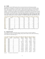
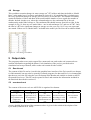
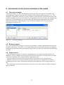
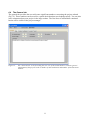
The FYRIS model Version 2.0
– A tool for catchment-scale modelling of source apportioned
gross and net transport of nitrogen and phosphorus
A user´s manual
by
Klas Hansson, Mats Wallin & Georg Lindgren
Department of Environmental Assessment
Swedish University of Agricultural Sciences
Box 7050 SE 750 07 Uppsala
2006
Report 2006:16
The FYRIS model Version 2.0
– A tool for catchment-scale modelling of source apportioned
gross and net transport of nitrogen and phosphorus
A user´s manual
by
Klas Hansson, Mats Wallin and Georg Lindgren
ISSN 1403-977X
Contents
1
MODEL HISTORY ...........................................................................................................................................................3
2
MODEL DESCRIPTION .................................................................................................................................................3
3
USE OF OTHER MODELS TO CALCULATE INPUT DATA................................................................................4
4
INPUT DATA FILE ..........................................................................................................................................................4
4.1
4.2
4.3
4.4
4.5
4.6
4.7
4.8
5
OUTPUT DATA.................................................................................................................................................................9
5.1
5.2
6
CATCHMENT .................................................................................................................................................................4
MAJOR POINT SOURCES ................................................................................................................................................6
MINOR POINT SOURCES ................................................................................................................................................6
TYPE SPEC CONC ...........................................................................................................................................................7
TEMPERATURE ..............................................................................................................................................................7
COBS ............................................................................................................................................................................8
SPECIFIC RUNOFF ..........................................................................................................................................................8
STORAGE .......................................................................................................................................................................9
RESULTS.XML ...............................................................................................................................................................9
MONTECARLO .OUT ........................................................................................................................................................9
INTRODUCTION TO THE VARIOUS WINDOWS OF THE MODEL ..............................................................10
6.1 THE PROJECT MANAGER .............................................................................................................................................10
6.2 WORKSPACE PANEL ....................................................................................................................................................10
6.3 PROJECTS PANEL .........................................................................................................................................................10
6.4 THE G ENERAL TAB .....................................................................................................................................................11
6.5 THE DATA TAB............................................................................................................................................................12
6.6 THE Q-DATA TAB ........................................................................................................................................................12
6.7 THE CALIBRATION TAB ..............................................................................................................................................13
6.8 THE SCENARIO TAB ....................................................................................................................................................14
6.9 THE RESULT TAB ........................................................................................................................................................14
6.9.1 Internal load.......................................................................................................................................................15
6.9.2 Sources ...............................................................................................................................................................15
6.9.3 Apportionment....................................................................................................................................................15
6.9.4 Catch contr.........................................................................................................................................................15
6.9.5 The Catchment listbox .......................................................................................................................................15
6.9.6 Other features ....................................................................................................................................................15
7
SPECIAL FEATURES....................................................................................................................................................16
7.1
7.2
8
HOW TO START USING THE FYRIS MODEL......................................................................................................16
8.1
8.2
8.3
8.4
8.5
9
REMOVAL OF EMPTY ROWS IN THE INPUT DATA TABLES ..........................................................................................16
COLUMN MODE SWITCH .............................................................................................................................................16
SYSTEM REQUIREMENTS.............................................................................................................................................16
INSTALLING THE PROGRAM ON YOUR COMPUTER .....................................................................................................17
IMPORT DATA ..............................................................................................................................................................17
CALIBRATION ..............................................................................................................................................................17
SCENARIOS ..................................................................................................................................................................17
REFERENCES .................................................................................................................................................................18
2
1 Model history
The dynamic Fyris model was originally developed by Hans Kvarnäs at the Dept. of Environmental
Assessment at SLU1 for calculating source apportioned nitrogen and phosphorus transport in the
River Fyris catchment in central Sweden (Kvarnäs 1996). After this first application the model has
been further developed in applications for the Lake Vättern catchment (Kvarnäs 1997), the Lake
Storsjön catchment (Johansson & Kvarnäs 1998), catchments of coastal areas in Lake Vänern
(Wallin et al. 2000) and the River Göta catchment (Sonesten et al. 2004). During 2005-2006 the
platform for the Fyris model has been changed from LabView (http://www.ni.com/labview) to
Visual Studio and .Net Framework (http://msdn.microsoft.com/netframework). This user manual
describes the new version of the model released in September 2006.
2 Model description
The dynamic Fyris model calculates source apportioned gross and net transport of nitrogen and
phosphorus in rivers and lakes. The main scope of the model is to assess the effects of different
nutrient reduction measures on the catchment scale. The time step for the model is one month and
the spatial resolution is on the sub-catchment level. Retention, i.e. losses of nutrients in rivers and
lakes through sedimentation, up-take by plants and denitrification, is calculated as a function of
water temperature, nutrients concentrations, water flow, lake surface area and stream surface area.
The model is calibrated against time series of measured nitrogen or phosphorus concentrations by
adjusting two parameters.
Data used for calibrating and running the model can be divided into time dependent data, e.g.
time-series on observed nitrogen and phosphorus concentration, water temperature, runoff and point
source discharges, and time independent data, e.g. land-use information, lake area and stream length
and width (see Fig. 1).
Figure 1.
1
The general structure of inputs and outputs to the Fyris model.
SLU = Swedish University of Agricultural Sciences
3
3 Use of other models to calculate input data
The dynamic SOILNDB model (Johnsson 2002) is used for calculating type-specific concentration
of nitrogen in leaching from agricultural land. For calculating the type-specific concentration of
phosphorus in run off from agricultural land a regression model has been used until now (Ulén et al.
2001). This model will, however, be replaced by the dynamic ICECREAM model (Larsson et al.
2003). Type-specific concentration of a given nutrient (N,P) is an annual average concentration
normalized for climatic conditions and typical for a combination of crop and soil type. For
calculating the type-specific concentration of nitrogen and phosphorus in run off from forested
areas a regression model is used (Löfgren & Westling 2002). For calculating runoff and water
discharge the HBV model (Bergström 1995) or the Q model (Kvarnäs 2000) is used.
4 Input data file
In order to perform simulations with the Fyris model, one Excel-file containing all input data is
required. Any suitable name may bee chosen for the Excel file and it must have the .xls extension.
The Excel data file contains eight different worksheets (Fig. 2). Worksheets that are not needed in
your project (eg. Storage if no model lakes with storage are included) can be left blank. They may,
however, not be deleted. The order of the worksheets in the workbook is of no importance,
however, the names and content of each worksheet must obey the guidelines in this manual. Make
sure the name of the worksheet is spelled according to Fig. 2, and that the upper/lower case is
correct!
Figure 2.
The worksheets required in the Excel workbook.
An example of the excel input data file is provided with the program (Demo_Input_Nitrogen.xls).
4.1 Catchment
This worksheet contains time independent data on the different sub-catchments that is needed for
the quantification of the nutrient transport. This includes information on hydrological network of
sub-catchments and sub-catchment specific data on land-use, deposition, type-specific
concentration in runoff from arable land and pasture and data on included model lakes.
Figure 3.
The first rows and columns of an example Catchment worksheet. Given that the Fyris model
uses decimal point and not decimal comma, make sure that your input data is provided using
decimal point!
4
The position for each column must not be changed. The variable name in the header row can,
however, be changed (possible to include translation of variable and more detailed description). The
variable names, units and description of the variables are given in Table 1.
Table 1.
The variables included in the Catchment worksheet.
Variable name
Catchment ID
Station ID
Unit
-
Downstream ID
Area
Lake Area
Stream Length
Stream Area
Mountain
Forest
Clearcuts
Mire
Arable
Pasture
Open
Settlements
Urban
cArable
cPasture
Altitude*
Lake Model
Dep Lake
Dep Clearcut
Model Lake Name*
Model Lake Area
Model Lake Depth*
Model Lake Volume
Initial Lake Concentration
km2
km2
m
km2
km2
km2
km2
km2
km2
km2
km2
km2
km2
mg/l
mg/l
m
kg/month/km2
kg/month/km2
km2
m
m3·106
kg/m3
Description
Sub-catchment ID
The ID-number of the nearest downstream
flow measuring station.
Downstream sub-catchment
Total area of sub-catchment
Lake area
Stream length
Stream area
Mountain area – above tree line
Forested area
Clear cuts (not older than 5 years)
Mire/Wetland
Arable land
Pasture
Other open land
Settlements
Urban areas.
Type specific concentration from arable land
Type specific concentration from pasture
Altitude above sea level
1 = Yes, 0 = No
Nitrogen deposition on lakes (zero for P)
Nitrogen deposition on clearcuts (zero for P)
Model lake area
Model lake mean depth
Model lake volume
Initial concentration for model lakes
* Parameter currently not in use in the model.
The outflow ID in the Catchment worksheet contains information on how the sub-catchments are
connected to each other. If, for instance, sub-catchment 1360 is immediately downstream of subcatchment 1348, 1360 should be typed into column C (Downstream ID column) on the row
containing the sub-catchment 1348 information (see example in Fig. 5). The outlet area for the
whole model catchment should have the downstream ID -1.
Large lakes with water turnover time significantly higher than the time step of the model (1 month)
may be included as “Model lakes” in the Catchment worksheet (Tab. 1). For these lakes additional
information is needed (area, volume and initial concentration). The “Model lakes” are assumed to
be situated close to the outlet of the sub-catchment and, hence, receive the total load from sources in
the sub-catchment. Furthermore, there can only be one “Model lake” per sub-catchment. Information on water storage in “Model lakes” is inserted in a separate worksheet (see section 4.8).
5
4.2 Major point sources
This worksheet contains data from large point sources such as wastewater treatment plants. The
data should be organized according to Fig. 4, i.e. the first row should contain headings for every
column. It is of no importance what is actually written, just make sure to write something on line
one, and start providing data on row two. Column A should contain the catchment ID, column B the
name of the facility, column C the year for which the data applies, column D the month during
which the measurement was taken, and column E the average load per month (kg month-1). There
can be more than one facility in a certain catchment area. The data for the different facilities are
inserted below each other. Catchments that have no major point sources do not need to be included.
Figure 4.
The first rows and columns of the Major point sources-worksheet.
4.3 Minor point sources
This worksheet contain data from small point sources such as scattered households with
autonomous sewage treatment system. The data should be organized according to Fig 5, i.e. the first
row should contain headings for every column. It is of no importance what is actually written, just
make sure to write something on line one, and start providing data on row two. Column A should
contain the catchment ID, column B the average load per month (kg month-1) from households. In
column C and D you have the possibility to insert data on other minor point sources that should be
included in the source apportionment calculations. Catchments that have no minor point sources do
not need to be included.
Figure 5.
The first rows and columns of the Minor point sources-worksheet.
6
4.4 Type spec conc
This worksheet includes type-specific concentrations (mg/l) in runoff from different land use. Typespecific concentrations in runoff from arable land and pasture are, however, given in the Catchment
worksheet thus allowing different concentrations to be used for different sub-catchments. The
values in the Type spec conc worksheet depend on the season so there should be one value for each
month of the year (12 rows). The land use classes are from left: mountain areas (above tree line),
forests, clear cuts, mire/wetlands, open land, settlements and urban areas (Fig. 6). The default
values are values used for the most recent model applications in the southern part of Sweden. Make
sure to include a header row since data is imported from the second row down.
Figure 6.
Type specific nutrient concentrations (mg/l) in the runoff from different land uses.
4.5 Temperature
This worksheet includes data on measured water temperature. If these data are not available from
the modelled catchment data on measured air temperature (monthly mean) is an acceptable
approximation of water temperature. The columns from left in the temperature worksheet are: Year;
Month (1-12); Number of days per month (28-31); and Temperature (˚C) (Fig. 7). These data are
used for all sub-catchments in the model and you have to fill in a row for each time step of the
model. This means that if the model includes data for 5 years (60 months) you have to fill in 60
rows. Make sure to include a header row since data is imported from the second row down.
Figure 7.
A snapshot from a typical Temperature worksheet.
7
4.6 COBS
The worksheet named COBS contains data on measured nutrient (total nitrogen and total
phosphorous) concentrations. Note that only one nutrient at the time can be calculated for in the
model. Data is provided once a month in mg l-1, and the model only allows for one measurement
site per sub-catchment. The first row in this worksheet should contain headings (Fig. 8). From
column C, and further to the right, the sub-catchment ID corresponding to the measurement station
should be provided. Only include the sub-catchments for which there are measured values. If values
are missing for a certain month, type -99 in the cell. This informs the model that there is a missing
value for that month and sub-catchment. Note that missing data may only be assigned the value
-99 in this worksheet! In the other worksheets, -99 will be interpreted as data with value -99.
Figure 8.
A typical COBS worksheet containing measured (and missing) concentration values of the
studied nutrient.
4.7 Specific runoff
This worksheet contains information on the area-specific runoff in each sub-catchment
(mm/month). The first row contains headings, and Q-station numbers (ID), while the following
rows contain the actual data (Fig. 9).
Figure 9.
The Specific runoff worksheet.
8
4.8 Storage
This worksheet contains changes in water storage (m3·106) in lakes and dams included as “Model
lakes” in the model (see Catchment worksheet in section 4.1). If a modelled lake is judged not to
have any significant changes in storage you fill in zeros (0) for this lake. The number of columns
equals the number of lakes and dams in the model and the number of rows equals the number of
months. Include a header row, where the column headers are the catchment IDs of the subcatchment the model lake belongs to. The catchment IDs should increase from left to right. In the
example in Fig. 10, there are two model lakes – one in sub-catchment 1367 and one in 1407. Only
the lake in 1407 have significant changes in storage over the year (Fig. 10). Every row represents
one month. If there are no “Model lakes” included in the model you can leave the worksheet blank.
Figure 10. The Storage worksheet.
5 Output data
The program produces two major output files: montecarlo.out, and results.xml. montecarlo.out
contains information regarding the Monte Carlo simulation of the project, provided such a
simulation has been performed, while results.xml contain all other results.
5.1 Results.xml
The content of this file can be viewed in the graphical user interface of the Fyris model (see chapter
6 of this manual), but may also be opened in external programs for data analysis. It is recommended
that the user saves the file using the save file button in the Results tab window to obtain an ASCII
file named Results.out. This file can be opened in Excel and contains the information included in
the Result tab described in section 6.3
5.2
montecarlo.out
The content of the montecarlo.out ASCII file is organized in columns:
Column 1
c0
2
cT (= 20 °C)
3
kvs
4
E
5
r
empirical calibration parameter for
temperature
dependency
upper limit in °C
for temperature
dependency
empirical calibration parameter for
sedimentation loss
rate
model efficiency
according to Nash
& Sutcliffe (1970)
the correlation
coefficient
A more detailed description of the parameters above is given in the technical description of the
Fyris model (Hansson et al. 2006).
9
6 Introduction to the various windows of the model
6.1 The project manager
The project manager is where you organize the work you carry out using the Fyris model. The
project manager comprises two parts, the workspace panel and the projects panel (Fig. 11). The
workspace is essentially a directory on your computer (found under the Fyris model directory) that
contains a number of projects. A possible way of organizing your work is to give the workspace the
same name as the catchment you currently study, and then store all simulations related to that
catchment as projects in that workspace. If you click any workspace in the list, the projects
belonging to it will show up.
Figure 11.
The project manager.
6.2 Workspace panel
The “New” button allows the user to create a new workspace, and the delete button allows the user
to delete a workspace – but ONLY if it is empty. Thus, the user must delete all projects within the
workspace first and then delete the workspace itself. This is to reduce the risk of unwanted deletions
of work.
6.3 Projects panel
– The New button creates a new project by prompting the user to import an input data file (see
chapter 4). The user should browse to the desired Excel file and open it. The data in the Excel file
will now be imported if the contents fulfil the requirements on it.
– The Delete button is used to delete a project. Only one project at a time can be deleted.
– The Copy button is used to copy an entire project to a new project to which the user will be
prompted to provide a name. All settings and results of the old project will be copied to the new
one.
– The Open button opens the selected project. The same action will be taken by double-clicking a
project in the list.
10
6.4 The General tab
The general tab provides the user with some significant numbers concerning the project at hand
(Fig. 12). These numbers can be used for a quick check that data was loaded properly. You can also
store comments about your project in the large textbox. The first lines of information contained
herein will be visible in the project manager.
Figure 12.
The “General tab” is the first thing the user sees of the actual model. It contains general
information of the projects such as number of sub-catchments and number of measurement
stations.
11
6.5 The Data tab
Under the data tab one can find data tables corresponding to the worksheets of the input data Excel
file (Fig. 13) by clicking corresponding button on the left. These data tables are useful for checking
that the import of data worked well.
Figure 13.
The “Data tab” is useful for browsing the input data tables making sure that all information
was imported correctly.
6.6 The Q-data tab
The data under the Q-data tab shows the area specific runoff and storage from the input data Excel
file (Fig. 14).
Figure 14.
The Q-data tab contains input data regarding runoff and storage.
12
6.7 The Calibration tab
This is where you will probably spend most of your time. The basic idea of this tab window is to
provide means of calibrating your model, and evaluate how sensitive a goodness-of-fit value is to
changes in parameter values (see section 8.2). Both manual calibration and Monte Carlo simulations
may be used to find out the optimum set of parameter values.
Calibration may be carried out by means of manual calibration, where the user
manually changes the value of the calibration parameters c0 and kvs between simulations. The first
step is to chose Manual calibration from the list in the upper right corner. Then insert values on c0
and kvs and click on the Settings button to chose time period (months) for the calibration. All
stations included in the COBS worksheet will be included in the calibration. If you want to use
some of the stations for calibration and some for validation you must use two different COBS
worksheets – one containing the selected calibration stations and one containing the selected
validation stations. To run the calibration you click on the Run button in the lower right corner.
The agreement between the modelled and measured data is evaluated using the model
efficiency (Eff) (Nash and Sutcliffe, 1970), and the correlation coefficient (r). After a manual
simulation, the user can look at time series plots on modelled data (solid line) and measured data
(dots) for every sub-catchment where measured data exist (Fig. 15). First click on the Plot button.
Then change station by using the < or > button. It is also possible to make a plot of simulated
values versus measured values.
Figure 15. The plot shows a time series simulation of nitrogen concentration in catchment 13. Parameter
values are displayed to the right, as well as the statistical measures used in the Fyris model.
Parameter influence can be analysed by means of Monte Carlo simulations where parameter values
are generated randomly according to a user specified uniform distribution. The results can then be
visualised through scatter plots (Fig. 16). The scatter plots reveal if any parameter is redundant, and
will also give information about what parameter values will give the best fit to the measured data.
The parameter values (c0 and kvs) giving the best fit to measured data generated with Monte Carlo
simulations are in the next step used to run the model using manual calibration.
13
Figure 16.
The plot shows an example Monte Carlo simulation consisting of 200 individual simulations.
Every single simulation is plotted as a dot where the model efficiency is a function of the value
of the calibration parameter kvs.
6.8 The Scenario tab
This tab is currently not in use.
6.9
The Result tab
Figure 17.
The “Result tab” provides the means to display output data as well as ways to e.g. perform
source apportionment.
14
The Result tab lets you look at the entire results file in itself, sorted according to sub-catchment. In
addition, it provides the user with the possibility to automatically perform various computations by
pressing the following buttons (Fig 17):
6.9.1 Internal load
Pressing this button presents in the tabular area (here referred to as the data grid view) of the
Results tab the internal gross load (before retention) in each sub-catchment, and the net contribution
(after retention) of each sub-catchment to the downstream sub-catchment summed over the entire
simulation period
6.9.2 Sources
After the computation, the data grid view will contain the gross contribution (before retention) of
the different sources in each sub-catchment summed over the entire simulation period
6.9.3 Apportionment
Clicking this button will start the computation of the source apportionment of the total upstream net
load (after retention) calculated for the outlet of the sub-catchment that is chosen by inserting its
catchment ID in the textbox labelled Out in the left margin of the Result tab (Fig. 17). I.e. it is
possible to make a source apportionment for every sub-catchment in the system if wanted. The
upper row of the presented data contains the actual load in kilograms per month that each source
contributed with at the chosen outlet point. The lower row comprises the corresponding fractions.
6.9.4 Catch contr
Clicking this button will start the calculation of the nutrient mass contribution in kilograms per
month from each sub-catchment to the chosen outlet. As mentioned in paragraph 6.9.3, the outlet
catchment is selected by inserting its ID number in the textbox labelled Out (Fig. 17). The column
labelled “Gross contribution” contains values that are identical to the values presented as gross
contribution when pressing the internal load button. The column labelled “Contribution at outlet”
contains the load from this sub-catchment at the chosen outlet point, i.e. after retention in all
downstream sub-catchments in the flow path to the outlet.
6.9.5 The Catchment listbox
Clicking any of the catchment ID numbers in this listbox in the left margin of the Result tab will
present the part of the complete results file relating to the chosen ID.
6.9.6 Other features
Other features of the Result tab are:
open a plot window by clicking the Plot button to view the data in graphical form (Fig. 18).
copy the present contents of the data table to the clipboard by clicking the Copy button.
save the entire results file (consisting of all catchment ID data tables) to a semi-colon separated
text file called results.out by clicking the Write file button.
15
Figure 18. The source apportionment presented graphically by means of a pie chart for sub-catchment 14.
7 Special features
7.1 Removal of empty rows in the input data tables
If the program imported more rows from the Excel worksheet than are filled with data, you can
double-click on a row header in any data table shown under the data tab to remove all rows where
the first cell is empty. The model will not run if there is more than one empty row after the last data
filled row.
7.2 Column mode switch
Under the data tab, you can change column mode by clicking the salmon coloured little square in
the bottom right corner.
8 How to start using the Fyris model
8.1 System requirements
In order for the Fyris model to run properly on your computer, it is required that you have Windows
XP including .NET framework installed. The .NET-framework should be provided with Windows
Service Pack 2, but can otherwise be installed separately from Windows homepage. Furthermore,
Office 2003 is required since the input data is imported using an Excel workbook.
Notice as well that the Fyris model utilises point (.) and not comma (,) to define non-integer
numbers (e.g. 5.3 and not 5,3). Thus, make sure that your input data have the correct format!
Depending on your computers national settings, you may want to change this using your computers
Control Panel -> National settings -> Numbers.
16
8.2 Installing the program on your computer
A standard set up program comprising two files (setup.exe and Setup Fyris model.msi) is provided
for installation of the Fyris model on your computer. The program will check your computer to
make sure that the .Net-framework is previously installed, and will encourage you to download it if
it is missing. During the installation you have the possibility to decide in what folder you want the
program installed, and the set up program will create a desktop shortcut as well as a start menu
shortcut. If your computer is connected to a network, it is likely that administrator rights are needed
for the installation.
8.3 Import data
The first thing do to when you want to start working with the Fyris model is to import the data
needed to run the model. The requirements on the input data have been mentioned in chapter 4 of
this document. A short walkthrough is provided here:
Open the project manager using the Menu.
If needed, create a new workspace which will contain your projects by clicking the new button
in the workspace panel.
Start a new project by clicking the new button in the projects panel. A dialog will emerge and
show Excel files in the directory last used on your computer. Browse to the Excel file you want to
use as data source, and open it.
Even if no error messages appeared during the opening of the Excel file, it might be a good idea
to look through the imported data to make sure it was imported as expected. This can be done by
browsing the data tables in the data grid view under the Data and Q-data tabs respectively.
If there is more than one empty line beneath your imported data, remove it (paragraph 7.1).
8.4 Calibration
Good modelling practice requires the user to calibrate the model such that the computed output
compares well to the measured output. This is done be means of adjusting the model parameters, c0
and kvs. The Fyris model provides the user with two alternatives: manual or Monte Carlo
simulations. The manual calibration is useful in getting acquainted with the model behaviour, and
provides graphical means of comparing the modelled times series to the measured data values. In
addition to the visual, subjective comparison, the model also computes two statistical goodness-offit values. Monte Carlo simulations are useful when assessing the model response to simultaneous
changes in all parameter values. This differs from sensitivity analysis where only one parameter is
altered while fixing all others. However, by plotting goodness-of-fit measures as a function of
individual parameter values, a scatter plot is obtained which provides information about sensitivity
to single parameters. When you feel confident with the results, it is time to start with scenario
modelling as described below.
8.5 Scenarios
The scenarios need to be created by the user by means of altering the input data, and then reimporting the data to the model to see the changes in output. Remember to keep the same parameter
values as was found during the calibration process.
17
9 References
Hansson, K, Wallin, M & Lindgren, G. The Fyris model Version 2.0. Technical description. –
Swedish University of Agricultural Sciences, Dept. of Environmental Assessment,
Report 2006:17, ISSN 1403-977X.
Johansson, J-Å. & H. Kvarnäs, 1998. Modellering av näringsämnen i Storsjön och dess
tillrinningsområde (in Swedish). Länsstyrelsen i Gävleborgs län. Rapport 19998:13.
ISSN 0204-5954. [Modelling nutrients in Lake Storsjön and its catchment. County Administration of
Gävleborg. Report 1998:13].
Johnsson, H., Larsson, M.H., Mårtensson, K. and M. Hoffmann 2002. SOILNDB: a decision
support tool for assessing nitrogen leaching losses from arable land. Pages 505-517.
Environmental Modelling & Software 17:505-517.
Kvarnäs, H., 1996. Modellering av näringsämnen I Fyrisåns avrinningsområde. Källfördelning och
retention (in Swedish). Rapport från Fyrisåns vattenförbund 1996, 31 sid. [Modelling
nutrient transport in the Fyris River catchment. Source apportionment and retention (in Swedish). –
Report from River Fyris Society for Water Conservation, Uppsala, Sweden].
Kvarnäs, H., 1997. Modellering av näringsämnen i Vätterns tillrinningsområde. Källfördelning och
retention (in Swedish). Vättervårdsförbunder, rapport nr 46. ISSN 1102-3791. [Modelling
nutrient transport in the catchment of Lake Vättern. Source apportionment and retention. – Lake Vättern
Society for Water Conservation, Report no 46].
Löfgren, S. & O Westling, 2002. Modell för att beräkna kväveförluster från växande skog och
hyggen i Sydsverige (in Swedish with English summary). Institutionen för miljöanalys,
SLU, rapport 2002:1. [Model for estimating nitrogen losses from growing forests and clear-felled
areas in southern Sweden. Dept. of Environmental Assessment, SLU, Report 2002:1. 23 pp.]
Nash, J. E. and J. V. Sutcliffe , 1970. River flow forecasting through conceptual models part I — A
discussion of principles, Journal of Hydrology, 10 (3), 282–290.
Sonesten, L., Wallin, M. & H. Kvarnäs, 2004. Kväve och fosfor till Vänern och Västerhavet.
Transporter, retention och åtgärdsscenariern inom Göta älvs avrinningsområde (in
Swedish). Länsstyrelsen i Västra Götalands län, rapport nr 2004:33.ISSN 1403-168X.
[Nitrogen and phosphorus loading on Lake Vänern and Västerhavet Sea. Transport, retention and nutrient
reduction measures within the River Göta catchment. County Administration of Västra Götaland, report
no 2004:33.ISSN 1403-168X].
Ulén, B., Johansson, G. and K. Kyllmar 2001. Model predictions and long-term trends in
phosphorus transport from arable lands in Sweden. Agricultural Water Management
49, 197-210.
Wallin, M., Östlund, M. & H. Kvarnäs 2000. Näringsbelastning på Vänerns vikar inom Karlstad
kommun. Källfördelning, retention, mål och årgärder (in Swedish). Institutionen för
miljöanalys, SLU, rapport 2000:6. ISSN 1403-977X. [Nutrient loading in coastal areas of Lake
Vänern within Karlstad Township. Source apportionment, retention, environmental objectives and
measures. - Swedish University of Agricultural Sciences (SLU), Dept. of Environmental Assessment.
Report 2000:6, ISSN 1403-977X, 113 p].
18