1
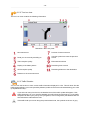
User Manual
Navigation Software
-2-
Table of Contents
1 Starting up ..............................................................................................................................
1.1 Important information .....................................................................................................
1.2 Alternative installation of navigation software from a memory card ....................................
1.3 Further map material ......................................................................................................
1.4 Transferring map material to a memory card ....................................................................
1.5 Transferring installation files and map material to the internal memory ...............................
1.6 Data transfer (GoPal Assistant) .......................................................................................
1.6.1 Transferring the installation files ...........................................................................
1.6.2 Transferring the map data ....................................................................................
4
5
5
5
6
6
6
7
7
2 Operating the navigation software .......................................................................................... 8
2.1 Symbols ........................................................................................................................ 9
2.2 Map ............................................................................................................................ 10
2.3 Destination .................................................................................................................. 11
2.3.1 Enter new destination ........................................................................................ 11
2.3.2 Search for ......................................................................................................... 12
2.3.3 Favourites ........................................................................................................ 12
2.3.4 Last locations .................................................................................................... 12
2.3.5 Route options ................................................................................................... 12
2.3.6 Add location to favourites ................................................................................... 13
2.3.7 Show location ................................................................................................... 13
2.3.8 Calculating the route ......................................................................................... 13
2.3.9 Quick search ..................................................................................................... 13
2.3.10 Area search .................................................................................................... 13
2.3.11 Route planning ................................................................................................ 14
2.3.12 Save current position ....................................................................................... 14
2.3.13 Stored locations .............................................................................................. 14
2.4 Route .......................................................................................................................... 14
2.4.1 Go to ... ............................................................................................................ 15
2.4.2 Change route .................................................................................................... 15
2.4.3 Directions ......................................................................................................... 15
2.4.4 Route options ................................................................................................... 15
2.4.5 Stop route guide ................................................................................................ 15
2.5 View ............................................................................................................................ 15
2.5.1 2-D or 3-D map ................................................................................................. 15
2.5.2 Turn icon view ................................................................................................... 16
2.5.3 Traffic Situation ................................................................................................. 16
2.5.4 Compass .......................................................................................................... 17
2.5.5 Journey info ...................................................................................................... 17
2.5.6 Other Applications ............................................................................................. 17
2.6 Settings ....................................................................................................................... 17
2.6.1 Settings for the unit ........................................................................................... 17
-3-
2.6.2 Display .............................................................................................................
2.6.3 Volume control ..................................................................................................
2.6.4 Language .........................................................................................................
2.6.5 Map selection ...................................................................................................
2.6.6 TMC-Transmitter ...............................................................................................
2.6.7 Preferred petrol stations ....................................................................................
2.6.8 Quick search category .......................................................................................
2.6.9 Info ..................................................................................................................
18
18
18
18
19
19
19
19
3 Further notes ........................................................................................................................
3.1 Liability ........................................................................................................................
3.2 Support .......................................................................................................................
3.3 Trademarks .................................................................................................................
20
21
21
21
-4-
1. Starting up
This chapter contains information about the following subjects:
1.1 Important information
1.2 Alternative installation of navigation software from a memory card
1.3 Further map material
1.4 Transferring map material to a memory card
1.5 Transferring installation files and map material to the internal memory
1.6 Data transfer (GoPal Assistant)
-5-
1.1 Important information
For safety reasons, the driver must not make entries whilst driving. The instructions issued
by the navigation system are recommendations. The road traffic regulations must be observed
in all cases.
Thermally insulated glass or windscreens with metallic coating reduce the GPS reception a
lot. Usually this type of coating is omitted at a special place behind which the navigation unit
can be fitted. If that is not the case, a commercially available GPS aerial has to be fitted outside,
e.g. on the roof of the vehicle.
1.2 Alternative installation of navigation software from a memory card
The software for your navigation system can also be directly installed from an appropriately prepared
memory card. Preinstalled software may have to be de-installed first (see device manual).
On first-time set-up you will be requested to install the navigation software. Please proceed as follows:
a. Carefully remove the memory card from the packaging. Please take care not to touch contacts or allow
them to become soiled.
b. Insert the memory card in the SD/MMC slot until it clicks into place.
c. Click OK to install the application.
Once all data has been copied to your navigation system, the main window will be displayed in which
you can now perform the navigation settings.
Note
Please take note that a valid GPS signal must be received and the time zone needs to be set
after the installation of the software, so that the correct arrival time can be calculated in future
route calculations.
1.3 Further map material
Your navigation system is already supplied ex works with a digitalised map of your country in its internal
memory. Further digitalised maps may be added to those in the internal memory. Depending on the
version, further digitalised maps will be featured on your DVD. These maps may be immediately transferred to a memory card whereby the use of an external card reader is recommended (see device
manual).
Depending on the extent of the map material, memory cards with 256 MB,512 MB,1,024 MB or larger
are required.
Note
Please note that some of the devices do not include memory cards in the delivery. In these
units the installation and map files have already been loaded. The installation will run automatically.
-6-
Additional memory cards (MMC or SD cards) are stocked by specialist stores.
1.4 Transferring map material to a memory card
Transferring further map material to a memory card is best performed via your PC explorer. Please
proceed as follows:
a. Insert the DVD with the required map material.
b. Open your workplace and select your DVD drive.
c. Copy the file with the .psf extension from the directory of the region you require from the DVD to
the directory MapRegions on your memory card.
You can transfer several files of map material to your memory card, depending on the size of the latter.
Please hereby ensure that there is sufficient storage space on your memory card.
If you have copied digitalised maps of several countries or country groups to your memory card, you
must select the required country map in the navigation application of your device.
1.5 Transferring installation files and map material to the internal
memory
Your device features an internal, non-volatile memory Contained in the \My Flash Disk folder. Via
®
ActiveSync you can use the Search option to display this and further folders. Manipulations to folders
and files can be performed as in an explorer.
The necessary folders must be created to make installation files and map material available to the device.
Create the INSTALL folder (\My Flash Disk\INSTALL) for the installation files. Store map material
in the MapRegions (\My Flash Disk\MapRegions) folder. On naming folders please observe the
writing forms specified above.
Should additional data be stored on your navigation device, please note that sufficient capacity must be
available on transferring data. If this is not the case, remove files that are not required.
Note
®
The navigation system must be linked to the computer via ActiveSync (see device manual)
for data transfer.
1.6 Data transfer (GoPal Assistant)
The GoPal assistant is available for transferring installation files and card data to the navigation device.
In this case, use a memory card reading device or ActiveSync connection.
-7-
1.6.1 Transferring the installation files
Note
Please note that the memory card is formatted before the data transfer! Please therefore ensure
beforehand that there are no important files still on your memory card!
Before installing the software you must transfer the installation files using the GoPal Assistant as follows:
a. The software will start up automatically when you insert the DVD into your PC drive. If the software
does not start automatically, you can also run it directly from the DVD in Windows Explorer by clicking
on the GoPalAssistant.exe file (directory: Assistant).
®
b. Insert your memory card in the card reader or connect the navigation device via ActiveSync to your
PC.
®
c. Select the drive for your memory card or drive linking ActiveSync to your computer.
d. You can now transfer the navigation software installation files from the DVD to your memory card by
clicking on Transfer software.
Note
Please note that software installation in the navigation system is only performed following a
hard reset (see: device manual).
1.6.2 Transferring the map data
Once the installation files have been transferred to your memory card you can create your own personal
map area using a general map. Later on you can adapt your personal map area using the GoPal Assistant,
i.e. delete map regions you no longer need or add new map regions.
a. The software will start up automatically when you insert the DVD into your PC drive. If the software
does not start automatically, you can also run it directly from the DVD in Windows Explorer by clicking
on the GoPalAssistant.exe file (directory: Assistant).
®
b. Insert your memory card in the card reader or connect the navigation device via ActiveSync to your
PC.
®
c. Select the drive for your memory card or drive linking ActiveSync to your computer.
d. You can now switch to the general map by clicking on Transfer Map Data. There you can create your
personal map area by clicking on the map regions. Simply follow the instructions in the software.
Note
If you have just transferred the navigation software installation files to your memory card, you
will be back in your memory card drive view. You can switch directly to the general map by
clicking on Transfer Map Data.
-8-
2. Operating the navigation software
This chapter contains information about the following subjects:
2.1 Symbols
2.2 Map
2.3 Destination
2.4 Route
2.5 View
2.6 Settings
-9-
2.1 Symbols
Symbols in menus
Use this symbol to access the menu bar.
Use this symbol to access the View menu.
Use this symbol to access the Destination menu.
Use this symbol to access the Route menu.
Use this symbol to access the Settings menu.
Use this symbol to access the Help menu.
Use this symbol to access the previous screen.
Use this symbol to confirm the entry and move to the next screen.
Use this symbol to exit the navigation software.
Symbols on map
Press this symbol to access the compass.
This symbol dispays the battery status of the device.
Use this symbol to check GPS signal quality and by clicking on the symbol you can change
to Compass view.
Current traffic information can be received via the TMC module, which will then be displayed
on the map with a corresponding traffic symbol.
A warning symbol on the map as well as an acoustic warning will alert you to the nearest
traffic hold-ups on your route that affect your travelling time.
Clicking on the warning symbol will take you to the traffic warning view.
If the traffic hold-ups are not along the precalculated route, the symbols are shown in grey.
- 10 -
2.2 Map
The map view contains the following information:
Resolution: 480 x 272 pixels
Compass
Your current position
1
2
Road you are currently travelling on
Main menu/Autozoom
TMC reception quality
Estimated arrival time
Display of the battery status
Remaining time to travel
GPS reception quality
Remaining distance to the destination
Scale
View
Zoom
1)
During a manoeuvre distance and turn-off info are additionally displayed.
2)
After zooming in or out, you can use this switch to reactivate Autozoom.
You can select a destination directly from the map. Touch the area of the map that you want to go to. If
your desired destination is not in the area touched, you can use the menu bar at the bottom of the screen
to switch to further areas nearby.
Use this to navigate to the previously marked section of the map.
Use this to navigate to the next marked section of the map.
Here you can view detailed information about the marked area selected.
- 11 -
Use this to select the marked area as your destination.
2.3 Destination
After starting the navigation software you can plan your route and drive off immediately after entering
the destination.
2.3.1 Enter new destination
Resolution: 480 x 272 pixels
Select one of the last chosen destinations
Enter the postcode
Selecting a search category (roads or
special places)
Enter street name or house number
Enter town or select country
Select a destination from the favourites
1)
When you have selected a special place (e.g. hotel) under search category, the input boxes Street
and House number are replaced by the input box Name.
Note
You can search for a place using the postcode and/or the town/city. In order to further specify
the search you can enter the street and house number. If it is possible to take the house
number into consideration when calculating the route, this will be indicated in the
Detailed informationen view. You can also reach the town centre without giving a street name,
or reach the middle of a street without giving a house number.
When searching for a special place (e.g. a petrol station), entering the name will allow a more
detailed search.
- 12 -
Use the keyboard to enter your destination address. The navigation software automatically completes
the address when searching for a destination. After entering just a few characters, you will be shown
the three best results along with the list of all possible results. If the place you are looking for does not
appear on the list, you may have to enter more detailed information for the address.
2.3.2 Search for
You can use the search category to determine the type of destination. By default, the program will search
for the road/street of the entered address. But you can also select a different category and search for
special places such as hotels, airports or petrol stations in a certain town.
You can also select the Geo-coordinates search category and set a destination by entering degrees of
longitude and latitude.
2.3.3 Favourites
This is a list containing those destinations you have saved and that you require more frequently.
2.3.4 Last locations
The last used destination locations are saved in chronological sequence and can be reactivated as
destination using this option. The last three can be selected directly from the address field, all other
previous locations can be accessed via Last locations.
2.3.5 Route options
Before calculating the route you can determine the route options in the detailed information of the destination. You can use the route options to determine the way you are guided to your destination.
Route calculation and guide optimised for motor vehicles (standard option)
Route calculation and guide optimised for cyclists (possible up to a radius of 50 km)
Route calculation and guide optimised for pedestrians (possible up to a radius of 50 km)
Route calculation and route guiding optimised for motorcyclists
The optimisation of the calculated route is based on the time factor (standard option).
The optimisation of the calculated route is based on the length of the journey.
Economic route: a combination of short and fast route
Toll roads are included in the route calculation (standard option).
Toll roads are avoided in the route calculation.
- 13 -
Motorways are included in the route calculation (standard option).
Motorways are avoided in the route calculation.
Ferries are included in the route calculation (standard option).
Ferries are avoided in the route calculation.
No congestion by-pass
Manual congestion by-pass
Automatic congestion by-pass
2.3.6 Add location to favourites
You can choose this option in the detailed information in order to save the displayed location in the favourites.
2.3.7 Show location
You can use this option to have the location displayed in the map beforehand.
2.3.8 Calculating the route
Once you have checked the destination details and selected the route options according to your preferences, you can start the route calculation. The calculation can only be done when the unit works without
any faults. Faults are identified as follows:
The GPS reception is faulty. Your current location can therefore not be determined.
2.3.9 Quick search
Using the quick search you can look for items in a pre-set search category (e.g.: hotels, airports or petrol
stations).
2.3.10 Area search
You will be offered special places near your current location for your selection. For the identified places,
the device will also display the distance as the crow flies.
- 14 -
Note
At first, the navigation software will search within a smaller radius. If this does not yield any
results, the search is extended to a larger radius. This may cause a time delay in certain circumstances.
2.3.11 Route planning
Using this option you can plan a route (e.g. the day before going on holiday) by entering the starting
point and destination, even while the GPS receiver is switched off. You can also enter multiple destinations, which are navigated one after the other.
Your starting point (as standard, the last known position is used)
You can add up to 5 destinations.
Move the selected destination upwards.
Move the selected destination downwards.
Delete a destination.
Here, you can change the starting point of your route or adapt the route in terms of the entire
journey.
2.3.12 Save current position
You can use this function to save your current position as favourite. However this will only work if you
receive a GPS signal with your navigation device.
2.3.13 Stored locations
Using the Stored locations function you can rename or delete your personal favourites, or delete the
last destination visited or all previous destinations.
2.4 Route
Once the route has been calculated successfully, you will be guided to the specified destination with the
help of acoustic and visual instructions.
The following functions can be used during navigation:
- 15 -
2.4.1 Go to ...
When navigating or after planning a route you can change your view here to see an overview of your
route or your destination area or return to your current location or, if planning a route, your starting point.
2.4.2 Change route
You can change your current route as described in Section 2.3.11, “Route planning”.
2.4.3 Directions
The description of the route tells you what roads to take in order to reach your destination. In addition,
border crossings into other countries are marked. The route description is only available once you have
calculated a route.
2.4.4 Route options
You can also change your route options during navigation in order to influence the way that you reach
your destination (see Section 2.3.11, “Route planning”).
2.4.5 Stop route guide
Use this function to terminate current routing and delete the route from the memory.
2.5 View
You can switch between various views when navigating:
2.5.1 2-D or 3-D map
Here you can change quickly between a 2-D and 3-D view of the map.
- 16 -
2.5.2 Turn icon view
The turn icon view contains the following information:
Resolution: 480 x 272 pixels
Next manoeuvre
Preview of next manoeuvre
Road you are currently travelling on
Use this symbol to access the previous
screen.
TMC reception quality
Estimated arrival time
Display of the battery status
Remaining time to travel
GPS reception quality
Remaining distance to the destination
Distance to the next manoeuvre
2.5.3 Traffic Situation
You can use this function to have current traffic information displayed in a list. This will show first the
traffic reports affecting your route (sorted by distance) and then the events not situated along your route
(in alphabetical order).
If you select an entry from the list, the detailed view of this traffic update will appear. If this
traffic disruption is on your route the detailed view will indicate how far away it is. If the traffic
disruption will affect your journey time (congestion, slow-moving traffic) the detailed view will
also indicate the estimated time lost.
If the traffic hold-ups are not along the precalculated route, the symbols are shown in grey.
- 17 -
In the traffic warning view you will be shown the distance to the traffic hold-up affecting your route and
the likely delay in travelling time and you will be given the option to ask for an alternative route to be
calculated.
If you don't want to ask for a calculation of an alternative route you can decline and the warning symbol
will disappear from the map.
If you want to ask for an alternative route to be calculated, the navigation software will calculate a route
which tries to bypass the traffic hold-up.
If it is not possible to calculate an alternative route, the warning will disappear from the map, but you
can select the traffic hold-up affecting your route once again in the list view and then ask again for an
alternative route to be calculated in the traffic warning view.
2.5.4 Compass
In the compass you can read the speed, the current longitude and latitude as well as the GPS reception
quality (HDOP value). The direction of travel is displayed reliably from a speed of approximately 3 mph.
In addition, after a GPS signal has been received once the GPS time will be displayed in Greenwich
Mean Time (GMT).
2.5.5 Journey info
In this option you can view information on your current route, such as average speed, total journey time
elapsed or total distance covered.
2.5.6 Other Applications
If your navigation system has other applications, these can be started directly from the navigation software.
2.6 Settings
It is possible to configure the navigation software individually using a number of setting options.
2.6.1 Settings for the unit
The following settings can be adjusted on your unit:
In this settings template you can re-calibrate the touch screen when this does not react accurately to the touch. For calibration, a cross appears in the middle of the screen. After pressing
this cross it will move on across the screen. Keep pressing the cross until it is back in the
centre of the screen. By pressing the touch screen again, the calibrated setting will be adopted.
If you do not confirm the calibration, the view will be quit after a pre-selected period without
changes.
This can be used to adjust the brightness of the screen.
- 18 -
In order to save electricity, you can use this input template to select periods for mains and
battery operation, after which the unit will switch off.
Use this to adjust the sound volume of your unit (e.g.: key clicks).
In this view you can see the charging status of the battery of your unit and also whether
charging is in progress.
2.6.2 Display
You have the following options for the display:
The map is displayed in north orientation or in the direction of travel, depending on the scale
of the map (2D-map view).
The map always turns according to the direction of travel (2D-map view).
The map is displayed in north orientation (2D-map view).
The 3D map is always displayed in the direction of travel. The zoom function remains active
in the 3D map, but it is no longer possible to move the map.
Display of the map view with daylight optimised design.
Display of the map view with darkness optimised design.
The design of the map is adjusted to daylight or darkness, depending on the time of day.
During the manoeuvre the map changes automatically into arrow view. After the manoeuvre
the display changes back to map view.
Map view remains on display also during a manoeuvre. A small version of the manoeuvre
arrow appears on the map.
2.6.3 Volume control
Use this to adjust the sound volume of the acoustic instructions issued by the navigation software. Adjust
the system volume in the settings of the device under Settings.
2.6.4 Language
If your navigation device has several languages installed, you can use this to select another language.
After the selection, the device reboots and uses the language selected by you.
2.6.5 Map selection
If you have installed more than one map area on your memory card, you can select an area here.
- 19 -
2.6.6 TMC-Transmitter
Here you can search for a TMC transmitter. If you have tuned to a radio station and have activated
automatic search and the quality of the reception deteriorates, the unit will search for a new transmitter
in order to resume receiving TMC data. If you search manually and the reception quality deteriorates,
you cannot receive any more TMC data and have to tune into a new radio station manually.
You can specify in this view whether or not you want to be automatically directed away from
congestion. The navigation software will then automatically inform you in the background
using the traffic information available of alternative routes away from any traffic disruptions
on your route that will affect your journey time.
With manual congestion by-pass a warning symbol in the map view will alert you to the nearest
traffic disruption on your route that will affect your journey time.
Clicking on the warning symbol will take you to the traffic warning view where you
can select whether or not an alternative route is to be calculated.
If you selected No congestion by-pass the latest traffic updates will not be taken into account
in the route guidance.
2.6.7 Preferred petrol stations
Enter your preferred brands of petrol here. This is particularly useful if you have a loyalty card for a
particular brand of petrol and want this brand of petrol station to be shown first when searching for one.
2.6.8 Quick search category
Here you can determine search categories in the quick search for a specific place (e.g. a petrol station).
2.6.9 Info
This contains information about the software and map versions.
- 20 -
3. Further notes
This chapter contains information about the following subjects:
3.1 Liability
3.2 Support
3.3 Trademarks
- 21 -
3.1 Liability
The software and the manual are subject to change without notice. MEDION AG may not be liable for
the correctness of the information contained in this manual nor for damages resulting from the use of
this manual.
To improve the quality of our products and our services, we appreciate all suggestions or improvement
and all error notices.
3.2 Support
MEDION Service Center – United Kingdom
Medion Electronics Ltd.
120 Faraday Park
Faraday Road
Dorcan
Swindon SN3 5JF
Wilts, United Kingdom
Call our support staff for telephone support:
■
Mondays to Fridays 8 am to 8 pm
■
Saturdays and Sundays 10 am to 4 pm
Hotline: 0870 7270370
Fax:
01793 715716
E-mail: [email protected]
3.3 Trademarks
All brands and trademarks mentioned in this document are possibly registered by third party and subject
to the current legislation and to the rights of their respective owners without reservation. All mentioned
names of products, societies, or brands may be registered trademarks of their respective owners. Every
right that is not explicitly accorded is reserved.
The absence of an explicit labelling of registered trademarks does not allow the conclusion that this
brand was not subject to the rights of third party.
®
®
®
Windows and ActiveSync are registered trademarks of the Microsoft Corporation.