1
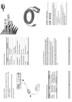
The GPS92.
Just another handheld GPS.
(Yeah, and the Pitts is just a single-engine airplane.)
This is no ordinary GPS. We’ve packed more power, more performance, more pizzazz into this compact navigator.
For starters, GARMIN’s 12 parallel channel receiver delivers a first
fix fast and stays locked on even in tight maneuvers. Enjoy up to 24
hours of pinpoint positioning from 4 AA batteries, or place your GPS 92
on the optional yoke mount and run off the aircraft’s power – forever.
The pilot-friendly operating characteristics of the GPS 92 are identical
to those on the popular GPS 90. Only now, as your thumb scrolls
through pages and across the rocker keypad, you can
access more aviation data than before. At the heart of
the GPS 92 is a Jeppesen® database with approach,
departure, FSS and ARTCC frequencies. The highcontrast, backlit LCD display reveals valuable
information like moving map
graphics and sectorized SUA
airspace. And for safety’s sake,
you can call up the nine nearest airports, VORs, NDBs, intersections, user waypoints, FSS or CTR.
What’s more, the GPS 92 earns its wings long before you’re
airborne with fuel and trip planning capabilities and an E6-B calculator.
Build and store 20 flightplans with as many as 30 waypoints each.
The GPS 92 quite simply does it all. It handles great. Boasts outstanding performance. And flies circles around the competition. See your
dealer for details or call
GARMIN at 913/397-8200.
GARMIN International, 1200 East 151st Street, Olathe, KS 66062 913.397.8200 fax 913.397.8282
GPSCOM 190, GPSMAP 195, GPS III Pilot
© 1998 GARMIN Corporation
GARMIN (Europe) Ltd., Unit 5, The Quadrangle, Abbey Park Industrial Estate, Romsey, SO51 9AQ, UK
44.1794.519944 fax 44.1794.519222
Pitts airplane photograph courtesy AVIAT Aircraft, Inc.
GPS 92
Jeppesen® Database
Coverage:
Americas, Atlantic International,
or Pacific International
Airports:
Identifier, city/state, country, facility
name, lat/lon, elevation, runways,
comm frequencies, fuel services
VORs:
Identifier, city/state, country, facility
name, lat/lon, freq., co-located DME
(or TACAN)
NDBs:
Identifier, city/state, country, facility
name, lat/lon, frequency
Intersections:
Identifier, country, lat/lon
Comm Freq.:
ATIS, Pre-Taxi, Clearance Delivery,
Ground, Tower, Unicom, Multicom,
Departure, Approach, Arrival, Class B,
TMA, CTA, Class C, TRSA, ARTCC
and FSS
Runways:
Designation, length, surface, lighting,
pilot controlled lighting frequency,
graphically displayed runway
configuration
SUA:
US Class B & C with sectors, D,
International CTA & TMA with sectors,
all SUAs including MOAs, Prohibited
and Restricted
Performance
Receiver:
Acquisition Times:
Warm:
Cold:
AutoLocate™ :
Update Rate:
Accuracy:
Position:
Velocity:
Dynamics:
Interfaces:
Antenna:
Emergency Search:
User Waypoints:
Routes:
Map Datums:
Alarms:
Timers:
PhaseTrac12™ tracks and uses up to
12 satellites simultaneously
approx. 15 seconds
approx. 45 seconds
approx. 5 minutes
1/second, continuous
Physical Specifications
Size:
6.15 x 2 x 1.23 inches (15.6 x 5.1 x 3.1 cm)
Weight:
9 ounces (255g) with batteries
Display:
2.2 x 1.5 in (5.6 x 3.8 cm) high-contrast LCD with
back lighting
Case:
Ultrasoncially welded, dry nitrogen-filled
Power:
Source:
(4) AA batteries or 10 to 32 volts DC
Usage:
.75 watts maximum
Battery Life:
Up to 24 hours (normal mode)
Temp. Range:
5 F to +158 F (-15 C to 70 C)
Components
Standard:
Optional:
GPS 92 unit with detachable antenna
Suction cup mounting bracket
4 AA batteries
Carrying case
Power/data cable
User’s manual
Quick Reference Card
Cigarette Lighter Adapter
PC database update kit
PC software kit
Yoke mount
Specifications subject to change without notice.
Jeppesen and NavData are trademarks of Jeppesen Sanderson.
**Subject to accuracy degradation to 100m 2DRMS under the United States
Department of Defense imposed Selective Availability Program.
© 1998 GARMIN Corporation
15 meters (49 feet) RMS**
0.1 knot RMS steady state*
999 knots velocity; 6g’s
NMEA 180, 182, 183, unit-to-unit,
PC, RTCM 104 v.2.0 (corrections)
Detachable with standard
BNC connector
9 nearest airports, VORs, NDBs,
intersections, user waypoints, ARTCC
or FSS
500 alphanumeric
20 reversible (30 waypoints each)
More than 100
Cross-track error, arrival and SUA
intrusion
Countdown and countup
GARMINInternational
1200 East 151st Street
Olathe, KS 66062, U.S.A.
913/397.8200 FAX 913/397.8282
GARMIN (Europe) Ltd.
Unit 5, The Quandrangle, Abbey Park Industrial Estate
Romsey, S051 9AQ, U.K.
44/1794.519944 FAX 44/1794.519222
GARMIN (Asia) Corporation
4th Floor, No. 1, Lane 45, Pao-Hsing Road
Hsin-Tien, Taiwan
886/2.917.3773 FAX 886/2.917.1758
www.garmin.com
M00-00000-00
0398
GPS 92 AVIATION NAVIGATOR™