1
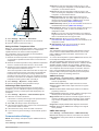
2 Select Settings > My Vessel > Keel Offset.
3 Select or based on the location of the transducer.
4 Enter the distance measured in step 1.
Setting the Water Temperature Offset
Before you can set the water temperature offset, you must have
a NMEA 0183 water-temperature sensor or a temperaturecapable transducer to measure water temperature.
The temperature offset compensates for the temperature
reading from a temperature sensor.
1 Measure the water temperature using the temperature sensor
or temperature-capable transducer that is connected to the
chartplotter.
2 Measure the water temperature using a different temperature
sensor or a thermometer that is known to be accurate.
3 Subtract the water temperature measured in step 1 from the
water temperature measured in step 2.
This is the temperature offset. Enter this value in step 5 as a
positive number if the sensor connected to the chartplotter
measures the water temperature as being colder than it
actually is. Enter this value in step 5 as a negative number if
the sensor connected to the chartplotter measures the water
temperature as being warmer than it actually is.
4 Select Settings > My Vessel > Temp. Offset.
5 Enter the temperature offset calculated in step 3.
Calibrating a Water Speed Device
If you have a speed-sensing transducer connected to the
chartplotter, you can calibrate that speed-sensing device to
improve the accuracy of water-speed data displayed by the
chartplotter.
1 Select Settings > My Vessel > Calibrate Water Speed.
2 Follow the on-screen instructions.
If the boat is not moving fast enough or the speed sensor is
not registering a speed, a message appears.
3 Select OK, and safely increase the boat speed.
4 If the message appears again, stop the boat, and ensure the
speed-sensor wheel is not stuck.
5 If the wheel turns freely, check the cable connections.
6 If you continue to get the message, contact Garmin product
support.
Communications Settings
NOTE: Some settings and options require additional charts or
hardware.
Select Settings > Communications.
Device Configuration
Serial Port 1: Sets the input/output format for port 1 to use
when connecting the chartplotter to external NMEA devices,
computers, or other Garmin devices.
Serial Port 2: Sets the input/output format for port 2 to use
when connecting the chartplotter to external NMEA devices,
computers, or other Garmin devices.
NMEA 0183 Setup: Sets the NMEA 0183 sentences the
chartplotter transmits, how many digits to the right of the
decimal point are transmitted in a NMEA output, and how
waypoints are identified (NMEA 0183 Settings).
NMEA 2000 Setup: Allows you to view and label the devices on
the NMEA 2000 network (NMEA 2000 Settings).
Marine Network: Allows you to view the devices with which you
are sharing maps, sonar, or radar. Not available on all
chartplotter models.
NOTE: You can only view networked data on a model that
supports that data. For example, you cannot view networked
radar on model that does not support radar.
Wireless Devices: Allows you set up wireless devices
(Communication with Wireless Devices). Not available on all
chartplotter models.
Wi-Fi® Network: Allows you set up the Wi‑Fi network
(Communication with Wireless Devices).
NMEA 0183
The chartplotters support the NMEA 0183 standard, which is
used to connect various NMEA 0183 devices, such as VHF
radios, NMEA instruments, autopilots, wind sensors, and
heading sensors.
To connect the chartplotter to optional NMEA 0183 devices, see
the chartplotter installation instructions.
The approved NMEA 0183 sentences for the chartplotter are
GPAPB, GPBOD, GPBWC, GPGGA, GPGLL, GPGSA, GPGSV,
GPRMB, GPRMC, GPRTE, GPVTG, GPWPL, GPXTE, and
Garmin proprietary sentences PGRME, PGRMM, and PGRMZ.
This chartplotter also includes support for the WPL sentence,
DSC, and sonar NMEA 0183 input with support for the DPT
(depth) or DBT, MTW (water temperature), and VHW (water
temperature, speed, and heading) sentences.
NMEA 0183 Settings
Select Settings > Communications > NMEA 0183 Setup.
Sounder: Enables NMEA 0183 output sentences for the
sounder (if applicable).
Route: Enables NMEA 0183 output sentences for routes.
System: Enables NMEA 0183 output sentences for system
information.
Garmin: Enables NMEA 0183 output sentences for Garmin
proprietary sentences.
Posn Precision: Adjusts the number of digits to the right of the
decimal point for transmission of NMEA output.
Waypoint IDs: Sets the device to transmit waypoint names or
numbers via NMEA 0183 while navigating. Using numbers
may resolve compatibility issues with older NMEA 0183
autopilots.
Diagnostics: Displays NMEA 0183 diagnostic information.
Defaults: Restores the NMEA 0183 settings to the original
factory defaults.
NMEA 2000 Settings
Select Settings > Communications > NMEA 2000 Setup.
Device List: Displays the devices connected to the network.
Label Devices: Changes the labels for available connected
devices.
33