1
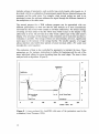
Sources of Errors in Time Domain
Reflectometry Measurements of Soil Moisture
lVlagnus Carlsson
- _._--- --._ "'iIlWIO~)W
~
I
~eg~\"'dow
1Qr
, t-
~I--- ' I>
-.; nil
p . , - - . , r - - - - J ••.
_. ___ . -------- -..---i
a::
" I 0"
/ I \
" I ' ..
--OE
---- _... -
I
i
\J
El:
-7
-4
11
____
8t~O_lTraa'
_ ___ ._ _ _ _ _ _ _ _
Eo_dOfT_f1I(..:..:..e_ _ _....J _I
200
S.,... Polol
260
110_
MSc Thesis (Exarnensar:)ete)
Supervisors (Handledar'e) : Per-Erik Jansson & Manfred StiihU
__
__
__
---- .. _ ---..
._ -- -_.
._---_. ._- InsUtutionen for markvetenskap
Avdell:tingen for lantbrukets hydrotel{nik
_
8vIledrsh University of Agrecultural Sciences
Department or Soil Sciences
Division of Agricultural Hydrotechnics
--- -- - - - ---- - - -
Avdelningsmeddelande 98:5
Communications
Uppsala 1998
ISSN 0282-6569
ISRN SLU-HY-AVDM--98/5--SE
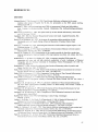
Sources of Errors in Time Domain
Reflectometry Measurements of Soil Moisture
Magnus Carlsson
140
6
MinWindow
120
100
.
a:
+--t
4
I
BegWindow
80
-,---------------'
----------
0
~
Ii:
60
-2
40
... ReoresRange
(Scaled)
20
0
I+-M
-4
1+-+1 ReoresRange
L -_ _ _ _
Beg_~_T~
____________~En=dM~~=e______~-6
0
50
100
150
250
200
S....n Point
No_
MSc Thesis (Examensarbete)
Supervisors (Handledare) : Per-Erik Jansson & Manfred SUihli
Institutionen for markvetenskap
Avdelningen for lantbrukets hydroteknik
Avdelningsmeddelande 98:5
Communications
Swedish University of Agricultural Sciences
Department of Soil Sciences
Division of Agricultural Hydrotechnics
Uppsala 1998
ISSN 0282-6569
ISRN SLU-HY-AVDM·-98/5--SE
PREFACE
This is the report of my diploma work of a master degree in soil science at the Swedish
University of Agricultural Sciences (SUAS). The work was mainly conducted at the
Division of Environmental Physics during twenty weeks, in summer -96 and during the
following winter. During this time a system for measurement of soil moisture, a
technique known as Time-Domain Reflectometry, was tested, in laboratory as well as in
field with respect to sources of errors. A few of the components of the systems tested had
earlier been used by researchers at the Department of Soil Science while other
components were newly purchased. I hope that this work can give some help to recognize
and avoid some sources of errors that occur in TDR soil moisture measurements.
TABLE OF CONTENTS
ABSTRACT .............................................................................................................. 7
REFERAT (in Swedish) .......................................................................................... 7
INTRODUCTION .................................................................................................... 8
BACKGROUND ..................................................................................................... 11
History of dielectric measurements of soil water .......................... 11
The relationship between Ka and ~ ................................................ 11
General equations ....................................................... 11
Mixing models ............................................................ 13
Soil bulk electrical conductivity ...................................................... 14
TDR in frozen soils ........................................................................... 15
Development of components ............................................................ 15
Probes and probe design ............................................. 15
System considerations ................................................ 17
Automated systems ..................................................... 17
TDR measurements at Department of Soil Science, SLU ............. 18
MATERIAL AND METHODS .............................................................................. 19
Theory
.................................................................................... 19
Principles ofTDR ....................................................... 19
The dielectric constant ................................................ 20
Capacitance-theory ..................................................... 21
TDR-theory ................................................................. 24
Soil bulk electrical conductivity ................................. 24
Instrumentation ................................................................................ 26
Cable tester ................................................................. 27
Probes ......................................................................... 28
Cables ......................................................................... 28
Multiplexers ................................................................ 29
Baluns ......................................................................... 29
Software for evaluation of data.................................. .29
Experimental set-up ......................................................................... 31
Experiment I-in field ................................................. .32
Experiment 2-in laboratory ........................................ .33
RESULT
.................................................................................... 34
Experiment 1 .................................................................................... 34
Trace-performance ...................................................... 34
Gravimetric calibration ............................................... 3 5
Drainage-event ............................................................ 36
Experiment 2 .................................................................................... 36
Calibration- trace set-off parameter ............................ 36
Comparison between the two systems ........................ 38
Software evaluation of different probe types .............. 38
Software parameter setting ........................................ .39
DISCUSSION
.................................................................................... 40
Errors which affect the quality of the trace .................................. .40
Power supply and electrical grounding ...................... .41
Signal attenuation ...................................................... .41
System considerations ............................................... .41
Errors caused when the trace is interpreted .................................. .42
Comparison of software ............................................. .43
Suggestions on system design ................................... .44
Conversion of Ka to Bv ...................................................................... 44
Soil properties influencing Ka .................................... .45
Development in TDR-technology ................................................... .45
CONCLUSIONS
.................................................................................... 46
ACKNOWLEDGEMENTS .................................................................................... 46
.................................................................................... 47
REFERENCES
.................................................................................... 47
Literature
Personal communications ............................................................... .48
APPENDICES
I.
H.
.................................................................................... 49
Terms and symbols ................................................................ 49
Troubleshooting ..................................................................... 50
ABSTRACT
In the monitoring of soil water Time-Domain Reflectometry (TDR) has gained
widespread use. TDR has proved to be useful both in determination of soil water
content and soil bulk electrical conductivity. These measurements are, however,
complex and there are many sources of errors to consider. The purpose of this
investigation is therefore to identify errors, the causes of these errors and to suggest
improvements. This was achieved by a literature study as well as by two experiments,
one conducted in the field and one conducted in the laboratory. Four TDR-systems
were tested.
The results show that errors can be classified in two groups, errors which is
influencing the determination of the dielectric constant, K a , and errors affecting the
conversion of Ka to volumetric water content, Ov. The former type can be further
divided into errors which concern the quality of the trace and errors influencing the
evaluation of the trace. Unbalanced probes and long cables were identified as
contributing to uncertainties. Errors from conversion of Ka to Bv were considered
when the systems were calibrated. One of the programs tested allows convenient onepoint calibration with a trace offset parameter. The advantage of re-evaluation of
measurements with individual settings also permits increased accuracy of
measurements.
REFERAT (in Swedish)
Time-Domain Reflectometry (TDR) har yid markvattenmatningar tatt en omfattande
anvandning. TDR har visat sig anvandbart bade i vattenhaltsbestamningar och fOr
matning av markvattnets elektriska konduktivitet. Matningar med TDR ar dock
komplexa och det finns manga felkallor att beakta. Syftet med den har
undersokningen ar att identifiera fel, felkallor samt att f6resla f6rbattringar i
systemens design for att undvika felkallor. Detta gjordes dels genom en
litteraturstudie och dels genom tva experiment, ett i faIt och ett i Iaboratorium.
SarnmanIagt undersoktes fyra TDR-system.
Resultaten visar att fel kan kIassificeras i tva grupper, fel som paverkar bestamningen
av permitivitetskonstanten, Ka, och fel som paverkar konverteringen av Ka till
volumetriskt vatteninnehall, Bv. Den fOrra gruppen kan vidare deIas in i fel som ror
kvaIiten pa matsignaIen och fel som paverkar utvarderingen av denna signal.
ObaIanserade givare och Ianga kabIar var indentifierade till att bidra till osakerheter i
matningar. Felkallor nar Ka omvandlades till Bv diskuterades nar systemen
kaIibrerades. Ett av utvarderingsprograrnmen som anvandes har en "trace off-set"
parameter for enkel enpunktskaIibrering av matsystemet. Mojligheten att anaIysera
matsignaIen i efterhand med individuellt satta parametrar okar ocksa nogrannheten i
matningarna.
7
INTRODUCTION
Water is essential for human existence. Vital human activities carried out for a long
time such as agriculture, forestry and drinking-water supply depend completely on the
availability of water. Late in human history industrial activities have also started to
consume large amounts of water. These activities have, together with the urban
structure of building areas and roads, the use of artificial fertilisers and pesticides in
agriculture influenced the availability and the quality of water. Water, and particularly
clean water, has become a scarce resource in many parts of the world. Water is,
furthermore, both an outstanding solvent and a transport medium for nutrients and
other potential pollutants. The monitoring of water has therefore gained increasing
interest.
Soil water is of special interest due to the storage of water available for plants and as
the stage in the water cycle where the chemical composition changes due to
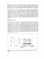
interactions with soil before reaching groundwater, streams, lakes and seas (Figure 1).
Water vapour
SOIl-
GroundwOler
tlow
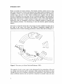
Figure 1. The water cycle (from Ward and Robinson, 1990).
The capacity of soils to store water is also determined by the composition of the soil
(i.e. texture and structure) and by processes which control the movement of water
through the soil such as drainage, evaporation and transpiration. These processes take
place at different depths in the soil and this is important to consider when soil water
8
content is to be estimated. The rates of these processes are then influenced by
different factors such as climate, topography and vegetation.
The major change in chemical composition of water in the hydrological cycle also
takes place in the soil. This is a result of the fact that soil water in the root zone
dissolves carbon dioxide that is released from the respiration of plant roots. In other
words, the soil water is acidified. This increases the weathering of minerals and
results in an increasing content of dissolved ions in the soil water. On arable land, the
application of fertilisers and pesticides also further increases the concentration of
solutes in soil.
Many methods to determine soil water content are both labour-intensive and time consuming. Sampling of soil cores for gravimetric determination of soil water content
requires both a lot of digging and when the samples are taken the site is ruined for
further sampling. The method is therefore destructive. The neutron probe method is,
in contrast, a less demanding but on-site calibration is needed and the radiation from
the instrument poses a health risk. Remote radar sensing techniques are also
convenient and cover large areas, but do not account for the deeper parts of the soil
(Kutilek, 1994).
A preferable method to measure both soil water content and soil bulk electrical
conductivity should be continuous and non-destructive. It should also measure at
many depths ranging from the surface to the groundwater level. This can be achieved
by measurements of the dielectric property of soil (Davis and Annan, 1977). The
dielectric property is primarily a function of soil water content (Topp et aI., 1980). It
has also shown to be a useful estimator of soil bulk electrical conductivity (Giese and
Tiemann, 1975). Techniques that are based on measurements of the dielectric
property of soil are traditionally called capacitance methods. Time-Domain
Reflectometry (from here on referred to as TDR) is a method that has gained
widespread use and is both suitable to determine the water content and the electric
conductivity of the soil water (Topp et aI., 1980; Heimovaara, 1992).
There are several advantages of TDR in measurements of soil water content and soil
bulk electrical conductivity compared to other methods:
• direct measurements of a soil property that is primarily a function of water content
and electrical conductivity of soil water
• non-destructive
• high spatial and temporal resolution
• continuous measurements through automated systems
• allows flexible system design
9
The practical use of TDR for monitoring of soil water is also considerable. TDR is
used in estimation of water storage for crops in yield analysis, flood control,
monitoring of water fluxes, detection of pollutant solute transport, determination of
salt influences in soils including arable land and in the monitoring of leaching from
landfills and landslide activities (Topp et aI., 1980); (Mall ants et aI., 1994); (AimoneMartin and Oravecz, 1994). Nevertheless, TDR measurements are complex and in
order to operate successfully there are many sources of errors that must be considered.
The aim of this study is therefore to clarify the sources of uncertainties in
measurements by classification of errors and by examining how different components
contribute to these errors. Suggestions on how to improve the measurements are also
given. Two experiments with four different TDR-systems were conducted. In one of
these experiments, two software programs were used in the evaluation of the
measurements.
Three questions were asked:
1. What type of errors give uncertainties in the systems examined?
2. What components in the systems contribute to these errors in the measurements of
soil water content?
3. Which of the software programme used gives the most reliable and easiest
evaluation of the soil water content measurements?
10
BACKGROUND
The following paragraph is concerned with the development of the TDR-technique as
well as some examples of the use of TDR measurements at the Department of Soil
Science at the Swedish University of Agricultural Sciences (SLU). The latter also
includes a discussion of some problems to operate that led to this study.
History of dielectric measurements of soil water
Measurements of dielectric properties to estimate water content in soils is not a new
idea. This was suggested, in literature, already in 1939 (Patterson and Smith, 1980).
During the 1960's and the 1970's many attempts were made to use dielectric
properties for estimation of water content in soils (Davis and Annan, 1977). The
instruments used, however, were originally designed to test electric cables and was
operating in frequency ranges where the dielectric property is frequency dependant.
Consequently, accurate measurement of soil water content, (4, was prevented (Topp et
aI., 1980). However, in 1980 instruments that operated on a lower frequency range (11000 MHz) where the dielectric property of soil is not strongly frequency dependant
began to be used (Topp et al, 1980). The technique operated was referred to as TDR
and is, in principle, similar to a well-known technique, RADAR. A difference
between traditional capacitance methods used to measure dielectric properties and
TDR is that while the former operates on a single frequency, the latter uses a wide
spectrum of frequencies. This also decreases the influence of frequency dependants of
the dielectric property which provide more accurate measurements in soils of various
water contents (Patterson and Smith, 1980).
The dielectric property, furthermore, had earlier been described as a complex
constant, composed of a real part and an imaginary part where the imaginary part
corresponds to dielectric losses (Davis and Annan, 1977). For materials with low
losses, such as soil, the imaginary part was also shown to be negligible and the real
part can be approximated to a measurable apparent dielectric constant, Ka (Topp et aI.,
1980).
The relationship between Ka and Bv
General equations
An empirical relationship between the apparent dielectric constant, K a , and the
volumetric soil water content, B v , was given by Topp et al. (1980). Four soils, a
sandy loam, two clay loams and a heavy clay was examined. The TDR measurements
conducted were correlated with gravimetrical soil core samples. The relationship
gained is useful in general for most soils (Topp et aI., 1980).
11
Bv
= -0.053 + 0.0292Ko -
0.00055Ko 2 + 0.000043K/
eq. (1)
where Bv is the volumetric water content (-)
and Ko is the apparent dielectric constant (-)
The validity of TDR as a method for measuring soil water content in non-uniform
soils with steep gradients were also examined by Topp et al. (1982a). Three cases
were examined, a two-layer model, a general water content gradient with a more
stratified and continuous gradient and the detection of a water-front in an
infiltration event. For all cases TDR was shown to be a useful method for
measuring soil water content.
TDR is, as the name suggests, built on the principle that a brief electromagnetic
pulse is sent along a transmission line and reflected. The measurements are then
conducted in the time-domain. Ledieu et al. (1986) determined the soil water
content directly from the transit time of the electrical pulse and discovered a
simpler relationship.
Bv = 5.69t -17.58
eq. (2)
where t is the travel time for the pulse along the probe (ns)
The relationship is further improved when soil bulk density is considered. An
change of 0.1 g/cm3 in bulk density was shown to give a change in soil water
content of 0.34 %. (Led~eu et al.,1986)
Bv
= 5.688t -
3.385 -15.29
eq. (3)
where 8 is the soil bulk density (g cm-3)
The dielectric constant, Ko, is primarily determined by the dominant material in
the soil. A general relationship between Ko and soil water content was derived by
Roth et al. (1992) from this starting point. The dielectric constant for organic soils
was concluded to be lower than that of mineral soils at a corresponding soil water
content. In other words, bulk density is a significant factor to be considered when
Ko is estimated. A third degree polynomial relationship was found for 11 mineral
soils and another similar equation was calculated for 7 organic soils.
Among the mineral soils, furthermore, special attention was given to a Ferralsol in
order to examine whether magnetic properties influence TDR measurements or
not. It was shown that magnetic properties from minerals, i.e. magnetite and
maghemtite, hardly influence the measurements because of the very brief travel
time of the TDR pulse.
To summarize: A general relationship between Ko and Bv is useful for most soils.
The dominant material of the soil, however, determines Ka and consideration of
soil bulk density improves the relationship, especially for organic soils.
12
Mixing models
Dirksen et al. (1993) proposed, with a similar starting point as Roth, that tightly
bound water is a factor to consider when a relationship between Ka and soil water
content is determined. The tightly bound water was estimated to have a much
lower dielectric constant, in the same range as ice, other than free water. Tightly
bound water was considered by using two four-component mixing models. One of
the mixing models was empirical and the other was theoretical. Both were
compared with equation 1 for 11 soils including loess as well as bentonite (Figure
2). The theoretical mixing model gave a better calibration function than equation 1
at lower values of soil bulk density and for fine textured soils that hold tightly
bound water. The empirical model gave unpredictable values and did not seem to
be useful even when fitted data was used.
.----------------:1,....,
32
Topp 01 at.
----
I
'I
'1
0
'I
C
24
cu
-
'/'
"
'1/ •
100
I
1/ '
,'/i ,.I
".
200
( /)
c
o(.)
1// / /
,~// : /
//
, /~~'
/.
400
--
(.) 16
600
,~,/
( .)
,,/
~
/ /
' /
'" " / /
,'//
~'// / /
(I)
(I)
'"C
,
8
,'/
~/" /
~;~. , / /
3
~...:,...""""
Pb - 1.0 g/cm
",/ / '/
o
~--~--~----~--~--~
0.0
0.1
0.2
0.3
0.4
0.5
soil water content
Figure 2. Influence of tightly bound water as specific surface vs. soil water
content according to the theoretical mixing model used by Dirksen and Dasberg.
The soil bulk density was set to 1.0 g cm-3 and the specific surface, S = 0, 100,
200,400, 600 m2 g-l. Equation 1 is also shown, referred to as Topp's equation, in
the figure (from Dirksen and Dasberg, 1993).
Jacobsen and Schonning (1993) compared different calibration functions,
including physical mixing models, for five soils from coarse sandy soil to sandy
clay loam. From this one set of data it was also shown that the most suitable
third-order polynomial equation gave more accurate soil water contents than any
of the mixing models. For precise measurements for individual soils, however,
one theoretical mixing model was better than any of the third-degree polynomial
equations.
13
Nevertheless, a calibration function that included the effect of soil bulk density
did not improve the fit compared with earlier relationships presented by Jacobsen
et al. (1993). The calibration, however, was conducted for field plots at three
locations and was shown to be better than equation 1. It was also shown that the
variation of the measurements increased with increasing clay content.
Hook et al. (1995) investigated temperature effects on the dielectric electric
constant. Four soils: peat, sand and two loams were compared considering the soil
water content using a mixing model. The model was calibrated by measurements
on distilled water. The temperature dependency was shown to increase with
increasing water content in soils. It is also at high water contents where changes in
temperature can cause the largest errors. The influence of temperature was
however smaller for free water than for tightly bound water. A temperature
correction coefficient was also suggested (see Hook et aI., 1995 for details).
To summarize: The dielectric constant, K a , is influenced by soil properties such as
temperature, bulk density, tightly bound water and soil bulk electrical
conductivity. The influence of these soil properties has been considered as single
parameters in empirical equations and by several variables in so called mixing
models. Mixing models have in some cases been shown to improve calibration
functions. When absolute values of Bv are needed, calibration for individual soiltypes is required.
Soil bulk electrical conductivity.
Measurements of electrical conductivity in soil water by TDR have also gained
widespread use. Dalton et al. (1984) was among the first to use TDR to measure
soil bulk electric conductivity but did not take multi-reflections caused by
discontuintues in cables used into account. Topp et al. (1988) concluded that the
approach of Giese and Tiemann (1975) gave the most satisfying results.
Measurements of solute breakthrough curves were conducted by Mallants et al.
(1994). Horizontally installed TDR probes which measured bulk soil electrical
conductivity in saturated soil columns in a laboratory were used and shown to be
useful. However, it was concluded that many TDR probes are necessary,
especially for structured soils, to follow the breakthrough event accurately. This is
because of the fact that the probes measure a rather small area and the risk of
excluding a macropore with high transport velocity is obvious.
That the same TDR-system simultaneously can measure both soil water content
and electrical conductivity was also shown by Nadler et al. (1991). The
measurement of electrical conductivity was also considered less sensitive than
water content determination since the contact between the probe and the medium
is not crucial in the former case.
14
TDR in frozen soil
TDR has also shown to be useful in frozen soil and snow to detect unfrozen water
(Patterson and Smith 1980; Stein and Kane 1983). The apparent dielectric constant,
K a , for ice is 3.2, which is very similar to that of dry soil but significantly lower than
that of unfrozen water (82 at 20QC). Ka has also been shown to be a good indicator of
the relationship between unfrozen and frozen water in the soil at temperatures below 0
QC. Patterson and Smith (1980) showed that the unfrozen soil water content
corresponded well when the soil water content obtained by equation (1) was
compared with the result gained from another method, dilatomery.
Salt distribution in a freezing soil was examined by Stadler and Stahli (1997). This
was accomplished by exposing two columns, one sand and one loam, to a freezing
and thawing event. The flow of water was directed towards both ends of the columns
during the freezing event but was opposed by diffusion towards the middle where the
salt concentration increased. In the frozen part of the soils, the low content of salt was
also only just detectable by TDR. The concentration of solutes in frozen soils was
moreover said to be determined by this diffusion with the appearance of high
concentration gradients and in addition the content ofunfrozen water.
The salt concentration was calculated as a function of temperature, soil bulk electric
conductivity and the unfrozen soil water content according to the model of van Loon
et al. (1991). The function was also shown to be useful for low salt concentrations of
unknown ions, a situation which is similar to that expected in most field conditions.
Development of components
The components of the TDR-system have, of course, been modified and improved
during the evolution of the TDR-system. This concerns especially the system's sensing
device, the probe. Furthermore, automated systems with multiplexed connections from
the main component of the system, the cable tester, allowed the use of many probes.
Software programs to co-ordinate these automated measurements and to evaluate the
measurements have also been developed.
Probes and probe-design
The two most common probe-types are the two-wired and the three-wired. The probe
is connected to the rest of the system by a coaxial cable, a cable with two leads. In a
three-wired probe the centre cord of coaxial cable is connected to the middle of the
three rods and the outer conductor is divided between the other two rods. This
configuration makes the electromagnetic field symmetrical and the probe is said to be
balanced. Signals from three-wired probes are in general clearer and easier to interpret
than signals from unbalanced two-wired probes ( Nadler et aI., 1991). A device that
balances two-wired probes is the balun, which will be further discussed in the
paragraph instrumentation.
The probe length is one aspect of system-design that determines the soil volume
measured. In other words, the soil water content is determined as an average of the
15
probe length. In combination with long cables, which give a more significant signal
attenuation, the use of short probes results in signals which are difficult to interpret.
Heimovaara (1993) tested the maximum cable length for different probe lengths. For
probes longer than 0.2 m, 24 m cables could be used. For probes shorter than 0.1 m
the maximum cable length which gave an acceptable quality of the signal was 15 m.
Stein and Kane (1983) explained the uncertainties occurring when short probes
lengths were used with the fact that the transmission zone (where the change in
electrical properties from the cable to the probe-wire take place) between the cable
and the probe becomes long relative to the probe length. As a consequence, Ka is
determined less accurately.
The electrical field that is created between the rods determines the volume of soil
measured. Baker&Lascano (1989) found the cross-area, which primarily influences
the measurements, to be rectangular with elliptical corners and of about 1000 mm2 •
Ledieu et al. (1986) found that accurate measurement of soil moisture was possible
with two-wired probes with 2,5 cm between the rods, in layers of 4-5 cm thickness.
The maximum distance between the probe-wires is also dependent on the wavelength
of the electromagnetic signal and should be smaller than a tenth of this wavelength.
This prevents transverse electromagnetic modes that would interfere with the
propagation velocity'S relationship to Ka. (Stein and Kane, 1983). The volume
sampled is nearly the square of the distance between the rods (Topp et aI., 1982a).
The shape of this volume is furthermore likely to be an ellipse-shaped cylinder.
The diameter of the rods also influences the robustness of the probe. This, of course,
is a practical aspect when probes are to be installed and when for example a hammer
is used to push the rods in to the soil. However, if probes with a thick rod diameter are
used, there is a risk of increasing soil density around the rod. Topp et al. (1982b)
obtained a lower soil density when the soil was packed around the probes than when
probes were pushed in to the soil.
Another aspect which has to be considered is the angle effect that can be expected
when the separate rods of the probe are not installed parallel. This would theoretically
influence the measured soil volume and therefore Ka. According to results from Stein
and Kane (1983) it is not, however, very important that the rods are installed exactly
parallel. In soils with high soil water content ( By = 40 %) no difference in measured Ka
due to angle effects was detected. Nevertheless, when very dry soil (By = 0 %) was
examined Ka differed slightly (± 0.2).
Installation of probes in the soil needs to be done in a way that ensures good soil
contact to prevent air between the probe and the soil lowering the Ka-values. Predrilled holes can in this context be a risk but are in some soils (e.g. rocky soils)
inevitable. Probes can also be installed at any angle in the soil. Most common are
horizontally and vertically installed probes. Vertically installed probes are inserted
from the surface and are therefore more convenient. Horizontally installed probes,
however, give smaller thermal and hydraulic disturbances than vertically installed
probes (Stein and Kane, 1984).
Interpretation of a trace is easier and more accurately carried out if the probe is
designed in a way that gives sharp changes in impedance. The beginning and the end
of the trace are characterised by transmission zones where a gradual change in the
16
reflection coefficient take place due to: power losses, imperfect connections between
conductors and rods and a non-ideal open circuit at the end of the probe (Stein and
Kane, 1983). The transmission between the conductors in the cable and the rods are
usually sieved. This gave a more distinct transmission zone probably due to lower
losses by multi-reflections (Thomsen, 1997). Another way to obtain a clearer signal is
to connect the two transmission lines, at the same place, by using two diodes (Ledieu
et al. 1986).
The probe head should to consist of a material in which no reflections are created
which disturb the signal such as resin or epoxy cement for use in electrical devices.
The head is, furthermore, often made of materials such as POM (polyacetal-Acetal
plastic) which is a material with suitable electrical properties and high resistance to
changes due to temperature fluctuations and UV exposure (Thomsen, 1997).
System considerations
Hook et al. (1992) hooked up diodes between the conductors and designed a low-loss
probe that allowed measurements with clear signals to be conducted with a cable
length up to 100 m. Different cables were compared concerning rise time of the pulse
by Hook and Livingstone (1995). A coaxial cable of 75 ohm was shown to have a
better rise time than the one often used 50 ohm cable (R058). In addition, it has a
thinner diameter and costs less than the latter. Measurements in a strongly layered
media were also carried out with excellent accuracy with three-diode probes.
Propagation velocity errors were identified and quantified by Hook and
Livingstone (1995a) using a newly developed TDR-technique including remotely
switched diodes and differential wave form detectors. They concluded that
dissolved ions and the use of long cables are the most significant sources of errors.
Errors in converting TDR measurements of propagation velocity to estimates of
soil water content were examined by Hook and Livingstone (1995b). By using a
simple physically-based model, the linear relationship between TITair , the ratio of
the travel time for the pulse in soil over the travel time in air, versus Bv, was
examined. In some cases, the deviations from linearity corresponded to the delay
in travel time. It was shown that the main component contributing to errors of
conversion in agricultural soils (except clays) was the measurement of the
transition time. The transition time is a function of Bv. A value of the TITair - Bv
slope was also presented.
Automated systems
Systems to measure large numbers of probes automatically have been developed
(Heimovaara, 1996). Campbell (1991) described a system with a logger and a
maximum of three levels of multiplexers which allow measurements of up to 512
probes. A PC-based system that measures 49 probes was described by Thomsen
(1994). Automated systems are made up of components that need to be co-ordinated
in time for successful measurements. This is done by a software computer program.
The software program is in turn operated from either a logger or a PC. An interface
17
i.e. a device which handles the communication between logger/PC and cable tester is
also required for automated measurements.
TDR measurements at the Department of Soil Sciences, SLU
Stahli and Fryklund (1995) used TDR to observe infiltration in washed sands used in
biological water treatment systems. Different equations such as Topp (1980) and
Ledieu (1986) were compered with gravimetric core samples. Topp was shown to
have a better fit at low water contents in the examined sands. Andersson (1994) used
TDR to determine if the time of sowing influences water uptake for barley. Two
different TDR techniques and a neutron probe were compared. A stationary TDR
system was found to work better than a portable system and both were considered
more reliable and user-friendly than the neutron probe. Conversion of dielectric
constant to soil water content with equation (1) gave significantly lower water
contents than expected. It was concluded that calibration was necessary for reliable
estimation of absolute values of soil water content.
Stiihli (1995) also used TDR to follow infiltration events in frozen soils. Two sandy
soils have been monitored by TDR and measurements have been conducted since
1994 (Stahli, 1997). These set-up's were the same as used in experiment 1 in this
paper. The measurements were, however, subjected to a number of errors and
problems. The evaluation of the data from the automated system, described as system
A, in the chapter 'Material and methods', was unreliable on some occasions. Timeconsuming manual evaluation was then required. The idea of this study was therefore
to investigate what the causes of these uncertainties were and to identify other sources
of errors that occur in TDR-measurements which concerns several researchers at the
department. Components for a laboratory set up had, furthermore, been purchased to
design a TDR-system for precise measurements for soils used in teaching. The
intention to use these components in a laboratory set-up for determination of physical
properties of different soils at the Department of Soil Sciences led to a study trip to,
Foulum Research Centre in Denmark where a new software program for evaluation of
TDR-measurements was demonstrated. This software program was then compared
with a program used for several years in an experiment.
18
METHODS AND MATERIAL
TDR-measurements are as mentioned rather complex. In this paragraph the theory of
the measurements is described. This includes the principle of TDR as well as
capacitance theory and TDR-theory (the relationships used directly in the
measurements). Instrumentation is also discussed when the function of different
components is explained. The experimental set-ups are also described.
Theory
Principles of Time-domain reflectometry
Time-domain reflectometry belongs to the capacitance methods for measuring soil
water content. The method measures continuously and non-destructively a change in
voltage over a brief period oftime on permanent soil-installed wave guides or probes.
This is accomplished by the transmission, the reflection and the detection of a brief
electrical pulse.
First, the electromagnetic pulse is produced by a pulse generator in the cable tester,
the main component of a TDR-system. Then the signal travels through a transmission
line and reach the probe (Figure 6). At the transmission point between the cable and
the probe the electrical properties of the media surrounding the conductor changes. As
a consequence a part of the electrical pulse is dissipated in the soil and another part of
the pulse is reflected back along the transmission line. The proportion dissipated to
the soil is related to the electrical conductivity while the travel time of the pulse along
the probe is a function of the water content of the soil.
Finally, the reflected signal travels back and is detected on an oscilloscope on the
cable tester. The event is recorded as a time -voltage plot on the oscilloscope. Ka is
interpreted from the travel time of the pulse along the probe while the electric
conductivity is determined from the difference in voltage between the cable and the
end of the probe.
cable tester
system
12!__
c_oa_X_ia_1c_ab_le
I
l'~mb'
Figure 3. Schematic figure on a TDR-system.
19
The dielectric constant
The dielectric property can be described as a complex constant (Davis and Annan,
1977):
eq. (4)
where K* is the complex dielectric constant (-)
and K' is the real part of the dielectric constant (-)
and K" is the imaginary part of the dielectric constant (-)
and ode is the zero-frequency conductivity (m S-I)
and w is the angular frequency (rad S-I)
and eo is the free space permittivity (m S-I)
··
and J..IS th
e Imagmary
number, (1)112
The complex dielectric constant is not really a constant since the imaginary part
varies for most materials. The real part, K', is also known as a material's electrical
permittivity while the imaginary part, K" describes the electrical losses. An
electrical loss term, tan y, is defined as:
VII
1'>..
ode
+-weo
K:
tany=---~
eq. (5)
All the characters defined as above.
Certain soils such as clays have a larger loss term than sands. The losses also
increase with water content and salt concentration (Patterson and Smith, 1980).
For low loss materials, such as soil in the frequency range of 1-1000 MHz is K"
considerably less than K' and can be neglected.
K'~K*
eq. (6)
In TDR measurements the dielectric property is expressed as the apparent
dielectric constant, Ka. Soils are low loss materials and in general Ka can be
approximated as:
eq. (7)
Figure 4 shows the dependency of the complex dielectric constant, K*, of the
electrical loss term, tan y, and real dielectric constant, K'. Below frequencies of
1000 MHz is tan y small and can usually be neglected.
20
100
- 1.0
90
-0.9
K'
80
·0.8
70
- 0.7
60
-0.6
..,
z
«
K'
50
- 0.5
40
- 0."
30
-0.3
20
- 0.2
10
-0.1
0
"10'
10·
101
~
0
10·
10'
'0'0
101\
FREQUENCY (HZ)
Figure 4. Dependency of the real dielectric constant, K' and the loss factor, tan y
for water at 20°C (from Patterson and Smith, 1980).
Capacitance theory
Since most of the users of the TDR-technique are not likely to be electronic
specialists, some capacitance theory follows. Firstly, the nature of the electromagnetic
pulse, the concept of permittivity and the wave's propagation velocity is discussed.
Then capacitance and the use of impedance in TDR is explained. Finally, the
dielectric constant for different materials is shown.
The electrical pulse can be seen as a brief generation of electromagnetic waves;
electromagnetic waves actually consist of a magnetic and an electrical field. The
vectors of these fields have propagation directions at an angle of 90° to each other and
also to the propagation direction of the electromagnetic wave. The electromagnetic
wave transports energy and requires new generation of waves to continue. The
frequency of the waves on the one hand is set by the source that generates the wave.
The propagation velocity of the wave on the other hand is determined by the
permittivity of material which transports this energy. The propagation velocity is
related to the permittivity constant (Sears et aI., 1982):
21
1
v = ---,-..,-(eu)1!2
eq. (8)
where v is the propagation velocity of the electromagnetic wave (m S-I)
and e is the permittivity constant (s m-I)
and u is the magnetic permeability (s m-I)
For relatively isolating materials, such as soil, the influence of the magnetic
permittivity on the propagation velocity can be neglected. In other words, the
permittivity constant becomes a characteristic of the propagation velocity for these
materials.
v
=[<f>
eq. (9)
As mentioned earlier TDR belongs to the capacitance methods for measuring soil
water content but the recorded change in voltage is in fact a change in impedance.
Impedance is the total opposition to the electrical current and may be divided into a
frequency independent part known as resistance and a frequency dependent part
called reactance. In the frequency range of IMHz to IGHz (where TDR-signals are
operating) the reactance is not very dependent for a relatively isolating material which
makes impedance measurements useful when soil water content is to be determined.
Reactance is, furthermore, made up of capacitance and inductance. This also implies
that capacitance corresponds to changes in impedance. Capacitance can also be
viewed as a conductor's ability to store energy in the isolating layers between the
leads and is specific for different materials, depending on the permittivity of the
material (Tektronix, 1989):
A
C = e(-)
I
eq. (10)
where C is the capacitance (F)
and e is permittivity constant (-)
2
and A is the area of the lead (m )
and I is the length of the lead (m)
Similarly, the use of voltage measurements in a capacitance method can be explained
by the following: two parallel electrodes surrounded by soil make up a capacitor, as
any two conductors separated by an isolator would do. Another name for an isolator
or non-conductance material is a dielectric. The capacitor then induces an
electromagnetic field surrounding the conductants. The capacitance depends on the
charge of the field and on the difference in potential. The electrical charge is
unaffected by the addition of an isolator. This is showed by placing an isolator
between the leads which causes the potential to rise. When the isolator is then
removed, the potential will return to the original value (Sears et aI., 1982):
22
eq. (11)
where C is the capacitance (F)
and Q is the electrical charge (C)
and Vab is the change in voltage (V)
Different materials are, of course, influenced by the electrical field differently. Dipole
molecules will under the influence of the field polarize. As a consequence elements
\:milt up of polar molecules, such as water, will therefore conduct an electrical pulse
better than elements that consist of less polar molecules, such as air or solid soil. This
electrical conductance for different materials can be expressed.as a dielectric constant,
K , which is 1 for air ,4-8 for solid soil and 82 for water at 20°C (Kutilek, 1994; see
Table 1). The significantly larger value for water makes the measurement of the
dielectric constant useful when soil water content is to be estimated. The dielectric
constant is expressed as the ratio between the conductance of the dielectric and the
conductance in a vacuum (Sears et aI., 1977):
eq. (12)
where K is the dielectric constant (-)
and C is the capacitance of capacitor with dielectric (F)
Co is the capacitance of capacitor in vacuum (F)
Table 1. The dielectric electric constant,
K, at 20 D C (except for ice) for different
materials (after Kutilek, 1994)
Material
Vacuum
Air (1 atm)
Polyethylene
Ice
Soil
Water
K
1
1.00059
2.25
3.2
4-8
82
The propagation velocity is, moreover, related to Ka by:
c
v=~·-
jKa
eq. (13)
where v is the propagation velocity (m s-l)
c is the speed oflight (:::::: 3.8 10 9 ms-I)
Ka is the apparent dielectric constant (-)
23
TDR-theory
The propagation velocity is not measured directly in TDR but is deduced from the
length of the transmission line and the travel time of the wave. Instead the travel time
of the pulse, or the transit time, is measured when the pulse travels along the probe.
The propagation velocity, Vp , is then determined from this. vp can be described by the
equation:
2L
v=-
eq. (14)
t
where v is the propagation velocity (m1s)
and L is the length of transmission line in soil (m)
and t is the transit time for electrical pulse (ns)
The factor 2 in equation (14) is explained by the fact that the wave is reflected and has
to travel twice the length of the transmission line to the detector. If equation (14) is
substituted in equation (13) then the following relationship is gained:
eq. (15)
where La is the apparent length in soil (m)
and L is the apparent length in air (m)
Soil bulk electric conductivity
The principle of measuring soil bulk electric conductivity with TDR is that the
impedance decreases with increasing ion solvents. This is detected by the difference
in amplitude of the wave signal, in the time-voltage plot, between the minimum value
at the trough of the curve and a maximum value after the gradual rise of the signal.
At low frequencies, the impedance is equal to the total resistance (Giese and
Tiemann, 1975).
R = Z(l+ p)
(1- p)
eq. (16)
where R is the total resistance (ohm)
and Z is the impedance of cable tester (ohm)
and p is the reflection coefficient at infinite times (-)
A problem related to the measurement of the impedance is multiple reflections
interference which originates from irregularities in the cable caused by discontinuities
(Heimovaara, 1996). When soil bulk conductivity is measured the interest is focused
24
on the difference in voltage level between the signal from the cable and the part
reflected passing through the probes. The determination of the beginning and the end
of the trace for travel time is fundamental for measuring soil water content but
becomes unimportant when soil bulk conductivity is determined. On the contrary to
soil water content measurements where the use of long transmission lines means loss
of energy and arduous detectable trace this set-up could be beneficial for soil bulk
conductivity measurements. A more accurate value of the impedance at infinite time
is obtained since interference of the reflection coefficient becomes less significant
than in a short cable. The reflection constant is then calculated from the voltage wave:
v -v
p=-"'--
v
eq. (17)
where VeX) is the infinite value of voltage (V)
and V is the voltage (V)
The bulk electrical conductivity, EC, for low frequencies can also be expressed as
(Nadler et al.,1991):
EC= kjZ = kjR
eq. (18)
where k is the cell constant ofTDR probe (m-I)
and f is the temperature correction coefficient (-)
and R is the resistance of the soil (ohm)
The cell constant is usually determined from calibrations with solutions of known
concentration. This is also the normal procedure by which the internal resistance of
the cable and the cable tester is determined. The bulk soil electrical conductivity is
temperature-dependent and the temperature coefficient,f, can be obtained through the
relationship:
f
1
= 1 + 0.019(T - 25)
eq. (19)
where T is the temperature at which the electrical conductivity is measured
The resistance of the soil, R s , can then be calculated as the difference between the
total resistance, R tot , and the resistance of the cable, Rcab/e:
eq. (20)
Heimovaara et. al. (1996) calculated a linear relationship for Rcable for a specific
device by calibrations in solutions with known soil bulk conductivity. It was also
possible to determine the cell constant, k, by this procedure. The reflection coefficient
can be calculated as in equation (17). The soil bulk electric conductivity can then be
calculated as in equation (18).
25
Instrumentation
TDR-systems consist of several different components. The function of these
components will briefly be described here (for details see instruction manuals).
The instruments and components used in the experiments conducted are as follows:
Hardware:
• Metallic Cable testers I502B, I502C (Tektronix)
• Coaxial cables (RG58) and Communication cable (Tektronix 6549)
• Probes: two-wired; (Campbell, PB 30), 25 cm (modified PB 30), 10 cm; threewired; 15 cm (Figure 8.)
• Baluns (Campbell )
• Multiplexer (Campbell, SDMX50)
• Data-logger (Campbell, CRIO)
• PC lap top
Software:
• AutoTDR software program (Thomsen, 1994)
• PI 100 (Campbell, 1995)
Figure 5. A TDR-system, similar to system D, with cable tester, cables, two and
three-wired probes and a PC (From: http://tal.agsci.usu.edul, Utah State University,
Department of Soil Physics).
26
Cable tester
The cable tester is constructed to locate defects in metal cables. The instrument works
by tracking reflections caused by discontinuities in the cable from an emitted brief
pUlse. These discontinuities can be caused by foreign substances in the cable (such as
water). Reflections occur due to changes in impedance since the dielectric constant
varies for different materials and is displayed as a wave form that shows change in
voltage over time on the oscilloscope of the cable tester. Smaller changes in
impedance occur in any cable and are referred to as noise. Under some circumstances,
(e.g. when long cables are used) signal attenuation can make noise more significant
which results in a signal that is harder to interpret.
An important property of the measurements which is set at the instrument is the
propagation velocity, vp , the velocity with which the pulse travels through the cable.
The propagation velocity varies for different materials and is expressed as a fraction
of the velocity in a vacuum. The propagation velocity for the common cable (RG58)
used in this study is, for example, 0.66, i.e. 2/3 of the propagation velocity for the
electromagnetic wave in vacuum. This value corresponds to the vp of the
electromagnetic pulse travelling in the cable and is used when the length of the
transmission line is calculated and Ka is determined (eq.14). A menu at the display of
the cable tester gives information about vp-values for cables of different materials
(Tektronix, 1995). Two typical traces on the voltage-time display are the short-cut that
is shown by a downward pulse and the open circuit that can be viewed as an upward
pulse (Tektronix, 1995).
~---------~----~----~:.ac
=
:
;
--~----~--------20---00---0--(-t--~
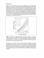
:
~ •••• ····I .•• ·F.{~.:
.:
~f-
:
r~
~
• . ·i· •.. i• .·• • • :••.•
:
.
..
.
i
i
: : : : : : : : :
.
--T----~---·~----~--·-:----1
.... :. ..... :- ..... :. ....... .: ....... .: .... .: ..... .:
::
:
:
:
:
!
:
:
;
:
:
.... ...... ; ....... ........ t.. . . !....... . -.. . ...... i .... ....
..: ..... .: ...... :-._.:..
.
~
~
~
~
~
ii~~~~l~~~~l~~~~l~~~~l~ ~~l~~~~l~~~~l~~~~l~~~~~~~~~j
Figure 6. Schematic figure of typical traces, short circuit and open circuit, found on
the cable tester's oscilloscope (From Tektronix, 1995).
27
Probes
Probes are sensing devices indicating the change in impedance between the coaxial
cable and the soil, acting as an extended wave guide leading the pulse along the rods
of the wire. The probe length and the propagation velocity is then used to determine
the travel time of the pulse that corresponds to Ka (equation 15).
The probe consists of two or more parallel metal rods often connected to the coaxial
cable in an enclosed head (Figure 6) . In two wired probes the inner conductant of the
cable goes to one of the rods and the outer conductor to the other rod. A coaxial cable
consists of two conductors, an inner conductor and an outer conductor. In a two-wired
probe one of the conductors is connected to each wire. The pulse transported through
the coaxial cable is however not equally divided between the two conductors. One of
the probe wires receives a larger part of the pulse, which makes the field surrounding
the probes asymmetrical. The probe is said to be unbalanced. The fact that
measurements are still performed with accuracy can be explained by the fact that the
electrical field surrounding the wires is divided as the signal travels along the probe.
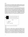
_ _ _ _ _ _ _ _ _ _ _ _ ~2.5 mm
____________
~2
mm
..
150mm
plastic head
connection to coaxial cable
Figure 7. The three-wired probe used in experiment 2.
Cables
Cables are designed to transport energy in a certain range of frequencies with the
smallest losses. As a consequence, the cable impedance does not change very much.
Changes in impedance cause, as mentioned, reflections and energy loss which is really
the principle of TDR-measurements. Although cables are designed to minimise
energy losses, losses still occur and become significant when long cables are used. In
practical measurements with automated systems both cables and multiplexers give
significant energy losses and signal attenuation. Each level of multiplexers correspond
to a signal attenuation loss equivalent to an additional 5 m of cable (Campbell, 1995).
28
Multiplexers
Multiplexed connections or relay scanners allow simultaneous measurements of many
probes using only one cable tester. The analogue signal from the cable tester is
switched over with a position jumper that directs the signals of the cables from the
different probes. Several multiplexers can be connected in up to three levels, with
coaxial cables in between, for the use of up to 512 probes in the system (Campbell,
1995). Each multiplexer has 8 connections and is controlled by a software PC
program through a logger or a PC that co-ordinates the probes with the cable tester. A
five conductant cable is also needed for communication between the logger, the cable
tester and the multiplexer. The cable tester in automated systems is supplied with an
interface that handles the communication between the logger or the PC and the cable
tester.
In a system where more than one multiplexer is used the addresses of the multiplexers
are important to co-ordinate the measurements. The addresses of the different
multiplexers are set in the program but is also set mechanically at the multiplexers. On
the panel of the multiplexers two different addressing positions is therefore to be set,
MSD (most significant digit) and LSD (least significant digit). When a system of
more than 8 channels are used several multiplexers are required. The multiplexers
then needs to be divided in to a superior, level 1, and slaves, level 2. These addresses
are as mentioned set mechanically to the right at the panel of the multiplexer (see
Campbell, 1990 for further instructions). The interface has four address switches
which are also set manually.
Baluns
One problem that often occurs in field measurements when long cables have to be
used, is energy losses which make the signal more difficult to interpret due to
disturbances or noise. A device that could makes energy losses less significant for the
TDR-system especially when using long cables is the balun. The balun is used for two
purposes: to match different impedance's and to balance a cable. The balanced cable
with a balun divides the energy between the inner and the outer conductor which
results in a clearer signal. Baluns can also be used to match cables with different
impedance without energy losses. A 50 ohm coaxial cable from the cable tester, for
example, can be matched with a 200 ohm twinax cable to make measurements with
longer cables possible since the noise in a cable with higher impedance becomes less
significant. Baluns are often made from ferrite, a ceramic composed of ferric and
other metal oxides, that concentrates the magnetic field and prevent a large electrical
flow in the ferrite due to high electrical resistance (Spaans and Baker, 1993).
Software for evaluation of data
Automated TDR measurements and evaluation of data are usually carried out with
computer programs. The software is programmed for two main purposes: to control
the measurements and to evaluate the data obtained. The first of these two purposes
29
includes settings of parameters, such as probe type, probe length, cable length, etc. It
also deals with the co-ordination of measurement signals that are directed between the
computer and the cable tester. For example, when several probes are used in an
automated system, the software addresses the signal through the different channels of
the multiplexer to the cable tester.
The second purpose for a TDR software program can be approached with two
different philosophies: to store raw data for later analysis or to store automatically
converted the data of soil water content or soil bulk conductivity. The former strategy
of storing raw data refers to that the whole trace which occurs on the display of the
cable tester is saved. The raw data is in other words a photo-copy of the cable tester's
display. The advantage of this strategy is that evaluation can be made later and that reevaluation is possible. The storage of these raw data demands, however, significantly
more space in the memory of the storage facility. The smaller capacity of a logger
allows therefore only briefer time periods of saved raw-data while a PC could store
raw-data for a very long time.
The evaluation of data is also controlled by parameters to interpret the trace. These
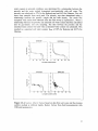
parameters are, for instance, instructions to define the beginning and the end of the
trace, individual offsets for traces deviating from the usual shape. The trace is then
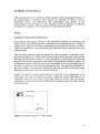
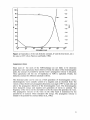
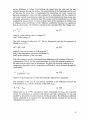
analysed with an algorithm. (Figure 8)
6
MinWindow
~
4
I
BegWindow
III
:.-
~
:.-
)
---",
2
-
----~----------~--~
.....
---
0
"C
•
Cl
~
i:i:
·2
~
t.:c RegresRange
-4
I4-M RegresRange
(Scaled)
BegOfTrace
0
50
EndOfTrace
100
150
~8
250
200
Screen Point
No.
Figure 8. A trace produced by AutoTDR with some of the parameters used in the
evaluation ( from Thomsen, 1994).
30
The different tasks operated by the software are often divided into smaller
programme units. These units could be, for example, programs for communication
with the cable tester, serial communication with the multiplexers and analysis of the
trace. In order to make parameter setting easier and to present the result in a visual
way graphic programs and a screen menu may be included. A number of parameters
are given and options are given to specify different properties of the system.
The Campbell Programming Instruction 100 (from now on referred to as PI 100) can
be used to design programmes of different purposes. The program uses parameters all
set in the program list found by codes and set by flags (Figure 9). AutoTDR, the other
software in this comparison has a main menu including a sub menu for the setting of
parameters and is more user friendly in the sense that the parameters are set in the
menu and not in the listing of the program as is the case in the P.I 100. Parameters
such as probe length, cable length and equation for conversion to water content are
essential information requested in both of the two software program.
AutoTDR stores raw data and although PI 100 has the same option, the size of the
storage capacity makes it more common to store only Ka values and soil water
contents.
TABLE 4-1 Instruction 100 Parruneters
PAR. DATA
NO. TYPE DESCRIPTION
01:
2
02:
2
03:
04:
FP
FP
05:
4
SDM1502 address
Ouqmt option
o Water content
1 Raw data
98 Manual step through
99 SDM1502 signature
Probe length. m.eU"es
Cable length. metres; enter 0 for auto
search
Multiplexer channel/Reps
ABeD
ehau.. of 1st Mux. 0 if none
A
B
Chan. of 2nd Mux. 0 if none
06:,
4
07:
FP
C
Chan. of 3rd Mux. 0 if none
o No. of Probes to scan
Input locatiou
Multiplier
08:
pp
Offset
Input Locations altered:
\Vater conteD.l
1 per probe scanned
RAw data
256 per probe scanned
Intermediate Locations required:
531 the nrs[ ti..ro.e Instruction. 100 is used
16 intennediate locations for each fnst.cuction 100
thereafter.
Figure 9. Parameter setting in Campbell software programme PI 100 (From
Campbell, 1995).
Experimental set-up
Two experiments were conducted in sandy soils, a washed sand referred to as Baskarp
and a natural sandy soil referred to as Nantuna. Sandy soils have, of course, a simpler
structure than clays which makes water fluxes easier to explain. Furthermore, sandy
soils do not absorb a lot of tightly-bound water which is the case for clays. This
tightly-bound water is not detectable by TDR and would make a comparison between
31
different sources of errors more difficult. In the first experiment, conducted in the
field, errors from probes and cables were examined. In the second, performed in the
laboratory, the role of software program evaluation in measurements was examined.
In a third experiment manual measurements of electrical conductivity were conducted.
The TDR-systems used in the different set-ups were similar in the following respects:
The automated systems were all programmed by Campbell Programme Instruction
100 and a data-logger (Campbell CR10) was used to process and store information.
Multiplexers (Tektronix SDMX50) and a 5 conductor communication cable
(Tektronix 6549) to alternate the connection between the probes and the cable tester
were also used in these automated systems. Other similar components used in all of
the set-ups were, furthermore, a Metallic Cable Tester (Tektronix 1502B or 1502C)
which was supplied with an interface (Tektronix SP 232) and coaxial cables (RG 58,
50 ohm).
Experiment 1 - in field
In this experiment, errors from probes and cables were examined. The conversion of
Ka to Bv was also examined as calibration functions for the two sands were
determined. The experiment was conducted in four field plots ( Figure 10). The plots
were equal in pairs, two plots with Baskarp sand and two plots with Nantuna sand.
Each plot was supplied with two separate automated TDR-systems. The systems were
different in probe type only. The first system installed (October -95), system A, had
two-wired unbalanced probes 15 cm long and long (24 m) cables. The second system,
system B, installed in June -96 was supplied with balanced 30 cm two-wired probes
(Campbell PB 30) and 19 m cables at corresponding depth. Measurements were
conducted of 10 min intervals, except during a drainage event when the water content
was measured every 2 min.
s
~
o
o
Sand
--------=
TDR
G ravel
water
Pressure
outlet
[-----=---=·-·--=--=-====-====-i!':-:-=:ti~tfi11iirr===3J"t'1.fiIi ag t§
-----2-0-0-c-m------------+i pipe
Figure 10. Schematic figure on the experimental set up in field used for systems A
andB.
32
Experiment 2- in laboratory
In the second experiment two plastic cylinders, 50 cm of height and 29,5 cm in
diameter, were filled again with Nfultuna sand and Baskarp sand for studies in
laboratory. Both sands were dried when filled and placed upon a 5 cm gravel layer.
Each of the two cylinders was provided with two sets of TDR probes, six two-wired
and five three-wired (Figure 11) in two separate systems. A water container and an
electrical pump were used to apply water to the cylinders and an arrangement of hosts
controlled an artificial ground water level. After the two soils had been saturated
during a wetting event the containers were drained as the ground water level was
drained in steps (to avoid trapped air). Later an electrical fan of250 watts was used to
dry the soils. The system with two-wired probes, system C·was automated (PI 100)
while manual measurements were conducted in the system with three-wired probes,
system D (Figure 11). These manual measurements were evaluated with the software
AutoTDR. The automated measurements were conducted every 5 minutes while
manual measurements were conducted at different water contents ranging from dry
water conditions to near saturated conditions. This was accomplished to test the
software's evaluation of the trace and to see how the different parameter settings
influence the interpretation.
. . •. '"
2 an / :
. . ::~!!!.~~.~:
8an
r
~
13an
====:::l••",
23 an
18an/,::::====
System C
cable tester
28 an
/~.s=a=n=d==
System 0
~==.~ 33an
38 an/,
48 an
5 an
====:::l...",
cable tester
43 an
rgravef .
Figure 11. Schematic figure on the laboratory set up. Two systems, C and D measure
on probes installed in a cylinder of sand.
33
RESULTS
Experiment 1
Trace performance
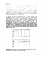
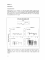
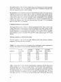
While system A gave unrealistic Ka values and water contents, system B gave
reasonable data (Figure 12). System A, with long cables and short unbalanced probes
gave, on one hand, a trace heavily disturbed by noise. Measurements with system B
also consisting of long cables but with long balanced probes gave, on the other hand,
an acceptable quality of the signal.
Signal trace from system A and
the Baskarp sand influenced by
............_............. System B
System A
o. 10 cm depth
17 cm depth
0.4
0.3
----=
~
Q
-=
~
0.2
0.1
,~~
I'~'
.~---.~
I,
OT-----~----~------~----~
12
o
-~
I-.
~
13
14
july
25 cm depth
O.
0.1
OT-----,,-----,------.-----~
12
13
14
july
35 cm depth
t:':
~
.~ O.
0.2
0.1
O~-----,-----,------,-----~
Figure 12. Traces disturbed by noise. Above: An example of a trace from system A
influenced by noise before the electrical ground of the power supply was
disconnected. Below: Time series of traces from system A and system B at four
depths.
34
The quality of the signal from system A was later improved when the electrical
ground in the system was given attention. The ground had earlier been supplied from
the power net but this had apparently disturbed the signal. The noise was also reduced
simply by disconnecting the ground of the power-supply. A point close by the plots
was instead used as ground to have a similar potential as the soil in which the probes
where installed.
Another phenomenon that occurred at water contents near saturation in the Nfultuna
sand was an incorrect interpretation of the trace. The end of the trace become under
these conditions very flat. PI 100 then failed to detect the last inflexion point of the
trace (Figure 7) which made the apparent probe-length longer. As a consequence Ka
became unreasonably large and unrealistic water contents of 80-100 % were recorded.
Gravimetric calibration
An acceptable calibration function was not found for system A, as a consequence of
the poor quality of the trace.
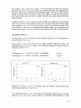
The accuracy of data from system B was further improved when the system was
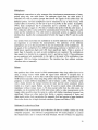
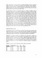
calibrated against small core samples. The calibration functions found for the two
sands and system B were:
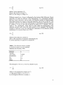
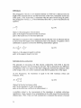
For Baskarp: 8" = -0.000206 + 0.070Ka + 0.002088K/
eq. (21)
2
eq. (22)
For Nfultuna: 8" = 0.00005 + 0.03330Ka + 0.007245Ka
Baskarp eq. 21
Nantuna eq. 22
40
40
/ / r=0.85
r=0.88
C
30
~
30
0
20
§ 20
c
.l!!
c
8
C
Q)
2<1l
:;
·0
x
~
*
:; 10
·0
10
(f)
(f)
0
2
4
VKa
1
5
0
/
/
2
/
\4
.-(
~
x //
x
4
3
5
6
-v'f<a
Figure 13. Calibration curves for Baskarp sand and Nfultuna sand obtained from
gravimetrical sampling of small cores.
The calibration functions were constructed with measuring points from one occasion
when soil cores where taken. This resulted in a somewhat small distribution in data
35
with respect to water content. The data also occurred at different water content ranges
in the two sands, between 20-37 % for Baskarp and between 9-20 % for Nantuna.
Each curve was therefore complimented with a constructed point in the range were
points were lacking. These values were obtained with the pressure outflow method in
which the water contents of core samples were determined at different pressures.
These data are presented in figure 15 below.
Drainage event
A drainage event was then recorded by system B in order to compare equations (21)
and (22) with the commonly used Topp equation (eq. 1). The groundwater level of the
field plots was lowered with approximately 10 cm each day for three days. During this
time the plots were also covered to prevent evaporation. The volume of drained water
was measured with tipping buckets. System A was also used to record changes in
water content at different depths. The accumulated outflow was measured with tipping
buckets but was also calculated from TDR measurements. This is shown in figure 14.
The calculations were conducted for layers defined by the depth of the probes.
Figure 14 shows, on one hand, that both eq. 1 and eq. 21 underestimate the absolute
soil water content significantly in the Baskarp sand. For Nantuna, on the other hand,
eq. 1 overestimates the drained volumes. Relative differences in water content are,
however, very well described by the TDR measurements in both sands. For the
Nantuna sand Eq. 22 gives volumes that corresponds well with the volumes measured
by tipping buckets.
mm
100
75
mm
DRAINED VOLUMES BASKARP
1. - -___ .:......__
2.
3.
tipping buckets
TOR eq.1 (Topp's eq.)
TOR eq.19 (Grav. caLl
mm
100
100
75
75
1.
2.
3.
TOR eq. 20 (Grav. caL)
tipping buckets
TOR eq. 1 (Topp's eq.)
1.
/
50
9
10
11
2.
~.t",Y#rJ
50
'-.3.
_.£
8
75
~
50
:/.-v.t,
25
100
1.
·--~2.
50
mm
DRAINED VOLUMES NANTUNA
3.
25
12 july
25
25
15
16
17
18
july
Figure 14. Drained volumes from the Baskarp sand and the Nantuna sand, measured
with tipping buckets and TDR, when the groundwater level was lowered by 10 cm
each day for three days.
Experiment 2
Calibration- trace set-off parameter
In order to determine the water content of two calibration points for system D the
water content was estimated both at saturated conditions and at dry conditions. The
36
water content at saturated conditions was determined by a relationship between the
porosity and the water content determined gravimetrically with soil cores. The
porosity was calculated to 47% for the Baskarp sand and 44% for Nantuna. Five soil
cores were sampled from each sand. The porosity was then determined using a
relationship between the specific weight and the bulk density. The result was
compared with similar data obtained from the field set-up in experiment 1, where a
relationship between the porosity and saturated soil water content had been calculated
also by gravimetric soil core sampling. The ratio between the porosity and the
saturated water content was used when a saturated water content was calculated. This
resulted in a saturated soil water content, Bsat, of 38% for Baskarp and 40.5% for
Nantuna.
BASKARP
NANTUNA
4
4
c
"~
c:
3
ID
::!: 2
Cl
.2
o
10
20
30
50
0
10
20
30
40
50
soil water content (vol%)
BASKARP
5
C
0
"u;
5
4
4
3 -
3
NANTUNA
c:
2
--'-2
Cl
2
.2
o
10
20
30
40
50
soil water content (vol%)
Figure 15. pF-curves. Above: Curves based on data from soil cores and the pressure
outflow method at different depths. Below: Curves from field measurements with
TDR and tensiometers.
37
The water content at 100 cm water column, 8100, was estimated to be 9% for Baskarp
and 7% for Nantuna. This was obtained from pF-curves established with data from
soil cores using the pressure outflow method.
The possibility of re-evaluation of traces in AutoTDR and system D was then used to
calibrate the measurements against the two values of saturated water content and the
water content at the tension 100 m water column. This was accomplished by adjusting
a trace off-set parameter until the measured values corresponded to the calculated
values. These off-set values were determined to be -0.02 for the Baskarp sand and
0.025 for the Nantuna sand. This gave 8100 and 8sat 8.9 % and 37.7 % for Baskarp
and 7.4 % and 40.8 % for Nantuna.
Comparison between the two systems
The logger-based system, system C, showed significantly lower values of soil water
content. When the PC based system, system D, predicted a soil water content of 8,9%
for Baskarp and 7,0 % for Nantuna at the tension 100 m water column, the logger
system displayed a corresponding water contents of 3.5 % and 5.0 %. In conditions
near saturation, system C recorded 33% and 39 % while system D gave 37.7 % and
40.8%.
Software evaluation of different probe types
The two systems C and D also run with different probes and software evaluation
programs. The results are shown in table 2.
Table 2. Ka values measured and evaluated with a combination of the components in
system C and system D at near saturated conditions in a sandy soiL
PI 100
two-wired
probe m.
..__...__..._..._-_.._. __...probe
__ .....
__ ......._.......................
20.52
1
19.80
2
17.30
3
20.70
4
19.71
5
21.16
6
.........
.................
AutoTDR
two-wired
probe
19.80
18.83
16.17
19.61
18.93
20.43
-~---
PI 100
three-wired
probe
17.47
17.72
18.49
17.30
17.89
AutoTDR
three-wired
probe
19.28
19.29
20.28
19.16
19.35
Table 2 shows that PI 100 evaluates measurements conducted with the three-wired
probe resulting in Ka-values in average about 9 % lower than when evaluated by
AutoTDR. When the two-wired probe was used, on the contrary, AutoTDR evaluates
the measurements about 5 % lower than PI 100. AutoTDR was used with a trace off
set value determined according to the user's manual for both probe-types. The trace
off values used were 0.172 for the two-wired probe and 0.128 for the three-wired
38
probe. These trace off values, however, deviated significantly from the calibrated
values because they were determined according to the instruction manual (Thomsen,
1994). It is also important to remember that the two probe types were installed at
different depths in the cylinder which means that the values from the same rows in the
table can only be compared between similar probes.
The systematic deviation of two-wired probe ill. 3 (Table 2) together with an
inspection of the probe set-up resulted in an additional investigation of how the length
of the probe actually in contact with soil influences the measurements. In other words,
the installation of the probes from the outside of the cylinder-wall does not allow the
whole probe to be buried in the soil. The sensitivity of Ka to the fraction of the sensor
not in contact with the soil was examined. This was achieved by setting a shorter
probe length, corresponding more with the part of the probe in contact with the soil
using a parameter in AutoTDR. The Ka values obtained were compared with the
value obtained using the total probe length in the parameter setting. For the two-wired
probe-type in system C, a setting 1 cm shorter than the total length of the probe gave a
8% higher value. For 2 or 3 cm the corresponding values were 18 % or 29 %. For
most probes in the set up, 2 or 3 cm of the rods were not in contact with soil. For the
three-wired probes of system D, the set up is, on one hand, made in a way that a
shorter length of the rods is in contact with soil. On the other hand, this probe-type is
shorter which made the deviations even greater: 1 cm of non-soil contact gives an
increased Ka of 16% while 2 cm which is more reasonable gave 30 %.
Software parameter setting
The parameter setting in AutoTDR can be reduced to set probe type and probe length
when using a default function. For other probe types than a standard probe (Thomsen,
1994) a more accurate interpretation of the trace could, however, be accomplished by
abandoning the default function and to set parameters manually and individually.
Differences in parameter setting in AutoTDR were examined by altering two
parameters, RegressRange and SmoothWindow. RegressRange sets the length of the
segment used, when regression lines are drawn, to define the beginning and the end of
the trace (Figure 6). This is expressed as horizontal co-ordinate points on the trace
plot. SmoothWindow is a filter that averages the values of the trace. How the settings
effect the measurements at water contents near saturated conditions is presented in
table 3.
Table 3. Ka-values when the parameter setting is altered in AutoTDR
Settings
RegRess 5
10
15
20
25
SmoothW 5
17.87
18.13
17.94
17.65
17.50
10
15
20
20.56
20.16
19.89
20.17
19.93
20.52
19.96
20.05
19.87
19.69
20.43
20.20
19.91
19.30
19.03
39
DISCUSSION
TDR-systems consist of several components that can contribute to errors in soil
moisture measurements. There are two major groups of errors: those that influences
the determination of Ka and those that occurs when Ka is converted to soil water
content (figure 16). The first of these errors which belong to the type found on the left
side in the figure, can then be further divided into those that influence the signal as it
appears on the cable testers oscilloscope and others that affect the interpretation of the
trace.
The type of errors discovered in the two experiments described above can be
summarised and classified as follows:
errors in
TDR-measurements···
determination of Ka
attenuation
parameter setting
in software
noise
tightly bound
water
soil bulk density
temperature
soil bulk electric
conductivity
Figure 16. Classification of some errors occurring in TDR-systems. The errors
primarily focused on in this study are found on the left side, related to determination
of the apparent dielectric constant, Ka in soils. The soil properties, on the right side in
the figure, influencing the conversion of Ka to Bv are considered when calibration
functions are determined.
Errors which affect the quality of the signal
The first group of errors, found to the left in figure 16, can be exemplified by
observations made in field, such as: noise due to improper grounding, signal
attenuation due to long cables and noise due to the use of long cables in combination
with short unbalanced probes (Figurel1).
40
Power supply and electrical grounding
Noise and signal fluctuation can affect the possibilities of a proper evaluation of the
trace. A trace affected by an improper grounding is characterised by a fluctuating trace
which pattern reminds of sinus curves. As a consequence the software program that
interprets the trace does it in an unreasonable way or even fails to interpret the trace.
This problem can be overcome simply by disconnecting the ground wire of the cable
that supports the cable tester with power. This is not, however, a satisfying solution
since electrical systems require a ground connection for safty. Besides a stationary
system requires a grounding as protection of the euqipment from thunderstorms.
Instead, a grounding point near the site where the probes are installed should be
chosen.
The stationary system A, for example, was heavily disturbed by noise until the
electrical grounding was re-arranged. The grounding from the power-supply was
disconnected and the grounding was taken from a pole which was put up next to the
measured plots. Thus, it is of importance that the electrical ground-point is selected
near the installation of the probes to ensure that the potential of the soil does not differ
much from the electrical ground used in the power-supply.
Signal attenuation
A problem that often occurs when long cables are used is signal attenuation. Loss of
energy makes noise more significant and the trace becomes difficult to interpret. This
is even more likely to be the case when short probes are used since the shorter probe
length gives a shorter trace which can, due to the relative long transmission zones,
easily be interpreted incorrectly. In practical measurements in the field, however, long
cables are often required. One way to avoid signal attenuation is then to use cables
with a higher impedance. Noise, which is always present during any measurement,
will then be less significant. Cables with a higher impedance can be matched with
cables with lower impedance using a balun. A 50 ohm cable from the cable tester
connects, in this way, a longer 200 ohm twinax cable which improves the quality of
the signal (Thomsen, 1994).
System considerations
The errors described above are in general caused by improper instrumentation. One
strength of the TDR-system is the flexibility in design which makes it possible to
adjust the system to different soil types, conditions and to the demands of the users .
Nevertheless, this flexibility can also be a weakness if the user does not have the
knowledge to correctly adjust the system to different conditions. Even a widespread
system, such as system B (Campbell), where the different components are designed to
be used together, has been subject to significant changes. (CampbeU, 1995).
The difference in nature of soils are for example between a sand and a clay requires
attention and consideration v/hen similar systems are used for both types of soil. This
41
has not been examined in this study but similar systems like those operated in the
experiments described in this paper have been used in clays. Andersson (1994) may
be correct when she concludes that the contact between the probe and the soil was the
explanation to underestimated water contents in a clay soil.
The cables and probes used in system C are connected by screws. The result is a
signal where the beginning of the trace is difficult to define. The peak indicating the
beginning of the trace becomes fairly large. The connection was also modified to
allow quicker installation, which further decreased the distinctiveness of the
transmission zone. The material used in the modified connection also had different
isolating properties than the cable and is also fragile. It is not surprising that a
connection between the probe and the cable with this design contribute to
uncertainties in measurements. A connection between the cable and the rods with a
more distinct transmission zone is preferable.
In the second experiment, K a , changed significantly when the actual probe length was
changed in system C. Apparently, the part of the probe in contact with the soil is
shorter than the probe length due to the arrangement of the probes. A shorter probe
length reflecting the length of the probe in contact with the soil was set and the
obtained Ka was compared with the value gained with the full probe length. That this
significantly influences Ka is easy to understand if equation (15) is considered. The
size of the deviations is, however, surprising. For the two-wired probe type in system
C, a setting 1 cm shorter in the probe length parameter setting gave a 7 % lower value
than a setting with the total probe length. Corresponding values for 2 and 3 cm were
15 % and 20 % and these values seems reasonable for the probes in this set up. The
three-wired probe type in system D is, on one hand, made in a way such that a shorter
length of the rods looses soil contact. On the other hand, the probe is shorter which
make deviations even greater. Assuming 1 cm of non-soil contact gives a Ka value 16
% lower than a parameter value using the total length of the probe.
In the latter case these deviations were compensated by calibration with a trace offvalue. in addition, the bending of the cylinder wall influences the probe set up in a
way that the outer rods get a slightly shorter contact with the soil than the middle rod.
Another effect of the wall in a experiment design of this type, furthermore, may be
influences of the distribution of soil moisture.
Errors caused when the signal is interpreted
The second type of error which influences the determination of Ka concerns the
interpretation of the trace. Interpretations are conducted with software programs
controlled by parameter settings. Both software programs used in this paper, PI 100
and AutoTDR interpret the trace by locating inflection points at the trace which
determine the beginning and the end of the trace by regression lines and interception
points (Figure 7 ).
A phenomenon that occurred in system B during the measurements in the Nantuna
sand was improper interpretation of the trace. At nearly saturated water contents the
42
software PI 100 was not able to recognise the inflexion point at the end of the trace as
the trace under these conditions became very flat. The result is unreasonable high
values of Ka and soil water content. This type of error has also been observed by
Camp bell (1995) in other soil types. A solution to this problem would be to use cables
with a shorter rise time. Ledieu et al. (1985) are correct when they suggest a cable of
75 ohm impedance and with shorter rise time as a solution to this type of problem.
In PI 100 it is not, furthermore, possible to set any parameter which influences the
way the trace is interpreted. In AutoTDR, however, two parameters, SmoothWindow
and RegressRange influence the way the trace is evaluated. The result of the settings
can be conveniently and quickly evaluated by eye as the trace is displayed.
SmoothW has a critical value where the interpretation changes significantly. This is
the value of the settings when deviating points of the trace are excluded by the filter
function. In other words, small changes on the trace which were earlier identified as
inflection points are smoothed through the filter function and the inflection points are
moved. The desired value of SmoothW is obtained when the filter function excludes
noise interference near the beginning and end of the trace but where the real beginning
and end of these points are not moved. In the case examilled, this value is apparently
situated somewhere between (5) and (10) because of the significant difference in the
resulting Ka-value for these two settings. This also corresponds rather well with the
value (8) obtained when the default function was used.
RegressR is theoretically correct when the smallest possible value (5) is chosen. This
is when the regression line's slope corresponds best to the slope close to the inflection
point. However, if the inflection points have been moved when SmoothW filtered the
trace then a larger value of RegressR could give a more accurate interpretation. The
two parameters have to be matched for an optimal interpretation of the trace.
It is also important to remember that these tests were conducted with few probes and
also with only five measurements on each probe. The results above are therefore to be
seen as an indication on how the two software programs evaluate the two types of
probes. An extensive statistical analysis of this is, unfortunately, out of the scope of
this study.
Comparison of software
The advantage of using a PC and AutoTDR compered to a logger and PI 100 is
considerable. First the evaluation of the trace could be made by eye, on the computer
screen where the trace is graphically displayed, immediately after the measurement.
This saves time during for example, an installation of a system. Secondly, reevaluation is possible in a direct and convenient way. Lastly, TDR measurements are
conceptually difficult to comprehend and immediate interpretation of the graphical
trace is educational.
Another observation when PI 100 was used concerns the propagation velocity. The
velocity is set in PI 100. If the setting on the cable tester doesn't correspond to the
43
value in the programme, then the apparent cable length will change. As a consequence
the programme will start to search for the trace in the wrong place. This is displayed
on the oscilloscope of the cable testers as a brief glimpse of the trace followed by a
long search for the trace. In the end when the trace is not located an enlargement of a
discontinuity somewhere along the cable is shown. The values of Ka are then
typically small (Ka<l). In AutoTDR this error will not occur since the programme
reads the settings on the cable tester through an interface.
In general, system D with the three-wired probe and PC for storage of data evaluated
by the software AutoTDR, seems to be more reliable and robust than any of the other
systems. This is because of a high reproducibility and the possibility to re-evaluate the
trace which can increase the precision of the measurements. The software interpreted
the traces measured in different water regimes without any failure of the type
occurring when PI 100 evaluated the Nantuna sand under near-saturated conditions.
Sometimes, however, the program fails to recognise the beginning of the trace,
followed by a message to move the trace on the cable tester's oscilloscope. This is
probably due to the fact that the first peak of the trace, in some cases, is fairly large.
The running of the program is also sometimes interrupted if the wrong probe type is
given in the parameter setting. Then the programme has to be started up again and the
parameter setting has to be given once more. An error message would be preferable.
Re-evaluation of trace by AutoTDR also allows calibration against a single
calibration-point by the use of a trace off value. The single point can be chosen most
conveniently either at the saturated water content or at the residual water content.
Suggestion on system design
By using a system similar to system D, with the possibility of re-evaluating the trace
by adjusting the parameter settings, precise measurements can be conducted. It could
be especially convenient in soils where data of saturated water content or the residual
water content are known since no separate calibration method nor calculation of
specific calibration functions are then required. Further measurements in different
soils such as clays and organic soils are required before it is possible to say anything
about AutoTDR's usefulness in all types of soils. It would also be desirable to test the
system during a longer period with an automated version of the system.
Conversion of K" to
(Jp
The calibration function (eq.22) found for system B and the Nantuna sand showed a
better fit than equation (1). For Baskarp, however, the function (eq.21) gave lower
values than obtained both from the tipping buckets and calculated values of equation
(1). This is a consequence of the constructed points of the two curves. The
constructed point of the Ntmtuna sand is situated near saturated conditions and is well
estimated. It is also this range of the curve that holds the largest volumes of water, the
significant part when accumulated volumes are measured. In the Baskarp sand the
very low soil water contents are represented by a constructed point. The water content
44
is here overestimated which results in a curve with a too flat slope and too low
volumes of drained water.
The different characteristics of the two sands could also contribute to uncertainties.
The Baskarp sand transports water very fast during a filling event and air could also
easily get trapped in this condition. The water content near saturation may vary and
might not be well described by a single calibration curve. Nantuna, on the contrary
will fill up more slowly, preventing air from getting trapped. During the installation of
the probes, however, pockets with drier material were observed in the Nantuna sand.
Soil properties influencing Ka
The choice of two sandy soils to conduct the TDR measurements in, decreased the
influence of soil properties such as tightly bound water, soil bulk density and salt
concentration on Ko. A widely used relationship (equation 1), however, did not
describe the absolute soil water contents in these two sands as well as expected.
Instead, new calibration functions for the two sands were determined and one of them
was shown to describe the relationship better than equation (1).
Development in TDR-technology
Finally, a few words about the development of the TDR-technology. A trend in TDRsystems design is that the cable tester is replaced by smaller units. A portable version
of TDR is TRASE that allows measurements without a separate calibration method
but with lower accuracy than permanent systems (Soil Moisture Company, 1997).
Two other systems of pocket size are Soil content reflectometer CS 615 (Campbell,
1997) and TRIME (IMKO,1997). The former is designed to be used in combination
with a logger and the latter can either be operated together with a logger or a PC. The
manufacturers promise deviations less than about 2% from the actual water content.
This is still not near the accuracy of less than 1% gained in many permanently
installed systems (Topp et aI., 1980; Ledieu et aI., 1985) but may be sufficient for
many purposes. These types of portable systems are specially well suited to sporadic
measurements on probes installed over a large area.
Another trend in system-design is the development of highly automatic permanent
systems. These systems are computer-based and can be monitored remotely by for
example, a mobile phone and a modem. The data from the measurements can then be
collected as the station is called up and transferred using internet. This, of course,
saves time when TDR measurements are conducted at remote sites. TDR has also
been used as a calibration method for remote sensing techniques conducted from
aeroplanes or satellites. These techniques have previously been limited by shallow
resolution depths but measurements to a depth of one meter have to date been
conducted.
45
CONCLUSIONS
•
Errors in TDR-measurements can be divided into two groups: Errors influencing
the determination of the dielectric constant, Ka and errors which occur when Ka is
converted to soil water content, Bv. The first type is often caused by improper
instrumentation while the latter type often occur when the influence of soil
properties on Ka is neglected.
•
Long cables, multiplexer-devises and probes with long transmission zones that
causes relative large energy losses of the system all contribute to errors in the
measurement of Ka. The implementation of general equations in very dry
conditions or in conditions near saturated contribute to another source of error
when Bv is considered.
•
Probes with a distinct transmissionzone and cables of 75 ohm decreases relative
energy losses which increases the accuracy of the determination of Ka. The
accuracy of measurements in very dry conditions or at conditions near saturation
is improved when an apropirate equation is choosen.
• When accurate values of absolute soil water content are required a specific
calibration of the system is needed. If values of relative changes in water content to
describe the dynamics of soil moisture are more important then a general equation
such as Topp's equation can be used without further calibration.
• Flexible system design is a strength of TDR but the different components must be
matched to function together for accurate measurements in a certain type of soil.
This advantage of flexibility can, however, also be a weakness if the knowledge on
proper system design are lacking. One important property of a system is a probe
type with a distinct transmission zone that allows accurate interpretation of the
trace by software.
• Re-evaluation of traces can improve the interpretation. Individual parameter
settings can improve the accuracy of the measurements compared with using
default functions. In AutoTDR this evaluation is conveniently done by eye
directly on the computer-screen. A trace off-set parameter allows easy calibration
at conditions where a good fit of the general equations can not be expected.
ACKNOWLEDGEMENTS
Thanks to my supervisors, Professor Per-Erik Jansson and Manfred Stahli for help and
support. Anton Thomsen and Henning Bjaergaard at the Research Centre in Foulum
who was both helpful and showed great hospitality during a week in Denmark. I
would also like to thank Lave Persson, Gunnel Alvenas and Hakan Alfredsson for
assistance and Professor Nicholas Jarvis for advise on the manuscript.
46
REFERENCES
Literature
Aimone-Martin, C.T & Oravecz, K.1. 1994. Time Domain Reflectory calibration for the waste
isolation pilot project. Pre-print No 94-144, for presentation at the SME annual meeting,
A1buquerque NM, /p
Andersson, J. 1994. Vattenhaltsmatningar med TDR och neutronsond i ilirsok med tidig sactd av
korn. Sveriges Lantbruksuniversitet Uppsa1a. Meddelande fran Jordbearbetningsavdelningen,
Nr.11.
Baker 1. M. & Lascano R. 1. 1989. The spatial sensitvity of time domain reflectometry. Soil Science
vo!. 147 No 5 pp. 378-383
Campbell, 1995. TDR Soil Moisture Measurement System User Guide. Campbell Scientific, INC.
Shepshed, Leiestershire, UK.
Davis, J.L.& Chudobiak, W.J. 1975. In situ meter for measuring relative permitivity of soils.
Geological survey of Canada. Energy, Mines and Resources of Canada, Ottawa. Paper
75-1A
Davis, 1.L., & Annan A. P. 1977. Electromagnetic detection of soil moisture: Progress report 1. Can.
J Remote sensing, 3, 1,76-86.
Dirksen, C. & Dasberg, S. 1993. Improved calibration of time domain reflectory soil water content
measurements. Soil Sci. Soc. Am. 1. 57:660-667.
Giese, K. & Tiemann, R. 1975. Determination of the complex permittivity from thin- sample time
domain reflectometry: Improved analysis ofthe step response wave form. Adv. Molec. ReI. Proc.,
7:45-59.
Heimovaara, T.J. ,de Water E. & Dekker S.c. 1996. A computer controlled TDR system for
measuring soil water and soil bulk electrical conductivity of soils.. Laboratory of Physical
Geography and Soil Science, University of Amsterdam, Nieuwe Prinsengracht 130 1018 VZ,
Amsterdam Report 41.
Heimovaara, T.J. 1996. Design of a triple-wire time domain reflectometry probes in practice and
theory. Soil Sci. Soc. Am J. 57:1410-1417
Hook, W.R & Livingstone, N.1. 1992. Remove diode shortening improve measurement of soil water
by time domain reflectory. Soil Sci. Soc. Amer. J 56:1384-1391
Hook, W.R & Livingstone, N.1. 1995a. Propagation Velocity Errors in Time Domain Reflectometry
Measurements of Soil Water. Soil Sci. Soc. Amer. J. 59:92-96,
Hook, W.R & Livingstone. N.J. 1995b. Errors in Converting Time Domain Reflectometry
measurements of Propagation Velocity to Estimate Soil Water Content. Soil Sci. Soc. Amer. J
59:35-41.
Jacobsen, O.H. & Schjonning, P. 1993a. A Laboratory Calibration of Time Domain Reflectometry
for Soil Water Measurement Including Effects of Bulk Density and Texture. Journal of
Hydrology 151: 147-157.
Jacobsen, O.H. & Schjonning, P. 1993b. Field Evaluation of Time Domain Reflectometry for Soil
Water Measurements. Journal of Hydrology, 151: 159-172.
Jacobsen, O.H. & Schjonning, P. 1993c. Comparison ofTDR Calibration Functions for Soil Water
Determination. unpublished.
Kutilek, M & Nielsen, D.R. 1994. Soil Hydrology. Catena Verlag CremlingenDestedt. p. 28-44.
Ledieu, 1., De Ridder, P., De Clerck, P. & Dautrebande, S. 1986. A Method of Measuring Soil
Moisture by Time-Domain Reflectometry. J. Hydrology 88: 319-328.
Mallants, D., Vanc1ooser, M.,Meddahi M.& Feyen 1. 1994. Estimating solute transport in
undistributed soil columns using time-domain reflectory. 1. Con. Hyd. 17:91-109.
Nadler, A., Dasberg, S. & Lapid 1., 1991. Time domain reflectory measurements of water content and
electrical conductivity of layered soil columns. Soil Sci. Soc. Am. 1. 55:938-943.
Patterson, D.E. & Smith, M. W. 1980. The Use of Time Domain Reflectometry for the Measurement
of Unfrozen Water Content in Frozen Soils. Cold Regions/Science and Technology 3: 205-210.
Pepin S., Livingstone, N.1. & Hook, W.R. 1995. Temperature-Dependent Measurement Errors in
Time Domain Retlectol1letry of Soil Water. Soil Sci. Soc. Am. 1. 59:38-43.
47
Roth, K., Schulin, R., FlUhler, H. & Attinger, W. 1990. Calibration of Time Domain Reflectometry
for Water Content Measurement Using a Composite Dielectric Approach. Water Resources
Research, 26 (no 10): 2267-2273.
Roth, C.H., Malicki, M.A. & Plagge, R. 1992. Empirical Evaluation of the Relationship between Soil
Dielectric Constant and Volumetric Water Content as the Basis for Calibrating Soil Moisture
Measurements by TOR. 1. Soil Sc. 43: 1-13.
Sears, F.W., Zemansky M.W. & Young H.D. 1982. University Physics. Addison-Wesley Publishing
Company. New York.
Spaans, E. J. A. & Baker J. M. 1993. Simple Baluns in Parallel Probes for Time Domain
Reflectometry. Soil Sci. Soc. Amer. J. 57:668-673,
Stein, J. & Kane, D.L. 1983. Monitoring the Unfrozen Water Content of Soil and Snow Using Time
Domain Reflectometry. Water Resources Research. 19: 1573-1584.
Stahli, M. & Fryklund, C.1995. TDR measurements in washed filter-sand. D. Soil Sc. SLU
(unpublished).
Stahli, M. & Stadler D. 1997. Measurements of water and solute dynamics in freezing soil columns
with time domain reflectrometry. Journal of Hydrology. (in print)
Tektronix, 1995. 1502C Metallic Time Domain Reflectometer Operator manual 070-7169-00.USA
Thomsen, A. 1994. Program AUTOTDR for Making Automated TDR Measurements of Soil Water
Content., Danish Inst. of Plant and Soil Science. SP report 38.
Topp, G.C., Davis, J.L. & Annan, A.P. 1980. Electromagnetic Determination of Soil Water Content:
Measurements in Coaxial Transmission Lines. Water Resources Research 16: 574-582.
Topp, G.c., Davis, J.L. & Annan, A.P. 1982a. Electromagnetic Determination of Soil Water Content
Using TOR: 1. Applications to Wetting Fronts and Steep Gradients. Soil Sci. Soc. Am. J. 46: 672678.
Topp, G.c., Davis, J.L. & Annan, A.P. 1982b. Electromagnetic Determination of Soil Water Content
Using TOR: Il. Evaluation of Installation and Configuration of Parallel Transmission Lines. Soil
Sci. Soc. Amer. 1. 46: 678-684
van Loon, M.P.K., Perfect, E., Groenevelt, P.H. & Kay B.D. 1990. A new method to measure soil
bulk conductivity in soils with time domain reflectometry. Can. J. Soil Sci. 70:403-410.
Ward, R. C. & Robinson, M. 1990. Principles of hydrology. McGraw-Hill Book Company Europe,
Maidenhead.
Personal communications
Bjaergaard, Henning 1997. Department of Soil Science, Research Center Foulum, Denmark.
Clearinghouse, 1997. http://acns.nwu.edu.!clear/tdr/
IMKO, 1997. http://alive.de/IMKO/
Jansson, Per- Erik. 1997. Department of Soil Science, Swedish University of Agricultural Sciences.
Persson, Lave 1997. Department of Soil Science, Swedish University of Agricultural Sciences.
Soil Moisture Company, 1997 http://www.soilmoisture.com
Stahli, Manfred 1997. Department of Soil Science, Swedish University of Agricultural Sciences.
Tektronix, 1997. http://www.tek.com.
Thomsen, Anton 1997. Department of Soil Science, Research Center Foulum, Denmark.
48
I.
APPENDIX:
TERMS AND SYMBOLS
A = area (m2)
e = speed of light (3 108 ms-I)
C = electric capacitance (F)
e = electric permittivity constant (-)
EC = soil bulk electrical conductivity (srn-I)
f = temperature coefficient (-)
j = the imaginary number (-1 )112
k = cell constant (m-I)
K = dielectric constant (-)
I = length (m)
p = reflection coefficient (-)
Q = electrical charge (C)
R = total resistance (ohm)
S = specific surface (m2 g- l )
t = travel time (ns)
tan y = dielectric loss(-)
T = temperature (OC)
u = magnetic permeability
v = velocity propagation (nm/s)
V= voltage (-)
w = angular frequency (-)
Z = impedance (ohm)
Bv = volumetric water content (cm3 cm-3)
ode = zero frequency conductivity
8= soil bulk density (g cm-3)
49
H.
Appendix:
TROUBLESHOOTING
The display cable tester's shows us possible mismatch of the system. Below some
symptoms that occurred during the experiments are given causes and solutions.
Symptoms
Causes
Solutions
"Noisy" signal
electrical losses due to long cables, short probes, several levels of
multiplexers
shorten cables, change to cables with an higher
impedance e g 750hm instead of 50 ohm. Longer probes.
that is fluctuating
check grounding of system, interferences on coax-cables from extern
cables- install an external ground (other than the power-supply) on site,
shield coax-cables
Clear signal
Ka too low
after long search -setting of cable length! vp wrong
air-spalting (clays) -reinstall, if not OK change probetype
Ka too high
failure of the evaluation program to recognise the end of trace- occure in
near saturated conditions
8 y unreasonable
at very dry conditions or at conditions near saturated - check the equation
converting Ka to 8 y , change equation-calibrate the system with an
individual equation or use trace-off value if possible. Test the probe by
shortcutting it, using for example a screwdriver, near the probe head. Ifthe
change in impedance (voltage is shown) that occures on the cable testers
osilloscope is gradual and not steep the design ofthe probe itself
contribute to energy-losses which lowers the precison of the
measurements.
Forteckning over utgivna hiiften i publikationsserien
SVERIGES LANTBRUKSUNIVERSITET, UPPSALA. INSTITUTIONEN FOR MARKVETENSKAP.
AVDELNINGEN FOR LANTBRUKETS HYDROTEKNIK. AVDELNINGSMEDDELANDE. Fr 0 m 1995
95: 1
Alavi, G. Radial stem growth and transpiration of Norway spruce in relation to soil water availability. Granens
tillvaxt och transpiration i relation till markvattnets tillganglighet (Licenciatavhandling). 13 + 11 + 14 s.
95:2
Johansson, W. & Fellin, O. Biogas fran vall. Teknik och ekonomi yid odling, skord, transporter, ensilering
samt rotning med tvastegsteknik. 38 s.
95:3
Svensson, E., Linner, H. & Carlsson, H. Utvardering av vaxtanalys i fabrikspotatis. 53 s.
95:4
Andersson, A. Vattentillgangar fOr bevattning i Kalmar lan. I. Litteraturoversikt. 11. Intervjuundersokning rorande
vattenmagasin. 48 s.
95:5
Wesstrom, I. Bestamning av markens salthalt genom matning med konduktivitetssond. 18 s.
95:6
Eckersten, H., Jansson, P-E., Karlsson, S., Persson, B., Perttu, K. & Andersson, J. En introduktion till
biogeofysik. 72 s.
95:7
Eckersten, H. Simulation of water flow in plant communities. SPAC model description, exercises and user's
manual. 49 s.
95:8
Nabieian, F. Simulering av vattenbalans fOr energiskog pa en torvmark. 25 s.
96:1
Eckersten, H., Jansson, P-E., & Johnsson, H. SOILN model, user's manual. Version 9.1. 93 s.
96:2
Eckersten, H., Jansson, P-E., Karlsson, S., Lindroth, A., Persson, B., Perttu, K. & Andersson, J. En introduktion
till biogeofysik, 2:a upplagan. 110 s.
96:3
Carlsson, H., Larsson, K. & Linner, H. Vaxtnaringsstyming i potatis. 69 s.
97: 1
Uppenberg, S., Wallgren, O. & Ahman, M. Saturated hydraulic conductivity in an acid sulphate soil. A minor
field study in the the Vietnamese Mekong delta. 45 s.
97:2
Djodjic, F. Avrinningsmonster i ett litet akeromrade under 40 ar av successiv urbanisering. 38 s.
97:3
Vukovic, M. The effect of soil hydraulic properties on ground water fluctuations in a heavy clay soil.
Measurements and simulations. 43 s.
97:4
Eckersten, H., Jansson, P-E., Karlsson, S., Lindroth, A., Persson, B., Perttu, K., Carlsson, M., Lewan, L. &
Blomback, K. En introduktion till biogeofysik, 3:e upplagan. 130 s.
97:5
Eckersten, H. Simulation of water flow in plant communities. SPAC model description, exercises and user's
manual. 2nd edition. SPAC version 5.0.52 s.
98: 1
Lustig, T. Land Evaluation Methodology. Small-Scale Agro-Pastoralist Farming Systems. Agricultural
community case study in the IV region of Chile. 91 s.
98:2
Jansson, P-E. Simulating model for soil water and heat conditions. Description of the SOIL model. 81 s.
98:3
Casanova, M. Int1uence of slope gradient and aspect on soil hydraulic conductivity measured with tension
infiltrometer. Field study in the Central Zone of Chile. 50 s.
98:4
Ingvar-Nilsson, N. Variationsmonster hos grundvattennivaerna i skogsmark. Faltstudier i Norunda hosten 1995.
52 s.
98:5
Carlsson, M. Sources of errors in Time Domain Reflectometry measurements of soil moisture. 50 s.
Denna serie meddelanden utges av Avdelningen for lantbrukets hydroteknik, Sveriges
Lantbruksuniversitet, Uppsala. Serien innehaller
sadana forsknings- och forsoksredogorelser
samt andra uppsatser som bedoms vara av i
forsta hand internt intresse. Uppsatser lampade
for en mer all man spridning publiceras bl a i
avdelningens rapportserie. Tidigare nummer i
meddelandeserien kan i man av till gang
levereras fran avdelningen.
This series of Communications is produCQd by
the Division of Agricultural Hydrotechnics,
Swedish University of Agricultural Sciences,
Uppsala. The series consists of reports on
research and field trials and of other articles
considered to be of interest mainly within tile
department. Articles of more general interest
are published in, for example, the department's
Report series. Earlier issues in the Communic'.ltions series can be obtained from the Division of
Agricultural Hydrotechnics (subject to availability).
Distribution:
Sveriges Lantbruksuniversitet
Institutionen for markvetenskap
Avdelnlngen for lantbrukets hydroteknik
Box 7014
750 07 UPPSALA
Swedish University of Agricultural Sciences
Department of Sui I Scienc&s
l1ivbion of Agricultural Hydrotecnni<;s
P.O. Box 7014
S-750 07 UPPSALA, SWEDEN
Tel. 018-671185,671186
Tel. +46-(18) 671185, +46-(18) 61 1186
--_._-_.