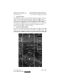
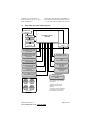
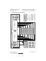
1
GARMIN Ltd. or its Subsidiaries, c/o Garmin International 1200 E. 151st Street Olathe, KS 66062 USA AIRPLANE FLIGHT MANUAL SUPPLEMENT or SUPPLEMENTAL AIRPLANE FLIGHT MANUAL for STC SA02015SE-D GARMIN G500 SYSTEM Table of Contents SECTION Section 1. GENERAL 1.1 Garmin G500 Primary Flight / Multi-Function Display System 1.2 System Power Sources 1.3 Navigation Sources 1.4 Synthetic Vision Technology 1.5 Autopilot Interface 1.6 Audio Panel 1.7 Traffic and Weather Systems 1.8 Single G500 Operational Block Diagram 1.9 Dual G500 Operational Block Diagram 1.10 Definitions Section 2. LIMITATIONS 2.1 Cockpit Reference & Pilot’s Guide 2.2 System Software Requirements 2.3 Database Cards 2.4 AHRS Operational Area 2.5 Magnetic Variation Operational Area 2.6 Navigation Angle 2.7 AHRS Normal Operating Mode 2.8 Maximum Airspeed 2.9 Aerobatic Maneuvers 2.10 Standby Attitude Gyro 2.11 Course Pointer Auto Slewing 2.12 Synthetic Vision Technology 2.13 Autopilot Interface 2.14 Terrain Display 2.15 TAWS Annunciations on the PFD [from a Garmin navigator] 2.16 Datalinked Weather Display 2.17 Traffic Display 2.18 Active Weather RADAR 2.19 Kinds of Operations Section 3. EMERGENCY PROCEDURES 3.1 Emergency Procedures 3.2 Abnormal Procedures 3.3 Abnormal Indications 3.4 Loss of Electrical Power 3.5 Warnings, Cautions, and Advisories Section 4. NORMAL PROCEDURES 4.1 PFD Knob & PFD Soft Keys 4.2 MFD Knobs & MFD Soft Keys 4.3 Altitude Synchronization 190-01102-01 Rev. 4 FAA APPROVED DATE: AUG 24, 2010 PAGE 5 5 5 6 6 7 8 8 9 10 11 12 12 12 12 13 13 14 14 14 14 14 15 15 15 16 16 16 16 17 18 19 19 19 20 21 22 24 24 24 25 Page 3 of 29 GARMIN Ltd. or its Subsidiaries, c/o Garmin International 1200 E. 151st Street Olathe, KS 66062 USA AIRPLANE FLIGHT MANUAL SUPPLEMENT or SUPPLEMENTAL AIRPLANE FLIGHT MANUAL for STC SA02015SE-D GARMIN G500 SYSTEM 4.4 Synthetic Vision Technology 4.5 Autopilot Operations with the G500 System Section 5. PERFORMANCE Section 6. WEIGHT AND BALANCE Section 7. SYSTEM DESCRIPTIONS 190-01102-01 Rev. 4 FAA APPROVED DATE: AUG 24, 2010 25 26 29 29 29 Page 4 of 29 GARMIN Ltd. or its Subsidiaries, c/o Garmin International 1200 E. 151st Street Olathe, KS 66062 USA AIRPLANE FLIGHT MANUAL SUPPLEMENT or SUPPLEMENTAL AIRPLANE FLIGHT MANUAL for STC SA02015SE-D GARMIN G500 SYSTEM Section 1. GENERAL 1.1 Garmin G500 Primary Flight / Multi-Function Display System The G500 PFD/MFD System consists of a Primary Flight Display (PFD) and Multi-Function Display (MFD) housed in a single Garmin Display Unit (GDU), plus an Air Data Computer (ADC) and Attitude and Heading Reference System (AHRS). The G500 interfaces with other installed systems in the aircraft, including Garmin GNS series GPS/WAAS navigators, Garmin SL30 VHF navigators, Garmin GDL 69 data link radios, and various audio panels, traffic systems and ADF navigators. The primary function of the PFD is to provide attitude, heading, air data and navigation information (from GNS units) to the pilot. The primary function of the MFD is to provide mapping, terrain, and flight plan information. The standby instruments (altimeter, airspeed, attitude, and magnetic compass) are completely independent from the PFD and will continue to operate in the event the PFD is not usable. These standby instruments should be included in the pilot’s normal instrument scan and may be referenced if the PFD data is in question. A second G500 system installed on the co-pilot’s side does not require additional standby instruments. 1.2 System Power Sources The G500 system depends on electrical power to maintain proper operation. The Garmin Display Unit (GDU), Attitude and Heading Reference System (AHRS), and Air Data Computer (ADC) should be directly tied to the aircraft’s main or essential bus and energized when the aircraft master switch is turned on. Other systems, like the navigation equipment, weather datalink, autopilot and Adapter (GAD) are typically located on the avionics bus and may not be operable during engine start. The major components of the G500 are circuit breaker protected with reset-able type breaker available to the pilot. These breakers are located at the main or essential bus circuit breaker panel and labeled as follows: 1. 2. 3. 4. PFD AHRS ADC GAD - Garmin Display Unit (PFD/MFD), GDU 620 Attitude and Heading Reference System, GRS 77 Air Data Computer, GDC 74A Garmin Adapter, GAD 43 (optional) Note: In dual installations the pilot side equipment is suffixed with a “1” and the copilot side equipment is suffixed with a “2”; Example: PFD 2. 190-01102-01 Rev. 4 FAA APPROVED DATE: AUG 24, 2010 Page 5 of 29 GARMIN Ltd. or its Subsidiiaries, c/o E 151st Street Garmin Intternational 1200 E. Olathe, KS S 66062 USA AIRPLANE FL LIGHT MANUAL L SUPPLEMENT or SUPPLEMENT TAL AIRPLANE FLIGHT F MANUA AL for STC SA002015SE-D GARM MIN G500 SYSTE EM 1.3 Na avigation Sourrces The G50 00 requires at leeast one Garmiin GPS/WAAS S navigation unnit to ensure the integrity of the Attitudee and Heading Reference Sysstem. The AHR RS will still operate in a reversionarry mode if the GPS fails, andd the PFD attituude display willl still be prresented, see Paragraph P 2.7. The T G500 HSII can be selecteed to display course deeviation inform mation from upp to four indepeendent sources: two GPS, andd two VHF F NAV. In adddition, the HSI can c display two simultaneouss bearing pointers sourced from GPS, G VHF NA AV, or ADF. 1.4 Sy ynthetic Vision n Technology SVT usees an internal teerrain databasee and GPS locaation to presennt the pilot withh a syntheticc view of the terrain in fronnt of the aircrraft. The purppose of the SV VT system iss to assist the pilot p in maintaiining situational awareness with w regard to the t terrain an nd traffic surroounding the airccraft. A typicall SVT display is shown below w: 02-01 Rev. 4 190-0110 FAA AP PPROVED DA ATE: AUG 24, 2010 Page 6 of 29 2 GARMIN Ltd. or its Subsidiaries, c/o Garmin International 1200 E. 151st Street Olathe, KS 66062 USA AIRPLANE FLIGHT MANUAL SUPPLEMENT or SUPPLEMENTAL AIRPLANE FLIGHT MANUAL for STC SA02015SE-D GARMIN G500 SYSTEM SVT provides additional features on the G500 primary flight display (PFD) which display the following information: • Synthetic Terrain; an artificial, database derived, three dimensional view of the terrain ahead of the aircraft within a field of view of approximately 25 degrees left and 25 degrees right of the aircraft heading. • Obstacles; obstacles such as towers, including buildings over 200 AGL that are within the depicted synthetic terrain field of view. • Flight Path Marker (FPM); an indication of the current lateral and vertical path of the aircraft. The FPM is always displayed when synthetic terrain is selected for display. • Traffic; a display on the PFD indicating the position of other aircraft detected by a traffic system interfaced to the G500 system. • Horizon Line; a white line indicating the true horizon is always displayed on the SVT display. • Horizon Heading; a pilot selectable display of heading marks displayed just above the horizon line on the PFD. • Airport Signs; pilot selectable “signposts” displayed on the synthetic terrain display indicating the position of nearby airports that are in the G500 database. • Runway Highlight; a highlighted presentation of the location and orientation of the runway(s) at the destination airport. The synthetic terrain depiction displays an area approximating the view from the pilot’s eye position when looking directly ahead out the windshield in front of the pilot. Terrain features outside this field of view are not shown on the display. The synthetic terrain display is intended to aid the pilot awareness of the terrain and obstacles in front of the airplane. It may not provide either the accuracy or fidelity, or both, on which to solely base decisions and plan maneuvers to avoid terrain or obstacles. The synthetic vision elements are not intended to be used for primary aircraft control in place of the primary flight instruments. 1.5 Autopilot Interface The G500 may be interfaced to an optional autopilot. The G500 typically provides course and heading datum to the autopilot based on the data selected for display on the HSI. For multiple GPS/NAV systems, the G500 acts as a selection hub for the autopilot’s NAV mode, and the G500 may also provide GPS Steering data. Some autopilots may provide Flight Director capabilities which can be displayed on the G500 Attitude Indicator as a Single Cue Flight Director. 190-01102-01 Rev. 4 FAA APPROVED DATE: AUG 24, 2010 Page 7 of 29 GARMIN Ltd. or its Subsidiaries, c/o Garmin International 1200 E. 151st Street Olathe, KS 66062 USA AIRPLANE FLIGHT MANUAL SUPPLEMENT or SUPPLEMENTAL AIRPLANE FLIGHT MANUAL for STC SA02015SE-D GARMIN G500 SYSTEM 1.6 Audio Panel The G500 PFD/MFD system should be interfaced into the aircraft audio panel to provide aural altering generated by the G500. 1.7 Traffic and Weather Systems The G500 PFD/MFD system supports TIS traffic via the Garmin GTX Series Mode-S Transponders. The system also supports TAS/TCAS/TIS traffic from various active traffic awareness systems. The information from these systems is available and controllable on the MFD. The G500 PFD/MFD system supports XM datalink weather via the Garmin GDL69 and GDL69A receivers. If an optional XM datalink receiver is installed, the pilot will be able to access graphical and text weather products on the MFD and control the audio entertainment data from the MFD while listening via an appropriately installed audio panel. 190-01102-01 Rev. 4 FAA APPROVED DATE: AUG 24, 2010 Page 8 of 29 GARMIN Ltd. or its Subsidiaries, c/o Garmin International 1200 E. 151st Street Olathe, KS 66062 USA 1.8 AIRPLANE FLIGHT MANUAL SUPPLEMENT or SUPPLEMENTAL AIRPLANE FLIGHT MANUAL for STC SA02015SE-D GARMIN G500 SYSTEM Single G500 Operational Block Diagram Equipment Installed per this STC Magnetometer GMU 44 #1 AHRS GRS 77 #1 PFD/MFD Display GDU 620 Air Data Computer GDC 74A #1 Temperature Probe GTP 59 #1 Adapter (optional) GAD 43 No. 1 GPS/WAAS Navigator 400W/500W Series or GNS 480 (required) No. 2 GPS/WAAS Navigator 400W/500W Series or GNS 480 (optional) Autopilot/Flight Director Various Models (optional) No. 1 VOR/Localizer/GS GNS 430W/530W, GNS 480, or SL30 (optional) Traffic Various Models (optional) No. 2 VOR/Localizer/GS GNS 430W/530W, GNS 480, or SL30 (optional) XM WX/Entertainment GDL 69/69A (optional) Audio Panel Various Models (optional)** Weather RADAR (optional) ADF Various Models (optional) Standby Airspeed Standby Altimeter Standby ADI* Magnetic Compass (required) 190-01102-01 Rev. 4 FAA APPROVED DATE: AUG 24, 2010 Existing Equipment (already installed in the aircraft) *STBY ADI: may be replaced with electric ADI with integral / dedicated backup battery. *STBY ADI: Not required to be installed or operational for VFR operations. **Audio panel connection to GDU 620 is recommended for tones and aural alerts generated by the GDU 620. Page 9 of 29 190-01102-01 Rev. 4 FAA APPROVED DATE: AUG 24, 2010 Magnetic Compass Standby ADI* (required on pilot side only) Standby Altimeter Standby Airspeed Audio Panel Various Models (optional)*** Weather RADAR (optional) Adapter (optional) GAD 43 Temperature Probe GTP 59 #1 Air Data Computer GDC 74A #1 Autopilot/Flight Director Various Models (optional)** GDL 69/69A (optional)** XM WX/Entertainment Traffic Various Models (optional)** ADF Various Models (optional)** No. 2 VOR/Localizer/GS GNS 430W/530W, GNS 480, or SL30 (optional)** Flight Director Only Copilot PFD/MFD Display GDU 620 No. 1 VOR/Localizer/GS GNS 430W/530W, GNS 480, or SL30 (optional)** No. 2 GPS/WAAS Navigator 400W/500W Series or GNS 480 (required) No. 1 GPS/WAAS Navigator 400W/500W Series or GNS 480 (required) Pilot PFD/MFD Display GDU 620 Equipment Installed per this STC ***Audio Panel connection to GDU 620 is recommended for tones and aural alerts generated by the GDU 620. **Optional Equipment: Connection of optional equipment to both GDUs is not required. Functions provided by the optional equipment will only be available on the GDU to which the optional equipment is connected. *STBY ADI: Not required to be installed or operational for VFR operations. *Standby ADI: May be replaced with electric ADI with integral /dedicated backup battery. Existing Equipment (already installed in the aircraft) Temperature Probe GTP 59 #2 Air Data Computer GDC 74A #2 AHRS GRS 77 #2 Magnetometer GMU 44 #2 1.9 AHRS GRS 77 #1 Magnetometer GMU 44 #1 GARMIN Ltd. or its Subsidiaries, c/o Garmin International 1200 E. 151st Street Olathe, KS 66062 USA AIRPLANE FLIGHT MANUAL SUPPLEMENT or SUPPLEMENTAL AIRPLANE FLIGHT MANUAL for STC SA02015SE-D GARMIN G500 SYSTEM Dual G500 Operational Block Diagram Page 10 of 29 GARMIN Ltd. or its Subsidiaries, c/o Garmin International 1200 E. 151st Street Olathe, KS 66062 USA AIRPLANE FLIGHT MANUAL SUPPLEMENT or SUPPLEMENTAL AIRPLANE FLIGHT MANUAL for STC SA02015SE-D GARMIN G500 SYSTEM 1.10 Definitions The following terminology is used within this document: ADC: ADF: AHRS: AUX: BARO: BRG: CDI: CRS: FD: FPM: GDU: GPS: GPSS: HDG: HSI: IFR: IMC: LOI: MFD: PFD: SD: SVT: TAS: TAWS: TCAS: TIS: VFR: VMC: V/S: WAAS: Air Data Computer Automatic Direction Finder Attitude & Heading Reference System Auxiliary Barometric Pressure Bearing Course Deviation Indicator Course Flight Director Flight Path Marker Garmin Display Unit Global Positioning System GPS Roll Steering Heading Horizontal Situation Indicator Instrument Flight Rules Instrument Meteorological Conditions Loss of Integrity Multi Function Display Primary Flight Display Secure Digital Synthetic Vision Technology Traffic Awareness System Terrain Awareness and Warning System (a TSO-C151b function) Traffic Collision and Avoidance System Traffic Information Service Visual Flight Rules Visual Meteorological Conditions Vertical Speed Wide Area Augmentation System 190-01102-01 Rev. 4 FAA APPROVED DATE: AUG 24, 2010 Page 11 of 29 GARMIN Ltd. or its Subsidiaries, c/o Garmin International 1200 E. 151st Street Olathe, KS 66062 USA AIRPLANE FLIGHT MANUAL SUPPLEMENT or SUPPLEMENTAL AIRPLANE FLIGHT MANUAL for STC SA02015SE-D GARMIN G500 SYSTEM Section 2. LIMITATIONS 2.1 Cockpit Reference & Pilot’s Guide The Garmin G500 Cockpit Reference Guide P/N 190-01102-03, Revision A or later appropriate revision must be immediately available to the flight crew. Garmin also provides a detailed G500 Pilot’s Guide P/N 190-01102-02. This reference material is not required to be on board the aircraft but does contain a more in depth description of all the functions and capabilities of the G500. 2.2 System Software Requirements The G500 must utilize the following or later FAA approved software versions: Component GDU 620 GRS 77 GDC 74 GMU 44 GAD 43 (optional) Identification PFD/MFD AHRS Air Data Computer Magnetometer Adapter Software Version 3.01 2.12 3.02 2.01 2.00 In addition to the main components of the G500, at least one Garmin GPS/WAAS navigator must be interfaced to the G500. Any GPS/WAAS systems connected to the G500 must utilize the following applicable software versions: Component Identification GNS 400W Series GNS 500W Series GNS 480/CNX80 GPS/WAAS NAV GPS/WAAS NAV GPS/WAAS NAV Software Version (or later) 3.20 3.20 2.2 2.3 Database Cards The G500 utilizes several databases. Database titles display in yellow if expired or in question (Note: the G500 receives the calendar date from the GPS, but only after acquiring a position fix.). Database cycle information is displayed at power up on the MFD screen, but more detailed information is available on the AUX pages. Internal database validation prevents incorrect data from being displayed. The upper Secure Digital (SD) data card slot is typically vacant as it is used for software maintenance and navigational database updates. The lower data card slot should contain a data card with the system’s terrain / obstacle information and optional data including Safe Taxi, FliteCharts and ChartView electronic charts. 190-01102-01 Rev. 4 FAA APPROVED DATE: AUG 24, 2010 Page 12 of 29 GARMIN Ltd. or its Subsidiaries, c/o Garmin International 1200 E. 151st Street Olathe, KS 66062 USA AIRPLANE FLIGHT MANUAL SUPPLEMENT or SUPPLEMENTAL AIRPLANE FLIGHT MANUAL for STC SA02015SE-D GARMIN G500 SYSTEM The terrain databases are updated periodically and have no expiration date. Coverage of the terrain database is between North 75° latitude and South 60° latitude in all longitudes. Coverage of the airport terrain database is worldwide. The obstacle database contains data for obstacles, such as towers, that pose a potential hazard to aircraft. Obstacles 200 feet and higher are included in the obstacle database. It is very important to note that not all obstacles are necessarily charted and therefore may not be contained in the obstacle database. Coverage of the obstacle database includes the United States and Europe. This database is updated on a 56-day cycle. The Garmin SafeTaxi database contains detailed airport diagrams for selected airports. These diagrams aid in following ground control instructions by accurately displaying the aircraft position on the map in relation to taxiways, ramps, runways, terminals, and services. This database is updated on a 56-day cycle. The Garmin FliteCharts database contains procedure charts for the coverage area purchased. This database is updated on a 28-day cycle. If not updated within 180 days of the expiration date, FliteCharts will no longer function. The Jeppesen ChartView electronic charts database contains procedure charts for the coverage area purchased. An own-ship position icon will be displayed on these charts. This database is updated on a 14-day cycle. If not updated within 70 days of the expiration date, ChartView will no longer function. 2.4 AHRS Operational Area The AHRS used in the G500 is limited in its operational area: IFR Operations are prohibited north of 72°N and south of 70°S latitudes. In addition, IFR operations are prohibited in the following four regions: 1) North of 65° North latitude between longitude 75° W and 120° W 2) North of 70° North latitude between longitude 70° W and 128° W 3) North of 70° North latitude between longitude 85° E and 114° E 4) South of 55° South latitude between longitude 120° E and 165° E Loss of the G500 heading and attitude may occur near the poles, but this will not affect the GPS track or standby attitude indicator. 2.5 Magnetic Variation Operational Area IFR operations are prohibited in areas where the magnetic variation is greater than 99.9 degrees East or West. 190-01102-01 Rev. 4 FAA APPROVED DATE: AUG 24, 2010 Page 13 of 29 GARMIN Ltd. or its Subsidiaries, c/o Garmin International 1200 E. 151st Street Olathe, KS 66062 USA AIRPLANE FLIGHT MANUAL SUPPLEMENT or SUPPLEMENTAL AIRPLANE FLIGHT MANUAL for STC SA02015SE-D GARMIN G500 SYSTEM 2.6 Navigation Angle The GDU 620 Navigation Angle can be set to either True or Magnetic on the AUX page. The Navigation Angle defines whether the GDU 620 headings are referenced to True or Magnetic North. The Navigation Angle set in the GDU 620 must match that which is set on all GNS navigators interfaced to the unit. 2.7 AHRS Normal Operating Mode The Attitude and Heading Reference System integrity monitoring features require the availability of GPS and Air Data. Although the attitude will remain valid if one of these systems becomes inoperative, IFR flight is not authorized unless both integrity systems are fully operational. The G500 monitors these integrity systems automatically and will alert the pilot when the AHRS is not receiving GPS or Air Data. Note: In dual GPS installations, only one GPS needs to be available for IFR use. 2.8 Maximum Airspeed Primary means of determining maximum airspeed in this aircraft are described below: The airspeed markings on the G500 PFD match those on the standby indicator regardless of operating altitude. Vne as displayed on the G500 PFD may be used as the means to determine maximum airspeed. This aircraft was originally equipped with an airspeed indicator that also displayed an altitude variable airspeed limitation such as Mmo or a variable Vmo/Vne. The standby airspeed indicator is the controlling display for the maximum airspeed. Do not use Vne as displayed on the G500 PFD, unless Mmo is greater than Vmo/Vne at the current altitude. This aircraft was originally equipped only with a placard for determining maximum airspeed based on altitude; that placard remains as the means to determine maximum airspeed. 2.9 Aerobatic Maneuvers Conducting aerobatic maneuvers may cause the attitude information displayed on the G500 to be incorrect or temporarily removed from the display. 2.10 Standby Attitude Gyro A standby attitude indicator is required for IFR operations. The Standby Attitude Gyro may operate via the aircraft vacuum system or the aircraft electrical system with a dedicated emergency battery specific to the electric gyro. The electric attitude gyro battery capacity may vary considerably depending on temperature, charge status, and battery life condition. Low temperatures below 32°F will temporarily degrade battery capacity. Internal chemistry will slowly degrade battery capacity over several years of operation even when correctly maintained. A poorly maintained battery will suffer accelerated degradation. Extended storage in a discharged state and over-charging will permanently damage the battery. 190-01102-01 Rev. 4 FAA APPROVED DATE: AUG 24, 2010 Page 14 of 29 GARMIN Ltd. or its Subsidiaries, c/o Garmin International 1200 E. 151st Street Olathe, KS 66062 USA AIRPLANE FLIGHT MANUAL SUPPLEMENT or SUPPLEMENTAL AIRPLANE FLIGHT MANUAL for STC SA02015SE-D GARMIN G500 SYSTEM Complete charging is required to bring the battery up to full capacity if it has been unused for more than four months or partially discharged. 2.11 Course Pointer Auto Slewing The G500 HSI will auto slew, i.e. automatically rotate the GPS course pointer to the desired course defined by each GPS leg. The system will also auto slew the VHF NAV course pointer when the CDI transitions to a LOC setting if an ILS, LOC, LOC BC, LDA, or SDF approach is activated in the GPS/WAAS navigator. The VHF NAV (green) course pointer will only auto slew if the approach is active in the navigator, the LOC frequency is loaded in the active NAV frequency, and then the HSI source is changed to the corresponding VHF NAV for the approach. Back Course approaches will auto slew to the reciprocal course. The system is not capable of automatically setting the inbound VHF NAV course pointer if an approach is not active in the GNS Navigation System. The pilot should always double check the inbound course pointer prior to initiating any transition on any VHF NAV approach. Auto slewing the VHF NAV course pointer to the correct selected course is a database dependent function. 2.12 Synthetic Vision Technology The use of the synthetic vision display elements alone for aircraft control without reference to the G500 primary flight instruments or the aircraft standby instruments is prohibited. The use of the synthetic vision display alone for navigation, or obstacle, terrain, or traffic avoidance is prohibited. 2.13 Autopilot Interface The G500 is not capable of controlling autopilot mode selection or displaying the autopilot selected mode, except for GPS Steering mode when emulating Roll Steering via the autopilot heading mode, see Paragraph 4.5. Refer to the autopilot operators manual or Airplane Flight Manual Supplement for proper operation of the installed autopilot system. The G500 acts as a navigation source switching hub to an interfaced autopilot when multiple navigation sources are available. The autopilot will follow navigation deviations from the selected course which is displayed on the G500 HSI. Some autopilots may have navigation source selection integral to their system; this feature is overridden by the G500 navigation source selection described herein. Changing the navigation sources displayed on the HSI (by pressing the CDI button or the 1-2 button) may result in some autopilots disconnecting or entering a wings level mode. 190-01102-01 Rev. 4 FAA APPROVED DATE: AUG 24, 2010 Page 15 of 29 GARMIN Ltd. or its Subsidiaries, c/o Garmin International 1200 E. 151st Street Olathe, KS 66062 USA AIRPLANE FLIGHT MANUAL SUPPLEMENT or SUPPLEMENTAL AIRPLANE FLIGHT MANUAL for STC SA02015SE-D GARMIN G500 SYSTEM The G500 altitude alerter may be used as an altitude pre-selector for some autopilot installations. The autopilot will not couple to the pre-selected altitude if not properly configured or supported by the installation. Refer to the autopilot operators manual or Airplane Flight Manual Supplement for the proper operation of that system. In order to capture the vertical glidepath for LPV or LNAV/VNAV instrument approaches, the autopilot must be in an analog mode, APR mode selected on the autopilot. The autopilot will not track the vertical glidepath in GPS Roll Steering mode. Not all autopilot systems are approved for GPS vertical coupling; therefore consult the AFMS for the GPS/WAAS system and the Autopilot installed. 2.14 Terrain Display The G500 terrain and obstacle information appears on the MFD display as red and yellow tiles or towers, and is depicted for advisory only. Aircraft maneuvers and navigation must not be predicated upon the use of the terrain display. Terrain unit alerts are advisory only and are not equivalent to warnings provided by TAWS. 2.15 TAWS Annunciations on the PFD [from a Garmin navigator] The G500 can display TAWS (Terrain Awareness and Warning System) annunciations on the PFD if the G500 is interfaced to a Garmin navigator with integrated TAWS. The required TAWS annunciations appear in the upper right of the PFD. These annunciations include PULL UP (red), TERRAIN (yellow), TERR N/A (white), TERR INHB (white). These annunciations are not relative to the terrain displayed on the MFD or the yellow/red terrain shading of the Synthetic Vision displayed on the PFD of the G500 system. Refer to the Garmin navigator Airplane Flight Manual Supplement for proper pilot action and information on these alerts. TAWS alerts on the PFD of the G500 System are only displayed from GNS system 1 and are displayed regardless of the system 1-2 setting, which drives all other PFD and MFD data used by the G500. 2.16 Datalinked Weather Display XM weather data is provided by an optional GDL 69 interface. The weather information display on the MFD of the G500 is limited to supplemental use only and may not be used in lieu of an official weather data source. 2.17 Traffic Display Traffic may be displayed on the G500 System when connected to an approved optional TCAS, TAS, or TIS traffic device. These systems are capable of providing traffic monitoring and alerting to the pilot. Traffic shown on the display may or may not have traffic alerting available. The display of traffic is an aid to visual acquisition and may not be utilized for aircraft maneuvering. 190-01102-01 Rev. 4 FAA APPROVED DATE: AUG 24, 2010 Page 16 of 29 GARMIN Ltd. or its Subsidiaries, c/o Garmin International 1200 E. 151st Street Olathe, KS 66062 USA AIRPLANE FLIGHT MANUAL SUPPLEMENT or SUPPLEMENTAL AIRPLANE FLIGHT MANUAL for STC SA02015SE-D GARMIN G500 SYSTEM 2.18 Active Weather RADAR RADAR is broadcasting energy while in Weather or Ground mapping modes. If the G500 system is configured to control an airborne weather radar unit, observe all safety precautions, including: • Do not operate in the vicinity of refueling operations. • Do not operate while personnel are in the vicinity (approximately 20 feet) of the radar sweep area. WARNING If a radar system is installed, it generates microwave radiation and improper use, or exposure, may cause serious bodily injury. DO NOT OPERATE THE RADAR EQUIPMENT UNTIL YOU HAVE READ AND CAREFULLY FOLLOWED THE SAFETY PRECAUTIONS AND INSTRUCTIONS in the USER MANUAL 190-01102-01 Rev. 4 FAA APPROVED DATE: AUG 24, 2010 Page 17 of 29 GARMIN Ltd. or its Subsidiaries, c/o Garmin International 1200 E. 151st Street Olathe, KS 66062 USA AIRPLANE FLIGHT MANUAL SUPPLEMENT or SUPPLEMENTAL AIRPLANE FLIGHT MANUAL for STC SA02015SE-D GARMIN G500 SYSTEM 2.19 Kinds of Operations Unless placarded as limited to VFR only operations, G500 equipment installed in an appropriately certified aircraft is approved for Day and Night / VFR and IFR operations in accordance with 14 Code of Federal Regulations Part 91, Part 121, and Part 135 when appropriately maintained. The table below lists the minimum fully functional G500 System Elements** required for IFR flight operations: Equipment Primary/Multi Flight Display GNS 400W/500W Series or GNS 480 Attitude / Heading Unit (AHRS) Air data computer (ADC) Magnetometer (GMU) Standby Attitude Indicator Standby Airspeed Indicator Standby Altimeter Magnetic Compass Number installed 1 or 2 1 or 2 1 or 2 1 or 2 1 or 2 1 1 1 1 VFR IFR 1a* 1a* 1b 1b 1 1 1 1 1 1 1 1 1 1 * For VFR operations under 14 CFR Part 91, the aircraft must have one source of altitude and airspeed information. This may be from either the PFD or the standby instruments. (i.e. all “1a” items or all “1b” items from the table above) ** For IFR flight a fully functional G500 system should not generate system alerts, which indicate faults within the system or any interfaced equipment. 190-01102-01 Rev. 4 FAA APPROVED DATE: AUG 24, 2010 Page 18 of 29 GARMIN Ltd. or its Subsidiaries, c/o Garmin International 1200 E. 151st Street Olathe, KS 66062 USA AIRPLANE FLIGHT MANUAL SUPPLEMENT or SUPPLEMENTAL AIRPLANE FLIGHT MANUAL for STC SA02015SE-D GARMIN G500 SYSTEM Section 3. EMERGENCY PROCEDURES 3.1 Emergency Procedures No change. 3.2 Abnormal Procedures These procedures supersede those presented as markings or placards, or documented in the aircraft’s FAA approved Airplane Flight Manual as a result of the installation of the G500 PFD/MFD system. All other emergency procedures remain in effect. 1. If primary flight information (Attitude, Heading, Altitude or Airspeed) on the PFD is not available or appears invalid, utilize the standby instruments installed around and adjacent to the G500, as required. 2. The Attitude, Heading and Reference System (AHRS) requires at least one GPS or air data input to function properly. In the unlikely event that GPS data and air data is not received by the AHRS, the system will subsequently lose attitude and heading and the pilot will be required to use the standby instrumentation. In this instance, the PFD will not provide Attitude, Heading, Altitude, or Airspeed information; however, if the PFD is receiving valid GPS information, the reversionary data on the PFD provides GPS Track and GPS Altitude data along with course information and deviations which are still valid and may be used to navigate. 3. If navigation information on the PFD/MFD (HSI, RMI, WPT bearing and distance information, or Moving Map Data) is not available or appears invalid, select an alternate data source (via CDI key or 1-2 key) or utilize the data directly from the navigation equipment as required. 4. The synthetic vision display of terrain uses several data sources to correctly display terrain (GPS, terrain database, attitude information, etc.). If any of these data sources become unreliable or unavailable, the display of synthetic terrain will automatically revert to the non-SVT PFD display of blue over brown. Additionally, if during the course of normal operations there is any discrepancy between actual terrain around the aircraft and terrain shown on the SVT display, the display of synthetic vision should be manually turned off using the procedure in section 4.4 of this flight manual supplement. 190-01102-01 Rev. 4 FAA APPROVED DATE: AUG 24, 2010 Page 19 of 29 GARMIN Ltd. or its Subsidiaries, c/o Garmin International 1200 E. 151st Street Olathe, KS 66062 USA 5. 3.3 AIRPLANE FLIGHT MANUAL SUPPLEMENT or SUPPLEMENTAL AIRPLANE FLIGHT MANUAL for STC SA02015SE-D GARMIN G500 SYSTEM If GPS position information from the 400W/500W/480 is not valid due to an inability to track GPS, the own-ship icon on the MFD is removed and “NO GPS POSITION” text is overlaid on the MFD moving map. The system will annunciate a loss of integrity, “LOI” on the HSI. The LOI annunciation will be colored yellow and the HSI needle will flag. The pilot should select an alternate navigation source (via CDI key or 1-2 key). Pressing the CDI soft key will change the HSI navigation source. If GPS navigation is subsequently restored, the MFD moving map will display the own-ship icon, and the HSI navigation source may be selected to GPS; at that time the “LOI” annunciation will be removed. Abnormal Indications 3.3.1 Heading Failure A magnetometer failure is indicated by a HDG with a red X over it just to the left of the heading display. If the GDU 620 is still receiving valid GPS ground track from the GNS navigator, the heading will be replaced with GPS ground track in magenta. The aircraft can be flown by reference to GPS ground track instead of heading. In this case, the autopilot will continue to fly in HDG mode, but the course being sent to the autopilot will be based on ground track instead of magnetic heading. A complete Heading Failure (magnetometer and GPS ground track failure) is indicated by the digital heading presentation being replaced with a red X and the compass rose digits being removed. The course pointer will indicate straight up and operate much like a traditional CDI with the Omni-Bearing Selector being adjusted by the PFD knob set to CRS. Under this condition, the pilot must use an alternate source of heading such as the standby compass. If the installation includes an autopilot, the pilot workload may be reduced by operating that system in NAV mode. 3.3.2 AHRS Failure A failure of the Attitude and Heading Reference System (AHRS) is indicated by a removal of the sky/ground presentation, a red X, and a yellow “AHRS FAILURE” shown on the PFD. A heading failure will also occur as described above in 3.3.1. 1. 2. 3. Use Standby Attitude Indicator and standby compass Set course datum using CRS selection of the PFD knob Seek VFR conditions or land as soon as practical 190-01102-01 Rev. 4 FAA APPROVED DATE: AUG 24, 2010 Page 20 of 29 GARMIN Ltd. or its Subsidiaries, c/o Garmin International 1200 E. 151st Street Olathe, KS 66062 USA AIRPLANE FLIGHT MANUAL SUPPLEMENT or SUPPLEMENTAL AIRPLANE FLIGHT MANUAL for STC SA02015SE-D GARMIN G500 SYSTEM 3.3.3 Air Data Computer (ADC) Failure Complete loss of the Air Data Computer is indicated by a red X and yellow text over the airspeed, altimeter, vertical speed, TAS and OAT displays. Some derived functions, such as true airspeed and wind calculations, will also be lost. 1. 2. Use Standby Airspeed Indicator and Altimeter Seek VFR conditions or land as soon as practical 3.4 Loss of Electrical Power In the event of a total loss of electrical power, the G500 system will cease to operate and the pilot must utilize the standby instruments to fly the aircraft. For installations utilizing the battery powered electric attitude gyro, the amber standby power light will start flashing. Press the “STBY PWR” button to operate the gyro via its emergency battery. If the red warning flag is in view, the gyro is inoperative and must not be used. 190-01102-01 Rev. 4 FAA APPROVED DATE: AUG 24, 2010 Page 21 of 29 GARMIN Ltd. or its Subsidiaries, c/o Garmin International 1200 E. 151st Street Olathe, KS 66062 USA AIRPLANE FLIGHT MANUAL SUPPLEMENT or SUPPLEMENTAL AIRPLANE FLIGHT MANUAL for STC SA02015SE-D GARMIN G500 SYSTEM 3.5 Warnings, Cautions, and Advisories The following tables show the color and significance of the warning, caution, and advisory messages which may appear on the G500 displays. NOTE The G500 Cockpit Reference Guide and the G500 Pilot’s Guide contain detailed descriptions of the annunciator system and all warnings, cautions and advisories. Warning annunciations – Red Annunciation Pilot Action ATTITUDE FAIL Use Standby Attitude. AIRSPEED FAIL Use Standby Airspeed. ALTITUDE FAIL Use Standby Altitude. VERT SPD FAIL Cross check instruments. HDG Use Standby Magnetic Compass or GPS track information. Reference the data source or alternate equipment. Red X 190-01102-01 Rev. 4 FAA APPROVED DATE: AUG 24, 2010 Cause Display system is not receiving attitude reference information from the AHRS; accompanied by the removal of sky/ground presentation and a red X over the attitude area. Display system is not receiving airspeed input from the air data computer; accompanied by a red X through the airspeed display. Display system is not receiving altitude input from the air data computer; accompanied by a red X through the altimeter display. Display system is not receiving vertical speed input from the air data computer; accompanied by a red X through the vertical speed display. Display system is not receiving valid heading input from the AHRS; accompanied by a red X through the digital heading display. A red X through any display field, indicates that display field is not receiving data or is corrupted. Page 22 of 29 GARMIN Ltd. or its Subsidiaries, c/o Garmin International 1200 E. 151st Street Olathe, KS 66062 USA AIRPLANE FLIGHT MANUAL SUPPLEMENT or SUPPLEMENTAL AIRPLANE FLIGHT MANUAL for STC SA02015SE-D GARMIN G500 SYSTEM Caution annunciations – Yellow Annunciation Pilot Action Fly the aircraft CHECK ATTITUDE manually and crosscheck GDU 620 Autopilot will attitude indication automatically with standby attitude disconnect. indicator and other sources of attitude Note: Only appears with information the installation of an (airspeed, heading, optional GAD 43 adapter altitude, etc.) AHRS Aligning – Limit aircraft Keep Wings Level banking as AHRS Aligns - OK to taxi. NO GPS POSITION TRAFFIC No Traffic Data Advisories – White Annunciation Various Alert Messages may appear under the MFD - ALERTS soft key. If the system is configured with dual GPS, press the 1-2 button. Visually acquire the traffic to see and avoid. Use vigilance, as the traffic sensor is not able to detect traffic. Cause The GDU 620 attitude monitors have detected an AHRS malfunction, or the inability to actively monitor the AHRS output. Attitude and Heading Reference System is aligning. Keep wings level using standby attitude indicator. AHRS will align even if you must bank, but the alignment time may be slightly longer if maneuvering. GPS data on the selected system is no longer valid. The Moving Map and associated data are not updating. The configured traffic system has determined that nearby traffic may be a threat to the aircraft. The configured traffic system is not able to detect traffic and / or provide the pilot with any traffic awareness. Pilot Action View and understand all advisory messages. Typically, they indicate communication issues within the G500 System. Refer to the G500 Cockpit Reference for appropriate pilot or service action. 190-01102-01 Rev. 4 FAA APPROVED DATE: AUG 24, 2010 Page 23 of 29 GARMIN Ltd. or its Subsidiaries, c/o Garmin International 1200 E. 151st Street Olathe, KS 66062 USA AIRPLANE FLIGHT MANUAL SUPPLEMENT or SUPPLEMENTAL AIRPLANE FLIGHT MANUAL for STC SA02015SE-D GARMIN G500 SYSTEM Section 4. NORMAL PROCEDURES Refer to the Garmin G500 PFD/MFD System Cockpit Reference Guide P/N 19001102-03 or G500 Pilot’s Guide P/N 190-01102-02, presented in Paragraph 2.1 of this document, for normal operating procedures. This includes all Primary Flight Display and Multi-Function Display information. Although intuitive and user friendly, the G500 PFD/MFD System requires a reasonable degree of familiarity to avoid becoming too engrossed at the expense of basic instrument flying in IMC and basic see-and-avoid procedures in VMC. Pilot workload will be higher for pilots with limited familiarity in using the unit in an IFR environment, particularly without the autopilot engaged. Garmin provides excellent training material with the Cockpit Reference Guide and the detailed Pilot’s Guide. Pilots should take full advantage of these training tools to enhance system familiarization. 4.1 PFD Knob & PFD Soft Keys The basic PFD controls are on the left side of the unit, next to and beneath the PFD display. The rotary knob performs the function annunciated on the display just to the upper left of the HSI: HDG, CRS, ALT, V/S, or BARO. If no function is annunciated then the knob is providing a HDG function. Assigning the function of the knob is done by pressing/releasing one of the dedicated function buttons to the left of the display. The knob defaults back to HDG if it is not rotated for a period of 10 seconds. The Garmin G500 PFD/MFD System Cockpit Reference describes each function and its operation. The soft keys at the bottom of the PFD display are used to configure the course data displayed in the HSI (CDI button, 1-2 button) and select the optional bearing pointers (BRG1 and BRG2 button) which are may be overlaid in the HSI presentation on the PFD. The soft keys operate by press and release. Note: In Dual G500 installations, the CDI key located on the GNS units is not operational Consult the Garmin G500 PFD/MFD System Cockpit Reference for a complete description. The units and markings on the PFD are not user configurable. They match the units as specified in the aircraft’s FAA approved Airplane Flight Manual and standby instruments. Display and control of the airspeed references are made via the AUX page of the MFD; consult the Garmin G500 Cockpit Reference Guide for description and operation of these references. 4.2 MFD Knobs & MFD Soft Keys The MFD controls are on the right side of the unit, next to and beneath the MFD display. The rotary knobs scroll through various page groups and pages of the MFD and manipulate data and settings by pressing the knob to activate a cursor. 190-01102-01 Rev. 4 FAA APPROVED DATE: AUG 24, 2010 Page 24 of 29 GARMIN Ltd. or its Subsidiaries, c/o Garmin International 1200 E. 151st Street Olathe, KS 66062 USA AIRPLANE FLIGHT MANUAL SUPPLEMENT or SUPPLEMENTAL AIRPLANE FLIGHT MANUAL for STC SA02015SE-D GARMIN G500 SYSTEM Soft keys at the bottom of the display allow for some quick functions to be performed on each page. The soft keys operate by press and release. More detailed configuration is typically available by pressing the MENU button, which is on the right side of the display. Pressing and holding down the CLR key is a good way to get back to the main map page on the MFD. This can be used as a quick way back, or when the pilot has selected a submenu within the system. The functions available under the MFD are explained in the Garmin G500 Cockpit Reference Guide. 4.3 Altitude Synchronization The pilot must synchronize the PFD BARO setting and the Standby Altimeter Kollsman window with the local altimeter setting as appropriate. In dual installations if synchronization between the units is enabled, setting either PFD will adjust both PFDs, but the standby must still be set by the pilot. Reference the Garmin G500 Cockpit Reference Guide for a complete description and the usage of synchronization in dual installations. 4.4 Synthetic Vision Technology The SVT system may be turned on or off, as desired. To access the synthetic vision system softkey menu, press the PFD softkey on the GDU 620, followed by the SYN VIS softkey. Synthetic vision terrain, horizon headings, and airport signs can be toggled on and off from this menu. Press the BACK softkey to return to the root PFD menu. 190-01102-01 Rev. 4 FAA APPROVED DATE: AUG 24, 2010 Page 25 of 29 GARMIN Ltd. or its Subsidiaries, c/o Garmin International 1200 E. 151st Street Olathe, KS 66062 USA AIRPLANE FLIGHT MANUAL SUPPLEMENT or SUPPLEMENTAL AIRPLANE FLIGHT MANUAL for STC SA02015SE-D GARMIN G500 SYSTEM 4.5 Autopilot Operations with the G500 System The G500 PFD/MFD System offers various integration capabilities dependent mainly upon the type of autopilot installed in a particular aircraft. The autopilot installed in this aircraft provides the following capabilities: This installation does not interface with the autopilot (basic wing leveling autopilot or no autopilot is installed in the aircraft). Course / NAV Selection coupling to the autopilot. Heading Bug coupling capability to the autopilot. Roll Steering emulated via heading mode. Roll Steering capable autopilot. Altitude Pre-Selector integrated with the autopilot. Flight Director display driven from external autopilot or FD computer. Flight Director is not available with Synthetic Vision enabled. A GAD 43 Adapter is installed in this aircraft 4.5.1 Attitude and Rate Based Autopilots If the autopilot is an attitude based system, it is operating by inputs from the standby attitude gyro or a remote gyro – not the G500 AHRS which is presenting attitude data to the pilot in the PFD. If the autopilot is rate based, it uses a Turn Coordinator rate gyro which may be in the instrument panel or remotely mounted. In either case, independent systems are driving the autopilot and the PFD; the pilot should understand the system to better detect possible faults which could occur. Refer to the autopilot AFMS to review the system installed in the aircraft. 4.5.2 Course / NAV Selection coupling to the autopilot When operating the autopilot in NAV mode, the deviation information from the installed navigation sources (i.e. GPS1, GPS2, NAV1, NAV2) is switched via the G500 PFD display. Whatever is displayed on the HSI is the NAV source the autopilot is following. Most autopilots also use the course datum to determine the best intercept angles when operating in NAV mode. 4.5.3 Heading Bug coupling capability to the autopilot When operating the autopilot in HDG mode, the difference between the HDG bug location on the HSI and the actual aircraft heading creates an error signal which the autopilot will minimize by turning in the direction of the bug. If the bug is turned more then 180 degrees, the autopilot may turn the airplane in the opposite direction of the desired turn. 190-01102-01 Rev. 4 FAA APPROVED DATE: AUG 24, 2010 Page 26 of 29 AIRPLANE FLIGHT MANUAL SUPPLEMENT or SUPPLEMENTAL AIRPLANE FLIGHT MANUAL for STC SA02015SE-D GARMIN G500 SYSTEM GARMIN Ltd. or its Subsidiaries, c/o Garmin International 1200 E. 151st Street Olathe, KS 66062 USA 4.5.4 Roll Steering emulated via HDG mode If the autopilot does not have GPS Roll Steering capability, the G500 may be able to emulate this functionality by operating the autopilot in HDG mode and selecting GPS Roll Steering mode via one of two types of external switches located near the autopilot control panel. A toggle or push-button switch as depicted below allows the pilot to select the heading datum source that the autopilot will use. AP HDG DATUM GPSS AP HDG DATUM OR HDG (toggle switch) GPSS HDG (push-button) Whenever GPSS is selected as the autopilot’s heading GPSS datum source, the mode is annunciated just left of the G500 HSI. The icon is the heading bug with an “X” through it, signifying that GPSS information is overriding the heading bug data. GPS steering information is then sent via the heading error signal to the autopilot to make the aircraft turn onto course or fly arcs and holding patterns. The G500 HDG bug is decoupled from the autopilot in this mode, but the bug is still controllable and may still be used by the pilot for reference. If the GPS Roll Steering data becomes invalid, because the GPS system has flagged it or the selected HSI source is not GPS, the text of the GPSS annunciator will be yellow and the data to the autopilot will command wings level flight. 4.5.5 Roll Steering capable autopilots If the autopilot is already designed to receive Roll Steering information, the data is transmitted via a digital communications bus from the G500 to the autopilot. The G500 receives this data from the GPS. In dual GPS installations, the G500 sends Roll Steering information for the GPS which is currently selected for use via the PFD 1-2 button. 4.5.6 Altitude Pre-Selector integrated with the autopilot If the autopilot is compatible with the Altitude Alerter in the G500 system, then the alerter may be used as an Altitude Pre-Selector for the autopilot. The G500 system does not control the rate or pitch of the climb; it only communicates the approaching altitude to the autopilot computer. The Altitude Bug Setting will flash when approaching within 1000 feet of the selected altitude, and an audio tone is played when approaching or deviating within 200 feet of the selected altitude. 190-01102-01 Rev. 4 FAA APPROVED DATE: AUG 24, 2010 Page 27 of 29 GARMIN Ltd. or its Subsidiiaries, c/o E 151st Street Garmin Intternational 1200 E. Olathe, KS S 66062 USA AIRPLANE FL LIGHT MANUAL L SUPPLEMENT or SUPPLEMENT TAL AIRPLANE FLIGHT F MANUA AL for STC SA002015SE-D GARM MIN G500 SYSTE EM 4.5.7 Flight Directorr Display If autopillot flight directtor commands are interfaced to the G500, thhey will be presented d as a single cuue flight directoor on the PFD.. Control of thee flight directorr is accom mplished via thee autopilot/flighht director conntroller; there arre no pilot controls or adjustmentss for the flight director on thee G500. The G50 00 system limits the distance the t flight direcctor pitch comm mands may deviate from f the aircrafft attitude icon. In the event that t the pitch coommand provided d by the autopillot flight directtor is greater thhan the distance allowed by thhe G500, th he command baars will be dispplayed at the maximum distannce allowed byy the G500 0. As the aircraaft pitch changees to satisfy thee command baars, the bars willl continue to be displayeed at the maxim mum distance from fr the aircrafft attitude icon until the aircraft pitch deviation d is witthin the command display lim mit. In both exampless below, the fliight director is commanding approximatelyy 7 degrees pitcch up. With h SVT turned off, the 7 degreee pitch up com mmand is displaayed with the command bar at 7 degrrees pitch up. With W SVT turneed on, the G500 limits the command bar shown ass 4.5 degrees pitch p up, whichh is the maximuum deviation thhat can be diisplayed. The G500 G system will w hold the coommand bars att the same distance from the aircraaft icon until thhe aircraft pitchh attitude is wiithin 4.5 degreees of the command. SVT Off 02-01 Rev. 4 190-0110 FAA AP PPROVED DA ATE: AUG 24, 2010 SVT On Page 28 of 29 2 GARMIN Ltd. or its Subsidiaries, c/o Garmin International 1200 E. 151st Street Olathe, KS 66062 USA AIRPLANE FLIGHT MANUAL SUPPLEMENT or SUPPLEMENTAL AIRPLANE FLIGHT MANUAL for STC SA02015SE-D GARMIN G500 SYSTEM 4.5.8 GAD 43 Operation The GAD 43 Adapter provides attitude, heading, and barometric correction information from the G500 System to the autopilot. The GAD 43 can also be configured to provide synchro heading output to other systems and its attitude output can be used for RADAR stabilization. The GAD 43 has the ability to disconnect the autopilot if an error in the GAD 43 output or GRS 77 is detected. This disconnect mechanism must be tested prior to each flight in the following manner: 1. 2. 3. Upon G500 startup, an AP TEST soft key will be available on the G500 PFD side of the G500 display. Engage the AP while on the ground. Press the AP TEST soft key and verify that the autopilot disconnects. 4.5.9 Dual G500 Autopilot Interface If the installation has dual G500 PFD/MFD systems installed, the autopilot is physically connected to the pilot side system. Control of navigation course, heading, or altitude data affecting the autopilot from the co-pilot side can only be made if the systems are synchronized with each other. Refer to the Garmin G500 Cockpit Reference Guide for additional information. Section 5. PERFORMANCE No change. Section 6. WEIGHT AND BALANCE See current weight and balance data. Section 7. SYSTEM DESCRIPTIONS See Garmin G500 PFD/MFD System Cockpit Reference Guide P/N 190-01102-03 for basic operational aspects of the system. For a complete detailed explanation of all the G500’s capabilities see the G500 Pilot’s Guide P/N 190-01102-02. 190-01102-01 Rev. 4 FAA APPROVED DATE: AUG 24, 2010 Page 29 of 29