1
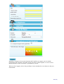
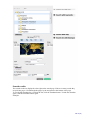
User Manual
Utfärdad av:
Dokumentnamn:
Jan Svensson
User Manual ECDS Data Portal 2.1
Avd:
Fastställd datum:
Fastställd av:
Dnr:
Sekretess:
2011-11-30
-
-
-
B
User Manual
SMHI-#893 -2011
ECDS Data Portal 2.1
Version
Date
Author
Comments
1.0
2011-05-27
Jan Svensson
1.1
2011-10-18
Jan Svensson
Updated for “ECDS Data Portal 2.1” and some
clarifications
1.2
2011-11-30
Jan Svensson
Updated for “ECDS Data Portal 2.1.2” and some
clarifications
Sida 1(20)
Contents
1INTRODUCTION .............................................................................................. 3
1.1
1.2
1.3
1.4
1.5
1.6
ECDS .............................................................................................................. 3
The ECDS Data portal..................................................................................... 3
The ECDS Metadata profile ............................................................................ 3
References...................................................................................................... 4
Glossary .......................................................................................................... 4
News in ECDS Data portal 2.1.2 2011-11-30 .................................................. 4
2
3
4
PUBLISHING ........................................................................................ 5
SEARCHING ....................................................................................... 16
FUTURE FUNCTIONALITY ................................................................ 20
Sida 2(20)
1Introduction
1.1
ECDS
Environment Climate Data Sweden, ECDS, is a Swedish service facilitating the search,
publication and long-term accessibility of data for research in the fields of environment
and climate. The ECDS-initiative was previously known under the name SND-KM,
Swedish National Data Service for Climate and Environment. ECDS is hosted by the
Swedish Meteorological and Hydrological Institute (SMHI).
1.2
The ECDS Data portal
The ECDS data portal gives environmental and climate researchers the possibilities to
- Describe the metadata of one or more datasets
- Search for datasets from other researchers.
The data portal is based on GeoNetwork opensource (Ref. 1). The GeoNetwork
software includes a lot of functionality, but may not be so easy to use for those who are
unfamiliar with geodata portals or metadata. Therefore the functionality has been
reduced, but can be included later on, if there is a need from the research community
(see chapter 4).
A dataset is an identifiable collection of data. A dataset may be a smaller grouping of data
which is physically located within a larger dataset. Theoretically, a dataset may be as small as a
single feature within a larger dataset. The purpose of this data portal is not to have such a small
granularity.
To get an idea about a suitable granularity for your dataset, we recommend visiting some
general purpose data portals, such as the IPY metadata portal
(http://gcmd.gsfc.nasa.gov/KeywordSearch/Home.do?Portal=ipy&MetadataType=0 ).
The standard ISO 19115 and the GeoNetwork software give the possibility to describe subsets
of datasets (or subsets of subsets of datasets) in a hierarchy. We have not exploited this
possibility, but it can be included later on.
1.3
The ECDS Metadata profile
The ECDS metadata profile is based on the international standard ISO 19115. It is a
rather new standard from 2003 and most of the newly developed geographical metadata
profiles follow ISO 19115.
We have also been influenced by the Swedish national geographical metadata profile
which follows the European INSPIRE metadata profile. INSPIRE also follows ISO
19115.
SMHI is the Swedish national repository for IPY data. Swedish IPY metadata has been
migrated from the IPY data portal to ECDS data portal. This means that we are also
influenced by the IPY metadata profile. The IPY metadata profile was built from the
Global Change Master Directory (GCMD) Directory Interchange Format.
Metadata describe the dataset and geographical metadata includes information about WhatWhere-When-Who-How. Our metadata profile includes the following main groups
What:
-
Dataset title
Dataset description
Sida 3(20)
- Graphic illustration
- Keywords from a wide-spread thesaurus – GCMD Science keywords
- Topic category code; an ISO-standard
Where:
- Geographic bounding box
When:
- Revision of the dataset
- Time period covered by the dataset
Who:
- Who to cite regarding the dataset
- Contact information regarding the dataset
- Contact information regarding the distribution of the dataset
- Contact information regarding the metadata
How:
- Limitations regarding the use and access of the dataset
- Data format
- Web address to access the dataset
- Quality report
1.4
References
1. Geonetwork opensource, the complete manual; v. 2.4.
2. ECDS profile of ISO 19115:2003 Version 2.0; 1.0/2011-10-13
1.5
Glossary
Metadata
Metadata is "data about data". The term commonly refers to the attributes of
computer data, though it may by definition refer to any information which
describes other information. Geographical metadata includes information
about What-Where-When-Who-How.
ISO
19115
A standard for Geographic information - Metadata
IPY
International Polar Year 2008-2010
INSPIRE
Infrastructure for Spatial Information in Europe
Thesaurus Another name for keywords list.
1.6
News in ECDS Data portal 2.1.2 2011-11-30
Easier to select several science keywords when publishing your data
An error when searching for Where? and When? is corrected
It is now possible, for the owner of the metadata, to delete metadata for a dataset
The element “description of graphics file” is now visible
The Check-button (from Geonetwork) has been deleted (the Check-test was not easy to
understand)
Some (3) implementation errors of the ISO 19115 standard have been corrected
Possibility to send metadata information via social networks (mail, Facebook,….)
And we have updated the User manual with some more clarifications.
Sida 4(20)
2
Publishing
Publishing requires a username. When you enter the Publish-page you will see the following
information
When you have a username then write it and the password. If you have forget your username
(userid) but remember the mailadress you used, the system can give you the username. If you
know the username but have forgot your password the system can give you the possibility to
create a new password. If you don’t have a username you click on Register and get the
following page:
Sida 5(20)
Mandatory elements is Given name, Surname and E-mail but we suggest you also include
Organisation and Telephone. The rather strange text below (called Captcha) is used to ensure
that the attempt to create a username is generated by a person.
When you have logged you have the possibility to insert metadata for a new dataset or edit your
old metadata
Sida 6(20)
We now describe how you create metadata for a new dataset (edit old metadata is quite similar)
In the first page you are required to state
- Template
- Group
-
We only have one template to start with. The template is the official name of our metadata
profile – ISO19115:2003 ECDS 2.0. There is an official description of our metadata profile (see
Ref 2).
You may also create your own personal templates (see below) and then you can select this
personal template.
We only have one group – ECDS – to start with.
After selecting template and group (quite easy, not so many choices) click on Create to show
the publishing page with all metadata elements. Before you fill in the metadata elements, read
the following general information about buttons and other notifications.
Buttons:
Reset – resets all metadata elements in this metadata record.
Save – your metadata record is saved, but you can continue to work.
Save and close – your metadata record is saved and you leave the editing page and can view
your saved metadata.
Save and send to reviewer – your metadata is saved and a mail is sent to the reviewer, who will
review your metadata before it is made public. During the review the metadata record is not
available to you.
Check – a formal check of your metadata record is done (a rather formal check result – don’t
bother)
Cancel – means that you leave the publishing page without saving your metadata record
Sida 7(20)
Type (at the bottom of the page) – Type is either Metadata or Template, where Metadata is
default. Select Template to create your personal template which will be available only for
you. Useful information including in this template could be contact person information, which
may be the same for most of your datasets.
Notifications:
When you move the cursor over the name of a metadata element a ? is shown. Click the left
mouse button to show help text. Click again and the help text disappears.
A red asterix means that the metadata element is Mandatory. Note: It is however possible to
store metadata without every mandatory elements. You can regard it as “highly mandatory” and
the reviewer will probably require that all mandatory fields ar filled in.
A red frame means EITHER that the metadata element is Mandatory and you have not written
anything yet OR you have written something which is syntactically wrong, e.g. a date is written
in the wrong format.
A black frame means that the metadata element is correctly entered.
Text without a frame means that a value is fixed – you can’t change it
The sign + means that you can add another metadata element, e.g. you can have several ISO
topics. To cancel – if you don’t want another metadata element – click on the x and it will
disappear. Note: Right now there is a bug in GeoNetwork. If you add an element, then cancel
and delete it you cannot add an element again.
Below is a list of the metadata elements. We have chosen to use other names than the official
ISO19115-names. Ref. 2 shows a cross-reference table to the corresponding ISO19115elements.
Note: The examples are fictitious. When we get a good example from a real dataset, we will –
with permission from the author – include this.
Title
The title of the dataset, which is described by the metadata. A short text describing WhatWhere-When might give a good title. Example: “Automatic Weather Station Data from
Vestfonna Ice Cap during 2009”.
Title is mandatory.
Example:
Revision
This is the latest date when there was a major change of the dataset. “Revision” consists of
“Revision date” and “Revision type”.
Revision date is expressed as YYYY-MM-DD or YYYY-MM or YYYY. You can also use
the calendar – except for Internet Explorer where the calendar does not work.
Revision type is the event used for revision date. That is what happened to the dataset at the
revision date. Can be either Creation (when dataset was created), Publication (when dataset was
public) or Revision (a major change in the dataset).
Sida 8(20)
Revision is mandatory.
Example:
Dataset version
It is good practice to have a version number of the dataset, if the dataset is changed now and
then. This means that someone using your data knows what dataset (what version) has been
used in their research.
You can use your own notation of the version number; e g 1, 2, 3… or A, B, C…
Dataset version is optional.
Example:
Dataset citation
This is the reference that is used if someone has used your dataset and it is cited in an article.
References may be provided in styles used by professional scientific journals. The organisation
DataCite deals with citation of datasets; see http://www.datacite.org
Dataset citation is optional.
Example:
Dataset description
Brief description of the dataset (Note: Description of the dataset – not the project result).
You should use words that you think will be found by someone using the Free-text-search.
Dataset description is mandatory
Example:
Contact information regarding the dataset.
Sida 9(20)
This is the first one of three required contact information. The three contacts are
- regarding the dataset
- regarding distribution
- regarding metadata
It may seem overambitious to have three different kinds of contacts, but ISO19115 clearly
separates this kind of contact information. However if you are the one and only contact person,
regardless if it is about the dataset, distribution or metadata, then we suggest that you create a
personal template with you as the contact person for every kind of contact.
“Contact information regarding the dataset” is who to contact regarding questions about the
dataset. Each “Point of contact” consists of Individual name, Organisation, Electronic mail and
Role. You may have several points of contact.
Name (surname and first name) of the person to contact.
Organisations are more permanent than individuals so please insert the organisation name.
E-mail to the organisation/person to contact.
Several roles are allowed. We suggest you use pointOfContact, but it might also be interesting
to show the principle investigator, so you could add Principle investigator and thus have two
points of contact regarding the dataset. If you use Principle investigator the Organisation
should be the Project name. The reason to include the project name is that anyone can use the
project name in the free text search to find the datasets from your project.
“Contact information regarding the dataset” is mandatory.
Example:
Graphic illustration
Consists of
- Link to the graphic file
- Description of the graphic file
- Graphic format
Provides a graphic which illustrates the dataset. Could be a photo from the site or a graph
showing a time series of the data or anything which you think illustrates the dataset
- Write the name of the file which contains the files. It should be a public URL.
- Include a text description of the graphic that illustrates the dataset
- Describe the format in which the illustration is encoded. Examples: JPG, TIFF
The graphic illustration is assumed to have an approximative size of 800x800 pixels. Other sizes
may give a distorded graph.
“Graphic illustration” is optional
Example:
Sida 10(20)
Descriptive keywords from thesaurus
Provides keywords. Right now we only have one thesaurus - “GCMD Science keywords” – see
http://gcmd.nasa.gov/Resources/valids/archives/GCMD_Science_Keywords.pdf. “GCMD
Science keywords” is a hierarchical keyword list which can be expanded by clicking on the +.
If you want to use several keywords, then press down the CTRL-key and select several
keywords. The selected keywords have a light blue background.
Example:
Here you have selected
- Atmosphere (highest level)
- Cryosphere>Frozen ground
- Cryosphere>Sea ice
If you change your mind and do not want the key word Cryosphere>Frozen Ground just click
on this line (still with CTRL key pressed) it will be deleted and the light blue background will
disappear.
Title is fixed = GCMD - Science keywords
Reference date is fixed = 2008-02-05 (which was the last time the GCMD Science keywords
were revised)
Reference date type is fixed = Revised
“Descriptive keywords from thesaurus” is mandatory.
Use limitation
Limitation affecting the fitness for use of the dataset, for example “The quality of the data is not
good enough to be used as input observation data in climatological models”.
If there is nothing relevant to say, then write “No known limitations”.
“Use limitation” is mandatory.
Sida 11(20)
Example:
Access constraints
Several choices e.g. Copyright or Patent. We suggest you use Other restrictions and use the next
metadata element (that is “Other constraints”).
Access constraints is mandatory.
Example:
Other constraints
We suggest you use the Creative Commons License and write “Creative Commons Attribution
(see http://creativecommons.org/licenses )”. This means (in short) that this license lets others
distribute, remix, tweak and build upon your work, even commercially, as long as they credit
you for the original creation. There are in total six Creative Commons Licenses to choose
between. If neither fits then you may write something like “Constrained; please contact the
contact person for the dataset for more information”.
“Other constraints” is mandatory.
Example:
Language
Language used in the dataset.
Dataset language is mandatory. Default is English.
Example:
Topic category code
High-level geographic theme from http://gcmd.nasa.gov/User/difguide/iso_topics.html. This is
central to the standard ISO 19115. Select one or several topics from the list.
Topic category code is mandatory.
Example:
Geographic bounding box
Geographic position for the dataset. The bounding box is expressed as
Sida 12(20)
- North bound (-90, +90)
- East bound (-180, +180)
- South bound (-90, +90)
- West bound (-189, 180)
Use the map to create the box or write the bounding latitudes/longitudes (use decimals, not
minutes and seconds). You can move around and zoom in the map or use the roll-bar to the right
and select country/region. If a country/region is selected, a bounding box, covering the
country/region, is drawn on the map.
Geographical extent is mandatory
Example:
Temporal extent
Time period of the content of the dataset.
The time reference system is fixed = Gregorian.
Begin date and end date is expressed as YYYY-MM-DD or YYYY-MM or YYYY. You may
use the calendar or write it as it is.
Note 1: The calendar may not work in Internet Explorer (a bug)
Note 2: What End date should be used when the data is continuously updated? We suggest you
write the present year at the start of each new year (e.g. 2011)
Temporal extent is mandatory.
Example:
Additional information regarding geographic, temporal and vertical extent
Above you find metadata elements describing
- Geographic extent
- Temporal extent
Sida 13(20)
There is an element in ISO19115 describing vertical extent. We have not used this in our
metadata profile, but information about vertical extent can be described here.
You may use “additional information” when the extents above is not enough to describe
the dataset. E g:
- Geographical extent: Observations from the river of Donau
- Temporal extent: Data is covering the Cenozoic era.
- Vertical extent: The measurements are made from a 10 m tower
“Additional information regarding geographic, temporal and vertical extent” is optional.
Example:
Contact information regarding distribution
This is the second of three required contact information entries, and describes who to contact
regarding distribution of the dataset. Each “Point of contact” consists of Individual name,
Organisation, Electronic mail address and Role. You may have several point of contacts.
Name (surname and first name) of the person to contact.
Organisations are more permanent than individuals so please insert the organisation name.
E-mail to the organisation/person to contact.
Several roles are allowed. We suggest you only use Distributor.
“Contact information regarding distribution” is optional.
Example:
Data format
Consists of
- Data format name; e.g. Excel, Shape, GRIB.
- Data format version; e.g. 2003
“Data format” is optional.
Example:
On-line resource
Sida 14(20)
Information about on-line resources from which the dataset or other information about the
dataset can be obtained; e.g. http://climatdata.se. On-line resource consists of
- URL (web address)
- Description – a short description about the on line resource.
Note: For users “with small needs and limited resources” there is the possibility to store data at
ECDS. This functionality will be added later.
“On-line resource” is optional.
Example:
Data quality information
Provides overall information about the quality of the content in the dataset. Quality report
consists of
- Scope of the quality report
- Quality report
ISO 19115 offers several choices for the scope. We have used Dataset and it is fixed.
Quality report is a general text about the quality of the data, such as which instruments have
been used, the process when the data are created, and the quality control of the data.
Data quality information is mandatory. If it is not possible to write a quality report then write
something like “Not known” or “Not documented”.
Example:
Metadata information
The information about metadata is either fixed or created automatically. Metadata information
consists of
- Metadata identifier – created automatically. A unique identifier (UUID) for this
metadata set.
- Metadata language – fixed = English
- Scope of the metadata – fixed = Dataset.
- Date stamp – created automatically.
- Name of the metadata standard – fixed = ISO 19115:2003 ECDS
- Version of the metadata standard – fixed = 2.0
Example:
Sida 15(20)
Contact information regarding metadata
This is the third of three required contact information entries, and describes who to contact
regarding the metadata for this dataset. Each “Point of contact” consists of Individual name,
Organisation, Electronic mail address and Role. You may have several points of contact.
Name (surname and first name) of the person to contact.
Organisations are more permanent than individuals so please insert the organisation name.
E-mail to the organisation/person to contact.
Several roles are allowed. We suggest you only use “Point of contact”.
“Contact information regarding metadata” is mandatory.
Example:
Now you are ready with your dataset. You can Save it and come back later to finalize your
metadata. Or you can send it to the Reviewer. During the review the metadata record is not
available for you. But otherwise you can always go back and edit your metadata.
Once you have saved your metadata and edit the metadata, the there is a Delete-button you can
use to delete the metadata record for a dataset.
3
Searching
Simple search
To make a simple search, start by clicking on Search in the menu.
Then enter text in the Free text input box to the left and click the green search button at the
bottom.
Example:
Text Karin finds every dataset which contains the word Karin (which may be an author’s name)
Text IPY finds every dataset which contains the word IPY (which mean every IPY-project)
Text IPY-026 finds every dataset which contains the word IPY-026 (which means every dataset
from the project IPY-026)
You may use ? as a wild card.
Sida 16(20)
Example: Text Creativ? finds (among others) every data set which use Creative Commons
licence. However – GeoNetwork use a rather advanced algorithm for search with wild card, so
the result are not always predictable!
The search result is show in a list to the left.
Advanced search
There are three ways of making a more advanced search.
By keywords:
Under the Free text field you will see a box containing a hierarchal list with all keywords that
are connected to a public dataset.
To make a keyword search, click on the plus button to go down through the hierarchy.
Select any level in the hierarchy by clicking on the text. It will be marked with a light blue
background. If you want to select on several keywords keep the CTRL key pressed while
selecting the keywords. Then click the green search button to make a search for this keyword.
By geographical area:
Start by clicking on Where? under the keywords box, to display the map.
By date:
Start by clicking on When? under the keywords box, to display two input fields (Start and Stop
date).
Note: There is a calendar available. But it may not work for every web browser.
The search algoritm is
“Free text” AND “Keywords” AND “Geographical area” AND “Date”
Example:
Here we have selected
Free text - IPY
Keywords
- Oceans
- Atmospheric Temperature
- Atmospheric Water Vapor
Area – as shown on the map
Time from 2005 to 2010
Sida 17(20)
Search results
The search results are displayed to the right on the search page. If there are many results they
are split into pages. Click through the pages by the navigation at the bottom of the page.
To see the full metadata for a result in the list, click the metadata button. To hide the metadata
again, click the metadata button again.
Example:
Sida 18(20)
Hint: Generally the metadata records are sorted in alphabetical order of the Title. If you sort by
“Change date” those metadata records, which have changed lately, will appears at the top.
The full metadata is shown when you press the metadata button.
Example: The first lines from “Agave 2007 Track”. Note that you can distribute the metadata
record by different social media e g Facebook or an ordinary e-mail. You can distribute
metadata from your datasets or metadata for other dataset which you want to share. But – once
again – it may be some problem with Internet Explorer.
Sida 19(20)
4
Future functionality
Additional functionality may be added in the future, depending on the response from the
research community. Some changes we foresee are:
- The possibility for users “with small needs and limited resources” to store their data at
ECDS
- Include “Inspire themes” and some more data-elements from the INSPIRE metadata
profile into our metadata profile.
- Include other time reference systems besides the Gregorian calendar
- Vertical extent, described by official and well-known reference systems, may be
interesting for several research areas
- For some users which are already defined in the user database the authentization may
not work. Until this bug is fixed we can create a user name for you manually. Please
contact our Helpdesk.
- The “Graphic illustration” are taken from a web site defined by you. A more stable
solution may be that we fetch your graphic and store it at ECDS. To be discussed.
More information (including templates and/or examples) may be useful regarding
- Dataset citation using practices from DataCite
- Creative Commons License
- Quality report
Sida 20(20)