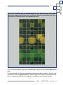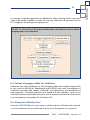
1
Tools
CAPFITOGEN
Programme to Strengthen
National Plant Genetic
Resource Capacities
in Latin America
Version 1.2
Tools
CAPFITOGEN
Programme to Strengthen
National Plant Genetic
Resource Capacities
in Latin America
Versión 1.2
Author of the tools:
Mauricio Parra Quijano
Consultant
International Treaty on Plant Genetic Resources
for Food and Agriculture, (ITPGRFA)
FAO
Authors of the accompanying manual:
Mauricio Parra Quijano
Elena Torres Lamas, Universidad Politécnica de Madrid (Spain)
José María Iriondo Alegría, Universidad Rey Juan Carlos (Spain)
Francisco López, ITPGRFA, FAO
The terms used in this information product and the form
in which the data contained appear, do not imply
in any way, that the United Nations Food and Agriculture Organisation has any
judgment concerning the legal status or level of development of
countries, territories, cities or zones, or their authorities, or with respect to
the delimitation of their frontiers or territorial limits. The mention of any specific companies or products
manufactured, whether or not they are patented, does not mean that the FAO
endorses these or is recommending others of a similar nature
which are not mentioned.
The opinions expressed in this information product are those of its authors
and do not necessarily reflect the views or policies of the FAO.
ISBN
© FAO 2014
The FAO promotes the use, reproduction and dissemination of the material contained
in this information product. Unless indicated to the contrary, the material may be
copied, printed and downloaded for the purposes of private study, research
and teaching, or for use in products or services for no commercial purpose,
as-and-when the FAO is acknowledged as author and owner of the
copyright, and that this in no way means that the FAO
endorses the views, products or services of the users.
Any queries concerning translation and adaptation rights
as well as the resale and other rights of commercial use should be addressed to
www.fao.org/contact-us/licence-request o a [email protected].
FAO information products are available on its website
(www.fao.org/publications) and may be acquired by sending an e-mail to
[email protected].
Electronic products
FAO may not be held liable for errors or deficiencies in the database, software or accompanying
documentation, nor for program maintenance and upgrading, nor for any damage that may arise from
these. Similarly, the FAO shall not be held responsible for updating the data and is not liable in any way
for any errors or omissions in the data provided. Nonetheless, the FAO requests users to report any errors
or deficiencies that they may find.
3
Contents
1. .
Programme to Strengthen National Plant Genetic Resource Capacities
in Latin America
2.
CAPFITOGEN Tools: features and installation
3. 5
9
23
ELCmapas Tool
35
4.
GEOQUAL Tool
5. 49
Representa Tool
59
6.
ECOGEO Tool
7. DIVmapas Tool
71
8. ColNucleo Tool
95
9. FIGS_R Tool
105
10.
Frequent errors
119
11.
Acknowledgments
127
12.
Annexes
133
Tools
CAPFITOGEN
Version 1.2
4
4
Herramientas
CAPFITOGEN
Versione 1.2
Programa
5
1. Programme to Strengthen National
Plant Genetic Resource Capacities
in Latin America
Under the auspices of the International Treaty on Plant Genetic Resources for Food
and Agriculture (ITPGRFA and the Spanish Agency for International Cooperation
for Development (AECID), two workshops were held on implementing the
ITPGRFA for countries from the Group of Latin American and Caribbean Countries
(GRULAC) in Cartagena de lndias (Colombia, July-August 2008) and Antigua
(Guatemala, August 2010). The success of the events was a testament to the
effectiveness of this kind of workshops in contributing to the implementation
of the ITPGRFA objectives within the GRULAC community. The coordination
of the workshops between the organizations involved was a decisive factor
in achieving the objectives set, particularly given Spain’s commitment to the
ITPGRFA. The organizations involved were the Secretariat of the ITPGRFA, the
Spanish International Cooperation and Development agency (Agencia Española
para la Cooperación Internacional y el Desarrollo - AECID), the Spanish Ministry
of Environment, Rural and Marine areas (Ministerio de Medio Ambiente y Medio
Rural y Marino) and the Spanish Plant Genetic Resources Center (Centro Nacional
de Recursos Fitogenéticos) of the Spanish Institute for Research and Agrarian
Technology (Instituto Nacional de Investigación y Tecnología Agraria y Alimentaria
- CRF-INIA). The success of the events was also due to the close relationship
between the National Plant Genetic Resources Conservation programs and the
National Agricultural Research Institutes (Institutos Nacionales de Investigación
Agrícola - INIAs) in Spain and the GRULAC countries.
The positive experiences from earlier workshops and the importance of achieving
some key ITPGRFA objectives in Latin America and the Caribbean, particularly
those explained in articles 5, 6, 7, 8 and 13.2 c, were strong incentives to continue
with these activities. At the same time, it became clear that there was a need for
the workshops to be developed in greater depth with more technical content by
setting up a technology transfer program where the workshops would be a key
element of a broader-based action strategy.
Taking this precedent and the region’s necessities as a point of departure,
the Programme to Strengthen National Plant Genetic Resource Capacities in
Latin America - CAPFITOGEN - was launched. This program is focused on the
development of appropriate technologies for countries which are extremely
agrobiodiverse but have limited economic resources. Its function is to develop
and transfer technology and provide the appropriate training for technical
personnel from those Latin American countries signatories to the Treaty.
Tools
CAPFITOGEN
Version 1.2
The warm reception given to the tools and methodologies developed under the
auspices of the CAPFITOGEN program in 2013, has meant that some countries
targeted by the program have organized national workshops on their own
initiative, financed by the most interested parties. At the same time, there has
been interest from other countries and regions not initially targeted by the
program, which have been asking for tools and transfer and training activities.
Thus the program CAPFITOGEN is primed to function not only as a generator and
facilitator of appropriate technology, but also as a model of transfer in itself.
One of its most innovative aspects is the way in which it seeks to involve people
who have developed scientific methodologies. They are invited to develop the
tools provided by the program based on their methodologies and to carry out
the technical training and transfer activities themselves. This model means that
the program beneficiaries are guaranteed direct access to the scientists and
developers in order to answer queries or discuss cases. At the same time, the
scientists themselves benefit directly from the experiences and issues tackled by
the technical experts from the national programs, an outcome with a positive
impact on future investigations with a more focused application and better
suited to meet real needs.
Tools
CAPFITOGEN
Version 1.2
CAPFITOGEN
7
8
CAPFITOGEN
8
Tools
CAPFITOGEN
Version 1.2
2. CAPFITOGEN
9
CAPFITOGEN tools:
features and installation
2.1. Origin
Cultivated plants today were once wild plants whose array of genetic weaponry
helped them withstand and adapt to the challenges brought by a constantlychanging environment, such as plagues, disease, a grazing herbivore, drought,
etc. The process of domestication transformed these wild plants into the grains,
legumes, fruits and vegetables that we know today; a selection of products tailored
to meet the needs and tastes of human beings. However, achieving these products
involved a lengthy and intense selection process. As a result, the genetic basis of
these domesticated species is rather small if we compare it with that of their wild
ancestors.
The evolution of cultivated species has left behind it a range of products among
which there are also differences. For example, the modern varieties and hybrids
which began to be developed as from the 1960s are material with a high production
potential but an overly-narrow genetic base when compared with varieties from
the early XX century.
Thus domestication, a largely selective process, has left many genetic configurations
by the wayside in its search for the “best” variety. This process led to the loss of
many valuable genes that could had provided solutions to future problems we may
encounter with our modern and productive varieties, which are yet vulnerable and
homogenous. Fortunately, not everything has disappeared from the fields, and
farmers around the world continue to preserve heirloom varieties inherited from
their ancestors. These are unlikely to be commercially viable but have a tremendous
significance for their cultural values, eating and food habits and even religious
traditions.
Aware of the progressive loss of their genetic heritage, many nations began to
rescue and preserve these varieties and the wild plants related to them, storing
them in germplasm collections (seeds, plant tissue, propagules) as from the 1950s.
2.1.1 Conservation to increase knowledge and use
Germplasm collections are essentially different from a museum’s collection as what
is preserved is intended to be used at a later date. The main users tend to work
in the area of crop breeding and seek out features of interest from specimens
in germplasm collections with a view to transferring these to modern varieties.
However, they can only employ germplasm efficiently and effectively on the basis
Tools
CAPFITOGEN
Version 1.2
CAPFITOGEN
10
10
of the knowledge derived from it. Obtaining this knowledge is carried out through
specific processes of characterization and evaluation which require a substantial
investment in economic and logistics terms by those entities in charge of conserving
agrobiodiversity. At a national level, these activities are carried out as part of
national programs; in Latin America, they are usually the premise of the national
institutes of agricultural research (Institutos Nacionales de Investigación Agraria INIAs).
2.1.2 Appropriate techniques for scenarios with limited resources
Methods to collect, preserve, and characterize agrobiodiversity using scientific
standards have generally been developed in regions and centers where there are
few, if any, restraints on investment, infrastructure, or staff qualifications. This
has meant that developing countries are either directly unable to apply these
methodologies or, if they do so, they are nonetheless unable to include all the
preserved germplasm. This situation is in stark contrast to the fact that it is precisely
in developing countries where the greatest concentrations of agricultural plant
genetic wealth are to be found.
This scenario has prompted some research groups in the world to direct their
efforts towards the exploration of less costly and complex methodologies
which are far better adapted to the context of national programs in developing
countries. Such alternative methodologies include making use of environmental
information from collection sites (ecogeographic), for example, to evaluate the
genetic variability of the germplasm, or calculate with a higher success margin
the probability of locating genes of interest. Similarly, another option is the use
of geographic information systems as a means of obtaining and making use of
these ecogeographic data. Given that most ecogeographic information and
computer programs for performing analysis are free, the size of the investment
is reduced to a computer with an ordinary business-type configuration and the
training required for the personnel involved. These are, then, methods which are
compatible with a scenario of limited resources, a recurring condition of national
programs in developing countries. After demonstrating their effectiveness in
case studies published in international scientific journals, the new generation of
methodologies were chosen to be adapted and transformed into simplified tools
and practices before being finally transferred to national programs in the regions
selected.
2.2 Characteristics
Ecogeographic applications and geographic information systems (GIS) encompass a
range of processes directed at the conservation and efficient use of plant genetic
resources. These, as demonstrated in the articles published in various scientific
media, involve the use of numerous software programs, many of which are neither
Tools
CAPFITOGEN
Version 1.2
easily accessible nor free, to achieve complex methodological analyses. Thus, the
main challenge lies in developing practical tools that enable these advances
to be applied by technical personnel with no training in either managing and
programming statistics or GIS software.
The solution lies in the use of a computer program that offers the following
features:
(a) Includes all the statistical analyses required.
(b) Includes all GIS functions, both for the management of georeferenced data
and their subsequent analysis.
(c) Is able to manage databases and the products of statistical analysis and GIS.
(d) Enables all the results of the analysis to be saved in conventional computer
formats.
(e) Be freely-available and widely-distributed.
Currently, the “R” software programming environment (R. Cran, 2012), widely
used in the scientific community, offers all the features necessary to develop the
CAPFITOGEN tools. The “R” software environment is very powerful for analysis
but its main drawback is that it requires specific technical knowledge in order
to program its functions properly. The CAPFITOGEN program has overcome this
drawback by involving the research team responsible for the most of the original
methodologies to develop the program’s tools, particularly the R programming.
The R program seeks to integrate all the functions and the analysis required in
one single program in such a way that it operates with predefined data formats,
through which any user data can be entered into the R routines to achieve specific
results.
The last challenge in the popularization of the use of these tools was to simplify
the way in which commands and data are entered. This has been solved thanks to
a simple interface based on Java programming and html with the use of Tomcat
virtual servers . This solution is offered by the RWUI application (http://sysbio.
mrc-bsu.cam.ac.uk/Rwui), which has undergone some minor modifications in
order to be used for the development of the CAPFITOGEN tools.
2.3 Installation and execution
Version 1.1 of the CAPFITOGEN tools required a complex installation process
including the manual installation of R, the Java execution and Tomcat virtual server
environments, as well as the modification of certain Windows environment variables.
The old procedure required the user to manually install the programs and changes in
the environment variables, as well as take into account the type of operating system
(32 bit or 64 bit) of the Windows version.
Tools
CAPFITOGEN
Version 1.2
CAPFITOGEN
11
CAPFITOGEN
12
12
From version 1.2 onwards, the CAPFITOGEN tool set comes with an installer which
performs all the steps required to install the program and modify the environment
variables. This installer is also responsible for unzipping and installing all the R
packages required to perform the analyses.
The tools package has been developed to be ready to use. The steps required to
install and execute the CAPFITOGEN tools are the following:
(a) If you have downloaded the tools from the web site created for this purpose
(see http://www.agrobiodiversidad.org/blog/?p=1039), you should have an
.alz extension file (compressed) with the main body of tools and other .alz files
with the ecogeographic information for each country or region contemplated
as a work area. Extract all files or folders with those files, and then assemble
the Tools installer, placing the folder with the name of the country or region
in the “rdatamaps” folder in the set of files and folders in the main body
of the tool, which is included in the “CAPFITOGEN” folder. Copy the folder,
preferably onto an external drive dedicated specifically to tools, or directly
FigurE 1. Typical content of the USB memory or the file compressed using
the CAPFITOGEN tools where the CAPFITOGEN.exe file is highlighted.
Tools
CAPFITOGEN
Version 1.2
onto the hard disk of the PC, frequently corresponding to the C:\ drive. The
systems used to download material from internet and set up the tools may
change in subsequent versions.
(b) If you have has accessed the tools using a USB flash drive provided by the
CAPFITOGEN program, simply connect it to one of your PC’s USB ports. The
contents of the USB drive include a folder called “CAPFITOGEN”. Do not move
the contents of this folder. This folder contains the structure of folders and
files (Fig. (1) necessary to operate the tools.
(c) in the set of files you will find one single executable file (with the file extension
.exe), usually called “CAPFITOGEN.exe”. Double click on this file and a window
will immediately open up like the one shown in Fig. 2.
(d) Click on the “Install” button. The installer will show the progress of the
installation of the different programs in blue. When it has finished, a graycolored window will appear, indicating the completion of the process (Fig.
3). Click on the “OK” button in this window. It is not necessary to restart the
computer.
(e) Immediately after the installation has finished, the initial window (which
showed the “Install” button) will now show the “Execute” button. Click on
this link.
(f) At this point, a black-colored window will appear and a series of white code
numbers will be loaded (see Fig. 4) This code means the program to enable
the tomcat virtual server is being loaded. The instructions are complete when
the following line of text appears, indicating the milliseconds (ms) taken to
activate the virtual server:
INFO: Server startup in xxxx ms
FigurE 2. Window showing the installation of the CAPFITOGEN tools.
Tools
CAPFITOGEN
Version 1.2
CAPFITOGEN
13
CAPFITOGEN
14
14
FigurE 3. Window indicating that the installation is complete.
(g) A few seconds after beginning the previous process, the default internet browser
program will open automatically (for example: Internet Explorer, Mozilla Firefox
or Google Chrome) as shown in Fig. 5a (language selection panel) and Fig. 5b
(tool selection panel). The following instruction will appear in the browser
address bar:
http://localhost:8080/start/
FigurE 4. A black window where the virtual server is being loaded. This
window should not be closed until the tools have finished being used.
Tools
CAPFITOGEN
Version 1.2
Occasionally, the process described above in point “f” begins before the process
described in point “e” has finished. This means that the virtual server is not ready
when summoned by the browser, which prompts an error message to appear in
the browser (see fig. 6) Process “f” occurs before “e”, occurs frequently the first
time that the tools are run or when the computer’s configuration is out of date.
This problem is solved simply by closing and opening the browser and typing the
following in the address bar:
http://localhost:8080/start/
FigurE 5. The browser opens automatically, showing: a) the language selection
panel and b) the tool selection panel.
FigurE 6. Example of an error occurring when the browser attempts to open
the virtual server address before it completed the loading process.
Tools
CAPFITOGEN
Version 1.2
CAPFITOGEN
15
CAPFITOGEN
16
16
(h) A start panel will appear in the browser (Fig. 5), showing the list of tools
available on the left-hand side and on the languages available for each tool
on the right. Clicking on the green icons opens the form for the tool and
language selected in the browser. In Fig. 7 the form for the GEOQUAL tool is
shown as an example. This form displays a small bar with links as described in
Fig. 8.
To exit the application once you have finished using the tool, simply close your
browser, close the black background window and close the window of Fig. 2 by
clicking on the “Exit” button. It is possible that, after closing all the windows,
Windows may ask you if the application was correctly installed. Please answer in
the affirmative.
FigurE 7. GEOQUAL tool form. 1. Languages available and links concerning
legal issues. 2. Space indicating the tool currently in use. 3. Links bar. 4. Brief
description of the tool. 5. Link to the instruction manual. 6. Area where
parameters may be introduced. 7. Button to start the scan.
Tools
CAPFITOGEN
Version 1.2
When the installation is carried out, an identification file is added to the drive and
path where the files and folders of the CAPFITOGEN tools are kept. This file enables
the computer to recognize that the installation has already been carried out. In this
way, each time you need to use the tools, just click on the CAPFITOGEN.exe file for
the installation window to open, displaying the “Execute” button. From this step
onwards, the entire process from point “d” as indicated above is repeated. If for any
reason the letter of the drive or path where the executable file is located changes
or the ID file is deleted accidentally, when you double click on CAPFITOGEN.exe the
“Install” button will be displayed again. It is advisable at this point to reinstall the
program and tools. If R and Java programs are reinstalled, there is no danger of any
problems arising in the execution of the tools.
FigurE 8. Links bar (corresponds to part 3 of Fig.6). The buttons have the
following functions: 1. Return to the form for the tool selected. 2. See the
CAPFITOGEN tools instruction manual 3. Contact and support information. 4.
Return to the page where the tools may be selected (landing page).
(i) While the analysis is running, Windows will display the standby icon as the mouse
pointer of the mouse. Once the analysis has been successfully completed, the
page containing the form will move to the top of the screen, showing the
header with the ITPGRFA logo. When you go to the bottom of the page, a
“Process finished” message will appear (Fig.9), indicating that the previously
saved results are now available. If you wish to change any parameter and rerun
the analysis, you can do so using the same form by changing the parameter in
question and clicking on the “Analyze” button. You can also delete the entire
contents of the form with the “Clear Page” button.
Tools
CAPFITOGEN
Version 1.2
CAPFITOGEN
17
CAPFITOGEN
18
18
FigurE 9. View of the bottom of the form page once the analysis has been
completed correctly and the results are available.
The results of the analysis are to be found in the folder defined by the user in
the “results” parameter. Maps, both in raster format (mesh of cells with .grd
and .gri file extensions), such as the maps generated by the ELCmapas tool and
those in vector format (usually “shapefiles”), for example, point maps, may be
opened with DIVA-GIS software since they are fully compatible. Results tables
are generated in text format separated by tabs, which can be opened with
programs such as Microsoft Excel or the Open Office spreadsheets.
(j) It is possible that when exiting a tool to go to the start panel (using the
button
in Fig.8 and subsequently returning to the same tool, or if the
address is simply reloaded in the browser, a window will appear like that
shown in Fig. 10 with instructions in English. This window asks the user if
they wish to reload a tool that has previously been loaded. No problems will
occur if the tool is reloaded from this window. All that is required to continue
is to click on the “Run new copy of” button and the name of the tool.
(k) When an error occurs in the execution of the tool, either due to a faulty
installation, or a parameter that was incorrectly entered, or because of
defects in the tables providing passport or characterization information,
the page with the form shows the header (as it does when the process
has finished successfully), but the time it take is considerably less than a
successful process and an error message appears at the bottom of the page,
as shown in Fig. 11. It is possible to detect the source of the error through
the error message. Thus, when the message (which is directly generated by
the R program) appears, its contents should be compared with the list of
messages in Chapter 10 “Frequent errors”.
Tools
CAPFITOGEN
Version 1.2
FigurE 10. A window that indicates that you are attempting to reload a tool
which was open before. To continue, simply click on the “Run new copy of”
button and the name of the tool.
FigurE 11. A view of the bottom of the page of the form when an error has
occurred.
(l) It is possible that not all the R packages required to carry out the planned
analysis during the installation are properly loaded due to the different settings
of some personal computers This will produce a recurrent error when the tools
are executed, which will show up in red as in Fig. 11 but with the following text:
An error occurred: Error in the library (package name): there is no package called
‘name of package’ Calls: source - > withVisible - > eval - > eval - > library
Tools
CAPFITOGEN
Version 1.2
CAPFITOGEN
19
CAPFITOGEN
20
20
This error, which is detailed in Chapter 10 “Frequent errors”, may be repeated
for all the packages needed, making the process of correction proposed in
Chapter 10 too extensive. In this case, the user should delete the “library”
folder to be found in the C:\rwin route, then copy the “library” folder from
the CAPFITOGEN\Error route and paste it into the C:\rwin route. This action will
completely eliminate the problems arising from the absence of those packages
necessary for R.
(m) In some instances, due to a faulty installation process or the incorrect location
of the “CAPFITOGEN” folder, it may be that the interface is unable to activate
R and send the information necessary to perform the analysis. This problem
will become evident when, after clicking on the button “Analyze” and having
filled in the parameters correctly, the execution time is abnormally short
and error messages do not appear in red. Instead, the message of “Process
finished” appears and no new file appears in the folder where the results are
usually saved. In this case make sure of two aspects:
1. The files and folders making up the CAPFITOGEN tools are stored in a
folder and are not directly to be found in the root directory. In other words,
the path to capfitogen.exe should be X:\CAPFITOGEN\capfitogen.exe and not
X:\capfitogen.exe, where X is the letter of the disk drive. If the tools need to
be reinstalled, ensure the condition detailed above is met.
2. If the CAPFITOGEN folder is not in the root directory (X:\CAPFITOGEN) but
in a path in other folders, something which is in itself not to be recommended,
this path should not contain any spaces between words. For example, if the
folder is stored in the X:\Mis Documentos\CAPFITOGEN path, the error will
show up because of the space between the words “Mis” and “Documentos”.
If, in spite of making sure that the two conditions above are met, the problem
persists, please contact the program’s technical support team.
n) When the process executed after clicking on the “Analyze” button takes
too long (over 15 or 20 minutes) it is possible that the page displaying the
tool form will change its appearance and display a Java error message, such
as the one shown in Fig. 12. The page change and error message do not
indicate that the process has terminated abruptly nor that results will not be
generated. This error is more about the visualization of the interface than
the R process itself. Therefore, the next step is to check if the files expected
appear as results in the designated folder.
Tools
CAPFITOGEN
Version 1.2
FigurE 12. Java error notice that appears when the process takes too long.
Tools
CAPFITOGEN
Version 1.2
CAPFITOGEN
21
22
GEOQUAL
22
Tools
CAPFITOGEN
Version 1.2
3. GEOQUAL
23
GEOQUAL Tool
3.1. What is the Evaluation of the Quality of Geo-referencing in passport
data?
This methodology determines the degree of certainty contained in some passport
descriptors whose function is to unequivocally define the location where the
germplasm was collected. GEOQUAL is thus able to make an assessment of the
quality of the data describing the location and the coordinates indicated as a
collection site.
In broad terms, the concept of quality applied to data has received different
definitions. In the geographical context, the definition of quality as “fitness for
use” or potential for use is widely accepted (Chrisman, 1983). This directly relates
quality to the possibility of using data. The uncertainty associated with all kinds of
data is a property of anyone who obtains or uses the data beyond the data itself.
Therefore quality and uncertainty share a degree of variable subjectivity, which can
be reduced to a certain extent by using methodologies that perform evaluations
on as objective a basis as possible. In any case, quality and uncertainty are taken as
measures of understood risk and assumed risk (Chapman, 2005).
The need to assess the quality of the geo-referencing of information available
about the presence or absence of biological entities is a tangible issue in a range of
different areas from ecology and spatial analysis to the patterns of the distribution
of species. There are several studies that point out that quality is a critical issue in
methodologies such as the modeling of the distribution of species. The certainty of
the occurrence of a species at a given site is crucial for any method using presence
or absence as raw data (Foley et al., 2009; Hill et al., 2009; Otegui et al., 2013).
An estimate of the degree of uncertainty in the geo-referencing of sites concerning
the presence or absence of species then becomes a key aspect prior to any analysis
which uses spatial aspects to study distribution. Many analyses of this kind lead to
decision making about the practical aspects of areas such as the conservation of
biodiversity. Therefore, the introduction of reliable baseline information to feed
into the appropriate analysis will produce reliable results as well as successful and
timely decisions.
Tools
CAPFITOGEN
Version 1.2
24
GEOQUAL
24
3.2. History of the GEOQUAL tool
The methodology which gave rise to GEOQUAL is the result of four years of
development, from the moment when the need arose for an estimator able
to measure the reliability (or risk, whichever fits) of the geo-referencing of a
collection site, usually reflected in passport data. This need arose at the end of
2009, when the passport data for the Spanish National Inventory of Plant Genetic
Resources were being prepared to be characterized ecogeographically. At the
time, obtaining an idea of the quality of the geo-referencing for passport data
was a priority for the creation of the System for Ecogeographic Information for
Spanish Plant Genetic Resources (Sistema de Información Ecogeográfica de los
Recursos Fitogenéticos - SIERFE, http://www.sierfe.es).
SIERFE is a system which enables the selection of germplasm on the basis of the
environmental characterization of a collection site through an internet portal.
With the development of GEOQUAL and its incorporation into SIERFE, a quality
estimator allows SIERFE users (seekers of germplasm, such as breeders, scientists,
or farmers) to define their requirements in terms of the quality of geo-referencing
when selecting germplasm by ecogeographic variables. This represents a major
advance in the development of information systems and germplasm selection.
Over 45,000 accessions in the Spanish inventory have been ecogeographically
characterized and each one given a quality rating value on a scale from 0 to 100.
GEOQUAL was then tailored to the characteristics of the passport data from the
Spanish National Inventory of Plant Genetic Resources passport. This was possible
using a range of programs, most of which are commercial-type programs such as
ESRI’s ArcGIS.
In 2011, within the framework of the PGR secure project enshrined in the Seventh
Framework Program of the European Union (http://www.pgrsecure.org), it was
necessary to clear four databases containing information of the occurrence of wild
varieties and species related to four taxa of agricultural interest in Europe (Avena,
Beta, Brassica and Medicago). More than 33,000 records received a GEOQUAL
value, which meant that the quality of some 4,000 accessions could neither be
considered nor improved.
Since then, several European researchers on agrobiodiversity issues have become
interested in GEOQUAL, which resulted in a demand for the development of a userfriendly management tool permitting the application of GEOQUAL to different
formats of species presence data.
In 2012, when the CAPFITOGEN program was approved and the tools to be
developed were decided, GEOQUAL became a priority. This was about addressing
the challenge of creating a tool capable of evaluating the quality of geo-referencing
data, a simple tool which already had all the necessary information preloaded,
Tools
CAPFITOGEN
Version 1.2
and which did not require a great knowledge of geographic information systems
(GIS) in order to apply it. The tool had to offer an integrated solution (using
only a GIS program), and employ the passport descriptors format defined by the
FAO and Bioversity International in 2012 as a basis, and finally, it had to be capable
of being transferred to technicians of national programs. The GEOQUAL tool
presented here is the evolution of an original idea transformed into easily-adopted
technology which offers a range of adaptability factors which are appropriate for
the conditions and needs of various national programs for the conservation of plant
genetic resources.
3.3. Features of GEOQUAL
The GEOQUAL tool comprises four parameters, three of which provide different
approaches to the quality of georeferencing (COORQUAL, SUITQUAL and
LOCALQUAL) and a fourth parameter (TOTALQUAL) that summarizes the first
three. The base parameters are calculated in ranges from zero to twenty, with
zero being no quality and 20 maximum quality. Sometimes, depending on the
passport data available, the calculation of LOCALQUAL can be sidestepped, as
explained later. In addition, the program has generated a parameter transforming
TOTALQUAL’s initial values (0 to 40 or 0 to 60) into an evaluation range from 0 to
100, to make it easier to use and interpret the evaluation values (TOTALQUAL100).
It is important to note that GEOQUAL operates with the FAO-Bioversity passport
descriptors format published in 2012 with the addition of four location descriptors
(ADM1, ADM2, ADM3 and ADM4) that correspond to different administrative
figures by country (see Annex 9.1). However, if the data were in the 2001 FAOIPGRI format, GEOQUAL would also be able operate after migrating the 2001
formatting information to 2012 without having to add information for new fields
included by the 2012 version. However, it would have to consider including the
four ADM descriptors.
The GEOQUAL tool includes a model of a table of passport descriptors based on
the FAO-Bioversity’s multi-crop descriptors with the addition of the four ADM
descriptors in Excel format (folder “DescriptoresPasaporteModelo”, file “Tabla
pasaporte modelo FAO_Bioversity 2012 modificada.xls”), where the color green is
used to identify descriptors which are essential for GEOQUAL and yellow for those
which, although not essential, are nonetheless important. Non-designated fields
are not taken into account by GEOQUAL but their position in the table should
nonetheless be maintained (as in the case of those listed) so that GEOQUAL is
able to find the variables it needs to analyze exactly where it expects to find
them. As a general rule, when filling out this table, when it is not clear what
information is being sought, it is best to write NA in the requisite field, which
normally means Not Applicable, but in the case of GEOQUAL also indicates that
Tools
CAPFITOGEN
Version 1.2
GEOQUAL
25
GEOQUAL
26
26
there is no information available.
3.3.1 Description of GEOQUAL’s base parameters
3.3.1.1 COORQUAL parameter
This parameter determines the intrinsic quality of the coordinates contained in
the passport data. Four sub-parameters are initially used to determine it:
(a) ERRORS: If the coordinates in decimal or sexagesimal format contain values
out of the references of the WGS84 latlong coordinates system. Uses the
descriptors LATITUDE, LONGITUDE, DECLATITUDE and DECLONGITUDE.
(b) PRECIS: This applies to coordinates in decimal format that comply with the
coding of the list of FAO-Bioversity 2012 passport descriptors. This subparameter determines whether the coordinates were obtained with an
accuracy of seconds, minutes, or degrees. Use the following descriptors:
(c) GEORBLE: The descriptor evaluates the possibility of obtaining the collection
site from the available data describing the location.
(d) INTERTEMP: It uses the COLLDATE descriptor values and interprets them
according to the possibility of using geo-referencing methods. For example,
for collections which occurred after 2000, it is highly likely that GPS was used,
which would increase the quality of the coordinates.
(e) GEOREFMETH: This assesses the system used to assign coordinates to the
collection site. GEOREFMETH corresponds to a field in the FAO/Bioversity
2012 passport table. This sub-parameter will only be taken into account when
there are values available for all accessions in this field.
Each sub-parameter provides an evaluation on a scale of zero to three, where
zero corresponds to minimum quality and three to the maximum quality. The
combined values of each sub-parameter generate the COORQUAL parameter in
a range of zero to twenty.
3.3.1.2 SUITQUAL parameter
This parameter assigns a quality value to coordinates according to how appropriate
the collection site is for plant growth. It differentiates the nature of the accession
(wild or cultivated according to the SAMPSTAT descriptor). Information about
the characteristics of the collection site comes from a land use map (Global Land
Cover 2000 or GLC2000) use. This is an older and freely accessible global coverage
map which provides details on the use of land with a 1 km resolution. The original
classes of this map change according to how appropriate each class is for the
presence of cultivated or wild plants, on a scale of 0 to 20.
Tools
CAPFITOGEN
Version 1.2
Figure 13. An example of how to obtain SUITQUAL values according to the
interpretation of land use values.
3.3.1.3 LOCALQUAL parameter
LOCALQUAL is the result of the comparison between the location description
where germplasm was collected from the fields ORIGCTY, ADM1, ADM2, ADM3,
ADM4 and COLLSITE, with fields ISO, NAME1, NAME2, NAME3 and NAME4 from
the database called “Global Administrative Areas” (GADM) v2.0 database. These
were drawn using the coordinates provided by DECLATITUDE and DECLONGITUDE
(or through the transformation to the decimal format used by LATITUDE and
LONGITUDE). Unlike the process that performs “Check Coordinates” (checking
coordinates) included in DIVA-GIS where the comparison is absolute (the terms
must match character for character to be considered a match), GEOQUAL uses
the generalized Levenshtein distance through the “agrep” function of the base
package of R, which takes into account the number of insertions, deletions,
or changes of characters between the two strings being compared. Thus, even
allowing for a certain number of such changes, the “agrep” function is able
to identify concordances despite typographical errors or differences created by
using alphabetical characters from certain languages which are not encoded
properly (such as the “ñ” and the accents in the Spanish language).
To be on the safe side, LOCALQUAL also compares the fields included in GADM
(VARNAME1, VARNAME2, VARNAME3, and VARNAME4), which are variants of
the official name of the administrative unit and may be used by curators when
Tools
CAPFITOGEN
Version 1.2
GEOQUAL
27
GEOQUAL
28
28
FigurE 14. Example of obtaining LOCALQUAL values according to the comparison
of administrative levels of the data provided by the user and the coordinates
drawn from GADM.
registering germplasm in their passport databases.
Lastly, LOCALQUAL takes into account the series of positive comparisons between
different pairings (ORIGCTY with ISO, ADM1 with NAME1, etc.) to calculate a
value on a scale of zero to twenty.
3.3.2 Description of the TOTALQUAL and TOTALQUAL100 parameters
The final summary parameter of TOTALQUAL is simply the sum of the values of
COORDQUAL, SUITQUAL and LOCALQUAL. For the possible ranges of values for
these three parameters, TOTALQUAL is able to work with values from 0 to 60.
However, to make it easier to interpret and analyze the results generated by
GEOQUAL, the TOTALQUAL100 parameter is also calculated. This is a transformation
of TOTALQUAL to a range of values from 0 to 100, where 0 is zero quality (including
Tools
CAPFITOGEN
Version 1.2
FigurE 15. Results of the application of GEOQUAL to the Spanish National
Inventory of Plant Genetic Resources. The values reached by TOTALQUAL100
are displayed.
the lack of coordinates) and 100 represents a theoretically optimum quality.
3.3.3 Determination of quality thresholds
Since it was first put to use, GEOQUAL has been designed to be used as a highly
objective methodology, where the user has only a minimum intervention in the
Tools
CAPFITOGEN
Version 1.2
GEOQUAL
29
GEOQUAL
30
30
achievement of the final value. However, any determination of quality involves
subjective components and GEOQUAL is no exception.
For example, there is a degree of subjectivity when certain values concerning
the suitability of growing plants are applied to certain categories of land use.
Also the definition of the point from which values may be considered to be high
or low is a subjective matter that has to do with the observer rather than the
technique.
The threshold over which an accession is considered to be correctly geo-referenced
using GEOQUAL values must be defined by the user of the data, based on their
expectations and needs. Different thresholds may be set, depending on how the
data are to be used, how they will be studied, and the degree of accuracy and
precision of information provided by the other sources. It is advisable to see how
the TOTALQUAL100 values are distributed in the set of accessions as a whole, in
order to know in advance that an over-demanding threshold (near 100) will result
in a small selection of accessions, whereas one that is less demanding (under 50)
will lead to a larger selection of accessions.
3.4. Using the GEOQUAL tool
Once the CAPFITOGEN tools have been installed and the GEOQUAL tool selected,
it will be necessary to define a set of parameters to ensure the R program runs
correctly.
Following the definition of all the parameters and routes required by GEOQUAL,
the analytical process will begin after clicking on the “Analyze” button. After a
time which may vary, due to the introduction of specific resolution parameters,
the type of analysis, the amount of processed data or the computer’s hardware
settings, GEOQUAL will produce results to be stored where indicated (3.4.1.6
parameter).
3.4.1 Initial parameters defined by the user
3.4.1.1 Parameter: ruta
Explanation: Path where the CAPFITOGEN tools have been copied or are to be
found. Note: use / instead of \ when indicating the path of the folder. For example,
F:/CAPFITOGEN, C:/CAPFITOGEN, D:/MisHerramientas/CAPFITOGEN, etc.
3.4.1.2 Parameter: pasaporte
Explanation: Enter the name of the file containing the passport table in text
format, remembering to add the file extension (.txt). For example, if the file is
Tools
CAPFITOGEN
Version 1.2
called “table”, you should enter: “table.txt”. Remember to save the file first in the
“passport” folder which is part of the set of folders making up the CAPFITOGEN
directory.
3.4.1.3 Parameter: precision
Explanation: Select high or low resolution maps to determine whether the
coordinates for a collection site fall in the sea and if so, how far in. High resolution
may slow the process down a little when working in very large databases (over
15,000 accessions with coordinates)
3.4.1.4 Parameter: local
Explanation: Specify whether you wish to use the LOCALQUAL parameter to
evaluate the quality of the geo-referencing. LOCALQUAL is a parameter of
comparison between a locality described and drawn by GIS. If your data does not
contain any description of locality, or if the description is completely contained
in the COLLSITE field, this option is UNSUITABLE.
3.4.1.5 Parameter: resultados
Explanation: Enter the path of the folder where you wish the results of the
analysis to be saved. Note: use / instead of \ when indicating the path of the
folder. For example, C:/Resultados, D:/MisHerramientas/Resultados, etc.
3.5. GEOQUAL results
In the path and folder created for “resultados” (parameter 3.4.1.5) there should
be three tables and a map of vector-type points (shapefile).
3.5.1 Tables
The tables generated by GEOQUAL are in tab-delimited text format and can be
opened in programs such as Excel, OpenOffice, or R.
3.5.1.1 “PasaporteOriginalEvaluadoGEOQUAL.txt”: It is the passport table in the
format suggested which was originally used for analysis, with the addition of five
columns with the values obtained for the parameters: SUITQUAL, LOCALQUAL,
COORQUAL, TOTALQUAL and TOTALQUAL100.
3.5.1.2 “tabla_de_analisisGEOQUAL.txt”: This table also contains all columns of
the passports table which were originally introduced for the purposes of analysis,
although in this case only those accessions with coordinates are included. However,
Tools
CAPFITOGEN
Version 1.2
GEOQUAL
31
GEOQUAL
32
32
the most important aspect of this table is that it includes all the columns which
correspond to extractions, interpretations or sub-parameters and which are
considered necessary to calculate the values of the GEOQUAL parameters. The
list of additional variables included in this table and their explanation are found
in Annex 12.4.
3.5.2 Maps
3.5.2.1 Point map in a vector format of the “shapefile” type. This map is
accompanied by a table that includes the values of the GEOQUAL evaluation
parameters in such a way that the points can be shown in different colors
according to their score (quality) when using DIVA-GIS. A “shapefile” is made up
of up to 6 files of the same name but with a different extension. In the case of
GEOQUAL, the shapefile comprises just three extensions (.shp, .shx, and .dbf) and
is called ShapefilePuntosGEOQUAL.
3.5.2.2. Point map in Google Earth format. This map corresponds to the file mapa_
puntos_google.kml. If you have the Google Earth program installed on your
computer, just double click on its name in Windows Explorer and a point map (in
the form of tacks or pins) will open in that program, locating the collection sites
on satellite images. Clicking on the thumbtacks opens a small window showing
the TOTALQUAL100 value of each accession.
Tools
CAPFITOGEN
Version 1.2
GEOQUAL
33
3.6. References
Chapman, A.D. 2005. Principles of data quality, version 1.0. Report of the Global
Biodiversity Information Facility, Copenhagen.
Chrisman, N.R. 1983. The role of quality information in the long-term functioning
of a GIS. Proceedings of AUTOCART06, 2: 303-321. Falls Church, VA: ASPRS.
FAO, IPGRI. Multi-crop Passport descriptors 2001. List developed by FAO and
IPGRI.
FAO, BIOVERSITY. 2012. FAO/Bioversity Multi-crop Passport descriptors V.2.
Available at http://www.bioversityinternational.org/index.php?id=19&user_
bioversitypublications_pi1%5BshowUid%5D=6901
Foley, D.H., Wilkerson, R.C., Rueda, L.M. 2009. Importance of the “what,” “when,”
and “where” of mosquito collection events. J Med Entomol. 2009 Jul; 46 (4): 71722.
Hill, A.W., Guralnick, R., Flemons, P., Beaman, R., Wieczorek, J., Ranipeta, A.,
Chavan, V., Remsen, D. 2009. Location, location, location: utilizing pipelines and
services to more effectively geo-reference the world’s biodiversity data. BMC
Bioinformatics. 2009 Nov 10; 10 Suppl 14:S3. DOI: 10.1186/1471-2105-10-S14-S3.
Otegui, j., Ariño, A.H., Oaks, M.A., Pando, F. 2013. Assessing the primary data
hosted by the Spanish node of the Global Biodiversity Information Facility (GBIF).
PLoS One. 2013; 8)(1): e55144. DOI: 10.1371/journal.pone.0055144.
Soberon, j., Peterson, T. 2004. Biodiversity informatics: managing and applying
primary biodiversity data. Phil. Trans-. R Soc. LOND. B. 359, 689-698.
Tools
CAPFITOGEN
Version 1.2
34
GEOQUAL
34
Tools
CAPFITOGEN
Version 1.2
4. ELC mapas
35
ELCmapas Tool
4.1. Applications of the Ecogeographic Land Characterization (ELC)
mapping tool
ELC mapping tools provide information on various different environmental
scenarios in order to assess plant adaptation processes in a given territory. They
are also useful for conservation and the sustainable use of agrobiodiversity.
The idea of using maps to express adaptation is not new. Maps of biomes,
ecosystems and ecological regions have been in use since the middle of the
last century. These maps usually represent environmental units comprising
large and homogeneous regions. The “climates” or “environments” (terms used
interchangeably) represented in these maps have been used to study different
types of organisms (plants, animals, microorganisms). Some maps are more
detailed and represent, for example, specific climates favorable for the kinds
of plant formations described by Leslie Holdridge in 1947, although these were
later generalized under the heading of “life zone classification systems”.
These maps have been extremely useful for biologists and naturalists studying
the distribution of living organisms in relation to temperature and humidity.
The Holdridge system is still employed today in studies of climate change,
for example. However, the main obstacles to using this system for studies on
species adaptation, were its failure to differentiate between biotic features
(vegetation) and abiotic ones (temperature, rainfall) on these maps, in addition
to its tendency to reduce the abiotic component to only two factors and the
way in which it delimited regions (large, homogeneous and continuous).
Designing a collection on the basis of adaptation information, or storing and
using plant genetic resources according to specific efficiency criteria, is nothing
new, although there is little material published on this subject which explicitly
refers to adaptation. One early reference is an ecogeographic map drawn up
in 1997 to help create core collections (Tohmé et al., 1995), although other
different criteria were also taken into account after the accessions selection
process in addition to the ecogeographic dimension.
Since then, there have been several developments: GIS programs have become
gradually more flexible and “user-friendly”, while some statistical packages now
also include GIS utilities and tools. Similarly, the ecogeographical information
available (in the form of GIS layers) is of better quality and more accessible
software with a high capacity for analysis now retails at a discount. Furthermore,
Tools
CAPFITOGEN
Version 1.2
ELC mapas
36
36
access to the internet has increased markedly in developing countries. This
progress has impacted on the development of maps representing different
adaptation scenarios for crop wild relatives and was responsible for the
generation of the first ecogeographic land characterization map for Spain in
2005 (Parra Quijano et al., 2008). This is a general map which could be applied to
several different crop wild relatives, although it was only used for certain species
of the Lupinus genus. The map was obtained through multivariate analysis
techniques and by determining the number of groups according to Bayesian
criteria. It represented the different environmental units as small, discontinuous
homogeneous regions using cross-links; these physical features were already a
marked contrast to traditional bioclimatic maps. Another difference was the
inclusion of geophysical and soil-type variables in addition to the bioclimatic
ones, in order to represent any abiotic aspects affecting plant development
from the agronomic point of view.
In mid-2008 a new ecogeographic map was developed for Peninsular Spain and
the Balearic Islands on the basis of other sources of ecogeographic information,
although the methodology used was similar to the one produced in 2005. The
researchers were keen to both ensure that the map was able to portray adaptive
scenarios as faithfully as possible, and establish whether it could be used to
perform an evaluation. They evaluated the performance of the new map with
eight species (four leguminous varieties and four grasses), two of which were
crop wild relatives (CWR), while the other six were local varieties. Adaptive
values were assigned to the distribution and “seed weight” variable used as a
variable phenotypic indicator. The results were compared with two reference
maps: the first displayed a physical structure similar to that of an ELC map
(discontinuity, small units and cross-links), but was created without taking into
account aspects related to the abiotic adaptation of plants (CORINE land cover
map, land use map, see http://www.eea.europa.eu/data-and-maps/exploreinteractive-maps/corine-landcover-2006). The second map had a different
physical structure (more similar to the traditional maps) but was created for a
similar purpose (DMEER map or a digital map of European ecological regions,
see
http://www.eea.europa.eu/data-and-maps/figures/dmeer-digital-map-ofeuropean-ecological-regions).
Overall, the ELC map performed better with the leguminous species than with
the grasses, although the exception was Zea mays which elicited an acceptable
result. As expected, the map displayed adaptive scenarios for both CWR, but also
produced acceptable results for the local varieties, such as in Phaseolus vulgaris.
In conclusion, ELC maps provide a satisfactory rendition of adaptive scenarios
and can thus be used for many activities related to the collection, conservation
and efficient utilization of plant genetic resources. However, specific maps
should be created for each species or group of phylogenetically-related species.
Creating general-type ELC maps is unadvisable when drawing conclusions from
Tools
CAPFITOGEN
Version 1.2
FigurE 16. ELC map of Peninsular Spain and the Balearic Islands for the Lupinus
genus.
a large group of species, particularly if the map is not properly evaluated. It
is also important to make a proper selection of the ecogeographic variables
representing the three key abiotic aspects involved in plant development:
bioclimatic, geophysical and edaphic aspects.
4.2. History of the ELCmapas tool
The ELCmapas tool covered in this manual represents the development of the
concept Ecogeographical Land Characterization Maps published by Parra Quijano
et al. (2012 A).
This type of maps has been put to diverse uses for the collection, conservation and
use of plant genetic resources (e.g., Parra Quijano et al. 2011A, 2011 B,2012 B and
Thormann 2012).
The interest that this methodology prompted among various teams and research
projects concerning the collection, conservation and use of plant genetic resources
contrasted with a specific observation made repeatedly by potential users. The
methodology described in this publication is complex because it mixes geographic
Tools
CAPFITOGEN
Version 1.2
ELC mapas
37
ELC mapas
38
38
information systems (GIS) with multivariate analysis techniques. In addition, the
original development implied the use of a commercial program to carry out
statistical analysis. These issues were a major hindrance to the generation of ELC
maps by researchers and technical experts.
4.3. Features of ELCmapas
The ELCmapas tool is a new option which uses R to develop ELC maps and also
avoids the complications described above. This free software environment is
able to compute large amounts of statistical data and has an impressive array of
graphics resources able to integrate GIS with multivariate analysis. The tool can
produce ELC maps without switching between different programs, downloading
and manipulating ecogeographic information. It is important to note that ELC
tool products are maps and tables that can be visualized in programs such as
DIVA-GIS, Google Earth, or Microsoft Excel and thus these maps can be used as a
component of other tools like Representa.
The ELCmapas tool uses two methods to determine the number of groups to use
in the clustering analysis. These procedures are:
a) A simple system that uses K - means as a clustering algorithm where the cutoff point is determined on the basis of the decrease in the sum of the intragroup squares (Ketchen and Shook, 1996). The optimal number of groups is
reached when the decrease in the intra-group sum of squares in a range of n
and n + 1 groups is less than 50%. This is the fastest method, also known as
“elbow”, as it can process large amounts of data without long delays, and is
thus recommended for large countries.
b) Method of partition clustering around the medoids (pam). The method of
silhouette interpretation and validation of the number of groups is used. This
system (principally graphic, later adapted to R by the fpc package) allows the
composition of the clusters to be checked (Kaufman and Rousseeuw, 1987;
Rousseeuw, 1987). As this system consumes more computing resources, it
takes considerably longer when applied to large data sets.
The methods used to determine the numbers of groups are not entirely objective,
because the user decides the maximum number of groups allowed. Furthermore,
the elbow method means that the percentage of decrease is subjective, even
though it is based on the observation of the graphs of intra-group variance by
the number of groups.
As ecogeographic information at a resolution of 1 km or even 5 km for an entire
subcontinent such as Latin America is considerable, the ELCmapas tool is best
used at country level, although the distribution of the species in question or
Tools
CAPFITOGEN
Version 1.2
the distribution of germplasm collections may exceed national frontiers. With
the new version (1.2) of ELCmapas, data with a lower resolution (10-20 km)
is available. These resolutions can be used at continental or sub-continental
level.
4.4. How to select ecogeographic variables
The selection of ecogeographic variables needs to be established before using
the ELCmapas tool. Any changes to a single variable of a single component
(bioclimatic, geophysical or edaphic), or the addition or deletion of a variable,
will significantly alter the final configuration of the map and its correlation with
the adaptive scenarios of the species.
Originally ELC mapping techniques did not envisage a need for a higher level of
discrimination between the variables, given that the objective was to create maps
for general use. However, it emerged that their ability to discriminate correctly
between adaptive scenarios increased when focusing on a particular species or
a group of closely related species (in genetic terms). Accordingly, a selection
was made of the ecogeographic variables of each component with the greatest
influence on the abiotic adaptation of the species and which thus determined
their distribution.
The process used to select variables is critical in order to obtain more accurate
maps in adaptive terms. The list of variables which can be potentially selected
can be obtained from:
a) Bibliographic searches: It is easy to find references in technical and/or scientific
publications about the environmental factors that influence, determine or
limit the distribution of a species. Sometimes maps can be made on the basis
of the correspondence between factors which use variables in the form of GIS
layers.
b) Expert knowledge: Consultation with experts in the species or group of species
often yields highly valuable information when selecting variables in order
to know which ecogeographic variables are key for species’ adaptation and
distribution. Although the query introduces subjectivity into the process, this
is not something to be afraid of. When creating ELC maps, resorting to expert
knowledge during the preliminary stages can make the difference between
a successfully-validated map and a map with little meaning in terms of the
target species’ adaptation. The more experts consulted, the more decisive the
contribution of expert knowledge to achieving an informed consensus. The
work of Parra Quijano et al. (2012 C) is a good example of an ELC map created
on the basis of expert knowledge.
Tools
CAPFITOGEN
Version 1.2
ELC mapas
39
ELC mapas
40
40
In this study, the map was used to determine the ideal location of genetic reserves
for several Beta species in Europe.
After establishing the list of potential variables, each component (bioclimatic,
geophysical and edaphic) must be analyzed to determine which ones are
redundant. This involves performing an analysis of bivariate correlations or an
analysis of collinearity. When there is a high correlation between two variables of
the same component, one of them should be discarded. Furthermore, an analysis
of the principal components (where all variables are quantitative) can help to
define the relationships between variables and determine the final selection. No
more than five variables should be used per component because the configuration
of the zones (adjacent cells with the same value) in the ensuing map may be
difficult to read. Similarly, the use of latitude and longitude (parameters 4.5.1.7
and 4.5.1.8) results in maps with larger areas and less cross-links. The opposite
effect is obtained by using variables such as “orientation” from the geophysical
component.
Once the final list of variables has been determined, these are selected in the
parameters bioclimv, geophysv and edaphv (parameters 4.5.1.5, 4.5.1.6 and
4.1.5.9). The complete list of variables, including the ELCmapas v1.2 tool, is given
at the end of this document (Annexes 12.1, 12.2 and 12.3).
4.5. Using the ELCmapas Tool
Once the CAPFITOGEN tools have been installed and the ELCmapas tool selected,
the user should specify a series of parameters.
4.5.1 Initial Parameters Defined by the User
4.5.1.1 Parameter: ruta
Explanation: Path where the CAPFITOGEN tools have been copied or are to be
found. Note: use / instead of \ when indicating the path of the folder. For example,
L:/CAPFITOGEN, D:/CAPFITOGEN, etc.
4.5.1.2 Parameter: primvez
Explanation: If this is the first time that the ELCmapas tool is used on this computer,
click on this box.
4.5.1.3 Parameter: pais
Explanation: Select the country for which you wish to build the ELC map. Multiple
available countries will appear only if the tool includes information for all of them;
otherwise, only one specific country will appear.
Tools
CAPFITOGEN
Version 1.2
4.5.1.4 Parameter: resol1
Explanation: Select the degree of resolution you wish to use to generate the map.
Note that 1x1 km offers greater resolution but requires greater computing capacity
and takes far longer than 5x5 km, particularly in countries with a large land mass.
See Annex 12.5 on the availability of resolutions in relation to the country or region
selected.
4.5.1.5 Parameter: bioclimv
Explanation: Select the bioclimatic variables (temperature, rainfall and indexes)
that you wish to include in order to generate the ELC map. You can select a multiple
of variables by holding down the Ctrl (control) key and adding more variables by
clicking on them with the left-hand button on the mouse.
4.5.1.6 Parameter: geophysv
Explanation: Select the geophysical variables (related to terrain and sunlight) that
you wish to include in order to generate the ELC map. You can select multiple
variables.
4.5.1.7 Parameter: latitud
Explanation: Will you include latitude on your map? Note: by including latitude and
longitude and excluding orientation, you will create more contiguous ecogeographic
units and less cross-linking in the maps.
4.5.1.8 Parameter: longitud
Explanation: Will you include longitude on your map? Note: by including latitude
and longitude and excluding orientation, you will create more contiguous
ecogeographic units and less cross-linking in the maps.
4.5.1.9 Parameter: edaphv
Explanation: Select the edaphic variables (texture, depth, pH, etc.) that you wish to
include in order to generate the ELC map. You can select multiple variables.
4.5.1.10 Parameter: optim
Explanation: Please indicate if you require an optimization process. Optimization is
only recommended for large countries (e.g., Argentina, Brazil, Mexico) using high
(1x1 km). Otherwise, this may slow down the process. Do not use “optim” if you
include latitude or longitude as variables to create the ELC map.
Tools
CAPFITOGEN
Version 1.2
ELC mapas
41
ELC mapas
42
42
4.5.1.11 Parameter: maxg
Explanation: Please indicate the maximum number of clusters per component
(bioclimatic, geophysical and edaphic) that you wish to allow (the larger the number,
the more categories on the map). We recommend values lower than five.
4.5.1.12 Parameter: metodo
Explanation: Select one of the methods offered to generate the clusters in an
objective manner. The elbow method is the simplest and fastest, while the medoids
method is more sophisticated and requires more computing resources.
4.5.1.13 Parameter: resultados
Explanation: Enter the path of the folder where you wish the results of the analysis
to be saved. Note: use / instead of \ when indicating the path of the folder. For
example, C:/Resultados, D:/MisHerramientas/Resultados, etc.
Once all the parameters and paths required by ELCmapas have been defined, the
analytical process will begin after clicking on the “Analyze” button. After some
time, which may vary due to the specific resolution parameters, the type of analysis,
the amount of processed data or the computer’s hardware settings, the ELCmapas
tool will produce results to be saved where indicated (parameter 4.5.1.13).
4.6. Results of ELCmapas
In the path and folder created for “resultados” (parameter 4.5.1.13) five maps and
three tables are generated.
4.6.1 The Maps
These files correspond to the final ELC map of the country or the region determined
in parameter 4.5.1.3 (mapa_elc_country.grd, and mapa_elc_country.gri, together
with mapa_elc_country.png image) as well as the maps representing the categories
resulting from the bioclimatic, geophysical and edaphic components (mapa_
bioclimatico_country.grd, mapa_bioclimatico_country.gri, mapa_geofisico_country.
grd, mapa_geofisico_country.gri, mapa_edafico_country.grd and mapa_edafico_
country.gri). All of these maps can be opened in DIVA-GIS. Initially, DIVA-GIS opens
the maps as shown in Fig. 17.
However, the display may be altered by double clicking on the gray panel on the
left-hand side which represents this layer. By adding as many rows as there are
categories in the map, and then applying a swatch of random colors, you can obtain
a map such as that shown in Fig. 18. It helps to use widely-contrasting colors so
that the categories (ecogeographic scenarios) present in the territory may be easily
identified.
Tools
CAPFITOGEN
Version 1.2
FigurE 17. Example of a map of Colombia generated by the ELCmapas tool as
pictured in DIVA-GIS before any editing. The 20 categories are shown grouped
into 5 rows.
NOTE: Always remember that the “0” (zero) category is not one of the ecogeographic
categories in the final map; rather, it is used to refer to those areas for which there is
information for one or two components but not all three. For example, for obvious
reasons, there is no soil information for urban areas or bodies of water, but there
may be information on bioclimatic and even geophysical features for these areas.
Those areas will be coded as “0”.
Tools
CAPFITOGEN
Version 1.2
ELC mapas
43
ELC mapas
44
44
FigurE 18. Example of a map of Colombia, generated by the ELCmapas tool,
showing a color for each category. The properties of the map as opened by
DIVA-GIS have been altered to show each category in a different color.
In addition to DIVA-GIS compatible maps, a Google Earth map is also generated:
“mapa_elc_country.kml”. If you have Google Earth installed in your computer, this
map may be opened as a layer over the Google Earth images when you double click
on the file. This map may not be manipulated (to change the colors) and it does not
have optimal graphic quality.
Tools
CAPFITOGEN
Version 1.2
ELC mapas
45
4.6.2 The Tables
The tables generated by ELCmapas are in tab-delimited text format and can be
opened in programs such as Excel, OpenOffice, or R. Normally, when you right-click
on file name, the “Open with” option offers some of these programs if they are
installed.
4.6.2.1 “Tabla_ELC_celdas_country.txt”. This table shows the values of the selected
variables and the values of the ELC categories (“ELC_CAT”), which are the bioclimatic,
geophysical and edaphic categories for each cell centroid (row) making up the
territory of the country under study. It also includes latitude and longitude values
for each centroid.
4.6.2.2 “numero_categorias_country.txt”. This contains a simple count of the
ecogeographic categories which have been generated and represented in the
resulting ELC map (column “N_ELC_CAT”) and the number of categories generated
by each component.
4.6.2.3 “Estadist_ELC_country.txt”, “Estadist_BIOCLIM_country.txt”, “Estadist_
EDAPH_country.txt” and “Estadist_GEOPHYS_country.txt”. These tables provide
the descriptive statistics (average, minimum value, maximum value and standard
deviation) for each of the original variables involved in generating the ELC map and
for the maps of each component (bioclimatic, geophysical and edaphic) represented
in the ELC map. These tables are similar to the S2 supplementary table presented
in order to describe the categories of the ELC map in Parra Quijano et al. (2012 A).
Tools
CAPFITOGEN
Version 1.2
ELC mapas
46
46
4.7. References
Kaufman, l. and Rousseeuw, P.J. 1987, Clustering by means of Medoids, in
Statistical Data Analysis Based on the L1-Norm and Related Methods. Y. Dodge
(eds), North-Holland, 405-416.
Ketchen, D. J. & Shook, C. L. 1996. The application of cluster analysis in Strategic
Management Research: An analysis and critique. Strategic Management Journal
17 (6): 441-458.
Parra-Quijano, M.; Draper, D.; Torres, E. and Iriondo, J.M. 2008. Ecogeographical
representativeness in crop wild relative ex-situ collections. p. 249-273. In Maxted,
N.; Ford-Lloyd, B.V.; Kell, S.P.; Iriondo, J.M.; Dulloo, M.E. and Turok, J. (ed.) Crop
wild relative conservation and use. CAB International, Wallingford.
Parra-Quijano, M. Iriondo, J.M., De la Cruz, M., Torres, M.E. 2011 A. Strategies
for the development of core collections based on ecogeographical data. Crop
Science 51:656-666
Parra-Quijano, M. Iriondo, J.M., Torres, M.E., De la Rosa, L. 2011 B. Evaluation
and validation of ecogeographical core collections using phenotypic data. Crop
Science 51:694-703
Parra-Quijano, M. Iriondo, J.M., Torres, M.E. 2012 A. Ecogeographical land
characterization maps as a tool for assessing plant adaptation and their
implications in agrobiodiversity studies. Genetic Resources and Crop Evolution
59(2):205-217 DOI 10.1007/s10722-011-9676-7.
Parra-Quijano, M. Iriondo, J.M., Torres, M.E. 2012 B. Improving representativeness
of genebank collections through species distribution models, gap analysis and
ecogeographical maps. Biodiversity and Conservation 21:79-96 DOI 10.1007/
s10531-011-0167-0
Parra-Quijano, M. Iriondo, J.M., Frese, L., Torres, M.E. 2012 C. Spatial and
ecogeographic approaches for selecting genetic ecogeographic reserves in
Europe. In: N. Maxted, M.E. Dulloo, B.V. Ford-Lloyd, L. Frese, J. Iriondo and MAA
Pinheiro de Carvalho (ed.) Agrobiodiversity Conservation: securing the diversity
of crop wild relatives and landraces. CABI, Wallingford, UK.
Rousseeuw, P.J. 1987. “Silhouettes: a Graphical Aid to the Interpretation and
Validation of Cluster Analysis”. Computational and Applied Mathematics 20: 5365. doi:10.1016/0377-0427(87) 90125-7.
Thormann, I. 2012. Applying FIGS to crop wild relatives and landraces in Europe.
Crop Wild Relative 8 14:16. http://www.pgrsecure.org/publications
Tools
CAPFITOGEN
Version 1.2
Tohme, J., Jones, P., Beebe, S. and Iwanaga, M. 1995. The combined use of
agroecological and characterization data to establish the CIAT Phaseolus vulgaris
core collection. p. 95-107. In Hodgkin, T., Brown, A.H.D., van Hintum, Th.J.L. and
Morales, E.A.V. (eds.) Core collections of plant genetic resources. IPGRI, Rome.
Tools
CAPFITOGEN
Version 1.2
ELC mapas
47
48
ELC mapas
48
Tools
CAPFITOGEN
Version 1.2
5. ECOGEO
49
ECOGEO Tool
5.1. Ecogeographic Characterization of Germplasm
Ecogeographic characterization is understood as the analysis of all environmental
information from the growth site of an individual plant or plant population,
directly related to the process of adaptation to the biotic or abiotic environment.
CAPFITOGEN tools only analyze the abiotic component, classified according to
three principal features which are often considered in studies of crop adaptation
(Ceballos-Silva and Lopez-Blanco, 2003) and agricultural zoning (Williams et al.,
2008):
(a) Bioclimatic: This refers to factors related to temperature and rainfall. It also
includes the relationships between temperature and rainfall that are managed
using indexes.
(b) Geophysical: This brings together topographical and relevant relief factors,
especially those related to solar radiation.
(c) Edaphic: This concerns factors related to the physical and/or chemical conditions
of the soil.
Thus, the ecogeographic characterization of a set of accessions involves assigning
the bioclimatic, geophysical and edaphic information from the collection site to
each accession.
Ecogeographic information from a collection site reveals many adaptive
traits of the germplasm, and, if considered in conjunction with other types
of characterizations, such as phenotypic or genotypic, can be very useful in
explaining the genetic patterns observed. In cases where economic resources are
too scarce for other kinds of studies, ecogeographic characterization is a valid,
simple and cheap alternative to using germplasm for breeders seeking parent
plants with certain adaptive traits in the collections.
The most important input required for an ecogeographic characterization are
the collection site’s coordinates or its description (from which the coordinates
may be extracted), usually recorded in the passport descriptors at the time of
collection. Using these coordinates, data may be assigned to each accession
describing the most important environmental features of the collection site. The
quality of these coordinates is thus a crucial aspect for the proper allocation
of ecogeographic information, which is why the GEOQUAL tool should be used
before performing a characterization of this type.
Tools
CAPFITOGEN
Version 1.2
50
ECOGEO
50
FigurE 19. Process used to extract ecogeographic information for a collection
site using GIS.
In addition to the coordinates as raw material, ecogeographic characterization
requires environmental information about the entire work area as well as a GIS
project management software to extract the information corresponding to each
collection site.
The product of an ecogeographic characterization is similar to other types of
characterization: it is a data matrix where the rows usually correspond to the
accessions and the columns to the descriptors. From this initial matrix, it is possible
to perform multivariate analyses to determine environmental similarity between
different collection sites. One such factorial analysis, (for example, the Principal
Component Analysis (PCA), would also highlight the relationship between the
different variables originally entered and create synthetic non-correlated variables
describing the ecogeographic affinities between the inputs with a reduced number
of components.
Please note that ecogeographic characterization yields information about the
collection sites, rather than the nature of the germplasm itself. Therefore,
Tools
CAPFITOGEN
Version 1.2
multivariate analyses which operate on matrices of distance or dissimilarity here
reflect the environmental affinity and, indirectly, the adaptive affinity between
different collection sites. Accessions for the same species with different genotypic
or phenotypic patterns may occur in very similar or even indistinguishable
environmental scenarios.
5.2. Characteristics of ECOGEO
The ECOGEO tool provides ecogeographic information for over 100 variables (see
Annexes 12.1, 12.2 and 12.3) extracted for a list of accessions to be entered into
the analysis using the format for passport data FAO/Bioversity 2012, with minor
modifications. This format is used in several of the CAPFITOGEN tools.
The ECOGEO tool contains all the necessary information, meaning that the user
does not have to download any information from the Internet. The information
or layers of ecogeographic variables are adapted and arranged to work with the
tool’s R program settings.
The work area is the second aspect defined by the user and often corresponds to
national territorial boundaries as defined in the global database on administrative
areas (http://www.gadm.org). Variables or ecogeographic layers are cut according
to their limits, so that if a particular country is chosen but the passport data
includes coordinates corresponding to sites outside the country, the accessions for
these coordinates will not be assigned any information. Options may be available
to draw up multi-country analyses for a given region or even a continent. If
regions or continents are available, (appearing in the listings under the “country”
parameter), the user can work with these areas of greater coverage, taking into
account that the level of resolution of this information will probably be in a
shorter range (cell sizes over 10x10 km).
Some considerations must be made concerning the way in which ecogeographic
information is extracted from a collection site. Usually, extractions are performed
at the point indicated by the coordinates. However, there are two situations
when the “specific” extraction does not reflect the true nature of the abiotic
conditions of the collection site:
A) When there is little information available about the coordinates or these are
poor quality, according to GEOQUAL or other methodologies. For instance, in
cases of species with a coastal distribution, where, despite relatively accurate
geo-referencing, a specific extraction may yield a number of “NA” values (no
information available) because the ecogeographic information raster maps/
layers do not mold themselves perfectly to the contours of the shoreline.
Tools
CAPFITOGEN
Version 1.2
ECOGEO
51
ECOGEO
52
52
(B) When for various reasons the germplasm collection site does not correspond
precisely to the site where the plant grows, but is found within a relatively
well-known perimeter (for example when germplasm is collected in local
markets).
In these cases, the user may use “radial” extraction and provide the radius around
the point indicated by the coordinates for which the information is to be extracted.
Thus, ECOGEO extracts ecogeographic data from the full range of cells within
the radius, calculates its average value and assigns this value to the accession,
repeating this process for all the ecogeographic variables used to characterize
the germplasm (see Fig. 20). Additionally, ECOGEO automatically discards “NA”
values when calculating and subsequently assigning values. To program ECOGEO
to perform a “radial” extraction, the user must first activate the buffy parameter
(see paragraph 5.3.1.6) and then enter the value in meters of the radius of the
circular extraction area in the tamp parameter (paragraph 5.3.1.7).
FigurE 20. Differences between the values assigned from a specific extraction
point and a radial extraction. Cells in blue and NA values represent bodies of
water, while the red points indicate the three collection sites (identified using
ACCENUMB codes) located on the basis of their coordinates.
Once the user has prepared the passport table according to the pre-established
format, programmed the tool with the location, and indicated the work area,
resolution and the extraction method required, the only remaining task is to define
the variables/layers of interest for each aspect (bioclimatic, geophysical and edaphic)
to characterize the germplasm collection sites.
With the definition of these parameters, in a single step, the ECOGEO tool can
seek out variables/layers of ecogeographic information of interest, group them and
Tools
CAPFITOGEN
Version 1.2
extract information for each coordinate from the group of layers. The information
extracted is used to generate a table that will be saved wherever defined by the
user in the “results” parameter.
Finally, if user is interested in performing a cluster analysis or a Principal Components
Analysis (PCA), the tool can be programmed to run these analyses. The type of
grouping and the number of main components to be retained may also be indicated
at this point. The ECOGEO tool will produce graphs (dendrograms or biplots) and
tables (values and main vectors and scores for the retained components) which will
be saved in the folder indicated in the “results” parameter.
5.3. Using the ECOGEO Tool
Once the CAPFITOGEN tools have been installed and the GEOQUAL tool selected,
you must define a set of parameters to ensure the R program runs correctly.
5.3.1 Initial Parameters Defined by the User
5.3.1.1 Parameter: ruta
Explanation: Path where the CAPFITOGEN tools have been copied or are found.
Note: use / instead of \ when indicating the path of the folder. For example, F:/
CAPFITOGEN, C:/CAPFITOGEN, D:/MisHerramientas/CAPFITOGEN, etc.
5.3.1.2 Parameter: pais
Explanation: Select the country where all or most of the data accessions you wish
to analyze were collected. If accessions have been collected from more than one
country, you may select a region, subcontinent or continent (these options will be
added progressively).
5.3.1.3 Parameter: pasaporte
Explanation: Enter the name of the file containing the passport table in text format,
remembering to add the file extension (.txt). For example, if the file is named ‘table’,
you should enter ‘table.txt’. Please remember that this file must first be saved in the
‘Passport’ folder, which is part of the set of folders that make up the CAPFITOGEN
directory.
5.3.1.4 Parameter: geoqual
Explanation: Select this option if the passport data have been analyzed using the
GEOQUAL tool and thus contain 50 columns (rather than the 45 columns in the
passport model used by CAPFITOGEN tools). If so, please use the table generated
Tools
CAPFITOGEN
Version 1.2
ECOGEO
53
ECOGEO
54
54
by GEOQUAL v.2 named “PasaporteOriginalEvaluadoGEOQUAL.txt” as a passport
table in the point above.
5.3.1.5 Parameter: totalqual
Explanation: If your passport table is from GEOQUAL and you wish to set a
minimum quality standard for your data to be included in the analysis, determine
the value of TOTALQUAL100 to be used as a threshold. The range covers from 0
(zero quality) to 100 (maximum quality).
5.3.1.6 Parameter: buffy
Explanation: Check this option if you wish ecogeographic information to be
extracted from an area around the collection site. Leaving this option unchecked
means that information is extracted only from the point indicated by the collection
site coordinates.
5.3.1.7 Parameter: tamp
Explanation: Specify the radius (in meters) of a circular area around the point
indicated by the collection site coordinates from which the ecogeographic
information is to be extracted. The values extracted from the circular area will be
averaged to obtain a single value and cells without a value will not be taken into
account. This value should not be lower than the distance from each side of the
cell in the resol1 parameter.
5.3.1.8 Parameter: resol1
Explanation: Select the resolution level you wish to use to extract the ecogeographic
information. Note that 1x1 km offers greater resolution but requires greater
computing capacity and takes far longer than 5x5 km; however, this is not as
limiting a factor as it is for the ELCmapas tool. Resolutions of 10x10 and 20x20
may only be used for large countries, subcontinents or continents. See Annex 12.5
on the availability of resolutions in relation to the country or region selected.
5.3.1.9 Parameter: bioclimsn
Explanation: Select this option if you wish to include bioclimatic variables
(temperature, rainfall and associated indexes).
5.3.1.10 Parameter: bioclimv
Explanation: Select the bioclimatic variables you wish to include in the
ecogeographic characterization. All selectable variables are detailed in Annex
12.1.
Tools
CAPFITOGEN
Version 1.2
ECOGEO
55
5.3.1.11 Parameter: edaphsn
Explanation: Select this option if you wish to characterize the information by soil
variables (texture, depth, pH, etc.).
5.3.1.12 Parameter: edaphv
Explanation: Select the edaphic variables you wish to include in the ecogeographic
characterization. All selectable variables are detailed in Annex 12.2.
5.3.1.13 Parameter: geophyssn
Explanation: Select this option if you wish to characterize the information by
geophysical variables (related to terrain and sunlight).
5.3.1.14 Parameter: geophysv
Explanation: Select the geophysical variables that you wish to include in the
ecogeographic characterization. All selectable variables are detailed in Annex 12.3.
5.3.1.15 Parameter: latitud
Explanation: Do you wish to include latitude as a variable of the ecogeographic
characterization?
5.3.1.16 Parameter: longitud
Explanation: Do you wish to include longitude as a variable of the ecogeographic
characterization?
5.3.1.17 Parameter: ecogeoclus
Explanation: Select this option if you wish to carry out an analysis of clusters of
accessions by ecogeographic characterization.
5.3.1.18 Parameter: ecogeoclustype
Explanation: Choose the type of hierarchical cluster to be used for ecogeographic
clusters: “single” = nearest neighbor, “complete” = more compact neighborhood,
“ward” = method of minimum variance of Ward, “mcquitty” = McQuitty’s method,
“average” = average similarity (UPGMA) , “median” = similarity of the median,
“centroid” = geometrically centroid, “flexible” = Beta flexible.
5.3.1.19 Parameter: ecogeopca
Explanation: Select this option if you wish to perform an analysis of major
components for accessions with an ecogeographic characterization.
Tools
CAPFITOGEN
Version 1.2
ECOGEO
56
56
5.3.1.20 Parameter: ecogeopcaxe
Explanation: Number of components to be retained within the PCA analysis. This
number should always be less than the number of ecogeographic variables.
5.3.1.21 Parameter: resultados
Explanation: Enter the path of the folder where you wish the results of the analysis
to be saved. Note: use / instead of \ when indicating the path of the folder. For
example, C:/Resultados, D:/MisHerramientas/Resultados, etc.
5.4. ECOGEO Results
In the path and folder created for “resultados” (parameter 5.3.1.21) two figures
and four tables will be generated.
5.4.1 Figures
These are files called dendrograma_ecogeo.wmf and pca_ecogeo.wmf; they
are vector figures in Windows Metafile format. The figures (a dendrogram and
a biplot) are only generated if the tool has been instructed to perform cluster
analysis (parameter 5.3.1.17) or an analysis of the main components (parameter
5.3.1.19). They may be opened and even modified in Microsoft PowerPoint or
image editing programs.
5.4.2 Tables
The four tables correspond to two types of information.
5.4.2.1 Ecogeographic characterization table of the accessions: This is the file called
TablaVarEcogeograficacountry.txt. It corresponds to the initial characterization
matrix and contains as many rows as accessions analyzed, and as many columns as
ecogeographic descriptors.
5.4.2.2 Tables generated as a result of the analysis of main components: These
correspond to the following files: ecogeographic_eigenvalues.txt (table of
eigenvalues), ecogeographic_eigenvectors.txt (table of eigenvectors) and
ecogeographic_pcascores.txt (table containing each accession’s score for the main
components retained). These are only generated if the tool has been required to
perform this analysis (parameter 5.3.1.19).
Tools
CAPFITOGEN
Version 1.2
ECOGEO
57
5.5. References
Ceballos-Silva, A. and Lopez-Blanco, J. 2003. Evaluating biophysical variables to
identify suitable areas for oats in Central Mexico: a multi-criteria and GIS approach.
Agriculture, Ecosystems and Environment 95 (2003) 371-377.
Williams, C.L., Hargrove, W.W., Liebman, M. and James, D.E. 2008. Agroecoregionalization of Iowa using multivariate geographical clustering. Agriculture,
Ecosystems and Environment 123 (2008) 161-174
Tools
CAPFITOGEN
Version 1.2
58
Representa
58
Tools
CAPFITOGEN
Version 1.2
6. Representa
59
Representa Tool
6.1. Concept of representativeness in germplasm collections
There are certain sensitive issues that may jeopardize the successful exsitu conservation of plant genetic resources. These may arise at two specific
moments: at the time of collection or during conservation per se. The risk of
losing accessions during the conservation period may be reduced by applying
appropriate techniques to manage germplasm. Nonetheless, the germplasm
selected for conservation must be the most faithful reflection possible of
the genetic diversity of plant populations occurring in the field. In the best
case scenarios, this reflection should remain intact without the need for new
collections. This situation highlights the importance of collecting germplasm in
a manner that ensures the capture of the broadest genetic diversity possible.
The representativeness of a germplasm collection measures the ability of the
conserved sample to represent the full range of genetic diversity occurring in
nature.
The representativeness of a species in a germplasm collection can be determined
at the intra- and inter-population levels. In the case of a cultivated species, the
equivalent would be the intra- and inter-varietal levels. These two concepts are
inseparable when taking the representativeness of a collection as a whole. Despite
this, and due to practical issues related to the way in which germplasm conservation
is carried out, both concepts have hitherto been worked independently of each
other.
The intra-population representativeness has been exhaustively studied, as in the
multiple papers by Crossa et al. (1994, 1997, 2011), which has resulted in the
design of specific collection strategies according to the reproductive biology of the
species, the spatial distribution of the individuals and the size of the population.
Basically, the idea is to calculate on a case-by-case basis the minimum number
of individuals to be collected in order to ensure the capture of the majority of
the alleles present in the population. In contrast, there has been less work on
how to represent a species in a collection in inter-populational terms. However,
since the development of the concept of core collections, the inter-populational
representation of a species in a collection has gained importance, given that
these subcollections only operate at this level (Brown, 1989; Yonezawa et al.,
1995).
Once the concept of representativeness of a germplasm collection had taken root
in the community of scientists and curators working in the field of plant genetic
resources, the next step was to determine the most appropriate way of calculating
it. If the objective of the ex-situ conservation is to capture and hold the broadest
Tools
CAPFITOGEN
Version 1.2
Representa
60
60
genetic diversity possible of a species, the ideal definition of representativeness
would be in genetic terms. Therefore, the formula to determine the genetic
representation (GR) in percentage terms would be:
GR = (NAC*100) / NAT
Where NAT is the total number of alleles in the sum of all the loci studied
presented by the target species within the spatial area (continent, country,
region, etc.) of collection to be evaluated, and NAC is the number of alleles of
the loci of this species captured by this collection. This ideal determination of
genetic representation entails a practical impediment. Knowing the total number
of alleles which a species may have in a territory as large as a country (the usual
size of a germplasm collection from a National Program) or even much lower
levels, is, in practice, an insurmountable task for any species (except for those
which are known definitively to be composed of very few populations). Given the
context of the plant genetic resources for food and agriculture, this exception is
almost non-existent. Additionally, trying to calculate the GR leads indirectly to
having represented 100% of the alleles, if the sampling of all populations implies
the germplasm collection. In other words, if calculating the GR of a germplasm
collection involves collecting samples and germplasm from all the populations
of the species within a work area, then, regardless of how difficult this task may
be, the maximum representativeness would already be achieved as long as the
appropriate criteria for intra-population representativeness have been followed
for the collection.
These practical and logistical difficulties have prompted the consideration of
other alternatives to determine the representativeness of a collection. The issue
of ecogeographic representativeness (ER) was raised by Parra-Quijano et al.
(2008) in ex-situ collections of crop wild relatives (CWR). The authors examined
the possibility of using ecogeographic land characterization maps (such as those
generated by ELCmapas) to find out how many environmental conditions in a
given spatial framework would be represented in a germplasm collection.
As an example of this application, Fig. 21 shows a frequency distribution for
each ELC category of a germplasm collection contrasted with the availability of
these categories in the total spatial framework. This fictitious example serves
to show how the representativeness of a collection may, or may not, be biased
according to the amount of environmental units present in the work area. The
contrast between the values found in categories 2 and 7 reveals that the two
distributions are highly dissimilar, and that it is possible that a Chi-squared test
would determine an insignificant association between the two distributions.
However, the most accurate determination of the ER is achieved using gap analysis.
To do this, it is necessary to previously compile information from other sources
external to the collection, such as other germplasm collections or any other data
Tools
CAPFITOGEN
Version 1.2
FigurE 21. Comparison of the representation of each ELC category in the
germplasm collection and the total availability of these categories in the ELC
map, measured by frequency values (as a percentage).
indicating the presence of populations of the target species (herbarium specimen
sheets, botanical databases, bibliographic references, etc.). Then the frequency
distribution of collection sites for the collections being evaluated should be
compared with that of external sources. This will enable a clear view of which
environments are under-represented in the collection.
FigurE 22. Comparison of the frequency distribution of collection sites in the
target collection and presence of external sources about ten ELC categories.
This also includes the distribution of the frequency of each category in the total
of the ELC map.
Tools
CAPFITOGEN
Version 1.2
Representa
61
Representa
62
62
Fig. 22 illustrates the previously mentioned comparison process. Using the same
fictional data from the example in Fig. 21, this bar chart includes (in green) the
frequency distribution of the ELC categories for presence data from external
sources. In this case the resemblance between distributions of the target
collection and external sources is clear, and some differences are especially
interesting. For categories 5 and 8, external sources indicate the presence of the
species in that environmental unit, which is not represented in the collection. This
shows that there are missing or empty ecogeographic data. These gaps may be
useful for planning how to collect new germplasm, as one can prioritize visiting
these environments because, thanks to external sources, the location of these
populations is known.
It is important to make a clarification regarding how presence data from
external sources could be analyzed. By taking the presence data provided by
another germplasm collection as an external source, you can learn about the
representativeness of the target collection globally; however, using these data
to determine priority sites for collecting can lead to collect inter-collection
duplicates.
6.3. Using the Representa tool
Once the CAPFITOGEN tools have been installed and the Representa tool selected,
it will be necessary to define a set of parameters to ensure the R program runs
correctly.
6.3.1 Initial Parameters Defined by the User
6.3.1.1 Parameter: ruta
Explanation: Path where the CAPFITOGEN tools have been copied or are to be
found. Note: use / instead of \ when indicating the path of the folder. For example,
F:/CAPFITOGEN, C:/CAPFITOGEN, D:/MisHerramientas/CAPFITOGEN, etc.
6.3.1.2 Parameter: internet
Explanation: If you wish to download information about external sources from
internet databases (GBIF) and have access to the Internet, please select this option.
6.3.1.3 Parameter: pasaporte
Explanation: Enter the name of the file containing the passport table in text format,
remembering to add the file extension (.txt). For example, if the file is called “table”,
you should enter: “table.txt”. Remember to save the file first in the “passport”
folder which is part of the set of folders making up the CAPFITOGEN directory.
Tools
CAPFITOGEN
Version 1.2
6.3.1.4 Parameter: geoqual
Explanation: Select this option if the passport data have been analyzed using the
GEOQUAL tool and thus contain 50 columns (rather than the 45 columns in the
passport model used by CAPFITOGEN tools). Use the table from GEOQUAL v.2
called PasaporteOriginalEvaluadoGEOQUAL.txt as the passport table in the point
above.
6.3.1.5 Parameter: totalqual
Explanation: If your passport table is from GEOQUAL and you wish to set a
minimum quality standard for your data to be included in the analysis, determine
the value of TOTALQUAL100 to be used as a threshold. The range covers from 0
(zero quality) to 100 (maximum quality).
6.3.1.6 Parameter: fext
Explanation: Do you have input from outside sources (meaning any information
source other than the target collection being analyzed for representativeness) in
the requisite format?
6.3.1.7 Parameter: fuentex
Explanation: Please indicate the name of the file containing the input from
external sources in the requisite format. If the file is called “ExternalSources”,
then “ExternalSource.txt” should appear in the field (because the table must be
in text format and delimited by tabs). Please remember that this file should be
saved in the Passport folder.
6.3.1.8 Parameter: geoqualfe
Explanation: Does the table of externally-sourced input in the requisite format
provide information about the quality of the geo-referencing in the required
columns (prior application of GEOQUAL)?
6.3.1.9 Parameter: totalqualfe
Explanation: If your table of externally-sourced input was evaluated by GEOQUAL
and you wish to set a minimum quality standard to be met by the data to be
included in the analysis, determine the value of TOTALQUAL100 to be used as a
threshold. The range covers from 0 (zero quality) to 100 (maximum quality).
6.3.1.10 Parameter: duplibg
Explanation: Check this option if you believe that input provided by outside
sources from other databanks or germplasm collections is missing. (TYPESOURCE
column with a value of 40). Please note that if you check this option, you may
Tools
CAPFITOGEN
Version 1.2
Representa
63
Representa
64
64
make collections of populations that are already represented in other collections,
leading to duplications between collections. Attention: Check this option if all
occurrences of external sources that you are entering are from banks or germplasm
collections. Otherwise, an error will be generated.
6.3.1.11 Parameter: gbifFE
Explanation: Do you wish to download externally-sourced data from the Global
Biodiversity Information Facility (GBIF) website? This option requires an Internet
connection. This option is incompatible with the inclusion of externally-sourced
input provided by the user. If you check this option and also provide a table with
externally-sourced input, it will only take the latter into account.
6.3.1.12 Parameter: genero
Explanation: Type the name of the genus of the species to be analyzed. This is
the genus for which information will be downloaded from the GBIF website.
Remember to capitalize the first letter. If the gbifFE parameter is not activated, it
is not necessary to enter any information here.
6.3.1.13 Parameter: especie
Explanation: Type the name of the species (epithet only) to be analyzed. This name
will be placed next to the genus in order to request and download information
from GBIF. If you wish to download information for the entire genus, type only
an asterisk (*). The epithet should be written entirely in lowercase. If the gbifFE
parameter is not activated, it is not necessary to enter any information here.
6.3.1.14 Parameter: mpaelc
Explanation: Enter the name of the file containing the ELC map (generated by
running the ELCmapas tool), which should be stored in the ELCmapas folder, one
of the folders that makes up the CAPFITOGEN directory. The map should be in
DIVA-GIS format, made up of the two files with extensions “.grd” and “.gri”, as
generated by ELCmapas. In this text box, type the file name with the extension
“.grd”. Thus, if the name of the map is “mapa_elc_spain”, enter “mapa_elc_spain.
grd”.
6.3.1.15 Parameter: satelc
Explanation: Enter the name of the file with the table of the ELC map’s descriptive
statistics generated using the ELCmapas tool (the tool usually names this file
“Estadist_ELC_” plus the name of the country or region, corresponding to the
result 4.6.2.3). Like the ELC map, this file should also be located in the ECLmapas
folder. Similarly, the name should be followed by the file extension, which in this
case is “.txt” because the file is a table. Therefore, if the file is named “Estadist_
ELC_spain”, it should be written “Estadist_ELC_spain.txt”.
Tools
CAPFITOGEN
Version 1.2
6.3.1.16 Parameter: dstdup
Explanation: Determine the distance (in km) under which you consider two
presence or collection sites to represent in fact the same population. The
value zero (by default) excludes accessions with identical coordinates from the
representativeness analysis.
6.3.1.17 Parameter: resultados
Explanation: Enter the path of the folder where you wish the results of the
analysis to be saved. Note: use / instead of \ when indicating the path of the
folder. For example, C:/Resultados, D:/MisHerramientas/Resultados, etc.
6.4. Results of Representa
In the path and folder created for “resultados” (parameter 6.3.1.17) up to five
maps and up to five tables will be generated.
6.4.1 Maps
These are two vector point maps (shapefiles) and three raster maps (in the .grid
format) that can be directly displayed in DIVA-GIS. If data from external sources
are not introduced, there will be only three maps (as described in sections 6.4.1.1,
6.4.1.2 and 6.4.1.4).
6.4.1.1 “mapa_Class_ELC.grd”. This map divides the original ELC map categories
into four groups (by quartile) according to their frequency across the whole
territory The frequency is divided on the basis of quartiles. Group 1 corresponds
to the lowest frequency (below the 0.25 quartile); Group 2 is medium-low
frequency (between quartiles 0.25 and 0.5 or median); Group 3 corresponds
to medium-high frequency (between quartiles 0.5 or median, and 0.75); and
Group 4 corresponds to the highest frequency (above the 0.75 quartile). When
this map is opened in DIVA-GIS, five colors are displayed by default, so it is
important to change the display to ensure that only four colors are seen. Each
color corresponds to a range representing each Group value (1 to 4). This is
illustrated in Fig. 23.
6.4.1.2 “mapa_Class_Sp.grd”. This map divides the original ELC map categories
into four groups (by quartile) These groups correspond to the division of
categories by frequency across the whole territory. The frequency is divided on
the basis of quartiles. Group 1 corresponds to the lowest frequency (below the
0.25 quartile); Group 2 is medium-low frequency (between quartiles 0.25 and 0.5
or median); Group 3 corresponds to medium-high frequency (between quartiles
0.5 or median, and 0.75); and Group 4 corresponds to the highest frequency
(above the 0.75 quartile).
Tools
CAPFITOGEN
Version 1.2
Representa
65
Representa
66
66
FigurE 23. The appropriate visual configuration for Representa raster
maps. A) Display of the mapa_Class_ELC.grd file as opened in DIVA-GIS. B)
Display adjusted to four colors (one per frequency group). The least frequent
adaptive scenarios (low and medium-low frequency groups) appear in green
and yellow.
6.4.1.3 “mapa_Tipo_faltante.grd”. This map is another reclassification of the
original ELC map categories. This map is only generated when the user enters data
from external sources. This reclassification corresponds to criteria set out in the
following table:
TablE 1. Classification of ELC map categories according to priority criteria for
future exploration.
Class
Difference between
external sources
and germplasm
bank (DIF)1
Classification by frequency of
species occurrence2
Classification by frequency of the
category in the ELC map3
0
Not applicable
Not applicable
Not applicable
1
1
Low or medium-low
Low or medium-low
2
1
Low or medium-low
Medium-high or high
3
1
Medium-high or high
Low or medium-low
4
1
Medium-high or high
Medium-high or high
5
0.99-0.5
Low or medium-low
Low or medium-low
6
0.99-0.5
Low or medium-low
Medium-high or high
7
0.99-0.5
Medium-high or high
Low or medium-low
8
0.99-0.5
Medium-high or high
Medium-high or high
Tools
CAPFITOGEN
Version 1.2
Class
Difference between
external sources
and germplasm
bank (DIF)1
Classification by frequency of
species occurrence2
Classification by frequency of the
category in the ELC map3
9
0.01-0.499
Low or medium-low
Low or medium-low
10
0.01-0.499
Low or medium-low
Medium-high or high
11
0.01-0.499
Medium-high or high
Low or medium-low
12
0.01-0.499
Medium-high or high
Medium-high or high
13
0 y NA
Not applicable
Not applicable
This value is determined by comparing occurrences in external sources with those from germplasm
collections/banks in each category according to the following formula: DIF = (FE/BG)/FE. FE refers to
the number of occurrences from external sources while BG refers to the germplasm bank.
2
This classification is the same as that shown in map 6.4.1.2.
3
This classification is the same as that shown in map 6.4.1.1.
1
These classes are related to the priority level assigned to the visit or exploration of
each ecogeographic category in a future collection. Class 1 comprises categories
with the highest priority, while Class 2 has a lower priority than Class 1, and so on
consecutively until Class 13.
When the map opens in DIVA-GIS it does not show the 13 classes with an individual
color for each class, but all 13 values into five colors. The correct display is achieved
using DIVA-GIS to add 8 more colors and adjusting the value ranges of each color
(as in previous maps) to the value of a class.
6.4.1.4 “Shapefile_Puntos_BG.shp”. Vector map (shafile) representing the collection
sites of the germplasm bank or the collection being evaluated for representativeness.
The table that goes along with this map contains all fields of the FAO/Bioversity
2012 passport format.
6.4.1.5 “Shapefile_FE_class.shp”. Vector map (shafile) representing the occurrences
from external sources. The table accompanying this points map presents the
following fields in addition to the format data from external sources:
FE_cat: Category of the ELC map where these are present.
FE_BG_dif: DIF value (see table 1) for the ELC category in which these are present.
Class_Sp: Indicates the quartile to which the category where the external source is
present belongs, according to the species frequency.
Class_ELC: Indicates the quartile to which the category where the external source is
present belongs, according to the frequency of the same category in the ELC map.
Tipo_falt: Indicates the class to which the category where the external source is
present belongs, according to the classification given in Table 1.
Tools
CAPFITOGEN
Version 1.2
Representa
67
Representa
68
68
6.4.2 Tables
Just as with the maps, the list of tables may be reduced from five to three, depending
on whether or not the user enters data from external sources.
6.4.2.1 “Tabla_Fuentes_Externas_clasificadas.txt”. This corresponds to the same table
accompanying the shapefile in paragraph 6.4.1.5, and contains the same variables.
6.4.2.2 “Tabla_Resultados_Representatividad.txt”. This table presents the final
results of the representativeness evaluation, whether or not data from external
sources has been included. With this table, it is possible to create bar graphs in Excel
as shown in Figs. 21 and 22. Finally, this table presents all the information required
to calculate the parameters in Table 1, including the class value used to define
priorities.
6.4.2.3 “Tabla_Resultados_X2.txt”. This table shows the results of the Chi-squared
test to determine the degree of association between two distributions. If data from
external sources have been introduced, this table will contain two Chi-squared
test results: distribution bank/collection (or BG) vs. external sources (FE), and bank/
collection vs. distribution of total frequencies of the ELC map categories.
6.4.2.4 “TablaClasificacionCuartilesEspecie.txt” and “TablaClasificacionCuartilesMapa
ELC.txt”. These two tables show values of the quartiles 0.25, 0.5 (median) and 0.75
for the distribution of species frequencies and ELC map categories.
6.5. References
Brown, A.H.D. 1989. The case for core collections. In: Brown, A.H.D., Frankel, O.H.,
Marshall, D.R. and Williams, J.T. (ed.) The use of plant genetic resources. Cambridge
University Press, Cambridge, UK.
Crossa, J. and Vencovsky, R. 1994. Implications of the variance effective population
size on the genetic conservation of monoecious species. Theoretical and Applied
Genetics 89:936-942
Crossa, J. and Vencovsky, R. 1997. Variance effective population size for two-stage
sampling of monoecious species. Crop Science 37:14-26
Crossa, J. and Vencovsky, R. 2011 Chapter 5: Basic sampling strategies: theory and
practice. In: Guarino, l., Ramanatha Rao, V. and Goldberg, E. (ed.) Collecting Plant
Genetic Diversity: Technical Guidelines - 2011 Update. Bioversity International
Available online (accessed 6 November 2013) http://cropgenebank.sgrp.cgiar.org/
index.php?option=com_content&view=article&id=671
Parra-Quijano, M.; Draper, D.; Torres, E. and Iriondo, J.M. 2008. Ecogeographical
representativeness in crop wild relative ex-situ collections. p. 249-273. In Maxted,
Tools
CAPFITOGEN
Version 1.2
N.; Ford-Lloyd, B.V.; Kell, S.P.; Iriondo, J.M.; Dulloo, M.E. and Turok, J. (ed.) Crop wild
relative conservation and use. CAB International, Wallingford.
Yonezawa, K.; Nomura, T. and Morishima, H. 1995. Sampling strategies for use in
stratified germplasm collections. P. 35-53. In : In Hodgkin, T., Brown, A.H.D., van
Hintum, Th.J.L. and Morales, E.A.V. (ed.) Core collections of plant genetic resources.
John Wiley & sons, Chichester, UK.
Tools
CAPFITOGEN
Version 1.2
Representa
69
70
DIV mapas
70
Tools
CAPFITOGEN
Version 1.2
7. DIV mapas
71
DIVmapas Tool
7.1. Spatial representation of local diversity
In 2012, a study was published on the presentation of spatial patterns of genetic
diversity from neutral markers of the microsatellite type in the case of Annona
cherimola (van Zonneveld et al., 2012). The study aims to show a different way
of displaying the distribution of genotypic diversity, based on the estimate of
parameters belonging to population genetics. However, in this case, before they
are applied to all samples at once, diversity is estimated at local level with the
determination of neighborhoods or areas of influence. The results of putting
together all the results from each neighborhood led to a map that clearly shows
where the diversity “hot spots” are located. The application of this methodology
to the ex-situ and in situ conservation of plant genetic resources is evident.
This is not the first GIS or geostatistical approach used to analyze genetic diversity,
as there have also been earlier interpolations of genetic data (Hoffman et al.,
2003). However, the methodology used by van Zonneveld and his collaborators is
very practical and simple in terms of its analysis and interpretation.
Later, Thomas et al. (2012) applied the same methodology to 993 individuals
characterized by cocoa microsatellites (Theobroma cocoa), in addition to other
analyses, in order to identify evolutionary processes in this cultivated plant.
On the basis of the publication of these developments, it became possible to
understand the steps involved in the process of obtaining a map of this type.
The methodology could clearly be replicated as the only element that varies
is the genetic parameter which is calculated from the samples making up a
neighborhood. Thus, if the parameter expresses the genetic differences between
samples from a specific neighborhood, the map could be called a “diversity map”.
The “DIVmapas” tool was developed on the basis of this methodology, and its
application broadened beyond genotypic characterization data.
It is very important to note that these maps show genotypic diversity at the intraspecific level, one aspect that differentiates them notably from maps showing
the wealth of species or phylogenetic diversity maps, which work at the interspecific level.
Illustrating diversity in the form of maps has multiple advantages over the ways
in which these results are usually presented. Diversity maps, based on the original
version developed by van Zonneveld et al. (2012), are able to simply and quickly
identify those areas or regions with a high concentration of variability. This type
Tools
CAPFITOGEN
Version 1.2
DIV mapas
72
72
of map becomes a powerful tool for decision-making concerning ex-situ and in
situ conservation.
7.1.1 Why a Map of Ecogeographic Diversity?
The ecogeographic diversity of a cluster of accessions is one way of measuring
the differences occurring between the adaptive scenarios where these accessions
are sourced, or in other words, the collection sites. The term “adaptive scenario”
is used rather than “environment”, because only the abiotic environmental
features with the greatest influence on the distribution and occurrence of
the target species are considered when calculating ecogeographic diversity, as
opposed to using all the environmental characteristics available.
Ecogeographic diversity, like any other kind of diversity, is determined on the
basis of germplasm characterization data. Ecogeographic characterization is
carried out by extracting information for each coordinate using a GIS software,
which has been previously loaded with layers of environmental information.
The display of ecogeographic diversity as a map similar to those developed by van
Zonneveld and his team (2012) facilitates the comparison between areas or regions
based on the difference between the adaptive scenarios where the accessions
occur. The zones or regions where the greatest differences occur can be translated
directly into zones where one may expect to find germplasm with more divergent
adaptations. This may also indirectly indicate the possible occurrence of greater
genotypic or phenotypic diversity. Obviously, the determination of areas with
greater genotypic or phenotypic diversity is best when carried out using genotypic
and phenotypic characterization data, respectively. However, in the absence of
these, a map of ecogeographic diversity may serve as an interim solution while
the accessions are characterized in genotypic and/or phenotypic terms. In any
case, the ideal setting for diversity analysis under this new methodology is when
maps may be obtained for the three types of characterization, as the contrast
offers a very complete biological view of the status of plant genetic resources
occurring within a work framework.
7.2. Procedure for Obtaining Diversity Maps Using the DIVmapas Tool
DIVmapas is an application developed on the basis of the application developed
by van Zonneveld et al. (2012) for the custard apple (Annona cherimola). However,
it has some differences from the original methodology which become very clear
when comparing the two processes. This section will show, step by step, how the
DIVmapas tool creates diversity maps.
The DIVmapas tool determines ways of measuring local diversity. For instance, it
compares accessions collected in a grid-shaped area of a certain size with other
Tools
CAPFITOGEN
Version 1.2
neighborhoods (zone of influence), using ecogeographic, phenotypic or genotypic
input. Note that from this point on we shall be referring to accessions rather
than samples, as the tool is intended to be used in the field of plant genetic
resources, which does not imply that it cannot be used in other biological fields.
As a result, the DIVmapas tool offers a graphic illustration that reflects the values
of the diversity measurements in a map, which helps to visualize genetic diversity
“hot spots”.
It is important to note that the DIVmapas tool, like other tools included in this
manual and many other GIS and ecogeographic tools for plant genetic resources,
requires each accession to be properly geo-referenced. Section 3 of this manual
refers to the GEOQUAL tool, which provides information on the quality of the
geo-referencing of the germplasm collection site. It is advisable to use this tool
before using the DIVmapas tool, so that only accesssions with sufficiently high
geo-referencing quality are taken into account when obtaining diversity maps. In
any case, accessions without coordinates (DECLATITUDE and DECLONGITUDE or
LATITUDE and LONGITUDE fields) will not be included in the analysis performed by
the DIVmapas tool.
The second important point is that if you need to obtain phenotypic or genotypic
diversity maps, details of the characterization of each type must be arranged
according to the format usually supplied in the “Formats” (Excel .xls files) folder. If
you require an ecogeographic diversity map, please note that the DIVmapas tool
includes the same germplasm ecogeographic classification process as the ECOGEO
tool (Chapter 5). Therefore, it is not necessary to prepare characterization data
tables or matrices; simply indicate the ecogeographic variables that you wish to use
to characterize the accessions.
The DIVmapas tool will take advantage of all the valid characterization information
available and accordingly create diversity maps for each individual aspect. Thus,
the list of accessions characterized on a genotypic, phenotypic or ecogeographic
basis may either match (which facilitates the interpretation of results) or not. It
is essential is that identification codes for the accessions in the genotypic or
phenotypic characterization tables be included in the FAO/Bioversity 2012 passport
table containing geo-referencing information from the collection sites.
Once these conditions are clear, the following points show how the DIVmapas tool
generates diversity maps, independently of the characterization data used for this
purpose.
7.2.1. Distribution of collection sites and generation of grid
A workspace (x-min, y-min, x-max, and y-max where x is latitude and y longitude)
is generated using the coordinates for each collection site. A square grid or set
Tools
CAPFITOGEN
Version 1.2
DIV mapas
73
DIV mapas
74
74
of cells defined by the user is then overlaid (see Figure 24). Additionally, a layer
including the centroids of each cell in the grid is loaded (see Fig. 25 part A). Each
centroid has an identification code.
FigurE 24. First step. A) spatial distribution of the collection sites, B) overlay of
cell dimension grid (resolution) selected by the user.
7.2.2. Selection of cells with accessions and neighborhood cells
The cells with accessions are selected from the total number of cells making up the
grid. The user also determines an area of influence by indicating the radius of a
circular area. This is related to the reproductive biology of the species and its gene
flow as well as any handling and dispersal of human origin, particularly if this is
a cultivated form. This area of influence is used to determine the neighborhood
cells, which are cells without accessions lying close to those initially selected (cells
with accessions). For a cell to qualify as a neighborhood cell, its centroid should
fall within the projection of the circular area of influence drawn from the centroid
of each cell containing accessions. The process to select cells with accessions and
neighborhood cells is shown in Fig. 25.
Tools
CAPFITOGEN
Version 1.2
FigurE 25. Second step. A) Determination of cells with accessions and their
centroids; B) projection of the areas of influence from the centroids of cells with
accessions; C) determination of neighborhood cells.
7.2.3. Determination of accessions linked to cells with accessions and neighborhood
cells
The circular areas of influence are again projected from the centroids of the cells with
accessions and the neighborhood cells. The ensuing list of accessions falling into each
area is assigned an identification code for its respective centroid (see Fig. 26).
Tools
CAPFITOGEN
Version 1.2
DIV mapas
75
DIV mapas
76
76
FigurE 26. Third step. A) Determination of accessions occurring within the area
of influence of a single cell; B) determination of accessions occurring within
the areas of influence of cells with accessions; C) determination of accessions
occurring within the areas of influence of neighborhood cells.
7.2.4. Obtaining final diversity maps
The list of accessions per cell may be used to obtain the initial matrices where
the phenotypic, genotypic or ecogeographic characterization data (depending
on the data entered by the user) appear in columns and the accessions for each
centroid are identified by their ACCENUMB value in rows. Thus, determining the
number of cells with accessions and neighborhood cells indicates the number
Tools
CAPFITOGEN
Version 1.2
of initial matrices to be obtained. The process to standardize data is applied to
each initial matrix when the data involves quantitative variables. Subsequently,
a distance or similarity/dissimilarity coefficient is applied, which also produces
a diagonal distance matrix. The average distance of the accessions included is
calculated on the basis of this matrix and assigned to each centroid code and
its respective cell. This allows R to produce raster cell maps reflecting the values
assigned (see Fig. 27).
FigurE 27. Fourth step. A) The number of accessions analyzed by cell; B) values
assigned to cells of an average genotypic, phenotypic or ecogeographic distance;
C) assignment of colors graded according to the average values of distance.
Tools
CAPFITOGEN
Version 1.2
DIV mapas
77
DIV mapas
78
78
In the case of genotypic characterization, in addition to the average distance or
dissimilarity, other genetic parameters may be calculated, such as Nei’s measure of
genetic diversity (1987), or the proportion of polymorphic markers for each group
of accessions within each area of influence. R calculates these parameters using the
initial characterization matrices.
FigurE 28. Display of diversity maps. A) A map of ecogeographic diversity for the
Ecuadorian peanut collection (Arachis hypogaea) generated by the DIVmapas
tool opened in DIVA-GIS, B). The same map in its final version.
Finally, when the raster file of the cells (whose values were assigned by the
diversity parameters) is displayed in DIVA-GIS, the software assigns each one
a specific color from a graded color swatch. This allows you to quickly see
the locations with the highest levels of diversity, as measured by the average
values of distance/dissimilarity or by other genetic parameters (see Fig. 28). If
different kinds of characterization data have been entered, several maps will
appear as follows: one for ecogeographic characterization, one for phenotypic
characterization and one or more for genotypic characterization. This depends
on whether the user has requested the calculation of one or more parameters. A
map of the number of accessions analyzed by cell is also generated, as shown in
Fig. 29, corresponding to Fig. 27 part A. This last map can be used as a support to
determine whether there is any potential bias in the collection or interpretation
of the patterns found in the diversity maps.
Tools
CAPFITOGEN
Version 1.2
FigurE 29. Display of the map with the number of accessions analyzed by cell.
A) Map opened in the DIVA-GIS program; B) the final version of the same map.
7.2.5. Use of resampling to eliminate any potential collection bias
Van Zonneveld and collaborators (2012) suggest using a method called rarefaction,
which eliminates the effect of any potential bias in the collection of the samples
analyzed. Thomas and collaborators (2013) suggest a resampling method. The
latter method is incorporated into the DIVmapas tool. N (sample size) is defined
as the median number of accessions analyzed per cell. Cells with a lower-thanaverage number of accessions are discarded. The value assigned to each cell
thus corresponds to the average of the average distance values obtained in each
resampling process. Depending on the number of resamplings selected by the user
and the number of cells in the diversity map, the process may take minutes or
hours.
7.2.6. Other analyses
The DIVmapas tool also permits other types of analysis to be performed, particularly
when data characterization of different types have been entered. DIVmapas thus
asks the user if he/she wants to perform a cluster analysis or a management analysis
in the same way as the ECOGEO tool. The user may also request Mantel test (1967)
comparisons between distance matrices for all accessions. DIVmapas automatically
Tools
CAPFITOGEN
Version 1.2
DIV mapas
79
DIV mapas
80
80
creates a matrix of geographical distances between all the collection sites and
enters this matrix into the paired matrix correlations.
7.3. Formats for data entered into DIVmapas
To ensure that the DIVmapas tool works properly, enter the different kinds of
information in the indicated formats. Usually, these formats are located in the
“Formats” folder within the CAPFITOGEN tools’ folders and files. Inside this
folder you will find another with the name “Formatos DIVmapas” and within it
five Excel files.
7.3.1. Model of passport data
As in other CAPFITOGEN tools, the passport data must be entered using the FAO/
Bioversity 2012 format with minor modifications (file “ModeloDatosPasaporte_
FAO_BIOVERSITY_2012.xls”). Since DIVmapas allows you to work with data
evaluated on the basis of its geo-referencing quality using GEOQUAL, in addition
to the normal passport data model, there is also a model with additional fields
for the GEOEQUAL evaluation values (file “ModeloDatosPasaporte_FAO_
BIOVERSITY 2012_conDatosGEOQUAL.xlsx”). However, the easiest way to use
GEOEQUAL-evaluated passport data is to directly load the table containing all
the GEOEQUAL evaluation data called “PasaporteOriginalEvaluadoGEOQUAL.
txt”. Remember that this table must be in a tab-delimited text file format and
must be exported from Excel in this format. It should be saved in the “Passport”
folder in the CAPFITOGEN tools’ folders and files.
7.3.2. Phenotypic data model
When the contents of the phenotypic data format (file “ModeloDatosFenotipicos.
xlsx”) are displayed, a green column will appear (which must be filled in) called
“ACCENUMB”. This corresponds to the same ACCENUMB code used for the
passport data table. The order in which the codes are given is not relevant. Since
phenotypic characterization data is not always available for all the accessions
in the passport table, the number of accessions in the phenotypic data table
may be less than the number of passport data. What should not happen is for
accessions or ACCENUMB codes to appear in the phenotypic data table but not
in the passport data table. This will generate a processing error.
The other columns in this format are named “D1”, “D2” and “D3”. These names
represent the names of phenotypic descriptors 1, 2 and 3. The format only includes
three descriptor columns; however, in theory, there can be as many descriptors
as the user makes available, extending the sequence from “D4” to as many as
Tools
CAPFITOGEN
Version 1.2
necessary. Their names may be changed (e.g. “D1” to “PWEIGHT”) for greater ease
of use. Should you wish to change the names, there are three recommendations
to remember. First, there must be no spaces in the name. Secondly, the name
must include at least eleven characters. Thirdly, it is important that no name be
repeated. The third condition may generate an error.
The coding of the phenotypic variables imposes certain conditions. Variables,
whether quantitative or categorical, must be expressed numerically. For
categorical variables, the names of the states written with alphabetic or nonalphabetic characters when they were characterized must be changed to numeric
codes, with no dashes, periods, commas or spaces. Any missing data should be
coded as “NA”.
Finally, please note that the DIVmapas tool only recognizes information in tables
when it is in tab-delimited text format. As a result, once the phenotypic data has
been completed in Excel according to the previously-mentioned requirements, the
table must be exported in tab-delimited text format and saved in the “Passport”
folder together with the other characterization data tables and the passport
data table.
7.3.3. Model of table of the types of phenotypic variables
If you wish to use available phenotypic characterization data to generate a diversity
map using DIVmapas, in addition to providing the phenotypic data table given
in 7.3.2, you must also fill in the table called “ModeloTablaNaturalezaVariables.
xlsx”. This table indicates the nature of each phenotypic variable or descriptor
included in the phenotypic data table. This Excel file contains two worksheets.
The first (“Natvariables”) is the phenotypic variables type table, which contains
only three columns. In the first column, named “ID”, a number is assigned to each
variable in consecutive form (1, 2, 3...) so that each row in the table corresponds
to a phenotypic variable or descriptor in the phenotypic data table. The second
column, named “NOMVAR”, corresponds exactly to the names assigned to the
variables or descriptors in the phenotypic data table. The third and last column
is named “NATVAR”; it indicates the nature of the variable or corresponding
descriptor. When you place the cursor over a cell, the list of possible values for
this column appears, namely: binary symmetric, binary asymmetric, nominal,
ordinal or quantitative.
Finally, the “Observations” worksheet contains some guidelines and tips to help
with filling in the “Natvariables” spreadsheet.
At the end of the process, export the table with the nature of variables using tabdelimited text format and save it in the “Passport” folder in the same way as the
other data accession tables.
Tools
CAPFITOGEN
Version 1.2
DIV mapas
81
DIV mapas
82
82
7.3.4. Genotypic data model
As mentioned above, DIVmapas is a way of creating diversity maps on the basis of
genotypic germplasm characterization which analyzes information from molecular
markers as if these were of the dominant type. This means that the genotypic
data table (in the Excel file “ModeloDatosGenotipicos0_1.xlsx”) contains absence/
presence variables which are encoded as 0 and 1 respectively. As the structure of
this table is very similar to the phenotypic data table, it should be completed in the
same way, except that all the variables or descriptors in the genotypic data table
correspond to asymmetric binary variables and must thus be encoded with values
0 and 1.
As with the phenotypic information, the DIVmapas only recognize information in
tables when it is in tab-delimited text format. Accordingly, once the data has been
completed in Excel as indicated, the table must be exported in tab-delimited text
format and saved in the “Passport” folder together with the other characterization
data tables and the passport data table.
7.4. Using the DIVmapas tool
Once the CAPFITOGEN tools have been installed and the GEOQUAL tool selected, it
will be necessary to define a set of parameters to ensure that the R program runs
correctly.
7.4.1 Initial Parameters Defined by User
7.4.1.1 Parameter: ruta
Explanation: Path where the CAPFITOGEN tools have been copied or are to be
found. Note: use / instead of \ when indicating the path of the folder. For example,
F:/CAPFITOGEN, C:/CAPFITOGEN, D:/MisHerramientas/CAPFITOGEN, etc.
7.4.1.2 Parameter: pais
Explanation: Select the country where all or most of the data accessions you wish
to analyze were collected. If accessions have been collected from more than one
country, you may select a region, subcontinent or continent (these options will be
added progressively).
7.4.1.3 Parameter: bootstrap
Explanation: Check this option if you wish to calculate the values for maps using the
bootstrapping (resampling) technique. Please note that choosing this option will
reduce the number of number of areas of analysis on the maps where the density
of collection sites is lower.
Tools
CAPFITOGEN
Version 1.2
7.4.1.4 Parameter: bootn
Explanation: Specify the number of resamplings if you have chosen the bootstrapping
technique option.
7.4.1.5 Parameter: replac
Explanation: Mark this option if you wish to perform resampling with replacements.
7.4.1.6 Parameter: pasaporte
Explanation: Enter the name of the file containing the passport table in text
format, remembering to add the file extension (.txt). For example, if the file is
named “table”, you should enter: “table.txt”. Remember to save the file first in the
“Passport” folder which is part of the set of folders making up the DIVmapas tool.
7.4.1.7 Parameter: geoqual
Explanation: Select this option if the passport data have been analyzed using the
GEOQUAL tool and thus contain 50 columns (rather than the 45 columns in the
passport model used by CAPFITOGEN tools). If so, please use the table generated by
GEOQUAL v.1.2 named “PasaporteOriginalEvaluadoGEOQUAL.txt” as the passport
table in the point above.
7.4.1.8 Parameter: totalqual
Explanation: If your passport table is from GEOQUAL and you wish to set a minimum
quality standard for your data to be included in the analysis, determine the value
of TOTALQUAL100 to be used as a threshold. The range covers from 0 (zero quality)
to 100 (maximum quality).
7.4.1.9 Parameter: buffy
Explanation: Check this option if you wish ecogeographic information to be
extracted from an area around the collection site. Leaving this option unchecked
means that information is extracted only from the point indicated by the collection
site coordinates.
7.4.1.10 Parameter: tamp
Explanation: Specify the radius (in meters) of a circular area around the point
indicated by the collection site coordinates from which the ecogeographic
information is to be extracted. The values extracted from the circular area will be
averaged to obtain a single value and cells without a value will not be taken into
account. This value should not be lower than the distance from each side of the cell
in the resol1 parameter.
Tools
CAPFITOGEN
Version 1.2
DIV mapas
83
DIV mapas
84
84
7.4.1.11 Parameter: ecogeo
Explanation: Select this option if you wish to obtain an ecogeographic diversity
map.
7.4.1.12 Parameter: resol1
Explanation: Select the resolution level you wish to use to extract the
ecogeographic information. Note that 1x1 km offers greater resolution but
requires greater computing capacity and takes far longer than 5x5 km; however,
this is not as limiting a factor as it is for the ELCmapas tool. Resolutions of 10x10
and 20x20 may only be used for large countries, subcontinents or continents. See
Annex 12.5 on the availability of resolutions in relation to the country or region
selected.
7.4.1.13 Parameter: bioclimsn
Explanation: Select this option if you wish to use bioclimatic variables (temperature,
rainfall and associated indexes) to create a map of ecogeographic diversity.
7.4.1.14 Parameter: bioclimv
Explanation: Select the bioclimatic variables you wish to include to create a map
of ecogeographic diversity. All selectable variables are detailed in Annex 12.1.
7.4.1.15 Parameter: edaphsn
Explanation: Select this option if you wish to classify the information by soil
variables (texture, depth, pH, etc.) to create maps of ecogeographic diversity.
7.4.1.16 Parameter: edaphv
Explanation: Select the edaphic variables you wish to include to create a map of
ecogeographic diversity. All selectable variables are detailed in Annex 12.2.
7.4.1.17 Parameter: geophyssn
Explanation: Select this option if you wish to classify the information by geophysical
variables (related to terrain and sunlight) to create maps of ecogeographic
diversity.
7.4.1.18 Parameter: geophysv
Explanation: Select the geophysical variables you wish to include to create a map
of ecogeographic diversity. All selectable variables are detailed in Annex 12.3.
Tools
CAPFITOGEN
Version 1.2
7.4.1.19 Parameter: latitud
Explanation: Do you wish to include latitude on your map of ecogeographic
diversity? Note: the inclusion of latitude and longitude will be reflected in
distances on the final map, albeit at local level (within each area of influence).
7.4.1.20 Parameter: longitud
Explanation: Do you wish to include longitude on your map of ecogeographic
diversity? Note: the inclusion of latitude and longitude will be reflected in
distances on the final map, albeit at local level (within each area of influence).
7.4.1.21 Parameter: phenotip
Explanation: Select this option if you wish to obtain a map of phenotypic diversity.
This map requires data accessions on phenotypic characterization or evaluation
(e.g., morphology, phenology, productivity, resistance, etc.) in the format specified.
Please remember to include the name of the file extension. For example, if the table
is called “phenotypes”, you should enter “phenotypes.txt” in this space. Remember
that this table must be in the Passport folder stored in the CAPFITOGEN tools folder.
7.4.1.22 Parameter: phenot
Explanation: Enter the name of the text file that contains data from the phenotypic
characterization in the specified format. Please remember to include the name of
the file extension. For example, if the table is called “phenotypes”, you should
enter “phenotypes.txt” in this space.
7.4.1.23 Parameter: phenotv
Explanation: Enter the name of the text file that contains the table describing
the nature of each phenotypic variable in the specified format. Please remember
to include the name of the file extension. For example, if the table is called
“variablesfenotipo”, you should enter “variablesfenotipo.txt” in this space. This
table should describe all the variables included in the characterization data table
(see above).
7.4.1.24 Parameter: genotip
Explanation: Select this option if you wish to obtain a map of genotypic diversity.
This map requires data accessions on genotypic characterization or evaluation (such
as the presence or absence of markers like zero and one) in the format specified.
Remember that this table must be in the Passport folder stored in the CAPFITOGEN
tools folder.
Tools
CAPFITOGEN
Version 1.2
DIV mapas
85
DIV mapas
86
86
7.4.1.25 Parameter: genot
Explanation: Enter the name of the text file containing the genotypic characterization
data in the format specified. Please remember to include the name of the file
extension. For example, if the table is called ‘genotipos’, you should enter ‘genotipos.
txt’ in this space.
7.4.1.26 Parameter: neigd
Explanation: Select this option if you wish to obtain a map of Nei’s average index of
genetic diversity (1987), a map of the average proportion of polymorphic markers
and a map of the number of accessions analyzed by cell.
7.4.1.27 Parameter: csimilar
Explanation: Enter the similarity coefficient that you wish to use in order to generate
the map of average genotypic distance. 1 = Jaccard index (1901), 2 = SMC by Sokal
& Michaner (1958), 3 = Sokal & Sneath (1963) (S5 by Gower & Legendre), 4 = Rogers
& Tanimoto (1960), 5 = Dice (1945), 6 = Hamann coefficient, 7 = Ochiai (1957), 8 =
Sokal & Sneath (1963) (S13 by Gower & Legendre), 9 = Pearson Phi coefficient, 10
= S2 by Gower & Legendre. Distance (d) is obtained as d=sqrt(1-s) where s is the
similarity coefficient.
7.4.1.28 Parameter: rgrid
Explanation: Choose the cell size (in km) for the diversity map/maps to be generated.
This parameter is restricted to the following values: 1, 5, 10, 50 and 100 km (if you
choose another value, this will produce an error).
7.4.1.29 Parameter: buffer
Explanation: Choose the radius of the circular area of influence or neighborhood
(in km). This area is created on the basis of each cell centroid on the map showing
collection sites and generates clusters using accessions whose collection sites are
included. The value of the indexes and average distances of each cluster will be
assigned to the cell from whose centroid the area of influence was drawn.
7.4.1.30 Parameter: ecogeoclus
Explanation: Select this option if you wish to perform a cluster analysis for all
accessions that include ecogeographical information.
7.4.1.31 Parameter: ecogeoclustype
Explanation: Choose the type of hierarchical cluster to be used for ecogeographic
clusters: “single” = nearest neighbor, “complete” = more compact neighborhood,
“ward” = Ward’s method of minimum variance, “mcquitty” = McQuitty’s method,
Tools
CAPFITOGEN
Version 1.2
“average” = average similarity (UPGMA), “median” = similarity of the median,
“centroid” = geometrically centroid, “flexible” = Beta flexible.
7.4.1.32 Parameter: ecogeopca
Explanation: Select this option if you wish to perform an analysis of major components
for all accessions for which ecogeographic information has been extracted.
7.4.1.33 Parameter: ecogeopcaxe
Explanation: Number of components to retain within the PCA analysis. This number
should always be lower than the number of ecogeographic variables.
7.4.1.34 Parameter: phenoclus
Explanation: Select this option if you wish to perform an analysis of clusters for all
accessions including phenotypic information.
7.4.1.35 Parameter: phenoclustype
Explanation: Choose the type of hierarchical cluster to be used for phenotypic
clusters: “single” \ = nearest neighbor, “complete” \ = more compact neighborhood,
“ward” \ = Ward’s method of minimum variance, “mcquitty” \ = McQuitty’s method,
“average” \ = average similarity (UPGMA), “median” \ = similarity of the median,
“centroid” \ = geometrically centroid, “flexible” \ = Beta flexible.
7.4.1.36 Parameter: phenopca
Explanation: Select this option if you wish to perform an analysis of the main
components/coordinates for all accessions including phenotypic information.
7.4.1.37 Parameter: phenopcaxe
Explanation: Number of components/coordinates to retain within the PCA/PCoA
analysis. This number should always be lower than the number of ecogeographic
variables.
7.4.1.38 Parameter: phenovarq
Explanation: Select this option if all the phenotypic variables/descriptors correspond
to quantitative variables.
7.4.1.39 Parameter: genoclus
Explanation: Select this option if you wish to perform a cluster analysis for all
accessions that include genotypic information.
Tools
CAPFITOGEN
Version 1.2
DIV mapas
87
DIV mapas
88
88
7.4.1.40 Parameter: genoclustype
Explanation: Choose the type of hierarchical cluster to be used for genotypic
clusters: “single” \ = nearest neighbor, “complete” \ = more compact neighborhood,
“ward” \ = Ward’s method of minimum variance, “mcquitty” \ = McQuitty’s method,
“average” \ = average similarity (UPGMA), “median” \ = similarity of the median,
“centroid” \ = geometrically centroid, “flexible” \ = Beta flexible.
7.4.1.41 Parameter: genopco
Explanation: Select this option if you wish to perform an analysis of the main
coordinates for all accessions that include genotypic information.
7.4.1.42 Parameter: genopcoaxe
Explanation: Number of components to retain within the PCoA analysis. This number
should always be lower than the number of ecogeographic variables.
7.4.1.43 Parameter: mantelt
Explanation: Please specify if you wish to analyze the correlation matrix (Mantel,
1967) between possible combinations of factors (ecogeographic vs. phenotypic vs.
genotypic). All comparisons possible will be made according to whether phenotypic
or genotypic data were entered or if an ecogeographic matrix was created on the
basis of collection sites. A matrix of geographic distances will be generated for
paired matrix comparisons.
7.4.1.44 Parameter: mantelmeth
Explanation: Select the type of correlation to use for the Mantel test.
7.4.1.45 Parameter: mantelper
Explanation: Enter as many permutations as desired for the Mantel test.
7.4.1.46 Parameter: resultados
Explanation: Enter the path of the folder where you wish the results of the analysis
to be saved. Note: use / instead of \ when indicating the path of the folder. For
example, C:/Resultados, D:/MisHerramientas/Resultados, etc.
7.5. Results of DIVmapas
When using DIVmapas, the number of graphs, tables and maps may vary according
to the data entered, the options chosen and the analysis that the user wishes to
perform. Using DIVmapas can produce many results, which may be organized
Tools
CAPFITOGEN
Version 1.2
according to their data and/or their source analysis. Therefore, DIVmapas creates
several folders within the path indicated in the results parameter (see paragraph
7.4.1.46). The results are saved in the corresponding thematic folders explained
in the following sections. The points map corresponding to the collection sites
will be saved elsewhere in two versions (“ShapefilePuntosPasaporte.shp” and
“mapa_puntospas_google.kml”). There is also a table (“Valor_mediana_para_
bootstrapping.txt”) which appears only when resampling processes are requested,
and contains the average value used as a threshold for the process.
7.5.1 “ClassicMultivariateResults_country” folder
This folder contains graphics (.wmf format) and tables (.txt) generated by
multivariate analyses (cluster analysis and principal component analysis), as outlined
in paragraphs 5.4.1 for figures and 5.4.2.2 for tables. Depending on the data
entered, the following terms will appear in the file names: “ecogeographic” (from
ecogeographic characterization), “genotypic” (from genotypic characterization)
and “phenotypic” (from phenotypic characterization). The results saved in this
folder are generated by a simultaneous analysis of all accessions, i.e., the normal
analytical procedure as performed by the ECOGEO tool.
7.5.2 “EcogeographicResults_country” folder
This folder will appear when an ecogeographic diversity map is requested (see
paragraph 7.4.1.11). It contains the diversity map in three different formats (as
an image “mapadiv_ecogeo_country.png”; as a Google Earth map “mapadiv_
ecogeo_country.kml”; and DIVA-GIS “mapadiv_ecogeo_country.grd”). In these
maps, the average ecogeographic distances from each cell’s accession of the
area of influence are shown in different colors. This is the Euclidean distance,
which has possible values ranging from 0 (when there is only one accession or all
accessions were collected in identical environments) to infinity.
You will find the following tables:
7.5.2.1 “tabla_estadisticas_mapadiv_ecogeo.txt”. This table shows the statistics
for the ecogeographic diversity map in terms of distance, i.e., the average
standard deviation and the maximum and minimum distance values defined in
the set of cells making up the map.
7.5.2.2 “TablaVarEcogeograficascountry.txt”. This table contains ecogeographic
characterization data from the accessions analyzed. This table is similar to the
one generated by the ECOGEO tool in paragraph 5.4.2.1.
7.5.2.3 “DistanciasMedias_sin_con_bootstrap_ECOGEO.txt”. This table is only
available when a bootstrap analysis has been requested (paragraph 7.4.1.3). It
Tools
CAPFITOGEN
Version 1.2
DIV mapas
89
DIV mapas
90
90
shows the average distance values for each cell (here denominated “cluster”) with
bootstrap (“W_bootstrap”) and without bootstrap (column “WO_bootstrap”).
7.5.2.4 “TestBootstrapping.txt”. This table is only available when a bootstrap
analysis has been requested (paragraph 7.4.1.3). This table shows two association
tests carried out between the average distance values obtained from processes
performed with and without bootstrap (table 7.5.2.3).
7.5.3 “PhenotypicResults_country” folder
This folder appears when a phenotypic diversity map is requested (see paragraph
7.4.1.11) and the table with the corresponding data has been entered. This contains
the diversity map in three different formats (as an image “mapadiv_ phenot _country.
png”; as a Google Earth map “mapadiv_ phenot _country.kml”; and DIVA-GIS
“mapadiv_ phenot _country.grd”). In these maps, the average phenotypic distances
from each cell’s accession of the area of influence are shown in different colors.
The distance corresponds to 1- Gower’s general similarity coefficient (1971) and
has possible values from 0 (when there is only one single accession or all accessions
submitted have the same phenotype) up to 1 (maximum difference).
You will find the following tables:
7.5.3.1 “tabla_estadisticas_mapadiv_phenot.txt”. This table shows the statistics
for the phenotypic diversity map in terms of distance, i.e., the average standard
deviation and the maximum and minimum distance values defined in the set of
cells making up the map.
7.5.3.2 “TestBootstrapping.txt”. This table is only available when a bootstrap
analysis has been requested (paragraph 7.4.1.3). This table shows two association
tests carried out between the average distance values obtained from processes
performed with and without bootstrap.
7.5.4 ”GenotypicResults_country” folder
This folder appears when a genotypic diversity map is requested (see paragraph
7.4.1.11) and the table with the corresponding data has been entered.
Inside the folder you will find the following maps:
7.5.4.1 “mapadiv_GenotDistance_country”. This corresponds to the map of
genotypic diversity measured in average distances in three formats (image “.png”;
Google Earth “.kml”; and DIVA-GIS “.grd”). In these maps, the average genotypic
distances from the areas of influence of each cell are shown in different colors. The
Tools
CAPFITOGEN
Version 1.2
distance corresponds to 1- Dice similarity coefficient (1945) and has potential
values from 0 (when there is only one single accession or all accessions submitted
have the same phenotype) to 1 (maximum difference).
7.5.4.2 “mapadiv_GroupSize_country”. This corresponds to the map for the
number of accessions analyzed by cell (“.png” image; Google Earth “.kml”,
and DIVA-GIS “.grd”). In these maps, the number of accessions for the areas of
influence of each cell are shown in different colors.
7.5.4.3 “mapadiv_NeisGeneDiversity_country”. This corresponds to the map of
genotypic diversity measured by Nei’s diversity index (1987) in three formats
(image “.png”, Google Earth “.kml”, and DIVA-GIS “.grd”). In these maps, the
aforementioned diversity index obtained from the accessions characterized by
the area of influence of each cell are shown in different colors.
7.5.4.4 “mapadiv_ProportionVariableMarkers_country”. This corresponds to the
map showing the proportion of polymorphic markers in three formats (image
“.png”, Google Earth “.kml”, and DIVA-GIS “.grd”). In these maps, the proportion
of polymorphic molecular markers obtained from the accessions characterized by
the area of influence of each cell is shown in different colors.
You will find the following tables:
7.5.4.5 “tabla_estadisticas_mapa_GenotDistance.txt”. This table shows the
statistics for the ecogeographic diversity map (map 7.5.4.1) in terms of the Dice
distance (1945), i.e., the average standard deviation and the maximum and
minimum distance values defined in the set of cells making up the map.
7.5.4.6 “tabla_estadisticas_mapa_ NeiGeneDiversity.txt”. This table shows the
statistics for the genotypic diversity map (map 7.5.4.3) in terms of Nei’s genetic
diversity index (1987), i.e., the average standard deviation and the maximum and
minimum distance values for this index, defined in the set of cells making up the
map.
7.5.4.7 “NeiGeneDiversityMedias_sin_con_bootstrap.txt”. Table with Nei’s genetic
diversity indexes (1987) obtained for each cell (here called the “cluster”) without
bootstrapp (“WO_bootstrap” column) and with bootstrap (“W_bootstrap”). This
table is only available when a bootstrap analysis has been requested (paragraph
7.4.1.3).
7.5.4.8
“ProportPolymorphMarkersMedias_sin_con_bootstrap.txt”.
Table
showing the proportion of polymorphic markers obtained for each cell (here
called the “cluster”) without bootstrap (“WO_bootstrap” column) and with
Tools
CAPFITOGEN
Version 1.2
DIV mapas
91
DIV mapas
92
92
bootstrap (“W_bootstrap”). This table is only available when a bootstrap analysis
has been requested (paragraph 7.4.1.3).
7.5.4.9 “DistanciasMedias_sin_con_bootstrap_DICE.txt”. This table shows Dice’s
average distance values (1945) for each cell (here denominated “cluster”) without
bootstrap (“W_bootstrap”) and with bootstrap (column “WO_bootstrap”). This
table is only available when a bootstrap analysis has been requested (paragraph
7.4.1.3).
7.5.4.10 “TestBootstrappingDICE.txt”. This table shows two association tests
carried out between Dice’s average distance values (1945) obtained from processes
performed with and without bootstrap. This table is only available when a bootstrap
analysis has been requested (paragraph 7.4.1.3).
7.5.4.11 “TestBootstrappingNei.txt”. This table shows two association tests carried
out between Nei’s genetic diversity index (1987) values, obtained from processes
performed with and without bootstrap. This table is only available when a bootstrap
analysis has been requested (paragraph 7.4.1.3).
7.5.4.12 “TestBootstrappingPPM.txt”. This table shows two association tests carried
out between the proportion of polymorph markers obtained from processes
performed with and without bootstrap. This table is only available when a bootstrap
analysis has been requested (paragraph 7.4.1.3).
7.5.4 “MantelCorrelationResults_country” folder
All tables with the distance matrices calculated for all accessions simultaneously
(“Matriz_distancia_”) and those containing the results of Mantel’s matrix correlation
tests (1967) will be saved in this folder. The name of each table indicates the kind
of comparison process made. Dice’s distance matrix is used to measure correlations
where genotypic data are involved. For example, the file “Mantel_genotypic_Vs_
phenotypic.txt” contains the results of the correlation matrix between genotypic
distances (Dice) and phenotypic distances (Gower). It is important to note that
DIVmapas also calculates the matrix of geographical distances (calculated in decimal
degrees) to enable matrices to be compared in terms of the geographical distance
component.
7.6. References
Damme, P., Garcia, W., Tapia, C., Romero, J., Manuel Sigueñas, M. and Hormaza, J.I.
2012. Mapping Genetic Diversity of Cherimoya (Annona cherimola Mill.): Application
of Spatial Analysis for Conservation and Use of Plant Genetic Resources. PLoS ONE
7(1): e29845. doi:10.1371/journal.pone.0029845
Tools
CAPFITOGEN
Version 1.2
Dice, L.R. 1945. Measures of the Amount of Ecologic Association Between Species.
Ecology 26:297-302.
FAO, BIOVERSITY. 2012. FAO/Bioversity multi-crop Passport descriptors V.2. Available
at:
h t t p : / / w w w. b i o v e r s i t y i n t e r n a t i o n a l . o r g / i n d e x . p h p ? i d = 1 9 & u s e r _
bioversitypublications_pi1%5BshowUid%5D=6901
Gower, J.C. 1971. A general coefficient of similarity and some of its properties.
Biometrics 27: 857-74.
Hoffmann, M.H., Glass, A.S., Tomiuk, J., Schmuths, H., Fritsch, R.M. and Bachmann,
K. 2003. Analysis of molecular data of Arabidopsis thaliana (L.) Heynh. (Brassicaceae)
with Geographical Information Systems (GIS). Molecular Ecology, 12: 1007-1019
Mantel, N. (1967) The detection of disease clustering and a generalized regression
approach.
Cancer Res. 27: 209-220.
Thomas, E., van Zonneveld, M., Loo, J., Hodgkin, T., Galluzzi, G., and van Etten, J.
2012. Present spatial diversity patterns of Theobroma cocoa L. in the neotropics
reflect genetic differentiation in pleistocene refugia followed by human-influenced
dispersal. PLoS ONE 7 (10): e47676.doi:10.1371/journal.pone.0047676
Van Zonneveld M, Scheldeman X, Escribano P, Viruel MA, Van Damme P, et al. (2012)
Mapping Genetic Diversity of Cherimoya (Annona cherimola Mill.): Application of
Spatial Analysis for Conservation and Use of Plant Genetic Resources. PLoS ONE
7(1): e29845. doi:10.1371/journal.pone.0029845
Tools
CAPFITOGEN
Version 1.2
DIV mapas
93
94
ColNucleo
94
Tools
CAPFITOGEN
Version 1.2
8. ColNucleo
95
ColNucleo Tool
8.1. Concept of core collection
A core collection is a subset, or a fraction of an original collection, organized for
any number of reasons. The size of the original collection is the key determining
factor when deciding to create a core collection. Core collections are used as a
solution when the size of the original collections becomes a problem. A larger
collection is often a problem when multiplying, characterizing or evaluating
germplasm, particularly when economic resources are limited. The size also affects
the selection of materials for breeding programs and the creation of active or
working collections, for example. The definition of a “large collection” depends
on the conditions of each site, and may range from 500 to 1,000, 2,000 or more
accessions.
A core collection is usually made of 10% of the total accessions in the original
collection, although there are studies which place the optimum percentage
above or below this value (Parra Quijano et al., 2011a). This percentage is known
as a “sampling intensity”.
The determination of a core collection should never jeopardize the conservation
of non-selected accessions, known as the “reserve collection”. A core collection
can help to set priorities when resources are limited and decisions need to be
made about specific conservation activities; this does not exempt the user from
their responsibility to conserve the collection in its entirety. For example, when
you need to multiply germplasm using a core collection but with limited resources,
you could begin by multiplying accessions from the core collection and perform
another multiplication cycle for the rest of the collection with other additional
resources.
Independently of the reasons for its creation, the main feature of a core collection,
as compared with other kinds of subcollections, is that it should represent the
genetic diversity contained in the original collection. This implies that a core
collection should contain accessions which are as dissimilar as possible so that
genetic duplicates or closely-related accessions are not included (Brown, 1995).
Thus, in order to obtain a subset of genetically dissimilar accessions, it is essential
to have information about the genetic composition of the collection, in other
words, characterization data.
This is one of the first difficulties in obtaining core collections: when resources
are limited, it may not be feasible to characterize a collection of over 1,000 or
Tools
CAPFITOGEN
Version 1.2
ColNucleo
96
96
2,000 accessions. Genotypic and phenotypic characterizations usually demand
significant financial resources and human effort which many institutions are
unable to afford. However, other kinds of characterization data may be employed
to overcome this problem.
In certain cases when core collections were needed and no characterization
data were available for this purpose, one solution proposed was to use passport
data, in particular the administrative details describing the location of the
collection site (country, state, province). The idea was to assimilate different
administrative collection units into different environments to achieve a core
collection representative of all administrative units and environments. Several
administrative core collections were created in this way for species such as
the peanut (Upadhyaya et al., 2003), pigeon pea (Reddy et al., 2005), sesame
(Xiourong et al., 2000) and sorghum (Grenier et al., 2001). This kind of collection
does not however guarantee that the core collection includes the greatest variety
of accessions in terms of the environment from which they were collected, as
the different administrative units answer to man-made divisions and do not
necessarily correspond to different environments.
8.1.1 Clustering strategy
The first step in setting up a core collection is to organize the original collection
into clusters according to affinity. As mentioned previously, a core collection
requires ecogeographic, genotypic and phenotypic data or, in the case of
administrative core collections, passport data. This information is used to create
clusters of similar or related accessions. Clusters can be created with multivariate
classification methods using germplasm characterization data.
One option to create ecogeographic core collections proposes the use of
ecogeographical land characterization where the germplasm occur (using ELC
maps) instead of the usual germplasm characterization approach. Thus, accessions
are grouped according to the ecogeographic category where they occur. This is
helpful when new accessions are added to the core collection, as it becomes
unnecessary to repeat the cluster analysis and all that is required is to know to
which cluster (ecogeographic map category) the new accession belongs (Parra
Quijano et al., 2011b).
8.1.2 Determination of quotas by allocation strategies
Subsequently, the number of accessions to be selected for each affinity cluster is
determined. This number or quota is determined by the allocation strategy selected
by the curator as appropriate. As the use of core collections has become more
widespread, an increasing number of allocation strategies have been proposed.
Tools
CAPFITOGEN
Version 1.2
The complexity and sophistication of these strategies has also increased over
time. However, some comparative studies show that the most complex strategies
do not necessarily produce the most representative core collections (Parra Quijano
et al., 2011b). The most popular, simple and widely-tested strategies are as follows
(Yonezawa et al., 1995):
a) Random (R): Accessions are selected at random from the whole collection.
Clusters created by stratification are ignored.
b) Constant (C): The same number of accessions is selected from each cluster,
regardless of how many accessions it contains.
c) Proportional (P): The number of accessions selected from each cluster is
proportional to its size (total number of accessions contained).
d) Logarithmic (L): The number of accessions selected from each cluster is proportional
to the logarithm of its size (total number of accessions contained).
(e) Diversity dependent (G): The number of accessions selected from each cluster
is proportional to the diversity it represents. This strategy requires access to
characterization data, in addition to the clusters generated by stratification.
8.1.3 Information about availability of accessions
Many scientific studies about the creation of core collections perform simulations
to determine the best cluster and allocation strategy for producing the most
representative core collection for each case, using the entire collection for this
purpose. However, these theoretical approaches and simulations may produce
core collections which in practice cannot be created as the selected accessions are
unavailable. There are several factors which influence an accession’s availability for
inclusion in a core collection, including the number of seeds available, or if the
accession is only represented in the base collection or if there are any restrictions
conditioning its use and distribution. For this reason, it is important for the curator
to know what information is available when drawing up a core collection for
practical purposes.
8.2. Ecogeographic Core Collections
Ecogeographic characterization is an alternative method of creating core collections.
A core collection based on ecogeographic characterization, taking into account
the relationship between phenotype, genotype and the environment, may be
representative in terms of the environmental conditions of the populations where
the accessions originated. It may also be representative of their phenotypes and
genotypes, provided that this representativeness is evaluated according to those
phenotypic or genotypic traits related to adaptation (Parra Quijano et al., 2011a).
Tools
CAPFITOGEN
Version 1.2
ColNucleo
97
ColNucleo
98
98
The use of ecogeographic characterization data to establish core collections
has been documented since 1995, when a core collection of Phaseolus vulgaris
was created at the International Centre for Tropical Agriculture (Centro
Internacional de Agricultural Tropical - CIAT) (Tohme et al., 1995). However,
the wide availability of GIS could not be applied to plant genetic resources
and ecogeographic information layers until the decade following the year
2000, and core ecogeographic collections did not reappear in the international
scientific context until 2008, with the case of Trifolium spumosum (Ghamkhar
et al., 2008).
Subsequently, a couple of studies on different kinds of ecogeographic
collections determined that the combination of an ELC map as a clustering
strategy with a proportional map as an allocation strategy generated highly
representative ecogeographic and phenotypic core collections for Lupinus
spp. and Phaseolus vulgaris, respectively (Parra Quijano et al., 2011a, 2011b).
In these studies, up to 16 different combinations of clustering and allocation
strategies generated similar or inferior results in terms of ecogeographic and
phenotypic representativeness as compared with the combination of the ELC
map with proportional allocation.
8.3. Obtaining ecogeographic core collections in ColNucleo
Following the recommendations of certain scientific studies on core collections
and representativeness, the ColNucleo tool enables ecogeographic core
collections to be obtained using the combination of ELC map clusters with three
allocation methods (C, P and L). The ELC map should be generated using the
“ELCmapas” tool (see Chapter 4).
Fig. 30 shows how the ELC map category corresponding to each accession’s
collection site, including coordinates, is extracted as a first step. The accessions
are then grouped according to the ELC map category assigned. ColNucleo sets
quotas or a number of accessions for each group making up the core collection
according to the allocation strategy and sampling intensity selected by the
user. ColNucleo then determines if the quota can be met by accessions without
geographical duplicates (not necessarily genetic) designated as “available” by
the curator if the user has selected the option of using data about availability.
Accessions without duplicates will have precedence over duplicate accessions.
If the quota is smaller than the number of non-duplicate accessions available,
a random selection will be made from these. If the quota is larger, all nonduplicate accessions will be selected and the shortfall made up with a random
selection of duplicate accessions. Finally, the selected accessions will be marked
with the number 1 (one) in a new column added to the accessions’ passport table.
If only available data is used, the core collections obtained may be incomplete
if there are not enough accessions to represent one or more ELC categories. For
Tools
CAPFITOGEN
Version 1.2
this reason, ColNucleo generates an additional table showing which accessions
need to be made available in order for the core collection to represent all the
ELC categories according to the quotas set.
FigurE 30. Illustration of the process followed by the ColNucleo tool to obtain
ecogeographic core collections.
8.4. Format of passport table for ColNucleo
ColNucleo uses the FAO/Bioversity 2012 passport table with modifications which
in turn uses the GEOQUAL, Representa and ECOGEO tools with the addition of
a field on the right side named “AVAILAB” that determines the availability of
each accession. Available accessions are coded with the number 1 (one) in the
AVAILAB column, unavailable accessions with a 0 (zero) and those for which there
is no information are coded with the letters NA.
8.5. Using the ColNucleo Tool
Once the CAPFITOGEN tools have been installed and the ColNucleo tool selected,
a set of parameters must be defined to ensure the R program runs correctly.
Tools
CAPFITOGEN
Version 1.2
ColNucleo
99
ColNucleo
100
100
8.5.1 Initial Parameters Defined by User
8.5.1.1 Parameter: ruta
Explanation: Path where the CAPFITOGEN tools have been copied or are to be
found. Note: use / instead of \ when indicating the path of the folder. For example,
F:/CAPFITOGEN, C:/CAPFITOGEN, D:/MisHerramientas/CAPFITOGEN, etc.
8.5.1.2 Parameter: pasaporte
Explanation: Enter the name of the file containing the passport table in text format,
remembering to add the file extension (.txt). For example, if the file is called “table”,
you should enter: “table.txt”. Remember to save the file first in the “passport” folder
which is part of the set of folders making up the CAPFITOGEN directory. This table is
identical to the passport table, which is used as a model for other CAPFITOGEN tools,
but contains an additional column called “AVAILAB”. This is an additional column
which indicates the availability of each accession to be selected for a core/nuclear
collection.
8.5.1.3 Parameter: geoqual
Explanation: Select this option if the passport data have been analyzed using the
GEOQUAL tool and thus contain 51 columns (rather than the 46 in the passport
model used exclusively by ColNucleo without having undergone GEOQUAL
analysis). Therefore, please use the table generated by GEOQUAL called
PasaporteOriginalEvaluadoGEOQUAL.txt as a passport table in the point above.
8.5.1.4 Parameter: totalqual
Explanation: If your passport table is from GEOQUAL and you wish to set a minimum
quality standard for your data to be included in the analysis, determine the value
of TOTALQUAL100 to be used as a threshold. The range covers from 0 (zero quality)
to 100 (maximum quality).
8.5.1.5 Parameter: mapaelc
Explanation: Enter the name of the file containing the ELC map (generated by the
ELCmapas tool), which should be found in the ELCmapas folder, one of the folders
making up the CAPFITOGEN directory. This map should be in DIVA-GIS format (.grd
extension, exactly as generated by the ELCmapas tool) and the name should be
entered with the file extension. Thus, if the name of the map is “mapa_elc_spain”,
enter “mapa_elc_spain.grd”.
8.5.1.6 Parameter: statelc
Explanation: Enter the name of the file with the table of the ELC map’s descriptive
statistics generated by the ELCmapas tool (the tool usually names this kind of file
as “Estadist_ELC_” plus the name of the country or region). Like the ELC map, this
Tools
CAPFITOGEN
Version 1.2
file should also be located in the ECLmapas folder. Similarly, the name should be
followed by the file extension, which in this case is “.txt” because the file is a table.
Therefore, if the file is called “Estadist_ELC_spain”, it should be written “Estadist_
ELC_spain.txt”.
8.5.1.7 Parameter: distdup
Explanation: Determine the distance (in km) under which you consider that two
presence or collection sites in fact represent the same population (geographical
duplicate). The value of zero (which is the minimum and the default value) has a
lower priority for the selection process for accessions with identical coordinates.
The number of accessions considered to be geographical duplicates rises in tandem
with increases in the distance value stipulated here.
8.5.1.8 Parameter: porcol
Explanation: This corresponds to the sampling intensity. Indicate the size required
for the core collection expressed as a percentage of the size of the original collection
(values from 0 to 100). For example, if the original collection contains 2,000 accessions
and a core collection of 200 accessions is required, then enter “10”. For a core
collection of 300 accessions, enter “15”.
8.5.1.9 Parameter: estratcol
Explanation: Select a strategy in order to set the allocation of representation quotas
for each ecogeographic category of the ELC map. You may choose from these
strategies: “C” constant (using the same quota for all categories); “P” proportional
(quotas which are proportional to the number of accessions in each category); or
“L” logarithmic (quotas which are proportional to the logarithm of the number of
accessions in each category).
8.5.1.10 Parameter: availab
Explanation: Select this option if you wish to use the accession availability column to
select accessions for a core collection. Remember that the passport table in this tool
includes a column called “AVAILAB” showing which accessions from the original
collection are available to make up a core collection. Accessions may be marked 1
(available), 0 (unavailable) or NA (no information/unavailable). If you prefer not
to use information on availability, the selection of accessions will be carried out on
the basis of the total number of accessions. Availability is defined according to the
curator’s own criteria and may be determined by the number of seeds preserved,
their germination or a range of other factors.
8.5.1.11 Parameter: resultados
Explanation: Enter the path of the folder where you wish the results of the analysis
to be saved. Note: use / instead of \ when indicating the path of the folder. For
example, C:/Resultados, D:/MisHerramientas/Resultados, etc.
Tools
CAPFITOGEN
Version 1.2
ColNucleo
101
ColNucleo
102
102
8.6. ColNucleo Results
Once the analysis is complete, ColNucleo produces three tables or, if the user has
indicated that availability data should be used (parameter 8.5.1.10), four tables.
8.6.1.1 “CoreCollection.txt”. This table contains the passport table with the
accessions selected by ColNucleo for the ecogeographic core collection and an
additional column on the far right of the table called “BGcat”, indicating the
group or category in the ELC map to which the accession belongs, according to
its collection site.
8.6.1.2 “CoreCollect_Properties.txt”. This table shows several parameters
introduced by the user which ColNucleo has used to establish the core collection.
The fields included are: “Allocation_strategy”; “Sample_size” (sampling intensity
percentage); and “Use_availability_data” (whether availability data is used);
“No_access_sampled” (the size of the core collection); and “No_access_to_be_
multiplied” (the number of unavailable accessions or those for which there are
no availability data) (only when using availability data and when such data is
needed to create a complete core collection).
8.6.1.3 “CoreCollect_stats.txt”. This table contains statistics for each ELC
map category (identified in the “ELC_CAT” column). It contains the following
columns on the right of the ELC_CAT column: “FREC_W_DUPL” indicates the
number of accessions, including geographical duplicates, whose collection
site falls within each category; “FREC_WO_DUPL” indicates the same as the
previous column without the geographical duplicates; “Porcent_W_DUPL”
indicates the percentage of accessions (including duplicates) in each category;
“FreqClass_W_DUPL” indicates the quartile classification of occurrence frequency
in each category as in paragraph 6.4.1.1.; “Duplicates” indicates the number of
duplicate geographic accessions per category; “N_Availab” indicates the number
of total available accessions (duplicates and non-duplicates) per category; “N_
AvailabWO” indicates the number of non-duplicate accessions available per
category; “Q_Even” or “Q_Prop” or “Q_Log” (the column heading depends on
the allocation method selected) refers to the quota (the number of accessions
which each category should contain a priori); and lastly “CCfinal” indicates the
number of accessions making up the ecogeographic core collection obtained by
the ColNucleo tool on the basis of the parameters entered and (when applicable)
availability of accessions.
8.6.1.4 “AccessionsToBeMultiplied.txt”. This table has the same column structure
as “CoreCollection.txt” except that it shows the accessions selected by ColNucleo
as part of the core collection which are unavailable. It is assumed that these
accessions need to be multiplied in order to become available for the core
collection. However, there may be several reasons why they are unavailable, as
explained in paragraph 8.1.3.
Tools
CAPFITOGEN
Version 1.2
ColNucleo
103
8.7. References
Brown, A.H.D. 1995. The core collection at the crossroads. p. 3–19. In Hodgkin, T.,
Brown, A.H.D., Hintum, T.J.L., Morales, E.A.V. (ed.) Core collections of plant genetic
resources. John Wiley & Sons, New York, NY.
Ghamkhar, K., R. Snowball, B.J. Wintle, Brown, A.H.D. 2008. Strategies for developing
a core collection of bladder clover (Trifolium spumosum L.) using ecological and
agro-morphological data. Aust. J. Agric. Res. 59:1103–1112.
Grenier, C., Hamon, P., Bramel-Cox, P.J.. 2001. Core collection of sorghum: II.
Comparison of three random sampling strategies. Crop Science. 41:241–246.
Parra Quijano, M., Iriondo, J.M., Torres, M.E., De la Rosa, L. 2011a. Evaluation and
validation of ecogeographical core collections using phenotypic data. Crop Science
51:694-703.
Parra-Quijano, M., Iriondo, J.M., de la Cruz, M., Torres, M.E. 2011b. Strategies for
the development of core collections based on ecogeographical data. Crop Science
51:656-666.
Reddy, L.J., H.D. Upadhyaya, C.L.L. Gowda, S. Singh. 2005. Development of core
collection in pigeon pea (Cajanus cajan (L.) Millspaugh) using geographic and
qualitative morphological descriptors. Genetic Resources and Crop Evolution
52:1049–1056.
Tohme, J., P. Jones, S. Beebe, and M. Iwanaga. 1995. The combined use of
agroecological and characterization data to establish the CIAT Phaseolus vulgaris
core collection. p. 95–107. In Hodgkin, T., Brown, A.H.D., Hintum, T.J.L., Morales,
E.A.V. (ed.) Core collections of plant genetic resources. John Wiley & Sons, New
York, NY.
Upadhyaya, H.D., Ortiz, R., Bramel, P.J., S. Singh, S. 2003. Development of a
groundnut core collection using taxonomical, geographical and morphological
descriptors. Genet. Resour. Crop Evol. 50:139–148.
Xiurong, Z., Yingzhong, Z., Yong, C., Xiangyun, F., Qingyuan, G., Mingde, Z., Hodgkin,
T. 2000. Establishment of sesame germplasm core collection in China. Genet. Resour.
Crop Evol. 47:273-279.
Yonezawa, k., Nomura, T., Morishima, H. 1995. Sampling strategies for use in
stratified germplasm collections. p. 35-53. In Hodgkin, T., Brown, A.H.D., Hintum,
T.J.L., Morales, E.A.V. (ed.) Core collections of plant genetic resources. John Wiley &
Sons, New York, NY.
Tools
CAPFITOGEN
Version 1.2
104
FIGS_R
104
Tools
CAPFITOGEN
Version 1.2
FIGS_R
105
9. FIGS_R Tool
9.1. Focused Identification of Germplasm Strategy
The technique used to select germplasm for practical purposes known as a
“Focused Identification of Germplasm Strategy” or FIGS, comes from a concept
originally developed by Mackay (1990).
It seeks to identify accessions in a collection that could potentially be used by
breeders. The potential for use in breeding is based on ecogeographic information
about collection sites and associations with traits of interest for breeders (Mackay
and Street, 2004).
As FIGS uses abiotic ecogeographical variables to select germplasm, the association
between ecogeographic variables and traits of interest for breeding is direct if
the trait of interest is abiotic, or indirect if the trait is biotic. So, if a breeder is
looking for germplasm with breeding potential and the trait of interest is its
adaptation to drought conditions, he/she will directly look for germplasm from
a collection location with low rainfall. If the trait of interest is biotic, such as
its resistance to a pathogen, a relationship between a series of ecogeographic
variables and the resistance to the pathogen needs to be established first. This
will enable the subsequent selection of germplasm from a collection site whose
ecogeographic conditions are associated with resistance to the pathogen.
There are two techniques for selecting germplasm using FIGS. The first is filtering
accessions and the second is a calibration technique.
The filtering technique selects accessions from an ecogeographically-characterized
collection and chooses those that comply with certain values or ranges for the
variables characterized. Sometimes what is selected is just a fraction of the
distribution of an ecogeographic variable in the collection characterized. The
values and ranges or the fraction of distribution, as well as the ecogeographic
selection variable are set by the researcher, curator or breeder based on their
knowledge of the species, the ecogeographic variable and the trait of interest.
An example of the application of this method was the indirect selection made
by FIGS for a wheat strain resistant to the plague Eurygaster integriceps (El
Bouhssini et al., 2009). Another case is the direct application of FIGS used to
identify genetic resources of Vicia faba able to adapt to drought conditions
(Khazaei et al., 2013).
The calibration technique requires the entire collection (or almost all of it) to
have been ecogeographically characterized (using accessions with coordinates).
Tools
CAPFITOGEN
Version 1.2
106
FIGS_R
106
Additionally, it must also have been evaluated at least partially for the trait of
interest. The calibration technique takes place in two phases. In the first phase,
mathematical and statistical analyses are used to establish the relationship between
the presence or absence of the trait of interest and one or more ecogeographical
variable. Once this relationship has been established, the presence or absence
of the trait of interest is predicted from the non-evaluated fraction of the
collection, using ecogeographic information available for the entire collection
for this purpose. The prediction indicates which accessions would be potentially
relevant to crop breeding. The application of the calibration technique can be
seen in the studies by Endresen and his team for barley and wheat (Endresen,
2010; Endresen et al., 2012).
The calibration technique lends itself naturally to indirect FIGS while the
filtering technique can be used for both types. The calibration technique is
methodologically more complex than the filtering technique, and its results
are also assumed to be more accurate for detecting accessions with the trait of
interest. However, the calibration technique has a drawback in that it has to rely
on partial collection evaluation data which must also be sufficiently reliable to
enable a valid relationship to be established between the ecogeographic variable
and the trait of interest. This means that its application is restricted to 22% of
the collections, which is the percentage of national collections including some
form of biotic evaluation from 40 countries, according to the Second Report on
the Status of Plant Genetic Resources for Food and Agriculture (FAO, 2010).
Regardless of the way that the FIGS subset is obtained, it should be validated with
adaptation, tolerance or resistance tests to ensure that the accessions selected
do in fact possess the trait of interest for which they were chosen using the
ecogeographical conditions of their collection sites.
9.2. FIGS subsets and core collections
A FIGS subset is the set of accessions with potential for use in breeding a cultivated
species and which comes from a FIGS selection process.
FIGS subsets, unlike a core collection, do not necessarily need to be representative
of the variability of the original collection. A conventional FIGS subset carries a
pronounced bias when selected: the interest of crop breeders. Thus, it is unlikely
to be highly representative.
Another difference between a core collection and a FIGS subset is that as many
of the latter may be established for a given species as there are traits of interest.
In contrast, only one core collection is usually established per species.
However, as with core collections, establishing one or more FIGS subsets should
not jeopardize the conservation of non-selected accessions. For example, while a
Tools
CAPFITOGEN
Version 1.2
FIGS_R
107
core collection is used to prioritize the characterization and evaluation of specific
accessions in a collection when there are no resources to do this for the entire
collection, a FIGS subset seeks to enhance the use of a germplasm collection, by
helping crop breeders to locate material with the potential for integration into
breeding programs.
9.3. Obtaining FIGS subsets using the FIGS_R tool
The FIGS_R tool can be used to obtain a FIGS subset using the filtering technique.
FIGS_R allows up to three selection variables to be used in hierarchical order. A
primary variable (required) is used for the first filtering process, the secondary one
(optional) filters the subset resulting from the first filter, and a tertiary variable
(optional, and only used after the secondary variable) which filters the subset
generated by the second filter. Any one of the 103 ecogeographical variables can
be chosen as the primary, secondary or tertiary variable (see Annexes 12.1, 12.2 and
12.3) available in the CAPFITOGEN tools. Fig. 31 shows the process followed by
FIGS_R to create FIGS subsets.
FigurE 31. Illustration of the process followed by FIGS_R to create FIGS subsets.
Tools
CAPFITOGEN
Version 1.2
108
FIGS_R
108
When using FIGS_R, you can set the criteria for each selection variable. The
first determines the range of values which the accession must meet in order to
be included in the FIGS subset. The second determines a specific percentage of
the collection whose accessions have higher or lower values than the selection
variable.
FIGS_R employs some of the terms or definitions used in crop breeding, such
as selection intensity and selection differential. Selection intensity defines the
percentage of the initial collection to be included in the FIGS subset. Selection
differential refers to the difference between the mean of the original collection
and the mean of the FIGS subset for the selection variable(s).
In addition, the FIGS_R tool can be used to create FIGS subsets which are
ecogeographically balanced. In other words, if an ELC map has been created (with
the ELCmapas tool, Chapter 4) using the second selection criteria (fraction of the
collection), one may do the following: 1. Assign categories to each accession
based on the ELC map category of the site collection, and 2. select the fraction of
accessions with the highest or lowest values to define the selection variable for
each category. Creating this kind of balance with an ELC map generally results
in FIGS subsets with a greater ecogeographic representativeness which are still
useful for breeding programs, given their trait of interest.
Finally, please note that the FIGS_R tool can also work with information on
the availability of accessions for selection. It also uses the same data accession
format (passport data) as ColNucleo, i.e., the GEOQUAL format with the addition
of the “AVAILAB” field. To fill in the “AVAILAB” field, simply apply the criteria
described in paragraph 8.4.
9.4. Using the FIGS_R Tool
Once the CAPFITOGEN tools have been installed and the FIGS_R tool selected,
define a set of parameters to ensure the R program runs correctly.
9.4.1 Initial Parameters Defined by the User
9.4.1.1 Parameter: ruta
Explanation: Path where the CAPFITOGEN tools have been copied or are
to be found. Note: use / instead of \. For example, F:/, C:/CAPFITOGEN D:/
MisHerramientas/CAPFITOGEN, etc.
Tools
CAPFITOGEN
Version 1.2
FIGS_R
109
9.4.1.2 Parameter: pais
Explanation: Select the country where all or most of the data accessions you wish
to analyze were collected. If accessions have been collected from more than one
country, you may select a region, subcontinent or continent (these options will
be added progressively).
9.4.1.3 Parameter: pasaporte
Explanation: Enter the name of the file containing the passport table in text
format, remembering to add the file extension (.txt). For example, if the file
is called “table”, you should enter: “table.txt”. Remember to save the file first
in the “Pasaporte” folder, which is part of the set of folders making up the
CAPFITOGEN directory. This table is identical to the passport table, which is used
as a model for other CAPFITOGEN tools, but contains an additional column called
“AVAILAB”. This additional column indicates the availability of each accession
to be selected for a FIGS subset.
9.4.1.4 Parameter: geoqual
Explanation: Select this option if the passport data have been analyzed using
the GEOQUAL tool and thus contain 51 columns (rather than the 46 in the
passport model used exclusively by ColNucleo without having undergone
GEOQUAL analysis). Therefore, please use the table generated by GEOQUAL
called PasaporteOriginalEvaluadoGEOQUAL.txt as a passport table in the point
above.
9.4.1.5 Parameter: totalqual
Explanation: If your passport table is from GEOQUAL and you wish to set a
minimum quality standard for your data to be included in the analysis, determine
the value of TOTALQUAL100 to be used as a threshold. The range covers from 0
(zero quality) to 100 (maximum quality).
9.4.1.6 Parameter: controlelc
Explanation: Please specify if you wish to use a previously-created ELC map to
determine the distribution of accessions in the FIGS subset concerning the map’s
different categories. For advanced users, this option enables the user to obtain
an additional FIGS subset in which accessions are selected for each ELC category.
This requires the use of methods which make a selection from distribution
fractions for all variables considered.
Tools
CAPFITOGEN
Version 1.2
110
FIGS_R
110
9.4.1.7 Parameter: mapaelc
Explanation: Enter the name of the file containing the ELC map (generated by
the ELCmapas tool), which should be found in the ELCmapas folder, one of the
folders making up the CAPFITOGEN directory. This map should be in DIVA-GIS
format (.grd extension, exactly as generated by the ELCmapas tool) and the
name should be entered with the file extension. Thus, if the name of the map is
“mapa_elc_spain”, enter “mapa_elc_spain.grd”.
9.4.1.8 Parameter: statelc
Explanation: Enter the name of the file with the table of the ELC map’s descriptive
statistics generated by the ELCmapas tool (the tool usually names this kind of file
as “Estadist_ELC_” plus the name of the country or region). Like the ELC map,
this file should be located in the “ECLmapas” folder. Similarly, the name should
be followed by the file extension, which in this case is “.txt” because the file is a
table. Therefore, if the file is called “Estadist_ELC_spain”, enter “Estadist_ELC_
spain.txt”.
9.4.1.9 Parameter: distdup
Explanation: Determine the distance (in km) under which you consider that two
presence or collection sites in fact represent the same population (geographical
duplicate). The value of zero (which is the minimum and the default value) has a
lower priority for the selection process for accessions with identical coordinates.
The number of accessions considered to be geographical duplicates rises in
tandem with increases in the distance value stipulated here.
9.4.1.10 Parameter: availab
Explanation: Select this option if you wish to use the column regarding the
availability of accessions to be selected to make up the FIGS subset. This means
prioritizing available accessions but not restricting the possibility of considering
unavailable ones. Remember that the passport table in this tool includes a column
called “AVAILAB” showing which accessions from the original collection are
available to make up a core collection. Accessions may be marked 1 (available),
0 (unavailable) or NA (no information/unavailable). Availability is defined
according to the curator’s own criteria and may be determined by the number of
seeds preserved, their germination or a range of other factors.
9.4.1.11 Parameter: soloavailab
Explanation: Select this option if you wish to restrict the selection of accessions
destined for the FIGS subset exclusively to the accessions designated as available
(value 1 in the “AVAILAB” field).
Tools
CAPFITOGEN
Version 1.2
FIGS_R
111
9.4.1.12 Parameter: resol1
Explanation: Select the resolution level you wish to use to extract the ecogeographic
information. Note that 1x1 km offers greater resolution but requires greater
computing capacity and takes far longer than 5x5 km; however, this is not as limiting
a factor as it is for the ELCmapas tool. Resolutions of 10x10 and 20x20 may only be
used for large countries, subcontinents or continents.
9.4.1.13 Parameter: buffy
Explanation: Check this option if you wish ecogeographic information to be
extracted from an area around the collection site. Leaving this option unchecked
means that information is extracted only from the point indicated by the
collection site coordinates.
9.4.1.14 Parameter: tamp
Explanation: Specify the radius (in meters) of a circular area around the point
indicated by the collection site coordinates from which the ecogeographic
information is to be extracted. The values extracted from the circular area will
be averaged to obtain a single value.
9.4.1.15 Parameter: variab1v
Explanation: Select one (1) primary ecogeographical value for which you wish
to select accessions in order to obtain a FIGS subset. If you choose to select
accessions on the basis of one or two additional variables (secondary and tertiary
variables), the variable selected at this point will be used for the first filter.
9.4.1.16 Parameter: variab1rang
Explanation: Check this option if you wish to select accessions for the primary
variable using a range of values, i.e., indicating minimum and maximum values
of the range to use in selecting the accessions for the FIGS subset.
9.4.1.17 Parameter: variab1min
Explanation: Specify the minimum value for the primary variable to determine
the range to be used to select accessions for the FIGS subset.
9.4.1.18 Parameter: variab1max
Explanation: Specify the maximum value for the primary variable to determine
the range required to select accessions for the FIGS subset.
Tools
CAPFITOGEN
Version 1.2
112
FIGS_R
112
9.4.1.19 Parameter: variab1cola
Explanation: Check this option if you wish to select accessions for the primary
variable using a distribution fraction, i.e., a percentage of the original collection
whose values are either higher or lower than the primary variable.
9.4.1.20 Parameter: variab1vpor
Explanation: Determine the distribution fraction (as a percentage) that you wish
to select to make up the FIGS subset. The values allowed range from 0 to 100.
9.4.1.21 Parameter: variab1vhl
Explanation: Select the distribution fraction you wish to select for the primary
variable.
9.4.1.22 Parameter: variab2
Explanation: Check this option if you wish to use a secondary variable to select
accessions for a FIGS subset. The values of this variable will be used to select
the accessions from the subset which was previously selected using the primary
variable.
9.4.1.23 Parameter: variab2v
Explanation: Select one (1) secondary ecogeographic variable which you wish
to use to select accessions for a FIGS subset. It may be the same as the primary
variable.
9.4.1.24 Parameter: variab2rang
Explanation: Check this option if you wish to select accessions for the secondary
variable using a range of values, i.e., by indicating minimum and maximum values
to set a range for selecting the accessions for the FIGS subset.
9.4.1.25 Parameter: variab2min
Explanation: Specify the minimum value for the secondary variable in order to
determine the range to be used to select accessions for the FIGS subset.
Tools
CAPFITOGEN
Version 1.2
FIGS_R
113
9.4.1.26 Parameter: variab2max
Explanation: Specify the maximum value for the secondary variable in order to
determine the range for selecting accessions for the FIGS subset.
9.4.1.27 Parameter: variab2cola
Explanation: Check this option if you wish to select accessions for the secondary
variable using a fraction of the remaining distribution, i.e., a percentage of the
subset selected by the primary variable with the highest or lowest values with
respect to the secondary variable.
9.4.1.28 Parameter: variab2vpor
Explanation: Determine the fraction of the remaining distribution (as a
percentage) that you wish to select to make up the FIGS subset using the
secondary variable. The values allowed range from 0 to 100.
9.4.1.29 Parameter: variab2vhl
Explanation: Select the distribution fraction you wish to select for the secondary
variable.
9.4.1.30 Parameter: variab3
Explanation: Check this option if you wish to use a tertiary variable to select
accessions for a FIGS subset. The values of this variable will be used to select
accessions from the subset previously selected using the primary and secondary
variables. If the use of a secondary variable has not been previously determined,
the selection of a tertiary variable will have no effect on the composition of a
FIGS subset.
9.4.1.31 Parameter: variab3v
Explanation: Select one (1) tertiary ecogeographic variable which you wish to
use to select accessions for a FIGS subset. This may be the same as the primary
or secondary variable.
9.4.1.32 Parameter: variab3rang
Explanation: Check this option if you wish to select accessions for the tertiary
variable using a range of values, i.e., by indicating minimum and maximum
values to determine the range which will be used to select accessions for a FIGS
subset.
Tools
CAPFITOGEN
Version 1.2
114
FIGS_R
114
9.4.1.33 Parameter: variab3min
Explanation: Specify the minimum value for the range of the tertiary variable to
be used to select accessions for the FIGS subset.
9.4.1.34 Parameter: variab3max
Explanation: Specify the maximum value for the range of the tertiary value to be
used to select accessions for the FIGS subset.
9.4.1.35 Parameter: variab3cola
Explanation: Check this option if you wish to select accessions for the tertiary
variable using a fraction of the remaining distribution, i.e., a percentage of the
subset selected by the primary and secondary variables whose values are higher
or lower than the tertiary variable.
9.4.1.36 Parameter: variab3vpor
Explanation: Determine the fraction of the remaining distribution (as a
percentage) that you wish to select for the FIGS subset using the tertiary variable.
The values allowed range from 0 to 100.
9.4.1.37 Parameter: variab3vhl
Explanation: Select the distribution fraction you wish to select for the tertiary
variable.
9.4.1.38 Parameter: resultados
Explanation: Enter the path of the folder where you wish the results of the
analysis to be saved. Note: use / instead of \. For example, C:/Resultados, D:/
MisHerramientas/Resultados, etc.
9.5. Results of FIGS_R
Once the analysis is complete, FIGS_R will produce between three and five tables
according to the configuration of the parameters detailed above.
When an ELC map is not included in the analysis (parameter 9.4.1.6, controlelc),
only the following three tables appear:
9.5.1 “FIGS_regular.txt”. This table identifies the accessions selected for the
FIGS subset (field “ACCENUMB”) as well as the site collection coordinates
Tools
CAPFITOGEN
Version 1.2
FIGS_R
115
(“DECLATITUDE” and “DECLONGITUDE”), the field of availability (“AVAILAB”)
and includes as many columns as the number of selection variables used.
9.5.2 “FIGS_stat_table.txt”. This table summarizes the characteristics of both the
original collection and the FIGS subset. It uses statistics on the intensity of the
selection achieved, as well as the selection average, and the maximum, minimum
and differential selection values for each selection variable.
9.5.3 “Passport_FIGS_R.txt”. This is the passport table introduced by the user
into the analysis plus an additional field for each selection variable called “SEL_
VAR” followed by the numbers 1, 2 or 3. In these fields, accessions included
in the FIGS subset are marked “1” while those not selected are marked “NA”.
Thus, the selection process using the primary variable (defined in parameter
9.4.1.15 ) selects the accessions identified with a “1” in the “SEL_VAR1” field. If
a secondary variable is used, the accessions selected during the second filtering
process are identified with a “1” in the “SEL_VAR2” field. Finally, if a tertiary
variable is used, the accessions are identified with a “1” in the “SEL_VAR3” field.
When an ELC map is included to provide more information about the
ecogeographical characteristics of a FIGS subset, a new table appears:
9.5.4 “FIGS_freq_ELCmap.txt”. This table shows frequency values as well as
the number of duplicates and of accessions available for each ecogeographic
category in a manner similar to the ColNucleo table described in paragraph
8.6.1.3 (“CoreCollect_stats.txt”). On the left side of the table there are also three
new fields identified with the prefix “FIGS_var” and then the numbers 1, 2, or
3. Thus, the number of accessions selected by the primary variable for each ELC
category appears in the field “FIGS_var1”; the number of accessions selected by
the secondary variable in the second filtering process performed for each ELC
category appears in “FIGS_var2”; and the number of accessions selected by the
tertiary variable in the third filtering process for each ELC category appears in
“FIGS_var3”.
Finally, if only the second selection method (collection fraction) has been used
for the primary, secondary and tertiary selection variables – meaning that the
options “variab1cola”, “variab2cola” and “variab3cola” have been checked (in
parameters 9.4.1.19, 9.4.1.27, and 9.4.1.35 respectively) – then the results will
include a fifth table:
9.5.5 “FIGS_UnderELC.txt”. This is a table containing the same fields as in
“Passport_FIGS_R.txt” (paragraph 9.5.3), but in this case it contains only those
accessions from the FIGS collection balanced by the ELC map. These accessions
Tools
CAPFITOGEN
Version 1.2
116
FIGS_R
116
also include the fields “SEL_VAR1”, “SEL_VAR2” and “SEL_VAR3” marked with
a “1” to indicate whether these accessions would also have been selected for a
FIGS without using an ELC map. On the left side of the table there will be up to
three new fields called “var_eco1”, “var_eco2” and “var_eco3”, depending on
how many selection variables have been used. These fields will show the values
for the selection variables extracted from each collection site (“var_eco1” for the
primary variable values, “var_eco2” for the secondary ones and “var_eco3” for
the tertiary variable values).
The “FIGS_freq_ELCmap.txt” table (paragraph 9.5.4) will include up to three
new fields on the left side, under the headings “No_by_var1”, “No_by_var2” and
“No_by_var3”. These fields show the number of accessions selected for the FIGS
subset balanced by the ELC map in each selection process: “No_by_var1” for the
first filtering process using the primary variable, “No_by_var2” for the second
filtering process using the secondary variable and “No_by_var3” for the third
filtering process using the tertiary variable.
Tools
CAPFITOGEN
Version 1.2
FIGS_R
117
9.6. References
Bouhssini, M. E., Street, K., Joubi, A., Ibrahim, Z., Rihawi, F. 2009. Sources of
wheat resistance to Sunn pest, Eurygaster integriceps Puton, in Syria. Genetic
Resources and Crop Evolution 56: 1065-1069.
Endresen, D.T.F. 2010. Predictive association between trait data and ecogeographic
data for Nordic barley landraces. Crop Science 50: 2418-2430.
Endresen, D.T.F., Street, K., Mackay, M., Bari, A., Amri, A., De Pauw, E., Nazari,
K., Yahyaoui, A. 2012. Sources of resistance to stem rust (Ug99) in bread wheat
and durum wheat identified using Focused Identification of Germplasm Strategy.
Crop Science 52: 764-773.
FAO 2010 The Second Report on the State of the World’s Plant Genetic Resources
for Food and Agriculture. Rome
Khazaei, H., Street, K., Bari, A., Mackay, M., Stoddard, F.L. 2013. The FIGS
(Focused Identification of Germplasm Strategy) approach identifies traits related
to drought adaptation in Vicia faba genetic resources. PLoS ONE 8(5): e63107.
doi:10.1371/journal.pone.0063107
MacKay, M.C. 1990. Strategic planning for effective evaluation of plant germplasm.
p. 21-25 In: Srivastava, J.P., Damania, A.B. (eds). Wheat genetic resources: Meeting
diverse needs. John Wiley & Sons, Chichester, UK.
MacKay, M.C., Street, K. 2004. Focused identification of germplasm strategy –
FIGS. p 138-141. In: Black, C.K., Panozzo, J.F., Rebetzke, G.J. (eds). Cereals 2004.
Proceedings of the 54th Australian Cereal Chemistry Conference and the 11th
Wheat Breeders’ Assembly, 21-24 September 2004, Canberra, Australian Capital
Territory (ACT). Cereal Chemistry Division, Royal Australian Chemical Institute,
Melbourne, Australia.
Tools
CAPFITOGEN
Version 1.2
118
FIGS_R
118
Tools
CAPFITOGEN
Version 1.2
Frequent errors
119
10. Frequent errors
The following list shows many of the error messages (text in red at the bottom of
the interface), or at least the most frequent ones, which may occur when running
tools. If other error messages appear when working with CAPFITOGEN tools or
you have any questions about their operation, please visit the help forum at:
http://www.agrobiodiversidad.org/foroCAPFITOGEN/.
1. No error message but no results in the folder designated for this
purpose:
Tool: This can refer to any tool as the problem is due to the tool set being located
in the wrong place.
Solution(s): Check that the data structure of the tools (the folders and files in
the CAPFITOGEN folder) are all in a path with neither atypical values nor spaces.
For example, if you saved the tools in the “Mis documentos” folder, the path
could look like this: C:\Mis documentos\CAPFITOGEN. This path contains a space
between the words “My” and “documents”. This can generate an error where
the analysis appears to have run successfully, but the folder where the results
should be saved is empty. The CAPFITOGEN folder should be located in the root
directory of the disk drive directly as follows: C:\CAPFITOGEN.
2. Error message:
An error occurred: Error in the library(package name) : there is no package
called ‘package name’Calls: source -> withVisible -> eval -> eval -> library
Tool: Any tool, as this is an installation issue.
Solution(s): The error indicates that one of the R packages requiring the tool was
not properly installed, which is why R cannot find it. Make sure that the structure
of folders and files for the tools is not located in the root directory (for example
in K:/). If this is the case, create a folder (usually named CAPFITOGEN) in the root
directory, then cut and paste the entire folder set into the new folder created.
Then reinstall the tools. If this option does not work, try installing the package
manually. To do this:
a. The error code gives the name of the uninstalled package, exactly where
it says ‘package name’ in the example. Use the package name to open the
Tools
CAPFITOGEN
Version 1.2
120
Frequent errors
120
“packages” folder in the set of CAPFITOGEN folders and files. Here you will
find a series of “.zip” files with different names. One of these files corresponds
to the package name and is accompanied by numbers which refer to the
version. Copy the file name and include the .zip extension.
b. Open R using the executable hosted on the following path: C:\rwin\bin\i386\
Rgui.exe, and type the following command in the “R console”:
Install.packages(“X:/CAPFITOGEN/packages/nombrearchivopaquete.zip”)
X refers to the drive where the CAPFITOGEN tools are lodged (change this
letter accordingly). Where it says “nombredearchivo.zip”, paste the file name
copied in step 1. Then hit “Enter”.
c. The program will install the package and when it has finished, the following
notification will appear:
package ‘sp’ successfully unpacked and MD5 sums checked
d. Ensure that the package has been successfully installed, by typing:
library(“package name”)
“package name” is the name of the package as it appears in the error notice
(with neither the version code nor the .zip extension). Then press “enter”. A
notification like the following will appear:
Lost warning notices
package ‘cluster’ was built under R version 2.15.3
e. Try the tool again. The same error may appear again but for a different
package. If so, repeat the operation until the error notices cease to appear.
Such errors tend to be unusual since the installation system was improved,
but they do occur occasionally, particularly with Windows 8.
3. Error message:
An error occurred: Error: unable to locate a vector of X.X Gb
Tool (s): various
Solution(s): This problem is related to the size of the matrices managed by R. It
can usually be solved by reducing the resolution of the maps. If the error occurs
in ELCmapas, change the method to determine the optimal number of groups or
increase the cell size in the resol1 parameter.
Tools
CAPFITOGEN
Version 1.2
This error may also appear in GEOQUAL due to an error in the contents of the
passport tables, specifically when duplicates occur in the ACCENUMB field. This field
unequivocally identifies each accession and thus a single duplicate can generate an
error message. The solution is to check that there are no duplicates in the table. If
there are, assign each duplicate accession a unique number or code.
4. Error message:
An error occurred: Error in sample.int(m, k) : first argument InvalidoCalls: source...
withVisible -> eval -> eval -> kmeans -> sample.int
Tool(s): ELCmapas
Solution(s): This means that a variable is constant for that region or country and
that when it is standardized, it produces a table of 0 rows which generates an error
in Kmeans (elbow method). It can be solved by deselecting the variable causing
the problem. Please note that this variable usually corresponds to soil variables,
especially in small countries. For example, the “depth” variable often creates this
problem. Using minimum rainfall variables in dry countries also tends to produce
this problem
5. Error message:
An error occurred: Error in clara(sdata, k,...) : x is not a numeric dataframe or matrix.
Calls: source -> withVisible -> eval -> eval -> pamk -> clara
Tool(s): ELCmapas
Solution(s): This means that a variable is constant for that zone and that when it is
standardized, it produces a table of 0 rows which generates an error in medoides.
The solution is the same as for No. 2.
6. Error message:
An error occurred: Error in kmeans(edaph[,-1], centers = i) : more cluster centers
than distinct data points.Calls: source -> withVisible -> eval -> eval -> kmeans
Tool(s): ELCmapas
Solution(s): This means that the maximum number of groups entered is lower
than the optimum target number determined by the elbow method. Repeat the
operation with a lower number of groups.
Tools
CAPFITOGEN
Version 1.2
Frequent errors
121
Frequent errors
122
122
7. Error message:
An error occurred: Error: ‘ecogeot’ object not found
Tool(s): ECOGEO
Solution(s): Select the geophyssv option if selecting geophysical variables.
8. Error message:
An error occurred: Error in validObject (.Object) : invalid class “SpatialPoints”
object: bbox should never contain infinite valuesCalls: source ... SpatialPoints ->
new -> initialize -> initialize -> validObject
Tool(s): Representa
Solution(s): Review the text file called “process_info.txt” in the “Error” folder
in the CAPFITOGEN tools’ set of folders and files. The bottom line of the text
file may read, “WARNING!!, failed to delete all FE records as data from other
banks considered not missing”. This indicates that the tool has run out of data
from external sources because all the contributions have been sourced from
“germplasm banks”. When instructed to assume that these are not missing, an
error occurs as there is no data left to analyze. Remove the option for external
sources or allow Representa to use data from other banks as missing (paragraph
6.3.1.10).
9. Error message:
An error occurred: Error in dist(x[ss[[i]],], method = metric, ...) : longitude vectors
not allowed negativaCalls: source ... withVisible -> eval -> eval -> pamk ->
distcritmulti -> dist
Tool(s): ELCmapas
Solution(s): This error appears when the country or region is very large, the
resolution is high (a smaller cell size), and the tool is asked to determine the
optimum number of medoides clusters. The first solution is to rerun the analysis
using the elbow method. If another error is generated regardless, use a lower
resolution (larger cell size).
Tools
CAPFITOGEN
Version 1.2
10. Error message:
An error occurred: Error in merge.data.frame(as.data.frame(x), as.data.frame
(y),...) : longitude vectors are not allowed negativaCalls: source ... merge -> merge.
default -> merge -> merge.data.frame
Tool(s): ELCmapas
Solution(s): The error persists because the matrices generated are so large that the
elbow method of determining the optimum number of clusters cannot manage
them. The solution is to use a lower resolution (greater cell size).
11. Error message:
An error occurred: Error in. checkNumericCoerce2double(obj) : cannot retrieve
coordinates from non-numeric elementsCalls: source ... coordinates -> .local ->
do.call -> .checkNumericCoerce2double
Tool: GEOQUAL
Solution(s): Error in coding the coordinates or preparing the passport table. In the
first case, correct the coordinates manually in Excel and save the file in tab-delimited
text format. In the second case, the order of the variables is wrong, which is why
the columns corresponding to the coordinates are misplaced. Follow the order of
the variables exactly according to the format specified and do not add columns or
change their order.
12. Error message:
An error occurred: Error in readChar(con, 5L, useBytes = TRUE) : unable to open
the conexionCalls: source -> withVisible -> eval -> eval -> load -> readChar
Tool: This may occur in any tool
Solution(s): This error usually corresponds to the wrong input of parameters. For
example, in ELCmapas, this error may appear if you request that the tool use a cell
resolution of 10x10 km for a country like Cuba. It also appears when the wrong
path is entered for tools or passport tables, etc. To avoid this problem, check each
parameter individually to ensure that the values are correct.
Tools
CAPFITOGEN
Version 1.2
Frequent errors
123
Frequent errors
124
124
13. Error message:
An error occurred: Error in apply(x, 2, fun2) : dim (X) must have a positive
lengthCalls: source ... extract -> .xyValues -> .xyvBuf -> lapply -> FUN -> apply
Tool: This may occur when using radial extraction tools
Solution(s): This error may occur when the user requests a radial extraction using
a radius that is too small (parameter tamp) for the cell size or ecogeographic
variable resolution (parameter “resol1”). For example, if you request a radial
extraction of 1,000 m using cell resolutions of 10x10 km approx. (5 arcmin). This
will produce extraction values of zero and generate an error. Try using larger
radii, ensuring they are greater than the size of side of each cell, and/or use a
higher resolution. For example, if working with a radial extraction of 1,000 m,
change “cells 5x5 km approx. (2.5 arcmin)” to “cells 1x1 km approx. (30 arcsec)”
to solve the problem. If this does not work, try using specific extractions.
14. Error message:
An error occurred: Error in ‘colnames<-’(‘*tmp*’, value = “ACCENUMB”) : the
‘names’ [1] attribute must have the same length as the vector [0]Calls: source ->
withVisible -> eval -> eval -> colnames <Tool: This may occur with tools where the user needs to enter passport details.
Solution(s): The error message may occur when, in the “passport” parameter, the
user indicates a passport table with the wrong number of columns. This may be
due to the accidental deletion of a column, or because the tool expects additional
columns which are not included. This can occur with ColNucleo, which expects
the additional “AVAILAB” column. It can also occur if, under the “geoqual”
parameter, the user indicates that the table has four extra columns containing the
results of the GEOQUAL analysis and in fact it doesn’t. Check the contents of the
passport table you are entering and use the “geoqual” parameter accordingly.
15. Error message:
An error occurred: Error in if (any(puntosorig$DECLATITUDE >= 90 |
puntosorig$DECLATITUDE <= : value absent where TRUE/FALSE is necesarioCalls:
source -> withVisible -> eval -> eval ó
An error occurred: Error in if (any(puntosorig$DECLONGITUTE >= 180
| puntosorig$DECLONGITUDE <= : value absent where TRUE/FALSE is
necesarioCalls: source-> withVisible-> eval-> eval
Tools
CAPFITOGEN
Version 1.2
Tool: This may occur with tools where the user needs to enter passport details.
Solution(s): There is an error in at least accession’s coordinates, which may be due
to mistakes in coding the coordinates or because the coordinate field is empty
or NA. To solve the problem in the first case, check the full six-figure code of the
coordinates and ensure these correspond to the FAO/Bioversity 2012 format and
decimal values. These are between -90 and 90 for DECLATITUDE and between
-180 and 180 for DECLONGITUDE. In the second case (empty or NA fields), this
may be due to the emergence of “ghost” accessions, which are formed when the
passport table is created in Excel. These have extra rows which unfortunately
cannot be easily identified as they are blank and only appear when you export
the table in text format. The system interprets them as accessions because they
occupy a row, but as they have neither data nor coordinates, this generates an
error.
Tools
CAPFITOGEN
Version 1.2
Frequent errors
125
126
Acknowledgments
126
Tools
CAPFITOGEN
Version 1.2
Acknowledgments
127
11. Acknowledgments
11.1 How to quote CAPFITOGEN
The following are the references required when quoting the use of CAPFITOGEN
tools or the present user manual:
Parra-Quijano, M., Torres, E., Iriondo, J.M., López, F. 2014. CAPFITOGEN Tools
User Manual Version 1.2 International Treaty on Plant Genetic Resources for
Food and Agriculture, FAO, Rome.
11.2 Software used in CAPFITOGEN
The development of the CAPFITOGEN tools has been possible thanks to funding
from the Ministry of Foreign Affairs and Cooperation of Spain (Ministerio de
Asuntos Exteriores y de Cooperación de España) and the International Treaty on
Plant Genetic Resources for Food and Agriculture.
CAPFITOGEN tools are supported by R version 2.15.2 (http://cran.r-project.org/).
R Core Team. 2012. R: A language and environment for statistical computing. R
Foundation for Statistical Computing, Vienna, Austria. ISBN 3-900051-07-0, URL
http://www.R-project.org/
Rwui was used for the interface provided for GEOQUAL users (http://sysbio.mrcbsu.cam.ac.uk/Rwui/).
Lextrend S.L developed the installer and improved the display interface (http://
www.lextrend.com/).
11.3 R Packages
CAPFITOGEN tools use the following R packages:
SP (Edzer Pebesma, Roger Bivand, Barry Rowlingson, Virgilio Gomez-Rubio)
raster (Robert J. Hijmans and Jacob van Etten)
Tools
CAPFITOGEN
Version 1.2
Acknowledgments
128
128
maptools (Roger Bivand, Nicholas Lewin-Koh)
rgdal (Roger Bivand, Tim Keitt, Barry Rowlingson)
rgeos (Roger Bivand, Colin Rundel, Edzer Pebesma, Karl Ove Hufthammer)
RJSONIO (Duncan Temple Lang)
googleVis (Markus Gesmann, Diego de Castillo)
cluster (Martin Maechler)
modeltools (Torsten Hothorn, Friedrich Leisch, Achim Zeileis)
FPC (Christian Hennig)
dismo (Robert J. Hijmans, Steven Phillips, John Leathwick and Jane Elith)
ade4 (Daniel Chessel, Anne-Beatrice Dufour and Stephane Dray)
labdsv (David W. Roberts)
Vegan (Jari Oksanen, F. Guillaume Blanchet, Roeland Kindt, Pierre Legendre,
Peter R. Minchin, R.B.) O’Hara, Gavin L. Simpson, Peter Solymos, M. Henry, H.
Stevens, Helene Wagner)
These packages in turn depend on other packages for their proper operation.
We are grateful for the contributions of all the authors involved.
Some genotypic diversity maps using parameters derived from the AFLPdat scripts
(http://www.nhm.uio.no/english/research/ncb/aflpdat/) of Dorothée Ehrich.
11.4 Data
The source for high precision administrative information is:
Global Administrative Areas GADM version 2 (http://www.gadm.org)
Maps with high-precision rings of 1 and 10 km around administrative areas
(GADM) were obtained using the Buffer function (zone of influence) in ArcGIS
10.
Maps with low-precision rings of 1, 10 and 20 km are a modification of the world
countries ESRI map (2011) under this license: Creative Commons AttributionNoncommercial-Share Alike 3.0 United States License.
The Land Use Map used to calculate the SUITQUAL parameter is
Global Land Cover (GLC) 2000 and its reference is:
Tools
CAPFITOGEN
Version 1.2
E. Bartholomé, A.S. Belward, F. Achard, S. Bartalev, C. Carmona-Moreno, H. Eva,
S. Fritz;
J.M. Grégoire, P. Mayaux, H.J. Stibig (2002). Global Land Cover mapping for the
year 2000
- Project status November 2002, Office for Official Publications of the European
Communities,
Luxembourg EUR 20524).
The source of ecogeographic information (variables) is:
Worldclim (http://www.worldclim.org)
Hijmans, R.J.; Cameron, S.E.; Parra, J.L.; Jones, P.G. and Jarvis, A. 2005. Very high
resolution interpolated climate surfaces for global land areas. Int. J. Climatol.
25:1965-1978.
Harmonized world soil database
(http://webarchive.iiasa.ac.at/Research/LUC/External-World-soil-database/
HTML/)
FAO/IIASA/ISRIC/ISSCAS/JRC. 2012. Harmonized World Soil Database (version
1.2). FAO, Rome, Italy and IIASA, Laxenburg, Austria.
Digital Elevation Models (DEM) of the Shuttle Radar Topography Mission (SRTM)
(http://srtm.csi.cgiar.org/)
Jarvis, A., H.I. Reuter, A. Nelson, E. Guevara, 2008, Hole-filled SRTM for the globe
Version 4, available from the CGIAR-CSI SRTM 90m Database: http://srtm.csi.
cgiar.org.
11.5 Methodologies
The quality evaluation of georeferencing for passport data is a technique
originally developed by the System for Ecogeographic Information for
Spanish Plant Genetic Resources (Sistema de Información Ecogeográfica de los
Recursos Fitogenéticos Españoles - SIERFE). The development of GEOQUAL,
the Ecogeographic Land Characterization (ELC) Maps and the concept of
Ecogeographic Representativeness (RE) are an original contribution by Mauricio
Parra Quijano, Elena Torres Lamas and José María Iriondo Alegría.
The original concept used to develop diversity maps (DIVmapas tool) was
published by:
Tools
CAPFITOGEN
Version 1.2
Acknowledgments
129
130
Acknowledgments
130
Tools
CAPFITOGEN
Version 1.2
Van Zonneveld M, Scheldeman X, Escribano P, Viruel MA, Van Damme P, et
al. (2012) Mapping Genetic Diversity of Cherimoya (Annona cherimola Mill.):
Application of Spatial Analysis for Conservation and Use of Plant Genetic
Resources. PLoS ONE 7(1): e29845. doi:10.1371/journal.pone.0029845
The FIGS_R tool incorporates ideas and developments achieved by PGR Secure
(http://www.pgrsecure.org), a collaborative project funded under the Seventh
Framework Programme (THEME KBBE 2010.1.1-03, “Characterization of
biodiversity resources for wild crop relatives to improve crops by breeding).
The concepts and developments introduced in FIGS_R are from the work by
the “Predictive characterization” group (Task 2.2) of the WP2 “Informatics”,
led by Bioversity International (http://www.bioversityinternational.org/). The
researchers involved in these developments are: Imke Thormann, Jacob van
Etten and Sonia Dias (Bioversity); José Iriondo and Luisa Rubio (Universidad Rey
Juan Carlos); Shelagh Kell (University of Birmingham); Dag Endresen (GBIF); Rosa
García (CRF-INIA); and Mauricio Parra Quijano (ITPGRFA).
11.6 Other Acknowledgments
Thanks to Fernando Latorre (CRF-INIA, Spain) for his firm support of the
CAPFITOGEN program and the development of its tools. Thanks are also due for
the support and comments supplied by other CRF-INRA researchers, in particular
Lucía de la Rosa, Rosa García and Luis Ayerbe.
Thanks to Robert J. Hijmans for his valuable assistance in resolving issues with
certain R packages and his generosity in permitting the distribution of worldclim
and GADM information within the CAPFITOGEN tools.
We also thank many centers for research and conservation of plant genetic
resources and their researchers and curators for their valuable comments and
inputs to help improve the CAPFITOGEN tools.
Tools
CAPFITOGEN
Version 1.2
Acknowledgments
131
132
Acknowledgments
132
Tools
CAPFITOGEN
Version 1.2
Annexes
133
12. Annexes
12.1 Available Ecogeographical Variables. Bioclimatic variables.
Code
Description of variables
Unit
Source
prec_1
Average rainfall for January
mm
Worldclim
prec_2
Average rainfall for February
mm
Worldclim
prec_3
Average rainfall for March
mm
Worldclim
prec_4
Average rainfall for April
mm
Worldclim
prec_5
Average rainfall for May
mm
Worldclim
prec_6
Average rainfall for June
mm
Worldclim
prec_7
Average rainfall for July
mm
Worldclim
prec_8
Average rainfall for August
mm
Worldclim
prec_9
Average rainfall for September
mm
Worldclim
prec_10
Average rainfall for October
mm
Worldclim
prec_11
Average rainfall for November
mm
Worldclim
prec_12
Average rainfall for December
mm
Worldclim
tmean_1
Average temperature for January
°C
Worldclim
tmean_2
Average temperature for February
°C
Worldclim
tmean_3
Average temperature for March
°C
Worldclim
tmean_4
Average temperature for April
°C
Worldclim
tmean_5
Average temperature for May
°C
Worldclim
tmean_6
Average temperature for June
°C
Worldclim
tmean_7
Average temperature for July
°C
Worldclim
tmean_8
Average temperature for August
°C
Worldclim
tmean_9
Average temperature for September
°C
Worldclim
tmean_10
Average temperature for October
°C
Worldclim
tmean_11
Average temperature for November
°C
Worldclim
tmean_12
Average temperature for December
°C
Worldclim
tmin_1
Minimum temperature for January
°C
Worldclim
tmin_2
Minimum temperature for February
°C
Worldclim
tmin_3
Minimum temperature for March
°C
Worldclim
tmin_4
Minimum temperature for April
°C
Worldclim
tmin_5
Minimum temperature for May
°C
Worldclim
tmin_6
Minimum temperature for June
°C
Worldclim
tmin_7
Minimum temperature for July
°C
Worldclim
tmin_8
Minimum temperature for August
°C
Worldclim
Tools
CAPFITOGEN
Version 1.2
Annexes
134
134
12.1 Continued
Code
Description of variables
Unit
Source
tmin_9
Minimum temperature for September
°C
Worldclim
tmin_10
Minimum temperature for October
°C
Worldclim
tmin_11
Minimum temperature for November
°C
Worldclim
tmin_12
Minimum temperature for December
°C
Worldclim
tmax_1
Maximum temperature for January
°C
Worldclim
tmax_2
Maximum temperature for February
°C
Worldclim
tmax_3
Maximum temperature for March
°C
Worldclim
tmax_4
Maximum temperature for April
°C
Worldclim
tmax_5
Maximum temperature for May
°C
Worldclim
tmax_6
Maximum temperature for June
°C
Worldclim
tmax_7
Maximum temperature for July
°C
Worldclim
tmax_8
Maximum temperature for August
°C
Worldclim
tmax_9
Maximum temperature for September
°C
Worldclim
tmax_10
Maximum temperature for October
°C
Worldclim
tmax_11
Maximum temperature for November
°C
Worldclim
tmax_12
Maximum temperature for December
°C
Worldclim
bio_1
Annual average temperature
°C
Worldclim
bio_2
Average daytime temperature range
°C
Worldclim
bio_3
Isothermality (BIOCLIM2/BIOCLIM7)(*100)
Worldclim
bio_4
Temperature seasonality (standard
deviation*100)
Worldclim
bio_5
Maximum temperature for the warmest
month
°C
Worldclim
bio_6
Minimum temperature for the coldest
month
°C
Worldclim
bio_7
Annual temperature range (BIOCLIM5 BIOCLIM6)
°C
Worldclim
bio_8
Average temperature for the quarter
with most rainfall (3 rainiest months)
°C
Worldclim
bio_9
Average temperature for the driest
quarter (3 driest months)
°C
Worldclim
bio_10
Average temperature for the hottest
quarter (3 hottest months)
°C
Worldclim
bio_11
Average temperature for the coldest
quarter (3 coldest months)
°C
Worldclim
bio_12
Annual rainfall
mm
Worldclim
bio_13
Rainfall during the wettest month
mm
Worldclim
bio_14
Rainfall during the driest month
mm
Worldclim
bio_15
Seasonality of rainfall (variation
coefficient)
mm
Worldclim
Tools
CAPFITOGEN
Version 1.2
Annexes
135
12.1 Continued
Code
Description of variables
Unit
Source
bio_16
Rainfall during the wettest quarter (3
rainiest months)
mm
Worldclim
bio_17
Rainfall during the driest quarter (3
driest months)
mm
Worldclim
bio_18
Rainfall during the hottest quarter (3
hottest months)
mm
Worldclim
bio_19
Rainfall during the coldest quarter (3
coldest months)
mm
Worldclim
12.2 Available Ecogeographical Variables. Edaphic variables.
Code
Description of variables
Unit
Source
ref_depth
Depth reference for the soil unit
m
HWS Database
t_gravel
Gravel content in surface soil
%vol.
HWS Database
t_sand
Sand content in surface soil
% peso
HWS Database
t_silt
Silt content in surface soil
% peso
HWS Database
t_clay
Clay content in surface soil
% peso
HWS Database
t_ref_bulk
Apparent bulk density reference in
kg/dm3
HWS Database
surface soil
t_oc
Organic carbon content in surface soil
% peso
HWS Database
t_ph_h2o
Surface soil pH in a soil-water solution
-log(H+)
HWS Database
t_cec_clay
Clay cation exchange capacity in surface
cmol/kg
HWS Database
cmol/kg
HWS Database
soil
t_cec_soil
Cation exchange capacity in surface soil
(general)
t_bs
Saturation of bases in surface soil.
%
HWS Database
t_teb
Total exchangeable bases in surface soil
cmol/kg
HWS Database
t_caco3
Calcium carbonate in surface soil
% peso
HWS Database
t_caso4
Gypsisols in surface soil
% peso
HWS Database
t_esp
Sodicity of surface soil
%
HWS Database
t_ece
Salinity of surface soil
dS/m
HWS Database
s_gravel
Gravel content of subsoil
%vol
HWS Database
Tools
CAPFITOGEN
Version 1.2
Annexes
136
136
12.2 Continued
Code
Description of variables
Unit
Source
s_sand
Sand content of subsoil
% peso
HWS Database
s_silt
Silt content of subsoil
% peso
HWS Database
s_clay
Clay content of subsoil
% peso
HWS Database
s_ref_bulk
Apparent bulk density reference in
subsoil
kg/dm3
HWS Database
s_oc
Content of organic carbon in subsoil
% peso
HWS Database
s_ph_h2o
pH in subsoil in soil-water solution
-log(H+)
HWS Database
s_cec_clay
Clay cation exchange capacity in subsoil
cmol/kg
HWS Database
s_cec_soil
Cation exchange capacity in subsoil
(general)
cmol/kg
HWS Database
s_bs
Saturation of bases in subsoil.
%
HWS Database
s_teb
Total exchangeable bases in subsoil
cmol/kg
HWS Database
s_caco3
Calcium carbonate in subsoil
% peso
HWS Database
s_caso4
Gypsisols in subsoil
% peso
HWS Database
s_esp
Sodicity in subsoil
%
HWS Database
s_ece
Salinity in subsoil
dS/m
HWS Database
12.3 Ecogeographic variables available. Geophysical variables.
Code
Description of variables
Unit
Source
alt
Altitude. Meters above sea level
m
Worldclim
slope
Gradient (in degrees) of the land surface
º
SRTM MDE
aspect
Orientation (in degrees) of the land
surface
º
SRTM MDE
northness
Northness. 1 if it faces northwards, - 1 if
it faces southwards
SRTM MDE
eastness
Eastness. 1 if it faces eastwards, - 1 if it
faces westwards
SRTM MDE
POINT_X
Longitude
º
POINT_Y
Latitude
º
Note: The websites of information sources (worldclim, SRTM MDE and HWS Database) appear in
Chapter 11 (Acknowledgments).
Tools
CAPFITOGEN
Version 1.2
12.4 Explanation of the extra columns in the results table “tabla_de_
analisisGEOQUAL.txt”.
Variable
globlandc
DISTOLAND
SUITQUAL
ID_0
ISO
NAME_0
ID_1
NAME_1
VARNAME_1
ENGTYPE_1
ID_2
NAME_2
VARNAME_2
ENGTYPE_2
ID_3
NAME_3
VARNAME_3
ENGTYPE_3
ID_4
NAME_4
VARNAME_4
Explanation
Value extracted from GLC 2000 (Global Land Cover 2000).
Ring of distance within which the coordinates are found. (0
= ground, 1 = 1 km, 10 = 10 km, etc.).
SUITQUAL parameter (values from 0 to 20).
Value extracted from GADM identifying the area of the
country.
Value extracted from GADM compared with ORIGCTY.
Value extracted from GADM for the country’s full name.
Value extracted from GADM identifying the area at the
NAME_1 level.
Value extracted from GADM compared with ADM1.
Value extracted from GADM for alternative names to
NAME_1.
Value extracted from GADM defining the type of
administration represented by NAME_1.
Value extracted from GADM identifying the area at the
NAME_2 level.
Value extracted from GADM compared with ADM2.
Value extracted from GADM for alternative names to
NAME_2.
Value extracted from GADM defining the type of
administration represented by NAME_2.
Value extracted from GADM identifying the area at the
NAME_3 level.
Value extracted from GADM compared with ADM3.
Value extracted from GADM for alternative names to
NAME_3.
Value extracted from GADM defining the type of
administration represented by NAME_3.
Value extracted from GADM identifying the area at the
NAME_4 level.
Value extracted from GADM compared with ADM4.
Value extracted from GADM for alternative names to
NAME_4.
Tools
CAPFITOGEN
Version 1.2
Annexes
137
Annexes
138
138
Variable
ENGTYPE4
NIVELMAX
LOCALQUAL
COORQUAL
intertemp
errores
precis
georble
TOTALQUAL
TOTALQUAL100
Explanation
Value extracted from GADM defining the type of
administration represented by NAME_4.
Depending on the country, this is the lowest administrative
level included in GADM.
LOCALQUAL parameter (values 0 to 20).
COORQUAL parameter (values 0 to 20).
COORQUAL intertemp sub-parameter
COORQUAL errors sub-parameter
COORQUAL precis sub-parameter
COORQUAL georble sub-parameter
TOTALQUAL parameter (values from 0 to 40 or 0 to 60,
depending on whether LOCALQUAL is included or not).
TOTALQUAL100 parameter (values from 0 to 100).
12.5 Table of cell size availability by region/country
To-date, ecogeographic information adapted to the CAPFITOGEN tools is available
for 162 countries and 2 regions. The cell size available for countries is 30 arc-seconds
(~1x1 km at the equator) and 2.5 arc-minutes (~5x5 km at the equator). In some
large countries (such as Brazil), the ELCmapas tool may generate errors when
using high-resolution information (1x1 km), although other tools are unlikely to
encounter any problems.
As regards regions, there is ecogeographic information for Europe at 2.5 arcminutes (~5x5 km at the equator) and for the world in two resolutions, 5 arc-minutes
(~10x10 km) and 10 arc-minutes (~20x20 km). Problems with the ELCmapas tool
may arise when using a 10x10 km resolution with countries larger than 1 million
square kilometers.
Ecogeographic information is also available for Brazil on a state-by-state basis in
resolutions of 1x1 and 5x5 km.
Tools
CAPFITOGEN
Version 1.2
Tools CAPFITOGEN Version 1.2
GEOQUAL
ELC mapas
ECOGEO
Representa
DIV mapas
ColNucleo
FIGS_R
With the support and the collaboration of:
International Treaty on Plant Genetic Resources
for Food and Agriculture
Phone: (+39) 06 5705 6343 • Fax (+39) 06 570 56347 • [email protected]
http://www.planttteaty.org/capfitogen