1
FetchClimate Overview
version 1.2
FetchClimate is a combination of cloud-based service and a programmatic cloud that fetches necessary
environmental data from multiple publicly available data sources. FetchClimate can be accessed from
anywhere, either through a simple web interface, or via a few lines of code inside any .net program.
any geographical region, at any grid resolution: from global, through continental, to a few
kilometres
any range of years (1900 – 2010), days within the year, and / or hours within the day
wide range of environmental variables for both land and ocean
automatic selection of the most appropriate source data
uncertainty and provenance returned along with the climate information
entire query can be shared as a single URL, enabling others to retrieve the identical data
retrieval times vary – but are always orders of magnitude faster than doing this kind of thing the
hard way!
This document covers what’s necessary to run FetchClimate from your program or from OS command
prompt.
Contents
Getting started ...........................................................................................................................................................................3
Command prompt queries ............................................................................................................................................ 3
Fetch climate from C++ ............................................................................................................................................... 3
Fetch climate from C#, Visual Basic, F# and other .NET languages ................................................................... 4
FetchClimate C++API .............................................................................................................................................................4
Single value....................................................................................................................................................................... 4
Batch request ................................................................................................................................................................... 4
Grid requests ................................................................................................................................................................... 5
TimeSeries requests ........................................................................................................................................................ 5
Other functions ............................................................................................................................................................... 5
Functions parameters description ................................................................................................................................ 5
Climate variables description ........................................................................................................................................ 8
Comments ........................................................................................................................................................................ 9
FetchClimate C# API (Procedural) ........................................................................................................................................9
FetchClimate overview, version 1.2
©2011 Microsoft Corporation
Single region...................................................................................................................................................................10
Batch request .................................................................................................................................................................10
Grid requests .................................................................................................................................................................11
Time series requests......................................................................................................................................................11
Missing value handling .................................................................................................................................................12
Command line interface ........................................................................................................................................................ 12
General notes .......................................................................................................................................................................... 13
Gridded interpolated station data data sources (WorldClim, CRU CL 2.0) ........................................................13
Time aggregated observations (GHCN) ...................................................................................................................14
2
FetchClimate overview, version 1.2
©2011 Microsoft Corporation
Getting started
FetchClimate runs on any Microsoft Windows computer which is connected to Internet and has Microsoft
.NET Framework 4.0 installed. You will need only one file ‘fetchclimate.exe’ to run FetchClimate queries.
The ‘fetchclimate.h’ file simplifies the use of the library in C++ code. This introductory section assumes you
have Microsoft Visual Studio or Microsoft Visual Studio Express installed on your computer.
Command prompt queries
The following command gets interpolated mean annual temperature at latitude=52.2°, longitude=0.1°
(Cambridge, UK) for 30 years since 1961.
>fetchclimate t 52.2 0.1
Fetching FC_TEMPERATURE for 1 regions for whole days for whole years for years f
rom 1961 till 1990
Progress: 0%...100.0%
FetchClimate client version:
1.2.1193.0
FetchClimate service version:
1.2.875.0
Region #1 [point 52.2; 0.1]
9.717+-0.527 °C
>
To get this result he program passes parameters to FetchClimate service which does all the work. Invoke
‘fetchclimate’ without parameters to learn how to ask for specific climate data.
Fetch climate from C++
You will need Microsoft Visual C++ compiler to run FetchClimate queries. Below is a minimum C++
program that prints interpolated mean annual temperature at latitude=52.2°, longitude=0.1° (Cambridge,
UK) for 30 years since 1961.
#include <stdio.h>
#include "fetchclimate.h"
int main(int argc, char** argv[])
{
double t = fetch_climate(FC_TEMPERATURE, 52.2, 52.2, 0.1, 0.1,
FC_NOVALUE, FC_NOVALUE, FC_NOVALUE, FC_NOVALUE, 1961, 1990);
printf("%lf", t);
return 0;
}
The number being printed is 9.716667.
3
FetchClimate overview, version 1.2
©2011 Microsoft Corporation
You have to enable compiler Common Language Runtime support (/clr option) and ensure that
‘fetchclimate.exe’ file is available both during compile and at run time. At compile time you may place
‘fetchclimate’exe’ in current directory. There are also several other options. Look into Visual C++
documentation for ‘#using’ directive. At runtime the ‘fetchclimate.exe’ file must be at the same directory as
the executable program itself, or it can be in any directory list in PATH environmental variable.
Fetch climate from C#, Visual Basic, F# and other .NET languages
Reference ‘fetchclimate.exe’ assembly in your Microsoft Visual Studio project. The API is in
‘Microsoft.Research.Science.Data’ namespace. As an example, a C# program that prints interpolated mean
annual temperature at latitude=52.2°, longitude=0.1° (Cambridge, UK) for 30 years since 1961 may look like
this.
using System;
using Microsoft.Research.Science.Data;
namespace CS_Sample
{
static void Main(string[] args)
{
double t = ClimateService.FetchClimate(ClimateParameter.FC_TEMPERATURE,
52.2, 52.2, 0.1, 0.1);
Console.WriteLine(t);
}
}
Below is an equivalent F# script.
#r "FetchClimate.exe"
open Microsoft.Research.Science.Data
printf "%f\n" (ClimateService.FetchClimate(
ClimateParameter.FC_TEMPERATURE,
52.2,52.2,0.1,0.1,
-999,-999,-999,-999,1961,1990,
EnvironmentalDataSource.ANY))
FetchClimate C++API
Single value
double fetch_climate(int p, double latmin, double latmax, double lonmin, double lonmax, int
hourmin, int hourmax, int daymin, int daymax, int yearmin, int yearmax);
Batch request
double* FetchClimateN(int p, double* latmin, double* latmax, double* lonmin, double* lonmax,
int* hourmin, int* hourmax, int* daymin, int* daymax, int* yearmin, int* yearmax, int N);
4
FetchClimate overview, version 1.2
©2011 Microsoft Corporation
Grid requests
void FetchClimateGrid(double* grid, int grid_dim1, int grid_dim2, int p, double latmin, double
latmax, double lonmin, double lonmax, int hourmin, int hourmax, int daymin, int daymax, int
yearmin, int yearmax, double dlat, double dlon);
double* FetchClimateGridEx(int p, double latmin, double latmax, double lonmin, double lonmax,
int hourmin, int hourmax, int daymin, int daymax, int yearmin, int yearmax, double dlat,
double dlon);
TimeSeries requests
void FetchClimateYearly(double* result,int result_len,int p, double latmin, double latmax,
double lonmin, double lonmax, int hourmin, int hourmax, int daymin, int daymax, int yearmin,
yearmax, double dyear);
void FetchClimateSeasonly(double* result,int result_len,int p, double latmin, double
latmax, double lonmin, double lonmax, int hourmin, int hourmax, int daymin, int daymax,
int yearmin, int yearmax, double dday);
void FetchClimateHourly(double* result,int result_len,int p, double latmin, double latmax,
double lonmin, double lonmax, int hourmin, int hourmax, int daymin, int daymax, int
yearmin, int yearmax, double dhour);
double* FetchClimateYearlyEx(int p, double latmin, double latmax, double lonmin, double
lonmax, int hourmin, int hourmax, int daymin, int daymax, int yearmin, yearmax, double
dyear);
double* FetchClimateSeasonlyEx(p, double latmin, double latmax, double lonmin, double
lonmax, int hourmin, int hourmax, int daymin, int daymax, int yearmin, int yearmax,
double dday);
double* FetchClimateHourlyEx(p, double latmin, double latmax, double lonmin, double
lonmax, int hourmin, int hourmax, int daymin, int daymax, int yearmin, int yearmax,
double dhour);
Other functions
bool is_missing_value(double value)
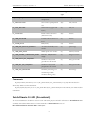
Functions parameters description
Paramenter
Description
Allowed values
p
An integer setting up what climate
FC_TEMPERATURE, FC_PRECIPITATION,
parameter needs to be fetched. It is
FC_LAND_AIR_TEMPERATURE,
usually set up with one of the
FC_OCEAN_AIR_TEMPERATURE,
predefined enum values.
FC_ELEVATION, FC_LAND_ELEVATION,
FC_OCEAN_DEPTH, FC_SOIL_MOISTURE,
FC_RELATIVE_HUMIDITY,
FC_LAND_AIR_RELATIVE_HUMIDITY,
FC_LAND_WIND_SPEED,
5
FetchClimate overview, version 1.2
Paramenter
Description
©2011 Microsoft Corporation
Allowed values
FC_LAND_DIURNAL_TEMPERATURE_RANGE,
FC_LAND_FROST_DAY_FREQUENCY,
FC_LAND_WET_DAY_FREQUENCY,
FC_LAND_SUN_PERCENTAGE
Latmin
The bottom bound value in degrees
-90 .. -90 inclusive
of requested spatial rectangle for
calculating mean climate parameter
value.
Latmax
The top bound value in degrees of
-90 .. 90 inclusive
requested spatial rectangle for
calculating mean climate parameter
value.
Lonmin
Lonmax
dlat
The left bound value in degrees of
-180..180 or 0..360
requested spatial rectangle for
Lonmin and Lonmax must follow the same
calculating mean climate parameter
notation. You must use either -180..180 or 0.360
value.
notation in both Lonmin and Lonmax
The right bound value in degrees of
-180..180 or 0..360
requested spatial rectangle for
Lonmin and Lonmax must follow the same
calculating mean climate parameter
notation. You must use either -180..180 or 0.360
value.
notation in both Lonmin and Lonmax
a step of latitude splitting that will be
more than 0
used to produce grid. The first
dimension of the output grid that
corresponds to latitude will have a
length equal to (latmax-latmin)/dlat.
Latmax value will be corrected to
keep (latmax-latmin)/dlat as integer
value.
dlon
a step of longitude splitting that will
more than 0
be used to produce grid. The second
dimension of the output grid that
corresponds to longitude will have a
length equal to (lonmaxlonmin)/dlon. Latmax value will be
corrected to keep (lonmaxlonmin)/dlon as integer value
6
FetchClimate overview, version 1.2
©2011 Microsoft Corporation
Paramenter
Description
Allowed values
Hourmin
A lower inclusive bound of time
0..24 (or FC_NOVALUE in C++)
interval in a day that will be used for
calculation. It can be set to
FC_NOVALUE
that will be treated as 0.
hourmax
A higher inclusive bound of time
0..24 (or FC_NOVALUE in C++)
interval in a day that will be used for
calculation. It can be set to
FC_NOVALUE that will be treated
as 24.
Daymin
A number of the day in the year that
1..365(366) (or FC_NOVALUE in C++)
will be the first day within each year
if query covers a single year, the maximum value
of the requested time period. It can
of Daymin can be 365 if the year is not leap or 366
be set to FC_NOVALUE that will
if the year is leap.
be treated as the 1th of January.
If query covers several years, it is assumed that all
years are not leap and maximum value of Daymin
must be less or equal to 365
Daymax
A number of the day in the year that
1..365(366) (or FC_NOVALUE in C++)
will be the last day within each year
if query covers a single year, the maximum value
of the requested time period. It can
of Daymax can be 365 if the year is not leap or 366
be set to FC_NOVALUE that will
if the year is leap.
be treated as the 31th of December.
If query covers several years, it is assumed that all
years are not leap and maximum value of Daymax
must be less or equal to 365
yearmin
The number of year that will be the
1 .. 9999
first year in the requested period
yearmax
The number of year that will be the
1 .. 9999
last year in the requested period
grid
A pointer to the preallocated array
where the result data will be put in
the grid request functions.
result
A pointer to the preallocated array
where the result data will be put in
the time series request functions
grid_dim1
The length of the first dimension of
0 .. n
preallocated array where the result
7
FetchClimate overview, version 1.2
Paramenter
©2011 Microsoft Corporation
Description
Allowed values
will be put in the grid request
functions.
grid_dim2
The length of the second dimension
0 .. n
of preallocated array where the result
will be put in the grid request
functions.
result_len
The length of the preallocated array
0 .. n
where the result will be put in the
time series request functions.
The length of all arrays that are used
N
0 .. n
as a arrays with parameters in
function FetchClimateN
A value that divides [yearmin,
dyear
1 .. n
yearmax] interval into periods of
dyear length to form output grid.
A value that divides [daymin,
dday
1 .. n
daymax] interval into periods of dday
length to form output grid.
A value that divides [hourmin,
dhour
1 .. n
hourmax] interval into periods of
dhour length to form output grid.
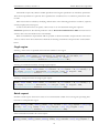
Climate variables description
FetchClimate supports different coverage types.
Only land area in the requested spatial region (L).
Only ocean area in the requested spatial region (O).
Both land and ocean (W).
The following table describes the mapping of FetchClimate API parameter to corresponding climate
parameter and coverage type
Fetch Climate API Parameter
Climate parameter
Coverage
Default units
type
FC_TEMPERATURE
Near surface air
(W)
Degrees Celsius
(L)
Degrees Celsius
temperature
FC_LAND_AIR_TEMPERATURE
Near surface air
temperature
8
FetchClimate overview, version 1.2
Fetch Climate API Parameter
©2011 Microsoft Corporation
Climate parameter
Coverage
Default units
type
FC_OCEAN_AIR_TEMPERATURE
Near surface air
(O)
Degrees Celsius
(W)
mm/month
(L)
mm/m
(W)
meters
(L)
meters
temperature
FC_PRECIPITATION
Near surface precipitation
rate
FC_SOIL_MOISTURE
Soil moisture (upper soil
layers)
FC_ELEVATION
Earth surface elevation
(land and ocean)
FC_LAND_ELEVATION
Land elevation above sea
level
FC_OCEAN_DEPTH
Bathymetry
(O)
meters
FC_LAND_AIR_RELATIVE_HUMIDITY
Air related humidity near
(L)
percentage
surface
FC_LAND_WIND_SPEED
Wind speed near surface
(L)
Meters/second
FC_LAND_DIURNAL_TEMPERATURE_RANGE
Diurnal temperature
(L)
Degrees Celsius
(L)
Days per month
(L)
Days per month
(L)
Percentage
range
FC_LAND_FROST_DAY_FREQUENCY
Number of days with
ground frost in month
FC_LAND_WET_DAY_FREQUENCY
Number of days with
precipitation in month
FC_LAND_SUN_PERCENTAGE
Sunshine percentage of
maximum possible
sunshine during a day
Comments
If pair (hourmin, hourmax) is set to (FC_NOVALUE, FC_NOVALUE) or (0, 24) then the data for
whole day will be used in calculation.
If pair (daymin, daymax) is set to (FC_NOVALUE, FC_NOVALUE) then the whole year will be used in
calculation
FetchClimate C# API (Procedural)
To use FetchClimate C# API we need to create .NET 4.0 project and add a reference to FetchClimate.exe
assembly. Procedural API consists of static methods of ClimateService class of
Microsoft.Research.Science.Data namespace.
9
FetchClimate overview, version 1.2
©2011 Microsoft Corporation
All methods require only climate variable specification and region specification as mandatory parameters.
Time interval specification is optional. If not specified it is considered to be a continuous period from 1961
to 1990.
Time interval can be refined by modifying default values of the following parameters: starthour, stophour,
startday,stopday,startyear,stopyear.
As well as time interval we can specify a data source to use for calculation through an optional
dataSource parameters. The default parameter value is EnvironmentalDataSource.ANY means that most
accurate data source should be chosen automatically.
With a FetchClimate C# procedural API it is possible to fetch uncertainties and provenance of the mean
values as well as mean values themselves. Methods for fetching uncertainties and provenance are described
below.
Single region
Fetching a mean value of specified environmental variable for one region
public static double FetchClimate(ClimateParameter parameter, double latmin, double latmax,
double lonmin, double lonmax, int starthour=0, int stophour=24, int startday=1, int
stopday=GlobalConsts.DefaultValue, int startyear=1961, int stopyear =
1990,EnvironmentalDataSource dataSource=EnvironmentalDataSource.ANY)
Fetching an estimated uncertainty for single region request.
public static double FetchClimateUncertainty(ClimateParameter parameter, double latmin, double
latmax, double lonmin, double lonmax, int starthour = 0, int stophour = 24, int startday = 1,
int stopday = GlobalConsts.DefaultValue, int startyear = 1961, int stopyear = 1990,
EnvironmentalDataSource dataSource = EnvironmentalDataSource.ANY)
Fetching a result provenance for single region request
public static string FetchClimateProvenance(ClimateParameter parameter, double latmin, double
latmax, double lonmin, double lonmax, int starthour = 0, int stophour = 24, int startday = 1,
int stopday = GlobalConsts.DefaultValue, int startyear = 1961, int stopyear = 1990,
EnvironmentalDataSource dataSource = EnvironmentalDataSource.ANY)
Batch request
Perform a batch request: fetch mean values of an environmental variable for several regions specifying time
intervals for each particular region.
public static double[] FetchClimate(ClimateParameter parameter, double[] latmin, double[]
latmax, double[] lonmin, double[] lonmax, int[] starthour = null, int[] stophour = null, int[]
startday = null, int[] stopday = null, int[] startyear = null, int[] stopyear = null,
EnvironmentalDataSource dataSource = EnvironmentalDataSource.ANY)
Fetch estimated uncertainties in a batch request.
public static double[] FetchClimateUncertainty(ClimateParameter parameter, double[] latmin,
double[] latmax, double[] lonmin, double[] lonmax, int[] starthour = null, int[] stophour =
10
FetchClimate overview, version 1.2
©2011 Microsoft Corporation
null, int[] startday = null, int[] stopday = null, int[] startyear = null, int[] stopyear =
null, EnvironmentalDataSource dataSource = EnvironmentalDataSource.ANY)
Fetch data sources in a batch request.
public static string[] FetchClimateProvenance(ClimateParameter parameter, double[] latmin,
double[] latmax, double[] lonmin, double[] lonmax, int[] starthour = null, int[] stophour =
null, int[] startday = null, int[] stopday = null, int[] startyear = null, int[] stopyear =
null, EnvironmentalDataSource dataSource = EnvironmentalDataSource.ANY)
Grid requests
With a grid request it is possible to fetch mean values of some environmental variable for the cells of a grid
specified. Each value of the resulting array is a mean value for corresponding grid cell. The Grid is defined by
its spatial bounds, by a step along latitude and by a step along longitude.
Fetching mean values of a climate variable.
public static double[,] FetchClimateGrid(ClimateParameter parameter, double latmin, double
latmax, double lonmin, double lonmax, double dlat, double dlon, int hourmin = 0, int hourmax =
24, int daymin = 1, int daymax = GlobalConsts.DefaultValue, int yearmin = 1961, int yearmax =
1990, EnvironmentalDataSource dataSource = EnvironmentalDataSource.ANY)
Fetching an uncertainties array for grid request values.
public static double[,] FetchUncertaintyGrid(ClimateParameter parameter, double latmin, double
latmax, double lonmin, double lonmax, double dlat, double dlon, int hourmin = 0, int hourmax =
24, int daymin = 1, int daymax = GlobalConsts.DefaultValue, int yearmin = 1961, int yearmax =
1990, EnvironmentalDataSource dataSource = EnvironmentalDataSource.ANY)
Fetching a provenance array for grid request values.
public static string[,] FetchProvenanceGrid(ClimateParameter parameter, double latmin, double
latmax, double lonmin, double lonmax, double dlat, double dlon, int hourmin = 0, int hourmax =
24, int daymin = 1, int daymax = GlobalConsts.DefaultValue, int yearmin = 1961, int yearmax =
1990, EnvironmentalDataSource dataSource = EnvironmentalDataSource.ANY)
Time series requests
Time series requests give an ability to split single request into several requests either along years, or along days
within year or along hours within day. FetchClimateYearly splits the years interval with a step specified in
dyear paramerer. FetchClimateSeasonly splits subinterval of days within each year into several subintervals
with a step of dday. FetchClimateHourly splits subinterval of hours within each day into several
subintrervals with a step of dhours. If the interval to split is not multiple of a step the later bound of last
subinterval can be trimmed not to exceed the later bound.
public static double[] FetchClimateYearly(ClimateParameter p, double latmin, double latmax,
double lonmin, double lonmax, int hourmin = 0, int hourmax = 24, int daymin = 1, int daymax =
11
FetchClimate overview, version 1.2
©2011 Microsoft Corporation
GlobalConsts.DefaultValue, int yearmin = 1961, int yearmax = 1990, int dyear = 1,
EnvironmentalDataSource dataSource = EnvironmentalDataSource.ANY)
public static double[] FetchClimateSeasonly(ClimateParameter p, double latmin, double latmax,
double lonmin, double lonmax, int hourmin = 0, int hourmax = 24, int daymin = 1, int daymax =
GlobalConsts.DefaultValue, int yearmin = 1961, int yearmax = 1990, int dday = 1,
EnvironmentalDataSource dataSource = EnvironmentalDataSource.ANY)
public static double[] FetchClimateHourly(ClimateParameter p, double latmin, double latmax,
double lonmin, double lonmax, int hourmin = 0, int hourmax = 24, int daymin = 1, int daymax =
GlobalConsts.DefaultValue, int yearmin = 1961, int yearmax = 1990, int dhour = 1,
EnvironmentalDataSource dataSource = EnvironmentalDataSource.ANY)
Get corresponing uncertatinty and provenance values the following methods can be used.
For yearly timeseries: FetchClimateYearlyUncertainty, FetchClimateYearlyProvenance.
For seasonly timeseries: FetchClimateSeasonlyUncertatinty,
FetchClimateSeasonlyProvenance.
For hourly timeseries: FetchClimateHourlyUncertainty, FetchClimateHourlyProvenance
.
Missing value handling
Missing value is supposed to appear in case of fetching coverage specific (i.e. only land without an ocean)
parameter for area with different coverage. For instance fetching over land air temperature for ocean area will
return missing value. In C API the values returned by the service should be checked by is_missing_value
function. In C# API the values containing missing values equal to double.NAN.
Command line interface
FetchClimate.exe can also be used from a command prompt or a batch file. Command line parameters
specify which data to fetch and where the result will go. At a minimum you have to specify climate variable
and one geographical region. Default time interval is set to continuous years from 1961 to 1990 and can be
overridden. When several spatial regions are specified on a command line, one climate variable and time
interval are applied to all requested spatial regions. By default, FetchClimate.exe prints the formatted result to
standard output. The result can also be exported either to plain CSV file or to annotated CSV (readable by
SDS as a dataset). The below command line syntax is printed if you invoke FetchClimate.exe without
parameters.
FetchClimate /clearcache
FetchClimate <parameter> [<TimeSpec>] <RegionSpec> {<RegionSpec>} [/export plain
|annotated FILENAME] [/dsv]
<RegionSpec>
<PointSpec>
<RectSpec>
<GridSpec>
:=
:=
:=
:=
<PointSpec>|<RectSpec>|<GridSpec>
<lat> <lon>
<latMin>:<latMax> <lonmMin>:<lonMax>
<latMin>:<latStep>:<latMax> <lonMin>:<lonStep>:<lonMax>
12
FetchClimate overview, version 1.2
©2011 Microsoft Corporation
<TimeSpec>
:= [/years <yearmin> <yearmax>] [/days <daymin> <daymax>] [/hou
rs <hourmin> <hourmax>] [<TimeSeriesSpec>]
<TimeSeriesSpec>
:= /ty <YearStep> | /ts <DayStep> | /th <HourStep>
<parameter>
:= t|FC_TEMPERATURE|p|FC_PRECIPITATION|lt|FC_LAND_AIR_TEMPERATU
RE|ot|FC_OCEAN_AIR_TEMPERATURE|e|FC_ELEVATION|le|FC_LAND_ELEVATION|od|FC_OCEAN_D
EPTH|sm|FC_SOIL_MOISTURE|rh|FC_RELATIVE_HUMIDITY|lrh|FC_LAND_AIR_RELATIVE_HUMIDI
TY|lwnd|FC_LAND_WIND_SPEED|ldtr|FC_LAND_DIURNAL_TEMPERATURE_RANGE|lfdf|FC_LAND_F
ROST_DAY_FREQUENCY|lwdf|FC_LAND_WET_DAY_FREQUENCY|lsp|FC_LAND_SUN_PERCENTAGE
/clearecache
clear client-side cache
/ty <YearStep>
perform yearly timeseries request by dividing specified
years into <YearStep> long subintervals
/ts <DayStep>
perform seasonly timeseries request by dividing specifie
d days into <DaysStep> long subintervals
/th <HourStep>
perform hourly timeseries request by dividing specified
hours into <HourStep> long subintervals
/and
add an additional region to fetch
If <TimeSpec> is omitted
the mean value for whole years from 1961 to 1990 is fetched.
General notes
Service works with 8 data sources. They are NCEP Reanalysis 1, CRU CL 2.0, WorldClim 30s, GHCN v2,
CPC Soil Moisture, GTOPO30 and ETOPO1
All time is now interpreted as UTC time. If you specify “morning” hours in your request while requesting
a wide spatial area, the result that will be returned won’t correspond to average morning time for this area. It
will contain an average for specified UTC hours across whole region.
Gridded interpolated station data data sources (WorldClim, CRU CL 2.0)
Data sources with Gridded interpolated station data like WorldClim or CRU will not calculate a mean value
for a region containing missing value (e.g water area), some other less accurate data source will be used to get
a value for this type of regions.
If the requested days of year do not fit month bound, monthly average values will be weighted according
to the length of submonth period.
For example, in the case of requesting mean temperature for days from the 10th of June to the 10th of
August, the result will be generated using mean temperature of June,July and August with corresponding
weights 0.7, 1 and 0.32.
Weight of June= requested days in June / total days in June = 21/30 =0.7
Weight of July= requested days in July / total days in July = 31/31 =1
Weight of August = requested days in August / total days in August = 10/31 =0.32
The resulting mean value will be the following:
(JuneTemp*0.7+JulyTemp*1 + AugustTemp*0.32)/(0.7+1+0.32)
13
FetchClimate overview, version 1.2
©2011 Microsoft Corporation
Time aggregated observations (GHCN)
GHCN Data source uses only those stations to get a result for the request, that contain continuous
timeseries (e.g. all requested months for all requested years are present in the data). If at least one of the
requested months of any of the requested years is absent for some station in the requested spatial region, the
station data will be ignored.
Major effect for precision calculation for GHCN data source is caused by station density in a region. So it
is likely that GHCN data source will only be used in the high station density regions (e.g. USA) or if other
data sources fail their calculations for the particular request.
14


![[U4.91.11] Procédure IMPR_CO](http://vs1.manualzilla.com/store/data/006380066_1-aa4fba2c5ff65604a3c9f71622787d35-150x150.png)