1
maps + more
User’s manual
English (United Kingdom)
October 2011
The crossed-out wheeled bin means that within the European Union
the product must be taken to separate collection at the product end-oflife. This applies to your device but also to any enhancements marked
with this symbol. Do not dispose of these products as unsorted
municipal waste.
Imprint
NAVIGON AG
Schottmüllerstraße 20A
D-20251 Hamburg
The information contained herein may be changed at any time without prior
notification. Neither this manual nor any parts thereof may be reproduced for any
purpose whatsoever without the express written consent of NAVIGON AG, nor may
they be transmitted in any form either electronically or mechanically, including
photocopying and recording. All technical specifications, drawings etc. are subject
to copyright law.
2011, NAVIGON AG
All rights reserved.
User’s manual maps + more
Table of contents
1
Introduction .......................................................................................8
1.1
1.2
1.3
2
Before you begin...............................................................................9
2.1
2.2
2.3
2.4
2.5
3
Scope of Delivery ................................................................................ 9
Description of the navigation device................................................... 10
Important safety information .............................................................. 10
2.3.1
Navigation safety information .............................................. 10
2.3.2
Safety information for the navigation device ........................ 11
Mounting/removing the navigation system ......................................... 12
2.4.1
Removing the navigation device ......................................... 12
2.4.2
Mounting the navigation device........................................... 13
2.4.3
Memory card....................................................................... 14
Navigating with GPS .......................................................................... 15
Switching the navigation device on and off .................................15
3.1
3.2
3.3
3.4
3.5
4
About this manual ................................................................................ 8
1.1.1
Conventions.......................................................................... 8
1.1.2
Symbols................................................................................ 8
Legal notice ......................................................................................... 8
1.2.1
Liability ................................................................................. 8
1.2.2
Trade marks ......................................................................... 9
Questions about the product ................................................................ 9
Device mounted in the vehicle ........................................................... 16
3.1.1
Switching on the device ...................................................... 16
3.1.2
Screensaver ....................................................................... 16
3.1.3
Switching the device to standby mode ................................ 17
3.1.4
Switching off the device ...................................................... 17
Device not mounted ........................................................................... 17
3.2.1
Switching on the device ...................................................... 17
3.2.2
Screensaver ....................................................................... 18
3.2.3
Switching the device to standby mode ................................ 18
3.2.4
Switching off the device ...................................................... 18
Starting the navigation device for the first time ................................... 18
Manual .............................................................................................. 20
Options .............................................................................................. 20
Password Lock................................................................................20
4.1
4.2
4.3
4.4
User’s manual
Activating password protection .......................................................... 21
Changing a password ........................................................................ 21
Cancelling password protection ......................................................... 21
Forgotten your password? ................................................................. 22
Table of contents III
User’s manual maps + more
5
Operating the navigation system ..................................................22
5.1
5.2
5.3
5.4
Information ........................................................................................ 22
Software keyboard ............................................................................. 26
5.2.1
Special keys ....................................................................... 26
5.2.2
Entering data ...................................................................... 27
Options .............................................................................................. 28
Menus ............................................................................................... 28
6
Voice Command ..............................................................................28
7
Navigation........................................................................................30
6.1
6.2
6.3
6.4
6.5
7.1
7.2
7.3
7.4
8
Activating the voice commands function ............................................ 29
Use Voice Command ......................................................................... 29
Help ................................................................................................... 29
Deactivation of the voice commands function .................................... 29
Configuring the voice commands function.......................................... 30
Starting the navigation application ..................................................... 31
Specifying a destination ..................................................................... 32
7.2.1
Specifying the country in which the destination is
situated ............................................................................... 33
7.2.2
Entering a destination by voice commands ......................... 33
7.2.3
Entering a destination address............................................ 34
7.2.4
Enter Coordinates ............................................................... 36
7.2.5
Points of interest ................................................................. 37
7.2.6
Direct access to POI ........................................................... 40
7.2.7
Information about the destination ........................................ 41
7.2.8
Favourites ........................................................................... 42
7.2.9
Last Destinations ................................................................ 42
7.2.10 Imported Addresses: Outlook / Internet ............................... 43
7.2.11 Imported Addresses from the phone book........................... 44
7.2.12 Navigating home ................................................................. 44
7.2.13 Selecting destinations on the map ...................................... 45
7.2.14 Route preview..................................................................... 45
Managing destinations ....................................................................... 47
7.3.1
Saving destinations............................................................. 48
7.3.2
Deleting a destination from the Favourites list ..................... 48
7.3.3
Defining the home address ................................................. 48
7.3.4
Changing the home address ............................................... 50
Tracks and multi-leg routes................................................................ 50
7.4.1
Entering the starting point ................................................... 50
7.4.2
Entering route points ........................................................... 51
7.4.3
Editing route points ............................................................. 51
7.4.4
Managing routes ................................................................. 52
7.4.5
Loading routes or tracks ..................................................... 52
7.4.6
Calculating and displaying routes........................................ 53
7.4.7
Simulating routes ................................................................ 53
7.4.8
Route preview..................................................................... 54
Options ............................................................................................56
IV Table of contents
User’s manual
User’s manual maps + more
9
Working with the map .....................................................................58
9.1
9.2
9.3
9.4
9.5
10
Selecting the navigation map ............................................................. 58
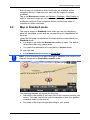
Map in Standard mode ...................................................................... 59
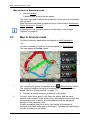
Map in Preview mode ........................................................................ 60
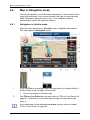
Map in Navigation mode .................................................................... 62
9.4.1
Navigation in Vehicle mode................................................. 62
9.4.2
Navigation in Pedestrian mode ........................................... 66
9.4.3
Navigation in Track mode ................................................... 68
9.4.4
Navigation in Offroad mode ................................................ 69
9.4.5
Map options in Navigation mode ......................................... 69
9.4.6
Quitting navigation .............................................................. 69
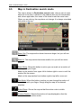
Map in Destination search mode........................................................ 70
9.5.1
Operating in Destination search mode ................................ 71
Useful functions ..............................................................................71
10.1
10.2
10.3
10.4
10.5
10.6
10.7
10.8
10.9
10.10
10.11
10.12
10.13
10.14
User’s manual
Route profiles .................................................................................... 71
10.1.1 Route profile settings .......................................................... 72
10.1.2 NAVIGON basic profiles ..................................................... 72
10.1.3 Creating a new route profile ................................................ 73
10.1.4 Selecting a route profile ...................................................... 73
10.1.5 Managing route profiles ...................................................... 73
MyPOIs: My POIs .............................................................................. 75
10.2.1 Creating your own destinations ........................................... 75
10.2.2 Symbols for your own POIs................................................. 76
10.2.3 POI-Import: Importing your own POIs onto the
navigation device ................................................................ 76
Tracks ............................................................................................... 77
Parking near the destination .............................................................. 78
Nearby ............................................................................................... 79
MyBest POI: POI on Your Route........................................................ 80
10.6.1 Displaying POIs along the route.......................................... 80
10.6.2 Navigating to one of the destinations .................................. 82
10.6.3 Selecting categories ........................................................... 82
NAVIGON Sightseeing ...................................................................... 82
Sightseeing Tours .............................................................................. 84
Direct Help......................................................................................... 86
GPS Status, saving the current location ............................................. 86
Block ................................................................................................. 87
Turn-by-Turn List ............................................................................... 87
TMC (Traffic Information) ................................................................... 89
10.13.1 Preview TMC ...................................................................... 89
10.13.2 Displaying traffic information ............................................... 91
10.13.3 Showing a single message in detail .................................... 92
10.13.4 TMC Settings ...................................................................... 92
Logbook ............................................................................................ 93
Table of contents V
User’s manual maps + more
11
Car Info ............................................................................................94
11.1
11.2
11.3
11.4
11.5
11.6
12
Low fuel warning ................................................................................ 95
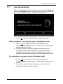
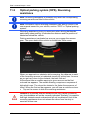
Optical parking system (OPS), Reversing assistance ........................ 96
Door monitoring ................................................................................. 97
Trip Computer.................................................................................... 97
11.4.1 Opening the trip computer .................................................. 97
11.4.2 Selecting the period ............................................................ 98
Status ................................................................................................ 98
11.5.1 Opening the Status window ................................................ 98
11.5.2 Configuring the Status window............................................ 99
Think Blue. Trainer ............................................................................ 99
11.6.1 Opening the trainer ............................................................. 99
11.6.2 Blue Index ........................................................................ 100
11.6.3 Gear Shifting..................................................................... 101
11.6.4 Cruising ............................................................................ 102
11.6.5 Consumption .................................................................... 103
11.6.6 Resetting the trainer ......................................................... 104
Media..............................................................................................104
12.1
12.2
12.3
12.4
12.5
Controlling the car radio................................................................... 105
12.1.1 Selecting the frequency band............................................ 106
12.1.2 Setting a certain frequency ............................................... 106
12.1.3 Selecting a radio station.................................................... 106
12.1.4 Scan: Scanning the frequency band ................................. 107
12.1.5 Preset List ........................................................................ 107
Media Player ................................................................................... 108
12.2.1 Supported audio files ........................................................ 109
12.2.2 Selecting a media source.................................................. 109
12.2.3 Selecting files for playing back .......................................... 111
12.2.4 Selecting the play-back mode ........................................... 111
12.2.5 Controlling the play back................................................... 112
Options for the radio and media player ............................................ 112
12.3.1 Traffic Information (TP) ..................................................... 113
12.3.2 Sound ............................................................................... 113
12.3.3 Volume ............................................................................. 114
Pictures ........................................................................................... 114
12.4.1 Suitable files ..................................................................... 114
12.4.2 Opening the picture viewer ............................................... 115
12.4.3 Selecting an image file ...................................................... 115
12.4.4 Operating the picture viewer ............................................. 115
12.4.5 Selecting the play-back mode ........................................... 116
Options for the picture viewer .......................................................... 116
12.5.1 Slideshow (Slide Show) .................................................... 116
12.5.2 Background for the screensaver ....................................... 117
VI Table of contents
User’s manual
User’s manual maps + more
13
Handsfree Module .........................................................................117
13.1
13.2
13.3
13.4
13.5
13.6
13.7
Bluetooth Connection ...................................................................... 119
13.1.1 Searching for and pairing Bluetooth devices ..................... 120
13.1.2 Pairing from the mobile phone .......................................... 121
13.1.3 Connecting to a device ..................................................... 121
13.1.4 Activating a mobile phone ................................................. 123
13.1.5 Deleting a device .............................................................. 123
13.1.6 Import Phone Book ........................................................... 124
13.1.7 Import recent calls ............................................................ 125
Taking a call .................................................................................... 125
Receiving a text message ................................................................ 126
Making a call ................................................................................... 126
13.4.1 Making a call with the voice commands function ............... 126
13.4.2 Dialling a telephone number ............................................. 128
13.4.3 Dialling a Speed Call number............................................ 128
13.4.4 Calling a contact from the phone book .............................. 128
13.4.5 Calling most recently dialled, received or missed
numbers ........................................................................... 129
13.4.6 Transferring a call from your mobile telephone ................. 129
During a call .................................................................................... 129
13.5.1 Moving the navigation application to the foreground ......... 130
13.5.2 Entering numbers ............................................................. 130
13.5.3 Muting the microphone ..................................................... 130
13.5.4 Transferring a call to the mobile phone ............................. 130
13.5.5 Ending the call .................................................................. 130
Useful functions ............................................................................... 131
13.6.1 Navigating to a contact from the phone book .................... 131
13.6.2 Opening the mailbox ......................................................... 131
Configuring the hands-free function ................................................. 131
13.7.1 Preset ............................................................................... 132
13.7.2 Settings ............................................................................ 132
14
15
Configuring the Navigation System ............................................134
Appendix .......................................................................................136
16
17
Troubleshooting............................................................................142
Index ..............................................................................................144
15.1
15.2
15.3
User’s manual
Technical data of the navigation device ........................................... 136
NAVIGON Licensing Policy.............................................................. 137
Declaration of Conformity ................................................................ 141
Table of contents VII
User’s manual maps + more
1
Introduction
1.1
About this manual
1.1.1
Conventions
For better legibility and clarification, the following styles are used in this
manual:
Bold and italics:
Names of products
SMALL CAPITALS:
Names of windows and dialogue boxes
Bold:
Highlighting of important parts in the text
Underlined:
Descriptions of buttons, input boxes and other
elements on the user interface
Underlined and italics:
Names of control elements on the navigation
device
1.1.2
Symbols
The following symbols refer to specific passages of text:
Instructions and tips for operating the software
More detailed information and explanations
Warnings
1.2
Legal notice
1.2.1
Liability
The software and manual are subject to change without notice.
NAVIGON AG is not liable for the accuracy of the information contained
in this manual or for damages resulting from the use of this manual.
Suggestions for improvements and information regarding errors are
always welcome so that we can supply you with even better products in
the future.
-8-
Introduction
User’s manual maps + more
1.2.2
Trade marks
All brand and trade marks mentioned in this document and registered
by third parties are subject without reservation to copyright law and the
proprietary rights of their respective owners. All trade marks, trade
names and company names used in this document are or may be trade
marks or registered trademarks of their respective owners. All rights
reserved except those explicitly granted.
If the registered trade marks used in this manual are not explicitly
identified as such, this does not imply that the name is not subject to the
rights of a third party.
►
►
1.3
Microsoft, Outlook, Excel and Windows are registered trade marks
of the Microsoft Corporation.
NAVIGON is a registered trade mark of NAVIGON AG.
Questions about the product
You have a question concerning your product? Then visit our website
www.navigon.com and click on "Customer Services". There you will find
an area with frequently asked questions (FAQ Center) along with details
of how to contact us by phone or e-mail.
2
Before you begin
2.1
Scope of Delivery
Please check that the contents are complete. If anything is missing, get
in touch immediately with the dealer who sold you the product.
The purchased product includes the following:
►
Navigation device
►
Designer car cradle
►
USB cable
►
Illustrated installation instructions
Before you begin
-9-
User’s manual maps + more
2.2
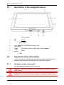
Description of the navigation device
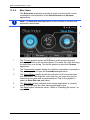
1
Touch-screen
2
On/Off
3
Microphone
4
Slot for microSD memory card
5
Mini USB socket for USB cable / mains adapter
6
Reset
7
2.3
LED
Important safety information
In your own interest, please read the following safety information and
warnings carefully before starting up your navigation system.
2.3.1
Navigation safety information
Use the navigation system at your own risk.
Caution! To prevent accidents, do not operate the navigation system
while driving.
Caution! Do not look at the screen unless it is absolutely safe to do so!
- 10 -
Before you begin
User’s manual maps + more
Caution! Traffic regulations have priority over any instructions from the
navigation system.
Caution! Follow the instructions of the navigation system only when the
circumstances and the road traffic regulations allow you to do so! The
navigation system will still guide you to your destination even if you
deviate from the calculated route.
Caution! When you use the navigation device in a vehicle, mount it
only in the supplied cradle.
Caution! Check that the cradle is secured and adjusted properly before
each journey.
Note: If you have not understood the spoken instructions or are unsure
about what to do at the next junction, you can refer briefly to the map or
schematic view of your navigation system.
2.3.2
Safety information for the navigation device
Caution! Protect the device from moisture. The device is neither
waterproof nor protected against splash water.
Caution! Do not open the case of the navigation device under any
circumstances.
Caution! Do not expose the navigation device to extreme heat or cold.
This may damage the device or impair its function. (Refer to "Technical
data" on page 136)
Caution! Do not subject the navigation device to severe temperature
fluctuations. This can lead to condensation.
Note: Create a backup of the data which exist in the internal memory of
your navigation device.
This is very easy to do with the NAVIGON Fresh software which can be
downloaded free of charge from our website www.navigon.com/fresh.
Before you begin
- 11 -
User’s manual maps + more
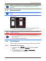
2.4
Mounting/removing the navigation system
The vehicle is already prepared for the navigation system to be
installed. In the middle of the dashboard is a slot for the cradle of the
navigation device. Power is supplied to the device through this cradle.
Radio traffic information is received via the antenna of the car radio.
The navigation device can be used to control the car radio, and it
receives vehicle data such as consumption, amount of fuel in the tank,
speed, etc.
2.4.1
Removing the navigation device
When you receive your new vehicle, the navigation device is already
installed. To prevent theft we recommend that you do not leave the
navigation system mounted in the vehicle when you park.
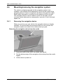
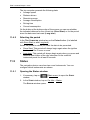
Removing the navigation device from the cradle
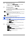
1. Press the button at the top of the cradle (see figure).
2. Pull the bottom edge of the navigation device away from the cradle
slightly.
3. Lift the device up and out.
- 12 -
Before you begin
User’s manual maps + more
Removing the cradle
1. Press the button at the bottom of the cradle (see figure).
2. Holding the button pressed, take the cradle out of the opening.
Fitting the cover
1. Place the cover over the opening.
2. Press the cover fully into the opening.
2.4.2
Mounting the navigation device
Caution! Be sure to refer to all the safety information in chapter
"Important safety information" on page 10.
Removing the cover
In the middle of the dashboard is the opening for the cradle of the
navigation device.
►
Remove the cover from over the opening in the dashboard.
Fitting the cradle☺
1. Place the cradle, correctly aligned, over the opening provided for it.
2. Press the cradle into the opening until you hear and feel that it
latches in place.
Fitting the navigation device in the cradle
On the back of the navigation device you will see a circle with two
recesses.
1. Hang the navigation device by the upper recess on the upper lug of
the cradle.
2. Then press it towards the cradle so that it latches in place.
Before you begin
- 13 -
User’s manual maps + more
Supplying power to the navigation device
The navigation device is supplied with power via the cradle. At the
same time the device's battery is charged so that it can also be used
outside the vehicle, e.g. for pedestrian navigation.
The LED on the bottom of the navigation device is active only when the
navigation device is being charged via a charger or is connected by a
USB cable to a computer. In this case its colour has the following
meaning:
►
Orange: The device is in the process of being charged.
►
Green: The battery is fully charged.
The LED on the bottom of the navigation device lights up orange during
charging.
As soon as the battery is fully charged, the LED lights up green.
Note: It takes approx. 3 hours to charge the device when the battery is
flat.
A fully charged battery enables up to 3 hours of use depending on the
device configuration.
Traffic Information (TMC)
The navigation device has an integrated TMC receiver. As soon as it is
mounted, the device can receive traffic message updates. If required, it
can change your route dynamically, e.g. in order to avoid a traffic jam.
2.4.3
Memory card
A memory card is not required to operate the navigation system
because all the data needed for navigation are stored in the internal
memory of the device.
Note: If you purchase additional navigation maps, they must be saved
in the internal memory of the navigation device. Navigation data on the
memory card are not used. The slot for memory cards is intended only
for media which you can play back with the media player or the picture
viewer.
When you connect the navigation system to your computer using a USB
cable, the internal memory is detected as the 'NAVIGON' drive. The slot
for the memory card is detected as the 'NAVIGON SD' drive.
Data backups, software updates and navigation map updates can be
carried out quickly and conveniently with the NAVIGON Fresh software,
which you can download free of charge from the website
www.navigon.com/fresh.
Caution! Do not remove the memory card from the device while the
data saved on it are in the process of being used, e.g. for playing back
music or viewing pictures. Data may be lost as the result.
- 14 -
Before you begin
User’s manual maps + more
Note: A change of memory card is detected only when the device has
been switched on. If the memory card is not detected, insert it again
when the device is on and running.
2.5
Navigating with GPS
GPS is based on a total of at least 24 satellites orbiting the Earth and
continuously transmitting signals of their position and time. The GPS
receiver receives this data and calculates its own geographical position
on the basis of the information transmitted by the various satellites.
Data from at least three satellites is required for positioning with an
acceptable degree of accuracy. With data from four or more satellites it
is possible in addition to determine the position's altitude above sea
level. Positioning is accurate to within three metres.
Once the navigation device has determined your position, this position
can be used as a starting point for calculating a route.
The map data on your navigation device includes the geographical
coordinates of all digitally recorded points of interest, streets and
places. This enables the device to calculate a route between a starting
point and a destination.
Calculation of the current position and its representation on the map
take place approximately once every second. In other words, your
current position is always shown on the map.
3
Switching the navigation device on and
off
The navigation device can be in one of four states:
►
On: The navigation device is on and can be operated.
►
Screensaver: The navigation device is on. However, you see only
a screensaver. As long as the screensaver is visible, the device
cannot be operated.
The screensaver is available only when the device is mounted in
the vehicle.
If you switch on the screensaver while navigation is in progress, you
will continue to hear the navigation announcements from the
device.
If music is being played when the screensaver is switched on, the
music will continue.
►
Standby: When you switch the navigation device to standby mode,
the next time it is switched on it will start very quickly. In standby
mode the device still consumes a small amount of energy however.
Switching the navigation device on and off
- 15 -
User’s manual maps + more
Depending on how full the battery is, it can become flat within a few
days or a few weeks.
►
Off: When you switch off the device, it consumes no energy. It can
then take several months for the battery to become flat. Switching
the device on again triggers a restart which can take some time
(approx. 60 seconds). Your settings and your saved destinations
and routes will be retained.
The procedure for switching the navigation device on and off depends
on whether it is mounted in the vehicle or not.
3.1
Device mounted in the vehicle
When the navigation device is mounted in the vehicle, it does not need
to be switched on or off.
3.1.1
Switching on the device
The navigation device switches on when you switch on the ignition.
Note: The device also switches on when it is fitted in the vehicle while
the ignition is already on.
If the navigation device was previously set to standby, the window
which was last visible will appear.
If the device was previously switched off, it will take several seconds for
the software to be started again. The START window then appears.
If you want to switch on the device with the engine off, press and hold
the
3.1.2
(On/Off) key until the device switches on.
Screensaver
Switching on the screensaver
The screensaver is available only under the following conditions:
The device is mounted in the vehicle and is on.
The vehicle's ignition is on.
►
Press briefly on the
(On/Off) key.
– or –
►
In the START window tap on
(Switch off).
The screensaver will appear. On it you can see the date, the time and
the outdoor temperature.
- 16 -
Switching the navigation device on and off
User’s manual maps + more
Using the NAVIGON Fresh software you can install a function which
allows you to select the picture you want to use as the screensaver.
NAVIGON Fresh can be downloaded free of charge from the website
www.navigon.com/fresh.
The date, the time and the outdoor temperature are shown likewise on
the picture which you selected yourself. For more details refer to the
chapter "Background for the screensaver" on page 117.
Switching off the screensaver
►
Press briefly on the
(On/Off) key.
– or –
►
Tap anywhere on the screen.
The screensaver is phased out. The window which was active when the
screensaver was switched on is visible again.
Note: The screensaver is also switched off automatically when you pull
out the ignition key.
3.1.3
Switching the device to standby mode
When you pull out the ignition key, a message will appear shortly
afterwards telling you that the device is being switched to standby
mode.
►
3.1.4
Tap on Standby or wait for the device to go out on its own.
Switching off the device
When the device is mounted in the vehicle, it does not need to be
switched off. However, if you are not going to use the device for a
longer period of time, you can switch it off all the same.
►
3.2
Press the
(On/Off) key and keep it pressed until the device
switches off (approx. 5 seconds).
Device not mounted
Of course you can also switch the device on and off when it is not
mounted in the vehicle.
3.2.1
Switching on the device
►
Press the
(On/Off) key and keep it pressed until the device
switches on.
If the navigation device was previously set to standby, the window
which was last visible will appear.
Switching the navigation device on and off
- 17 -
User’s manual maps + more
If the device was previously switched off, it will take several seconds for
the software to be started again. The START window then appears.
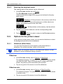
Forgotten your password?
It can happen that you activate the password but are then unable to
remember it.
►
3.2.2
If you forget your password, follow the procedure described in
"Forgotten your password?" on page 22.
Screensaver
When the navigation device is not being supplied with power from the
vehicle, the screensaver is not available.
3.2.3
Switching the device to standby mode
►
Press briefly on the
(On/Off) key.
– or –
►
In the START window tap on
(Switch off).
A message will appear telling you that the device will be switched to
standby mode in several seconds.
►
3.2.4
Wait for the device to be switched to standby mode or tap on
Standby.
Switching off the device
►
Press the
(On/Off) key and keep it pressed until the device
switches off (approx. 5 seconds).
– or –
1. Press briefly on the
(On/Off) key (max. 1 second).
A message will appear telling you that the device will be switched to
standby mode in several seconds.
2. Tap on Switch off.
3.3
Starting the navigation device for the first time
When you switch on the navigation system for the first time, you will be
asked to make the following settings:
- 18 -
►
your preferred language for using the software
►
the unit of length for distances
►
the time format
►
the date format
►
the unit for temperature readings
Switching the navigation device on and off
User’s manual maps + more
When you have entered all the required data, the following message will
appear:
"Please note that the road traffic regulations are prior to the instructions
of the navigation system. Please do not operate the device while
driving."
►
After you have read and fully understood the message, tap on OK.
The START window opens.
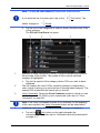
From the START window you can access all the applications of the
navigation device:
►
Navigation, see page 30
►
Car Info, see page 94
►
Media, see page 104
►
Phone, see page 117
Note: You can open the START window from practically every other
window by tapping on the
(Main menu) button.
Switching the navigation device on and off
- 19 -
User’s manual maps + more
Note: If you have not used the navigation device for a long time, the
battery may be flat.
If you are using a plug-in mains adapter or have connected your device
to a PC, the device may need charging for a few minutes before it can
be switched on.
When you have fitted the navigation device correctly in the vehicle, it
cannot be switched on immediately. You must first wait approx. two
minutes before switching it on by hand.
Chargers and other accessories are available in the NAVIGON online
shop at www.navigon.com or in specialist stores.
3.4
Manual
An excerpt of this manual describing the most important functions of the
navigation device is saved on the navigation device.
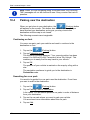
To open the manual:
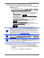
1. In the START window, tap on more > Manual.
The TABLE OF CONTENTS window opens.
2. Tap on the name of the chapter you want to read.
The content of the chapter is shown.
With the
(Up) and
(Down) buttons you can scroll up one
page and down one page respectively.
With the
(To the Left) and
(To the Right) buttons you
can open the previous or the next chapter respectively.
►
►
3.5
Tap on the Table of Contents button in order to open the Table of
Contents window.
Tap on the
(Close) button to close the manual and return to
the START window.
Options
Some windows offer options that lead to more functions.
A description of all available options can be found in the chapter
"Options" on page 56.
4
Password Lock
You can protect your navigation system from unauthorised use by
creating a password. The password is always requested when the
device is switched on and it is not mounted in your vehicle.
- 20 -
Password Lock
User’s manual maps + more
As soon as the device is mounted in a vehicle, it automatically receives
the vehicle's individual ID number. The device knows therefore whether
it is mounted in the "correct" vehicle. In this vehicle the password is
requested only once.
4.1
Activating password protection
1. In the NAVIGATION window tap on Options > Settings > Options >
Password Lock.
The NEW PASSWORD window opens.
2. Enter a password in the New password box and tap on Next.
3. Enter this password again in the Confirm new password box.
4. Tap on Activate.
Note: The password must have exactly 4 digits.
4.2
Changing a password
1. In the NAVIGATION window tap on Options > Settings > Options >
Password Lock.
The ENTER PASSWORD window opens.
2. Enter the currently valid password in the Enter password box.
3. Tap on Change password.
The NEW PASSWORD window opens.
4. Enter a password in the New password box and tap on Next.
5. Enter this password again in the Confirm new password box.
6. Tap on Activate.
Note: The new password must have exactly 4 digits.
4.3
Cancelling password protection
1. In the NAVIGATION window tap on Options > Settings > Options >
Password Lock.
The ENTER PASSWORD window opens.
2. Enter the currently valid password in the Enter password box.
3. Tap on Deactivate.
Password Lock
- 21 -
User’s manual maps + more
4.4
Forgotten your password?
If you enter the password wrongly three times, a window will open with
instructions telling you what to do now.
►
Follow the instructions on the screen.
5
Operating the navigation system
5.1
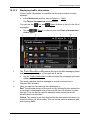
Information
The time is indicated at the top edge of many windows. When the
device is mounted in the vehicle and the ignition is on you will also see
the outdoor temperature.
Various information symbols are likewise located at the top of many
windows.
GPS
The GPS symbol can show the following GPS reception status:
No GPS (No symbol): The built-in GPS receiver is not operational.
Contact us if the problem persists. (Refer to "Questions about the
product" on page 9)
No Signal: Data is being received from less than three satellites.
Position cannot be calculated.
GPS Ready: Data is being received from at least 3 satellites. Position
can be calculated.
For details of the GPS status refer to chapter "GPS Status, saving the
current location" on page 86.
Track
The
(Record Track) symbol indicates that a track is being recorded
at this moment.
For more information about tracks refer to chapter "Tracks" on page 77.
Compass
The Compass symbol is available only in the map view. It shows you in
which direction you are currently moving. It can indicate the following
points of the compass: N, NE, E, SE, S, SW, W, NW.
- 22 -
Operating the navigation system
User’s manual maps + more
Showing and hiding the Compass symbol
You can activate and deactivate the Compass symbol so that it is
shown or hidden.
►
►
In the NAVIGATION window tap on Options > Settings > Navigation.
Scroll with the
(To the Left) and
(To the Right) buttons
until you see the Display Compass setting.
The currently valid setting value is highlighted (red).
►
►
Tap on the
values.
(Toggle) button to alternate between the setting
Tap on OK.
Energy
The Energy symbol can indicate the following states of the integrated
battery:
The device is mounted in the vehicle and is being supplied with power
from the vehicle. The battery is fully charged.
The device is mounted in the vehicle and is being supplied with power
from the vehicle. The battery is in the process of being charged.
The device is in the vehicle and is being supplied with power from the
vehicle. The battery cannot be charged because its temperature is too
high or too low.
The device is being supplied by its internal battery. The battery charge
is sufficient.
The device is being supplied by its internal battery. The battery charge
is low.
Traffic Information (TMC)
The navigation system has an integrated TMC receiver which supplies
up-to-date traffic information. Using this information the navigation
system can change your route dynamically, for example in order to
avoid a traffic jam.
Note: This function is only available if TMC traffic messages are being
transmitted in the country in which you are travelling. This is not the
case in all countries.
The TMC symbol can display the following TMC reception status:
Tuning (in red): The TMC receiver is operational but cannot find a
transmitter that is sending TCM signals. There are no active traffic
messages.
Operating the navigation system
- 23 -
User’s manual maps + more
Tuning: The TMC receiver is operational but cannot find a station that
is transmitting TMC signals. Traffic messages are active however. This
can be the case, for example, when travelling through a tunnel.
TMC on Standby (in grey): Traffic messages can be received.
Note: The TMC receiver uses the antenna of the car radio. The Tuning
symbol may still appear therefore when the navigation device is not
mounted in the vehicle.
For details of the TMC function refer to chapter "TMC (Traffic
Information)" on page 89.
Traffic Information (TP)
The car radio can phase out the playing back of music or navigation
instructions and have traffic messages announced instead when traffic
information is available.
The TP symbol can indicate the following states:
No TP (No symbol): Traffic messages are not phased in.
TP on Standby (white): Traffic messages are phased in. When the
traffic message announcement has finished, the original audio source
will be used again.
Tuning (red): The radio looks for a station which transmits traffic
information.
Bluetooth / Phone
The navigation device has an integrated Bluetooth hands-free module.
This enables you to use the device as a hands-free kit for up to two
mobile phones with Bluetooth capability.
The Phone symbol can display the following states of the hands-free
module:
No Bluetooth (No symbol): The Bluetooth function is deactivated.
Not connected (red mobile phone): The navigation device has no
Bluetooth connection to another device.
Connected (white mobile phone): The navigation device is connected
to a mobile phone and can be used as a hands-free car kit. The number
indicates which of the two phones is currently active.
Call in Progress (green mobile phone): The hands-free module of the
navigation device is being used for a phone call. The number indicates
which of the two phones is being used to make the call.
- 24 -
Operating the navigation system
User’s manual maps + more
Headset: A headset is connected. All the instructions given by the
navigation system are heard over the headset. The telephone functions
of the hands-free module are not available.
Muting
The Muting symbol can indicate the following states:
No symbol: The navigation application is not muted.
Muting: The navigation application is muted. If the device is navigating
at the moment, you will not hear any driving instructions.
Note: This icon indicates only the muted state of the navigation
instructions. It says nothing about the volume of the hands-free module.
The procedure for regulating the volume is described in the chapter
"Navigation in Vehicle mode", section "Volume", on page 65.
Logbook
The Logbook symbol can indicate the following states:
No symbol: The logbook is deactivated. There is no recording of trips.
Logbook: The logbook is activated. Before each navigation you will be
prompted to enter the necessary details for the logbook entry (reason
for the trip, km total, …). It is possible however to suppress the
recording of the trip.
For a description of the logbook refer to the chapter "Logbook" on
page 93.
Media
When the navigation device is mounted in the vehicle and is being
supplied with power from the vehicle, it can control the installed car
radio. The Media symbol then indicates which audio source is active at
the moment.
No symbol: The radio is off or the navigation device is not being
supplied with power from the vehicle.
FM: The current audio source is the radio. It is set to FM reception.
AM: The current audio source is the radio. It is set to AM reception.
AUX-IN audio: The current audio source is an external device which is
connected to the AUX port of the car radio.
Operating the navigation system
- 25 -
User’s manual maps + more
BT-Audio: The current audio source is an external device (mobile
phone or smartphone) which is connected to the navigation device via
Bluetooth.
CD: The current audio source is the CD which is inserted in the car
radio.
SD card: The current audio source is the MicroSD card which is
inserted in the navigation device.
5.2
Software keyboard
A software keyboard appears on the screen when text entries are
necessary.
All entries can be made on the software keyboard using your fingertips.
Only capital letters can be entered.
When entering town or street names you need not enter any special
characters or umlauts. The navigation system fills in these characters
for you automatically. For example, if you are looking for the town of
"Bärnau", then simply type in the word "BARNAU". Special characters
may be helpful however when naming saved destinations and routes.
5.2.1
Special keys
inserts a space.
deletes the character in front of the cursor.
opens the keyboard with numerals.
Latin, Cyrillic and Greek alphabet
opens the keyboard with the Latin alphabet.
Note: The layout for the keyboard with the Latin alphabet can be
configured.
►
►
In the NAVIGATION window tap on Options > Settings > General >
Keypad layout (Latin).
Select the layout you want to use (QWERTZ, QWERTY, ABCDEF,
AZERTY).
opens the keyboard with the Cyrillic alphabet.
opens the keyboard with the Greek alphabet.
When you want to enter addresses, names or POIs, the keyboard with
the alphabet for the country in question will open automatically.
- 26 -
Operating the navigation system
User’s manual maps + more
When you want to save a destination to Favourites or when you enter a
POI category or a country, the keyboard with the alphabet of the user
interface will open automatically.
You can also switch from the Cyrillic or Greek keyboard to the Latin
keyboard. Many addresses can then also be entered as transliterations
or in the language of the user interface.
Example: The language of the user interface is English. You want to
navigate to Moscow. You have the following options:
►
"Москва" (Cyrillic)
►
"Moskva" (transliterated)
►
"Moscow" (English).
Note: Street names and place names can be entered only in the
language of the user interface if that is how they exist in the map's
database.
Note: The maximum number of keyboards available is always 2.
Umlauts, accents and other letters
Another keyboard with special characters is available for each alphabet.
opens the keyboard with Latin special characters.
opens the keyboard with Cyrillic special characters.
opens the keyboard with Greek special characters.
As soon as you have entered a special character the letter keyboard
reappears.
5.2.2
Entering data
Often you can select an entry from a list. This is the case, for example,
when you enter a location.
As soon as you enter the first letter, the largest city in the given country
that begins with this letter appears.
Enter more letters and after each entry the first city which begins with
these letters will appear.
►
When the correct location appears, tap on
complete the entry.
Operating the navigation system
(OK) in order to
- 27 -
User’s manual maps + more
You can open at any time a list containing all the locations which begin
with the letters or include the text already entered. The more letters you
enter, the shorter the list becomes.
►
Tap on
(Open List) in order to call up this list.
You can use the
(Up) button and the
move through the list.
►
(Down) button to
Tap on an entry in the list to select it and transfer it to the input box.
The list closes once an entry has been selected. You are now
finished with entering the city.
►
Tap on
an entry.
(Close List) in order to close the list without selecting
Note: The list opens automatically as soon as it contains only 4 or less
entries.
5.3
Options
Some windows offer options that lead to more functions.
A description of all available options can be found in the chapter
"Options" on page 56.
5.4
Menus
Some buttons have menus which open when activated.
►
Tap on a menu point to execute its function.
If you would like to quit the options list without selecting a function, tap
on the button you used to open the menu.
6
Voice Command
Note: The Voice Command function is not available in every language.
For languages in which this function is available, the Voice Command
button is shown in the NAVIGATION window. For languages which are
not supported, the Voice Command button is replaced by the Show
Map button.
Many functions of your navigation device can be called up conveniently
by voice command.
- 28 -
Voice Command
User’s manual maps + more
6.1
Activating the voice commands function
The voice commands function is automatically active in many windows.
This applies in particular to windows in which you are expected to
provide an answer, for example when there is a new traffic message
concerning your route.
6.2
Use Voice Command
When the functions in a window can be called up by voice command,
this is indicated in the top left corner of the window by the symbol
(Voice command active).
A single signal tone and the symbol
(Speak) indicate that the
navigation system is waiting for your voice command.
►
Say a command.
The positive acknowledgement tone sounds (two high-pitch tones)
and the function is executed.
If the navigation system has not understood your instruction or if you do
not say anything within a certain time, the negative acknowledgement
tone (two short low-pitch tones) will sound.
►
Say the command again.
If the navigation system has not understood you after several
repetitions, the prompt "Say Help" will appear.
Note: Navigation instructions, warnings and the media player are muted
for as long as the navigation device expects to receive voice commands
from you.
6.3
Help
Say only "Help" if you want to know which voice commands are
currently possible. In nearly all windows in which voice commands are
supported the navigation system will then tell you which commands you
can say in the current window.
6.4
Deactivation of the voice commands function
The voice commands function will be deactivated under the following
conditions:
►
►
Voice Command
If you operate the navigation device with your finger while a voice
command is expected from you.
If a call is received and during an active phone call if the navigation
device is being used as a hands-free module.
- 29 -
User’s manual maps + more
6.5
Configuring the voice commands function
You can configure for which tasks you want to use voice commands.
►
In the NAVIGATION window tap on Options > Settings > General >
Use Voice Command.
Select the tasks for which you want to use Voice Command:
►
►
►
Complete: You can use all the voice command functions.
Answering: You can enter addresses and answer questions
asked by the navigation device.
Entering Addresses: You can enter only addresses with the
voice command function.
For details of how to enter a destination using voice commands refer to
the chapter "Entering a destination by voice commands" on page 33.
For details of how to make a call using voice commands refer to the
chapter "Making a call with the voice commands function" on page 126.
The volume of the voice controls assistant can be controlled
independently of the volume of the navigation instructions. This means
you can still hear the speak prompts when you have muted the
navigation instructions.
1. In the NAVIGATION window tap on Options > Settings > General >
Volume of the Assistant.
2. Select the volume for the assistant.
Note:For details of how to configure the navigation system refer to the
chapter "Configuring the Navigation System" on page 134.
7
Navigation
Use the navigation system at your own risk.
Caution! Be sure to refer to all the safety information in chapter
"Important safety information" on page 10.
Impaired GPS reception
If GPS reception is impaired (e.g. because you are in a tunnel),
navigation will be continued. The navigation system will then calculate
your likely position from the route data and your previous driving profile.
As soon as GPS signals are received again, navigation will be
continued with real GPS data.
- 30 -
Navigation
User’s manual maps + more
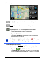
Arriving at your destination
When you have reached your selected destination, a message to this
effect will be displayed.
Only your current position (red arrow) and the destination flag will now
be shown on the map.
7.1
Starting the navigation application
You have switched on the navigation device. The START window is
open.
Tap on Navigation.
The NAVIGATION window is opened. From here you can access all the
functions of the navigation application.
►
Returning to the Start window
You can go to the START window at any time by tapping on on the
(Start) button. This does not result in the current application
being closed.
Initialising the GPS receiver
Note: Good reception of GPS data requires an unobstructed path from
the GPS receiver to the satellites. Tunnels, narrow thoroughfares
between buildings and reflecting house fronts can restrict GPS
reception greatly or make it impossible. If the GPS receiver or the
navigation device is inside a vehicle, a metallised windscreen or a
windscreen heater can be the cause of poor GPS reception.
As soon as the navigation device has been switched on, initialisation of
the GPS receiver will begin.
The integrated GPS receiver is not initialised for the first time until the
navigation application is started for the first time. It can take up to
5 minutes to initialise the GPS receiver for the first time.
Each time you switch on the navigation device after this, GPS reception
will start within a short time.
If the navigation device has not been switched on for more than a week,
it can take up to 10 minutes to re-initialise the receiver.
Note: Directly after the GPS symbol indicates the GPS Ready state,
the accuracy of the positioning may be reduced for a few minutes.
In the top right hand corner of the screen you will see the GPS symbol.
As soon as data from at least three satellites is received, the symbol will
change to
Navigation
(GPS Ready).
- 31 -
User’s manual maps + more
Note: Initialisation takes the least time if you do not start driving until
the initialisation has finished.
For more details about the GPS symbol refer to chapter "GPS" on
page 22.
Returning to the Navigation window
The NAVIGATION window opens when the navigation application is
started.
If another window of the navigation application is open, tap on
(Back). This will return you to the window you came from.
►
7.2
Tap on
opened.
(Back) repeatedly until the NAVIGATION window is
Specifying a destination
Under New Destination you can enter destinations to which you have
not yet navigated or which you have not saved. Here you can
►
►
►
►
enter the address of the destination. (Refer to "Entering a
destination address " on page 34)
enter the coordinates of the destination. (Refer to "Enter
Coordinates" on page 36)
select a point of interest. (Refer to "Points of interest" on page 37)
select a destination with the Direct Access function. (Refer to
"Direct access to POI" on page 40)
Note: The first time that you want to enter a new destination you will be
asked to select the country in which your destination is situated.
Under My Destinations you can select from the following lists of
destinations and addresses:
►
FAVOURITES: All destinations that you have entered and then saved.
(Refer to "Favourites" on page 42)
Three special destinations are also saved in the FAVOURITES list:
►
►
►
►
- 32 -
My Address: The address which was saved as the home
address. ("Defining the home address" on page 48)
My Vehicle: The location of your vehicle is automatically saved
when you leave the vehicle.
My Starting Point: The starting point of the last navigation is
automatically saved.
LAST DESTINATIONS: Destinations to which you have navigated on a
previous occasion. (Refer to "Last Destinations" on page 42)
Navigation
User’s manual maps + more
►
7.2.1
IMPORTED ADDRESSES: All destinations that you have imported from
Microsoft Outlook or from other data sources. (Refer to "Imported
Addresses: Outlook / Internet" on page 43 and "Imported Addresses
from the phone book" on page 44)
Specifying the country in which the destination is situated
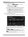
At top left in the ADDRESS, POI IN A CITY and POI NATIONWIDE windows
you will find the Country button. It bears the flag of the country in which
you can currently select destinations for the navigation application.
If your destination is in a different country, then proceed as follows:
1. Tap on the Country button.
2. Enter the name of the country in which your destination is situated.
The button shows the flag of the destination country.
Note: The selection list contains only those countries whose maps are
available to the navigation device.
7.2.2
Entering a destination by voice commands
It is particularly convenient to select the destination by voice
commands.
1. In the NAVIGATION window tap on Voice Command.
The VOICE COMMAND window opens.
Entering an address
2. Say "Address".
Indicated at the top is the country for which you can select
addresses.
►
Tap on the country if your destination address is situated in a
different country. Then follow the instructions given by the
navigation system.
You will be asked for the address data in this order: City > Street >
House number.
3. Follow the instructions given by the navigation system.
When you have finished entering the address, the map will open in
Preview mode. The destination is indicated on the map.
Navigation
- 33 -
User’s manual maps + more
Entering a POI nearby
2. Say "POI Nearby".
3. Say which category of POI you want (e.g. "Hotel").
A list of nearby hotels opens.
4. Say the number of the hotel to which you want to navigate.
Say "Up" or "Down" in order to scroll in the list.
When you have selected a destination, the map opens in Preview
mode. The destination is indicated on the map.
Entering a Favourite or an address from the phone book
2. Say "My Destinations".
3. A list opens. It contains the destinations found in the FAVOURITES
list, destinations imported from Outlook, and destinations from the
phone book of a connected mobile phone.
4. Say the number of the destination to which you want to navigate.
Say "Up" or "Down" in order to scroll in the list.
When you have selected a destination, the map opens in Preview
mode. The destination is indicated on the map.
For detailed information on how to start navigation, please refer to
chapter "Route preview" on page 45. Please read on there.
Note: The Voice Command function is not available for every
language. In the languages for which this function is not available, the
Voice Command button is replaced by the Show Map button.
7.2.3
Entering a destination address
1. In the NAVIGATION window, tap on New Destination > Enter an
Address.
Note: The following description is based on City First as the order for
entering the address.
If the navigation device contains the map of a country in which the
street is usually listed first (e.g. Sweden, Norway, ...), you can also
choose Street First as the order for entering the destination address.
You can define the order in the NAVIGATION window at Options >
Settings > General > Input Mode for Address Data.
Please note however that the Street First order of entry is not possible
for all countries. In this case you must enter the city first.
The ADDRESS window opens.
2. Enter the name or the postal code of the destination town.
- 34 -
Navigation
User’s manual maps + more
3. Enter the name of the destination street.
4. Enter the house number. If you do not know the house number,
then leave this box empty.
If you don't know the house number but know the name of a nearby
side street, then tap on the Cross Street box and enter the name of
this street. The navigation system will calculate a route to the
intersection of the streets you have entered.
The DETAILED INFORMATION ABOUT THE DESTINATION window opens.
Indicated on the Activate MyRoutes button is whether several route
suggestions are to be calculated (Yes) or not (No).
►
Tap on Activate MyRoutes in order to change the setting.
Note: The Activate MyRoutes button is available only when you have
entered all the address information. You can also make this setting
under Options > Settings > Navigation > Activate MyRoutes.
5. Tap on Start Navigation in order to navigate to the stipulated
address.
- or Tap on Parking in order to search for and navigate to a car park
near your destination.
Sometimes the destination cannot be found exactly because, for
example, the entered combination of place and street name exists
several times.
In this case a window will open with a list of all the addresses
matching your entry plus additional information.
►
Tap on the address to which you want to navigate.
If the entered house number is not included on the map, the window
will show an address with the house number closest to the one
entered.
The map opens in Preview mode. The destination is indicated on
the map.
For detailed information on how to start navigation, please refer to
chapter "Route preview" on page 45. Please read on there.
Note: It is not necessary to enter all the address details. You can tap on
(Start Navigation) before you get that far.
If you specify the town only, the navigation system will calculate a route
to the town centre.
If you specify only the town and street without specifying a house
number or cross street, the navigation system will calculate the best
route to this street.
Navigation
- 35 -
User’s manual maps + more
7.2.4
Enter Coordinates
You can also enter the geographic coordinates of your destination. The
coordinates can be entered as decimal degrees or in degrees, minutes
and seconds.
1. In the NAVIGATION window, tap on New Destination > Enter
Coordinates.
The ENTER COORDINATES window opens.
Entering as a decimal number
2. Enter the degree of latitude.
Begin the entry with a minus sign if you want to enter a southern
degree of latitude.
3. Enter the degree of longitude.
Begin the entry with a minus sign if you want to enter a western
degree of longitude.
Entering with minutes / seconds
2. Enter the degree of latitude.
Use the corresponding buttons shown on the keyboard in order to
enter the units:
(degrees),
(minutes),
(seconds).
The (N S) button alongside the entry box indicates whether it is a
northern or southern degree of latitude. The active setting is
highlighted in colour (red).
►
Tap on the button if you want to change the current setting.
3. Enter the degree of longitude.
Use the corresponding buttons shown on the keyboard in order to
enter the units:
(degrees),
(minutes),
(seconds).
The (E W) button alongside the entry box indicates whether it is an
eastern or western degree of longitude. The active setting is
highlighted in colour (red).
Tap on the button if you want to change the current setting.
The DETAILED INFORMATION ABOUT THE DESTINATION window opens.
►
Indicated on the Activate MyRoutes button is whether several route
suggestions are to be calculated (Yes) or not (No).
►
- 36 -
Tap on Activate MyRoutes in order to change the setting.
Navigation
User’s manual maps + more
4. Tap on Start Navigation in order to navigate to the stipulated
address.
- or Tap on Parking in order to search for and navigate to a car park
near your destination.
Note: If the destination with the coordinates you entered does not lie on
the road system covered by the map, navigation will be performed as
far as the nearest road point using the mode defined by the selected
route profile. From this point on, the navigation system will automatically
switch to Offroad mode. (Refer to "Navigation in Offroad mode" on
page 69)
7.2.5
Points of interest
Points of Interest, called POI for short, are useful addresses that are
catalogued according to particular criteria.
POIs include ports, airports, restaurants, hotels, petrol stations, public
buildings, doctor's surgeries, hospitals, shopping centres, etc.
Points of interest can be displayed on the map by means of a symbol.
In the NAVIGATION window tap on Options > Settings > Map Display >
Categories Shown in order to select the categories you want to appear
on the map.
Note: If you have created your own POIs, they will be available under
the MyPOIs category. For more details about creating your own POIs
refer to chapter "MyPOIs: My POIs" on page 75.
POI nearby
POIs nearby are POIs located within a certain radius of your current
location. This means you can always find the nearest petrol station for
example, no matter where you are.
Note: GPS reception must be good enough for determining your
position. Check the
(GPS Ready) symbol to see whether GPS
reception is good enough.
If GPS reception is not good enough, the system will look for POIs near
the last known position. If there is no last known position, the POI
Nearby function will not be available.
For more details refer to the chapter "Initialising the GPS receiver" on
page 31.
Note: The direct access function offers 3 categories of nearby POIs
which can be searched for quickly and without additional entry.
For more details refer to the chapter "Direct access to POI" on page 40.
Navigation
- 37 -
User’s manual maps + more
1. In the NAVIGATION window tap on New Destination > Search for
POI > Nearby.
The POI NEARBY window opens.
2. Select a category from which you would like to find a POI.
Categories in which no destinations are available nearby cannot be
selected.
If sub-categories exist for the category you have selected, the Sub
Category list opens.
3. Select the sub-category from which you would like to select a POI.
The Destination list opens. It contains the nearest POIs in the
specified category, sorted by distance.
4. If the list is very long:
►
Tap on
(Close List).
The keyboard appears.
►
Enter a number of letters from the destination.
►
Tap on
(Open List).
The list now contains only those destinations which begin with the
letters entered.
5. Tap on the name of the destination.
The DETAILED INFORMATION ABOUT THE DESTINATION window opens.
Indicated on the Activate MyRoutes button is whether several route
suggestions are to be calculated (Yes) or not (No).
►
Tap on Activate MyRoutes in order to change the setting.
6. Tap on Start Navigation.
- or Tap on Parking in order to search for and navigate to a car park
near your destination.
The map opens in Preview mode. The destination is indicated on
the map.
For detailed information on how to start navigation, please refer to
chapter "Route preview" on page 45. Please read on there.
POI of nationwide significance
POIs of nationwide significance are airports, sights, national
monuments, large ports etc. This way you can find well-known places of
interest even if you don't know the name of their location.
1. In the NAVIGATION window tap on New Destination > Search for
POI > Nationwide.
The POI NATIONWIDE window opens.
- 38 -
Navigation
User’s manual maps + more
2. Select a category from which you would like to find a POI.
The Destination list opens. It contains the POI from the selected
category, sorted alphabetically.
3. If the list is very long:
►
Tap on
(Close List).
The keyboard appears.
►
Enter a number of letters from the destination.
►
Tap on
(Open List).
The list now contains only those destinations which begin with or
contain the letters entered.
4. Tap on the name of the destination.
The DETAILED INFORMATION ABOUT THE DESTINATION window opens.
Indicated on the Activate MyRoutes button is whether several route
suggestions are to be calculated (Yes) or not (No).
►
Tap on Activate MyRoutes in order to change the setting.
5. Tap on Start Navigation.
- or Tap on Parking in order to search for and navigate to a car park
near your destination.
The map opens in Preview mode. The destination is indicated on
the map.
For detailed information on how to start navigation, please refer to
chapter "Route preview" on page 45. Please read on there.
POI in a particular location
POIs in a particular location can be useful when navigating in an
unfamiliar town.
1. In the NAVIGATION window tap on New Destination > Search for
POI > in a City.
The POI IN A CITY window opens.
2. Enter the name or the postal code of the destination town.
3. Select a category from which you would like to find a POI.
Categories in which no destinations are available in the selected
town cannot be entered.
If sub-categories exist for the category you have selected, the Sub
Category list opens.
Navigation
- 39 -
User’s manual maps + more
4. Select the sub-category from which you would like to select a POI.
The Destination list opens. It contains POI from the specified
category, sorted alphabetically.
5. If the list is very long:
►
Tap on
(Close List).
The keyboard appears.
►
Enter a number of letters from the destination.
►
Tap on
(Open List).
The list now contains only those destinations which begin with or
contain the letters entered.
6. Tap on the name of the destination.
The DETAILED INFORMATION ABOUT THE DESTINATION window opens.
Indicated on the Activate MyRoutes button is whether several route
suggestions are to be calculated (Yes) or not (No).
►
Tap on Activate MyRoutes in order to change the setting.
Sometimes the destination cannot be found exactly because, for
example, several restaurants with the same name exist in the town
in question.
In this case a window opens with all the destinations matching your
entry plus additional information.
►
Tap on the destination to which you want to navigate.
7. Tap on Start Navigation.
- or Tap on Parking in order to search for and navigate to a car park
near your destination.
The map opens in Preview mode. The destination is indicated on
the map.
For detailed information on how to start navigation, please refer to
chapter "Route preview" on page 45. Please read on there.
7.2.6
Direct access to POI
The direct access area contains 3 categories of POI. Destinations in
your vicinity that correspond to one of these categories can be viewed
here quickly and without further entry.
►
- 40 -
In the NAVIGATION window tap on Options > Settings > General in
order to select which categories or sub-categories are to be
available for direct access.
Navigation
User’s manual maps + more
Note: GPS reception must be good enough for determining your
position. Check the
(GPS Ready) symbol to see whether GPS
reception is good enough.
If GPS reception is not good enough, the system will look for POIs near
the last known position. If there is no last known position, the POI
Nearby function will not be available.
For more details refer to the chapter "Initialising the GPS receiver" on
page 31.
1. In the NAVIGATION window tap on New Destination.
The NEW DESTINATION menu opens.
In the Direct Access area you are shown the symbols of those POI
categories that are available by direct access.
2. Tap on the category from which you would like to select a POI.
A list opens. It contains the nearest POIs in the specified category,
sorted by distance.
3. Tap on the name of the destination in order to start navigation to it.
The map opens in Preview mode. The destination is indicated on
the map.
For detailed information on how to start navigation, please refer to
chapter "Route preview" on page 45. Please read on there.
7.2.7
Information about the destination
For many destinations that you specify, there will be further information
available, stored in the navigation system's database.
There is, for example, a telephone number available for many
restaurants. You can then call the restaurant to reserve a table, for
example.
One of the destination entry windows described above is open.
►
Tap on Options > Info.
The DESTINATION INFO window opens. It contains all the information
about the specified destination that is stored in the navigation system's
database.
►
►
►
Navigation
Tap on Close in order to close the DESTINATION INFO window again.
Tap on
map.
(Show on Map) in order to see the destination on the
Tap on
(Save Destination) in order to save the destination in
the FAVOURITES list.
- 41 -
User’s manual maps + more
7.2.8
Favourites
Destinations to which you want to travel often can be saved in the
FAVOURITES list.
In the FAVOURITES list you can save up to 500 destinations.
Information on how to save a destination can be found in chapter
"Saving destinations" on page 48.
1. In the NAVIGATION window, tap on My Destinations > Favourites.
2. Tap on the destination to which you want to navigate.
The DETAILED INFORMATION ABOUT THE DESTINATION window opens.
Indicated on the Activate MyRoutes button is whether several route
suggestions are to be calculated (Yes) or not (No).
►
Tap on Activate MyRoutes in order to change the setting.
3. Tap on Start Navigation.
- or Tap on Parking in order to search for and navigate to a car park
near your destination.
The map opens in Preview mode. The destination is indicated on
the map.
For detailed information on how to start navigation, please refer to
chapter "Route preview" on page 45. Please read on there.
Note: Favourites are indicated on the map by a small flag with their
name.
7.2.9
Last Destinations
The last 12 destinations to which you have navigated are saved by the
navigation system in the LAST DESTINATIONS list.
1. In the NAVIGATION window, tap on My Destinations > Last
Destinations.
2. Tap on the destination to which you want to navigate.
The DETAILED INFORMATION ABOUT THE DESTINATION window opens.
Indicated on the Activate MyRoutes button is whether several route
suggestions are to be calculated (Yes) or not (No).
►
- 42 -
Tap on Activate MyRoutes in order to change the setting.
Navigation
User’s manual maps + more
3. Tap on Start Navigation.
- or Tap on Parking in order to search for and navigate to a car park
near your destination.
The map opens in Preview mode. The destination is indicated on
the map.
For detailed information on how to start navigation, please refer to
chapter "Route preview" on page 45. Please read on there.
7.2.10
Imported Addresses: Outlook / Internet
You can use the NAVIGON Sync software to export to your navigation
system the contact addresses which you have saved in Microsoft
Outlook on your computer.
From many route planners on the Internet it is also possible to copy the
entered destination address directly onto your navigation system. This
function is clearly indicated on those websites which offer it.
Note: You can download NAVIGON Sync free of charge from our
website www.navigon.com/manuals.
Contacts which have been saved with several addresses will appear
once with each address in the IMPORTED ADDRESSES list.
1. In the NAVIGATION window tap on My Destinations > Imported
Addresses > Outlook / Internet.
2. Tap on the address to which you want to navigate.
The DETAILED INFORMATION ABOUT THE DESTINATION window opens.
Indicated on the Activate MyRoutes button is whether several route
suggestions are to be calculated (Yes) or not (No).
►
Tap on Activate MyRoutes in order to change the setting.
3. Tap on Start Navigation.
- or Tap on Parking in order to search for and navigate to a car park
near your destination.
The map opens in Preview mode. The destination is indicated on
the map.
For detailed information on how to start navigation, please refer to
chapter "Route preview" on page 45. Please read on there.
Navigation
- 43 -
User’s manual maps + more
7.2.11
Imported Addresses from the phone book
The phone book of a mobile phone with which you are connected can
be imported into the navigation device. Addresses from the phone book
are then found in the IMPORTED ADDRESSES FROM THE PHONE BOOK list.
1. In the NAVIGATION window tap on My Destinations > Imported
Addresses > From the phone book.
2. Select the contact you want from the phone book.
3. Tap on the address to which you want to navigate.
The DETAILED INFORMATION ABOUT THE DESTINATION window opens.
Indicated on the Activate MyRoutes button is whether several route
suggestions are to be calculated (Yes) or not (No).
►
Tap on Activate MyRoutes in order to change the setting.
4. Tap on Start Navigation.
- or Tap on Parking in order to search for a car park near your
destination.
The map opens in Preview mode. The destination is indicated on
the map.
For detailed information on how to start navigation, please refer to
chapter "Route preview" on page 45. Please read on there.
7.2.12
Navigating home
You can save one address as Home Address. You can navigate to your
home address at any time by pressing a single button.
More information about entering your home address can be found in the
chapter "Defining the home address" on page 48.
►
In the NAVIGATION window tap on Take Me Home.
If you have not yet entered your home address, a dialog box will
notify you of this.
Navigation starts. The route profile used for the previous navigation will
be applied.
- 44 -
Navigation
User’s manual maps + more
7.2.13
Selecting destinations on the map
You may select a destination directly on the map. This is a quick way to
select towns, streets and POI.
1. In the NAVIGATION window tap on Show Map.
- or If the voice commands function is available on your navigation
device and for your language:
►
In the NAVIGATION window, tap on Options > Show Map.
2. Tap on
(Destination search).
The map opens in Destination search mode.
3. Tap on the point to which you want to navigate.
Note: For details of how to change the map view so that your destination
is easily seen refer to the chapter "Map in Destination search mode" on
page 70.
The destination that you have selected appears under the cross
hairs.
The geographical coordinates of the destination and the
corresponding address are shown in the bottom third of the screen.
4. Tap on
(OK).
The DESTINATION ON M AP window opens. The detailed address data
of the selected destination is displayed in the upper left-hand
corner.
5. Tap on Take Me There.
The map opens in Preview mode. The destination is indicated on
the map.
For detailed information on how to start navigation, please refer to
chapter "Route preview" on page 45. Please read on there.
7.2.14
Route preview
The map is open in Preview mode.
The navigation destination is depicted by a small flag.
For detailed information refer to the chapter "Map in Preview mode" on
page 60.
Navigation
- 45 -
User’s manual maps + more
Route Profile
The route is calculated on the basis of a route profile. The current route
profile is indicated at the top right edge of the map.
Route profiles take account of the characteristics and special aspects of
the different modes of transport. For example a route profile for bicycles
will exclude motorways from the route calculation but will include roads
which other vehicles are not allowed to use. And a bicycle profile will
calculate different arrival times than a motorcycle profile.
Note: If you select a pedestrian profile, a type of navigation specially
developed for pedestrians will be started. (Refer to "Navigation in
Pedestrian mode" on page 66)
►
Tap on the Route Profile button if you want to select a different
route profile.
For details of how to create and select route profiles refer to chapter
"Route profiles" on page 71.
Turn-by-Turn List
►
If you want to see detailed directions for the route, tap on Options >
Turn-by-Turn List.
For details of the functions in the TURN-BY-TURN LIST window refer to
chapter "Turn-by-Turn List" on page 87.
MyRoutes
When the MyRoutes function is activated, the navigation system
calculates up to three routes on the basis of the currently selected route
profile and shows them on the map in different colours (blue, green,
red) and with a number. For each route there is a button with the same
number and a symbol in the same colour.
When calculating the time of arrival or the trip time, the navigation
system takes account of additional factors such as day of the week,
time of day and particularly your previous driving profile.
The route which corresponds best to the selected route profile is
marked with "MyRoute".
Note: Even when the MyRoutes function is activated, sometimes only
one additional route or no additional routes at all can be calculated for a
particular route. No further suggestion is then shown on the button in
question.
- 46 -
Navigation
User’s manual maps + more
Start Navigation
►
Tap on the button of the route which you want to use for the
navigation.
If you select a route for which traffic obstructions have been announced,
the PREVIEW TMC window may open before navigation starts. (Refer to
"Preview TMC" on page 89)
►
Select whether you want to use the original route (Current Route) or
a detour (Alternative route).
No GPS reception
If GPS signal reception is not good enough, the following message will
appear: "Waiting for GPS-Signal…"
You have the following options:
►
►
►
Wait. As soon as GPS reception is good enough for determining
your position, the route will be recalculated and navigation will
begin.
Tap on Cancel. The window in which you entered your destination
will open again. Your destination is saved in the LAST DESTINATIONS
list.
Tap on Demo. The route will be calculated using the centre of the
destination location as starting point. Navigation will then be
simulated on this route.
Tap on
(Back) in order to terminate the demonstration.
Note: If you selected the destination on the map, then the Demo button
is not available.
7.3
Managing destinations
Every destination you enter and destinations from the LAST
DESTINATIONS and IMPORTED ADDRESSES lists can be saved in the
FAVOURITES list. This makes sense if you frequently navigate to this
particular destination.
Note: Favourites are indicated on the map by a small flag with their
name.
Navigation
- 47 -
User’s manual maps + more
7.3.1
Saving destinations
1. Enter a destination. (Refer to "Entering a destination address " on
page 34 or "Points of interest" on page 37). Do not tap on the Start
Navigation button!
2. Tap on Options > Save Destination.
- or 1. Select a destination from the LAST DESTINATIONS list or from the
IMPORTED ADDRESSES list. (Refer to "Last Destinations" on page 42
or "Imported Addresses: Outlook / Internet" on page 43). Do not
tap on the Start Navigation button!
2. Tap on Options > Save as Favourite.
3. Enter a name for the destination.
4. Tap on Save.
7.3.2
Deleting a destination from the Favourites list
1. In the NAVIGATION window, tap on My Destinations > Favourites.
The FAVOURITES list opens.
2. Select the destination you want to delete.
The DETAILED INFORMATION ABOUT THE DESTINATION window opens.
3. Tap on Options > Delete Destination.
7.3.3
Defining the home address
You can always start navigation to your home address very quickly by
tapping in the NAVIGATION window on Take Me Home.
You can define exactly one destination as your home address. You can
enter the address manually or select a destination from the FAVOURITES
list.
Your home address is saved in the FAVOURITES list where it is marked
by a house symbol.
Note: The home address is also indicated on the map by a house
symbol.
- 48 -
Navigation
User’s manual maps + more
Entering the home address
1. In the NAVIGATION window tap on Take Me Home.
A window with the following message opens:
"Would you like to enter the address now?"
If you have already saved favourites, the message will be as
follows:
"Do you want to enter the address, or do you want to select it from
the Favourites?"
The currently valid value is highlighted (red).
►
If Enter an Address is NOT highlighted, tap on
(Toggle).
2. Tap on OK.
The ADDRESS window opens.
3. Enter your home address. (Refer also to Entering a destination
address on page 34)
4. Tap on
(Home Address) to save the specified address as the
home address.
Selecting the home address from your favourites
1. In the NAVIGATION window tap on Take Me Home.
A window with the following message opens:
"Do you want to enter the address, or do you want to select it from
the Favourites?"
If you have not yet saved any favourites, the message will be as
follows:
"Would you like to enter the address now?"
In this case you must enter the home address manually. (Refer to
"Entering the home address" on page 49)
►
If Favourites is NOT highlighted, tap on
(Toggle).
2. Tap on OK.
The FAVOURITES list opens.
3. Select the destination which you want to define as your new home
address. (Refer also to Favourites on page 42)
The DETAILED INFORMATION ABOUT THE DESTINATION window opens.
(Home Address) to save the specified address as the
4. Tap on
home address.
Navigation
- 49 -
User’s manual maps + more
7.3.4
Changing the home address
You can define a different address as the home address at any time.
Proceed as follows:
1. Delete your home address from the FAVOURITES list. (Refer to
"Deleting a destination from the Favourites list" on page 48)
2. Enter the new home address. (Refer to "Defining the home
address" on page 48)
7.4
Tracks and multi-leg routes
It is possible to plan routes without GPS reception, for example in the
comfort of your home. Planned routes can be saved for later use. This
allows you to plan as many routes as you like, for example for your
holidays.
1. In the NAVIGATION window tap on Options.
The options list opens.
2. Tap on the Routes and Tracks option.
The ROUTES AND TRACKS window opens.
7.4.1
Entering the starting point
The starting point of a route is the point at which you want to begin your
trip. This is not necessarily the current location. If you are planning a
route for your holidays at home, you could, for example, enter your
hotel as the starting point.
The starting point is only important if you want to see a planned route
on the map but currently have no GPS reception, or if you are not
currently at the planned starting point. This is why your selected starting
point has the flow number "0".
As soon as you start navigation, your current location will be used as
the starting point for the route calculation.
The first leg of the route is therefore the journey to the route point with
flow number "1".
1. Tap on the Specify Starting Point box.
The STARTING POINT menu opens.
If you want to enter your current location as the starting point:
2. Tap on the Current Position menu item.
- 50 -
Navigation
User’s manual maps + more
If you want to enter a different starting point:
2. Tap on the corresponding button.
3. Enter the starting point. (Refer to the corresponding section of the
chapter "Specifying a destination" on page 32.)
4. Tap on
(Set Starting Point).
The selected starting point will now be shown next to the 0 (Starting
Point) button.
Changing the starting point
►
Tap on the starting point (button 0).
The STARTING POINT menu opens. You can now enter a different
starting point. Proceed as described above.
7.4.2
Entering route points
The route points of a route are the destinations that you want to
navigate to.
The flow number for each route point is indicated on a button in front of
it.
1. Tap on the Add Route Point box.
The ROUTE POINT menu opens.
2. Tap on the button for how you want to enter the destination.
3. Enter the route point. (Refer to the corresponding section of the
chapter "Specifying a destination" on page 32.)
4. Tap on
(Add).
The selected route point is now shown next to its flow number.
Repeat these steps for each destination that you want to add to your
route.
7.4.3
Editing route points
Route points can be deleted from a route. The order of the route points
can be changed as you wish.
Note: The starting point (flow number "0") can be neither moved nor
deleted. However you can make another route point into the starting
point provided the Current Position setting was not selected for the
starting point.
►
Navigation
Tap on the route point that you want to edit.
- 51 -
User’s manual maps + more
The context menu contains the following buttons:
Route Point Up: Moves the selected route point further to the front.
(Example: route point 2 becomes route point 1)
Route Point Down: Moves the selected route point further to the
back. (Example: route point 2 becomes route point 3)
Delete: Deletes the selected route point. A dialog window prompts
you to confirm deletion.
►
7.4.4
Tap on the number to the left of the symbols if you want to close the
context menu again.
Managing routes
You can save each planned route under a particular name.
Note: Only the start point and route points will be saved, not the
calculated route. When you load a saved route, it must be recalculated
before navigation can start.
You can load, rename or delete stored routes.
Saving routes
The ROUTES AND TRACKS window is open. You have entered the
starting point and at least one route point.
1. Tap on Options > Save Route.
2. Enter a name for the route.
(Save).
3. Tap on
The destination is now saved to the SAVED ROUTES AND TRACKS list.
The dialog window closes.
7.4.5
Loading routes or tracks
1. Tap on Options > Saved Routes and Tracks.
The SAVED ROUTES AND TRACKS list opens. It shows all the saved
routes and tracks in alphabetical order.
A symbol in front of the name indicates whether it is a route (
or a track (
- 52 -
)
).
Navigation
User’s manual maps + more
If you want to load a route:
2. Tap on the route that you want to load.
3. Tap on
(Load Route).
The ROUTES AND TRACKS window opens. The starting point and the
route points of the loaded route have been entered. When
navigation starts, the starting point is replaced by the current
position. You will now be guided to the first route point.
If you want to load a track:
2. Tap on the track that you want to load.
3. Tap on Load Track.
The ROUTES AND TRACKS window opens. The current location is
entered as the starting point. The loaded track is entered as route
point 1. Navigation then leads first to the starting point of the track.
For details about navigating along recorded tracks refer to chapter
"Navigation in Track mode" on page 68.
7.4.6
Calculating and displaying routes
It is possible to calculate and display a planned route on the map even
without GPS reception in order to get an impression of the journey.
The ROUTES AND TRACKS window is open. The starting point and at
least one route point have been entered.
►
Tap on Show Route.
The map opens in Preview mode.
The starting point and the route points are marked by flags. The
distance and the estimated trip time is given for each leg of the
route.
7.4.7
Simulating routes
It is also possible simply to simulate navigation on a planned route.
Note: GPS reception is not necessary for simulation.
If you have planned a multi-leg route, only the first leg will be simulated.
You have calculated and displayed a route.
1. Tap on Options > Simulation.
►
If you have planned a route with only one route point and the
MyRoutes function is activated, you will be prompted to select
a route for the simulation.
The route will be recalculated for simulation purposes.
Navigation
- 53 -
User’s manual maps + more
2. Tap on the button of the route on which you want to simulate the
navigation.
For more details about the MyRoutes function refer to the chapter
"MyRoutes" on page 55.
Stopping simulation
You can stop simulation at any time.
►
Tap on
(Back).
The ROUTES AND TRACKS window opens.
7.4.8
Route preview
You have calculated and displayed a route. The map is open in
Preview mode.
Route Profile
Route profiles take account of the characteristics and special aspects of
the different modes of transport. For example a route profile for bicycles
will exclude motorways from the route calculation but will include roads
which other vehicles are not allowed to use. And a bicycle profile will
calculate different arrival times than a motorcycle profile.
Note: If you select a pedestrian profile, a type of navigation specially
developed for pedestrians will be started. (Refer to "Navigation in
Pedestrian mode" on page 66)
►
Tap on the Route Profile button if you want to select a different
route profile.
For details of how to create and select route profiles refer to chapter
"Route profiles" on page 71.
Note: When you load routes which originate from a different provider
than NAVIGON, it may be impossible for you to change the route profile
of this route.
Turn-by-Turn List
If you want to see detailed directions for the route, tap on Options >
Turn-by-Turn List.
For details of the functions in the TURN-BY-TURN LIST window refer to
chapter "Turn-by-Turn List" on page 87.
- 54 -
Navigation
User’s manual maps + more
MyRoutes
When the MyRoutes function is activated, the navigation system
calculates up to three routes on the basis of the currently selected route
profile and shows them on the map in different colours (blue, green,
red) and with a number. For each route there is a button with the same
number and a symbol in the same colour.
When calculating the time of arrival or the trip time, the navigation
system takes account of additional factors such as day of the week,
time of day and particularly your previous driving profile.
The route which corresponds best to the selected route profile is
marked with "MyRoute".
Note: The MyRoutes function can be used only for routes with only one
route point. For routes with two or more route points only one route is
calculated and displayed, regardless of whether you have activated the
function or not.
Note: Even when the MyRoutes function is activated, sometimes only
one additional route or no additional routes at all can be calculated for a
particular route. No further suggestion is then shown on the button in
question.
Start Navigation
►
Tap on the button of the route which you want to use for the
navigation.
If you select a route for which traffic obstructions have been announced,
the PREVIEW TMC window may open before navigation starts. (Refer to
"Preview TMC" on page 89)
►
Select whether you want to use the original route (Current Route) or
a detour (Alternative route).
No GPS reception
If GPS signal reception is not good enough, the following message will
appear: "Waiting for GPS-Signal…"
You have the following options:
►
►
Navigation
Wait. As soon as GPS reception is good enough for determining
your position, the route will be recalculated and navigation will
begin.
Tap on Cancel. The map opens in Preview mode.
- 55 -
User’s manual maps + more
8
Options
Some windows offer options that lead to more functions.
►
Tap on Options.
►
Tap on the option you would like to use.
►
If you would like to quit the options list without selecting an option,
tap on the Options button again.
2D/3D: Changes between 2D and 3D mode. The symbol indicates the current
mode.
Add to Route: Opens the route planning. The address specified will be added as
a route point. (Refer to "Tracks and multi-leg routes" on page 50)
Block: Opens a window in which you can block a section of the route lying
ahead in order to calculate a route which avoids this section, e.g. if you
have heard on the radio of a traffic jam relating to this section. (Refer to
"Block" on page 87)
Day/Night: Changes between "Day" and "Night" screen modes. The symbol
indicates the current mode.
Delete All: Deletes all destinations in the list (LAST DESTINATIONS list or
FAVOURITES list, depending on where you opened the options). The list
is then empty. A dialog window prompts you to confirm deletion.
Delete Destination: Deletes the selected destination from the list (LAST
DESTINATIONS or FAVOURITES, depending on where you opened the
options). A dialog window prompts you to confirm deletion.
Direct Help: Opens a window in which you can find in quick and uncomplicated
manner the addresses and phone numbers of offices in your direct
vicinity that can be useful in emergencies. (Refer to "Direct Help" on
page 86)
Factory Settings: Resets all settings to the as-delivered state. Routes and
saved destinations are deleted. The software is re-started and behaves
as if started for the first time after being purchased. (Refer to "Switching
the navigation device on and off" on page 15)
GPS Status: Opens the GPS STATUS window. Here you can see details
regarding GPS reception. You can also save the data of your current
location. (Refer to "GPS Status, saving the current location" on
page 86)
- 56 -
Options
User’s manual maps + more
Home Address: Saves the selected destination as your home address. You can
then always start navigation to this destination very quickly by tapping in
the NAVIGATION window on Take Me Home.
Interim Destination: Sets the selected point as interim destination. The
navigation system will first guide you to this interim destination.
Afterwards you can continue navigation to your original destination.
Manual: Opens the manual on the navigation device. (Refer to "Manual" on
page 20)
MyReport: Opens the MYREPORT window. Here you can notify NAVIGON about
any changes to traffic monitoring systems and routing.
MyRoutes: Opens the map in Preview mode. You are provided with up to three
different suggestions as to how you can continue your journey. Select
one of the routes offered.
New Route: Deletes the starting point and all route points from the ROUTES AND
TRACKS window so that you can plan a new route. If necessary, save
the previously planned route!
Parking: Starts the search for car parks near the destination. Once you have
decided in favour of a car park, you can navigate there directly.
POI on Your Route: Opens a list with POIs lying on your route. A destination
shown here can be selected as an interim destination and can be
navigated to. (Refer to "MyBest POI: POI on Your Route" on page 80)
Product Information: Here you are shown the version numbers and copyright
details of the hardware and software.
Rename: Opens a window in which you can change the name for the selected
destination or route.
Route Profile: Opens the ROUTE PROFILE window. Here you can view the
options for route planning and, if necessary, change them.
Routes and Tracks: Opens the ROUTES AND TRACKS window. Here you can plan
routes, manage planned routes and start navigation on a planned route.
(Refer to "Tracks and multi-leg routes" on page 50)
Save as Favourite: Saves the selected destination to the FAVOURITES list. (Refer
to "Saving destinations" on page 48)
Save Destination: Saves the selected address in the FAVOURITES list. (Refer to
"Saving destinations" on page 48)
Options
- 57 -
User’s manual maps + more
Save Position: Opens the SAVE DESTINATION AS window. Here you can save
your current position under a certain name in the FAVOURITES list.
Save Route: Opens a window in which you can save the planned route under a
specific name. (Refer to "Saving routes" on page 52)
Saved Routes and Tracks: Opens a window in which you can load a saved
route or a track.
Settings: Opens the SETTINGS window. Here you can configure the navigation
system. (Refer to "Configuring the Navigation System" on page 134)
Show Map: Opens the map in Standard mode. (Refer to "Map in Standard
mode" on page 59)
Show on Map: Shows the selected address on the map.
Sightseeing Tours: Opens the SIGHTSEEING TOURS window. There you can
select a sightseeing tour and start the navigation on a tour. (Refer to
"Sightseeing Tours" on page 84)
Simulation: Simulates a navigation on the route indicated. This simulation can
be performed without GPS reception. On multi-leg routes, only the first
leg is simulated.
Skip current destination: Tap on this button to omit the next route point. This
button is active only when at least 2 route points still lie ahead of you.
(Refer to "Tracks and multi-leg routes" on page 50)
Start Recording, Stop Recording: Starts or ends the recording of a track. (Refer
to "Tracks" on page 77)
Traffic: Opens the TRAFFIC INFORMATION window in which pending reports are
listed. (Refer to "TMC (Traffic Information)" on page 89)
Turn-by-Turn List: Shows detailed directions for the route, including all points at
which you must turn. (Refer to "Turn-by-Turn List" on page 87)
9
Working with the map
9.1
Selecting the navigation map
Each country has its own navigation map. Seamless navigation over
several maps on one continent is possible however if a continuous
route can be calculated with the maps saved on the device.
- 58 -
Working with the map
User’s manual maps + more
Even if maps of countries in other continents are available on the
navigation device, it can only ever work with the maps of a single
continent.
Tap in the NAVIGATION window on Options > Settings > Map Display in
order to see which maps are currently in use. Here you can also select
a different continent if the navigation device contains any maps of
countries on other continents.
9.2
Map in Standard mode
The map is always in Standard mode when you are not navigating,
have not calculated a route and are not searching for a destination on
the map.
Under the following circumstances the map switches automatically to
Standard mode:
►
►
You begin a trip while the NAVIGATION window is open. The switch
takes place after only a short while.
You reach the destination of a navigation in Vehicle mode.
To open the map:
►
In the NAVIGATION window tap on Show Map.
Note: If GPS reception is not good enough to establish your location, the
map will be opened in Destination search mode.
The following features are typical for this view:
►
►
Indicated in the middle of the lower third is your current position (red
arrow). The map view follows your movements so that your position
is always visible on the screen.
The scale of the map changes according to your speed.
Working with the map
- 59 -
User’s manual maps + more
Map options in Standard mode
►
Tap on Options.
A window with several buttons opens.
The most important functions for navigation can be reached via buttons
with symbols.
Other functions are found by tapping on one of the buttons Destination,
Route, Services or General.
A description of all available options can be found in the chapter
"Options" on page 56.
9.3
Map in Preview mode
You have entered a destination and tapped on Start Navigation.
- or You have planned or loaded a route and tapped on Show Route.
The map opens in Preview mode.
1
(Route Profile) button.
The current route profile is indicated on the
The symbol illustrates the mode of transport on which the profile is
based. (Refer to "Route profiles" on page 71)
►
2
Tap on the symbol to select a different route profile.
For each route (blue, green, red) there is a button with the same
number and a symbol in the same colour. Indicated on each button are
the estimated time of arrival, the total distance and the estimated
duration of the particular route.
If traffic messages exist for a route, the number of messages is
indicated in a small traffic sign on the button. The reported obstructions
are also indicated on the route.
- 60 -
Working with the map
User’s manual maps + more
The route which corresponds best to the selected route profile is
marked with "MyRoute".
If the MyRoutes function is not activated, only one route is presented.
As soon as you tap on a button, navigation along the route in question
will start.
3
The current position is indicated (red arrow).
If you display a planned or loaded route and the specified starting point
is not your current location, then it is possible that your current position
will not be shown on the preview.
4
When the MyRoutes function is activated, up to three numbered routes
are indicated on the map in different colours (blue, green, red).
In the following cases only one route is shown:
5
►
The MyRoutes function is deactivated.
►
You have planned a route with more than one route point.
►
A route profile with the Pedestrian speed profile is active.
►
The route includes a track.
The destination is marked with a little flag.
If you display a planned or loaded route, the starting point and each
route point will be marked with a little flag.
In the case of a multi-leg route, the distance and the estimated driving
time for each leg are shown.
►
►
Tap on the
(Route Profile) button (refer to the figure, point 1) in
order to select a different route profile.
To start the navigation, tap on the button for the route (see figure,
point 2) you want to use for the navigation.
If you display a planned or loaded route, the route may be
recalculated. The starting point for the calculation will now be your
current location. You will first be guided to the first route point
entered.
►
►
Tap on Options > Turn-by-Turn List to view detailed directions for
the route. (Refer to "Turn-by-Turn List" on page 87)
Tap on
(Destination search) in order to view the map in
Destination search mode. (Refer to "Map in Destination search
mode" on page 70)
Working with the map
- 61 -
User’s manual maps + more
9.4
Map in Navigation mode
How you are guided to your destination depends on various factors (the
route profile selected, your current location, the type of route planning,
traffic information along the route, etc.). Your navigation system
automatically selects the optimum method.
9.4.1
Navigation in Vehicle mode
After the route was shown in Preview mode, navigation was started.
The map opens in Navigation mode.
1
If any information is available about the sign which you should follow, it
will be shown at the top edge of the screen.
►
2
Tap on the display to hide the sign.
The POI on Your Route bar will open (refer to "POI on Your Route" on
page 80). This button is not visible when a sign is being shown (see
point 1).
For a description of the POI on Your Route function refer to chapter
"POI on Your Route" on page 80.
- 62 -
Working with the map
User’s manual maps + more
3
Possible speed limits may be shown here.
4
When two manoeuvres need to be executed in quick succession, the
small arrow box indicates the second manoeuvre to be executed.
5
Your current position is indicated on the map (red arrow). The section of
the map displayed changes continually so that your current position is
always in view on the map.
6
The large arrow box shows a diagram of the next junction which you
should turn on to. The distance remaining to this junction is indicated
underneath.
As you get closer to the junction you will see a bar in addition to the
distance:
The fuller the bar, the closer you are to the junction.
If you don't have to change direction for a long time, you will see only a
straight arrow. The distance you must continue straight on is indicated
underneath the arrow.
7
►
Tap on the large arrow box to hear current route instructions.
The Traffic Information box opens if a reported traffic obstruction
affects your route.
If a distance is indicated in the Traffic Information box, no detour route
was calculated yet for the traffic obstruction in question.
►
Tap on the Traffic Information box in order to open the
PREVIEW TMC window. It shows a map view with the route section
affected by the message and a possible detour.
If no distance is indicated, all the obstructions which are reported for
your route and would lead to a loss of time will be avoided.
►
Tap on the Traffic Information box in order to open the TRAFFIC
INFORMATION window. (Refer to "Displaying traffic information" on
page 91)
Note: The calculation of detour routes to avoid reported traffic
obstructions can be performed automatically. (Refer to "TMC Settings"
on page 92)
8
When you get close to your destination, the Parking button will appear.
If you tap on the Parking box you will be given two options:
►
►
You can select a car park from where you can then continue on
foot.
When you have parked your vehicle, you can save the current
position and continue the navigation on foot.
Working with the map
- 63 -
User’s manual maps + more
For a description of the Parking function refer to chapter "Parking near
the destination" on page 78.
9
When you get close to a NAVIGON Sightseeing sight, the NAVIGON
Sightseeing button will appear instead of the height above sea level and
the speed (point 10). The distance indicated on the button tells you how
far away the sight is (beeline).
If you tap on the NAVIGON Sightseeing button, the DESTINATION INFO
window will open (refer to "Displaying information about a NAVIGON
Sightseeing sight" on page 83).
For a description of the NAVIGON Sightseeing function refer to chapter
"NAVIGON Sightseeing" on page 82.
10
The height above sea level and the current speed are shown here.
11
12
The route is highlighted in blue.
In the Total box you can see the distance remaining to the destination,
the estimated duration of the trip and the estimated time of arrival.
►
►
13
Tap on the arrival time if you want to see the estimated driving time
instead.
Tap once again on the info box if you want to see the estimated
time of arrival.
If you are navigating a multi-leg route, you will see the remaining
distance to the next interim destination and the estimated time of arrival
in the Next box.
►
►
Tap on the arrival time if you want to see the estimated driving time
instead.
Tap once again on the info box if you want to see the estimated
time of arrival.
14
The name of the route section that you need to drive onto next is shown
in the upper road box.
15
The name of the section you are currently driving on is shown in the
lower road box.
16
Ahead of many junctions the information from points 10 and 12 is
hidden. Instead you are shown which lanes lead to your destination.
►
Tap on the box in order to hide the lane information.
Note: The displays of many of the above mentioned areas can be
configured in Options > Settings > Navigation. Some displays will only
function if the required information is available on the map.
Note: If you tap on the large arrow box, the current route instruction will
be repeated.
- 64 -
Working with the map
User’s manual maps + more
Note: If you leave the road system covered by the map, the navigation
will switch to Offroad mode. (Refer to "Navigation in Offroad mode" on
page 69)
►
►
Tap on Options > Route > Turn-by-Turn List in order to view a turnby-turn list. (Refer to "Turn-by-Turn List" on page 87)
Tap on
(Destination search) in order to view the map in
Destination search mode. (Refer to "Map in Destination search
mode" on page 70)
Volume
The volume of the spoken driving instructions can be adjusted during
navigation.
When the device is mounted in the vehicle:
►
You can regulate the volume on the radio when a navigation
instruction is being announced.
Tap on the large arrow box (see point 6 in the figure at the
beginning of this chapter). A current instruction will then be
announced.
When the device is not mounted in the vehicle:
1. Tap on
(Volume).
The volume bar opens. It contains three buttons for adjusting the
volume.
(Louder),
2. Tap on
(Quieter),
(Volume on/off).
(Volume) again or wait a few seconds.
The volume bar closes.
Reality View
The map switches to Reality View mode when you approach one of the
following points while driving on the motorway:
►
a motorway junction
►
a three-leg motorway junction
►
the exit you must take to leave the motorway
Working with the map
- 65 -
User’s manual maps + more
The Reality View mode shows with greater clarity the signposting and
lanes you must follow.
This display does not change until you have passed the spot indicated.
The map will then change back to Navigation mode.
►
If you want to change to Navigation mode before then, just tap on
any point on the map.
Note: The Reality View mode is not available for all motorway
junctions and three-leg motorway junctions. Availability depends on the
map material used.
9.4.2
Navigation in Pedestrian mode
This mode is active if you have selected a pedestrian route profile for
the navigation. These profiles can be identified by the
(Pedestrian)
symbol.
After the route was shown in Preview mode, navigation was started.
You receive a route proposal which is calculated on the basis of the
digitalised road system. You are also shown in which direction your
destination lies. If you leave the proposed route, for example in order to
take a more pleasant route through a park, you will still see at all times
the direction in which your destination lies.
Please note:
►
►
►
- 66 -
You will receive no navigation instructions. Instead you will receive
a message when you are getting close to the destination.
The map view follows your movements so that your position is
always visible on the screen.
If you leave the calculated route, the route will not be recalculated
automatically.
Working with the map
User’s manual maps + more
►
►
If you are navigating on a route and more route points are still to
follow, navigation to the next route point will be started immediately
after the message.
Traffic messages are not taken into account.
Note: In pedestrian mode you must take care to hold the device without
covering it at the top. The GPS receiver is located there and its
reception could be impaired..
1
The scale of the map section shown is indicated here. The length of the
ruler corresponds to the distance indicated.
2
The route which was calculated using the digitalised road system is
marked in blue.
3
The current position is indicated (red arrow). You can see in which
direction you are moving.
4
The part of the route which you have already covered is marked in
green.
5
The compass indicates where north is.
6
The direction in which your destination lies is indicated (red triangle).
7
In this box you are shown the distance remaining to the destination
(beeline).
Operating the map
Zoom Out: The map section shown becomes larger, but you will see
fewer details.
Working with the map
- 67 -
User’s manual maps + more
Zoom In: The map section becomes smaller, but you will see more
details.
Centre the position: During pedestrian navigation you can shift the
visible map section in order to view the surrounding area on the map.
This may mean that your current position can no longer be seen on the
visible section of the map.
►
Tap on the Centre the position button if your current position can no
longer be seen on the visible section of the map.
Your current position will be shown again on the map.
Recalculate route: Recalculates the route. Use this function if you have
wandered far from the calculated route and would like a new route
proposal.
9.4.3
Navigation in Track mode
This mode becomes active if you have planned a route with a track for
the navigation. (Refer to "Tracks and multi-leg routes" on page 50)
After the route was shown in Preview mode, navigation was started.
First the navigation guides you from your current location to the
beginning of the loaded track. This navigation corresponds to the
navigation of the selected route profile. (Refer to "Navigation in Vehicle
mode" on page 62 and "Navigation in Pedestrian mode" on page 66)
As soon as the first recorded point of the track is reached, the
navigation switches to Track mode.
Navigation in Track mode works like navigation in Pedestrian mode.
(Refer to "Navigation in Pedestrian mode" on page 66)
There are only a few differences:
►
►
- 68 -
The Recalculate route function is not available.
If more route points follow after the track, the navigation will switch
back to the originally selected mode.
Working with the map
User’s manual maps + more
9.4.4
Navigation in Offroad mode
Note: This mode does not become active if you have selected a
pedestrian route profile for the navigation. These profiles can be
identified by the
(Pedestrian) symbol.
Nor does it become active if you are navigating along a track. (Refer to
"Navigation in Track mode" on page 68)
If you enter a destination which lies off the digitalised road system, the
navigation will guide you first in Vehicle mode to the point of the
digitalised road system that lies nearest to the destination. From here
the navigation then continues in Offroad mode.
If the current position at the beginning of navigation lies off the
digitalised road system, the navigation will guide you first in Offroad
mode to the nearest point of the digitalised road system. From here the
navigation then continues in Vehicle mode.
Navigation in Offroad mode works like navigation in Pedestrian mode.
(Refer to "Navigation in Pedestrian mode" on page 66)
There are only a few differences:
9.4.5
►
The part of the route already covered is not shown.
►
The Recalculate route function is not available.
Map options in Navigation mode
►
Tap on Options.
A window with several buttons opens.
The most important functions for navigation can be reached via buttons
with symbols.
Other functions are found by tapping on one of the buttons Destination,
Route, Services or General.
A description of all available options can be found in the chapter
"Options" on page 56.
9.4.6
Quitting navigation
You quit the navigation in the same way in all modes:
►
Tap on
(Back) in order to quit navigation. A dialog box will
prompt you to confirm.
Working with the map
- 69 -
User’s manual maps + more
9.5
Map in Destination search mode
The map is always in Destination search mode, when a pair of cross
hairs are to be seen. Indicated in the address box are the coordinates
and, where applicable, the name of the street under the cross hairs.
When you are driving, the map does not change. It is always orientated
with north at the top.
Zoom Out: The map section shown becomes larger, but you will see
fewer details.
Zoom In: The map section becomes smaller, but you will see more
details.
Zoom Mode: When this button is active you can mark out a section of
the map with your finger.
Mark out the section from upper left to bottom right to zoom in until the
section fills the screen.
Mark out the map section from bottom right to top left to zoom out.
Pan Mode: When this button is active you can change the section of
map shown with your finger. Simply drag the map in the desired
direction.
Entire Route: Zooms the map so that the entire route is visible.
Current Position: Selects the section of map displayed so that the
current location is at the centre.
- 70 -
Working with the map
User’s manual maps + more
9.5.1
Operating in Destination search mode
1. Tap on the point to which you want to navigate.
The destination that you have selected appears under the cross
hairs.
The geographical coordinates of the destination and the
corresponding address are shown in the bottom third of the screen.
2. Tap on
(OK).
Buttons with various functions will be displayed.
Take Me There: Starts navigation to the selected point. If you are currently
navigating, this route navigation will be cancelled.
MyReport: Opens the MYREPORT window. Here you can notify NAVIGON about
any changes to traffic monitoring systems and routing.
Interim Destination: Sets the selected point as interim destination. The
navigation system will first guide you to this interim destination.
Afterwards you can continue navigation to your original destination.
This function is only active during navigation.
Add to Route: Adds the selected point to the route planning as the last point.
Navigation will then continue to this point after you have reached the
original destination or the other route points.
Save: Opens the SAVE DESTINATION AS window. You can enter a name under
which the selected point will be saved in the FAVOURITES list. (Refer to
"Saving destinations" on page 48)
Search Nearby: Opens the POI NEARBY window. Here you can search for
destinations near the selected point. (Refer to "POI nearby" on page 37)
►
Tap on
(Back) in order to quit Destination search mode.
You will be returned to the window from which you started this
mode.
10
Useful functions
10.1
Route profiles
Route profiles define the characteristics and special aspects of the
different modes of transport which are to be taken into account when
calculating routes. For example a route profile for bicycles will exclude
motorways from the route calculation but will include roads which other
vehicles are not allowed to use. And different arrival times will be
calculated for a bicycle than for a motorcycle for example.
Useful functions
- 71 -
User’s manual maps + more
10.1.1
Route profile settings
A route profile is made up of several settings:
►
►
►
►
►
Speed Profile: Defines the mode of transport (e.g. Bicycle,
Pedestrian, Car, ...).
Type of Route: Defines the type of route which is to be calculated
(e.g. Short Route, Fast Route, ...).
Consider Traffic Information: Defines whether traffic messages are
to be considered when calculating the route.
Motorways, Ferries, Restricted Areas: Defines whether these types
of road are allowed to be used.
Use of Toll Roads: Defines whether toll roads are allowed to be
used when calculating the route.
►
Tap on the
(Edit) button.
The USE OF TOLL ROADS window opens.
►
Adapt the individual settings to your requirements (Yes, No, Ask
before). (Refer also to "Configuring the Navigation System" on
page 134)
If you activate the Ask before setting, every time your route can
take a toll road you will be prompted to make the corresponding
setting(s).
For each setting there is a
(Help) button. When you tap on it you
will see an exact definition of the setting in question.
The number of possible settings depends on the selected speed profile.
For example, for the Pedestrian speed profile there are no Motorways
and Use of Toll Roads settings.
10.1.2
NAVIGON basic profiles
A basic profile is already defined for each speed profile.
Bicycle
Pedestrian
Lorry
Motorbike
Car
The speed profile of a basic profile cannot be changed. You can adapt
the other settings to your requirements.
Basic profiles cannot be renamed or deleted.
- 72 -
Useful functions
User’s manual maps + more
To have a choice of different profiles for example for several cars, you
can create your own route profiles.
10.1.3
Creating a new route profile
You can create your own route profiles. This makes sense for example
if you own two cars and only one has a prepaid toll disc for Austrian
motorways.
1. Tap on Options > Settings.
If the map is open in Standard mode, tap on Options > General >
Settings.
2. Tap on the
(Current Route Profile) button. This button can also
show a different symbol.
3. Tap on the name of the route profile which you want to take as
basis for the new profile.
4. Tap on Options > Copy.
5. Enter a name for the route profile.
6. Tap on Save.
7. Adapt the route profile to your requirements.
8. Tap on OK.
The new route profile is shown in the ROUTE PROFILES list.
10.1.4
Selecting a route profile
1. Tap on Options > Settings >
(Current Route Profile).
If the map is open in Standard mode, tap on Options > Route >
Current Route Profile.
2. Tap on the name of the route profile which you want to use.
3. Tap on
10.1.5
(Back).
Managing route profiles
User-defined route profiles can be edited, renamed and deleted.
Editing a route profile
1. Tap on Options > Settings.
If the map is open in Standard mode, tap on Options > General >
Settings.
2. Tap on the
(Current Route Profile) button. This button can also
show a different symbol.
3. Tap on the
want to edit.
Useful functions
(Edit) button alongside the route profile that you
- 73 -
User’s manual maps + more
4. Make the required settings.
5. Tap on OK.
The Use of Toll Roads setting is comprised of several individual
settings. For example for each country with toll motorways you can
select whether you want to use these roads for the navigation.
1. Tap on the
(Edit) button alongside the Use of Toll Roads
setting.
The USE OF TOLL ROADS window opens.
2. Adapt the individual settings to your requirements (Yes, No, Ask
before).
If you activate the Ask before setting, each time the route preview
wants to calculate a route with a toll road you will be asked whether
you want to use the type of toll roads in question. You can then lay
down this setting for future journeys as well.
Renaming a route profile
1. Tap on Options > Settings.
If the map is open in Standard mode, tap on Options > General >
Settings.
2. Tap on the
(Current Route Profile) button. This button can also
show a different symbol.
3. Tap on the name of the route profile which you want to rename.
4. Tap on Options > Rename.
5. Enter the new name for the route profile.
6. Tap on Save.
Note:Basic profiles cannot be renamed.
Deleting a route profile
1. Tap on Options > Settings.
If the map is open in Standard mode, tap on Options > General >
Settings.
2. Tap on the
(Current Route Profile) button. This button can also
show a different symbol.
3. Tap on the name of the route profile which you want to delete.
4. Tap on Options > Delete.
5. A dialog window prompts you to confirm deletion.
6. Tap on Yes.
- 74 -
Useful functions
User’s manual maps + more
Note: Basic profiles cannot be deleted.
10.2
MyPOIs: My POIs
You can create files with your own POIs. These files have to be made
available to your navigation system in a specific folder.
If you want to choose from your own POIs, you will find them under the
MyPOIs category of POIs. Each file with your own POIs is listed as a
sub-category. Each sub-category can have a personally created symbol
for representing your destinations on the map.
The navigation device can import a maximum of 10,000 POIs. These
destinations are allowed to be shared among a maximum of 40 subcategories.
10.2.1
Creating your own destinations
1. Open an empty document in an editor which can save the files in
UTF8 code (e.g. MS Notepad, Microsoft Word).
Note: The following description is based on the use of MS Notepad as
editor. If a different editor is used, the saving of the file and its UTF-8
coding (point 4-9) may differ from this description.
2. For each destination create a data record (one line) with the
following form:
►
►
►
►
►
Comma (as list separator)
Latitude. Begin the entry with a minus sign if you want to enter
a southern degree of latitude. The latitude must be entered as a
decimal number with a dot as the decimal sign.
Comma (as list separator)
Name of the destination. Any name is possible, but no commas
are allowed. If the use of a comma is indispensable, precede it
with a backslash ('\').
►
Comma (as list separator)
►
PHONENUMBER=
►
A phone number. This entry can remain empty.
Tilde ('~')
►
Additional information. This entry can remain empty.
►
Enter (in order to begin a new data record)
►
Useful functions
Longitude. Begin the entry with a minus sign if you want to
enter a western degree of longitude. The longitude must be
entered as a decimal number with a dot as the decimal sign.
- 75 -
User’s manual maps + more
The address does not have to be included in the data record. It is
shown automatically when you select this POI for navigation.
Example:
9.94302,49.79906,NAVIGON AG,PHONENUMBER=+49 931~Best
Navigation Devices
3. Repeat step 2 for each destination you want to save in this file.
4. Click on File > Save.
5. Select a folder in which you want to save the data.
6. In the File type box select the All Files option.
7. In the file name box enter a name of your choice followed by '.csv',
e.g. 'XYZ.csv'. Please note that the file name will appear in the
navigation system as a sub-category! This means that if you save a
file under the name 'XYZ.csv', the destinations of this file will appear
in the sub-category XYZ.
8. In the Encoding box select the UTF8 option.
9. Tap on Save.
10.2.2
Symbols for your own POIs
For each sub-category of your own POIs you can create a symbol
which is used to represent the destinations of this sub-category on the
map.
These symbols must be graphic files with the following characteristics:
►
File format bmp (Bitmap) or png (Portable Network Graphic)
►
Size max. 40x25 pixels
The graphic files must be saved in the same folder as the files with the
POIs.
The file name must be the same as the name of the category.
Example:
Destinations of the XYZ sub-category are saved in the 'XYZ.csv' file.
They are represented on the map by the 'XYZ.bmp' symbol.
10.2.3
POI-Import: Importing your own POIs onto the navigation
device
The files you have created with your own POIs and the related symbols
must still be transferred to the navigation device. This is very easy to do
with the NAVIGON Fresh software which can be downloaded free of
charge from our website www.navigon.com/fresh.
- 76 -
Useful functions
User’s manual maps + more
10.3
Tracks
You can record any section of a route you take, even if it lies off the
digitalised road system.
You can record for example a bicycle tour and follow the same route
again some time later.
Tracks are saved in KML data format. KML is a widely used data
format. You can also play back your tracks for example in Google Earth
on your PC.
Recording a track
You can record a track when the map is open in Navigation mode or in
Standard mode.
1. Tap on Options > Services > Start Recording.
The START RECORDING window opens.
2. Enter a name for the planned recording.
Note: Only Latin characters are available for naming tracks.
3. Tap on Start Recording.
Starting from your current position, the navigation device will record
the entire route you now take.
The
(Record Track) symbol appears at the top edge of the
screen throughout the recording.
The recorded route is saved in the SAVED ROUTES AND TRACKS list
in KML data format. It can be loaded again from there at any time.
Stopping the recording
1. Tap on Options > Services > Stop Recording.
The recording is stopped. The recorded route is saved in the SAVED
ROUTES AND TRACKS list in KML data format. It can be loaded again
from there at any time.
Note: Switching off the navigation device will only interrupt the track
recording. If you want to stop the recording, you must proceed as
described above.
Using a track for navigation
You can load saved tracks as part of planning a route. (Refer to
"Loading routes or tracks" on page 52)
Note: All tracks that have been saved in KML data format are suitable
for route planning. Use NAVIGON Fresh in order to load tracks from
other suppliers onto your navigation system.
Useful functions
- 77 -
User’s manual maps + more
Note: When you are navigating along a recorded track, any incoming
TMC messages will not be checked to see if they concern the track in
question.
10.4
Parking near the destination
When you get close to your destination, the
(Parking) button
will appear on the screen. This button also remains visible after you
have reached your destination as long as you stay close to the
destination and the map is not closed.
The following scenarios are imaginable:
Continuing on foot
You see a car park, park your vehicle and want to continue to the
destination on foot.
1. Tap on the
(Parking) button.
2. Tap on Pedestrian mode.
The following message appears: "Your current position has been
saved. You will find it in the 'Favourites' list as 'My Vehicle'. This
enables you to easily find the way back to your vehicle."
3. Tap on OK.
The position of your vehicle is marked on the map by a flag with a
star.
The navigation continues to guide you to the destination in
Pedestrian mode.
Searching for a car park
You want to be guided to a car park near the destination. From there
you want to walk to the destination.
1. Tap on the
(Parking) button.
2. Tap on Parking Close to Destination.
A list opens. You are shown possible car parks in order of distance
from your destination.
3. Tap on the car park where you want to park your vehicle.
You are shown more information about this car park.
4. Tap on Add.
- 78 -
Useful functions
User’s manual maps + more
5. The navigation now guides to the selected car park in the mode
corresponding to the selected route profile. When you arrive there,
the following message appears: "Your current position has been
saved. You will find it in the 'Favourites' list as 'My Vehicle'. This
enables you to easily find the way back to your vehicle."
6. Tap on OK.
The position of your vehicle is marked on the map by a flag with a
star.
The navigation continues to guide you to the destination in Pedestrian
mode.
Back to the destination
You have reached your destination. Navigation has ended. For some
reason, however, you carry on driving, perhaps because you were
unable to find a place to stop. Now you want to be guided back to the
destination.
1. Tap on the
(Parking) button.
2. Tap on Last Destination.
The navigation now guides you back to the original destination in the
mode corresponding to the selected route profile.
NAVIGON Clever Parking: Current information about parking
options
Some parking options are marked by a small asterisk (e.g.
). There
is more information available for these parking options, e.g. opening
times or the number of parking spaces for women or the number of
parking spaces for the handicapped.
This information is becoming available for more and more parking
options. Regular updates of this information can easily be obtained via
the NAVIGON Fresh software. NAVIGON Fresh can be downloaded
free of charge from the website www.navigon.com/fresh.
Note: The NAVIGON Clever Parking function is not available as
standard. You can easily purchase it however via the NAVIGON Fresh
software. NAVIGON Fresh can be downloaded free of charge from the
website www.navigon.com/fresh.
10.5
Nearby
During the navigation, or after having opened the map using the Show
Map button, you can have POIs, Favourites and traffic information of
the current map view shown in a clearly arranged list.
Useful functions
- 79 -
User’s manual maps + more
Note: This function is not available if the map was opened in one of the
modes Destination search, Preview or Reality View.
1. Tap on the map on a symbol which represents a POI, a favourite or
a traffic message.
The NEARBY list opens. It contains all the POIs, favourites or traffic
messages to be found in a small radius around the position on
which you have tapped.
2. Tap on an entry in the list in order to receive detailed information
about it.
You have the following options:
►
10.6
Tap on Interim Destination in order to set the selected point as an
interim destination. The navigation system will first guide you to this
interim destination. Afterwards you can continue navigation to your
original destination. The Interim Destination button is available in
navigation mode only.
►
Tap on Start Navigation in order to navigate to the selected point.
►
Tap on Cancel in order to close the list again.
MyBest POI: POI on Your Route
Note: This function is available only during navigation in Vehicle mode
(refer to "Navigation in Vehicle mode" on page 62).
You can stipulate 3 categories of POI for the POI on Your Route
function. POIs which lie along your route and match one of these
categories can be quickly displayed and selected as an interim
destination during the navigation.
10.6.1
Displaying POIs along the route
1. Tap on the
(POI on Your Route) button which appears at
the top left of the map (refer to point 2 in "Navigation in Vehicle
mode" on page 62).
The POI on Your Route bar opens.
It shows symbols of the 3 stipulated categories of POI. The distance
to the nearest POI in each category is indicated. The marking along
the route also indicates whether the POI lies on the right (
) or
left (
) in driving direction.
- 80 -
Useful functions
User’s manual maps + more
Note: The POI on Your Route bar closes after a few seconds.
If you want the bar to remain open, tap on the
button changes to
(Fix) button. The
(Fixed).
2. Tap on one of the categories in order to show a list with more POIs
in this category.
The POI ON YOUR ROUTE list opens.
1
Symbols of those categories in which POIs are available are shown at
the top edge of the screen. The symbol of the currently selected
category is highlighted.
►
2
3
Tap on the symbol of the category whose POIs you want to have
displayed.
The list contains the next 5 POIs, sorted by distance in descending
order, which lie along your route and are in the stipulated category. The
nearest POI is therefore the lowest entry in the list.
Voice Command: Opens the VOICE COMMAND window in which you can
initiate the search for POIs by voice commands (refer also to "Voice
Command" on page 28).
Note: If the voice commands function is not available for the language
of the user interface, the Voice Command button will be deactivated.
4
Additional information about each POI in the list can be displayed.
►
Useful functions
Tap on the
(Info) button on the right alongside the
corresponding POI (refer also to "Information about the destination"
on page 41).
- 81 -
User’s manual maps + more
5
10.6.2
The route and your current position are shown schematically on the left
edge of the screen. The markings along the route indicate the distance
of the listed destinations from your position. The markings indicate
whether the respective destination is on the right (
) or on the left
(
) in driving direction.
Navigating to one of the destinations
►
Tap in the list on the destination to which you want to navigate.
The selected destination will be inserted as an interim destination.
The system recalculates the route. Navigation to the original
destination will be continued after reaching the interim destination.
10.6.3
Selecting categories
You can stipulate which 3 categories or sub-categories are to be
available for the POIs along the route.
1. Tap in the POI ON YOUR ROUTE list on Settings.
The SETTINGS: POI ON YOUR ROUTE window opens.
2. Tap on the
(List) button alongside the category you want.
The list of POI categories will open.
If any sub-categories exist for a category, the
(List) button will
be shown again alongside it. Tap on this button to show the subcategories.
3. Select a category.
4. Tap on OK.
The SETTINGS: POI ON YOUR ROUTE window opens.
5. Tap on OK.
6. The POI ON YOUR ROUTE list opens. If there are POIs of the newly
selected category along the route, they will already appear in the
list.
7. Tap on
(Back) in order to close the list.
The map opens.
10.7
NAVIGON Sightseeing
NAVIGON Sightseeing sights are a special category of POI. You can
be pointed to these sights when you get close to them.
Note: Pointers are possible only during navigation or when the map is
opened in Standard mode.
- 82 -
Useful functions
User’s manual maps + more
Activating pointers to NAVIGON Sightseeing sights
You can select whether or how you want to be pointed to NAVIGON
Sightseeing sights.
1. In the NAVIGATION window tap on Options > Settings > Navigation >
Info about 'NAVIGON Sightseeing' Destinations.
2. Select one of the following settings:
►
No: You will not be pointed to NAVIGON Sightseeing sights.
►
Only on the Screen: When you get close to a NAVIGON
Sightseeing sight, the
(NAVIGON Sightseeing)
button will appear on the map and can be used to open the
DESTINATION INFO window.
►
Audio Info for Important Destinations: For nationally known
sights, a description will be read out as soon as the
(NAVIGON Sightseeing) button appears.
►
Audio Info for All Destinations: For all sights in the category, a
description will be read out as soon as the
(NAVIGON Sightseeing) button appears.
Note: Only a limited number of NAVIGON Sightseeing sights are
included in the delivery package. An update with many additional sights
in 18 European countries and particularly in-depth information about
each NAVIGON Sightseeing sight can be easily purchased via the
NAVIGON Freshsoftware. NAVIGON Fresh can be downloaded free of
charge from the website www.navigon.com/fresh.
Note: Descriptions cannot be read out in every language. In this case
the two settings Audio Info for Important Destinations and Audio Info for
All Destinations are not available.
Note: During navigation in Pedestrian mode you will receive a pointer
only when your destination is a NAVIGON Sightseeing destination and
you are getting close to your destination.
Displaying information about a NAVIGON Sightseeing sight
►
►
Useful functions
You have chosen to be informed about NAVIGON Sightseeing
sights (refer to "Activating pointers to NAVIGON Sightseeing sights"
on page 83).
The map is open in Navigation or Standard mode.
- 83 -
User’s manual maps + more
When you get close to a NAVIGON Sightseeing sight, the
(NAVIGON Sightseeing) button will appear on the map. The
distance indicated on the button tells you how far away the destination
is (beeline). Depending on your settings, a description of the destination
will be read out in addition.
►
Tap on the
(NAVIGON Sightseeing) button.
The DESTINATION INFO window opens. In addition to a description it
contains information such as the address, phone number or opening
hours.
You have the following options:
►
►
►
►
Tap on
(Audio Info) in order to start or stop the description
being read out.
Tap on
(Show on Map) in order to show the sight on the map.
Tap on
(Save Destination) in order to save the sight in the
FAVOURITES list.
Tap on the picture of the sight to show it in full screen mode.
Tap on the picture again in order to close full screen mode.
►
►
►
10.8
During navigation: Tap on Interim Destination on order to insert the
sight as an interim destination.
If there is no navigation in progress: Tap on Start Navigation in
order to start the navigation to this sight.
Tap on Close in order to close the DESTINATION INFO window again
and return to the map view.
Sightseeing Tours
Sightseeing Tours are predefined routes with destinations of scenic,
cultural or touristic interest which are sorted according to various
categories.
Note: The navigation software contains only a limited number of
sightseeing tours. An update with more than 100 sightseeing tours can
be purchased via NAVIGON Fresh. You can download the
NAVIGON Fresh software free of charge from the website
www.navigon.com/fresh.
1. In the NAVIGATION window, tap on Options > Sightseeing Tours.
The SIGHTSEEING TOURS window opens.
2. Enter the country in which you want to search for sightseeing tours
(refer to "Specifying a destination" on page 32).
- 84 -
Useful functions
User’s manual maps + more
3. Select a category from which you would like to find a route.
The NAME list opens. It contains routes from the specified category,
sorted alphabetically.
4. Tap on the name of the route.
The DETAILS OF THE ROUTE window opens.
It shows the name of the route, the length of the route, the
estimated driving time and a short description of the route.
►
Tap on Info to receive a detailed description of the route.
Tap on Close to reopen the DETAILS OF THE ROUTE window.
On the Begin at… button you are told at which route point the route
starts:
►
►
First: You are guided from your current position to the advised
starting point of the sightseeing tour. Navigation on the selected
tour then begins.
Nearest: You are guided from your current position to the most
favourable starting point for the selected tour. Navigation on the
selected tour then begins.
The most favourable starting point is
►
►
for a round trip: the nearest point on the route.
for any other trip: the nearest end point (start or destination) of
the route.
5. Tap on Begin at… in order to select the alternative setting.
6. Tap on Plan route.
The ROUTES AND TRACKS window opens. (Refer also to Tracks and
multi-leg routes on page 50)
Here you can obtain an overview of the various legs of the selected
tour and of the order the legs will follow.
Note: The list of route points in the ROUTES AND TRACKS window is for
orientation purposes only. It is impossible in this list to change the order
of the route points, delete route points or add new route points.
►
Tap on Show Route.
The map opens in Preview mode and you can start the navigation
on the route.
Detailed information about starting the navigation and about the map in
Preview mode can be found in the chapter "Map in Preview mode" on
page 60.
Useful functions
- 85 -
User’s manual maps + more
10.9
Direct Help
If you arrive at the scene of an accident or have an accident yourself, it
may be necessary to call for emergency aid and to give the answering
office your current location.
►
In the NAVIGATION window, tap on Options > Direct Help.
If you are currently in a navigation:
►
Tap on Options > Services > Direct Help.
The DIRECT HELP window opens.
If GPS reception is good enough, the address and the geographic
coordinates of your current location will be indicated.
►
Tap on
(Show on Map) if you want to view your current
location on the map.
In the bottom half of the window you will find the buttons for
4 categories: Petrol Station, Police Station, Hospital, Pharmacy.
►
Tap on the corresponding button.
The nearest help point in the selected category will be indicated.
You are shown the name, address, phone number (if known) and
distance of the help point from your current location.
You have the following options:
►
►
►
Tap on the Map button in order to see your location and the help
point on the map. This gives you an overview of the route to the
help point.
Tap on Start Navigation. You will then be guided directly to the
displayed help point.
You can use the
(Up) and
(Down) buttons to select other
help points in the selected category.
The help points are sorted by distance from your current position.
►
Use the
window.
(Back) button to return to the DIRECT HELP
Note: Only those help points are displayed which are situated no further
than than 30 mi from your position.
10.10
GPS Status, saving the current location
In the GPS STATUS window you will find an overview of the data the
navigation system calculates from the GPS signals it receives.
The GPS status can be accessed from the options button in many
windows.
►
- 86 -
Tap on Options > GPS Status.
Useful functions
User’s manual maps + more
The current location can be saved in the FAVOURITES list.
1. Tap on Save Position.
The SAVE DESTINATION AS dialog box opens.
2. Enter a name for the destination.
3. Tap on Save.
10.11
Block
You can block a leg of the route at any time during a navigation, i.e. to
re-calculate the route in order to avoid the leg, e.g. if you have heard on
the radio of a traffic jam affecting this section.
Note: The block is valid only for the current navigation. It no longer
exists on a new navigation.
You are currently in a navigation. The map is open in Navigation mode.
1. Tap on Options.
Buttons with various functions will be displayed.
2. Tap on Block.
The BLOCK menu opens. It contains buttons with different distance
values.
3. Select the distance you want to block.
Note: If you are currently driving on a motorway, the alternative route
will begin at the next exit. Indicated on the buttons is the junction up to
which the block extends.
The system recalculates the route. The blocked route section will be
avoided. It is marked on the map in red.
Unblocking a route section
►
Tap on Options > Unblock.
The block will be lifted. The system recalculates the route. The unblocked route section can now be integrated into the calculation.
10.12
Turn-by-Turn List
You can display detailed directions of the calculated route before
starting navigation or at any time during navigation. This list displays all
of the driving instructions in table form.
The map is open in Preview mode:
►
Tap on Options > Turn-by-Turn List.
The map is open in Navigation mode or in Reality View mode:
►
Useful functions
Tap on Options > Route > Turn-by-Turn List.
- 87 -
User’s manual maps + more
The TURN-BY-TURN LIST window opens.
1
Schematic depiction of the next junction where you must make a turn.
2
Distance to this junction.
3
Route instruction and if available the name of the street into which you
must turn.
4
Indicates whether you want to drive on the route section in question or
not.
(Allow): The section in question is allowed on the route.
(Forbid): The section in question is not allowed on the route.
Blocking route sections
1. Tap on the route sections that you do not want to travel on so that
the
(Forbid) symbol appears next to them.
2. Tap on
(Modify Route).
The navigation system calculates an alternative route avoiding the
route sections selected. The new driving instructions are displayed
in the TURN-BY-TURN LIST window.
3. Tap on
window again.
(Back) in order to close the TURN-BY-TURN LIST
Removing blocks and using original routes
Section blocks can be removed at any time.
►
- 88 -
In the TURN-BY-TURN LIST window, tap on Options > Calculate
Original Route.
Useful functions
User’s manual maps + more
10.13
TMC (Traffic Information)
The integrated TMC receiver enables the navigation system to make
use of current traffic messaging. If necessary it can change your route
dynamically, for example in order to avoid a traffic jam.
Note: TMC is available free of charge in many European countries.
PremiumTMC, promising a faster and more up-to-date service, is
offered (exclusively or in addition) in some countries at a charge.
The PremiumTMC services from TrafficMaster (UK) and ViaMichelin (F)
are included in the delivery package.
You can easily subscribe to additional PremiumTMC services via the
NAVIGON Fresh software. NAVIGON Fresh can be downloaded free
of charge from the website www.navigon.com/fresh.
10.13.1
Preview TMC
If a new traffic message concerning your route arises while navigation is
in progress, the Traffic Information button will appear at the right edge
of the screen.
Recalculate Route: Automatically
If you have selected Automatically for the Recalculate Route setting, the
button will not show a distance. The traffic obstruction will be avoided
automatically if this can justifiably shorten the trip. If not, the traffic
information will be ignored.
Recalculate Route: On Request
If you have selected On Request, then the distance to the reported
traffic obstruction will be indicated on the button. The button will turn red
if the distance is less than 50 km.
►
Tap on the
(Traffic Information) button.
The PREVIEW TMC window opens. It shows a map view with the
route section affected by the message. If the reported obstruction is
likely to involve a considerable loss of time, a possible detour will
also be shown.
Useful functions
- 89 -
User’s manual maps + more
Zoom Out: The map section shown becomes larger, but you will see
fewer details.
Zoom In: The map section becomes smaller, but you will see more
details.
Original map section: The original map section is shown again.
►
Tap on the button of the route you want to follow.
- or -
►
Tap on the Details button.
The TRAFFIC INFORMATION window opens. (Refer to "Displaying
traffic information" on page 91)
Note: If you tap on a traffic symbol (in the display:
) in the map
view of the PREVIEW TMC, a window with detailed information about this
message will open. (Refer to "Showing a single message in detail" on
page 92)
Recalculate Route: On Request
If you have selected On Request, the button may also appear in green.
In this case there is no longer a traffic obstruction requiring a detour.
►
Tap on the
(Traffic Information) button.
The PREVIEW TMC window opens (see above). You can now have
yourself guided back to the original route or continue on the detour.
- 90 -
Useful functions
User’s manual maps + more
10.13.2
Displaying traffic information
Current traffic information is available via the options button in many
windows.
►
In the NAVIGATION window, tap on Options > Traffic.
The TRAFFIC INFORMATION window opens.
You can use the
messages.
►
1
3
(Down) buttons to scroll in the list of
(Back) in order to close the TRAFFIC INFORMATION
The Traffic Information button shows the type of traffic messaging listed
and how many messages of this type are in the list.
►
2
Tap on
window again.
(Up) and
Tap on Traffic Information in order to select the messages you want
displayed.
This mark indicates that the message in question comes from a
PremiumTMC provider.
Here you can see how serious the obstruction is:
Red: The affected section of the route is fully blocked by the obstruction
or involves a considerable loss of time (more than 30 minutes) to pass
through. This can be the case for example when several lanes are
blocked due to an accident.
Yellow: The section is not fully blocked by the obstruction but there is a
threat of delays (10-30 minutes). This can be the case for example with
slow-moving traffic.
Useful functions
- 91 -
User’s manual maps + more
No colour: The obstruction is not classified as serious. This can be the
case for example when slow-moving traffic is reported on a very short
section, when SOS telephones are not working or when parking areas
are blocked off.
4
Here you can see how far you are from this obstruction. If the
obstruction does not lie on your route or if a detour route was already
calculated for this obstruction, then the distance as the crow flies will be
shown.
5
Here you can see in which state the obstruction lies.
Note: Most radio stations report only traffic obstructions in their own
state.
6
Here the reported obstruction is displayed as a traffic sign.
7
Here you can see on which section of the road the obstruction lies.
8
The navigation system can either Detour (
) or Ignore (
)
congestion on the route. The button indicates the respective status. Tap
on the button to select the alternative setting.
9
Here the affected road is indicated.
10
(Show on Map): This button is only available if at least one of the
indicated messages concerns your route. Tap on this button in order to
open the PREVIEW TMC window. (Refer to "Preview TMC" on page 89)
10.13.3
Showing a single message in detail
►
Tap on a message to display this information in detail.
The navigation system announces the traffic message in question if the
detail view is open. Reading out text messages is not possible in all
languages however.
►
10.13.4
Tap on the
(Show on Map) button in order to view the section
concerned on the map.
TMC Settings
►
In the TRAFFIC INFORMATION window tap on Settings.
In the TMC SETTINGS window you can set the TMC traffic station and
configure whether the reception of a traffic message concerning your
route should affect your route planning and if so how.
- 92 -
Useful functions
User’s manual maps + more
Tuning Mode
Tap on Tuning Mode and select a method for selecting the TMC radio
station.
►
►
►
Automatic: You can use the arrow keys in the station area to select
another station. The system will search for another station if
reception becomes poor.
Hold station: You can use the arrow keys in the station area to
select another station. The system will search for the same station
on a different frequency if the signal becomes poor.
Hold frequency: You can use the arrow keys in the station area to
select another frequency. The system will not search for another
station if reception becomes poor.
Recalculate Route
Tap on Recalculate Route and select how new traffic messages
concerning your route are to be used.
►
►
Automatically: An alternative route will be calculated automatically.
The system will inform you on the recalculation.
On Request: An announcement from the navigation device tells you
that a traffic message concerns your route. On the screen the
Traffic Information box indicates the distance to the reported traffic
obstruction.
Tap on the Traffic Information box. You can then decide whether an
alternative route is to be calculated or not.
10.14
Logbook
You can use your navigation device to record a logbook. The logbook is
recorded in the "Logbook.xls" file. You can open the file with Microsoft
Excel. Each recorded trip is added at the bottom of the table as a new
entry.
The first time a trip is recorded, the "Logbook.xls" file will be created in
the "NAVIGON\Logbook" folder. If you delete, move or rename this file,
a new file will be created when you next record a trip.
Recording trips
You can have all trips recorded automatically.
1. In the NAVIGATION window tap on Options > Settings > Navigation.
2. Set Logbook to Yes.
3. Tap on OK.
Every trip from now on will be recorded until you reset Logbook to No. It
is possible, however, to exclude individual trips from the recording.
Useful functions
- 93 -
User’s manual maps + more
The navigation system also records trips when you are not navigating.
Of course this requires the navigation system to be switched on and
receiving GPS signals.
Before a trip
If your trips are recorded in the logbook, a window for entering the trip's
key data is opened before the trip begins. You can also decide,
however, not to record the trip in question.
►
If you don't want to record the trip in question, tap on
(Cancel).
- or -
1. In the Reason for the Trip box tap on one of the possible reasons
for the trip.
2. Enter a name for this entry, e.g. "Trip to customer X", in the
Logbook Entry box.
3. Tap on Mileage.
4. Enter the mileage of your vehicle.
5. Tap on Start.
Navigation starts.
11
Car Info
When the cradle is correctly fitted in the vehicle and the navigation
device is inserted, you can use many innovative functions to monitor
vehicle data and assess your driving style.
You can use these functions when the following requirements are met:
►
►
►
- 94 -
The cradle of the navigation device is correctly fitted in the vehicle
(refer to "Mounting the navigation device" on page 13).
The navigation device is correctly inserted in the cradle (refer to
"Fitting the cradle☺" on page 13).
The vehicle ignition is on.
Car Info
User’s manual maps + more
11.1
Low fuel warning
The low fuel warning is active when the map is opened in Standard
mode or in Navigation mode. It appears as soon as the reserve fuel
tank indicator appears on the vehicle's instrument panel.
The indicated remaining range depends on the current consumption.
►
Tap on No if you do not want to buy more fuel until later.
While navigation is in progress (map in Navigation mode)
1. Tap on Yes if you want to drive to a petrol station now.
The POI ON YOUR ROUTE list opens. It shows the nearest petrol
stations along your route.
2. Tap on the name of the petrol station you want to drive to.
The petrol station will be inserted as an interim destination.
Navigation to this station will start. Navigation to the original
destination will be continued after you have bought more petrol.
No navigation in progress (map in Standard mode)
1. Tap on Yes if you want to drive to a petrol station now.
The POI NEARBY window opens. It shows petrol stations in your
vicinity.
2. Tap on the name of the petrol station you want to drive to.
Navigation to the petrol station starts.
Car Info
- 95 -
User’s manual maps + more
11.2
Optical parking system (OPS), Reversing
assistance
Note: Reversing assistance is available only when the corresponding
reversing sensors are fitted to the vehicle.
Note: Information about reversing assistance can also be found in the
user manual issued for your vehicle, section "OPS" or "Optical parking
system".
Reversing assistance gives you assurance when driving backwards,
particularly when parking. It indicates the distance and the position of
obstacles behind the vehicle.
Parking assistance is activated as soon as you engage the reverse
gear. The space behind the vehicle is divided into three zones.
When you approach an obstacle while reversing, the distance to each
of the reversing sensors is inndicated visually by yellow bars. As soon
as you get very close to the obstacle, the bars turn red.
At the same time an audible warning is given as soon as the first
coloured bar appears. The audible warning comprises a sequence of
high-pitch tones. The closer the obstacle, the faster the sequence of
tones. When the first red bar appears, you will hear a continuous tone.
►
Tap on the screen to hide the reversing assistance.
Caution! It is possible that the distance from very narrow, pointed or
very low obstacles will not be correctly indicated. Similarly it is possible
that high obstacles such as branches will not be detected. Use of the
reversing assistance does not release the driver from his duty to
exercise all due care.
- 96 -
Car Info
User’s manual maps + more
Note: The optical and acoustic reversing assistance is interrupted when
a mobile phone is connected to the navigation device and a call is
received.
11.3
Door monitoring
Note: Door monitoring is available only when the vehicle has central
locking.
The door monitoring function always warns you when a door in your
vehicle is open.
When a door is open, it is pictured as open and highlighted in colour.
►
Tap on the screen to hide the door monitoring.
Caution! Door monitoring does not release the driver from his duty to
exercise all due care.
Note: The door monitoring function is interrupted or suppressed
►
►
11.4
when a mobile phone is connected to the navigation device and a
call is received,
when reversing assistance is active.
Trip Computer
The trip computer presents your vehicle's travel and consumption data.
11.4.1
Opening the trip computer
1. If necessary, tap on
(Main menu) to open the START
window.
2. In the START window, tap on Car Info > Trip Computer.
The TRIP COMPUTER window opens.
Car Info
- 97 -
User’s manual maps + more
The trip computer presents the following data:
►
Average speed
►
Distance driven
►
Remaining range
►
Average consumption
►
Driving time
►
Current consumption
On the button at the bottom edge of the screen you can see whether
the indicated data are for the current trip (Since Start) or for the period
since the data were last reset (Long term).
11.4.2
Selecting the period
In the TRIP COMPUTER window tap on the Period button (it is labelled
with Since Start or with Long term).
Select the period for which you want the data to be presented.
►
►
11.5
Since Start: This period will always begin again when the ignition
has been off for 2 hours or more.
Long term: This period will always begin again when you press and
hold the reset button of the day odometer on the vehicle's
instrument panel for at least 5 seconds.
Status
The navigation device can show two round instruments. You can
configure which instruments are shown.
11.5.1
Opening the Status window
1. If necessary, tap on
(Main menu) to open the START
window.
2. In the START window, tap on Car Info > Status.
The STATUS window opens.
- 98 -
Car Info
User’s manual maps + more
11.5.2
Configuring the Status window
The navigation device can show the following instruments:
►
RPM Gauge
►
Coolant Temperature
►
Outside Temperature
Note: It is possible that your vehicle does not support all the
instruments which can be shown by the navigation device. In this case
the choice will be limited.
1. In the STATUS window tap on Car Info > Gauge 1 to configure the
left round instrument.
- or ►
In the STATUS window tap on Car Info > Gauge 2 to configure the
right round instrument.
- or -
►
In the STATUS window tap on the round instrument which you want
to reconfigure.
The GAUGE 1 or GAUGE 2 list opens. It contains all the instruments
which can be shown. The instrument currently presented is marked.
2. Tap on the instrument which you want to be shown.
3. Tap on OK.
11.6
Think Blue. Trainer
The trainer provides applications which present various aspects of your
driving style and evaluates them in the light of the vehicle's fuel
consumption. These applications are optimised to help you in your
efforts to adopt an ecological and cost-saving driving style.
11.6.1
Opening the trainer
1. If necessary, tap on
(Main menu) to open the START
window.
2. In the START window, tap on Car Info > Think Blue. Trainer.
The BLUE INDEX window opens. Here you can open the trainer's
other applications or reset the trainer.
Car Info
- 99 -
User’s manual maps + more
11.6.2
Blue Index
The BLUE INDEX application provides a quick overview of the current
consumption and evaulation of the GEAR SHIFTING and CRUISING
applications.
Note: The GEAR SHIFTING application is not available in vehicles with
automatic transmission.
1
The Cruising graphic shows the evaluation of the accelerating and
braking operations in the recorded period. The wider the outer blue ring,
the smoother your driving. Tap on the graphic to open the CRUISING
application.
2
The Consumption graphic shows the vehicle's momentary consumption.
Tap on the graphic to open the CONSUMPTION application.
3
The Gear Shifting graphic shows the evaluation of the recorded gear
shift operations. The wider the outer blue ring, the more precise your
response to the gear shift recommendations. Tap on the graphic to
open the GEAR SHIFTING application.
4
The Blue Index button indicates which trainer application is currently
active. You can open the other trainer applications here.
5
The Reset button resets the trainer. (Refer to "Resetting the trainer" on
page 104)
- 100 -
Car Info
User’s manual maps + more
11.6.3
Gear Shifting
Note: The GEAR SHIFTING application is not available in vehicles with
automatic transmission.
This application presents the gear shift operations. Follow the gear shift
recommendation as closely as possible in order to keep consumption
low.
The gear shift recommendation takes account of various factors, e.g.
speed, engine load, torque, position of the accelerator pedal and others.
As the result the gear shift recommendation is always optimally adapted
to the current driving situation.
1
The current engine speed is shown in the outer ring.
2
The gear shift, the current gear or the gear shift recommendation are
shown in the middle of the circle. The gear shift appears when you
press the clutch, when the reverse gear is engaged or when the gear
unit is in idle.
3
As long as the engine speed is in the blue range, no gear shift
recommendation is given. The current gear is indicated inside the circle.
4
The optimal gear shift speed is indicated by the white line in the outer
ring. The gear shift recommendation is shown inside the circle. At which
speed the gear shift recommendation is given depends on the current
driving situation.
5
When the speed rises above the recommended gear shift speed, this
part is shown in grey. The gear shift recommendation continues to be
shown inside the circle. Regardless of any shift recommendation, the
fraction of the speed with which you travel at 78 mph (125 km/h) or
higher is always shown in grey.
Car Info
- 101 -
User’s manual maps + more
6
The Info button opens a window with information about the current
application.
7
The Gear Shifting button indicates which trainer application is currently
active. You can open the other trainer applications here.
8
The small segments inside the circle represent evaluations of your gear
shift operations.
Note: Gear shift down operations are not included in the evaluation.
Shifting down the gears late does not increase fuel consumption.
Shifting down the gears too early results immediately in a new gear shift
recommendation.
The current segment is white. Each segment behind the white segment
stands for a gear shift operation. The bigger the blue part of a segment,
the more precise your response to the gear shift recommendations.
When the circle is full of segments, old segments are overwritten.
Note: When no gear shift operations are being performed, the system
evaluates whether the recommended gear is engaged and how quickly
you are driving. The quicker you drive, the smaller the blue part of the
segment. When the recommended gear is engaged, an evaluation is
performed every 12 seconds, otherwise every 3 seconds.
The recording always begins again when the trainer is reset. (Refer to
"Resetting the trainer" on page 104)
►
11.6.4
Tap on the graphic to open the Blue Index application.
Cruising
This application presents the braking and acceleration operations. By
driving with foresight try to avoid hard braking and acceleration in order
to keep consumption low.
1
- 102 -
Acceleration is shown in the outer ring.
Car Info
User’s manual maps + more
2
The harder you accelerate, the further down the blue arcs wander. The
harder you brake, the further up they wander.
3
The grey arcs indicate the ideal position. When the speed is held
constant, the grey arcs are covered by the blue arcs.
4
A vehicle outline is shown in the middle of the circle.
5
The Cruising button indicates which trainer application is currently
active. You can open the other trainer applications here.
6
The Info button opens a window with information about the current
application.
7
The small segments inside the circle represent records of your braking
and acceleration operations. Recording always takes place when the
vehicle moves forward at at least walking pace.
The current segment is white. Each segment stands for a period of
12 seconds. The bigger the blue part of the segment, the more constant
your speed in the corresponding period. When the circle is full of
segments, old segments are overwritten.
The recording always begins again when the trainer is reset. (Refer to
"Resetting the trainer" on page 104)
►
Tap on the graphic to open the Blue Index application.
11.6.5
Consumption
This application presents the vehicle's average consumption and its
development. Try to keep consumption low by adapting your driving
style.
The consumption of the past 30 minutes' driving is presented
graphically. Only periods in which the engine is running and the vehicle
is moving are recorded.
Car Info
- 103 -
User’s manual maps + more
1
A bar represents the average consumption per minute for each of the
past 30 minutes' driving.
The bar can represent a maximum of 15 l/100km or a maximum of
120 mpg. Values beyond the maximum are indicated by a small arrow
on the bar.
The bluer the bar, the lower the consumption in the corresponding
minute. The greyer the bar, the higher the consumption.
The recording always begins again when the trainer is reset. (Refer to
"Resetting the trainer" on page 104)
2
The Info button opens a window with information about the current
application.
3
The Consumption button indicates which trainer application is currently
active. You can open the other trainer applications here.
►
Tap on the graphic to open the Blue Index application.
11.6.6
Resetting the trainer
You can delete the trainer's recorder data at any time and begin the
recording again.
1. If necessary, tap on
window.
(Main menu) to open the START
2. In the START window, tap on Car Info > Think Blue. Trainer.
If one of the applications GEAR SHIFTING, CRUISING or CONSUMPTION is
open:
►
Tap on any position of the graphic.
The BLUE INDEX window opens.
3. Tap on Reset.
12
Media
The integrated multimedia application can be used
►
To control the car radio
►
To control the CD player in the car radio
►
►
►
►
- 104 -
To play back audio files from a memory card in the navigation
devvice
To play back aduio files from a device connected via Bluetooth
(phone, smartphone or Bluetooth-capable MP3 player)
To play back audio files from a device which is connected to the
AUX input of the car radio
To view graphic files from a memory card in the navigation device
Media
User’s manual maps + more
12.1
Controlling the car radio
You can use the navigation device to control basic functions of the car
radio.
1. If necessary, tap on
window.
(Main menu) to open the START
2. In the START window, tap on Media > Radio.
The RADIO window opens.
1
2
Indication of the currently selected frequency band (see also point 10)
Logo of the radio station. The logo is shown only when it is available.
Note: More and more logos are becoming available. You can easily
update the logos in your navigation device via the NAVIGON Fresh
software. NAVIGON Fresh can be downloaded free of charge from the
website www.navigon.com/fresh.
3
Memory number. When the radio station is saved in the radio, the
number of the memory location is indicated here.
4
Name of the radio station. If the station does not transmit its name, the
station's frequency will be indicated here.
5
Radio text. If the station transmits radio text, the text will be shown here.
6
Tuning Down. Searches for the next lower frequency at which the radio
station can be received. Refer to also "Selecting a radio station" on
page 106)
7
Scan. Searches the entire frequency band for radio stations. Each
station found is played for several seconds before the next is searched
for.
Media
- 105 -
User’s manual maps + more
8
Tuning Up. Searches for the next higher frequency at which a radio
station can be received. (Refer also to "Selecting a radio station" on
page 106)
9
Options. Here you can adjust the sound settings. Also, you can decide
whether traffic announcements are to be phased in or not.
10
Radio Spectrum. Here you can set the frequency band. The current
frequency band (AM or FM) is indicated on the button.
11
Preset List. Here you can save the current radio station or select a
different saved station.
12.1.1
Selecting the frequency band
The Radio Spectrum button indicates the current frequency band (AM
or FM).
1. Tap in the RADIO window on the Radio Spectrum button.
The list of available frequency bands is opened.
2. Tap on the frequency band from which you want to receive radio
stations.
12.1.2
Setting a certain frequency
►
In the RADIO window tap on
(Up) or
(Down) until the FREQUENCY window opens.
The frequency can be changed in steps of 0.1MHz (FM) or 9kHz (AM).
►
►
►
12.1.3
Tap briefly on
(Up) or
the frequency by one step.
(Down) to change
Tap longer on the buttons to change the frequency by several
steps.
Tap on
(Back) in order to return to the RADIO window.
Selecting a radio station
Instead of setting a specific frequency you can search manually for
radio stations.
Note: In the car radio you can set whether the radio station search
function is to search for all stations or whether only the stations in the
memory list are to be searched through. For details refer to the manual
issued for the radio.
- 106 -
Media
User’s manual maps + more
►
►
In the RADIO window tap on
(Tuning Up) to search for
the next higher frequency at which a radio station can be received.
In the RADIO window tap on
(Tuning Down) to search
for the next lower frequency at which a radio station can be
received.
When the phasing in of traffic messages is activated (TP), only those
radio stations which transmit traffic information are found.
12.1.4
Scan: Scanning the frequency band
The navigation device offers the possibility of scanning the current
frequency band automatically. Each radio station found is played for
several seconds before the next is searched for.
1. In the RADIO window tap on Scan.
The search begins. As long as searching is in progress, the Scan
button is highlighted in colour (red). Also, the word Scan is visible at
the top edge of the screen.
2. Tap again on Scan when you find a radio station you like.
The search is ended.
12.1.5
Preset List
For each frequency band there are 12 memory locations at which you
can save your favourite radio stations.
Saving a radio station
Set the radio station you want to save. You can set the station either on
the navigation device or on the radio.
1. In the RADIO window tap on
(Preset List).
The memory list for the current frequency band is opened.
2. Tap on the memory location where you want to save the radio
station until you hear a confirmation tone.
The radio station is now saved.
3. Tap on Close.
The RADIO window opens again. The number of the memory
location is now shown in front of the name of the radio station.
Selecting a saved radio station
1. In the RADIO window tap on
(Preset List).
The memory list for the current frequency band is opened.
Media
- 107 -
User’s manual maps + more
2. Tap on the memory location of the radio station which you want to
listen to.
Alongside the name of the radio station appears the
Station) symbol and the station can be heard.
(Current
3. Tap on Close.
The RADIO window opens again. The name of the radio station and
the number of the memory location are indicated.
12.2
Media Player
You can use the navigation device as a media player.
1. If necessary, tap on
window.
(Main menu) to open the START
2. In the START window, tap on Media > Media Player.
The MEDIA PLAYER window opens.
1
Currently selected source. See also point 10.
2
Media data (ID3 tag). Here you are shown (from top to bottom) the
name of the music item currently being played, the name of the artist
and album, and the album cover (top left), provided these data have
been saved in an ID3 tag. If no data are available, the file name is
indicated along with the name of the folder in which the file is saved.
3
Progress indicator. Indicates the complete length of the audio file.
The already played time of the current file is indicated on the left side of
the progress indicator. It is represented by the coloured part of the
indicator.
- 108 -
Media
User’s manual maps + more
The still remaining time of the current file is indicated on the right side of
the progress indicator. It is represented by the dotted part of the
indicator.
►
►
4
5
6
Tap on the remaining time to show the total time of the current file.
Tap on the time of the total time to show the remaining time of the
current file again.
Back
►
Press briefly: Play back the previous file
►
Press and hold: Fast rewind
Start / stop play back
►
Start play back
►
Stop play back
Forward
►
Press briefly: Play back the next file
Press and hold: Fast forward
Opens the START window.
►
7
8
Opens the volume bar (available only when the system is not connected
to the radio).
9
Opens the FILE MANAGER window. Here you can choose the media files
which you want to play back. You can also set the order of play back
and the repeat mode and you can start the scan function (Scan).
10
Media Source. The current source is indicated on the button and at the
top right edge of the screen (see point 1). Possible sources: SD card,
CD, BT-Audio, AUX.
11
Options. Sound and TP settings (only when the system is connected to
the radio), see "Options for the radio and media player" on page 112.
12
Back to the previously opened window.
12.2.1
Supported audio files
You can control the play back of audio CDs which have been inserted in
the CD player of the navigation device. Also, you can play back audio
files in the following formats:
MP3, WMA, OGG Vorbis, AAC, FLAC
12.2.2
Selecting a media source
The current source is indicated on the Media Source button (AUX, BT,
CD or SD).
1. Tap in the MEDIA PLAYER window on the Media Source button.
Media
- 109 -
User’s manual maps + more
The media source list opens.
►
►
►
►
AUX: An external device which is connected by cable to the
AUX input of the car radio. For details refer to the manual
issued for your car radio.
BT-Audio: A device (mobile phone, smartphone or Bluetoothcapable MP3 player) which is connected by Bluetooth to the
navigation device. The device must support the Bluetooth
protocol A2DP. When two such devices are connected to the
navigation device, both are listed here.
CD: A CD which is inserted in the car radio. For details refer to
the manual issued for your car radio.
SD card: An SD card which is inserted in the navigation device.
The current source is marked by a coloured dot (red).
Tap on the source which has the files you want to listen to.
For details of how to connect a Bluetooth-capable device to the
navigation system refer to the chapter "Bluetooth Connection" on
page 119.
Note: Not all Bluetooth-capable devices are 100% compatible.
Depending on the device, some functions may not be supported at all or
only with limitations.
Note: When the navigation device is not mounted in the vehicle, AUX
and CD are not listed.
When the AUX input is deactivated in the car radio settings, AUX is not
listed. For details refer to the manual issued for your radio.
Note: When playing back files with BT-Audio, dropouts may occur if the
distance between the navigation device and the connected device
(mobile phone, smartphone or Bluetooth-capable MP3 player) is too big
or if there are objects between the devices.
Note: A change of memory card is detected only when the device has
been switched on. If the memory card is not detected, insert it again
when the device is on and running.
- 110 -
Media
User’s manual maps + more
12.2.3
Selecting files for playing back
►
In the MEDIA PLAYER window tap on
(File Manager).
The FILE MANAGER window opens.
At the top of the list is the name of the folder whose contents are now
being shown. It is followed underneath in alphabetical order first by the
sub-folders, then by the files in the current folder. They are identified as
follows:
Folder : Sub-folders of the current folder are shown.
►
Tap on a sub-folder in order to open it.
Note: If the sub-folder has no playable audio files and no sub-folders, it
cannot be opened.
File: Only files which can be played back by the media player are
shown. (Refer to "Supported audio files" on page 109)
►
Tap on
►
Tap on the name of a media file in order to select it for playing back.
(Up one level) in order to open the next higher folder.
(Current File)
Alongside the name of the file appears the
symbol and this file can be heard. The file will remain selected even
if you open another folder.
Tap on
12.2.4
(Close) in order to return to the MEDIA PLAYER window.
Selecting the play-back mode
The files of the current folder can be played back in various ways.
1. In the MEDIA PLAYER window tap on
(File Manager).
The FILE MANAGER window opens.
Visible at the bottom edge of the window are buttons for the playback modes.
The current play-back mode is highlighted in colour (red).
(Standard): The items of the current folder will be
played in the indicated order.
(Mix): The items of the current folder and its subfolders will be played in random order.
Media
- 111 -
User’s manual maps + more
(Repeat): The items of the current folder and its subfolders will be played in the order indicated. When all the items
have been played, play back starts again from the beginning.
(Scan): The items of the current folder and its subfolders will be played briefly one after the other. Tap again on Scan
if you want to listen to the current item in full.
Note: It is possible that the selected media source will not support all
the play-back modes offered by the navigation device. In this case the
selection will be limited.
2. Tap on the button of the play-back mode you want.
3. Tap on
window.
12.2.5
(Close) in order to return to the MEDIA PLAYER
Controlling the play back
Three buttons are available for controlling the play back:
(Back)
►
►
►
Press briefly: Play back the previous file
►
Press and hold: Fast rewind
continues it.
(Pause): Interrupts the play back of the current file.
►
(Next)
►
12.3
(Play): Starts the play back of the current file or
►
Press briefly: Play back the next file
►
Press and hold: Fast forward
Options for the radio and media player
In the options for audio applications you can regulate the sound and
select whether you want traffic messages to be phased in.
Note: The options are available only when the navigation device is
mounted in the vehicle.
- 112 -
Media
User’s manual maps + more
12.3.1
Traffic Information (TP)
The car radio can phase out the playing back of music or navigation
instructions and have traffic messages announced instead when traffic
information is available.
When traffic messages are being phased in, the TP symbol is visible at
the top edge of the screen.
1. Tap on the RADIO button or in the MEDIA PLAYER window on
Options.
The list of available options. Alongside the TP entry you can see
whether the phasing in of traffic messages is activated or not.
2. Tap on the TP entry to select the alternative setting.
When TP is activated and traffic information is being transmitted, a
message window will appear.
►
12.3.2
Tap on Cancel if you do not want to listen to the traffic information.
Sound
You can regulate the treble, bass and balance values on the navigation
device.
►
In the RADIO window or in the MEDIA PLAYER window tap on
Options > Sound.
The SOUND window opens.
1
The values for treble and bass are indicated in colour on vertical scales
(red).
2
The balance is presented in colour on a schematic view of the vehicle's
interior (red).
3
If rear loudspeakers are installed, the fader for the front-rear balance is
also shown.
Media
- 113 -
User’s manual maps + more
How to regulate the sound:
1. Shift the colour markings until you are satisfied with the sound.
2. Tap on OK.
12.3.3
Volume
The volume of the radio and the media player can be regulated
independently.
When the device is mounted in the vehicle:
►
You can regulate the volume on the radio when the MEDIA PLAYER
window or the RADIO window is open and no navigation instruction
is in the process of being announced.
When the device is not mounted in the vehicle:
(Volume).
1. Tap on
The volume bar opens. It contains three buttons for adjusting the
volume.
(Louder),
2. Tap on
(Quieter),
(Volume on/off).
(Volume) again or wait a few seconds.
The volume bar closes.
12.4
Pictures
The navigation device can show image files which are saved on a
memory card which is inserted in the device.
12.4.1
Suitable files
The picture viewer can show files in the following formats: BMP, GIF,
JPEG, JPG, PNG, TIF, TIFF.
Pictures for the picture viewer must not have more than
2048 x 1536 pixels.
They are also subject to file size limitations:
File format
- 114 -
Max. size
JPG, JPEG, BMP
4 MB
All others
1 MB
Media
User’s manual maps + more
12.4.2
Opening the picture viewer
1. If necessary, tap on
(Main menu) to open the START
window.
2. In the START window, tap on Media > Pictures.
12.4.3
Selecting an image file
►
In the PICTURES window tap on Browse.
The CURRENT FOLDER window opens. The name of the current folder is
indicated at the top. Underneath is a list of files and sub-folders. These
are marked as follows:
Picture File: Only those files are indicated which are supported by the
picture viewer. Refer to "Suitable files" on page 114)
After a short time a miniature view of the picture will appear instead of
the
symbol.
Folder : Sub-folders of the current folder are shown.
►
Tap on a sub-folder in order to open it.
Note: If the sub-folder contains no suitable image files or sub-folders, it
cannot be opened.
►
Tap on
►
Tap on an image file in order to show it.
►
12.4.4
(Up one level) in order to open the next higher folder.
Tap on
(Close) to close the CURRENT FOLDER window
without selecting a file.
Operating the picture viewer
In the PICTURES window are three buttons for controlling the display:
►
►
►
Media
(Back): Shows the previous picture
(Full Screen): Switches to Full Screen mode. Tap
there on any point of the picture to close this mode again.
(Next): Shows the next picture
- 115 -
User’s manual maps + more
12.4.5
Selecting the play-back mode
The viewing order of the pictures can be influenced.
1. In the PICTURES window tap on Browse.
The FILE MANAGER window opens.
Visible at the bottom edge of the window are buttons for the playback modes.
(Standard): All the pictures on the memory card will be
shown in succession. Once all the pictures in a folder have been
shown, the system moves to the next folder.
(Mix): All the pictures on the memory card are shown
in random order.
2. Tap on one of the two buttons to set the corresponding mode.
3. Tap on
12.5
(Close) in order to return to the PICTURES window.
Options for the picture viewer
In the options for the picture viewer you can start a slideshow or select
the background picture for the screensaver.
12.5.1
Slideshow (Slide Show)
You can have the pictures on the memory card presented as a
slideshow. No controls are then visible on the screen.
Note: When the navigation device is mounted in the vehicle, it is not
possible to show a slideshow during a journey.
Slideshow
►
In the PICTURES window, tap on Options > Slide Show.
The slideshow begins. The pictures on the memory card are shown
one after the other. Once all the pictures of a folder have been
shown, the pictures of the next folder will be shown.
►
Tap on any point of the screen to end the slideshow.
Slideshow mix
►
In the PICTURES window, tap on Options > Slide Show Mix.
The slideshow begins. The pictures on the memory card are shown
in random order.
►
- 116 -
Tap on any point of the screen to end the slideshow.
Media
User’s manual maps + more
12.5.2
Background for the screensaver
Note: This function is not available as standard. However, you can
install it very easily via the NAVIGON Fresh software. NAVIGON Fresh
can be downloaded free of charge from the website
www.navigon.com/fresh.
You can use any picture on the memory card as background for the
screensaver.
For more details about the screensaver refer to chapter "Screensaver"
on page 16.
Selecting a picture for the screensaver
1. Call up the picture which you want to use as background for the
screensaver. Refer to "Selecting an image file" on page 115)
2. In the PICTURES window, tap on Options > Select picture for
standby.
The picture will now be used as background for the screensaver.
Resetting the screensaver
►
In the PICTURES window, tap on Options > Reset picture for
standby.
The screensaver uses the standard graphic again.
13
Handsfree Module
The navigation device has a hands-free module which supports
Bluetooth connections to Bluetooth-capable mobile phones, MP3
players and headsets. It can be connected simultaneously to up to two
mobile phones or MP3 players or to a headset.
If you have set up a connection to a mobile phone, you can use the
navigation device as a hands-free module for it.
If you have set up a connection to a Bluetooth headset, you will hear
the voice instructions from the navigation software via the headset. This
is useful for example when travelling on a motorcycle. All other
functions described in this chapter are not available when connected to
a headset.
Note: Not all Bluetooth-capable devices are 100% compatible.
Depending on the device, some functions may not be supported at all or
only with limitations. It may happen that a device (mobile phone,
smartphone or Bluetooth-capable MP3 player) cannot be connected
when a certain other device is already concected.
Handsfree Module
- 117 -
User’s manual maps + more
Opening the hands-free module
1. If necessary, tap on
(Main menu) to open the START
window.
2. In the START window tap on Phone.
The HANDSFREE MODULE window opens.
When you start the hands-free module for the first time, a window will
open in which you can start a search for Bluetooth-capable devices.
►
►
Tap on Yes if you want to start the search now and set up a
connection to a headset or a mobile phone. As soon as the
navigation device has found your Bluetooth device you can initiate
the pairing. (Refer to "Pairing with a device" on page 120)
Tap on No if you want to initiate the connection later. (Refer to
chapter "Searching for and pairing Bluetooth devices" on page 120)
Elements of the hands-free module
All functions can be reached from the HANDSFREE MODULE window.
1
Status display of the hands-free module. This status display can also be
seen in the navigation software. (Refer to "Bluetooth / Phone" on
page 24)
2
The Phone 1 and Phone 2 buttons are used to select the active phone.
(Refer to "Activating a mobile phone" on page 123)
The button of the currently active phone has a "pressed" look (here:
Phone 1). The name of the active phone appears alongside the buttons.
These buttons can have various colours:
►
- 118 -
Green if a mobile phone is connected as "Phone 1" or as "Phone 2".
Handsfree Module
User’s manual maps + more
►
White if no mobile phone is connected.
If the hands-free module is connected to a headset, the
(Headset) button will appear.
3
Speed Call buttons. See "Preset" on page 132.
4
Back to the previously opened window.
5
Opens the TRUSTED DEVICES window. Here you can enter which
devices are connected to the hands-free module. (Refer to "Connecting
to a device" on page 121)
6
If you press this button, you will be returned to the START window.
The following labelled buttons are also visible:
Keyboard: Opens the keypad on which you can dial phone numbers. (Refer to
"Dialling a telephone number" on page 128)
Phone Book: Opens the phone book of the active telephone. (Refer to "Calling
a contact from the phone book" on page 128 and "Navigating to a
contact from the phone book" on page 131)
Recent Calls: Opens the recent calls of the active telephone. (Refer to "Calling
most recently dialled, received or missed numbers" on page 129)
Voice Command: Opens the VOICE COMMAND window in which you can initiate
a call by voice commands. (Refer to "Making a call with the voice
commands function" on page 126)
Note: If there is no connection to a mobile phone or if the voice
commands function is not available for the language of the user
interface, the Settings button will be shown instead of the Voice
Command button.
13.1
Bluetooth Connection
To be able to use the hands-free module of the navigation device, it
must be connected to at least one Bluetooth device.
Note: Both the navigation device and the mobile phone must be
configured accordingly in order for a Bluetooth connection to be set up
between the two devices. Headsets are suitably configured at the
factory.
For details of how to configure the navigation device refer to the chapter
"Settings" on page 132.
For details of how to configure the mobile phone or headset refer to the
related manual issued by the manufacturer.
Handsfree Module
- 119 -
User’s manual maps + more
13.1.1
Searching for and pairing Bluetooth devices
Pairing is the term used for setting up a coded connection between two
Bluetooth devices. This requires each of the two devices to send the
same password to respectively the other device. The password and the
connection data are saved on both devices, which means that pairing is
necessary once only when the connection is set up for the first time.
Paired devices are saved in the TRUSTED DEVICES list.
The navigation device can connect automatically to the last connected
device as soon as it is within range.
The hands-free module of the navigation device can save and manage
the connection data of up to 4 paired mobile phones or Bluetoothcapable MP3 players and one headset. From each paired mobile phone
it is possible to import the phone book and recent calls and to save this
information with the connection data.
Note: In this case the phone book and recent calls are only available
when the phone in question is connected. For details of how to import
the phone book and recent calls refer to the chapters "Import Phone
Book" on page 124 and "Import recent calls" on page 125.
Searching for devices
1. Make sure that the Bluetooth function is activated on both the
mobile phone and the navigation device. If you want to set up a
connection to a headset, the headset must be switched on.
Additional information can be found in the manual issued for the
headset.
2. In the HANDSFREE MODULE window tap on
(Trusted Devices).
The TRUSTED DEVICES window opens.
3. Tap on Options > Search for Devices.
The navigation device starts the search for Bluetooth devices and
lists all the devices it recognises in the DISCOVERED DEVICES
window. The symbol to the left of the device name indicates
whether the device is a mobile phone or a headset.
Pairing with a device
4. Tap in the DISCOVERED DEVICES window on the name of the device
you want to connect to.
►
If pairings already exist with 4 mobile phones or with a headset, you
will now be prompted to delete a device from the TRUSTED DEVICES
list. (Refer to "Deleting a device" on page 123)
5. The navigation device prompts you to enter a password.
- 120 -
Handsfree Module
User’s manual maps + more
►
►
If you are setting up a connection to a mobile phone, enter a
password (1-16 digits) in the Key box and tap on OK. Then enter
the same password on the mobile phone.
If you are setting up a connection to a headset, enter the headset
password. This password and additional information about pairing
can be found in the manual issued for the headset.
The pairing is performed and a connection is set up between the
two devices. The connected device is indicated in the TRUSTED
DEVICES list. (Green symbol)
13.1.2
Pairing from the mobile phone
Note: Please consult the mobile phone's manual if you are uncertain
about how to carry out the following steps on the mobile phone.
1. Make sure that the Bluetooth function is activated on both the
mobile phone and the navigation device. To perform the pairing
from the mobile phone, the functions Discoverable by Others and
Others May Connect must also be activated on the navigation
device. (Refer to "Configuring the hands-free function" on page 131)
2. Using your mobile phone, search for other Bluetooth devices.
The navigation device is detected as Car Phone.
3. Initiate a connection to the detected Car Phone device.
The mobile phone prompts you to enter a password.
4. Enter a password (1-16 digits).
The navigation device prompts you to enter a password.
5. Enter the same password in the Key box as on the mobile phone
and tap on OK.
The pairing is performed and a connection is set up between the
two devices. The connected device is indicated in the TRUSTED
DEVICES list.
►
►
13.1.3
If the new device is a headset, the symbol will appear to the
right of its name in green colour. The connection to any mobile
phones will be disconnected if applicable.
If the new device is a mobile phone, one of the two symbols will
appear to the right of its name in green colour depending on
whether it is connected as Phone 1 or as Phone 2.
Connecting to a device
In this case "connection" refers to any subsequent connections between
Bluetooth devices which have already been paired. No further password
entry is necessary when connecting.
Handsfree Module
- 121 -
User’s manual maps + more
1. Make sure that Bluetooth is activated on your navigation device.
►
If you want to connect to a mobile phone, make sure that Bluetooth
is activated on the mobile phone and that the Discoverable by
Others and Others May Connect settings are activated.
Note: The exact designation of these settings may vary from
manufacturer to manufacturer. For details please refer to the manual
issued for your mobile phone.
►
If you want to connect to a headset, make sure that the headset is
switched on.
Connecting manually
If a Bluetooth connection to a device is active, you must disconnect this
connection first before you can connect to a different device. The
existing connection is disconnected automatically as soon as the
connection to a different device is initiated.
2. In the HANDSFREE MODULE window tap on
(Trusted Devices).
The TRUSTED DEVICES window opens. Currently connected devices
are marked with a green symbol to the right of their name. Devices
which are not connected have white symbols.
3. Please ensure that the Bluetooth connection is working properly.
►
►
►
Tap on the
(Connect) symbol in order to initiate a
connection to the corresponding headset. All active connections
to other devices will then be disconnected.
Tap on the
(Connect) symbol in order to connect the
corresponding mobile phone as "Phone 1". The connection to a
headset or to a device which is already connected as "Phone 1"
will be disconnected.
Tap on the
(Connect) symbol in order to connect the
corresponding mobile phone as "Phone 2". The connection to a
headset or to a device which is already connected as "Phone 2"
will be disconnected.
The corresponding symbol will turn green. The navigation device
connects to the selected device.
4. Tap on
(Back) in order to return to the HANDSFREE
MODULE window.
If the telephone to which you want to connect the hands-free module is
not in the list, you can start a search for Bluetooth devices. (Refer to
"Searching for and pairing Bluetooth devices" on page 120)
- 122 -
Handsfree Module
User’s manual maps + more
Connecting automatically
Note: For automatic connection to be possible, the navigation device
must be saved in the Bluetooth settings on your mobile phone as
"authorised" or "authorised device" (the exact wording can vary from
manufacturer to manufacturer). For details please refer to the manual
issued for your mobile phone.
If the device you want to connect to was either of the two last connected
devices and the Reconnect Automatically setting is activated, the
connection will be set up automatically as soon as the device is within
range.
13.1.4
Activating a mobile phone
If the hands-free module is connected to two mobile phones, you can
select in the HANDSFREE MODULE window which is to be the active
telephone.
If you want to call someone, the call will be made via the active phone.
Incoming calls and text messages on the inactive telephone will be
announced however and can be taken.
Recent calls and the phone book of the inactive telephone are not
available.
You can activate only one connected telephone.
►
Tap on the
(Phone 1) or
the corresponding mobile phone.
(Phone 2) button to activate
The button of the active phone has a "pressed" look. The name of
the active phone is shown to the right of the buttons.
If no mobile phone is connected yet as "Phone 1" or as "Phone 2", the
symbol on the corresponding button will appear in white. If you tap on
the symbol, the TRUSTED DEVICES window will open. There you can
connect a mobile phone to the hands-free module. (Refer to
"Connecting to a device" on page 121)
13.1.5
Deleting a device
You can delete the connection data of paired devices. The device is
then no longer shown in the TRUSTED DEVICES list. If you imported the
phone book or recent calls from this device, these data will be deleted
from the navigation device.
1. In the HANDSFREE MODULE window tap on
(Trusted Devices).
The TRUSTED DEVICES window opens.
2. Tap on Options > Delete Device.
The DELETE DEVICE window opens.
Handsfree Module
- 123 -
User’s manual maps + more
3. Tap on the
(Delete Device) button to the right of the device you
want to delete.
You will be requested to confirm deletion.
4. Tap on Delete.
The device is deleted from the TRUSTED DEVICES list.
13.1.6
Import Phone Book
For each paired mobile phone in the TRUSTED DEVICES list it is also
possible to import its phone book and save it together with the
connection data. Access to the phone book of a mobile phone is then
only possible when the navigation device is connected to the mobile
phone from which the phone book was imported. As soon as you
connect to a different phone or disconnect the connection, the phone
book will no longer be available on the hands-free module.
1. In the HANDSFREE MODULE window activate the mobile phone
whose phone book you want to import. (Refer to "Activating a
mobile phone" on page 123)
2. Tap in the HANDSFREE MODULE window on the Phone Book button.
The phone book import is started. Depending on the size of the
phone book this can take some time. When the import is completed,
the phone book is opened.
Note: The number of phone book entries that can be imported from the
mobile phone is limited to 1000.
Note: It can take some time to import a phone book depending on its
size. During the import you can move the Bluetooth application into the
background in order e.g. to show the map during navigation. Tap in the
window opened during the import on the To background button in order
to move the navigation application into the foreground.
Editing and updating a phone book
The phone book cannot be edited in the hands-free module. If you want
to change or delete an entry in the phone book, you must make the
changes on your mobile phone and then update the phone book on the
hands-free module. The phone book is re-imported for the update.
1. In the HANDSFREE MODULE window activate the mobile phone
whose phone book you want to update. (Refer to "Activating a
mobile phone" on page 123)
2. Tap in the HANDSFREE MODULE window on the Phone Book button.
The phone book of the active phone is opened.
3. Tap on Options > Refresh.
The phone book import is started.
- 124 -
Handsfree Module
User’s manual maps + more
Note: Deleting the complete phone book is possible only by deleting the
mobile phone from the TRUSTED DEVICES list (refer to "Deleting a
device" on page 123). In this case the connection data, phone book and
recent calls will all be deleted, which means that you will have to repeat
the pairing routine in order to set up a connection with the device again.
For more details about the phone book refer to the chapter "Calling a
contact from the phone book" on page 128.
13.1.7
Import recent calls
For each paired mobile phone in the TRUSTED DEVICES list it is also
possible to import its recent calls and save them together with the
connection data. Access to the recent calls of a mobile phone is then
only possible when the navigation device is connected to the mobile
phone from which the phone book was imported. As soon as you
connect to a different phone or disconnect the connection, the recent
calls will no longer be available on the hands-free module.
Note: The number of recent calls that can be imported from the mobile
phone is limited to 20.
1. In the HANDSFREE MODULE window activate the mobile phone
whose recent calls you want to import. (Refer to "Activating a
mobile phone" on page 123)
2. Tap in the HANDSFREE MODULE window on the Recent Calls button.
The recent calls import is started. When the import is completed,
the recent calls are shown.
13.2
Taking a call
When you receive a call, a ring tone will sound and the INCOMING CALL
window will open. The header line shows which connected phone is
receiving the call.
The name and the number of the caller will be displayed if this
information is available. (If the caller's number is displayed but does not
exist in the phone book, Unknown number will be displayed instead of
the name. If the number is suppressed, Anonymous will be displayed.)
►
Tap on Accept if you want to take the call.
The CALL IN PROGRESS window opens.
►
Tap on Reject if you do not want to take the call.
Note: Navigation instructions are muted during a call.
Handsfree Module
- 125 -
User’s manual maps + more
13.3
Receiving a text message
The hands-free module can show incoming text messages (SMS).
Note: The showing of incoming text messages (SMS) on the hands-free
module is not supported by every mobile phone.
When you receive a text message, a signal tone will sound and the
INCOMING TEXT MESSAGE window will open. The header line shows
which connected telephone received the text message.
The name and the number of the sender will be displayed if this
information is available. (If the sender's number is displayed but does
not exist in the phone book, Unknown number will be displayed
instead of the name. If the number is suppressed, Anonymous will be
displayed.)
►
Tap on Read if you want to read the text message now.
The TEXT window opens. You can then read the text message.
Note: The navigation system will also read out the text to you when the
window is opened. Reading out text messages is not possible in all
languages however.
►
Tap on Cancel if you want to read the message later.
Note: You can also choose not to have incoming text messages
announced immediately. (Refer to "Settings" on page 132)
You can however open the list of received text messages at any time to
check whether you have received any new text messages. (Refer to
"Opening the mailbox" on page 131)
13.4
Making a call
With the hands-free module you can make a call in various ways:
13.4.1
Making a call with the voice commands function
It is particularly convenient to make a call with the voice commands
function.
1. In the HANDSFREE MODULE window activate the mobile phone which
you want to use to make the call. (Refer to "Activating a mobile
phone" on page 123)
- 126 -
Handsfree Module
User’s manual maps + more
2. In the HANDSFREE MODULE window tap on Voice Command.
- or In the NAVIGATION window, in the map and if applicable in the
HANDSFREE MODULE window move your hand briefly near to the
screen of the navigation device. As soon as you take your hand
away from the screen again you will hear a single prompt tone.
►
Then say "Call".
The VOICE COMMAND window opens.
Specifying a phone number
3. Say "Telephone Number".
Say the number that you want to call.
Note: You have to say each number separately but you can say the
numbers in blocks. For example, say "nine-four-three-three" for the
number block 9433.
4. Wait for the numbers you said to appear.
Repeat steps 3 to 4 until the complete phone number is shown on
the display. Say "Correction" if the last number you said was not
understood correctly.
5. Say "Call".
The phone number will be dialled.
Calling a contact from the phone book
3. Say "Phone Book".
4. Say the name of the contact you want to call.
If several entries are recognised as matching this name, a list with
these entries will appear.
►
Say the number in front of the contact that you want to call.
If several phone numbers are saved for this contact, a list with
these numbers will appear.
►
Say the number in front of the phone number that you want to call.
The connection will be established.
Note: The Voice Command function is not available for every
language. If it is not available, the HANDSFREE MODULE window will not
show the Voice Command button but the Settings buttons.
Handsfree Module
- 127 -
User’s manual maps + more
13.4.2
Dialling a telephone number
1. In the HANDSFREE MODULE window activate the mobile phone which
you want to use to make the call. (Refer to "Activating a mobile
phone" on page 123)
2. Tap in the HANDSFREE MODULE window on the Keyboard button.
The TELEPHONE NUMBER window opens.
3. Enter the desired telephone number.
4. Tap on the Call button.
13.4.3
Dialling a Speed Call number
A total of 4 speed call buttons are available. These buttons can be
configured separately for each paired mobile phone.
1. In the HANDSFREE MODULE window activate the mobile phone which
you want to use to make the call. (Refer to "Activating a mobile
phone" on page 123)
2. Tap in the HANDSFREE MODULE window on the corresponding
Speed Call button.
Note: If the selected speed call button has not been configured yet, it
will be labelled with just three dots (…). If you tap on the symbol, the
MODIFY PRESET window will open. (Refer to "Preset" on page 132)
13.4.4
Calling a contact from the phone book
You can select numbers from the phone book of the active telephone.
1. In the HANDSFREE MODULE window activate the mobile phone which
you want to use to make the call. (Refer to "Activating a mobile
phone" on page 123)
2. In the HANDSFREE MODULE window tap on Phone Book.
►
If the phone book of the active phone was not yet imported, the
import will be started now. (Refer to "Import Phone Book" on
page 124)
3. Select from the phone book the contact you want to call.
The SELECTED PHONE BOOK ENTRY window opens. It shows all the
phone numbers and addresses which have been saved for the
selected contact.
4. Tap on the
to dial.
- 128 -
(Call) button alongside the phone number you want
Handsfree Module
User’s manual maps + more
13.4.5
Calling most recently dialled, received or missed numbers
The RECENT CALLS list contains outgoing, received and unanswered
calls on the active telephone.
Note:Incoming and unanswered calls can be dialled only if the caller's
number was transmitted.
1. In the HANDSFREE MODULE window tap on Recent Calls.
►
If the recent calls on the active phone were not yet imported,
the import will be started now; refer to "Import recent calls" on
page 125.
The RECENT CALLS list opens. The entries are sorted
chronologically; the symbols to the right of the entry indicate the
type of call:
(Missed calls)
(Incoming calls)
(Outgoing calls)
2. Tap on the entry you want.
Note: The RECENT CALLS list is available to the hands-free module only
for as long as the hands-free module is connected to the mobile phone.
It is updated automatically each time it is opened.
13.4.6
Transferring a call from your mobile telephone
The navigation device takes calls automatically from the mobile phone
as soon as a Bluetooth connection is established between the two
devices.
13.5
During a call
You are calling using the hands-free module. The CALL IN PROGRESS
window is open.
Handsfree Module
- 129 -
User’s manual maps + more
13.5.1
Moving the navigation application to the foreground
You can move the navigation application to the foreground at any time.
In this way you can have the map with the navigation instructions in the
foreground during a call when the navigation device is in the process of
navigating.
►
Tap on
(Start) > Navigation.
While a call is in progress, the
(Call in Progress) symbol is visible in
the top right corner of the display. The number indicates which of the
connected phones is being used to make the call (here: "Phone 1").
►
13.5.2
Tap on
window again.
(Start) > Phone to open the CALL IN PROGRESS
Entering numbers
You can enter numbers during a call. This may be the case, for
example, if a further connection via a telephone system is necessary.
1. Tap on Keyboard.
2. Enter the desired numbers.
3. Tap on
window.
13.5.3
(Back) in order to open the CALL IN PROGRESS
Muting the microphone
During the call, you can mute the microphone so that you can talk to
someone without the interlocutor hearing.
►
In the CALL IN PROGRESS window, tap on
switch off the microphone.
(Muting) to
The person on the other end of the line can no longer hear you. The
modified symbol on the button indicates this.
►
13.5.4
Tap on
(Muting) to switch the microphone on again.
Transferring a call to the mobile phone
►
In the CALL IN PROGRESS window, tap on Options > Use Mobile
Phone.
You can now continue the call from your mobile phone.
13.5.5
Ending the call
►
- 130 -
Tap in the CALL IN PROGRESS window on the Hang up button in
order to end the call.
Handsfree Module
User’s manual maps + more
13.6
13.6.1
Useful functions
Navigating to a contact from the phone book
You can also use the address of a contact in the phone book of the
active telephone as a destination for the navigation system.
1. In the HANDSFREE MODULE window tap on Phone Book.
2. Select from the phone book the contact you want to navigate to.
The SELECTED PHONE BOOK ENTRY window opens. It shows up to
two addresses and up to four phone numbers which have been
saved for the selected contact.
3. Tap on Start Navigation.
If more than one address is available for the selected contact, all
the addresses will be shown.
►
Tap on the address to which you want to navigate.
You can also select addresses from the phone book in the navigation
software to act as destinations. For more details refer to the chapter
"Imported Addresses from the phone book" on page 44.
13.6.2
Opening the mailbox
You can read text messages from the mailbox of the active telephone.
Note: The number of SMS that can be imported from the mobile phone
is limited to 15.
1. In the HANDSFREE MODULE window, tap on Options > Text Inbox.
The TEXT INBOX list opens. The entries are sorted in chronological
order. The symbol to the right of each entry indicates whether the
text message has been opened at least once:
(Unopened text message)
(Opened text message)
2. Tap on the entry you want.
Note: The TEXT INBOX list is available to the hands-free module only for
as long as the hands-free module is connected to the mobile phone. It
is updated automatically each time it is opened.
13.7
Configuring the hands-free function
The hands-free module contains a number of settings that can be
individually configured.
Handsfree Module
- 131 -
User’s manual maps + more
13.7.1
Preset
The hands-free module of the navigation device contains four Speed
Call buttons that can be individually configured.
1. In the HANDSFREE MODULE window, tap on Options > Modify Preset.
The PRESET window opens.
2. Tap on the
to define.
(Edit) button to the right of the Speed Call you want
The MODIFY PRESET window opens.
Entering a new Speed Call number or editing an existing Speed Call
number
3. Tap on the
(Edit) button.
4. Enter the name and the number for the selected Speed Call button
or edit the existing name and number.
5. Tap on OK.
Adopting a number from the phone book of the mobile phone
3. Tap on the
(From the phone book) button. This button is
deactivated when there is no connection to a mobile phone.
4. Select the contact which you want to adopt for the Speed Call.
The SELECT PHONE NUMBER window opens. It shows all the phone
numbers saved for the selected contact.
5. Tap on the phone number you want to use for the Speed Call.
Deleting a Speed Call number
3. Tap on the
(Delete) button.
4. Confirm that you want to delete the Speed Call number.
The PRESET window opens again. No phone numbers and no name
exist any longer for the selected Speed Call button.
13.7.2
Settings
In the SETTINGS window you can configure the settings for the phone
functions of the hands-free module.
►
In the HANDSFREE MODULE window, tap on Options > Settings.
The SETTINGS window opens.
Volume of the Phone Call: The volume of the phone call can be controlled
independently of the volume of the navigation application.
Note: During a phone call the volume of the call can be regulated on
the radio.
- 132 -
Handsfree Module
User’s manual maps + more
Volume of the Ring Tone: The volume of the ring tone can be controlled
independently of the volume of the navigation application.
Info about New Texts: Select whether you want incoming text messages to be
announced (Yes or No).
Bluetooth Function: Select whether you want to activate the Bluetooth function
(Yes or No). The hands-free module cannot connect to a mobile phone
or headset if the Bluetooth function is deactivated.
Others May Connect: Select whether other devices should be able to initiate a
connection (Yes or No).
Discoverable by Others: Select whether other Bluetooth-capable devices (in
particular mobile phones) should be able to detect the navigation device
(Yes or No).
Reconnect Automatically: Select whether the connection to the last connected
phone is to be restored automatically (Yes or No) as soon it comes
within range again.
Sort phone book by: Select the column to be used for sorting the phone book
(First Names or Last Names). This setting applies only to the phone
book display in the navigation device.
Autoplay: Select whether you want audio files of a connected Bluetooth-capable
device to be played back via the media player of the navigation system
when the play-back function on the connected device is started (Yes or
No).
For information about configuring the settings in this window refer to
"Configuring the Navigation System" on page 134.
Note: In order for the last connection to be restored without further
questioning, the navigation device must be saved in your mobile phone
as "authorised" or "authorised device" (the exact wording can vary from
manufacturer to manufacturer).
Note: The Discoverable by Others and Others May Connect settings
are effective only when the Bluetooth function is activated.
A Bluetooth connection can be initiated from the mobile phone only
when Yes is selected for both settings.
Handsfree Module
- 133 -
User’s manual maps + more
14
Configuring the Navigation System
The SETTINGS window is the starting point for customising the
navigation system to match your personal preferences.
Settings can be accessed via the options in the NAVIGATION window
and via the options in many windows of the navigation application.
►
Tap on Options > Settings.
The SETTINGS window of the navigation application has several buttons:
Current Route Profile:, Navigation, Map Display and General.
►
Tap on a button to open the corresponding settings window.
For details of how to select and configure a route profile refer to the
chapter "Route profiles" on page 71.
The settings of the individual windows are split over various screens.
You can toggle between them with the
the Right) buttons.
(To the Left) and
(To
Some settings can have only one of two values. These settings can be
recognised by the
(Toggle) button. All possible values are visible.
The currently valid value is highlighted (red).
►
Tap on
(Toggle) in order to switch between the possible values.
Some settings can adopt many different values. These settings can be
recognised by the
1. Tap on
(List) button. The current value is visible.
(List).
A list with all possible values opens. The currently valid value is
marked.
2. Tap on the value you want. It is now marked.
3. Tap on OK.
The list will close. The new value is indicated.
- 134 -
Configuring the Navigation System
User’s manual maps + more
For each setting there is a
(Help) button. When you tap on it you
will see an exact definition of the setting in question.
You can close the settings windows in two ways:
►
Tap on OK.
Any changes you have made will be adopted.
►
Tap on Cancel.
Any changes you have made will not be adopted.
Configuring the Navigation System
- 135 -
User’s manual maps + more
15
Appendix
15.1
Technical data of the navigation device
Dimensions
Weight
Operating
conditions
Operating
temperature
Storage
temperature
Humidity
CPU
Operating system
Display
Memory
RAM
Flash
GPS
TMC
Device keys
I/O
Keyboard
Loudspeaker
Memory card
USB
Bluetooth
Power supply
Rechargeable
battery
Charging
- 136 -
137 x 83 x 15,3 mm
190 g
-10°C to 70°C (14°F to 158°F)
-30°C to 80°C (-22°F to 176°F)
0% to 90%, non-precipitating
STM Cartesio 2064 (520MHz)
Microsoft Windows CE
5" LCD colour display with resistive
touch-panel, 300 cd/m², 300:1
480 x 272 pixel (WQVGA)
128 MB
4 GB
Yes (STM STA5630, ST-AGPS)
Built-in antenna
Yes
1 (On/Off)
Software keyboard
Yes
microSD
1 x USB 2.0
Integrated
With echo suppression
Via the car cradle
Type
LiIonPo / LiIon, 1400 mAh
Electronic
Integrated
Appendix
User’s manual maps + more
15.2
§1
NAVIGON Licensing Policy
Scope of Regulations
This Agreement regulates the relations between the user and
NAVIGON AG, Schottmuellerstrasse 20 A, 20251 Hamburg, developer
and proprietor of the exclusive utilisation rights to the NAVIGON
software (“Software”) as specified in the order. The subject matter of
this Agreement is copyright interests.
§2
Extent of Use
(1)
NAVIGON grants the user the non-exclusive right, unlimited by time and
location, to utilise the Software at a utilisation volume as specified in the
order. The licensing includes the right to install and use the Software in
accordance with the documentation and pursuant to these regulations.
(2)
NAVIGON expressly informs the user that complete utilisation of the
Software is not possible until after proper registration.
(3)
The user must ensure that the above mentioned restricted utilisation
rights are complied with.
(4)
Any kind of use which goes beyond the framework as stipulated in the
Agreement requires the written consent of NAVIGON. In the event that
such utilisation should be exploited without NAVIGON’s consent,
NAVIGON shall charge the amount accruing for this extended utilisation
in accordance with the valid price list at the time. NAVIGON shall
reserve the right to assert further reaching claims for compensation of
damages. The user shall have the right to prove lower damages.
(5)
All the above mentioned utilisation rights shall only be transferred to the
user after full and final payment of the license fee.
§3
(1)
Appendix
Copyright and Protection Rights
The user acknowledges the copyrights of NAVIGON and therewith its
exclusive utilisation and exploitation rights to the Software. Exclusive
utilisation and exploitation rights also exist with regard to extended
development of the Software or amendments thereto, which NAVIGON
has created for the user compliant with the order.
- 137 -
User’s manual maps + more
(2)
Any kind of non explicitly authorised copying of the Software in its
entirety or partially, any kind of non expressly authorised passing on of
the Software and development of similar Software or segments of such
Software or utilisation of the contractual Software as a master template
shall in particular be deemed to be judicially and contractually
prohibited.
(3)
The user acknowledges the imprint, trademark, trade name and patent
rights of NAVIGON to the Software and the relevant appending
documentation. The user is forbidden to remove, change or in any other
way camouflage the copyright notices and identifications pertaining to
existing protection rights.
§4
Passing on the Software
(1)
The user is permitted to sell or give away the Software and the user
manual or any other accompanying materials on a permanent basis to
third parties, under the proviso that the acquiring third party agrees that
the contractual terms and conditions at hand shall henceforth also be
imposed on it.
(2)
In the event of passing on the Software, the user shall hand over to the
new user all copies of the program, including possible back-up copies
made, or destroy the copies not handed over. As a result of passing on
the Software, the former user’s utilisation rights to the program shall
extinguish.
(3)
The user is permitted to sell or give away the Software and the user
manual or any other accompanying materials to third parties on a
temporary basis, if this is not done within the framework of leasing or
renting out for gainful purposes, under the proviso that the acquiring
third party agrees that the contractual terms and conditions at hand
shall henceforth also be imposed on it. For the period of assignment of
the Software to third parties, the assigning user shall have no right to
any kind of utilization of the program. For the period of assignment of
the Software to third parties, the assigning user shall have no right to
any kind of utilisation of the program. Renting out or granting a lease for
gainful purposes shall be prohibited.
(4)
The user may not assign the Software to third parties if there should be
any justified suspicion that such third party could violate the contractual
terms and conditions, especially by making unlawful copies.
- 138 -
Appendix
User’s manual maps + more
§5
Reproduction Rights and Access Security
(1)
The user may reproduce the Software if the respective copying should
be necessary for operation. Necessary reproduction shall be deemed to
be the installation of the program from the original data carrier to the
bulk memory of the hardware used as well as loading of the program
into random access memory.
(2)
Furthermore, the user is permitted to make copies for back-up
purposes. However, fundamentally, only one single back-up copy may
be made for safekeeping. The back-up copy has to be identified as
such.
(3)
If regular copying of the complete database, including computer
programs, is indispensable for reasons of data security or to ensure
speedy reactivation of the computer system after a total crash, then the
user is allowed to make back-up copies in the number specifically
required. The data carriers used in this case must be marked
accordingly. The back-up copies may only be used for purely archiverelated purposes.
(4)
Further reproductions, which also include release of the program code
on a printer as well as photocopying of the manual, may not be made
by the user. Any additional manuals required by employees have to be
obtained from NAVIGON.
§6
Multiple Deployment and Network Integration
(1)
The user may use the Software on any hardware available to it.
However, in the event that the user should replace the hardware, it is
obliged to delete the Software from the hardware utilised up till then.
Any isochronous storage, keeping in stock or operation on more than
only one hardware unit is not permissible.
(2)
The deployment of the entrusted Software within a network or any other
multiple workstation computer system is not permissible if thereby the
possibility of simultaneous multiple usage should be facilitated. Should
the user select to use the Software within network operations or any
other multiple workstation computer system, the user is obliged to
abstain from simultaneous multiple use by integration of access
protection devices or to compensate NAVIGON by payment of special
network license fees to an amount calculated on the basis of the
number of users linked up with the computer system. The user shall be
informed immediately by NAVIGON with regard to network license fees
to be raised in each individual case as soon as the user has informed
NAVIGON in writing of the intended network integration and the number
of integrated users. The implementation into such kind of network or
multiple workstation computer system shall only be permissible after full
and final payment of the network licensing fees.
Appendix
- 139 -
User’s manual maps + more
§7
Third Party Software
The Software contains third party software products which have been
integrated into the contractual Software or supplied together with the
contractual Software. NAVIGON fundamentally only awards such rights
which are necessary for general use of the programs as components of
the contractual Software and which NAVIGON is authorised to grant.
No modification rights or further processing rights are incorporated
therein.
§8
Decompiling and Amendment of Programs
The user is forbidden to retranslate the entrusted program code into
other code configurations (decompiling) as well as any other kind of
inverted development of the diverse manufacturing phases of the
Software (reverse engineering) or to carry out program amendments of
any kind unless such actions should serve purposes of eliminating
serious defects, especially such defects which can not be avoided by
organisational or any other reasonable measure of remedy. Copyright
markings, serial numbers as well as other characteristics serving
purposes of identification of the program may not be eliminated or
changed. Any removal of copy protection or similar protective routine
measures is prohibited without the knowledge and co-operation of
NAVIGON.
§9
Final Clauses
(1)
In the event that any provision contained in this License Policy should
be determined to be invalid or become invalid, the effectiveness of the
other regulations shall not be affected thereby. The said invalid
provision shall be replaced by a valid provision within the context of the
remaining contractual interpretation, which comes as close as possible
to the intended economical purpose of such invalid provision.
(2)
Amendments and supplements to these regulations have to be in the
written form and have to be expressly identified as such. Verbal
ancillary agreements shall be deemed to be ineffective. This
requirement of written form may only be renounced by written
agreement.
(3)
If legally permissible, the Parties agree that the laws of the Federal
Republic of Germany shall apply to all legal relations arising from these
contractual relations, under exclusion of UN Purchase Law.
- 140 -
Appendix
User’s manual maps + more
(4)
If the user should be a businessman within the meaning of the
Commercial Code, legal entity under public law or special assets under
public law, all disputes which may arise in connection with the
accomplishment of these contractual regulations shall fall under the
jurisdiction of Hamburg.
15.3
Declaration of Conformity
NAVIGON AG declares herewith that the devices described in the
manual are in conformance with the basic requirements and other
relevant provisions of EU Directive 1999/5/EC and the R&TTE
Directive.
The declaration of conformity can be viewed on the Internet at
www.navigon.com/ce-erklaerung.
Appendix
- 141 -
User’s manual maps + more
16
Troubleshooting
In this chapter you will find solutions to problems which may arise
during use of the navigation system.
This list does not claim to be complete. Answers to many other
questions can be found on the NAVIGON website. (Refer to "Questions
about the product" on page 9)
I have connected a charger to the navigation device. A connection to a
computer is shown on the screen.
- or I have connected the navigation device to a computer but it is not
detected as a removable disc.
The USB connector of the charger is not fully inserted in the case.
- or The USB connector is not connected correctly.
1. Unplug the connector.
The navigation device will carry out a new start. Wait for the
navigation software to be reloaded.
2. Insert the USB connector from the charger into the corresponding
socket of the navigation device swiftly as far as it will go. (Refer to
"Description of the navigation device" on page 10)
My navigation device makes no response any longer, the screen is frozen.
Perform a reset.
►
Use a thin object to press the Reset key. (Refer to "Description of
the navigation device" on page 10)
The software will be restarted. Your settings and your saved
destinations and routes will be retained.
It seems to me that the battery of my navigation device becomes flat
relatively quickly when the device is not connected to an external power
supply.
Some settings can be configured so that energy consumption is
minimised.
1. In the NAVIGATION window tap on Options > Settings > General.
2. Set the values for Brightness Day and Brightness Night as low as
possible.
3. Tap on OK.
4. Tap on
(Back).
The NAVIGATION window is now open again.
- 142 -
Troubleshooting
User’s manual maps + more
I have inserted a memory card but it is not detected. I am unable to play
the music or view the pictures on the memory card.
Try the following:
1. Make sure that the memory card is correctly inserted in the device.
2. Press the
(On/Off) key and keep it pressed until the device
switches off (approx. 5 seconds).
3. Wait several seconds.
4. Press the
(On/Off) key and keep it pressed until the device
switches on.
If the card is not detected again, it may be defective.
Note: Use only accessories that are recommended by NAVIGON
expressly for your navigation system. NAVIGON AG accepts no liability
for errors or damages resulting from the use of other accessories.
For suitable accessories go to www.navigon.com or your authorised
dealer.
Troubleshooting
- 143 -
User’s manual maps + more
17
Index
A
D
Activate .......................................... 123
Data entry .........................................27
Destination
Direct Access ................................40
Enter Coordinates .........................36
Favourites .....................................42
From Map .....................................45
From the phone book .................. 131
Home Address ........................ 44, 48
Imported Addresses
From the phone book ....... 44, 131
Outlook / Internet ......................43
Last Destinations ..........................42
My Destinations ............................32
New Destination............................32
POI ............................................... 37
Direct Access ...........................40
in a City ....................................39
Nationwide ...............................38
Nearby .....................................37
Save ............................................. 48
Start Navigation ............................45
Take Me Home ....................... 44, 48
Turn-by-Turn List ..........................46
Voice Command ...........................33
Direct Help ........................................ 86
Door monitoring.................................97
B
Block .......................................... 87, 88
Blue Index
Consumption .............................. 103
Cruising...................................... 102
Gear Shifting .............................. 101
Overview .................................... 100
Bluetooth
Activate ...................................... 123
Connect ..................................... 121
Pairing........................................ 120
Bluetooth ........... see Handsfree Module
Bluetooth Connection ..................... 119
C
Call
Dial Number ............................... 128
Phone Book ............................... 128
Preset ........................................ 128
Recent Calls............................... 129
Voice Command......................... 126
Call in Progress
Enter numerals ........................... 130
Hang up ..................................... 130
Muting ........................................ 130
Show Map .................................. 130
Use handsfree ............................ 129
Use Mobile Phone ...................... 130
Compass .......................................... 22
Configuration .................................. 134
Connect .......................................... 121
Consumption .................................. 103
Conventions followed in this
manual ............................................... 8
Coolant Temperature........................ 98
Cruising .......................................... 102
Current Position
Save............................................. 87
- 144 -
E
Energy ................................ 14, 23, 142
Enter Coordinates .............................36
Entering data.....................................27
F
Favourites ................................... 42, 47
G
Gauges
Coolant Temperature ....................98
Outside Temperature ....................98
Index
User’s manual maps + more
RPM Gauge ................................. 98
Gear Shifting .................................. 101
GPS
Faulty reception............................ 30
Initialise ........................................ 31
Signals ......................................... 15
Symbols ....................................... 22
GPS Status....................................... 86
H
Handsfree Module
Activate ...................................... 123
Bluetooth Connection ................. 119
Call ............................................ 126
Call in Progress .......................... 129
Connect ..................................... 121
Delete Device............................. 123
Dial Number ............................... 128
Enter numerals ........................... 130
Hang up ..................................... 130
Import Phone Book .................... 124
Import recent calls ...................... 125
Incoming Call ............................. 125
Incoming text message .............. 126
Muting ........................................ 130
Open .......................................... 118
Pairing........................................ 120
Phone Book ............................... 128
Preset ................................ 128, 132
Recent Calls............................... 129
Settings .............................. 131, 132
Show Map .................................. 130
Symbols ....................................... 24
Text Inbox .................................. 131
Use handsfree ............................ 129
Use Mobile Phone ...................... 130
Voice Command......................... 126
Home Address
Edit .............................................. 50
Home Address............................ 44, 48
Hotline ................................................ 9
I
Imported Addresses
Index
From the phone book ....................44
Outlook / Internet ..........................43
K
Keyboard ..........................................26
L
Last Destinations......................... 42, 47
Logbook ...................................... 25, 93
Low fuel warning ...............................95
M
Manual
Conventions ....................................8
Symbols ..........................................8
Manual ..............................................20
Map
Destination search ........................70
Offroad .........................................69
Pedestrian ....................................66
Preview .........................................60
Reality View .................................. 65
Standard ....................................... 59
Track ............................................ 68
Vehicle..........................................62
Media
Media Player ............................... 108
Media Source ......................... 109
Sound..................................... 113
TP .......................................... 113
Traffic Information................... 113
Radio .......................................... 105
Sound..................................... 113
TP .......................................... 113
Traffic Information................... 113
Media ................................................ 25
Media Player
Media Source.............................. 109
Sound ......................................... 113
TP ............................................... 113
Traffic Information ....................... 113
Media Player ................................... 108
Memory card ............................. 14, 143
- 145 -
User’s manual maps + more
Menu ................................................ 28
Muting .............................................. 25
My Destinations ................................ 32
My POIs ........................................... 75
MyPOIs ............................................ 75
MyRoutes ................................... 46, 55
N
Navigation
Block ...................................... 87, 88
MyRoutes ............................... 46, 55
No GPS.................................. 47, 55
Route Profile .......................... 46, 54
Start ....................................... 45, 54
Start Navigation...................... 47, 55
Turn-by-Turn List.................... 46, 54
Unblock ........................................ 87
Navigation Application
Start ............................................. 31
Navigation system
Description ................................... 10
Energy ......................................... 14
Installation .................................... 12
Memory card ................................ 14
No TMC ....................................... 14
Scope of Delivery ........................... 9
Start ............................................. 15
Technical data............................ 136
NAVIGON Sightseeing ..................... 82
Nearby.............................................. 79
New Destination ............................... 32
O
OPS ................................................. 96
Optical parking system ..................... 96
Options ..................................20, 28, 56
Outside Temperature........................ 98
P
Pairing ............................................ 120
Parking
Last Destination ........................... 79
Parking Close to Destination ........ 78
- 146 -
Pedestrian mode...........................78
Parking assistant ...............................96
Password Lock .................................. 20
Phone ............... see Handsfree Module
Phone Book
Import Phone Book ..................... 124
Refresh ....................................... 124
Phone Book .................................... 128
Picture Viewer ................................. 114
Pictures ........................................... 114
POI
Direct Access ................................40
in a City ........................................39
Nationwide .................................... 38
NAVIGON Sightseeing..................82
Nearby .......................................... 37
POI on Your Route........................80
POI
Nearby .......................................... 37
POI
Nationwide .................................... 38
POI
in a City ........................................39
POI
Direct Access ................................40
POI
POI on Your Route........................80
POI
NAVIGON Sightseeing..................82
POI on Your Route ............................80
Preset ............................................. 132
Preview TMC .................................... 89
R
Radio
Sound ......................................... 113
TP ............................................... 113
Traffic Information ....................... 113
Radio ........................................ 25, 105
Reality View ...................................... 65
Recalculate Route .............................93
Recent Calls
Import recent calls ...................... 125
Recent Calls.................................... 129
Reversing assistance ........................96
Route Planning .................................50
Index
User’s manual maps + more
Route points
Add .............................................. 51
Delete .......................................... 52
Order............................................ 52
Starting Point ............................... 51
Route Profile..........................46, 54, 71
Routes
Load ............................................. 52
Manage ........................................ 52
Route points ................................. 51
Route Profile ................................ 54
Save............................................. 52
Show ............................................ 53
Simulation .................................... 53
Start Navigation............................ 54
Starting Point ............................... 50
Turn-by-Turn List.......................... 54
Routes and Tracks
Load ............................................. 52
Planning ....................................... 50
Routes and Tracks ........................... 50
RPM Gauge...................................... 98
S
Safety information............................. 10
Scope of Delivery ............................... 9
Service ............................................... 9
Settings
Configuration.............................. 134
Handsfree Module ...................... 132
Volume......................................... 65
Settings Handsfree Module
Bluetooth Connection ................. 119
Delete Device............................. 123
Preset ........................................ 132
Sightseeing Tours............................. 84
Simulation
Exit ............................................... 54
Start ............................................. 53
Software keyboard............................ 26
Support............................................... 9
Symbols
Handsfree Module ........................ 24
Logbook ....................................... 25
Media ........................................... 25
Muting .......................................... 25
Index
Radio ............................................25
TMC.............................................. 23
TP .................................................24
Traffic Information ................... 23, 24
Symbols used in this manual ...............8
T
Take Me Home ........................... 44, 48
Technical data................................. 136
Text Inbox ....................................... 131
Think Blue. Trainer ............................99
TMC
Preview TMC ................................89
Recalculate Route ........................93
Show ............................................ 91
Symbols ........................................ 23
Tuning Mode .................................93
TMC Settings
Recalculate Route ........................93
TMC..............................................92
Traffic Information .........................92
Tuning Mode .................................93
TP
Radio .......................................... 113
Symbols ........................................ 24
Track
Load ............................................. 52
Record Track .......................... 22, 77
Trade marks ........................................9
Traffic Information
Preview TMC ................................89
Radio .......................................... 113
Recalculate Route ........................93
Show ............................................ 91
Symbols .................................. 23, 24
Tuning Mode .................................93
Trip Computer ................................... 97
Troubleshooting .............................. 142
Tuning Mode .....................................93
Turn-by-Turn List
Block............................................. 88
Show ................................ 46, 54, 87
- 147 -
User’s manual maps + more
U
W
Unblock ............................................ 87
Use Voice Command........................ 28
Warranty .............................................8
V
Voice Command ..................28, 33, 126
Volume ............................................. 65
- 148 -
Index