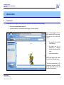
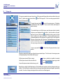
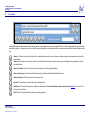
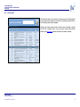
1
Scottish Government / SEPA Scottish Flood Defence Asset Database Website User Guide May 2012 JBA Consulting Port Neuk 1 Longcraig Road SOUTH QUEENSFERRY Edinburgh EH30 9TD UK t: +44 (0)131 319 2940 f: +44 (0)131 319 2944 www.jbaconsulting.co.uk Flooding Policy Team Scottish Government - Water, Air, Soils & Flooding Victoria Quay 1-H (North) Edinburgh EH6 6QQ SEPA Corporate Office Erskine Court Castle Business Park STIRLING FK9 4TR t: 0131 244 0737 f: 0131 244 0259 Tel: 01786 457700 Fax: 01786 446885 [email protected] Scottish Government Scottish Flood Defence Asset Database User Guide REVISION HISTORY Revision Ref./ Date Issued Original Amendments Issued to Website March 2006 Updated - version 2 Amended for website upgrades Website Changes to Section 2 to acknowledge the handover of database responsibility to SEPA Website Mar 2009 Updated – version 3 May 2012 PURPOSE This document has been prepared solely as a User Guide for the Scottish Flood Defence Asset Database website. JBA Consulting accepts no responsibility or liability for any use that is made of this document other than by the Scottish Government for the purposes for which it was originally commissioned and prepared. JBA Consulting www.jbaconsulting.co.uk SFDAD User Guide v3.doc: 22/05/2012 i Scottish Government Scottish Flood Defence Asset Database User Guide CONTENTS Page i i ii REVISION HISTORY PURPOSE CONTENTS 1 1.1 1.2 INTRODUCTION --------------------------------------------------------------------------------------------------1 Scottish Flood Defence Asset Database Project ....................................................................... 1 Website and GIS Interface ......................................................................................................... 3 2.1 2.2 2.3 ACCESSING THE SITE -----------------------------------------------------------------------------------------1 The Website ............................................................................................................................... 1 The Welcome Screen ................................................................................................................. 2 Logging In ................................................................................................................................... 3 3.1 3.2 3.3 3.4 3.5 THE MAIN SCREEN ----------------------------------------------------------------------------------------------4 The Main Window....................................................................................................................... 4 The Layer List............................................................................................................................. 5 The Toolbar ................................................................................................................................ 6 The Map Display ...................................................................................................................... 10 The Mapping Data .................................................................................................................... 11 4.1 4.2 4.3 4.4 THE DATA FORMS--------------------------------------------------------------------------------------------- 12 The Data Form Header ............................................................................................................ 12 The Scheme Data Form ........................................................................................................... 13 The Defence Data Form ........................................................................................................... 18 The Sub-Defence Data Form ................................................................................................... 19 2 3 4 APPENDICES: APPENDIX A: - ---------------------------------------------------------------------------------------- FORM FLOW DESIGN APPENDIX B: - ------------------------------------------------------------------------------- DATA FORM FLOW DESIGN ABBREVIATIONS FPS GIS JBA OS NGR PDF SEPA SG Flood Prevention Scheme Geographical Information System JBA Consulting – Engineers & Scientists Ordnance Survey National Grid Reference Portable Document Format Scottish Environment Protection Agency Scottish Government JBA Consulting www.jbaconsulting.co.uk SFDAD User Guide v3.doc: 22/05/2012 ii Scottish Government Scottish Flood Defence Asset Database User Guide This page is intentionally left blank. JBA Consulting www.jbaconsulting.co.uk SFDAD User Guide v3.doc: 22/05/2012 iii Scottish Government Scottish Flood Defence Asset Database User Guide 1 INTRODUCTION 1.1 Scottish Flood Defence Asset Database Project The Scottish Government (SG) is committed to improving its understanding of flooding in Scotland. , Recommendations made in reports on climate change 1 2 identified a need for a register of fluvial and coastal defences, containing detailed records of assets, defended areas and number of properties protected. On 1 November 2006 SEPA published the Indicative River and Coastal Flood Map (2006), which shows the 0.5% probability risk of flooding for rivers and the coast in Scotland. However, this map contains only limited information about the location of flood defences and does not take flood defences into account when assessing flood risk. The Scottish Flood Defence Asset Database therefore supplements the SEPA Indicative River and Coastal Flood map by showing locations that currently benefit from flood prevention schemes to mitigate against the risk of flooding. The Scottish Government has funded 72 Flood Prevention Schemes since the Flood Prevention (Scotland) Act 19613. All schemes promoted under the 1961 Act are described as Flood Prevention Schemes (FPS), however, due to the nature of flooding most Flood Prevention Schemes provide management of flooding rather than prevent flooding. This project was commissioned to provide a condition and asset database and to establish the defended areas for each of the schemes. Specific objectives were: Construct an electronic database of river and coastal flood prevention schemes and provide a GIS interface Record the condition of the defences Show the area benefiting from the flood defences Define defended and undefended areas for a range of return period events Establish the current standard of protection Determine the number and value of properties benefiting from the defences The database includes the detailed location, type and condition of defences, the flood outlines, defended areas, defence photos, as-built drawings of schemes, details of schemes including information on the level of protection, construction costs and date of construction, benefits in terms of numbers of properties protected and the value of these, scheme contacts and the Local Authority area, the maintenance regime and frequency of inspection. It is intended that the defended areas will eventually be shown as an additional layer on the SEPA flood maps. The database and maps are available to all the Local Authorities, SEPA and Scottish Government as an integrated flood risk information system over the web. The database also identifies flood defences that the Local Authorities have knowledge of that have not been constructed as a formal Flood Prevention Scheme (FPS). The current project calls for fluvial and coastal defences to be recorded but does not refer specifically to schemes promoted as erosion or coastal protections schemes under the Coastal Protection Act 1949 which may also provide flood protection. It is likely that a number of Coastal Protection schemes will provide an element of flood protection. In order to populate the database over half the schemes were reviewed in detail and a report on those schemes is also available. These reports have been added to the website as part of the 2009 updates to the database. A full list of those schemes with reports is shown overleaf. 1 Climate change Scottish Implications Scoping Study 1999 Scottish Executive Kerr et al. 2 Climate Change review of level of protection offered by Flood Prevention Schemes 2001 Scottish Executive D J Price and J E McKenna. 3 Flood Prevention Act 1961. HMSO JBA Consulting www.jbaconsulting.co.uk SFDAD User Guide v3.doc: 22/05/2012 1 Scottish Government Scottish Flood Defence Asset Database User Guide 1.1.1 List of schemes assessed by study Schemes assessed further as part of the SFDAD scheme Aberlour - Moray FPS 1982 Inspection Report available Yes Scheme Report available Yes Arbroath (Brothock Water) FPS 1985 Yes Yes Auchtermuchty FPS 1996 Yes Yes Bridge of Allan FPS 1988 Yes Yes Bridge of Earn Flood Prevention Scheme 1998 Yes Yes Brock Burn & Levernwater FPS 1991 Yes Yes Cairneyhill FPS 1982 Yes Yes Carnoustie (Barry Burn) FPS 1979 Yes Yes Yes x2 Combined report Collier Street FPS 1999 Yes Yes Conon Bridge Village FPS 1990 Yes Yes Dalbeattie FPS 1980 Yes Yes Dunshalt Village FPS 1996 Yes Yes Denholm FPS 1985 Yes Yes Earnhill Road, Gourock FPS 2001 Yes Yes Fettercairn FPS 1984 Yes Yes Fort Augustus FPS 1993 Yes Yes Yes x2 Combined report Innerleithen Hall Street FPS 1998 Yes Yes Jedburgh - Skiprunning Burn Culvert FPS 1985 Yes Yes Jed Water FPS 1987 Yes No Kincardine-on-Forth FPS 1991 Yes Yes Kirriemuir (Gairie Burn) FPS 1986 Yes Yes Largs FPS 2002 Yes Yes Lauder Station Yard FPS 1990 Yes Yes Lennoxtown (Rannie Burn) FPS 1963 Yes Yes Linlithgow FPS 2001 Yes Yes Millfield of Cupar FPS 1994 Yes Yes Moredun Playing Field FPS 1998 Yes Yes Parkneuk FPS 1987 Yes Yes Peebles - Southpark Area FPS 1987 Yes Yes Port Logan FPS 1986 Yes Yes Prestonpans FPS 1972 Yes Yes River Gryfe, Crosslee FPS 2001 Yes Yes Turfford Burn FPS 1967 (Earlston) Yes Yes Well Road Moffat FPS 1985 Yes Yes Ceres Village FPS 1994 Pitscottie Village FPS 1994 Galashiels - Netherdale FPS 1987 Galashiels - Plumtree/Wilderhaugh FPS 1987 JBA Consulting www.jbaconsulting.co.uk SFDAD User Guide v3.doc: 22/05/2012 2 Scottish Government Scottish Flood Defence Asset Database User Guide 1.2 Website and GIS Interface This website has been developed as part of the Scottish Flood Defence and Asset Database project commissioned by the Scottish Government. The work was carried out by JBA. Since May 2012 the SEPA SFDAD team has taken on the administration duties of the SFDAD from the Scottish Government Flooding Policy team. The aim of this website is to provide users with a tool to view the FPS and their associated assets within Scotland. This aim has been achieved by developing a web based Geographic Information System (GIS) through which a user can locate and view information on flood and coastal assets in Scotland. JBA Consulting www.jbaconsulting.co.uk SFDAD User Guide v3.doc: 22/05/2012 3 Scottish Government Scottish Flood Defence Asset Database User Guide This page is intentionally left blank. JBA Consulting www.jbaconsulting.co.uk SFDAD User Guide v3.doc: 22/05/2012 4 Scottish Government Scottish Flood Defence Asset Database User Guide 2 ACCESSING THE SITE 2.1 The Website The site can be found at the following address: http://www.scottishflooddefences.gov.uk To access the information on this site you must have a username and password. If you are a flood prevention practitioner or other professional engaged in flood mitigation and prevention activities and have not been issued a username and password, please contact the SEPA SFDAD team with your name, address and main area of interest regarding flooding, e.g. academic study, engineering consultancy, hydrology. The SEPA SFDAD team: Phone: 01786 452634 Email: [email protected] Since May 2012 the SEPA SFDAD team has taken on the administration duties of the SFDAD from the Scottish Government Flooding Policy team. General inquiries regarding this website and its operation should be directed to the webmaster: [email protected] JBA Consulting www.jbaconsulting.co.uk SFDAD User Guide v3.doc: 22/05/2012 1 Scottish Government Scottish Flood Defence Asset Database User Guide 2.2 The Welcome Screen The welcome screen displays a brief introduction to the website and the project with links to sources of more in-depth information on specific areas of the project. This screen is also where the user must login before using the site. Additional information on the study and study outputs is available in the link on the right. This provides access to the summary report for the study and this user manual. JBA Consulting www.jbaconsulting.co.uk SFDAD User Guide v3.doc: 22/05/2012 2 Scottish Government Scottish Flood Defence Asset Database User Guide 2.3 Logging In In order to gain access to the site a user must login. This is done by entering their username and password as shown opposite and clicking the ‘Login’ button. The password is displayed as black dots for security reasons. Also remember the password is case sensitive. Should the user fail to provide a username or password a dialog box will be displayed requesting the missing information. If you have forgotten your username or password please contact the webmaster: Should the user enter the incorrect details a dialog will be displayed informing the user they have been denied access to the site. [email protected] JBA Consulting www.jbaconsulting.co.uk SFDAD User Guide v3.doc: 22/05/2012 3 Scottish Government Scottish Flood Defence Asset Database User Guide 3 THE MAIN SCREEN 3.1 The Main Window If the map window does not display or the map window show 'retrieving map' continuously, please try the following. 1 - make sure your pop up blocker is turned off. 2 - try pressing control and F5 at the same time prior to logging in, to remove any cache. Once successfully logged in the user will be presented with the map screen. This screen is split into three main sections: 1. The Layer list on the left hand side of the screen, 2. the toolbar and list of Schemes/Local Authorities selection boxes at the top of the screen, 3. and the main map window. Each of these sections will be covered in more detail in the following sections. The main map window shows the XY coordinates of the cursor (to OS NGR) the map window width (in metres) and the scale of the map window. JBA Consulting www.jbaconsulting.co.uk SFDAD User Guide v3.doc: 22/05/2012 4 Scottish Government Scottish Flood Defence Asset Database User Guide 3.2 The Layer List The layers are organised into groups for ease of use. All the groups and the layers they contain are visible on the map by default. To hide an entire group uncheck the box to the left of the group title. To turn on an entire group select the box to the left of the group title. To expand the group select the icon next to the main group name. This displays all available layers within that group. The user can then choose which layers are visible on the map. To turn selected layers on or off within a group, open the group and select or deselect the layers you want displayed in the map window. Layers are visible on the map if they have a tick next to their name. By clicking the check box next to the layer name its visibility on the map can be altered. All of the available layers have a corresponding legend next to the selection box to identify the layer in the map window. Clicking on a layer will make it the “Active Layer”. When identifying a layer in the map window, the relevant layer must be active. This is presented as the background colour of the layer turning a darker shade of blue. To close a group select the selection. icon. This will close the group and retain any layer Selecting or unselecting the main group will override any pre-selected layers. The tick box next to the main group name will change depending on the selections within the group: If all the layers are turned off the box is empty. If all the layers are turned on the box has a blue tick. If a layer is visible but not available at a selected zoom level its description will appear grey instead If some of the layers are turned on the box has a grey tick. of white. Below the layer control list is the Refresh map icon. This will refresh the map window to reflect any changes made to layer visibility. If the ‘Auto Refresh’ icon below is ticked, then the map will automatically refresh when changes to layer visibility are made. If a number of changes are being made this can result in a less efficient approach. JBA Consulting www.jbaconsulting.co.uk SFDAD User Guide v3.doc: 22/05/2012 5 Scottish Government Scottish Flood Defence Asset Database User Guide 3.3 The Toolbar Viewing of the schemes and navigation around the map window is accomplished via a series of standard GIS tools. These are displayed at the top of the main window in the toolbar. Hovering over a tool icon with the mouse will display the tool description both in a comment window and in the Internet Explorer ‘status bar’. Zoom in. Click once to zoom in by a factor of two, selected location moved to centre of screen or draw a rectangle in the map window to zoom to the selected area. Zoom out. Click once to zoom out by a factor of two, selected location moved to centre of screen or draw a rectangle in the map window to zoom to the selected area. Zoom to full extent. Click once to zoom out to the maximum extent of the project (Scotland). Zoom to active layer. Zooms to the extent of the active layer of defence/structure/photo/fault/flood extent. Zoom to last extent. Click once to zoom to the previous view. Pan tool. Click and drag to centralise the map on a particular area. Identify tool. Click to identify a feature or scheme on selected layer. Ensure that the desired layer is selected in the layer list. If it is not a “File not Found” error will occur. Print Tool. Click to print current map and an accompanying legend. JBA Consulting www.jbaconsulting.co.uk SFDAD User Guide v3.doc: 22/05/2012 6 Scottish Government Scottish Flood Defence Asset Database User Guide 3.3.1 Dropdown lists The “List of Schemes” dropdown list provides a quick way of navigating directly to a particular scheme. Each scheme is listed by name and when selected loads the Data Form for the scheme as well as centring the map on the scheme’s location. The data forms are described in greater detail later in the guide. A further option to locate schemes is via the “District” dropdown list which provides a quick way of navigating directly to a particular Local Authority district. The relevant district is selected, highlighted in yellow and centred on the map window. When a district is selected it loads the Scheme Form listing all schemes within the selected Local Authority area. The data forms are described in greater detail later in the guide. The reload button allows the user to reload the Data Form or Scheme Form for the selected scheme/district should the form be closed prematurely. The log out button logs users out of the website and returns users back to the welcome screen. Help Manual button. Opens this manual from website in a pdf file format. JBA Consulting www.jbaconsulting.co.uk SFDAD User Guide v3.doc: 22/05/2012 7 Scottish Government Scottish Flood Defence Asset Database User Guide 3.3.2 Search option The Search tool allows a user to search for a scheme by name. By entering either a full or partial search expression in the edit box and clicking the search button a list of matching schemes will be displayed. Selecting one of these schemes works in the same way as selecting a scheme from the “List of Schemes” above, in that the map is centred on the selected scheme and the Data Form populated with data for that scheme is loaded. JBA Consulting www.jbaconsulting.co.uk SFDAD User Guide v3.doc: 22/05/2012 8 Scottish Government Scottish Flood Defence Asset Database User Guide 3.4 Scheme form The Scheme Form lists all schemes within the selected Local Authority area. The Scheme Form can be loaded by two alternative methods: either directly from the “List of Schemes” dropdown list, or by clicking on the Authority Name in the data form header. JBA Consulting www.jbaconsulting.co.uk SFDAD User Guide v3.doc: 22/05/2012 9 Scottish Government Scottish Flood Defence Asset Database User Guide 3.5 The Map Display The contents of the map display are dictated by the layer control and navigation around the window is controlled using the toolbar. Both of these topics are covered in detail in earlier sections of the guide. In addition to the toolbar the map can be navigated around using the arrows or bars located at the edges of the screen. Clicking either the bar or the arrow will pan the map in the direction indicated. Clicking items on the map when the “Identify” tool is selected and when the item’s layer is active, results in the Data Form for that item being loaded. If a photograph icon is clicked on the map and the photographs layer is set to active then the photograph will be displayed in a pop up window. JBA Consulting www.jbaconsulting.co.uk SFDAD User Guide v3.doc: 22/05/2012 10 Scottish Government Scottish Flood Defence Asset Database User Guide 3.6 The Mapping Data The map window has four main types of background maps (in addition to the national relief map) available to help provide data regarding the location of schemes and defences. Examples of each can be found below. 200K Mapping 10K Mapping (road atlas scale) 50K Mapping Landline Mapping (1:1,250 or 1:2,500) JBA Consulting www.jbaconsulting.co.uk SFDAD User Guide v3.doc: 22/05/2012 11 Scottish Government Scottish Flood Defence Asset Database User Guide 4 THE DATA FORMS 4.1 The Data Form Header All of the data forms share a common header. This header contains details regarding the Authority Name, Scheme Name, SE File Reference and Scheme Contact. The Scheme Name and Authority Name also serve as navigation links. Clicking on the Scheme Name will display the Scheme Defence Form. Clicking on the Authority Name will load the Schemes Form which lists all schemes in that district. This and all other navigation routes around the forms are illustrated in the Form Flow Diagram in Appendix A. JBA Consulting www.jbaconsulting.co.uk SFDAD User Guide v3.doc: 22/05/2012 12 Scottish Government Scottish Flood Defence Asset Database User Guide 4.2 The Data Form The data forms display information relating to a scheme and its associated defences, subdefences and structures. All scheme, associated defences, subdefences and structures have an accompanying data form. All data forms list information about the structure, defence or scheme as well as any associated faults and photographs. All data forms also contain a “Locate on Map” button which will display the particular scheme, defences, subdefences or structure on the map and highlight the item in yellow. The Scheme data form also includes a Documents section, details about hydrology, flood extents and additional drawings related to the scheme. These are presented in more detail later in the guide. Data forms can be viewed by selecting the “Identify” tool and clicking on the item about which data are required to be reviewed. This will only work if the item you selected resides on the “Active Layer”. See the section entitled “The Layer List” for details on how to make a layer active. Failing to select the correct “Active Layer” will result in a “Feature Not Found” error. Scheme data forms can also be loaded by two alternative methods, either directly from the “List of Schemes” dropdown list, or from the results window of a search, both of which are covered in previous sections. JBA Consulting www.jbaconsulting.co.uk SFDAD User Guide v3.doc: 22/05/2012 13 Scottish Government Scottish Flood Defence Asset Database User Guide 4.2.1 Asset Information The asset information lists the number and type of defence assets within the selected scheme e.g. walls, embankments, culverts etc. Information regarding a particular defence or structure can be viewed by clicking on the number to the right. Each number will appear highlighted in dark blue as the mouse is moved over it, as displayed. On clicking the number the user will be presented with one of two forms. Either a defence form or a defence form with subdefences. The only difference between these forms is that a defence form with subdefences will also contain an “Asset Information” section detailing any subdefences a defence form will not. This is illustrated in the Data Form Flow Diagram in Appendix B. 4.2.2 Documents This section provides links to the List of Operations, the Condition Assessment Report and the SFDAD report for the scheme, if available. To open either document click on the button to the right of the required document. To View PDF documents Adobe Acrobat or another suitable PDF viewer must be installed. (These can be downloaded from the internet, frequently free of charge, from sites such as www.adobe.com please note that this may require approval from your IT Department). JBA Consulting www.jbaconsulting.co.uk SFDAD User Guide v3.doc: 22/05/2012 14 Scottish Government Scottish Flood Defence Asset Database User Guide 4.2.3 Hydrology and Coastal Hydraulics The Hydrology and Coastal Hydraulics Form can be loaded from the Scheme Data Form by selecting the Hydrology and Coastal Hydraulics button: To return to the Data Form click on the Scheme Name navigation link at the top of the common header. JBA Consulting www.jbaconsulting.co.uk SFDAD User Guide v3.doc: 22/05/2012 15 Scottish Government Scottish Flood Defence Asset Database User Guide 4.2.4 Flood Extents The Flood Extents Form can be loaded from the Data Form by selecting the Flood Extents button: To return to the Data Form click on the Scheme Name navigation link at the top of the common header. JBA Consulting www.jbaconsulting.co.uk SFDAD User Guide v3.doc: 22/05/2012 16 Scottish Government Scottish Flood Defence Asset Database User Guide 4.2.5 Drawings and Photographs The Drawings and Photographs Form can be loaded from the Scheme Data Form by selecting Drawings and Photographs button: Moving the cursor over a row highlights it dark blue. Clicking on a highlighted row will load the relevant photograph or PDF document in a separate window. To View PDF documents Adobe Acrobat or another suitable PDF viewer must be installed. (These can be downloaded from the internet, frequently free of charge, from sites such as www.adobe.com). To return to the Data Form click on the Scheme Name navigation link at the top of the common header. JBA Consulting www.jbaconsulting.co.uk SFDAD User Guide v3.doc: 22/05/2012 17 Scottish Government Scottish Flood Defence Asset Database User Guide 4.3 The Defence Data Form The Defence Data Form displays information regarding the currently selected defence type. The dropdown list provides access to all defences of the current type that belong to the scheme. This form is also opened by identifying features from the map window. After selecting a defence from the list the data form is refreshed displaying the data for the new defence. Certain defences have subdefences associated with them. If a defence has a sub defence associated with it then the defence form will also contain an “Asset Information” section detailing any subdefences. This is illustrated in the Data Form Flow diagram in Appendix B. As with all data forms there is a “Locate on Map” button which will display the particular defence on the map and highlight the item in yellow. JBA Consulting www.jbaconsulting.co.uk SFDAD User Guide v3.doc: 22/05/2012 18 Scottish Government Scottish Flood Defence Asset Database User Guide 4.4 The Sub-Defence Data Form The Sub-defence Data Form works in a similar way to the Defence Data Form however it does not contain an “Asset Information” section. It includes a back button to allow the user to navigate back up to the parent defence data form. The dropdown list works in the same way as on the Defence Form. When a sub-defence is selected from the list the sub-defence data form is refreshed to display the new information. Navigation around the data forms can be seen on the Data Form Flow Diagram in Appendix B. JBA Consulting www.jbaconsulting.co.uk SFDAD User Guide v3.doc: 22/05/2012 19 Scottish Government Scottish Flood Defence Asset Database User Guide This page is intentionally left blank. JBA Consulting www.jbaconsulting.co.uk SFDAD User Guide v3.doc: 22/05/2012 20 Scottish Government Scottish Flood Defence Asset Database User Guide Appendix A: - JBA Consulting www.jbaconsulting.co.uk SFDAD User Guide v3.doc: 22/05/2012 Form Flow Design Scottish Government Scottish Flood Defence Asset Database User Guide This page is intentionally left blank. JBA Consulting www.jbaconsulting.co.uk SFDAD User Guide v3.doc: 22/05/2012 " ! ! # ! !& $ % '( ( & .$ )* / )01 +,,* Scottish Government Scottish Flood Defence Asset Database User Guide Appendix B: - Data Form Flow Design JBA Consulting www.jbaconsulting.co.uk SFDAD User Guide v3.doc: 22/05/2012 Scottish Government Scottish Flood Defence Asset Database User Guide This page is intentionally left blank. JBA Consulting www.jbaconsulting.co.uk SFDAD User Guide v3.doc: 22/05/2012 ! "#$ ' ( ")* %&&#