1
No.
A325/A101 スマートアンテナ
取扱説明書
Rev. A
(A101)
(A325)
株式会社ヘミスフィア
(Hemisphere Inc.)
D75-0325-000A
本製品は、FCC規定第15部に準拠しています。
本機の操作にあたっては、(1)他の機器への電波干渉を引き起こさないこと、(2)本機が電波干
渉を受けることにより予期しない動作を起こし得ること、を理解した上でご使用ください。
著作権表示
Hemisphere GNSS 高性能 GPS アプリケーション
© Copyright Hemisphere GNSS (2012). All rights reserved.
このマニュアルを Hemisphere GNSS の事前の書面による承諾なしに、電子的/機械的/磁気
的/光学的/化学的/その他手作業等のいかなる手段であれ、複製、再配布、転写、あるいは
いかなる言語やコンピュータ言語による翻訳や検索システムへの登録を禁止します。
商標
Hemisphere GNSSとそのロゴ、A100TM, A20TM, A21TM, A220TM, A221TM, A30TM, A31TM, A320TM, A321TM,
TM
TM
TM
TM
TM
TM
TM
TM
TM
A42 , A52 , AC110 , AerialACE , AirStar , AirTrac , AutoMate , Bantam , BaseLineHD ,
TM
®
TM
TM
®
®
TM
®
®
BaseLineX , BEELINE , COAST , Contour Lock , Crescent , Earthworks , Eclipse , e-Dif , eDrive ,
TM
TM
TM
TM
TM
TM
TM
TM
TM
TM
eDriveTC , eDriveVSi , eDriveX , FliteTrac , G100 , G4 , GateMate , GPSteer , H102 , H320 ,
TM
®
TM
TM
TM
TM
TM
TM
TM
TM
HQ , IntelliFlow , IntelliGate , IntelliStar , IntelliTrac , Just Let Go , L-Dif , LiteStar II , LV101 , LX-1 ,
TM
TM
®
TM
TM
TM
TM
TM
LX-2 , M3 , MapStar , MBX-4 , miniEclipse , Outback , Outback 360 , Outback Guidance Center ,
®
TM
TM
TM
TM
TM
Outback Guidance , Outback Hitch , Outback S , Outback S2 , Outback S3 , Outback S-Lite , Outback
TM
TM
TM
TM
TM
TM
TM
TM
Sts , Outback Steering Guide , PocketMAX PC , PocketMAX , PocketMax3 , R100 , R131 , R220 ,
TM
TM
®
TM
TM
TM
TM
TM
TM
TM
R320 , S320 , Satloc , the Satloc logo, SBX-4 , V101 , V102 , V103 , V111 , V113 , VS101 ,
TM
TM
TM
TM
TM
TM
TM
TM
TM
は、HemisphereGNSS
VS111 , VS131 , Vector , X200 , X300 , XF1 , XF100 , XF101 , XF102
社の登録商標です。また、本マニュアル記述のその他商標は、それぞれの所有者に帰属します。
特許
Outback S 及び S-lite の自動誘導と自動操縦システムは米国特許 6,539,303 と 6,711,501、
Outback Hitch の自動連結制御システムは米国特許 6,631,916、Outback eDriveTC GPS の補
助操舵システムは米国特許 7,142,956 によって保護されており、Hemisphere GNSS 製品は、次
の各米国特許によって保護されています。
6,111,549
6,397,147
6,469,663
6,501,346
6,539,303
6,549,091
6,631,916
6,711,501
6,744,404
6,865,465
6,876,920
7,142,956
7,162,348
7,277,792
7,292,185
7,292,186
7,373,231
7,400,956
7,400,294
7,388,539
7,429,952
7,437,230
7,460,942
その他、米国あるいは他国に出願中の特許が多数あります。
本マニュアルは、Hemisphere GNSS が発行した「A325/A101 GNSS Smart Antenna User
Guide」の内容を日本国内での使用を想定して訳しており、本機の使用目的以外に流用すること
を禁止します。
2
目
次
はじめに ..……………………………………………………………………………….
1:機材の設置
…………………………………………………………………………
1.1 設置場所の選定
4
5
..………………………………………………………………...……
6
1.2 アンテナの取付け
….………………………………………………………...……….
6
1.3 ケーブル類の接続
.………………………………………………………...……........
6
1.4 外部デバイスとの接続
1.5 出荷時のパラメータ
……………………………………………………...……..
7
….………………………………………………………...…….
7
1.6 BlueToothの使用方法
….………………………………………………………...……. 8
1.7 NMEA2000メッセージ
2:GPSの概要
2.1 GPS概要
………………………………………………………...…….
8
……………………………………………………………………………
9
...……………….…………………………………………………………… 10
2.2 ディファレンシャル測位
2.3 RTK測位
………………………………………………………….… 10
…………………………………………………………………………….… 10
…...………………………………………………………………………………...
13
A:チューニング&トラブルシューティング …………………………………………
14
B:製品仕様 ………………………………………………………………………………
15
C:同梱物
16
付 録
………………………………………………………………………………
D:コマンド・メッセージ
……………………………………………………………
17
ソフトウェア使用許諾契約書
…………………………………………………………….
25
3
はじめに
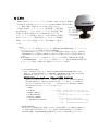
A325/A101™ スマートアンテナ(以下A325/A101と表記)は、Eclipse
/Crescent 技術を使ったプロフェショナル仕様のGNSS/GPS受信機と
して、農業・海洋・GIS等あらゆる分野で利用できます。
(LED表示色)
A325/A101は、スタートアップ(衛星補足)/衛星再捕
•赤 :電源オン
•オレンジ:GPS捕捉
捉の時間が短く、しかもLEDランプにより通電状態/測位
•緑 :DGPS測位
状態などを簡単に認識できるため作業効率が向上します。
注) Bluetooth接続
時は点滅(A325)
また、アンテナと受信機を一体化にした頑丈な構造と多種多
様なアプリケーションで使用可能なシリアルポート(RS232)、
A325/A101 スマートアンテナ
CAN、パルス入出力等を備えており、相互接続性にも優れて
います。
(特長)
・プロフェッショナル仕様のオールインワンGPS(A101)/GNSS(A325)スマートアンテナ
・センチメートルレベルの精度を実現するRTK測位
L1-GPS(A101)でもセンチメートルレベルの測位性能が実現できますが、L1/L2を
使用(A325)すると基線長を50Kmまで延長でき高速かつ安定した性能が実現でき
ます。
・豊富な接続インタフェース(詳細サポートプロトコルは付録 B:製品仕様に記載)
CAN/NMEA2000、バイナリデータ、1PPSタイミング、Event Markerが利用可能
・ピッチ/ロール測定(内蔵2次元傾斜計によるオフセット補正)
注)A101/A325の相違点
・A101 はL1-GPS 専用に対し、A325 はL1/L2-GPS/GLONASS(GNSS) に対応
・A325 は、SureTrack®技術によりRTK測位・GLONASS 利用で高速・安定性増
・L-Band利用(別途サービスプロバイダーとL-Band契約が必要)
・MFA(Multi-Function Application Software)を実装(A325のみ)
測位のための新たなソフトウェア(MFA)の採用により、利用可能な補正情
報の選択を順序付け(期待される精度の高い順)して、測位モードを自動的に
決定します(順序付けは以下の通り - 詳細は付録または「Hemisphere GNSS’
。
GPS Technical reference」マニュアルをご覧ください)
1. RTK
2. L-Band
(例)RTK測位:RTK補正情報の受信不可を検出すると、
自動的に次に使用可能な上位の補正情報を捕捉し
3. SBAS(DGPS)
て測位を継続。
4. L-Band (DGPS)
尚、利用する補正情報は下記コマンドで取捨選択
5. Beacon(DGPS)
できます。
6. External RTCM
(特定補正情報の有効/無効の指定)
7. 単独測位(Autonomous)
有効 ― $JDIFFX,INCLUDE,[補正情報名]
無効 ― $JDIFFX,EXCLUDE,[補正情報名
(SureTrack®技術)
Rover 局は、衛星配置の悪い環境でも安定した性能を発揮するためBase局が捕捉でき
ない衛星も測位計算に利用します。また、Base 局がL1/L2-GPSのみの対応機でも、
Rover局は捕捉したGLONASS衛星情報を利用し安定した測位結果を出力します。
4
1:
機材の設置
設置場所の選定
アンテナの取付け
ケーブル類の接続
外部デバイスとの接続
出荷時のパラメータ
5
■1.1 設置場所の選定
アンテナ位置は測位精度に影響するため、A325/A101の設置場所を次のように決めます。
・上空に遮蔽物のないできる限り高い位置置
・マルチパス/他無線設備の干渉のない場所
注)振動・温度変化の激しい場所あるいは湿度の多
い場所への設置は避けてください。
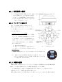
■1.2 アンテナの取付け
図1-1にA325/A101の寸法を示します。
A325/A101の取付けには、マグネットマウン
トによる設置/ポールマウントによる設置の2
つの方法が可能です。
マグネットマウントによる設置
マグネチックマウント(マグネットと固定
用パイプ)をA325/A101底面の1インチネ
ジ穴に取付け、マグネットを金属表面などに
設置します。マグネットが利用できない場合、
以下の手順で付属の粘着シールと金属板を
使って取付けます。
1.
取付け部表面を綺麗にする。
2.
3.
粘着シールの片側を剥がし金属板に貼付ける。
粘着シールの反対側を剥がし設置場所に貼付ける。
図1-1
A325/A101 の寸法
ポールマウント
A325/A101底面の1インチネジ穴を使ってポールに実装します。
注)
A325/A101を設置場所に直接取付ける場合は、図1-2に
示すように底面の4つのネジ穴を使って固定します(ネジのサ
イズはNo.8-32:深さは約8 mm)。
図 1-2 A325/A101 底面
■1.3 本機の起動
A325/A101 は、別売のパワー/データケーブルを使って電源供給および本受信機の制御・
測位データの読出し動作を行います(使用可能電源電圧:9 - 36 VDC)。
注)電源の極性を誤って接続しても保護機能が働きますが、故障しないことの保証はありません。
電源を投入すると、自動的に測位動作を開始します。
最初の起動には最大15分程度時間がかかる場合もありますが、通常は5分程度で測位結
6
果の出力が有効になります。
■1.4 外部デバイスとの接続
別売のパワー/データケーブルを使ってPC等に接続します(下図はDsub9ピンコ
ネクタを使った信号接続例)。
10
1
2
11
3
4
A325/A101 コネクタ上の信号割付け
とコネクタのキー(噛合せ用のしるし)
位置を図1-3に示します。
A325/A101 本体側(オス)
ケーブル側(メス)
9
8
12
7
6
5
図1-3 信号割付けとコネクタのキー
ケーブル側コネクタのピン割付けと信号
表 1-1 ケーブル上の信号割付けと色
の関係を表1-1に示します。
ピン番号 A325信号割付
表中に、別売の下記パワー/ケーブルに取付け
られているDsub9ピンコネクタの信号対応
も記述しました。Dsub9ピンコネクタ(オス)
を持たないケーブルの場合は芯線の色で対応す
る信号を識別することができます。
(型名)051-0129-002# 3m ケーブル
※本ケーブルの Dsub9 ピンには、2ポート(Port_A、
Port_B)の信号が割り当てられています。
1
2
3
4
5
6
7
8
9
10
11
12
イベントマーカー
Tx B
Rx B
CAN High
Signal Ground
Tx A
1 PPS
Rx A
CAN Low
Power in(12V)
Power ground
Speed out
ケーブル側
芯線の色
白
茶
青
だいだい
黄
むらさき
ねずみ
ピンク
うす茶
赤
黒
みどり
Dsub 9ピンコネクタ(例)
7
6(PORT B)
8(PORT B)
NC
5
2(PORT A)
9
3(PORT A)
NC
NC
NC
NC
(ケーブル設置上の注意点)
・熱源の近くや腐食性薬品から遠ざける。
・回転運動をする機械からケーブルを離す。
・ケーブルを過度に捻ったり曲げたりしない。
・ケーブルから受信機までの間の弛みを無くす。
Dsub 9 ピン(メス)
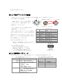
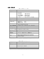
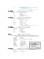
■1.5 出荷時のパラメータ
表1-2と表1-3に、A325/A101のパラメータ及び出力時の設定を示します。
表1-2 A325/A101パラメータ
項目
Firmware
A325
A101
シリアルポート A,B
GPS メッセージ
表1-3 A325/A101出荷時の設定
パラメータ
app1: MFA、app2:RTK
app1: WAAS、app2:AutoDiff
通信速度:
4,800-115,200 bps
データ(ビット): 8
パリティ:
None
ストップビット:
1
インタフェース規格: RS232
Type: NMEA0183, NMEA2000
Hemisphere GPS binary
更新レート: 1Hz to 10Hz
Max DGPS age: 259,200 s
Elevation mask: 5°
7
項目
DGPS
出力ポート
ボーレート
GPSメッセージ
DGPS Age
仰角マスク
設定
WAAS
PORT A
19200dps
GPGGA(更新:1Hz)
2700秒
5°
■1.6 BlueToothの使用方法(A325のみ)
A325には、標準でBlueToothによる通信機能が実装されています。
BlueTooth通信は「Port_C」を使用し、他のシリアルポートと同様の機能が備わってい
ますが、本機能を使用するとNMEA2000インタフェースは使用できなくなります。
BlueToothを使ってPC等のコントローラと接続するには、一般的な接続手順に従って
ペアリング動作(パスキーを要求された場合は「0000」を使用)等を行ってください。
PORT_CをBlueTooth専用として使用する場合は、Port_AまたはPort_Bから下記コマン
ドを入力し、設定を確認した後保存操作($JSAVEコマンドを発行)を行ってください。
(入力)
(応答)
$JRELAY,PORTC,$JSERIALMODE<Enter>
$>JSERIALMODE,ENABLED
$>resetting
※
本応答はPort_C(Bluetooth接続画面上)にて確認します。
■1.7 NMEA2000 メッセージ
A325/A101では、表1-4に示すNMEA2000メッセージをサポートします。
表1-4
PGN (16進)
059392(00E800)
059904(00EA00)
060928(00EE00)
126208(01ED00)
126992(01F010)
127257(01F119)
129025(01F801)
129026(01F802)
129027(01F803)
129028(01F804)
129029(01F805)
129033(01F809)
129539(01FA03)
129540(01FA04)
129542(01FA06)
A325がサポートするNMEA2000メッセージ
内容
ISO acknowledge
ISO request
Address claim
NMEA–request group function
System Time
Altitude
Position, Rapid update
COG & SOG, Rapid update
更新レート(Hz)
1
1
10
4
Position delta, high precision, Rapid update
10
Altitude, High precision, Rapid update
GNSS position data
Time and date
GNSS DOP’s
GNSS Sats in view
GNSS Pseudorange Noise Statistics
10
1
1
1
1
1
(GPZDA相当)
(GPGLL相当)
(GPVTG相当)
(GPGGA相当)
(GPZDA相当)
(GPGSA/GSV相当)
NMEA2000は、PORT_Cを使用します(BlueTooth動作と排他)。
NMEA2000専用で使用する場合は、Port_AまたはPort_Bから下記コマンドを入力後し、
設定を確認した後保存操作($JSAVEコマンドを発行)を行ってください。
(入力)
(応答)
”$JRELAY,PORTC,$JN2KMODE<Enter>
$>N2KMODE,ENABLED
$>resetting
※
本応答はPort_C(Bluetooth接続画面上)にて確認します。
注)NMEA2000は、National Marine Electronics Associationが船舶関連産業拡充のた
めに策定した統合化された規格です。
・通信速度:
・ケーブル長:
250kbps
最大200m(上記通信速度の場合)
8
2:
GPSの概要
GPS概要
ディファレンシャル補正
9
■2.1 GPS 概要
A325/A101は、出荷時にGPS捕捉とSBASディファレンシャル補正で動作するよう設
定(標準)がされており、最初の電源投入時から利用可能なGPS衛星を捕えてSBASデ
ィファレンシャル補正による測位が開始されます。
GPS 探索
本機は、使用するディファレンシャル補正情報の種類に関係なく、自動的にGPS衛星を
捕捉して測位動作を開始します(Automatic Tracking)。
4個以上のGPS衛星を捕捉して測位計算を始め単独測位では2.5mの精度ですが、デ
ィファレンシャル補正情報を利用することによりサブメートル(0.6m)の測位精度を
実現しています。
■2.2 ディファレンシャル測位
A325/A101 は、測位精度向上のためにディファレンシャル補正情報としてSBAS
(Space Based Augmentation Systems -MSAS衛星を利用)が利用可能です。
通常動作では、同時に2個のSBAS衛星を追尾(Automatic SBAS Tracking)する機能
により、ディファレンシャル補正情報を取得します。2個のSBAS衛星のいずれかが受信
できない状態になっても自動的に他方のSBAS衛星からの信号受信に切り替えて高精度の
測位を継続します。
■2.3 RTK 測位
A325/A101 は、RTKオプション(オプションのご購入が必要です)を実装することで
センチメートル・レベルの精度を達成できます。
更にRTK測位では、L1/L2オプションを実装することで基線長を最大50kmに拡
大することが可能であり、より広範囲のアプリケーションにも対応できます。
RTK測位の操作方法等は、別紙「簡易RTK操作マニュアル」をご覧ください。
10
付録
A:チューニング&トラブルシューティング
B:製品仕様
C:同梱物
D:コマンド・メッセージ
ソフトウェア使用許諾書
11
付録A:チューニング&トラブルシューティング
(チルトセンサーの利用方法)
A325/A101にはチルトセンサーが搭載されたことで、ピッチやロール情報をご利用頂けます。
1) $JRELAY,PORTC,$JTILT,CALIBRATE[,RESET] (チルトセンサーの初期化)
本コマンドで“RESET”を指定するとチルトセンサーの傾きをリセット(水平)に
初期化します。
2) $JRELAY,PORTC,$JASC,INTLT,rate[,port]
(チルトセンサーの値を出力)
・rate
出力更新レート
・port
出力ポート指定(PORT_Aからコマンド入力時は省略可能)
本コマンドによって出力される値は、A325/A101のコネクタ実装面を
手前に見て、その延長戦方向をx軸(ピッチ)、直角方向をY軸(ロール)とし
て傾斜角を出力します。
注)アンテナの設置方向は、上記の通りですが、本受信機を車などに搭載
して移動する場合は、X軸方向が進行方向になることを想定しています。
アンテナの設置方向を変更する場合は、以下のコマンドで補正してくだ
さい。
$JRELAY,PORTC,$JTLT,COGBIAS[,value] (設置方向のバイアス値指定)
(トラブルシューティング)
表A-1に、本機によく起こるトラブルとその解決方法を示します。
表A-1:トラブルシューティング
事 象
電源が入らない
対 策
・±電極の取付が正しいことを確認する。
・電源コネクタ/ケーブルが正しく接続されていることを確認する。
・入力電圧が正しいことを確認する(7~36 VDC)。
・電源電流の制限値を確認する(350 mA程度供給可能であること)。
データ出力がない
・受信機の電源が入っていることを確認する(電流計を使って確認できます)。
・期待するデータを出力するように設定されているか($JSHOWコマンドなどを使う)。
・通信速度が正しいか確認する。
・ケーブル接続が正しいか確認する。
・BluetoothモジュールがONになっていることを確認する。
解読できない出力
・RTCMあるいはバイナリ出力に設定されていないか($JSHOWコマンドなどを使う)。
・通信速度が正しいか確認する。
・通信速度と出力データの総量の関係を確認する(通信速度を速くしてみる/または遅く
して変化するか確認する)。
GPSがロックしない
・本機(アンテナ)の上空が遮蔽されていないことを確認する。
SBASがロックしない ・GPS衛星の状態を確認する(PocketMAXなどを利用する)。
・アンテナケーブルが正しく接続されているか確認する。
・$JWAASPRN,AUTO(衛星を自動捕捉)になっているか確認する。
外部RTCMが
・入力ポートの通信速度などが設定値と合っているか確認する。
動作しない
・入出力信号端子が正しいか確認する。
・補正情報の入力ポート設定を確認($JDIFF.PORTBコマンド)する。
12
付録B:製品仕様
表B-1:GNSSセンサー仕様
項 目
仕 様
受信機タイプ
(A325):キャリアフェース GNSS L1 & L2 RTK、(A101): L1-GPS
チャネル
SBASトラッキング
更新レート
12 L1CA GPS
12 L1P GPS
12 L2P GPS
(A325 オプション)
12 L2C GPS
(A325 オプション)
12 L1 GLONASS
(A325 オプション)
12 L2 GLONASS
(A325オプション)
3 SBAS または 3 L1CA GPS (追加可)
1 L-Band
(A325 オプション L-Band契約)
3 チャネル、パラレル・トラッキング
標準 10 Hz (オプション 20 Hz)
時刻(1PPS)精度
20 ns
水平測位精度
2DRMS (95%)
RTK
0.02 m + 2 ppm
OmniSTAR HP
0.2 m
SBAS
0.6 m
単独測位(SA無)
2.5 m
SBAS、RTK、外部RTCM、
及びOmniSTAR(G2/HP/XP/VBS)
補正情報
スタート時間(標準)
衛星再取得時間
最大速度/高度
< 60 秒 (コールド)、< 30 秒 (ウォーム)、< 10 秒 (ホット)
<1 秒
1,850 kph(速度)/18,288 m(高度)
入力電圧
7 – 36V DC
消費電力
A325 :
A101 :
筐体寸法
< 4.6W(334 mA -12 VDC)(L1/L2-GPS/GLONASS,L-Band使用時)
< 3.0W(134 mA -12 VDC)(L1-GPS)
104.0 (H) x 145.0 (D) mm
重量
< 558 g
動作条件
保管条件
衝撃と振動
-40 – 70°C
-40 – 85°C (湿度 95%以下- 結露なきこと)
Vibration: EP455 Section 5.15.1 Random
Mechanical Shock: EP455 Section 5.14.1 Operational
CE(ISO 14982 Emissions and Immunity)、FCC Part 15、
Subpart B、CISPR22
IP67
EMC
筐体
注)測位精度:マルチパス、衛星数とその配置、電離層などの影響を受けます。
表B-2:通信(インタフェース)
項 目
通信ポート
仕 様
x2(全二重RS232、通信速度:4,800–115,200bps)、CAN、Bluetooth(A325のみ)
補正情報プロトコル
データプロトコル
1PPS
Hemisphere GPS独自、RTCM 2.3 (DGPS)、RTCM 3.0 (RTK)、CMR、CMR+
NMEA 0183、NMEA2000、HemisphereGPS仕様バイナリ、
Bluetooth 2.0 (class 2 – A325のみ)
アクティブLow(立下り検出)、10 kΩ、10 pF load
イベントマーカー
アクティブLow(立下り検出)、10 kΩ、10 pF load
注)尚、BlueToothとNMEA2000を同時に使用することはできません。
13
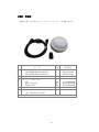
付録C:同梱物
本機をお買い上げ頂きますと、以下のコンポーネントが同梱されます。
品
1
2
3
4
名
数量
スマートアンテナ
A325 GNSS Smart Antenna
A101 GNSS Smart Antenna
Antenna mounting kit
パワー/データケーブル
3m
4.6 m (ばら線)
15m(ばら線)
A325/A101マニュアル(日本語)
付属品
他に、弊社作成CDを添付
14
部品番号
1
1
opt.
804-0079-000
804-0107-000
710-0111-000#
opt.
opt.
opt.
1
051-0129-002#
051-0169-000#
051-0168-000#
D75-0325-000C
付録D:コマンド・メッセージ(HemisphereGNSS製品共通仕様)
また、メッセージに後ろに(Vec)が付いてるものは Vector 製品(V/VSシリーズ等)専用です。
E1.
コマンド一覧(コマンド入力は必ず大文字を使用してください)
コマンドの発行あるいはメッセージの表示や保存にはPC上のユーティリティ(Windows XP
の場合Hyperterminalなど)が利用できますが、PocketMAX(http://www.hemgps.com上から
ダウンロード可能)
、または付属CD上のEGSet なども利用できます。
表 E-1
コマンド
$JASC
各種コマンド
説明
ASCIIメッセージ出力の指示を行います(表E-3参照)。
$ JASC,msg,r[,OTHER]<CR><LF>: msg=下記メッセージの指定、r=更新レート、[OTHER]=別ポート
msg=GPGGA/GPGLL/GPGSA/GPGST/GPRMC/GPPRE/GPVTG/GPZDA/HDT/ROT/INTLT/HPR/
$JAPP
インストールされているファームウェアの確認を行います。
$JAPP<CR><LF>: (応答は以下の通り)
>$JAPP,current,other
current:現在動作中アプリ、other:第2アプリ
$JDIFF
ディファレンシャル・タイプの確認ができます。
$JBAUD
RS232・RS422の通信速度指定を行います。
$JDIFF<CR><LF>: (応答は “$JDIFF,WAAS>”
であれば、SBASモードであることを表す)
$ JBAUD,,R[,OTHER]<CR><LF>: R=以下の通信速度から選択、[OTHER]=別ポート
設定可能な通信速度:4,800/9,600/19,200/38,400/57,600/115,200 bps
$JBIN
バイナリー出力が指定できます(表E-4参照)。
$JI
シリアル番号、ファームウェア版数の確認ができます(お問合せ等で必要な場合があります)。
$JAGE
ディファレンシャル動作に使用する補正情報の有効期間を指定します(衛星からの補正情報取得
が困難な場合でも独自技術で最後に取得した補正情報で処理を継続します)。
$ JAGE,age<CR><LF>: age:制限時間(秒)を指定(初期設定値:2,700 のままご使用ください.)
$JGEO
測位に使用しているSBAS衛星の周波数・位置・PRN番号などを出力します
$ JGEO,SENT=1575.4200,USED=1575.4200,PRN=prn,LON=lon,EL=ele,AZ=az
$JASC,D1
測位に使用しているSBAS衛星の診断情報を出力します。
$ JASC,D1,R[,OTHER]<CR><LF>: R:メッセージ出力有効なら“1”、無効:“0”(応答は “$> ” )
$JOFF
バイナリデータを含むすべてのメッセージ出力をオフに設定します、
$ JOFF[,OTHER] <CR><LF>:[OTHER]で別ポートからのメッセージ出力オフを指示
ビーコン調整用のコマンドです(詳細はビーコンコマンドを参照してください)。
$ JBIN,msg,r<CR><LF>: msg=表E-4 のメッセージ指定、r=更新レート
$GPMSK
$GPMSK,fff.f,F,mmm,M,n<CR><LF> :fff.f: ビーコン周波数、F:周波数選択(M:手動、A:自動) ・・
$GPCRQ,MSS ビーコンの受信状態の確認に使用します(詳細はビーコンコマンドを参照してください)。
$JQUERY,
GUIDE
電源投入時などにで受信機が動作可能になったか確認するとき使用します(ウォームスタート
後、5分程度経過しても有効な出力が得られない時などに使用できます)。
$ JQUERY,GUIDE<CR><LF>:応答が$ JQUERY,GUIDE,YES<CR><LF>なら正常動作可の意味)
$JRESET
設定内容のリセット(デフォルトに設定)に使用します。
注)本コマンド発行後は、$JATT,FLIPBRD,YESで内部Vectorボードの設定指示が必要です。
$JSAVE
設定した内容を内部不揮発メモリに保存します(次の電源投入時にも設定を有効にします)。
$JSHOW
現在の設定内容を表示します(設定内容の確認に利用できます)。
$JT
受信機のプロセッサタイプの確認ができます(応答が“SX2g”であれば正常です)。
$JWAASPRN
SBAS(WAAS)情報を出力します。
$ JWAASPRN <CR><LF>: (応答)$>JWAASPRN,prn1,prn2
prn1,2=第 1, 2 PRN 番号
日本上空は、MSAS 番号(prn1,2=129, 137)となります。
$ JWAASPRN[,sv1[,sv2]]<CR><LF>: sv1,2 で prn1,prn2 を強制的に指定できます。
$ JWAASPRN,AUTO<CR><LF>: SBAS 衛星を自動捕捉する指定です。
$JMASK
水平線に近い衛星を捕捉しないよう仰角を設定するとき使います。
$J4STRING
4 種のメッセージ(GPGGA,GPVTG,GPGSA,GPZDA))を本コマンド一つで出力指示する。
$ JMASK,e <CR><LF>:
e でカットする仰角(°)を指定(初期設定値:5°)
$ J4STRING[,r][,OTHER] <CR><LF>: r:更新レート、[OTHER]で別ポートを指定
※尚、このコマンドを発行すると、ボーレートは自動的に4,800bpsに変更されます。
$JATT(Vec)
主に、コンパス方位に関連する各種設定の変更または状態確認に使用します。
詳細は、“JATTコマンド(詳細)”を参照してください。
15
E2.
JATT (Vec)コマンド(詳細)
*JATTコマンドはベクター製品(V/VSシリーズなど)専用です。
表 E-2 $JATT(Vec)コマンドの詳細
コマンド
$JATT,SUMMARY
$ JATT,COGTAU
説明
現在設定されている時定数(TAUなど)が確認できます(次の“コマンド補足”の項を参照)。
移動体の速度変位のバラツキ抑止のための時間が設定できます
$ JATT,COGTAU,cogtau <CR><LF>:cogtau は 0.0 から 3,600 まで指定可 (通常 0.0)
$ JATT,CSEP
$ JATT,MSEP
測定結果から算出した現在のアンテナ間距離(m表示)を出力します(出力が安定している
ことで受信状態の良否判定の参考になる場合があります)。
アンテナ間距離の変更に使用します。
$ JATT,MSEP,sep <CR><LF>:sep でアンテナ間距離(m)指定
$ JATT,GYROAID ジャイロの有効/無効の設定/確認に使用します(出荷時は ON に設定されています)。
$JATT,GYROAID,YES[NO]<CR><LF> :ジャイロの有効(YES)/無効(NO)指示
$JATT,GYROAID<CR><LF>
:現在のジャイロの状態出力
※ジャイロは、衛星信号遮断状態から復旧した時の方位再測定時間の短縮、あるいは
信号遮断時検出から3分間の方位データの補正出力(方位精度は1度)に使用します。
$ JATT,HBIAS
方位計測で、真の方位とのズレを補正するため設定に使います。
$ JATT,HBIAS,x <CR><LF>:修正方位量:x は-180~+180 を指定 (指定なし場合現在値)
$ JATT,HIGHMP
マルチパス環境下で有効(YES)指定できますが、方位確定時間が増加します(通常無効)。
$ JATT,HRTAU
回頭角速度計測で、角速度変位のバラツキ抑止のための時関が設定できます。
$ JATT,HTAU
方位計測で、回頭速度変位のバラツキ抑止のための時間が設定できます。
$ JATT,LEVEL
水平動作モードの有効(YES)/無効(NO)指定ができます。(通常、無効)
$ JATT,NEGTILT
ピッチ/ロール角のマイナス符号角の修正指示を指定できます
$ JATT,HRTAU,hrtau <CR><LF>:hrtau は 0.0 から 3,600 までを指定 (通常 2.0)
$ JATT,HTAU,htau <CR><LF>:htau は 0.0 から 3,600 まで指定可(ジャイロ・オフなら通常 0.5)
$ JATT,LEVEL,k<CD><LF>:k=NO(オフ)/YES(オン)、k がないとき現在状態を表示
$ JATT, NEGTILT,k <CR><LF>: k=YES(符号が反転)/NO(無効)、指定なしは現在値
※ 第2アンテナが第1アンテナより低い場合に利用します。
$ JATT,NMEAHE
NMEA メッセージの接頭子を“HE”または“GP”のどちらにするか指示するとき使います。
$ JATT,PBIAS
ピッチ計測で、真のピッチとのズレを補正するため設定に使います。
$ JATT,PTAU
ピッチ計測で、ピッチ角変位のバラツキ抑止のための時間が設定できます。
$ JATT,ROLL
アンテナを船軸に直角に設置してロール角計測時に使用します。
$ JATT,SEARCH
現在の方位計測を一度キャンセルし、再計測の開始を指示します。
$ JATT,SPDTAU
対地速度計測で、速度変位のバラツキ抑止のための時間を設定します。
$ JATT,NMEAHE,x<CD><LF>:x=1(HE)/0(GP)
$ JATT,PBIAS,x <CR><LF>:修正ピッチ量:x は-15~+15 を指定 (指定なしは現在値)
$ JATT,PTAU,ptau <CR><LF>:ptau は 0.0 から 3,600 までを指定(通常 0.5)
$ JATT,ROLL,k <CR><LF>:k=YES(ロール角測定)/NO(無効)、指定なしは現在値
$ JATT,SEARCH <CR><LF>:RTK 計測の再スタート
$ JATT,SPDTAU,spdtau <CR><LF>:spdtau は 0.0 から 3,600 までを指定 (通常 0.0)
$ JATT,TILTAID
傾斜計の有効/無効指示(YES:有効、NO:無効)に使います。
$JATT,TILTAID<CR><LF>
現在の傾斜計の状態出力
※傾斜計は、方位計算設定時間の短縮化に有効。
$ JATT,TILTCAL
傾斜計キャリブレーションを行います(VS101/111
を必ず水平に設置してください)。
$JATT,TILTCAL<CR><LF> 傾斜計の水平キャリブレーション指示
※時間は約2秒かかり、その時の値を記憶。
$ JATT,FLIPBRD
内蔵されている Vector モジュールが上下反転して設置されているかを指定します。
$ JATT,FLIPBRD,k <CR><LF>:k=YES(上下反転)/NO(無効)、指定しない場合は現在値
*VS101/111は、出荷時の設定で“NO”になっています。
《JATT (Vec)コマンドの補足説明》
・JATT,SUMMARYコマンド
時定数の設定内容を確認するためには、$JATT,SUMMARYコマンドを使用します。
(応答は以下の形式)
$>JATT,SUMMARY,htau,hrtau,ptau,ctau,spdtau,hbias,pbias,hexflag<CR><LF>
16
以下は、実際の応答例です。
(応答)$JATT, SUMMARY,TAU:H=2.00,HR=2.00,P=0.50,COG=0.00,SPD=0.00,
BIAS:H=0.00,P=0.00,FLAG_HEX:HFGN-RMTL=62<CR><LF>
応答の中に、それぞれの時定数の現在値が表示されます。
ただし、最後の“HEX:HFGN-RMTL=62”は、下図のように“HDMTRUE”から
“LEVEL”までの先頭の文字に重み付けをして8ビットに並べた時のON(1)/
OFF(0)を16進数で表示した意味になります。
例題の16進表示“62”は ビット列で“0110 0010”を意味するので、
(ビ ッ ト 列 )
・FLIPBRD ON
(定 義 )
・GYROAID ON
HDMTRUE
7
6
5
4
3
2
1
0
F LIP B R D
・TILTAID ON
H
F
G
N
R
M
T
L
を意味します。
1
1
1
1
1
OR
OR
OR
OR
OR
OR
0
0
0
0
0
0
(M S B )
E3.
1
1
1
OR
OR
0
0
(LS B )
G Y R O A ID
N E G T ILT
R O LL
M
T ILT A ID
LE V E L
JASCコマンド(詳細)
JASCコマンドで有効なNMEA0183の各種データメッセージを活用できます。それぞれ
の詳細はD5.をご覧ください。
表E-3 出力メッセージ(一覧)
メッセ ー ジ
$G P G G A
$G P G L L
$G P G N S
$G P G R S
$G P G S A
$G P G S T
$G P G S V
$G P H D T (V ec)
$G P H E V (V ec)
$G P R M C
$G P R O T (V ec)
$G P R R E
$G P V T G
$G P Z D A
$P S A T ,G B S
$P S A T ,H P R (V ec)
$P S A T ,IN T LT (V ec)
$P C S I,1
$R D 1
タイプ
P
P
P
S
S
S
S
H
H
P
H
S
V
V
S
H
H
S
S
概 要
G P S 測 位 情 報 (時 刻 、 緯 度 、 経 度 、 測 位 状 態 な ど )
緯 度 ・経 度 情 報
G N S S 測 位 情 報 (G P G G A と ほ ぼ 同 等 の 情 報 )
測 位 情 報 (時 刻 、 各 衛 星 の 擬 似 距 離 補 正 量 )
DOP、測 位 状 況 な ど
疑 似 距 離 (D G P S )誤 差 の 標 準 偏 差 な ど
衛星の位置や信号強度など
方位情報
ヒーブ情報
測位情報の要約
回頭角速度
計 算 による距離 と計測 値 からの 距 離の 誤差 など
速度および進行方向
標準時
R A IM (G P S 衛 星 の イ ン テ グ リ テ ィ の 確 認 )
方 位 、 ピ ッ チ 、 ロ ー ル (メ ー カ ー 独 自 仕 様 )
傾 斜 計 の ピ ッ チ ・ロ ー ル (メ ー カ ー 独 自 仕 様 )
ビーコン関連 情 報
SBAS関 連 情 報
注 ) 表 中 の タイプは 以 下 の 分 類 に よる。
P = P osition (測 位 情 報 )
V = V e lo city, T im e(速 度 や 時 間 )
H = H eading ,A ltitude(方 位 や 高 さ )
S = S atellite, Q uality(衛 星 情 報 な ど )
(使用例)
A. メッセージの出力指示/出力停止指示
(通常、入力コマンドと同一のメッセージ・ヘッダーでデータが出力される)
$JASC, GPGGA,1<enter> :GPGGAメッセージの出力有効(“1”は更新レート)
$JASC, GPGGA,0<enter> :GPGGAメッセージの出力無効(停止)
17
(出力指示により以下のようにメッセージが出力されます)
$GPGGA,hhmmss.ss, ・・*cc<CR><LF>
Hhmmss.ss : UTC時刻、*cc:チェックサム、<CR><LF>:改行指示
B. 入力コマンドとメッセージ・ヘッダーが異なる場合(例)
$JASC, GPGBS,1(Vec)<enter>
: RAIM出力指示
(出力)$PSAT,GBS,hhmmss.ss,
・・*cc<CR><LF>
hhmmss.ss : UTC時刻、*cc:チェックサム、<CR><LF>:改行
$JASC, GPHPR,1(Vec)<enter>
:RAIM出力指示(入力“1”は更新レート)
(出力)$PSAT,HPR,hhmmss.ss,
・・*cc<CR><LF>
hhmmss.ss : UTC時刻、*cc:チェックサム、<CR><LF>:改行
$JASC, INTLT,1(Vec)<enter>
:傾斜計の値出力指示
(出力)$PSAT,INTLT,pitch,roll*cc<CR><LF>
pitch: ピッチ、roll:ロール、*cc:チェックサム、<CR><LF>:改行
ビーコン・コマンド
・$GPMSK
(ビーコン受信調整用のコマンド)
$GPMSK,fff.f,F,mmm,M,n<CR><LF>
fff.f: ビーコン周波数、F:周波数選択(M:手動、A:自動)、
mmm: MSK ビットレート、M:MSK 選択(M:手動、A:自動)、n:出力レート
(応答)$PCSI,ACK,GPMSK,fff.f,F,mmm,M,n<CR><LF>
・$GPCRQ,MSS<CR><LF> (ビーコン受信状態の確認用コマンド)
(応答)$CRMSS,xx,yy,fff.f,ddd*cc<CR><LF>
xx: 信号強度(dBμV/m)、yy: SNR(dB)、fff.f: ビーコン周波数、ddd: MSK ビットレート
E4.
バイナリコマンド
バイナリーメッセージは、8バイトのヘッダー(4バイト:$BIN、2バイト:ID、2バイト:
データ長)、データ、チェックサム(2バイト)、およびキャリジリターン・ラインフィード(2
バイト:0x0D、0x0A)で構成されます。
表E-4 バイナリーメッセージ詳細
注)バイナリーメッセージは、本
製品独自のフォーマットにな
っております。
メッセ ー ジ
$J BIN 1
$J BIN 2
$J BIN 80
$J BIN 93
$J BIN 94
$J BIN 95
$J BIN 96
$J BIN 97
$J BIN 98
$J BIN 99
18
説明
GP S 衛 星 の 位 置 情 報
GP S 衛 星 の D OP情 報
SBA S(W AAS )衛 星 の 基 本 情 報
SBA S(W AAS )衛 星 暦 情 報
電 離 層 や UTC時 間 の 基 本 情 報
12 個 の G PS暦 ・ 軌 道 の 基 本 情 報
搬 送 波 位 相 ・C A コー ド な どの 基 本 情 報
統計情報
GP S全 衛 星 の 軌 道 情 報
GP S衛 星 の 健 康 状 態
E5.
データメッセージ(詳細)
・基本的に、それぞれのメッセージの先頭にはGPSメッセージを示す“$GP”が付きます。
メッセージの更新レートは、標準で10Hzまで可能です。
注)以下の表記
1)
*CC はチェックサム、<CR><LF>はキャリッジリターン & ラインフィードの意味です。
$GPHDT (Vec)
(True heading of the vessel)
$GPHDT,x.x,T*cc<CR><LF> ※ T:true Heading の意味
・x.x
2)
$GPROT (Vec)
(Vessel’s Rate of Turn: ROT)
$GPROT,x.x,A*cc<CR><LF> ※ A:「x.x 値が有効」の意味
・x.x
3)
船の方向回転角速度(°/分:マイナス値は、ポート側への回転)
(Proprietary NMEA message)
$PSAT,HPR (Vec)
$PSAT,HPR,time,heading,pitch,roll,type*cc<CR><LF>
・time
・heading
・pitch
・roll
・type
4)
方位(°)
GPS time(HHMMSS)
方位(°)
ピッチ角(°)
ロール角(°)
方位の由来(N :GPS 計測値、G:Gyro 計測値)
(RAIM: Receiver Autonomous Integrity Monitoring)
$PSAT,GBS (Vec)
$PSAT,GBS,hhmmss.ss,ll.l,LL.L,aa.a,ID,p.pppp,b.b,s.s,f*cc<CR><LF>
・hhmmss.ss
・ll.l/LL.L/aa.a
・ID
・p.pppp
・b.b
・s.s
・f
測位時刻(UTC)
緯度/経度/標高のエラー予測
異常衛星の ID
HPR 出力異常の確率
異常衛星の予測許容値
標準的な許容偏差値
Integrity 判定(0:良好、1:警告、2:異常)
5)
$PSAT,INTLT (Vec)
(Proprietary NMEA message)
$PSAT,INTLT,pitch,roll*cc<CR><LF> 傾斜計のピッチ(°)とロール(°)情報
6)
$GPGGA
(GPS Position information)
$GPGGA,hhmmss.ss,ddmm.mmmm,s,dddmm.mmmm,s,n,qq,pp.p,
aaaa.aa,M,±xx.xxxx,M,sss,aaaa*cc<CR><LF>
・hhmmss.ss
・ddmm.mmmm
・s
・dddmm.mmmm
・s
・n
・qq
・pp.p
・aaaa.aa
・M
・±xxxx.xx
・M
・sss
・aaaa
7)
測位時刻(UTC)
緯度(度分)
N:北緯 S:南緯
経度(度分)
E:東経 W:西経
測位モード(0:測位不能、1:単独測位、2:DGPS)
受信衛星数
HDOP
アンテナ高(m)
M=メートル
ジオイド高(m)
M=メートル
DGPS データのエイジ(秒)
DGPS 局の ID
$GPGLL
(Latitude and Longitude)
$GPGLL,ddmm.mmmm,s,dddmm.mmmm,s,hhmmss.ss,s*cc<CR><LF>
・ddmm.mmmm
緯度(度分)
19
・s
・dddmm.mmmm
・s
・hhmmss.ss
・s
8)
V:無効)
$GPGRS
(Receiver Autonomous Integrity Monitoring : RAIM)
$GPGRS,hhmmss.ss,m,x.x,x.x,x.x, ・・・・,x.x*cc<CR><LF>
・hhmmss.ss
・m
・x.x
9)
N:北緯 S:南緯
経度(度分)
E:東経 W:西経)
測位時刻(UTC)
ステータス(A:有効
時刻
モード:
(0:GGA 計算値から算出、1:GGA 計算値とは無関係)
Range residual(受信衛星ごとの観測値に対する補正量:メートル)
$GPGSA
(GPS DOP and active satellite information)
$GPGSA,a,b,cc,dd,ee,ff,gg,hh,ii,jj,kk,mm,nn,oo,p.p,q.q,r.r,ID*cc<CR><LF>
・a
・b
・cc から oo まで
・p.p
・q.q
・r.r
・ID
測位モード(M:手動で 2D/3D を設定、A:自動)
モード(1:測位不能、2:2D fix、3:3D fix)
測位に関与した衛星番号(null データはチャネル未使用の意味)
PDOP
HDOP
VDOP
SystemID
1: GPS 2: GLONASS(V4.1 only)
10) $GPGST
(GNSS pseudorange error statistics & position accuracy)
$GPGST,hhmmss.ss,a.a,b.b,c.c,d.d.e.e,f.f,g.g*cc<CR><LF>
・hhmmss.ss
・a.a
・b.b
・c.c
・d.d
・e.e
・f.f
・g.g
11)
測位時刻(UTC)
航法処理へ入力の標準偏差(rms)
誤差楕円の長軸標準偏差(メートル)
誤差楕円の短軸標準偏差(メートル)
誤差楕円の長軸方向(度)
緯度誤差標準偏差(メートル)
経度誤差標準偏差(メートル)
高さ誤差標準偏差(メートル)
$GPGSV
(GNSS satellite information)
$GPGSV,t,m,n,ii,ee,aaa,ss,SID*cc<CR><LF>
・t
・m
・n
・ii
・ee
・aaa
・ss
・SID
受信衛星数によりデータ数は変化
全メッセージ数
メッセージ番号 m=1---3
受信可能衛星数
衛星番号
衛星仰角(°)
衛星方位角(°)
SNR(dB) + 30
SignalID 1: L1CA 0:L1+l2 (V4.1 only)
12) $GPRMC
(Recommended minimum specific GNSS data)
$GPRMC,hhmmss.ss,a,ddmm.mmm,n,dddmm.mmm,w,z.z,y.y,ddmmyy,
d.d,v,m,s*cc<CR><LF>
・hhmmss.ss
・a
・ddmm.mmm
・n
・dddmm.mmm
・w
・z.z
・y.y
・ddmmyy
・d.d
測位時刻(UTC)
ステータス(A:有効 V:無効)
緯度(度分)
N:北緯 S:南緯
経度(度分)
E:東経 W:西経
対地速度(ノット)
進行方向(度)、基準は真北
日付(UTC)
地磁気の偏角(度)
20
・v
・m
・s
13)
$GPRRE
(各衛星の残差と位置の精度:標準偏差)
$GPRRE,n,ii,rr,hhh.h,vvv.v*cc<CR><LF>
・n
・ii
・rr
・hhh.h
・vvv.v
14)
位置計算に用いた衛星数
衛星番号
距離残差(メートル)
水平位置標準偏差(メートル)
高さ標準偏差(メートル)
$GPVTG
(Velocity and course information)
$GPVTG,ttt,c,ttt,c,ggg.gg,u,ggg.gg,u,a*cc<CR><LF>
・ttt
・c
・ttt
・c
・ggg.gg
・u
・ggg.gg
・u
・a
15)
変位の向き(E:東 W:西)
A:単独 D:dgps E:estimated S: simulator N: date not valid
P: precise R: RTK F: float (V4.1 only))
Nav. status(S:safe C:Caution U:Unsafe V:not valid (V4.1 only))
進行方位(度) 基準真北
常時 T
進行方位(度) 基準磁北
常時 M
対地速度(ノット/h)
N (ノットの意味)
対地速度(km/h)
K (キロメートルの意味)
A:単独測位、D:DGPS、N:無効、P: Precise(V4.1 only)
$GPZDA
(Universal time information)
$GPZDA,hhmmss.ss,dd,mm,yyyy,xx,vv*cc<CR><LF>
・hhmmss.ss
・dd
・mm
・yyyy
・xx
・vv
16) $RD1
測位時刻(UTC)
日(UTC)
月(UTC)
西暦(UTC)
ローカル時間(時)
ローカル時間(分)
(SBAS diagnostic information)
$RD1,SecOfWeek,WeekNum,FreqMHz,DSPLocked,BER-BER2,AGC,DDS,
Doppler,DSPStat,ARMStat,DiffStatus,NavCondition*cc>CR><LF>
・SecOfWeek
・WeekNum
・FreqMHz
・DSPLocked
・BER-BER2
・AGC
・DDS
・Doppler
・DSPStat
・ARMStat
・DiffStatus
・NavCondition
17) $PCSI,1,1
GPS 週(秒)
GPS 週番号
L バンド周波数(SBAS では 1475.42MHz)
N/A
ビットエラー比
L バンドの電波強度
0.0 (SBAS の場合)
NavCondition(HEX)
0 (SBAS の場合)
例:データが 179889A の場合
DSP の SBAS 補足状況
A ロックした衛星数
ARM の処理状況
9 計算に使用できる衛星数
8 状況の良い衛星数
SBAS(使用中)の PRN 番号
8 状況がよく、仰角もよい衛星数
16 進表示
(右から左に読む:右図参照) 9 仰角内の衛星数
7 ディファレンシャルの衛星数
1 ディファレンシャルでない衛星数
(Beacon Status Command)
$PCSI,CS0,PXXX-Y.YYY,SN,fff.f,M,ddd,R,SS,SNR,MTP,WER,ID,H,T,G
・CS0
・PXXX-Y.YYY
・S/N
チャネル0
ビーコンボードのバージョン
シリアル番号
21
・fff.f
・M
・ddd
・R
・SS
・SNR
・MTP
・Q
・ID
・H
・T
・G
チャネル0のビーコン周波数
受信モード(自動:A, 手動:M)
MSK ビットレート(変調信号ビットレート)
RTCM データ出力頻度
受信電波強度
信号対雑音比
メッセージ出力処理量
最新 25 ワード中の 30 ビット RTCM ワードのエラー率
ビーコン局 ID
ビーコン電波の良否状態(0-7)
このメッセージの出力間隔(0---99)
AGC ゲイン(db: 0 - 48 db)
18) $PSAT,RTKSTAT
(RTK Status Command)
$PSAT,RTKSTAT,MODE,TYP,AGE,SUBOPT,DIST,SYS,NUM,SNR,RSF,BSF,H
AG*CC<CR><LF>
・MODE
・TYP
・AGE
・SUBOPT
・DIST
・SYS
・NUM
・SNR
・RSF
・BSF
・HAG
(例)
受信モード(FIX,FLT,DIF,AUT,NO)
補正データタイプ(DFX,ROX,CMR,RTCM3,CMR+,…)
ディファレンシャル補正情報のエイジ
購入オプション
ベース局から離れた距離(キロメートル)
使っている衛星
-GPS: L1, L2, L5
-GLONASS: G1, G2
-Galileo: E5a, E5b, E5a+b, E6
各システムが捕捉した衛星数
各システム衛星の信号対雑音比
-A は>20 dB 時
-B は>18 dB 時
-C は>15 dB 時
-D は 15 dB 以下時
ローバースリップフラグ
ベーススリップフラグ
予測水平精度
$PSAT,RTKSTAT,FIX,RTCM3,1,007F,15.2,(,L1,L2,G1,G2,)(,6,6,8,6,)(,A,A,A,C,),0,0,0.037,00C*19
GPS(L1/L2) & GLONASS(G1/G2) Band
E6.
1)
衛星数
SNR level (A:good > B > C > D )
GNSS対応コマンド(GLONASSモードが有効な場合のみ使用可)
$JNMEA,GGAALLGNSS
(GLONASS 情報を GGA メッセージに反映)
$JNMEA,GGAALLGNSS,YES[NO]<CR><LF>
GLONASS情報を有効(YES)/無効(NO)の指示。
$JNMEA,GGAALLGNSS<CR><LF>
現在の有効/無効状態を確認する。
(注)
GPS/GLONASSまたは両衛星に関連付けられるGNSSコマンド
以下の対応表を参考にしてください。
コマンド
$GNGNS
$GPGNS
$GLGNS
$GNGGA
$GPGGA
$GLGGA
$GNGLL
$GPGLL
$GLGLL
$GNGSA
$GPGSA
$GLGSA
$GNGSV
$GPGSV
$GLGSV
更新レート
20,10,2,1,0 or 0.2
20,10,2,1,0 or 0.2
20,10,2,1,0 or 0.2
1 or 0
1 or 0
22
詳細
GNSS 測位情報
GPS 測位情報
GLONASS 測位情報
GNSS 測位情報
GPS 測位情報
GLONASS 測位情報
GNSS による緯度、経度、UTC時間情報
GPS による緯度、経度、UTC時間情報
GLONASS による緯度、経度、UTC時間情報
GNSS DOP及び受信衛星番号
GPS DOP及び受信衛星番号
GLONASS DOP及び受信衛星番号
GPS 各衛星受信状況
GPS 各衛星受信状況
GLONASS 各衛星受信状況
ソフトウェア使用許諾契約書
本製品に関連するソフトウェアを使用するにあたっては、以下の使用許諾契約書に
合意したものとみなされます。
HEMISPHERE GNSS
END USER LICENSE AGREEMENT
IMPORTANT - This is an agreement (the "Agreement") between you, the end purchaser
("Licensee") and Hemisphere GNSS Inc. ("Hemisphere") which permits Licensee to use the
Hemisphere software (the "Software") that accompanies this Agreement. This Software may
be licensed on a standalone basis or may be embedded in a Product. Please read and ensure
that you understand this Agreement before installing or using the Software Update or using a
Product.
In this agreement any product that has Software embedded in it at the time of sale to the
Licensee shall be referred to as a "Product". As well, in this Agreement, the use of a Product
shall be deemed to be use of the Software which is embedded in the Product.
BY INSTALLING OR USING THE SOFTWARE UPDATE OR THE PRODUCT, LICENSEE THEREBY
AGREES TO BE LEGALLY BOUND BY THE TERMS OF THIS AGREEMENT. IF YOU DO NOT
AGREE TO THESE TERMS, (I) DO NOT INSTALL OR USE THE SOFTWARE, AND (II) IF YOU ARE
INSTALLING AN UPDATE TO THE SOFTWARE, DO NOT INSTALL THE UPDATE AND
PROMPTLY DESTROY IT.
HEMISPHERE PROVIDES LIMITED WARRANTIES IN RELATION TO THE SOFTWARE. AS WELL,
THOSE WHO USE THE EMBEDDED SOFTWARE DO SO AT THEIR OWN RISK. YOU SHOULD
UNDERSTAND THE IMPORTANCE OF THESE AND OTHER LIMITATIONS SET OUT IN THIS
AGREEMENT BEFORE INSTALLING OR USING THE SOFTWARE OR THE PRODUCT.
1. LICENSE. Hemisphere hereby grants to Licensee a non-transferable and non-exclusive
license to use the Software as embedded in a Product and all Updates (collectively the
"Software"), solely in binary executable form.
2. RESTRICTIONS ON USE. Licensee agrees that Licensee and its employees will not
directly or indirectly, in any manner whatsoever:
a. install or use more copies of the Software than the number of copies that have been
licensed;
b. use or install the Software in connection with any product other than the Product the
Software was intended to be used or installed on as set out in the documentation that
accompanies the Software.
c. copy any of the Software or any written materials for any purpose except as part of
Licensee's normal backup processes;
d. modify or create derivative works based on the Software;
e. sub-license, rent, lease, loan or distribute the Software;
f. permit any third party to use the Software;
g. use or operate Product for the benefit of any third party in any type of service
outsourcing, application service, provider service or service bureau capacity;
h. reverse engineer, decompile or disassemble the Software or otherwise reduce it to a
human perceivable form;
i. Assign this Agreement or sell or otherwise transfer the Software to any other party
except as part of the sale or transfer of the whole Product.
3. UPDATES. At Hemisphere's discretion Hemisphere may make Updates available to
Licensee. An update ("Update") means any update to the Software that is made available
to Licensee including error corrections, enhancements and other modifications. Licensee
23
may access, download and install Updates during the Warranty Period only. All Updates
that Licensee downloads, installs or uses shall be deemed to be Software and subject to
this Agreement. Hemisphere reserves the right to modify the Product without any
obligation to notify, supply or install any improvements or alterations to existing
Software.
4. SUPPORT. Hemisphere may make available directly or through its authorized dealers
telephone and email support for the Software. Contact Hemisphere to find the authorized
dealer near you. As well, Hemisphere may make available user and technical
documentation regarding the Software. Hemisphere reserves the right to reduce and limit
access to such support at any time.
5. BACKUPS AND RECOVERY. Licensee shall back-up all data used, created or stored by
the Software on a regular basis as necessary to enable proper recovery of the data and
related systems and processes in the event of a malfunction in the Software or any loss or
corruption of data caused by the Software. Licensee shall assume all risks of loss or
damage for any failure to comply with the foregoing.
6. OWNERSHIP. Hemisphere and its suppliers own all rights, title and interest in and to the
Software and related materials, including all intellectual property rights. The Software is
licensed to Licensee, not sold.
7. TRADEMARKS. "Hemisphere GPS", "Outback Guidance", "BEELINE", "Crescent",
"Eclipse" and the associated logos are trademarks of Hemisphere. Other trademarks are
the property of their respective owners. Licensee may not use any of these trademarks
without the consent of their respective owners.
8. LIMITED WARRANTY. Hemisphere warrants solely to the Licensee, subject to the
exclusions and procedures set forth herein below, that for a period of one (1) year from
the original date of purchase of the Product in which it is embedded (the "Warranty
Period"), the Software, under normal use and maintenance, will conform in all material
respects to the documentation provided with the Software and any media will be free of
defects in materials and workmanship. For any Update, Hemisphere warrants, for 90 days
from performance or delivery, or for the balance of the original Warranty Period,
whichever is greater, that the Update, under normal use and maintenance, will conform in
all material respects to the documentation provided with the Update and any media will
be free of defects in materials and workmanship. Notwithstanding the foregoing,
Hemisphere does not warrant that the Software will meet Licensee's requirements or that
its operation will be error free.
9. WARRANTY EXCLUSIONS. The warranty set forth in Section (8) will not apply to any
deficiencies caused by (a) the Product not being used as described in the documentation
supplied to Licensee, (b) the Software having been altered, modified or converted in any
way by anyone other than Hemisphere approved by Hemisphere, (c) any malfunction of
Licensee's equipment or other software, or (d) damage occurring in transit or due to any
accident, abuse, misuse, improper installation, lightning (or other electrical discharge) or
neglect other than that caused by Hemisphere. Hemisphere GPS does not warrant or
guarantee the precision or accuracy of positions obtained when using the Software
(whether standalone or embedded in a Product). The Product and the Software is not
intended and should not be used as the primary means of navigation or for use in safety
of life applications. The potential positioning and navigation accuracy obtainable with the
Software as stated in the Product or Software documentation serves to provide only an
estimate of achievable accuracy based on specifications provided by the US Department
of Defense for GPS positioning and DGPS service provider performance specifications,
where applicable.
10. WARRANTY DISCLAIMER. EXCEPT AS EXPRESSLY SET OUT IN THIS AGREEMENT,
HEMISPHERE MAKES NO REPRESENTATION, WARRANTY OR CONDITION OF ANY KIND
TO LICENSEE, WHETHER VERBAL OR WRITTEN AND HEREBY DISCLAIMS ALL
24
REPRESENTATIONS, WARRANTIES AND CONDITIONS OF ANY KIND INCLUDING
FITNESS FOR A PARTICULAR PURPOSE, MERCHANTABILITY, ACCURACY, RELIABILITY
OR THAT THE USE OF THE SOFTWARE WILL BE UNINTERRUPTED OR ERROR-FREE AND
HEREBY DISCLAIMS ALL REPRESENTATIONS, WARRANTIES AND CONDITIONS ARISING
AS A RESULT OF CUSTOM, USAGE OR TRADE AND THOSE ARISING UNDER STATUTE.
11. LIMITS ON WARRANTY DISCLAIMER. Some jurisdictions do not allow the exclusion
of implied warranties or conditions, so some of the above exclusions may not apply to
Licensee. In that case, any implied warranties or conditions which would then otherwise
arise will be limited in duration to ninety (90) days from the date of the license of the
Software or the purchase of the Product. The warranties given herein give Licensee
specific legal rights and Licensee may have other rights which may vary from jurisdiction
to jurisdiction.
12. CHANGE TO WARRANTY. No employee or agent of Hemisphere is authorized to change
the warranty provided or the limitation or disclaimer of warranty provisions. All such
changes will only be effective if pursuant to a separate agreement signed by senior
officers of the respective parties.
13. WARRANTY CLAIM. In the event Licensee has a warranty claim Licensee must first
check for and install all Updates that are made available. The warranty will not otherwise
be honored. Proof of purchase may be required. Hemisphere does not honor claims
asserted after the end of the Warranty Period.
14. LICENSEE REMEDIES. In all cases which involve a failure of the Software to conform in
any material respect to the documentation during the Warranty Period or a breach of a
warranty, Hemisphere's sole obligation and liability, and Licensee's sole and exclusive
remedy, is for Hemisphere, at Hemisphere's option, to (a) repair the Software, (b) replace
the Software with software conforming to the documentation, or (c) if Hemisphere is
unable, on a reasonable commercial basis, to repair the Software or to replace the
Software with conforming software within ninety (90) days, to terminate this Agreement
and thereafter Licensee shall cease using the Software. Hemisphere will also issue a
refund for the price paid by Licensee less an amount on account of amortization,
calculated on a straight-line basis over a deemed useful life of three (3) years.
15. LIMITATION OF LIABILITY. IN NO EVENT WILL HEMISPHERE BE LIABLE TO LICENSEE
FOR ANY INCIDENTAL, CONSEQUENTIAL, SPECIAL OR INDIRECT DAMAGES INCLUDING
ARISING IN RELATION TO ANY LOSS OF DATA, INCOME, REVENUE, GOODWILL OR
ANTICIPATED SAVINGS EVEN IF HEMISPHERE HAS BEEN INFORMED OF THE
POSSIBILITY OF SUCH LOSS OR DAMAGE. FURTHER, IN NO EVENT WILL HEMISPHERE'S
TOTAL CUMULATIVE LIABILITY HEREUNDER, FROM ALL CAUSES OF ACTION OF ANY
KIND, EXCEED THE TOTAL AMOUNT PAID BY LICENSEE TO HEMISPHERE TO PURCHASE
THE PRODUCT. THIS LIMITATION AND EXCLUSION APPLIES IRRESPECTIVE OF THE
CAUSE OF ACTION, INCLUDING BUT NOT LIMITED TO BREACH OF CONTRACT,
NEGLIGENCE, STRICT LIABILITY, TORT, BREACH OF WARRANTY, MISREPRESENTATION
OR ANY OTHER LEGAL THEORY AND WILL SURVIVE A FUNDAMENTAL BREACH.
16. LIMITS ON LIMITATION OF LIABILITY. Some jurisdictions do not allow for the
limitation or exclusion of liability for incidental or consequential damages, so the above
limitation or exclusion may not apply to Licensee and Licensee may also have other legal
rights which may vary from jurisdiction to jurisdiction.
17. BASIS OF BARGAIN. Licensee agrees and acknowledges that Hemisphere has set its
prices and the parties have entered into this Agreement in reliance on the limited
warranties, warranty disclaimers and limitations of liability set forth herein, that the same
reflect an agreed-to allocation of risk between the parties (including the risk that a remedy
may fail of its essential purpose and cause consequential loss), and that the same forms
an essential basis of the bargain between the parties. Licensee agrees and acknowledges
that Hemisphere would not have been able to sell the Product at the amount charged on
25
an economic basis without such limitations.
18. PROPRIETARY RIGHTS INDEMNITY. Hemisphere shall indemnify, defend and hold
harmless Licensee from and against any and all actions, claims, demands, proceedings,
liabilities, direct damages, judgments, settlements, fines, penalties, costs and expenses,
including royalties and attorneys' fees and related costs, in connection with or arising out
of any actual infringement of any third party patent, copyright or other intellectual
property right by the Software or by its use, in accordance with this Agreement and
documentation, PROVIDED THAT: (a) Hemisphere has the right to assume full control over
any action, claim, demand or proceeding, (b) Licensee shall promptly notify Hemisphere
of any such action, claim, demand, or proceeding, and (c) Licensee shall give Hemisphere
such reasonable assistance and tangible material as is reasonably available to Licensee
for the defense of the action, claim, demand or proceeding. Licensee shall not settle or
compromise any of same for which Hemisphere has agreed to assume responsibility
without Hemisphere's prior written consent. Licensee may, at its sole cost and expense,
retain separate counsel from the counsel utilized or retained by Hemisphere.
19. INFRINGEMENT. If use of the Software may be enjoined due to a claim of infringement
by a third party then, at its sole discretion and expense, Hemisphere may do one of the
following: (a) negotiate a license or other agreement so that the Product is no longer
subject to such a potential claim, (b) modify the Product so that it becomes non-infringing,
provided such modification can be accomplished without materially affecting the
performance and functionality of the Product, (c) replace the Software, or the Product,
with non-infringing software, or product, of equal or better performance and quality, or (d)
if none of the foregoing can be done on a commercially reasonable basis, terminate this
license and Licensee shall stop using the Product and Hemisphere shall refund the price
paid by Licensee less an amount on account of amortization, calculated on a straight-line
basis over a deemed useful life of three (3) years.
The foregoing sets out the entire liability of Hemisphere and the sole obligations of
Hemisphere to Licensee in respect of any claim that the Software or its use infringes any
third party rights.
20. INDEMNIFICATION. Except in relation to an infringement action, Licensee shall
indemnify and hold Hemisphere harmless from any and all claims, damages, losses,
liabilities, costs and expenses (including reasonable fees of lawyers and other
professionals) arising out of or in connection with Licensee's use of the Product, whether
direct or indirect, including without limiting the foregoing, loss of data, loss of profit or
business interruption.
21. TERMINATION. Licensee may terminate this Agreement at any time without cause.
Hemisphere may terminate this Agreement on 30 days notice to Licensee if Licensee fails
to materially comply with each provision of this Agreement unless such default is cured
within the 30 days. Any such termination by a party shall be in addition to and without
prejudice to such rights and remedies as may be available, including injunction and other
equitable remedies. Upon receipt by Licensee of written notice of termination from
Hemisphere or termination by Licensee, Licensee shall at the end of any notice period (a)
cease using the Software; and (b) return to Hemisphere (or destroy and provide a
certificate of a Senior Officer attesting to such destruction) the Software and all related
material and any magnetic or optical media provided to Licensee. The provisions of
Sections 6), 7), 8), 9), 10), 15), 21), 26) and 27) herein shall survive the expiration or
termination of this Agreement for any reason.
22. EXPORT RESTRICTIONS. Licensee agrees that Licensee will comply with all export
control legislation of Canada, the United States, Australia and any other applicable
country's laws and regulations, whether under the Arms Export Control Act, the
International Traffic in Arms Regulations, the Export Administration Regulations, the
regulations of the United States Departments of Commerce, State, and Treasury, or
otherwise as well as the export control legislation of all other countries.
26
23. PRODUCT COMPONENTS. The Product may contain third party components. Those
third party components may be subject to additional terms and conditions. Licensee is
required to agree to those terms and conditions in order to use the Product.
24. FORCE MAJEURE EVENT. Neither party will have the right to claim damages as a result
of the other's inability to perform or any delay in performance due to unforeseeable
circumstances beyond its reasonable control, such as labor disputes, strikes, lockouts,
war, riot, insurrection, epidemic, Internet virus attack, Internet failure, supplier failure, act
of God, or governmental action not the fault of the non-performing party.
25. FORUM FOR DISPUTES. The parties agree that the courts located in Calgary, Alberta,
Canada and the courts of appeal there from will have exclusive jurisdiction to resolve any
disputes between Licensee and Hemisphere concerning this Agreement or Licensee's use
or inability to use the Software and the parties hereby irrevocably agree to attorn to the
jurisdiction of those courts. Notwithstanding the foregoing, either party may apply to any
court of competent jurisdiction for injunctive relief.
26.
APPLICABLE LAW. This Agreement shall be governed by the laws of the Province of
Alberta, Canada, exclusive of any of its choice of law and conflicts of law jurisprudence.
27. CISG. The United Nations Convention on Contracts for the International Sale of Goods
will not apply to this Agreement or any transaction hereunder.
28. GENERAL. This is the entire agreement between Licensee and Hemisphere relating to the
Product and Licensee's use of the same, and supersedes all prior, collateral or
contemporaneous oral or written representations, warranties or agreements regarding the
same. No amendment to or modification of this Agreement will be binding unless in
writing and signed by duly authorized representatives of the parties. Any and all terms
and conditions set out in any correspondence between the parties or set out in a purchase
order which are different from or in addition to the terms and conditions set forth herein,
shall have no application and no written notice of same shall be required. In the event that
one or more of the provisions of this Agreement is found to be illegal or unenforceable,
this Agreement shall not be rendered inoperative but the remaining provisions shall
continue in full force and effect.
27
株式会社
ヘミスフィ ア
〒 211- 0015
神 奈 川 県 川 崎 市 中 原 区 北 谷 町 16- 3
TE L :0 4 4‐2 2 3 -70 7 1
FA X :0 4 4 ‐2 2 3-7 0 72
ソ ニア北谷町ビ ル2階
e-m a il : info@ hem gps .com
w w w.h em g ps .com
28