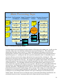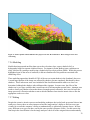
1
SOUTHERN LAKES, YUKON TERRITORY
EARTH COVER CLASSIFICATION
USER’S GUIDE
August, 2002
Final Report
Alsek Renewable
Resources Council
Citation:
A Collaborative Project by: Ducks Unlimited Canada, Edmonton, Alberta; Ducks
Unlimited, Inc., Rancho Cordova, California; Yukon Territorial Government, Whitehorse,
Yukon; Canadian Wildlife Service, Whitehorse, Yukon. August 2002. "Southern Lakes,
Yukon Territory Earth Cover Classification User's Guide" 63pp
Acknowledgements
A lot of work and help from various sources went into this project. Funding was provided by Ducks
Unlimited Canada (DUC), Ducks Unlimited Inc. (DU,Inc.), the Yukon Territorial Government (YTG),
Environment Canada – Canadian Wildlife Service (CWS), the Yukon Energy Corporation, and the
Yukon Fish and Wildlife Enhancement Trust. Cooperation and support was received from the Teslin
Tlingit Council, the Champagne and Aishihik First Nation and the Alsek Renewable Resources Council.
Gary Stewart (DUC) and Dr. Fritz Reid (DU Inc.) were instrumental in the development and overall
management of the project. Al Richard (DUC) and Debbie van de Wetering (DUC) managed the field
work and was responsible for much of the project planning. Staff of Yukon Department of Renewable
Resources (YTG) and the Canadian Wildlife Service (CWS) aided in all aspects of the project. Val
Loewen (YTG) and Jim Hawkings (CWS) were instrumental in the development of a Southern Lakes
classification scheme. Marcus Waterreus (YTG) georeferenced and orthorectified both the 1987 and
1999 images. Val Loewen, Bruce Sundbo (Parks Canada), Marcus Waterreus, and Al Richard were the
recorders for the field sessions. Jennifer Staniforth (YTG), and Karen McKenna (contractor) provided
expert vegetation classification for the field sites. Capital Helicopters of Whitehorse, YT provided
helicopter support, and pilot Mike McPhee flew the helicopter in a manner that allowed for safe,
accurate, and efficient field data collection. The staff of the Western Regional Office of Ducks
Unlimited Inc. put a lot of effort into this project as well. Beate Sterrenberg managed the project and
Kevin Smith was the navigator in the field season, and performed all of the image processing. Ruth
Spell and Brendan O’Hara provided technical support on numerous occasions. Roxie Anderson helped
to prepare the field gear. Brandon Sullivan worked long hours helping to print the final maps. Many
thanks to Val Loewen, Jim Hawkings, Marcus Waterreus, Debbie van de Wetering, and Al Richard for
their constructive input to the final report and products. A special thanks to Debbie van de Wetering for
helping to coordinate all aspects of the field work, correspondence, status reports, and final debriefing.
1
Table of Contents
Citation ......................................................................................................................
1
Acknowledgements ...................................................................................................
1
List of Figures ...........................................................................................................
4
List of Tables ............................................................................................................
4
Abstract ......................................................................................................................
5
1.0 Introduction ........................................................................................................
6
2.0 Project Objective ................................................................................................
6
3.0 Project Participants/Funding ............................................................................
6
4.0 Project Area ........................................................................................................
7
5.0 Data Acquisition .................................................................................................
8
6.0 Methods ............................................................................................................
9
6.1 Sampling Design .......................................................................................... 9
6.1.1 Classification Scheme ........................................................................ 9
6.1.2 Sampling Unit..................................................................................... 13
6.1.3 Sample Size ........................................................................................ 13
6.1.4 Sample Selection ................................................................................ 14
6.2 Image Preprocessing ................................................................................... 14
6.3 Field Verification......................................................................................... 15
6.4 Field Data Analysis...................................................................................... 17
6.5 Classification................................................................................................
6.5.1 Generation of New Bands ..................................................................
6.5.2 Seeding Process..................................................................................
6.5.3 Generation of Unsupervised Signatures.............................................
6.5.4 Modified Supervised/Unsupervised Classification............................
6.5.5 Editing and Modeling.........................................................................
19
19
19
19
19
21
6.6 Change Detection......................................................................................... 21
6.6.1 Pre-processing .................................................................................... 21
6.6.2 Change Detection Methods ................................................................ 22
6.7 Accuracy Assessment................................................................................... 23
6.7.1 Error Matrix........................................................................................ 23
2
7.0 Results.................................................................................................................. 24
7.1 Field Verification......................................................................................... 24
7.2 Classification................................................................................................
7.2.1 Forested Cover Types.........................................................................
7.2.2 Wetland Cover Types.........................................................................
7.2.3 Shrub Vegetation Cover Types ..........................................................
7.2.4 High Elevation Cover Types ..............................................................
7.2.5 Influences on Earth Cover Types .......................................................
7.2.6 Modeling ............................................................................................
7.2.7 Editing ................................................................................................
25
27
29
30
30
31
32
32
7.3 Change Detection......................................................................................... 34
7.4 Accuracy Assessment................................................................................... 35
7.4.1 Overall and Class Accuracy ............................................................... 36
7.4.2 Accuracy Discussion .......................................................................... 38
7.5 Final Products.............................................................................................. 39
8.0 Summary ............................................................................................................. 39
9.0 Addendum ........................................................................................................... 39
Literature Cited.......................................................................................................... 41
Appendix A
Classification Decision Tree ............................................................ 43
Appendix B
Southern Lakes Earth Cover Class Descriptions.......................... 47
Appendix C
Structure of the DUFF Field Database........................................... 52
Appendix D
Summary of Final Map Classes ...................................................... 55
Appendix E
Accuracy Assessment ....................................................................... 57
Appendix F
DUFF Data and Photo Viewer Extension ...................................... 59
Appendix G
Field Site Attribute Tables and Field Descriptions....................... 62
3
List of Figures
Figure 1.
Figure 2.
Figure 3.
Figure 4.
Figure 5.
Figure 6.
Figure 7.
Figure 8.
Figure 9.
Figure 10.
Figure 11.
Southern Lakes project area location...........................................................................
Custom field data collection form.................................................................................
The customized database and user interface for field data entry (DUFF)...................
The image processing flow diagram.............................................................................
Fuel site locations and field site distributions for the Southern Lakes project ............
Southern Lakes earth cover map ..................................................................................
Pure Lodgepole pine stands in an old burn area .........................................................
One of the many shallow depressional lakes in the study area ....................................
Surface profile of the Southern Lakes project area near the Teslin River ...................
Change areas around Whitehorse, YT..........................................................................
Short growth form of Aspen..........................................................................................
8
16
18
20
25
26
28
30
32
35
37
List of Tables
Table 1.
Table 2.
Table 3.
Table 4.
Classification scheme developed at the BLM Earth Cover Workshop .........................
Southern Lakes, Yukon, classification scheme .............................................................
Area and percent cover of earth cover classes within the study area ..........................
1987-1999 Southern Lakes project area change ..........................................................
10
11
27
34
4
Abstract
Ducks Unlimited, Inc. and Ducks Unlimited Canada have been mapping wetlands in the boreal regions
of Alaska since 1988 and in Canada for the past two years. The project area chosen was a 3.8 million
hectare (9.4 million acre) area in the Southern Lakes region centered on Whitehorse, Yukon Territory.
Portions of two cloud-free Landsat TM scenes (Path 59, Rows 17 and 18) imaged on August 1, 1999
were used to classify the project area into 31 earth cover categories. The classification scheme was
based on Viereck et al. (1992) in Alaska, but was modified to represent the earth cover communities
found in the Yukon. Mapped classes included open and closed canopy forests, tall, low and dwarf
shrubs, herbaceous, lichen, and wetlands, as well as unvegetated and anthropogenic types. The overall
accuracy of the mapped categories was 86% at the +/-5% level of variation. A change detection was
performed using an August 24, 1987 Landsat TM 5 image. Changes in earth cover included those due to
fires, urban expansion, conversion of arable land to agriculture, receding snow packs, and lowering of
water levels. Standardized procedures were used to conduct the earth cover classification. An
unsupervised clustering technique was used to determine the location of the field sites to ground truth
the satellite imagery. Global positioning system (GPS) technology was used to navigate to the preselected sites and to record new sites selected in the field. A total of 479 sites were visited by Bell Jet
Ranger helicopter during July 15-26, 2000. Field information was recorded on a custom field data form
and digital database. Approximately 30% of the field sites were set aside for accuracy assessment. A
modified supervised/unsupervised classification technique was performed to classify the satellite
imagery.
5
1.0 Introduction
Ducks Unlimited Inc. and Ducks Unlimited Canada are in the second year of a multi-year program to
provide regional earth cover data as part of the Western Boreal Forest Initiative (WBFI). The WBFI is
focussed on understanding how the wetlands of the boreal forest function within the larger landscape and
on finding ways to ensure that these wetlands continue to support an abundance of waterfowl and other
wildlife. Earth cover mapping is an important aspect of the WBFI. Some areas that have been mapped
include the area around Norman Wells, Northwest Territories, and Utikuma Lake, Alberta. This project
continued the mapping effort in the Yukon Territory. The Yukon portion of the western boreal region is
a vast expanse of cordillera and sub-arctic woodland covering three distinct ecozones, and providing
critical habitat for waterfowl and numerous other wildlife species. The Yukon Southern Lakes Project
area contains highly diverse landscapes and is deemed important for its wildlife, cultural, and recreational
values.
Landsat Thematic Mapper (TM) satellite imagery was chosen as the primary source for the DU WBFI’s
earth cover mapping effort. Satellite imagery offers a number of advantages for region-wide projects.
TM data is cost effective, processed using automated mapping techniques, and collected on a cyclical
basis, providing a standardized data source for future database updates or change detection studies. In
addition, TM imagery includes a mid-infrared band, which is sensitive to both vegetation and soil
moisture content and is useful in identifying earth cover types. When combined with other GIS data sets,
(e.g., elevation, slope, aspect, shaded relief, and hydrology), Landsat TM data produces highly accurate
classifications with a moderately detailed classification scheme.
Earth cover databases allow researchers, biologists, and managers to define and map crucial areas for
wildlife; perform analysis of related habitats; detect changes in the landscape; plot movement patterns for
ungulates; generate risk assessments for proposed projects; and provide baseline data to which wildlife
and sociological data can be related.
2.0 Project Objective
The objective of this project was to develop a baseline earth cover inventory using Landsat TM imagery
for a portion of southwestern Yukon and to provide this inventory in an integrated GIS database that can
be used for improved natural resources planning. A sub-objective was to provide coverages of changes
in earth cover from an earlier date. Change detection information is crucial to long term ecological
monitoring of the project area.
3.0 Project Participants/Funding
Funding for this project was a multi-agency cooperative effort including the Yukon Territorial
Government (YTG, Department of Renewable Resources), the Yukon Fish and Wildlife Enhancement
Trust, the Yukon Energy Corporation, Environment Canada- Canadian Wildlife Service (CWS), Ducks
Unlimited Canada, and Ducks Unlimited, Inc. Cooperation and support was received from the Teslin
Tlingit Council, the Champagne and Aishihik First Nation and the Alsek Renewable Resources Council.
6
This project was administered through Ducks Unlimited Canada. Ducks Unlimited Inc. in Sacramento,
California was contracted to produce the earth cover classification. Staff of YTG Dept. of Renewable
Resources (now Dept. of Environment), Parks Canada, and the Canadian Wildlife Service participated in
various aspects of the project.
4.0 Project Area
The Southern Lakes Earth Cover Mapping Project consisted of approximately 3.8 million hectares
centered roughly on Whitehorse, YT (60.73° N, 135.098° W) and included portions of the traditional
territories of the Ta'an Kwach'an, Kwanlin Dun, Champagne and Aishihik, Carcross/Tagish, and Teslin
Tlingit First Nations. Figure 1 shows the location of the study area. This project area encompassed a
wide variety of environments ranging from glaciated mountains to lowland black spruce muskeg.
Woodland Caribou (Rangifer tarandus caribou), Dall’s sheep (Ovis dalli), mountain goat (Oreamnos
americanus), moose (Alces alces), grizzly (Ursus arctos horribilis) and black bear (Ursus americanus)
are just some of the large mammalian species that can be found within the project area. The many small
lakes and ponds are important staging/molting/production habitats for breeding ducks, geese, trumpeter
swans (Cygnus buccinator), grebes, and other waterbirds.
7
Figure 1. Southern Lakes project area location.
5.0 Data Acquisition
The imagery for the earth cover classification was contributed to the project at the systematic correction
level by Forest Resources of the Department of Indian and Northern Affairs, Canada. Two Landsat 7
ETM+ scenes were used in the project, and the final study area used the top 50% of row 18 and the
bottom 50% of row 17 (row 17 shifted 50% south). The acquisition date for the imagery was August 1,
1999 and the field data was collected July 15-July 26, 2000, both within the peak summer season. Ducks
Unlimited Canada purchased two historical TM 5 images (Path 59, rows 17 &18) for the change
detection. They were acquired on August 24, 1987, which was close to the acquisition date of the 1999
image (August 1). All imagery was cloud-free.
Ancillary data was limited for the Southern Lakes project. The data that was used was provided by
YTG, and included some 1:20,000 color infrared and color photographs taken in 1978. The areas
covered by these photographs were limited to the agricultural areas along the Yukon and Takhini River
8
valleys. Due to the long period between the dates of the photographs and the imagery, these files were
used to help determine land cover in areas where there was no photo-interpreted change. A forest cover
GIS layer was also used in this project. Use of the ancillary data was limited, and therefore minimally
influenced the final earth cover classification.
The path images were mosaicked using the path correction information in the image header file, and
then georeferenced and orthorectified to within one pixel root mean squared error.
6.0 Methods
6.1 Sampling Design
The sampling design followed the following steps:
1.
2.
3.
4.
Determination of a Classification Scheme (# of classes)
Determination of the Sampling Unit
Calculation of the Number of Samples
Sample selection
The sampling design for this project was ultimately influenced by the detail of the classification (number
of classes) and the overall project budget.
6.1.1 Classification Scheme
The classification system categorized the features to be mapped. The system was derived from the
anticipated uses of the map information and the features of the earth that could be discerned by TM data.
The classification system had two critical components: (1) a set of labels (e.g., forest, shrub, and water);
and (2) a set of rules, or a system for assigning labels. The set of rules for assigning labels was mutually
exclusive and totally exhaustive (Congalton 1991). Any given area fell into only one category and every
area was to be included in the classification.
The classification system used to classify the earth cover types for the Southern Lakes project was based
on an Alaskan earth cover classification system developed through a cooperative partnership between
the Bureau of Land Management (BLM) and Ducks Unlimited Inc. This system was developed over
several years, and has been field tested on several projects. The decision to derive the Southern Lakes
classification scheme from the Alaskan classification was based on the similarity of cover types between
the two areas.
6.1.1.2 Derivation of Alaskan Classification Scheme
As projects expanded in size and as other cooperators began mapping and sharing data across Alaska,
the necessity for a standardized classification system became apparent. At the BLM Earth Cover
Workshop in Anchorage on 3-6 March 1997, a classification system based on the existing Alaska
Vegetation Classification (Viereck et al., 1992) (Table 1) was designed to address this need. The goals
of this meeting were to: (1) develop an earth cover classification system for the state of Alaska that can
be used in large regional mapping efforts, and (2) build consensus for the system among multiple land
management agencies. The classification system has been slightly improved since this meeting.
9
The classification scheme consisted of 10 major categories and 27 subcategories. A classification
decision tree and written description was developed in order to clarify the classification. Though based
largely on Level III of the Viereck et al. (1992) classification, some classes were modified, added or
omitted for the earth cover mapping projects: e.g., rock, water, ice, cloud and shadow classes were
added. Other classes that could not reliably be discerned from satellite imagery had to be collapsed,
such as open and closed tall shrub classes, ericaceous, willow, and dwarf shrub classes. Because of the
importance of lichen for site characterization and wildlife, and because the presence of lichen can be
detected by satellite imagery, shrub and forested classes with and without a component of lichen were
distinguished. A few classes from Level IV of the Viereck et al. (1992) classification were also mapped
because of their identifiable satellite signature and their importance for wildlife management. These
Level IV classes included tussock tundra, low shrub tussock tundra and low shrub willow/alder.
Table 1. Classification scheme developed at the BLM Earth Cover Workshop
Level II
1.0 Forest
Level III
1.1 Closed Needleleaf
1.2 Open Needleleaf
1.3 Woodland Needleleaf
1.4 Closed Deciduous
1.5 Open Deciduous
Level IV
1.21Open Needleleaf Lichen
1.31 Woodland Needleleaf Lichen
1.41 Closed Paper Birch
1.42 Closed Aspen
1.43 Closed Balsam Poplar/Cottonwood
1.44 Closed Mixed Deciduous
1.51 Open Paper Birch
1.52 Open Aspen
1.53 Open Balsam Poplar/Cottonwood
1.54 Open Mixed Deciduous
1.6 Closed Mixed Needleleaf/Deciduous
1.7 Open Mixed Needleleaf/Deciduous
2.0 Shrub
2.1 Tall Shrub
2.2 Low Shrub
2.3 Dwarf Shrub
3.0 Herbaceous
3.1 Bryoid
3.2 Wet Herbaceous
3.3 Mesic/Dry Herbaceous
4.0 Aquatic Vegetation
4.1 Aquatic Bed
4.2 Emergent Vegetation
5.0 Water
5.1 Snow
5.2 Ice
5.3 Clear Water
5.4 Turbid Water
6.0 Barren
6.1 Sparsely Vegetated
6.2 Rock/Gravel
6.3 Mud/Silt/Sand
2.21 Low Shrub Willow/Alder
2.22 Low Shrub Tussock Tundra
2.23 Low Shrub Lichen
2.24 Low Shrub Other
2.31 Dwarf Shrub Lichen
2.32 Dwarf Shrub Other
3.11 Lichen
3.12 Moss
3.21Wet Graminoid
3.22 Wet Forb
3.31 Tussock Tundra
3.32 Mesic/Dry Sedge Meadow
3.33 Mesic/Dry Grass Meadow
3.34 Mesic/Dry Graminoid
3.35 Mesic/Dry Forb
7.0 Urban
10
8.0 Agriculture
9.0 Cloud/Shadow
9.1 Cloud
9.2 Shadow
10.0 Other
6.1.1.3 Derivation of Southern Lakes Classification Scheme
As stated earlier the final classification scheme for the Southern Lakes was based on the Alaskan
classification scheme, but was adapted on several levels in an attempt to better classify the earth cover
types found in the Yukon Territory. Also, the classification scheme was designed to record in the field
as much variation in the vegetation as possible. For instance, in the Southern Lakes classification
scheme, the open needleleaf class was broken into pine and spruce classes, and then each one of those
had several understory classes. The understory classes were moss, lichen, herb, shrub, and other. This
procedure greatly expanded the number of classes (Table 2). The classification decision tree is shown in
Appendix A and written descriptions of the classes are in Appendix B.
Although this classification scheme provided very detailed information for all of the sites visited in the
field, the final classification did not have all of the classes listed. Since there were nearly 100 classes,
about 1500 or more sites would have to be recorded in the field in order to get a statistically valid
sample for each class and to accurately classify all of the classes in this scheme. This level of sampling
was beyond the scope of this project. The classification scheme was designed so that the higher level
classes could be "rolled up" into more general classes if the inherent limits of the TM sensor to
discriminate that level of vegetation were exceeded.
Table 2. Southern Lakes, Yukon Classification Scheme
Level II
1.0 Forest
Level III
1.1 Closed Needleleaf (NL)
Level IV
1.11 Closed Spruce-Fir
1.12 Closed Pine
1.13 Closed Mixed Needleleaf
1.2 Open Needleleaf
1.21 Open Needleleaf
1.22 Open Needleleaf
1.23 Open Needleleaf
1.24 Open Needleleaf
1.25 Open Spruce-Fir
/ Lichen
/ Moss
/ Herb.
/ Shrub
1.26 Open Pine
1.27 Open Mixed Needleleaf
1.3 Woodland Needleleaf
Level V
1.111 Closed Spruce-Fir / Shrub
1.112 Closed Spruce-Fir / Moss
1.113 Closed Spruce-Fir / Other
1.121 Closed Pine / Shrub
1.122 Closed Pine / Moss
1.123 Closed Pine / Other
1.131 Closed Mixed NL / Shrub
1.132 Closed Mixed NL / Moss
1.133 Closed Mixed NL / Other
1.2111 Open Spruce-Fir / Lichen
1.2112 Open Spruce-Fir Shrub
1.2113 Open Spruce-Fir / Moss
1.2114 Open Spruce-Fir / Herb.
1.2115 Open Spruce-Fir / Other
1.261 Open Pine / Lichen
1.262 Open Pine / Shrub
1.263 Open Pine / Moss
1.264 Open Pine / Herb.
1.265 Open Pine / Other
1.271 Open Nixed NL / Lichen
1.272 Open Nixed NL / Shrub
1.273 Open Nixed NL / Moss
1.274 Open Nixed NL / Herb.
1.275 Open Nixed NL / Other
1.31 Woodland Needleleaf / Lichen
1.32 Woodland Needleleaf / Shrub
1.33 Woodland Needleleaf / Herb.
11
1.34 Woodland Needleleaf / Other
1.4 Closed Deciduous
1.41 Closed Paper Birch / Poplar
1.42 Closed Aspen
1.411 Closed Birch-Poplar/ Shrub
1.412 Closed Birch -Poplar/ Herb.
1.413 Closed Birch-Poplar / Other
1.421 Closed Aspen / Shrub
1.422 Closed Aspen / Herb.
1.423 Closed Aspen / Other
1.44 Closed Mixed Deciduous
1.5 Open Deciduous
1.51 Open Paper Birch - Poplar
1.52 Open Aspen
1.511 Open Paper Birch – Poplar / Shrub
1.512 Open Paper Birch – Poplar / Herb.
1.513 Open Paper Birch – Poplar / Other
1.521 Open Aspen / Shrub
1.522 Open Aspen / Herb.
1.523 Open Aspen / Other
1.53 Open Mixed Deciduous
1.6 Closed Mixed NL/Deciduous
1.61 Closed Mixed NL/Deciduous
Shrub
1.62 Closed Mixed NL/Deciduous
Moss
1.63 Closed Mixed NL/Deciduous
Other
1.7 Open Mixed NL/Deciduous
2.0 Shrub
2.1 Tall Shrub
2.2 Low Shrub
3.0 Herbaceous
2.11 Closed Tall Shrub
2.12 Open Tall Shrub
2.21 Closed Low Shrub
2.22 Open Low Shrub
2.3 Dwarf Shrub
2.31 Dwarf Shrub / Lichen
2.32 Dwarf Shrub / Moss
2.33 Dwarf Shrub / Herb.
2.34 Dwarf Shrub / Other
3.1 Bryoid
3.11 Lichen
3.12 Moss
3.21Wet Graminoid
3.22 Wet Forb
3.31 Tussock Tundra
3.32 Tussock Tundra / Lichen
3.33 Mesic/Dry Sedge
3.34 Mesic/Dry Grass
3.35 Mesic/Dry Graminoid
3.36 Mesic/Dry Forb
3.2 Wet Herbaceous
3.3 Mesic/Dry Herbaceous
4.0 Aquatic Veg.
4.1 Aquatic Bed
4.2 Emergent Vegetation
5.0 Water
5.1 Snow
5.2 Ice
5.3 Clear Water
5.4 Turbid Water
6.0 Barren
6.1 Sparsely Vegetated
6.2 Rock/Gravel
6.3 Non-Veg. Soil
2.121 Open Tall Shrub / Lichen
2.122 Open Tall Shrub / Moss
2.123 Open Tall Shrub / Herb.
2.124 Open Tall Shrub / Low Shrub
2.125 Open Tall Shrub / Other
2.221 Open Low Shrub / Lichen
2.222 Open Low Shrub / Moss
2.223 Open Low Shrub / Herb.
2.224 Open Low Shrub / Other
7.0 Urban
8.0 Agriculture
9.0 Cloud/Shadow
9.1 Cloud
9.2 Shadow
10.0 Other
12
6.1.2. Sampling Unit
The sampling unit for a project refers to the size of the field site area that will be sampled for the
training of the classification and accuracy assessment. The sampling unit most useful for both
techniques was determined to have the following criteria:
1. Larger than the minimum mapping unit to minimize errors of omission due to
misregistration.
2. Could be located easily within the image using GPS technology.
3. Was not an arbitrary designation, i.e. formed a representative area of a cover class being
mapped.
There are several potential sampling units for a project: a pixel, a group of pixels, or a polygon. For this
project, the sampling unit chosen was a homogeneous polygon, since all of the other possible sampling
units did not satisfy all of the above criteria desired for this project. For instance, a 3 X 3 cluster of
pixels would be an arbitrary designation and would result in the sampling unit encompassing more than
one earth cover type. Homogeneous polygons were selected because they directly correspond to areas
within a single cover type and also provide a homogeneous spectral signature for the classification.
6.1.3 Sample Size
An adequate number of samples must be collected in the field for each earth cover class in order to
determine the statistical validity of the classification, as well as to provide a representative sample of the
various spectral signatures of the myriad cover types for the classification. Determination and sampling
of every distinct spatial area encompassed by all of the cover types within the project area is not
feasible, particularly for large, remote-access areas, so sample size is in turn influenced by logistic and
economic constraints. Thus the primary objective of the sample size determination is to balance
statistical recommendations with these more practical limitations.
The first step was to determine the sampling design needed to provide an adequate number of field sites
used as training sites for the classification as well as enough field sites for the accuracy assessment of
the earth cover map. For this project, the minimum sample size for each earth cover class was set at 15
(5 for accuracy assessment, 10 for image processing training sites) in order to perform an accuracy
assessment for that class. This number was a balance between the theoretical statistical
recommendations and the financial limitations of large scale mapping projects. The fieldwork for
obtaining the training sites for classifying the imagery and the reference data for the accuracy
assessment was accomplished at the same time. Special care was taken during the preprocessing stage
and in the field to make sure an adequate number of samples were obtained. Some earth cover classes
were naturally limited in size and distribution, so a statistically valid accuracy assessment sample could
not be obtained without additional field time.
For these classes with low sample sizes few, if any, field sites were withheld for the accuracy
assessment. This does not indicate that the classification for these types is inaccurate but rather that no
statistically valid conclusions can be made about the accuracy of these classes. However, withholding
even a small percentage of sites for the accuracy assessment provided some confidence in the
classification and guided the image processor and end user in identifying areas of confusion in the
classification. Accuracy assessment sites were selected randomly across the project area to reduce bias.
13
The final number of samples for each earth cover class often was a reflection of how much area that earth
cover class occupied within the project area boundary. Thus, if one class covered a larger portion of the
project area than another class, it should have had more samples overall. Exceptions to this rule were for
classes such as clear water, shadow, ice, snow, urban, and agriculture, which, due to their inherent
spectral properties, did not need to be sampled in the field. These classes were readily determined from
the imagery, so more field emphasis was placed on those earth cover types with more spectral variability.
6.1.4 Sample Selection
Once the appropriate sample size for the project is determined, the samples must be allocated among the
earth cover classes in the map. The primary purpose of a sampling scheme is to provide an adequate
number of samples to represent the earth cover classes within a project area, for use in both the
classification and the accuracy assessment. Thus the sample selection process ultimately determines the
distribution of samples throughout the project. The three most common methods for selection of field
sites are a random approach, a systematic approach, or a stratified approach. All of these approaches
have strengths and limitations. A purely random approach has excellent statistical properties, but is
difficult and expensive to apply. A purely systematic approach is easy to apply, but could result in
sampling from only limited areas of the map. A stratified approach uses prior knowledge about the study
area in order to divide the image into earth cover strata, and then each stratum is randomly sampled.
The sampling procedure used in this project was a modified stratified approach. The image was
separated into strata using an unsupervised classification, which provided an unbiased grouping of strata
that collectively represent the entire spectral variation found in the imagery. For this project, 30 distinct
strata were determined, and a set number of samples (30) for each class were randomly selected from
each of the spectral groups. Field sites are hand-digitized polygons selected from pixel clusters of
sufficient size for sampling (greater than 10 pixels) of each spectral stratum. The standard deviation of
the spectral variation found within each field site polygon was calculated, and typically sites over three
standard deviations from the mean (in any of the bands) were thrown out. In a few cases, classes with
higher standard deviations were kept due to the wide range of spectral variation found within a spectral
class. In these cases, there tend to be few or no areas within the class that exhibit less than three standard
deviations from the spectral mean. Thus, in order to provide samples within spectral classes with a wide
range of spectral variation (such as in rocky/dwarf shrub areas), higher standard deviations were
allowed.
Because earth cover classes are often arbitrary designations of a continuum of ecological variation, this
sampling approach provides samples that represent the spectral variation of the project area. Since the
actual ecological variation of each site is collected in the field, the sampling scheme allows the
classification technique used in this project to relate spectral variation to earth cover types in a nonbiased manner.
6.2 Image Preprocessing
Each image was examined for quality and consistency. Each band was examined visually and
statistically by reviewing histograms. Combinations of bands were displayed to check for band to band
registration and for clouds, shadows, and haze. Positional accuracy was checked by comparing the
image to available ancillary data such as adjacent imagery, hydrography, and DEM’s.
14
In order to optimize helicopter efficiency, field sites were identified and plotted on field maps before
fieldwork began. Sufficient samples for each mapped class were selected to span the variation of spectral
responses within that class throughout the entire image. For example, a shrub class in the southern part
of an image may have a different spectral response than the same shrub class in the northern part of that
image. Many factors contribute to such variation, including aspect, terrain shadow, or small differences
in soil moisture. In addition, each earth cover type encompassed a variety of subtypes; e.g., the open
needleleaf class included forested areas with 25%-59% crown closure, trees of varying height, and a
diverse understory composition.
The image analyst individually selected training sites from the spectrally unique areas of the
unsupervised classification. Whenever possible, training sites were grouped in clusters to reduce the
amount of travel time between sites. The image analyst also placed training sites near landmarks that
were easily recognizable in the field, such as lakes or streams. A tally of the estimated number of field
sites per class was kept until all of the target map classes were adequately sampled throughout the project
area. The coordinates of the center points of the field sites were then uploaded into a Garmin III+ for
navigational purposes. Training sites were overlain with the satellite imagery and plotted at 2.54cm =
1.6km (1 inch = 1 mile) scale. These field maps were used for recording field notes, placing additional
field sample sites, and navigating to field sites.
6.3 Field Verification
The purpose of field data collection was to assess, measure, and document the on-the-ground vegetation
variation within the project area. This variation was correlated with the spectral variation in the satellite
imagery during the image classification process. Low-level helicopter surveys were a very effective
method of field data collection since a much broader area was covered with an orthogonal view from
above, similar to a satellite sensor. In addition, aerial surveys are often the only alternative in Canada
due to the large amount of roadless areas.
In order to obtain a reliable and consistent field sample, a custom field data collection form (Kempka et
al., 1994) was used to record field information (Figure 2). A five person helicopter crew performed the
field assessment. Each crew consisted of a pilot, biologist, recorder, navigator, and alternate. The
navigator operated the GPS equipment, interpreted the satellite image derived field maps to guide the
biologist to the pre-defined field site, and collected photos of the field sites. It was valuable for the
image processor to gain first-hand knowledge of the project area, therefore the image processor filled the
role of the navigator. The biologist identified plant species, estimated the percent cover of each, and
determined the overall earth cover class based on the classification scheme. The recorder wrote species
percentages and other data on the field form and generally assisted the biologist. The alternate was
responsible for on-ground support, data entry, and substitution in case of sickness. The majority of sites
were observed without landing the helicopter. Ground verification was performed when identification
of dominant plant species was uncertain.
15
Figure 2. Custom field data collection form.
These procedures for collecting field data have evolved into a very efficient and effective means of data
collection. The navigator located the site with a GPS and verified the location on the field map. As the
helicopter approached the site at about 300 meters above ground level the navigator described the site to
the biologist and the pilot and took a high overhead picture with a digital camera. The pilot then
descended to approximately 5-10 meters above the vegetation and laterally moved across the site while the
biologist called out the vegetation to the recorder. The navigator took another picture with the digital
16
camera for a close-up view of the site. The pilot then ascended to approximately 100 meters so that the
biologist could estimate the percentages of each species to the recorder. The navigator then snapped an
oblique angle photo and directed the pilot to the next site. On average, it took 5-8 minutes to collect all of
the information for one site.
6.4 Field Data Analysis
The collected field information was entered into a digital database using a custom data entry application
(DUFF), designed jointly by the BLM and DU Inc. and programmed by GeoNorth. The structure of the
relational database is described in Appendix C. It was powered by SQL Anywhere while the user
interface was programmed in Visual Basic. The user interface was organized similarly to the field form to
facilitate data entry (Figure 3). The application utilized pull down menus to minimize keystrokes and
checked for data integrity to minimize data entry errors. The database program also calculated an overall
class name for each site based on the recorded species and its cover percentage. Digital images from each
site were stored in the database and accessible from within the user interface. The number of field sites
per earth cover class was tracked daily to ensure that adequate samples were being obtained within each
class.
17
Sample Field Site – Closed Mixed Needleleaf/Deciduous
High site photo
Low site photo
DUFF INTERFACE
Figure 3. The customized database and user interface for field data entry (DUFF).
18
6.5 Classification
Every image is unique and presents special problems in the classification process, but we use the same
basic approach in all projects (Figure 4), as it has proven successful. It is particularly valuable that the
image processor was actively involved in the field data collection and had first hand knowledge of every
training site.
Erdas Imagine (v. 8.4) was used to perform the classification. Arc Info (v. 7.2.1) was utilized to manage
the field site polygons. Various word processing and data analysis software including MS Word, Excel
and Access was also used during the image classification.
6.5.1 Generation of New Bands
The Landsat TM imagery contained 7 bands of data: 3 visible bands, 1 near-infrared band, 2 mid-infrared
bands, and 1 thermal band. One new band, the NDVI (Normalized Difference Vegetation Index), was
generated for this project. The NDVI was highly correlated with the 4/3 ratio, a band ratio that typically
reduces the effect of shadows in the image and enhances the differences between vegetation types
(Kempka et al. 1995, Congalton et al., 1993). The NDVI has been correlated with various forest and
crop canopy characteristics such as biomass and leaf area index. This NDVI band replaced thermal band
(band 6) to retain a 7-band image for classification.
6.5.2 Seeding Process
Spectral signatures for the field sites to be used as training areas were extracted from the imagery using a
“seeding” process in Erdas Imagine. A pixel within each training area was chosen as a “seed” and
adjoining pixels were evaluated for inclusion in each training site using a threshold value based on a
spectral Euclidean distance. The standard deviations of the seeded areas were kept close to or below 3
and all seeded areas were required to be over 15 pixels (approximately 1.5 ha/3.75 acres) in size. Along
with the field training areas, additional “seeds” were generated for clear water, turbid water, and snow
classes. These classes were easily recognizable on the imagery and aerial photography. The output of
the seeding process in Imagine was a signature file that contained all of the statistics for the training
areas. The signature file was then used in the modified supervised/unsupervised classification.
6.5.3 Generation of Unsupervised Signatures
An unsupervised classification was generated using the six raw bands and the NDVI ratio. One hundred
and fifty signatures were derived from the unsupervised classification using the ISODATA program in
Imagine. The output of this process was a signature file similar to that of the seeding process but
containing the 150 unsupervised signatures. A maximum likelihood classification of the 150
unsupervised signatures was generated using the supervised classification program in Imagine.
6.5.4 Modified Supervised/Unsupervised Classification
A modified supervised/unsupervised classification approach (Chuvieco and Congalton 1988) was used
for the classification. This approach uses a statistical program to group the spectrally unique signatures
19
Main Processing Steps
Data Input Pre-Processing Image Processing Iterative Accuracy Assessment
& Fieldwork & Classification
Process
& Final Products
Terrain
Corrected
Landsat TM
Images
Historic
Fire
Boundaries
QA/QC Imagery and
Clip to Project Area
Generation of New
Bands, Ratios, PCA
Classify & Remove
Clouds/Shadows
Merge Raw Bands
With New Bands
Unsupervised Clustering,
Digitize Pre-selected
Field Site Locations
Mask Out
Clouds/Shadows
Plot and Laminate Field
Maps with Field Sites
Generate
Unsupervised Signatures
From Imagery
Field Verification
Cluster Unsuper Sigs
with Training Site Sigs
& Label Clusters
Aerial
Photographs
Data Analysis – Separate
Training Sites from
AA Sites
Training
Sites
DEM,
GIS Layers,
Photos
Iterative Process
Of Masking Confused
Clusters
Combine and Recode
Into Draft Classification
Edit and Model
Remaining Confusion
Final Classification
Accuracy Assessment
Confused
Clusters
Labeled
Clusters
Reprocess if Accuracy
Assessment Below
Standard
Final Maps
And Statistics
Accuracy
Sites
Figure 4. The image processing flow diagram.
from the unsupervised classification with the signatures of the supervised training areas. In this way, the
spectrally unique areas were labeled according to the supervised training areas. This classification
approach provided three major benefits: (1) it aided in the labeling of the unsupervised classes by
grouping them with known supervised training sites; (2) it helped to identify classes that possessed no
spectral uniqueness (i.e., training sites that were spectrally inseparable); and (3) it identified areas of
spectral reflectance present in the imagery that had not been represented by a training site. This
approach was an iterative process because all of the supervised signatures do not cluster perfectly with
the unsupervised signatures the first time. The unsupervised signatures that matched well with the
supervised signatures were inspected, labeled with the appropriate class label, and removed from the
classification process. The remaining confused clusters were grouped into general categories (e.g.,
forest, shrub, non-vegetation) and the process was repeated. This process was continued until all of the
spectral classes were adequately matched and labeled, or until the remaining confused classes were
spectrally inseparable. Throughout this iterative process, interim checks of classification accuracy were
performed by intersecting the classified image with a coverage of the training sites to determine if the
training sites were being accurately labeled by the classification. Areas with incorrectly classified
training sites were run through further iterations of the supervised/unsupervised classification and
further refined. The iterative process of interim accuracy assessments and refining classifications was
terminated when the accuracy assessments indicated no improvements between iterations.
20
6.5.5 Editing and Modeling
The Southern Lakes project area exhibited considerable topographic effects on the remotely sensed
imagery. To minimize the effect of this on the final classification, some modeling was done to enhance
the classification. Modeling was performed using shaded relief, slope, and elevation images derived
from DEMs. All of the relief, slope, and elevation images were created using Erdas IMAGINE. The
modeling process was used primarily to identify potentially misclassified cover types (due to the
influence of topography) throughout the study area.
The final steps of the classification process were to model the confused classes remaining after the
iterative supervised/unsupervised classification process and to make final edits in areas that still had
classification errors. Editing of classification errors was a process of comparing the classified image to
the raw satellite image, aerial photography, and notes on field maps to identify errors remaining in the
classification. The pixels that were classified in error were then corrected by manually changing the
class value to their correct class value.
6.6 Change Detection
6.6.1 Pre-processing
Like the image classification pre-processing, change detection images must be accurately georeferenced
and orthorectified in areas of significant terrain relief, typically within one-half pixel (within 15 meters)
root mean squared error. Image-to-image registration quality is critical to a valid change detection
analysis. Misregistration will lead directly to commission errors and will corrupt the results. For
example, roads that are slightly off show up as a narrow band in change detections due to the error in
registration. Commission errors are extremely difficult, or impossible in many cases, to mitigate using
post-processing techniques. In addition, since image orthorectification involves pixel resampling, a
nearest neighbor resampling kernel was used, as this technique alters the original pixel values the least.
The two Landsat 5 images were mosaicked for the change detection analysis for the Southern Lakes
study area. The 1987 imagery covered a slightly smaller area than the 1999 imagery, with less area in
the eastern portion of the image. The image was orthorectified using the same method and control
points as for the 1999 imagery. Root mean squared error for the orthorectification was less than half of
a pixel.
Once the earlier date image is satisfactorily orthorectified, that image must be normalized to the
reference image (in this case, the image associated with the field data). Correctly normalized images
ensure that changes of small magnitude can be detected and measured, and spurious changes will be
minimized. Selection of anniversary dates where the spectral reflectances of most of the features on the
ground are similar in both images is advisable. This is because areas that have the same unchanged
cover type in both images and have different reflectance values will need to be normalized to each other,
so images with similar reflectance values minimizes the need for normalization. The object of
normalization is to correct for all of the differences between the images in the change analysis that are
not associated with landscape change in cover or condition. These discrepancies may include
atmospheric conditions, solar illumination, phenologic changes in the landscape, and sensor calibration.
21
The first step in the normalization process was to take training samples of as much spectral variation as
possible throughout the 1987 image. A total of 35 training sites were selected to normalize the 1987
image to the 1999 image. These sites were chosen to maximize spatial (image distribution) and spectral
(range in brightness values) distribution in “stable” areas, or areas throughout the image that did not
change between the two dates. The sites encompassed all of the major earth cover types, from water to
forest to shrub to rock. Once the training sites were selected, a simple linear regression was used to
determine the radiometric normalization for each band. Then the intercept and coefficient of the
regression equation were applied to each band, providing the final normalized 1987 image, which was
used in the change detection.
6.6.2 Change Detection Methods
After the images were correctly orthorectified and normalized, change detection procedures were run on
the images. For this analysis, a simple band differencing change detection was used. All of the bands
were put into a simple model and the difference (either positive or negative) was displayed as an image.
Difference images were determined for each band in the image. A threshold was set where everything
above the threshold was labeled as change, and everything below was labeled no change. The threshold
is an arbitrary value, set by the analyst after reviewing the image. The threshold level is highly variable
from image to image. Since land cover changes showed up in all of the bands, there was a lot of
redundancy in the band difference images. After a review of all of the difference images, the TM Band
4 difference image was chosen to determine the vegetation and water level changes, and the TM Band 7
difference image was used to detect changes in snow cover, urban expansion, fires, and agriculture
changes.
Image differencing techniques provided the difference in spectral reflectance between 1987 and 1999 for
each of the bands. This final difference image exhibits a range of values from negative to positive,
depending on the brightness values of each image. For this specific change detection, modeling or
statistical classification of change signatures were not possible due to the overlap of difference values
among change classes. For example, a fire and a clearcut might exhibit the same difference in spectral
signatures between the two dates, but would belong to different change classes. In addition, some
changes were nearly impossible to separate using unsupervised classification techniques, but were
readily classified by an analyst using visual references. Pattern recognition, context, and other visual
cues were all used to separate classes. For these reasons, a decision was made to manually classify the
difference image into the different change categories. This process was done using field data, aerial
photographs, and the interpretive ability of the analyst.
Because no data was collected at the time of the 1987 image overpass, no accuracies were provided for
the change detection analysis. Sources of error were minimized where possible. One source of error
that was present was misregistration. Although the overall pixel error for the orthorectification
procedure was less than a half a pixel (<15 meters), in some areas the registration was off by more than
a pixel. This typically occurred in areas where there were few control points available for the
registration, for example the northwestern portion of the image. Other areas, such as around Whitehorse
and along the major transportation routes, were very accurately orthorectified. A large portion of the
change occurred in these areas, while very little occurred in the areas with registration errors. In areas
with registration error, all changes were checked visually, and false changes were edited out of the final
change coverage.
22
6.7 Accuracy Assessment
There were two primary motivations for accuracy assessment: (1) to understand the errors in the map (so
they can be corrected), and (2) to provide an overall assessment of the reliability of the map (Gopal and
Woodcock, 1992). There is no accuracy assessment method available that would provide a precise
representation of the true accuracy of the final earth cover map, due to limitations including sampling
error, logistics, project funding, and the degree of complexity found within the landscape. Because
sampling for every spatial unit is not economically or logistically feasible, particularly for large land
areas, the sample design for this project provides an estimate of the accuracy of the map.
In an effort to account for some of the variation in human interpretation in the accuracy assessment
process, overall classification accuracies were also generated assuming a +/- 5% variation in estimation
of vegetation compositions for each of the accuracy assessment sites. In other words, if a variation in
interpretation of +/- 5% would have resulted in the generation of a different reference site label, this new
label was also considered an acceptable mapping label for the reference site.
For this project, an accuracy assessment was calculated for each of the designated accuracy assessment
sites. The total number of earth cover classification pixels that fall within the accuracy assessment site
are compared with the field site designation. For the site to be assessed as accurate, greater than 50% of
the earth cover classification pixels must correspond to the earth cover class calculated by the field site.
Sites with less than 50% coverage in the “correct” class are labeled as “false”.
6.7.1 Error Matrix
The standard method for assessing the accuracy of a map is to build an error matrix, also known as a
confusion matrix, or contingency table. The error matrix compares the reference data (field site or photo
interpreted site) with the classification. The matrix was designed as a square array of numbers set out in
rows and columns that expressed the number of sites assigned to a particular category in the reference
data relative to the number of sites assigned to a particular category in the classification. The columns
represented the reference data while the rows indicated the classification (Lillesand and Kiefer, 1994). In
the error matrix, numbers along the main diagonal of the matrix indicate an exact match between the
reference data site and the map. Sites that have been designated as “false” in the accuracy assessment are
shown in the off-diagonal cells of the error matrix. Thus if an accuracy assessment site was designated
in the field as open needleleaf and the majority of the image pixels were calculated as closed needleleaf,
this accuracy site would be placed in the off diagonal cell that corresponds to closed needleleaf.
An error matrix was an effective way to represent accuracy in that the individual accuracy of each
category was plainly described along with both the errors of inclusion (commission errors) and errors of
exclusion (omission errors) present in the classification. A commission error occurred when an area was
included in a category it did not belong. An omission error was excluding that area from the category in
which it did belong. Every error was an omission from the correct category and a commission to a
wrong category.
In addition to clearly showing errors of omission and commission, the error matrix was used to compute
overall accuracy, producer’s accuracy, and user’s accuracy (Story and Congalton 1986). Overall
accuracy is the sum of the major diagonal (i.e., the correctly classified samples) divided by the total
number of samples in the error matrix. This value is the most commonly reported accuracy assessment
statistic. Producer’s and user’s accuracies are ways of representing individual category accuracy instead
23
of just the overall classification accuracy. The producer’s accuracy provides an assessment of the error
of omission, and is calculated by dividing the total number of correctly determined accuracy assessment
sites within an earth cover type by the total number of accuracy assessment sites classified into that earth
cover type (as derived from the reference data). The user’s accuracy is a measure of the commission
error, and is calculated by the total number of sites within an earth cover class divided by the total
number of sites that were classified into that category.
An error matrix was calculated for accuracy at 0% and at +/-5% variation in interpretation within the
reference data. The +/- 5% refers to adding or subtracting 5% to the cover percentages of the field sites
and then recalculating the cover class. This technique gives the user an indication of the robustness of
the field site vegetation calls. For instance, say a site is called in the field as 55% spruce. It would be
classed as an open needleleaf, when in reality it might typify a closed needleleaf stand. By adding 5% to
the cover of spruce, the value would become 60% and the site would then be correctly calculated as a
closed needleleaf site. This technique compensates for human error and provides a metric of how many
“borderline” sites were in the classification.
7.0 Results
7.1 Field Verification
A total of 479 sites were surveyed in the field during the period from July 15-July 26, 2000. A total of
54.2 hours of flight time were used to collect the field sites. The proportions of sites per class (Appendix
D) largely reflected the proportions of corresponding earth cover types within the project area. In some
cases, more sites were collected for classes that exhibited greater variation in growth form and or
spectral response from the satellite. Within any cover type, there is a wide range of phenological
variation (and therefore spectral variation) among cover types caused by a wide range of variables
(elevation, aspect, soils, moisture regimes, etc.). Although the range of spectral variation within a
spectral class is determined before the field work using an unsupervised classification, it is more
difficult to determine pre-field the ecological variation within an earth cover class. For this reason,
some new field sites were collected in the field. Fuel locations were spaced throughout the image, and
allowed for a wide distribution of sites (Figure 5).
24
Figure 5. Fuel site locations and field site distributions for the Southern Lakes project.
7.2 Classification
A total of 31 earth cover classes were mapped in the final earth cover map (Figure 6). Appendix D
shows the composition of the final map classes in relation to the field classes. Table 3 presents the total
percent cover and area covered in hectares per class. The three most extensive vegetation classes were
the closed needleleaf (9.9% of total area), open spruce (8.4%), and woodland needleleaf/shrub (7.9%).
This agrees with observations made during the field data collection. As these summary statistics show,
none of the earth cover classes were dominant (no classes were more than 10%). At over 8%, the nonvegetated rock/gravel class was one of the most dominant classes, primarily in the mountains in the
south central portion of the image. The Southern Lakes project area was diverse, ranging from glacial
icepack in the southern portion of the image to dwarf shrub/lowshrub highlands, to the forested river
valleys. The lower elevations were characterized mainly by fire-influenced open needleleaf forests,
which ranged from woodland needleleaf to closed needleleaf with interspersed deciduous forests. The
25
mountainous upland areas were characterized by dwarf shrub, low shrub, tall shrub, sparse vegetation,
rock/gravel, snow, ice, and lichen cover types.
Figure 6. Southern Lakes earth cover map.
26
Table 3. Area and percent cover of earth cover classes within the study area.
Earth Cover Class
Closed Needleleaf
Open Mixed Needleleaf
Open Needleleaf Lichen
Open Spruce
Open Pine
Closed Mixed Needlelaf Deciduous
Open Mixed Needleleaf Deciduous
Closed Deciduous
Open Deciduous
Woodland Needleleaf Shrub
Woodland Needleleaf Other
Tall Shrub (Open and Closed)
Closed Low Shrub
Open Low Shrub Other
Open Low Shrub Herb
Open Low Shrub Lichen
Dwarf Shrub Other
Dwarf Shrub Lichen
Dwarf Shrub Herb
Mesic/Dry Forb
Lichen
Aquatic Bed
Emergent Vegetation
Clear Water
Turbid Water
Snow/Ice
Sparse Vegetation
Rock/Gravel
Urban
Agriculture
Terrain Shadow
Total Area
Hectares
377862.48
62444.25
105640.29
319683.51
172105.02
57867.12
206270.46
75075.3
130913.19
302427.27
86086.35
158618.61
184310.64
226440.36
102989.52
165563.46
173906.91
154794.15
57326.31
6145.92
13326.12
3587.31
2854.71
113269.23
44384.76
88751.43
93047.4
307574.19
8733.87
2831.58
12476.79
Area Percentage
9.9%
1.6%
2.8%
8.4%
4.5%
1.5%
5.4%
2.0%
3.4%
7.9%
2.3%
4.2%
4.8%
5.9%
2.7%
4.3%
4.6%
4.1%
1.5%
0.2%
0.3%
0.1%
0.1%
3.0%
1.2%
2.3%
2.4%
8.1%
0.2%
0.1%
0.3%
3817308.51
7.2.1 Forested Cover Types
In the lower elevations with better soils and drainage, forested cover types were typically the dominant
earth cover classes. Closed and open canopy needleleaf stands could be found throughout many of the
river valleys and well drained hillsides along the valleys. Lodgepole Pine (Pinus contorta var. latifolia)
was extensive in old burn areas in the interior influenced valleys such as the Yukon and Teslin river
valleys. While deciduous trees often dominate the fire scar regeneration areas, pine regeneration in pure
stands can be found along the river valleys (Figure 7).
27
Figure 7. Pure Lodgepole pine stands in an old burn area.
White Spruce (Picea glauca) was common throughout the image, whereas Black Spruce (Picea
mariana) was more common in the eastern portion of the image. Since their growth forms were very
similar in many areas, they were grouped together in the field data collection and the classification.
Spruce trees were among the most widely distributed trees in the Southern Lakes project area, ranging
from just below tree line to the interior and coastal influenced river bottoms. Subalpine Fir (Abies
lasiocarpa) was often associated with the spruce trees, and also shared a wide range in distribution and
growth forms, from the stunted, bush-like Krummholtz form near the treeline to the 10 –20 meter tall
mature trees in the eastern portion of the study area. Because fir and spruce were often mixed and the
spectral signatures of each were also indistinguishable in many areas, spruce and fir were grouped into
one class. In general, the spruce and fir stands dominated the forested areas of higher elevations, and
pine occurred at lower elevations.
Despite the spectral similarities among all of the conifer types, the open needleleaf class was separated
into open pine and open spruce categories. This separation was more difficult than expected, since
several factors such as slope, aspect, stand age, understory components, and other factors caused
significant confusion between the spectral classes. In areas where the two could not be distinguished,
those classes were assigned back to the open needleleaf class. Where possible, every attempt was made
to determine the understory component within the major earth cover type class. For instance, open
needleleaf lichen was readily determined, but the other types of understory components were not readily
separated from each other, so they had to be lumped into a larger category (open needleleaf). If spruce
and pine had exhibited different and distinguishable understories, they would have been separated based
on the understory.
The open needleleaf lichen class was comprised of open pine lichen, open spruce lichen, and open
mixed needleleaf lichen earth cover classes. Since there were not enough combined field sites in these
sub classes, they were grouped into the more general open needleleaf lichen mapped earth cover class.
Despite the lack of an accuracy assessment on this class, this class was mapped because the spectral
signature was distinct, and separable from the other open needleleaf classes.
28
The mixed needleleaf/deciduous classes occurred as mature stands, shorter stature stands in successional
areas, and as sapling regrowth in recent burn scars, which resulted in a wide range of cover types being
grouped into one classification class. Mixed Needleleaf/Deciduous classes are very difficult to separate.
A wide variation of mixtures are possible, including stands where the conifers and deciduous trees are
mixed tree by tree or in clumps of trees within the site.
Open and closed deciduous stands were found in association with the conifer forests throughout the
image, in regenerating burn areas, along well-drained south facing slopes, and in the coastal influenced
valleys. Aspen (Populus tremuloides) was the most common, although tree willows (Salix sp.) and
Balsam Poplar (Populus balsamifera) were also found in abundance. Relatively few stands of Paper
Birch (Betula papyrifera) were found in the study area. Due to a limited number of balsam poplar and
paper birch field sites as well as to their spectral similarity to aspen, attempts to distinguish birch and
balsam poplar from aspen were unsuccessful, and therefore not included in the final classification.
Woodland needleleaf areas were very common throughout the study area, particularly in areas
influenced by fire or with poorer soils. Woodland areas represent over 10% of the project area. These
classes were among the most difficult earth cover classes to map because 80-95% of the signature was
derived from the understory constituents. Transitional areas between open needleleaf and tall shrub
areas, mixed pixel areas at the edge of open/closed needleleaf stands, and areas regenerating after fires
were areas included within this class.
7.2.2 Wetland Cover Types
Although over 4% of the earth cover in the Southern Lakes project was water, there were relatively few
large (~400ha / 1000 acres) non-forested wetland complexes. While there were some areas of black
spruce muskegs throughout the image, many of these forested wetland types were classified in the
woodland other or open spruce classes.
Emergent vegetation and aquatic bed classes were most common as rings of vegetation in the many
small basins and lakes found throughout the image (Figure 8) and also as riparian wetlands along the
rivers. These areas exhibited a wide range of variation in the spectral classes due to the many types of
earth cover classes found within a small area. The amount of water also has a great influence on the
ability of the sensor to detect wetland classes. Therefore, the value of a pixel might be the result of the
mud, water, trees, and wetland plants all at once. For this reason, wetland areas often confused with
closed needleleaf, open needleleaf, rock/gravel, and terrain shadow cover types.
All of the sites containing wetland pixels that were selected during the site selection process classified as
"other" in the classification scheme. These sites were a mix of several different classes and were not
useful as training sites for wetland types. Four emergent wetland sites were added in the field and notes
were made if emergent or aquatic bed areas were encountered during the field work. This information
was used to generate the classification for these types.
29
Figure 8. One of the many shallow depressional lakes in the study area.
7.2.3 Shrub Vegetation Cover Types
Shrub-dominated cover types were very common throughout the image. They were common in burn
areas, areas with poorer soils not able to support forested vegetation, and the areas above the treeline and
below the bare rock mountaintops. The difference in shrub height was not always easily distinguishable
in the imagery, as there was a wide variation in greenness in the shrub classes throughout the image.
The coastal influenced valleys in the southwestern portion of the image were much more lush than many
of the interior influenced shrub sites. Since these coastally influenced shrub areas exhibited a different
signature than the other parts of the image, this area was processed separately, and then merged back
into the final classification. This area was basically west of Kusawa Lake in the southwestern corner of
the image.
7.2.4 High Elevation Cover Types
The higher elevations in the Southern Lakes project area contained a mix of non-forested vegetation
communities. Rock/gravel, sparse vegetation, snow, ice, dwarf shrub lichen, dwarf shrub, low shrub,
and low shrub lichen were the dominant cover types. The imagery in these areas showed a large amount
of spectral variation, primarily due to the highly variable distribution of cover types within one field site.
For example, a myriad of cover types were often found within one 30-meter area; rock, gravel, sparse
vegetation, lichen, dwarf shrub, and snow were commonly associated with each other. Within a specific
site, the relative percentages of each of these components will determine the cover type. For instance, a
site might have dwarf shrub lichen, ice, rock, snow, etc. The final cover type determination depends on
the relative proportions of these components.
30
7.2.5 Influences on Earth Cover Type
7.2.5.1 Fires
Most of the vegetation in the Southern Lakes project area is based on successional stages of fire regimes.
Many of the field sites were in old burn areas that were spectrally similar but very different on the
ground. The more recent burn areas were dominated by standing dead trees and ground litter, which
caused much of the confusion between the different field sites. Most of the confusion in the old burn
areas was among tall shrub, low shrub, and woodland needleleaf. The majority of these old burn areas
were classified solely on field site verification.
Areas that had been burned within a close time frame of the image date left a very bright and
homogenous signature because of the abundance of standing dead, litter, and burned vegetation. The
standing dead trees, litter and exposed soils give a very high reflection value because the features do not
absorb any IR. The actual live vegetation within the area was not represented in the signature.
Therefore, it is impossible to collect any variation in signatures for classification of these areas. For this
reason, very few field sites were delineated in the burned areas, and they were classified based on the
spectral signatures from the imagery date. Also, areas within the fire scar are highly variable year to
year. For example, the 1998 Braeburn fire was mostly bare soil during the imagery date (1999), but
during the field season (2000) it had considerably more vegetation (ie., regrowth). So the image was
classified based solely on remote sensing analyst interpretation – not based on field determination.
7.2.5.2 Elevation
Another factor that greatly influenced the earth cover types in this project was elevation. As can be seen
in Figure 9, vegetation was clearly stratified by elevation. Pine areas, shown as forest green in the
image, tended to occur in the valley bottoms. Dwarf shrub lichen sites occurred in the highest areas, just
below the rock/gravel class. Interspersed between the two were the dwarf shrub, low shrub, tall shrub,
deciduous (aspen), and spruce cover types.
31
Figure 9. Surface profile of the Southern Lakes project area near the Teslin River. Refer to Figure 6 for color
referencing.
7.2.6 Modeling
Models that incorporated ancillary data sets such as elevation, slope, aspect, shaded relief, or
hydrography helped to separate confused classes. For instance, terrain shadow/water confusion was
easily corrected by creating a model using a shaded relief layer derived from DEMs. While this process
highlighted some of the areas of confusion, it did not eliminate all of the problems associated with
shadowing effect.
These modeling approaches identified 0.30% of the area as terrain shadow in the Southern Lakes area.
A much larger portion of the image was affected by shadows, but not completely blackened by those
shadows. These in-between areas were included in the classification and an earth cover class was
determined, although the shadows often influenced the signature. In some cases, the effect of the
shadow on a cover type would be that it would cause it to fall into another spectral class. Attempts were
made to classify any shadowed areas that showed enough spectral reflectance, but it was left up to the
image processor’s discretion whether or not to edit the shadowed area into the terrain class or into the
appropriate earth cover class.
7.2.7 Editing
Despite the extensive iterative process and modeling techniques devised to break up spectral classes into
earth cover classes, there are some instances where the image analyst’s ability to discern cover types
visually far exceeds the computer’s ability to mathematically or statistically separate classes. In some
cases, different cover types can have exactly the same spectral reflectance values. For this reason, the
final step in the classification is for the image analyst to check all of the assigned classes and manually
32
edit pixels where field data, aerial photographs, or personal knowledge allows for greater accuracy.
Only a very small portion of the Southern Lakes image was manually edited, but the edits were scattered
throughout the image.
Manual pixel editing was performed on all classes to a minor extent depending on how well the iterative
classification and modeling processes separated the spectral classes. Some editing centered on
ecological differences across the project area. For instance, the tall and low shrub classes found in the
coastal influenced valleys in the southwestern portion were significantly different than the same type of
class in the drier, interior influenced areas. Editing in this case consisted of separating the two areas,
and re-running the classification on each type simultaneously. Where the differences were not able to be
resolved spectrally some manual editing was needed.
In some cases, a single pixel fell across two cover types, for example, between a lake and the forested
land surrounding it. These half-water, half-land signatures were often confused with emergent wetland
and closed deciduous signatures.
Editing was also required to classify areas that fell in the middle of the gradient between one class and
another, e.g., between woodland needleleaf and shrub. A woodland area of 10-15% trees was easily
confused with a shrub area of 5-10% trees. The most prevalent example of the confusion within the
gradient between classes was found between open- and woodland needleleaf classes. As evidenced by
the field training sites, a large number of the open and woodland needleleaf classes exhibited a crown
closure between 15-25%. A classification decision was made based on the available data for these
transitional areas and signatures.
A similar case of spectral classification confusion involved the misclassification of open mixed
needleleaf/deciduous pixels in areas of woodland needleleaf that exhibited a dense low and tall shrub
understory. The mix of the sparse needleleaf trees and the deciduous shrubs mimicked the spectral
signatures of two open mixed needleleaf/deciduous field training sites. This confusion was corrected via
manual editing utilizing photo-interpretation and review of specific field notes and photos.
Detecting plant heights also proved problematical. Low shrub areas at a height of 0.3 meters were
confused with dwarf shrub areas with a height of 0.2 meters. Also, low shrub and tall shrub were
confused as well for the same reason at heights near 1.5 meters.
The aquatic bed and emergent classes cover types commonly required extra editing because they were
generally both limited in extent and highly variable. Emergent vegetation typically occurred in narrow
strips, often only a few pixels wide, making it very difficult to obtain reliable ground samples. Small
differences in soil moisture content, density of vegetation, and the proportion of senescent plants
drastically affected the reflectance values. Standing water created a very dark signature, while senescent
plants created a very bright signature. Emergent vegetation signatures were confused with a wide variety
of other cover types including open needleleaf, open and closed mixed needleleaf/deciduous, low shrub,
dwarf shrub, and even open and closed deciduous. The pixel mixing of water, mud, emergent vegetation,
and upland vegetation caused much of the confusion in these small areas. Due to the number of ponds,
lakes, and wetlands found throughout the image, a considerable effort went into editing these errors
where possible. Undoubtedly, some of the areas around the lakes and ponds in the final classification
will contain an erroneous scattering of open needleleaf pixels.
33
Manual editing of some classes can be a more effective classification technique in some cases, because
there are certain features of the image that can be “seen” by the image processor, but are not identified
by the computer. Classes such as urban and agriculture were manually edited, as they are spatially
distinct features of the landscape. If an analyst tried to separate these classes using the iterative process,
it would be a long, involved attempt that would largely be unsuccessful due to both the wide range of
spectral variation and similarity to many other natural (non-anthropogenic) earth cover types. Yet these
areas can easily be differentiated by use of visual interpretation cues such as spatial context, and were
manually separated into the appropriate classes.
7.3 Change Detection
Changes to the Southern Lakes project area and the areas changed are included in Table 4. All of the
change classes were merged into one thematic raster coverage for the Southern Lakes project area, and
coded by change class. Most of the anthropogenic change in the landscape occurred near the major
transportation arteries, including areas around Whitehorse and the Alaska Highway. These changes
included urban expansion (roads, houses, developments, mining, sewer, etc.), and conversion of arable
land to agriculture. The agriculture change class was edited to remove spurious phenologic change
(crop rotation, plowing), so that all of the changes in this class were alterations of the “natural” earth
cover to agricultural. Aerial photographs were used where they were applicable in determining preexisting agricultural fields. An example of some of the urban, agricultural, and fire change classes
around Whitehorse is shown in Figure 10.
Some of the natural changes in the earth cover types included snow receding in the higher elevations,
fires, channel shift in rivers, vegetation change, and water table changes. Fire and snow receding classes
were separated as single classes, while the remaining classes were lumped into one class. This was done
because many of the remaining changes were similar or related in nature, for instance, if an area dropped
in water level, often in the change image it was included as vegetation change, since the exposed land
often was covered by emergent, upland herbaceous, or shrub cover types.
Table 4. 1987-1999 Southern Lakes project area change.
Change Class
Fire
Agriculture Conversion
Urban Expansion
Snow Receding
Water table/Vegetation Change
Area (Acres)
120502
5175
3039
59214
47700
Area (Hectares)
48765
2094
1230
23963
19304
34
Figure 10. Change areas around Whitehorse, YT. The yellow changes are urban expansion, green changes are
agriculture conversion, and red changes are fire scars. The underlying image is a 4,5,3 composite of the 1999 image.
7.4 Accuracy Assessment
The final tally of training and accuracy sites is shown in Appendix D. An assessment of the
reliability/accuracy of the earth cover classification is found in the error matrix provided in Appendix E
(Tables 1 and 2). The overall accuracy of the project was calculated to be 77% (86% at the +/- 5%
level). In addition to the overall map accuracy, the error matrix allows the user to evaluate the
performance and interrelationships of each of the mapping classes that met the minimum criteria for an
accuracy assessment (highlighted in Appendix D). These classes correspond to most of the major (in
terms of area extent) earth cover classes found within the final earth cover map.
35
An accuracy assessment was not done on all of the mapped classes. However, earth cover classes with
no accuracy sites should not be interpreted as being necessarily inaccurately mapped. Some earth cover
classes were not adequately represented in the field data, primarily because of their scarcity within the
project area (e.g. open/closed birch, open/closed poplar). In some cases, these classes were merged
together into a higher class (e.g., open/closed deciduous). Other classes did not meet the minimum
requirements for accuracy assessment, but had enough training sites to be mapped. Earth cover classes
were not classified if they were not represented in the field data, were not readily determinable from the
ancillary data, or did not exist in the study area.
The overall map accuracy did not include classes for which no accuracy assessment was done, e.g.,
snow/ice, clear water, water, turbid water, urban, agriculture. Due to their spectral distinctiveness, it is
certain that both the user’s and producer’s accuracy for these classes would be at or very near 100%,
thus only acting to improve the overall accuracy for the final earth cover map.
One site was discarded from the accuracy assessment where the error was not able to be reconciled (i.e.,
the site was labeled as closed needeleleaf when it occurred in a dwarf shrub lichen area). In a few other
cases, the accuracy sites were reclassed from one class to another class where they were interpreted to be
incorrect. One example was a tall shrub site classed as dwarf shrub. The actual shrub height of over 4
meters was not recorded on the field form and the site was calculated as dwarf shrub. This site was
reclassed to closed tall shrub from dwarf shrub other.
7.4.1 Overall and Class Accuracy
The difference in classification accuracy between the 0% variation in interpretation level (76.5%) and
the +/- 5% variation in interpretation level (86.1%) indicated that characteristics of many of the
reference data sites were close to the threshold of two or more mapping classes. It is generally accepted
that variation in interpretation of +/- 10% is common for human interpreters, either from aerial
photography or on the ground. When this natural and accepted variation is measured and accounted for
(as in the case of the error matrix in Table 2, Appendix E), a more reliable and informative measure of
accuracy is presented.
The acceptance or unacceptance of each accuracy assessment site with an off-diagonal map class
provides insight into the vegetation composition of that reference site. Similarly, since the number of
misclassified sites is still indicated in the matrix, a user can determine in which classes the map is least
reliable and with which mapping classes the unreliable classes are confused. If lumping of classes is
still desired, this can easily be accomplished through application of the techniques utilized in previous
projects.
The computed accuracies for the needleleaf forested classes were the same at both the 0 and +/- 5%
variation levels (i.e., Closed Needleleaf = 71.4%, open spruce = 100%, and open pine = 71.4%). The
user’s accuracy for the same classes was in the 83-85% range. These measures were encouraging since
a large portion of the study area was mapped as one of these forested needleleaf classes. When an area
was classified as one of the forested needleleaf classes, the user can have confidence in the accuracy of
that classification.
The open and woodland needleleaf classes were difficult to map due to their high diversity of possible
components. In some cases, cover types other than trees dominated the signature of woodland sites. For
example, a woodland site could include 40% graminoid cover and just 10% trees, or it could contain
36
20% trees and 50% shrubs. A great deal of effort was expended in separating these two classes from one
another as well as from other similar non-forested sites. The overall producer’s error for the woodland
needleleaf shrub class was 47%, while the user’s error was 100%. This means that this class was
“underclassified” in that it kept falling into other classes, yet none of the other classes fell into the
woodland earth cover class. The error matrix indicates that only five of the 17 (accuracy = 71%)
woodland needleleaf shrub reference sites were mapped incorrectly when allowing for only +/- 5%
variation in interpretation of the reference data. This indicates that cover values in several of the
reference sites that were not direct matches with the map sites were close to the threshold between two
different mapping classes; one of which the map presented for the site. Similar results were found
throughout the error matrix. When accounting for those reference sites with cover values close to these
class boundaries, consistently high user’s and producer’s accuracy measures were found (Appendix E:
Table 2).
Analysis of the off diagonal sites showed several reasons for their misclassification. In several cases,
particularly the dwarf shrub and many of the needleleaf sites, terrain shadow caused these classes to fall
into a different category in the classification. For instance, open needleleaf sites on north slopes
generally tended to class as closed, while dwarf shrub on the north slopes tended to be sparse vegetation.
This problem contributed nearly 10% of the error in the classification. Another problem was the fire
regeneration sites, which had very different growth forms than the classification scheme could handle.
As can be seen in Figure 11, the aspen in this picture are small, most less than 2 meters in height. This
site was classed as low shrub in the image classification, but came out as open aspen shrub in the
decision tree (classification scheme).
Figure 11. Short growth form of Aspen.
37
Three classes that are listed in Appendix D do not appear to meet the minimum requirement for
accuracy assessment (at least 15 sites total, 5 for accuracy). Dwarf Shrub Herb originally had 15 sites,
but one site was reclassed into another earth cover class due to errors in the field observations. Open
Deciduous and Open Low Shrub Herb did have at least 15 sites, but several additional sites from each
were required for training. The remote sensing analyst evaluated each class and determined that the
accuracy sites would adequately represent the class and would be sufficient for the analysis.
In summary, based on the quantitative accuracy assessment, the earth cover classification map produced
for the Southern Lakes project area is very reliable. Nearly 75% of the accuracy assessment sites
matched the full detailed 31 mapping classes directly; even when taking no variation in interpretation
into account. When as little as +/- 5% variation in interpretation was accounted for, more than eight out
of ten (85.6%) of the reference sites were found to correspond correctly with the classified map.
7.4.2 Accuracy Discussion
A major assumption of quantitative accuracy assessments is that the label from the reference data
represents the “true” label of the site and that all differences between the remotely sensed map
classification and the reference data are due to classification and/or delineation error (Congalton and
Green, 1993). Unfortunately error matrices can sometimes be inadequate indicators of map error
because they are often confused by non-map error differences. Some of the non-map errors that can
cause confusion are:
(1) registration differences between the reference data and classification map,
(2) digitizing errors,
(3) data entry errors,
(4) changes in earth cover between the date of the remotely sensed data and the date of the field
collection of reference data,
(5) mistakes in interpretation of the reference data (perhaps the most significant)
(6) variation in classification and delineation of the reference data due to inconsistencies in human
interpretation of vegetation.
The error matrices included in this report attempt to capture, measure, and account for the most
significant of these sources of inconsistency and error in the development of the reference dataset:
variation in human interpretation. Since the fieldwork occurred in July 2000, only a year after the
imagery was acquired on August 1, 1999 the field data was assumed to be valid.
While the accuracy assessment performed in this project was not a robust test of the classification, it
gives the user some confidence in using the classification. It provided enough detail for the end user to
determine where discrepancies in the classification may cause a problem while using the data.
38
7.5 Final Products
The final products include a digital earth cover classification, a 1987-1999 change detection coverage, a
hard-copy map of the entire project area, and a digital database of field data collected for the 479 field
sites visited during this project. The digital map was delivered in Erdas Imagine format. Digital
photographs of the field sites are stored in .jpg format and can be viewed using the DUFF Data and
Photo Viewer ArcView extension (Appendix F). The site photos, field site information and vegetative
species lists are stored as digital tables in Dbase IV format, described in Appendix G. Hardcopy maps of
the entire project area at the 1:250,000 scale, as well as 1:50,000 scale quadrangles were also produced
of the classified area. All of the delivered datasets were loaded into Arcview projects for display
purposes.
8.0 Summary
The total area mapped in this project was 3.8 million hectares. Classification was performed using
Landsat 7 ETM+ satellite scenes, Path 59, Rows 17 and 18 acquired on a cloudless day on August 1,
1999. The project area was classified into 31 earth cover categories with an overall accuracy of 86% at
the +/- 5% level of variation in interpretation. The digital database and map of the classification were
the primary products of this project along with hard copy maps of the classification, a complete field
database including digital site photos, and an ArcView project.
9.0 Addendum
During the review process, a software bug was identified which caused a non-linear distortion of the
original imagery used for the Southern Lakes project. The software bug was documented and confirmed
by the software vendor. A bug report was filed, and the software vendor attempted a fix with no success
after two months. Due to the nature of the non-linear distortion of the image, rubber sheeting could not
be applied to correct the error. The remaining solution was to use the original iterative processing files
and the original classification to guide a rerun of the classification.
The methods used to rerun the analysis are the same as those described in Section 6.5. The first step was
to correct the image distortion by using the orthorectified imagery. This imagery was then processed
with a workaround to solve the distortion problem. Then the undistorted image was used as the basis for
the classification. The signature files from the old classification were used to train the new classification
as part of the iterative process. In cases where the geometric distortion influenced the signature files, the
old classification was used to supply additional training sites for the classification. This involved taking
random clusters that represented one distinct earth cover class within the old classification. These
signatures were buffered by at least five pixels to make sure that the geometric distortion would not
influence the new classification. The signatures from these clusters were then combined with the
signature files from the old classification to produce the new classification. The iterative process was
then rerun and the classification was reassembled.
The undistorted image allowed the field sites to be more accurately registered to the image, producing
better separation of spectral clusters and a more accurate classification. Differences between the original
and final earth cover classifications are primarily due to the improved spatial registration. In the new
classification there were the increases in open and closed mixed needleleaf/deciduous, low shrub lichen,
39
and aquatic bed vegetation. These classes often occurred in narrow bands between vegetation types, so
the improved spatial registration allowed them to be more accurately determined during the iterative
process.
After the distortion problem was solved comparison between the original and the final classification
showed an improved accuracy from 84% to 86%. Although the original classification appears to be less
pixilated than the final classification, this is because many of the edge classes (like low shrub lichen and
needleleaf deciduous) were more difficult to isolate using the distorted image. Since these classes were
readily separated in the final classification, the new classification is more accurate.
Some manual edits were done on the image for the final classification where errors were indicated by
YTG staff. These areas include some of the pixels within deciduous forest classes that were mislabeled
as closed low shrub, mixed pixels that occurred in wetland classes, and other minor revisions throughout
the image. Also some of the classes were combined for simplicity at the request of YTG staff reviewers.
This included combining snow and ice into one class, merging the deciduous classes into two classes
(closed deciduous and open deciduous classes), and merging the closed pine class back into the closed
needleleaf class. Thus the total number of earth cover classes were reduced from 34 to 31.
40
Literature Cited
Chuvieco, E. and R.G. Congalton. 1988. Using cluster analysis to improve the selection for training
statistics in classifying remotely sensed data. Photogrammetric Engineering and Remote Sensing
54:1275-1281.
Congalton, R., and K. Green. 1993. A practical look at the sources of confusion in error matrix
generation. Photogrammetric Engineering & Remote Sensing 59:641-644.
Congalton, R.G., K. Green, and J. Teply. 1993. Mapping Old Growth Forest on National Forest and
Park Lands in the Pacific Northwest from Remotely Sensed Data. Photogrammetric Engineering
and Remote Sensing 59:529-535.
Congalton, R.G. 1991. A review of assessing the accuracy of classifications of remotely sensed data.
Remote Sensing of Environment 37:35-46.
Ducks Unlimited Inc., 1998. Earth Cover Classification System –Draft. Unpublished Report. Rancho
Cordova, California, USA.
Gopal, S. and C. Woodcock. 1992. Accuracy assessment of the Stanislaus vegetation map using fuzzy
sets. Pages 378-394. Remote Sensing and Natural Resource Management: Proceedings of the
Fourth Forest Service Remote Sensing Applications Conference. American Society for
Photogrammetry and Remote Sensing, City, State, USA.
Kempka, R.G., R.D. Macleod, J. Payne, F.A. Reid, D.A. Yokel, and G.R. Balogh. 1995. National
Petroleum Reserve Alaska Landcover Inventory: Exploring Arctic Coastal Plain Using Remote
Sensing. Pages 788-798 in Ninth Annual Symposium on Geographic Information Systems in
Natural Resources Management, GIS World Inc., editor. GIS 95 Symposium Proceedings,
Vancouver, British Columbia, Canada.
Kempka, R.G., B.S. Maurizi, F.A. Reid, R.C. Altop, and J.W. Denton. 1994. Standardizing reference
data collection for satellite land cover mapping in Alaska. Pages 419-426 in Eighth Annual
Symposium on Geographic Information Systems in Forestry, Environmental, and Natural
Resources Management, GIS World Inc., editor. GIS 94 Symposium Proceedings Vancouver,
British Columbia, Canada.
Kempka, R.G., F.A. Reid, and R.C. Altop. 1993. Developing large regional databases for waterfowl
habitat in Alaska using satellite inventory techniques: a case study of the Black River. Pages 1-1
in Seventh Annual Symposium on Geographic Information Systems in Forestry, Environment,
and Natural Resources Management, GIS World Inc., editor. GIS 93 Symposium Proceedings
Vancouver, British Columbia, Canada.
Krebs, P. 1980. ASVT Project Phase I, Denali Study Area, Alaska. Draft Technical Report. U.S.
Department of Interior, Bureau of Land Management, Anchorage, Alaska, USA.
41
Landis, J., and G. Koch. 1977. The measurement of observer agreement for categorical data.
Biometrics 33:159-174.
Lillesand, T. and R. Kiefer. 1994. Remote Sensing and Image Interpretation. Wiley and Sons, Inc.,
New York, USA.
Ritter, R.A., G.T. Koeln, and C. Altop. 1989. Use of Landsat Thematic Mapper Data for Waterfowl
Habitat Inventory in Alaska.
Story, M. and R.G. Congalton. 1986. Accuracy Assessment: A User’s Perspective. Photogrammetric
Engineering and Remote Sensing 16:529-535.
Tortora, R. 1978. A note on sample size estimation for multinomial populations. The American
Statistician 43:1135-1137.
Viereck, L.A., Dryrness, C. T., Batten, and A. R. Wenzlick. 1992. The Alaska Vegetation
Classification. General Technical Report PNW-GTR-286. U.S. Department of Agriculture,
Forest Service, Pacific Northwest Research Station, Portland, Oregon, USA.
42
Appendix A Classification Decision Tree
Southern Lakes (Yukon) Land Cover Classification
Closed Spruce-Fir
/ Shrub
Trees 25 - 100%;
≥ 1m tall
NO
YES
YES
≥75% Needleleaf
NO
≥60%
canopy cover
YES
Closed
Needleleaf
YES
NO
≥75%
Single Species
Closed Spruce-Fir
/ Moss
YES
NO
Closed Spruce-Fir
/ Other
Closed Spruce-Fir
> 25% Understory
YES
Closed Pine
Closed Pine
/ Shrub
Closed Pine
/ Moss
Closed Pine
/ Other
Closed Mixed NL / Shrub
Closed Mixed NL
> 25% Understory
YES
Closed Mixed NL / Moss
Closed Mixed NL / Other
Open Spruce-Fir / Shrub
Open Spruce-Fir / Moss
Open Spruce-Fir / Lichen
Open Needleleaf
YES Open Needleleaf / Lichen YES
25 - 59% cc
Open Needleleaf / Moss
Open Needleleaf / Herb
Open Needleleaf / Shrub
YES
≥75%
Single Species
Open
Spruce-Fir
Open Spruce-Fir / Herb
> 25% Understory /
> 20% Lichen
Open Pine
YES
NO
NO
Open Pine / Shrub
Open Pine / Moss
Open Pine / Lichen
Open Pine / Herb
Open Pine / Other
Open Spruce-Fir / Other
Open Mixed NL / Shrub
Open Mixed NL
> 25% Understory
> 20% Lichen
NO
YES
Open Mixed NL / Moss
Open Mixed NL / Lichen
Open Mixed NL / Herb
Open Mixed NL / Other
43
Closed BP / Shrub
≥75% Deciduous
YES
NO
YES
Closed
Deciduous
≥60% cc
YES
≥75% Single Species
YES
Closed BP/ Herb
> 25% Understory
Closed Aspen
NO
NO
Closed Birch
/ Poplar
YES
NO
Closed Aspen / Shrub
Closed Aspen / Herb
Closed BP / Other
Closed Aspen / Other
Closed Mixed Deciduous
Open BP / Shrub
Open Birch / Poplar
25 - 59% cc
YES
≥75% Single Species
YES
NO
Open BP / Herb
> 25% Understory
YES
Open Aspen / Shrub
NO
Open Aspen
Open Aspen / Herb
Open Aspen / Other
Open BP / Other
Open Mixed Deciduous
Closed Mixed NL / Deciduous Shrub
≥60% cc.
NO
YES
Closed Mixed
NL / Deciduous
YES
> 25% Understory
YES
NO
Closed Mixed NL / Deciduous Moss
Closed Mixed NL / Deciduous Other
Open Mixed NL / Deciduous
44
Woodland / Lichen
Woodland / Shrub
YES
Trees 10-24%; ≥ 1 M Height
YES
Woodland
YES
> 25% Understory /
≥20% Lichen
Woodland / Herbaceous
NO
Woodland / Other
YES
Shrubs 25 - 100%
NO
Highest %Shrub
is≥ 1.5M tall OR
highest % is Tall Shrub
.
YES
YES
> 60% canopy cover
Closed Tall Shrub
NO
NO
Open TS / Herbaceous
> 25% Understory /
≥20% Lichen
Open TS / LS
YES
Open TS / Lichen
Open TS / Moss
NO
Open TS / Other
Highest %Shrub
is≥ 0.25 <1.5 tall OR
highest % is Low Shrub
.
NO
YES
YES
> 60% canopy cover
Closed Low Shrub
NO
Open LS / Herbaceous
Open Low Shrub
YES
Open LS / Moss
YES
> 25% Understory/
≥20% Lichen
Open LS / Lichen
Open LS /Other
DS / Herbaceous
Highest %Shrub
is≤ 0.25 tall OR
highest % is Dwarf Shrub
.
YES
Dwarf Shrub
YES
> 25% Understory/
≥20% Lichen
YES
DS / Moss
NO
DS / Lichen
DS / Other
>30% Herbaceous AND
< 10% Water
NO
YES
YES
≥50% Byroid
≥50% Lichen
NO
YES
Lichen
NO
Moss
> 5% and < 10% Water
YES
> 35% Tussock
NO
> 50% Graminoid
(Sedge, Grass Tussock)
NO
YES
> 50% Graminoid
(Sedge, Grass, Tussock)
NO
YES
NO
Wet Graminoid
NO
Wet Forb
YES
YES
YES
> 50% Grass &/or Tussock
YES
≥20% Lichen
> 35% Tussock
Tussock Tundra
Lichen
NO
NO
Tussock Tundra
> 50% Sedge
YES
Mesic / Dry Sedge
> 50% Grass
NO
YES
Mesic / Dry Grass
NO
Mesic / Dry / Gramin.
Mesic / Dry Forb
45
YES
> 30% Aquatic Vegetation
> 30% Aquatic Bed
YES
Aquatic Bed
NO
NO
Emergent Vegetation
>75% Water
YES
NO
Open Water
YES
Clear Water
NO
Turbid Water
Barren >50%
YES
NO
> 20% Vegetation
YES
Sparse Vegetation
NO
> 50% Rock / Gravel
YES
Rock / Gravel
NO
Non Veg. Soil
Urban >50%
YES
YES
Agriculture >50%
Snow >50%
Ice >50%
Cloud >50%
Shadow >50%
Other
YES
YES
YES
YES
YES
Urban
Agriculture
Snow
Ice
Cloud
Shadow
Other
46
Appendix B. Southern Lakes Earth Cover Class Descriptions
1.0 Forest
Needleleaf and Deciduous TreesThe needleleaf species generally found were white spruce (Picea glauca) and black spruce (P.
mariana). White spruce tended to occur on warmer sites with better drainage, and deeper soils while
black spruce dominated poorly drained sites with poorer soils. Since the two spruce types were difficult
to separate visually from a helicopter, the needleleaf classes included both white and black spruce.
Lodgepole pine (Pinus contorta var. latifolia) was common throughout the interior influenced valleys
throughout the project. A wide variety of understory plant groups were present, including low and tall
shrubs, forbs, grasses, sedges, horsetails, mosses and lichens.
The deciduous tree species generally found were aspen (Populus tremuloides) and balsam poplar (P.
balsamifera), and less commonly, paper birch (Betula papyfera). Under some conditions willow (Salix
spp.) and alder (Alnus incana) formed a significant part of the tree canopy. Deciduous stands were
found in major river valleys, on alluvial flats, surrounding lakes, or most commonly, on the steep south
facing slopes. Mixed deciduous/coniferous stands were present in the same areas as pure deciduous
stands.
1.1 Closed Needleleaf
At least 60% of the cover was trees, and >75% of the trees were needleleaf trees. Common distribution
throughout image.
1.2 Open Needleleaf
From 25-59% of the cover was trees, and >75% of the trees were needleleaf. Distributed throughout
study area in transitional areas.
1.21 Open Needleleaf/Lichen
From 25-59% of the cover was trees, >75% of the trees were needleleaf, and > 20% of the understory
was lichen. Common throughout study area.
1.3 Woodland Needleleaf
From 10-24% of the cover was trees, and >75% of the trees were needleleaf. Very common, highly
variable.
1.31 Woodland Needleleaf/Lichen
From 10-24% of the cover was trees, >75% of the trees were needleleaf, and > 20% of the understory
was lichen.
1.4 Closed Deciduous (Mixed Deciduous Species 1.45)
At least 60% of the cover was trees, and >75% of the trees were deciduous. Common throughout study
area.
1.41 Closed Birch
At least 60% of the cover was trees, >75% of the trees were deciduous, and >75% of the deciduous trees
were Paper Birch (Betula Papyrifera). Extremely rare distribution.
47
1.42 Closed Aspen
At least 60% of the cover was trees, >75% of the trees were deciduous, and >75% of the deciduous trees
were Aspen. Common throughout study area.
1.43 Closed Balsam Poplar
At least 60% of the cover was trees, >75% of the trees were deciduous, and >75% of the deciduous trees
were Balsam Poplar. Rare in pure stands, more common mixed with other deciduous species.
Open Deciduous (Mixed Deciduous Species 1.54)
From 25-59% of the cover was trees, and >75% of the trees were deciduous. There was generally a
needleleaf component to this class though it was less than 25%. This was a relatively uncommon class.
1.51 Open Birch
From 25-59% of the cover was trees, >75% of the trees were deciduous, and >75% of the deciduous
trees were Paper Birch. No sites were found of this class were found in the study area.
1.52 Open Aspen
From 25-59% of the cover was trees, >75% of the trees were deciduous, and >75% of the deciduous
trees were Aspen. Relatively common class.
1.5 Closed Mixed Needleleaf-Deciduous
At least 60% of the cover was trees, but neither needleleaf nor deciduous trees made up >75% of the tree
cover. This class was uncommon but distributed throughout image.
1.7 Open Mixed Needleleaf-Deciduous
From 25-59% of the cover was trees, but neither needleleaf nor deciduous trees made up >75% of the
tree cover. Relatively common.
2.0 Shrub
The tall and low shrub classes were dominated by willow species, dwarf birch (Betula glandulosa) and
Vaccinium species, with alder being somewhat less common. However, the proportions of willow to
birch and the relative heights of the shrub species varied widely, which created difficulties in
determining whether a site was made up of tall or low shrub. As a result, the height of the shrub species
making up the largest proportion of the site dictated whether the site was called a low or tall shrub. The
shrub heights were averaged within a genus, as in the case of a site with both tall and low willow shrubs.
Tall shrubs generally had a major willow component that was mixed with dwarf birch and/or alder, but
could also have been dominated by nearly pure stands of alder. It was found most often in wet
drainages, at the head of streams, or on slopes. The low shrub class was found at mid-high elevations.
The shrub species in this class were nearly always dwarf birch. Dwarf shrub was usually composed of
dwarf ericaceous shrubs and Dryas species, but often included a variety of forbs and graminoids. The
species composition of this class varied widely from site to site and included rare plant species. It is
nearly always found on hill tops or mountain plateaus, and may have included some rock.
2.1 Tall Shrub
Shrubs made up 25-100% of the cover and shrub height was >1.5 meters. Very common just above
treeline.
48
2.21 Closed Low Shrub
Shrubs made up 60-100% of the cover, shrub height was .25 - <1.5 meters. Common throughout study
area.
2.22 Open Low Shrub/Lichen
Shrubs made up 25 - <60% of the cover, shrub height was .25-1.3 meters, and >20% of the cover was
made up of lichen. Fairly common throughout study area.
2.23 Open Low Shrub/Other
Shrubs made up 25 - <60% of the cover, shrub height was .25-1.3 meters. Very common throughout
study area.
2.24 Open Low Shrub/Herb
Shrubs made up 25 - <60% of the cover, shrub height was 0.25 – 1.3 meters, and >20% of the cover was
made up of herbaceous ground cover. Uncommon distribution throughout study area, mainly in
coastally influenced alpine regions.
2.31 Dwarf Shrub/Lichen
Dwarf Shrubs made up >25% of the cover, shrub height was <.25 meters, and >20% of the cover was
made up of lichen. Very common at higher elevations.
2.31 Dwarf Shrub/Other
Dwarf shrubs made up >25% of the cover, the shrub height is <.25 meters, ground cover is variable.
Very common at higher elevations.
3.0 Herbaceous
The classes in this category included bryoids, forbs, and graminoids. Bryoids and forbs were present as
a component of most of the other classes but rarely appeared in pure stands. Graminoids such as Carex
spp. may have dominated a community.
3.11 Lichen
Composed of >30% herbaceous species, <10% water, and >50% lichen species. Not common to find
areas dominated by lichen in study area.
3.12 Moss
Composed of >30% herbaceous species, <10% water, and >50% moss species. No sites found of this
type in study area.
3.21 Wet Graminoid
Composed of >30% herbaceous species, >5% and <10% water, and where >35% was tussock forming
graminoids and where >50% of the total was graminoid. Moderately well distributed throughout study
area; areas were typically very small sites.
3.34 Mesic/Dry Graminoid
Composed of >30% herbaceous species, <5% water, with >50% graminoids, but <35% tussock forming
cotton grass. This class was not common and was found generally only at high elevations.
49
3.35 Mesic/Dry Forb
Composed of >30% herbaceous species, <5% water, with <50% graminoids. This class was very rare in
the Southern Lakes project area, and many of the areas were reclassed into agriculture, for example.
4.0 Aquatic Vegetation
The aquatic vegetation was divided into Aquatic Bed and Emergent classes. The Aquatic Bed class was
dominated by plants with leaves that float on the water surface, generally pond lilies (Nuphar
polysepalum) and some pondweed (Potamogeton spp.) The Emergent Vegetation class was composed
of species that were partially submerged in the water, and included freshwater herbs such as sedge
(Carex spp), Horsetails (Equisetum spp.), Marestail (Hippuris spp.), and Buckbean (Menyanthes
trifoliata).
4.1 Aquatic Bed
There was >10% water and aquatic vegetation made up >30% of the cover, and >30% of the vegetation
was composed of plants with floating leaves. This class was uncommon, and spatially limited in
distribution. Generally dominated by pond lilies.
4.2 Emergent Vegetation
There was >10% water and aquatic vegetation made up >30% of the cover, and >30% of the vegetation
was composed of hydrophilic plants. Common around ponds, but areas usually very small.
5.1 Clear Water
Composed of >75% clear water. Common.
5.2 Turbid Water
Composed of >75% turbid water. Moderately common.
6.0 Barren
This class included sparsely vegetated sites, e.g., abandoned gravel pits or riparian gravel bars, along
with non-vegetated sites, e.g., barren mountaintops or glacial till.
6.1 Sparse Vegetation
At least 50% of the area was barren, but vegetation made up >20% of the cover. This class was often
found on riparian gravel bars, on rocky or very steep slopes and in abandoned gravel pits. The plant
species were generally herbs.
6.2 Rock/Gravel
At least 50% of the area was barren, >50% of the cover was composed of rock and/or gravel, and
vegetation made up less than 20% of the cover. This class was most often made up of mountaintops or
glaciers. Common.
6.3 Non-vegetated Soil
At least 50% of the area was barren, >50% of the cover was composed of mud, silt or sand, and
vegetation made up less than 20% of the cover. This type was generally along shorelines or rivers.
7.0 Urban
At least 50% of the area was urban. Included areas of human habitation, e.g. Whitehorse.
50
8.0 Agriculture
At least 50% of the area was agriculture. This was an uncommon type.
9.0 Cloud/Shadow
At least 50% of the cover was cloud or shadow. The imagery was cloud-free.
9.1 Cloud
At least 50% of the cover was made up of clouds.
9.2 Cloud Shadow
At least 50% of the cover was made up of clouds' shadows.
9.3 Terrain Shadow
At least 50% of the cover was made up of terrain shadows. Terrain shadows were important in the
mountainous areas.
10.0 Other
Sites that did not fall into any other category were assigned to Other. For example, sites with mixed
pixels from several different types such as, 25%-80% water, <25% shrub and <30% aquatic vegetation
were classed as Other. Sites classed as Other may have also included extensive areas of vegetative litter,
such as downed wood.
51
Appendix C. Structure of the DUFF Field Database
The field database is delivered as a field site polygon coverage and three related .dbf tables. The
structure of the related tables is diagrammed below. These tables can be linked in MS Access or
linked/joined in ArcView where they can also be related to the field site polygon coverage.
Field Site Theme
slak_fld_sts
Shape
Area
Perimeter
Utik_fld_sts#
Utik_fld_sts-id
Site_num
Year
Area_name
Crew_num
Obs_nav
Obs_date
Percnt_slp
Aspect_dir
Elevation
Latitude
Longitude
Obs_level
Stem_dist
Obs_id
Maj_obs
Obs_class
Comments
Calc_class
Calc_cl_id
Aa_flag
Field Database Tables
slak_site_photo.dbf
Year
Area_name
Crew_num
Site_num
Sess_num
Photo_num
slak_site_species.dbf
Year
Area_name
Crew_num
Site_num
Percnt_cov
Height
Symbol
slak_species.dbf
Symbol
Family
Species
Author
Common
Alternate
General
Specific
Showit
52
SLAK_FLD_STS (polygon coverage) - ArcInfo coverage of the field sites.
Field
Description
AREA
ArcInfo internal field; area in coverage units
PERIMETER
ArcInfo internal field
COVERAGE
ArcInfo internal field
COVERAGE-ID
ArcInfo internal field
SITE_NUM
Field site number
YEAR
Year of field data collection
AREA_NAME
4 letter code for project area
CREW_NUM
ID number of crew that collected data
OBS_NAV
Navigator for field data collection
OBS_VEG
Vegetation caller for field data collection
OBS_REC
Recorder for field data collection
OBS_DATE
Date of field data collection
PERCNT_SLP
Percent slope of site
ASPECT_DIR
Aspect of site
LATITUDE
Latitude of site (only entered for non-preselected sites)
LONGITUDE
Longitude of site (only entered for non-preselected sites)
OBS_LEVEL
Observation level, where
1 = Observation made from within site, on the ground
2 = Observation made from above site (ie from helicopter)
3 = Observation made from a distance, outside of site
4 = Observation made from aerial photographs
STEM_DIST
Distance between tree stems (applies to Open or Woodland Needleleaf only)
OBS_ID
ID of observed class (ie classification assigned by vegetation caller)
MAJ_OBS
Level 1 class of classification hierarchy (ie forest, shrub, herbaceous, etc)
53
OBS_CLASS
Classification label assigned by vegetation caller
COMMENTS
Notes made by vegetation caller while observing the site
CALC_CLASS
Classification of site as calculated using the project decision tree
CALC_CL_ID
AA_FLAG
ID number of calculated class
Indicates if site was used as an accuracy assessment site or training data.
0 = site used for training
1 = site used for accuracy assessment
54
Appendix D. Summary of Final Map Classes
Shows Field Classes that comprise them and the number of Training and Accuracy Sites for each
(shaded map classes are included in accuracy assessment, Appendix E).
Field Sites
Final Map (roll-up) Class1
Closed Needleleaf
Open Pine
Open Spruce-Fir
Open Needleleaf Lichen
Open Needleleaf
Closed Mixed Needleleaf/Deciduous
Open Mixed Needleleaf/Deciduous
Open Deciduous
Closed Deciduous
Woodland Needleleaf Shrub
Woodland Needleleaf Other
Field or Modeled Class2
Closed Spruce/Fir
Closed Pine
Sub-Total
Open Pine Herb
Open Pine Shrub
Open Pine Other
Sub-Total
Open Spruce/Fir Herb
Open Spruce/Fir Moss
Open Spruce/Fir Shrub
Open Spruce/Fir Other
Sub-Total
Open Needleleaf Lichen
Open Spruce/Fir Lichen
Open Pine Lichen
Sub-Total
Open Needleleaf Herb
Open Needleleaf Shrub
Open Needleleaf Other
Sub-Total
Closed Mixed Needleleaf/Deciduous
Open Mixed Needleleaf/Deciduous
Open Aspen Shrub
Open Aspen Other
Open Birch/Poplar Shrub
Open Birch/Poplar Herb
Open Mixed Deciduous
Sub-Total
Closed Aspen
Closed Mixed Deciduous
Sub-Total
Woodland Needleleaf Shrub
Woodland Needleleaf Lichen
Woodland Needleleaf Herb
Woodland Needleleaf Other
Sub-Total
Training
Accuracy
Total
16
6
22
3
7
8
18
5
11
17
2
35
1
4
9
14
3
2
1
6
1
13
8
1
0
1
2
12
6
4
10
36
5
1
3
9
7
0
7
0
4
3
7
0
5
7
0
12
0
0
0
0
0
0
0
0
0
0
2
1
1
0
0
4
0
0
0
17
0
0
0
0
23
6
29
3
11
11
25
5
16
24
2
47
1
4
9
14
3
2
1
6
1
13
10
2
1
1
2
16
6
4
10
53
5
1
3
9
55
Appendix D cont.
Final Map (roll-up) Class
Field or Modeled Class
Training
Field Sites
Accuracy
Total
Closed Tall Shrub
15
4
19
Open Tall Shrub Herb
3
1
4
Open Tall Shrub/ Low Shrub
3
1
4
Tall Shrub
Open Tall Shrub Lichen
2
0
2
Open Tall Shrub Other
9
3
12
Sub-Total
32
9
41
Closed Low Shrub
Closed Low Shrub
13
6
19
Open Low Shrub
Open Low Shrub Other
18
11
29
Open Low Shrub Herb
Open Low Shrub Herb
12
3
15
Open Low Shrub Lichen
Open Low Shrub Lichen
12
0
12
Dwarf Shrub Other
Dwarf Shrub Other
24
13
37
Dwarf Shrub Herb
Dwarf Shrub Herb
10
4
14
Dwarf Shrub Lichen
Dwarf Shrub Lichen
19
8
27
Lichen
Lichen
2
0
2
Mesic/Dry Forb
Mesic/Dry Forb
2
0
2
Aquatic Bed
Aquatic Bed
0
0
0
Emergent Vegetation
Emergent Vegetation
4
0
4
Clear Water
Clear Water
4
0
4
Turbid Water
Turbid Water
0
0
0
Sparse Vegetation
Sparse Vegetation
10
5
15
Rock/Gravel
Rock/Gravel
19
9
28
Urban
Urban
0
0
0
Agriculture
Agriculture
0
0
0
Snow/Ice
Snow/Ice
0
0
0
Shadow
Shadow
0
0
0
Non Vegetated Soil
1
0
1
Other
6
0
6
TOTAL
364
115
479
1. Map classes are often comprised of (i.e. a roll-up of) more than one field class, where confusion between field
classes was significant.
2. Field classes are those identified in the field, but also includes those readily mapped through modeling.
56
Appendix E. Accuracy Assessment
Table 1. Error Matrix at 0% Variation
Classified Data
Closed Needleleaf
Open Needleleaf Lichen*
Open Spruce
Open Pine
Open Mixed N/D*
Open Deciduous
Woodland Ndlf.Shrub
Tall Shrub
Closed Low Shrub
Open Low Shrub
Open Low Shrub Herb
Dwarf Shrub Other
Dwarf Shrub Lichen
Dwarf Shrub Herb
Sparse Vegetation
Rock/Gravel
Producer's Accuracy
(error of omission)
Total Number of Sites
Diagonal Sum
Off-diagonal Sum
Overall Accuracy
1
3
4
5
7
9
10
12
13
14
15
17
18
19
27
28
Sum
115
88
27
76.5%
1
5
3
4
5
7
1
0
12
1
1
5
0
1
7
71.4%
0
N/A
12
7
100.0% 71.4%
0
N/A
User's Accuracy
Sum (error of commission)
6
83.3%
2
N/A
1
14
85.7%
6
83.3%
1
2
N/A
5
4
80.0%
8
8
100.0%
4
1
12
7
58.3%
1
7
6
85.7%
1
1
2
13
9
69.2%
3
3
100.0%
1
8
7
87.5%
1
7
6
85.7%
3
3
100.0%
4
8
4
50.0%
1
1
11
9
81.8%
4
17
9
6
11
3
13
8
4
5
9
115
100.0% 47.1% 77.8% 100.0% 81.8% 100.0% 53.8% 75.0% 75.0% 80.0% 100.0%
Overall Accuracy:
76.5%
9
10
1
1
1
Reference Data
12
13
14
15
17
18
19
27
28
* Denotes mapped classes that accuracy sites from other mapped classes fell into due to error of commission.
These classes were therefore included in the error matrix, but no accuracy assessment was done for these two classes.
57
Table 2. Error Matrix at +/- 5% Level of Variation
Classified Data
ClosedNeedleleaf
Open Needleleaf Lichen*
Open Spruce
Open Pine
Open Mixed N/D*
Open Deciduous
Woodland Ndlf.Shrub
Tall Shrub
Closed Low Shrub
Open Low Shrub
Open Low Shrub Herb
Dwarf Shrub Other
Dwarf Shrub Lichen
Dwarf Shrub Herb
Sparse Vegetation
Rock/Gravel
Producer's Accuracy
(error of omission)
Total Number of Sites
Diagonal Sum
Off-diagonal Sum
Overall Accuracy
1
3
4
5
7
9
10
12
13
14
15
17
18
19
27
28
Sum
115
99
16
86.1%
1
5
3
4
5
7
9
0
0
12
1
1
10
1
0
1
Reference Data
12
13
14
15
17
18
19
27
28
Sum
0
6
1
0
1
4
12
2
1
1
7
6
1
1
9
1
3
1
11
1
7
3
1
7
71.4%
0
N/A
12
7
100.0% 85.7%
0
N/A
5
0
0
9
4
17
9
6
11
3
13
8
4
5
9
100.0% 70.6% 77.8% 100.0% 81.8% 100.0% 84.6% 87.5% 75.0% 100.0% 100.0%
6
0
13
7
2
5
12
10
7
12
3
12
8
3
6
9
115
User's Accuracy
(error of commission)
83.3%
N/A
92.3%
85.7%
N/A
80.0%
100.0%
70.0%
85.7%
75.0%
100.0%
91.7%
87.5%
100.0%
83.3%
100.0%
Overall Accuracy:
86.1%
* Denotes mapped classes that accuracy sites from other mapped classes fell into due to error of commission.
These classes were therefore included in the error matrix, but no accuracy assessment was done for these two classes.
58
Appendix F. DUFF Data and Photo Viewer Extension
Installation and “How to Run” the Extension, Version 1.0
Edited By Ruth Spell, Ducks Unlimited, Inc., Western Regional Office
By
LEMA Center
Utah State University
John Lowry, Project Coordinator
[email protected]
Bill Wagner, LEMA Manager
[email protected]
Nathan Bentley, LEMA Coordinator
[email protected]
Pat Terletzky, GIS Technician
[email protected]
July 2000
Installation and Requirements
Requirements:
1. ArcView 3.1 or 3.2 with the Dialog Designer extension. (NOTE: The Dialog
Designer extension comes with ArcView 3.1 and 3.2.)
2. It is assumed that the machine on which the extension is to be run has the
environmental variable $AVHOME set to the directory where ArcView is located.
The environmental variable $AVEXT should also be set to the Ext32 directory where
ArcView is located.
3. The structure of the field data is important. The following directories must be at the
same directory level:
.\arccovs
.\photos
where the photos are set up under the photos directory as shown in the following
example:
.\photos\2000-SLAK-1\0806\sess1\0806_001.jpg
(where SLAK is the 4 letter project code, 0806 is the month/day, and
001 is the photo number)
59
Installation:
1. Copy the duff.avx file to the ArcView extension directory (Ext32). Generally this
directory is located at c:\esri31\AV_gis30\Arcview\Ext32. If the user has set the
$USEREXT variable to another location, the extension can be placed there since
ArcView will look in that directory for all extensions.
2. Open a new ArcView session, go to File -> Extensions, and turn on the DUFF Data
and Photo Viewer extension.
Using the DUFF Data and Photo Extension:
1. As described under Installation, make sure the DUFF Data and Photo Viewer
extension is turned on in ArcView.
2. Load the slak_fld_sts coverage from the /arccovs directory into a view, where slak is
the project abbreviation (Ex: SLAK for Southern Lakes).
3. Load the three .dbf files from /arccovs into the ArcView project. To do this, click on
the Tables icon in the Project Menu and then click Add. You will be prompted to
enter the .dbf files to be loaded. The three .dbf files are slak_site_species.dbf,
slak_species.dbf, and slak_site_photo.dbf.
4. Once the DUFF Data and Photo Viewer extension is turned on, the following
buttons/tools will appear on the ArcView menu bars:
the DUFF Info Tool can be used to access the field info from a selected
site.
the DUFF Photo tool can be used to view the field photos related to a
selected field site.
the DUFF Inquiry button can be used to query the field database according
to user specified criteria.
Steps to run the Inquiry Button:
NOTE: Due to a bug in the program, you must deselect all sites before using the
Inquiry Button. If you have sites selected when you use the Inquiry Button, no
sites will be returned in response to your inquiry. We hope to correct this error
in the near future. –Ducks Unlimited, Inc.
1. Select a way of identifying up to 3 species: 4 letter code (Symbol), Common
Name, or Scientific Name.
2. Select the type of physical parameter(s) to examine for a single species: either
percent cover or height or both.
3. Select a mathematical operator for the physical parameter to examine. Note
this is specific to each species selected.
4. Determine if specific sites are to be compared. If only certain sites are to be
examined, select yes. Next, select a field with which the DUFF field site
theme will be queried. Finally, select a value to use as a limiter. This inquiry
may run a long time due to large numbers of records being chosen.
60
Limitations of the DUFF Data and Photo Viewer Extension
1. If there is more than one view in the ArcView Project, the user will have to identify
which view contains the field site theme.
2. The field site theme must be named with the same project name as the tables. (ie for
the Southern Lakes project: slak_fld_sts, slak_species.dbf, slak_site_species.dbf,
slak_site_photo.dbf.)
3. To sort the species box, the user needs to click on the column which they want sorted.
4. DUFF Photo tool looks specifically for .jpg files, not .jgw files.
5. If sites are currently selected when you use the Inquiry Button, no sites will be
returned in response to your query regardless of the query. This is due to a bug in the
program. To avoid this problem, deselect all sites before using the Inquiry Button. –
added by Ducks Unlimited, Inc.
61
Appendix G. Field Site Attribute Tables and Field Descriptions
SLAK_SITE_PHOTO.dbf
Dbase file containing site photo information
YEAR
Year of field data collection
AREA_NAME
4 letter code for project area
CREW_NUM
ID number of crew that collected data
SITE_NUM
Field site number; relates to SITE_NUM of field site polygon
coverage in a one-to-many relationship (ie each site may have
multiple photos).
SESS_NUM
Session number for field data collection.
PHOTO_NUM
Photo number. Photos are numbered consecutively within each
session.
SLAK_SPECIES.dbf - The data in the following table are based on the PLANTS
National Database developed by the National Resource Conservation Service. Edits have
been made to some species codes to facilitate the use of the data with the DUFF data
entry program. Also species have been added to the list (and a species code created) as
necessary when compiling field data.
SYMBOL
Species code. Most of these are from the PLANTS National
Database. When new species were added to the field database,
a code was created to represent it.
FAMILY
Plant family.
SPECIES
Plant genus and species (or in some cases genus only)
AUTHOR
Author citation for species information.
COMMON
Common name.
ALTERNATE
Alternate name.
GENERAL
General plant type; used to pipe information correctly through the
decision tree.
SPECIFIC
Specific plant type; used to pipe information correctly through the
decision tree.
SHOWIT
Internal field used by the DUFF program.
62
SLAK_SITE_SPECIES.dbf - Dbase table containing species composition information
for each site. Each record describes an individual species observed at a site. Each site
can have multiple records in this table depending on how many different species were
observed within the site.
YEAR
Year of field data collection
AREA_NAME
4 letter code for project area
CREW_NUM
ID number of crew that collected data
SITE_NUM
Field site number; relates to SITE_NUM of field site polygon
coverage in a one-to-many
relationship. Each site may have multiple species records in this
table.
PERCNT_COV
Percent coverage of the species as observed at site by vegetation
caller.
HEIGHT
Height of tree or shrub species at site as observed by vegetation
caller.
63