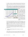
1
Research Institute for Knowledge Systems BV Integral Assessment Module for Coastal Zone Management. RAMCO 2.0 User Guide Inge Uljee, Guy Engelen and Roger White RIKS Geo RIKS bv P.O. Box 463 Papenstraat 8 6200 AL Maastricht The Netherlands June 1999 Important Notice Please take notice of the following remarks when installing the RAMCO Demo. 1. RAMCO has originally (Octobre, 1996) been developed (Contract RKZ-308) for the National Institute for Coastal and Marine Management (RIKZ) and the associated Coastal Zone Management Centre (CZMc), P.O. Box 20907, 2500 EX The Hague, The Netherlands. RAMCO has been developed by INFRAM bv, P.O. Box 81, 3890 AB Zeewolde, and RIKS bv, P.O. Box 463, 6200AL Maastricht, The Netherlands. 2. The version 2.0 of RAMCO is the result of the Land Water Environment Information technology (LWI) - Project “Integral Systems Analysis”, in the “LWI Estuaria and Coasts” project group. The end-users of this LWI-product are: National Institute for Coastal and Marine Management (RIKZ) and the Coastal Zone Management Centre (CZMc), and the Netherlands Organization for the Advancement of Tropical Research (WOTRO). The developers group consists of: INFRAM bv, RIKS bv, and WL|Delft Hydraulics. 3. The SW Sulawesi model makes extensive use of knowledge gathered in project W01.60 of the Netherlands Organization for the Advancement of Tropical Research (WOTRO). This scientific material remains the full property of WOTRO. 4. If you have on your machine other RIKS applications, such as: GEONAMICA®, the LEEFOMGEVINGSVERKENNER, WADBOS, the ISLAND Demo, SIMLUCIA, the CELLCITY Demo or earlier versions of the RAMCO Demo, then put the RAMCO version 2.0 files in a dedicated directory different from the one(s) that contain(s) any of the other applications. Do not interchange files between the different applications as files may have the same name but different contents. 5. RIKS bv is constantly trying to improve its applications. It is our policy to provide you with the most recent versions of the programs and manuals available. However, as a result, you may receive an application that is slightly different from the one described in the manual. Do not hesitate to contact us if this would cause you any problems. 6. The RIKS Demos are curtailed versions of more elaborate software products. Each of the Demos is conceived to allow you to get a good understanding of the full software product. If you are interested in a demonstration of the full version, you are welcome to contact RIKS bv. 7. Neither software development with the tools provided in the RAMCO package nor the application of the RAMCO package to a case study is permitted. Software or application development and further usage or marketing of the RAMCO package will only be accepted following the purchase of a full version of the package. Enjoy our demos and please return your comments to us. RIKS bv, P.O. Box 463, 6200 AL Maastricht, The Netherlands Tel. 31-43-388.33.32; Fax. 31-43-325.31.55; e-mail:[email protected]; http://www.riks.nl/ RamCo User Guide - Version 2.0 June 1999 Page 2 Table of Contents 1. 2. 3. 4. Introduction 5 1.1. Decision Support Systems. 5 1.2. Modelling and decision making philosophy 7 1.3. Policy analysis by means of RAMCO 8 1.4. Model integration and model implementation 9 1.5. Future developments 15 1.6. The case South-West Sulawesi 17 Getting Started 19 2.1. What is included in this demo package ? 19 2.2. Installing RAMCO: Hard- and Software Requirements 19 2.3. Installing RamCo: Installation procedure 19 2.4. Starting RAMCO 20 2.5. Screen Layout 20 2.6. Getting Help 23 2.7. Exiting RAMCO 23 2.8. If you experience problems 24 Running SW Sulawesi Simulations 25 3.1. Running a simulation 25 3.2. Starting the simulation. 34 3.3. Viewing model output 35 3.4. Saving simulation results. 36 3.5. Printing simulation results 37 The RAMCO Menu System 39 4.1. The File Menu 39 4.2. Edit Menu 42 4.3. View Menu 43 4.4. Maps Menu 45 4.5. Rules Menu 49 4.6. Simulation Menu 50 4.7. Options Menu 52 4.8. Window Menu 54 4.9. Help Menu 55 RamCo User Guide - Version 2.0 June 1999 Page 3 5. ANALYSE 5.1. 6. 57 Basic concepts and features 57 Policy exercises with RAMCO 61 6.1. Introduction 61 6.2. Exercise a: introducing scenarios 62 6.3. Exercise b: implementing a policy option 64 6.4. Exercise c: studying the impacts of other coastal processes on policy effectiveness 65 7. References 69 8. ANNEX A: Pointer Shapes 71 9. ANNEX B: Factors and Weights 72 RamCo User Guide - Version 2.0 June 1999 Page 4 1. Introduction RAMCO is a prototype of an information system which is to evolve eventually into a Generic Decision Support Environment for the Integral (or rapid) Assessment of Coastal Zone Management problems. The ultimate aim is to develop an environment that will be applicable for the purpose of (1) integral assessment of (2) a wide range of coastal zone management problems, in (3) a large variety of coastal zones. The term generic in this report is to be understood is this sense. The first version of RAMCO was developed as part of the project: “RAMCO: Generic Decision Support System for the Rapid Assessment phase of Sustainable Coastal Zone Management” financed by the National Institute for Coastal and Marine Management (RIKZ), Rijkswaterstaat, and the associated Coastal Zone Management Centre (CZMc), Contract RKZ-308 and carried out by the consortium consisting of INFRAM bv (Zeewolde, main contractor), and RIKS bv (Maastricht). The version 2.0 of RAMCO is the result of the Land Water Environment Information technology (LWI) - Project “Integral Systems Analysis”, in the “LWI - Estuaria and Coasts” project group. The end-users of this LWI-product are: National Institute for Coastal and Marine Management (RIKZ) and the associated Coastal Zone Management Centre (CZMc), and the Netherlands Organization for the Advancement of Tropical Research (WOTRO). The developers group consists of: INFRAM bv, RIKS bv, and WL|Delft Hydraulics (Delft). The Technical University of Twente, Department of Civil Engineering Technology & Management, (Enschede) participated as a sub-contractor of INFRAM bv. Both version 1 and version 2 of RAMCO are applied to the Coastal zone of SW Sulawesi (Indonesia). The model of the coastal zone of SW Sulawesi makes extensive use of knowledge gathered in project W01.60 of the Netherlands Organization for the Advancement of Tropical Research (WOTRO). This scientific material remains the full property of WOTRO and the scientific teams that carried out the original research. This demo is an implementation for demonstration purposes of RAMCO and runs on PC compatible machines. The scientific philosophy which is at the base of RAMCO and the RAMCO methodology is described at greater length in a number of publications and technical reports mentioned in the reference list of this user guide. The demo will be best used in combination with a selection of these documents. 1.1. Decision Support Systems. Decision Support Systems are defined here as computer-based information systems that are built to assist decision makers address semi-structured problems by allowing them to ‘access’ and use ‘data’ and ‘analytic models’ (Najdawi and Stylianou, 1993). RamCo User Guide - Version 2.0 June 1999 Page 5 ‘Access’ to models and data is provided by means of the user interface (UI), which is --in the state of the art systems at least-- of a graphical nature (GUI) and is to hide the technical (software) complications of the information system from the end-user. The ‘data’ required to correctly and formally define, analyse and possibly solve the decision problem, are stored in the database management system (DBMS) of the DSS. For decision making problems with an explicit geographical nature, such as Coastal Zone Management, a more versatile solution is to have a GIS take care of data management. GIS have additional analytical and decision support features that potentially can enhance the capabilities of the DSS. Finally, the ‘analytic models’ are stored in the model base management system (MBMS) of the DSS. Typically ‘decision models’; statistical and operations research methods, as well as tools to portray, compare and evaluate different decision alternatives, are part of it. Even more essential in the model base are the ‘domain specific models’ capable of grasping the complexities of the system and the problems under study. All the instruments in the model base are of a formal nature hence exclude decision making based on common sense, hear say or intuition solely. Good formal decision support methods will rather assume that the decision maker desires to make decisions on the basis of a consistent line of reasoning and will suggest solutions in a way that makes intuitive sense to him. (Holtzman, 1989) We insist on the fact that a DSS is not the same as ‘a model with a nice user interface’. This abuse of the term DSS has become very common. The difference between a ‘model’ and a ‘DSS’ resides in the fact that a model solves a very precisely defined problem, while the DSS is developed to solve problems that can not easily be reduced to known problems or solutions. It provides the user with models, methods and tools that allow to find the best possible answer to the problem. Hence, it will not necessarily give a precise answer or solution, rather it will approach a solution in a manner similar to an heuristic procedure. DSS emphasise flexibility, effectiveness and adaptability, hence are at best systems with an open architecture to permit their renewal and expansion as new knowledge and tools become available. The primary function of DS systems is to improve the quality of the decision making process. It is inherently understood that if the process can be improved, higher quality decisions will be the end result. From the management sciences, DSS methodologies have adopted the view that ‘decision making’ is a process consisting of various stages that are stepped through linearly or cyclically. Generally three major phases are defined in the decision making process (Janssen, 1992): the identification phase, the development phase and the selection phase. From the fields of psychology and economics, the idea is adopted that decision making is a normative process: given a certain definition of optimality, decision rules are developed that result in an optimal solution for a stated problem. Coastal Zone Management problems are rarely posed in terms of a single goal, rather as sets of different, simultaneous, often contradicting goals that should be met when and where possible. This involves ‘satisfying’ rather than ‘optimising’, as there is not a ‘unique’ or ‘optimal’ answer to the problems raised. Hence, for the purpose of strategic management in highly dynamic complex systems such as coastal zones, adequate techniques are required that support and stimulate the decision maker in recognising actual problems and anticipating future ones, and that permit him to formulate and test possible solutions to assure a ‘safe’ future for the system. For such exercises --and despite the fact that they are not typically used in DSS-- simulation models are effective means (Boersma, 1989), because: RamCo User Guide - Version 2.0 June 1999 Page 6 • they permit to represent complex situations that are beyond the reach of the operations research and analytical methods typically used in DSS; • they permit an intuitive, plastic representation of reality, thus providing a better insight in the actual decision domain and the particular decision situations; • they permit to calculate alternative, comparable futures, thus constituting an instrument to investigate the likeliness of a desirable situation through experimentation. But, simulation models remain poor decision tools, in the sense that they are not goaldirected. Rather, an initial condition, along with constraints on the model, is solved and propagated forwards in time. By means of ‘What-if’ analysis, the user is to change the initial state, or the constraints, until the model produces a desirable final ‘goal’ state. It is by no means certain that this goal state can or will ever be reached, nor is it very clear why it is or is not reached. Future research in the field should focuss on the development and inclusion in the DSS of tools that extend simulation models beyond ‘what-if’ in the sense meant by Rothenberg (1989). The application of multi-objective and multi-criteria methods on simulation results will certainly help in the decision making process, while the application of techniques such as Constraint Satisfaction, Genetic Algorithms and Neuro-computing might reduce the potential search space substantially. 1.2. Modelling and decision making philosophy At the centre of the methodology propagated by RAMCO, is the idea that a good policy is first of all a policy based on the right information and sufficient knowledge about the system for which it is intended. This can only result from a thorough understanding of the network of processes in which the policy maker intervenes. Policy makers face the difficult task of interfering in processes that are very complex in nature because of their interconnection and interrelation. In order to help the policy maker see through this complexity, RAMCO offers him a system model incorporating as much as possible of the essential linked processes and representing reality as faithfully as possible. This is a fundamental scientific approach in which ‘learning about the behaviour and dynamics of the system’ rather than ‘finding a specific solution’ is the most important incentive for the development of models and Decision Support Systems. Thus, it is important to carefully represent these sections of reality as faithfully as possible. The knowledge and the model outline determine the nature and quality of the outcome of RAMCO. Four aspects, in particular, are prominent: 1. Policy makers intervene in complete systems. Although they are supposed to intervene in systems with a view to their particular speciality or policy domain, they automatically intervene in other linked processes and may consequently cause unwanted (side) effects in the entire system. Conversely, problems that occur in particular parts of the system may originate from other parts of the system. This understanding, but also a better assessment of advisable interventions, can only be gained by using integral models --meaning complex coupled models--, which make it possible to understand the main driving forces within the system. 2. Policy makers intervene in living systems which are never at equilibrium. Rather they are in a (thermodynamic) ‘far from equilibrium’ condition. Thus, policy makers intervene in a dynamic reality. Their interventions cause irreversable effects and even small interventions in the system can have unexpected and macroscopic consequences. These can lead to changes in the system in the short or long term (paradigm of self-organization, see for example Prigogine, 1981; Engelen 1988). RamCo User Guide - Version 2.0 June 1999 Page 7 This requires strongly linked, dynamic models, to grasp the feed back loops and the complexity which characterizes reality. 3. Policy makers intervene in spatial systems. In space, processes occur in more or less defined clusters of high and low concentration. Antropogenic and natural processes do not occur on average, neither evenly spread or constant in time. The detailed and changing spacing is controlled by the spatial interaction between physical processes and spatial (human) mobile agents. A true representation of a policy domain therefore requires spatial dynamic models. Literature shows that the robustness and succes of a spatial system (such as a coastal zone) particularly depends on its diversity, its complexity and its behaviour on a microscale. Policies can be more effectively directed if these microdynamics are better understood. Hence, they need to be represented in the decision instruments. 4. Policy makers have to deal with uncertainty. Despite all scientific knowledge that is currently available, it has not been possible to accurately predict the behaviour of complex natural and antropogenic processes. It is possible, however, to make certain statements about the robustness of the behaviour of the system when it is disturbed by interventions. RAMCO supports an exploratory use of models. In this way it particularly helps to narrow down the number of possible interventions, without making a predictive statement about the only or optimal intervention. RAMCO uses integrated spatial models, in which natural, social and economic processes are fully linked on an appropriate detailed scale. It uses spatial information from GIS and (static and/or descriptive) GIS operations. The models are used to simulate reality and they show the user a glimpse of the future in all its complexity --either influenced by him or not. Time has the same meaning as in non-linear thermodynamics: there is only one calendar, one time loop, in which all processes occur simultaneously, and time runs clockwise only. This is very different from the classic mechanics based approach in which sub-processes are solved separately and sequentially: each sub-process produces an output which is passed from one sub-process to the next in a chain like fashion. In the latter approach, time is only an intermediate variable, which is set back and rerun for each sub-process separately. The knowledge contained in RAMCO is mainly available in the form of mathematical (sub-)models and algorithms. These sub-models fit into an integrated dynamic model of the coastal zone. Although RAMCO calculates nearly the entire integrated model in the background, the user can limit himself to selecting those model components that are required to home in onto his problem. The processes that remain in the background will make certain that the consistency in the system be maintained. All the models used in RAMCO are fully documented in on-line documentation pages in which characteristics of the sub-models and their connection to the larger model are explained. This transparency has been implemented with the aim of informing RAMCO users as completely as possible about the possibilities the system offered as well as on the details of the calculations it performs. They also provide information on the source of the knowledge used and the hypotheses which underlie this scientific material. 1.3. Policy analysis by means of RAMCO Inherent in the aims that lead to the development of RAMCO is the positivistic view that the use of scientific models and methods can improve the policy making process. More in particular, RAMCO adheres to the view that better informed policy makers are better RamCo User Guide - Version 2.0 June 1999 Page 8 equipped to make better policies. Thus the role of the models and the Decision Support System is foremost awareness building and the education of the user, rather than support of the decision-making act itself. The models therefore should give an adequate, truthful representation of the real world system, and the policy maker should be enabled to work with the models and the system in a well-structured, well-guided, transparent and flexible manner. The formal representation of the real world system by means of an integral model enables the user to work with it in a manner similar to what is common in process control. The coastal system (box: System) is represented by means of an integral model. Due to its autonomous dynamics, this system will evolve into new states as time goes by (box: Resulting state). The new state can be captured in a number of indicators. When starting the exercise, the policy maker or coastal zone manager should have a clearly defined set of criteria expressing the desired state of the system at a particular point in time (box: Prefered state). In order to bring the actual state of the system closer to the prefered state, the policy maker can intervene in the system by means of policy measures (box: Policy measures). In an iterative process, he can tune his policy measures in an attempt to appraoch the prefered state with a minimum amount of intervention and costs. The robustness of the chosen policy measures can be tested by imposing effects on the system which are beyond the control of the policy maker. These effects are called scenarios (box: Scenarios) in RAMCO. In the RAMCO user interface, these different elements can be interactively consulted or specified from separate screens, each giving a specific view on the integral model. See section 3.1.2. for more detail. We would like to draw the attention on the fact that the above scheme represents the loops in the learning process of the user. It is too simple a scheme to represent the manner in which policy measures are designed, decided and implemented in reality. To that effect, the model developed by Mintzberg (See for example Janssen, 1992) is much more useful. 1.4. Model integration and model implementation At the very hart of RAMCO is an integral model representing the physical, environmental, economic and social processes that typify the dynamics of a coastal zone RamCo User Guide - Version 2.0 June 1999 Page 9 generally and the coastal zone of SW Sulawesi in particular. In order to develop this type of integral model, use is made to the extent possible, of existing scientific knowledge, methods, models and databases. Existing models dealing with physical, ecological and socio-economic aspects of coastal zones have been reviewed and adapted in view of their integration into a multi-scale, multi-temporal dynamic modelling framework. This activity requires to pay attention to the scientific, practical and technical aspects of model integration (Engelen et al., 1999). But, despite the fact that the terms ‘integral model’ and ‘integrated model’ are used all over the literature, and despite the fact that the use of integrated models is strongly advocated in disciplines such as Integrated Assessment (see for example: Gough et al., 1998), very few recipes or procedures for model integration are available from the literature. Model integration seems more an art than a science at this moment: Scientific integration, we believe, is about what can and what cannot be integrated from a scientific point of view. It involves constraints on the type of models (for example: qualitative vs. quantitative, dynamic vs. static, etc.) on the temporal dynamics and time scales, on the spatial dynamics and spatial resolutions, on the details that matter, and on rigorous methods for aggregation and simplification. Practical integration deals with the end-use and the end-user of the model. It seeks an answer to the questions: what is useful to be integrated with a particular end-use in mind and what are the needs, expectations and constraints of the end-user? It is the experience of the authors that public policy problems are often ‘complex problems’ rather than ‘complicated problems’, meaning that the problems touch the near complete system, but could be given an adequate answer if a limited formal description of the whole system would be available. As a result, we believe that the development of an integral model will foremost involve a simplification and aggregation effort in order to enable policy use of models that have been developed most of the time for research purposes. Technical integration deals with the ways in which existing models, their software representation, databases, user-interfaces, input and output devices can be coupled into a single system, running on the end-user’s computer platform. In the computer sciences, technical integration has been given a lot of attention. It has become much easier, at least for the technicians among us, and should no longer be the limiting factor in the development of a usable integral model. From a computer science point of view, integration of models is very much a problem of software component integration. Software components are pieces of software that are designed for re-use. The ideal software-component is platform independent and can be plugged into a software system like a plug into a socket. In the last decades, several software component technologies have been developed; some of which are platform independent. On the PC platform, on which RAMCO runs, one of the first successful component technologies was the Dynamic Link Library (DLL): a file with executable code that is easy to distribute and re-use. The main drawback of the DLL is the lack of structure, which prevents an application from verifying whether it uses the DLL in the correct way. Compared to DLL’s, VBX’s have more internal structure. They are easy to develop in Visual Basic and were mostly used to build small supporting graphical applications, called controls, and abbreviated as X in “Visual Basic X”. Their main drawback is the inherent 16-bit technology on which they are based. A heavyweight 32bit version of VBX is OCX, but the latter software components are notoriously difficult to develop. ActiveX (Rogerson, 1997) is the latest software component technology developed by Microsoft. It concerns a ‘light’ version of OCX. It was mainly the need to create small interactive web pages on machines running Microsoft Windows that led to RamCo User Guide - Version 2.0 June 1999 Page 10 the development of ActiveX, because small ‘active’ controls were needed as part of a web page. Hence each interactive control became an ActiveX software component. ActiveX is supported very well by the Microsoft Development Studio toolkit, which enables to build ActiveX components in C++, Visual Basic or Fortran within minutes. In the future, RAMCO will use more extensively the ActiveX technology. In order to incorporate existing models in RAMCO, they will need to be represented as ActiveX components. With a view to change the software code of the existing models as little as possible, the models are ‘wrapped’ into a piece of intermediate software code (called ‘wrapper’), which will make them look like ActiveX’s from the outside. subroutine declarations of ActiveX / RamCo components RamCo simulation engine using ActiveX subroutines An ActiveX / RamCo wrapper is put around each existing model 'XYZ'. This wrapper converts the subroutines of model 'XYZ' on the inside into ActiveX / RamCo subroutines at the outside subroutine declarations of existing model 'XYZ' implementation of existing model 'XYZ' Clearly, the typical user of the RAMCO modelling shell or Decision Support System would be served best if he could compose, exchange and re-arrange sub-models as easily as Lego building blocks and develop his model from a set of exchangeable and interchangeable Model Building Blocks (MBB), each representing an autonomous process which is executed at its characteristic time step and geographical scale. The ‘wrapping’ technique is applied to each unit, and the RAMCO simulation engine takes care of the linking, time keeping, synchronisation and data management and of the units. 1.4.1. RAMCO’s simulation environment In order to develop and adapt integral models in as flexible a manner as possible, RAMCO features an Object-Oriented (O-O) simulation environment and simulation language. The objects are the so-called Model Building Blocks (MBB’s). MBB’s are more or less complete models. They vary from simple mathematical operators, such as Multipliers or Adders, to rather sophisticated and nearly complete models consisting of coupled mathematical equations performing sophisticated calculations. A Model Building Block represents a portion of the model: an action or process. Each MBB is represented by means of a unique graphical object that shows how the MBB relates and is connected to other MBB’s in the model. From this connection scheme, the MBB knows where it has to get its input from, and where it has to send its output to. MBB’s may simply represent sources of information (i.e. entered from file or by the user), other will transform information as it passes through them, and still other will simply serve to communicate, in a synthetic manner, the outputs of the model to the user. Despite the fact that all these MBB’s play different roles in the model, in Object-oriented jargon, they are all ‘children’ of the same ‘parent’, which is essentially a MBB capable of exchanging and transforming information. RamCo User Guide - Version 2.0 June 1999 Page 11 Model Building Block In-Connector Connection Out-Connector Next to the Model Building Blocks, RAMCO’s simulation language features a number of additional primitives: In-Connectors through which MBB’s obtain data from other MBB’s; Out-Connectors through which MBB’s send out their output for use in other MBB’s; Connections that link the MBB’s; Dialogs through which the MBB’s communicate with the user; and Documentation pages containing the technical specifications of the MBB’s. Libraries are repositories of MBB’s. The entire definition of the MBB (its code, its graphical representation, its dialog, its connectors) are stored in the Library. When a MBB is included in a model, the block itself is not copied to the model, rather a reference to the block in the library is made. SuperMBB’s group a number of interrelated and linked MBB’s that form a logical entity. They are introduced to keep the representation of the model structured and clear. Every MBB has one Dialog associated with it. Dialogs are used to enter MBB specific information, such as the parameter values and the initial values of the state variables of the model. While the simulation is running, dialogs return the updated values of output variables to the user. Entering data in dialogs is done in a manner which will support and protect the user to an extent, because each edit box in a dialog window knows what type of data it should get from the user: a single number, a set of numbers, or a table (i.e. time series). For each type the appropriate editor is opened when the user clicks in the edit box. Each MBB has its Documentation page in the Documentation system. It is accessible when the dialog window of the MBB is opened (by pressing the F1-key or clicking in the dialog window by means of the Context Sensitive Help cursor). This Documentation page gives technical information about the MBB. It can include the mathematical expression, scientific references, the specification of the In- and Out-Connectors, etc. A model block has a so-called In-Side and an Out-Side. The In-Side is where the InConnectors are placed, the Out-Side is where Out-connectors are placed. Each of the four edges of the MBB can be the In-Side or the Out-Side. The only limitation is that the In-Side and the Out-Side of an MBB can never be on one and the same edge. In future versions of RAMCO the modeller will be enabled to manipulate the objects by means of a graphical editor. He will place the Objects on the screen and connect them to each other in order to create a consistent and coherent model. RamCo User Guide - Version 2.0 June 1999 Page 12 1.4.2. Levels of spatial dynamics One of the unique features of RAMCO is its capability to deal with spatial dynamics at different levels within the same integral models. More in particular RAMCO models will generally have two strongly coupled components: one for macro-level, long range and large scale processes and a second one for processes operating on the micro-level, short range, and micro-scale. Sub-models will in general operate at one level, but may exchange information with sub-models at the other level. At the macro-level, the model integrates several component sub-models, representing the natural, social and economic sub-systems of the coastal zone. These are all linked to one RamCo User Guide - Version 2.0 June 1999 Page 13 another in a network of mutual, reciprocal influence. The macro-level allows for the use of regionalised representations and for different types of mathematical representations thus permitting a more or less detailed modelling of various aspects of the sub-systems as required for specific applications. The micro-level models are cellular models: they are developed on a cellular aray of identical cells. At this level RAMCO supports the use of models that are based on the theory of Cellular Automata (CA). Cellular Automata are mathematical objects that have been studied rather extensively in mathematics, physics, computer science and artificial intelligence (Gutowitz, 1991), but, until recently they were best known as games (Gardner, 1970). Tobler (1979) defined them as ‘geographical models’, but only recently have they been applied in the spatial sciences (e.g. Couclelis, 1985, 1988; Engelen et al. 1993, 1995, 1996; White and Engelen, 1994, 1997a, 1997b). A cellular automaton consists of an array of identical cells in which each cell can assume one of a discrete number of possible states at any one point in time. Time progresses in discrete steps, and all cells change state simultaneously as a function of their own state and the state of the cells in their immediate neighbourhood and defined in a set of state transition rules. Flow and diffusion processes require spatial contiguity in order to take place, since the interactions consist of point to point spread: water currents carrying sediments from one cell to the neighbouring cells, or seeds spreading from one site to another. They can be represented in a fairly simple CA model defined in terms of the Moore neighbourhood, consisting of a cell an its 8 nearest cells. But, socio-economic interactions take place over distances beyond the nearest neighbours, and neighbourhoods of a larger size are required to model them adequately. As a result, the neighbourhood of the land use model in RAMCO is a circular template consisting of 197 cells at the maximum. Except for purely theoretical problems (See for example: Gardner, 1970; White and Engelen, 1993), spatial problems are set in spaces that have idiosyncrasies and heterogeneities at all levels of detail. In RAMCO heterogeneities have been introduced on the level of the individual cells of the cellular space. The apparent similarity of cellular spaces with raster based GIS systems led us to define these in terms of geographical factor maps (Wright, 1990) and derived suitabilities and accessibilities. This allows us to introduce physical, environmental, institutional and historical characteristics in dynamic models at high levels of spatial resolution. 1.4.3. GIS component RAMCO can handle cellular models with dimensions up to 500 by 500 cells. In its actual form, it is most useful for modelling problems on grids which resolution varies from 50 to 500 meter. RAMCO has all the facilities required to be used as a stand-alone application: it has all the editors required to enter new or to modify existing information, it permits to import GIS data and to export its (geographical) output to GIS systems. In particular RAMCO has been equipped with the necessary data-translators to exchange information with IDRISI for Windows (Eastman, 1995). IDRISI offers all the functionalities required to import, enter or prepare the data for RAMCO’S micro models, and it offers a number of tools to further analyse the map output generated by RAMCO. IDRISI for Windows has been selected because: 1. it is a raster based GIS, and thus fits the cellular paradigm by design; 2. it makes use of standard file formats and thus permits the exchange of information with other GIS packages; 3. it is easy to use and runs on most PC’s under Windows; RamCo User Guide - Version 2.0 June 1999 Page 14 4. it is updated on a regular basis; 5. it is very well documented and widely used, both for training and policy making; 6. it has been selected by UNEP and UNITAR as the system for use in developing nations; 7. it is very reasonably priced. It could be envisaged to include in the future versions of RAMCO aditional data translators to exchange GIS information with other commercial GIS packages. 1.4.4. DDE link with Excel. With the aim of increasing RAMCO‘s level of re-usability and flexibility, the possibility has been built-in to link it to Microsoft Excel. More in particular there exists a DDE link between RAMCO’S Simulation Environment and Excel. In this prototype, the link is one way: at each simulation time step, RAMCO sends a row of data to a predefined Microsoft Excel Workbook. These data –updated values of the goal variables-- are available to the user during and after the simulation and he has the full functionality of Microsoft Excel at his disposal to work with them. Hence he can store the results or perform more or less sophisticated operations on the data using the evaluation and optimisation algorithms available in Microsoft Excel. 1.5. Future developments Decision making with RAMCO will be to an extent a collaborative effort involving three distinctive types of users. For the sake of clarity we name them: Modeller, Analyst and Policy Maker. It is not excluded that different types are unified in one and the same person, but, given the specific technical and context knowledge required from each, it is more likely that this is not the case. This version of RAMCO does not as yet feature the full functionality required to support each of the users entirely. In particular the editors required to alter the models are not as yet available to the Analyst and the Policy maker. However, later versions are intended to evolve into the general direction outlined below. The Modeller is furthest away from the actual policy making process. He is the most technical type and responsible for the development of the Model Building Blocks (MBB’s) that are stored in the MBB-Libraries. This user has the knowledge and skills required to translate technical and conceptual problems posed by the Policy maker and the Analyst into quantitative models, algorithms and new building blocks that are missing in the existing MBB-libraries. Next he is capable of implementing the algorithms into executable software code which respects the guidelines, templates and interfaces that Active X component technology imposes. The Analyst is capable of building integrated models by means of the Model Building Blocks which he selects from a MBB-Library. To that end he will need to have a good knowledge of the processes in coastal zones and of the state of the art scientific knowledge about how to represent them formally. He will have to be familiar with the Model-editor of the RAMCO simulation environment. The analyst will possibly personalise dialogs as well as Documentation pages. He will calibrate the models which he builds and will define the ranges of parameters and variables as well as the initial conditions and the default values. He is sufficiently familiar with RAMCO, the IDRISI GIS system and MS Excel to prepare (import and export) map information and possibly to customise the output of the system. The Analyst and the Modeller have access to all the facilities offered by RAMCO. Thus, they can overrule the parameter settings and ranges of all kinds. RamCo User Guide - Version 2.0 June 1999 Page 15 The Policy maker is the final user of the system. He will work with the fully prepared and calibrated version of an integral model, coupled as it might be with the GIS, Microsoft Excel or the ANALYSE program. He will have the possibility to change parameter and variable settings within the (save) ranges set by the Modeller and/or the Analyst. He will have full access to the different views of the model, to verify values of intermediate and state variables, but he will work mostly with the views Scenarios, Policy Options and Policy Impacts as they have been designed and prepared specially for him. If we define Integral Assessment as ‘the exercise aimed at getting a good understanding of the coastal system as a holistic, integral system, in order to identify the major driving forces and to detect the faults therein’, then it is likely to state that the Analyst in collaboration with the Policy maker are the primary users of the RAMCO system. Eventually they should be able to quickly set-up the system for a specific case and should be able to share their views through hands-on experiments with stakeholders, even with the public at large. Developing a new application with the RAMCO DSS will in most cases start with a discussion between the Policy maker and the Analyst. The Policy maker will pose the specific policy problems he is faced with. He will define the policy measures that are to be tested, the external influences that have an impact upon the system and the performance indicators and criteria which he wants to incorporate in the evaluation process. Next, he might be able to present a first analysis of possible cause and effect loops that typify the coastal system. In the best of cases, the Analyst will be able to select an existing integral model which has been implemented in RAMCO and adapt it to represent the new problem adequately. To that end he will use a graphical model editor, remove obsolete MBB’s from the model, select new MBB’s from the MBB Libraries and connect them with the other MBB’s of the model. If the new model requires MBB’s that are not as yet included in an MBB Library, then the analyst will request a Modeller to develop such a MBB for inclusion in the MBB Library and his model. The Analyst will gather the data for the model. Part of these consist of geographical data which he can import from existing GIS systems or enter them by means of RAMCO’s GIS facilities. He will calibrate his new model and test its sensitivity. From these exercises he will obtain the default values and ranges for the parameters and state variables, which he enters into the system. Once the models have been fully calibrated, the system can be handed to the Policy maker. He can design and run alternatives and evaluate their relative merits in meeting the policy goals which he has set. It is obvious that the steps described above are not run through in a linear and sequential manner, rather an iterative and cyclic process is more likely. Also the interplay between the different users will be more lasting than suggested. One of the very great merits of RAMCO is the manner in which it could gradually evolve into a storage tank of coastal zone management knowledge. Indeed, as a result of its application to coastal zones worldwide, its MBB-Libraries and Model bases will grow, till a point where many of the processes typifying coastal zones will have a formal representation available from the MBB Libraries. From this, we imagine that specific Libraries could be developed --similar to the engineering and manufacturing fields-- that will group the MBB’s required for specific coasts, such as: Tropical coasts, Arctic coasts, Sandy coasts, Strongly urbanised coast, etc. RamCo User Guide - Version 2.0 June 1999 Page 16 1.6. The case South-West Sulawesi In order to demonstrate the capabilities of RAMCO in addressing Coastal Zone Management problems, a case has been implemented. It concerns a coastal zone in South-West Sulawesi (Indonesia) centred around the city of Ujung Pandang. This region suffers of a number of typical problems, which can be addressed by means of RAMCO. A short description of the problems is given here. This section is based on: J.L. de Kok and Wind H.G., 1996; ‘Towards a Methodology for Sustainable Coastal Zone Management, A Case Study for South-West Sulawesi’, Twente University, the Netherlands, and J.L. Kok and Wind H.G., 1999; ‘Methodology for Sustainable Coastal Zone Management in the Tropics, The Integrative Research’, Twente University, the Netherlands. For more ample information on the case study, we refer to the original publications. 1. Urban growth: The total population size in the study area outnumbered 2 million people in 1994, half of which is living in Ujung Pandang, the main city in the region. The annual population growth of this city in the period 1984-1990 was 4.7 %. Major projects are ongoing and planned to develop the urban area: expansion of the harbour, the airport and the nearby industrial site. Thus the city will continue to exert a major drawing force on the rural area. Its population size is expected to double in the next 20 years. This causes major pressure on the land in the coastal fringe, but also causes problems related to waste generation. 2. Aquaculture: Along the coastline, most of the mangroves --providing a natural coastline protection-have been cut to be replaced by brackish-water ponds (called tambaks) to grow fish, prawns and seaweed. The main driving force of this mechanism is the export market which is an important source of foreign currency. For S.W. Sulawesi Aquaculture in tambaks now represents 70% of the total monetary production of the fish sector. The tambaks, which often use the tidal action for waste discharge, also form a major source of coastal waters pollution due to the intensive utilisation of antibiotics and overfeeding of the prawns. RamCo User Guide - Version 2.0 June 1999 Page 17 3. Intensified Agriculture: The introduction of new high-yielding rice varieties and increased use of fertilisers exacerbate ground- and surface water pollution. The productivity of the rice fields almost entirely depends on the amount of irrigation. The runoff of fertilisers and pesticides affects the quality of the water used for nearby tambaks. 4. Erosion in the upland area: The catchment area upstream the Bili-Bili dam is characterised by considerable soil erosion, increased by intensive land-use for horticulture products and large scale forestry. Without proper counter measures, the resulting runoff of sediments can reduce the life time of the reservoir. Moreover the degradation of cultivable lands has lead to the expulsion of labour. This makes more and more people dependant on marine resources for their livelihood or causes people to migrate to the city for their survival. 5. Bili-Bili dam and Jeneberang river: The main purpose of the dam is to prevent the city from flooding by the Jeneberang river during the wet season. The reservoir will contribute to the solution of the municipal water shortage in Ujung Pandang. At present, less than 50 % of the demand is met by the municipal supply. It is improbable that the water supply from the reservoir will be able to keep up with the rapid growth of the city. Irrigation and hydropower are competing for water use. Downstream of the dam problems can be expected as most of the sediment in the Jeneberang will be intercepted by the dam, the amount of sediments transported to the coast is expected to reduce with 80%. This may result in coastal morphologic changes of the land north of the river mouth. On the other hand, the near to the coast coral reefs and seagrass meadows will be less affected by terrigene sedimentation due to the decreased discharge of the Jeneberang river. 6. Tourism in the delta: S.W. Sulawesi is not as yet a major destination for domestic and foreign tourists. The regional authorities are planning to develop local tourism and recreation. North of the river mouth an area of 1000 ha has been given a tourism destination. The possible morphological changes of the river delta, the problems caused by the increasing pollution and the risks for flooding have not been taken into consideration sufficiently. 7. Over-exploitation of marine resources: As the population of the coastal zone traditionally depends very largely on fish for its food and proteine intake, the fish stocks in the strait of Makassar are strongly subject to overfishing. This problem has become a severe one, and plans have been made to create a marine park where fishing is forbidden in oder to allow the fish stocks to recover somewhat. Meanwhile, dynamite fishing is still practiced in the Spermonde archipelago, which causes substantial damage to the coral reefs and the depletion of the fish stocks. Moreover, the urbanisation process is accompanied by large scale infrastructural developments and construction activities, which leads to an increasing demand for construction material. Coral reefs provide a cheap base material for the cement. This coral mining takes place around the islands in the reef zones of the Spermonde archipelago. RamCo User Guide - Version 2.0 June 1999 Page 18 2. Getting Started This chapter explains how to install RAMCO on your computer and how to start the program. It also describes the main features of the graphical user interface. 2.1. What is included in this demo package ? The RAMCO demo package consists of this printed document and two 1.44 Mb diskettes labelled RAMCO disk 1/2 and RAMCO disk 2/2. On RAMCO disk 1/2 you will find a series of compressed files and 1 executable Setup.EXE that is used to install RAMCO. 2.2. Installing RAMCO: Hard- and Software Requirements RAMCO runs on personal computers equipped with an Intel 80486 or Pentium processor. To use RAMCO, your computer should have the following hardware components: • • • At least 16 Mb of RAM (32Mb recommended) A hard disk with at least 4 Mb free (for RAMCO only) A SVGA video card and screen (recommended: resolution 1024*768 pixels, 16 colours, size 17 inch or more) To run the application and the exercises which we describe and provide the files for on the demo diskettes, you should have the following software packages installed on your computer: • • • Microsoft Windows 95/98/NT Microsoft Excel (version 6.0, or later) (optional) IDRISI for Windows (version 1.0, or later) (optional) Contrary to the older versions of RAMCO, it is no longer possible to run this version 2.0 under Windows 3.x. 2.3. Installing RamCo: Installation procedure The following is a description of the step by step installation of the RAMCO. The installation/uninstallation of RAMCO follows the standard for Windows 95/98/NT. If you have a previous version of RAMCO software installed on your machine, it is better to uninstall it first. If you would want to keep it, make sure to put (this new version of) RAMCO in a separate directory. During the installation you may encounter a message asking whether you want to keep or replace certain files. It is prefered to replace them for use with RAMCO. Keeping the old files may cause malfunctioning of the software. RamCo User Guide - Version 2.0 June 1999 Page 19 1 2 3 Start Microsoft Windows 95/98/NT. Insert the disk labelled "RAMCO disk 1/2" into the drive. Click the Start button in the Windows 95/98/NT Task bar. Move the mouse pointer to the Settings command and move on to the Control Panel option. As a result the Control Panel dialog box will open. Select from the list Add/Remove Programs by double clicking it. Next click the Install button in the Install/Uninstall view of the Add/Remove Programs dialog box. Next, the Windows 95/98/NT installation program will be started and will request you to click the Next button until (1) the program has selected your disk drive as the installation medium, and (2) until it will have found on the diskette the Setup.EXE program for RAMCO. Then, the command line "a:\setup.EXE" will appear in the edit field of the install window. Hit Finish to have the program continue the installation. Continue clicking “Next” until the “Read Me” screen appears. Make sure to read this page. After clicking “Next” again, a second dialog box appears asking you where to install RAMCO. You can accept the default path, which is “c:\RamCo” or replace it in the edit box by one of your own choice. You may use the “Browse” button to select this alternative path as well. To go on, press the "Next" button. Otherwise to cancel the installation process, press the "Cancel" button. The installation program will ask you whether the programme must be installed for Windows 95/98/NT or Windows 3.x. Select RAMCO for Windows 95/98/NT. Next the installation program suggests to add RAMCO to the new Program Group RAMCO. You are free to create another Group or to choose an existing one from the list shown. From that moment the installation application is decompressing the necessary files and puts them in the directory structure of RAMCO. At a certain point in time you will be asked to insert disk #2 in the drive. Insert at that moment the disk labelled “RAMCO disk 2/2”. If everything went OK, a last dialog box will inform you about the fact that the installation is finished. Once the installation on the hard disk is completed, the program creates a group named “RAMCO” under the Start button and Programs command. It contains an item labelled “RAMCO”. When you double click this item, RAMCO will be started and the “About” window will appear. Click “OK” to enter the Application window. 4 5 6 7 8 9 2.4. Starting RAMCO Once installed, you can start the RAMCO application as follows: 1 2 3 2.5. Start Microsoft Windows. Under the Windows 95/98/NT Start button and the Programs group, you will find a group called RAMCO. Double-click on the RAMCO icon in the RAMCO group. RAMCO will be started and you will see the RAMCO Application window on your screen. Screen Layout When you start RAMCO, you will enter immediately in the Application window of the simulation environment. This is the window in which you will run your models. Before RamCo User Guide - Version 2.0 June 1999 Page 20 a simulation file is opened, the screen is empty except for its top part. Below we will describe the different components of this screen. Menu Bar Control Menu box Caption Bar Tool bar Status bar 2.5.1. Application Window The Control Menu box The Control Menu box contains the Application window Control Menu, which controls how windows are arranged on the desktop. The list below summarises the Control Menu Commands. Use this command Restore Move Size Minimize Maximize Close 2.5.2. To … restore the window to its previous size move the window using the arrow keys. change the size of the window. You can use the mouse or the arrow keys to change the size. shrink the window to an icon enlarge the window to the full size of the screen close the application window The Caption bar The Caption bar, also called Title bar, of the Application window displays “RAMCO”. To the left of the Caption bar three buttons are positioned that enable you to re-size the Application window. • The Minimize button allows you to shrink the window to an icon (same as Minimize in the Control Menu box); • The Maximize button allows you to enlarge the application window to the full size of the screen (same as Maximize in the Control Menu box); • The Close button allows you to close the application window, and thus quit the application (same as Close in the Control Menu box) 2.5.3. The Menu bar The Menu bar of the Application window contains RAMCO’s main Menu. The commands are logically organised in the menu so that you will quickly become RamCo User Guide - Version 2.0 June 1999 Page 21 comfortable with the various functions of the program. The menus are summarised in the table below; subsequent chapters elaborate on the description. Chapter 4 gives an overview of all menu commands. Use this menu File Edit View Maps Rules Simulation Options Window Help 2.5.4. To … manage your simulation files. The printing facilities are also located in this menu, and if you want to exit the program, you can do it from here. edit the maps that are part of the micro-scale model. All commands for editing are located here. Depending on the type of map that is active, the appropriate edit features are listed and accessible. change the way a map is displayed. Commands to zoom in and out as well as commands to display information on the foreground or background of the maps are part of this menu. open a new window with one of the maps of the modelled region. define the model at the micro level by means of defining the Cellular Automata transition rules. control the simulation. The commands in this menu are the same as the ones represented by means of buttons in the Tool bar. customise the workspace. Commands permit among others to display or remove the Status bar and/or Tool bar, and to (DDE) link the simulation package to Excel. manage your windows on the screen invoke the on-line Help facilities. The Tool bar The Tool bar, also known as Speed bar, gives a faster access to some of the more frequently used commands which are also accessible via the menu. Use this Button To … open a simulation file from the disk. save a simulation file to disk. change the pointer to a pen. The pen is used to pick a value from the legend and enter it in a cell on the map. change the pointer to a bucket. The bucket is used to pick a value from the legend and enter it in larger, contiguous areas of the map. change the pointer to a ruler. The ruler is used to enter detailed information cell by cell. When a cell is clicked, a dialog will open to enter the exact value. zoom-in. Increase the size of the map on the display. zoom-out. Decrease the size of the map on the display. advance the simulation with one simulation step (as set with the Steps... command). advance the simulation till the next pause is reached (as set with the Pauses ... command). stop the simulation. reset the simulation. State variables and maps take their initial values, parameters keep their actual values. RamCo User Guide - Version 2.0 June 1999 Page 22 Use this Button To … print the Micro-scale dynamics window.. access the context sensitive help cursor. The next click action on a command will invoke the context sensitive help on this command. Next to this set of buttons, the Tool bar also displays the simulation clock. Each time step, the clock is updated. The left most figure indicates the years simulated (range: year 0 till year 25), while the right most figure is the month within the year (range: month 1 till month 12) The Tool bar command in the View Menu allows to display or hide the Tool bar in the RAMCO Application window. 2.5.5. The Status bar The Status bar is displayed at the bottom of the Application window. This zone provides information to the user on his actions while he is working with the application. The left area of the status bar describes actions of menu items as you use the mouse or arrow keys to navigate through menus. This area similarly shows messages describing the actions of toolbar buttons when pressed. The right area of the status bar indicates which of the following keys are latched down: Indication CAP NUM SCRL Description The Caps Lock key is latched down. The Num Lock key is latched down. The Scroll Lock key is latched down. The Status bar command from the View Menu allows to display or hide the Status bar in the RAMCO Application window. 2.6. Getting Help RAMCO comes with a very concise on-line Help facility. Its structure and operation is in accordance with the Microsoft Help standards. Hence, using Help should pose no problems for those familiar with Windows. To get Help, press “F1” or the key sequence ALT-H The Help menu has 3 items: 1 “Index” gives an access to the index of the help guide. 2 ”Using Help”, gives the general instructions on how to use the Windows Help System. 3 “About RAMCO ...", gives information about the version of RAMCO that you are working with. 2.7. Exiting RAMCO Closing RAMCO is simply done by selecting the Exit command from the File menu. If you have simulation files open when you select Exit, the application will ask whether you want to save simulation results. If you confirm to be interested in saving results you RamCo User Guide - Version 2.0 June 1999 Page 23 will get the Save dialog box. More information on saving simulation results is given in the next chapter. 2.8. If you experience problems If you experience problems in installing or running RAMCO 2.0, contact: Research Institute for Knowledge Systems bv. To the attention of Inge Uljee or Guy Engelen P.O. Box 463 6200 AL Maastricht The Netherlands Tel: +31 43 388.33.22 Fax: +31 43 325.31.55 E-mail: [email protected] RamCo User Guide - Version 2.0 June 1999 Page 24 3. Running SW Sulawesi Simulations This chapter describes how to run simulations with RAMCO. No details will be given on the model for South West Sulawesi which comes with this demo version of the RAMCO Decision Support environment. For details about the model, we refer to: ‘Methodology for Sustainable Coastal Zone Management in the Tropics, by Jean-Luc de Kok and Herman G. Wind, Department of Civil Engineering Technology & Management, Twente University, Enschede, The Netherlands,1999.’ Also the on-line model documentation contains a lot of detailed information about the model (see section 2.1.2 Dialog boxes). In the previous chapter we explained how to install and run RAMCO. We assume from now on that you have read this information, that you have knowledge of the different technical terms introduced, and that you have successfully installed RamCo on your computer. 3.1. Running a simulation Click the Start button in the Windows 95/98/NT Task bar and point the cursor to Programs group. Move through the cascading menu into the RamCo group and open RAMCO by clicking the RAMCO icon. If the software has been installed successfully, the Application window will open and the About information window will be displayed. Read the information in the About window and push the O.K. button (or the RAMCO icon). Immediately the Open dialog box will open. If not, push the Open Simulation file button. Look in the Open dialog box for files with a .SIM extension. By means of the standard Windows 95/98/NT manipulations you can navigate through the directories on your hard disk, or on another computer in the network, in search of the simulation file of your choice. Once the name of the file appears in the Open dialog box, select it and press the Open button or double click the file icon. RamCo User Guide - Version 2.0 June 1999 Page 25 In fact the .SIM file contains references to all the files that are required to run a model. Later in this chapter we will give more detail about the contents and composition of the .SIM files. Once all files have been loaded, two windows will appear in the Application window: one titled Micro-scale dynamics and the other Macro-scale dynamics. 3.1.1. The Micro-scale dynamics window The Micro-scale dynamics window is split into 3 viewing areas, called Panes. Panes are separated from one another by means of Splitter bars. You can displace the Splitter bars to change the size of the Panes. To this end, position the cursor over the Splitter bar. The cursor changes to the Split Pointer (see Annex A for the meaning of the different pointer shapes). With the left mouse button clicked down, the Splitter bar can be moved and the size of the Panes is adjusted accordingly. Legend Pane Map Pane Splitter Bar Focus Pane The Pane on the left of the Micro-scale dynamics window --called the Map pane-contains a map representation of the modelled region. More in particular the actual land use of the region as well as the position of coral reefs and seagrass beds is mapped. For the sake of simplicity and clarity of this text, we will name sea, coral reefs and seagrass beds land uses. The legend of the map is displayed in the upper left pane --called Legend pane--. The lower left Pane --called the Focus pane-- of the Micro-scale dynamics window shows the mapped region in small. In the upper left part of this small map you will see a wire-frame (an inverted rectangle). If the mouse is placed inside this wireframe, the frame can be moved while holding the left mouse button clicked down. While the wire-frame is moved, you will notice that the focus of the map in the Map pane is changing accordingly. The focus of the map can also be changed by means of the scrollbars of the Map pane. The Legend pane too is equipped with a vertical scroll bar. RamCo User Guide - Version 2.0 June 1999 Page 26 When the simulation is running, the Micro-scale dynamics window will be updated and the resulting land use will be displayed in the Map pane. The commands of the View Menu permit to change the manner in which micro-scale results of the model are displayed in the Map pane. Display options include among other: Zoom in, Zoom out, and 3-D representation. For a complete overview, consult the View Menu in section 4.3 of this User guide. Most of the functionality of the micro-scale models is accessible via the menu structure of the system. Details on the different menu options is given in Chapter 4 of this guide. Here we will focus on a number of elements that are essential to understand the functioning of the micro-scale model and to change its parameters. The micro level model calculates and displays the changing land use (and sea use) of the coastal zone. The legend of the map explains the meaning of the different colours. A distinction is made in the model between the dynamic elements and the non-dynamic elements. Dynamic elements are also called Land-use Functions and Sea-use Functions. The static elements are called Land-use Features. Sea Use Functions: Seagrass Coral Reef Land Use Functions: Agriculture Rice culture Shrimp culture Urban residential Rural residentialt Mangrove Land Use Features: Sea Inland water Airport Industry Nature/forest Tourism Harbour Beach Land-use Features will not change as the result of micro-scale dynamics. That is to say they will not change location: they will not expand or will not disappear due to expansion of other activities. Yet, they influence the dynamics of the Land use or Sea use Functions, and will interfere in the allocation process. For example the Land use function ‘Tourism’ will be influenced by the presence (or absence) of the land use feature ‘Beach’. The dynamic behaviour in space and time is of Sea use functions Seagrass and Coral Reef is different from the other land use functions. The specific details on their dynamics can be found in the documentation pages of the model (see section 2.1.2 Dialog boxes). The dynamic behaviour of the Land-use functions is based on a number of elements which can be changed (in principle at the least) by the user of the model: Cellular Automata Transition Rules. First and most important are the Cellular Automata transition rules. They represent the dynamic element of the micro model (see for example: Engelen G., White R., Uljee I. and Drazan P., 1995; ‘Using Cellular Automata for Integrated Modelling of SocioEnvironmental Systems’, Environmental Monitoring and Assessment, 34, pp.203-214.). For each cell in the cellular space they will calculate how land uses will change throughout the simulation period. The transition rules are accessible via the Rules menu. The rules are written as distance functions, expressing the manner in which land uses influence one another, stating whether they attract or repel one another in their vicinity. These rules are defined for each possible combination of land uses. The model is very sensitive to the values entered for most rules. Hence, changing rules can have dramatic RamCo User Guide - Version 2.0 June 1999 Page 27 effects on the micro-scale dynamics. We advice not to change the transition rules unless you have gained a lot of experience with running the model. An overview of the complete set of rules can be seen when selecting Overview from the Rules menu. Next to the transition rules, the intrinsic characteristics of the cell itself will influence its potential for change to another land-use. These are represented in the model by means of maps, namely the Elevation map, the Suitability map and the Network map. All the maps are accessible via the Maps menu. Elevation. The elevation map is displaying the relief (above and below sea level) of the modelled region. It is important for the model to the extent that land below sea level is not suitable for socio-economic use and that this land can not be allocated to one or the other land use activity. Indirectly, the elevation will influence the suitability of a number of activities. Select Elevation from the Maps menu to have it displayed in a new window on the screen. The View Menu allows to change the manner in which the map is displayed. The possibility exist to Zoom in, to Zoom out or to change the elevation categories with the Legend dialog box. Suitability. For each land-use function a suitability map is present in the model. It shows how suitable each cell in the region is to receive that land use. Suitability calculations are rather standard GIS operations. Suitabilities are composite measures that involve the manipulation of so called Factor Maps. A factor is a unique geographical attribute such as slope, soil type or vegetation cover. Variations within a factor such as the degrees of slope, soil classifications or density of vegetation cover are referred to as factor types. A factor map is showing the geographical location and distribution of factor types for a given factor. Factor maps can be combined in various ways to generate a composite map depicting the relative capability of any given geographical unit to support a specific land use. These composite maps are displaying the so-called suitability of the individual geographical entities (in our case cells). In the SW Sulawesi model a linear combination of factors has been applied: the importance of a factor type (for a specific land use) is first rated and next, the factors are weighted and summed. In Annex B an example of the factor type ratings and factor weights is given. The suitability calculations are done in IDRISI for Windows and the resulting suitability maps are imported in RAMCO. The suitability map of each land use function can be selected from the Maps menu and the way the map is displayed can be altered by means of the View and Edit menu. Network. For each land-use function an accessibility map is present in the model. It shows how accessible each cell is in relation to a network. The network can be --in principle at least-- any network. For the case of the SW Sulawesi model two networks are available: the road network and the irrigation network. In this version of the model, the network included is the road network. For some activities, such as tourism, the direct access to the road system is more important than for other, such as agriculture. The maps are the result of an accessibility calculation done on the basis of the Accessibility parameters which are accessible via the Edit Menu. The user can freely open and close maps (except for the Micro-scale window). We warn the user that opened windows are updated while the simulation is running and that this does take-up processing time, hence that the program will be slowed down. RamCo User Guide - Version 2.0 June 1999 Page 28 More details on the use of Cellular Automata for modelling geographical phenomena at the micro-scale can be found in the publications in the reference list. 3.1.2. The Macro-scale dynamics window The Macro-scale dynamics window is the graphical interface to the Macro-scale model. It consists of 4 Views, but will always show View # 4, the System diagram View, when a simulation model is opened. The other Views are called: Scenarios, Policy options, and Impacts. These names appear as the names of tabs which are positioned just below the Title bar of the Macro-scale dynamics window. You can change the View by simply clicking the appropriate tab. Each of the Macro scale dynamics Views shows a specific graphical representation of the macro model: 1. the View # 4, System diagram View, shows an overview of the structure of the system modelled at the most synthetic level. It allows access to all the details of the model at this level but also at lower levels. You should learn to use it as a graphical explorer of the model. 2. the View # 1, Scenarios View, shows the parts of the model that are most subject to external influences and where hypothesis about these influences can be entered. 3. the View # 2, Policy options View, shows the parts of the model that are subject to policy interventions. This is the View that will be used to select and typify the policy interventions that can be analysed with the simulation model. 4. the View # 3, Impacts View, shows the parts of the model that contain the summarised information and policy indicators to evaluate the impacts of scenario and policy options settings. It is via this View that further information about indicators can be selected. In this prototype, the model structure, nor its graphical representation can be changed by the user. RamCo User Guide - Version 2.0 June 1999 Page 29 A RAMCO model consists of Model Building Blocks (MBB’s) that contains the code required to calculate and execute mathematical operations varying from a single operation (such as the sum of two numbers) to a list of operations (set of mathematical equations). MBB’s are connected to one another by means of MBB Connectors. In order to improve the readability of the diagram, it is possible to group parts of the model into a SuperMBB and represent it in the diagram as a single block. The diagrams in the different Views have been built by means of these primitives. Model Building Blocks. The diagrams in the different Views allow the user to understand the structure of the model and to access parts of it. Model building blocks are represented by means of a rectangle with the name of the MBB in it. Active Model Building Blocks appear in black on the display. When the user moves the mouse pointer on top of such a MBB, its colour will invert. If the user clicks the mouse, the response will depend on the type of MBB. If the MBB clicked is not a SuperMBB, then a dialog box will open. This dialog box has the function of both receiving the data entered by the user and of communicating model results to the user. If the MBB is a SuperMBB, then a more detailed diagram is shown in which each of the MBB’s will act as explained. Non-active MBB’s appear in grey in the diagrams. They are copies (or Alias) of MBB’s that appear elsewhere in the diagram (usually in another View or at another hierarchical level). Connections made with a Non-active MBB are in fact links with the Active version of the MBB. Further, the only function of the NonActive MBB is to increase the readability of the diagram. MBB’s that provide access to maps of the land side of the coast have a green contour, while MBB’s that provide access to maps of the sea side of the coast have a bleu contour. Connectors and Connections. Variables and parameters can be passed from one MBB to the other via Connections, or Pipes. MBB’s will dispense variables or parameters with In-Connector the rest of the model via Out-connectors, and will take-in information Out-Connector from other MBB’s via In-connectors. Connector The actual exchange between MBB’s is possible when a Connection (or Pipe) is drawn between an Out-connector of the issuing block and the In-connector of the receiving block. For each variable or parameter that is being exchanged, one connection is drawn (except if one of the MBB’s is a SuperMBB) in the diagram. All In-connectors are grouped on the In-side of the MBB and all the Out-connectors are grouped on the Out-side. The In-side and Out-side of the MBB can never coincide. Apart from this restriction the user can freely decide which of the four sides of the MBB are In- and/or Out-side. In the diagrams In- and Out-Connectors will appear that are not connected to other MBB’s. Rather they are represented by means of a special symbol in red. They represent the connections that cross from one View into the other. Specifically in the Scenarios, Policy options and Impacts Views, connectors are used that refer to the fact that the MBB is connected to a larger diagram which is not RamCo User Guide - Version 2.0 June 1999 Page 30 completely represented in the respective View. Connector Description Standard In-Connector bringing-in information from another MBB. Standard Out-Connector issuing information available to another MBB. In-Connector bringing-in information from a Scenario MBB. In-Connector bringing-in information from a Policy options MBB. Out-Connector issuing information to an Impacts MBB. In-Connector bringing-in information from a MBB not shown in the View. Out-Connector issuing information to a MBB not shown in the View. Dialog boxes. Each MBB has a dialog box attached to it. This dialog box is the vehicle that permits the interactive exchange of information between the user and the Model Building Block. The MBB will communicate the results (output) of its numerical operations to the user and it will accept the data entered (input) by the user that are required for the execution of the MBB. It concerns data that are internal to the MBB and which it does not get from other MBB’s via its In-Connectors. RamCo User Guide - Version 2.0 June 1999 Page 31 When a dialog box is opened, the user can open an information page containing more information about the MBB to which it is attached. To this end, he simply has to push the F1-key while the dialog box is active. Above is the documentation page linked to the MBB ‘Food Supply’. Typically the information is organised under a number of headings: Heading in the documentation page definition application mathematical formulation out-connector(s) internal parameter(s) in-connector(s) reference(s) Description Describes briefly the function of the MBB; Explains where in the model this MBB is used; Contains the mathematical expression which is solved in the MBB Names the different Output-variables calculated in this MBB (and which are available from the out-connectors of the MBB) Names the different parameters that are specific to the MBB and that need to be read-in via the dialog-box; Names the different Input-variables that are needed in this MBB and that are entered into the MBB via its Inconectors; Contains reference material about the MBB The documentation pages are very usefull to obtain the details of the model. Not only do they provide information about the different variables and parameters that appear in the dialog boxes (and are used in the MBB), but they also contain information about the mathematical expressions used, etc. Moreover, MBB’s that get as an input data from other MBB’s will display the names of these variables in green and underlined. If the user clicks this (hyper)text, then the documentation page of the corresponding MBB is opened. Thus, the user can navigate through the whole model to uncover how it fits together. In the dialog boxes model results and model inputs are presented in Edit Fields. The difference between input and output fields is indicated by the colour of the text in the edit field: green for state variables (to be entered as initial values and for the remainder output of the MBB); purple and blue for intermediate variables; black for variables or parameters copied from other MBB’s (output of the MBB); and finally red for internal parameters of the MBB (input for the MBB). Colour of text in the Edit Fields of MBB-dialog boxes RED PURPLE GREEN BLUE BLACK RamCo User Guide - Version 2.0 Description Input. Parameter value (can be changed during the entire simulation) or State variable at the initial state. Input. Variable value. If the edit field is clicked, a dialog will pop-up requesting input necessary for the calculation of the variable Input / Output. State variable which can be changed at the start of the simulation, and which display output for the remainder. Output. Variable value. (read-only) Output. Values copied from other MBB’s. (read-only) June 1999 Page 32 A simple way of finding out whether a field will accept input or not is by simply moving the mouse over it. If the field can be edited, the mouse pointer will change shape in function of the type of data that are to be entered. If the mouse is clicked, the appropriate editor is opened. In Annex A, the meaning of the different pointers is explained. One of three editors will open: A single value numerical editor. This editor allows the user to enter a single numerical value. More precisely it will display a default setting –the result of the calibration of the model-- with the request to change it with a value within the range specified: Minimum ≤ value entered ≤ Maximum If values outside this range are entered, the user is warned. A table (of values) editor This editor allows the user to enter a series of numerical values. More precisely it will request the user to change default values. The values entered will all have to be inside a range specified: Minimum ≤ value entered ≤ Maximum If values outside this range are entered, the user is warned. A graph editor. This editor is used extensively in RAMCO --in both the Microscale and Macro-scale model-to change two-dimensional relations: time series, distance decay functions, etc. It has two main parts: to the left a graphical representation of the two-dimensional relation, and to the right a list box with the co-ordinate pairs defining the relation. The relation can be edited in each of the two parts. 1. The easiest way to enter data is via direct manipulation of the graph. Move the cursor to the abscissa position for which you want to enter a new (ordinate) value. The pointer will change to a pen symbol indicating that it is positioned correctly on top of RamCo User Guide - Version 2.0 June 1999 Page 33 a vertical grid line for which it will accept an ordinate value. Move the pointer to the vertical position equal to the ordinate value which you want to enter. Then click the left mouse button to enter the new ordinate of the point on the graph. 2. The second manner of editing is useful if you have to enter exact numbers rather than trends or approximate numbers. It consists in clicking in the list box the co-ordinate pair that you want to change. Then a dialog box will open in which you can enter the new ordinate value. The changes made in one part of the graph editor are immediately visible in the other part. The number of values to be entered as well as the range is displayed. A Dialog editor. The dialog editor is opened to enter the data for a small sub-model required to calculate the value of an intermediate variable (printed in purple). This editor is used in particular to edit data that are subject to stocahstic perturbations such as Precipitation available from the Scenario View. 3.2. Starting the simulation. Once the Micro-scale dynamics and the Macro-scale dynamics windows have been opened, the program has read-in the default values for all the parameters as well as the initial values for all the state variables of the model. The program is ready to run a simulation. Verify this by pushing the Step button from the Tool bar. Once pushed, RAMCO will go through a number of essential phases (such as the initialisation and testing of its inputs) which are of no direct interest to the user before it will make 1 simulation step. This will take a while. You will notice that the action is finished when the simulation time changes from 0-1 to 1-1 and the land-use map in the Micro-scale dynamics window is being updated. To put things more correctly we should say that the model will make 12 monthly steps in the macro-level model and one year step in the microlevel model. Undo the simulation step by pushing the Reset button from the Tool bar. This action will reset all the state variables of the model to their initial value, but will not do so for the values of the parameters. These are not influenced by Reset and remain unchanged. Since we have not changed parameter values the latter is of no importance now, but it will be an important issue once you will be changing parameter settings while running and testing different Scenarios and Policy options with the system. The Micro-scale dynamics and Macro-scale dynamics windows can not be closed by the user (the Close-window-icon in the Title bar of both windows is greyed out). The user can only minimize or maximize their size by clicking the respective icons in the Title bar. The results of the micro-scale models is always shown by means of the map in the Microscale dynamics window. You can personalize the Micro-scale map by means of the command in the View and Options menu. It is possible to add overlay information to it, such as the road system and the boundaries of the administrative regions. If the region boundaries are drawn, it is possible to pick-up information per region from the map by clicking the left mouse button in the region of your choice. An Information window will show an overview of the land use within the region. While the simulation is running, this overview is updated dynamically, thus permitting to get an impression of the changes affecting the region. RamCo User Guide - Version 2.0 June 1999 Page 34 The output of the macro-scale models is not visible unless the user has opened the parts of the model that he wants to consult. As an example we will see what the model has to offer in the Food Supply MBB. Move the mouse to the MBB named Food Supply (System Diagram View). As soon as the mouse is inside the borders of the MBB, the colour of the MBB will invert. Now click the left mouse button. The following dialog box will open. Now have the simulation take one simulation step again (by pushing the Step button) while watching the values displayed in the box. Notice that the values of the variables are updated 12 times as the 12 monthly simulation steps are taken. Finally, the map in the Micro-scale dynamics window is updated. This demonstrates the fact that models developed with RAMCO have coupled micro- and macro-components running simultaneously. For variables preceded by a white check-box, such as 'Total employment' in the Human welfare MBB of the Impacts View, the model allows to make a time-graph. All you need to do is to click in the check box and the graph will open. As long as it is opened, it will be updated at each simulation time step. To close it, you should click the Close-windowicon in the title bar of the Graph window. 3.3. Viewing model output The flexibility of RAMCO is also reflected in the manner in which output can be displayed and viewed. Indeed, the user has a lot of freedom in selecting and organising the in- and output windows. The version 2.0 of RAMCO has hundreds of windows containing information related to the model. These windows are all accessible in accordance with the structure and the logic explained: Macro-scale dynamics model; Micro-scale dynamics model; Views; SuperMBB’s; MBB’s; dialog boxes; Graphs, and Maps. A window or dialog will be opened by the user and will stay open untill it is minimized or closed by the user. While the simulation is running all the windows that are opened are updated. This has the great advantage of displaying information from linked MBB’s simultaneously and the user can see how changes occur in different parts of the model. However, the user should learn to manage output windows carefully and to close those windows he is not directly interested in. If not, his screen will get overloaded with ‘leftover’ information which he is not really using, but also, every opened window is updated by RAMCO. Updating information takes execution time and memory space. Hence the program might slow down considerably. Certainly when maps are being used, it is imperative to close as much as possible the maps that are not of immediate interest to the user. Moving the mouse with the left mouse-button clicked-down in the Title bar of a window, will permit to move the window around. It is good practice to organise the screen in such a way that the dialogs are all grouped on one side and the map(s) on the other side of the RamCo User Guide - Version 2.0 June 1999 Page 35 screen. This will permit to see simultaneously the macro- and microscopic effects of the simulation. 3.4. Saving simulation results. Working with Decision Support Systems is to a large extent an iterative process: the decision maker is exploring different combinations of policy alternatives to learn interactively which interventions are likely to satisfy the policy criteria. These explorative exercises require a capacity to store simulation results in an efficient manner. The Save simulation command from RAMCO’s File menu allows the user to store simulation results in more or less sophisticated manners. More in particular it allows the user to efficiently manage the different kinds of files that constitute a single simulation. Indeed, a simulation requires not just one, but 10 to 20 data files, hence, saving a large number of simulation runs will require a large storage space on your hard disk(s). When the user selects Save Simulation from the File menu, the Save dialog box will open, requesting the user to enter the name of the file. If the name of the current simulation file is entered, then it will be overwritten, and the original values will be lost. Overwriting files can be avoided by simply choosing another file name than the current one. Once the name of the file is entered and the Save button has been pressed, the system will display the Simulation file ... .SIM dialog box. If you are a relatively new user of RamCo, simply press the OK button to complete the action of saving the simulation and skip the remainder of this section. If however, you are more experienced with the system this dialog box will help you to change the composition of your simulation file before saving it. The dialog box shows an overview of all the file types --and their respective names-- that are used in a simulation. RamCo User Guide - Version 2.0 June 1999 Page 36 In the dialog box, the files are preceded by a check box. Files preceded by a crossed check box will be saved with the name mentioned to their right. The program keeps track of the actions that the user has performed during a session and knows what files are affected by it. These files are shown with their check-box crossed, and that is why the program suggests to save them. If however you do not want a new copy --for example because the corrections you made are not important to you-- then you simple cross out the check box. Although this procedure might seem cumbersome at first, it will become a great help to you once you are more familiar with the system. RAMCO saves its output in exactly the same format as its inputs. Hence, you can always use saved simulations as the input for a new run. Keep in mind however that the simulation clock will be set back to 0-1 when you continue a simulation in this way. ‘Save simulation’ will only save final results of the model (current values of state variables and parameters). It will not store intermediate results. To save these, you should make use of the ‘Log ...’ and the ‘Link to Excel’ commands from the Options menu. ‘Log ...’ will save Micro-scale simulation results. More in particular it will store maps in a .LOG file. When the ‘Log ...’ command is selected, the user will have to enter the interval for which he wants to store maps. The ‘Link to Excel’ command will permit to send simulation data to a Microsoft Excel Workbook. More in particular the values of the policy impact indicators --and accessible from the Impacts View-- can be send to Excel. It is possible to save this Workbook (using the Excel commands) and thus store the data for further analysis. 3.5. Printing simulation results Printing simulation results can be done in different manners. RAMCO supports very directly the printing of maps. To this end, you can invoke from the File menu the commands Page Setup, Print preview and Print. First select Page Setup to decide on the scale of the map, expressed as the number of cells which you want to print per unit of measurement (for example 5 cells (5 * 400 m = 2000 m) per cm for a map of SW Sulawesi at a scale of 1/200.000), then select Print Preview to get an idea on how the printed maps will look like, and finally push the Print button in the Print Preview window or from the Tool bar to print the maps. Results from the Macro-level model can be printed by selecting ‘Link to Excel’ from the Options menu and use the Excel print functions to get the results on paper. If you want from a particular MBB, then click it to open its dialog box. Once the dialog box is open, key-in Alt + Prt Sc. This will put the dialog box on the Windows Clipboard. Now open your Paintbrush, Paint or Word Processing package and select Paste from its Edit menu. Once the dialog window has been pasted, Print the dialog by using the print facilities of the receiving package. This procedure works not only for dialogs, but for all RAMCO’s windows. It is handy to print among other the 3 D representation of the study area. RamCo User Guide - Version 2.0 June 1999 Page 37 RamCo User Guide - Version 2.0 June 1999 Page 38 4. The RAMCO Menu System This Chapter explains the different commands that are available in RAMCO’s Menu System. The Menus will be treated as they appear in the Menu bar from left to right. 4.1. The File Menu Use the File menu to create a new simulation file or open an existing one, save and print files, and to exit RAMCO. RAMCO saves simulation files with a .SIM extension attached to the filename. 4.1.1. New simulation Command Use the ‘New simulation’ command to create a new simulation file. This option is greyed out and not available in this version of RAMCO, because it comes with the specially tailored model for SW Sulawesi. 4.1.2. Open simulation Command Use the ‘Open command’ to open a simulation file stored on a disk. You can open only one simulation file at the time. Use the Windows menu or the mouse to switch among the different windows opened by the simulation. When you select ‘Open simulation’, the Open dialog box appears. If the name of the file of your choice is not visible in the list box, use the scroll bar to move through the list of filenames in the directory or disk you are working in. If the file you want to open is not in the current directory or on the current disk, use the scroll list or browse symbols in the section named ‘Look in:’ to change directories, drives or network site. Double-click the name of the file you want to open. You can also type the name and path of the file in the Filename box. Choose open after you have typed the name of the file. RamCo User Guide - Version 2.0 June 1999 Page 39 4.1.3. Save simulation as… Command Use the ‘Save simulation as …’ command to save a simulation to a disk. When you save a simulation, a Save As dialog box. This box allows you to specify the name of the file and the location where you want to store it. When you click the Save button, RAMCO displays the Simulation file … dialog box which shows an overview of the different files that constitute the simulation your are storing. The file names that are preceded by a crossed check box, have been changed by the user during the session and will be saved if the OK button is pushed. If you want to save them under a different name, click on the name and enter the new name of your choice. Be careful not to change the extension of the files. 4.1.4. Import file... Command Use the ‘Import file…’ command to import a file from disk into the simulation. Importing and exporting files is possible for all maps that can be edited in the system (Land Use, Suitability, Network, Regions map, …). The type of map has to be selected from the menu and has to be in the active window before the ‘Import file...’ command will be active. When active, ‘Import file...’ will open a Open dialog box displaying all the files in the working directory with the correct extension. If you change the type of file to import in the appropriate scroll list, you will be able to import IDRISI files with .IMG extension. 4.1.5. Export file... Command Use the ‘Export file...’ command to export a file from the simulation to disk. Exporting and importing files is possible for all maps that can be edited in the system (Land Use, Suitability, Network, Regions map, …). The type of map has to be selected from the menu and has to be in the active window before the ‘Import file...’ command will be active. When active, ‘Export file...’ will open a Save dialog box displaying all the files in the working directory with the correct extension. If the user changes the type of file to export in the appropriate scroll list, he will be able to export files to IDRISI with the .IMG extension. 4.1.6. Page Setup Command Use the Page Setup command to decide on the size and scale at which you want RAMCO to print the simulation results of the Micro-level model. 4.1.7. Print Command Use the Print command to print the maps generated by the Micro-level model. 4.1.8. Print Preview Command Use the Print Preview command to get a preview on the screen of the printed document. 4.1.9. Print Setup Command Use the Print Setup command to arrange the setup of your printer, so that simulation results will be correctly printed by RAMCO. RamCo User Guide - Version 2.0 June 1999 Page 40 4.1.10. List of Recent File (1, 2, 3, 4) RAMCO keeps track of the 4 most recent files opened by the program. It will display those in the File menu. If you select one of the 4 files, it will be opened. 4.1.11. Exit Command Use the Exit command to quit RAMCO and return to Windows. If you have made changes to simulation files since the last time that you saved the simulation, a dialog box appears asking whether you want to save the simulation file before exiting RAMCO. RamCo User Guide - Version 2.0 June 1999 Page 41 4.2. Edit Menu Use the commands on the Edit menu to edit the maps of the micro-scale models. The first three commands on the Edit menu are standard, but for each type of map one or more commands will be added to permit specific edit operations. These will be explained in more detail in section 3.4 Maps menu. Be careful, RamCo is not equipped with a so-called Undo command. Hence, all corrections made are definite! 4.2.1. Pen Command Use the Pen command to pick a value from the legend of the map (by clicking the radio button next to a reading) and entering it in the map by clicking the cell of your choice. This command will change the pointer into a pen. It is identical to selecting the Pen icon from the Tool bar. 4.2.2. Fill Command Use the Fill command to pick a value from the legend of the map (by clicking the radio button next to a reading) and entering it in larger, contiguous areas of the map. The Fill command will change the values of all the adjacent cells that have the same colour as the one that is clicked. All these adjacent cells will get the value that is selected from the legend. This command will change the pointer into a bucket. It is identical to selecting the Bucket icon from the Tool bar. 4.2.3. Precision Command Use the Precision command to enter detailed information on a cell by cell basis. When a cell is clicked, a dialog box will open which allows you to enter the exact value. This command is identical to selecting the Ruler icon from the Tool bar. RamCo User Guide - Version 2.0 June 1999 Page 42 4.3. View Menu Use the View menu to change the manner in which the different maps of the Microscale model are displayed. The first three commands on the View menu are standard, but for each type of map one or more commands will be added to specify views. These will be explained in more detail in section 3.4 Maps menu. 4.3.1. Go to... Command Use the ‘Go to...’ command to move the cursor to a specific location on the map. Selecting this command from the View menu will open a dialog box requesting to enter the co-ordinates of the desired location. 4.3.2. Zoom in Command Use the ‘Zoom in’ command to increase the size of the map on your screen by a factor 2. This command is identical to selecting the Zoom-in icon from the Tool bar. 4.3.3. Zoom out Command Use the ‘Zoom out’ command to reduce the size of the map on your screen by a factor 2. This command is identical to selecting the Zoom-out icon from the Tool bar. When the Micro-scale dynamics window is the active window, the View menu is completed with four additional commands: Show regions, Show network, Show elevation and 3D settings. These commands allow the user to draw overlay information on top of the Micro-scale simulation window. 4.3.4. Show regions Command Use the ‘Show regions’ command to draw (or remove) the boundaries of the regions, as defined in the Regions map, on top of the land uses in the Micro-scale dynamics window. 4.3.5. Show network Command Use the ‘Show network’ command to draw (or remove) the network, as defined in the network map, on top of the land uses in the Micro-scale dynamics window. 4.3.6. Show elevation Command Use the ‘Show elevation’ command to change the flat land use map of the Micro-scale dynamics window into a 3D representation. The relief of this representation is as defined in the elevation map. 4.3.7. 3D settings Command RamCo User Guide - Version 2.0 June 1999 Page 43 Use the ‘3D settings’ command to change the manner in which the 3D diagram is represented. This command is only active when the land use map of the Microscale dynamics window is shown as a 3D diagram. When you select the ‘3D settings’ command you will get a dialog box that allows you to specify the angle of rotation, the perspective and the vertical exaggeration of the diagram. RamCo User Guide - Version 2.0 June 1999 Page 44 4.4. Maps Menu Use the Maps menu to select the different maps and their respective editor that are being used in the micro scale model. The Landuse, Elevation, Network, Suitability maps, Marine park, Coral maps and Wave height will each open in their own mapping window and with their own editors. The Regions and USLE maps are input to RamCo models, but can not be edited. The Potential maps and Suspended sediment maps are model outputs and can not be edited. The editors will become active as soon as the grid will be shown on top of the maps. In order to see the grid, and to invoke the editors, it might be necessary to Zoom-in and enlarge the map ! 4.4.1. Landuse Command Use the ‘Landuse’ command to select the land use map and its editor in the Landuse window. With the Landuse editor it is possible to change the land use map as cells can be given a different landuse. When the landuse map is selected, the Edit menu will get one additional command named ‘Change landuse’. This command allows you to change the name and colour of the land use functions. When it is selected a Change Land use dialog box will open. 4.4.2. Elevation Command Use the ‘Elevation’ command to select the elevation map and its editor in the Elevation window. With the Elevation editor it is possible to change the elevation map as cells can be given a different height. When the land use map is selected, the View menu will get one additional command named ‘Legend…’. This command allows you to change the classification that is used to display the elevation data on the map. When it is selected a Legend dialog box will open. It will request you to enter the maximum of the highest class, the interval of values above sea-level, the minimum of the lowest class, and the interval of classes below sea-level. These data are used to create classes of equal length. 4.4.3. Network Command Use the ‘Network’ command to select the network map and its editor in the Network window. With the Network editor it is possible to change the network as network links and network nodes can be added to the network or removed from it. When the network map is selected, the Edit menu will get two additional commands named: ‘Accessibility parameters’ and ‘Compute accessibility’. RamCo User Guide - Version 2.0 June 1999 Page 45 When ‘Accessibility parameters’ is selected, an Accessibility parameters dialog box will open which will request the user to enter a number per land use function, reflecting the sensitivity of the function to good access to the network. When ‘Compute accessibility’ is selected, new accessibility values per cell and per land use function are calculated. ‘Compute accessibility’ should be invoked every time the accessibility parameters have been changed, or if the network has been changed. When the network map is selected, the View menu will get a number of additional commands. These permit you to change the background colour of the network map. Backgrounds will either be blank (White background), the actual land use (Land use, the standard option), or the accessibility for one of the land uses. 4.4.4. Suitability maps Command Use the ‘Suitability maps’ command to select one of the suitability maps and its editor in the Suitability window. With the Suitability editor it is possible to change a suitability map as cells can be given a different suitability value. When a suitability map is selected, the View menu will get one additional command named Show features. This command allows to display the cells occupied by a land use feature by means of a special symbol. These cells are excluded for the allocation of (dynamic) land use functions. 4.4.5. Marine park Use the ‘Marine park’ command to select the Marine park map and its editor in the Marine park window. With the Marine park editor it is possible to select a site for the Marine park or to change the position of the Marine park. Attention, the area represented in the Marine park map is bigger than the area in the other maps. This is to allow you to install a Marine park outside the modelled coastal area. When the Marine park map is selected, the Edit menu will get one additional command named ‘Change landuse’. This command allows you to change the name and colour with which the Marine park is shown on the map. When it is selected a Change Land use dialog box will open. 4.4.6. Coral maps RamCo User Guide - Version 2.0 June 1999 Page 46 Use the ‘Coral maps’ command to select one of the Coral maps and its editor in the Coral map window. The following 3 Coral maps can be edited: Coral surface, Live coral cover, and Coral species. When one of the Coral maps is selected, the View menu will get one additional command named ‘Legend…’. This command allows you to change the classification that is used to display the coral data on the map. When it is selected a Legend dialog box will open. It will request you to enter the maximum of the highest class, the interval of the classes containing positive numbers, the minimum of the lowest class, and the interval of classes containing negative numbers. These data are used to create classes of equal length. For the 3 Coral maps, the values represented are always positive, hence, there is no need to specify intevals and minimum values for negative numbers. 4.4.7. Wave height Use the ‘Wave height’ command to select the Wave height map and its editor in the Wave height window. With the Wave height editor it is possible to change the Wave height map as cells can be given a different Wave height value. When the Wave height map is selected, the View menu will get one additional command named ‘Legend…’. This command allows you to change the classification that is used to display the wave height data on the map. When it is selected a Legend dialog box will open. It will request you to enter the maximum of the highest class, the interval of the classes containing positive numbers, the minimum of the lowest class, and the interval of classes containing negative numbers. These data are used to create classes of equal length. For the Wave height map, the values represented are always positive, hence, there is no need to specify intevals and minimum values for negative numbers. 4.4.8. Regions Command Use the ‘Regions’ command to view the Regions map in the Regions window. The Regions map shows the different geographical entities for which the model will generate regional sums. The Regions map is fixed for the model and can not be changed by the user. When the Regions map is selected, the Edit menu will get one additional command named ‘Component...’ . When this command is clicked, a dialog box will open requesting the user to enter a weight for each land use. These weights are multiplied with the total number of cells of that type and presented in the information window which can be opened by clicking in a region. Thus, the number of cells can be translated in another measure (i.e. if the component is the surface of a cell in ha, the totals generated will be the area in ha taken in per land use function.) 4.4.9. USLE maps Command Use the USLE maps command to view the spatial parameters (used in the USLE MBB of the Macro-scale model) in the USLE map window. The following 3 USLE parameters can be viewed: Rainfall (R-factor), Erosion RamCo User Guide - Version 2.0 June 1999 Page 47 sensitivity (K-factor) and Slopes. The USLE maps are fixed in the model and can not be changed by the user. 4.4.10. Potential Command Use the ‘Potential’ command to view one of the Potential maps in the Potential window. A Potential map displays the transition potential of a cell to change to the land use specified. The transition potentials are used to decide which land use will be allocated to each cell in the next simulation step. When a potential map is selected, the View menu will get one additional command named ‘Show function’. This command allows you to display the cells taken in by the land use function for which the potential is displayed on the map. It allows you to get an idea to what extent the land use function is indeed present in cells with a high transition potential for the specific function. 4.4.11. Suspended sediment Command Use the ‘Suspended sediment’ command to view the suspended sediment map in the Suspended sediment window. RamCo User Guide - Version 2.0 June 1999 Page 48 4.5. Rules Menu Use the Rules Menu to view or specify the spatial interaction forces that typify each possible pair of land uses. 4.5.1. (land use) Command Select from the menu the land use function (LU1) for which you would like to enter, edit or view its interaction with another land use (LU2). Select this other land (LU2) use by pointing at it in the cascading menu that will open and by clicking it. As a result the Graph editor will open. From its title bar you will read what interaction is to be entered: ‘Effect of (land use LU2) on (land use LU1)’. 4.5.2. Overview Command Use the Overview command to get an overview of the complete set of interaction rules defined in the model. The colours representing the different land uses are the same as those in the Micro-scale window. RamCo User Guide - Version 2.0 June 1999 Page 49 4.6. Simulation Menu Use the Simulation menu to control the simulation. 4.6.1. Init Command Use the ‘Init’ command to initialise the simulation. After the model has been initialised all the variables are displaying the correct initial condition (values) of the model. If the ‘Step’ or ‘Run’ command is selected the simulation will be automatically initialised if this has not been done manually. 4.6.2. Step Command Use the ‘Step’ command to advance the simulation with one step. This command is identical to clicking the Step button from the Tool bar. The size of the step is set by the ‘Steps...’ command in the same Simulation menu. Once the model has been initialised all the windows display the correct initial condition (values) of the model. If the ‘Step’ or ‘Run’ command is selected the simulation will be automatically initialised if this has not been done manually. 4.6.3. Run Command Use the ‘Run’ command to advance the simulation till the next pause tab has been reached. This command is identical to clicking the Run button from the Tool bar. Once the simulation is running, it can be halted by the user by selecting the ‘Stop’ command from the Simulation Menu or by pressing the Stop button from the Tool bar. The default simulation run will take 300 months or 25 years. The Macro-model is updated on a monthly basis, and the Micro-model is updated every twelfth month (every year). 4.6.4. Stop Command Use the ‘Stop’ command to interrupt the simulation. This command is identical to clicking the Stop button from the Tool bar. Once interrupted, the simulation will halt till the user selects the ‘Step’ or ‘Run’ command from the Simulation Menu or till the Step or Run button from the Tool bar is pushed. 4.6.5. Reset Command Use the ‘Reset’ command to switch the clock of the simulation back to 0-1 (month 1 of year 0). This command is identical to clicking the Reset button from the Tool bar. Selecting Reset will set the simulation clock equal to 0-1, the state variables and maps RamCo User Guide - Version 2.0 June 1999 Page 50 will be set equal to their initial values (hence the changes made during the simulation are lost), and the parameters keep their actual value. 4.6.6. Pauses ... Command Use the ‘Pauses...’ command to set the pause tabs of the simulation. When Pauses ... is selected, a dialog box will open requesting the user to enter the time interval (in years) for which he wants the simulation to halt. 4.6.7. Random ... Command Use the ‘Random ...’ command to run the simulation in stochastic mode. When Random ... is selected, a dialog box will open requesting the user to set a value for the alpha parameter as well as the seed value for the random generator. 4.6.8. Steps ... Command Use the ‘Steps...’ command to set the step size. When Steps ... is selected, a dialog box will open requesting the user to select 1 month or 1 year (12 months) as the step size. Every time the ‘Step’ command from the Simulation menu is selected or the Step button from the Tool bar is pushed, the simulation is advanced by this amount of months (1 iteration = 1 month). RamCo User Guide - Version 2.0 June 1999 Page 51 4.7. Options Menu Use the Options Menu to personalise your workspace. 4.7.1. Grid ... Command Use the ‘Grid ...’ command to draw a (major) grid on the maps. When Grid is selected from the Options menu, a dialog box will open. The user is requested to switch on or off the Major grid check box. Next he is to enter the size of the grid expressed in number of cells. Finally he can offset the origin of the grid by a certain amount of cells (for example in order to fit a reference system of some sort). 4.7.2. Font ... Command Use the ‘Font ...’ command to change the font, font style and size of the character set used to print the legends of maps and the informative windows. 4.7.3. Link to Excel … Command Use the ‘Link to Excel…’ command to link RAMCO with the Microsoft Excel Workbook IMPACT.XLS. This link is a DDE (Dynamic Data Exchange) link. Via this link RAMCO is sending model output to the Workbook while the simulation is advancing. Note that in order to establish a successful link, it is required that Excel is installed on your machine. If RAMCO can not find Excel, the menu option will be greyed out. The Workbook IMPACT.XLS is available to the user once the simulation is finished. It can be used for further analysis of the simulation data. 4.7.4. Log ... Command Use the ‘Log ...’ command to store the land use maps produced by the micro-level model in a .LOG file. When Log ... is selected, a dialog box will open requesting the user to enter the name of the .LOG file and the interval for which simulation results are to be written to the file. .LOG files can be analysed by means of the ANALYSE utility program (see section 5). 4.7.5. User Command Use the User command to select one of the three user types supported by RAMCO: Policy maker, Analyst and Modeller. RamCo User Guide - Version 2.0 June 1999 Page 52 User type ‘Policy Maker’ can only change parameter values in the Policy options, Scenarios and Impacts Views. This user type can not change the minimum and maximum ranges of parameters or variables. User type ‘Analyst’ can change parameter and variable values in all the Views of RAMCO. In future versions of RAMCO this user type will be able to change existing models or build new models by means of MBB’s available from the MBB libraries. User type ‘Modeller’ is not supported in this version of RAMCO. In future versions this user type will be able to develop new MBB’s and add those to the MBB libraries. 4.7.6. Tool bar Command Use the ‘Tool bar’ command to view or hide the Tool bar in the Applications window. 4.7.7. Status bar Command Use the ‘Status bar’ command to view or hide the Status bar in the Applications window. RamCo User Guide - Version 2.0 June 1999 Page 53 4.8. Window Menu Use the Window menu to arrange the contents of the screen and to activate one of the opened windows. 4.8.1. Cascade Command Use the ‘Cascade’ command to arrange multiple opened windows in an overlapped fashion so that the Title bar of each window is visible. 4.8.2. Tile Horizontal Command Use the ‘Tile Horizontal’ command to vertically arrange multiple opened windows in a non-overlapped fashion so that all windows are visible. 4.8.3. Tile Vertical Command Use the ‘Tile Vertical’ command to arrange multiple opened windows side by side in a non-overlapped fashion so that all windows are visible. 4.8.4. Arrange Icons Command Use the ‘Arrange Icons’ command to arrange the icons for minimized windows at the bottom of the screen. If RAMCO’S windows are positioned at the bottom of the screen, they may hide some or all of the icons. 4.8.5. Close windows Command Use the ‘Close windows’ command to close all the opened windows except for the ones that can not be closed (in particular the Micro-scale dynamics and Macro-scale dynamics windows). 4.8.6. List of Windows (1, 2, 3, 4, ...) At the bottom of the Windows menu a list of open windows is presented. A check mark appears in front of the document name of the active window. Choose a name from this list to make the window active. RamCo User Guide - Version 2.0 June 1999 Page 54 4.9. Help Menu Use the Help menu to select the type of Help you want RAMCO to display on the screen. The different commands in this menu will permit to look up information about RAMCO, its commands, options, and tools. 4.9.1. Index Command Use the Index command to get the opening screen of the Help file of RAMCO. From the opening screen, you can jump to step-by-step instructions for using RAMCO. Double click the topic you want help on. A Help screen will appear. Once you open Help, you can click the contents button whenever you want to return to the opening screen. In this version of RAMCO the on-line Help is very incomplete, 4.9.2. Using Help Command Use the Using Help command for getting general instructions on how to use the Windows Help System. 4.9.3. About ... Command Use the About ... command to get the copyright notice and version number of the RAMCO application which you are using. The latter is important if you need assistance with the software from the developers or when you request an update of the software. RamCo User Guide - Version 2.0 June 1999 Page 55 RamCo User Guide - Version 2.0 June 1999 Page 56 5. ANALYSE The program ANALYSE, which is also on the RAMCO Demo diskettes, can be used to analyse log files created with RAMCO. To run ANALYSE click on the Start button in the Windows Task bar point at the Programs folder and move to the RAMCO sub-folder. Then finally select the ANALYSE icon. 5.1. Basic concepts and features As explained in scetion 3.7, RAMCO allows you to store map output from the micro model in the so-called log files. Hence, a log file consists of a sequence of maps generated by a simulation. The name of a map in such log file consists of the concatenation of the name of the log file and the iteration number. With ANALYSE you are able to compare any two maps within the log file, and see the differences graphically as well as in numbers. Also the comparison of maps from different log files is possible. The ANALYSE window has a menu bar with the menus: File, Options, and Help. The File menu contains commands to open and close log files, to print, and exit. Select Open to open a log file. If there is already a log file open, the program will append (up to a maximum of 42 maps) the maps of the newly opened file to the current list. Thus you will have the possibility of comparing maps from different simulation runs (and RamCo User Guide - Version 2.0 June 1999 Page 57 log files). Select Close to close all the log files opened. Select Print to send the contents of the ANALYSE window to the default printer using the default printer setup of your Windows environment. Select Exit to quit the ANALYSE program. The Options menu gives you the possibility to overlay a grid on the map (select Show grid/Hide grid), to represent each cell by a circle instead of a square (select Circle/Square), and to hide or show the legend (select Hide legend/Show legend). The Help menu only contains an About option. Just underneath the menu bar there is a toolbar. It contains three list boxes and four picture buttons. • Pushing the first button • Pushing the second button list box. will display the map selected in the first (left) list box will display the map selected in the second (middle) will display differences between the two maps selected • Pushing the third button in the first (left) and the second (middle) list box. Differences are displayed for the land-use selected in the third (right) list box. The comparisons are made on a cell by cell basis. • Pushing the fourth button will display the differences between the two maps selected in the first and the second list box by means of a matrix-like numerical overview. Next to this matrix representation, also the Kappa statistic is calculated and represented. The Kappa statistic is a measure of the resemblance of both maps compared, globally or per land-use. The resemblance is expressed by means of a figure in the range [0-1]. RamCo User Guide - Version 2.0 June 1999 Page 58 RamCo User Guide - Version 2.0 June 1999 Page 59 RamCo User Guide - Version 2.0 June 1999 Page 60 6. Policy exercises with RAMCO Now that the general functionality of RAMCO has been covered, this chapter will briefly describe how to use RAMCO for Decision and Policy support in SW Sulawesi. We will treat three exercises that are getting progressively more complex and require a better understanding of the SW Sulawesi model and RAMCO. 6.1. Introduction Policy making and more generally Decision making is a stepwise process. In order to come to a decision, the steps are run through sequentially in one or more iteration. Depending on the author or the literature that is consulted, the process is subdivided in more or less phases (or steps) and different names are given to each phase. Some agreement seems to exist on the following three major phases, and their contents: • the identification phase, the purpose of this phase is to better discern the real problem which requires a decision to be taken. This is an analytical phase during which the real origin of a problem is the topic of research, before suggestions to solve the problem are made. • the development phase, this is the phase during which a more or less large number of alternative solutions for the problems are developed. • the selection phase, is finally the phase during which the least unfavorable solution amoung all alternative solutions is searched for and selected. Although we have mentioned the three phases in a sequential order, it should be stated clearly that decision making is very often a cyclical process, during which some if not all of the phases are run through a number of times. The purpose of these cycles is clearly: (1) to get an in depth understanding of the real problems; (2) to generate more and better solutions, and (3) to decide upon an intervention or a combination of interventions that will solve the problem, at least in part. Full fletched Decision Support Systems (DSS) will support the decision maker in each of the three phases mentioned. However many so-called Decision Support Systems will focuss on one or two of the phases only. For example quantitative models are used to generate alternative solutions during the development phase, while multi-criteria analysis is used to select amoung alternative solutions in the selection phase. This version of RAMCO provides support for both the first and the second phase. RAMCO will help the user to get a better understanding of the origin of problems as they exist in SW Sulawesi or as they might pop-up in a more or less distant future and it will support the user in the design and evaluation of alternative solution to cope with these problems. The selection phase is less well supported bij RAMCO, since there is less functionality built-in to compare and rank alternative solutions, other than what is available in ANALYSE, Microsoft Excel or IDRISI. RamCo User Guide - Version 2.0 June 1999 Page 61 In the three exercises we will study the effects of external factors and policy interventions. The exercises have been kept rather simple. Their purpose is mainly to make you acquainted with RAMCO to the point that you will be able to run your own exercises. First we will show how to study the effects of external factors. Next we will see how interventions of the type ‘policy interventions’ can be tested with the system. If you intend to use RAMCO for planning or policy making, you should remember that you are working with a model and that this particular model is a strong simplification of reality. More, RAMCO is an instrument intended for scientific analysis, hence, you have full access to nearly all of its parameter and variables. Whenever you change parameters or variables beyond their validity interval, the model might generate results that are merely nonsense. In conclusion, use the model in a responsible manner and with particular care ! All the exercises in this chapter will be done with the simulation files named Sulawesi.SIM and Deforest.SIM. In the previous chapters we have explained how to Start RAMCO, how to Open a simulation and how to Run, Reset and Exit a simulation exercise. We assume that you know this at this point. Begin each of the exercises described underneath by starting RAMCO and opening the simulation file SULAWESI.SIM. 6.2. Exercise a: introducing scenarios The effectiveness of coastal zone management can be strongly influenced by physical and social factors external to the coastal zone system. They are usually beyond the control of the coastal zone manager or decision maker. His intervention is limited to the early detection of possible dangers brought about by such factors and the design and implementation of counter measures. In the model for South-West Sulawesi three external factors are included in the form of scenario variables: (1) the external markets and prices of fish, shrimp, rice, and other agricultural products, (2) the average precipitation, and (3) the demographic growth. In example, the user may study the consequences of high or low population growth rates for the coastal zone system and see how these affect the results of his selected policy options. Aim: The first exercise aims at analysing the effect of weak versus strong population growth in the sustainability of the coastal zone system. More in particular we will analyse the effect of population growth on BOD production. Screen arrangement: In this exercise we want to try out population growth scenarios and evaluate the impacts thereof on the coastal zone. More in particular we will analyse the effects on the BOD production in the coastal zone. We will arrange the screen layout in a manner to have all the in- and outputs of the model displayed which are of direct interest to us. Thus we will be able to see how variables change while the simulation is running. First, on the Macro scale dynamics window, select the Scenario View and click the ‘Population growth’ MBB. Activate the Population growth dialog box and drag it to the top right side of the application window. Next, select the Impacts View and click the ‘Ecosystem vitality’ MBB. Now drag the Ecosystem vitality dialog box to the right side of the Application window to position it just underneath the Population growth dialog box. Next click the check box left of the text Total BOD load. As a result the graph window will open; again place it on the right side of the Application window. Finally click the minimize button of the Macro-scale dynamics window. RamCo User Guide - Version 2.0 June 1999 Page 62 It is good practice to manage your windows very carefully. This will keep you from being distracted and will help you to focus on the problem studied. Keep only the windows opened that are of direct interest to you. Windows and dialogs that are not visible are updated in the background, hence, you can always open them later if you would want to consult them. As a result of the above actions, your Application window should look more or less like this: What-if? run: We will compare two scenarios: the first one with a population growth of 1%, the second with a population growth of 4%. • Click in the Population growth dialog box and move your cursor to the Population growth rate edit field. Notice how the cursor changes once you position it on top of the edit field. Click to edit the default value, and enter 1 (for a growth of 1% yearly during the 25 years of the simulation) in the Edit value dialog box, and then click OK. We are now ready to run the simulation. A Typical simulation run takes 25 years. This period can be shortened by means of the ‘Pauses...’ command from the simulation menu. For the purpose of this exercise we will run the simulation for 10 years. Hence, enter 10. Now click the Run button in the Tool bar. RAMCO will read from file all the additional information needed to run your simulation, it will initialise the simulation, and will then start stepping through the simulation period. Notice how the clock starts ticking away the months and how the numbers in the dialog RamCo User Guide - Version 2.0 June 1999 Page 63 boxes on your screen are changing. Write down the total amount of BOD produced as soon as the simulation comes to a halt (after 10 years). The figure we are interested in is to be found in the column named Value at date • What is the unit used for BOD you wonder? BOD (Biological Oxygen Demand) is a general indicator for organic pollution of surface waters. You will see what its units are if you activate the Ecosystem vitality dialog box and then push the F1-key to invoke the Documentation page linked to the Ecosystem vitality MBB. From this page you will learn that BOD is expressed in ton/day in this model. • Now check what part of the BOD is urban. To that end you need to dig deeper into the model. From the Window menu select Macro-scale dynamics window to bring it back to the foreground. Select on that window the System diagram View. Click the ‘Pollution’ SuperMBB. As a result the diagram of this part of the model pops-up. Select the ‘Urban BOD production’ MBB and read the details about the BOD production from the dialog box. Again make a note of the amount read from the dialog box. • Next we will do the same exercise with a high population growth rate. Push the Reset button from the Tool bar to return the simulation to its initial state. All you need to do is to enter a population growth rate of 4% in the Population growth dialog box and run the simulation again. Take note of the total population, the total BOD production and the Urban BOD production. What are your conclusions from this exercise ? • Finally reset the simulation one more time and enter a value for the population growth rate typical for your home region and see what effects it would have for this coastal zone. 6.3. Exercise b: implementing a policy option From the previous exercise it will be clear that demographic pressure influences the coastal zone directly (visible as increasing urban BOD loads), but also indirectly (visible in the increasing BOD loads from the growing Shrimp culture). The coastal zone manager can only influence demographic growth indirectly and in part. On top, changes in the population growth rate usually take a very long time. Hence, in most cases, he will have to take demographic pressure as a fact and try to mitigate its consequences through the design of appropriate accommodating policy measures. The design of such a policy is the purpose of the following exercise. Aim: To design policy measures that will mitigate the consequences for the coastal zone of a rapidly growing population. To that end we will first find out whether pollution levels could be kept down if water treatment plants were installed. Because policy measures have a price tag, we will check whether the costs are within limits. Screen arrangement: Similar to the previous exercise, we want to be able to change the population growth and to see how that affects the BOD loads. Repeat the steps explained in the previous exercise to arrange your screen. To implement policies, we need to select them from the Policy options View. Click the ‘Waste water treatment’ MBB and drag its dialog window to the right side of the screen. Minimize the Macro-scale window. What if?: We will test whether investment in water treatment plants will keep the overall water quality as measured by the BOD loads from deteriorating as the region grows. Note that the model permits to develop policies related to both urban and industrial waste water treatment. BOD generated by shrimp production can not be dealt with. • First enter a population growth rate of 3.19 %. • Next, we will check what the initial BOD loads are. To that end we need to initialise the simulation. During this phase, the initial values of all the variables of the model will RamCo User Guide - Version 2.0 June 1999 Page 64 be calculated. Select the ‘Init’ command from the Simulation menu and notice how some of the values in the dialogs will change to take their initial value. Read from the Ecosystem Vitality dialog box the figure in the Total BOD load field in the column Value at date. • We enter this figure in the Total BOD load edit field in the column named Policy criterion. From now on we can read in the column Score at date the difference between the value wanted (Policy criterion) and the value measured (Value at date) in the model. • First run the simulation with no treatment facility, and at the end of the 10 year run, read from the Ecosystem Vitality dialog box the Value at date of the Total BOD load, as well as the Score at Date and write it down. Reset the simulation. • Now, we will design a Waste water treatment investment policy. To that end activate the Waste water treatment dialog box. Decide to install a waste water treatment plant for the treatment of urban household waste waters by clicking the check box. From now on the policy will be in effect. • Next decide on your treatment plant building programme by entering the capacity available with the graph editor of the Total purification capacity edit field. Do not change the figure in the Investment per capacity edit field. The latter has been set to the correct value for SW Sulawesi. • Enter data in the graph editor that represent a realistic building programme. Most likely the resulting graph should have a logistic form: a slow start, a rapidly increasing capacity once the programme has been going for a number of years and finally a slow end after the facility has been completed. The final capacity of your treatment plant should be about 0.14 million cubic Meters, since this represents the standard size of such a facility. • Run the simulation and check the values of Total BOD load as well as the Score at date in the Ecosystem vitality dialog box. Examine also the graph of the BOD load. What has been the effect of the treatment facility on the quality of urban waste water ? • Now change your capacity curve and Reset and Run the simulation till you get an investment level that just keeps BOD loads at a more or less constant level as the population grows. 6.4. Exercise c: studying the impacts of other coastal processes on policy effectiveness After the completion of a dam, the life time of the storage lake depends on the reservoir capacity and on the volume of the yearly inflow of sediments from the catchment area. For the Bili-bili dam upstream from Ujung Pandang, the life time of the storage lake is RamCo User Guide - Version 2.0 June 1999 Page 65 estimated to be 50 years. In this exercise we will study how large-scale deforestation will affect the life time of the reservoir. Aim: To study the effects of land-use changes on the life time of the dam and to get insight in the micro-scale dynamics and their coupling with the macro-scale. Screen arrangement: Arrange your screen such that the micro-scale dynamics window is visible. Select from the view menu the Show Regions command. This will show the boundaries of the administrative regions on top of the land use map. (You can identify the regions on the map, and get an overview of land use data, by clicking-in a region: a table of cell counts for the named region will appear.) Now focus your map such that you have a good view of the River catchment area above the dam as well as the river from the dam down to the sea (see the figure). We want also to enter a population scenario and be able to work with the Dam construction & management policy option. Hence, open the appropriate dialog boxes or keep them at hand in their minimized form. Jenerakikang Now select from the System diagram the ‘Upstream catchment area’ SuperMBB and open the ‘Sediment production’ and ‘Sediment delivery’ MBB’s dialog boxes. Select from the scroll list the Jenerakikang region since that is the one we are interested in for the time being. What if?: We will run a simulation in which we assume that suddenly (which is rather unrealistic) a large part of forested land in the river catchment area above the storage lake is deforested and developed for agricultural use occupation. This simulation run we will check against a default run where no changes have been introduced. • First, enter a population growth of 3.19 % if it is not already set at that value. Switch on the decision to construct the dam (by clicking the check box). Run the simulation and check the changes that take place in the land use of the Jenerakikang region. To get some figures about it, click in the region and see how the land use composition is changing. The changes in the land use, the precise location of the changes in the region and the scenario entered for the precipitation in the region will cause the sediment production to change. Write down some sediment production figures while the simulation is ticking away the years. To finish this first part of the exercise, push the Reset button from the Tool bar. New screen arrangement: In order to be able to see the details necessary to edit the different maps, you will have to resize the Micro-dynamics window such that it occupies the top half of the screen. Then, Zoom-in 2 or 3 times to enlarge the cells to the point that you can easily distinguish them. While doing so, keep the focus of the map on the Jenerakikang region. • Now, we will develop Jenerakikang into an agricultural area. Select from the Maps menu the Suitability map for agriculture. Resize, Zoom-in, and position it, so that it is below the Micro-scale dynamics window and is also focused on the Jenerakikang region. RamCo User Guide - Version 2.0 June 1999 Page 66 Now fill as accurately as possible all the forested Jenerakikang cells with a suitability value equal to 1. This action is similar to the development of perfect agricultural conditions in the region. • Close the suitability map and open the Network map. Zoom, resize, and position it, so that it is below the Micro-scale dynamics window and is also focused on the Jenerakikang region. Build a road through the Jenerakikang region: draw a Link from cell (133, 171) to cell (126, 195). This way the future farmers of the region get road access. To confirm this change in the network, select the Compute accessibility command from the Edit menu. • Close the network map and open the Landuse map to create the agricultural area by changing all the forest cells of the Jenerakikang region into agriculture cells. • Now, select Save simulation from the File menu and save the simulation with the name DEFOREST.SIM. To that end select form the File menu the Save simulation as… command and enter DEFOREST.SIM in the edit field called File name of the Save As dialog box. Next click the Save button. Next, the Simulation DEFOREST.SIM dialog box will open. Click OK. Read sections 2.4 and 3.1 of the manual again if saving the simulation causes problems. • Finally select the ‘Storage lake’ SuperMBB in the Macro-scale dynamics window (System diagram View) and open the ‘Storage lake capacity’ MBB’s dialog box. Now run the simulation and check the sediment production and sediment delivery in Jenerakikang. • Some of the sediment produced will be deposited in the storage lake and reduce the lake capacity unless it is being removed. Notice how the ‘Storage lake capacity’ decreases as the years go by. What-if ?: Now, try out a policy option aimed at removing sediment from the lake. Find out what the costs are to increase the life-time of the storage lake. • Select the System diagram View. From the ‘Upstream catchment area’ SuperMBB open the ‘Sediment production’ and ‘Sediment delivery’ MBB’s dialog boxes (unless you opened them before); from the ‘Storage lake’ SuperMBB open the ‘Storage lake capacity’ and ‘Sediment removed’ dialog boxes; and finally from the ‘Employment & income’ SuperMBB open the ‘Government spending’ dialog box. Next switch to the Policy options View and under the ‘Dam construction & management’ SuperMBB open the Sediment removal dialog box and enter a value of 0.5 (Million cubic Metres). • Now run the simulation, noting values for sediment production and delivery, and storage lake capacity. The effective minimum storage capacity of the lake is approximately 345 million cubic Metres; below this level the water intake for power generation is likely to be blocked by sediment. How does sediment removal alter the effective life-time of the lake ? At what cost ? Note that the cost of sediment removal is an annual figure and that sediment is removed during one month only. RamCo User Guide - Version 2.0 June 1999 Page 67 RamCo User Guide - Version 2.0 June 1999 Page 68 7. References Boersma S.K.Th., 1989; ‘Beslissingsondersteunende Systemen’, Academic Service, Schoonhoven Couclelis H., 1985; ‘Cellular Worlds: A Framework for Modelling Micro-Macro Dynamics’. Environment and Planning A, 17, pp.585-596. Couclelis H., 1988; ‘Of mice and men: what rodent populations can teach us about complex spatial dynamics’, Environment and Planning A, 20, 99-109. Eastman J.R., 1995; ‘IDRISI for Windows. User’s Guide Version 1.0’, Clark University, Worcester, MA, USA. El-Najdawi M.K. and Stylianou A.C., 1993; ‘Expert Support Systems: Integrating AI technologies’, Communications of the ACM, 36, (2), pp.55-65. Engelen G., 1988; ‘The theory of self-organization and modelling complex urban systems’, European Journal of Operational Research, 37, pp.42-57. Engelen G., White R. and Uljee I., 1993; ‘Exploratory Modelling of Socio-Economic Impacts of Climatic Change’, in: Maul G.A. (ed.) Climate Change in the Intra-Americas Sea, Edward Arnold, London, pp.306-324. Engelen G., White R., Uljee I. and Drazan P., 1995; ‘Using Cellular Automata for Integrated Modelling of Socio-Environmental Systems’, Environmental Monitoring and Assessment, 34, pp.203-214. Engelen G., White R., Uljee I. and Wargnies S., 1996 ‘Numerical Modelling of Small Island SocioEconomics to Achieve Sustainable Development’ In: Small Islands: Marine Science and Sustainable Development. Edited by G. A. Maul, American Geophysical Union, pp.437-463. Engelen G., van der Meulen M., Hahn B., 1999 ‘A Spatial Modelling Tool for Integrated Environmental Decision-making’, Proceedings of the 5th EU-GIS Workshop held in Stresa June 28-30 1999. Gardner M., 1970; ‘The fantastic combinations of John Conways new solitaire game Life.’ Scientific American, 223, pp.120-123 Gough C., Castells N., and Funtowics S., 1998; ‘Integrated Assessment; an emerging methodology for complex issues’, Environmental Modeling and Assessment, 3, pp.19-29 Gutowitz H., 1991; ‘Cellular Automata Theory and Experiment’, MIT Press, Cambridge, Massachusetts. Holtzman S., 1989; ‘Intelligent Decision Systems’, Addison-Wesley, Reading Janssen R., 1992; ‘Multiobjective Decision Support for Environmental Management’, Kluwer Academic Publishers, Dordrecht. Kok (de) J.L. and Wind H.G., 1996; ‘Towards a Methodology for Sustainable Coastal Zone Management, A Case Study for South-West Sulawesi’, Twente University, Department of Civil Engineering Technology & Management, The Netherlands. Kok (de) J.L. and Wind H.G., 1999; ‘Methodology for Sustainable Coastal Zone Management in the Tropics, The Integrative Research’, Twente University, Department of Civil Engineering Technology & Management, The Netherlands. Prigogine I., 1981; ‘From Being to Becoming’, Freeman, San Francisco Rogerson D., 1997; ‘Inside COM’, Microsoft Press, Redmond, Washington, USA. RamCo User Guide - Version 2.0 June 1999 Page 69 Rothenberg J., 1989; ‘The Nature of Modelling’, in: Widman L.E., Loparo K.A. and Nielsen N.R., ‘Artificial Intelligence, Simulation and Modelling’, John Wiley & Sons, New York, pp.75-92. Tobler W., 1979; ‘Cellular Geography’, in: Gale S. and Olsson G. (eds.), Philosophy in Geography, Reidel, Dordrecht, pp.379-386. White R. and Engelen G., 1993: ‘Cellular Automata and Fractal Urban Form: a Cellular Modelling Approach to the Evolution of Urban Land use Patterns’, Environment and Planning A, 25, pp.11751199 White R. and Engelen G., 1994; ‘Cellular Dynamics and GIS: Modelling Spatial Complexity.’ Geographical Systems, 1, pp.237-253. White R., Engelen G. and Uljee I., 1997a ‘The Use of Constrained Cellular Automata for HighResolution Modelling of Urban Land Use Dynamics’ Environment and Planning B, 24, pp.323-343. White R. and Engelen G., 1997b ‘Cellular Automata as the Basis of Integrated Dynamic Regional Modelling’ Environment and Planning B, 24, pp.235-246. Wright J.R., 1990; ‘ISIS: Toward an Integrated Spatial Information System’ in: Kim T.J., Wiggins L.L., Wright J.R. (eds.) ‘Expert Systems: Applications to Urban Planning’, Springer Verlag, New York, pp.43-66. RamCo User Guide - Version 2.0 June 1999 Page 70 8. Pointer Shape ANNEX A: Pointer Shapes Description Standard MS Windows Pointer Shapes Standard Windows© cursor. Standard I-beam cursor for editing windows. Sizing cursor to change the width of the window. Displayed when the pointer is on top of a vertical window border. Sizing cursor to change the height of the window. Displayed when the pointer is on top of a horizontal window border. Sizing cursor to change the width and/or the height of the window. Displayed when the pointer is on top of a window corner. Sizing cursor to change the width and/or the height of the window. Displayed when the pointer is on top of a window corner. Context Sensitive pointer to get on-line help on the command you click on. Specific RAMCO Pointer Shapes Insert cursor to insert values in an MBB-dialog edit field by means of the text value and table editor. Insert cursor to insert values in an MBB-dialog edit field by means of the text value and graph editor. Pen cursor to pick a value from the legend of a map and to enter it in a cell; or to enter ordinal values in the X-Y graph part of the graph editor. Bucket cursor to pick a value from the legend of a map and to enter it in a group of contiguous cells. RamCo User Guide - Version 2.0 June 1999 Page 71 9. ANNEX B: Factors and Weights This annex contains an overview of the factors and weights as used in an overlay analysis to produce a set of suitability maps usable in the SW Sulawesi application. Factor: Land Use nature mangrove rice culture agriculture shrimp culture industry tourism rural resident urban resident sea waters airport harbour beach island Factor: Distance to waterway 0-1000 1000-5000 > 5000 Factor: Distance to port Not used > 5 km sea < 5km Factor: Elevation <0 0 - 55 > 55 Factor: Zoning regulations Not used none sea industrial tourism residential Factor: Distance to coast Not used > 5 km sea < 5km Factor weights Land Use Distance to waterway Distance to port elevation Zoning Regulation factor Rating per land use function type schrimp rural urban rice agriculture tourism industry mangrove culture residential residential culture 0 5 5 8 5 5 5 5 7 1 5 5 8 5 5 5 5 7 2 10 6 7 4 4 3 3 7 3 4 8 6 7 7 5 5 4 4 3 3 8 4 4 2 5 3 5 2 2 2 2 2 1 8 1 6 3 3 3 4 4 8 2 3 7 2 2 1 9 9 5 5 1 8 2 2 1 9 9 5 5 1 9 0 0 0 0 0 0 0 0 10 7 5 5 3 3 4 2 5 11 0 0 0 0 0 0 0 0 12 0 0 0 0 0 0 0 0 13 0 0 0 0 0 0 0 0 14 0 0 0 0 0 0 0 0 factor Rating per land use function type schrimp rural rice urban agriculture tourism industry mangrove culture residential residential culture 8 6 5 9 9 5 7 8 7 5 5 7 7 5 6 5 5 5 5 3 3 5 5 5 factor Rating per land use function type rice schrimp rural urban agriculture tourism industry mangrove culture culture residential residential 0 0 0 0 0 0 0 0 0 1 5 5 5 5 5 5 5 5 2 0 0 0 0 0 0 0 0 3 5 5 5 3 3 3 9 1 factor Rating per land use function type rice schrimp rural urban agriculture tourism industry mangrove culture culture residential residential 0 0 0 0 0 0 0 0 8 6 5 6 6 5 6 5 5 5 5 5 5 5 5 5 factor Rating per land use function type schrimp rural rice urban agriculture tourism industry mangrove culture residential residential culture 0 0 0 0 0 0 0 0 0 1 5 5 5 5 5 5 5 5 2 0 0 0 0 0 0 0 0 3 1 1 1 3 3 1 9 1 4 1 1 1 3 3 9 1 2 5 1 1 1 3 3 3 3 1 factor Rating per land use function type rice schrimp rural urban agriculture tourism industry mangrove culture culture residential residential 0 0 0 0 0 0 0 0 0 1 1 1 0 1 1 1 1 0 2 0 0 0 0 0 0 0 0 3 1 1 1 1 1 1 1 1 Weight per land use function schrimp rural rice urban agriculture tourism industry mangrove culture residential residential culture 3 2 3 3 3 1 2 1 2 2 2 2 2 1 1 2 0 0 1 1 1 0 2 0 2 1 0 1 1 1 1 0 0 0 0 2 2 2 2 0 RamCo User Guide - Version 2.0 June 1999 Page 72