1
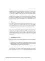
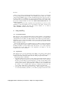
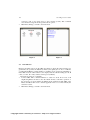
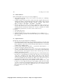
GeoVTag: a User’s Guide
Michel Deriaz
Abstract. This paper presents GeoVTag, an application running on a mobile
phone that allows the user to publish anywhere on Earth virtual tags. Every user
in the neighborhood of such a publication point will get the message. It is a kind
of blog, in which editors and readers share the same physical place. GeoVTag
allows tag edition and reading, but has also some additional functionalities like
a digital compass, a radar to find and display graphically all neighboring tags, a
tracker to record GPS data, a marker function that sends automatically time-totime a tag, and a "goto" function that directs a user to a specific tag by showing
graphically the direction to follow and the remaining distance.
1
Introduction
Spatial messaging, also called digital graffiti, air graffiti, or splash messaging, allows
a user to publish a geo-referenced note so that any other user that enters the same
place can get the message. For example, let us consider the community of the MtBlanc mountain guides. The members would like to inform their colleagues about
dangers in specific places or about vacancies in refuges. One guide can publish a georeferenced message that informs about a high risk of avalanches, and any other guide
that enters the same place will get the warning, and comment it if necessary.
A detailed description of the spatial messaging concepts and a presentation of
different hypothetical scenarios can be found in [1], where we also describe issues
related to trust and security. GeoVTag is a first step to the implementation of the
concepts described in [1] and it will also serve as a test platform to evaluate future
trust models. The current prototype implementation allows tag edition and reading, as
well as additional functionalities like a digital compass, a radar to find and display
graphically all neighboring tags, a tracker to record GPS data, a marker function that
sends automatically time-to-time a tag, and a "goto" function that directs a user to a
specific tag by showing graphically the direction to follow and the remaining
distance.
Technically, posting virtual tags is quite simple. During a tag edition, the
application gets also the GPS position and adds it as a meta-data. The whole is then
sent via Internet (using the HTTP protocol) to a tag server. For the tag reading, the
principle is similar. The mobile user sends its current position to the server (still using
the HTTP protocol) which returns all the available tags at the given position and its
neighborhood. The size of the neighborhood is specified during the request.
We implemented this application using the java micro-edition language. This
guarantees us more independence towards the running device. For the tests, we started
with the Motorola A1000 smart phone, but where constrained to abandon it. Although
it has an internal GPS, the access to the java location API was restricted to digitally
Copyright 2006 University of Geneva - http://cui.unige.ch/ASG
GeoVTag: a User’s Guide
136
signed applications. The second main limitation of this device is that it follows only
the CLDC 1.0 specification (instead of CLDC 1.1) and has therefore no floating point
operations, which is a considerable drawback for our application. We chose therefore
to couple the Sony-Ericsson K750 mobile phone with the GlobalSat BT-338
Bluetooth GPS for our tests.
In this paper we describe the implementation details of our application. Section 2
gives some information about the GPS device, section 3 indicates how to install
GeoVTag, section 4 is a direction of use, section 5 presents three other tools that have
been developed around this application, section 6 talks about the evaluation of this
software, and section 7 concludes by indicating how this software will be used as a
test platform for future work.
2
GPS device
Using a Bluetooth GPS brings the advantage that our application can be used on a
wide range of different devices. A Bluetooth GPS usually sends its data in NMEA
(National Marine Electronics Association) sentences [2]. Our application deals with
two of these sentences, GGA and VTG. Typically a GGA sentence looks like this:
$GPGGA,123519,4807.038,N,01131.000,E,1,08,0.9,545.4,M,46.9,M,,*47
where 123519 is the time in UTC, 4807.038 is the latitude, and 01131.000 is the
longitude. The reader that is unfamiliar with NMEA sentences can get more
information at [2]. Our GPS has typically a precision of about 10 meters. It uses the
Sirf III technology and therefore only needs -159dB as signal strength, against -175dB
for a Sirf II GPS. Concretely it means that such a GPS works also in difficult
situations, like behind an athermanous windscreen or in small roads surrounded by
high buildings.
3
Installation of GeoVTag
Tests have been made on the Sony-Ericsson K750 mobile phone and the GlobalSat
BT-338 Bluetooth GPS, but all the devices that have the following characteristics
should work:
•
•
A mobile device with a J2ME (Java 2 Micro Edition) interpreter, supporting
MIDP 2.0, CLDC 1.1, JSR 135, JSR 75, JSR 82 and having a screen of minimum
176x220. Specifications about any phone can be found at [3].
A Bluetooth GPS sending NMEA messages. GGA sentences are required, VTG
sentences are optional and only required for specific functions. Information about
NMEA, GGA and VTG can be found at [2].
To test the software, it is possible to download all the required files from [4]. Note
that this paper describes version 0.2, so it is possible to have little differences with the
Copyright 2006 University of Geneva - http://cui.unige.ch/ASG
M. Deriaz
137
current version, which is frequently updated. The application comes as a .jar file and
its corresponding .jad file. By default, a user-defined property called "url" contains
"http://127.0.0.1:8080/geovtag/" as value, meaning that the remote tag server runs on
the same machine. If your IDE does not support the modification of this value (in the
.jad and the .jar), proceed as follow: Modify manually the value in the .jad file, unzip
the .jar file, modify manually the value in the META-INF/MANIFEST.MF file, and
finally re-zip the all.
The installation itself is then completely device-dependant. If you want to test the
application on the Sun emulator [5], you can simply use the "File - Create project
from JAD/JAR" command, and then tick off the "CLDC 1.1" as well as
"Bluetooth/OBEX" checkboxes in the settings.
4
4.1
Using GeoVTag
General information
This part gives some general information that is directly related to the application.
The starting point of the application is a main menu (see Figure 1) form which all the
other functions are accessible. As a GPS sends the same sentence type (GGA, VTG...)
maximum once in a second, the updates are also done at this rate. Some functions
display information in blue if it is fresh or in red if the last data obtained from the
GPS is older than 3 seconds.
Because this application is not digitally signed, you will be prompted a few times
when you launch the program, asking your authorization for accessing the Internet,
the Bluetooth GPS or your local file system. Just answer "yes" to these questions.
You them arrive in the main menu of the application (see Figure 1). Use the
navigation keys to select a function.
4.2
Tag function
This function shows you the current time (from GPS), your current position and all
the available tags at the current position (See Figure 2). The current position is
actually a circle with a 20-meter radius centered on the point given by the GPS.
The menu provides 3 commands:
• Tag edition: This screen is used to create a new tag. Note that when this screen is
displayed, the current location is frozen. It means that even if you move between
the time you start editing your tag and the time you send it, the tag will be posted
at the location you were when you started editing. You can yet update your
current position with the "Update GPS data" command or enter it manually with
the "Select coord." command. The "Send tag" command sends the tag to the
server, and the "Main menu" command brings you back to the main menu.
• Save tags: If you use a local tag server (see 4.6 - "Options function"), the tags are
not saved automatically (otherwise you would be prompted each time by the
Copyright 2006 University of Geneva - http://cui.unige.ch/ASG
GeoVTag: a User’s Guide
138
•
system in order to give write access to the local file system). This command
saves all the new tags in the file specified in the options.
Main menu: Brings you back to the main menu.
Figure 1
4.3
Figure 2
GPS function
Displays information given by the GPS (See Figure 3). From the GGA sentences we
get the time, the position, the altitude (in meters), the quality (0 = no fix, 1 = GPS fix,
2 = differential GPS fix), and the number of satellites used to get the fix (minimum 3).
If the GPS sends also VTG sentences, the display adds the current heading (N = 0°, E
= 90°, S = 180°, W = 270°) and the current speed (in km/h).
The menu provides two commands:
• Connect GPS: This command launches a search for about 10 seconds of all
neighboring Bluetooth devices. Use the "Back" menu to cancel the operation, or
the arrow keys to select a Bluetooth GPS from the returned list. The URL of the
Bluetooth GPS is then saved so that the application tries to reconnect directly the
next time it starts.
• Main menu: Brings you back to the main menu.
Copyright 2006 University of Geneva - http://cui.unige.ch/ASG
M. Deriaz
139
Figure 3
4.4
Figure 4
Tracker function
Records in a file the GPS data every few seconds (see Figure 4).
• State: Indicates the state of the process. Can be "Not started yet", "Running",
"Stopping" or "Stopped".
• Session counter: Counts the number of positions that have been recorded since
the last time the data have been saved.
• Global counter: Counts the number of positions that have been recorded since the
last time the application has started.
• File: The file that will contain the data. Click on it to browse the local file system.
See also 4.14 - Browsing the local file system.
• Interval: Specifies how many seconds the application pauses between two
records. Note that the time of the recording itself is not counted in this time,
meaning that the real interval between two records is actually the number
specified here plus the time your device needs to make a record.
Commands:
• Start: Starts the recording.
• Stop: Stops the recording.
• Record now: Records now the current data. Can be used while the process is
running or not.
• Save: Saves the recorded data in the specified file, and clears the session counter.
• Main menu: Brings you back to the main menu. The process won't be stopped by
this command.
Copyright 2006 University of Geneva - http://cui.unige.ch/ASG
GeoVTag: a User’s Guide
140
4.5
Marker function
Sends automatically a tag every few seconds (see Figure 5).
• State: Indicates the state of the process. Can be "Not started yet", "Running",
"Stopping" or "Stopped".
• Content: Content of the tag. If the content ends with a hyphen followed by a
number, this number is automatically incremented. For example, if the content is
"Test-00" then the tags will be "Test-00", "Test-01", "Test-02"... With "Other0023" we will have "Other-0023", "Other-0024", "Other-0025"...
• Interval: Specifies how many seconds the application pauses between two
records. Note that the time of the recording itself is not counted in this time,
meaning that the real interval between two records is actually the number
specified here plus the time your device needs to make a record.
Commands:
• Start: Starts the process.
• Stop: Stops the process.
• Send now: Sends a tag now. Can be used while the process is running or not.
• Main menu: Brings you back to the main menu. The process won't be stopped by
this command.
4.6
Options function
Specifies the options for the application (see Figure 6).
• Time diff.: The number of hours to add (or subtract if negative) to the time given
by the GPS (which is UTC), during display. Note that this affects only how the
time is displayed on the screen, not the time that will be taken into account when
creating a tag or making a track.
• Position format: Similar than "Time diff". "°" represent the data in degrees, "° ' ""
represents it in degrees, minutes and seconds.
• Tag server: Specifies if the tag server is local or remote. If local, then the tags are
not sent over the Internet (there are therefore no costs) but recorded locally in the
file specified in the "Local tag file" field. If remote, then the tags are sent via
Internet to the remote tag server.
• Local tag file: If the tag server is local, then the tags are recorded in this file. Note
that tags are not automatically saved in this file, but they are saved only by the
"Save tags" command (in the Tags function). This file is read when the
application starts. When the user changes the tag file, then all the tags in memory
are erased (including the tags that the user didn't saved!) and the new tags are
loaded in memory. See also 4.14 - "Browsing the local file system".
• Flash delay (sec): Many mobile phones put their screen in stand-by after a while
if there is no user input. To keep the screen bright, specify here how many
seconds to wait before the application flashes the screen. Note that some mobile
phones loose the connection with the GPS when they go in a stand-by position;
this option can be set in order to avoid that.
Commands:
Copyright 2006 University of Geneva - http://cui.unige.ch/ASG
M. Deriaz
•
•
•
141
OK: Confirms the modification and shows the main menu.
Cancel: Cancels all the modifications and shows the main menu.
Default values: Sets the default values.
Figure 5
4.7
Figure 6
EasySend function
Sends a tag by just pressing a single key. The user links each numerical key (0 - 9) to
the text he wants to send each time he presses that key. It seems important to remind
here that, if you use a local tag file, then the tags are not automatically saved.
4.8
Logging function
Logs some events, like tags loading or saving (see Figure 7). This function is mainly
used to make sure that tags have been correctly loaded or saved.
Commands:
• Back: Shows the main menu.
Copyright 2006 University of Geneva - http://cui.unige.ch/ASG
GeoVTag: a User’s Guide
142
Figure 7
4.9
Figure 8
Speedometer function
Indicates the current speed (see Figure 8). The speed information is extracted from
VTG sentences. This value is computed by comparing two succeeding positions.
Because of the precision limitations of the device, it is possible to print an average of
the last values. The printed value is then more precise but reacts slower to speed
changes. In addition to the speed average, this function prints also the current speed
(as gotten by the GPS device) and the number of values taken for the average
computation.
Commands:
• Back: Shows the main menu.
• Average: Shows a list allowing the user to precise the number of values to take
for the average.
4.10 Compass function
Shows the direction of the North Pole (see Figure 9). In digital compasses, the
direction is computed according to the current heading of the user. Like for the
speedometer, the GPS device must be able to send VTG sentences. To find the North
Pole, walk straight forward for a few seconds while holding your mobile device in
front of you. The red line on the screen indicates the North Pole. Note that it indicates
the true North, and not the magnetic North, as traditional compasses do. This value is
computed by comparing two succeeding positions. Because of the precision
limitations of the device, it is possible to print an average of the last values. The
printed value is then more precise but reacts slower to direction changes. In addition
Copyright 2006 University of Geneva - http://cui.unige.ch/ASG
M. Deriaz
143
to the direction of the North Pole, this function prints also the current heading (as
gotten by the GPS device) and the number of values taken for the average
computation.
Commands:
• Back: Shows the main menu.
• Average: Shows a list allowing the user to precise the number of values to take
for the average.
Figure 9
Figure 10
4.11 Radar function
The radar function shows graphically the positions of the neighboring tags (see Figure
10). The distance printed at the bottom of the screen indicates the number of meters
between two circles. The second line at the bottom indicates whether the top of the
screen corresponds to the North Pole or your current heading. In the second case, the
current heading is given by the GPS if it understands VTG sentences. If you do not
move fast enough, the printed dots, whose positions are computed according to your
current heading, become leaping. It is therefore recommended to choose the North
Pole option and use the compass function to find more precisely where the North Pole
is.
Each time a new tag enters in the covered area (three times the value specified in
"Distance"), it gets the smallest available number. This number determines its color,
and allows the user to recognize it in the "details" screen. When a tag leaves the
covered area, its number is made available for the next tag.
Commands:
• Details: Shows detailed information about the visible tags.
Copyright 2006 University of Geneva - http://cui.unige.ch/ASG
GeoVTag: a User’s Guide
144
•
•
•
•
Params: Allows the user to specify some parameters like the distance between
two circles, whether the top of the screen represents the North Pole or the current
heading, and whether numbers should be shown. If the alarm checkboxes are
ticked off, then a sound (or/and a vibration) is played each time a new tag appears
on the screen.
Freeze GPS: Data that comes from the GPS device are not updated anymore.
Unfreeze GPS: Cancels the "Freeze GPS" command.
Main menu: Shows the main menu.
4.12 Goto function
This function allows you to find a specific tag, given its name or a part of its name
(see Figure 11). When you activate this function, you are prompted with a form
asking you the name of the tag (or a part of its name) and the radius of search. The
"Search" command looks then for all the available tags that contains the specified
pattern (case insensitive) and which are not further than the specified distance. The
result is presented in a list. Select one item. The program shows then graphically and
continuously the direction to follow to reach the tag, and precisely at which distance it
is. The first line of text indicates this distance between you and the tag, and the
second line indicates whether the top of the screen is the North Pole or your current
heading (see 4.11 - Radar function).
Commands:
• Details: Gives detailed information about the tracked tag.
• Params: Allows you to define whether the top of the screen represents the North
Pole or your current heading.
• Back: Returns to the list resulted by the last search.
• Close: Closes this function and goes back to the main menu.
4.13 Exit function
The exit function closes open connections, stops running operations, and finally exits
the application. It is important to remind here that local tags are not saved
automatically when the application exits.
4.14 Browsing the local file system
The application includes a file browser that allows you to create new files or
directories, delete them, and to select a file. It is used to select the local tag file in the
options or to select where to save data from a track. The title of the screen indicates
the current directory (see Figure 12). "d .." means the parent directory. Actually, all
the lines starting with "d" (and ending with "/") are directories, while line starting
with "f" are files and lines starting with "r" are roots. Typically, a mobile phone has
two roots, the first is the build-in memory of the phone and the second is an additional
Copyright 2006 University of Geneva - http://cui.unige.ch/ASG
M. Deriaz
145
memory stick. We recommend saving tag files and track files in the memory stick
rather than in the phone memory.
Figure 11
Figure 12
4.15 Saving parameters
The values entered in the Option screen, as well as the ones entered in different fields
(mostly in parameters screens) are saved automatically in a MIDlet record store. You
will not be prompted for an authorization like it is the case each time you access the
local file system. Record stores stays even if the application is reinstalled. To delete
the record store associated to GeoVTag, delete the application before reinstalling it.
5
Tools for the GeoVTag application
In addition to the GeoVTag application itself, three tools have been developed. The
first is a GPS simulator. The user enters data like the current time or the current
position, and the application builds and sends via Bluetooth the corresponding NMEA
sentences. Although it works also on a physical device, this soft is mainly used to test
the GeoVTag application on the emulator.
The second tool is a remote tag server. It is a servlet that is able to record new tags
and to return all the ones that are available within a certain radius around a given
position.
The third and last tool is a program that converts coordinates given in the WGS84
format to the CH1903 format. This allows printing the result of a track on a Swiss
Copyright 2006 University of Geneva - http://cui.unige.ch/ASG
GeoVTag: a User’s Guide
146
map, in order to observe the quality of the positions given by the GPS. An example is
given in Figure 13.
Figure 13
6
Evaluation
We tested the application several times in the field and were quite satisfied about the
results. But it consists only in technical tests, to make sure that all the functionalities
work properly and that the user interface allows to achieve the current operations
easily. We tested the application in the mountains by tracing virtual paths and finding
easily some POIs (points of interests), but all the test that have been made so far were
done by a single user. What misses in our evaluation is the social aspect, or to observe
if and how people would publish tags for other people.
7
Conclusion
This paper presented how the GeoVTag application is used. Although the application
is useful as is for many situations and scenarios, we will use it as a vehicle and
Copyright 2006 University of Geneva - http://cui.unige.ch/ASG
M. Deriaz
147
platform for further developments. Our idea is to develop a trust and security model
for virtual tags. In our Mt-Blanc mountain guides example, the security aspect will
ensure that the posted messages are really posted by the signer, that no modification
of the original text can be made afterwards, that the service is available for everyone
that is authorized, and finally that the messages can be read only by authorized
people. But this is not sufficient. Even if you can be sure about the identity of an
editor, it is useless if you do not know him and therefore cannot trust the content of
his message. That is why we are specifically interested in the trust aspect. This
application will be used to test our future trust and security models.
8
[1]
[2]
[3]
[4]
[5]
References
Michel Deriaz. Trust and Security for Spatial Messaging. In this collection of papers
Website: http://www.gpsinformation.org/dale/nmea.htm
Website: http://www.j2mepolish.org/
Website: http://cui.unige.ch/~deriazm/Softs/GeoVTag/
Website: http://java.sun.com/products/sjwtoolkit/download-2_3.html
Copyright 2006 University of Geneva - http://cui.unige.ch/ASG