1
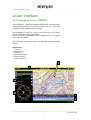
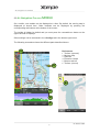
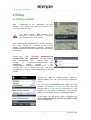
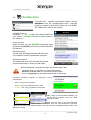
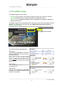
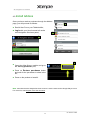
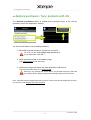
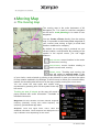
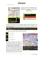
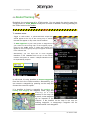
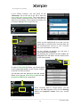
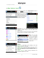
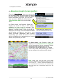
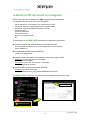
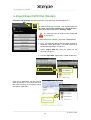
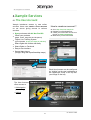
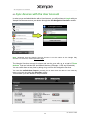
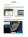
Air
Navigation
Pro
User’s
Guide
Air Navigation
Real-time navigation system with moving map
for more info: www.xample.aero
Air Navigation Pro Android
The information in this document is subject to change without notice and does not
represent a commitment on the part of Xample Ltd. The software described by this
document is subject to a License Agreement and may not be copied to other
media. All product and company names are TM or ® trademarks of their respective
owners.
Software developed by: Johann Huguenin, Flavien Volken and Alexander Hauser.
Product Version: 1.3.3 v64 (06/2013)
Document version: 1.3.3 (06/2013)
Document written by: Sebastián Vecchio
Special thanks to our Beta testers, partners and
making this a better product.
Contact info
Xample LLC
Coteau des Ifs 41B
1400 Cheseaux-Noréaz
Switzerland
http://www.xample.aero
http://www.facebook.com/AirNavNews
1
users who where
invaluable in
Air Navigation Pro Android
Contents
(jump to page by clicking)
1. Introduction
1.1. About this document
1.2. Minimum requirements
1.3. Disclaimer
2. User interface
2.1. Air Navigation Pro on a Tablet
2.2. Air Navigation Pro on a mobile
2.3. Buttons in the toolbar
3. Setup
3.1. Getting started
4. Installation
4.1. Maps and charts
4.2. The Map Store
4.3. Install products in other devices
4.4. The Addons page
4.5. Install Addons
4.6. Restore Purchases / Sync products with iOS
5. Moving map
5.1. The moving map
5.2. Route planning
5.3. Map Options menu
5.4. Elevation Graph
6. Instruments
6.1. HSI
7. Tools/features
7.1. Create an Aircraft profile
7.2. Create user waypoints
7.3. Geo-referenced Approach Charts
7.4. Attach a PDF document to a waypoint
7.5. Import/Export GPX files (Routes)
8. Xample Services
8.1. The User Account
8.2. Sync devices with the User Account
8.3. Live tracking service
9. External devices
9.1. Use Air Nav Pro with an external GPS device
10.Getting support
10.1. Send diagnostic
10.2. Contact us
2
Air Navigation Pro Android
1.Introduction
Thank you for your interest in Air Navigation Pro. Air Navigation was firstly
developed for Apple devices running under iOS operating system versions 4 or higher.
It was developed with General Aviation in mind, however it was quickly adopted by
pilots of various flying vehicles including, for example: paragliders, gliders, ultra light,
single or multiengine airplanes, helicopters and even hot air balloons.
After having good impact on users from different parts of the world, we decided to take
Air Navigation to the Android platform.
Our goal is to implement as many tools and features as the Apple version offers, by
releasing regularly updates month by month.
Air Navigation is an affordable, yet powerful flight planning and real-time
navigation application. We hope you will enjoy the product as much as we enjoyed
working on it.
1.1.About
this document
This document is intended to show the user all the existing tools and features Air
Navigation Pro comes with and assist on how to use them.
This document might not be complete, since we release a new update very often,
which means that the version of the application may be higher than the one appearing
on the first page.
1.2.Minimum
requirements
Air Navigation Pro will run on:
- A mobile or a tablet running
Android operating system version 2.3 or higher.
- 200 MB of
available space for the application and database.
- approximately 350 MB of
available space for each chart of the size of a country like France or Germany.
- A GPS module is mandatory for real-time navigation.
If the device does not bring an internal one, then an external GPS gadget will be required. We
can recommend the XGPS Garmin GLO.
3
Go back to index
Air Navigation Pro Android
1.3.Disclaimer
Before using this software, you must read
conditions.
and
agree with the following terms and
This software is not intended to replace a certified navigation device! We do not
guarantee the accuracy and comprehensiveness of the information provided. The
embedded navigation database is provided for informational purpose only. It may
not be complete and may contain erroneous data.
You should always use official aeronautical documentation (AIP) when preparing and
performing a flight. You should always use certified navigation devices when
performing a flight. This software is provided ‘as-is’, without any express or
implied warranty. In no event will the authors or third party data providers be held
liable for any damages arising from the use of this software
YOUR USE OF THIS REAL TIME ROUTE GUIDANCE APPLICATION IS AT
YOUR SOLE RISK. LOCATION DATA MAY NOT BE ACCURATE.
4
Go back to index
Air Navigation Pro Android
2.User
Interface
2.1.Air Navigation Pro on a
TABLET
On a tablet the screen is divided to display the selected route
and the HSI instrument. The moving map is on the right side
together with the data bar at the bottom.
Air Navigation Pro can be set to full-screen and, in this case,
the route and the HSI will be hidden.
Other modules, functionalities and settings can be accessed
from the top toolbar.
The following screenshot shows the different parts described
above:
References:
1. Toolbar
2. Moving map
3. Data bar
4. Elevation Graph
5. Route module
6. HSI instrument
2
1
5
6
3
4
5
Go back to index
Air Navigation Pro Android
2.2.Air Navigation Pro on a
MOBILE
On a mobile, one module can be displayed at a time. By default, the moving map is
displayed at launch time. Other modules can be displayed by pressing the
corresponding tab buttons at the bottom of the screen.
The toolbar is hidden by default and you must press the «screwdriver» button on the
upper-left side to display it.
Other settings can be accessed in the «Config» tab in the bottom-right corner.
The following screenshot shows the different parts described above:
1
2
References:
1. Toolbar (opened)
2. Moving map
3. Data bar
4. Elevation Graph
5. Bottom tab bar
6. Toolbar (closed)
6
3
4
5
6
Go back to index
Air Navigation Pro Android
2.3.Buttons
in the toolbar
On a mobile, this button toggles the moving map data bar visibility on/off. On a
tablet, this button toggles between Split-screen and Full-screen mode. The split
screen shows the HSI instrument and the Route module on the left side of the
screen.
«Map options» displays the Map Settings, where you can configure what will
be displayed on the map
and how. You will find options to configure the
Airspace format, filter waypoints, enable/disable the Elevation Graph and more.
Toggles between Flight mode and Edit mode. When Edit mode is turned on, a
yellow-black bar at the top of the screen indicates it is active. It is possible to tap
waypoints on the map to add/remove them to/from a current route and also
press and drag a leg up to a waypoint to include it in the created route as well.
Displays the waypoint database where it is possible to Search for a particular
waypoint or list nearby waypoints, sorted by distance. The search can be done by
Airport name, city name, ICAO code, or directly by accessing to the list of
countries.
Displays the list of stored Routes. Tapping on a route from the list will set
this route as current, displaying the legs in the
«Route module» and displaying the route in the moving map.
Selects the
waypoint.
Nearest Airfield
from
your current
location as a direct-to-
Eliminates the Route from the Map in order to fly freely without following any legs.
It also Hides the Approach Charts from the Map as well.
The «Document Browser» allows the user to create an Aircraft profile to use with
Air Nav Pro. On a mobile, this tool is reachable from the «Config» tab at the
bottom right corner .
Displays the Tools list where you can find additional utilities. On a mobile, the
tools are reachable from the «Config» tab at the bottom right corner.
«Config» button displays the application behavior and customize units and other
Settings. On a mobile, the settings are reachable from the «Config» tab at the
bottom-right corner.
7
Go back to index
Air Navigation Pro Android
3.Setup
3.1.Getting started
After
installation of the application, on every
launch,
the system will ask to activate the GPS
antenna in case it is not.
You should allow
GPS access to Air
Navigation, otherwise realtime
navigation
functionalities will not work properly.
After launching Air Navigation Pro for the first time,
the
map
should be
centered to your current
location. The application has an internal waypoints
database and you should see waypoints in the vicinity
on the map.
Please note
that
NO MAP background is
installed with the application. You can install a
map
background
from
various
free
of
charge
or
commercial sources from
the
«MapStore»
module
located
in
the
«Configuration» button on a tablet and
in the
«Config» tab
on a mobile. You can
find more
information on how to install maps/charts in the next
chapter.
Should you wish to change length, speed or
altitude UNITS, you can do it from the «Settings»
panel.
You can also enable/disable the option for map
rotation, use magnetic or true north for track and
bearing and in if you are not connected to a wifi
network, but you wish to download a map through
GSM, you are able to do it by activating the option.
In this panel, you will also be able to configure the
type of Approach Chart you will use (VFR or IFR)
on the moving map.
8
Go back to index
Air Navigation Pro Android
4.Installation
4.1.Maps and charts
Commercial charts screenshots: http:// www.facebook.com/AirNavShots
Different type of products can be installed to be
used as the background image of the moving
map module, as additional information displayed on
the map or to use with the 3D module and the
Elevation Graph:
‣ Free-of-charge maps 1:250k
(from the Domain OpenStreetMaps)
‣ Charts from the public domain
(ONC 1:1000k and other VFR charts)
‣ Paid charts
(ICAO/Official VFR charts & non-official)
‣ Geo-referenced Approach Charts
‣ Free Elevation data
These products are stored in the
memory and do not require
connection while flying.
iPhone/iPad’s
an internet
There are two ways of getting the charts/data:
➡ «Map Store» module,
Free-of-charge maps
Public domain charts
ICAO/VFR paid charts
Free Elevation data
➡ «Addons» page at Xample Services,
Geo-referenced Approach Charts
9
Go back to index
Air Navigation Pro Android
4.2.
The Map Store
To browse the available maps/charts catalog, choose
«MapStore» from the «Configuration» menu (top-right
button) on a tablet or from the «Config» tab on a mobile.
The «Map Store» module has 4 parts:
Installed Products
It displays a list of maps and charts installed on
your device. Re-install or Delete a whole product or
just parts of it.
All my products
Inside this part, you will RESTORE purchased maps
and charts and SYNC them with up to three Android or
iOS devices.
Download queue
Current and pending downloads will show here.
It is possible to cancel a download in progress.
Download products
The catalog will show up in this part and you will
choose which maps or charts you will install.
Before attempting to download a map you should check that:
- the tablet/mobile is connected to a functional Wifi network.
- bluetooth is turned OFF, as it can disturb the Wifi network.
- there is enough space on the tablet/mobile sdcard or internal disc.
Installed products appear in different colors
according to:
•
White : maps are not installed;
•
Green : maps are installed and up to date;
•
Orange : new version available for download.
After a map or chart has been installed, you
will be able to manage it from the «Map
Options» module.
Other products such as the Free Elevation
data and the Geo-referenced approach
charts will not show under «Map Options», but only under the «Installed products» part in the
Map Store module.
10
Go back to index
Air Navigation Pro Android
4.3. Install
products in other devices
Maps, charts, free subscriptions and other purchases can be installed in more than 1
device according to the following conditions:
‣ Using your Google Play account
These products are purchased from the Map Store module within Air Nav Pro.
You will check in the Play Store terms and conditions to learn in up to how many
Android devices you can install the in-app purchases on a same account (normally
you will be able to install them in up to three to five devices).
In order to install your products in a different device, read the chapter “Restore
purchases”.
‣ Using your Xample Services account
These products are purchased from the Addons page.
You will be able to install the products in up to three different Android or iOS devices.
This does not mean that you are allowed to install them on three Android devices +
three iOS devices, but in up to a total of three (example: 2 Android + 1 iOS).
In order to install your products in a different device, read the chapter “Install
Addons”.
Note: remember that the Xample Services Account is not the same as the Google Play account.
For more info, read chapter «The User Account».
11
Go back to index
Air Navigation Pro Android
4.4.The
Addons page
The Addons page will let the users:
•
•
•
•
See ALL their purchases, subscriptions and the products sync with their devices;
Purchase products such as yearly subscriptions to approach charts;
Subscribe to free database packages such as waypoints and airspaces databases;
Renew subscriptions.
The Addons page will be accessible under «Services» menu from the Xample Services
Website. You will have to first login with your Xample Services User Account, on
http://services.xample.ch
If you don’t have a Xample Services User Account, read chapter «The User Account».
Logged in as svecchio
You will show three separated lists:
My Addons
It will show all your purchases, subscriptions
and the products that you sync from your
iOS/Android devices.
Note: a user can sync up to a total of three
devices with the same Xample Services
account, no matter they are Android or iOS
nature. Example: the User Account svecchio is
sync with an iPhone, an iPad and an Android
mobile.
Paid Addons
It will offer products to buy and use with
Air Navigation Pro.
Free Addons
It will give you the possibility to subscribe
for free to the database updates for both
waypoints and airspaces.
12
Go back to index
Air Navigation Pro Android
4.5.Install
Addons
Once you have made a purchase through the Addons
page, you will proceed as follows:
3
➡ Run Air Nav Pro on your Tablet/mobile;
➡ Login with your User Account info under
«Air Navigation Services» panel;
1
2
4
➡ Open the «Map Store» module and go to
the «All my products» part;
➡ Press on Restore purchases button
and wait for the purchases to show in the
list;
➡ Press on the product to install it.
Note: remember that the Xample Services Account is not the same as the Google Play account.
For more info, read chapter «The User Account».
13
Go back to index
Air Navigation Pro Android
4.6.Restore
purchases / Sync products with iOS
The «Restore purchases» button is located at the top-right corner of the «All my
products» part in the «MapStore» module.
You will use this button in the following situations:
‣
Re-install purchased maps on your device or devices;
You must use the same Google Play account that
you purchased the charts with.
‣
Install purchases made on the Addons page;
‣
Synchronize maps and charts with other Android or iOS devices.
(read previous page to see learn how)
(you will proceed the same as on previous page)
Before sync any products with a new device, you will have to first sync them with
your previous device. Always using the same Xample Services User Account.
Note: remember that the Xample Services Account is not the same as the Google Play account.
For more info, read chapter «The User Account».
14
Go back to index
Air Navigation Pro Android
5.Moving Map
5.1.The moving map
The moving map is the main instrument of Air
Navigation Pro. It is used for real-time navigation
as well as for route planning or to create of user
waypoints.
You can Create a Route directly from the moving
map. It is possible to add intermediate waypoints to
your current route during a flight (to avoid bad
weather conditions for example).
By default, the moving map is centered on your
current location, north-oriented. By pressing on the
symbol in the top-left corner, you can toggle
between :
North-oriented, current location in the center
of the screen, moving.
Track-oriented, current location rotating to
match current track, moving.
Panned mode. Touching and moving the
map will switch to panned mode. In this
case the map will be moved to the location
of your choice, north-oriented or pointing to any direction in case you have the option
for map rotation enabled in the Settings. It will not move to follow your current location,
instead, the aircraft symbol will move on the map, possibly leaving the screen area.
You can center the map again and restore map
movements by pressing once on the symbol in the topleft corner.
Touching an area of interest on the map will reveal a
popup window with useful information. Touchable or
interactive items are:
Waypoints: ID code, elevation, full name, latitude, longitude,
frequency (Navaids), runway and contact frequency info
(Airports), geo-referenced app charts.
Airspace: lower and upper limits, name, class and
additional information. These airspaces are displayed on the
map in different colors depending on their class.
15
Go back to index
Air Navigation Pro Android
You can press on any of the waypoints in the
map to assign it to the HSI instrument or to
select it as your destination, by pressing where
it says:
Press to select
The data bar at the bottom of the moving map will display real-time information. From
left to right: ID and name of next waypoint; bearing, track and distance of next
waypoint; groundspeed and altitude as reported by the GPS signal, and estimated time
to the next waypoint.
The data bar also shows a GPS signal symbol as follows:
Excelent GPS signal
Good GPS signal
Weak GPS signal
Very week GPS signal
For real time navigation, the quality of the
GPS signal is required to be a green or
yellow symbol. A red or orange symbol will
only show an approximate location and will
not report speed nor track information.
For better results, you should place your
device near a window, with a direct view of
the sky. If you are flying with a full-metal
airplane or your airplane is equipped with
anti-ice windshield, the internal GPS of your
tablet/mobile may be a bit weak and you
may need an external GPS device to assist it.
16
Go back to index
Air Navigation Pro Android
5.2.Route
Planning
By default, the moving map is in «Flight mode». You can toggle the moving map from
«Flight mode» to «EDIT MODE» at any time to create or amend a route by pressing on
the «Edit» button in the Toolbar.
To create a route:
- Toggle to «edit mode», a yellow-and-black striped bar
should appear at the top of the moving map. A search
field will also appear on top of the «Route module».
- To Add waypoints to your route, press on waypoints of
your choice on the moving map. In the waypoint popup,
press on the «add» option. A yellow star should now
appear on the moving map and your waypoint should be
in the «Route» list.
- Alternatively, you can input one or more waypoint
identifiers in the «search» field on top of the «Route
module» and press on “search”. Multiple identifiers must
be separated by a space:
In edit mode it is also possible to remove waypoints
from the list in the «Route module». Alternatively, you
can remove a waypoint by pressing on the map and
choose the «remove» option.
It is possible to insert a waypoint by pressing on,
holding and dragging the magenta vector (leg) and
moving to a new
location on the map. As
a result, a new waypoint
will be inserted in the
«Route». If the location on the map is not over an
existing waypoint, a «temporary» waypoint will be
created named “user waypoint”.
17
Go back to index
Air Navigation Pro Android
In the «Route module», you can press on the
«Summary» line at the top of the list to write the
route name and cruise speed. The route name is
used to identify a particular route in the «Routes list»
when they are saved. Cruise speed information will
be used to display ETA on top of the list.
When you are satisfied with your route, you can
toggle back to «Flight mode», and the route will
be automatically stored in the «Routes
list» (see screenshot on the left).
On the left-side screenshot you can see 3
routes stored as an example.
By selecting any of them from this module, Air
Navigation Pro will take it as the current route
on the moving map.
In order to Reverse the Route, you should press
on the upper-right button of the «Route module»
as shown on the screenshot.
You will also have the options to save the current
Route as a new one, send it by e-mail and also
to import a GPX file as a new route.
When switching back to «Flight mode», you will
show on the next waypoint of the list the bearing
(BRG) and magnetic course from your current
position.
18
Go back to index
Air Navigation Pro Android
5.3.Map
Options menu
From the Toolbar press on the «Map Options» button to
access various options for the moving map.
Airspaces: You can show
or hide the different class
of interactive airspaces on
the map and you can also
filter them by “altitude”.
Waypoints: You can show or hide different kind of
waypoints (Airfield, Heliport, IFR, VFR, NDB, VOR,
TACAN, etc).
Also, you have an option at the bottom of the panel that
allows to filter by an airfield’s runway’s surface.
Maps: You can show
or hide a downloaded
map or move it above
or below to make it
visible in case of
overlaying with
another one.
Widgets:
Bearing line, it will draw a line pointing to the next
waypoint selected on the map.
Extended track line, it is the front line from your current
position showing ETE of 2, 5 and 10 minutes away.
Vector label, shows the course and distance to the next
waypoint.
Runway identifier , shows runway extensions for
destination waypoint of a route.
19
Go back to index
Air Navigation Pro Android
5.4.Elevation
Graph (terrain profile)
From the «Map Options» menu, yo can turn on
the Elevation Graph. If elevation data is installed
for your region, the elevation graph will display
terrain information. Note that you will show
data information ONLY after downloading
«Free Elevation data» files from the Map
Store.
In «Flight mode», the Elevation Graph will
display the terrain in front of the aircraft,
updating the view every 5 seconds. The
maximum reported altitude of the total
distance of terrain profile in front of us will be
displayed in the Graph. We can zoom in or zoom
out by using two fingers to see less or more
terrain. The scale is displayed in NM. A symbol
representing your aircraft will show in the view
with a red dashed line, representing your current
altitude, as reported by the GPS.
In «Edit mode», the Elevation Graph will
display the terrain between the two waypoints
of the selected leg. On the screenshot beside,
the terrain profile is displayed for the leg
NZKK-NZKO with a total distance of 13.4 NM.
This is very useful when planning your route, to
get an estimate of the minimum safe altitude.
Note: Please note that even with a good GPS
signal, the altitude as reported by the GPS may have
an accuracy of +/- 200 ft. Elevation database may
also contains some inaccuracies. You should always
plan your flight with a reasonable margin over the
obstacles.
20
Go back to index
Air Navigation Pro Android
6.Instruments
Using a GPS signal Air Navigation Pro can simulate an HSI instrument. Unlike realnavigation instruments, the virtual instruments can be set-to-point to any
waypoint in the database (airport, VOR/DME, user waypoint, etc).
6.1.HSI
The HSI is the most practical of all traditional
nav instruments but it also requires some
training before it can be used efficiently.
If the GPS reception is bad the warning flag will
show that the instrument does not display
correct data.
The top part of the screen is an emulated HSI
(Horizontal situation indicator) . The yellow
needle is the Course select pointer, the moving
part in the middle is the Course deviation
indicator (CDI) which displays the deviation (+/12 degrees) from the selected radial or course
to or from the selected waypoint. Unlike on a
real HSI where the orange Heading bug is used
to set a course for the autopilot, the heading
bug displays the bearing to the selected
waypoint. Also the HSI does not
display
magnetic heading but the track of the
aircraft.
The advantage of the HSI is that it displays the position of the aircraft symbol in the
middle relative to the selected course. The compass card will rotate automatically to
match the current flying track. Radial or course selection is done by touch and swipe
gesture up or down on the left or right of the compass ring.
A “NAV” warning flag (as shown in the image above) will let you know that you should
Not trust the HSI indicator in the following cases:
‣ No waypoint is selected for the instrument;
‣ the waypoint distance is over 250 nautical miles;
‣ the GPS accuracy is bad;
‣ Groudspeed is less than 5 Kts.
Below the main indicator, the selected waypoint is displayed as well as the
distance from the waypoint (great
circle
distance). You can use any kind of
waypoint (Airports, VOR, NDB, etc) with the HSI instrument. (A real
HSI
indicator requires radio signals from VOR, VOR/DME or VORTAC transmitters).
21
Go back to index
Air Navigation Pro Android
7.Tools/features
7.1.Create an Aircraft profile
If you wish to create an aircraft profile, you should do it through the «Tools» menu, in
the module «Aircraft Editor»
22
Go back to index
Air Navigation Pro Android
7.2.Create
User Waypoints
A «user waypoint» can be created as follows:
➡ directly on the «moving map» by pressing and
holding for 2 seconds on the desired location
of the map.
➡ from the «Custom waypoint Editor» under
Tools menu.
Once you have created your waypoint, it should
appear on the map. Example below.
If your waypoint does NOT appear on the
map, then check that the type of waypoint
you created is selected in «Map Options».
23
Go back to index
Air Navigation Pro Android
7.3.Geo-referenced
Approach Charts
Air Navigation Pro supports geo-referenced approach
charts that can be opened directly over the map.
We offer a 1-year-subscription package that includes:
‣ Geo-referenced Approach Charts to be used on the map
‣ Approach Charts PDF documents (with additional info)
‣ Regular updates according to the Amendment cycles
In order to purchase a subscription, you should read the
chapter “Installation”.
The Approach Chart package brings:
- Geo-referenced approach chart
(it will be opened on the map)
- Chart PDF Document
(it has additional info to complement the approach chart)
Both can be opened by selecting a waypoint on the map.
As an example, we selected the waypoint SKBG from the moving map. The files from the
top are the PDF documents, while the files at the bottom are the geo-referenced approach
charts classified by IFR or VFR (instrumental or visual).
We will set the class of the approach(VFR/IFR) chart
we want to use in the Settings panel, where the user
can also enable or disable the option «Auto approach
chart». When enabled, the geo-referenced approach
charts will be opened on the map automatically by Air
Nav Pro for the destination waypoint.
Example: if I create a Route: SKBG - SKBO - SAEZ.
If we have downloaded the approach charts for SAEZ, then
an approach chart will pop up on the map when SAEZ is our
next selected waypoint.
In order to hide the approach chart you should use the RED icon from the
toolbar.
24
Go back to index
Air Navigation Pro Android
7.4.Attach
a PDF document to a waypoint
A PDF document can be attached to ANY waypoint from the database.
The purpose for this can be one of the followings:
-
Add an Aerodrome chart diagram to an Airfield from the map
Add a PDF sheet to correct/complement any waypoint’s data
Add a PDF sheet with additional information such as:
contact frequency
approach instructions
info about the place
photos to recognize the area
etc
The procedure to ATTACH a PDF document to a waypoint is as follows:
➡ Create a folder in the /sdcard/ folder of the Android device:
(for devices with NO sdcard on it, you will create them in the root folder)
create /AirNavPro
➡ Create another folder inside /AirNavPro/
create /user_app_charts
➡ Create a folder with the ID of the waypoint inside /user_app_charts/
Example 1: I have a PDF document for SADM
then we will create /SADM
Example 2: I have a PDF document for “la colorada”
then we will create /la colorada
➡ Copy the PDF document inside the ID folder
Example 1: we should have have
/sdcard/AirNavPro/user_app_charts/SADM/document.PDF
To OPEN the PDF document, you will select the waypoint directly on the map.
PAGE NUMBER
25
Go back to index
Air Navigation Pro Android
7.5.Import/Export
GPX files (Routes)
A Route in GPX format can be imported or exported from Air Navigation Pro.
In order to Export a Route, you should press on
the upper-right button located in the «Route Module»
panel, then select the option “Send by email”.
You must first have an Email account configured
on your device.
In oder to Import a Route, you have 3 alternatives:
‣ Copy the GPX files directly into the folder advised by
the button “Show GPX folder”. This folder will have all
the Routes appearing in Air Nav Pro.
‣ Select “Import GPX file”, then you search for the
GPX file and open it.
‣ Use the “Open with” feature from outside Air Nav Pro.
Note: As an alternative, you can send a
GPX file (Route) to your Email box and
then open it directly on your device using
the feature “Open with”.
26
Go back to index
Air Navigation Pro Android
8.Xample Services
8.1.The User Account
Xample introduces access to new online
services. Users can create a Free account
on our server giving access to various
services:
‣ Sync purchases with Air Nav Pro iOS
‣ Check your products
How to create an account ?
➡ Go to http://services.xample.ch
➡ Register your Email Address;
➡ Check you Email inbox and click on
the link to finish registration;
➡ Make sure you are connected.
(Maps, charts, waypoints and airspaces)
‣ Flights: Live Tracking System
(Sync/Visualize, share your flights in real-time)
‣
‣
‣
‣
Share flights with friends and family
Share flights on Facebook
Easy-to-use interface
Several base layers
(Google, Bing and OpenStreetMap maps)
Each User Account can be configured
by “clicking” on the user’s nickname at
the upper-right corner of the top bar.
(see image on the left)
The User Account
offers access to:
• AirNavigation
(live tracking)
• Addons
27
Go back to index
Air Navigation Pro Android
8.2.Sync
devices with the User Account
In order to sync an Android device with a User Account, you will just have to Log in with you
Xample Services account on your device through the «Air Navigation Services» module.
Note: remember that the Xample Services Account is not the same as the Google Play
account. For more info, read on previous page.
The Xample Services account is unique and can be sync with up to a total of Three
devices. That can include iOS and Android devices (Example: 1 iOS and 2 Android).
You can unlink them at any time by doing a log out from Air Navigation Services.
You can also unlink them forever (normally this is done when the device is not used any
more by the user) by using the «Revoke» option.
This will take up to two weeks to be processed.
28
Go back to index
Air Navigation Pro Android
8.3.Live
tracking service
(record a flight online)
The application will send points through the server in Real time as the flight performs
and at the same time a person connected with your User Account will be able to check
those points that build the track and has relevant info such as current altitude, heading
and time. (see screenshot below)
In order to make user of this feature:
• Log in with your
User Account;
• enable «Live
tracking service»
u n d e r « To o l s »
menu.
Note: Flight tracking system will work live as
long as GSM network is available.
Each recorded flight will be stored on the left bar in the «AIRNAVIGATION» section of
the User Account Website. It can be downloaded as a KML file or as a GPX file from
the right side of the bottom data bar. You can also delete a flight.
LIST OF RECORDED FLIGHTS
DOWNLOAD KML/GPX
ELIMINATE FLIGHT
29
Go back to index
Air Navigation Pro Android
It is possible to keep the flight private or
share it with family or friends with a
password or set it as “public”. This can
be configured from the «Options» tab
on the left bar (see image on the left).
From this tab, it is also possible to
change the units for altitude and
speed, change the color of the track
line and even switching to a bunch of
varied map backgrounds.
30
Go back to index
Air Navigation Pro Android
9.External devices
9.1.Use Air Nav Pro with an external GPS device
If your ANDROID device does not have an integrated GPS antenna, you can get an
external one to use with Air Nav Pro.
The external GPS antenna must be compatible with your Android device.
An example of a good one is the Garmin GLO external GPS.
In order to use your external GPS device with Air Nav Pro proceed as follows:
‣
‣
‣
‣
Disable internal GPS in Android settings (if applicable)
Enable bluetooth in Android Settings
Pair with the external bluetooth in Android settings
Install the application “Bluetooth GPS” :
https://play.google.com/store/apps/details?id=googoo.android.btgps
‣
‣
‣
‣
Launch “Bluetooth GPS”
Press on «Connect» (see image)
Enable «Mock GPS Provider» (see image)
Run Air Nav Pro
31
Go back to index
Air Navigation Pro Android
10.Getting
Support
Make sure you have the Latest version of Air Nav Pro installed on your device.
10.1.Send
diagnostic
If you have any issues or you think there’s a Bug
making Air Nav Pro work improperly, you can send us
a diagnostic from within the app.
This will provide us with important and essential
information related to your device’s settings, memory
and processor that will better help us find a solution.
In order to send us a diagnostic,
please follow the steps described:
Possible
solution to
common
issues
32
Go back to index
Air Navigation Pro Android
10.2.Contact
us
Current user manual is a work in progress, since it will be updated and completed
as new features and tools are released.
In the mean time, if you don’t find specific information about Air Navigation Pro, you
can send us a support request from the «support» section of our website:
http://xample.desk.com/
We usually answer support requests within a few business days.
33
Go back to index