1
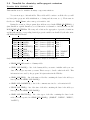
THE EXTERNALIZED SURFACE USER’S GUIDE
January 11, 2005
Contents
1 Overview of the externalized surface sequence
3
1.1
The sequence . . . . . . . . . . . . . . . . . . . . . . . . . . . . . . . . . . . . . .
3
1.2
The atmospheric models using the externalized surface . . . . . . . . . . . . . . .
4
1.2.1
in offline mode . . . . . . . . . . . . . . . . . . . . . . . . . . . . . . . . .
4
1.2.2
in MESONH . . . . . . . . . . . . . . . . . . . . . . . . . . . . . . . . . .
4
1.2.3
in AROME . . . . . . . . . . . . . . . . . . . . . . . . . . . . . . . . . . .
6
2 The physiographic fields
2.1
7
Overview of physiographic fields computation: PGD . . . . . . . . . . . . . . . .
7
2.1.1
Choice of the grid . . . . . . . . . . . . . . . . . . . . . . . . . . . . . . .
7
2.1.2
Choice of the physiographic fields . . . . . . . . . . . . . . . . . . . . . . .
8
2.2
Choice of the surface schemes . . . . . . . . . . . . . . . . . . . . . . . . . . . . .
9
2.3
Definition of the grid . . . . . . . . . . . . . . . . . . . . . . . . . . . . . . . . . .
11
2.3.1
Choice of the grid type
. . . . . . . . . . . . . . . . . . . . . . . . . . . .
11
2.3.2
Conformal projection grids (Mercator, Lambert, Polar stereographic) . . .
13
2.3.3
Cartesian grids . . . . . . . . . . . . . . . . . . . . . . . . . . . . . . . . .
15
2.3.4
Regular longitude-latitude grids . . . . . . . . . . . . . . . . . . . . . . . .
17
2.4
Land cover fractions . . . . . . . . . . . . . . . . . . . . . . . . . . . . . . . . . .
18
2.5
Orography and subgrid orography . . . . . . . . . . . . . . . . . . . . . . . . . .
19
2.6
Namelist for ISBA scheme
. . . . . . . . . . . . . . . . . . . . . . . . . . . . . .
20
2.7
Namelist to add user’s own fields . . . . . . . . . . . . . . . . . . . . . . . . . . .
22
2.8
Namelist for chemistry anthropogenic emissions
23
. . . . . . . . . . . . . . . . . .
3 Initialization of the prognostic fields
25
3.1
Overview of fields computation: PREP . . . . . . . . . . . . . . . . . . . . . . .
25
3.2
Date initialization and default input data file for all schemes . . . . . . . . . . . .
26
3.3
Sea scheme ”SEAFLX” . . . . . . . . . . . . . . . . . . . . . . . . . . . . . . . .
28
3.4
Lake scheme ”WATFLX” . . . . . . . . . . . . . . . . . . . . . . . . . . . . . . .
30
3.5
Vegetation scheme ”ISBA ” . . . . . . . . . . . . . . . . . . . . . . . . . . . . . .
32
1
3.6
Town scheme ”TEB ” . . . . . . . . . . . . . . . . . . . . . . . . . . . . . . . . .
4 How to run the externalized surface physical schemes
35
39
4.1
”SEAFLX” sea scheme options . . . . . . . . . . . . . . . . . . . . . . . . . . . .
39
4.2
”ISBA ” vegetation scheme options . . . . . . . . . . . . . . . . . . . . . . . . . .
40
5 How to run the externalized surface chemical schemes
43
5.1
Chemical settings control . . . . . . . . . . . . . . . . . . . . . . . . . . . . . . .
43
5.2
Chemical anthropogenic emissions . . . . . . . . . . . . . . . . . . . . . . . . . .
43
5.3
Chemical deposition over ocean . . . . . . . . . . . . . . . . . . . . . . . . . . . .
44
5.4
Chemical deposition over lakes . . . . . . . . . . . . . . . . . . . . . . . . . . . .
44
5.5
Chemical deposition over towns . . . . . . . . . . . . . . . . . . . . . . . . . . . .
44
5.6
Chemical deposition and biogenic emissions over vegetation . . . . . . . . . . . .
45
6 Externalized surface diagnostics
47
6.1
Diagnostics relative to the general surface monitor . . . . . . . . . . . . . . . . .
47
6.2
Diagnostics relative to the general surface monitor and to each surface scheme . .
48
6.3
Diagnostics relative to the ISBA vegetation scheme . . . . . . . . . . . . . . . . .
49
Chapter 1
Overview of the externalized surface
sequence
The externalized surface facilities do not contain only the program to run the physical surface
schemes, but also those producing the initial surface fields (before the run) and the diagnostics
(during or after the run). All these facilities are listed, below, and they separate in 4 main parts:
1.1
The sequence
1. PGD (routine pgd surf atm.f90): this program computes the physiographic data file
(called PGD file below). At this step, you perform 3 main tasks:
(a) You choose the surface schemes you will use.
(b) You choose and define the grid for the surface
(c) The physiographic fields are defined on this grid.
Therefore, the PGD file contains the spatial characteristics of the surface and all the
physiographic data necessary to run the interactive surface schemes for vegetation and
town.
2. PREP (routine prep surf atm n.f90): this program performs the initialization of the surface scheme prognostic variables, as temperatures profiles, water and ice soil contents,
interception reservoirs, snow reservoirs.
3. run of the schemes (routine coupling surf atm n.f90): this performs the physical evolution of the surface schemes. It is necessary that this part, contrary to the 2 previous ones,
is to be coupled within an atmospheric forcing (provided either in off-line mode or via a
coupling with an atmospheric model).
4. DIAG (routine diag surf atm n.f90): this computes diagnostics linked to the surface (e.g.
surface energy balance terms, variables at 2m of height, etc...). It can be used either during
3
the run (adding these diagnostics in the output file(s) of the run), or independantly from
the run, for a given surface state (still, an instantaneous atmospheric forcing is necessary
for this evaluation).
In addition, in order to read or write the prognostic variables or the diagnostics variables, respectively, in the surface files, the following subroutines are used: init surf atm n.f90,
write surf atm n.f90 and write diag surf atm n.f90.
1.2
The atmospheric models using the externalized surface
The externalized surface can presently be used in:
1. in offline mode
2. MESONH
3. AROME
For each model, additionnal possibilities of the surface, especially the ability to read and
write in files with particular formats, are added:
1.2.1
in offline mode
In this case, 2 types of files can be used:
• ASCII files, not efficient in term of storage, but completely portable.
• netcdf files, that can be used by the program code ”OFFLIN”.
currently, PGD and PREP steps are done using ASCII files, while the run produces time
series of each variable (prognostic or diagnostic) in netcdf files and the output instant of the run
again in an ASCII file.
The nameists are all included in the namelist file named OPTIONS.nam
1.2.2
in MESONH
In this case, MESONH FM files are used. The parallelization of the surface fields is done during
the reading or writing of the fields by the FMREAD and FMWRIT routines.
Initialization of surface fields integrated in MESONH programs
In MESONH, there are usually 2 ways to produce initial files, depending if you want to use real
or ideal atmospheric conditions. However, from the surface point of view, there is no difference
between these 2 main possibilities of fields (real -e.g. from operationnal surface scheme in an
operationnal model- or ideal -e.g. uniform-), whatever the treatment done for the atmospheric
fields. This is allowed because the same externalized routines corresponding to PGD and PREP
are used:
In the case of realistic atmospheric fields, the MESONH programs calling the surface are:
1. PREP PGD : it uses the PGD facility of the surface
2. PREP NEST PGD : surface fields are only read and rewritten, except the orography that
is modified (the modification of the orography itself is considered as an atmospheric model
routine, as orography is also a field of the atmospheric model).
3. PREP REAL CASE : it uses the PREP facility of the surface, that can produce either
ideal or realistic surface fields.
4. SPAWNING : it does not produce surface fields any more. The surface fields will be
recreated during the PREP REAL CASE step following the SPAWNING.
In the case of ideal atmospheric fields, the MESONH program calling the surface is:
1. PREP IDEAL CASE : it uses both the PGD and PREP facilities of the surface. Ideal
or realistic (the latter only in conformal projection) physiographic fields can be either
produced or read from a file. Then the prognostic surface variables, either ideal or realistic,
can be computed by PREP.
If you use MESONH atmospheric model, the input and output surface files are the same
as the atmospheric ones, so there is no need to specify via surface namelists any information
about the input or output file names.
Namelist NAM PGDFILE
Note however that, in PREP PGD (just before the call to the surface physiographic computation
in PGD, for which the namelists are described in the next chapter), there is a namelist to define
the output physiographic file:
Fortran name
CPGDFILE
Fortran type
string of 28 characters
MESONH run and diagnostics
Then, the MESONH run can be done. During this one, the diagnostics can be, or not, be
computed.
In DIAG, the surface diagnostics can also be recomputed.
1.2.3
in AROME
In this case, MESONH FM files are also used, for the surface only. The parallelization of the
surface fields is done during the reading or writing of the fields by parallelization routines of
ALADIN atmospheric model.
Chapter 2
The physiographic fields
2.1
Overview of physiographic fields computation: PGD
The physiographic fields are averaged or interpolated on the specified grid by the program PGD.
They are stored in a file, called PGD file, but only with the physiographic 2D fields, the geographic and grid data written in it.
During the PGD facility :
1. You choose the surface schemes you will use.
2. You choose and define the grid for the surface.
3. The physiographic fields are defined on this grid.
2.1.1
Choice of the grid
There are 3 possibilities. 2 are always possible, one is available only if the PGD routine is
integrated into an atmospheric model initialization facility.
1. The grid is chosen via namelists options (see below)
2. The grid is defined as a part of the grid of an already existing surface file, indicated via
namelists (see below)
3. The grid is defined as being identical to the one of an atmospheric model, which is given as
fortran argument in the coupling of the PGD surface facilities (routine PGD SURF ATM)
into an atmospheric model initialization procedures. In this case, all namelists that are
usually used to define the surface grid are ignored. Note that, in addition to the
grid, the orography can also be given from the atmospheric file.
7
2.1.2
Choice of the physiographic fields
There are 2 main possibilities:
ideal physiographic fields:
These fields are either uniform (fraction of each 215 ecoclimap ecosystem, orography, or any
field needed by the surface schemes). As mentionned above, orography can be, in the case of
the coupling with an atmospheric model, imposed as the atmospheric model (non-uniform) field.
realistic physiographic fields:
PGD can use files to build accurate physiographic fields from geographical information. This
is possible only if the grid chosen can be linked to geographical coordinates (latitude and longitude), i.e. if the grid type is ”LATLONREG ” or ”CONF PROJ ”.
The files that can be used are :
• A file describing the type of cover of the surface. This describes where are located the
different cover types (forests, towns, seas, etc...). At the time being, the file provided
contains the ecoclimap data (215 land covers) on the world, with a resolution of 30”.
PGD computes the fraction of surface coverage occupied by each type in the grid mesh.
From this information, the surface parameter convenient for the surface schemes (such
as building fraction, leaf area index, etc..) are deduced, using correspondance arrays: a
parameter has always the same value for a given cover type, anywhere in the
world.
• A file containing the orography: GTOPO30. The resolution of the file is 30” on the world.
This allows to compute the model orography, and the following subgrid-scale orographic
characteristics:
– the surface of frontal obstacle (A) over the surface of the grid mesh (S) in each
direction (
z0ef f ),
P
Ai+ /S,
P
Ai− /S,
P
Aj + /S,
P
Aj − /S, used to compute the directional
−
+
−
– the half height of these obstacles (h+
i /2, hi /2, hj /2, hj /2, used to compute the
directional z0ef f ),
– These 8 parameters are used to compute the total roughness length in the four directions given by the model axis (z0 ef fi+ , z0 ef fi− , z0 ef fj + , z0 ef fj − ),
– the Subgrid-Scale Orography (SSO) parameters (standard deviation µzs , anisotropy
γzs , direction of the small main axis θzs and slope σzs ).
• For ISBA scheme, a file with the clay fraction of the (near-surface) soil. The resolution of
the file provided is 5’ on the world.
• For ISBA scheme, a file with the sand fraction of the (near-surface) soil. The resolution
of the file provided is 5’ on the world.
2.2
Choice of the surface schemes
You must first choose the surface schemes you will use. It is not possible, once chosen, to modify
the surface schemes in the later steps (PREP, running of the schemes, DIAG).
Depending on the schemes you use, some additional physiographic fields will be computed
if they are needed for the surface scheme chosen. For example, the ISBA scheme (used for
vegetation and soil) needs the fractions of clay and sand.
Namelist NAM PGD SCHEMES
This namelist defines the four schemes that will be used, one for each type of surface (sea, inland
water, town, vegetation).
Fortran name
CNATURE
CSEA
CWATER
CTOWN
Fortran type
string of 6 characters
string of 6 characters
string of 6 characters
string of 6 characters
values
”NONE
”NONE
”NONE
”NONE
”,
”,
”,
”,
”FLUX
”FLUX
”FLUX
”FLUX
”,
”,
”,
”,
”TSZ0 ”, ”ISBA ”
”SEAFLX”
”WATFLX”
”TEB ”
default value
”ISBA ”
”SEAFLX”
”WATFLX”
”TEB ”
• CNATURE: scheme used for vegegation and natural soil covers . The different possibilities
are:
1. ”NONE ” : no scheme used. No fluxes will be cmputed at the surface.
2. ”FLUX ” : ideal fluxes are prescribed. The have to be set in the fortran routine
init ideal flux.f90.
3. ”TSZ0 ” : In this cheme, the fluxes are computed according to the ISBA physics, but
the surface characteristics (temperature, humidity, etc...) remain constant with time.
4. ”ISBA ” : this is the full ISBA scheme (Noilhan and Planton 1989), with all options
developped since this initial paper.
• CSEA : scheme used for sea and ocean . The different possibilities are:
1. ”NONE ” : no scheme used. No fluxes will be cmputed at the surface.
2. ”FLUX ” : ideal fluxes are prescribed. The have to be set in the fortran routine
init ideal flux.f90.
3. ”SEAFLX” : this is a relatively simple scheme, using the Charnock formula.
• CWATER : scheme used for inland water . The different possibilities are:
1. ”NONE ” : no scheme used. No fluxes will be cmputed at the surface.
2. ”FLUX ” : ideal fluxes are prescribed. The have to be set in the fortran routine
init ideal flux.f90.
3. ”WATFLX” : this is a relatively simple scheme, using the Charnock formula.
• CTOWN : scheme used for towns . The different possibilities are:
1. ”NONE ” : no scheme used. No fluxes will be cmputed at the surface.
2. ”FLUX ” : ideal fluxes are prescribed. The have to be set in the fortran routine
init ideal flux.f90.
3. ”TEB ” : this is the Town Energy Balance scheme (Masson 2000), with all the
susequent ameliorations of the scheme.
2.3
Definition of the grid
Note that all the namelists presented in this section are ignored if the grid is imposed, in the
fortran code, from an atmospheric model. This is the case when one already have defined the
atmospheric grid and one want to be sure that the surface has the same grid. For example,
this is what happens in the MESONH program PREP IDEAL CASE (when no physiographic
surface file is used).
If you are in this case, ignore all the namelists presented in this section, and only the
namelists for cover and the following ones, have to be used.
2.3.1
Choice of the grid type
Namelist NAM PGD GRID
This namelist defines the grid type, either specified or from an existing surface file
Fortran name
CGRID
YINIFILE
YFILETYPE
Fortran type
string of 10 characters
string of 28 characters
string of 6 characters
default value
”CONF PROJ ”
none
none
• CGRID: type of grid and projection . It is used only if a file is not prescribed (see below).
The different grid possibilities are:
1. ”CONF PROJ ” : this grid is a regular grid (in meters in x and y perpendicular
directions) on conformal projection plan (Mercator, Lambert or polar stereographic).
2. ”CARTESIAN ” : this grid is a regular grid (in meters in x and y perpendicular
directions), with no reference to real geographical coordinates.
3. ”LONLAT REG” : this grid is defined as a regular latitude - longitude grid.
4. ”NONE ” : this grid is not regular. Only the number of points and the size of each
grid mesh is prescribed. There is no positioning of each point compared to any other.
• YINIFILE: name of the file used to define the grid. It is possible to define the grid as
a subgrid of a previously created file. This is currently possible only for files that have
a ”CONF PROJ ” or ”CARTESIAN ” grid type. The exact definition of the subgrid
grid chosen is prescribed in a namelist (described below), depending on the type of grid
available in the file chosen. The use of a file has priority on the CGRID type.
• YFILETYPE: type of the YINIFILE file, if the latter is provided. YFILETYPE must be
given. The following values are currently usable:
– ”MESONH” : the file type is a MESONH file.
2.3.2
Conformal projection grids (Mercator, Lambert, Polar stereographic)
Namelist NAM CONF PROJ
This namelist defines the projection in case CGRID=”CONF PROJ ”
Fortran name
XLAT0
XLON0
XRPK
XBETA
Fortran type
real
real
real
real
default value
none
none
none
none
• XLAT0: reference latitude for conformal projection (real, decimal degrees)
• XLON0: reference longitude for conformal projection (real, decimal degrees)
• XRPK: cone factor for the projection (real):
– XRPK=1: polar stereographic projection from south pole
– 1>XRPK>0: Lambert projection from south pole
– XRPK=0: Mercator projection from earth center
– -1<XRPK<0: Lambert projection from north pole
– XRPK=-1: polar stereographic projection from north pole
• XBETA: rotation angle of the simulation domain around the reference longitude (real)
Namelist NAM CONF PROJ GRID
This namelists defines the horizontal domain in case CGRID=”CONF PROJ ”.
Fortran name
XLATCEN
XLONCEN
NIMAX
NJMAX
XDX
XDY
Fortran type
real
real
integer
integer
real
real
• XLATCEN: latitude of the point of the center of the domain (real, decimal degrees)
• XLONCEN: longitude of the point of the center of the domain (real, decimal degrees)
• NIMAX: number of surface points of the grid in direction x.
• NJMAX: number of surface points of the grid in direction y.
• XDX: grid mesh size on the conformal plane in x direction (real, meters).
• XDY: grid mesh size on the conformal plane in y direction (real, meters).
Namelist NAM INIFILE CONF PROJ
This namelists defines the horizontal domain from an existing surface file in which grid type is
”CONF PROJ ”. If nothing is set in the namelist, a grid identical as the one in the file is chosen.
Fortran name
IXOR
IYOR
IXSIZE
IYSIZE
IDXRATIO
IDYRATIO
Fortran type
integer
integer
integer
integer
integer
integer
default value
1
1
YINIFILE size
YINIFILE size
1
1
• IXOR: first point I index, according to the YINIFILE grid, left to and out of the new
physical domain.
• IYOR: first point J index, according to the YINIFILE grid, under and out of the new
physical domain.
• IXSIZE: number of grid points in I direction, according to YINIFILE grid, recovered by
the new domain. If to be used in MESONH, it must only be factor of 2,3 or 5.
• IYSIZE: number of grid points in J direction, according to YINIFILE grid, recovered by
the new domain. If to be used in MESONH, it must only be factor of 2,3 or 5.
• IDXRATIO: resolution factor in I direction between the YINIFILE grid and the new grid.
If to be used in MESONH, it must only be factor of 2,3 or 5.
• IDYRATIO: resolution factor in J direction between the YINIFILE grid and the new grid.
If to be used in MESONH, it must only be factor of 2,3 or 5.
2.3.3
Cartesian grids
Namelist NAM CARTESIAN
This namelist defines the projection in case CGRID=”CARTESIAN ”
Fortran name
XLAT0
XLON0
NIMAX
NJMAX
XDX
XDY
Fortran type
real
real
integer
integer
real
real
default value
none
none
none
none
none
none
• XLAT0: reference latitude (real, decimal degrees)
• XLON0: reference longitude (real, decimal degrees)
• NIMAX: number of surface points of the grid in direction x.
• NJMAX: number of surface points of the grid in direction y.
• XDX: grid mesh size on the conformal plane in x direction (real, meters).
• XDY: grid mesh size on the conformal plane in y direction (real, meters).
Namelist NAM INIFILE CARTESIAN
This namelists defines the horizontal domain from an existing surface file in which grid type
is ”CARTESIAN ”. If nothing is set in the namelist, a grid identical as the one in the file is
chosen.
Fortran name
IXOR
IYOR
IXSIZE
IYSIZE
IDXRATIO
IDYRATIO
Fortran type
integer
integer
integer
integer
integer
integer
default value
1
1
YINIFILE size
YINIFILE size
1
1
• IXOR: first point I index, according to the YINIFILE grid, left to and out of the new
physical domain.
• IYOR: first point J index, according to the YINIFILE grid, under and out of the new
physical domain.
• IXSIZE: number of grid points in I direction, according to YINIFILE grid, recovered by
the new domain. If to be used in MESONH, it must only be factor of 2,3 or 5.
• IYSIZE: number of grid points in J direction, according to YINIFILE grid, recovered by
the new domain. If to be used in MESONH, it must only be factor of 2,3 or 5.
• IDXRATIO: resolution factor in I direction between the YINIFILE grid and the new grid.
If to be used in MESONH, it must only be factor of 2,3 or 5.
• IDYRATIO: resolution factor in J direction between the YINIFILE grid and the new grid.
If to be used in MESONH, it must only be factor of 2,3 or 5.
2.3.4
Regular longitude-latitude grids
Namelist NAM LONLAT REG
This namelist defines the projection in case CGRID=”LONLAT REG”
Fortran name
XLONMIN
XLONMAX
XLATMIN
XLATMAX
NLON
NLAT
Fortran type
real
real
real
real
integer
integer
default value
none
none
none
none
none
none
• XLONMIN: minimum longitude covered by the grid, i.e. corresponding to the west border
of the domain (real, decimal degrees). XLONMIN must be smaller than XLONMAX, but
no more than 360 smaller.
• XLONMAX: maximum longitude covered by the grid, i.e. corresponding to the east border
of the domain (real, decimal degrees). XLONMAX must be larger than XLONMIN, but
no more than 360 larger.
• XLATMIN: minimum latitude covered by the grid, i.e. corresponding to the south border
of the domain (real, decimal degrees). XLATMIN must be between -90 and +90, and
smaller than XLATMAX.
• XLATMAX: maximum longitude covered by the grid, i.e. corresponding to the ’right’
border of the domain (real, decimal degrees). XLATMAX must be between -90 and +90,
and larger than XLATMIN.
• NLON: number of surface points in the longitude direction.
• NLAT: number of surface points in the latitude direction.
2.4
Land cover fractions
Namelist NAM COVER
This namelist gives the information to compute the surface cover fractions.
Fortran name
XUNIF COVER
YCOVER
YFILETYPE
Fortran type
array of 255 reals
character (LEN=28)
character (LEN=6)
XRM COVER
LRM TOWN
real
logical
values
≥ 0 and
P255
i=1 XUNIF
’DIRECT’, ’BINLLF’,
’BINLLV’, ’ASCLLV’
≥0
COVER(i) = 1
default value
none
’’
none
10−6
.FALSE.
• XUNIF COVER : specified values for uniform cover fractions. For each index i between 1
and 255, XUNIF COVER(i) is the fraction of the ith ecosystem of ecoclimap. The same
fraction of each ecosystem is set to all points of the grid. The sum of all ecosystem fractions must be equal to one :
P255
i=1 XUNIF
COVER(i) = 1.
If XUNIF COVER is set, it has priority on the use of an ecosystem file (see next item:
YCOVER). In the case of grid without any reference to geographical coordinates (”CARTESIAN ” or ”NONE ”), XUNIF COVER must be set.
• YCOVER: ecoclimap data file name. It is used only if XUNIF COVER is not set.
• YFILETYPE: type of YCOVER file (’DIRECT’, ’BINLLV’, ’BINLLF’, ’ASCLLV’).
• XRM COVER: for each point, all fractions of ecosystems that are below XRM COVER
are removed (i.e. set to zero), and the corresponding area fractions are distributed among
the remaining ecosystem fractions. Whatever the value of XRM COVER, at least one
ecosystem remains for each grid point.
• LRM TOWN: if .TRUE., all ecosystems containing town fractions are removed and replaced by the ecosystem corresponding to rocks.
2.5
Orography and subgrid orography
Namelist NAM ZS
This namelist defines the orography file and orographic treatment to be done.
Fortran name
XUNIF ZS
YZS
YFILETYPE
Fortran type
real
character (LEN=28)
character (LEN=6)
COROGTYPE
XENV
NZSFILTER
character (LEN=3)
real
integer
values
’DIRECT’, ’BINLLF’
’BINLLV’, ’ASCLLV’
’AVG’, ’ENV’, ’SIL ’
default value
none
’ ’ (default orography is 0.)
none
’ENV’
0.
1
• XUNIF ZS : uniform value of orography imposed on all points (real,meters). If XUNIF ZS
is set, file YZS is not used.
• YZS: data file name. If XUNIF ZS is set, file YZS is not used. If neither XUNIF ZS and
YZS is set, then orography is set to zero.
• YFILETYPE: type of data file (’DIRECT’, ’BINLLF’, ’BINLLV’, ’ASCLLV’)
• COROGTYPE: type of orography (string of 3 characters):
– ’AVG’: mean orography zs .
– ’ENV’: envelope relief, defined from mean orography and the subgrid orography standard deviation as zs + XEN V ∗ σzs .
– ’SIL’: silhouette relief, defined as the mean of the two subgrid silhouettes in directions
x and y (if two main directions can be defined for the grid chosen).
• XENV: enhance factor in envelope orography definition (real).
• NZSFILTER: number of iterations of the spatial filter applied to smooth the orography
(integer, 1 iteration removes the 2∆x signal, 50% of the 4∆x signal, 25% of the 6∆x signal,
etc1 ...).
1
The amplitude of the filtered signal for each wavelength λ∆x is
1
2
(cos(2π/λ) + 1).
2.6
Namelist for ISBA scheme
Namelist NAM ISBA
Fortran name
NPATCH
CISBA
CPHOTO
Fortran type
integer
character (LEN=3)
string of 3 characters
NGROUND LAYER
XUNIF CLAY
YCLAY
YCLAYFILETYPE
integer
real
character (LEN=28)
character (LEN=6)
XUNIF SAND
YSAND
YSANDFILETYPE
real
character (LEN=28)
character (LEN=6)
XUNIF RUNOFFB
real
values
between 1 and 12
’2-L’, ’3-L’, ’DIF’
’NON’, ’AGS’, ’LAI’, ’AST’,
’LST’, ’NIT’
>0
between 0 and 1
’DIRECT’, ’BINLLF’
’BINLLV’, ’ASCLLV’
between 0 and 1
’DIRECT’, ’BINLLF’
’BINLLV’, ’ASCLLV’
between 0 and 1
default value
1
’3-L’
’NON’
3
none
’’
none
none
’’
none
0.5
• NPATCH : number of patches used in ISBA. One patch corresponds to aggregated parameters. 12 patches correspond to separate energy budgets for all vegetation types present
in ISBA (bare soil, rocks, permanent snow and ice, C3 crops, C4 crops, irrigated crops,
C3 grass, C4 grass, marsh and gardens, coniferous trees, evergreen broadleaf trees, deciduous broadleaf trees). 3 patches correspond to bare soil types, low vegetation, trees. Any
number of patches between 1 and 12 is possible.
• CISBA : type of soil discretization and physics in ISBA:
– ’2-L’ : force-restore method with 2 layers for hydrology
– ’3-L’ : force-restore method with 3 layers for hydrology
– ’DIF’ : diffusion layer, with any number of layers
• CPHOTO: type of photosynthesis physics. The following options are currently available:
– ”NON” : none is used. Jarvis formula is used for plant transpiration.
– ”AGS” : ISBA-AGS, without evolving Leaf Area Index
– ”LAI” : ISBA-AGS, with evolving Leaf Area Index
– ”AST” : ISBA-AGS with offensive/defensive stress, without evolving Leaf Area Index
– ”LST” : ISBA-AGS with offensive/defensive stress, with evolving Leaf Area Index
– ”NIT” : ISBA-AGS with nitrogen, with evolving Leaf Area Index
• NGROUND LAYER : number of soil layer used in case of diffusion physics in the soil
(CISBA = ’DIF’).
• XUNIF CLAY : uniform prescribed value of clay fraction. If XUNIF CLAY is set, file
YCLAY is not used.
• YCLAY: clay fraction data file name. If XUNIF CLAY is set, file YCLAY is not used.
• YCLAYFILETYPE: type of clay data file (’DIRECT’, ’BINLLF’, ’BINLLV’, ’ASCLLV’)
• XUNIF SAND : uniform prescribed value of sand fraction. If XUNIF SAND is set, file
YSAND is not used.
• YSAND: sand fraction data file name. If XUNIF SAND is set, file YSAND is not used.
• YSANDFILETYPE: type of sand data file (’DIRECT’, ’BINLLF’, ’BINLLV’, ’ASCLLV’)
• XUNIF RUNOFFB : uniform prescribed value of subgrid runoff coefficient.
2.7
Namelist to add user’s own fields
Namelist NAM DUMMY PGD
This namelist allows to incorporate into the physiographic file any surface field.
You can treat up to 999 such fields. These fields will be written on all the files you will
use later(after prognostic fields initialization, or during and after run, etc...). Their name in the
files are ’DUMMY GRnnn’, where nnn goes from 001 to 999.
During the execution of the programs, these fields are stored in the XDUMMY FIELDS(:,:)
(first dimension: spatial dimension, second dimension: total number of fields), in the module
MODD DUMMY SURF FIELD$n. You must modify the fortran source, where you want to use
them.
Fortran name
NDUMMY PGD
CDUMMY PGD
CDUMMY PGD
CDUMMY PGD
CDUMMY PGD
CDUMMY PGD
CDUMMY PGD
NBR
NAME(:)
FILE(:)
COMMENT(:)
FILETYPE(:)
AREA(:)
ATYPE(:)
Fortran type
integer
1000 * character
1000 * character
1000 * character
1000 * character
1000 * character
1000 * character
(LEN=20)
(LEN=28)
(LEN=40)
(LEN=6)
(LEN=3)
(LEN=3)
default value
0
1000 * ’ ’
1000 * ’ ’
1000 * ’ ’
1000 *’ ’
1000 *’ALL’
1000 *’ARI’
Only the first NDUMMY PGD NBR values in these arrays are meaningfull.
• NDUMMY PGD NBR: number of dummy fields.
• CDUMMY PGD NAME(:) : list of the dummy fields you want to initialize with your own
data. You can give any name you want. This is a way to describe what is the field. This
information is not used by the program. It is just written in the FM files.
• CDUMMY PGD FILE(:) : list of the names of the files containing the data for the fields
you have specified in CDUMMY PGD NAME(:).
• CDUMMY PGD FILETYPE(:) : list of the types of the files containing the data for the
fields you have specified in CDUMMY PGD NAME(:) (’DIRECT’, ’LATLON’, ’BINLLF’,
’BINLLV’, ’ASCLLV’).
• CDUMMY PGD AREA(:) : area of meaningfullness of the fields you have specified in
CDUMMY PGD NAME(:) (’ALL’, ’NAT’, ’TWN’, ’SEA’, ’WAT’, ’LAN’, respectively for
everywhere, natural areas, town areas, sea, inland waters, land = natural cover + town).
For example, oceanic emission of DNS is relevant on ’SEA’.
• CDUMMY PGD ATYPE(:) : type of averaging (during PGD for the fields you have
specified in CDUMMY PGD NAME(:) (’ARI’, ’INV’, ’LOG’, respectively for arithmetic,
inverse and logarithmic averaging).
2.8
Namelist for chemistry anthropogenic emissions
Namelist NAM CH EMIS PGD
This namelist is used to initialize chemistry components emissions.
You can treat up to 999 such fields. These fields will be written on all the files you will
use later (after prognostic fields initialization, or during and after run, etc...). Their name in
the files are ’EMIS GRnnn’, where nnn goes from 001 to 999.
During the execution of the programs, these fields are stored in the XEMIS GR FIELDS(:,:)
(first dimension: spatial dimension, second dimension: total number of fields), in the module
MODD EMIS GR FIELD$n. The temporal evolution, the aggregation of prescribed emissions
and the link with the corresponding chemical prognostic variables are handled by the subroutine
CH EMISSION FLUXn.f90
Fortran
NEMIS
CEMIS
CEMIS
CEMIS
NEMIS
CEMIS
CEMIS
CEMIS
name
PGD NBR
PGD NAME(:)
PGD FILE(:)
PGD COMMENT(:)
PGD TIME
PGD FILETYPE(:)
PGD AREA(:)
PGD ATYPE(:)
Fortran type
integer
1000 * character
1000 * character
1000 * character
integer
1000 * character
1000 * character
1000 * character
(LEN=20)
(LEN=28)
(LEN=40)
(LEN=6)
(LEN=3)
(LEN=3)
default value
0
1000 * ’ ’
1000 * ’ ’
1000 * ’ ’
0
1000 *’DIRECT’
1000 *’ALL’
1000 *’ARI’
Only the first NEMIS PGD NBR values in these arrays are meaningfull.
• NEMIS PGD NBR: number of dummy fields.
• CEMIS PGD NAME(:) : list of the dummy fields you want to initialize with your own
data. You can give any name you want. This is a way to describe what is the field. This
information is not used by the program. It is just written in the FM files.
• CEMIS PGD FILE(:) : list of the names of the files containing the data for the fields you
have specified in CEMIS PGD NAME(:).
• CEMIS PGD COMMENT(:) : list of the comments associated to each emission field.
• NEMIS PGD TIME(:) : list of the time of the files containing the data for the fields you
have specified in CEMIS PGD NAME(:).
• CEMIS PGD FILETYPE(:) : list of the types of the files containing the data for the
fields you have specified in CEMIS PGD NAME(:) (’DIRECT’, ’BINLLF’, ’BINLLV’,
’ASCLLV’).
• CEMIS PGD AREA(:) : area of meaningfullness of the fields you have specified in CEMIS PGD NA
(’ALL’, ’NAT’, ’TWN’, ’SEA’, ’WAT’, ’LAN’, respectively for everywhere, natural areas,
town areas, sea, inland waters, land = natural cover + town). For example, oceanic
emission of DNS is relevant on ’SEA’.
• CEMIS PGD ATYPE(:) : type of averaging (during PGD for the fields you have specified
in CEMIS PGD NAME(:) (’ARI’, ’INV’, ’LOG’, respectively for arithmetic, inverse and
logarithmic averaging).
Example:
&NAM_CH_EMIS_PGD NEMIS_PGD_NBR
= 2,
CEMIS_PGD_NAME(1)=’COE’,
NEMIS_PGD_TIME(1)=0,
CEMIS_PGD_COMMENT(1)=’CO_00h00’,
CEMIS_PGD_AREA(1)=’LAN’,
CEMIS_PGD_ATYPE(1)=’ARI’,
CEMIS_PGD_FILE(1)=’co_00.asc’,
CEMIS_PGD_FILETYPE(1)=’ASCLLV’,
CEMIS_PGD_NAME(2)=’COE’,
NEMIS_PGD_TIME(2)=43200,
CEMIS_PGD_COMMENT(2)=’CO_12h00’,
CEMIS_PGD_AREA(2)=’LAN’,
CEMIS_PGD_ATYPE(2)=’ARI’,
CEMIS_PGD_FILE(2)=’co_12.asc’,
CEMIS_PGD_FILETYPE(2)=’ASCLLV’,
CEMIS_PGD_NAME(3)=’DMSE’,
NEMIS_PGD_TIME(3)=0,
CEMIS_PGD_COMMENT(3)=’dms_cte’,
CEMIS_PGD_AREA(3)=’SEA’,
CEMIS_PGD_ATYPE(3)=’ARI’,
CEMIS_PGD_FILE(3)=’dms.asc’,
CEMIS_PGD_FILETYPE(3)=’ASCLLV’ /
Chapter 3
Initialization of the prognostic fields
3.1
Overview of fields computation: PREP
The prognostic fields (temperature, humidity, ice, snow, etc...) are averaged or interpolated on
the specified grid by the program PREP. They are stored in the surface file. The computation
is done separately for each surface scheme.
During the PREP facility :
1. You initializes the date of the surface
2. You initializes the prognostic variables of the chosen sea scheme
3. You initializes the prognostic variables of the chosen lake scheme
4. You initializes the prognostic variables of the chosen vegetation scheme
5. You initializes the prognostic variables of the chosen town scheme
Here are presented the initialization procedures for the schemes that need such information
(for example, scheme ”IDEAL ” does not need any information here, but modificaton of the code
source init ideal flux.f90).
Note that for each scheme, and for some for each variable of the scheme, it is possible to
initialize the prognostic fields either form an operationnal or research model, or using prescribed
(usually uniform) fields.
25
3.2
Date initialization and default input data file for all schemes
Namelist NAM PREP SURF ATM
This namelist information is used to (possibly):
• initialize the date of all surface schemes. The namelist information is used only if no input
data file is used, either from namelist or by fortran code (as in MESONH programs). If a
file is used, the date is read in it.
• define the default file in which each scheme can read the needed data (e.g. temperature).
Note that, all the information given in this namelist can be erased for each scheme by the
namelist corresponding to this scheme, as the information in the shceme namelists have priority
on namelist NAM PREP SURF ATM.
Fortran name
CFILE
Fortran type
string of 28 characters
values
CFILETYPE
string of 6 characters
’MESONH’,
’GRIB ’
NYEAR
NMONTH
NDAY
XTIME
integer
integer
integer
real
default value
- atmospheric file used in the program
calling the surface facilities, if any
- none otherwise
- type of the atmospheric file, if any
- none otherwise
none
none
none
none
• CFILE: name of the file used to define
1. the date.
2. the file in which to read the needed data (e.g. temperature).
The use of a file or prescribed value in each scheme namelist has priority on
the data in CFILE file of namelist NAM PREP SURF ATM.
• CFILETYPE: type of the CFILE file, if the latter is provided. CTYPE must then be
given. The following values are currently usable:
– ”MESONH” : the file type is a MESONH file.
– ”GRIB ” : the file type is a GRIB file, coming from any of these models:
1. ”ECMWF ” : european center forecast model
2. ”ARPEGE” : Arpege french forecast model
3. ”ALADIN” : Aladin french forecast local model
4. ”MOCAGE” : Mocage french research chemistry model
• NYEAR : year of surface UTC time. It is used only if no atmospheric file or no surface
file is given (in those the date can be read).
• NMONTH : month of surface UTC time. It is used only if no atmospheric file or no surface
file is given (in those the date can be read).
• NDAY : day of surface UTC time. It is used only if no atmospheric file or no surface file
is given (in those the date can be read).
• XTIME : time from midnight of surface UTC time. It is used only if no atmospheric file
or no surface file is given (in those the date can be read). (seconds).
3.3
Sea scheme ”SEAFLX”
Namelist NAM PREP SEAFLUX
This namelist information is used to initialize the ”SEAFLX” sea scheme temperature.
Fortran name
XSST UNIF
CFILE SEAFLX
CTYPE
Fortran type
real
string of 28 characters
string of 6 characters
NYEAR
NMONTH
NDAY
XTIME
integer
integer
integer
real
values
’MESONH’,
’GRIB ’
default value
none
CFILE in NAM PREP SURF ATM
CFILETYPE in NAM PREP SURF ATM
none
none
none
none
• XSST UNIF : uniform prescribed value of Sea Surface Temperature. This prescribed value,
if defined, has priority on the use of CFILE SEAFLX data.
• CFILE SEAFLX: name of the file used to define the Sea surface Temperature. The
use of a file or prescribed value XSST UNIF has priority on the data in
CFILE SEAFLX file.
• CTYPE: type of the CFILE SEAFLX file, if the latter is provided. CTYPE must then be
given. The following values are currently usable:
– ”MESONH” : the file type is a MESONH file.
– ”GRIB ” : the file type is a GRIB file, coming from any of these models:
1. ”ECMWF ” : european center forecast model
2. ”ARPEGE” : Arpege french forecast model
3. ”ALADIN” : Aladin french forecast local model
4. ”MOCAGE” : Mocage french research chemistry model
• NYEAR : year of surface UTC time. It is used only if no atmospheric file or no surface
file is given (in those the date can be read).
• NMONTH : month of surface UTC time. It is used only if no atmospheric file or no surface
file is given (in those the date can be read).
• NDAY : day of surface UTC time. It is used only if no atmospheric file or no surface file
is given (in those the date can be read).
• XTIME : time from midnight of surface UTC time. It is used only if no atmospheric file
or no surface file is given (in those the date can be read). (seconds).
3.4
Lake scheme ”WATFLX”
Namelist NAM PREP WATFLUX
This namelist information is used to initialize the ”WATFLX” sea scheme temperature.
Fortran name
XTS WATER UNIF
CFILE WATFLX
CTYPE
Fortran type
real
string of 28 characters
string of 6 characters
NYEAR
NMONTH
NDAY
XTIME
integer
integer
integer
real
values
’MESONH’,
’GRIB ’
default value
none
CFILE in NAM PREP SURF ATM
CFILETYPE in NAM PREP SURF ATM
none
none
none
none
• XTS WATER UNIF : uniform prescribed value of water surface temperature supposed at
an altitude of 0m (mean sea level altitude). The temperature is then modified for each
point depending on its altitude, following a uniform vertical gradient of -6.5 Kkm−1 . This
prescribed value, if defined, has priority on the use of CFILE WATFLX data.
• CFILE WATFLX: name of the file used to define the Sea surface Temperature. The use
of a file or prescribed value XTS WATER UNIF has priority on the data in
CFILE WATFLX file.
• CTYPE: type of the CFILE WATFLX file, if the latter is provided. CTYPE must then
be given. The following values are currently usable:
– ”MESONH” : the file type is a MESONH file.
– ”GRIB ” : the file type is a GRIB file, coming from any of these models:
1. ”ECMWF ” : european center forecast model
2. ”ARPEGE” : Arpege french forecast model
3. ”ALADIN” : Aladin french forecast local model
4. ”MOCAGE” : Mocage french research chemistry model
• NYEAR : year of surface UTC time. It is used only if no atmospheric file or no surface
file is given (in those the date can be read).
• NMONTH : month of surface UTC time. It is used only if no atmospheric file or no surface
file is given (in those the date can be read).
• NDAY : day of surface UTC time. It is used only if no atmospheric file or no surface file
is given (in those the date can be read).
• XTIME : time from midnight of surface UTC time. It is used only if no atmospheric file
or no surface file is given (in those the date can be read). (seconds).
3.5
Vegetation scheme ”ISBA ”
Namelist NAM PREP ISBA
This namelist information is used to initialize the ”ISBA ” vegetation scheme variables: soil
temperature profile, soil water and ice profiles, water intercepted by leaves, snow.
Fortran name
XHUG SURF
XHUG ROOT
XHUG DEEP
CFILE WG
CTYPE WG
Fortran type
real
real
real
string of 28 characters
string of 6 characters
XTG SURF
XTG ROOT
XTG DEEP
CFILE TG
CTYPE TG
real
real
real
string of 28 characters
string of 6 characters
CFILE ISBA
CTYPE
string of 28 characters
string of 6 characters
NYEAR
NMONTH
NDAY
XTIME
integer
integer
integer
real
values
’MESONH’,
’GRIB ’
’MESONH’,
’GRIB ’
’MESONH’,
’GRIB ’
default value
none
none
none
CFILE ISBA in this namelist
CTYPE in this namelist
none
none
none
CFILE ISBA in this namelist
CTYPE in this namelist
CFILE in NAM PREP SURF ATM
CFILETYPE in NAM PREP SURF ATM
none
none
none
none
• XHUG SURF : uniform prescribed value of soil water index (SWI) for the surface soil layer.
This prescribed value, if defined, has priority on the use of CFILE WG and CFILE ISBA
data.
• XHUG ROOT : uniform prescribed value of soil water index (SWI) for the root zone soil
layer(s). This prescribed value, if defined, has priority on the use of CFILE WG and
CFILE ISBA data.
• XHUG DEEP : uniform prescribed value of soil water index (SWI) for the deep soil layer(s).
This prescribed value, if defined, has priority on the use of CFILE WG and CFILE ISBA
data.
• CFILE WG: name of the file used to define the soil water profiles. The use of a file
or prescribed value of XHUG SURF, XHUG ROOT and XHUG DEEP has
priority on the data in CFILE WG file.
• CTYPE WG: type of the CFILE WG file, if the latter is provided. CTYPE WG must
then be given. The following values are currently usable:
– ”MESONH” : the file type is a MESONH file.
– ”GRIB ” : the file type is a GRIB file, coming from any of these models:
1. ”ECMWF ” : european center forecast model
2. ”ARPEGE” : Arpege french forecast model
3. ”ALADIN” : Aladin french forecast local model
4. ”MOCAGE” : Mocage french research chemistry model
• XTG SURF : uniform prescribed value of temperature for the surface soil layer, supposed
at an altitude of 0m (mean sea level altitude). The temperature is then modified for
each point depending on its altitude, following a uniform vertical gradient of -6.5 Kkm −1 .
This prescribed value, if defined, has priority on the use of CFILE TG and CFILE ISBA
data.
• XTG ROOT : uniform prescribed value of temperature for the root zone soil layer(s),
supposed at an altitude of 0m (mean sea level altitude). The temperature is then modified for each point depending on its altitude, following a uniform vertical gradient of
-6.5 Kkm−1 . This prescribed value, if defined, has priority on the use of CFILE TG and
CFILE ISBA data.
• XTG DEEP : uniform prescribed value of temperature for the deep soil layer(s), supposed
at an altitude of 0m (mean sea level altitude). The temperature is then modified for
each point depending on its altitude, following a uniform vertical gradient of -6.5 Kkm −1 .
This prescribed value, if defined, has priority on the use of CFILE TG and CFILE ISBA
data.
• CFILE TG: name of the file used to define the soil temperature profile. The use of a file
or prescribed value of XTG SURF, XTG ROOT and XTG DEEP has priority
on the data in CFILE TG file.
• CTYPE TG: type of the CFILE TG file, if the latter is provided. CTYPE TG must then
be given. The following values are currently usable:
– ”MESONH” : the file type is a MESONH file.
– ”GRIB ” : the file type is a GRIB file, coming from any of these models:
1. ”ECMWF ” : european center forecast model
2. ”ARPEGE” : Arpege french forecast model
3. ”ALADIN” : Aladin french forecast local model
4. ”MOCAGE” : Mocage french research chemistry model
• CFILE ISBA: name of the file used to define any ISBA variable. The use of a file or
prescribed value XHUG SURF, XHUG ROOT, XHUG DEEP, XTG SURF,
XTG ROOT, XTG DEEP, CFILE WG and CFILE TG has priority on the
data in CFILE ISBA file.
• CTYPE: type of the CFILE ISBA file, if the latter is provided. CTYPE must then be
given. The following values are currently usable:
– ”MESONH” : the file type is a MESONH file.
– ”GRIB ” : the file type is a GRIB file, coming from any of these models:
1. ”ECMWF ” : european center forecast model
2. ”ARPEGE” : Arpege french forecast model
3. ”ALADIN” : Aladin french forecast local model
4. ”MOCAGE” : Mocage french research chemistry model
• NYEAR : year of surface UTC time. It is used only if no atmospheric file or no surface
file is given (in those the date can be read).
• NMONTH : month of surface UTC time. It is used only if no atmospheric file or no surface
file is given (in those the date can be read).
• NDAY : day of surface UTC time. It is used only if no atmospheric file or no surface file
is given (in those the date can be read).
• XTIME : time from midnight of surface UTC time. It is used only if no atmospheric file
or no surface file is given (in those the date can be read). (seconds).
Namelist NAM PREP ISBA SNOW
This namelist defines the type of snow scheme used in ISBA scheme.
Fortran name
CSNOW
Fortran type
string of 3 characters
values
’D95’, ’3-L’
default value
’D95’
• CSNOW : type of snow scheme. Possible snow schemes are:
1. ’D95’ : Douville et al (1995) snow scheme.
2. ’3-L’ : Boone and Etchevers (2000) three layers snow scheme.
3.6
Town scheme ”TEB ”
Namelist NAM PREP TEB
This namelist information is used to initialize the ”TEB ” urban scheme variables: road, roof
and wall temperature profiles, water intercepted by roofs and roads, snow, building internal
temperature.
Fortran name
XWS ROAD
XWS ROOF
CFILE WS
CTYPE WS
Fortran type
real
real
string of 28 characters
string of 6 characters
XTS ROAD
XTS ROOF
XTS WALL
XTI BLD
XTI ROAD
CFILE TS
CTYPE TS
real
real
real
real
real
string of 28 characters
string of 6 characters
CFILE TEB
CTYPE
string of 28 characters
string of 6 characters
NYEAR
NMONTH
NDAY
XTIME
integer
integer
integer
real
values
’MESONH’,
’GRIB ’
’MESONH’,
’GRIB ’
’MESONH’,
’GRIB ’
default value
none
none
CFILE TEB in this namelist
CTYPE in this namelist
none
none
none
none
none
CFILE TEB in this namelist
CTYPE in this namelist
CFILE in NAM PREP SURF ATM
CFILETYPE in NAM PREP SURF ATM
none
none
none
none
• XWS ROAD : uniform prescribed value of soil water interception for the road reservoir.
This prescribed value, if defined, has priority on the use of CFILE WS and CFILE TEB
data.
• XWS ROOF : uniform prescribed value of soil water interception for the roof reservoir.
This prescribed value, if defined, has priority on the use of CFILE WS and CFILE TEB
data.
• CFILE WS: name of the file used to define the soil water reservoirs. The use of a file
or prescribed value of XWS ROAD and XWS ROOF has priority on the data
in CFILE WS file.
• CTYPE WS: type of the CFILE WS file, if the latter is provided. CTYPE WS must then
be given. The following values are currently usable:
– ”MESONH” : the file type is a MESONH file.
– ”GRIB ” : the file type is a GRIB file, coming from any of these models:
1. ”ECMWF ” : european center forecast model
2. ”ARPEGE” : Arpege french forecast model
3. ”ALADIN” : Aladin french forecast local model
4. ”MOCAGE” : Mocage french research chemistry model
• XTS ROAD : uniform prescribed value of surface temperature for road, supposed at an
altitude of 0m (mean sea level altitude). The temperature is then modified for each
point depending on its altitude, following a uniform vertical gradient of -6.5 Kkm−1 . This
prescribed value, if defined, has priority on the use of CFILE TS and CFILE TEB data.
• XTS ROOF : uniform prescribed value of surface temperature for roof, supposed at an
altitude of 0m (mean sea level altitude). The temperature is then modified for each
point depending on its altitude, following a uniform vertical gradient of -6.5 Kkm−1 . This
prescribed value, if defined, has priority on the use of CFILE TS and CFILE TEB data.
• XTS WALL : uniform prescribed value of surface temperature for wall, supposed at an
altitude of 0m (mean sea level altitude). The temperature is then modified for each
point depending on its altitude, following a uniform vertical gradient of -6.5 Kkm−1 . This
prescribed value, if defined, has priority on the use of CFILE TS and CFILE TEB data.
• XTI BLD : uniform prescribed value of internal building temperature. This temperature
is not dependent on altitude. This prescribed value, if defined, has priority on the use of
CFILE TS and CFILE TEB data.
• XTI ROAD : uniform prescribed value of deep road temperature, supposed at an altitude of 0m
(mean sea level altitude). The temperature is then modified for each point depending on
its altitude, following a uniform vertical gradient of -6.5 Kkm−1 . This prescribed value, if
defined, has priority on the use of CFILE TS and CFILE TEB data.
• CFILE TS: name of the file used to define the soil temperature profile. The use of a
file or prescribed value of XTS ROAD, XTS ROOF, XTS WALL, XTI BLD
or XTI ROAD has priority on the data in CFILE TS file.
• CTYPE TS: type of the CFILE TS file, if the latter is provided. CTYPE TS must then
be given. The following values are currently usable:
– ”MESONH” : the file type is a MESONH file.
– ”GRIB ” : the file type is a GRIB file, coming from any of these models:
1. ”ECMWF ” : european center forecast model
2. ”ARPEGE” : Arpege french forecast model
3. ”ALADIN” : Aladin french forecast local model
4. ”MOCAGE” : Mocage french research chemistry model
• CFILE TEB: name of the file used to define any TEB variable. The use of a file or pre-
scribed value XWS ROAD, XWS ROOF, XTS ROAD, XTS ROOF, XTS WALL,
XTI BLD, XTI ROAD, CFILE WS or CFILE TS has priority on the data in
CFILE TEB file.
• CTYPE: type of the CFILE TEB file, if the latter is provided. CTYPE must then be
given. The following values are currently usable:
– ”MESONH” : the file type is a MESONH file.
– ”GRIB ” : the file type is a GRIB file, coming from any of these models:
1. ”ECMWF ” : european center forecast model
2. ”ARPEGE” : Arpege french forecast model
3. ”ALADIN” : Aladin french forecast local model
4. ”MOCAGE” : Mocage french research chemistry model
• NYEAR : year of surface UTC time. It is used only if no atmospheric file or no surface
file is given (in those the date can be read).
• NMONTH : month of surface UTC time. It is used only if no atmospheric file or no surface
file is given (in those the date can be read).
• NDAY : day of surface UTC time. It is used only if no atmospheric file or no surface file
is given (in those the date can be read).
• XTIME : time from midnight of surface UTC time. It is used only if no atmospheric file
or no surface file is given (in those the date can be read). (seconds).
Chapter 4
How to run the externalized surface
physical schemes
Here are described the options available during the run of the several surface schemes.
4.1
”SEAFLX” sea scheme options
Namelist NAM SEAFLUXn
Fortran name
CSEA FLUX
CSEA ALB
Fortran type
string of 6 characters
string of 4 characters
values
’DIRECT’
’UNIF’, ’TA96’
default value
’DIRECT’
’TA96’
• CSEA FLUX: type of flux computation physics. The following option is currently available:
– ”DIRECT” : direct Charnock computation. No effect of convection in the the boundary layer on the fluxes formulae.
• CSEA ALB: type of albedo formula. The following options are currently available:
– ”UNIF” : a uniform value of 0.135 is used for water albedo
– ”TA96” : Taylor et al (1996) formula for water direct albedo, depending on solar
zenith angle θ:
αdir = 0.037/ 1.1cos(θ)1.4 + 0.15
39
4.2
”ISBA ” vegetation scheme options
Namelist NAM ISBAn
Fortran name
CRUNOFF
CC1DRY
CSCOND
CSOILFRZ
CDIFSFCOND
CSNOWRES
CALBEDO
CROUGH
XTSTEP
Fortran type
string of 4 characters
string of 4 characters
string of 4 characters
string of 3 characters
string of 4 characters
string of 3 characters
string of 4 characters
string of 4 characters
real
values
’WSAT’, ’DT92’
’DEF ’, ’GB93’
’NP89’, ’PL98’
’DEF’, ’LWT’
’DEF ’, ’MLCH’
’DEF’, ’CRO’
’MEAN’, ’DRY ’, ’WET ’, ’EVOL’
’Z01D’, ’Z04D’
default value
’WSAT’
’DEF ’
’NP89’
’DEF’
’DEF ’
’DEF’
’DRY ’
’Z04D’
none
• CRUNOFF: type of subgrid runoff. The following options are currently available:
– ”WSAT” : runoff occurs only when saturation is reached
– ”DT92” : Dumenill and Todini (1992) subgrid runoff formula
• CC1DRY: type of C1 formulation for dry soils. The following options are currently available:
– ”DEF ” : Giard-Bazile formulation
– ”GB93” : Giordani 1993, Braud 1993
• CSCOND: type of thermal conductivity. The following options are currently available:
– ”NP89” : Noilhan and Planton (1989) formula
– ”PL98” : Peters-Lidard et al. (1998) formula
• CSOILFRZ: type of soil freezing-physics option. The following options are currently available:
– ”DEF” : Boone et al. 2000; Giard and Bazile 2000
– ”LWT” : Phase changes as above, but relation between unfrozen water and temperature considered
• CDIFSFCOND: type of Mulch effects. The following options are currently available:
– ”DEF ” : no mulch effect
– ”MLCH” : include the insulating effect of leaf litter/mulch on the surf. thermal cond.
• CSNOWRES: type of turbulent exchanges over snow. The following options are currently
available:
– ”DEF” : Louis
– ”CRO” : Maximum Richardson number limit for stable conditions ISBA-SNOW3L
turbulent exchange option
• CALBEDO: type of bare soil albedo. The following options are currently available:
– ”DRY ” : dry bare soil albedo
– ”WET ” : wet bare soil albedo
– ”MEAN” : albedo for bare soil half wet, half dry
– ”EVOL” : albedo of bare soil evolving with soil humidity
• CROUGH: type of orographic roughness length. The following options are currently available:
– ”Z01D” : orographic roughness length does not depend on wind direction
– ”Z04D” : orographic roughness length depends on wind direction
• XTSTEP: time step for ISBA. Default is to use the time-step given by the atmospheric
coupling (seconds).
Chapter 5
How to run the externalized surface
chemical schemes
Here are described the options available during the run of the several schemes for emission and
deposition of chemical species. Note that all the schemes for deposition and emission of chemical
species do activate only if chemical species are present (i.e. if the coupling between atmosphere
and surface include the chemical species concentrations and fluxes).
5.1
Chemical settings control
Namelist NAM CH CONTROLn
Fortran name
CCHEM SURF FILE
Fortran type
string of 28 characters
values
’DIRECT’
default value
’DIRECT’
• CCHEM SURF FILE: name of general (chemical) purpose ASCII input file.
5.2
Chemical anthropogenic emissions
Namelist NAM CH SURFn
Fortran name
LCH SURF EMIS
Fortran type
logical
values
default value
.FALSE.
• LCH SURF EMIS: flag to use anthropogenic emissions or not.
43
5.3
Chemical deposition over ocean
Namelist NAM CH SEAFLUXn
Fortran name
CCH DRY DEP
Fortran type
string of 6 characters
values
’NONE ’, ’WES89 ’
default value
’WES89 ’
• CCH DRY DEP: type of deposition scheme.
– ”NONE ” : no chemical deposition scheme.
– ”WES89 ” : Wesley (1989) deposition scheme.
5.4
Chemical deposition over lakes
Namelist NAM CH WATFLUXn
Fortran name
CCH DRY DEP
Fortran type
string of 6 characters
values
’NONE ’, ’WES89 ’
default value
’WES89 ’
• CCH DRY DEP: type of deposition scheme.
– ”NONE ” : no chemical deposition scheme.
– ”WES89 ” : Wesley (1989) deposition scheme.
5.5
Chemical deposition over towns
Namelist NAM CH TEBn
Fortran name
CCH DRY DEP
Fortran type
string of 6 characters
values
’NONE ’, ’WES89 ’
• CCH DRY DEP: type of deposition scheme.
– ”NONE ” : no chemical deposition scheme.
– ”WES89 ” : Wesley (1989) deposition scheme.
default value
’WES89 ’
5.6
Chemical deposition and biogenic emissions over vegetation
Namelist NAM CH ISBAn
Fortran name
CCH DRY DEP
LCH BIO FLUX
Fortran type
string of 6 characters
logical
values
’NONE ’, ’WES89 ’
• CCH DRY DEP: type of deposition scheme.
– ”NONE ” : no chemical deposition scheme.
– ”WES89 ” : Wesley (1989) deposition scheme.
• LCH BIO FLUX : flag to activate the biogenic emissions.
default value
’WES89 ’
.FALSE.
Chapter 6
Externalized surface diagnostics
The diagnostics for the surface require the call to the complete physics of the surface. Therefore,
they can be computed either during the run of the schemes (in order to have for example continuous time series of these diagnostics), or can be computed at a given instant only, if atmospheric
forcing is given at this instant for the surface scheme to do one time step. The cumulated diagnostics are of course significant only when computed during a run.
6.1
Diagnostics relative to the general surface monitor
Namelist NAM DIAG SURF ATMn
Fortran name
LFRAC
Fortran type
logical
default value
.FALSE.
• LFRAC: flag to save in the output file the sea, inland water, natural covers and town
fractions.
47
6.2
Diagnostics relative to the general surface monitor and to
each surface scheme
Namelist NAM DIAG SURFn
Fortran name
N2M
LSURF BUDGET
Fortran type
integer
logical
values
0, 1
default value
0
.FALSE.
• N2M : flag to compute surface boundary layer characteristics:
– N2M=1 : computes temperature at 2 m, specific humidity at 2 m, zonal and meridian
wind at 10 m, and Richardson number.
• LSURF BUDGET: flag to save in the output file the terms of the surface energy balance
(net radiation, sensible heat flux, latent heat flux, ground flux), for each scheme (on the
four separate tiles), on each patch of the vegetation scheme if existing, and aggregated for
the whole surface. The diagnosed fields are (∗ stands for the scheme considered (∗=nothing
: field aggregated on the whole surface; ∗=name of a scheme : field for this scheme):
– RN ∗ : net radiation
– H ∗ : turbulent sensible heat flux
– LE ∗ : turbulent latent heat flux
– GFLUX ∗ : ground or storage heat flux
6.3
Diagnostics relative to the ISBA vegetation scheme
Namelist NAM DIAG ISBAn
Fortran name
LPGD
LSURF EVAP BUDGET
LSURF BUDGETC
Fortran type
logical
logical
logical
default value
.FALSE.
.FALSE.
.FALSE.
• LPGD : flag to save in the output file the physiographic fields of ISBA scheme that are
computed from ecoclimap data from the ecosystem fractions.
• LSURF EVAP BUDGET: flag to save in the output file the detailled terms of the water
vapor fluxes, on each patch of the vegetation scheme if existing, and aggregated for the
natural surface. The diagnosed fields are:
– LEG : ground evaporation
– LEGI : ground sublimation
– LEV : evaporation of intercepted water on leaves
– LES : snow sublimation
– LER : plant evaporation
– LETR : transpiration
– EVAP : total evaporation
– DRAIN : drainage
– RUNOFF : runoff
• LSURF BUDGETC: flag to save in the output file the time integrated values of all budget
terms that have been activated (either with :LSURF BUDGET flag in NAM DIAG SURFn
or LSURF EVAP BUDGET in the present namelist).