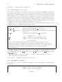
1
Polyphemus 1.1α User’s Guide CEREA – ENPC / EDF R&D Meryem Ahmed de Biasi, Vivien Mallet, ´ Ir` ene Korsakissok, Edouard Debry, Lin Wu http://www.enpc.fr/cerea/polyphemus/ [email protected] 2 Contents 1 Introduction and Installation 1.1 Polyphemus Overview . . . 1.2 Requirements . . . . . . . . 1.3 Installation . . . . . . . . . 1.3.1 Main instructions . . 1.3.2 AtmoPy . . . . . . . 1.3.3 Newran . . . . . . . 1.3.4 Fortran Subroutines . . . . . . . . . . . . . . . . . . . . . . . . . . . . . . . . . . . . . . . . . . . . . . . . . . . . . . . . . . . . . . . . . . . . . . . . . . . . . . . . . . . . . . . . . . . . . . . . . . . . . . . . . . . . . . . . . . . . . . . . . . . . . . . . . . . . . . . . . . . . . . . . . . . 9 9 11 12 12 13 13 14 2 Using Polyphemus 2.1 Remark . . . . . . . . . . . . . . . . . . . . . 2.2 Configuration Files . . . . . . . . . . . . . . . 2.2.1 Definitions . . . . . . . . . . . . . . . 2.2.2 Flexibility . . . . . . . . . . . . . . . . 2.2.3 Comments . . . . . . . . . . . . . . . . 2.2.4 Markups . . . . . . . . . . . . . . . . . 2.2.5 Sections . . . . . . . . . . . . . . . . . 2.2.6 Multiple Files . . . . . . . . . . . . . . 2.2.7 Dates . . . . . . . . . . . . . . . . . . 2.2.8 Booleans . . . . . . . . . . . . . . . . 2.3 Running Programs . . . . . . . . . . . . . . . 2.3.1 Compiling Programs . . . . . . . . . . 2.3.2 Running a Program . . . . . . . . . . 2.3.3 Sharing Configuration . . . . . . . . . 2.3.4 Notes about Models . . . . . . . . . . 2.4 Useful Tools . . . . . . . . . . . . . . . . . . . 2.4.1 Information about Binary Files . . . . 2.4.2 Differences between Two Binary Files 2.4.3 MM5 Files . . . . . . . . . . . . . . . 2.4.4 Script call dates . . . . . . . . . . . 2.5 Setting Up a Simulation . . . . . . . . . . . . 2.5.1 Suggested Directory Tree . . . . . . . 2.5.2 Roadmaps . . . . . . . . . . . . . . . . 2.5.3 Mandatory Data in Preprocessing . . 2.5.4 Mandatory Data for Models . . . . . . 2.5.5 Models / Modules Compatibilities . . 2.5.6 Checking Results . . . . . . . . . . . . 2.5.7 Important Notice . . . . . . . . . . . . . . . . . . . . . . . . . . . . . . . . . . . . . . . . . . . . . . . . . . . . . . . . . . . . . . . . . . . . . . . . . . . . . . . . . . . . . . . . . . . . . . . . . . . . . . . . . . . . . . . . . . . . . . . . . . . . . . . . . . . . . . . . . . . . . . . . . . . . . . . . . . . . . . . . . . . . . . . . . . . . . . . . . . . . . . . . . . . . . . . . . . . . . . . . . . . . . . . . . . . . . . . . . . . . . . . . . . . . . . . . . . . . . . . . . . . . . . . . . . . . . . . . . . . . . . . . . . . . . . . . . . . . . . . . . . . . . . . . . . . . . . . . . . . . . . . . . . . . . . . . . . . . . . . . . . . . . . . . . . . . . . . . . . . . . . . . . . . . . . . . . . . . . . . . . . . . . . . . . . . . . . . . . . . . . . . . . . . . . . . . . . . . . . . . . . . . . . . . . . . . . . . . . . . . . . . . . . . . . . . . . . . . . . . . . . . . . . . . . . . . . . . . . . . . . . . . . . . . . . . . . . . . . . . . . . . . . . . . . . . . . . . . . . . . . . . . . . . . . . . . . . . . . . . . . . . . . . . . . . . . . . . . . . . . . . . . . . . . . . . . . . . . . . . . . . . . . . . . . . . . 17 17 17 17 17 19 19 20 20 21 21 21 21 21 22 23 24 25 25 26 30 31 31 32 33 34 35 36 36 . . . . . . . . . . . . . . . . . . . . . . . . . . . . . . . . . . . . . . . . . . 3 . . . . . . . . . . . . . . . . . . . . . 4 CONTENTS 3 Preprocessing 3.1 Remark . . . . . . . . . . . . . . . . . . . . . . . . . . . . . . . . . . . . 3.2 Introduction . . . . . . . . . . . . . . . . . . . . . . . . . . . . . . . . . . 3.2.1 Running Preprocessing Programs . . . . . . . . . . . . . . . . . . 3.2.2 Configuration . . . . . . . . . . . . . . . . . . . . . . . . . . . . . 3.2.3 Dates . . . . . . . . . . . . . . . . . . . . . . . . . . . . . . . . . 3.2.4 Data Files . . . . . . . . . . . . . . . . . . . . . . . . . . . . . . . 3.3 Ground Data . . . . . . . . . . . . . . . . . . . . . . . . . . . . . . . . . 3.3.1 Land Use Cover – GLCF: luc-glcf . . . . . . . . . . . . . . . . 3.3.2 Land Use Cover – USGS: luc-usgs . . . . . . . . . . . . . . . . 3.3.3 Conversions: luc-convert . . . . . . . . . . . . . . . . . . . . . 3.3.4 Roughness: roughness . . . . . . . . . . . . . . . . . . . . . . . . 3.4 Meteorological Fields . . . . . . . . . . . . . . . . . . . . . . . . . . . . . 3.4.1 Program meteo . . . . . . . . . . . . . . . . . . . . . . . . . . . . 3.4.2 Program attenuation . . . . . . . . . . . . . . . . . . . . . . . . 3.4.3 Program Kz . . . . . . . . . . . . . . . . . . . . . . . . . . . . . . 3.4.4 Program Kz TM . . . . . . . . . . . . . . . . . . . . . . . . . . . . 3.4.5 Program MM5-meteo . . . . . . . . . . . . . . . . . . . . . . . . . 3.4.6 Program MM5-meteo-castor . . . . . . . . . . . . . . . . . . . . 3.5 Deposition Velocities . . . . . . . . . . . . . . . . . . . . . . . . . . . . . 3.5.1 Program dep . . . . . . . . . . . . . . . . . . . . . . . . . . . . . 3.5.2 Program dep-emberson . . . . . . . . . . . . . . . . . . . . . . . 3.6 Emissions . . . . . . . . . . . . . . . . . . . . . . . . . . . . . . . . . . . 3.6.1 Mapping Two Vertical Distributions: distribution . . . . . . . 3.6.2 Anthropogenic Emissions (EMEP): emissions . . . . . . . . . . 3.6.3 Biogenic Emissions for Polair3D Models: bio . . . . . . . . . . . 3.6.4 Biogenic Emissions for Castor Models: bio-castor . . . . . . . . 3.6.5 Sea Salt Emissions: sea-salt . . . . . . . . . . . . . . . . . . . . 3.7 Initial Conditions: ic . . . . . . . . . . . . . . . . . . . . . . . . . . . . 3.8 Boundary Conditions . . . . . . . . . . . . . . . . . . . . . . . . . . . . . 3.8.1 Boundary Conditions for Gaseous Species: bc . . . . . . . . . . . 3.8.2 Boundary Conditions for Aerosol Species: bc-gocart . . . . . . 3.9 Preprocessing for Gaussian Models . . . . . . . . . . . . . . . . . . . . . 3.9.1 Program discretization . . . . . . . . . . . . . . . . . . . . . . 3.9.2 Programs gaussian-deposition and gaussian-deposition aer . . . . . . . . . . . . . . . . . . . . . . . . . . . . . . . . . . 4 Drivers 4.1 BaseDriver . . . . . . . . . . . . . . . . . . 4.2 PlumeDriver . . . . . . . . . . . . . . . . . 4.3 PuffDriver . . . . . . . . . . . . . . . . . . . 4.4 StationaryDriver . . . . . . . . . . . . . . . 4.5 Data Assimilation Drivers . . . . . . . . . . 4.5.1 AssimilationDriver . . . . . . . . . . 4.5.2 OptimalInterpolationDriver . . . . . 4.5.3 EnKFDriver . . . . . . . . . . . . . . 4.5.4 RRSQRTDriver . . . . . . . . . . . . 4.5.5 FourDimVarDriver . . . . . . . . . . 4.6 Drivers for the verification of adjoint coding 4.6.1 AdjointDriver . . . . . . . . . . . . . . . . . . . . . . . . . . . . . . . . . . . . . . . . . . . . . . . . . . . . . . . . . . . . . . . . . . . . . . . . . . . . . . . . . . . . . . . . . . . . . . . . . . . . . . . . . . . . . . . . . . . . . . . . . . . . . . . . . . . . . . . . . . . . . . . . . . . . . . . . . . . . . . . . . . . . . . . . . . . . . . . . . . . . . . . . . . . . . . . . . . . . . . . . . . . . . . . . . . . . . . . . . . . . . . . . . . . . . . . . . . . . . . . . . . . . . . . . . . . . . . . . . . . . . . . . . . . . . . . . . . . . . . . . . . . . . . . . . . . . . . . . . . . . . . . . . . . . . . . . . . . . . . . . . . . . . . . . . . . . . . . . . . . . . . . . . . . . . . . . . . . . . . . . . . . . . . . . . . . . . . . . . . . . . . . . . . . . . 37 37 37 37 38 39 39 40 40 41 42 42 43 43 45 45 46 47 49 51 51 53 54 54 54 57 57 58 58 60 60 61 65 65 66 . . . . . . . . . . . . 75 75 75 75 76 76 76 77 77 77 78 78 79 5 CONTENTS 4.7 4.8 4.9 4.6.2 GradientDriver . . . . . . . . . . . . . . . . . . . . . . . . 4.6.3 Gradient4DVarDriver . . . . . . . . . . . . . . . . . . . . Output Savers . . . . . . . . . . . . . . . . . . . . . . . . . . . . 4.7.1 BaseOutputSaver . . . . . . . . . . . . . . . . . . . . . . . 4.7.2 SaverUnitDomain and SaverUnitDomain aer . . . . . . . 4.7.3 SaverUnitSubdomain and SaverUnitSubdomain aer . . . . 4.7.4 SaverUnitDomain assimilation . . . . . . . . . . . . . . . 4.7.5 SaverUnitDomain prediction . . . . . . . . . . . . . . . . 4.7.6 SaverUnitNesting and SaverUnitNesting aer . . . . . . . . 4.7.7 SaverUnitPoint and SaverUnitPoint aer . . . . . . . . . . 4.7.8 SaverUnitWetDeposition and SaverUnitDryDeposition . . 4.7.9 SaverUnitWetDeposition aer and SaverUnitDryDeposition Observation Managers . . . . . . . . . . . . . . . . . . . . . . . . 4.8.1 GroundObservationManager . . . . . . . . . . . . . . . . . 4.8.2 SimObservationManager . . . . . . . . . . . . . . . . . . . Perturbation Manager . . . . . . . . . . . . . . . . . . . . . . . . 5 Models 5.1 GaussianPlume . . . . . . . . . . . . . . . . . . . . . . . 5.1.1 Configuration File: plume.cfg . . . . . . . . . . 5.1.2 Source Description: plume-source.dat . . . . . 5.1.3 Vertical Levels: plume-level.dat . . . . . . . . 5.1.4 Species: gaussian-species.dat . . . . . . . . . 5.1.5 Meteorological data file: gaussian-meteo.dat . 5.2 GaussianPlume aer . . . . . . . . . . . . . . . . . . . . . 5.2.1 Configuration File: plume aer.cfg . . . . . . . . 5.2.2 Source Description: plume-source aer.dat . . . 5.2.3 Vertical Levels: plume-level.dat . . . . . . . . 5.2.4 Species: gaussian-species aer.dat . . . . . . . 5.2.5 Diameters: diameter.dat . . . . . . . . . . . . . 5.2.6 Meteorological data: gaussian-meteo.dat . . . 5.3 GaussianPuff . . . . . . . . . . . . . . . . . . . . . . . . 5.3.1 Configuration File: puff.cfg . . . . . . . . . . . 5.3.2 Puff Description: puff.dat . . . . . . . . . . . . 5.3.3 Vertical Levels, Species and Meteorological data 5.4 GaussianPuff aer . . . . . . . . . . . . . . . . . . . . . . 5.4.1 Configuration File: puff aer.cfg . . . . . . . . 5.4.2 Source Description: puff aer.dat . . . . . . . . 5.4.3 Vertical Levels, Species, Meteo and Diameters . . 5.5 Polair3DTransport . . . . . . . . . . . . . . . . . . . . . 5.5.1 Main Configuration File: polair3d.cfg . . . . . 5.5.2 Data Description: polair3d-data.cfg . . . . . 5.5.3 Vertical Levels and Species . . . . . . . . . . . . 5.6 Polair3DChemistry . . . . . . . . . . . . . . . . . . . . . 5.6.1 Main Configuration File: polair3d.cfg . . . . . 5.6.2 Data Description: polair3d-data.cfg . . . . . 5.6.3 Vertical Levels and Species . . . . . . . . . . . . 5.7 Polair3DAerosol . . . . . . . . . . . . . . . . . . . . . . 5.7.1 Main Configuration File: polair3d.cfg . . . . . . . . . . . . . . . . . . . . . . . . . . . . . . . . . . . . . . . . . . . . . . . . . . . . . . . . . . . . . . . . . . . . . . . . . . . . . . . . . . . . . . . . . . . . . . . . . . . . . . . . . . . . . . . . . . . . . . . . . . . . . . . . . . . . . . . . . . . . . . . . . . . . . . . . . . . . . . . . . . . . . . . . . . . . . . . . . . . . . . . . . . . . . . . . . aer . . . . . . . . . . . . . . . . . . . . . . . . . . . . . . . . . . . . . . . . . . . . . . . . . . . . . . . . . . . . . . . . . . . . . . . . . . . . . . . . . . . . . . . . . . . . . . . . . . . . . . . . . . . . . . . . . . . . . . . . . . . . . . . . . . . . . . . . . . . . . . . . . . . . . . . . . . . . . . . . . . . . . . . . . . . . . . . . . . . . . . . . . . . . . . . . . . . . . . . . . . . . . . . . . . . . . . . . . . . . . . . . . . . . . . . . . . . . . . . . . . . . . . . . . . . . . . . . . . . . . . . . . . . . . . . . . . . . . . . . . . . . . . . . . . . . . . . . . . . . . . . . . . . . . . . . . . . . . . . . . . . . . . . . . . . . . . . . . . . . . . . . . . . . . . . . . . . . . 79 79 80 80 81 81 82 82 82 82 84 84 85 85 85 86 . . . . . . . . . . . . . . . . . . . . . . . . . . . . . . . 87 87 87 88 89 89 90 91 92 92 92 92 92 92 92 92 93 94 94 94 94 94 94 94 96 98 99 100 100 100 101 101 6 CONTENTS 5.7.2 Data Description: polair3d-data.cfg 5.7.3 Vertical Levels and Species . . . . . . . 5.8 Polair3DChemistryAssimConc . . . . . . . . . . 5.9 CastorTransport . . . . . . . . . . . . . . . . . 5.9.1 Main Configuration File: castor.cfg . 5.9.2 Data Description: castor-data.cfg . . 5.9.3 Vertical Levels and Species . . . . . . . 5.10 CastorChemistry . . . . . . . . . . . . . . . . . 5.10.1 Main Configuration File: castor.cfg . 5.10.2 Data Description and Species . . . . . . 5.10.3 Chemistry Files . . . . . . . . . . . . . . 6 Modules 6.1 Transport modules . . . . . . . . . 6.1.1 AdvectionDST3 . . . . . . . 6.1.2 DiffusionROS2 . . . . . . . 6.1.3 TransportPPM . . . . . . . 6.2 Chemistry Modules . . . . . . . . . 6.2.1 ChemistryRACM . . . . . . 6.2.2 ChemistryRACM SIREAM 6.2.3 ChemistryRADM . . . . . . 6.2.4 ChemistryCastor . . . . . . 6.2.5 Decay . . . . . . . . . . . . . . . . . . . . . . . . . . . . . . . . . . . . . . . . . . . . . . . . . . . . . . . . . . . . . . . . . . . . . . . . . . . . . . . . . . . . . . . . . . . . . . . . . . . . . . . . . . . . . . . . . . . . . . . . . . . . . . . . . . . . . . . . . . . . . . . . . . . . . . . . . . . . . . . . . . . . . . . . . . . . . . . . . . . . . . . . . . . . . . . . . . . . . . . . . . . . . . . . . . . . . . . . . . . . . . . . . . . . . . . . . . . . . . . . . . . . . . . . . . . . . . . . . . . . . . . . . . . . . . . . . . . . . . . . . . . . . . . . . . . 102 102 102 103 103 104 104 105 105 105 105 . . . . . . . . . . . . . . . . . . . . . . . . . . . . . . . . . . . . . . . . . . . . . . . . . . . . . . . . . . . . . . . . . . . . . . . . . . . . . . . . . . . . . . . . . . . . . . . . . . . . . . . . . . . . . . . . . . . . . . . . . . . . . . . . . . . . . . . . . . . . . . . . . . . . . . . . . . . . . . . . . . . . . . . . . . . . . . . . . . . . . . . . . . . . . . 107 107 107 107 107 107 107 108 110 110 110 7 Postprocessing 7.1 Graphical Output . . . . . . . . . . . . . . . . . . . . . . . . . 7.1.1 Installation and Python Modules . . . . . . . . . . . . 7.1.2 A Very Short Introduction to Python and Matplotlib . 7.1.3 Visualization with AtmoPy . . . . . . . . . . . . . . . 7.2 Postprocessing for Gaseous Species . . . . . . . . . . . . . . . 7.2.1 Configuration File . . . . . . . . . . . . . . . . . . . . 7.2.2 Script evaluation.py . . . . . . . . . . . . . . . . . . 7.2.3 Script disp.py . . . . . . . . . . . . . . . . . . . . . . 7.3 Aerosol Postprocessing . . . . . . . . . . . . . . . . . . . . . . 7.3.1 Configuration File . . . . . . . . . . . . . . . . . . . . 7.3.2 Script init aerosol.py . . . . . . . . . . . . . . . . . 7.3.3 Script graph aerosol.py . . . . . . . . . . . . . . . . . . . . . . . . . . . . . . . . . . . . . . . . . . . . . . . . . . . . . . . . . . . . . . . . . . . . . . . . . . . . . . . . . . . . . . . . . . . . . . . . . . . . . . . . . . . . . . . . . . . . . . . . . . . . . . . . . . . . . . . . . . . . . . . . . . . . 113 113 113 115 117 120 120 121 121 122 122 122 123 A Polyphemus Eulerian Test-Case A.1 Preparing the Test-Case . . . . . . . . . . A.2 Modifying the General Configuration File A.3 Computing Ground Data . . . . . . . . . A.3.1 Land Use Cover . . . . . . . . . . A.3.2 Roughness . . . . . . . . . . . . . . A.4 Computing Meteorological Data . . . . . . A.5 Launching the Simulation . . . . . . . . . A.5.1 Modifying the Configuration File . A.5.2 Modifying the Data File . . . . . . A.5.3 Modifying Saver File . . . . . . . . . . . . . . . . . . . . . . . . . . . . . . . . . . . . . . . . . . . . . . . . . . . . . . . . . . . . . . . . . . . . . . . . . . . . . . . . . . . . . . . . . . . . . . . . . . . . . . . . . . . . . . . . . . . . . . 125 125 126 126 126 127 127 128 128 128 129 . . . . . . . . . . . . . . . . . . . . . . . . . . . . . . . . . . . . . . . . . . . . . . . . . . . . . . . . . . . . . . . . . . . . . . . . . . . . . . . . . . . . . . . . . . . . . . . . . . . . . . . . . . . . . . 7 CONTENTS A.5.4 Simulation . . . . . . . A.6 Visualizing Results . . . . . . . A.6.1 Modifying Configuration A.6.2 Using IPython . . . . . . . . . . . File . . . . . . . . . . . . . . . B Polyphemus Gaussian Test-Case B.1 Preprocessing . . . . . . . . . . . . . . . . B.2 Discretization . . . . . . . . . . . . . . . . B.3 Simulations . . . . . . . . . . . . . . . . . B.3.1 Plume . . . . . . . . . . . . . . . . B.3.2 Puff with Aerosol Species . . . . . B.3.3 Puff with Line Source . . . . . . . B.4 Result Visualization . . . . . . . . . . . . B.4.1 Gaussian Plume . . . . . . . . . . B.4.2 Gaussian Puff with Aerosol Species B.4.3 Gaussian Puff with Line Source . . . . . . . . . . . . . . . . . . . . . . . . . . . . . . . . . . . . . . . . . . . . . . . . . . . . . . . . . . . . . . . . . . . . . . . . . . . . . . . . . . . . . . . . . . . . . . . . . . . . . . . . . . . . . . . . . . . . . . . . . . . . . . . . . . . . . . . . . . . . . . . . . . . . . . . . . . . . . . . . . . . . . . . . . . . . . . . . . . . . . . . . . . . . . . . . . . . . . . . . . . . . . . . . . . . . . . . . . . . . . . . . . . . . . . . . . . . . . . . . . . . . . . . . . . . . . . . . . . . . . . . . . . . . . . . . . . . . . . . . . . . . . . . . . . . . . . . . . . . . 129 129 129 130 . . . . . . . . . . 131 131 132 132 132 133 134 135 135 135 136 8 CONTENTS Chapter 1 Introduction and Installation 1.1 Polyphemus Overview Polyphemus is an air-quality modeling system built to manage: - several scales: local, regional and continental scales; - many pollutants: from non-reactive species to particulate matter; - several chemistry-transport models; - a bunch of advanced methods in data assimilation and ensemble forecasting; - model integration. Further details are available in: Mallet, V., Qu´elo, D., and Sportisse, B. (2005). Software architecture of an ideal modeling platform in air quality – A first step: Polyphemus. Technical Report 11, CEREA Polyphemus is made of: - data processing abilities (available in libraries); - a library for physical parameterizations (library AtmoData); - programs to compute input data to chemistry-transport models; - chemistry-transport models; - drivers, that is, object-oriented codes responsible for driving models in order to perform, for instance, simulations and data assimilation; - programs to analyze and display output concentrations (primarily based on the library AtmoPy). Its flowchart is shown in Figure 1.1, in which three steps may be identified: (1) preprocessing (interpolations, physical parameterizations), (2) model computations (possibly with data assimilation or any other method implemented in a driver), (3) postprocessing (comparisons to measurements, statistics, visualization). 9 10 CHAPTER 1. INTRODUCTION AND INSTALLATION Polyphemus Database Data processing libraries (AtmoData, SeldonData, ...) D R I V E R Files Input data processing Files Computes physical fields I n p u t Numerical integration (Polair3D) O u t p u t Statistics (AtmoPy) Physics Libraries with physical parameterizations (AtmoData) Figure 1.1: Polyphemus flowchart (preprocessing, model computations, postprocessing). As a consequence, Polyphemus code is organized with the following directories tree: preprocessing bc: boundary conditions (Mozart 2, Gocart, INCA); bio: biogenic emissions; dep: deposition velocities; emissions: pollutant emissions (EMEP); ground: ground data (land use cover, roughness); ic: initial conditions (Mozart 2); meteo: meteorological data (ECMWF and MM5, including cloud attenuation and vertical diffusion); driver: forward simulations, data assimilation; example: a series of examples of configuration files for several applications; observation: observation managers for data assimilation (ground observations and simulated observations); optimization: optimization algorithms; output saver: modules to save the results of a simulation; perturbation: management of model perturbations (Monte Carlo); postprocessing: comparisons to measurements; water plume: liquid water diagnosis in a plume; include Talos: C++ library to manage configuration files (used everywhere in Polyphemus), dates and string processing; SeldonData: C++ library to perform data processing (interpolations, input/output operations); 1.2. REQUIREMENTS 11 AtmoData: C++ and Fortran library for physical parameterizations and atmospheric data processing; atmopy: AtmoPy is a Python library for statistical analysis and visualization; common: functions used to parse and manage the arguments of preprocessing programs; models: chemistry-transport models to be used by the drivers; modules common: a base module from which transport and chemistry modules derive, transport: numerical schemes for advection and diffusion; chemistry: chemical mechanisms; utils: useful tools, mostly to get information on binary files. Polyphemus is an open source software distributed under the GNU General Public License. It is available at http://www.enpc.fr/cerea/polyphemus/. Polyphemus development and support team can be contacted at [email protected]. 1.2 Requirements Polyphemus is designed to run under Unix or Linux-based systems. It should be able to run under Windows. AtmoPy has been tested under Windows and the Eulerian model Polair3D has been compiled with Microsoft Visual Studio.NET 2003. There is no obvious reason why other parts of Polyphemus should not work under Windows. Polyphemus is based on three computer languages: C++, Fortran 77 and Python. There are also a very few lines of C. Supported C++ compilers are GNU GCC (G++) 3.2, 3.3, 3.4, 4.0 and 4.1. GNU GCC 2.x series is too old to compile Polyphemus. Intel C++ compiler (ICC, versions 7.1 and 8.0) should work. Any other decent C++ compiler (compliant with the standard) should compile Polyphemus. If not, please report to [email protected]. Corresponding Fortran compilers are acceptable: GNU G77 3.2, 3.3 and 3.4, GNU GFortran 4.0 and 4.1 (take care: GFortran is rather slow according to our tests), and Intel Fortran compilers IFC 7.1 and IFORT 8.0. Note for GCC users: Please note that the Fortran compiler has changed between versions 3.x and versions 4.x of GCC. If you use G++ 4.x, please use GFortran to compile Polyphemus Fortran programs, unless you know what you are doing. Similarly, if you use G++ 3.x, please use G77. Python version 2.3 and higher are supported. With regard to software requirements, below is a list of possible requirements (depending on the programs to be run): - the C++ library Blitz++ (http://www.oonumerics.org/blitz/): versions 0.6, 0.7, 0.8 and 0.9 are supported. Note that your compiler may exclude a few versions. - Blas/Lapack (compiled libraries): any recent version. - NewRan: C++ library for generation of random numbers, from version 2.0. - NetCDF (compiled libraries and headers): C++ library, any version from series 3.x should work. 12 CHAPTER 1. INTRODUCTION AND INSTALLATION - NumPy: any recent version. Make sure that your versions of NumPy and Matplotlib (see below) are compatible. - Matplotlib: any recent version and corresponding pylab version (usually, pylab is included in Matplotlib package). It is recommended to install the corresponding version of Basemap in order to benefit from AtmoPy map-visualizations. Basemap is a toolkit available on Matplotlib website (http://matplotlib.sourceforge.net/), but usually not included in Matplotlib package. - SciPy: any recent version. All of them are open source software. Requirements are shown in Table 1.1. NewRan is not included in Table 1.1 because it is only needed if one performs data assimilation. driver include /atmopy preprocessing /bc /bio /dep /emissions /ground /ic /meteo postprocessing /water plume 1.3 Table 1.1: Polyphemus requirements. Blitz++ Blas/Lapack NetCDF NumPy X X X X X X X X X Matplotlib SciPy X X X X X X X X X Installation 1.3.1 Main instructions As soon as libraries and compilers are available, Polyphemus is almost installed. First, extract Polyphemus sources to a given directory. Polyphemus is usually distributed in a .tar, .tgz, .tar.gz or .tar.bz2 file. These files are extracted with one of these commands: tar tar tar tar -xvf Polyphemus.tar -zxvf Polyphemus.tgz -zxvf Polyphemus.tar.gz -jxvf Polyphemus.tar.bz2 Polyphemus programs must be compiled by the user when needed. Makefiles (called makefile) are provided so that program compilation should be easy. Depending on your compilers and maybe the paths to the libraries, you might need to slightly modify the makefiles. Then, one may compile the program meteo.cpp in this way: cd Polyphemus/preprocessing/meteo make meteo 13 1.3. INSTALLATION Then the program meteo is compiled and can be run. Launch make in order to compile all programs in a given directory. In directory driver/, you may use scons instead of make if you are familiar with SCons†1 . 1.3.2 AtmoPy A special step is required with the Python library AtmoPy. This library makes calls to a C++ program in order to parse configuration files. Follow the steps below to have AtmoPy fully installed: cd Polyphemus/include/atmopy/talos g++ -I../../Talos -o extract_configuration extract_configuration.cpp You may replace g++ with any supported compiler (see Section 1.2). 1.3.3 Newran The library Newran is required with Kalman algorithms (RRSQRT and ensemble) to generate random numbers. It should be installed in include/newran/. Download Newran from http://www.robertnz.net/download.html (or type “Newran” in search engine). At the time these lines are written, Newran 3.0 beta is available at http: //www.robertnz.net/ftp/newran03.tar.gz. The following commands work with Newran 3.0 beta (released 22 April 2006); there may be slight changes with other versions. Create directory include/newran/, expand Newran in it: mkdir Polyphemus/include/newran cd Polyphemus/include/newran wget http://www.robertnz.net/ftp/newran03.tar.gz tar -zxvf newran03.tar.gz If all is fine, you should have a file called include/newran/newran.h. Next, you have to edit include/newran/include.h and uncomment the line: //#define use_namespace // define name spaces That is, remove the first two slashes: #define use_namespace // define name spaces Compile the library (here, with GNU C++ compiler): make -f nr_gnu.mak libnewran.a This should create include/newran/libnewran.a. To complete the installation, you have to create a directory where the seed values are stored, for instance: mkdir ~/.newran cp fm.txt lgm.txt lgm_mix.txt mother.txt mt19937.txt multwc.txt wh.txt ~/.newran/ Recall the path to your seed directory since this is an entry of a configuration file (driver/example/assimilation/perturbation.cfg). †1 http://www.scons.org/ 14 CHAPTER 1. INTRODUCTION AND INSTALLATION 1.3.4 Fortran Subroutines A difficulty with Fortran subroutines is that some compilers append a trailing underscore at the end of routine’s name when it contains an underscore whereas other compilers append two underscores. In order to include the Fortran 77 routines a test is performed on the compiler used. It works for the supported compilers (see Section 1.2) but if you use another compiler you might need to complete the tests. As for now, tests are performed in: • include/AtmoData/Aerosol.hxx, • include/AtmoData/Meteorology.hxx, • include/models/Polair3DTransport.hxx, • include/models/Polair3DAerosol.hxx, • include/modules/transport/DiffusionROS2.hxx and • preprocessing/dep/gaussian-deposition aer.cpp. Here is an example of test in file include/AtmoData/Meteorology.hxx, // Fortran functions. #if defined(__GNUG__) && __GNUG__ < 4 && !defined (__INTEL_COMPILER) #define _compute_relative_humidity compute_relative_humidity__ #else #define _compute_relative_humidity compute_relative_humidity_ #endif extern "C" { void _compute_relative_humidity(double*, double*, double*, double*); } If the test fails you will have an error message during compilation saying that “compute relative humidity ” is undefined, in that case modify the test as: // Fortran functions. #define _compute_relative_humidity compute_relative_humidity_ extern "C" { void _compute_relative_humidity(double*, double*, double*, double*); } If the error message says that “compute relative humidity ” is undefined, modify the test as: // Fortran functions. #define _compute_relative_humidity compute_relative_humidity__ extern "C" { 1.3. INSTALLATION 15 void _compute_relative_humidity(double*, double*, double*, double*); } Warn Polyphemus development team ([email protected]) in case the test fails. You are advised against deleting lines if you have to modify the code such as shown previously but to comment them by adding two slashes (“// Commented line”). 16 CHAPTER 1. INTRODUCTION AND INSTALLATION Chapter 2 Using Polyphemus 2.1 Remark In configurations files, in output logs, and so on, indices start at 0 (as in C++ and Python, not at 1 as in Fortran). 2.2 2.2.1 Configuration Files Definitions All Polyphemus programs rely on flexible configuration files. These configuration files define simulation domains, input and output paths, options, etc. Configurations files are text files, preferably with extension .cfg. They primarily contain fields, that is, entries associated with values provided by the user. In a configuration file, a line usually reads: field = value A practical example is a discretization definition: x_min = 12.5 Delta_x = 0.5 Nx = 100 The fields x min, Delta x and Nx are associated with proper values specified by the user. The characters put between a field and its value are delimiters. In the previous example, the delimiters are blank spaces and equal signs. Delimiters are discarded characters. They may be put anywhere in a configuration file but they are always ignored. Their aims are to delimit words (i.e., fields and values) and to make the configuration file clearer. 2.2.2 Flexibility The fields and values can be introduced in many ways. First, many delimiters are supported: • blank space ( ), • tabulation ( ), • line break, 17 18 CHAPTER 2. USING POLYPHEMUS • equal sign (=), • colon (:), • semicolon (;), • coma (,), and • vertical bar (|). For example, x_min = 12.5 Delta_x = 0.5 Nx = 100 is equivalent to x_min 12.5 Delta_x == 0.5 Nx: 100 Recall that delimiters can only be used to delimit words, and are discarded otherwise. It means that a field or a value cannot contain a delimiter. The fact that the colon is a delimiter may raise a problem under Windows where drives are called C:, D:, . . . In the current version of Polyphemus, full paths (that is, with the drive name) should not be used under Windows. If you need a workaround, please contact the Polyphemus teams at [email protected]. Fields and values go by pair, but they can be placed anywhere. In particular, several fields may be put on a single line: x_min = 12.5 y_min = -6.2 Delta_x = 0.5 Delta_y = 1. Nx = 100 Ny = 230 The order in which the fields are placed may or may not be important. In most Polyphemus configuration files, the order does not matter. Then x_min = 12.5 y_min = -6.2 Delta_x = 0.5 Delta_y = 1. Nx = 100 Ny = 230 Delta_y = 1. x_min = 12.5 Ny = 230 Delta_x = 0.5 is the same as y_min = -6.2 Nx = 100 Recommandation – Use equal sign ’=’ between a field and its value if the value is a number and use semi-colon ’:’ if the value is a string. Example: x_min = 12.5 Output_directory: /home/user/path 19 2.2. CONFIGURATION FILES 2.2.3 Comments Comment lines may be added. They start with ’#’ or with ’%’: # Path where results are written. Output_directory: /home/user/path They may also be put at the end of a line: Output_directory: /home/user/path # Path where results are written. Recommandation – Prefer ’#’ for comments, so as to be consistent with Polyphemus default configuration files. 2.2.4 Markups In order to avoid duplications in a configuration file, Polyphemus features a markup management. A markup is denoted with surrounding ’<’ and ’>’, e.g. <path>. A markup is automatically replaced with its value whenever it is found. Its value should be provided somewhere in the configuration file with a proper field; for instance, <path> refers to the field path. Here is a complete example: Root: /home/user Input_directory: <Root>/input/ Output_directory: <Root>/output/ means: Input_directory: /home/user/input/ Output_directory: /home/user/output/ The markup can be used before its value is defined: Input_directory: <Root>/input/ Output_directory: <Root>/output/ Root: /home/user # After calls to <Root>. This is legal. Any field may be used as a markup. The user may define any new markup (that is a new field). Moreover, several markup substitutions can be performed in a single value, and nested markups are properly handled: Home: /home/user Root: <Home>/Polyphemus/work Number = 7 Input_directory: <Root>/input-<Number>/ is accepted and means: Input_directory: /home/user/Polyphemus/work/input-7/ Notice that markups may also replace numbers and may be based on preexisting fields: x_min = 12.5 Delta_x = 0.5 y_min = <x_min> Delta_y = 1. Nx = 100 Ny = <Nx> 20 CHAPTER 2. USING POLYPHEMUS 2.2.5 Sections Fields and values may be protected inside sections. Assume that two domains are defined, one for input data and another for output data. Instead of: x_min_in = 12.5 x_min_out = 35.8 Delta_x_in = 0.5 Delta_x_out = 0.3 Nx_in = 100 Nx_out = 400 one may prefer: [input] x_min = 12.5 Delta_x = 0.5 Nx = 100 [output] x_min = 35.8 Delta_x = 0.3 Nx = 400 Conflicts are avoided and the syntax is clear. This is why most Polyphemus configuration files have sections. Sections are enclosed by square brackets (’[’ and ’]’). Markups are not bound to any section. Recommandation – Put two blank lines before each section and one blank line after: ( blank ( blank [input] ( blank x_min = line ) line ) line ) 12.5 Delta_x = 0.5 Nx = 100 Delta_x = 0.5 Nx = 100 [output] x_min = 12.5 2.2.6 Multiple Files Several Polyphemus programs accept two configuration files as input. Providing two configuration files is then equivalent to providing a single configuration file that would contain all the lines of both files. This is useful to let several programs share a same configuration base. For instance, the simulation domain (whose description is needed by most programs) is usually defined in a configuration file that is provided to every program, in addition to a file dedicated to the specific configuration of the program. For instance: ./emissions general.cfg emissions.cfg 20010506 launches the program emissions with two configuration files as input: (1) the configuration file general.cfg shared with other programs and notably defining the domain description, (2) a specific configuration file, emissions.cfg, that includes options for emission generation. Markups defined in one configuration file can be used in the other file. Note however that each section must be defined in one file only. 21 2.3. RUNNING PROGRAMS 2.2.7 Dates Date formats are: YYYY YYYY-MM YYYY-MM-DD YYYY-MM-DD_HH YYYY-MM-DD_HH-II YYYY-MM-DD_HH-II-SS # # # # # # Year. With the With the With the With the With the month. day. hour. minute. second. Months range from 01 to 12. Days range from 01 to 31. Hours range from 00 to 23. Minutes and seconds range from 00 to 59. If the month is not specified (format YYYY), then the month is set to 01 (January). If the day is not specified (formats YYYY and YYYY-MM), it is set to 01 (first day of the month). If the hour, the minute or the second is not specified, it is set to zero (00). Hyphens and underscores may be replaced with any character that is neither a delimiter (see Section 2.2.2) nor a cipher. They can also be removed. Examples: 19960413 1996-04-13_20h30 1996/04/13@2030 Recommandation – Use hyphens around the month and around minutes. Use an underscore between the day and the hour (YYYY-MM-DD HH-II-SS). 2.2.8 Booleans Booleans are supported in configuration files and can be specified in any of the following ways: true false t f yes no y n This is case unsensitive: e.g., True or NO are valid. 2.3 Running Programs 2.3.1 Compiling Programs Along with all programs are provided makefiles, in the same directory. Edit these makefiles to change the compiler. Main variables are the C++ compiler CC, the Fortran compiler F77, the linker LINK, and maybe the libraries LIBS and the include paths INCPATH. 2.3.2 Running a Program Most programs require one or two input configuration files, and sometimes one or two dates (beginning and end dates, see Section 3.2.3). Most programs provide help when launched without any input file. Here is an example with the program bio†1 : †1 Further details about specific programs are provided in chapter 3. 22 CHAPTER 2. USING POLYPHEMUS ~/Polyphemus/preprocessing/bio/> ./bio Usage: ./bio ./bio ./bio ./bio ./bio [main configuration file] [secondary config file] [first date] [second date/time int [main configuration file] [fisrt date] [second date/time interval] [main configuration file] [secondary config file] [first date] [first date] [second date/time interval] [first date] Arguments: [main configuration file] (optional): main configuration file. Default: bio.cfg [secondary configuration file] (optional): secondary configuration file. Default: "". [first date]: beginning date in any valid format. [second date]: end date in any valid format. [time interval] (optional): Interval in format NdMh or Nd-Mh where N is the number of days Program bio takes from one to four arguments. Below are four possible calls: ./bio ./bio ./bio ./bio 2001-04-22 bio.cfg 2001-04-22 bio.cfg 2001-01-22 2001-04-23 ../general.cfg bio.cfg 2001-04-22 The first three calls are equivalent. The fourth one involves two configuration files. The program bio behaves as if these two configuration files were merged. It means that the fields required by the program may be put in any of these two files. Markups defined in one file can be expanded in the other file. The only constraint is that each section should appear in a single file only. 2.3.3 Sharing Configuration The command line: ./bio ../general.cfg bio.cfg 2001-04-22 1d with the two configuration files general.cfg and meteo.cfg, is the advocated line. The configuration file general.cfg gathers information that may be needed by several programs in the preprocessing directory (meteo, attenuation, luc-usgs, etc.). Such a configuration file is provided with Polyphemus/preprocessing/general.cfg: [general] Home: /u/cergrene/0/bordas Directory_computed_fields: <Home>/B/data Directory_ground_data: <Directory_computed_fields>/ground Programs: <Home>/codes/Polyphemus-HEAD [domain] Date: 2001-01-02 Delta_t = 3.0 2.3. RUNNING PROGRAMS 23 x_min = -10.0 Delta_x = 0.5 Nx = 65 y_min = 40.5 Delta_y = 0.5 Ny = 33 Nz = 5 Vertical_levels: <Programs>/levels.dat The simulation domain and the simulation dates are defined. In addition, markups (Directory computed fields, Directory ground data and Programs) are introduced and may be referred by other configuration files such as meteo.cfg. Actually most configuration files (meteo.cfg, luc-usgs.cfg, emissions.cfg, etc.) provided in Polyphemus, along with the programs, are examples that refer to the markups defined in general.cfg. Essentially three markups are defined in general.cfg: • Directory computed fields: where output results (i.e., fields computed by preprocessing programs) are stored. • Directory ground data: where ground data (land use cover, roughness) is stored. • Programs: path to Polyphemus preprocessing directory. Polyphemus configuration files are written so that mainly changes in general.cfg should be needed to perform a reference simulation. In general.cfg, one changes the paths (markups) to the preprocessing programs (Programs) and to the output results (Directory computed fields and Directory ground data), and one chooses its simulation domain. Other configuration files provide paths to input data (meteorological files, emissions data, etc.) and fine options. 2.3.4 Notes about Models To launch a simulation you have to compile and execute a C++ program which differs from preprocessing programs. After preprocessing steps, the simulation is made of a driver (on top of the model itself), a model and its modules (if any). See Section 1.1 for a short description of the flowchart. The program of the simulation looks like driver/polair3d.cpp: it is a short C++ code that declares the driver, the model and the modules. You may have to modify this program in case you change the model, the driver or a module. In that case, duplicate driver/polair3d.cpp (or another example) and modify it according to the notes below. Actually it is likely that the model/driver combination is already in use in one of the examples: have a look in driver/*.cpp. First determine which model you need, depending on your simulation target: • for a passive simulation: Polair3DTransport or CastorTransport; • for a simulation with chemistry for gaseous species: Polair3DChemistry or CastorChemistry; • for a simulation with aerosol species: Polair3DAerosol; • for a simulation with gaseous species and data assimilation: Polair3DChemistryAssimConc; • for a simulation at local scale using an Eulerian model: one of Polair3D models with driver StationaryDriver; • for a simulation with a plume Gaussian model: GaussianPlume, or GaussianPlume aer if there are aerosol species; • for a non-stationary simulation at local scale with a Gaussian model: GaussianPuff, or GaussianPuff aer if there are aerosol species. 24 CHAPTER 2. USING POLYPHEMUS To set the model, just modify the definition of ClassModel: typedef MyModel<Argument(s)> ClassModel; For instance: typedef Polair3DAerosol<real, AdvectionDST3<real>, DiffusionROS2<real>, Decay<real> > ClassModel; If you change a model, you may also change the modules (a model may need less modules or no module at all: remove them is necessary). The modules are all (template) arguments of the model (AdvectionDST3<real>, DiffusionROS2<real> and Decay<real>, in the previous example), except for real that should not be changed. The order in which the modules are provided matters: it is always advection, diffusion and chemistry, or transport (single module) and chemistry. See Section 2.5.5 for the modules you can use with the model you chose. Then, in your main C++ program, declare the right driver. You may replace BaseDriver with a new driver at this line (in driver/polair3d.cpp): BaseDriver<real, ClassModel, BaseOutputSaver<real, ClassModel> > Driver(argv[1]); Finally make sure to include all models, modules, drivers and output savers you use (at the beginning of the file – statements #include "...cxx"). The makefile may need changes too if the module uses Fortran functions. In particular, chemistry modules ChemistryRADM and ChemistryRACM need Fortran routines, make sure that they are included in SRC77: • for ChemistryRACM: LU decompose.f, LU solve.f, angzen.edf.f, chem.f, dratedc.f, fexchem.f, jacdchemdc.f, kinetic.f, rates.f, roschem.f and solvlin.f (in directory include/modules/chemistry/ChemistryRACM). • for ChemistryRADM: LU decompose.f, LU solve.f, angzen.edf.f, chem.f, jacdchemdc.f, kinetic.f, roschem.f and solvlin.f include/modules/chemistry/ChemistryRADM). chem.f, fex(in directory Chemistry module ChemistryRACM-SIREAM also needs Fortran routines, but a specific makefile is provided for simulations using this module. If you are not confident with your own changes, have a look at the examples: it is likely that you find a close combination there. In case you try an unusual combination, you may contact [email protected]. The directory named driver/example provides examples of configuration and data files to use with the programs. These examples should be launched in directory driver. Their outputs will then be stored in driver/results, so make sure that this directory exists before you start the simulation (indeed Polyphemus programs do not create directories before saving results). 2.4 Useful Tools A few useful tools are provided in directory Polyphemus/utils. Here is a brief explanation of their aim and their use. 2.4. USEFUL TOOLS 2.4.1 25 Information about Binary Files Two programs provided in Polyphemus/utils are meant to provide information about the content of binary files. It is highly recommended to use these programs to check the output files of preprocessing programs and drivers/models (e.g. in Section 2.5.6). These two programs perform the same thing but on binary files with different floating precision: • get info float gives the minimum, maximum and mean of a binary file in single precision. • get info double gives the minimum, maximum and mean of a binary file in double precision. It is assumed that the binary file to be analyzed by get info float or get info double, contains only floating point numbers. No extra data such as headers should be in the file. Output binary files from preprocessing programs and from drivers/models satisfy this condition and can be properly read by get info float or get info double. Note that Polyphemus programs usually generate single precision files: it is very likely that one only uses get info float. Using get info float or get info double is straightforward: $ get_info_float Temperature.bin Minimum: 257.621 Maximum: 300.882 Mean: 282.262 $ get_info_float Temperature.bin Pressure.bin -- File "Temperature.bin" Minimum: 257.621 Maximum: 300.882 Mean: 282.262 -- File "Pressure.bin" Minimum: 56369.2 Maximum: 102496 Mean: 87544.1 2.4.2 Differences between Two Binary Files There are two different types of programs to compute statistics about the differences between two files: • get diff precision where precision is float or double. They return statistics about the difference between two files. As for get info precision, the files should only contain floating point numbers. • get partial diff precision where precision is float or double. They return statistics about the difference between two files. If these two files have the same size, get partial diff precision does the same as get diff precision. If the files do not have the same size, only the first values (as much as possible) are compared. 26 CHAPTER 2. USING POLYPHEMUS Here is an example with get diff float: ~Polyphemus/driver/results> ../../utils/get_diff_float O3.bin O3-other.bin Minima: Maxima: Means: Standard dev.: File #0 0.0145559 136.795 71.578 26.958 Minimum: Maximum: Mean: Standard dev.: Difference -57.324 66.9219 6.16919 14.4999 File #1 0.0181665 175.123 65.4088 28.643 Correlation between files #0 and #1: 0.865696 2.4.3 MM5 Files It can be useful to get information from MM5 file, in particular to modify the configuration file MM5-meteo.cfg (see Section 3.4.5). To do so, two programs are provided: • MM5 var list gives a list of all variables stored in a MM5 file. It also gives miscellaneous information about the file. Information provided can be needed in preprocessing step (program MM5-meteo – Section 3.4.5): number of space steps, time step and projection type. • get info MM5 gives the minimum, maximum, mean and standard deviation of a variable stored in a MM5 file (use program MM5 var list to know what variables are stored in the file). For instance, the output of MM5 var list for the file MM5-2004-08-09 used in the Eulerian test case (see Section A) is: Metadata (-999 means unknown): OUTPUT FROM PROGRAM MM5 V3 : 11 TERRAIN VERSION 3 MM5 SYSTEM FORMAT EDITION NUMBER : 1 TERRAIN PROGRAM VERSION NUMBER : 6 TERRAIN PROGRAM MINOR REVISION NUMBER : 0 COARSE DOMAIN GRID DIMENSION IN I (N-S) DIRECTION : 76 COARSE DOMAIN GRID DIMENSION IN J (E-W) DIRECTION : 86 MAP PROJECTION. 1: LAMBERT CONFORMAL, 2: POLAR STEREOGRAPHIC, 3: MERCATOR : 1 IS COARSE DOMAIN EXPANDED?, 1: YES, 0: NO : 0 EXPANDED COARSE DOMAIN GRID DIMENSION IN I DIRECTION : 76 EXPANDED COARSE DOMAIN GRID DIMENSION IN J DIRECTION : 86 GRID OFFSET IN I DIR DUE TO COARSE GRID EXPANSION : 0 GRID OFFSET IN J DIR DUE TO COARSE GRID EXPANSION : 0 DOMAIN ID : 1 MOTHER DOMAIN ID : 1 27 2.4. USEFUL TOOLS NEST LEVEL (0: COARSE MESH) : 0 DOMAIN GRID DIMENSION IN I DIRECTION : DOMAIN GRID DIMENSION IN J DIRECTION : I LOCATION IN THE MOTHER DOMAIN OF THE J LOCATION IN THE MOTHER DOMAIN OF THE DOMAIN GRID SIZE RATIO WITH RESPECT TO 76 86 DOMAIN POINT (1,1) : 1 DOMAIN POINT (1,1) : 1 COARSE DOMAIN : 1 : 1 REGRID Version 3 MM5 System Format Edition Number : 2 REGRID Program Version Number : 16 REGRID Program Minor Revision Number : 1 COARSE DOMAIN GRID DISTANCE (m) : 36000 COARSE DOMAIN CENTER LATITUDE (degree) : 47 COARSE DOMAIN CENTER LONGITUDE (degree) : 6 CONE FACTOR : 0.715567 TRUE LATITUDE 1 (degree) : 60 TRUE LATITUDE 2 (degree) : 30 POLE POSITION IN DEGREE LATITUDE : 90 APPROX EXPANSION (m) : 360000 GRID DISTANCE (m) OF THIS DOMAIN : 36000 I LOCATION IN THE COARSE DOMAIN OF THE DOMAIN POINT (1,1) : 1 J LOCATION IN THE COARSE DOMAIN OF THE DOMAIN POINT (1,1) : 1 I LOCATION IN THE COARSE DOMAIN OF THE DOMAIN POINT (IX,JX) : 76 J LOCATION IN THE COARSE DOMAIN OF THE DOMAIN POINT (IX,JX) : 86 TERRAIN DATA RESOLUTION (in degree) : 0.0833333 LANDUSE DATA RESOLUTION (in degree) : 0.0833333 MM5 Version 3 MM5 System Format Edition Number : 1 MM5 Program Version Number : 6 MM5 Program Minor Revision Number : 1 FOUR-DIGIT YEAR OF START TIME : 2004 INTEGER MONTH OF START TIME : 8 DAY OF THE MONTH OF THE START TIME : 9 HOUR OF THE START TIME : 0 MINUTES OF THE START TIME : 0 SECONDS OF THE START TIME : 0 TEN THOUSANDTHS OF A SECOND OF THE START TIME : 0 MKX: NUMBER OF LAYERS IN MM5 OUTPUT : 25 TIMAX: SIMULATION END TIME (MINUTES) : 5760 TISTEP: COARSE-DOMAIN TIME STEP IN SECONDS : 100 TAPFRQ: TIME INTERVAL (MINUTES) THAT DATA WERE SAVED FOR GRIN : 60 Outputs: Name U Dim. 1 3 76 2 86 3 25 4 Stag. Ord. Units D YXS m/s V 3 76 86 25 D YXS m/s T 3 76 86 25 C YXS K Description U COMPONENT OF HORIZONTAL WIND V COMPONENT OF HORIZONTAL WIND TEMPERATURE 28 CHAPTER 2. USING POLYPHEMUS Q CLW RNW ICE SNOW GRAUPEL RAD TEND W PP PSTARCRS 3 3 3 3 3 3 3 3 3 2 76 76 76 76 76 76 76 76 76 76 86 86 86 86 86 86 86 86 86 86 GROUND T RAIN CON 2 2 76 76 RAIN NON 2 TERRAIN MAPFACCR MAPFACDT CORIOLIS RES TEMP C C C C C C C C C C YXS YXS YXS YXS YXS YXS YXS YXW YXS YX kg/kg kg/kg kg/kg kg/kg kg/kg kg/kg K/DAY m/s Pa Pa 86 86 C C YX YX K cm 76 86 C YX cm 2 2 2 2 2 76 76 76 76 76 86 86 86 86 86 C C D D C YX YX YX YX YX m (DIMENSIONLESS) (DIMENSIONLESS) 1/s K LATITCRS LONGICRS LAND USE TSEASFC PBL HGT REGIME SHFLUX LHFLUX UST SWDOWN 2 2 2 2 2 2 2 2 2 2 76 76 76 76 76 76 76 76 76 76 86 86 86 86 86 86 86 86 86 86 C C C C C C C C C C YX YX YX YX YX YX YX YX YX YX DEGREES DEGREES category K m (DIMENSIONLESS) W/m^2 W/m^2 m/s W/m^2 LWDOWN 2 76 86 C YX W/m^2 SWOUT 2 76 86 C YX W/m^2 LWOUT 2 76 86 C YX W/m^2 2 2 2 2 2 2 2 2 2 2 76 76 76 76 76 76 76 76 76 76 86 86 86 86 86 86 86 86 86 86 C C C C C C C C C C YX YX YX YX YX YX YX YX YX YX K K K K m^3/m^3 m^3/m^3 m^3/m^3 m^3/m^3 m^3/m^3 m^3/m^3 SOIL SOIL SOIL SOIL SOIL SOIL SOIL SOIL SOIL SOIL T T T T M M M M W W 1 2 3 4 1 2 3 4 1 2 25 25 25 25 25 25 25 26 25 MIXING RATIO CLOUD WATER MIXING RATIO RAIN WATER MIXING RATIO CLOUD ICE MIXING RATIO SNOW MIXING RATIO GRAUPEL MIXING RATIO ATMOSPHERIC RADIATION TENDENCY VERTICAL WIND COMPONENT PRESSURE PERTURBATION (REFERENCE) SURFACE PRESSURE MINUS PTOP GROUND TEMPERATURE ACCUMULATED CONVECTIVE PRECIPITATION ACCUMULATED NONCONVECTIVE PRECIPITATION TERRAIN ELEVATION MAP SCALE FACTOR MAP SCALE FACTOR CORIOLIS PARAMETER INFINITE RESERVOIR SLAB TEMPERATURE LATITUDE (SOUTH NEGATIVE) LONGITUDE (WEST NEGATIVE) LANDUSE CATEGORY SEA SURFACE TEMPERATURE PBL HEIGHT PBL REGIME SENSIBLE HEAT FLUX LATENT HEAT FLUX FRICTIONAL VELOCITY SURFACE DOWNWARD SHORTWAVE RADIATION SURFACE DOWNWARD LONGWAVE RADIATION TOP OUTGOING SHORTWAVE RADIATION TOP OUTGOING LONGWAVE RADIATION SOIL TEMPERATURE IN LAYER 1 SOIL TEMPERATURE IN LAYER 2 SOIL TEMPERATURE IN LAYER 3 SOIL TEMPERATURE IN LAYER 4 TOTAL SOIL MOIS IN LYR 1 4 TOTAL SOIL MOIS IN LYR 2 4 TOTAL SOIL MOIS IN LYR 3 4 TOTAL SOIL MOIS IN LYR 4 4 SOIL LQD WATER IN LYR 1 4 SOIL LQD WATER IN LYR 2 4 29 2.4. USEFUL TOOLS SOIL W 3 SOIL W 4 CANOPYM WEASD SNOWH SNOWCOVR ALB GRNFLX VEGFRC SEAICE SFCRNOFF UGDRNOFF T2 Q2 U10 V10 ALBD SLMO SFEM SFZ0 THERIN 2 2 2 2 2 2 2 2 2 2 2 2 2 2 2 2 2 2 2 2 2 76 76 76 76 76 76 76 76 76 76 76 76 76 76 76 76 27 27 27 27 27 86 86 86 86 86 86 86 86 86 86 86 86 86 86 86 86 2 2 2 2 2 SFHC SCFX SIGMAH 2 1 1 27 27 25 2 C C C C C C C C C C C C C C C C H YX YX YX YX YX YX YX YX YX YX YX YX YX YX YX YX CA CA CA CA CA CA CA S m^3/m^3 m^3/m^3 m mm m fraction fraction W m{-2} fraction (DIMENSIONLESS) mm mm K kg kg{-1} m s{-1} m s{-1} PERCENT fraction fraction cm 100*cal cm^-2 K^-1 s^1/2 J m^-3 K^-1 fraction sigma SOIL LQD WATER IN LYR 3 4 SOIL LQD WATER IN LYR 4 4 CANOPY MOISTUR E CONTENT WATER EQUIVALENT SNOW DEPTH PHYSICAL SNOW DEPTH FRACTIONAL SNOW COVER ALBEDO GROUND HEAT FLUX VEGETATION COVERAGE SEA ICE FLAG SURFACE RUNOFF UNDERGROUND RUNOFF 2-meter Temperature 2-meter Mixing Ratio 10-meter U Component 10-meter V Component SURFACE ALBEDO SURFACE MOISTURE AVAILABILITY SURFACE EMISSIVITY AT 9 um SURFACE ROUGHNESS LENGTH SURFACE THERMAL INERTIA SOIL HEAT CAPACITY SNOW COVER EFFECT VERTICAL COORDINATE Total number of time steps read in the file: 97 For each variable is provided: • its name; • its number of dimensions; • its length along dimension 1 (if applicable); • its length along dimension 2 (if applicable); • its length along dimension 3 (if applicable); • its length along dimension 4 (if applicable); • the position at which the variable is given (Stag.): dot points (D, corner of the grid squares) or cross points (C, center of the grid squares); • its dimensions ordering; • its unit (or (DIMENSIONLESS)); • a short description. 30 CHAPTER 2. USING POLYPHEMUS Then you can use the program get info MM5 to have statistical data about one of the variables only. Note that some variables have a blank space in their name so in that case you need to put the name between quotes to use get info MM5. If the name has no blank spaces, quotes are not necessary but can be used. ~/TestCase/raw_data/MM5> get_info_MM5 MM5-2004-08-09 ’GROUND T’ Min: 271.911 Max: 327.747 Mean: 294.112 Std. dev.: 6.46779 ~/TestCase/raw_data/MM5> get_info_MM5 MM5-2004-08-09 ALB Min: 0.0738 Max: 0.8 Mean: 0.122658 Std. dev.: 0.0501975 2.4.4 Script call dates The script call dates allows to call a program (in particular for preprocessing) over several consecutive days. Launch it without arguments to get help: ~/Polyphemus/utils> ./call_dates Script "call_dates" calls a program over a range of dates. Usage: "call_dates" [program] {arguments} [first date] [second date / number of days] Arguments: [program]: program to be launched over the range of dates. {arguments}: arguments. Any occurence of %D is replaced with the date; otherwise the date is assumed to be the last argument. [first date]: first date of the range of dates. [second date / number of days]: last date of the range of dates or number of days of this range. Below is an example: ~/Polyphemus/utils> call_dates echo "Current date:" 20060720 20060722 -----------------------------------------------------------------------------nice time echo Current date: 20060720 Current date: 20060720 0.00user 0.00system 0:00.00elapsed 0%CPU (0avgtext+0avgdata 0maxresident)k 0inputs+0outputs (0major+176minor)pagefaults 0swaps -----------------------------------------------------------------------------nice time echo Current date: 20060721 Current date: 20060721 0.00user 0.00system 0:00.00elapsed 0%CPU (0avgtext+0avgdata 0maxresident)k 2.5. SETTING UP A SIMULATION 31 0inputs+0outputs (0major+177minor)pagefaults 0swaps -----------------------------------------------------------------------------nice time echo Current date: 20060722 Current date: 20060722 0.00user 0.00system 0:00.00elapsed 200%CPU (0avgtext+0avgdata 0maxresident)k 0inputs+0outputs (0major+177minor)pagefaults 0swaps -----------------------------------------------------------------------------For each day, the command that is launched is shown (note that nice time has been prepended) and its output is displayed below. 2.5 Setting Up a Simulation This section is a quick overview of how a simulation should be set up. It is not meant to and cannot replace the chapters about preprocessing, models, modules, . . . 2.5.1 Suggested Directory Tree It is advocated not to modify Polyphemus code, including the configuration files provided with it. The whole Polyphemus directory should not be modified (except maybe makefiles). Copy the configuration files you need in a dedicated directory, modify the new configuration files in this directory, and run Polyphemus programs from this directory. Your directory tree may look like: Polyphemus-{version}/driver/ /include/ /postprocessing/ /preprocessing/ /utils/ MyStudy/configuration/ /data/emissions/ /meteo/ /[...] /results/reference/ /new_emissions/ /[...] where MyStudy contains Polyphemus configurations files set for the study (configuration with general.cfg, meteo.cfg, . . . in it), data generated by preprocessing programs (directory data), and output results from the chemistry-transport model (results, with results from different runs). Notice that Polyphemus directory includes the version number (or the date). This is very useful in order to properly track simulations. In directory MyStudy, you should add a file called version which should contain Polyphemus version (and maybe the version of other tools). You may also want to copy configuration files in your output directory. For instance, you may copy meteo.cfg in directory MyStudy/data/meteo/ so as to know with which configuration your meteorological data were generated. 32 CHAPTER 2. USING POLYPHEMUS 2.5.2 Roadmaps Roadmaps with Eulerian Models In short, the main steps to set up an Eulerian simulation are: 1. generation of ground data (land use cover, roughness height) – preprocessing/ground; 2. preprocessing of meteorological fields – preprocessing/meteo; 3. other preprocessing steps if relevant (deposition velocities, emissions, . . . ); 4. compiling the right combination of model, module(s) and driver (see Sections 2.5.5 and 2.3.4). Passive tracer Below is a possible sequence of programs to be launched to perform a basic passive simulation: preprocessing/ground/luc-glcf preprocessing/ground/roughness preprocessing/meteo/MM5-meteo preprocessing/meteo/Kz_TM driver/polair3d-transport Program polair3d-transport is not provided with Polyphemus. It should be built with Polyphemus components: BaseDriver (driver), Polair3DTransport (model), AdvectionDST3 (module), DiffusionROS2 (module). See Section 2.3.4 for details. Photochemistry Below is a possible sequence of programs to be launched to perform a photochemistry simulation: preprocessing/ground/luc-glcf preprocessing/ground/roughness preprocessing/meteo/MM5-meteo preprocessing/meteo/Kz_TM preprocessing/emissions/emissions preprocessing/bio/bio preprocessing/dep/dep preprocessing/ic/ic preprocessing/bc/bc driver/polair3d Roadmaps with Gaussian Models In short, the main steps to set up a Gaussian simulation are: 1. generation of meteorological data: no program is available to do it, but as only little information is required this should be quite easy. Examples of meteorological files are provided in driver/example/gaussian/gaussian-meteo.dat and driver/example/gaussian/gaussian-meteo aer.dat. 2. preprocessing: discretization to generate source files for line emission and gaussian-deposition or gaussian-deposition aer to compute deposition velocities and scavenging coefficients(without or with aerosol species respectively). For more details, see Section 3.9 2.5. SETTING UP A SIMULATION 33 3. compiling the right combination of model (GaussianPlume, GaussianPlume aer, GaussianPuff, GaussianPuff aer) and driver (PlumeDriver or PuffDriver). 2.5.3 Mandatory Data in Preprocessing ECMWF Fields In ECMWF files, it is recommended to have the following fields (with their Grib codes): • Volumetric soil water layer 1 (39), • Volumetric soil water layer 2 (40), • Volumetric soil water layer 3 (41), • Volumetric soil water layer 4 (42), • Temperature [3D] (130), • U velocity [3D] (131), • V velocity [3D] (132), • Specific humidity [3D] (133), • Snow depth (141), • Stratiform precipitation (Large-scale precipitation) [accumulated] (142), • Convective precipitation [accumulated] (143), • Snowfall (convective + stratiform) [accumulated] (144), • Surface sensible heat flux [accumulated] (146), • Surface latent heat flux [accumulated] (147), • Logarithm of surface pressure (152), • Boundary layer height (159), • Total cloud cover (164), • 2 meter temperature (167), • Surface solar radiation downwards [accumulated] (169), • Surface solar radiation [accumulated] (176), • East-West surface stress [accumulated] (180), • North-South surface stress [accumulated] (181), • Evaporation [accumulated] (182), • Low cloud cover (186), • Medium cloud cover (187), 34 CHAPTER 2. USING POLYPHEMUS • High cloud cover (188), • Skin temperature (235), • Forecast albedo (243), • Cloud liquid water content [3D] (246), • Cloud ice water content [3D] (247), • Cloud cover [3D] (248). Not all data may be required, depending on the programs you actually run. 2.5.4 Mandatory Data for Models The table below presents all variables needed by various models (and the name under which they appear in the data configuration files). Note that additional data can be necessary to add initial conditions, boundary conditions, source terms (volume emissions, surface emissions) or loss terms (deposition velocities, scavenging). In the table, Gaussian represents any Gaussian model (GaussianPlume, GaussianPuff, GaussianPlume aer or GaussianPuff aer) as they all need the same data. Table 2.1: Mandatory data for each models. Model CastorTransport CastorChemistry Polair3DTransport Polair3DChemistry Polair3DChemistryAssimConc Data necessary. Temperature, Pressure, Altitude, AirDensity, MeridionalWind ZonalWind VerticalDiffusion. The same as CastorTransport and SpecificHumidity, LiquidWaterContent, Attenuation. MeridionalWind (for advection), ZonalWind (for advection), VerticalDiffusion (for diffusion), Horizontal diffusion (if Isotropic diffusion is set to no; this value is given in the main configuration file), Temperature (if With air density is set to yes or for microphysical scavenging model), Pressure (if With air density is set to yes or for microphysical scavenging model). The same as Polair3DTransport and SpecificHumidity, Attenuation. The same as Polair3DChemistry. 35 2.5. SETTING UP A SIMULATION Polair3DAerosol Gaussian The same as Polair3DChemistry and LiquidWaterContent, SnowHeight. Temperature, Wind angle, Wind (wind module), Inversion height, Stability. All data for Eulerian models are outputs of meteorological preprocessing programs: • meteo, Kz, attenuation (and Kz TM if you use Troen & Mahrt parameterization for vertical diffusion), for models of type “Polair3D” while using raw meteorological data from ECMWF. • MM5-meteo (and Kz TM if you use Troen & Mahrt parameterization for vertical diffusion) for models of type “Polair3D” while using raw meteorological data from model MM5; • MM5-meteo-castor (and Kz TM if you use Troen & Mahrt parameterization for vertical diffusion) for models of type “Castor” while using raw meteorological data from model MM5. 2.5.5 Models / Modules Compatibilities Models of type “Polair3D” require two transport modules (one for advection and one for diffusion), while models of type “Castor” only require one transport module (which deals with advection and diffusion). This does not mean that a module could not be shared by both models (although there is no common module in current Polyphemus version). Table 2.2 and Table 2.3 present a summary of the compatibility between models and modules. Note that Gaussian models are not included in these tables because they don’t need any module. Table 2.2: Compatibility between models and transport modules. AdvectionDST3 DiffusionROS2 TransportPPM Polair3DTransport X X Polair3DChemistry X X Polair3DAerosol X X X X Polair3DChemistryAssimConc CastorTransport X CastorChemistry X Table 2.3: Compatibility between models and chemistry modules. Castor RACM RADM SIREAM Decay Polair3DChemistry X X X X Polair3DAerosol X X Polair3DChemistryAssimConc X X CastorChemistry X 36 CHAPTER 2. USING POLYPHEMUS In Table 2.3, module names are shortened to be displayed on one line: Castor is actually ChemistryCastor, RACM is ChemistryRACM, RADM is ChemistryRADM, SIREAM is ChemistryRACM-SIREAM. As for drivers, BaseDriver is the simplest and the most used of them. The other drivers available are: • StationaryDriver: for local scale Eulerian simulations. • PlumeDriver: for Gaussian plume model (with or without aerosol species). • PuffDriver: for Gaussian puff model (with or without aerosol species). • Data assimilation drivers: OptimalInterpolationDriver (optimal interpolation), EnKFDriver (ensemble Kalman filter), RRSQRTDriver (reduced rank square root filter), FourDimVarDriver (4D-Var), to be associated with Polair3DAssimConc model. • Drivers for the verification of adjoint coding in variational assimilation: AdjointDriver, GradientDriver, Gradient4DVarDriver. 2.5.6 Checking Results It is highly recommended to check the fields generated by Polyphemus programs: meteorological fields, deposition velocities, output concentrations, . . . First you can check the size of the binary files. The results are saved as floating point numbers with single precision. This means that most results file must be of size 4 × Nt × Nz × Ny × Nx bytes where Nx and Ny are the space steps along x and y directions respectively, Nz is the number of vertical levels of the field and Nt is the number of time steps. Note that, Nt is not the number of time steps of the simulation but the number of time steps for which concentrations are saved. Second you should check that the fields have reasonable values using the programs from directory utils, mainly get info float (see Section 2.4.1). The command line to use get info float is: get_info_float results/O3.bin And the output looks like: Minimum: 0.0563521 Maximum: 169.219 Mean: 91.3722 2.5.7 Important Notice As for now, under Linux, Talos cannot read text files with Windows end-of-lines. In particular, if you send a configuration file through FTP or transfer it on a USB flash disk, chances are the coding system will be Windows and Talos won’t be able to read the configuration. In that case, to solve the problem if needed, simply open the file with emacs†2 . If in the mode line (line at the bottom of the buffer) appears (DOS), the coding system is incorrect. To modify it, type: C-X <Ret> f <Ret> Actually the last <Ret> sets the coding system to its default value, which is UNIX encoding. †2 http://www.gnu.org/software/emacs/ Chapter 3 Preprocessing This chapter introduces all preprocessing programs. It details the input files (data files and configuration files) of every program, and it describes their output files. In Section 3.2, configurations and features shared by almost all programs are explained. 3.1 Remark In the descriptions of preprocessing programs, there are references to functions like ComputePressure, ComputeAttenuation LWC, etc. These functions are part of AtmoData and are described in AtmoData scientific documentation [Njomgang et al., 2005]. 3.2 3.2.1 Introduction Running Preprocessing Programs Most preprocessing programs: • accept one or two configuration files as arguments; • process data daily unless specified otherwise (see Section 3.2.3); • append their results at the end of binary files (if they already exist) or create them. Note that they cannot create the directory so you have to make sure it exists before launching a preprocessing program. For instance, program meteo processes meteorological data over one day. To generate data from day 2001-05-19 to day 2001-05-21, one should launch: ./meteo ../general.cfg meteo.cfg 2001-05-19 ./meteo ../general.cfg meteo.cfg 2001-05-20 ./meteo ../general.cfg meteo.cfg 2001-05-21 Another option is to use the script call dates (see Section 2.4.4). In that case, to generate data from day 2005-05-19 to day 2005-05-21, one should launch: meteo> ../utils/call_dates ./meteo ../general.cfg meteo.cfg 20050519 20050521 or meteo> ../utils/call_dates ./meteo ../general.cfg meteo.cfg 20050519 3 37 38 CHAPTER 3. PREPROCESSING Remember that the results are appended at the end of the output files if they already exist. If you decide to recompute your fields from the first day, you have to first remove old output binary files. In order to know what are the arguments of a program, you may launch it without arguments. For instance: emissions> ./emissions Usage: ./emissions [main configuration file] [secondary configuration file] [date] ./emissions [main configuration file] [date] ./emissions [date] Arguments: [main configuration file] (optional): main configuration file. Default: emissions.cfg [secondary configuration file] (optional): secondary configuration file. [date]: date in any valid format. 3.2.2 Configuration Almost all programs require the description of the domain over which computations should be performed. Since this configuration is shared by many programs, it is put in a common configuration file called general.cfg. An example of such a file is Polyphemus/preprocessing/general.cfg, whose content is quoted below: [general] Home: /u/cergrene/0/bordas Directory_computed_fields: <Home>/B/data Directory_ground_data: <Directory_computed_fields>/ground Programs: <Home>/codes/Polyphemus-HEAD [domain] Date: 2001-01-02 Delta_t = 3.0 x_min = -10.0 Delta_x = 0.5 Nx = 65 y_min = 40.5 Delta_y = 0.5 Ny = 33 Nz = 5 Vertical_levels: <Programs>/levels.dat Entries in section [general] are markups provided for convenience. See Section 2.3.3 for further explanations. The section [domain] contains the domain (in space and time) description. [domain] 3.2. INTRODUCTION Date Delta t x min Delta x Nx y min Delta y Ny Nz Vertical levels 3.2.3 39 The date at which the simulation (of the chemistry-transport model) is starting. It is also the date at which meteorological data (processed by Polyphemus – output from programs meteo or MM5-meteo) starts. As a consequence, any program that needs to read this meteorological data refers to this date. The date must be in a format described in Section 2.2.7. Time step in hour of output meteorological data processed by Polyphemus. Abscissa of the center of the lower-left cell. It is usually in longitude (degrees). Step length along x, usually in degrees (longitude). Number of cells along x (integer). Ordinate of the center of the lower-left cell. It is usually in latitude (degrees). Step length along y, usually in degrees (latitude). Number of cells along y (integer). Number of vertical levels (integer). Path to the file that defines vertical levels interfaces in m. Dates Many preprocessing programs require a starting and end date. In that case, the starting date must always be provided in command line, but there are three possibilities for the end date: 1. provide an end date in any valid format (see Section 2.2.7), e.g. ./MM5-meteo ../general.cfg MM5-meteo.cfg 2004-08-09_12-00-00 2004-08-11_06-00-00 2. provide a duration in format NdMh for a duration of N days and M hours. Alternatively, you can put a duration of Mh for M hours or Nd for N days. Valid duration can be, for instance, 3d5h or 5d or 14h. E.g. ./MM5-meteo ../general.cfg MM5-meteo.cfg 2004-08-09_12-00-00 1d12h 3. provide no end date nor duration. In that case a duration of one day is used. E.g. ./MM5-meteo ../general.cfg MM5-meteo.cfg 2004-08-09_12-00-00 Please note that in all three cases the end date is excluded. The advantage of it is that, if for whatever reason you want to use the preprocessing program several times in a row, you can use the end date as the starting date for the next time. Then the number of iterations is computed from the interval between the starting and end dates and from the time step you provided in the general configuration file. The first date given in command line is the date at which the preprocessing starts this time. It might differ from the date given in general.cfg if the preprocessing program is launched several times in a row, for example because the meteorological data file does not cover the whole time span of the simulation. 3.2.4 Data Files Polyphemus reads ECMWF Grib files, MM5 files, NetCDF files (for Mozart 2), text files and binary files. All files generated by Polyphemus are text files or binary files. Unless specified otherwise, all binary files store single-precision floating-point numbers. They do not contain any header. Each binary file only stores the values of a single field. Fourdimensional fields are stored this way: 40 CHAPTER 3. PREPROCESSING Loop on time t Loop on z Loop on y Loop on x Let this storage be symbolized by {t, z, y, x}. Dimensions t, z, y and x always appear in this order. For instance, three-dimensional fields may be stored in formats {z, y, x} or {t, y, x}, {t, z, x} or {t, z, y}. 3.3 Ground Data Computing ground data is the first step of a preprocessing as they are necessary to process meteorological fields. All programs related to ground-data generation are available in Polyphemus/preprocessing/ground. The first step should be program luc-usgs or luc-glcf depending on what raw data you have. Land use data may come from the US Geological Survey (USGS) or from the Global Land Cover Facility (GLCF). 3.3.1 Land Use Cover – GLCF: luc-glcf In order to prepare land use cover from GLCF, one should use program luc-glcf. It is recommended to download the global land use cover file at 1 km resolution provided in latitude– longitude coordinates. At the time this documentation is written, the file is available †1 at: ftp://ftp.glcf.umiacs.umd.edu/glcf/Global Land Cover/Global/ gl-latlong-1km-landcover/gl-latlong-1km-landcover.bsq.gz (single line, no white space – you may use wget to download it, or copy and paste the URL in your favorite browser). You need to uncompress this file (e.g., gunzip gl-latlong-1km-landcover.bsq.gz). Finally you have to fill the configuration file luc-glcf.cfg. Note that the default values in section [GLCF] are for file gl-latlong-1km-landcover.bsq: no need to change them if you downloaded this recommended file. Database luc-glcf LUC in Directory luc-glcf LUC out Step x min y min Nx Ny Nc †1 [paths] Directory where the raw data from GLCF can be found (directory where gl-latlong-1km-landcover.bsq lies). Name of the file containing raw data (i.e., gl-latlong-1km-landcover.bsq or its new name if you renamed it). Output directory. Output filename. The default filename LUC-glcf.bin is recommended for clarity. [GLCF] Space step in degrees in GLCF input file. Minimum longitude in the input file (degrees). Minimum latitude in the input file (degrees). Number of cells along longitude in the input file. Number of cells along latitude in the input file. Number of land use categories. In case the file has been moved, try to find it from http://glcf.umiacs.umd.edu/data/landcover/, or even from GLCF homepage http://glcf.umiacs.umd.edu/index.shtml. 41 3.3. GROUND DATA The output land-cover file is in format {c, y, x} where c stands for (land use) category. Program luc-glcf does not require any date as an input in command line. To launch luc-glcf, just type: ./luc-glcf ../general.cfg luc-glcf.cfg 3.3.2 Land Use Cover – USGS: luc-usgs For a simulation over Europe, program luc-usgs requires two files found at http://edcsns17. cr.usgs.gov/glcc/: • USGS Land Use/Land Cover Scheme for Eurasia in Lambert Azimuthal Equal Area Projection (optimized for Europe) available at http://edcftp.cr.usgs.gov/pub/data/glcc/ ea/lamberte/eausgs2 0le.img.gz in compressed format. • USGS Land Use/Land Cover Scheme for Africa in Lambert Azimuthal Equal Area Projection available at http://edcftp.cr.usgs.gov/pub/data/glcc/af/lambert/afusgs2 0l. img.gz in compressed format. The configuration file luc-usgs.cfg requires: Database luc-usgs LUC in ea LUC in af Directory luc-usgs LUC out [paths] Directory where the raw data from USGS can be found. Input file containing raw data for Eurasia (eausgs2 0le.img). Input file containing raw data for Africa (afusgs2 0l.img). Output directory. Output file name. The default filename LUC-usgs.bin is recommended for clarity. Step lon origin ea lat origin ea lon origin af lat origin af lon upper left lat upper left lon upper left lat upper left Nx ea Nx af Ny ea Ny af Nc Sea index [USGS] Space step in meters. Longitude of the center of lower-right cell for Eurasia. Latitude of the center of the lower-right cell for Eurasia. Longitude of the center of the lower-right cell for Africa. Latitude of the center of the lower-right cell for Eurasia. Longitude of the center of the upper-left cell for Eurasia. Latitude of the center of the upper-left cell for Eurasia. Longitude of the center of the upper-left cell for Africa. Latitude of the center of the upper-left cell for Africa. Number of cells along longitude in the input file for Eurasia. Number of cells along longitude in the input file for Africa. Number of cells along latitude in the input file for Eurasia. Number of cells along latitude in the input file for Africa. Number of land categories. Index of the sea in land categories (Remember that indices start at 0). ea ea af af The output land-cover file is in format {c, y, x} where c stands for (land use) category. Program luc-usgs does not require any date as an input in command line. To launch luc-usgs, just type: 42 CHAPTER 3. PREPROCESSING ./luc-usgs ../general.cfg luc-usgs.cfg 3.3.3 Conversions: luc-convert The output of luc-glcf or luc-usgs are land use cover described with GLCF or USGS categories. It is often useful to convert these descriptions to another set of land use categories. This means, for example, summing up the contributions of sparsely vegetated and bare ground tundra (USGS categories #19 and #22) to estimate the proportion of barren land in Wesely description (category #8). An input category may also be split into several output categories. In practice, one may want to convert in Wesely or Zhang land use cover using luc-convert. In particular it is necessary to convert land data from USGS or GLCF to Zhang categories before computing deposition velocities with program dep (see Section 3.5.1). In addition to the domain definition (Section 3.2.2), below is the information required in the configuration file (or configuration files) for luc-convert: File out [paths] Directory where the input file (input land use categories) is located. Input file name (in Database luc-convert). Directory where the output file (output land use categories) should be stored. Output file name (in Directory luc-convert). Nc in Nc out [dimensions] Number of land categories in the input format. Number of land categories in the output format. Database luc-convert File in Directory luc-convert [coefficients] Correspondence matrix between input land categories and output land categories. Each line corresponds to an input category. Each line contains: the index of the category (or any number: this first column is not read) and the distribution of the input category in all output categories (columns). The distribution is a set of numbers in [0, 1] whose sum should be 1. Several configuration files are provided to convert GLCF or USGS categories to Wesely or Zhang categories: glcf to wesely.cfg, glcf to zhang.cfg, usgs to wesely.cfg and usgs to zhang.cfg. The output land-cover file is in format {c, y, x} where c stands for (land use) category. The conversion can be launched with: ./luc-convert ../general.cfg usgs_to_wesely.cfg 3.3.4 Roughness: roughness After land use cover has been computed, roughness data can be estimated, using program roughness. Nx Ny [domain] Number of grid points along longitude. Number of grid points along latitude. [paths] 3.4. METEOROLOGICAL FIELDS LUC file Directory roughness Roughness out Roughness data file 43 File where the land use cover data are stored (e.g., computed using luc-glcf or luc-usgs). Directory where the output file will be stored. Output file name. [data] Path to the file giving the roughness of land categories. This file should be a text file with three columns: the land category index (starting at 0), the roughness height (in m) and the category name. Two examples are provided: roughness-glcf.dat and roughness-usgs.dat The program may be launched with: ./roughness ../general.cfg roughness.cfg Section [domain] is in general.cfg and the other sections are read in roughness.cfg. 3.4 3.4.1 Meteorological Fields Program meteo Program Polyphemus/preprocessing/meteo/meteo reads ECMWF Grib files and generates meteorological fields required by chemistry-transport models. Most fields are interpolated from ECMWF grid to a regular grid (latitude/longitude in the horizontal, altitudes in meters in the vertical). It is assumed that ECMWF input data are stored in daily Grib files. That is why this program (as well as attenuation and Kz) only processes data daily and requires only one date as an input in command line. Note that meteo needs as input data the land use cover which can be built using programs in preprocessing/ground. The reference configuration files for meteo is Polyphemus/preprocessing/meteo/meteo.cfg together with Polyphemus/preprocessing/general.cfg. In addition to the domain definition, below are options of meteo: Database meteo Roughness in Directory meteo Date [paths] Directory in which ECMWF input files may be found. It is assumed that ECMWF file names are in format ECMWF-YYYYMMDD where YYYY is the year, MM the month and DD the day. If program meteo is launched for a day D, ECMWF data files for days D-1 and D must be available. Data for day D-1 are needed to process cumulated data (e.g., solar radiation). Path to the binary file that describes roughness heights (in meters) in ECMWF grid cells. Its format is {y, x}. It is needed only if option Richardson with roughness is activated. Directory where output meteorological files are stored. [ECMWF] Date at which the meteorological file begins. It is referred as &D which is the date given in command line because it is supposed that ECMWF Grib files store data daily. 44 CHAPTER 3. PREPROCESSING t min Delta t Nt x min Delta x Nx y min Delta y Ny Nz First hour stored in the Grib file. Time step (in hour) of data stored in every ECMWF file. Number of time steps stored in every ECMWF file. Longitude in degrees of the center of the lower-left cell in ECMWF grid. Step length (in degrees) along longitude of ECMWF grid. Number of cells along longitude (integer) in ECMWF grid. Latitude in degrees of the center of the lower-left cell in ECMWF grid. Step length (in degrees) along latitude of ECMWF grid. Number of cells along latitude (integer) in ECMWF grid. Number of vertical layers (integer) in ECMWF grid. [meteo] Richardson with roughness Should the surface Richardson number be computed taking into account roughness height? Accumulated time Accumulated index [accumulated data] For data storing values cumulated in time (e.g., solar radiation), length number of time steps over which data is cumulated. Start index of the first complete cycle of cumulated data. Data is then cumulated from t min plus Accumulated index times Delta t. To launch the program, just type : ./meteo ../general.cfg meteo.cfg 2001-04-22 The program basically reads data in the ECMWF Grib file and interpolates it in time and space to Polyphemus grid. ECMWF data is described in meteo.cfg and Polyphemus grid is described in general.cfg. For the sake of simplicity, it is recommended to work with ECMWF files containing data for one day: all Polyphemus programs work on a daily basis. Program meteo should be called for each day (preferably from 0h to 24h), that is, for each available ECMWF file (except the first one – see below). If ECMWF files are not provided on a daily basis, it is recommended to contact the Polyphemus team at [email protected]. In order to process the ECMWF file for a given day, the ECMWF file for the previous day must be available. Indeed, ECMWF files contain data that is accumulated over several time steps (like rain), and values from previous steps (including from the previous day) must be subtracted to get the actual value of the field. Here is the list of input data needed in ECMWF files (with their Grib code): surface temperature (167), skin temperature (235), surface pressure (152), temperature (130), specific humidity (133), liquid water content (246), medium cloudiness (187), high cloudiness (188), meridional wind (132), zonal wind (131), zonal friction velocity (180), meridional friction velocity (181), solar radiation (169), boundary layer height (159), soil water content (39), sensible heat (146), evaporation (182). The list of output variables is: pressure, surface pressure, temperature, surface temperature, skin temperature, Richardson number, surface Richardson number, specific humidity, liquid water content, solar radiation, photosynthetically active radiations (direct beam, diffuse and total), zonal wind, meridional wind, wind module, wind friction module, boundary layer height, soil 3.4. METEOROLOGICAL FIELDS 45 water content, evaporation, sensible heat and first-level wind module. Inside meteo, ECMWF variables are read and decumulated (in time) if necessary. Pressures at ECMWF levels are computed with ComputePressure and altitudes are computed with ComputeInterfHeight and ComputeMiddleHeight. Richardson number is then estimated with ComputeRichardson. All input fields are then interpolated on the vertical. Finally photosynthetically active radiation are estimated, based on solar radiation and zenith angle (ZenithAngle). To get the complete set of input meteorological data for a transport model, one should then launch attenuation, Kz and maybe Kz TM. 3.4.2 Program attenuation Program Polyphemus/preprocessing/attenuation should be launched after program meteo. It computes cloud attenuation for photolysis rates. It also computes cloud related data, such as cloud height. Even for passive simulations this program should be launched. The reference configuration files for attenuation is Polyphemus/preprocessing/meteo/meteo.cfg together with Polyphemus/preprocessing/general.cfg. In addition to the domain definition and to the entries of meteo.cfg introduced in Section 3.4.1, below are options for attenuation: Directory attenuation [paths] Directory where the output of program attenuation is stored. [attenuation] Parameterization to be used to compute cloud attenuation. Put 1 to use RADM parameterization or put 2 to use ESQUIF parameterization. Type Min height [clouds] Minimum cloud basis height in m. Just like in program meteo, ECMWF data is read and interpolated. Then the relative humidity and the critical relative humidity are computed respectively with ComputeRelativeHumidity and ComputeCriticalRelativeHumidity. The cloud fraction is computed with ComputeCloudFraction. For it the cloudiness and cloud height are diagnosed using ComputeCloudiness and ComputeCloudHeight. Finally attenuation coefficients are computed with ComputeAttenuation LWC (RADM parameterization) or ComputeAttenuation ESQUIF (ESQUIF parameterization). Output files are: • the rain intensity (Rain.bin) in mm h−1 , • the convective rain intensity (ConvectiveRain.bin) in mm h−1 , • the 3D cloud attenuation coefficient (in [0, 2]), • the cloud height in m. 3.4.3 Program Kz Program Kz computes the vertical diffusion coefficients (needed in almost all applications) using Louis parameterization [Louis, 1979]. It should be launched after attenuation. 46 CHAPTER 3. PREPROCESSING The reference configuration files for Kz is Polyphemus/preprocessing/meteo/meteo.cfg together with Polyphemus/preprocessing/general.cfg. In addition to the domain definition and to the entries of meteo.cfg introduced in Section 3.4.1 and 3.4.2, below are options for Kz: File Kz [paths] Name of the file where the vertical diffusion coefficients (output) are stored. Min Max Apply vert [Kz] Lower threshold for vertical diffusion in m2 s−1 . Higher threshold for vertical diffusion in m2 s−1 . If set to no, the lower threshold is applied only at the top of the first layer, otherwise it is applied to all levels. This programs mainly computes the vertical diffusion coefficients with a call to ComputeLouisKz. Simple corrections are also performed to take into account convective conditions. The output is a 3D time-dependent field (format {t, z, y, x}) of vertical diffusion coefficients (in m2 s−1 ). Along the vertical, the coefficients are defined on the interfaces. So the size of the field (for each day) is N t × (N z + 1) × N y × N x. It is stored in the path given by entry File Kz. 3.4.4 Program Kz TM Program Kz TM “overwrites”, in the boundary layer height, the vertical diffusion coefficients computed with Louis parameterization, with coefficients computed according to Troen & Mahrt parameterization [Troen and Mahrt, 1986]. It should be launched either after Kz or after MM5-meteo. The reference configuration files for Kz TM is Polyphemus/preprocessing/meteo/meteo.cfg or Polyphemus/preprocessing/meteo/MM5-meteo.cfg together with Polyphemus/preprocessing/general.cfg. In addition to the domain definition in general.cfg, below are the entries for Kz TM: LUC file Sea index Roughness file Directory meteo File Kz Directory Kz TM Min Max [path] Path to the binary file that describes land use cover over the output grid (described in section [domain]). This file must be in format {l, y, x} (l is the land category) and it must contain proportions (in [0, 1]) of each land category in every grid cell. Index of sea in land categories (remember that indices start at 0). It is 0 for GLCF description and 15 for USGS description. Path to the binary file that describes roughness heights (in meters) in output grid cells. Its format is {y, x}. It is needed only if option Flux diagnosed is activated. Directory where output meteorological files are stored. Name of the file where the vertical diffusion coefficients as computed with the Louis parameterization are stored. Name of the directory where the vertical diffusion coefficients (output) are stored (the filename being Kz TM). [Kz] Lower threshold for vertical diffusion in m2 s−1 . Higher threshold for vertical diffusion in m2 s−1 . 3.4. METEOROLOGICAL FIELDS Apply vert p C SBL Ric Fluxes diagnosed BL diag TM stable 47 If set to no, the lower threshold is applied only at the top of the first layer, otherwise it is applied to all levels. Coefficient used in Troen and Mahrt parameterization (see Troen and Mahrt [1986]). Coefficient used in Troen and Mahrt parameterization (see Troen and Mahrt [1986]). Ratio between the surface layer and the atmospheric boundary layer (0.1 in Troen and Mahrt [1986]). Critical Richardson number used to estimate the atmospheric boundary layer height (in case BL diag is set to 2). Should the friction module, the evaporation and the sensible heat be diagnosed? If not, they are read in input data (which is recommended). What kind of diagnosis is used to estimate the boundary layer height? Put 1 to use Troen and Mahrt diagnosis [Troen and Mahrt, 1986]; put 2 to rely on a critical Richardson number; and put 3 to use ECMWF (or MM5) boundary layer height (so, there is no diagnosis – this option is more robust and it is recommended). The vertical diffusion as computed by Troen and Mahrt parameterization is applied only within the boundary layer. It is possible to further restrict its application: if TM stable is set to no, the parameterization is not applied in stable conditions. In this case, the Troen and Mahrt parameterization is only applied in unstable boundary layer. Several meteorological fields are computed with ComputePotentialTemperature, ComputeSaturationHumidity and ComputeSurfaceHumidity diag. If fluxes are not diagnosed, the Monin-Obukhov length is computed with ComputeLMO. Then the boundary layer height may be diagnosed with ComputePBLH TM (Troen & Mahrt parameterization) or ComputePBLH Richardson (critical Richardson number). Finally the vertical diffusion coefficients are computed with ComputeTM Kz. The main output is a 3D time-dependent field (format {t, z, y, x}) of vertical diffusion coefficients (in m2 s−1 ). Along the vertical, the coefficients are defined on the interfaces. So the size of the field (for each day) is N t × (N z + 1) × N y × N x. It is stored in Kz TM.bin in the directory given by entry Directory Kz TM. The surface relative humidity is saved in SurfaceRelativeHumidity.bin. Depending on the options, additional fields may be saved, such as the Monin-Obukhov length in file LMO.bin. 3.4.5 Program MM5-meteo Program Polyphemus/preprocessing/meteo/MM5-meteo processes MM5 data and generates meteorological fields required by chemistry-transport models. Most fields are interpolated from MM5 grid to a regular grid (latitude/longitude in the horizontal, altitudes in meters in the vertical). Note that MM5-meteo needs as input data the land use cover which can be built using programs in preprocessing/ground. Note for ECMWF users: program MM5-meteo is equivalent to what is performed by meteo, attenuation and Kz successively. Similarly to ECMWF files, Kz TM can be used afterwards. 48 CHAPTER 3. PREPROCESSING Program MM5-meteo can be launched as follows: ./MM5-meteo ../general.cfg MM5-meteo.cfg 2004-08-09_09-00-00 ./MM5-meteo ../general.cfg MM5-meteo.cfg 2004-08-09_09-00-00 2004-08-10_09-00-00 ./MM5-meteo ../general.cfg MM5-meteo.cfg 2004-08-09_09-00-00 1d The configuration file MM5-meteo.cfg contains several options: Database MM5 meteo Directory meteo Directory attenuation t min Delta t Nt x min Delta x Nx y min Delta y Ny Nz projection type Prev accumulated rain Type Min height Min Max Apply vert [paths] Directory in which MM5 input files may be found. If &D appears in the file name, it is replaced by MM5-YYYY-MM-DD where YYYY is the year, MM the month and DD the day. Directory where output meteorological files are stored. Directory where the output of program attenuation is stored. [MM5] First hour stored in every MM5 file. Time step (in hour) of data stored in every MM5 file. Number of time steps stored in every MM5 file. Index in MM5 coordinates of the center of the lower-left cell in MM5 grid. This is most likely 0.5. Index (MM5 coordinates) increase along longitude of MM5 grid. This is most likely 1. Number of cells (or dot points) along longitude (integer) in MM5 grid. Index in MM5 coordinates of the center of the lower-left cell in MM5 grid. This is most likely 0.5. Index (MM5 coordinates) increase along latitude of MM5 grid. This is most likely 1. Number of cells (or dot points) along latitude (integer) in MM5 grid. Number of vertical layers (integer) in MM5 grid. Type of projection. 1 corresponds to Lambert conformal conic, 2 to Mercator and 3 to stereographic. [accumulated rain] Is the rain accumulated from the previous day? [attenuation] Parameterization to be used to compute cloud attenuation. Put 1 to use RADM parameterization or put 2 to use ESQUIF parameterization. [clouds] Minimum cloud basis height in m. [Kz] Lower threshold for vertical diffusion in m2 s−1 . Higher threshold for vertical diffusion in m2 s−1 . If set to no, the lower threshold is applied only at the top of the first layer, otherwise it is applied to all levels. 3.4. METEOROLOGICAL FIELDS 49 The program basically reads data in MM5 output file and interpolates it in time and space to Polyphemus grid. MM5 file is described in MM5-meteo.cfg and Polyphemus grid is described in general.cfg. Note that each time a field is loaded by MM5-meteo, all time steps are loaded in memory. Note that the fields are released from memory when unused, but you may still need a lot of memory for big MM5 output files. The program first computes the altitude of MM5 layers, and converts the Polyphemus grid coordinates (latitude/longitude) to MM5 grid coordinates (Lambert, Mercator or stereographic) for interpolations. Interpolations on the horizontal are performed in MM5 grid for efficiency. The pressure is computed based on MM5 fields. The winds are rotated: this gives meridional and zonal winds. The Richardson number is then computed (ComputeRichardson). The relative humidity and the critical relative humidity are computed respectively with ComputeRelativeHumidity and ComputeCriticalRelativeHumidity. The cloud fraction is computed with ComputeCloudFraction. For it the cloudiness and cloud height are diagnosed using ComputeCloudiness and ComputeCloudHeight. Finally attenuation coefficients are computed with ComputeAttenuation LWC (RADM parameterization) or ComputeAttenuation ESQUIF (ESQUIF parameterization). The vertical diffusion coefficients are computed with ComputeLouisKz [Louis, 1979]. Finally photosynthetically active radiation are estimated, based on solar radiation and zenith angle (ZenithAngle). Among output files one may find: • the pressure and the surface pressure in Pa, • the temperature, the surface temperature and the skin temperature in K, • the meridional and zonal winds (MeridionalWind.bin and ZonalWind.bin) in m s −1 , • the Richardson number and the surface Richardson number, • the boundary layer height in m, • the vertical diffusion coefficients (time-dependent 3D field, defined on layer interfaces on the vertical, Kz Louis.bin) in m2 s−1 , • the specific humidity in kg kg−1 , • the liquid water content in kg kg−1 , • the cloud attenuation coefficients (3D field, Attenuation.bin) in [0, 2], • the solar radiation intensity (SolarRadiation.bin) in W m−2 , • the rain intensity (Rain.bin) in mm h−1 , • the convective rain intensity (ConvectiveRain.bin) in mm h−1 , • the cloud height in m. 3.4.6 Program MM5-meteo-castor Program MM5-meteo-castor processes MM5 data and generates meteorological fields required by chemistry-transport model Castor. 50 Vertical levels Database MM5 meteo Roughness file Directory meteo t min Delta t Nt x min Delta x Nx y min Delta y Ny Nz projection type Horizontal interpolation Dot coordinates Relative humidity threshold Low cloud top max CHAPTER 3. PREPROCESSING [domain] File containing the parameters alpha and beta used to compute the pressure at various levels and the altitudes. Note that for most preprocessing programs, this field designates file preprocessing/levels.dat but not for this specific application, for which you can use file preprocessing/meteo/hybrid coefficients.dat. [paths] Directory in which MM5 input files may be found. If &D appears in the file name, it is replaced by YYYY-MM-DD where YYYY is the year, MM the month and DD the day. Path to the binary file that describes roughness heights (in meters) per month in output grid cells. Note that this file is not the output of program roughness. Directory where output meteorological files are stored. [MM5] First hour stored in every MM5 file. Time step (in hour) of data stored in every MM5 file. Number of time steps stored in every MM5 file. Index in MM5 coordinates of the center of the lower-left cell in MM5 grid. This is most likely 0.5. Index (MM5 coordinates) increase along longitude of MM5 grid. This is most likely 1. Number of cells (or dot points) along longitude (integer) in MM5 grid. Index in MM5 coordinates of the center of the lower-left cell in MM5 grid. This is most likely 0.5. Index (MM5 coordinates) increase along latitude of MM5 grid. This is most likely 1. Number of cells (or dot points) along latitude (integer) in MM5 grid. Number of vertical layers (integer) in MM5 grid. Type of projection. 1 corresponds to Lambert conformal conic, 2 to Mercator and 3 to stereographic. Type of horizontal interpolation used. MM5 corresponds to MM5 coordinates and latlon to latitude/longitude coordinates. File containing coordinates of dot points. Used if Horizontal interpolation is set to latlon. [meteo] Minimum relative humidity above which cloud are formed. Low clouds maximum height (in m). Kz] 51 3.5. DEPOSITION VELOCITIES Min dry Min wet Min above PBLH Max Minimum value of Kz in PBLH for dry conditions (in m s−2 ). Minimum value of Kz in PBLH for cloudy conditions (in m s−2 ). Minimum value of Kz above PBLH (in m s−2 ). Maximum value for Kz (in m s−2 ). Among output files one may find: • the altitude in meters, • the air density (AirDensity.bin) • the pressure in Pa (Pressure.bin), • the temperature and temperature at 2 m in K (Temperature.bin and Temperature 2m.bin), • the meridional wind , zonal wind, convective velocity and wind module at 10 m (MeridionalWind.bin, ZonalWind.bin, ConvectiveVelocity.bin and WindModule 10m.bin) in m s −1 , • the boundary layer height in m (PBLH.bin), • the vertical diffusion coefficients using Troen and Mahrt parameterization (Kz.bin) in m2 s−1 , • the specific humidity in kg kg−1 (SpecificHumidity.bin), • the surface relative humidity (SurfaceRelativeHumidity.bin, • the liquid water content in kg kg−1 (LiquidWaterContent.bin), • the cloud attenuation coefficients (Attenuation.bin) • the soil moisture (SoilMoisture.bin), • the aerodynamic resistance (AerodynamicResistance.bin), • the friction velocity in m s−1 (FrictionModule.bin), 3.5 Deposition Velocities Deposition velocities are generated on the basis of meteorological fields and land data. The programs must be launched after meteorological and ground preprocessing. The computation of deposition velocities for Gaussian models is presented in Section 3.9.2. 3.5.1 Program dep The program dep computes deposition velocities according to Wesely [1989] or Zhang et al. [2003]. In addition to general.cfg, the program reads the configuration in dep.cfg. In this file, paths to several files generated by programs meteo or MM5-meteo are given. 52 SurfaceTemperature SurfaceRichardson SolarRadiation WindModule PAR PARdiff PARdir SpecificHumidity SurfacePressure FrictionVelocity CanopyWetness Rain RoughnessHeight Type Data Directory dep Ns CellRoughness Ra Rb Rc Save resistance CHAPTER 3. PREPROCESSING [paths] File where surface temperature is stored. File where surface Richardson number is stored. File where solar radiation is stored. File where wind module is stored. File where photosynthetically active radiation is stored. File where the diffuse part of the photosynthetically active radiation is stored. File where the direct beam part of photosynthetically active radiation is stored. File where (3D) specific humidity is stored. File where surface pressure is stored. File where friction velocity is stored. File where canopy wetness is stored. File where rain is stored. File where roughness height is stored. Configuration file that describes land use cover (see below for details about this file). File containing the data for species. This file should contain: the species name, the molecular weight (g mol−1 ), Henry constant, diffusivity, reactivity, alpha [Zhang et al., 2003], beta [Zhang et al., 2003], Rm. An example for RADM/RACM is available in preprocessing/dep/input/species data.txt. Directory where the output files are stored. [Species] Number of species for which data vided. This should be the number of preprocessing/dep/input/species data.txt. are procolumns in [Options] If this option is set to yes, the roughness height used in calculations only depends on the model cell (and not on the land use category). In this case, it uses the data file whose path is given in entry RoughnessHeight (section [paths]). If the options is set to no (recommended), the roughness height depends on the land use category (see entry Type). Parameterization used to compute the aerodynamic resistance. You can choose between fh (heat flux), fm (momentum flux) or diag (diagnostic). Parameterization used to compute the quasi-laminar sublayer resistance. You can choose between friction and diag. Parameterization used to compute the canopy resistance (Zhang et al. [2003] or Wesely [1989]). Should Ra, Rb and Rc be saved? This may take a lot of storage space: put no if you do not work on the deposition parameterizations. 3.5. DEPOSITION VELOCITIES 53 Entry Type is the path to a configuration file whose entries should be: File Midsummer Autumn Late autumn Snow Spring Path to the file describing the land use cover. The number of categories in the file is deduced from its size, but it must be consistent with the data provided in the following entries (Midsummer, etc.) Data file for midsummer (see below for details). Data file for autumn (see below for details). Data file for late autumn (see below for details). Data file for snow (see below for details). Data file for spring (see below for details). The data files mentioned above for the five “seasons” must contain a column for each land use category with 22 parameters in each column. You may modify these files or create new files only if you are well aware of deposition parameterizations. With Polyphemus, a set of 5 files is provided for convenience, and any beginner should use them. They are suited for land use categories as defined in Zhang et al. [2002]. A key step is therefore to generate a land use description with these categories (referred as Zhang categories). The recommended program to generate this file is luc-convert which is described in Section 3.3.3. You should use this program to convert GLCF or USGS land cover to Zhang categories. Please note that the program dep chooses which land use file to use according to the month of the beginning date only. Therefore, if you need deposition velocities for a date range during which the “season” changes, make sure to launch different simulations for the different seasons. The program may be launched this way: ./dep ../general.cfg dep.cfg 20040809 3.5.2 Program dep-emberson The program dep-emberson is used to compute deposition velocities for Castor model, using Emberson parameterization. Directory dep [paths] File where altitude is stored. File where surface temperature is stored. File where surface relative humidity is stored. File where the friction velocity is stored. File where the attenuation is stored. File where the aerodynamic resistance is stored. File containing the land use cover. Number of land use cover categories. Number of vegetation classes. File containing land data in Chimere format. File containing the data for species (molecular weight, Henry constant, reactivity). Directory where the output files are stored. Ns [Species] Number of species for which data are provided. Altitude SurfaceTemperature SurfaceRelativeHumidity FrictionVelocity Attenuation AerodynamicResistance LUC file Nc Nveg Land data Species data 54 CHAPTER 3. PREPROCESSING The program must be launched with: ./dep-emberson ../general.cfg dep-emberson.cfg 20040809 3.6 Emissions Emissions are generated on the basis of land data (anthropogenic emissions) and meteorological fields (biogenic emissions). The programs must be launched after meteorological and ground preprocessing. For Gaussian models, a preprocessing step may also be required in case line emissions are included (see Section 3.9.1). 3.6.1 Mapping Two Vertical Distributions: distribution Program distribution may be used to define the distribution of emissions along the vertical. It reads the vertical distribution of emissions in some input grid and maps this distribution on an output vertical grid. Thus it generates a file with the vertical distribution of emissions in the output grid. It is based on AtmoData function ComputeVerticalDistribution. Running this program is not compulsory. Even if the vertical distribution of emissions is required to compute anthropogenic emissions (program emissions), the vertical distribution can be generated by other means (including “by hand”). Nz Vertical levels Nz in Vertical levels Vertical distribution Polair vertical distribution Nsectors 3.6.2 [domain] Number of output vertical levels. Path to the text file that stores the altitudes (in m) of output level interfaces (hence Nz+1 values are read). [EMEP] Number of input vertical levels. Path to the text file that stores the altitudes (in m) of input level interfaces (hence Nz in+1 values are read). Path to the file with the input vertical distribution of emissions. This file should contain one line per emission sector. Each line contains the percentage of emissions at ground level (first column) and the percentage of emissions in each vertical level (Nz in following columns). Path to the output file where the output vertical distribution of emissions should be stored. The format is the same as in file Vertical distribution. Number of activity sectors. Anthropogenic Emissions (EMEP): emissions Program emissions processes an EMEP emission inventory and generates (anthropogenic) surface and volume emissions needed by Polair3D. First you must download Expert emissions inventories from http://webdab.emep.int/. Download emissions for CO, NH3, NNMVOC, NOx, SOx, PM2.5 and PMcoarse and make sure to have a file for each species called CO.dat, NH3.dat, NMVOC.dat, NOX.dat, SOX.dat, PM2.5.dat and PMcoarse.dat. Download files with the following options: 55 3.6. EMISSIONS • for all countries; • for the year of your choice (up to 2004); • for all activity sectors (SNAP), note that emissions for the eleventh EMEP sector are better estimated with program bio (see Section 3.6.3) but that if they are included in the inventory, they are ignored; • in format “Grid (50 km × 50 km), Semicolon-Separated”; • for one species at a time. In addition to the domain definition (Section 3.2.2), program emissions reads a configuration file such as emissions.cfg: Directory surface emissions Directory volume emissions Polair vertical distribution Input directory Hourly factors Weekdays factors Monthly factors Time zones Nx emep Ny emep Ncountries Species Nsectors Urban ratio Forest ratio Other ratio File x min Delta x Nx y min [paths] Directory where the computed surface emissions are stored. Directory where the computed volume emissions are stored. This should be different from Directory surface emissions since files for surface emissions and volume emissions have the same names (species names). [EMEP] File where the vertical distribution of emissions is stored. This file should contain one line per emission sector. Each line contains the percentage of emissions at ground level (first column) and the percentage of emissions in each vertical level (Nz following columns). Directory containing EMEP emissions inventory. File defining hourly factors (see below). File defining weekdays factors (see below). File defining monthly factors (see below). File defining the time zone for various countries. Number of cells along longitude (integer) in EMEP grid. Number of cells along latitude (integer) in EMEP grid. Maximum number of countries covered by the inventory. Names of inventory species. Number of activity sectors. Emission ratio for urban areas (see below). Emission ratio for forest (see below). Emission ratio for other areas (see below). [LUC] Path to land use cover file. Longitude in degrees of the center of the lower-left cell in LUC grid. Step length (in degrees) along longitude of LUC grid. Number of cells along longitude (integer) in LUC grid. Latitude in degrees of the center of the lower-left cell in LUC grid. 56 CHAPTER 3. PREPROCESSING Step length (in degrees) along latitude of LUC grid. Number of cells along latitude (integer) in LUC grid. Delta y Ny N Aggregation Speciation directory Deposition factor NH3 [Species] Number of emitted species. Aggregation matrix file (relations of the emitted species to the real chemical species). Directory in which, for each inventory species XXX, a file XXX.dat contains the speciation to real chemical species as function of the emission sector (columns). Part of emitted NH3 which is deposited right away. The program emissions reads EMEP emissions inventory, multiplies them by temporal factors and interpolates them on Polair3D grids. EMEP emissions are read with AtmoData function ReadEmep. The spatial interpolation is performed with EmepToLatLon. Urban, forest and “other” ratios Ratios Urban ratio, Forest ratio and Other ratio enable to distribute emissions of an EMEP cell according to the type of land (urban, forests and other categories). For instance, in an EMEP cell, emissions are distributed so that the ratio between total urban emissions and total emissions is Urban ratio on top of the sum of Urban ratio, Forest ratio and Other ratio. Temporal Factors EMEP emissions are provided as annual values. They are multiplied by temporal factors to estimate their time evolution (as function of month, week day and hour) in all emission sectors and in all countries. Here are examples on how these factors should be provided: • monthly factors.dat gives the factors for each country index (CC), each activity sector (SNAPsector) and each month. # Formate: CC SNAPsector JAN FEB MAR APR MAY 2 1 1.640 1.520 1.236 1.137 0.798 0.459 0.393 .. JUN JUL ... • weekdays factors.dat gives the factors for each country index (CC), each activity sector (SNAPsector) and each day of the week. # Formate: CC SNAPsector MON 2 1 1.0159 1.0348 1.0399 TUE 1.0299 WED 1.0298 Thu 0.9651 FRI 0.8846 SAT • hourly factors.dat gives the factor for each activity sector (SNAPsector) and each hour. # 1 1 2 3 4 5 6 7 8 9 10 11 12 13 14 15 16 17 ... 1.0 1.0 1.0 1.0 1.0 1.0 1.0 1.0 1.0 1.0 1.0 1.0 1.0 1.0 1.0 1.0 1.0 ... In addition to these factors a file called time zones.dat is necessary. It gives the various countries in EMEP inventories and their time zone offset to GMT. Please note that the list of countries in the inventories may vary without warnings. If it happens, the code should raise an error and tell you what country code in time zones.dat is unknown. SUN 57 3.6. EMISSIONS 3.6.3 Biogenic Emissions for Polair3D Models: bio Program bio computes biogenic emissions on the basis of meteorological fields and land use cover. In addition to the domain definition (Section 3.2.2), below is the information required in the configuration for bio (see example bio.cfg): SurfaceTemperature PAR LUC file Land data Directory bio Delta t Rates Terpenes Terpenes ratios [paths] Binary file where the surface temperature is stored. Binary file where the photosynthetically active radiation is stored. Binary file where the land use cover is stored. Data file giving emission factors for isoprene, terpenes and NOx for all land categories defined in LUC file. In this file, each line (which is not empty or does not start with “#”) provides data for one land use category. for such a line, the first 55 characters are discarded: you may put the category number and description for convenience. Then four columns are read with the biomass density (g m−2 ), and the emission factors for isoprene, terpenes and NOx (in this order). Two examples are provided with land data glcf.dat and land data usgs.dat, to be used in combination with land use cover generated by luc-glcf or luc-usgs respectively. Directory where output biogenic emissions are stored. [biogenic] Time step (in hours) for the output biogenic emissions. For simulations with Polair3D, anthropogenic emissions and biogenic emissions must have the same time step (that is, usually one hour). Should emission rates be saved? These rates are not needed by chemistry-transport models. Names of the species included in terpenes emissions. For RACM Stockwell et al. [1997], put API and LIM. Distribution of terpenes emissions among species (entry Terpenes). Biogenic emissions are computed according to Simpson et al. [1999]. Meteorological data is first interpolated in time so that its time step is Delta t (section [biogenic]). Emission rates are then computed using AtmoData function ComputeBiogenicRates and emissions using ComputeBiogenicEmissions. 3.6.4 Biogenic Emissions for Castor Models: bio-castor Program bio-castor is slightly different from bio, in particular regarding the data provided. SurfaceTemperature WindModule 10m [paths] Binary file where the surface temperature is stored. Binary file where the wind module at 10 m is stored. 58 CHAPTER 3. PREPROCESSING Attenuation SoilMoisture ConvectiveVelocity Land data Directory bio Binary file where attenuation data are stored. Binary file where the moisture of the ground is stored. Binary file where the convective velocity is stored. Land data in Chimere format. Directory where output biogenic emissions are stored. Minimum wind velocity Terpenes Terpenes ratios [biogenic] Minimum value of WindModule 10m. Species between which terpene emissions are distributed. Ratio of the terpene emissions for each of the above species. 3.6.5 Sea Salt Emissions: sea-salt Program sea salt computes the emissions of sea-salt aerosols. Its options and parameters are given in sea salt.cfg. Surface wind module file Directory sea salt Threshold radius Delta t File Nb luc Sea index Section computed Diameter min Diameter max Nsections File sections 3.7 [paths] Binary where the wind module at surface is stored. Directory where sea-salt emissions are stored. [sea salt] Radius above which Monahan parameterization is used (in µm). Time step for sea-salt emissions computation. [LUC] File containing land use cover. Number of land categories. Index of sea in land categories (recall that indices start at 0). [PM] Should diameter classes bounds be computed? Otherwise they are read in File sections. Minimum diameter if diameter classes bounds are computed. Maximum diameter if diameter classes bounds are computed. Number of diameter classes. File containing the diameter classes bounds if they are not computed. Initial Conditions: ic Climatological concentrations from Mozart 2 [Horowitz et al., 2003] are used to generate initial concentrations for photochemistry simulation with Polair3D. Program ic has been tested with Mozart 2 output files downloaded on NCAR data portal at http://cdp.ucar.edu. 3.7. INITIAL CONDITIONS: IC 59 To download any data from the NCAR Community Data Portal you need to register. This is quite easy and fast but there is a second step. You also have to ask for an access to Mozart data specifically. This takes longer as the application has to be reviewed by someone but it should go without problems if you say that you need Mozart data to generate initial and boundary conditions for a CTM. The data can be found in “ACD: Atmospheric Chemistry Models, Data Set and Visualization Tools”. If you registered, in this section of the site, you should be able to access “MOZART (Model for OZone And Related chemical Tracers)”. This opens a page with various informations about Mozart and in particular, in “Nested Collections” a link named “MOZART-2 MACCM3 Standard Simulation (v2.1)”. Click on this link. At the time, the direct link is http://cdp.ucar.edu/browse/browse.htm?uri=http:// dataportal.ucar.edu/metadata/acd/mozart/mozart2/mozart v2 1 maccm3.thredds.xml, but if this changes a search for “MOZART MACCM3” should lead you to the page. There are 38 files available in NCAR Community Data Portal (from hc0040.nc to hc0077.nc). One file gathers data for ten consecutive days. File hc0040.nc start at 26 December. Data in those files have been generated for a typical year, which means they can be use to generate boundary conditions for any year. See Equation 3.1to know how to determine the file you need given the date for which you want to generate the initial conditions. In addition to the domain definition (Section 3.2.2), below is the information required in the configuration for ic (see example ic.cfg): Date ic Nt Delta t Nx Ny Nz Database ic Species Molecular weight Directory ic [ic input domain] Date for which initial conditions are generated. Number of time steps in Mozart 2 files. Time step of Mozart 2 files (in hours). Number of grid points along latitude in Mozart 2 files (integer). Number of grid points along longitude in Mozart 2 files (integer). Number of vertical levels in Mozart 2 files (integer). Directory where the Mozart 2 files are available. Mozart 2 filenames are in form h00xx.nc where xx is computed by the program according to the date Date ic. [ic files] File providing correspondence between the name of species in Mozart 2 files and the name of species in simulation. In this file, the first column contains Mozart 2 species. After each Mozart 2 species name, the corresponding output species (e.g., RACM species) is put, if any. If Mozart 2 species gathers two output species, put the names of all output species followed by their proportion in Mozart 2 bulk species. For instance, the line C4H10 HC5 0.4 HC8 0.6 splits Mozart 2 species C4H10 into HC5 (40%) and HC8 (60%). Three examples are provided: preprocessing/bc/species v1.dat, preprocessing/bc/species v2.dat and preprocessing/bc/species v3.dat. File providing the molecular weights of output species. Directory where the output initial conditions must be stored. The name of the Mozart 2 files must be in the form h00xx.nc where xx is computed as 60 CHAPTER 3. PREPROCESSING shown in Equation 3.1. Nd + 6 xx = 40 + int 10 (3.1) with Nd the number of days since the beginning of the year (0 for first January) and int(x) represents the integral part of x. In case your Mozart 2 files do not satisfy this format (this may happen if Mozart files are updated on the NCAR data portal), you may modify the code or contact Polyphemus team at [email protected]. 3.8 3.8.1 Boundary Conditions Boundary Conditions for Gaseous Species: bc Boundary condition for gaseous species are generated using Mozart 2 files. See Section 3.7 on how to get those files. In addition to the domain definition (Section 3.2.2), below is the information required in the configuration for bc (see example bc.cfg): Nt Delta t Nx Ny Nz Directory bc Species Molecular weight [bc input domain] Number of time steps in Mozart 2 files. Time step of Mozart 2 files (in hours). Number of grid points along latitude in Mozart 2 files (integer). Number of grid points along longitude in Mozart 2 files (integer). Number of vertical levels in Mozart 2 files (integer). [bc files] Directory where the output boundary conditions must be stored. File providing correspondence between the name of species in Mozart 2 files and the name of species in simulation. In this file, the first column contains Mozart 2 species. After each Mozart 2 species name, the corresponding output species (e.g., RACM species) is put, if any. If Mozart 2 species gathers two output species, put the names of all output species followed by their proportion in Mozart 2 bulk species. For instance, the line C4H10 HC5 0.4 HC8 0.6 splits Mozart 2 species C4H10 into HC5 (40%) and HC8 (60%). Three examples are provided: preprocessing/bc/species v1.dat, preprocessing/bc/species v2.dat and preprocessing/bc/species v3.dat. File providing the molecular weights of output species. Program bc processes an entire Mozart 2 output file. If this file contains concentrations for 10 days, the program generates boundary conditions for 10 days. The program must be launched with: ./bc bc.cfg ../general.cfg /net/libre/adjoint/mallet/mozart/h0067.nc The last argument is the path to the Mozart 2 file. You have to select the file to use according to date as what is shown in Section 3.7. 61 3.8. BOUNDARY CONDITIONS The results are stored as &f &c.bin where &f is replaced by the name of the species and &c by the direction associated with the boundary condition (x, y or z). For example, the concentrations in O3 x.bin are interpolated at both ends of the domain along x, for all grid points along y and z. 3.8.2 Boundary Conditions for Aerosol Species: bc-gocart Boundary conditions for aerosol species are obtained using Gocart model †2 thanks to the program bc-gocart. Gocart format and conventions Gocart model usually provides files with the following naming convention: file name yyyymm.XX.vs.g yyyymm.XX.vs.g.day yyyymm.XX.vs.g.avg signification 6-hourly concentrations in g m−3 . daily averaged concentrations in g m−3 . monthly averaged concentrations in g m−3 . where yyyymm is the year and month (e.g., 200103), XX is the Gocart species, which can be either SU (sulfur), CC (carbonaceous), DU (dust), SS (sea-salt), and vs is the version (e.g., STD.tv12). Gocart species may have further speciations: • SU (sulfur): Total 4, 1-DMS, 2-SO2, 3-SO4, 4-MSA. • CC (BC+OC): Total 4, 1-hydrophobic BC, 2-hydrophobic OC, 3-hydrophilic BC, 4hydrophilic OC. • DU (dust): Total 5, 1-Re=0.1-1, 2-Re=1-1.8, 3-Re=1.8-3, 4-Re=3-6, 5-Re=6-10 µm. The first group (0.1-1 µm) contains the following subgroups: – 0.10-0.18 µm (fraction = 0.01053) – 0.18-0.30 µm (fraction = 0.08421) – 0.30-0.60 µm (fraction = 0.25263) – 0.60-1.00 µm (fraction = 0.65263) • SS (sea-salt): Total 4, 1-Re=0.1-0.5, 2-Re=0.5-1.5, 3-Re=1.5-5, 4-Re=5-10 µm. The data format of Gocart files is “direct access binary, 32 bits, big endian”. As an example, here is how they should be read in Fortran 77 language: dimension Q(imx,jmx,lmx) do k=1,nstep do n=1,nmx read(unit) nt1,nt2,nn,Q end do enddo where †2 http://code916.gsfc.nasa.gov/People/Chin/gocartinfo.html 62 CHAPTER 3. PREPROCESSING • imx = total number of longitudinal grid (144), • jmx = total number of latitudinal grid (91), • lmx = total number of vertical layers (version dependent), • nmx = total number of species (4 or 5, see species list above), • nt1 = yyyymmdd after 2000 (year-month-day, e.g., 20010201), or yymmdd before 2000 (e.g., 970101) • nt2 = hhmmss (hour-minute-second, e.g., 120000) • nn = tracer number (see species list above) • Q = 3-dimensional concentration of tracer nn • nstep = total time step (e.g., in 200101, nstep=4*31 for 4-times/day, nstep=31 for daily average files, and nstep=1 for monthly average files ). Important • If you plan to read Gocart data on your own, do not forget to translate files from big endian to little endian if necessary. • The conventions and format of Gocart files may change in the future. Fields resolution The horizontal resolution of Gocart fields is 2 degree latitude × 2.5 degree longitude, except at the poles where latitudinal resolution is 1 degree. In other words the longitude interval is [−180 : 2.5 : 177.5] (144 cells) and the latitude one is [−89.5 − 88 : 2 : 8889.5] (91 cells). The vertical resolution is given as a given number of vertical sigma levels. The number of vertical levels depends of the year : • 1980-1995: 20 sigma layers centered at 0.993936, 0.971300, 0.929925, 0.874137, 0.807833, 0.734480, 0.657114, 0.578390, 0.500500, 0.424750, 0.352000, 0.283750, 0.222750, 0.172150, 0.132200, 0.100050, 0.0730000, 0.0449750, 0.029000, 0.00950000 • 1996-1997: 26 vertical sigma layers centered at 0.993935, 0.971300, 0.929925, 0.875060, 0.812500, 0.745000, 0.674500, 0.604500, 0.536500, 0.471500, 0.410000, 0.352500, 0.301500, 0.257977, 0.220273, 0.187044, 0.157881, 0.132807, 0.111722, 0.0940350, 0.0792325, 0.0668725, 0.0565740, 0.0447940, 0.0288250, 0.00997900 • 2000-2002: 30 vertical sigma layers centered at 0.998547, 0.994147, 0.986350, 0.974300, 0.956950, 0.933150, 0.901750, 0.861500, 0.811000, 0.750600, 0.682900, 0.610850, 0.537050, 0.463900, 0.393650, 0.328275, 0.269500, 0.218295, 0.174820, 0.138840, 0.109790, 0.0866900, 0.0684150, 0.0539800, 0.0425750, 0.0335700, 0.0239900, 0.0136775, 0.00501750, 0.00053000 63 3.8. BOUNDARY CONDITIONS Gocart files processing Gocart files are handled by bc-gocart program which takes 4 arguments: ./bc-gocart ../general.cfg bc-gocart-CC.cfg 200101.CC.STD.tv15.g.day 200101 where • ../general.cfg is the general configuration file, • bc-gocart-CC.cfg is the configuration file for CC Gocart species, • 200101.CC.STD.tv15.g.day is the Gocart file • 200101 is the date of Gocart file, this file corresponds to daily carbonaceous values during month of January 2001. The gocart configuration file bc-gocart-CC.cfg provides all necessary informations to read Gocart fields and how to translate them into polair3d species. Temperature Directory bc [paths] Meteorological file of temperature. Directory where output will be written. x min y min Delta x Delta y Nx Ny Nz Sigma levels Scale height Surface pressure Top pressure [bc input domain] Minimum longitude in Gocart resolution. Minimum latitude in Gocart resolution. Gocart longitude resolution. Gocart latitude resolution. Number of grid cells in the longitude Gocart axe. Number of grid cells in the latitude Gocart axe. Number of Gocart vertical layers. File where are written the center of Gocart sigma levels. Scale height in meter. Surface pressure in atm. Pressure at top of Gocart level (in atm). There are two more sections in configuration file. The first one is [input species]. Each non blank line of this section corresponds to one speciation of Gocart species, e.g. CC is sub-divided in CC-1, CC-2, CC-3, CC-4. The range after the delimiter “:” is the aerosol size range (in SIµm) to which this sub-species apply. Most of the time this is the whole aerosol size range of polair3d model (e.g. 0.1 − 10.0), but in the case of dust (DU) each sub-species may correspond to a precise part of the polair3d aerosol size range, see configuration file bc-gocart-DU.cfg for an illustration. The second section is [output species]. Each non blank line of this section corresponds to one aerosol species of polair3d model. The columns after “:” delimiter correspond to the Gocart sub-species. Therefore the number of line in previous section must equal the number of column after “:” delimiter. The numbers in these columns are the fraction (between 0.0 − 1.0) of given Gocart sub-species that will contribute to given model species. As an example in bc-gocart-CC.cfg the first line PBC: 1. 0. 1. 0. 64 CHAPTER 3. PREPROCESSING means that sub-species CC-1 and CC-3 will fall into PBC Polair3D species, and nowhere else. In the same way the following line PPOA: 0. 0.4 0. 0.4 means that PPOA species is composed of 40% of CC-2 and 40% of CC-4. Important The Gocart files are proceeded month by month. • The beginning date of computation is the one provided in ../general.cfg if the beginning month is equal to the Gocart month, beginning of Gocart month otherwise. • The end date of computation is provided by the length of file Temperature. If this length exceeds the Gocart month, the end date is set to end of Gocart month. • If some boundary files already exist, the program bc-gocart will not overwrite them but append its result to each. For example if you want to compute boundary conditions between 15th of April to 15th of June 2001, you would launch bc-gocart three times: ./bc-gocart ../general.cfg bc-gocart-CC.cfg 200104.CC.STD.tv15.g.day 200104 ./bc-gocart ../general.cfg bc-gocart-CC.cfg 200105.CC.STD.tv15.g.day 200105 ./bc-gocart ../general.cfg bc-gocart-CC.cfg 200106.CC.STD.tv15.g.day 200106 The file given in Temperature field of configuration file bc-gocart-CC.cfg must respectively start and end exactly at dates 2001-04-15 and 2001-06-15. The python script bc-gocart.py provides an easy way to compute boundary conditions without worrying about how many times to launch bc-gocart. In the last example, one should simply launch: ./bc-gocart.py ../general.cfg 04 06 where 04 and 06 respectively stands for the first and last month to treat. Pay attention that some paths must be supplied inside this script (paths of Gocart configuration and data files) for it to work. Remarks Gocart does not provide any boundary conditions for nitrate and ammonia, you have to compute them on your own. Nevertheless a quick way to compute boundary conditions for ammonia is to apply electroneutrality to already computed aerosol boundary conditions from Gocart (or whatever else in fact). This can be done by bc-nh4 program which takes two arguments: ./bc-nh4 ../general.cfg bc-nh4.cfg The electroneutrality equation is set in configuration file bc-nh4.cfg. 3.9. PREPROCESSING FOR GAUSSIAN MODELS 3.9 3.9.1 65 Preprocessing for Gaussian Models Program discretization The aim of this program is to discretize a line emission in the case of a continuous source (plume source) or an instantaneous one (puff source). It reads a line source given by two points or more, and gives in return the discretized source. The output data is a list of point sources whose coordinates have been calculated given the line coordinates and the number of points to discretize the line, or the source velocity in the case of a moving source (for puff sources only). The program discretization is launched with one configuration file. The reference configuration file is discretization.cfg. It contains the following information: Trajectory file Np Delta t [trajectory] Path to the data file that contains the line coordinates. Number of points to calculate on the discretized trajectory. Used only when the source is continuous or when it is not moving. Time step to calculate the discretized trajectory in the case of a moving source. [source] Source type: puff or continuous. Name of the species emitted by the source (only one species for one line source). [plume-source] Source type Species name Section Source rate (in mass per second) of the line source. Velocity of the gas or aerosol emitted by the source (in m s −1 ). Temperature of the gas or aerosol emitted by the source (Celsius degrees). Section of the source in m2 . Quantity Source velocity tinit [puff-source] Total mass released on the line source (mass unit). Source velocity (in km h−1 ) (0. for non mobile sources). Release time for the first trajectory point (in s). With comment Source file [output] Are comments written? Path to the data file where the list of sources will be written. Rate Velocity Temperature The associated data file (reference: line-emission.dat) contains the coordinates of the line source to be discretized. The line source is a continuous line made of segments. Each segment is defined by two end points. The data file contains three columns corresponding to the coordinates (X, Y, Z in meters) of all end points. It contains at least the coordinates of two points. This is an example of data file, defining a straight line emission between two points: #X(m) 0. Y(m) 0. Z(m) 30. 66 CHAPTER 3. PREPROCESSING 20. 0. 30. The output data file contains a list of point sources. All points have the same source data and their coordinates have been calculated by the program. It is presented as a list of sections named [source], each section containing the coordinates and other data for one point source. 3.9.2 Programs gaussian-deposition and gaussian-deposition aer The aim of these programs is to calculate the scavenging coefficient and the deposition velocity of the species. The program gaussian-deposition is used when all species are gaseous species, and gaussian-deposition aer is used when some or all species are aerosol species. The input data are meteorological data and species data, and the output file is a file containing meteorological data and the scavenging coefficients and deposition velocities of all species. This file can be used as input meteorological file for the programs plume and puff for gaseous species, or plume aer and puff aer in the case of aerosol species. Program gaussian-deposition Configuration File The program gaussian-deposition is launched with one configuration file and two input files. The configuration file contains the path to the two input files and to the output file. The reference configuration file is gaussian-deposition.cfg. It contains the following information: Species Meteo Type [data] Path to the data file that contains the species data. Path to the data file that contains the meteorological data. [scavenging] Parameterization to be used to calculate the scavenging coefficients. Type [deposition] Parameterization to be used to calculate the deposition velocities. With comment Output file [output] Are comments written in the output file? (put yes or no). Path to the file where the output data are written. The parameterization type for the scavenging coefficient can be chosen between: • none: the scavenging coefficient is set to 0. for all species • constant: the scavenging coefficient is constant for one given species and entered in the species file. • belot: the scavenging coefficient is calculated with a Belot parameterization. In that case, the input data are a rainfall rate given in the meteorological data file, and coefficients a and b given for each species in the species file. Concerning the deposition velocity, the type can be chosen between: • none: the deposition velocity is set to 0. for all species 3.9. PREPROCESSING FOR GAUSSIAN MODELS 67 • constant: the deposition velocity is constant for one given species and is given in the species file. Input Files There are two input data files for this program: the meteorological data file (reference: meteo.dat) and the species file (reference: species.dat). 1. Meteorological data file: it contains as many sections as there are meteorological situations. For each situation, meteorological data (temperature, wind...) are given as described in section 5.1.5. They will be written unchanged in the output file which will be the meteorological data file of the main program. Other meteorological data might be needed, depending on the chosen parameterization to compute scavenging coefficients and deposition velocities. Currently, the only parameterization that needs other information is the Belot parameterization. If the type belot is chosen for the calculation of the scavenging coefficient, a rainfall rate must be provided (in mm h−1 ). If the chosen type is constant or none, the rainfall rate or other information can be provided but will be ignored by the program. So, the meteorological data file finally looks like this: [situation] # Temperature (Celsius degrees) Temperature = 10. # Wind angle (degrees) Wind_angle = 30. # Wind speed (m/s) Wind = 3.0 #Inversion height (m) Inversion_height = 1000. # Stability class Stability = D # Rainfall rate (mm/hr) Rainfall_rate = 1. In this example, there is only one meteorological situation described. Others can be added simply by adding similar sections [situation] at the end of the file. 2. Species data file: it contains several sections, but not all are needed for the preprocessing. The needed sections are: • [species] Contains the list of all species. • [scavenging] Contains the list of the species for which scavenging occurs. The scavenging coefficient of the others is set to 0. 68 CHAPTER 3. PREPROCESSING • [deposition] Contains the list of the species for which deposition occurs. The deposition velocity of the others is set to 0. • [scavenging constant] This section is needed when the type of parameterization chosen for the scavenging is constant. It contains the name of a species followed by the value of its scavenging coefficient (in s−1 ). Only one species per line must be provided. All species listed in the section [scavenging] must be present (the order is not important), the others will be ignored. • [scavenging belot] This section is needed when the type of parameterization chosen for the scavenging is belot. It contains the name of a species followed by two values corresponding to the coefficients a and b respectively in the Belot parameterization. Only one species per line must be provided. All species listed in the section [scavenging] must be present, the others will be ignored. • [deposition constant] This section is needed when the type of parameterization chosen for the deposition is constant. It contains the name of a species followed by the value of its deposition velocity (in m s−1 ). Only one species per line must be provided. All species listed in the section [deposition] must be present, the others will be ignored. A species file might look like this: [species] Caesium Iodine [scavenging] Iodine Caesium [deposition] Caesium Iodine [scavenging_constant] Caesium: 1.e-4 Iodine: 1.e-4 [scavenging_belot] Caesium: 2.8e-05 0.51 Iodine: 7e-05 0.69 [deposition_constant] Caesium: 0.05e-2 3.9. PREPROCESSING FOR GAUSSIAN MODELS 69 Iodine: 0.5e-2 Output File The output data file contains as many sections as there are meteorological situations. Each section [situation] contains the temperature, wind angle, wind speed, inversion height and stability class that are provided. In addition, it contains the list of all species followed by their scavenging coefficient, and the list of all species followed by their deposition velocity. It looks like this: [situation] # Temperature (Celsius degrees) Temperature = 10 # Wind angle (degrees) Wind_angle = 30. # Wind speed (m/s) Wind = 3. # Inversion height (m) Inversion_height = 1000 # Stability class Stability = D # Scavenging coefficient of the species (s^-1) Scavenging_coefficient = Caesium 6.36257e-05 Iodine 0.000212514 # Deposition velocity of the species (m/s) Deposition_velocity = Caesium 0.0005 Iodine 0.005 Program gaussian-deposition aer The program gaussian-deposition aer works the same way as the program gaussian-deposition, except that there are some more information specific to the aerosol species. The input and output files are the same as described in the section about gaussian-deposition, so in this section we will only describe the data that are added to the files described previously. One input file is needed in addition to the meteorological data and species data files. It is the diameter file (reference: diameter.dat) which contains the diameters of the aerosol particles. Configuration File In the configuration file, the following information are added: Diameter [data] Path to the data file that contains the particle diameters. [scavenging] 70 CHAPTER 3. PREPROCESSING Type aer Value Type aer Parameterization to be used to calculate the scavenging coefficients for aerosol species. Values to be used for a Slinn parameterization (choose between best estimate and conservative. [deposition] Parameterization to be used to calculate the deposition velocities for aerosol species. The parameterization type for the scavenging coefficient of aerosol species can be chosen between: • none: the scavenging coefficient is set to 0. for all aerosol species • constant: the scavenging coefficient is constant for one given diameter and entered in the species file. • slinn: the scavenging coefficient is calculated with a Slinn parameterization. In that case, the only input data that are used are the rainfall rate and the particle diameters. Concerning the deposition velocity, the type can be chosen between: • none: the deposition velocity is set to 0. for all species • constant: the diffusive part of the deposition velocity is constant for one given diameter and entered in the species file. The gravitational settling velocity is calculated for each particle, given the density and the diameter (provided in the species file) and the pressure and temperature (provided in the meteorological data file). Input Files 1. Meteorological data file: it is the same as the one for gaussian-deposition. If the parameterization type for the deposition velocity calculation is constant, the pressure must be provided (in Pa). 2. Diameter file: it contains the list of particle diameters (in µm). The first number is the diameter of index 0, the second of index 1, and so on. This is an example of diameter file: #Diameter (micrometer) [diameter] 0.1 1. The diameter of index 0 corresponds to the value 0.1 µm, the diameter of index 1 to the value 1. µm and so on. When referring to a given diameter in the other data files, one has to give the corresponding index. Note that there is only one diameter file for all aerosol species. Therefore all particulate species are assumed to have the same diameter distribution. The diameter file can also be the main configuration file. In that case, the section [diameter] is simply added to the main configuration file. 3.9. PREPROCESSING FOR GAUSSIAN MODELS 71 3. Species file: it is the same as described before, but the sections described for gaussian-deposition concern only gaseous species. All data concerning aerosol species are added in the following sections: • [aerosol species] Contains the list of all aerosol species. • [scavenging constant aer] This section is needed when the type of parameterization chosen for the scavenging for aerosol species is constant. In that case, the scavenging coefficient is assumed to be constant for one particle diameter. So the section contains the index of one diameter followed by the corresponding value of the scavenging coefficient (in s−1 ). Only one diameter per line must be provided. • [deposition constant aer]This section is needed when the type of parameterization chosen for the deposition of aerosol species is constant. It contains the index of a diameter followed by the value of its deposition velocity (in m s−1 ). Only one diameter per line must be provided. • [density aer] It contains the density of the aerosol species. That is, the name of each aerosol species followed by the corresponding density (in kg m−3 ). Only one species per line must be provided. This section is needed in order to calculate the gravitational settling velocity of a particle. The calculated deposition velocity of one species of a given diameter is therefore a combination of the diffusive part given in the section [deposition constant aer] and the gravitational settling velocity calculated by the program. Note that while some gaseous species might not be concerned by scavenging or deposition, the loss processes are assumed to occur for all aerosol species. Therefore, there is no need of a section containing the species for which scavenging or deposition occur in the case of aerosol species, as it is the case for gaseous species. Here is an example of species file containing the sections dedicated to aerosol species: [aerosol_species] aer1 aer2 aer3 [scavenging_constant_aer] # Scavenging coefficient for aerosol species ( Unit: seconds^(-1) ) # Depends on the diameter (first value: diameter index in file diameter.dat). # Only one diameter per line. 0: 1.e-4 1: 2.e-4 [deposition_constant_aer] # Dry deposition velocity (diffusive part) of the species (Unit: m/s) # Depends on the diameter 72 CHAPTER 3. PREPROCESSING # Only one diameter per line. 0: 0.05e-2 1: 0.5e-2 [density_aer] # Particle density (aerosol species) (kg/m^3) # Only one species per line. aer1: 1.88 aer2: 1. aer3: 4.93 Output File The output file is the same file as the one for gaussian-deposition, except that the scavenging coefficients and deposition velocities of aerosol species are also written. One coefficient corresponds to a given species of a given diameter. It is written as “species-name””diameter-index” followed by the value of the corresponding scavenging coefficient (or deposition velocity). The following example corresponds to a case with two gaseous species named “gas1” and “gas2” and three aerosol species named “aer1”, “aer2” and “aer3”. The diameter file is the same as displayed before, that is, contains two diameters. The output file looks like this: [situation] # Temperature (Celsius degrees) Temperature = 10 # Pressure (Pa) Pressure = 101325 # Wind angle (degrees) Wind_angle = 30 # Wind speed (m/s) Wind = 3 # Inversion height (m) Inversion_height = 1000 # Stability class Stability = D # Scavenging coefficient of the gaseous species (s^-1) Scavenging_coefficient = gas1 0.0001 gas2 0.0001 # Deposition velocity of the gaseous species (m/s) Deposition_velocity = 73 3.9. PREPROCESSING FOR GAUSSIAN MODELS gas1 0.0005 gas2 0.005 # Scavenging coefficient of the aerosol species (s^-1) Scavenging_coefficient_aer = aer1-0 5.95238e-05 aer1-1 5.95238e-05 aer2-0 aer2-1 5.95238e-05 aer3-0 5.95238e-05 aer3-1 5.95238e-05 5.95238e-05 # Deposition velocity of the aerosol species (m/s) Deposition_velocity_aer = aer1-0 2.11708 aer1-1 6.69479 aer2-0 1.54404 aer2-1 4.88268 aer3-0 3.42833 aer3-1 10.8413 The value following “aer1-0” corresponds to the calculated coefficient for the species “aer1” and the diameter of index 0, that is, in the case of our diameter file, the diameter equal to 0.1 µm. The value following “aer1-1” corresponds to the coefficient for the species “aer1” and the diameter of index 1, that is, equal to 1 µm, and so on. 74 CHAPTER 3. PREPROCESSING Chapter 4 Drivers 4.1 BaseDriver BaseDriver is configured with a file which contains the displaying options for the simulation. Show iterations Show date 4.2 [display] If activated, each iteration is displayed on screen. If activated, the starting date of each iteration is displayed on screen in format YYYY-MM-DD HH:II (notations from Section 2.2.7). PlumeDriver It is the driver dedicated to the Gaussian plume model. The associated configuration file is the same as the one for the BaseDriver, and it is usually part of the model configuration file described in Section 5.1. The associated input data file describes the meteorological data (reference: gaussian-meteo.dat) for gaseous species and gaussian-meteo aer.dat for aerosol and/or gaseous species. The meteorological data file contains the meteorological data that are needed. It can be the output file of the preprocessing program gaussian-deposition. The meteorological data file describes one or several meteorological situations. For each situation, the driver calls the model to calculate the concentrations, that is, the stationary solution for the given meteorological situation. It is associated with two models: the GaussianPlume model for gaseous species only (described in Section 5.1) and the GaussianPlume aer model which is the same model for aerosol and/or gaseous species (see Section 5.2). 4.3 PuffDriver It is the driver dedicated to the Gaussian puff model. The associated configuration file is the same as the one for the BaseDriver, and it is usually part of the model configuration file described in Section 5.3. The associated input data file describes the meteorological data. It is the same file as for the plume model. For each meteorological situation, the driver calculates the concentrations that depend on time. That is, for a given situation, it makes a loop on time and calls the model at each time step to calculate the current concentrations. It is associated with two models: the GaussianPuff model for gaseous species only (described in Section 5.3) and the GaussianPuff aer model which is the same model for aerosol and/or gaseous species (see Section 5.4). 75 76 4.4 CHAPTER 4. DRIVERS StationaryDriver This driver, as the Gaussian drivers presented before, is used to perform a simulation at local scale, the only difference being that in that case an Eulerian model is used. An additional section [stationary] is necessary in the configuration file: Nt Delta t 4.5 4.5.1 [stationary] Number of stationary steps. Time-step between stationary steps. Data Assimilation Drivers AssimilationDriver It is the base driver from which all data assimilation drivers are derived. Data assimilation is the concept and methods that estimate model state from diverse available sources, e.g. model simulations, observations and statistics information, aiming at and validated by a better prediction. Data assimilation methods can roughly be catalogued into variational and sequential ones. For the former the variational principle applies. The objective can be defined by the discrepancy between model simulation and a block of observations, usually combined with a priori background knowledge. This can be theorized and solved efficiently by optimal control theory (FourDimVarDriver). The sequential methods make use of observations instantaneously. This is a filtering process, and filter theory (linear or nonlinear) applies (OptimalInterpolationDriver, EnKFDriver and RRSQRTDriver). A typical data assimilation system consists of three components: model (physics), data (observation), and assimilation algorithm. The data assimilation drivers organize model and data to perform assimilations. The associated configuration file is an extension of that of the model configuration file exemplified in Section 5.8. For data part, it has an additional section [observation management], Configuration file [observation management] Path to the file containing the configuration of the observation management. In the distribution (directory driver/example/assimilation/), choose between observation.cfg (to use observations) and observation-sim.cfg (to use simulated observations). The value of Configuration file can be set to observation.cfg if you use GroundObservationManager (see Section 4.8.1) and to observation-sim.cfg if you use SimObservationManager (see Section 4.8.2). The data assimilation experiments are controlled by the following options. Nt Nt assimilation [domain] Number of time steps for the whole simulation (assimilation and prediction). [data assimilation] Number of time steps for the assimilation period. Nt is supposed to be greater than or equal to Nt assimilation. From time step #0 to time 4.5. DATA ASSIMILATION DRIVERS 77 step #Nt assimilation-1 , assimilation is performed; and from step #Nt assimilation to step #Nt-1, prediction is performed. In many cases such as data assimilation and ensemble prediction, perturbed model simulations are needed. Perturbations are managed by PerturbationManager (see Section 4.9) reading an additional section, Configuration file 4.5.2 [perturbation management] Name of the file that contains perturbation configurations. OptimalInterpolationDriver It is the driver dedicated to data assimilation applications using optimal interpolation algorithm. The optimal interpolation algorithm estimates model state status by minimizing the error variance of the estimation (called analysis in data assimilation terminology). It searches for a linear combination between background state (model simulations) and the background departures. The background departures are defined as the discrepancies between observations and background state. It involves with observation managements (described in Section 4.8) and storage managements of forecast and analysis results (see for instance Section 4.7.4). The background error covariance matrix can be either diagonal or generated by Balgovind correlation functions (see Section 5.8). 4.5.3 EnKFDriver It is the driver dedicated to data assimilation applications using ensemble Kalman filter algorithm. It consists of two steps: forecast and analysis. It differs from optimal interpolation in that the background error covariance is flow-dependent and approximated by an ensemble of perturbed model forecast. The algorithm parameters are set in section [EnKF]. [EnKF] Number ensemble The number of samples in the ensemble. With observation perturbation If observations are perturbed for consistent statistics for analyzed ensemble. With positivity requirement If positivity of the assimilated species concentrations is required. The generation of the ensemble is detailed in PerturbationManager configurations (see Section 4.9). 4.5.4 RRSQRTDriver It is the driver dedicated to data assimilation applications using reduced rank square root Kalman filter algorithm (RRSQRT). It consists of two steps: forecast and analysis. The background error covariance is flow-dependent and approximated by an explicit low rank representation. The algorithm parameters are set in section [RRSQRT]. Number analysis mode Number model mode [RRSQRT] The expected rank number (column number) of the square root (mode matrix) of forecast error covariance matrix. The number of the columns of the square root of model error covariance matrix to be added to the mode matrix. 78 CHAPTER 4. DRIVERS The number of the columns of the square root of observation error covariance matrix to be added to the analyzed mode matrix. Propagation option The option for the forecast of the columns of mode matrix. Only finite difference is supported. Finite difference perturbation Perturbation coefficient for mode forecast using finite difference method; set to 1. Number observation mode Model perturbations are employed to generate the columns of the square root of model error covariance matrix (see PerturbationManager configurations in Section 4.9). 4.5.5 FourDimVarDriver It is the driver dedicated to data assimilation applications using four-dimensional variational assimilation algorithm (4D-Var). The assimilation period is from time step 0 to Nt assimilation-1. The optimal model state at initial time step is obtained by minimizing an objective function which is the background departure plus discrepancy between model simulations and observations during the assimilation period. The model is supposed to be perfect, thus no model error terms are considered. The gradient of the objective function is calculated efficiently using adjoint model of the underlying model. The algorithm parameters are set in section [4DVar]. [4DVar] Display precision Display precision for optimization results. Jb file Name of the file that saves background departure during optimization. Jo file Name of the file that saves observation discrepancy during optimization. Gradient norm file Name of the file that saves gradient norms during optimization. With trajectory management If the trajectory of model integration is saved to disk for adjoint integration. Trajectory delta t Trajectory time step in seconds. Trajectory file Name of the file that saves model trajectory. The parameters for numerical optimization algorithm are set in section [optimizer] Type Maximal iteration Display iterations 4.6 [optimizer] Type of optimization solver; only BFGS is supported. The number of the maximal iteration for numerical optimization. If the optimization results during iteration are displayed. Drivers for the verification of adjoint coding The three drivers AdjointDriver, GradientDriver, Gradient4DVarDriver are dedicated to the verifications of adjoint model. The gradient of a given objective function calculated by adjoint model is compared with the gradient calculated by finite difference. The following ratio is checked ρ= J(x + αh) − J(x) α h∇x J, hi 4.6. DRIVERS FOR THE VERIFICATION OF ADJOINT CODING 79 where J is the objective function, x is the control variable, h is the perturbation direction, α is the perturbation coefficient, and ∇x J is the gradient calculated by adjoint model, < > denotes inner product. With α → 0, the ratio ρ is supposed to approach to 1 with high precision, then becomes unstable due to round-off errors. In practice, α = D −i , i ∈ [m, m + 1, . . . , n], where D is the decreasing factor (typical values are 2 and 10), m is the integer for largest perturbation (typical value is 0), and n is the integer for smallest perturbation. 4.6.1 AdjointDriver The objective function is chosen to be the model output of a given grid point in model domain with respect to initial model status. The corresponding gradient can therefore be interpreted as the sensitivity. This driver aims at the verification of adjoint code obtained by automatic differentiation of underlying model code using O∂yss´ee (version 1.7). The following options in section [adjoint] provide flexible control of the verification. Point species name Point nx Point ny Point nz Norm perturbation vector [adjoint] Species name of the selected point in model domain for sensitivity calculation. x-index of the selected point for sensitivity calculation. y-index of the selected point for sensitivity calculation. z-index of the selected point for sensitivity calculation. Norm of the initial perturbation vector. With random perturbation With random directions for the perturbation? Decreasing root Decreasing factor of the sequence of perturbation vectors (D). Start index Index for the calculation of the first decreasing ratio (m). End index Index for the calculation of the last decreasing ratio (n). With left finite difference checking Checking left-side finite difference results? Display sensitivity Display sensitivity results for the decreasing perturbation sequences? Option With trajectory management, Trajectory delta t, Trajectory file are similar to those for 4DVar in Section 4.5.5. 4.6.2 GradientDriver The objective function is chosen to be the norm of the difference between model simulations and synthetic observations. This driver aims at the verification of the backward integration algorithm of adjoint model for gradient calculations. Options Norm perturbation vector, With random perturbation, Decreasing root, Start index, End index, and With left finite difference checking in section [adjoint] have the same meanings as those in Section 4.6.1. Option Display cost indicates whether the values of the objective function are displayed when perturbation decreases accordingly. 4.6.3 Gradient4DVarDriver The objective function is chosen to be the observation discrepancy in the 4DVar objective function. This driver aims at the verification of the adjoint code of observation operator. All 80 CHAPTER 4. DRIVERS the options for this driver are same as those in Section 4.6.2 4.7 4.7.1 Output Savers BaseOutputSaver The saver BaseOutputSaver is configured with a file that contains one or several sections [save]. Each section is associated with one element of a list of output-saver units managed by BaseOutputSaver. According to the value of Type in every section, different saver units are called. Note however that a group attribute can be set in BaseOutputSaver (the default being all, and the other choices being forecast and analysis) and that only savers with the same group are called. Some parameters must be provided for any kind of savers: Species Date beg Date end Interval length Type Output file [save] Chemical species to be saved. If it is set to all, concentrations for all species are saved. The date from which the concentrations are saved. If concentrations are averaged, the first step at which concentrations are actually saved if not Date beg, but Date beg plus the number of steps over which concentrations are averaged. If the value - 1 is supplied, Date beg is set at the start of the simulation. The last date at which concentrations may be saved. If the value - 1 is supplied, Date end is set at the end of the simulation. The number of steps between saves. The type of saver, see Table 4.12 for details. The full path of output files, in which &f will be replaced by the name of the chemical species. Note that the directory in which the files are written must exist before the simulation is started. Note that Species, Date beg, Date end, Interval length must appear before Type. After Type, put additional options relevant for the chosen output saver. Here is a list of all types of saver units available at the moment: Table 4.12: Types of saver domain domain aer domain assimilation nesting nesting aer subdomain subdomain aer wet deposition dry deposition wet deposition aer dry deposition aer To save entire vertical layers. The same as domain but for aerosol species. The same as domain but for data assimilation applications. To perform nested simulations. The same as nesting but for aerosol species. To save concentrations only for an horizontal subdomain. The same as subdomain but for aerosol species. To save entire wet deposition fluxes. To save entire dry deposition fluxes. The same as wet deposition but for aerosol species. The same as dry deposition but for aerosol species. 81 4.7. OUTPUT SAVERS 4.7.2 SaverUnitDomain and SaverUnitDomain aer The output saver SaverUnitDomain defines an output-saver unit when Type is set to “domain” or “domain ensemble” and requires additional parameters presented in the table below. Levels Averaged Initial concentration [save] A list of integers that determines the vertical layers to be saved. Note that 0 is the first layer. Remember that the heights you specified in the file levels.dat are those of the level interfaces, while concentration are saved in the middle of each levels. Should concentrations be averaged over Interval length? If not, instantaneous concentrations are saved. Should initial concentrations be saved? This option is only available if concentrations are not averaged. For aerosol species, the saver should be SaverUnitDomain aer and the Type “domain aer”. The section [save] is very similar to the one for gaseous species, except that you have to specify for which diameters the concentrations are saved. Hence, the list of species to be saved looks like this: Species: aer1_{0} aer 1_{2} aer2_{0-1} In that case, the species named “aer1” is to be saved for the diameter of indices 0 and 2, and “aer2” for the diameters of indices 0 and 1. In Output file, &f will be replaced by the species name and &n by the bin index. You can use any symbol which is not a delimiter (or even nothing) to separate the species name from the bin index, even though &f &n.bin is the advised form. If Species is set to “all” the concentrations will be saved for all aerosol species and for all diameters. 4.7.3 SaverUnitSubdomain and SaverUnitSubdomain aer These saver units allow the user to save concentrations only over an horizontal subdomain (for example, if they perform a simulation over the whole of Europe but only want the concentrations over one country or region). Their Type is “subdomain” and “subdomain aer” respectively. The user must provide between which indices for x and y they want to save concentrations. The specific parameters for these saver units are: Levels Averaged Initial concentration i i j j min max min max [save] A list of integers that determines the vertical layers to be saved. Note that 0 is the first layer. Remember that the heights you specified in the file levels.dat are those of the level interfaces, while concentration are saved in the middle of each levels. Should concentrations be averaged over Interval length? If not, instantaneous concentrations are saved. Should initial concentrations be saved? This option is only available if concentrations are not averaged. Minimum latitude index of the subdomain. Maximum latitude index of the subdomain. Minimum longitude index of the subdomain. Maximum longitude index of the subdomain. 82 4.7.4 CHAPTER 4. DRIVERS SaverUnitDomain assimilation The output saver SaverUnitDomain assimilation defines an output-saver unit similar to SaverUnitDomain, except that it requires additional parameters presented in the table below. Date file [save] The full path name of the file that stores the date sequences of the assimilation results. The group attribute of the output saver SaverUnitDomain assimilation is set to “analysis”, whereas the group attributes of other saver units are set to “forecast” by default. Its Type is “domain assimilation”. 4.7.5 SaverUnitDomain prediction The output saver SaverUnitDomain prediction defines an output-saver unit similar to SaverUnitDomain. The group attribute of the output saver SaverUnitDomain prediction is set to “prediction”. Its Type is “domain prediction”. It works in a similar way to SaverUnitDomain assimilation, except that it is designed for the storage of model predictions starting from analyzed model state at the end of the assimilation period. 4.7.6 SaverUnitNesting and SaverUnitNesting aer The saver units SaverUnitNesting and SaverUnitNesting aer are used to perform nested simulations. That means that the results of a first simulation on a large domain are interpolated and saved at the boundary of a subdomain and are then used as boundary conditions for a second simulation on the subdomain. If the saver unit is of Type “nesting” or “nesting aer”, the additional parameters needed in the section [save] are presented in the table below. x min Delta x Nx y min Delta y Ny levels Nz [save] Origin of the subdomain along x. Step along x for the subdomain. Number of points along x for the subdomain. Origin of the subdomain along y. Step along y for the subdomain. Number of points along y for the subdomain. File giving the interfaces of the layers for the subdomain. Number of layers in the subdomain. In Output file &f and &n are replaced as for SaverUnitDomain or SaverUnitDomain aer and &c is replaced by the direction along which the boundary conditions were interpolated (that means that &c is replaced by x, y or z). 4.7.7 SaverUnitPoint and SaverUnitPoint aer The saver units SaverUnitPoint and SaverUnitPoint aer are used to save concentrations at a list of given points. There are two possible types: indices list saves concentrations at given indices in the simulation grid (provided in the main configuration file in section [domain]) and coordinates list saves concentrations at given (cartesian) coordinates, and is available for Gaussian models only. In case the saver is of type coordinates list the simulation grid is still 4.7. OUTPUT SAVERS 83 read but is not used, as concentrations are computed directly at each point of interest. The list of points where concentrations are to be saved has to be specified in the section [save] of the saver configuration file. It has to be written just after the line containing the field Output file. The list begins with the field Indices in case the saver type is indices list and Coordinates if the type is coordinates list. In both cases, the list must end with a line containing the field Point file, which is used to specify a file name where the list of all points where concentrations are saved is to be written during the simulation. This looks like: Type: indices_list Levels: 0 2 Output_file: <Results>/&f.bin Indices: 0 5 20 30 0 15 25 30 Point_file: <Results>/point.txt One line corresponds to one point. There can be either two or three indices. In case there are two indices on the line, the first one corresponds to index along y, the second one to the index along x, and concentrations are saved at this point for each vertical level specified in the field Levels. In the previous example, the file <Results>/point.txt will be created during the simulation and look like: # z 0 2 0 2 0 2 0 2 y x 0 0 5 5 20 20 30 30 0 0 15 15 25 25 30 30 In case there are three indices on a line, concentrations are saved only at the specified point, no matter what the field Levels contains. The first value on the line corresponds to index along z, the second to index along y and the third to index along x. Note that lines containing two or three values can be entered in any order. The output binary file containing concentrations will simply follow the order given in the file <Results>/point.txt for each time step. It means that the resulting binary file will be of size Nt × Npoint where Nt is the number of time steps to be saved, and Npoint is the number of points where concentrations are saved. To save coordinates instead of indices, one simply has to change the type to coordinates list, to add the field Levels coordinates to specified values of z where concentrations are to be 84 CHAPTER 4. DRIVERS saved, and to write the field Coordinates instead of Indices. The field Levels is still read but not used. Here is an example: Levels: 0 Levels_coordinates: 1.5 Output_file: <Results>/&f.bin Coordinates: 470.0 535.0 470.7 535.0 470.5 535.1 1.5 470.8 535.4 2.5 470.8 535.4 4.5 470.8 535.4 7.5 470.8 535.4 10.5 470.8 535.4 13.5 470.8 535.4 17.5 470.8 535.4 Point_file: <Results>/point.txt Note that coordinates are entered in meters, first z, then y, then x, or just y then x. In the previous example, every point for which only two coordinates are entered is saved at 1.5 meters above ground. For one point, one wished to save concentrations at different heights above ground, so heights have been explicitly written. When dealing with aerosol species, one just has to put indices list aer or coordinates list aer instead of indices list or coordinates list respectively. 4.7.8 SaverUnitWetDeposition and SaverUnitDryDeposition The output savers SaverUnitWetDeposition and SaverUnitDryDeposition define output-saver units when Type is set to “wet deposition” or “dry deposition” and both require additional parameters presented in the table below. Averaged Initial concentration [save] Should concentrations be averaged over Interval length? If not, instantaneous concentrations are saved. Should initial concentrations be saved? This option is only available if concentrations are not averaged. If Species is set to “all” the deposition fluxes will be saved for all scavenged or dry deposited species. 4.7.9 SaverUnitWetDeposition aer and SaverUnitDryDeposition aer The output savers SaverUnitWetDeposition aer and SaverUnitDryDeposition aer define output-saver units when Type is set to “wet deposition aer” or “dry deposition aer”. The section [save] is very similar to the one for gaseous species, except that you have to specify for 85 4.8. OBSERVATION MANAGERS which diameters the deposition fluxes are saved. Hence, the list of species to be saved looks like this: Species: aer1_{0} aer 1_{2} aer2_{0-1} In that case, the species named “aer1” is to be saved for the diameter of indices 0 and 2, and “aer2” for the diameters of indices 0 and 1. In Output file, &f will be replaced by the species name and &n by the bin index. You can use any symbol which is not a delimiter (or even nothing) to separate the species name from the bin index, even though &f &n.bin is the advised form. If Species is set to “all” the deposition fluxes will be saved for all aerosol species and for all scavenged or dry deposited diameters. 4.8 Observation Managers The observation managers deal with available observational data at different locations and dates. These managers are designed to prepare for applications related to observation treatments, especially for data assimilation. The observation operator are implemented for the mapping from observation space into model space. For a given date, these managers retrieve observation data values and the corresponding statistical information, e.g. observational error covariances. 4.8.1 GroundObservationManager The GroundObservationManager is dedicated to ground observation managements. [general] Name of observed species. The current version deals with only one observed species. Error variance Error variance for the observed species. With spatial interpolation Should observations be interpolated at adjacent model grid points? With perturbation Should the observation be perturbed? Perturbation scale If With perturbation is set to “yes”, gives the amplitude of the perturbation. Species Nstations Stations file Input directory 4.8.2 [stations] Total number of stations. File containing station information (code, name, latitude, longitude and altitude). &s in path names is replaced by species name specified in [general] section. Directory where the observations are stored. SimObservationManager The SimObservationManager is dedicated to synthetic observation managements. Library NewRan is needed for random number generations. Note that NewRan is not included in the distribution, and it is the user’s duty to install NewRan. The associated configuration file is an extension of that of GroundObservationManager. The additional sections are mainly for data specifications of the binary data files. [simulation manager] 86 CHAPTER 4. DRIVERS Simulation option Input file Date min Delta t Levels Initial concentration 4.9 Specifies how observations are provided. The current version deals only with observations at ground stations. Files containing the observation data. They usually are generated by certain reference run of Polair3D. &s in path names is replaced by species name. Starting date for the simulation results in data files. Time step in seconds for the simulation results in data files. Levels for the simulated data in files. Flag that indicates whether initial concentrations are included in data file. Perturbation Manager The PerturbationManager is dedicated to perturbation managements. It reads the perturbation configurations, and performs perturbations. The concerning fields are then updated according to perturbation results for new model simulations in diverse applications such as data assimilation and ensemble predictions. Library NewRan is needed for random number generations. The perturbation fields are defined in configuration file of which the name can be read from section [perturbation management] in the driver configuration file. [general] Perturbation field list that depends on species, e.g. DepositionVelocity, PhotolysisRate, SurfaceEmission, and BoundaryCondition. Rand seed Seed assignment for NewRan library, either a given seed number (in ]0, 1[), or name of the directory that contains NewRan seed files, or a random seed number (in ]0, 1[) that depends on the current CPU time. Field maximum spread Every random number for field perturbations cannot exceed the mean plus or minus ’Field maximum spread’ times the standard deviation. Observation maximum spread Every random number for observation perturbations cannot exceed the mean plus or minus ’Observation maximum spread’ times the standard deviation. Fields For fields listed in section [AdditionalField] e.g. Attenuation and VerticalDiffusionCoefficient, the perturbations do not depend on species. For each additional field, or each species of species-dependent fields, the perturbation is performed according to lognormal (LN) or normal (N) law with given standard derivation. The probability distribution types are listed in the PDF column, and the standard derivations are listed in the Parameter column. Sometimes there are two additional columns for species-dependent fields indicating correlated species, and correlation coefficient. The correlation coefficients can only be set to 1. Chapter 5 Models There are three major types of models: Gaussian models (see Section 5.1, 5.2, 5.3 and 5.4), Polair models (see Section 5.5, 5.6, and 5.7) and Castor models (see Section 5.9). All variants of a model have the same principles but can deal with various applications and phenomena. Polair models were the first implemented in Polyphemus. They allow, as well as Castor models, to compute the advection and diffusion of pollutants at a large scale and can integrate various additional phenomena (such as photochemical chemistry or deposition). Gaussian models have been added to perform simulation at a local scale of the effect of a continuous (plume) or instantaneous (puff) source of pollutant. As for now, Castor models only deal with gaseous species, while the other models deal with gaseous or aerosol species. 5.1 GaussianPlume Model GaussianPlume is the Gaussian plume model for gaseous species only. The associated program to be run is plume and it is configured with one configuration file (plume.cfg) and four data files (plume-source.dat, plume-level.dat, gaussian-meteo.dat and gaussian-species.dat). The configuration file provides the paths to the four other files. Basically, given a series of continuous point sources, it calculates the concentration of each species along a specified grid. There are several output files, one for each species, that are binary files. The way results are saved is described in an additional configuration file which corresponds to the file described in Section 4.7 (reference: plume-saver.cfg). In these configuration files, there are entries that are not relevant for the Gaussian model but that must be provided anyway. In descriptions of configuration files (below), they are described as irrelevant. 5.1.1 Configuration File: plume.cfg Date min Delta t Nt x min Delta x Nx y min [domain] Irrelevant. Provide a date. Irrelevant. Provide any number. Irrelevant. Provide an integer. Abscissa in meter of the center of the lower-left cell. Step length along x (in m). Number of cells along x (integer). Ordinate in meter of the center of the lower-left cell. 87 88 CHAPTER 5. MODELS Delta y Ny Nz Vertical levels Land category Time Species With plume rise With radioactive decay With biological decay With scavenging With dry deposition Sigma parameterization File meteo File source Deposition model Nchamberlain Configuration file Step length along y (in m). Number of cells along y (integer). Number of vertical levels (integer). Path to the file that defines vertical levels heights. Land category (choose between rural and urban). Relevant only when standard deviations are computed with Briggs parameterization. Choose whether it is nighttime (night) or daytime (day). Relevant only when there is biological decay, or when Doury sigma parameterization is used. Path to the file that defines involved species. [gaussian] Is plume rise taken into account? Is radioactive decay taken into account? Is biological decay taken into account? Is scavenging taken into account? Is dry deposition taken into account? Parameterization used to compute standard deviations (Briggs for Briggs parameterization, Doury for Doury parameterization, and similarity theory for a parameterization based on similarity theory). Path to the file containing the meteorological data. Path to the file that describes the sources. [deposition] Model used to take dry deposition into account (Chamberlain for Chamberlain model, Overcamp for Overcamp model). Number of points to calculate the Chamberlain integral (integer). Relevant only when dry deposition with Chamberlain model is taken into account. [output] Path to the configuration for the output saver. Note: The Chamberlain integral for the calculation of dry deposition is discretized and approximated as a sum. The integer that is provided corresponds to the number of terms of the sum in the plume model. In the puff model, it is incremented at each time step, so as to have a number of points consistent with the range of the integral (that is, not to have too many points to discretize an integral whose range is very small). 5.1.2 Source Description: plume-source.dat Sources are described in a single configuration file containing as many sections as there are sources. Each section named [source] is associated with a new source. Each section contains the following information: (1) the emission rate (in mass per seconds – the mass unit does not matter: the model will stick to it), (2) the velocity of emitted pollutants (m s −1 ), (3) the temperature of pollutants when emitted (o C), (4) the section area (in m2 ) of the source (most likely a stack), (5) the abscissa of the source (m), (6) the ordinate of the source (m), (7) the 5.1. GAUSSIANPLUME 89 height of the source (m), and (8) the species that is emitted. A typical source file looks like this: [source] # Source coordinates (meters) Abscissa: 100. Ordinate: 100. Altitude: 0.5 # Species name Species_name: Iodine # Source rate (mass/s) Rate = 56.5 # Source velocity (m/s) Velocity = 10.1 # Source temperature (Celsius degrees) Temperature = 60. # Source section (m^2) Section = 5.725 In this example, only one section is provided, but other sources may be added simply by adding the corresponding sections at the end of the file. One species may have several sources. The source file can contain a list of point sources provided by the user or a discretized line source. In that case, it corresponds to the output file of the discretization preprocessing program discretization. 5.1.3 Vertical Levels: plume-level.dat Vertical levels are defined in a single data file. They are defined by their interfaces. This means that the file contains Nz+1 heights, where Nz is the number of levels specified in the main configuration file. The concentrations are computed at layers mid-points. 5.1.4 Species: gaussian-species.dat Species are listed in the section [species] of a data file (the same as the species data file used in the preprocessing program gaussian-deposition, see Section 3.9.2). When radioactive or biological decay is taken into account, a section containing the half-life times of the species has to be provided. The section [radioactive decay] contains the list of all species followed by their half-life time in days (put 0. in the case of non-radioactive species). Provide only one species per line. The section [biological decay] contains two values following each species name, the first corresponding to its half-life time (in s) during daytime and the second to the value during nighttime (put 0. in the case of non biological species). Here is an example: [species] # List of the species Caesium Iodine bio1 [radioactive_decay] 90 CHAPTER 5. MODELS # Half-life of the species (Unit: days) # 0 coresponds to non-radioactive species Caesium: 1.1e4 Iodine: 8.04 bio1: 0. [biological_decay] # Half-life of the species ( Unit: seconds ) # First value: day, second value: night # 0 corresponds to non-radioactive species. Caesium: 0. 0. Iodine: 0. 0. bio1: 1000 500 In that case we have two radioactive species, “Caesium” and “Iodine”, and one biological species, “bio1”. If scavenging is taken into account, sections [scavenging] and [scavenging constant] must be added. The section [scavenging] contains the name of all species for which scavenging occur and [scavenging constant] their constants in s−1 . 5.1.5 Meteorological data file: gaussian-meteo.dat This file contains basic meteorological information needed to run Gaussian models. In case there are scavenging and deposition, it is the output file of preprocessing program gaussian-deposition described in section 3.9.2. Information that are always needed are: • Temperature (◦ C) • Wind angle (◦ from x axis) • Wind speed (m s−1 ) • Inversion height (m) These information are provided inside a section [situation], and the meteorological data file contains as many sections are there are situations. If the inversion height is set to 0., it is not taken into account. Otherwise, reflections on the inversion layer are performed. This value can be set equal to the boundary layer height, if known, during day and to 0. during night. It can also be set to 0. all the time if no other value is known. [situation] # Temperature (Celsius degrees) Temperature = 15 # Wind angle (degrees) Wind_angle = -100 # Wind speed (m/s) 5.2. GAUSSIANPLUME AER 91 Wind = 0.5 # Inversion height (m) Inversion_height = 1000 In case the Briggs parameterization for standard deviation is used, a stability class between ’A’ (very unstable) and ’F’ (very stable) has to be provided. # Stability class Stability = A In case the standard deviations are computed with similarity theory, a lot more information have to be provided: • Boundary layer height (m) • Friction velocity (m s−1 ) • Convective velocity (m s−1 ) • Monin-Obukhov length (m) • Coriolis parameter (s−1 ) If not known, the Coriolis parameter can be set to 10−4 s−1 . [situation] # Boundary layer height (m) Boundary_height = 500.0 # Friction velocity (m/s) Friction_velocity = 0.37 # Convective velocity (m/s) Convective_velocity = -0.81 # Monin Obukhov Length (m) LMO = 120.0 # Coriolis parameter (/s) Coriolis = 1.4e-04 5.2 GaussianPlume aer It is the Gaussian plume model for aerosol species. The corresponding program is plume aer. It can be run when there are aerosol species only, or both aerosol and gaseous species. It takes the same input files as the Gaussian plume model, except that they contain in addition some sections dedicated to aerosol species. It takes in addition another input file that describes the diameters of particles (file diameter.dat already described in Section 3.9.2). The output files are binary files, one for each gaseous species and one for each couple (aerosol species, diameter). The way results are saved is described in an additional configuration file (reference: plume-saver aer.cfg) described in Section 4.7. 92 5.2.1 CHAPTER 5. MODELS Configuration File: plume aer.cfg It is exactly the same file as the configuration file described in Section 5.1. The only data that may differ are the paths to the input files. 5.2.2 Source Description: plume-source aer.dat It is the same file as the source file for gaseous species, except that obviously some (or all) emitted species will be particulate species. The corresponding sections are named [aerosol source]. 5.2.3 Vertical Levels: plume-level.dat It is the same file as in Section 5.1. 5.2.4 Species: gaussian-species aer.dat The section [species] lists the gaseous species, and the section [aerosol species] lists the aerosol species. In the case of radioactive or biological decay, the sections are the same as described in Section 5.1 and contain the half-life times of both gaseous and aerosol species. 5.2.5 Diameters: diameter.dat See Section 3.9.2. 5.2.6 Meteorological data: gaussian-meteo.dat See Section 5.1.5. 5.3 GaussianPuff Model GaussianPuff is the Gaussian puff model for gaseous species only. The associated program to be run is puff and it is configured with one configuration file (puff.cfg) and four data files (puff.dat, puff-level.dat, gaussian-meteo.dat and gaussian-species.dat). The configuration file provides the paths to the four other files. Basically, given a series of instantaneous puffs emitted at different times, it calculates the concentration of each species along a specified grid. There are several output files, one for each species, that are binary files. (same as in the Gaussian plume model, and fully described in Section 4.7). 5.3.1 Configuration File: puff.cfg Show date [display] Irrelevant. Provide any Boolean. Date min Delta t Nt x min Delta x Nx [domain] Irrelevant. Provide any date (see Section 2.2.7). Time step of the simulation (in seconds). Number of time steps (integer). Abscissa in meter of the center of the lower-left cell. Step length along x (in m). Number of cells along x (integer). 93 5.3. GAUSSIANPUFF Species Ordinate in meter of the center of the lower-left cell. Step length along y (in m). Number of cells along y (integer). Number of vertical levels (integer). Path to the file that defines vertical levels heights. Land category (choose between rural and urban). Choose whether it is nighttime (night) or daytime (day). Relevant only when there is biological decay. Path to the file that defines involved species. With With With With File File [gaussian] Is radioactive decay taken into account? Is biological decay taken into account? Is scavenging taken into account? Is dry deposition taken into account? Path to the file containing the meteorological data. Path to the file that contains the puff data. y min Delta y Ny Nz Vertical levels Land category Time radioactive decay biological decay scavenging dry deposition meteo puff Deposition model Nchamberlain Configuration file 5.3.2 [deposition] Model used to take dry deposition into account (Chamberlain for Chamberlain model, Overcamp for Overcamp model) Number of points to calculate the Chamberlain integral (integer). Relevant only when dry deposition with Chamberlain model is taken into account. [output] Path to the configuration for the output saver. Puff Description: puff.dat Puffs are described in a single configuration file containing as many sections as there are puffs. Each section named [source] is associated with a new source. Each section contains the following information: (1) the time when the puff is released (s) (from the beginning of the simulation) (2) the total mass emitted (in mass unit – the mass unit does not matter: the model will stick to it),(3) the abscissa of the point of emission (m), (4) the ordinate of the point of emission (m), (5) the height of the point of emission (m), and (6) the species that is emitted. [source] # Source coordinates (meters) Abscissa: 0. Ordinate: 5. Altitude: 25. # Species name Species_name: Iodine # Release time (seconds) Release_time: 0. # Total mass released (mass) Quantity: 1. 94 CHAPTER 5. MODELS One species may have several puffs. The puff file can contain a list of puffs provided by the user or a discretized line source or trajectory. In that case, it corresponds to the output file of the discretization preprocessing program discretization. 5.3.3 Vertical Levels, Species and Meteorological data They are exactly the same file as those described in Section 5.1. 5.4 GaussianPuff aer It is the Gaussian puff model for aerosol species. It can be run when there are aerosol species only, or both aerosol and gaseous species. It takes the same input files as the Gaussian puff model, except that they contain in addition some sections dedicated to aerosol species. It takes in addition another input file that describes the diameters of particles (file diameter.dat already described in the Section 3.9.2). The output files are binary files, one for each gaseous species and one for each couple (species, diameter). 5.4.1 Configuration File: puff aer.cfg It is exactly the same file as the configuration file described in Section 5.3. The only data that may differ are the paths to the input files. 5.4.2 Source Description: puff aer.dat It is the same file as the puff file for gaseous species described in Section 5.3, except that obviously some (or all) emitted species will be particulate species. The corresponding sections are named [aerosol source]. 5.4.3 Vertical Levels, Species, Meteo and Diameters Vertical level file and gaussian meteo file have been described in Section 5.1 and diameter files is the same as in Section 3.9.2. Species file is the same file as described for the plume model for aerosol species (Section 5.2.4). 5.5 Polair3DTransport The model Polair3DTransport is configured with three configuration files (polair3d.cfg, polair3d-data.cfg and polair3d-saver.cfg) and two data files (levels.dat and species.dat). The main configuration file (polair3d.cfg) provides the paths to the four other files. 5.5.1 Main Configuration File: polair3d.cfg Date min Delta t Nt [domain] Starting date in any legal format (see Section 2.2.7). The date can therefore include seconds. Time step in seconds. Number of iterations of the simulation (integer). 95 5.5. POLAIR3DTRANSPORT x min Delta x Nx y min Delta y Ny Nz Vertical levels Cartesian Species With advection With diffusion With air density With initial condition With boundary condition With deposition With point emission With surface emission With volume emission Scavenging model Collect dry flux Collect wet flux Data description Horizontal diffusion Abscissa of the center of the lower-left cell. Provide a longitude (in degrees) or, in case Cartesian coordinates are chosen, an abscissa in meters. Step length along x, in degrees (longitude) or in meters (for Cartesian coordinates). Number of cells along x (integer). Ordinate of the center of the lower-left cell. Provide a latitude (in degrees) or, in case Cartesian coordinates are chosen, an ordinate in meters. Step length along y, in degrees (latitude) or in meters (for Cartesian coordinates). Number of cells along y (integer). Number of vertical levels (integer). Path to the file that defines vertical levels interfaces. If activated, coordinates are Cartesian and in meters. Otherwise, coordinates are latitudes and longitudes in degrees. Path to the file that defines involved species and their chemical properties. [options] Are species advected? Are species diffused? If activated, vertical wind is diagnosed from div(ρV ) = 0 where ρ isthe airdensity and V the wind, and the diffusion term is div ρK∇ ρc where c is the concentration and K is the diffusion matrix. If this option is not activated, it is assumed that ρ is constant and therefore disappears from the previous equations. Are initial conditions provided for given species? If not, initial concentrations are set to zero. Are boundary conditions available for given species? Is dry deposition taken into account? Are point emissions provided? Are emissions at ground provided? Are volume emissions provided? Which scavenging model is applied? If none, the scavenging is not taken into account. Otherwise, the following model is applied: constant for constant scavenging coefficient, belot for the Belot model (of the form a p0 b , where p0 is the rain intensity in mm h−1 ) or microphysical for the scavenging model based on microphysical properties of species. Are the dry deposition fluxes are collected in order to postprocess them if dry deposition is taken into account? Are the wet deposition fluxes are collected in order to postprocess them if wet deposition is taken into account? [data] Path to the configuration file that describes input data. Horizontal diffusion coefficient in m2 s−1 . 96 CHAPTER 5. MODELS Isotropic diffusion If activated, horizontal diffusion is set equal to vertical diffusion. Configuration file [output] Path to the configuration for the output saver. 5.5.2 Data Description: polair3d-data.cfg This configuration file describes input data files (binary files). It is divided into sections: for deposition, for meteorological fields, etc. A section roughly looks like this: [meteo] Date_min: 2004-08-09 Delta_t = 10800. Fields: MeridionalWind ZonalWind Temperature Pressure Rain CloudHeight Attenuation\ SpecificHumidity Filename: /u/cergrene/a/ahmed-dm/TestCase-1.0/data/meteo/&f.bin VerticalDiffusion: /u/cergrene/a/ahmed-dm/TestCase-1.0/data/meteo/Kz_TM.bin It is assumed that all binary files start at the same date, and this date is Date min (see dates formats in Section 2.2.7). The time step is Delta t, in seconds. Then a list of fields is provided after Fields. These are fields that the model needs, and their names are determined by the model. Below, all fields required by the model (depending on its options) are listed. A generic path (full file name) is then provided (entry Filename). In this path, the shortcut ’&f’ refers to a field name. In the previous example, the full path to the temperature is /u/cergrene/a/ahmed-dm/TestCase-1.0/data/Temperature.bin. In the specific case of boundary conditions, the shortcut ‘&c’ is replaced by x, y and z. If a few fields are not stored in a file with a generic path, their specific paths can be provided after the entry Filename. This is the case for VerticalDiffusion in the previous example. Note that: 1. entries Fields, Filename and additional paths must be at the end of the section, and in this order; 2. at least one element (possibly not a required field) must be provided to Fields and at least one element (possibly not a path) to Filename; for instance: Fields: --Filename: --- # means no generic path. but: Fields: Filename: # Illegal: one element required. # Illegal: one element required. In most sections, Fields is used to specify all chemical species involved in the process, e.g.: 97 5.5. POLAIR3DTRANSPORT [deposition] Date_min: 2001-01-02 Delta_t = 10800. Fields: O3 NO NO2 H2O2 HCHO PAN HONO SO2 HNO3 OP1 PAA ORA1 Filename: /u/cergrene/A/mallet/2001/data/dep-2005-01-19/&f.bin ALD CO /u/cergrene/A/mallet/2001/data/dep-2005-01-19/ALD-modified.bin 0.002 Notice that CO is not associated with a path but with a numerical value. This is a feature: a binary file may be replaced with a numerical value. In this case, the field (in the example, CO deposition velocity) is set to a constant value (in every cell and at every time step). This works with any field, including meteorological fields (section [meteo]). This feature is often used to set constant boundary conditions. In polair3d-data.cfg, several sections are required. Several sections have to be included only if given options are activated. In the following table, all possible sections are listed, with their entries. Section [initial condition] Entries Fields, Filename [boundary condition] Date min, Delta t,Fields, Filename Date min, Delta t, Fields, Filename [meteo] [deposition] [point emission] [surface emission] [volume emission] [scavenging] Date min, Delta t, Fields, Filename file Date min, Delta t, Fields, Filename Date min, Delta t, Nz, Fields, Filename Fields Comments If initial conditions are (With initial condition). If boundary conditions are (With boundary condition). activated activated Required fields are: MeridionalWind and ZonalWind if advection is activated, VerticalDiffusion if diffusion is activated, and Temperature and Pressure in case air density is taken into account. If deposition is activated (With deposition). Path to the file which defines the point emissions (described below). If point emissions are activated (With point emissions). If surface emissions are activated (With surface emission). If volume emissions are activated (With volume emission). Nz is the number of levels in which pollutants are emitted. If the scavenging model is not set to “none” (Scavenging model). The file for point emissions have to contain a section [source] for each point emissions, with the following features: • its location: Abscissa and Ordinate are given in degrees (or in meters, in case Cartesian coordinates are chosen) and Altitude is the vertical height in meters. Notice that the 98 CHAPTER 5. MODELS emission is released in the cell containing the location of the point emission. • the emitted species is filled after Species. Only one species is possible for each section [source]. • the type Type may be continuous or puff for instantaneous release. The continuous emission is described with entries Rate which corresponds to the quantity averaged on the duration of the release, Date beg and Date end which are the beginning and ending dates of the emissions (with format as described in Section 2.2.7). The puff emission is described with entries Quantity and Date. It may look like this: [source] Abscissa: 5.2 Ordinate: 48.5 Altitude: 10. Species: NO Type: continuous Rate: 1. Date_beg: 2001-04-22_00-05 Date_end: 2001-04-22_00-07 [source] Abscissa: 10.3 Ordinate: 48. Altitude: 80. Species: SO2 Type: puff Quantity: 1. Date: 2001-04-22_00-05 5.5.3 Vertical Levels and Species Vertical levels are defined in a single data file. They are defined by their interfaces. This means that the file contains Nz+1 heights, where Nz is the number of levels specified in the main configuration file. The concentrations are computed at layers mid-points. Species are listed in the section [species] of a configuration file. In addition, some scavenging models needs extra data: • The constant model requires a section [scavenging coefficient] which contains a threshold of rain to apply scavenging (in mm h−1 ) and the name of the species with its associated scavenging coefficient (in s−1 ); for instance: 99 5.6. POLAIR3DCHEMISTRY [scavenging_coefficient] # Scavenging is applied above the following threshold over rain [mm / h]. Scavenging_rain_threshold: 1. # Scavenging coefficient of the species: [s^{-1}] NO2 1.e-4 SO2 1.e-4 Notice that if the previous lines are replaced by # Scavenging coefficient of the species: [s^{-1}] all 1.e-4 the same scavenging coefficient will be used for all scavenged species. • The belot model has the following expression a p0 b where coefficients a and b have to be provided for every species in a section [belot]; for instance: [belot] # Coefficients a and b for the Belot parameterization ($a * {p_0}^b$) # where po is the rain intensity [mm / h]. # species all a 1.e-05 b 0.8 • In case the microphysical model is used, Henry constants (in mol L−1 atm−1 ) and gasphase diffusivities (in cm2 s−1 ) should be provided. Henry constants are listed in section [henry]; for instance: [henry] # Henry constant: [mol / L / atm] O3 HCHO SO2 ORA1 1.e-2 6.e3 1.e5 4.e6 NO ALD HNO3 CO 2.e-3 15. 1.e14 1.e3 NO2 PAN OP1 N2O5 1.e-2 3.6 2.4e2 1.e14 H2O2 HONO PAA 1.e5 1.e5 5.4e2 Gas-phase diffusivities are provided in the same way in section [diffusivity]. 5.6 Polair3DChemistry Model Polair3DChemistry is configured with three configuration files (polair3d.cfg, polair3d-data.cfg and polair3d-saver.cfg) and two data files (levels.dat and species.dat). The main configuration file (polair3d.cfg) provides the paths to the four other files. A configuration for Polair3DChemistry is an extension of the configuration for Polair3DTransport. In this section, the description is limited to Polair3DChemistry additional configuration. See Section 5.5 for the rest of the configuration. 100 5.6.1 CHAPTER 5. MODELS Main Configuration File: polair3d.cfg In addition to fields introduced in Section 5.5.1, the following fields are read by Polair3DChemistry: With chemistry With photolysis With forced concentrations Source splitting 5.6.2 [options] Should chemistry occur? Should photolysis occur? If activated, the concentrations of a few species are set to values read in files. If activated, source splitting is used within chemistry integration. Advection and diffusion fluxes are included in the chemistry integration as sources. This slightly increases the memory requirements but is recommended for numerical stability. Data Description: polair3d-data.cfg In addition to the configuration described in Section 5.5.2, a section [photolysis rates] may be required (if the chemical mechanism includes photolysis reactions). Photolysis rates depend on days, time angle, latitude and altitude. During the time integration, they are linearly interpolated in all cells. Section [photolysis rates] Entries Date min Delta t Ndays Time angle min Delta time angle Ntime angle Latitude min Delta latitude Nlatitude Altitudes Fields, Filename 5.6.3 Comments Starting date of photolysis rates. Time step in days. Number of steps. Starting time angle in hours. Time angle step in hours. Number of time angles. First latitude in degrees. Step along latitude in degrees. Number of latitude steps. List of altitudes in meters at which photolysis rates are provided. Photolysis reaction names and the paths to the files in which photolysis rates are stored. Vertical Levels and Species Section 5.5.3 is relevant for Polair3DChemistry, and in particular the file giving the levels is exactly the same. As for species, a section [molecular weight] lists the molecular weights (in g mol−1 ) of all species. If photolysis reactions are involved, the section [photolysis reaction index] is required. This section provides all reaction names and their indices in the list of reactions. Below is an example. [photolysis_reaction_index] NO2 HNO3 H2O2 0 4 8 O3O1D 1 HNO4 5 HCHOmol 9 O3O3P 2 NO3NO 6 HCHOrad 10 HONO NO3NO2 ALD 3 7 11 101 5.7. POLAIR3DAEROSOL MHP 12 GLYform 16 ORGNIT 20 HOP GLYmol MACR 13 17 21 PAA MGLY HKET 14 18 22 KETONE UDC 15 19 The previous section is quoted from Polyphemus/driver/species.dat and is consistent with RACM (as implemented in ChemistryRACM – Section 6.2.1). 5.7 Polair3DAerosol Polair3DAerosol is configured with three configuration files (polair3d.cfg, polair3d-data.cfg and polair3d-saver.cfg) and two data files (levels.dat and species.dat). The main configuration file (polair3d.cfg) provides the paths to the four other files. A configuration for Polair3DAerosol is an extension of the configuration for Polair3DChemistry. In this section, the description is limited to Polair3DAerosol additional parameters. See Section 5.6 for the rest of the configuration. 5.7.1 Main Configuration File: polair3d.cfg In addition to fields introduced in Section 5.6.1, the following fields are read by Polair3DAerosol. Bin bounds With initial condition aerosol With boundary condition aerosol With pH Lwc cloud threshold Fixed aerosol density With deposition aerosol Compute deposition aerosol With point emission aerosol With surface emission aerosol With volume emission aerosol With scavenging aerosol Collect dry flux aerosol Collect wet flux aerosol [domain] The bounds of the diameter classes for aerosol species. Note that the classes are the same for each aerosol species. [options] Are initial conditions provided for given aerosol species? If not, initial concentrations are set to zero. Are boundary conditions available for given aerosol species? Does the aerosol module returns cloud droplet pH? Liquid water content threshold above which a cloud is diagnosed in the cell. Fixed aerosol density in kg m−3 used in the model. Is dry deposition taken into account for aerosol species? If set to yes, deposition velocities for aerosol species are computed with land data, otherwise they are read in files. Only needed if dry deposition is taken into account. Are point emissions provided for aerosol species? Are emissions at ground provided for aerosol species? Are volume emissions provided for aerosol species? Is there scavenging for aerosol species? Are the dry deposition fluxes are collected in order to postprocess them if dry deposition is taken into account? Are the wet deposition fluxes are collected in order to postprocess them if wet deposition is taken into account? The bin bounds are presented as follow: Bin_bounds: 102 CHAPTER 5. MODELS # diameter of the particle classes in micrometers. 0.0 0.1 1 1.5 2 5 Note that these values are the bounds of the various diameter classes and that therefore there is one more value than there are classes. 5.7.2 Data Description: polair3d-data.cfg In addition to the sections described in Section 5.6.2, some parameters may be necessary: Section [initial condition aerosol] Entries Fields, Filename [boundary condition aerosol] Date min, Delta t, Fields, Filename [deposition velocity aerosol] Fields, Filename [point emission aerosol] file [surface emission aerosol] Date min, Delta t, Fields, Filename Date min, Delta t, Nz Fields, Filename [volume emission aerosol] 5.7.3 Comments If initial conditions are activated (With initial condition aerosol). If boundary conditions are activated (With boundary condition aerosol). If deposition is activated (With deposition aerosol) and deposition velocities are not computed (Compute deposition aerosol set to no). Path to the file which defines the point emissions. If point emissions are activated (With point emissions aerosol). If surface emissions are activated (With surface emission aerosol). If volume emissions are activated (With volume emission aerosol). Nz is the number of levels in which pollutants are emitted. Vertical Levels and Species Section 5.6.3 is relevant for Polair3DAerosol. In addition, there is at least a section added in the file species.dat: [aerosol_species] PMD PARO2 5.8 PBC PALK1 PNA POLE1 PSO4 PAPI1 PNH4 PNO3 PAPI2 PLIM1 PHCL PLIM2 PARO1 PPOA PH2O Polair3DChemistryAssimConc Polair3DChemistryAssimConc is dedicated for a state space formulation of the underlying dynamical model. The stochastic modeling is implemented for diverse applications such as data assimilation. Polair3DChemistryAssimConc is configured with three configuration files (polair3d.cfg, polair3d-data.cfg and polair3d-saver.cfg) and two data files (levels.dat and species.dat). The four files other than the main configuration file (polair3d.cfg) are the same as those for Polair3DChemistry. The main configuration file is an extension of that of Polair3DChemistry. The additional parameters are: 103 5.9. CASTORTRANSPORT Species Levels [state] List of species included in model state vector. All species must be on the same line. List of vertical levels of model domain included in model state vector. All levels must be on the same line. [data assimilation] Stochastic model for model and background error covariance. With option set to Balgovind, the corresponding error covariance matrix is calculated using Balgovind correlation function; with option set to diagonal constant, the corresponding error covariance matrix is a diagonal matrix of which the diagonal elements are error variances. Background error variance Error variance for background concentrations. The unit for the option value is µg m−3 . Balgovind scale background Balgovind scale for background error covariance. The model grid interval is chosen to be the unit for option values. Model error variance Error variance for model simulations (in µg m −3 ). Balgovind scale model Balgovind scale for model error covariance. The model grid interval is chosen to be the unit for option values. Error covariance model The data file is the same as in Section 5.6.2, the species and levels files are the same as those presented in Section 5.6.3. 5.9 5.9.1 CastorTransport Main Configuration File: castor.cfg Model CastorTransport is based on IPSL model Chimere. Its option are provided in a configuration file: Date min Delta t Nt x min Delta x Nx y min Delta y Ny Nz [domain] Starting date in any legal format (see Section 2.2.7). The date can therefore include seconds. Time step in seconds. Number of iterations of the simulation (integer). Abscissa of the center of the lower-left cell. Provide a longitude (in degrees) or, in case Cartesian coordinates are chosen, an abscissa in meters. Step length along x, in degrees (longitude) or in meters (for Cartesian coordinates). Number of cells along x (integer). Ordinate of the center of the lower-left cell. Provide a latitude (in degrees) or, in case Cartesian coordinates are chosen, an ordinate in meters. Step length along y, in degrees (latitude) or in meters (for Cartesian coordinates). Number of cells along y (integer). Number of vertical levels (integer). 104 CHAPTER 5. MODELS Path to the file that defines vertical levels interfaces. This field is read but is not used. Path to the file that defines involved species and their chemical properties. Vertical levels Species With boundary condition With deposition With volume emission [options] Is transport taken into account? Are initial conditions used? If set to yes, initial conditions are interpolated from boundary conditions, otherwise they are read in binary files. Are boundary conditions provided? Is deposition taken into account? Are volume emissions taken into account? Data description [data] Path to the configuration file that describes input data. With transport With initial condition Interpolated initial condition 5.9.2 Data Description: castor-data.cfg The data description is very similar to that of Polair3DTransport (see Section 5.5.1), except that the data can be different. Section [initial condition] Entries Fields, Filename [boundary condition] Fields, Filename [meteo] Date min, Delta t, Fields, Filename [deposition] Date min, Delta t, Fields, Filename Date min, Delta t, Nz, Fields, Filename [volume emission] 5.9.3 Comments If initial conditions are activated (With initial condition) and not interpolated (Interpolated initial condition set to no). If boundary conditions are activated (With boundary condition). Required fields are: Temperature, Pressure, Altitude, AirDensity, MeridionalWind, ZonalWind and VerticalDiffusion. If deposition is activated (With deposition). If volume emissions are activated (With volume emission). Nz is the number of levels in which pollutants are emitted. Vertical Levels and Species A file containing vertical levels similar to the one for “Polair” models is read but is not useful. Give any such file. Species file has two sections: • [species] which contains all species managed by the simulation. • [species ppm] which contains all species for which an upwind scheme is not used. 105 5.10. CASTORCHEMISTRY 5.10 CastorChemistry Model CastorChemistry is derived from CastorTransport and all data presented in Section 5.9 are necessary for this model too. In addition some other parameters are needed. 5.10.1 Main Configuration File: castor.cfg [options] Is chemistry taken into account? With chemistry [chemistry] Data file containing the reactions. Data file containing the stoichiometry of the reactions. Reaction file Stoichiometry file Photolysis file Rates file 5.10.2 Data Description and Species Data Description The only difference with what is described in Section 5.9.2 is that more meteorological fields are necessary (see Section 2.5.4). Species The species file is exactly the same as the one presented in Section 5.9.3. 5.10.3 Chemistry Files When model CastorChemistry is used, four files are necessary to describe the chemistry: • Reaction file which gives the reactions between the species managed in the format 2 CO OH 2 HO2 CO2 The first column gives n the number of species reacting, the n following columns give the name of the species reacting, the following columns are the number and names of the species resulting from the reaction. • Stoichiometry file • Photolysis file • Rates file 106 CHAPTER 5. MODELS Chapter 6 Modules 6.1 6.1.1 Transport modules AdvectionDST3 Module AdvectionDST3 is the transport module associated to advection for Polair3D. It is based on a third-order “direct space-time” scheme with a Koren-Sweby flux limiter. The data needed are the wind components and boundary conditions if they are available. Please note that Courant-Friedrichs-Lewy (CFL) condition is not verified and that the user should choose the mesh dimensions and the time-step of simulations very carefully. 6.1.2 DiffusionROS2 Module DiffusionROS2 is the transport module associated to diffusion for Polair3D. It is based on a second-order Rosenbrock method. Fortran routines are used to perform all numerical computations. 6.1.3 TransportPPM Module TransportPPM is the numerical solver for transport used in Castor model. It uses piecewise parabolic method (PPM) for advection but can also use an upwind scheme for some species. In the species file associated with castor there are two sections: [species] and [ppm species]. For all species in [species] but not in [ppm species] an upwind scheme will be used. 6.2 6.2.1 Chemistry Modules ChemistryRACM Module ChemistryRACM is the most common photochemical module used with Polair3D. It implements RACM (Stockwell et al. [1997]) and uses a second-order Rosenbrock method for time integration. Computations are performed by Fortran routines (automatically generated by the chemical preprocessor SPACK) and a C++ program is used as a frame to launch all these calculations. It only deals with gaseous species and manages 72 species, 237 reactions (including 23 photolysis reactions). 107 108 CHAPTER 6. MODULES 6.2.2 ChemistryRACM SIREAM Remark Before using this module, please read the file README-SIREAM provided in driver. To use this module, sources for ISORROPIA (Nenes et al. [1998]) are necessary. You can obtain them from its home page http://nenes.eas.gatech.edu/ISORROPIA/. After you obtained and extracted the files, you have to rename ISOCOM.FOR as isocom.f, ISOFWD.FOR as isofwd.f, ISOREV.FOR as isorev.f and ISRPIA.INC as isrpia.inc and to put them in directory include/isorropia. Another step before using ChemistryRACM SIREAM is to modify slightly the file Polair3DChemistry.cxx in models: • l 414 and 415: comment out if (this->option_process["with_chemistry"]) Chemistry_.Init(*this); • l 601: comment out Chemistry_.Forward(*this); And finally compile the file polair3d-siream.cpp using the makefile makefile.siream provided. A specific makefile has been provided because ChemistryRACM SIREAM redefines some Fortran routines defined by ChemistryRACM. ChemistryRACM SIREAM This chemistry module is used for gas and aerosol species for general purposes as air quality modeling and risk assessment. The gas chemistry is solved with the RACM (Stockwell et al. [1997]) mechanism and the aerosol dynamics by the SIREAM model (Debry et al. [2006]). When a cloud is diagnosed in one cell of the domain, then instantaneous aerosol activation is assumed and the SIREAM model is replaced by the VSRM cloud chemistry model (Fahey and Pandis [2003]). The number of aerosol bins is directly inferred from the number of bounds provided by the Bin bounds option in main configuration file (polair3d.cfg). Further options are required in this configuration file. With pH Scavenging model Lwc cloud threshold With coagulation With condensation With nucleation Fixed aerosol density With cloud chemistry With in cloud scavenging With heterogeneous reactions With kelvin effect Dynamic condensation solver Fixed cutting diameter Sulfate computation [options] Does the aerosol module returns cloud droplet pH? Which below cloud scavenging model is used? Liquid water content threshold for clouds. Is coagulation taken into account? Is condensation taken into account? Is nucleation taken into account? Fixed aerosol density in kg m−3 used in the module Is cloud chemistry taken into account? Is in-cloud scavenging taken into account? Are heterogeneous reactions taken into account? Is Kelvin effect taken into account? Which solver is used for dynamic condensation? Fixed cutting diameter in µm. Which method is used to solve sulfate condensation? Choices are equilibrium or dynamic. 6.2. CHEMISTRY MODULES Redistribution method Nucleation model With fixed density Wet diameter estimation 109 Which redistribution method is used? Which nucleation model is used? Is aerosol density fixed in the module? Which method is used to compute aerosol wet diameters? The liquid water content threshold is the amount of liquid water in the air above which a cloud is diagnosed in the cell. This chemistry module returns the cloud droplet pH, this means that With pH can be set to yes, and that microphysical-pH scavenging model can be used. Otherwise choosing the microphysical-pH scavenging model may result in crash or errors. Note that options With pH, Lwc cloud threshold and Fixed aerosol density are used by both model and module. That is to say the fixed aerosol density is the same in the model as in the module. The fixed cutting diameter has to be given as an aerosol diameter in µm. Aerosol bins below that diameter are assumed at equilibrium, and those above that diameter are not considered at equilibrium. The criteria is the comparison between the fixed cutting diameter and the bin bounds. The aerosol bin whose bounds are surrounding the fixed cutting diameter is included in the equilibrium bins. Dynamic condensation is intended for aerosol bins which are not at equilibrium, and therefore time resolved mass transfer has to be computed for them. The solver for dynamic condensation may be set to either etr or ros2 or ebi. The etr solver is an Explicit Trapezoidal Rule second order algorithm, the ros2 solver is the Rosenbrock implicit second order scheme (Rosenbrock [1963]), and ebi is an Euler Backward Iterative scheme. Each of these solvers usually needs some numerical parameters, these are gathered in the Fortran include file paraero.inc. Option With kelvin effect only affects dynamic bins. Among aerosol species, sulfate condensation may have a different treatment. If Sulfate computation is set to equilibrium then its treatment is equivalent to other species for both equilibrium and dynamic bins. But if it is set to dynamic then sulfate condensation is time resolved for all bins, using an analytic solution of mass transfer equations. This method is implemented in the sulfdyn.f Fortran routine. As dynamic condensation is solved with a Lagrangian scheme, a redistribution process over the fixed aerosol size grid has to be performed at the end of condensation. Two methods are possible: number-conserving or interpolation. The former conserves the relationship between mass and number concentration in each bin, the latter relaxes this relationship. Available nucleation models are either binary nucleation H2 SO4 –H2 O (Vehkam¨aki et al. [2002]) or ternary nucleation H2 SO4 –H2 O–NH3 (Arstila et al. [1999]). In the aerosol module, the aerosol density can be either fixed or recomputed at run time according to option With fixed density. If set to yes the aerosol density will always be equal to the fixed aerosol density mentioned above, if set to no the module will recompute one density for each aerosol bins according to their chemical compositions given by the thermodynamic model. Two parameterizations are available to compute wet diameters depending on the option Wet diameter estimation. If set to Isorropia the aerosol liquid water content computed by the thermodynamic model, for instance ISORROPIA, is used. If set to Gerber, a simpler but faster method, the Gerber formula, is used. Note that when Gerber option is used, the aerosol density is fixed for all aerosol processes except condensation even if option With fixed density is set to no. In other words if run time computation of density is chosen, it will only affect condensation. Indeed when using the Gerber formula for fastness purpose there is little interest in recomputing density. Then the fixed density is that specified with Fixed aerosol density option. 110 6.2.3 CHAPTER 6. MODULES ChemistryRADM Module ChemistryRADM is quite similar to ChemistryRACM. RACM has actually been derived from RADM. RADM manages 61 species, 157 reactions involving those species and 21 photolysis reactions. 6.2.4 ChemistryCastor Module ChemistryCastor is the default chemical module for Castor. It involves 44 species and 118 reactions. It is based on several data files which must be provided: Reaction file, Stoichiometry file, Photolysis file and Rate file. See Section 5.10.3 for more details about these files. 6.2.5 Decay This chemistry module is used for species (gaseous or particulate) which have a radioactive or biological decay, that is to say a natural decrease in their concentrations over time. This decay requires two more options in the configuration file (polair3d.cfg). With time dependence With filiation matrix [options] If set to yes, the value of the half-life time for each species depend on the time of the day (see below). If set to yes, decay and filiation are represented by a matrix (see below). Note that With time dependence and With filiation matrix cannot be both set to yes at the same time. Use of One Value of Decay The first possibility is that each species has a half-life time which is given in species.dat. In that case With time dependence and With filiation matrix are both set to no. The variation of concentration due to decay only is described in equation (6.1) where T1/2 is the species half-life time in days and t0 is a reference time. If a species has no decay, its half-life time is set to 0, and this is interpreted by Decay as the fact that concentration does not vary due to decay. (t − t0 ) ln 2 (6.1) C(t) = C(t0 ) exp − T1/2 The parameters needed are provided in species.dat as follow. [species] Sp1 Sp2 Sp3 Sp4 [aerosol_species] Aer1 Aer2 [half_life] # Half-lives in days, put 0 for species without decay. 6.2. CHEMISTRY MODULES Sp1 Sp2 Sp3 Sp4 111 300 216 0 41 [half_life_aerosol] # Half-lives in days, put 0 for species without decay. Aer1 250 Aer2 120 Use of Two Values of Decay Another option is that each species has two values of T 1/2 , one for the day and one for the night. This is in particular the case for species which have a biological effect. As before, for a species without decay, both half-life times are set to 0. The equation involved is very similar to equation (6.1), except that the value of T1/2 can vary. In that case With time dependence is set to yes and With filiation matrix to no. The parameters needed are provided in species.dat. [species] Sp1 Sp2 Sp3 Sp4 [aerosol_species] Aer1 Aer2 [half_life_time] # Half-lives in days, put 0 for species without decay. # First value for day, second for night. Sp1 Sp2 Sp3 Sp4 300 500 216 300 0 0 41 72 [half_life_time_aerosol] # Half-lives in days, put 0 for species without decay. # First value for day, second for night. Aer1: 250 350 Aer2: 120 180 Decay tests whether it is day or night and chooses the value of half-life time to use. Use of a Filiation Matrix The last solution is that a single matrix (called filiation matrix) is specified for all gaseous species (and one for all aerosol species), which takes into account both decay and the fact that a species can react to form other species. As a result, the evo- 112 CHAPTER 6. MODULES lution of the concentration due to chemistry only is described in equation (6.2). In that case With time dependence is set to no and With filiation matrix to yes. C n+1 (x, y, z) = AC n (x, y, z) (6.2) n c0 (x, y, z) n ... n n where A is the s × s filiation matrix and C (x, y, z) = ci (x, y, z) with ci (x, y, z) the ... n cs−1 (x, y, z) concentration of species i at time-step n in point of coordinate (x, y, z) and s the number of species involved. The parameters are specified as follows, in species.dat [species] Sp1 Sp2 Sp3 Sp4 [aerosol_species] Aer1 Aer2 [filiation_matrix] File: example/decay/matrix.dat [filiation_matrix_aerosol] File: example/decay/matrix_aer.dat The s × s filiation matrix is specified in file matrix.dat as below : 0.7 0.05 0 0.1 0 0.8 0.1 0.05 0.1 0.1 0.6 0.1 0.15 0 0.1 0.7 The matrix for aerosol species is very similar to the one for gaseous species. Chapter 7 Postprocessing 7.1 7.1.1 Graphical Output Installation and Python Modules In Polyphemus, we advocate the use of Matplotlib (with NumPy), Basemap and AtmoPy. Please refer to Sections 1.2 and 1.3 for system-wide installation notes. Below are installation notes for the user. IPython and Matplotlib Matplotlib is a Python 2D plotting library which produces high quality figures. On its website http://matplotlib.sourceforge.net/, you may find help for all Matplotlib commands. You may also find many useful examples (Sections “Screenshots” and “Examples (zip)”), a complete tutorial, a useful FAQ, an interesting “cookbook/wiki” and other resources. We highly recommend the use of Matplotlib (actually imported through module pylab – see below) together with IPython (enhanced Python shell, http://ipython.scipy.org/) to benefit from a powerful interactive mode. Once IPython, NumPy and Matplotlib installed, launch IPython with command ipython. IPython needs to be launched once to complete its (user) installation. You should get the prompt “In [1]:”. If you are aware of Python, you can execute Python commands from this prompt. Now, try to import Matplotlib: In [1]: from pylab import * If no error occurs, your installation is mostly complete. Quit IPython (ctrl+d and RET). Now edit Matplotlib configuration file. Under Linux or Unix, it is located in ∼/.matplotlib/matplotlibrc. Under Windows, it is in C:\Documents and Settings\yourname\.matplotlib. You should find the entries numerix and interactive. Edit them if necessary (warning: it is case sensitive), so that you have: numerix interactive : numpy : True # numpy, Numeric or numarray # see http://matplotlib.sourceforge.net/interactive.html You may change the backend depending on what is installed on your computer. Polyphemus development team mostly uses the backend TkAgg, but other interactive backends are fine. If you have any question about the backends, consult Matplotlib website. Now we test the installation. Launch IPython and: 113 114 CHAPTER 7. POSTPROCESSING In [1]: from pylab import * In [2]: plot([5, 8]) On screen, you should get a new window (a figure) with a line (first diagonal) from (0, 5) to (1, 8). And the prompt should still be available: In [3]: Make another plot: In [3]: plot([6, 7]) You should get a new line (in green, probably). The prompt should still be there: In [4]: Basemap Basemap extends Matplotlib so that one may display fields with a map in the background (World map, Europe map...). You can test your Basemap installation with: >>> >>> >>> >>> >>> >>> from pylab import * from matplotlib.toolkits.basemap import Basemap m = Basemap(projection = ’cyl’) m.drawcountries() m.drawcoastlines() draw() This should show a World map. Other examples are available on Matplotlib website. AtmoPy Recall that extract configuration.cpp must be compiled (in atmopy/talos) – see Section 1.3. Then make sure that Python will be able to find the AtmoPy directory in order to load it. In the distribution, AtmoPy is in directory Polyphemus/include/atmopy. When you load AtmoPy under Python (from atmopy import * in a program or in IPython), Python searches for the directory atmopy in the local directory (that is, ./atmopy). If atmopy is not in the current directory, Python searches for atmopy in all paths of $PYTHONPATH (under Linux and Unix). Hence you have two options: 1. copy directory atmopy (from Polyphemus/include/) into the current directory, or create a symbolic link to it (ln -s /path/to/Polyphemus/include/atmopy); or 2. update $PYTHONPATH so that it includes the path to atmopy, e.g., in Bash: export PYTHONPATH=$PYTHONPATH:/path/to/Polyphemus/include/atmopy, which you may put in ∼/.bashrc. If Matplotlib and Basemap are properly installed, then AtmoPy should work. A test function is provided with AtmoPy to check: >>> from atmopy import * >>> atmopy_test() If you get Figure 7.1, AtmoPy is properly installed. 115 7.1. GRAPHICAL OUTPUT 1.92 55 1.68 1.44 50 1.20 45 0.96 0.72 40 0.48 35 -10 -5 0 5 10 15 20 0.24 Figure 7.1: Output of function atmopy test. If you get this figure, AtmoPy is properly installed. 7.1.2 A Very Short Introduction to Python and Matplotlib In this section, several examples are meant to introduce to Python and Matplotlib. The following commands are sometimes given with comments (after character #). You can execute them under IPython if you wish. Base and Lists >>> >>> >>> 34 >>> y = >>> >>> -1 >>> [0, >>> ... i = i = i = x = 5 y = 2 * x + 7 print 2 * y # Under IPython, print is useless; just type 2 * y y = 7; print "y =", y # Combined commands with semicolon 7 a = [-1, 5, 3] # ’a’ is a list print a[0] # 0 is the first index a = range(10); print a 1, 2, 3, 4, 5, 6, 7, 8, 9] for i in range(3): print "i =", i 0 1 2 In Python, blocks are delimited by the indentation. For instance (without the prompt >>>): y = 0; x = 0 for i in [2, 5, 15]: # First loop 116 CHAPTER 7. POSTPROCESSING for j in [1, 3, 9]: # Nested loop x += i * j # Inside the inner loop y += x # Outside the inner loop, but still inside the outer loop print y # Outside the loops; the loops are "closed" Arrays (NumPy) >>> from numpy import * # Loads NumPy >>> a = arange(6, dtype = ’d’) # "d" means double (floating point precision) >>> print a [ 0. 1. 2. 3. 4. 5.] >>> a = zeros((2, 3), dtype = ’d’) # 2D array >>> print a.shape (2, 3) >>> a[1, 2] = 5. >>> a[0, :] = 10. # Fills the first line >>> a[1, 0:2] = -1. # From column 0 to column 1 (2 is excluded) >>> print a [[ 10. 10. 10.] [ -1. -1. 5.]] >>> print a.sum(), a.max(), a.min(), a.mean(), a[:, 0].sum() 33.0 10.0 -1.0 5.5 9.0 >>> print 2. * a[:, 1:] - 2. # Calculation without the first column [[ 18. 18.] [ -4. 8.]] Matplotlib >>> >>> >>> >>> >>> >>> >>> >>> >>> >>> >>> >>> >>> >>> >>> >>> >>> >>> >>> from numpy import * from pylab import * # Loads Matplotlib x = arange(10, dtype = ’d’) y = x * x plot(y) plot(x, y) figure() # New figure plot(x, y, "k-") # "k" for "black", "-" for a solid line figure(1) # Comes back to the first figure plot(x, y, "k--") # "--" for a discontinuous line close() # Closes current figure plot(x, y, "k:") # ":" for a dotted line clf() # Clears the figure plot(x, y, "k-", label = "Simple") # "label =" is for the legend plot(x, 2. * y, "k--", label = "Double") legend() xlabel("Abscissa") ylabel("Ordinate") savefig("plot_example.eps") # Saves the figure in EPS (could be PNG or JPG) 117 7.1. GRAPHICAL OUTPUT 7.1.3 Visualization with AtmoPy AtmoPy provides functions to use Basemap easily and to process data (mainly statistics). It is first used to load binary files (generated in preprocessing, or output of a model or a driver). Configuration File: disp.cfg In order to load and process data in a binary file, it is convenient to use AtmoPy with a small configuration file, often called disp.cfg. This file describes the data to be read: Nt x min Delta x Nx y min Delta y Ny Nz file [input] (optional) Number of time steps to be read in the binary file. It can be less than the total number of time steps in the file. It cannot be more. If you want to load all available steps, put 0: Nt will be deduced from the file size and other dimensions (Nx, Ny and Nz). If you do so, please check the number of steps that are actually read by AtmoPy; if the number of steps is surprising, check Nx, Ny and Nz in your configuration file. Abscissa (longitude) of the center of the lower-left cell. It is primarily used to load a background map in figures. Space step along x (longitude). It is primarily used to load a background map in figures. Number of cells along x. Ordinate (latitude) of the center of the lower-left cell. It is primarily used to load a background map in figures. Space step along y (latitude). It is primarily used to load a background map in figures. Number of cells along y. Number of vertical layers. Path to the binary file containing the data. Here is an example of such a configuration file where the data to be read is in results/O3.bin (e.g., ozone at ground level): [input] Nt = 121 x_min = -10.0 y_min = 35 Nz = 1 Delta_x = 0.5 Delta_y = 0.5 Nx = 67 Ny = 46 file: results/O3.bin Note that general.cfg, polair3d.cfg, . . . contain similar entries. You may simply copy and paste these entries. The number of time steps and vertical layers might be different. For instance, polair3d.cfg contains the number of model layers, not necessary the number of levels in the target file. Python Commands: Loading and Processing Data In IPython, AtmoPy first reads the configuration file (disp.cfg): >>> from atmopy import * # Loads AtmoPy 118 CHAPTER 7. POSTPROCESSING >>> from atmopy.display import * # Loads AtmoPy submodule display >>> d = getd("disp.cfg") # d is a 4D array You may overwrite the entries in disp.cfg: >>> d = getd("disp.cfg", filename = "results/NO.bin") # Loads another file # without editing disp.cfg >>> d = getd("disp.cfg", Nt = 0) # Overwrites Nt >>> d = getd("disp.cfg", filename = "results/NO.bin", Nt = 0) >>> d = getd("disp.cfg", filename = "results/NO.bin", Nt = 0, Nz = 2) The array d has four dimensions: Nt×Nz×Ny×Nx. Hence d[10, 0, 2, 9] refers to data at the time step #10 (11th time step since indices start at 0), in the first level, in horizontal cell with indices 2 along y and 9 along x. Another example is d[15, 0] which is a 2D array (dimensions: y, x) of data at 16th time step and in the first layer. A few examples show the way data can be manipulated: >>> d = getd("disp.cfg", filename = "results/O3.bin") >>> d_ref = getd("disp.cfg", filename = "results/O3-reference.bin") >>> print d.shape # Same as d_ref.shape: Nt = 48, Nz = 1, Ny = 46, Nx = 67 (48, 1, 46, 67) >>> print d.mean() 78.5597571528 >>> print abs(d - d_ref).mean() 16.99608674 >>> from numpy import * # Needed for sqrt (see below) >>> print sqrt(((d - d_ref) * (d - d_ref)).mean()) # Elementwise multiplication 22.6488311576 >>> print (d[10:25] - d_ref[10:25]).min() # Selected time steps -78.5329427719 >>> print (d[:, 0, 23, 34] - d_ref[:, 0, 23, 34]).max() # Selected cell in the # middle of the domain -1.01527786255 Python Commands: Visualization Using AtmoPy: >>> >>> >>> >>> >>> >>> >>> >>> >>> >>> >>> >>> >>> from atmopy import * # Loads AtmoPy from atmopy.display import * # Loads AtmoPy submodule display from pylab import * # Matplotlib is needed for figure() and plot() d = getd("disp.cfg") # d is a 4D array m = getm("disp.cfg") # Loads the background map; an empty figure should pop up disp(m, d[2, 0]) # Displays data at the third time step and first level disp(m, d[2, 1]) # Next vertical level figure() # Another figure disp(m, d[0, 0], vmin = 0, vmax = 200) # Data range (for the color bar) dispcf(m, d[10, 0]) # With contours dispcf(m, d[10, 0], V = 10) # With ten contours dispcf(m, d[10, 0], V = [0, 50, 100, 150, 200]) # Sets the contours disp(m, d[10, 0], interpolation = "nearest") # No interpolation 7.1. GRAPHICAL OUTPUT 119 Figure 7.1 shows the result of dispcf with 25 contours. Without disp or dispcf (in case there is no background map, e.g. at small scale): >>> contourf(d[10, 0]) >>> colorbar() Figure 7.2 illustrates contourf. Figure 7.2: Concentration map obtained with the command contourf. In addition, functions stat.spatial distribution and stat.time evolution may be very useful: >>> d = getd("disp.cfg") >>> print d.shape (48, 1, 46, 67) >>> d_max = stat.spatial_distribution(d, "max") # Takes time maxima >>> print d_max.shape (1, 46, 67) In every cell, function stat.spatial distribution takes the maximum concentration over the time. If you want to display the time averages: >>> dispcf(m, stat.spatial_distribution(d, "mean")[0]) Function stat.time evolution computes the time evolution of a spatial indicator. For instance: >>> d_min = stat.time_evolution(d, "min") # Spatial minimum as function of time >>> print d_min.shape (48,) >>> plot(d_min, label = "Spatial minimum") >>> plot(stat.time_evolution(d, "max"), label = "Spatial maximum") 120 CHAPTER 7. POSTPROCESSING To Get Further Help In IPython command line, you can get help this way: >>> help(plot) >>> help(stat.time_evolution) In addition, all AtmoPy functions are described in a reference documentation (generated with epydoc). See AtmoPy web page: http://www.enpc.fr/cerea/polyphemus/atmopy.html. Other online resources: 1. http://diveintopython.org/, learning Python (most useful chapters: 2, 3, 4 and 6); 2. http://docs.python.org/, documentations about Python; 3. http://www.scipy.org/Tentative NumPy Tutorial, introduction to NumPy; 4. http://matplotlib.sourceforge.net/, Matplotlib website, see Sections “Tutorial” and “Screenshots”; 5. http://www.scipy.org/, SciPy library which includes many scientific modules (linear algebra, optimization, etc.). 7.2 7.2.1 Postprocessing for Gaseous Species Configuration File The configuration file simulation.cfg is needed for disp.py and evaluation.py. Here is a brief explanation of the various options provided in simulation.cfg but more details can be found in the file itself for some options. file multiple file t min Delta t Nt x min Delta x Nx y min Delta y Ny Nz station file station file type obs dir station [input] Binary file with the results to postprocess. Boolean stating whether several files are used. Initial date of the binary file(s), in format YYYYMMDD or YYYYMMDDHH. Time step in hours. Number of time step in the binary file(s). Abscissa of the center of the lower-left cell (longitude in degrees). Step length along x, in degrees (longitude). Number of cells along x (integer). Ordinate of the center of the lower-left cell (latitude in degrees). Step length along y, usually in degrees (latitude). Number of cells along y (integer). Number of vertical levels (integer). File describing the stations. Type of station file (Emep, Airbase, BDQA, Pioneer). Directory where observations are stored. [output] Name of the station for which concentrations and observations are displayed. 7.2. POSTPROCESSING FOR GASEOUS SPECIES t range concentrations paired daily basis y range scatter meas style sim style select station measure cutoff ratio output 121 Dates for which concentrations and observations are displayed. What kind of concentrations are displayed: hourly, daily or peak concentrations? Should peak concentrations be paired in time? In case daily concentrations are chosen, are observations provided on a daily basis? If two numbers are provided, they define the axis range along y (and along x for scatter plots). If only one number is provided, the axis ranges are automatically set. Is there a scatter plot? See the configuration file for the various options. Style for the display of measurements. Style for the display of simulated data. Which stations are involved in statistical measures? Either set to single for a single station (defined in station), all for all stations or a couple Field-Value for all stations for which Field is equal to Value. Statistical measures to be applied to data (see configuration file for all measures available). All observations below cutoff are discarded. All stations for which the ratio between the number of available observations and the total number of time steps is below ratio are discarded. For instance, if ratio is set to 0.3, stations with over 70% of missing observations are discarded. Type of the output (summary, statistics for all stations or results written in a file). [file list] List of files used if multiple file is set to yes. [legend] List of the legends associated to the files in [file list] (in the same order). 7.2.2 Script evaluation.py Script evaluation.py is meant to assess the performances of a chemistry-transport model (CTM). Results of the CTM are compared to measurements at stations and statistics on the differences are computed. The output of the script is presented on screen or can be saved in a file. 7.2.3 Script disp.py This script written in Python allows to display concentrations and observations at the station station with regard to the time. Measurements are displayed with the style defined in meas style and simulation results with sim style. 122 CHAPTER 7. POSTPROCESSING 7.3 7.3.1 Aerosol Postprocessing Configuration File The configuration file simulation aerosol.cfg is the same as simulation.cfg described previously, where aerosol parameters are added: Nbins computed Dmin, Dmax file bounds bin index shift primary inorganics organics primary names inorganics names output species with organics graph type graphs at station i range j range log plot directory list [input] Number of size bins. If yes, the bin bounds are computed using a logarithmic law. If no, they are given in a file. If bin bounds are computed, the minimum and the maximum diameters. If bin bounds are given in a file, the name of the file. Number of the first bin (typically 0 or 1). Names of the primary species in the model. Names of the inorganic species in the model. Names of the organic species in the model. Real names of the primary species (to be displayed). Real names of the inorganic species (to be displayed). Aggregated data in output (PM10 , PM2.5 , total mass for each chemical component, total mass and number in each bin). If yes, total masses will take into account organic species. Graphs that will be displayed when launching graph aerosol.py (chemical composition, mass and number distribution, time series). If yes, the graphs will be displayed for the simulation at a given station. If no, graphs will be an average over the domain defined by i range and j range. First and last indices in x direction for the considered domain. First and last indices in y direction for the considered domain. If yes, the mass and number distributions will be displayed with a log scale for diameters. List of directories where outputs are, the aggregated data will be written in a file in the same directory as the output. The file simulation aerosol.cfg is used by scripts init aerosol.py and graph aerosol.py. 7.3.2 Script init aerosol.py The outputs of the model for aerosols will be several files: <species> <number>.bin where <species> is an aerosol chemical component (in [aerosol species], see Section 5.5.3) and <number> is the index of the size bin. But often, measurements are aggregated data: • PM10 and PM2.5 are the mass of aerosol with a diameter smaller than 10 µm and 2.5 µm respectively, • Total mass of one chemical component. One can also be interested by the number of particles in each size bin (granulometry), or by the mass distribution along the size bins. This will be done by the script graph aerosol.py, but before you have to launch init aerosol.py by the command: 7.3. AEROSOL POSTPROCESSING 123 python init_aerosol.py simulation_aerosol.cfg Then you can launch disp.py and evaluation.py with species such as PM10, PM2.5, PNA (total mass for sodium), etc. 7.3.3 Script graph aerosol.py You can launch graph aerosol.py by the command: python graph_aerosol.py simulation_aerosol.cfg} Then each desired graphs (specified in graph type section of the configuration file) will be displayed in a different window. 124 CHAPTER 7. POSTPROCESSING Appendix A Polyphemus Eulerian Test-Case The test case is available on Polyphemus site†1 . In order to use the test-case, you should download: • The meteorological data file MM5-2004-08-09.tar.bz2. The file is not included in the test-case so that it can be used for various applications and has not to be downloaded each time. • The archive TestCase.tar.bz2. Note that you should have Polyphemus installed and working in order to use the test-case. A.1 Preparing the Test-Case The first step is to extract the archive TestCase.tar.bz2 tar -xjvf TestCase.tar.bz2 The directory TestCase that will be created is divided in four subdirectories: • data, which contains all precomputed data. • raw data, which contains all data used for preprocessing. After preprocessing, the results are stored in data to be used directly during the simulation. • config, where configuration files are provided. • results, where the results of the simulation are stored. In addition a file version is included to indicate for which version of Polyphemus the test-case is designed, and which versions of the libraries are needed. MM5-2004-08-09 should be extracted and then placed in raw data. tar -xjvf MM5-2004-08-09.tar.bz2 mv MM5-2004-08-09 TestCase/raw_data/MM5/ Now you have all data necessary to perform preprocessing for the ground and for meteorological data. All other data (emissions, deposition velocities . . . ) are provided and ready-to-use. †1 http://www.enpc.fr/cerea/polyphemus/ 125 126 A.2 APPENDIX A. POLYPHEMUS EULERIAN TEST-CASE Modifying the General Configuration File The file general.cfg is used by all preprocessing programs and as such must be the first file you modify when performing preprocessing. Make sure to modify and use the file provided in the directory TestCase/config. Here is a copy of this file: [general] Home: /u/cergrene/a/ahmed-dm Path_to_test_case: <Home>/TestCase-1.0 Path_to_polyphemus: <Home>/Polyphemus-1.0 Directory_raw_data: <Path_to_test_case>/raw_data Directory_computed_fields: <Path_to_test_case>/data Directory_ground_data: <Directory_computed_fields>/ground Programs: <Path_to_polyphemus>/preprocessing [domain] Date: 20040809 t_min = 0.0 Delta_t = 1.0 Nt = 24 x_min = -10.0 Delta_x = 0.5 Nx = 65 y_min = 40.5 Delta_y = 0.5 Ny = 33 Nz = 5 Vertical_levels: <Programs>/levels.dat Replace Home by the path to your home directory, Path to test case by the path to TestCase and Path to polyphemus by the path to Polyphemus. Other paths needed for the simulation depend on these ones so modifying them should be sufficient. The domain is defined for a simulation over Europe. Make sure that the date is 20040809 (date for which meteorological raw data is provided). It is advised to put both TestCase and Polyphemus in your home directory, as this is what will be used below. A.3 Computing Ground Data Ground data are not necessary to perform the simulation but they are needed to compute the vertical diffusion using Troen and Mahrt parameterization. If you wish to use Louis parameterization, this step is not necessary and you can go to Section A.4. A.3.1 Land Use Cover Compile and execute luc-usgs (from your Polyphemus directory): cd Polyphemus/preprocessing/ground make luc-usgs ./luc-usgs ~/TestCase/config/luc-usgs.cfg The output on screen will be: ~/TestCase/config/general.cfg A.4. COMPUTING METEOROLOGICAL DATA 127 Reading configuration files... done. Memory allocation for data fields... done. Reading LUC data... done. Building LUC data on output grid... done. Writing output data... done. A.3.2 Roughness The preprocessing program roughness needs as input data the results of luc-usgs. The file roughness.cfg in Polyphemus/preprocessing/ground should be ready to use (just check that the markup LUC origin is set to “usgs”). Then compile and execute roughness. make roughness ./roughness roughness.cfg ~/TestCase/config/general.cfg The output on screen will be: Reading configuration files... done. Reading roughness data... done. Writing roughness binary ... done. A.4 Computing Meteorological Data No modification to configuration file MM5-meteo.cfg should be necessary but make sure to use the version of this file included in directory TestCase and not in directory Polyphemus. You can open the file and check that Database MM5-meteo is the path to the file MM5-2004-08-09, where the date is represented by &D. For details about the other options available in the configuration file, see Section 3.4.5. Then compile MM5-meteo: cd ../meteo make MM5-meteo and execute it: ./MM5-meteo ~/TestCase/config/MM5-meteo.cfg ~/TestCase/config/general.cfg 20040809 The output on screen will be: Reading configuration files... done. Memory allocation for grids... done. Memory allocation for output data fields... done. Conversion from sigma levels to heights... done. Converting from latlon to MM5 indices... done. Applying transformation to read fields... done. Computing pressure... done. Computing surface pressure... done. Interpolations... done. Computing Richardson number... done. Computing attenuation... 128 APPENDIX A. POLYPHEMUS EULERIAN TEST-CASE + Computing relative humidity and critical relative humidity... done. + Computing cloud profile... done. + Computing attenuation... done. Linear interpolations... + Attenuation + SpecificHumidity + Liquid Water content + CloudHeight + SurfaceTemperature + SkinTemperature + SoilWater + SensibleHeat + Evaporation + SolarRadiation + Rain + FrictionModule + BoundaryHeight done. Computing Kz... done. Computing PAR... done. Writing data... done. If you want to compute vertical diffusion using Troen and Mahrt parameterization, compile and execute Kz TM. make Kz_TM ./Kz_TM ~/TestCase/config/MM5-meteo.cfg ~/TestCase/config/general.cfg 20040809 The output on screen will be: Reading configuration files... done. Memory allocation for data fields... done. Extracting fields... done. Computing Kz... done. Writing output files... done. A.5 A.5.1 Launching the Simulation Modifying the Configuration File You should check and modify polair3d.cfg if necessary. You have to check the paths (in particular check that the data and saver files are config/polair3d-data.cfg and config/polair3d-saver.cfg) and to make sure that the date for the simulation is 20040809 (date for which the meteorological data have been computed). A.5.2 Modifying the Data File Check config/polair3d-data.cfg. If you decided to use Louis parameterization for vertical diffusion, modify the file associated to VerticalDiffusion in the section [meteo]. A.6. VISUALIZING RESULTS 129 As before, check the paths and dates. In particular, if the dates in any section (except for [photolysis], see below) are not right, you can have an error message. ERROR! An input/output operation failed in FormatBinary<T>:: Read(ifstream& FileStream, Array<TA, N>& A). Unable to read 42900 byte(s). The input stream is empty. Indeed, input data can be computed for several days, so the program will discard the data for the days between Date min in a section of polair3d-data and Date min for the simulation. Here, as the data has been computed for one day only, it would be as if the data files were empty, hence this error. Remark In the case of photolysis, data are provided for a whole year and Date min must be 2004-01-01 12. A.5.3 Modifying Saver File The file polair3d-saver.cfg should be ready to use. You can modify the species to save (you are advised against saving concentrations for all species). You can choose to save instantaneous concentrations or concentrations averaged over Interval length by setting Averaged to no or yes respectively. A.5.4 Simulation Compile the driver. cd ../../Polyphemus/driver make polair3d Launch the simulation from TestCase: cd ../../TestCase/ ../Polyphemus/driver/polair3d config/polair3d.cfg A.6 A.6.1 Visualizing Results Modifying Configuration File Modify results/disp.cfg if necessary (in particular if you have modified polair3d-saver.cfg). [input] # Number Nt = 22 # Domain x_min y_min # Number Nz = 1 of time steps for which concentrations are saved. description for x and y. = -10.0 Delta_x = 0.5 Nx = 65 = 40.5 Delta_y = 0.5 Ny = 33 of levels for which concentration are saved. file: O3.bin 130 APPENDIX A. POLYPHEMUS EULERIAN TEST-CASE A.6.2 Using IPython For details see Section 7.1.3. Remember that the directory atmopy should be in your $PYTHONPATH. Launch IPython and then type in command line (comments starting with “#”have been added to explain the meaning of each line): from atmopy.display import * m = getm(’disp.cfg’) d = getd(’disp.cfg’) dispcf(m, d[7,0]) # # # # # # # # Import to the interactive session all functions from the module ’display’ of ’atmopy’ Create the map. Create a data with the results. Display the data for the 8th time step and the first vertical level (remember that indices start at 0). The image obtained is Figure A.1. 180 160 56 140 54 52 120 50 100 48 46 80 44 60 42 -10 -5 0 5 10 15 20 40 20 Figure A.1: Figure obtained using IPython and AtmoPy (unit is µg m−3 ) You can create other data if you like to visualize concentrations for other species. In that case, the map has already been created and less information is needed to create the data. In particular it is not necessary to provide a file disp.cfg: d2 = getd(filename = ’NO.bin’, Nt = 22, Nz = 1, Ny = 33, Nx = 65) disp(m, d2[7,0]) Appendix B Polyphemus Gaussian Test-Case This document explains how to proceed to perform simulations using the test case for Gaussian models provided with Polyphemus. When the archive TestCase-1.0-Gaussian.tar.bz2 is extracted a directory TestCase-1.0-Gaussian/ is created. It is referred to below as TestCase. tar -xjvf TestCase-1.0-Gaussian.tar.bz2 The subdirectory config/ holds all configuration files necessary and the subdirectory results/ is meant to store the results of simulations. It is divided in three subdirectories (one for each possible simulation) : puff line/ for the Gaussian puff model and a gaseous line source, puff aer/ for the puff model with point sources of gaseous and aerosol species, and plume/ for the Gaussian plume model with gaseous species only. In each of those subdirectory a python program which allows to visualize some results easily can be found. To launch the test cases, you do not need to modify the configuration files. You just have to make sure to replace Polyphemus/ and TestCase/ by your path to the last version of Polyphemus and the Gaussian test case respectively. B.1 Preprocessing Prior to use Gaussian models, you need to compute scavenging coefficients and deposition velocities for the various species. This is achieved by using gaussian-deposition aer. First compile it : cd ~/Polyphemus/preprocessing/dep/ make gaussian-deposition_aer Then run it from the test case directory: cd ~/TestCase/ ~/Polyphemus/preprocessing/dep/gaussian-deposition_aer config/gaussian-deposition_aer.cfg The output on screen will be : Reading configuration file... done. Reading meteorological data... done. 131 132 APPENDIX B. POLYPHEMUS GAUSSIAN TEST-CASE Reading species... done. Reading diameter... done. Computation of the scavenging coefficients... done. Computation of the deposition velocities..done. Writing data... done. The file gaussian-meteo aer.dat has been created in the directory TestCase/config/. It will be used for all simulations. Note that if your simulation only involves gaseous species, you can use the preprocessing program gaussian-deposition. Here we use gaussian-deposition aer because its output can be used for simulations with or without aerosol species. B.2 Discretization This step is only necessary for the simulation with a line source. Its aim is to discretize this source into a series of puffs. To do so, compile the preprocessing program discretization: cd ~/Polyphemus/preprocessing/emissions/ make discretization Then run it from the test case directory: cd ~/TestCase/ ~/Polyphemus/preprocessing/emissions/discretization config/discretization.cfg The output on screen will be: Reading configuration file... done. Reading trajectory data... done. Length of the trajectory: 48.0278 Number of points on the trajectory: 26 Writing source data... done. The file puff-source-discretized.dat has been created in the directory TestCase/config. It contains a series of puffs representing the discretized line source. B.3 B.3.1 Simulations Plume This simulation uses the program plume, which is the program for the Gaussian plume model. It uses the following data: • Gaseous species : Caesium, Iodine. • Sources : 2 point sources for Iodine, one point source for Caesium. • Meteorological situations : 4 situations, rotating wind with an increasing speed (0.1m/s, 2m/s, 5m/s et 10m/s). • Urban environment. 133 B.3. SIMULATIONS The simulation uses the following files : • plume.cfg gives the simulation domain, the options and the paths to the other files. • gaussian-levels.dat gives the vertical levels. • gaussian-species aer.dat gives all meteorological data and scavenging and deposition coefficients. It was created during preprocessing (see Section B.1). • plume-source.dat contains all the data on stationary sources. • plume-saver.cfg contains the options and paths to save the results. Compile the program plume : cd ~/Polyphemus/driver/ make plume Then execute it from TestCase/ : cd ~/TestCase/ ~/Polyphemus/driver/plume config/plume.cfg The output on screen will be : Temperature Wind angle Wind velocity Stability 15 -100 0.5 D 10 -5 2 D 10 20 5 D 10 60 10 D Case #0 Case #1 Case #2 Case #3 Results are stored in results/plume/. B.3.2 Puff with Aerosol Species The simulation uses puff aer, which is the program for puffs with aerosol species, and the following data: • Gaseous species : Caesium, Iodine. • Aerosol species : aer1, aer2. • Sources : 1 point source per species. • Meteorological situations : 4 situations, rotating wind with an increasing speed (0.1m/s, 2m/s, 5m/s et 10m/s). • Urban environment. The simulation uses the following files: • puff aer.cfg gives the simulation domain, options and the paths to the other files. 134 APPENDIX B. POLYPHEMUS GAUSSIAN TEST-CASE • gaussian-levels.dat gives the vertical levels. • gaussian-species aer.dat gives all meteorological data and data on scavenging and deposition. It was created during preprocessing (see Section B.1). • puff-source aer.dat contains all the data on gaseous and aerosol sources. • puff-saver aer.cfg contains the options and paths to save the results. Compile the program puff aer: cd ~/Polyphemus/driver/ make puff_aer Then execute it from TestCase/: cd ~/TestCase/ ~/Polyphemus/driver/puff_aer config/puff_aer.cfg Results are stored in results/puff aer/. B.3.3 Puff with Line Source The simulation uses puff, which is the program for puffs with gaseous species only, and the following data: • Gaseous species : Iodine. • Source : 1 line source. • Meteorological situations : 4 situations, rotating wind with an increasing speed (0.1m/s, 2m/s, 5m/s et 10m/s). • Urban environment. The simulation uses the following files: • puff.cfg gives the simulation domain, options and the paths to the other files. • gaussian-levels.dat gives the vertical levels. • gaussian-species aer.dat gives all meteorological data and scavenging and deposition coefficients. It was created during preprocessing (see Section 3). • puff-source-discretized.dat gives data on the discretized source. It has been created using program discretization (see Section B.2). • puff-saver.cfg gives the options and paths to save the results. Compile the program puff: cd ~/Polyphemus/driver/ make puff Then execute it from TestCase/: cd ~/TestCase/ ~/Polyphemus/driver/puff config/puff.cfg Results are stored in results/puff line/. B.4. RESULT VISUALIZATION B.4 B.4.1 135 Result Visualization Gaussian Plume Python scripts are provided to display easily and quickly the results of a simulation. For the plume simulation, just launch: cd ~/TestCase/ python results/plume/display_plume.py It creates 5 figures in results/plume/: • plume gas max gives the repartition of the maximum of concentration of Iodine for all meteorological situations. • plume gas meteo1 gives the concentration for the first meteorological situation. • plume gas meteo2 gives the concentration for the second meteorological situation. • plume gas meteo3 gives the concentration for the third meteorological situation. • plume gas meteo4 gives the concentration for the fourth meteorological situation. Figure B.1 shows the result of display plume.py. Note that you can replace Iodine.bin with Caesium.bin in results/plume/disp.cfg to display the results for Caesium. B.4.2 Gaussian Puff with Aerosol Species Launch the python script to display the results: cd ~/TestCase/ python results/puff_aer/display_puff.py This creates 4 figures in results/puff aer/: • puff aer meteo1 shows the puff at t = 0s, t = 3s and t = 8s for the first meteorological situation. • puff aer meteo2 shows the puff at t = 0s, t = 3s and t = 8s for the second meteorological situation. • puff aer meteo3 shows the puff at t = 0s, t = 3s and t = 8s for the third meteorological situation. • puff aer meteo4 shows the puff at t = 0s, t = 3s and t = 8s for the fourth meteorological situation. Figure B.2 shows what is displayed. It shows how the puff evolves in time. By default, the species displayed is the first aerosol species and the first diameter class(aer1 0). Just modify the file results/puff aer/disp puff.cfg to display other species or diameters. 136 APPENDIX B. POLYPHEMUS GAUSSIAN TEST-CASE (a) Situation 1 (b) Situation 2 (c) Situation 3 (d) Situation 4 Figure B.1: Plume for the various meteorological situations. B.4.3 Gaussian Puff with Line Source Launch the python script to display the results: cd ~/TestCase/ python results/puff_line/display_puff.py This create 4 figures in results/puff line/: • linepuff meteo1 gives the concentration for the first meteorological situation. • linepuff meteo2 gives the concentration for the second meteorological situation. • linepuff meteo3 gives the concentration for the third meteorological situation. • linepuff meteo4 gives the concentration for the fourth meteorological situation. Concentrations are given for Iodine at t = 4s (middle of the simulation). Figure B.3 shows what is displayed. B.4. RESULT VISUALIZATION 137 (a) Situation 1 - Concentration at t = 0s, t = 3s and (b) Situation 2 - Concentration at t = 0s, t = 3s and t = 8s t = 8s (c) Situation 3 - Concentration at t = 0s, t = 0.5s and (d) Situation 4 - Concentration at t = 0s, t = 0.5s and t = 2.5s t = 2.5s Figure B.2: Evolution of the puff for the various meteorological situations. 138 APPENDIX B. POLYPHEMUS GAUSSIAN TEST-CASE (a) Situation 1 (b) Situation 2 (c) Situation 3 (d) Situation 4 Figure B.3: Concentration at t = 4s for the various meteorological situations. Bibliography Arstila, H., Korhonen, P., and Kulmala, M. (1999). Ternary nucleation: kinetics and application to water-ammonia-hydrochloric acid system. J. Aer. Sci., 30(2):131–138. Debry, E., Fahey, K. M., Sartelet, K., Sportisse, B., and Tombette, M. (2006). Technical Note: A new SIze REsolved Aerosol Model (SIREAM). Technical Report 37, CEREA. Fahey, K. M. and Pandis, S. N. (2003). Size-resolved aqueous-phase atmospheric chemistry in a three-dimensional chemical transport model. J. Geophys. Res., 108(D22). Horowitz, L. W., Walters, S., Mauzerall, D. L., Emmons, L. K., Rasch, P. J., Granier, C., Tie, X., Lamarque, J.-F., Schultz, M. G., Tyndall, G. S., Orlando, J. J., and Brasseur, G. P. (2003). A global simulation of tropospheric ozone and related tracers: description and evaluation of MOZART, version 2. J. Geophys. Res., 108(D24). Louis, J.-F. (1979). A parametric model of vertical eddy fluxes in the atmosphere. BoundaryLayer Meteor., 17:187–202. Mallet, V., Qu´elo, D., and Sportisse, B. (2005). Software architecture of an ideal modeling platform in air quality – A first step: Polyphemus. Technical Report 11, CEREA. Nenes, A., Pandis, S. N., and Pilinis, C. (1998). ISORROPIA: A new thermodynamic equilibrium model for multiphase multicomponent inorganic aerosols. Aquat. Geoch., 4(1):123–152. Njomgang, H., Mallet, V., and Musson-Genon, L. (2005). AtmoData scientific documentation. Technical Report 10, CEREA. Rosenbrock, H. H. (1963). Some general implicit processes for the numerical solution of differential equations. Computer J., 5:329–330. Simpson, D., Winiwarter, W., B¨orjesson, G., Cinderby, S., Ferreiro, A., Guenther, A., Hewitt, C. N., Janson, R., Khalil, M. A. K., Owen, S., Pierce, T. E., Puxbaum, H., Shearer, M., ¨ Skiba, U., Steinbrecher, R., Tarras´on, L., and Oquist, M. G. (1999). Inventorying emissions from nature in Europe. J. Geophys. Res., 104(D7):8,113–8,152. Stockwell, W. R., Kirchner, F., Kuhn, M., and Seefeld, S. (1997). A new mechanism for regional atmospheric chemistry modeling. J. Geophys. Res., 102(D22):25,847–25,879. Troen, I. and Mahrt, L. (1986). A simple model of the atmospheric boundary layer; sensitivity to surface evaporation. Boundary-Layer Meteor., 37:129–148. Vehkam¨aki, H., Kulmala, M., Napari, I., Lehtinen, K. E. J., Timmreck, C., Noppel, M., and Laaksonen, A. (2002). An improved parameterization for sulfuric acid–water nucleation rates for tropospheric and stratospheric conditions. J. Geophys. Res., 107(D22). 139 140 BIBLIOGRAPHY Wesely, M. L. (1989). Parameterization of surface resistances to gaseous dry deposition in regional-scale numerical models. Atmos. Env., 23:1,293–1,304. Zhang, L., Brook, J. R., and Vet, R. (2003). A revised parameterization for gaseous dry deposition in air-quality models. Atmos. Chem. Phys., 3:2,067–2,082. Zhang, L., Moran, M. D., Makar, P. A., Brook, J. R., and Gong, S. (2002). Modelling gaseous dry deposition in AURAMS: a unified regional air-quality modelling system. Atmos. Env., 36:537–560.