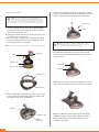
1
DELPHI MOBILE NAVIGATION
USER MANUAL
Important: This manual and the Delphi Mobile Navigation Quick Start Guide contain important safety and operating information.
Please read and follow the instructions in these manuals. Failure to do so could result in personal injury, death, and/or damage to your
Delphi Mobile Navigation and/or to your vehicle.
WELCOME
Congratulations on the purchase of your Delphi Mobile
Navigation. This unit will direct you without the need for
map books and second-hand instructions.
The Global Positioning System (GPS) is available free-ofcharge at any time, and is accurate to within 16.5 feet.
The maps in the Delphi Mobile Navigation package
provide street-level detail, allowing door-to-door navigation.
They even include points of interest such as hotels,
parks, and airports. With this unit, you will never be
lost again.
Use this manual to help install your Delphi Mobile
Navigation, learn how to operate it effectively and safely,
and find out about the different features.
This is the safety alert symbol. It is used to alert you to potential personal
injury hazards. Obey all safety messages that follow this symbol to avoid
possible injury or death.
Warning: When using your Delphi Mobile Navigation in a vehicle, it is
your sole responsibility to install, secure, and use the device in a manner
that will not cause accidents, personal injury or property damage, or in any
manner obstruct your view or interfere with the operation of vehicle safety
equipment.
The user of this product is solely responsible for observing safe driving
practices. Do not operate your Delphi Mobile Navigation while driving. Park the
vehicle first. It is your sole responsibility that the operating and vehicle mount
instructions are read carefully, understood, used with common sense, and
used consistent with the laws of operation for any country in which you use the
device. Failure to do so could result in personal injury, death, and/or damage
to your Delphi Mobile Navigation and/or to your vehicle.
DELPHI DISCLAIMS ALL LIABILITY FOR ANY USE OF THIS PRODUCT IN A WAY
THAT MAY CAUSE ACCIDENTS, DAMAGE, OR THAT MAY VIOLATE THE LAW.
Caution: To avoid overheating of the unit, do not leave your Delphi Mobile
Navigation on the dash or windshield while your vehicle is unattended,
especially in strong sunlight. Do not use or handle Delphi Mobile Navigation
while it is hot. Let it cool away from heat sources before handling it.
2
CONTENTS
Section 1
What is GPS? . . . . . . . . . . . . . . . . . . . . . . . . . . . . 4
Section 2
Unpacking Delphi Mobile Navigation . . . . . . . . . . . . . 4
Memory Cards . . . . . . . . . . . . . . . . . . . . . . . . . . 5
Accessories and Replacement Parts . . . . . . . . . . . 5
Section 3
Installing Software and New Maps . . . . . . . . . . . .
Installing Delphi Mobile Navigation Desktop . . . . .
Step 1: Connecting Delphi Mobile Navigation
to Your Computer . . . . . . . . . . . . . . . . . . . . .
Microsoft Windows XP Users. . . . . . . . . . . . .
Microsoft Windows 2000 Users . . . . . . . . . .
Microsoft Windows ME and 98SE Users . . . . .
Step 2: Installing SmartST™ Application . . . . . . .
Step 3: Installing Maps . . . . . . . . . . . . . . . . . .
Installing Maps on Delphi Mobile Navigation . . .
Installing Maps on MMC or SD Memory Cards .
Other Delphi Mobile Navigation Desktop Options. .
Backup . . . . . . . . . . . . . . . . . . . . . . . . . . . .
Visit Delphi Website . . . . . . . . . . . . . . . . . . .
Section 4
Installing Delphi Mobile Navigation in Your Vehicle
Suction Mount to Windshield . . . . . . . . . . . .
Suction or Adhesive Mount to Dash . . . . . . . .
Screw Mount to Dash . . . . . . . . . . . . . . . . .
3
.
.
.
.
.
.
.
.
..6
..6
.
.
.
.
.
.
.
.
.
.
.
.
.
.
.
.6
.7
.8
.8
.8
.9
.9
10
10
10
10
11
11
12
14
Section 5
Controls and Keyboard . . . . . . . . . . . . . . .
Using the Control Buttons. . . . . . . . . . . .
Using the Menus . . . . . . . . . . . . . . . . . .
Moving Around the Settings Screens . . . .
Entering Text with the On-Screen Keyboard
Changing the Brightness and Volume . . . .
.
.
.
.
.
.
.
.
.
.
.
.
.
.
.
.
.
.
.
.
.
.
.
.
.
.
.
.
.
.
.
.
.
.
.
.
16
16
17
17
17
18
Section 6
Getting Started . . .
Powering Up . . . .
Main Menu . . . . .
Driver Protection .
Getting a GPS Fix
.
.
.
.
.
.
.
.
.
.
.
.
.
.
.
.
.
.
.
.
.
.
.
.
.
.
.
.
.
.
19
19
19
19
20
Section 7
Setting Your Destination . . . . . . . . . . . . . . . . . .
Using Shortcuts and Favorites as a Destination .
Shortcuts . . . . . . . . . . . . . . . . . . . . . . . . .
Favorites . . . . . . . . . . . . . . . . . . . . . . . . . .
Setting a New Destination . . . . . . . . . . . . . . .
Heading to an Address . . . . . . . . . . . . . . . .
Heading to an Intersection . . . . . . . . . . . . . .
Heading to a Settlement . . . . . . . . . . . . . . .
Heading to a Point of Interest. . . . . . . . . . . .
Heading to a ZIP Code . . . . . . . . . . . . . . . .
Heading to a Recently Used Address. . . . . . .
Straight from the Map . . . . . . . . . . . . . . . . . .
.
.
.
.
.
.
.
.
.
.
.
.
.
.
.
.
.
.
.
.
.
.
.
.
21
21
21
21
21
21
22
23
23
24
24
25
.
.
.
.
.
.
.
.
.
.
.
.
.
.
.
.
.
.
.
.
.
.
.
.
.
.
.
.
.
.
.
.
.
.
.
.
.
.
.
.
.
.
.
.
.
.
.
.
.
.
.
.
.
.
.
.
.
.
.
.
.
.
.
.
.
.
.
.
.
.
.
.
.
.
.
.
.
.
.
.
.
.
.
.
.
Section 8
Viewing Your Route. . . . . . .
3D Navigation Map . . . . .
Map Browser . . . . . . . . .
Next Instruction. . . . . . . .
Next Four Instructions . . .
Back-On-Track™ Feature. .
Automatic Restart Feature
Route Information . . . . . .
Show Route . . . . . . . . .
Instruction List . . . . . . .
Summary . . . . . . . . . .
Cancel Route . . . . . . . .
.
.
.
.
.
.
.
.
.
.
.
.
.
.
.
.
.
.
.
.
.
.
.
.
.
.
.
.
.
.
.
.
.
.
.
.
.
.
.
.
.
.
.
.
.
.
.
.
.
.
.
.
.
.
.
.
.
.
.
.
.
.
.
.
.
.
.
.
.
.
.
.
.
.
.
.
.
.
.
.
.
.
.
.
.
.
.
.
.
.
.
.
.
.
.
.
.
.
.
.
.
.
.
.
.
.
.
.
.
.
.
.
.
.
.
.
.
.
.
.
.
.
.
.
.
.
.
.
.
.
.
.
.
.
.
.
.
.
.
.
.
.
.
.
.
.
.
.
.
.
.
.
.
.
.
.
.
.
.
.
.
.
.
.
.
.
.
.
26
26
26
27
27
27
27
27
27
28
28
28
.......
.......
.......
Shortcut.
.......
.......
Favorite .
.
.
.
.
.
.
.
.
.
.
.
.
.
.
.
.
.
.
.
.
.
.
.
.
.
.
.
.
.
.
.
.
.
.
.
.
.
.
.
.
.
.
.
.
.
.
.
.
.
.
.
.
.
.
.
.
.
.
.
.
.
.
.
.
.
.
.
.
.
.
.
.
.
.
.
.
.
.
.
.
.
.
.
.
.
.
.
.
.
.
.
29
29
29
29
30
30
30
Section 10
Using the GPS Status Information .
GPS Reception . . . . . . . . . . . .
Satellite Signal Strengths . . . . .
Satellite Positions . . . . . . . . . .
.
.
.
.
.
.
.
.
.
.
.
.
.
.
.
.
.
.
.
.
.
.
.
.
.
.
.
.
.
.
.
.
.
.
.
.
.
.
.
.
.
.
.
.
.
.
.
.
.
.
.
.
32
32
32
32
Section 11
Modifying the Settings . . . . . . .
Display Settings. . . . . . . . . .
Auto Zoom . . . . . . . . . . .
Map Colors . . . . . . . . . . .
Tutorial . . . . . . . . . . . . . .
Route and Guidance Settings
Points of Interest Settings . .
GPS Settings . . . . . . . . . . .
User Settings . . . . . . . . . . .
Maps Settings. . . . . . . . . . .
.
.
.
.
.
.
.
.
.
.
.
.
.
.
.
.
.
.
.
.
.
.
.
.
.
.
.
.
.
.
.
.
.
.
.
.
.
.
.
.
.
.
.
.
.
.
.
.
.
.
.
.
.
.
.
.
.
.
.
.
.
.
.
.
.
.
.
.
.
.
.
.
.
.
.
.
.
.
.
.
.
.
.
.
.
.
.
.
.
.
.
.
.
.
.
.
.
.
.
.
.
.
.
.
.
.
.
.
.
.
.
.
.
.
.
.
.
.
.
.
.
.
.
.
.
.
.
.
.
.
33
33
33
33
33
33
34
34
35
35
Section 9
Shortcuts and Favorites
Shortcuts . . . . . . . . .
Adding a Shortcut .
Editing or Deleting a
Favorites . . . . . . . . .
Adding a Favorite . .
Editing or Deleting a
.
.
.
.
.
.
.
.
.
.
.
.
.
.
.
.
.
.
.
.
.
.
.
.
.
.
.
.
.
.
.
.
.
.
.
.
.
.
.
.
.
.
.
.
.
.
.
.
.
.
.
.
.
.
.
.
Section 12
Automatic Route Simulator . . . . . . . . . . . . . . . . . . 36
Enable Recording. . . . . . . . . . . . . . . . . . . . . . . . 36
Section 13
Troubleshooting . . . . . . . . . . . . . . . . .
Contacting Technical Service Support .
Technical Information . . . . . . . . . . . .
FCC Statement . . . . . . . . . . . . . . . .
.
.
.
.
.
.
.
.
.
.
.
.
.
.
.
.
.
.
.
.
.
.
.
.
.
.
.
.
.
.
.
.
.
.
.
.
37
37
37
38
Section 14
Warranty . . . . . . . . . . . . . . . . . . . . . . . . . . . . . . 39
SECTION 1: WHAT IS GPS?
The Global Positioning System (GPS) is a network of
satellites launched by the U.S. military in the 1970s. The
satellites continuously transmit accurate time and position
information, which is freely used by commercial and
military applications worldwide. GPS receivers, such as
Delphi Mobile Navigation, are designed to pick up the
high-frequency radio signals from these satellites and use
the information to help determine your exact location.
Today, there are many applications that use GPS—from
marine to automotive, aviation, and military.
There are 24 satellites in total, orbiting approximately
12,000 miles above the Earth. While a GPS receiver can
detect signals from up to 12 satellites at any one time,
only three are needed to provide the two-dimensional
position (latitude and longitude), or “fix,” that is required
for vehicle and marine navigation systems. Aviation applications also need altitude, and therefore need information
from at least four satellites.
Delphi Mobile Navigation is designed specifically to use
the continuous stream of GPS information to help find
your current position and to calculate the best route to
your desired destination using the road maps stored in its
memory. With voice and visual commands, Delphi Mobile
Navigation helps guide you to your destination.
SECTION 2: UNPACKING DELPHI
MOBILE NAVIGATION
3. Mounting materials for
windshield and dash
(a) Suction cup mount
- Ball foot
- Locking nut
- Mounting clip
(b) Dash mount
- Retainer ring
- Screw plate
- Screws (3)
- Screw caps (3)
- Suction pad
- Adhesive tape
- Alcohol pad
4. 12/24V Vehicle
power adaptor
5. Power adaptor for
indoor programming,
demonstration,
and training
6. USB cable for map
and application downloading from a PC
Here’s what you should find in the Delphi Mobile
Navigation box.
1. Delphi Mobile Navigation
unit with integral
GPS receiver
7. Protective carrying
case and screen cleaner
2.CD-ROMs with:
• Delphi Mobile Navigation
desktop software
• SmartST™ in-car
digital navigation software
• U.S. maps
• User manual in Adobe
Acrobat PDF format
• Adobe Acrobat Reader
8. Delphi Mobile Navigation
Quick Start Guide
SmartST is a trademark of NAVMAN Mobile Limited.
4
Memory cards
Delphi Mobile Navigation has 64 megabytes of internal
memory available for storing maps. If this is not sufficient
for your needs, extra memory in the form of MMC (multimedia card) or SD (secure digital) memory cards is available for purchase.
A memory card can be plugged into the slot in the top of
the Delphi Mobile Navigation unit, and can be purchased
with various memory capacities. A memory card with
256 megabytes of memory or less can be used in the
Delphi Mobile Navigation unit.
Accessories and replacement parts
You can purchase the following items from your retailer.
Contact your retailer or Delphi for more information.
• GPS external antenna: 15-foot cable with MCX
connector; required if your vehicle is fitted with
a heat-reflective or heated windshield, or for
extra GPS performance in weak signal areas
• Memory card writer: an external device that connects to your computer so that you can download
maps directly onto an MMC or SD memory card
• Vehicle mount kit: includes suction and dash
mounting materials so that you can transfer Delphi
Mobile Navigation to an additional vehicle without
removing the initial mounting materials
• Care kit: protective carrying case and screen
cleaner; useful if original case and cleaner are lost
• 12/24V vehicle power adaptor: ideal when using
Delphi Mobile Navigation in more than one vehicle
For further information on replacement parts and
accessories, please visit www.delphi.com.
5
SECTION 3: INSTALLING SOFTWARE
AND NEW MAPS
A CD-ROM pack in the Delphi Mobile Navigation package
contains software that allows you to:
• Install new maps onto your Delphi Mobile Navigation
or memory cards.
• Back up any settings, shortcuts, and favorites you
have saved previously in your Delphi Mobile
Navigation.
• Install and upgrade the SmartST software
onto your Delphi Mobile Navigation. (SmartST is
preinstalled on your Delphi Mobile Navigation. This
CD-ROM is provided only if you need to reinstall it
for any reason.)
Once installed, you can
start the application in
Before you can use any of these features, you need to
set up the Delphi Mobile Navigation desktop software on
your computer. You will then be able to download software and maps to your Delphi Mobile Navigation via a
USB port on your PC.
Installing Delphi Mobile Navigation desktop
1. Place the installation CD-ROM into the CD-ROM drive
on your computer. The Delphi Mobile Navigation
desktop installation wizard should start automatically.
the future by creating a
shortcut on your desktop, or by selecting
“Start—Programs—
Delphi—Mobile
Navigation Desktop”
from the task bar.
You are now ready to personalize your Delphi Mobile
Navigation. There are three main steps required before
you can use the unit.
Step 1: Connect Delphi Mobile Navigation to your computer.
Step 2: If necessary, install the SmartST application onto
your Delphi Mobile Navigation. (SmartST has
been preinstalled on your unit. This step is
necessary only if you need to reinstall it for any
reason.)
Step 3: Install the maps you require onto your Delphi
Mobile Navigation.
When you are finished, the USB cable must be disconnected from the unit for the installation to complete. The
following information will lead you through these steps,
and will also explain the other functions available from the
Delphi Mobile Navigation desktop application.
2. Follow the on-screen prompts to complete your
license agreement and load the Delphi Mobile
Navigation desktop application onto your computer.
If the installation wizard does not start automatically, you can open
the CD manually. Also, verify that you have an Internet connection.
3. Once the wizard has finished the installation, Delphi
Mobile Navigation desktop will start automatically.
6
Step 1: Connecting Delphi Mobile Navigation
to your computer
This will enable your computer to communicate with
Delphi Mobile Navigation.
1. Ensure that the Delphi Mobile Navigation desktop is
running on your computer.
2. Plug the power adaptor into a power socket. Plug the
other end into the socket on the left side of the Delphi
Mobile Navigation unit.
3. Turn on Delphi Mobile Navigation by pressing
for
1 second.
4. If this is the first time you have powered up your
Delphi Mobile Navigation, a display prompts you to
connect the USB cable (supplied). Plug the USB cable
into a USB port on your computer. Plug the other
end into the underside of the Delphi Mobile Navigation
unit. The display will change to indicate that you are
connected and ready to download new software or maps.
5. If you have loaded software to your unit previously, the
main menu will be displayed. Plug the USB cable into a
USB port on your computer. Plug the other end into
the underside of the Delphi Mobile Navigation unit. The
display will change to indicate that you are connected
and ready to download new software or maps.
6. You are now ready to start using the functions available on the Delphi Mobile Navigation desktop application.
7. The drivers for Delphi Mobile Navigation should
automatically be installed during Delphi Mobile
Navigation desktop installation. If that does not happen
or you get an error message on your computer, follow
the directions given for your specific operating system.
Select “Next.”
Select “Continue Anyway.”
Microsoft® Windows® XP users: See above next column.
Microsoft Windows 2000 users: See page 8.
Microsoft Windows ME and 98SE users: See page 8.
Important: If you have difficulty installing this software, contact Microsoft
Customer Service at http://support.microsoft.com/.
Microsoft Windows XP users
Follow the steps below to complete installation under
Windows XP for each device that Windows prompts you
to install. You will see each of these screens twice.
Select “Finish.” You may now continue to step 2 on page 8.
Note: SmartST has been preinstalled on your unit. This step is necessary
only if you need to reinstall it for any reason. Otherwise continue to
step 3.
Microsoft and Windows are registered trademarks of Microsoft Corporation.
7
Microsoft Windows 2000 users
Under Windows 2000, you may see the screens below.
If you do not see these screens, then the installation has
completed automatically.
Enter the location of the Delphi Mobile Navigation USB
driver disk D:\USBDRIVER.
Note: The “D” drive may not be your CD-ROM drive. Use the letter
designating your CD-ROM drive.
Select “OK.” You may now continue to step 2.
Step 2: Installing SmartST application
Enter the location of the Delphi Mobile Navigation USB
driver disk D:\USBDRIVER.
Note: The “D” drive may not be your CD-ROM drive. Use the letter
designating your CD-ROM drive.
Note: SmartST has been preinstalled on your unit. This step is necessary
only if you need to reinstall it for any reason. Otherwise continue to
step 3.
This function allows you to install SmartST software onto
a Delphi Mobile Navigation unit. Before beginning, make
sure the unit is connected to the computer via the USB
port. Refer to step 1 on page 6 for more information.
(Your unit is correctly connected if the display shows a
computer and Delphi Mobile Navigation connected.)
1. Select “Install Application” from the main menu.
You will lose all of your settings, favorites, and shortcuts when
you upgrade your software. Use the backup function to save
these settings before upgrading the software. Refer to “Backup”
Select “OK.” You may now continue to step 2.
Microsoft Windows ME and 98SE users
Under Windows ME and 98SE, you may see the screens
below. If you do not see these screens, then the installation has completed automatically.
8
on page 10 for more information.
You will need Microsoft Internet Explorer version 5.5 or
above to correctly activate the software.
Note: The product key codes are located on the back of the SmartST CD
sleeve. These codes are required every time you install and register the
SmartST software and Map Data. Keep them in a safe place.
• Download new maps onto a memory card plugged
into your Delphi Mobile Navigation.
• Download new maps onto a memory card using a
memory card writer on your computer.
• Remove maps from your Delphi Mobile Navigation
or memory card.
Before beginning, make sure the unit is connected to the
computer via the USB port. Refer to step 1 on page 6
for more information. (Your unit is correctly connected if
the display shows a computer and Delphi Mobile
Navigation connected.)
Maps installed in Delphi
Mobile Navigation.
2. Select “Install Software.”
3. The installation may take several minutes to complete.
Do not open other applications on your computer
during this installation.
4. After you have completed the software application,
you are ready to install maps.
Step 3: Installing maps
This function allows you to manage the maps that you
can use on Delphi Mobile Navigation. Your Delphi Mobile
Navigation includes three Map CDs: Eastern United
States, Central United States, and Western United States.
Delphi Mobile Navigation has 64 megabytes of available
internal memory for storing maps. The unit can store one
or many map regions, depending on their size. Additional
maps can be stored on MMC or SD memory cards.
Maps can be changed at any time.
Map installation options let you:
• Review the maps you currently have stored in your
Delphi Mobile Navigation or memory card(s).
• Download new maps onto your Delphi Mobile
Navigation.
9
[NAVMAN TO
PROVIDE U.S. MAP]
Name and details of
the map currently
selected.
Color- and number-coded
maps highlight regions
that can be downloaded
from the CD.
Maps installed on the
memory card plugged
into Delphi Mobile
Navigation.
Maps installed on the
card using the memory
card writer on your
computer. This is also
referred to as removable media.
Multiple map regions can be selected and copied across to the Delphi
Mobile Navigation or memory cards. The total map size is displayed as
each map is selected.
Installing maps on Delphi Mobile Navigation
1. Select “Install Maps” from the main menu.
2. To install a map to Delphi Mobile Navigation, choose
either option:
• Select the region you wish to install. The region’s
name will appear in the lower left window. To download the map to your unit, choose “Add to Delphi
Mobile Navigation.”
• Using your computer mouse, drag and drop the
region to the Delphi Mobile Navigation window on
the right side of the screen.
3. To search for a particular city on the map:
• Select “Find City.”
• Type in the name of the city or select from the list
provided.
• Double click on your selection to locate the city on
the map.
Installing maps on MMC or SD memory cards
Installing maps onto a memory card can be done in
two ways:
1. Plug the memory card into the slot in the top of your
Delphi Mobile Navigation.
When using maps from
an MMC or SD card,
do not remove the card
while navigating or the
unit will reset.
2. Select “Install Maps” from the main menu. To install a
map to the memory card, choose either option:
• Select the region you wish to install. The region’s
name will appear in the lower left window. To download the map to a memory card, choose “Add to
MN SD.”
• Using your computer mouse, drag and drop the
region to the MN SD window on the right side of
the screen.
3. If you have a memory card writer, ensure the memory
card writer is connected to your computer via a USB
port. Insert the card into the writer. Select “Install
Maps” from the main menu. To install a map to the
memory card using the writer, choose either option:
• Select the region you wish to install. The region’s
name will appear in the lower left window. To
download the map to a memory card, choose
“Add to PC Writer.”
• Using your computer mouse, drag and drop the
region to the PC Removable Media window on the
right side of the screen.
Note: MMC and SD cards must be formatted using FAT16 format.
See your computer user guide for more information.
Other Delphi Mobile Navigation desktop options
Backup
This function allows you to back up the settings, favorites,
and shortcuts that you have programmed into your Delphi
Mobile Navigation. You will lose your settings, favorites,
and shortcuts if you upgrade your software. You can save
any number of backups onto your computer, and restore
them to your Delphi Mobile Navigation at any time.
10
This function is useful if you need to have your unit
repaired, or you are traveling and wish to store temporarily a new set of favorites and shortcuts.
Before beginning, make sure the unit is connected to the
computer via the USB port. Refer to step 1 on page 6
for more information. (Your unit is correctly connected if
the display shows a computer and Delphi Mobile
Navigation connected.)
1. Select “Backup” from the main menu.
2. To back up the settings, shortcuts, and favorites
currently stored on your Delphi Mobile Navigation:
• Select “New Backup.”
• Backup is stored using the current date and time. If
you wish to rename the backup, type over the
default name. Select “OK” to continue the backup.
• The backup is stored under C:\Program
Files\Delphi\Mobile Navigation Desktop
Installer\Backup.
3. To restore a previously saved backup to your Delphi
Mobile Navigation:
• Highlight the backup that you wish to restore.
• Select “Restore.”
4. To delete backups:
• Highlight the backup that you wish to delete.
• Select “Delete.”
Visit Delphi website
Select this option to visit www.delphi.com for product
updates, support, and general information. (You will need
an Internet connection to use this option.)
SECTION 4: INSTALLING DELPHI
MOBILE NAVIGATION IN YOUR VEHICLE
Warning: To avoid personal injury, follow the safety guidelines and
installation instructions provided so that Delphi Mobile Navigation does
not obstruct the view of the driver, interfere with the operation of any airbags
and safety features in the vehicle, or become airborne in the case of an accident. Do not attempt to install the Delphi Mobile Navigation unit while driving.
Before installing Delphi Mobile Navigation, check whether
your vehicle is fitted with a heat-reflecting or heated
windshield. If so, you will need to purchase an external
antenna from your retailer to allow your unit to pick up
the GPS signals.
The Delphi Mobile Navigation unit can be mounted three
different ways:
1. Suction onto the windshield
2. To the dash by suction or adhesive tape
3. Screw onto the dash
4. The ball foot should now be securely fixed on the
windshield. Slip the locking nut loosely over the ball
foot, with the flat side facing upward.
Suction cup
Lever
Locking nut
5. Making sure the short side of the socket clip is at the
top, push the socket clip onto the ball foot until it clicks.
Note: Alternative mounting options may be available for your vehicle make
and model. Contact your retailer or Delphi for more information.
Caution: To avoid overheating of the unit, do not leave your Delphi
Mobile Navigation on the dash or windshield while your vehicle is
unattended, especially in strong sunlight. Do not use or handle Delphi Mobile
Navigation while it is hot. Let it cool away from heat sources before handling it.
If the unit becomes hot, it prompts you to turn down the
brightness (press and hold the “Zoom”
key). If the unit
becomes too hot, the screen will go blank and voice
instructions will continue.
Suction mount to windshield
1. Choose a position on the windshield where Delphi
Mobile Navigation will be clearly visible by the driver
without obstructing the driver’s view. Mount low on
the windshield, as close to the dash as possible.
2. Thoroughly clean and dry the suction cup and the
mounting area of the windshield.
3. Hold the suction cup firmly against the windshield and
press the lever down until it snaps shut.
To remove the suction cup, pull the lever up. Pull the release tab
to release the suction.
If the suction cup does not adhere, clean the mounting area of
the windshield with a cloth dampened with isopropyl alcohol. Let
the area dry, then reapply the suction cup.
11
6. Adjust the position of the socket clip so that Delphi
Mobile Navigation will be clearly visible to the driver.
7. Thread the locking nut onto the socket clip; turn
clockwise until tight.
8. Snap Delphi Mobile Navigation onto the socket clip.
First, position the two locating tabs (found on the
bottom of the unit) into the corresponding slots on the
socket clip. Then, snap the top side of Delphi Mobile
Navigation onto the clip.
Suction or adhesive mount to dash
Warning: To avoid personal injury, follow the safety guidelines and
installation instructions provided so that Delphi Mobile Navigation does
not obstruct the view of the driver, interfere with the operation of any airbags
and safety features in the vehicle, or become airborne in the case of an accident. Do not attempt to install the Delphi Mobile Navigation unit while driving.
To unclip Delphi Mobile Navigation from the mounting bracket, press
down on the back of the upper plastic clip. Release the top of the
unit. Then lift the unit out of the bottom two slots.
9. Flip the GPS antenna outward so that the antenna
points horizontally.
Antenna points
up and out
1. Choose a position on the dash where Delphi
Mobile Navigation will be clearly visible to the driver
without obstructing the driver’s view.
2. Thoroughly clean and dry the suction cup and the
mounting area of the dash.
3. Suction mount: If the location is flat enough, you can
simply use the suction cup to mount the unit directly
onto the dash. If the suction cup does not adhere,
clean the mounting area with a cloth dampened with
isopropyl alcohol. Let the area dry, then reapply the
suction cup.
Adhesive mount: If the location is not suitable to use
the suction cup alone, use the suction pad to provide
a flat surface for the suction cup. Peel the protective
layer off the adhesive tape on the bottom of the
suction pad. Press the suction pad onto the desired
position on the dash and hold firmly for 30 seconds.
10. Plug the 12/24V power adaptor into the cigarette
lighter socket.
11. Plug the other end of the power cable into the
socket on the left side of Delphi Mobile Navigation.
12. Verify that Delphi Mobile Navigation is positioned such
that the GPS antenna has a clear view of the sky.
Note: In most vehicles, you will need to have the engine idling in order to
program your destination. You also can turn on the unit with just the
accessory power (i.e., your ignition key turned to the ACC “on” position).
When you turn on the engine, power may be interrupted to the unit but
the programmed destination will be saved. In vehicles where accessory
power is on permanently, the unit can be turned on and programmed as
soon as the power adaptor is connected. Turning on the engine will not
reset the unit.
You can remove the adhesive mount from your dash by taking
the following steps:
1. Lift one edge of the suction pad gently with fingers or the
rounded edge of a spoon. Once enough of the edge is loosened to grip with your fingers, pull the pad gently from the
mounting surface at a 90-degree angle. Avoid using sharp
tools that could damage the car interior.
2. If the pad fails to loosen, first warm it with a hair dryer for
2 minutes to 3 minutes to soften the adhesive. Be careful
not to apply too much heat, which could damage the
mounting surface.
Caution: Never use a commercial heat gun or paint-stripping gun.
This could result in damage to the unit or to your vehicle.
3. If any adhesive remains on the dash surface, the adhesive can
easily be removed by rubbing your thumb or finger across it.
4. As necessary, use a mild household cleaner to clean the
dash surface.
12
4. Hold the suction cup firmly against the dash or center
on the suction pad. Press the lever down until it
snaps shut. (To remove the suction cup, pull the lever
up. Pull the release tab to release the suction.)
5. The ball foot should now be securely fixed on the dash.
Slip the locking nut loosely over the ball foot, with the
flat side facing upward.
9. Snap Delphi Mobile Navigation onto the socket clip.
First, position the two locating tabs (found on the
bottom of the unit) into the corresponding slots on the
socket clip. Then, snap the top side of Delphi Mobile
Navigation onto the clip.
To unclip Delphi Mobile Navigation from the mounting bracket,
press down on the back of the upper plastic clip. Release the top
of the unit. Then lift the unit out of the bottom two slots.
Locking nut
Lever
10. Flip the GPS antenna outward so that the antenna
points horizontally.
Suction cup
Suction pad
Antenna points
up and out
6. Making sure the short side of the socket clip is at
the top, push the socket clip onto the ball foot until
it clicks.
11. Plug the 12/24V power adaptor into the cigarette
lighter socket.
12. Plug the other end of the power cable into the socket
on the left side of Delphi Mobile Navigation.
13. Verify that Delphi Mobile Navigation is positioned such
that the GPS antenna has a clear view of the sky.
7. Adjust the position of the socket clip so that Delphi
Mobile Navigation will be clearly visible to the driver.
8. Thread the locking nut onto the socket clip; turn
clockwise until tight.
13
Note: In most vehicles, you will need to have the engine idling in order to
program your destination. You also can turn on the unit with just the
accessory power (i.e., your ignition key turned to the ACC “on” position).
When you turn on the engine, power may be interrupted to the unit but
the programmed destination will be saved. In vehicles where accessory
power is on permanently, the unit can be turned on and programmed as
soon as the power adaptor is connected. Turning the engine on will not
reset the unit.
5. Place the assembly into position on the dash. Use the
three screws provided to fix the assembly firmly to the
dash. Press the screw caps over the screw heads.
Screw mount to dash
Warning: To avoid personal injury, follow the safety guidelines and
installation instructions provided so that Delphi Mobile Navigation does
not obstruct the view of the driver, interfere with the operation of any airbags
and safety features in the vehicle, or become airborne in the case of an accident. Do not attempt to install the Delphi Mobile Navigation unit while driving.
1. Choose a position on the dash where Delphi Mobile
Navigation will be clearly visible to the driver without
obstructing the driver’s view.
2. Center the suction cup on the suction pad. Press the
lever down until it snaps shut.
3. Fit the retainer ring inside the screw plate by sliding
the four locating tabs into the corresponding slots on
the underside of the screw plate.
Note: Do not use the screw plate without the retainer ring and suction pad.
Lever
Locking nut
Screw cap
Screw
Warning: Screw mount is not suitable for all dash surfaces. Dashes
with soft padding may not hold the unit firmly in place. Mounting unit
using screws may cause permanent damage to dash surface.
6. The ball foot should now be securely fixed. Slip the
locking nut loosely over the ball foot with the flat side
facing upward.
Suction cup
Locking nut
Suction pad
Ball foot
Retainer ring
7. Making sure the short side of the socket clip is at the
top, push the socket clip onto the ball foot until it clicks.
Screw plate
4. Bring the ball foot up through the center of the screw
plate. Position the ball foot by sliding the release tab
through the slot on the screw plate.
Ball foot
Release tab
Slot for
release tab
14
8. Adjust the position of the socket clip so that Delphi
Mobile Navigation will be clearly visible to the driver.
9. Thread the locking nut onto the socket clip; turn
clockwise until tight.
10. Snap Delphi Mobile Navigation onto the socket clip.
First, position the two locating tabs (found on the
bottom of the unit) into the corresponding slots on
the socket clip. Then, snap the top side of Delphi
Mobile Navigation onto the clip.
To unclip Delphi Mobile Navigation from the mounting bracket,
press down on the back of the upper plastic clip. Release the top
of the unit. Then lift the unit out of the bottom two slots.
11. Flip the GPS antenna outward so that the antenna
points horizontally.
Antenna
points up
and out
12. Plug the 12/24V power adaptor into the cigarette
lighter socket.
13. Plug the other end of the power cable into the socket
on the left side of Delphi Mobile Navigation.
14. Verify that Delphi Mobile Navigation is positioned such
that the GPS antenna has a clear view of the sky.
Note: In most vehicles, you will need to have the engine idling in order
to program your destination. You also can turn on the unit with just the
accessory power (i.e., your ignition key turned to the ACC “on” position).
When you turn on the engine, power may be interrupted to the unit but
the programmed destination will be saved. In vehicles where accessory
power is on permanently, the unit can be turned on and programmed as
soon as the power adaptor is connected. Turning the engine on will not
reset the unit.
15
SECTION 5: CONTROLS AND KEYBOARD
Warning: For your safety, program your Delphi Mobile Navigation and
enter information about your destination BEFORE you start your journey.
Do not operate Delphi Mobile Navigation while driving.
The most frequently used buttons are “OK,” “ESC,”
“Page,” and the eight-way toggle. Use the “OK” button to
confirm or make a selection. “ESC” returns you to the
previous screen or deletes the text you entered. With the
“Page” button, you can jump from one screen to the next.
The toggle button lets you move a cursor across the
screen—much like the mouse on a computer.
Using the control buttons
The control buttons on the right side of Delphi Mobile
Navigation allow you to navigate the screen options and
enter information. Many of the control buttons have more
than one use.
Zoom/Brightness
Press “+” to see a
close-up or “-” to see
more map area. Or,
hold down to adjust
screen brightness.
OK
Select the highlighted
menu option, text,
or command.
Eight-way Toggle
Scroll through the
menus and move
around the map when
selecting destinations.
Menu/Power
Press to return to the
menu, or hold down to
turn the unit on or off.
ESC
Cancel the current
function, delete
last character
typed, or return to
previous screen.
Delete an entire
line by holding
down this button.
Page
Jump between
different map
views, or when a
list of options is
spread across
several screens.
Volume
Press to hear the next
instruction, or hold down
to adjust the volume of the
voice guidance instructions.
16
Using the menus
Entering text with the on-screen keyboard
Many of the screens used with Delphi Mobile Navigation
contain a menu of options.
To enter your destination information, you will use the
controls and an on-screen keyboard. You can enter a
street name or area by typing the full name, or by
entering the beginning of the name and then selecting
from the list on the lower half of the screen.
Menu option
Use
to scroll between the keyboard, text entry line,
and the window containing a list of streets or areas.
Select “ESC” or
press
to
return to the
previous
screen.
To navigate menus:
1. Scroll through the menu options using the up/down
function of the eight-way toggle button.
2. Highlight your selection and then press
.
3. To exit from a menu, scroll to the on-screen “ESC”
option. Press
. Or simply press
.
Moving around the settings screens
The screen below is an example of the screens found in
the settings function.
Use this to view
different symbols
on the keyboard.
Text entry line
Select “ESC” or
press
to
return to the
previous
screen.
List of streets or
areas available for
selection from the
information you
have already
entered.
Select “Page Fwd”
or press
to see
more of the list.
To enter a name:
1. Navigate the keyboard using
. Highlight a letter and
press
. The selected letter will appear on the text
entry line.
2. If you make a mistake, select “ESC” on-screen or press
the
button to delete the letter. Hold down
to delete the entire line.
3. Repeat steps 1 and 2 until finished, or use
to
select from the list. Press
to view more of the list.
To select a name from the list:
1. Scroll to the list of available streets or areas. Press
or select page forward on the screen to see more
of the list.
2. Select a name by pressing
.
There are two types of settings:
• Either/or—indicated by circles with or without a dot
• Enable/disable—indicated by square boxes
To modify an either/or setting, use
to scroll to the
option you want. Press
. The dot will disappear from
the previous setting and be displayed next to your chosen
option.
To modify an enable/disable setting, use
to scroll to
the option. Press
to engage/disengage the option.
Some settings have a list of options spread across
multiple screens. Scroll to
and press
.
Note: Any changes you make to the settings screens are saved when
you exit the page.
17
Changing the brightness and volume
To change the brightness of the display:
1. Press
until you see the brightness bar on the
display. This can be done at any time.
2. Press
to make the display brighter, or
to
dim the display.
Note: The unit heats up more quickly if the display brightness is set higher
than 70 percent. The bar is red when the brightness level is set higher
than 70 percent.
To adjust the volume:
1. Hold down the volume button
until the volume
bar is displayed. This can be done at any time.
2. Press
or
to adjust the volume.
18
Driver protection
SECTION 6: GETTING STARTED
Warning: For your safety, program your Delphi Mobile Navigation and
enter information about your destination BEFORE you start your journey.
Do not operate Delphi Mobile Navigation while driving.
Powering up
1. Press
for 1 second.
2. A brief tutorial is available to show you how to use
Delphi Mobile Navigation. Press
to scroll
through the instructional screens. This tutorial can be
disabled in the settings function. For more information,
refer to “Modifying the Settings” on page 33.
3. The main menu is displayed.
The driver must not operate this unit while the vehicle
is moving. If any button is pressed while the vehicle is
moving, the driver protection screen is displayed.
Passengers may continue to use the device.
Main menu
Warning: The user of this product is solely responsible for observing
safe driving practices. Do not operate Delphi Mobile Navigation while
driving. Park the vehicle first.
DELPHI DISCLAIMS ALL LIABILITY FOR ANY USE OF THIS PRODUCT IN A WAY
THAT MAY CAUSE ACCIDENTS, DAMAGE, OR THAT MAY VIOLATE THE LAW.
Note: This screen can be disabled in the settings function. For more
information, refer to page 35.
No destination programmed.
Destination programmed.
The main menu provides access to all of the setup and
viewing modes of Delphi Mobile Navigation.
1. Use
to navigate the main menu.
2. Make your selection by pressing
.
3. Return to the main menu at any time by pressing
4. Press
to cancel your current entry or mode
and return to the previous screen.
.
Follow the instructions in this manual to program your
destination, select how the route is displayed, and customize your Delphi Mobile Navigation to suit your needs.
19
Getting a GPS fix
Delphi Mobile Navigation receives GPS signals every
second via the antenna. In order for your antenna to
receive signals, ensure that:
1. The unit is outside or in a vehicle parked outside.
2. The antenna is pointing horizontally out through your
windshield and has a clear view of the sky.
When you first power on the unit and program a route, it
may take several minutes for the unit to get its first GPS
fix. You can minimize this time by remaining stationary in
your vehicle until the GPS signal is received.
GPS strength indicator is
red when the unit has no
GPS fix, and green when
a GPS fix is available.
While the unit is attempting to get a GPS fix, there are
no route instructions displayed on the map screen. Once
the unit has a valid fix, the GPS signal-strength indicator
will turn green.
20
SECTION 7: SETTING YOUR DESTINATION
2. Use the up/down function of the eight-way toggle
button to choose from the list. Then press
to
confirm your selection.
Warning: For your safety, program Delphi Mobile Navigation and enter
information about your destination BEFORE you start your journey. Do
not operate Delphi Mobile Navigation while driving.
There are three ways that you can program your destination:
• Use the “Favorites” menu option to select
destinations used on a regular basis.
• Use the “Destination” menu option to enter an
address, intersection, settlement, point of interest,
ZIP code, or recently visited location.
• Program your destination straight from the map
screen.
If you attempt to configure a route that is impossible
(i.e., a large body of water to cross), an error message
will be displayed as a popup message. Simply click on
to configure an alternate route.
3. Select “Go.” Delphi Mobile Navigation will calculate the
route from your current position and take you straight
to the map display.
Favorites
1. From the main menu, select “Favorites.” You will be
directed to your shortcuts page. Access your favorites
by pressing
.
Using shortcuts and favorites as a destination
21
You can save your 10 most frequently used destinations
as shortcuts while maintaining a list of 200 favorite destinations with Delphi Mobile Navigation. For information on
editing your shortcuts and favorites, refer to the
“Shortcuts and Favorites” section beginning on page 29.
2. Use the up/down function of the eight-way toggle
button to choose from the list. Then press
to
confirm your selection.
3. Select “Go.” Delphi Mobile Navigation will calculate the
route from your current position and take you straight
to the map display.
Shortcuts
1. From the main menu, select “Favorites.” You will be
directed to your shortcuts page.
Setting a new destination
Heading to an address
Use the “Destination” option from the main menu to enter
a street address.
1. From the main menu, select “Destination” and then
“Address.”
2. Select “State.” To enter a state, choose one of the
following methods:
• In the text entry screen, type in the name.
After you finish, position the cursor on the text
entry line. Press
to confirm your selection.
• Use the up/down function of the eight-way toggle
button to choose from the list. Then press
to
confirm your selection.
3. Select “Town.” As above, type in a town name or
choose from the list.
4. Select “Road.” A list of streets in your chosen town is
displayed. Type in or select the street name from
the list. If no road is selected, you will be directed to
the geographical center of the town.
5. When a road has been chosen that has street
numbers associated with it in the map database, the
“House No.” field will be displayed. It will not display if
no road has been entered, or when there are no
house numbers associated with the selected road in
the map database. The house number will appear
with the road name whenever the road name is
displayed.
6. When the unit has enough information, the details are
displayed. If you wish to change the address, simply
press
or select “ESC” on the screen to re-enter
information.
22
7. Choose one of the following:
• Select “Save.” This allows you to save the
destination as a shortcut or favorite. Refer to
section 9, beginning on page 29.
• Select “Show.” The unit does not calculate the
route, but will simply display the address using the
map browser mode. From here, you can select this
address as your destination or navigate the map to
find another destination. Refer to the “Straight from
the map” segment on page 25.
• Select “Go.” The unit calculates the route and
displays the address on the navigation screen.
Heading to an intersection
1. From the main menu, select “Destination” and
then “Intersection.”
2. Select “State.” To enter a state, choose one of the
following methods:
• In the text entry screen, type in the name.
After you finish, position the cursor on the text
entry line. Press
to confirm your selection.
• Use the up/down function of the eight-way toggle
button to choose from the list. Then press
to
confirm your selection.
3. Select “Town.” As above, type in a town name or
choose from the list.
4. Select “Int. of.” A list of streets is displayed. Type in or
select one of the street names from the list.
5. Select “And.” A list of streets that intersect with
the first street is displayed. Type in or select the
intersecting street name from the list.
6. When the unit has enough information, the details are
displayed. If you wish to change the intersection, simply
press
or select “ESC” on the screen to re-enter
information.
7. Choose one of the following:
• Select “Save.” This allows you to save the
destination as a shortcut or favorite. Refer to
section 9, beginning on page 29.
• Select “Show.” The unit does not calculate the route,
but will simply display the address using the map
browser mode. From here, you can select this
address as your destination or navigate the map to
find another destination. Refer to the “Straight from
the map” segment on page 25.
• Select “Go.” The unit calculates the route and
displays the intersection on the navigation screen.
Heading to a settlement
Directions to a “Settlement” will direct you to a common
town center (i.e., city hall).
1. From the main menu, select “Destination” and then
“Settlement.”
2. Select “State.” To enter a state, choose one of the
following methods:
• In the text entry screen, type in the name.
After you finish, position the cursor on the text
entry line. Press
to confirm your selection.
• Use the up/down function of the eight-way toggle
button to choose from the list. Then press
to
confirm your selection.
3. Select “Settlement.” As above, type in a town name or
choose from the list.
4. When the unit has enough information, the details are
displayed. If you wish to change the settlement, simply
press
or select “ESC” on the screen to re-enter
information.
23
5. Choose one of the following:
• Select “Save.” This allows you to save the
destination as a shortcut or favorite. Refer to
section 9, beginning on page 29.
• Select “Show.” The unit does not calculate the route,
but will simply display the address using the map
browser mode. From here, you can select this
address as your destination or navigate the map to
find another destination. Refer to the “Straight from
the map” segment on page 25.
• Select “Go.” The unit calculates the route and
displays the destination on the navigation screen.
Heading to a point of interest
A point of interest is any named site, feature, landmark,
or public venue. There can be thousands of points of
interest in larger cities, so they are sorted into categories such as hotels, churches, schools, or parks.
1. From the main menu, select “Destination,” then
“Points of Interest.”
2. Select “Category.” Use the left/right function of the
eight-way toggle button to cycle through the options.
3. Select “Type.” This narrows down the number of
options. Use the left/right function of the eight-way
toggle button to cycle through the options.
4. Select “Area.” To enter an area, choose one of
the following:
• In the text entry screen, type an area of interest.
After you finish, position the cursor on the text
entry line. Press
to confirm your selection.
• Use the up/down function of the eight-way toggle
button to choose from the list. Then press
to
confirm your selection.
2. Enter a ZIP code using the numeric keypad.
5. After you enter all the information in the “Destination –
POI” screen, press
.
6. To select a point of interest, choose one of the
following methods:
• In the text entry screen, type in the name. After
you finish, position the cursor on the text entry line.
Press
to confirm your selection.
• Use the up/down function of the eight-way toggle
button to choose from the list. Then press
to
confirm your selection.
7. When the unit has enough information, the details are
displayed. If you wish to change the point of interest,
simply press
or select “ESC” on the screen to
re-enter information.
8. Choose one of the following:
• Select “Save.” This allows you to save the
destination as a shortcut or favorite. Refer to
section 9, beginning on page 29.
• Select “Show.” The unit does not calculate the route,
but will simply display the address using the map
browser mode. From here, you can select this
address as your destination or navigate the map to
find another destination. Refer to the “Straight from
the map” segment on page 25.
• Select “Go.” The unit calculates the route and
displays the destination on the navigation screen.
Heading to a ZIP code
You can also search for a destination based upon a ZIP code.
1. From the main menu, select “Destination” and then
“ZIP code.”
24
3. Select “Road.” A list of streets is displayed. Type in or
select one of the street names from the list.
4. Select “House No.” A list of house numbers is
displayed. Type in or select one of the numbers from
the list.
5. When the unit has enough information, the details are
displayed. If you wish to change the ZIP code, simply
press
or select “ESC” on the screen to re-enter
information.
6. Choose one of the following:
• Select “Save.” This allows you to save the
destination as a shortcut or favorite. Refer to
section 9, beginning on page 29.
• Select “Show.” The unit does not calculate the route,
but will simply display the address using the map
browser mode. From here you can select this
address as your destination or move around the
map to find another destination. Refer to the
“Straight from the map” segment on page 25.
• Select “Go.” The unit calculates the route and
displays the destination on the navigation screen.
Heading to a recently used address
Delphi Mobile Navigation saves the last 30 locations that
you have traveled to.
1. From the main menu, select “Destination” and then
“Recent.”
2. Select your destination from the list of recent
addresses. Press
or select page forward on the
screen to see more of the list.
3. The address details are automatically displayed.
4. Choose one of the following:
• Select “Save.” This allows you to save the
destination as a shortcut or favorite. Refer to
section 9, beginning on page 29.
• Select “Show.” The unit does not calculate the route,
but will simply display the address using the map
browser mode. From here you can select this
address as your destination or move around the
map to find another destination. Refer to the
“Straight from the map” segment below.
• Select “Go.” The unit calculates the route and
displays the destination on the navigation screen.
4. Use
to position the intersection of the grid lines
over the destination you want. Press
at any time
to remove the grid lines, and press again to return to
the automatic map browser screen.
5. Press
to select a point as your destination.
Press
again to bring up the map context menu.
The title bar references the location where the map
cursor is pointing.
• Select “Navigate To.” The unit will calculate the
route and display the destination on the navigation
screen.
• Select “Set as Start Location.” This sets the chosen
location as a departure point. Normally the
departure point is your present location. This option
is only available if the unit does not have a current
GPS fix.
• Select “Add to Favorites.” This will allow you to save
the destination as a shortcut or favorite. For more
information, refer to section 9, beginning on page 29.
• Select “Show Details.” The unit does not calculate the
route, but will simply display the address using the
map browser mode. From here you can select this
address as your destination or move around the
map to find another destination.
Straight from the map
Delphi Mobile Navigation lets you scroll across a map and
pick a destination point on the map.
1. From the main menu, select “Map.” You are now in
automatic map browser mode.
2. Navigate the map using the
button. Zoom in
and out as required using
and
. As you
navigate close to the edge of the map, the map area
will move to reveal more area.
3. Press
to display grid lines. You are now in manual
map browser mode.
25
6. Choose one of the following:
• Select “Save.” This allows you to save the
destination as a shortcut or favorite. Refer to
section 9, beginning on page 29.
• Select “Show.” The unit does not calculate the route,
but will simply display the address using the map
browser mode. From here you can select this
address as your destination or move around the
map to find another destination.
• Select “Go.” The unit calculates the route and
displays the destination on the navigation screen.
5. Pressing
will display a popup window in the top
right corner, giving the destination, time to go, distance
to go, and the completed percentage for the trip. This
screen will timeout after 3 seconds or when any key is
pressed.
SECTION 8: VIEWING YOUR ROUTE
Warning: For your safety, program your Delphi Mobile Navigation and
enter information about your destination BEFORE you start your journey.
Do not operate Delphi Mobile Navigation while driving.
There are four ways that you can view instructions along
the way.
• 3D Navigation map—displays your route on a threedimensional map that is always oriented in the
direction of travel.
• Map browser—displays your route on a
two-dimensional map that is always oriented north.
• Next instruction—simply shows the direction and
distance to the next turn.
• Next four instructions—lists the next four turns,
including the street name, direction of turn,
and distance.
Compass (always
points north)
Your planned
route is
highlighted
Your next turn is
highlighted in green
Your current
position is
marked with
an arrow
Map scale
The street you are traveling on
Note: These are the only four screens available for the driver to view
while traveling. The driver protection message will be displayed if an
attempt is made to use the other functions in this manual while driving.
For more information, refer to the “Driver protection” segment on page 19.
3D Navigation map
This view displays your route on a three-dimensional map
oriented to the direction you are traveling with an
adjustable horizon. You can use the eight-way toggle button to adjust the viewing angle.
Additional information can
be displayed here. Press the
left/right function of the
toggle button to scroll
through the options:
• Current speed
• Current time
• Current bearing/heading
(HDG)
• Distance to next turn
• Distance to go to destination (DTG)
• Expected time of arrival at
destination (ETA)
• Time to go to destination
(TTG)
You can use this screen to set your destination. For more
information, refer to the “Straight from the map” segment on page 25.
1. From the main menu, select “Map.”
2. Zoom in and out as required using
and
.
3. You can cancel your current route at any time. To
return to the main menu, press
and select
“Route Information” followed by “Cancel Route.”
Next instruction
Compass
Your planned route
is highlighted
Your current
position is
marked with
an arrow
GPS strength
indicator
The street you are traveling on
Additional information can
be displayed here. Press the
left/right function of the
toggle button to scroll
through the options:
• Current speed
• Current time
• Current bearing/heading
(HDG)
• Distance to next turn
• Distance to go to destination (DTG)
• Expected time of arrival at
destination (ETA)
• Time to go to destination
(TTG)
1. From the main menu, select “Map.”
2. Change to the 3D navigation map by pressing
.
3. Zoom in and out as required by using
and
4. You can cancel your current route at any time. To
return to the naming menu, press
and select
“Route Information” followed by “Cancel Route.”
26
This two-dimensional view is always oriented to the north,
and shows your current position and surrounding street
names. If you have already programmed a route, the
route and all turns are highlighted.
GPS strength
indicator
Cycle through the four navigation screens by simply
pressing
. Each selection is accompanied by audible
announcements of your next instruction.
Direction of
next turn
Map browser
.
4. Pressing
when in map browser mode will bring up
the map context menu. The title bar references the
location where the map cursor is pointing.
• Select “Navigate To.” The unit will calculate the
route and display the destination on the navigation
screen.
• Select “Set as Start Location.” This sets the chosen
location as a departure point. Normally the
departure point is your present location. This option
is only available if the unit does not have a current
GPS fix.
• Select “Add to Favorites.” This will allow you to save
the destination as a shortcut or favorite. For more
information, refer to section 9, beginning on page 29.
• Select “Show Details.” The unit does not calculate the
route, but will simply display the address using the
map browser mode. From here you can select this
address as your destination or move around the
map to find another destination.
1. From the main menu, select “Map.”
2. Press
until you see the next four instructions screen.
3. You can cancel your current route at any time.
To return to the main menu, press
and select
“Route Information” followed by “Cancel Route.”
Next instruction
Back-On-Track™ feature
The information that you need for the next turn—the
direction and distance to the turn—is displayed clearly in
this view. You must select a destination before you can
use this view. Refer to the “Setting Your Destination”
section on page 21 to calculate a route.
Delphi Mobile Navigation is designed to replan your route
automatically if you take a wrong turn or are detoured.
When Delphi Mobile Navigation is recalculating a route,
“Back-On-Track” will appear on the lower bar of the map
screens.
Next instruction
Automatic restart feature
Distance to next turn
1. From the main menu, select “Map.”
2. Press
until you see the screen above.
3. You can cancel your current route at any time.
To return to the main menu, press
and select
“Route Information” followed by “Cancel Route.”
1. If you shut off the power after a route has been
calculated, the unit will automatically return to your
chosen map screen when you restart. The route will be
recalculated from your current position.
2. If you shut off the power while you are in the process
of changing settings, the changes you have made will
be lost.
3. If you shut off the power while entering a destination
address (before the unit has calculated the route), the
information will be lost.
4. If you do not wish to use the programmed route after
you restart the unit, press
to return to the main
menu. Select “Route Information” followed by “Cancel
Route.”
5. Do not remove an MMC or SD memory card while
navigating or the unit may reset. Remove memory
cards only when no route is set.
Next four instructions
Route information
The next four turns are described by the direction of the
turn, the next street name, and the distance to the turn.
The next turn is highlighted, and is always at the top of
the list. The current street name is displayed at the
bottom of the screen. As with the next instruction
screen, you must select a destination before you can
use this screen.
Delphi Mobile Navigation allows you to view information
pertaining to your route before actually entering instructions mode. This option functions only when a route is
programmed.
Direction of
next turn
GPS strength
indicator
The street you are traveling on
Additional information can
be displayed here. Press the
left/right function of the
toggle button to scroll
through the options:
• Current speed
• Current time
• Current bearing/heading
(HDG)
• Distance to next turn
• Distance to go to destination (DTG)
• Expected time of arrival at
destination (ETA)
• Time to go to destination
(TTG)
Next street name
Direction of
next turn
Distance to turn
GPS strength
indicator
The street you are traveling on
Back-On-Track is a trademark of NAVMAN Mobile Limited.
27
Additional information can
be displayed here. Press the
left/right function of the
toggle button to scroll
through the options:
• Current speed
• Current time
• Current bearing/heading
(HDG)
• Distance to next turn
• Distance to go to destination (DTG)
• Expected time of arrival at
destination (ETA)
• Time to go to destination
(TTG)
Show route
Selecting “Show Route” displays the entire route on the
map browser screen at a zoom level that best displays
the entire route. If the entire route is larger than the
maximum zoom level, then the middle section of the
route will be displayed at maximum level.
1. From the main menu, select “Route Information.”
2. Select “Show Route.”
3. Zoom in and out as required using
and
.
4. You can cancel your current route at any time. To
return to the main menu, press
and select
“Route Information” followed by “Cancel Route.”
Instruction list
Selecting “Instruction List” displays all the turns and
direction instructions for the selected route.
1. From the main menu, select “Route Information.”
2. Select “Instruction List.”
3. Where there are more than four instructions, the next
page icon will display at the bottom right of the screen
to indicate there are more instructions to be viewed.
4. You can cancel your current route at any time. To
return to the main menu, press
and select
“Route Information” followed by “Cancel Route.”
Summary
Selecting “Summary” provides details pertaining to the
starting location, the destination, and estimated time and
distance between the two.
1. From the main menu, select “Route Information.”
2. Select “Summary.”
3. You can cancel your current route at any time. To
return to the main menu, press
and select
“Route Information” followed by “Cancel Route.”
Cancel route
“Cancel Route” cancels the current programmed route.
You will be returned to the main menu, where the “Route
Information” option will not be available until you program
a new destination.
28
SECTION 9: SHORTCUTS AND FAVORITES
Warning: For your safety, program your Delphi Mobile Navigation and
enter information about your destination BEFORE you start your journey.
Do not operate Delphi Mobile Navigation while driving.
Ten of your most frequently used destinations can be
stored as shortcuts in Delphi Mobile Navigation, while up
to 200 can be saved as favorites. Once saved, these
shortcuts and favorites can be accessed quickly through
the shortcuts menu with a minimum of key presses, and
without re-entering any information. If you power off before
saving, the details you have just entered will be lost.
Shortcuts
Adding a shortcut
1. From the main menu, select “Destination.”
4. To name a favorite:
• Scroll to the “Name” box and press
to go to
the text entry screen.
• On the text entry screen, scroll to the text entry
line and press
to delete the existing text.
• Type in a new name (up to 120 characters).
• Select “Enter” to save the name.
5. Scroll to the “Save As” option. Press the left/right
function of the eight-way toggle button to select
“Shortcut.” Select “Save.” If you power off the unit
before selecting “Save,” the details you have just
entered will be lost.
6. You are returned to the shortcut screen, which now
shows your new destination on the list. Continue adding
more shortcuts, or select a destination from the list.
Editing or deleting a shortcut
You can delete a shortcut, change its name, or move it
to your list of favorites. You may want to back up your
shortcuts before deleting them in case you want them at
a later time.
1. From the main menu, select “Favorites.”
2.Select one of the following options. To save an address,
intersection, settlement, point of interest, or ZIP code,
choose the “Save” option after you enter the destination
details.
• Address—follow the instructions in “Heading to an
address” on page 21.
• Intersection—follow the instructions in “Heading to
an intersection” on page 22.
• Settlement—follow the instructions in “Heading to a
settlement” on page 23.
• Point of interest—follow the instructions in
“Heading to a point of interest” on page 23.
• ZIP code—follow the instructions in “Heading to a
ZIP code” on page 24.
• Recent—the unit automatically stores the location of
your current position. You must have a GPS fix to
use this option.
3. You can customize the look of each shortcut by giving
the destination a nickname (e.g., HOME). You can also
save the shortcut as one of 200 favorite destinations.
29
2. Using the up/down function of the eight-way toggle
button, select one of the shortcuts on the list. Press
to confirm your selection.
3. To change the name of a shortcut:
• Scroll to the “Name” box and press
to go to
the text entry screen.
• On the text entry screen, scroll to the text entry
line and press
to delete the existing text.
• Type in a new name (up to 120 characters).
• Select “Enter” to save the name.
4. To move the shortcut to your favorite list:
• Scroll to the “Save As” option.
• Use the left/right function of the eight-way toggle
button to select “Favorites.” Press
.
5. If you attempt to save your new shortcut over the top
of an existing shortcut, a warning screen is displayed.
Choose either of the following:
• Select “Yes” to continue and your new shortcut will
replace the existing one.
• Select “No” to return to the new shortcut screen
and change the place to save your new shortcut.
6. Choose one of the following:
• Select “Go.” The unit calculates the route and
displays the destination on the navigation screen.
• Select “Show.” The unit does not calculate the route,
but will simply display the address using the map
browser mode. From here, you can select this
address as your destination or navigate the map to
find another destination. Refer to the “Straight from
the map” segment on page 25.
• Select “Delete.” This deletes your saved shortcut
and returns you to the list of shortcuts.
• Select “Save.” You are returned to the shortcut list,
where your edited shortcut will appear.
7. To delete all shortcuts, use the “Clear Shortcuts”
option in the “Settings – User” display. See page 35 for
more information.
• Settlement—follow the instructions in “Heading to a
settlement” on page 23.
• Point of interest—follow the instructions in
“Heading to a point of interest” on page 23.
• ZIP code—follow the instructions in “Heading to a
ZIP code” on page 24.
• Recent—the unit automatically stores the location of
your current position. You must have a GPS fix to
use this option.
3. You can customize the look of each favorite by giving
the destination a nickname (e.g., HOME). You can also
save the favorite as one of 10 shortcut destinations.
4. To name a favorite:
• Scroll to the “Name” box and press
to go to
the text entry screen.
• On the text entry screen, scroll to the text entry
line and press
to delete the existing text.
• Type in a new name (up to 120 characters).
• Select “Enter” to save the name.
5. Scroll to the “Save As” option. Press the left/right
function of the eight-way toggle button to select
“Favorite.” Select “Save.” If you power off the unit
before selecting “Save,” the details you have just
entered will be lost.
6. You are returned to the favorite screen, which now
shows your new destination on the list. Continue adding
more favorites, or select a destination from the list.
Favorites
Adding a favorite
1. From the main menu, select “Destination.”
Editing or deleting a favorite
You can delete a favorite, change its name, or move it to
your list of shortcuts. You may want to back up your
favorites before deleting them in case you want them at a
later time.
1. From the main menu, select “Favorites.” Press
to view screen with list of favorites.
2.Select one of the following options. To save an address,
intersection, settlement, point of interest, or ZIP code,
choose the “Save” option after you enter the destination
details.
• Address—follow the instructions in “Heading to an
address” on page 21.
• Intersection—follow the instructions in “Heading to
an intersection” on page 22.
30
2. Using the up/down function of the eight-way toggle
button, select the favorite that you want to edit
or delete. Press
to confirm your selection.
3. To change the name of a favorite:
• Scroll to the “Name” box and press
to go to
the text entry screen.
• On the text entry screen, scroll to the text entry
line and press
to delete the existing text.
• Type in a new name (up to 120 characters).
• Select “Enter” to save the name.
4. To move the favorite to your shortcut list:
• Scroll to the “Save As” option.
• Use the left/right function of the eight-way toggle
button to select “Shortcuts.” Press
.
5. Choose one of the following:
• Select “Go.” The unit calculates the route and
displays the destination on the navigation screen.
• Select “Show.” The unit does not calculate the route,
but will simply display the address using the map
browser mode. From here, you can select this
address as your destination or navigate the map to
find another destination. Refer to the “Straight from
the map” segment on page 25.
• Select “Delete.” This deletes your saved favorite and
returns you to the list of favorites.
• Select “Save.” You are returned to the favorite list,
where your edited favorite will appear.
6. To delete all favorites, use the “Clear Favorites” option
in the “Settings – User” display. See page 35 for more
information.
31
Satellite signal strengths
SECTION 10: USING THE GPS
STATUS INFORMATION
The GPS status screens indicate a variety of information,
including how many satellites Delphi Mobile Navigation is
receiving information from, signal strength, and satellite
position.
To view the screens:
1. From the main menu, select “GPS Status.”
2. Press
or select the on-screen page forward icon to
display the next screen.
GPS reception
Delphi Mobile Navigation relies on the reception of signals
transmitted by the GPS satellites. This display shows
how many satellites Delphi Mobile Navigation is receiving
information from.
Latitude and longitude
of current position
Each segment represents a satellite
Select “ESC” or press
to return to the
previous screen
Current heading in
degrees and ground
speed
A green circle means the
unit has a valid GPS fix
Local time
Select “Page Fwd” or
press
to view the next
GPS status screen of
settings
You can view the latitude/longitude values in degrees,
minutes, and seconds, or in decimal. See page 34 for
more information.
Delphi Mobile Navigation displays the status for up to 12
satellites. Each segment on the display represents the
satellite status as follows:
• A yellow segment indicates a satellite that is being
tracked, but is not being used to determine your
position.
• A red segment indicates a satellite that is being
used to determine a two-dimensional fix.
• A green segment indicates a satellite that is being
used to determine your position.
The circle below the segment display is green when there
is a valid fix. It is red when there is no fix available.
32
Satellite signal strengths are displayed in the form of a
bar graph. Colors indicate the status of each satellite.
Each bar represents a satellite
Current heading in
degrees and ground
speed
A green circle means
the unit has a valid
GPS fix
Select “ESC” or
press
to
return to the
previous screen
Select “Page Fwd” or
press
to view the
next GPS status
screen of settings
Latitude and
longitude of
current position
The circle on the right side of the screen is colored green
when there is a valid fix. It is red when there is no fix
available. The satellite status is represented as follows:
• Gray bar—no signal from satellite
• Red bar—signal being received from the satellite
but not being used to fix your position
• Green bar—good signal being received and satellite
being used to fix your position
Satellite positions
You can check on the location and performance of an
individual satellite by selecting that satellite using the
left/right function of the eight-way toggle button.
Each circle represents a satellite
Select “ESC” or
press
to return
to the previous
screen
Performance of
selected satellite
The satellite status is represented as follows:
• Clear circle—no signal from satellite
• Red circle—signal being received from satellite but
not being used to fix your position
• Green circle—good signal being received and
satellite being used to fix your position
• Yellow satellite icon—indicates the satellite whose
information is being displayed
SECTION 12: MODIFYING THE SETTINGS
SECTION 11: MODIFYING THE SETTINGS
Warning: For your safety, program your Delphi Mobile Navigation and
enter information about your destination BEFORE you start your journey.
Do not operate Delphi Mobile Navigation while driving.
Your Delphi Mobile Navigation has a number of settings
that you can change, including:
• Change the colors and brightness of the display to
suit the driving conditions or your preference.
• Use the “Route & Guidance” screens to find the
shortest distance or fastest time, avoid certain
route conditions, and change voice settings.
• Select points of interest that are relevant to you.
• Change the format of certain settings in the GPS
status screens.
• Access the user screen to clear your favorites,
shortcuts, or recent destinations from the unit’s
memory.
Do not attempt to change settings while driving.
Map colors
If you find that the display is difficult to see in certain
lighting, use this function to change the brightness and
color scheme.
1. From the main menu, select “Settings,” then “Display.”
2. Modify the settings:
• Select either “Day” or “Night” from the map colors
menu to improve the contrast.
• Select your preferred map color by using the
left/right function of the eight-way toggle button to
cycle through the options.
Tutorial
Use this function to disable the tutorial at startup.
1. From the main menu, select “Settings,” then “Display.”
2. Use the
to reach the “Settings – Startup” page.
3. Use this screen to enable or disable the tutorial at
startup.
Display settings
Auto zoom
Both the navigation map mode and map browser mode
have the ability to auto zoom. When “Auto Zoom” is
enabled, as the vehicle speed increases, the screen map
zooms out to a wider view. When the vehicle speed
decreases, the screen map zooms in to a closer view.
This option is enabled by default.
1. From the main menu, select “Settings,” then “Display.”
2. To disable auto zoom, remove the check in the
“Auto Zoom” box.
33
Route and guidance settings
1. From the main menu, select “Settings,” then “Route &
Guidance.” Navigate between the route and guidance
screens by selecting page forward on the screen or
pressing
.
GPS settings
This function allows you to modify the format of some of
the information displayed in the GPS status screens.
2. Use the “Route” screen to:
• Select either “Quickest Time” or “Shortest Distance”
from the “Route” menu.
• Enable or disable “Avoid Toll Roads” and “Avoid
Urban Areas” from the “Route” options.
• Enable or disable the Back-On-Track feature from
the “Rerouting” menu.
3. Use the “Guidance” screen to:
• Enable or disable voice instructions.
• Choose the type of voice you wish to hear using the
left/right function of the eight-way toggle button to
scroll through the options.
• Enable or disable the compass on the map screens.
• Choose to have all distance measurements provided
in miles or kilometers.
1. From the main menu, select “Settings,” then “GPS.”
Points of interest settings
This function allows you to select only those point-ofinterest categories that you might need. For example,
you only may be interested in accommodation and
entertainment venues, and would like to disable
categories such as schools and churches.
1. From the main menu, select “Settings,” then “Points of
Interest.”
2. Select the format to display the GPS position.
3. Set the local time using the table below to help
program the local time offset. Local time is derived
by an offset from the Universal Time Clock (UTC).
Or, scroll through UTC offset until the time on the right
side is the same as your local time. (You need a GPS fix
to use this method.)
Conversion from UTC
ADT - Atlantic Daylight
AST - Atlantic Standard
-3 hours
-4 hours
EDT - Eastern Daylight
EST - Eastern Standard
-5 hours
CDT - Central Daylight
SCT - Central Standard
MDT - Mountain Daylight
2. Enable the “Show Icons on Map” option if you want the
points of interest displayed on your maps.
MST - Mountain Standard
-6 hours
-7 hours
PDT - Pacific Daylight
PST - Pacific Standard
-8 hours
ADT - Alaskan Daylight
ALA - Alaskan Standard
HAW - Hawaiian Standard
Nome, Alaska
3. From the categories menu, select the points of interest
that you want. Press
or select the on-screen page
forward icon to view additional categories.
34
-9 hours
-10 hours
+1 hour
4. Select the 12- or 24-hour format that you wish to use.
5. Go to the simulator option by pressing
or selecting
the on-screen page forward icon.
Maps settings
6. Enable “Auto Simulate.” This allows you to program a
route without a GPS fix (i.e., from inside a building) and
view the route without going anywhere. Refer to the
next section for more information on using the
automatic simulator.
7. Enable “Repeat” to let the automatic route simulator
run continuously.
2. The maps settings allow you to manage maps loaded
on both the internal memory and MMC and SD cards.
If you check the box, maps will only be loaded when the
unit is turned on.
User settings
Quickly clear some or all of the unit’s stored information
using the user settings. You can also disable the tutorial
that is run when you power up the unit.
Before using the “Clear Lists” option, you should back up
your settings, favorites, and shortcuts to avoid accidental
erasure of stored material. For more information, refer
to the “Installing Software and New Maps” section,
beginning on page 6.
1. From the main menu, select “Settings,” then “User.”
2. Enable or disable the “Show at Startup” box in the
tutorial menu.
3. Enable or disable the “Driver Protection” option.
Warning: The user of this product is solely responsible for observing
safe driving practices—regardless of whether “Driver Protection” is
enabled or disabled.
DELPHI DISCLAIMS ALL LIABILITY FOR ANY USE OF THIS PRODUCT IN A WAY
THAT MAY CAUSE ACCIDENTS, DAMAGE, OR THAT MAY VIOLATE THE LAW.
4. If you wish to clear any of the information that you
have stored, simply scroll to the appropriate button in
the “Clear Lists” menu and press
.
35
1. From the main menu, select “Settings,” then “Maps.”
SECTION 12: AUTOMATIC ROUTE
SIMULATOR
The automatic route simulator allows you to program a
route without a GPS fix, and view the route without going
anywhere. To use the auto simulator, you must first set a
departure point and a destination.
1. From the main menu, select “Settings,” then “User.”
2. Press
or select page forward on the screen to go
to the GPS screen. Press
again. Enable “Auto
Simulate.”
3. Return to the main menu. Select “Map.”
4. Press
to display grid lines. You are now in the
manual map browser screen. Press
at any time
to return to the automatic map browser screen.
Note: If you do not want to use the map browser screen to select your
destination, use one of the other methods described in the “Setting Your
Destination” section, beginning on page 21.
5. Use
to position the intersection of the grid lines
over the departure point. When the grid lines are
over a street, the street name is shown at the
bottom of the screen.
6. Press
to select the location. Press
again to
bring up the map context menu. Select “Show Details.”
7. Select “Set as Start Location” to program this location
as your departure point.
8. You are then returned to the map browser screen.
Press
to display grid lines.
9. Again, use the grid lines to select the destination
point.
10. Press
to select the location. Press
again to
bring up the map context menu. Select “Show Details.”
11. Select “Go” to start the automatic simulator.
12. To stop the simulator, press
to return to the
main menu. Select “Route Information” followed by
“Cancel Route.”
36
Enable recording
Enabling this function records your travel route for
product evaluation feedback purposes. This is not a
recommended function for normal use.
SECTION 13: TROUBLESHOOTING
Your Delphi Mobile Navigation unit is designed and built to
provide you with trouble-free performance. If it does not
appear to be functioning properly, please follow these
troubleshooting guidelines.
No GPS fix:
1. Check the satellite icon in the lower left corner of the
map view screen. The satellite icon is red if you have
no GPS fix. If the satellite icon is green, then the unit
has a satisfactory GPS fix. For more information on the
GPS status, refer to the “Using the GPS Status
Information” section, beginning on page 32.
2. Make sure the antenna on the unit is pointed outward
and upward, providing a clear view of the sky.
3. Ensure that the vehicle does not have a heat-reflecting
or heated windshield. These cut out GPS signals. An
external antenna can be purchased from your retailer
to help ensure adequate GPS signal reception.
4. The first time you use the unit, it may take several
minutes to get the first GPS fix. The unit self-calibrates
and locates the satellites. The information it discovers
this time is stored in memory so from that point on, it
should take less than 2 minutes to get a fix. If you
travel overseas, the unit can take up to 10 minutes to
acquire a first fix.
GPS randomly loses its fix:
• Many factors can affect GPS reception. It is best to
be outdoors with a clear view of the sky.
• The GPS receiver continues to search for a signal
and automatically recalculates the route once the
reception is restored.
Delphi Mobile Navigation desktop will not accept any
more maps:
It is likely that you have used up the unit’s 64 megabytes
of internal memory. To store additional maps, either
delete maps that you no longer use or purchase an MMC
or SD memory card. These cards are available from your
retailer in a number of memory capacities. The recommended memory capacity is 128 or 256 megabytes.
No audible destination instructions:
Check the volume. Hold down
on the right side of
the unit.
Note: If you give the button a quick press, it will repeat the next
instruction.
Driver Protection screen comes on when a passenger
will be programming the unit during the drive:
From the main menu, select “Settings,” then “User.”
Delete the check in the “Driver Protection” box.
37
Intel and XScale are trademarks of Intel Corporation.
NAVTECH is a trademark of Navigation Technologies.
Unit does not start:
Check that you have followed the instructions in the
“Installing Software and New Maps” section, beginning
on page 6. If necessary, reinstall the software following
these steps. If your unit still does not work, take the unit
to your retailer.
Contacting technical service support
For additional information in solving problems with
your Delphi Mobile Navigation unit, contact Delphi at
1.877.667.8700 Monday—Friday, 8:00 am—4:30 pm
Eastern Standard Time, or visit www.delphi.com.
Technical information
Dimensions
Mobile Navigation ......................6.38" x 1.46" x 2.95"
(162 mm x 37 mm x 75 mm)
Weight
Mobile Navigation ............................12.35 oz. (350 g)
Specifications
Screen size ............................3.8" diagonal (96.5 mm)
Screen resolution ......................................320 x 240
Number of colors ................................................256
Microprocessor ......................Intel® XScaleTM 200 MHz
Onboard storage memory (for map data) ............64 MB
GPS accuracy ..................................16.5' (5 m), 95%
Time to GPS fix (cold start) ................................2 min
Time to GPS fix (hot start) ................................15 sec
Map data................NAVTECH®, complete U.S. database
Case ................................................Magnesium alloy
FCC statement
This equipment has been tested and found to comply with
the limits for a Class B digital device, pursuant to Part
15 of the FCC rules. These limits are designed to provide
reasonable protection against harmful interference in a
normal installation. This equipment generates, uses, and
can radiate radio frequency energy and, if not installed
and used in accordance with the instructions, may cause
harmful interference to radio communications. However,
there is no guarantee that interference will not occur in a
particular installation. If this equipment does cause harmful interference to radio or television reception, which can
be determined by turning the equipment off and on, the
user is encouraged to try to correct the interference by
one or more of the following measures:
• Reorient or relocate the receiving antenna
• Increase the separation between the equipment and
receiver
• Connect the equipment into an output on a circuit
different from that to which the receiver is connected
• Consult the dealer or an experienced electronics
technician for help
• A shielded cable must be used when connecting a
peripheral to the serial ports
• Modifications not expressly approved by the manufacturer could void the user’s authority to operate the
equipment under FCC rules
CTION 15: SECTION 15: WARRANTY
38
SECTION 14: WARRANTY
Delphi Product & Service Solutions (“Delphi”) warrants all
Delphi Mobile Navigation sold by Delphi (“Products”) to be
free of defects in material and workmanship, subject to
the following conditions.
The duration of Delphi’s warranty with respect to Delphi
Mobile Navigation is limited to one (1) year from the date
of sale to the original consumer purchaser.
No other express warranties are made with respect
to any Product. All implied warranties, including warranties of merchantability and fitness for a particular
purpose are limited to the warranty period set forth
above. This warranty is not transferable and applies
only to the original consumer purchaser of the
Product.
Delphi will, as its sole obligation under this warranty,
replace or repair, at its option, any Product that does
not conform to this warranty. Under no circumstances
will Delphi be liable for any incidental or consequential
damages under this warranty or any implied warranties.
Delphi will not be responsible for damage resulting from
any (i) deviation from Delphi’s operating instructions as
printed in Delphi’s catalog or on any packaging, labels or
other literature provided with a Product, (ii) installation of
a Product in a manner which is inconsistent with Delphi’s
written instructions, (iii) alteration or modification of a
Product, (iv) misuse, (v) neglect, (vi) abuse, (vii) accident,
(viii) normal wear and tear, (ix) commercial use,
(x) service by anyone other than a Delphi authorized
repair facility, or (xi) other improper application,
installation or operation of the Product.
How you (the Customer) can get service:
To obtain warranty service during the first thirty (30) days
after the date of purchase, you must return the defective
Product with the original receipt to the original place of
purchase. To obtain warranty service during the remainder
of the warranty period, you must contact Delphi by phone
at 1.877.667.8700.
39
If warranty service is needed at any time during the
warranty period, the purchaser will be required to
furnish a sales receipt/proof of purchase indicating the
date of purchase, amount paid and place of purchase.
Customers who fail to provide such proof of purchase
will be charged for the repair of any Product.
How state law relates to the warranty:
Some states do not allow limitations on how long implied
warranties last, or the exclusion or the limitation of
incidental or consequential damages. So the above
limitations or exclusions may not apply to you. This
warranty gives you specific legal rights. You may also
have other rights that may vary from state to state.
NO PERSON IS AUTHORIZED BY DELPHI
TO MODIFY OR ADD TO THIS LIMITED
WARRANTY.
Delphi Corporation
1441 West Long Lake Road
Troy, Michigan 48098-5090
U.S.A.
Technical Service Support: [1] 877.667.8700
www.delphi.com
©2004 Delphi Corporation. All rights reserved.
DPSS-04-E-016