1
VOLVO XC60, V70, XC70 & S80
VOLVO NAVIGATION SYSTEM (VNS)
OPERATING MANUAL
Volvo Car Corporation TP 11202 USA & Canada, AT 0920 Printed in Sweden, Göteborg 2009, Copyright © 2000-2009 Volvo Car Corporation
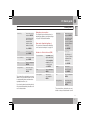
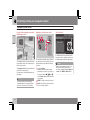
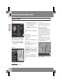
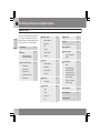
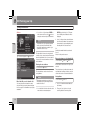
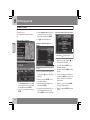
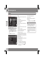
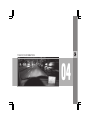
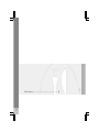
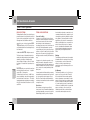
Text and symbols on the screen
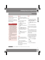
Distance to the next guidance point
Direction to take at next guidance point
Next guidance point
Final destination
Name of next street or road
Road sign information for next street or road
Route
Time restricted road/street
Symbol for a Point of Interest – POI (Hotel)
Remaining distance and time to destination
G041327
Map scale
Current road
Selected area to be avoided
Types of roads
Color
Stored location
Freeways
Green
Starting point
Main roads
Red
Completed section of the route
Secondary main roads
Brown
The vehicle’s current location
Normal roads
Dark gray
Intermediate destination
Local roads
Dark green
Extent of street/road with traffic problem (not available in all markets)
Traffic information (not available in all markets)
Direction to destination
Compass
VOLVO NAVIGATION SYSTEM (VNS) WITH RTT
VNS is a navigation system developed by Volvo, which is
designed to help guide you to the destination of your choice
and provide information along the way.
RTT1 (Real Time Traffic) is an information system developed by
Volvo, which can detect roads/streets with traffic disruptions
and make it possible to select an alternative route past the
problem area.
The system includes features that enable you to set itineraries,
search for certain types of points of interest along your route,
store special destinations, obtain traffic informaton en route,
etc.
The system indicates the vehicle’s current location, and shows
part or all of the route to your destination, depending on the
settings you have made. If at any time you should decide to
deviate from the route originally set by the system, a new route
to the destination will automatically be calculated.
By enabling you to reach your destination quickly and by the
most direct route, Volvo's navigation system also helps contribute to improving the environment.
NAVTEQ DATABASE End-User License Agreement
See the information on page 72.
1
Option. Not available in all markets.
Contents
01 Quick guide
Getting started............................................ 8
02 Getting to know your
navigation system
03 Planning your trip
Setting a destination.................................
Stored locations, Last ten.........................
Return trip, Intersection............................
Map search, Search by lat/long................
Itinerary.....................................................
Storing a location......................................
Next destination........................................
Current position........................................
Settings.....................................................
Avoiding an area.......................................
Map and Guidance options......................
System options.........................................
Demo........................................................
01 02 03
This manual...............................................
Before you begin.......................................
DVDs and the screen................................
XC60 system overview .............................
V70/XC70 system overview......................
S80 navigation system overview..............
Navigation system controls......................
On-screen keyboard.................................
Maps, types of roads, and the compass. .
Main menu, Scroll menu...........................
Shortcut menu..........................................
Menu selections........................................
2
14
15
17
18
20
22
24
25
26
28
30
32
36
39
40
41
42
44
46
47
48
49
51
53
54
Contents
04 Traffic information
05 Symbols on the map
06 Questions & Answers
Introduction............................................... 58
Selecting information................................ 60
Reading information.................................. 61
Points of interest....................................... 66
Frequently asked questions...................... 70
EULA – License agreement....................... 72
04 05 06
3
Contents
07 Index
Index......................................................... 76
07
4
Contents
5
6
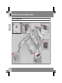
G028767
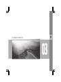
Getting started.......................................................................................... 8
QUICK GUIDE
01
01 Quick guide
Getting started
01
Navigation control/remote control
Activating the system
The navigation control is located on the right
rear side of the steering wheel, see page 24.
The buttons on the remote control have the
same function as the navigation control on the
steering wheel.
The remote key must be inserted in the ignition
slot1(see the vehicle’s Owner’s Manual).
•
•
•
Navigation control – Use this (or the arrow
keys on the remote control) to navigate up,
down, left, or right among the various
menu selections and alternatives, and to
move the cross hairs on the map.
1. Press the remote key into the ignition slot.
2. Press briefly on the START/STOP
ENGINE button.
3. If the screen does not deploy, press
BACK or ENTER.
Starting the system
this has been done, the vehicle's position will
be indicated by a blue triangle.
NOTE
The system can be used even when the
engine is not running. To help avoid battery
drain, the system should be turned off when
it is not in use.
Guidance to a street address
Set destination
ENTER – Confirms or activates a selection.
BACK – Press this key to go to the previous
menu or to undo a selection.
Use the navigation
control to go to Set
destination.
NOTE
Press ENTER.
For reasons of traffic safety, only the menu
alternatives Next destination, Current
position and Shut down are available
while the vehicle is in motion.
Certain functions in the Shortcut menu are
also available while the vehicle is in motion,
see page 32.
Address
The system initially displays a text on the
screen that must be confirmed by pressing
ENTER.
It may take the system several seconds to
determine the vehicle’s location after the key
has been inserted into the ignition slot. When
1
8
Press BACK to display the main menu.
On models with the optional Keyless Drive, press the START/STOP ENGINE button one time, so that the ignition system is at least in "Accessory" mode (mode I).
Go to Address and
press ENTER.
01 Quick guide
Getting started
State/City
Go to State or City
and press ENTER.
Select letters in the
list to specify the
state and city in
which the street
address is located.
Press ENTER.
Street
Go to Street and
press ENTER.
Street numbers
Go to Numbers and
press ENTER
Set
Go to Set and press
ENTER.
Start guidance
Go to Start guidance and press
ENTER.
The system will now calculate the route and
distance to the specified destination. You will
be provided with guidance and instructions
regarding intersections, etc.
If you leave the planned route during the trip,
the system will automatically calculate a new
route to the destination.
Navigation system options
The navigation system contains options for
adjusting map, guidance, and system settings.
see page 51 for detailed information.
State/City
The system has a Demonstration Mode that
can be used as a learning tool. see page 54.
Set destination
Press ENTER.
Type
POI
Go to POI and press
ENTER.
POI by name
Select POI by
name and press
ENTER.
Go to Type.
Select the type of
POI (service station,
restaurant, Volvo
retailer, etc.).
Press BACK to display the main menu.
Use the navigation
control to go to Set
destination and
press ENTER.
Go to State or City
and press ENTER.
Select letters in the
list to specify the
State or City where
the point of interest
is located.
Demo mode (simulated guidance)
Guidance to Points of Interest (POI)
01
Press ENTER.
Name
Go to Name.
Select POI and
press ENTER.
Set
Go to Set and press
ENTER.
Start guidance
Go to Start guidance and press
ENTER.
The system will now calculate the route and
distance to the specified destination. You will
}}
9
01 Quick guide
01
Getting started
be provided with guidance and instructions
regarding intersections, etc.
If you leave the planned route during the trip,
the system will automatically calculate a new
route to the destination.
10
01 Quick guide
01
11
12
14
15
17
18
20
22
24
25
26
28
30
32
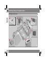
G028780
This manual.............................................................................................
Before you begin.....................................................................................
DVDs and the screen..............................................................................
XC60 system overview ...........................................................................
V70/XC70 system overview....................................................................
S80 navigation system overview.............................................................
Navigation system controls.....................................................................
On-screen keyboard...............................................................................
Maps, types of roads, and the compass................................................
Main menu, Scroll menu.........................................................................
Shortcut menu........................................................................................
Menu selections......................................................................................
GETTING TO KNOW YOUR NAVIGATION SYSTEM
02
02 Getting to know your navigation system
This manual
Using this manual
02
The manual is divided into chapters describing
the various features and functions of the navigation system.
See Planning your trip on page 36 for more
detailed descriptions and selections of settings
for specifying a destination.
Menu selections/Paths
Menu selections in this manual are listed in
gray text, for example:
Set destination
Address
Street
Quick guide
A quick guide is available to help you get
started with the basic functions as quickly as
possible, see page 8.
Changes in the manual
The specifications, design features, and illustrations in this manual are not binding. We
reserve the right to make modifications without
prior notice.
© Volvo Car Corporation
14
02 Getting to know your navigation system
Before you begin
General information
Map mode
The VNS system can be used even if a destination has not be specified.
When the system starts, text is displayed on
the screen that must be confirmed by pressing
ENTER.
The map, with the vehicle’s current location,
will be displayed on the screen, with the vehicle
marked as a blue triangle.
WARNING
•
•
Always use good judgment when following navigation system guidance,
and do not follow guidance that seems
contrary to your own best judgment.
Never use the navigation system or any
other feature in your vehicle in a way
that distracts you from the task of driving safely. Distraction can lead to a serious accident.
•
Set and make changes in your navigation system only with the vehicle
parked.
•
•
Be aware of the current traffic situation.
Always comply with relevant traffic regulations.
The system then enters Map mode and the
current map view is displayed.
•
Press ENTER to access the Shortcut
menu, see page 30.
•
Press BACK to access the Main menu, see
page 28.
1. Use the navigation control to activate
Map scroll mode, for example, to see sections of the map that are outside of the
screen.
2. Press ENTER to activate the Map scroll
menu. See also Scroll menu see
page 28.
Settings
The system contains default settings, but it
starts with the settings that were most recently
made.
If a setting has been changed and then
returned to the factory setting, only the setting
in question is affected.
On/Off
On
02
1. The remote key must be inserted in the
ignition slot1in order to use the system (see
the vehicle’s Owner’s Manual).
2. Press ENTER or BACK to activate the system.
3. The screen is activated automatically.
It may take several seconds for the system to
determine the vehicle’s location and direction.
Off
The system is automatically shut off when the
key is removed from the ignition slot (or when
the driver’s door is opened on vehicles with the
optional keyless drive).
The system can also be turned off manually so
that it does not start automatically the next time
the remote key is inserted in the ignition slot.
1. Press BACK to go to the Main menu.
2. Go to Shut down with the navigation
control.
3. Press ENTER.
4. The screen will retract automatically.
There is no global function to return all settings
to the factory defaults.
1
On models with the optional Keyless Drive, press the START button one time, so that the ignition system is at least in "Accessory" mode (mode I).
}}
15
02 Getting to know your navigation system
Before you begin
NOTE
02
The system can be used even when the
engine is not running. To help avoid battery
drain, the system should be turned off when
it is not in use.
Demo (simulated guidance)
For an overview of how guidance functions,
specify a destination.
If the vehicle is at a standstill, guidance can be
simulated to the specified destination, see
Start demo on page 54.
16
02 Getting to know your navigation system
DVDs and the screen
Contents of DVDs
Each set of DVDs contains at least two discs.
Each disc contains information covering a
greater part of the North American network of
roads. However, each disc contains detailed
information about addresses, points of interest, etc., in a specific geographic area.
During a trip, a message will be displayed when
it is time to switch DVDs. If the DVD containing
detailed information about the area in which
you are currently driving is not inserted, only
general information about the road network will
be available.
The maps and data on the DVDs are static.
They will not automatically update to reflect
real-life changes to road and traffic patterns.
Updated DVDs are produced periodically.
Please contact your Volvo retailer for more
information about availability.
Changing DVDs
When changing DVDs, the ignition must be on
during the entire procedure (see the vehicle’s
Owner’s Manual).
1. Turn on the navigation system.
2. Remove the upholstered panel that conceals the main unit under the floor on the
left side of the trunk or cargo compartment.
3. Hook a thumb behind the upper edge and
pull it out (see the overview illustrations on
page 18 and onwards).
DVD care
•
When changing discs, make sure that they
are kept free of oil, grease and other impurities.
•
The discs must not be exposed to moisture.
•
The discs must be kept in their packaging
when not in use.
7. Lock the catch.
•
In certain cases, new functions may be added
to the system when the new DVD is inserted. If
the DVD also contains new system software,
you will be prompted to accept a system
update.
Avoid storing discs in excessive heat,
direct sunlight, or in a dusty environment.
Screen care
4. Release the catch on front of the main unit.
5. Press the EJECT button and remove the
DVD.
6. Insert the new map DVD.
Confirm by selecting YES.
The text Preparing to load System
Software. Please wait… will then be displayed.
The update takes approximately 15 minutes.
The VNS start screen will be displayed when
updating is completed and the navigation system is ready for use.
02
Clean the display screen with a soft, non-static
cloth or a moist paper towel and a mild window
cleaning agent.
Never use petroleum based solvents or abrasive substances when cleaning the screen.
CAUTION
Do not place any objects in front of the navigation system's screen. This could scratch
its surface. Cell phones could also interfere
with the screen's function.
NOTE
The screen may retract or go blank while an
update is underway.
17
02 Getting to know your navigation system
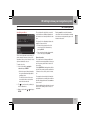
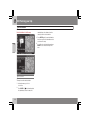
XC60 system overview
G031099
02
18
02 Getting to know your navigation system
XC60 system overview
Main VNS unit and DVD drive
The main unit and DVD drive is located on the
left side of the cargo area, and includes the following functions:
•
•
Determining the vehicle’s location.
•
•
Voice guidance.
Calculating a route to the selected destination.
Processes traffic information.
NOTE
•
The EJECT button is located to the left
and the locking catch is on the right side
of the main unit.
•
The DVD drive is intended for playing
Volvo’s map DVDs only.
Traffic information – TMC (option)
TMC is a standardized code system for transmitting traffic information. The receiver automatically tunes to the correct frequency and
reception is handled by the audio system’s FM
antenna.
NOTE
Global Positioning System (GPS)
antenna
The antenna is integrated into the roof module.
NOTE
Navigation control
The navigation control is located in the right
rear side of the steering wheel. Use it to move
among menu alternatives, to confirm selections or to go back in the menu system.
The GPS receiver is integrated into the main
unit. Using signals from the Global Positioning System, the vehicle’s speedometer, and
a gyroscopic sensor, it calculates the vehicle’s current location and direction.
For additional information, see page 24.
This also helps the system calculate direction and location if the GPS signal is temporarily interrupted, such as when driving
through a tunnel.
Use the vehicle’s audio system volume control
during voice guidance to raise or lower the volume. The volume can also be adjusted in the
menu system.
Speakers
Sound from the navigation system comes from
the vehicle’s audio system front speakers.
02
Volume control and infrared (IR)
receiver
The IR receiver for the VNS remote control is
located above the numeric keypad on the center instrument panel.
Screen
The screen displays the maps and provides
detailed information about intersections, distances, etc.
For information about caring for the screen,
see page 17.
TMC is not available in all areas/countries.
The area covered by the system is being
steadily expanded, which makes occasional updates necessary, see page 17
19
02 Getting to know your navigation system
V70/XC70 system overview
02
20
02 Getting to know your navigation system
V70/XC70 system overview
Main VNS unit and DVD drive
The main unit and DVD drive is located on the
left side of the cargo area, and includes the following functions:
•
•
Determining the vehicle’s location.
•
•
Voice guidance.
Calculating a route to the selected destination.
Processes traffic information.
NOTE
•
The EJECT button is located to the left
and the locking catch is on the right side
of the main unit.
•
The DVD drive is intended for playing
Volvo’s map DVDs only.
Traffic information – TMC (option)
TMC is a standardized code system for transmitting traffic information. The receiver automatically tunes to the correct frequency and
reception is handled by the audio system’s FM
antenna.
NOTE
Global Positioning System (GPS)
antenna
The antenna is integrated into the roof module.
NOTE
Navigation control
The navigation control is located in the right
rear side of the steering wheel. Use it to move
among menu alternatives, to confirm selections or to go back in the menu system.
The GPS receiver is integrated into the main
unit. Using signals from the Global Positioning System, the vehicle’s speedometer, and
a gyroscopic sensor, it calculates the vehicle’s current location and direction.
For additional information, see page 24.
This also helps the system calculate direction and location if the GPS signal is temporarily interrupted, such as when driving
through a tunnel.
Use the vehicle’s audio system volume control
during voice guidance to raise or lower the volume. The volume can also be adjusted in the
menu system.
Speakers
Sound from the navigation system comes from
the vehicle’s audio system front speakers.
02
Volume control and infrared (IR)
receiver
The IR receiver for the VNS remote control is
located above the numeric keypad on the center instrument panel.
Screen
The screen displays the maps and provides
detailed information about intersections, distances, etc.
For information about caring for the screen,
see page 17.
TMC is not available in all areas/countries.
The area covered by the system is being
steadily expanded, which makes occasional updates necessary, see page 17
21
02 Getting to know your navigation system
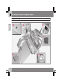
S80 navigation system overview
02
2
3
4
5
6
G021310
1
22
02 Getting to know your navigation system
S80 navigation system overview
Main VNS unit and DVD drive
The main unit and DVD drive is located on the
left side of the cargo area, and includes the following functions:
•
•
Determining the vehicle’s location.
•
•
Voice guidance.
Calculating a route to the selected destination.
Processes traffic information.
NOTE
•
The EJECT button is located to the left
and the locking catch is on the right side
of the main unit.
•
The DVD drive is intended for playing
Volvo’s map DVDs only.
Traffic information – TMC (option)
TMC is a standardized code system for transmitting traffic information. The receiver automatically tunes to the correct frequency and
reception is handled by the audio system’s FM
antenna.
NOTE
Global Positioning System (GPS)
antenna
The antenna is integrated into the roof module.
NOTE
Navigation control
The navigation control is located in the right
rear side of the steering wheel. Use it to move
among menu alternatives, to confirm selections or to go back in the menu system.
The GPS receiver is integrated into the main
unit. Using signals from the Global Positioning System, the vehicle’s speedometer, and
a gyroscopic sensor, it calculates the vehicle’s current location and direction.
For additional information, see page 24.
This also helps the system calculate direction and location if the GPS signal is temporarily interrupted, such as when driving
through a tunnel.
Use the vehicle’s audio system volume control
during voice guidance to raise or lower the volume. The volume can also be adjusted in the
menu system.
Speakers
Sound from the navigation system comes from
the vehicle’s audio system front speakers.
02
Volume control and infrared (IR)
receiver
The IR receiver for the VNS remote control is
located above the numeric keypad on the center instrument panel.
Screen
The screen displays the maps and provides
detailed information about intersections, distances, etc.
For information about caring for the screen,
see page 17.
TMC is not available in all areas/countries.
The area covered by the system is being
steadily expanded, which makes occasional updates necessary, see page 17
23
02 Getting to know your navigation system
Navigation system controls
02
Location of the navigation control and
IR (infrared) receiver
The navigation system can be operated using
the navigation control on the steering wheel or
with the remote control.
The navigation control is located on the right
rear side of the steering wheel.
Point the remote control toward the audio system display.
NOTE
The remote control uses two AAA (also
called R03) batteries. Try replacing the batteries in the remote if it does not function.
24
Navigation control/remote control
The navigation control and remote control have
the same functions. Each enables you to navigate through the menus and make settings/
selections.
Use the navigation
control to move among various menu
alternatives or to move the cross hairs on
the map. The buttons
,
,
and
on the remote control can be used for the
same purpose.
ENTER – Confirms or activates selections.
BACK – Press this key to go to the previous
menu or to undo a selection.
"Do not disturb"
In certain situations, the system may need a
few extra seconds to calculate a route. A symbol will be displayed while this is taking place.
NOTE
While the route calculation symbol is displayed, the navigation system cannot
accept any commands from the navigation
control, or the ENTER or BACK buttons.
02 Getting to know your navigation system
On-screen keyboard
Specifying an address
The scroll bar at the right of the screen indicates that there are additional alternatives in
the list that are not currently visible in the window.
Entering new will also result in alternatives
such as New York since alternatives containing
more than one word separated by spaces are
included in the search.
02
G033459
The figure (66 in the illustration) indicates the
number of names on the list.
The on-screen keyboard is used in many situations among the menus to select specific
information such as points of interest, a state/
city/street address/zip code, etc.
To make a selection:
1. Select a letter with the navigation
control and press ENTER.
> When there are no further alternatives,
the system will automatically add the
remaining letters.
The list at the bottom of the screen
shows the first three selections that
match the letters entered.
2. The
key can be used to go directly to
the list of alternatives.
3. Make a selection with
ENTER.
or
and press
•
Return to the keyboard section of the
screen from the list of alternatives by
pressing BACK.
•
Erase any letters that have been entered,
one at a time, by pressing BACK.
General searches
The search function is always available and
works in the same way regardless of where you
are in the menu system when a location is to
be specified.
Pressing ENTER while entering letters will display all of the currently possible combinations
of names for cities, streets, points of interest,
etc.
For example, when searching for Newark airport, all alternatives containing the word Newark will be displayed when the letters new have
been entered.
Entering additional letters will make the search
more specific, making it easier to choose a
destination.
25
02 Getting to know your navigation system
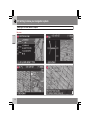
Maps, types of roads, and the compass
Map views
02
26
02 Getting to know your navigation system
Maps, types of roads, and the compass
Map views of the current location
The way in which the map is displayed
depends on the vehicle’s location and the settings that have been made in the system, such
as map scale, geographic location, the symbols that have been selected for display, etc.
An explanation of the text, signs, and symbols
that may be displayed on the screen can be
found on the inside of the front cover of this
manual.
The name of the current route can be viewed
at the bottom of the screen without setting a
destination.
Along a highway. The screen shows points
of interest along the highway, see
page 30.
Detailed intersection information. The
screen shows the direction in which you
should turn at the next intersection. (Alternative lanes are only displayed for major
roads.) Visual information is always
accompanied by voice guidance.
Two maps. The screen shows the same
map, but with two different scales, see
page 30.
Map scroll mode, see page 28.
Compass
The compass can be displayed in two ways:
- The red point on the compass needle points north on
the map and the white end of
the needle points south
- The gray destination arrow on the outer ring
of the compass points toward the specified
destination.
between a male or female voice, or no voice
guidance at all, and go to System options to
select the language to be used by the system.
see page 51 for more information.
NOTE
In certain cases, voice guidance will
replaced by an audible signal.
Unverified roads
Go to Settings Map options Compass
to select how the compass is to be displayed,
see page 51.
A small number of roads in the system may be
unverified. This means that information on
signs, one-way streets, left turns, etc., may not
be accurate.
Voice guidance
An itinerary containing unverified roads will be
displayed with gray arrows instead of the usual
yellow ones.
Once a destination has been entered and the
vehicle is approaching an intersection or an
exit, a voice will provide guidance about distance and type of action to be taken. A detailed
map of the intersection is also displayed.
The voice guidance is repeated as the vehicles
approaches the intersection. Adjust the volume with the audio system’s volume control
(this must be done while guidance is being
given).
In the menu system, go to Settings Guiding
options Guidance voice - to choose
02
The system’s default setting is to avoid unverified roads, and for this reason, no itineraries are
planned on them. These settings can be
changed under Settings and Route options,
see page 48.
The system provides information when an
unverified road is added to an itinerary and
when the vehicle begins to travel on one of
these roads.
27
02 Getting to know your navigation system
Main menu, Scroll menu
Main menu
1. Use the navigation control to move the
cross hairs in the direction of your choice
on the currently displayed map.
02
2. Press ENTER to activate the Scroll menu.
Scale
G040985
Change the scale for the currently displayed
area.
Set as destination
Add the position of the cross hairs as a destination in an itinerary.
The Main menu is the first one displayed on the
screen when the navigation system is started.
POI around
•
Read traffic msg.
When the system is running, the Main
menu can be reached by pressing BACK
one or more times.
Search for points of interest near the vehicle.
Store location
Save the location, which can later be found
under Set destination Stored locations.
Following a route on the map
To make it easy to follow a set itinerary, the
system has a built-in "magnet" function. This
means that regardless of the number of turns
or changes of direction in the route, the cross
hairs will follow the route by simply holding
down a button.
One of the lines in the cross hairs will be displayed darker than the other one to indicate
which button should be pressed.
Display current traffic messages for the area of
the map shown on the screen.
Set for surveill.1
Choose between Surveillan. 1, 2 or 3 and
Scroll menu
G040986
Activate the map. Select Map/route in the
Shortcut menu and select the desired surveillance.
1
28
Only areas with reception for traffic information.
G033536
press ENTER to save the map area currently
displayed as an area to be avoided, such as
roads with heavy traffic or areas where traffic
tie-ups often occur.
Use button
ically.
or
to follow the route automat-
02 Getting to know your navigation system
Main menu, Scroll menu
G033537
02
Use button
ically.
or
to follow the route automat-
To deactivate the "magnet" function, move the
cross hairs slightly away from the route until the
line in the cross hairs is no longer dark. Scrolling will then function normally.
29
02 Getting to know your navigation system
Shortcut menu
Easier operation while driving
02
The Shortcut menu contains functions that
make operating the system simpler. Press
ENTER in Map mode and select sub-menus
or
.
with
G028755
Route outline
G028755
– Map scale/Current route
Change the scale of the map on the screen for
a larger perspective or greater detail.
G023192
G029190
Most system settings can be made in
Settings while others can only be accessed in
the Shortcut menu.
– Route/Map/Surveillance
At the top of the menu, you can choose
between seeing the rest of the route from the
current location to the destination, or the entire
route to the destination, see point 7 in the overview illustration on the inside of the front cover.
If the system is set to show two maps, a symbol
for map scale will be displayed at each end of
the Shortcut menu. This is to make it possible
to adjust the respective map scales individually.
G028755
– Guidance
Press ENTER for current guidance or to repeat
voice guidance.
This is a list with coming guidance points. In
addition to the name of the road, the distance
between guidance points is shown, and an
arrow is displayed to indicate the action to be
taken.
One map/Two maps
Choose to display one or two maps of the current area.
Surveillance1
Select Surveillan. 1, 2 eller 3 to see areas previously selected for surveillance, see page 28.
G028755
– Detour
Avoiding certain streets/roads
Select special areas or streets to be avoided
when the system calculates a route, for example, to avoid driving through an area where
road construction is currently underway.
1. Select Avoid in the Route options menu
and press ENTER. A list of streets in the
current itinerary will be displayed.
2. Go to the street to be avoided and press
ENTER.
1
30
Only in areas with reception for traffic information.
02 Getting to know your navigation system
Shortcut menu
3. To also avoid other streets, move to the
first street in the group of streets to be
avoided with
and press ENTER. Then
go to the last street in the group and press
ENTER.
The system will then calculate a detour that will
guide you back to the original route after you
have passed the area(s) to be avoided.
NOTE
Larger, adjoining areas to be avoided must
be pre-selected in Route options, see
page 49.
Avoid areas from 0.5 – 50 miles
This function enables you to avoid an entire
area in the original itinerary, for example to
avoid a city during rush hour.
Select an alternative in the Detour menu
(0.5 – 50 miles) and press ENTER.
The system will then calculate a detour that will
guide you back to the original route after you
have passed the section of the itinerary to be
avoided.
2
G028755
– Traffic information (option)2
Use this menu to select the way in which traffic
information is displayed on the screen. For a
more detailed description of Traffic Information, see page 58.
G028755
– Points of interest
Displays a menu with different ways of searching for a point of interest.
Around the car
Read message
Pressing ENTER makes it possible to search
for POIs around the vehicle, see page 37.
Navigate among the various traffic messages.
Along the route
Messages on route
Messages received along the route that have
not resulted in the selection of an alternative
route or where there are no better alternatives
are stored here.
Avoided messages
Messages received along the route that require
the selection of an alternative route are stored
here.
Show all
02
Pressing ENTER makes it possible to search
along the route, see page 37.
Along HWY
Choose to search for e.g., rest areas or filling
stations that are near the highway on which you
are currently driving.
If the calculated route includes more than one
highway, the system will search along the highway on which the vehicle is currently traveling.
Show all messages.
Hide all
Hide all messages.
Show selected
Select the type of message to be displayed on
the screen, see page 58.
Not available in all areas.
31
02 Getting to know your navigation system
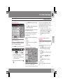
Menu selections
02
Three levels of the menu structure are shown
here. A number of the third level menus also
have sub-menus, which are described in detail
in their respective sections in this manual.
Set destination
p. 36
Stored locations
p. 39
Add to itinerary
Itinerary
Information
Edit
Sorting
Address
p. 36
State/City/Number/
Street/Set/Information
Points Of Interest (POI)
POI by name
Around the car
Along the route
Around point on map
Along a street
Delete location
Last ten
p. 39
Add to itinerary
Delete location
Delete all
p. 40
State
Street
Intersection
City
32
Start guidance
p. 42
Add to itinerary
p. 42
Route options
p. 48
Avoid highways/toll
roads/ferries/traffic
problems/time-restr.
roads/specified areas/
unverified roads
Avoid specified areas
see Itinerary
Intersection
p. 42
Route
Information
Return trip
p. 41
see Set destination/
Address
Delete all
p. 37
Map search
Reset to default
p. 40
Clear itinerary
p. 43
Next destinationA
p. 46
Current positionA
p. 46
02 Getting to know your navigation system
Menu selections
Settings
Traffic informationB
p. 51
p. 58
Auto. notification
Traffic-info. selection
Search station
Service provider
Frequency
Reset to default
Route options
see Itinerary/Route
options
p. 48
Map options
p. 51
System options
POI selection
Language
Map
Colors
Map view
Screen saver
2D map orientation
Disclaimer time out
Intersection map
Help
Map scroll
Distance unit
Compass
GPS Information
Current location
About
Reset to default
Reset to default
Guiding options
p. 51
Start demo
Guidance voice
Shut downA
Guidance volume
Guidance volume
check
A
B
p. 53
02
p. 54
p. 15
Only these functions are available when the vehicle is moving
at speeds above approximately 5 mph (7 km/h).
Option. Not available in all markets.
Time/dist. to go
Time format
Reset to default
33
34
36
39
40
41
42
44
46
47
48
49
51
53
54
G028782
Setting a destination...............................................................................
Stored locations, Last ten.......................................................................
Return trip, Intersection..........................................................................
Map search, Search by lat/long..............................................................
Itinerary...................................................................................................
Storing a location....................................................................................
Next destination......................................................................................
Current position......................................................................................
Settings...................................................................................................
Avoiding an area.....................................................................................
Map and Guidance options....................................................................
System options.......................................................................................
Demo.......................................................................................................
PLANNING YOUR TRIP
03
03 Planning your trip
Setting a destination
•
Address
Go to State or City and press ENTER to
make a new selection, or use
to choose
among the most recently selected names.
NOTE
G040987
03
Set destination
Address
State/City
The definition of a city or area may vary from
state to state, and also within the same
state. It will sometimes be an entire city, or
a particular section of a city.
G040988
36
Set
Confirm the number that has been entered.
Cancel
Entering the street address
A street can be selected even if no city is preselected.
Address
The street address can be entered for more
exact guidance.
selected in the most recently entered destination. See page 25 for information on specifying
an address.
2. Go to Set after you have entered the number of the street address. If no number has
been entered, the system will guide you to
the mid-point of the selected street.
The lists with the five most recently entered
countries, cities, or street names will be erased
when the destinations in Last ten are erased.
See page 39 for more information on the last
ten destinations.
Set destination
Enter State/City or select from the list
State may be preselected and is the state
ENTER (or go directly to Set). The numbers of existing street addresses will be
displayed.
NOTE
If the number entered does not exist for a
street address, the system will provide information to this effect.
1. Go to the field for Number after the street
name has been entered and press
Go back to the previous screen.
Enter a street name or select from the list
Set destination
Address
Street
The system does not contain street names for
very small towns or villages. In these cases, the
center of the town is used as the destination.
Start guidance
Set destination
Address
1. Go to Set to add the entered address to
the itinerary.
2. Then go to Start guidance to begin
receiving directions from the system.
03 Planning your trip
Setting a destination
Provides information about the destination.
Points of interest (POI) include gas stations,
hotels, restaurants, Volvo retailers, hospitals,
parking lots, etc.
Points of interest (POI)
•
Information
Enter a point of interest as a destination
Types of points of interest/Different
categories
Press ENTER to access a sub-menu with
different search options in order to select a
point of interest.
03
G040990
It is also possible to search for points of interest
around the car, along the route, or along the
highway in the Shortcut menu.
G040989
POI by name
Set destination
POI
POI by name
Around the car
The system will search for POIs around the car
(max. 100 mile/160 km radius). The search will
stop after 100 POIs have been found.
POI
Along the route
Around point on map
The system will perform the same type of
search as for Around the car, but the search
will be based on a point on the map.
Along street
The system will search along a specified street.
G040991
If a destination has been selected, the system
can search for points of interest along the route
(within approx. 0.5 miles/1km from the route).
G040990
Set destination
Enter the name of the point of interest, or select
an alternative in the menu. The list only shows
the points of interest in the selected city/area.
1. Go to Name and press ENTER to enter the
name of a point of interest without specifying a city.
}}
37
03 Planning your trip
Setting a destination
2. Go to Type and press ENTER to enter a
type of point of interest,
2.
G028755
or
Press
to choose among the most
recently selected ones.
03
3. Go to Set and press ENTER.
4. Then go to Start guidance and press
ENTER to receive guidance to the destination.
To make the search more exact,
•
Select a City first and then go to Name.
There are sub-categories of restaurants to
simplify the search.
Information about a point of interest
Information is displayed for e.g., the address,
coordinates, and the phone number to the POI.
There are several ways to search for information about a POI. The simplest and quickest
way is as follows:
1. With a map view on the screen, press
ENTER to access the Shortcut menu.
G029190
38
3. Navigate among the messages with
.
or
4. Select a POI among the available categories and press ENTER.
5. Select POI information and press
ENTER.
•
NOTE
Go to
using
or
and press
ENTER.
> Choose among Around the car, Along
the route or Along a street and press
ENTER.
Mark Map and press ENTER to see the
POI on the map.
03 Planning your trip
Stored locations, Last ten
Searching by zip code
Set destination
Address
Destinations can be limited by selecting a zip
code, after which a street or point of interest
can be selected.
1. Begin by selecting a state.
2. Go to Zip code and press ENTER.
3. Enter numbers and press ENTER or use
and choose a zip code directly from the
list if the alternative exists.
4. The scroll bar at the right of the screen
indicates that there are more alternatives in
the list.
5. Go to Street to choose among the
addresses with the selected zip code.
6. Go to Set and then to Start guidance to
receive guidance to the destination.
Stored locations
Last ten
Previously stored locations
Previously selected destinations
Set destinations
Stored locations
A stored location is a previously stored destination, such as a home address, favorite restaurant, an airport, or a Volvo retailer. see
page 44 for information on storing a location.
•
Navigate among the stored locations and
or ENTER to access the subpress
menu.
Add to itinerary
Place the stored location in the itinerary.
Information
Provides information about the stored location.
Edit
Change the name, etc., of the stored location.
Set destination
Last ten
This is a list of the ten most recently selected
destinations.
•
03
Go to the desired destination and press
or ENTER to access the sub-menu.
Add to itinerary
Adds the destination to the itinerary.
Information
Provides a summary about the destination.
Delete location
Remove the destination from the Last ten list.
Delete all
Removes all destinations from the Last ten list.
Sorting
Sort the list of stored locations by distance,
icon, or name.
Delete location
Deletes the stored location.
Delete all
Deletes all stored locations.
39
03 Planning your trip
Return trip, Intersection
Return trip
Back to the starting point
• Select Start guidance and press ENTER.
03
The system will begin guiding you back to the
location at which Start guidance was most
recently selected.
Intersection
Specifying a destination via intersections
Set destination
Intersection
1. Enter Street and press ENTER.
> All existing intersections will be displayed under Interse. if there are
streets that meet or cross the route.
2. Go to the intersection(s) that you would like
to set as destinations.
3. Go to Set and press ENTER.
4. Go to Start guidance and press ENTER
to receive guidance to the intersection.
NOTE
If the chosen combination of intersections
exists in more than one city, a city must also
be specified.
Searches can only be made for intersections of larger streets.
40
03 Planning your trip
Map search, Search by lat/long
Searching by latitude/longitude
Map searches
Searching for a location on the map
Set destination
map
Map search
Point on
1. Use the navigation control to move the
cross hairs to the desired destination and
press ENTER to access the scroll menu.
2. Go to Set as destination and press
ENTER.
Scale
Temporarily change the map scale while
searching with the cross hairs.
Set as destination
Select a location on the map as a final or intermediate destination.
POI around
The system searches for points of interest
around a specified point on the map (max. 100
mile/160 km radius). The search will stop after
100 POIs have been found.
Store location
Store a location on the map.
Set as destination
Latitude/longitude
Map search
1. Select a destination by specifying its coordinates on the map.
03
2. Select a latitude with the navigation
control: N for north or S for south.
3. Go to the second row to specify a longitude: select E for east or W for west.
> OK
This shows the position with the specified coordinates on the map.
4. Press ENTER to access the map scroll
menu.
5. Go to Set as destination and press
ENTER to select the position as a destination.
6. Press BACK to resume entering coordinates.
> Cancel
Return to the previous screen.
NOTE
Searches can be made directly with the
cross hairs by using the navigation
control in Map mode.
41
03 Planning your trip
Itinerary
Making an itinerary
Editing an itinerary
03
Start guidance
Final destination/Intermediate
destination
Itinerary
NOTE
The menu selection Itinerary becomes
accessible after a destination has been
selected.
Begin guidance to the destination.
Add to itinerary
Itinerary
All additional destinations are added to the itinerary.
•
Route options
Information
Provides settings for selecting various types of
roads, etc.
Provides information about the destination.
Clear itinerary
Removes the destination from the itinerary.
Deletes the entire itinerary.
Select a specified destination and press
ENTER or
to access a sub-menu.
Delete
Move
Make an itinerary with several stops to avoid
selecting a number of destinations during a
trip.
Change the destination’s position in the itinerary.
Up to six intermediate destinations and one
final destination can be specified in an itinerary.
Select a new location on the map as a destination.
Adjust
Store
Save the destination, which will be accessible
under Stored locations.
42
03 Planning your trip
Itinerary
Start guidance
Itinerary
Start guidance
Removing destinations from an
itinerary
Itinerary
To delete intermediate destinations in an
itinerary:
1. Select one of the specified intermediate
destinations and press ENTER or
to
access a sub-menu.
03
2. Go to Delete and press ENTER.
To delete all destinations:
When you have entered a destination and Start
guidance has been selected, the system will
begin to calculate a destination – Wait will be
displayed on the screen.
If you leave the planned route during your trip,
the system will automatically calculate a new
route.
•
Go directly to Clear itinerary and press
ENTER.
NOTE
All intermediate destinations and the final
destination will be deleted.
43
03 Planning your trip
Storing a location
Storing for re-use
Up to 250 destinations can be stored for reuse.
Saving a position on the map
3. Use the navigation control to go to a list
of symbols to select the one to be displayed on the map and press ENTER.
4. Use
Move the position of the stored location
to enter the desired name.
Storing a location that is part of an
itinerary
G040993
03
G040992
Set destination
Itinerary
1. Select the destination in the itinerary to be
saved and press
– a new menu will be
displayed.
1. Use the navigation control to go to Map
mode to navigate to the area to be saved
as a destination and press ENTER.
2. Select Store in the sub-menu and press
ENTER.
44
Stored locations
1. Mark a stored location and press
new menu will be displayed.
–a
2. Select Edit and press ENTER – a new
menu will be displayed.
3. Mark Adjust and press ENTER to display
the map.
2. Mark Store and press ENTER – a new
menu will be displayed.
4. Place the cross hairs on the desired location and press ENTER to specify the new
location – the map will close and a new
menu will open.
3. Mark the symbol to be displayed on the
map and press ENTER.
5. Mark Store location and press ENTER –
a new menu will be displayed.
4. Continue by entering the name of the location and finish by marking Store and
pressing ENTER to return to the itinerary.
6. Mark Store and press ENTER to store the
location.
03 Planning your trip
Storing a location
is approaching a stored location – the
signal is activated within a radius of
approx. 0.5 miles/700 m from the location.
7. Exit the menus and return to the map by
pressing BACK.
Add information about the stored
location
Set destination
Stored locations
1. Select a stored location and press
new menu will be displayed.
–a
2. Select Edit and press ENTER – a new
menu will be displayed.
Name
Address
City
03
Country
Phone
4. After making the adjustments, exit the
menu by pressing BACK, mark Store and
press ENTER – this returns you to the list
of Stored locations.
G040994
3. Mark Add info. and press ENTER – a new
menu will be displayed.
•
•
•
•
•
Choose to add/change among the following alternatives
• Icon
• Alert: Off/Sound 1/-2/-3 An audible
signal that alerts the driver when he/she
45
03 Planning your trip
Next destination
Next destination in the itinerary
remaining time or the distance from the
current position to the destination.
3. Press ENTER again if several destinations
have been specified for information and to
see them on the map.
4. Go to Map for each destination and press
ENTER to see a full-screen map of the
area.
03
Next destination
The map shows the next destination.
1. In the main menu, go to Next
destination.
2. Press ENTER or
for information about
the destination, such as its name, the
46
03 Planning your trip
Current position
Current position
The number displayed after GPS shows the
number of satellites with which the system is in
contact.
Traffic information
03
Settings
Traffic information
Refer to the "Traffic information" chapter
beginning on page 58.
Current position
To get a map view of the vehicle’s current position and information about this position, such
as its name or coordinates:
•
NOTE
Please be aware that traffic information may
not be available in all areas.
In the main menu, go to Current
position and press ENTER or .
47
03 Planning your trip
Settings
Route options
Route
See the detailed description below.
Select Fast or Short for the system to calculate a route.
Reset to default
Avoid highways
Set the system to avoid highways/freeways
when calculating a route.
03
Avoid toll roads
Set the system to avoid toll roads when calculating a route.
Avoid ferries
Settings
Route options
•
Use the navigation control to move
among the options, select the desired settings and press ENTER to save the settings.
•
Press BACK to cancel a setting.
Set the system to avoid ferries when calculating a route.
Avoid traffic problems
Set the system to avoid areas with traffic disruptions when calculating a route.
Avoid time-restr. roads
Set the system to avoid time-restricted roads
when calculating a route. This function requires
that the vehicle’s clock be correctly set for the
current time zone.
Avoid unverified roads
Set the system to avoid or use unverified roads
when calculating a route.
Avoid specified areas
1. Set the system to avoid specified areas
when calculating a route and press
.
2. Choose Selected and press
specify an area.
48
again to
Return to the system’s factory settings for
route options.
•
Press
, select OK and press ENTER.
NOTE
When the system calculates a route over
longer distances, it is designed to select
major roads (highways/freeways, etc).
If you have set the system to avoid highways
and toll roads, the system will avoid guiding
you to these types of roads to as great an
extent as possible, and will only use such
roads when no other reasonable alternative
is available.
03 Planning your trip
Avoiding an area
Selecting an area
system always excludes these areas when calculating a route.
Sub-menu – avoiding specified areas
NOTE
Highways that are part of a calculated route
that pass through an avoided area are an
exception.
Enter an area to be a avoided
1. Press
and choose Selected.
2. Press
again to enter the area.
None
•
Press ENTER to deactivate previously
selected areas.
Selected
1. Press
to enter new areas.
2. Press ENTER to activate previously stored
areas, which are marked with an X.
See also the following step pertaining to the
"Avoid specified areas" sub-menu.
Settings Route options
specified areas
Avoid
03
Settings Route options Avoid
specified areas Selected
Select alternatives in the sub-menu and press
ENTER.
Map
Use the navigation control to enter the area to
be avoided directly on the map.
See also the next step, "Entering areas on the
map."
Address
Enter the address of an area to be avoided. The
address will comprise the center of the area.
This function is designed to help you avoid
being guided to areas, cities or sections of cities that you prefer not to drive through. The
}}
49
03 Planning your trip
Avoiding an area
Entering areas on the map
Adjust size
•
Change the size of the area using the
navigation control.
•
Press BACK to undo a change.
Adjust area
03
•
Move to a new area using the navigation
control.
•
Press BACK to undo a move.
Saved areas to be avoided
Settings Route options Avoid
specified areas Selected Map
Use the navigation control to move the midpoint of the cross hairs to the center of the area
to be avoided.
The name of the place at which the mid-point
of the cross hairs is pointing will be displayed
at the bottom of the map. The rectangle shows
the size of the area.
Select which of the previously saved areas are
to be avoided when a route is calculated.
These are marked with an X.
1. Select an area with
or
.
2. Mark or unmark an area using
or
.
OK
1. Press ENTER to access the sub-menu.
Activate areas marked with an X. The activated
areas will be shown on the map.
2. Select alternatives and press ENTER.
Cancel
Scale
Enter the size of the map to be displayed of the
area to be avoided.
Set area to avoid
Save the specified area.
50
Settings Route options Avoid
specified areas Selected Map
Undo any changes and return to Route
options.
03 Planning your trip
Map and Guidance options
Map options
Select the way in which the map is displayed
on the screen.
G041008
03
1. Navigate with
the symbols.
or
to choose among
2. Activate/deactivate with
Settings
Map options
1. Select a function to be set with the
navigation control.
2. Press ENTER to open the function.
POI selection
•
•
Press
•
Select Hide all if no POI symbols are to be
displayed.
•
Select Show selected and press
to
enter the symbols that you would like to
have displayed on the map. These are activated with an X.
to access a sub-menu.
Select Show all to see all points of interest
symbols on the map.
Selecting the elevation angle
Settings
or
3. Press ENTER to save.
Map
If the map is not displayed, the system provides guidance with arrows on the screen.
Map view
Select to display the map in 2D or 3D.
Map
Map view
3D
After selecting 3D with
or
and ENTER,
the panel for selecting the elevation angle will
be displayed. Select the desired angle with
or
followed by ENTER and BACK.
2D map orientation
Choose to display north or the direction of
travel at the top of the map.
Intersection map
Choose to display the detailed map of intersections in 2D or 3D.
Map scroll
Choose to display the map in 2D or 3D when
scrolling.
Compass
Select the way in which the compass is displayed on the screen.
}}
51
03 Planning your trip
Map and Guidance options
Current location
Time format
Select whether or not the name of the street on
which you are currently driving will be displayed at the bottom of the screen
Select 12 or 24-hour intervals.
Reset to default
03
Return to the factory settings for Map options.
•
Press
, select OK and press ENTER.
Guidance options
Settings
Guidance options
Guidance voice
Select Female/Male
Guidance volume
Select a value between 1–35 to set the volume
level or Off for no voice guidance.
The volume level can also be adjusted using
the audio system's volume control during voice
guidance.
Guidance volume check
The set volume is indicate by a chime.
Time/dist. to go
Select RTA, ETA or Hide.
• RTA is the remaining length of time to the
destination.
• ETA is the estimated time of arrival.
52
Reset to default
Return to the factory settings for Guiding
options.
•
Press
, select OK and press ENTER.
03 Planning your trip
System options
Setting system options
Settings
GPS Information
Time limit for the disclaimer
•
System options
•
Move among the functions with the
navigation control.
•
•
Press ENTER to save settings.
About
Displays system and map information.
Press BACK to undo a setting.
Return to the factory setting for System
options.
Select the language to be used in the system
menus and for voice guidance.
best suit the current ambient light.
Screen saver
If the screen saver is set to ON, the screen will
go blank after 30 seconds.
If guidance or other information is provided, the
screen is activated automatically.
03
Reset to default
Language
Colors
Select Black, Blue or Chrome for colors that
Press
to show coordinates and the
address of the vehicle’s current location,
and to display the number of satellites with
which the system has contact.
Settings
time out
System options
Disclaimer
•
Press
, select OK and press ENTER.
Select No if the disclaimer must be confirmed
by pressing ENTER each time the system is
started.
Selecting Yes means that the disclaimer will
only be displayed for approximately
10 seconds and does not need to be confirmed.
Help
Hide or display context sensitive help texts at
the bottom of the screen.
Distance unit
Choose to display distances in miles or kilometers.
53
03 Planning your trip
Demo
Start the demo (system simulation)
Settings
03
Start demo
When the vehicle is at a standstill, this function
offers simulated guidance to the currently set
destination.
Stop demo interrupts the simulation.
NOTE
The demonstration function can only be
used if a destination has been selected.
54
03 Planning your trip
03
55
56
G029197
Introduction............................................................................................. 58
Selecting information.............................................................................. 60
Reading information................................................................................ 61
TRAFFIC INFORMATION
04
04 Traffic information
Introduction
Display and reception
Broadcast traffic information is always
received and presented, even if no destination
is specified.
The way in which traffic information is presented can be set and changed in Settings, see
page 32.
04
The way in which traffic information is presented is also affected by the way in which it is
broadcast.
A symbol will be displayed in the upper left
corner of the map when there is at least one
traffic message along the currently selected
route. Use the navigation control to scroll to
the message for information about the problem
and to see its location.
Traffic problems are marked with symbols,
lines and frames. These are colored red or yellow.
Red - Important information.
Yellow - General information.
NOTE
Traffic information is not available in all
areas/states/provinces.
Accident
The transmission range for traffic information is being increased continuously.
Traffic symbols on the map
Extent
Certain traffic messages also contain information on the extent of the traffic obstruction.
Slow traffic
In addition to the symbol, a red or yellow line
along the route is shown on all scales up to
3 miles. The length of the line is corresponds
to the extent (distance) of the traffic problem.
Slow traffic in both directions
Avoid traffic problems
Settings
Route options
Extent
Select whether or not the system should plan
to bypass the traffic problem.
Other information
1. Go to Avoid traffic problems
G041304
2. Select Yes or No.
Traffic information symbol.
58
Yes
The system avoids roads with traffic problems
when calculating a route.
04 Traffic information
Introduction
No
The system does not avoid roads with traffic
problems when calculating a route.
NOTE
When the system is started it can take up to
approx. 15 minutes before all traffic information for the area is loaded.
Automatic information
Settings Traffic information
notification
Auto.
Select whether or not transmitted traffic information should be shown.
Yes
The display shows Changed traffic situation.
Use new route? and shows alternatives provided, along with the fact that the new route is
approximately 3 miles (5.4 km) longer.
Yes
The system guides along the new route,
around and bypassing the problem.
The system provides the option to select an
alternative route to bypass any traffic problems.
No
No
Show new route
The system provides no information on traffic
problems and will plan the route through the
areas with possible traffic problems.
04
The system guides along the original route, up
to and through the problem.
Shows detailed information on the alternative
route.
New or original route
If the system calculates an alternative route in
the event of a traffic obstruction, you are given
the option of selecting which route that you
prefer to take.
59
04 Traffic information
Selecting information
Traffic information selection
2. Activate and deactivate respectively using
or
.
Slippery road
3. Confirm the settings with ENTER.
The scroll bar on the right side of the screen
indicates that there are more options in the list
than can be displayed at one time.
G033429
Signs on the map
04
Settings Traffic information
info. selection
Traffic-
Select which type of traffic information should
be shown on the screen.
Show all
All traffic information is available.
Accident
Contraflow (two-way traffic, single
lanes in each direction)
Diversion (detour)
Information
Hide all
No traffic information is displayed.
Narrow road
Show selected
1. Press
to enable selection from symbols.
Select the traffic information symbols (traffic messages) the system should show on
the map, and take consideration of, when
calculating the route.
Parking information
Congestion
Road work
60
Other hazard
Closed road
04 Traffic information
Reading information
Read traffic message
4. Press ENTER for detailed traffic information.
5. Press BACK to enable browsing between
current messages again.
The traffic messages relevant to the map area
are indicated on the screen.
Detailed information on the traffic problem is
also shown. The extent of the problem is
shown at the top.
G028868
Detailed traffic information.
Read traffic msg.
A traffic message is indicated by a symbol on
screen. To read a traffic message:
1. Press ENTER to open the Shortcut menu:
If details are available, the following are also
displayed:
•
•
duration
•
roads affected
restrictions on speed, vehicle width and
height
1. To change the scale or zoom in on a specific traffic message on the map: Select the
scale for the area, then press ENTER.
2. Press BACK to return to the previous
screen.
Search/select station for traffic
information
Settings
station
Traffic information
04
Search
Search stations
•
Size of area for traffic information
G029190
2.
The scale of the map determines the amount
of traffic information that can be shown - the
larger the map area shown on the screen, the
more information can be displayed.
Press ENTER to search for existing stations broadcasting traffic information.
Select station
1. Press ENTER to select from among existing stations.
Scroll to
by pressing
or
,
then press ENTER. Continue by selecting
Read message from the menu.
> Current messages are marked with a
red or yellow frame.
G028755
2. Select station using
ENTER.
or
and press
3. Press BACK to return to the previous
screen.
3. Browse between the messages using
or
.
G028788
Read traffic msg.
Map
Scale
Current station
Shows the current station for traffic information.
}}
61
04 Traffic information
Reading information
Reset to default
Restore factory settings for station settings.
•
04
62
Press
, select OK and press ENTER.
04 Traffic information
04
63
64
G028760
Points of interest..................................................................................... 66
SYMBOLS ON THE MAP
05
05 Symbols on the map
Points of interest
Choose to display all or no points of interest on
the map, or select individual points of interest
to be displayed.
3. Points of interest marked with an X will be
displayed on the map - navigate through
the list and deselect the POIs that are not
to be displayed using
.
4. After making all of your choices, finish by
pressing ENTER – exit the menus by
pressing BACK.
NOTE
An icon for a point of interest can vary
between states and countries.
Bus station
Casino
City center
Convention center
Court house
Ferry terminal
These symbols can be selected to be displayed
on the map:
05
Airport
G041008
Amusement park
ATM
Automobile club
Settings
Map options
POI selection
1. With POI selection marked, press
new menu will be displayed.
2. Mark Show selected and press
new menu will be displayed.
66
–a
–a
Auto service & maintenance
Bank
Business facility
Gas station
Golf course
Government office
Grocery store
Higher education
Historical monument
Hospital
05 Symbols on the map
Points of interest
Hotel
Ski resort
Library
Sports complex
Marina
Tourist attraction
Museum
Tourist information
Parking
§
Train station
Park & Recreation
Volvo dealer
Performing arts
Winery
05
Police station
Rental Car Agency
Rest area
Restaurant
School
Shopping mall
67
68
G028784
Frequently asked questions.................................................................... 70
EULA – License agreement..................................................................... 72
QUESTIONS & ANSWERS
06
06 Questions & Answers
Frequently asked questions
The vehicle’s position on the map is
incorrect.
The Global Positioning System (GPS) indicates
the car’s position with an accuracy of about
65 feet (20 meters).
Accuracy may be even less when driving on
roads lying parallel to another road, winding
roads, roads on several levels, and also after
driving a long distance without making any distinct turns.
Tall buildings and mountains, tunnels, viaducts, over/underpasses etc., also have a negative affect on the reception of GPS signals,
which means that the estimation of the car’s
position may not be precise.
VNS does not always calculate the
fastest/shortest route.
06
Parameters such as distance, width of road,
type of road, number of right or left turns, traffic
circles etc., are all taken into account when
calculating the best theoretical route. Experience and local knowledge may, however, lead
to a better choice of route.
The VNS system chooses toll roads,
freeways, and ferries even though I have
opted to avoid them.
When calculating routes over longer distances,
for technical reasons the system can only use
major roads. If you select NO for toll roads and
70
freeways, they will be avoided as much as possible, but will be used if no other reasonable
alternative is available.
After being transported, the car’s
position on the map is incorrect.
If the car is transported, for example by ferry or
train, or in such a way as to impede the reception of GPS signals, it can take up to 5 minutes
to calculate the car’s new position correctly.
The vehicle’s position on the map is
incorrect after its battery has been
disconnected.
If power has been cut from the GPS antenna,
it can take more than 5 minutes for the GPS
signals to be received correctly and the car’s
position to be calculated.
The car symbol on the map moves
erratically after a tire change
In addition to the GPS receiver, the vehicle’s
speedometer and an onboard gyro are also
used to calculate the vehicle’s current location
and direction of travel. If the spare tire is put on
the vehicle, or is a change is made from summer to winter tires (or vice versa), the navigation system must "learn" the new dimensions
of the tire(s). Therefore, it may be necessary to
drive for several miles, including a number of
turns, for the system to make this adjustment.
The map image does not correspond to
actual conditions.
Factors such as the constant expansion and
rebuilding of the road network, new traffic regulations constantly being introduced etc.,
mean that the digital map database is not
always complete.
The maps and data on the DVDs are static.
They will not automatically update to reflect
real-life changes to road and traffic patterns.
Updated DVDs are produced periodically.
Please contact your Volvo retailer for more
information about availability.
The map scale sometimes changes.
There is no detailed map information for certain
areas. If this is the case, the system automatically changes the map scale.
Certain menu options are not available.
Check the settings that you have made. Select
Reset to default for the particular option to
return to the default settings.
The car symbol on screen jumps forward
or spins.
The system may need a few seconds to sense
the position and movement of the car before
you drive off.
1. Switch off the VNS system and the ignition.
06 Questions & Answers
Frequently asked questions
2. Switch on the ignition again and restart
VNS, but remain at a standstill for a short
time before driving off.
I am planning a long trip but do not want
to specify destinations in the cities that I
will be passing through. What is the
easiest way to set up an itinerary?
Select the final destination directly on the map
using the cross hairs. The system will automatically guide you to the final destination even if
you drive past intermediate destinations.
How can I select a final destination/
intermediate destination that is not on
the DVD that is currently being used?
Begin by scrolling to the desired destination to
see if the road network and detailed information are displayed normally on the screen. If so,
set a normal route.
If this is not the case, this indicates that the
system cannot "see" the destination outside of
the area contained on the current map DVD.
Set a route with a destination that is close to
the boundary with the next map area.
When the route reaches the boundary for the
current map DVD, switch to the DVD containing
the next map area and a new route will be set.
NOTE
•
•
If the system no longer shows the road
network and detailed information normally, the vehicle has entered an area
contained on another map DVD. Switch
to the correct DVD.
The various DVDs overlap with adjacent
DVD map areas to different extents. For
this reason, try switching to another
DVD.
The navigation system contains several
DVDs. How do I know which one to use?
You should primarily use the DVD that contains
detailed information about the area in which
you live. This information is printed on the
DVD’s jewel case and on the disc.
If you plan to drive through several states or
provinces, it is advisable to have all of the DVDs
handy.
Will my itinerary disappear when I
change map DVDs?
WARNING
Navigating safely
Always use good judgment when following
navigation system guidance, and do not follow guidance that seems contrary to your
own best judgment.
Why are no street addresses available for
destinations in another state?
Each map DVD contains basic information for
the entire network of roads. Detailed information such as addresses, points of interest, etc.,
are split up among the respective DVDs for
geographic areas. Otherwise, the DVDs are
identical. Check that the correct DVD for the
area that your destination is in is inserted in the
navigation system’s DVD player.
How can I easily check to see which DVD
is activated?
06
See Settings System options About for
information on the DVD’s version and which
geographic area it covers.
No, the itinerary will be stored until you delete
it.
The system’s map information is not upto-date
Contact your Volvo retailer for updated map
information.
71
06 Questions & Answers
EULA – License agreement
END-USER TERMS
The Map Data Disc ("Data") is provided for your
personal, internal use only and not for resale. It
is protected by copyright, and is subject to the
following terms and conditions which are
agreed to by you, on the one hand, and NAVTEQ North America, LLC ("NT") and its licensors (including their licensors and suppliers) on
the other hand.
© 2006-2010 NAVTEQ. All rights reserved.
The Data for areas of Canada includes information taken with permission from Canadian
authorities, including: © Her Majesty the
Queen in Right of Canada, © Queen’s Printer
for Ontario, © Canada Post Corporation, GeoBase®.
NAVTEQ holds a non-exclusive license from
06
the United States Postal Service® to publish
and sell ZIP+4® information.
©United States Postal Service® 2005. Prices
are not established, controlled or approved by
the United States Postal Service®. The following trademarks and registrations are owned by
the USPS: United States Postal Service, USPS,
and ZIP+4.
TERMS AND CONDITIONS
Personal Use Only
You agree to use this Data for the solely personal, non-commercial purposes for which you
were licensed, and not for service bureau,
time-sharing or other similar purposes.
Accordingly, but subject to the restrictions set
forth in the following paragraphs, you may
copy this Data only as necessary for your personal use to (i) view it, and (ii) save it, provided
that you do not remove any copyright notices
that appear and do not modify the Data in any
way.
You agree not to otherwise reproduce, copy,
modify, decompile, disassemble or reverse
engineer any portion of this Data, and may not
transfer or distribute it in any form, for any purpose, except to the extent permitted by mandatory laws.
You may transfer the Data and all accompanying materials on a permanent basis if you retain
no copies and the recipient agrees to these
End-User Terms. Data provided in multi-disc
sets may not be transferred or sold on a divided
or single disc basis.
Restrictions
Except where you have been specifically
licensed to do so by NT and without limiting the
preceding paragraph, you may not (a) use this
Data with any products, systems, or applica-
72
tions installed or otherwise connected to or in
communication with vehicles, capable of vehicle navigation, positioning, dispatch, real time
route guidance, fleet management or similar
applications; or (b) with or in communication
with any positioning devices or any mobile or
wireless-connected electronic or computer
devices, including without limitation cellular
phones, palmtop and handheld computers,
pagers, and personal digital assistants or
PDAs.
Warning
The Data may contain inaccurate or incomplete
information due to the passage of time, changing circumstances, sources used and the
nature of collecting comprehensive geographic data, any of which may lead to incorrect results.
No Warranty
This Data is provided to you "as is," and you
agree to use it at your own risk. NT and its
licensors (and their licensors and suppliers)
make no guarantees, representations or warranties of any kind, express or implied, arising
by law or otherwise, including but not limited
to, content, quality, accuracy, completeness,
effectiveness, reliability, fitness for a particular
purpose, usefulness, use or results to be
obtained from this Data, or that the Data or
server will be uninterrupted or error-free.
06 Questions & Answers
EULA – License agreement
Disclaimer of Warranty
NT AND ITS LICENSORS (INCLUDING THEIR LICENSORS AND SUPPLIERS) DISCLAIM ANY WARRANTIES, EXPRESS OR IMPLIED, OF
QUALITY, PERFORMANCE, MERCHANTABILITY, FITNESS FOR A
PARTICULAR PURPOSE OR NONINFRINGEMENT.
Some States, Territories and Countries do not
allow certain warranty exclusions, so to that
extent the above exclusion may not apply to
you.
Disclaimer of Liability
NT AND ITS LICENSORS (INCLUDING THEIR LICENSORS AND SUPPLIERS) SHALL NOT BE LIABLE TO
YOU IN RESPECT OF ANY CLAIM,
DEMAND OR ACTION, IRRESPECTIVE OF THE NATURE OF THE
CAUSE OF THE CLAIM, DEMAND
OR ACTION ALLEGING ANY LOSS,
INJURY OR DAMAGES, DIRECT OR
INDIRECT, WHICH MAY RESULT
FROM THE USE OR POSSESSION
OF THE INFORMATION; OR FOR
ANY LOSS OF PROFIT, REVENUE,
CONTRACTS OR SAVINGS, OR ANY
OTHER DIRECT, INDIRECT, INCIDENTAL, SPECIAL OR CONSEQUENTIAL DAMAGES ARISING OUT
OF YOUR USE OF OR INABILITY TO
USE THIS INFORMATION, ANY
DEFECT IN THE INFORMATION, OR
THE BREACH OF THESE TERMS OR
CONDITIONS, WHETHER IN AN
ACTION IN CONTRACT OR TORT
OR BASED ON A WARRANTY, EVEN
IF NT OR ITS LICENSORS HAVE
BEEN ADVISED OF THE POSSIBILITY OF SUCH DAMAGES.
Some States, Territories and Countries do not
allow certain liability exclusions or damages
limitations, so to that extent the above may not
apply to you.
Export Control
You agree not to export from anywhere any
part of the Data provided to you or any direct
product thereof except in compliance with, and
with all licenses and approvals required under,
applicable export laws, rules and regulations.
Entire Agreement
These terms and conditions constitute the
entire agreement between NT (and its licensors, including their licensors and suppliers)
and you pertaining to the subject matter
hereof, and supersedes in their entirety any
and all written or oral agreements previously
existing between us with respect to such subject matter.
Governing Law
The above terms and conditions shall be governed by the laws of the State of Illinois, without
giving effect to (i) its conflict of laws provisions,
or (ii) the United Nations Convention for Contracts for the International Sale of Goods,
which is explicitly excluded.
You agree to submit to the jurisdiction of the
State of Illinois for any and all disputes, claims
and actions arising from or in connection with
the Data provided to you hereunder.
06
Government End Users
If the Data is being acquired by or on behalf of
the United States government or any other
entity seeking or applying rights similar to
those customarily claimed by the United States
government, this Data is a "commercial item"
as that term is defined at 48 C.F.R. ("FAR")
2.101, is licensed in accordance with these
End User Terms, and each copy of the Data
}}
73
06 Questions & Answers
EULA – License agreement
delivered or otherwise furnished shall be
marked and embedded as appropriate with the
following "Notice of Use," and shall be treated
in accordance with such Notice:
NOTICE OF USE
CONTRACTOR (MANUFACTURER/
SUPPLIER) NAME: NAVTEQ
CONTRACTOR (MANUFACTURER/
SUPPLIER) ADDRESS: 222 Merchandise
Mart Plaza, Suite 900, Chicago, Illinois 60654
This Data is a commercial item as defined in
FAR 2.101 and is subject to the End User
Terms under which this Data was provided.
© 2006-2010 NAVTEQ – All rights reserved.
06
If the Contracting Officer, federal government
agency, or any federal official refuses to use
the legend provided herein, the Contracting
Officer, federal government agency, or any federal official must notify NAVTEQ prior to
seeking additional or alternative rights in the
Data.
Denso
Hereby, DENSO CORPORATION declares that this DN-NS-020 is
in compliance with the essential
requirements and other relevant provisions of
Directive 1999/5/EC.
74
06 Questions & Answers
06
75
07 Index
A
street address....................................... 36
zip code................................................ 39
Activating the system.................................. 8
Disclaimer, time limit.................................. 53
Auto. notification........................................ 59
DVD
care....................................................... 17
changing............................................... 17
contents................................................ 17
Avoiding an area........................................ 49
C
Change scale of traffic information............ 61
Compass................................................... 27
Current station for traffic information........ 61
D
07
76
End-User terms......................................... 72
Extent......................................................... 58
F
Demo......................................................... 54
Destination
intersection...........................................
last ten..................................................
latitude/longitude..................................
points of interest...................................
return trip..............................................
searching for.........................................
setting...................................................
stored locations....................................
E
40
39
41
37
40
39
36
39
Frequently asked questions....................... 70
G
Guidance
options.................................................. 52
starting.................................................. 36
to a point of interest............................... 9
to a street address.................................. 8
voice..................................................... 27
I
Intersections.............................................. 51
Itinerary
making..................................................
next destination in................................
removing destinations from..................
start guidance.......................................
storing for re-use..................................
42
46
43
43
44
M
Map
current position.....................................
Direction...............................................
intersections.........................................
options..................................................
screens.................................................
scrolling................................................
searches...............................................
symbols on...........................................
47
51
51
51
26
51
41
66
Map mode................................................. 15
07 Index
Menu
scroll..................................................... 28
shortcut................................................. 30
system overview................................... 32
N
R
Stations for traffic information
search/select........................................ 61
Read traffic message................................. 61
Stored locations......................................... 39
Remote key............................................ 8, 24
Street address, as destination................... 36
Return trip.................................................. 40
Surveillance............................................... 28
Roads, unverified....................................... 27
Symbol - Do not disturb............................ 24
Route options............................................ 48
Symbols on the map.................................. 66
Navigation control.................................. 8, 24
O
On/Off........................................................ 15
P
Points of interest........................................ 31
as a destination.................................... 37
symbols on the map............................. 66
System options.......................................... 53
S
Scale
change.................................................. 61
Screen
care....................................................... 17
Traffic-info. selection................................. 60
Scrolling..................................................... 51
Traffic information
selecting messages.............................. 31
transmission......................................... 61
Scroll menu................................................ 28
Traffic symbols.......................................... 58
Search/select stations for traffic information............................................................. 61
Select station for traffic information.......... 61
Q
T
Select traffic information symbols............. 60
Setting a destination.................................. 36
Questions & Answers................................. 70
Shortcut menu........................................... 30
Quick guide.................................................. 8
Simulated guidance (demo)....................... 54
U
07
Unverified roads........................................ 27
Start guidance........................................... 43
77
07 Index
V
Voice
guidance............................................... 27
Volvo Navigation System
activating................................................ 8
demo..................................................... 54
end-user terms..................................... 72
general information............................... 15
options.................................................. 53
overview S80........................................ 22
overview V70/XC70.............................. 20
overview XC60...................................... 18
questions & answers............................ 70
quick guide............................................. 8
route options........................................ 48
switching on/off.................................... 15
system menus...................................... 32
unverified roads.................................... 27
07
Z
Zip code, as a destination......................... 39
78
Notes
79
Notes
80