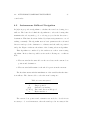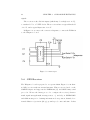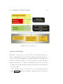
1
UNIVERSIDAD DE LAS PALMAS DE GRAN CANARIA
Máster Oficial en Sistemas Inteligentes y Aplicaciones Numéricas en
Ingenierı́a
Master Thesis
A-TIRMA: A small autonomous sailboat
Ángel Ramos de Miguel
Tutores:
Jorge Cabrera Gámez
Antonio Carlos Domı́nguez Brito
29 July 2013
Agradecimientos
A toda mi familia por todo el ánimo que me han dado en este trabajo, ası́
como en todos los aspectos de la vida. Por prestarme atención y entenderme
cada vez que les explicaba cualquier aspecto del proyecto.
Al todo los que trabajan en el instituto universitario de sistemas inteligentes y aplicaciones numéricas que me han hecho disfrutar de un año
adquiriendo conocimientos que seguramente utilice el resto de mi vida profesional.
Por supuesto a mis tutores D. Antonio Carlos Domı́nguez Brito por proponerme el proyecto y toda la ayuda prestada en todas las fases, y a D.
Jorge Cabrera Gámez por todas las horas, dı́as y meses que ha dedicado en
explicarme y ayudarme durante todas las fases del proyecto.
No puedo olvidar a los compañeros del equipo que han participado y
espero que participen durante mucho tiempo, a José Daniel Rodrı́guez Sosa
y a Bernardino Valle Fernández por las horas de diseño, debates de como
deberı́a comportarse el barco y las horas en la playa haciendo pruebas.
Por último a mi novia, por todas las horas que me ha esperado estando
yo en el laboratorio.
1
2
Abstract
This master thesis describes the development of the A-TIRMA, an autonomous sailboat based on an One Meter Class RC vessel. The A-Tirma
navigates autonomously with no human intervention except for establishing
the route it will follow. One of the distinctive features of sailing robots is
that they constitute really interesting operative platforms for monitoring
and data sampling in aquatic environments, mainly due to its low power
consumption requirements which allows them great operative autonomy. In
addition, in the case of A-TIRMA, it is also easily deployable due to its
small size and weight.
The control system of A-TIRMA consists of two main parts: a base station and the sailboat. From the base station (a notebook) we can command
straightly the sailboat’s sails and rudder remotely in RC (Remote Control)
mode using a wireless link. In autonomous mode, we can make the boat
to follow autonomously a route, which is a list of waypoints specified on a
Google Maps interface. The boat is endowed with an embedded on board
system, which, in autonomous mode, bases its operation in an autonomous
fuzzy-logic based navigation algorithm for controlling the boat’s sails and
rudder, in order to navigate autonomously following the route of waypoints
specified from the base station. During its development we have made intensive sea trials to check the operational capabilites of A-TIRMA and its
control system at sea, and its autonomy in terms of power consumption and
operative endurance.
3
4
Abstract
Chapter 1
Introduction
This master thesis is concerned with the development of unmanned vehicles
suitable for performing environmental monitoring and data sampling at sea.
The importance of the oceans in the overall health our planet Earth can’t
be underestimated. For a long time seas were considered vast spaces whose,
once thought, inexhaustible resources could be blindly exploited for fishing,
hunting, mining or even used for dangerous wastes disposal. Luckily, human
kind is now conscious about the importance that the health of the seas has
for the whole planet and its population.
The international scientific community has expressed clearly an repeatedly the necessity of improving the knowledge we have about the oceans.
Specifically, this knowledge is crucial to address the problem of global climate change as evidences continue to accumulate in that respect.
Three are the key problem associated with in situ data gathering at seas.
The first two are related to spatial and temporal data resolution. The other
one is cost. Until very recently, data could only be obtained from localized
points using moorings and buoys with very poor spatial resolution. Research
and opportunity vessels have been the other classical mean for sampling at
sea with good spatial and temporal resolution. However, the very high cost
of a research vessel normally limits the duration of campaigns and impedes
5
6
CHAPTER 1. INTRODUCTION
the acquisition of data series with the desirable temporal and spatial density.
1.1
Unmanned Marine Vehicles
The necessity of cutting costs of data gathering and sampling for longer
periods is pushing forward the development and utilization of unmanned
vehicles in oceanographic campaigns. Unmanned marine vehicles can be
broadly classified into two different categories: underwater vehicles and surface vehicles.
1.1.1
Underwater Vehicles
This category includes profilers, propelled underwater vehicles, also known
as AUVs, (Autonomous Underwater Vehicles), underwater gliders.
Profilers and floats are devices capable of traversing the column of water
regulating their buoyancy. They can only control its motion in depth and,
in the long term, they moved in the ocean carried away by marine currents.
Their power economy makes them very interesting instruments for long deployments. The ARGOS program [1] is perhaps the best known example of
a large scale program based on this kind of devices.
An AUV [2] is a propelled torpedo-shaped robot which travels underwater autonomously. Their range and payload capacity is basically limited by
its dimensions. Numerous examples of this kind of vehicles can be found on
[3]. AUVs are now being used for more and more tasks with roles and missions constantly evolving. Meaningful cases of use can be found in science
missions and commercial tasks in the oil and gas industries which use AUVs
to make detailed maps of the seafloor before start building a subsea infrastructure. Also in the military sector, AUVs are used routinely to perform
acoustic vigilance or to localize mines.
Underwater gliders [4] are a relatively new technology that is revolu-
1.1. UNMANNED MARINE VEHICLES
7
tionizing this field. They move by gravity, regulating their buoyancy, but
are normally equipped with wings that transform the vertical gravitational
force into forward motion. Due to this form of impulsion they move relatively
slowly, typically below 0.6 m/s, but their range autonomy is in the order of
thousands of kilometers. In practice this autonomy is limited nowadays by
biofouling and the power demands of the scientific instruments carried on
board.
1.1.2
Surface vehicles
The term ASV (Autonomous Surface Vehicle) refers to any vehicle that operates on the surface of the water without a crew. ASVs have been tested
since World War II and numerous examples exist of military vehicles of this
type, but it has not been until recently that ASVs have started to be considered for scientific missions.
ASVs are valuable in oceanography, as they are more capable than drifting buoys, but far cheaper than research vessels, and more flexible than
opportunity ship contributions [5].
We can find three different types of ASV depending on the source of
energy they use for impulsion.The widest class is that of motorized vehicles
power by electric motors or fuel engines. Another recent and revolutionary
type of vehicle is the wave-glider [6], a vehicle impulsed by sea waves. Finally,
there have been since ancient times vehicles that move impulsed by the wind,
that is, sailboats. The main advantage of these two lasta types of ASV have
over motorized ASVs is their virtually unlimited range autonomy. Wave
gliders’ main drawbacks is their limited payload capacity and relatively low
speed of 1 m/s.
Sailboats offer good payload capacity and, depending on sail dimensions,
8
CHAPTER 1. INTRODUCTION
Table 1.1: Oceanographic platform relative capabilities in normal operating conditions
(taken from [16]).
Vehicles
Manned Ship
Platform Specs.
Survey speed (m/s)
0-8
Survey time scale
Weeks
Cost ($USD)
10,000/day
Adaptive sampling
Yes
Max. 24h range (km)
600
Payload vol/weight 100m3 /500kg
Glider
Drifter
Sailboat
0-0.3
Months
60,000
Yes
25
0.1m3 /5 kg
0-0.3
Months
5,000
No
25
1m3 /25kg
0-2.5 1
Months
50,000
Yes
200
1m3 /50kg
are capable of larger speeds. The main disadvantage is their limited capacity
to surpass storm conditions unattended, at least with conventional sailboat
designs.
Table 1.1. taken from [16], summarizes the previous discussion on several
types of marine vehicles, comparing them across a number of characteristics.
1.2
Outline of This Thesis
This master thesis is committed with the design and implementation of an
autonomous low cost and low power sailboat. The main goal of the project
has been to transform a radio control sailboat into a complete autonomous
system. Through this document we will discuss its sensors and actuators,
describe the software on board and the implementation of a base station
application to communicate with the sailboat.
Extensive tests have been carried out in real conditions, concretely in
Alcaravaneras beach, in Las Palmas de Gran Canaria, Spain. Data collected
during those sea trials will be used to describe her control system and discus
her performance
1
Survey speed varies with specific design and weather conditions. The presented values
represent the range of current autonomous sailboats in an approximate sea state of 3 or
less.
Chapter 2
The vessel
The One Meter Class sailboat is a developmental class, which means that
there are very few design restrictions. The basic design restrictions include
overall hull length, keel depth and sail area. The hull can be self designed or
built from the scratch, and easily planked from wood or any other suitable
material. The structure of the class allows the designer/builder to experiment with a design, and then try it out on the water.
The design restrictions for the One Meter Class are the following:
1. LOA(Length Over All): 99-100 cm
2. Maximum Mast Height: 1.65 m
3. Maximum Mast Diameter: 1.90 cm
4. Rudder must be aft of keel fin.
5. Maximum Boom Diameters: 1.90 cm
The One Meter Class is light weight, very fast and responsive to the
controls. Two radio channels are required for control of sails and rudder.
The boat is easily disassembled and fits in a small size automobile for transportation.
9
10
CHAPTER 2. THE VESSEL
Figure 2.1: Sails physics
2.1
How Does A Sailboat Work?
The sailboats have been used since the Egyptians 5000 years ago [27]. The
sailing technology has changed a lot since then but the main idea remains
the same. The sails of a sailboat work like the wind of an aircraft, Figure 2.1.
The power to move the boat is produced by a pressure difference between
both sides of the sails, and this difference depends on the position of the
sails in relation to the direction of the wind.
Figure 2.2 shows different positions of the sails with respect to the wind.
For example, if the wind comes from the bow, we have to place the sails in
up wind position, if we do not set the sail on that position we will lose all
the power of the wind, and the sails will flutter. The sail positions might
work also like a brake, in order to make the sailboat reduce its velocity.
Fine sails regulation, i.e. how they are sheeted, strongly depends on wind
intensity. For example, when sailing close hauled with strong winds, placing
the sails in an optimum position may provoke over heeling, consequently
reducing boat’s velocity and even changing its bearing. Thus, depending on
2.2. SAILS
11
Figure 2.2: Sails Positions
wind direction, wind velocity and heeling we should place the sails and the
rudder in a way that we avoid that situation.
2.2
Sails
Sails are the most important part of a sailboat. They provide the large
potential autonomous sailboats have as high speed vehicles of virtually unlimited autonomy for environmental monitoring and sampling. Depending
on their net displacement and dimensions, they can accept scientific payloads, that maybe, are too large or too power demanding to be integrated
in other types of autonomous marine vehicles.
All in all, sails are the source of power of sail boats, and they have many
12
CHAPTER 2. THE VESSEL
Figure 2.3: Sail parts [28]
parts as we can see in Figure 2.3.
2.2.1
Sail Construction
Sails come in two general varieties of construction; single panel, where the
entire sail is one piece of cloth without seams, gores, or cuts in the body of
the sail; and paneled, where each sail is made up of panels or strips of cloth,
attached edge to edge with tapered seams to induce three dimensional shape
in the sail when filled with wind.
Single panel sails of a woven material are typically encountered in the
2.2. SAILS
13
construction of “kit” boats, because single panel sails are much less costly
for the kit maker to provide. The details of successful setting, trimming and
tuning of single panel sails is an entire subject in itself. Single panel sails
must be full of air, so that the cloth can stretch under the wind loading and
can begin to take on the cambered shape necessary for drive.
Paneled sails are used in a greater proportion in racing classes, and
also in scale models that are going to be operated on the water. They
provide superior performance because the airfoil shape that produces drive
for propelling the hull is built into the sail. Most use a membrane material
such as a mylar sandwich with load carrying fibers, or mylar film. These
modern materials do not stretch, so the cambered shape must be built into
the sail with tapered seams that hold the panels together.
We use single panel sails because they are less complicate to trim than the
paneled ones, and, in addition, with only one configuration we can navigate
in a variety of conditions.
2.2.2
Sail Attachment
A sail is attached to the spars by each of the three corners and by the luff
of the sail to either the mast or the jibstay. In the case of the jib, luffs are
fitted with a hem into which the jibstay slides. This supports the sail along
its length and makes for a smooth and clean entry where the wind meets
the sail. The luff hem method eliminates scalloping which can happen with
the tubes, and it distributes the wind load evenly over the entire luff. The
sail tubes provide for excellent swiveling as the sail tacks, but produce point
loads where they attach to the sail, and this can cause the sail to wear out
prematurely.
The head of the jib usually contains a grommet to which is attached
a halyard. For ease of adjustment, the halyard is fixed, usually up at the
jibstay attachment point. Tension is adjusted on the sail luff by use of a
14
CHAPTER 2. THE VESSEL
downhaul, which is tied to the tack grommet, led to the jib club, and back
about half way down the club to some sort of a tension adjustment like a
cleat, 3-hole bowsie,or other device. The clew is constrained in the vertical
direction by something as simple as a loop of sheet line tied through the
clew grommet and led under and around the club. A second line, called the
clew outhaul, leads aft to the end of the jib club, and provides for adjusting
the position of the clew along the club, controlling the fullness of the foot
and the bottom third of the jib. The corners of the mainsail are rigged in
the same way.
More details on model sailboat rigging techniques can be found on [28].
2.3
A-TIRMA Sailboat
The sailboat described in this master thesis has been named “A-TIRMA”, or
Autonomous-TIRMA, after the famous canary TIRMA sailboat [29]. This
vessel was built in 1910 in the shipyards of San Telmo, in Las Palmas de
Gran Canaria, Spain. It won its first race on October 25, 1911. One of its
most memorable achievements took place in 1960 when, under the command
of skipper D. Ventura Quevedo, managed to circumnavigate the island of
Gran Canaria in 27 hours and 8 minutes, beating the previous record at the
time. In November 10th 2000 it was rebuilt and nowadays it is exposed at
the building entrance of the Real Club Nautico of Gran Canaria.
A-TIRMA is based on a carbon fiber One Meter Class vessel with mainsail and jib displayed in Figure 2.4. It is equipped with two analog RC
servos, acting as actuators for rudder and sail sheets, that are powered from
a six NiMH rechargeable AA cell battery set with a capacity of approximately 20 Ah. The boat has been equipped with a custom-made wind vane
situated on the top of the mast for sensing the apparent wind direction, and
other electronics that will be described later.
Figure 2.5 details the dimensions of the sailboat. The most important
2.3. A-TIRMA SAILBOAT
15
Figure 2.4: Our sailboat
dimensions of the vessel are:
LOA
100 cm
Beam
24.5 cm
Draft
14 cm
Sail Area
0.61 m2
Displacement
4.3 kg
Mast Height
1.6 m
16
CHAPTER 2. THE VESSEL
Figure 2.5: Sailboat dimensions
Chapter 3
State of Art
This chapter is dedicated to review the evolution of the technical developments in sailing. The historical antecedents of robotic sailing date back to
the automatization of the rudder control and the utilization of self-steering
mechanisms, but continue nowadays with the recent appearance of kitebased proposals to use the wind to propel high-tonnage vessels with fuel
cost reductions of up to 20% [8]
3.1
Self-Steering Gear
The first task to be automated was the rudder control [9] which is also referred to as autopilot. Self-steering gears can be divided on mechanical or
electronic solutions.
3.1.1
Mechanical Self-Steering
The first approach to a mechanical self-steering system was a solution created by fishermen who set the rudder of their boat to a fixed position.
17
18
CHAPTER 3. STATE OF ART
Then Herbert Hasler designed a more sophisticated mechanical solution,
the wind vane, an example is shown in Figure 3.1. It basically consists of
a wind vane which is connected to the rudder, and when the angle of the
apparent wind changes, the wind vane detects the change and activates the
steering device to return the boat to the selected course.
Figure 3.1: Wind Vane [18]
3.1.2
Electronic Self-Steering
Electronic self-steering controls the rudder position based on various sensors
data. This system needs a compass, a wind direction sensor and additionally
a GPS receiver. The major contribution to the development of a self-steering
system was made by Sperry Gyroscope Company in 1911 [21]. This system
compensated for varying sea states using a feedback control and automatic
gain adjustments.
3.2. AUTOMATIC SAIL CONTROL
19
Nicholas Minorsky did a contributions to autonomous ship steering, he
presented a detailed analysis of a position feedback control. He formulated the specification of a proportional-integral-derivative (PID) controller
in [22]. But this type of controller has two disadvantages:
1. It is difficult to adjust it manually, because the operator usually does
not have enough insight about control theory.
2. The optimal adjustment varies depending on the situation. Changing
circumstances require readjustment of settings.
Due to the dynamic and ever-changing environment, artificial intelligence
and fuzzy logic has been studied for rudder control. Various publications
have shown the suitability of fuzzy logic for rudder control and also for sail
control [23]. Polkinghorne et al. [24] did a comparison between a conventional PID and a fuzzy logic controller. The experiments shown a much
smoother rudder action for the fuzzy logic controlled rudder.
3.2
Automatic Sail Control
Most sail control strategies published for autonomous sailboats are based
on measuring the apparent wind. Many of them have virtually an infinite
number of sail positions, when the system sets a sail position, the real position depends of the resolution of the actuator. Some researchers use only
10 discrete positions on their system, MOOP (University of Aberystwyth,
UK) [25], to avoid permanent switching between adjacent positions to save
20
CHAPTER 3. STATE OF ART
power on the sail actuators [26].
There is another method described by Stelzer et al. [23] which does not
calculate directly the sail positions using wind data. It first calculates the
desired heeling of the sailboat, and then a feedback-loop implemented as a
Mamdani type fuzzy inference system controls the sail positions to reach the
desired heeling of the boat.
3.3
Recent Technical Innovations
Sailing is an ancillary art but still in constant evolution. Every year international sailing races are used to announce new, sometimes radical, technical
innovations based on new designs, exotic materials or CFD results, all them
aimed at achieving faster vessels.
Autonomous sailboats may, of course, benefit from these technological
advances but the goals that drive the development in this field of robotics
are completely different. Here, much more important than speed are issues
like robustness, seaworthiness and energetic efficiency. In this section we will
briefly review some ideas and technological innovations that are nowadays
of interest for autonomous sailboats.
Rig innovations. Rigid wind sails and balanced rigs [10] are two of the
innovations that have been experimented recently on autonomous sailboats.
Wind sails are rigid sails that have been used in some designs developed at
Aberystwyth. They are robust yet light sail designs whose wing-like profile
is promoted as aerodynamically more efficient that the classical soft sails.
On the downside, rigid sails demand a careful and expensive design based
on high tech materials, they can not be reefed and are considered fragile
3.3. RECENT TECHNICAL INNOVATIONS
21
under bad weather conditions. On the other hand, the balanced rig is self
tacking, reduces mechanical loads on the rig and, overall, can be more energy efficient than an equivalent sloop rig[11].
Figure 3.2: Balanced rig concept [10]
Flexible hull. Protei [12] is an international volunteer-based organization that is designing a new concept of sailboat that can be applied on
autonomous cleaning of oil spills. In this kind of application, the boat must
tow a large floating structure designed to absorb the oil at surface. This
structure renders useless the classical stern rudder to head the boat. To
deal with this basic problem, a flexible shape-shifting hull has been proposed by the Protei team. According to the authors, its benefits are:
22
CHAPTER 3. STATE OF ART
• Better trajectory control, greater ”pulling capacity”.
• Better maneuvering, smaller radius of turning, dynamic stability.
• Lateral lift (due to curved hull profile, at high speed).
• Less resistance and turbulences (no centerboard, no rudder), compensating environmental noise with flexible body.
Figure 3.3: Protei, a shape-shifting hull sailboat [?]
Energy saving: Most of the energy consumed at a sailboat is used in
sheeting sails and, in general, energy-aware control systems do not adjust
the sails except when necessary. A good example of this approach taken
to the extreme, that is, no sail actuator is used, is Sailbuoy [15]. In this
2m boat the wing sail is free to swing from side to side following the wind
and its angle is not regulated. Accordingly, no wind sensor exists on board.
Sailbuoy is also remarkable because it is - to our knowledge - the only commercial product in this ambit, designed to act as a surface sampling vehicle.
3.4. AUTONOMOUS SAILBOAT COMPETITIONS
23
Figure 3.4: Sailbuoy [15]
3.4
Autonomous Sailboat Competitions
Two international competitions, Sailbot [13] in North America, and the
World Robotic Sailing Championship [14] in Europe, are common meeting
forums for researchers and students working this field.
It is beyond the scope of this document to extensively review all sailboats that have participated on this competitions and that information can
be obtained from the competitions’ web sites. The following tables just provide some examples of autonomous sailboats that have taken part in the
last editions of the World Robotics Sailing Championship [46] to provide
the reader a summary on the main characteristics of the boats.
24
CHAPTER 3. STATE OF ART
Table 3.1: FAST - University of Porto (FEUP)
Team: FAST - University of Porto (FEUP) and INESC TEC
Location: Porto, Portugal
Class: Microtransat
Length: 2.5 m
Displacement: 60 kg
Draft: 1.25 m
Beam: 0.67 m
Hull Type: Based on a scaled down version of a Class 40 hull.
Sensors and Computers: FPGA-based computer running Linux
Power Systems: 190 W/h of Lithium Ion batteries and 45 W
peak of photovoltaic solar panels.
Figure 3.5: FASt - FEUP
3.4. AUTONOMOUS SAILBOAT COMPETITIONS
25
Table 3.2: BeagleB - Aberystwyth University
Team: Department of Computer Science, Aberystwyth University
Location: Aberystwyth, Wales, UK
Class: Microtransat
Length: 3.65 m
Displacement: 280 kg
Draft: 0.65 m
Beam: 0.86 m
Hull Type: Based on a Mini-J disabled sailors dinghy hull.
Sail Type: 2 square metre carbon fibre wing sail.
Sensors and Computers: GPS, Fluxgate Compass, Ultrasonic
windsensor, Gumstix Single Board Computer
Power Systems: 2.8 KW/h of lead acid batteries and 90 W peak
of photovoltaic solar panels˙ Communications: Wifi, Iridium Satellite
Modem, optional GSM.
Figure 3.6: Beagle - Aberystwyth
26
CHAPTER 3. STATE OF ART
Table 3.3: Gill the Boat - US Naval Academy
Team: US Naval Academy
Location: Annapolis, Maryland, USA
Class: Sailbot
Length: 2 m
Displacement: 25 kg
Draft: 1.5 m
Beam: 0.6 m
Hull Type: Custom designed hull built for the SailBot class.
Sail Type: Bermudan style fabric mainsail and jib.
Sensors and Computers: Rabbit controller mounted on a in-house
designed and built board that includes a GPS receiver. Relative wind
is measured by an optical encoder and she has a working ultrasonic
collision avoidance system.
Other notes: She was wholly designed, built and is operated by the
midshipmen of the United States Naval Academy. She has reached
speeds of over 6 knots and has taken voyages up to 21 nautical miles.
Figure 3.7: Gill The Boat - USNA
3.4. AUTONOMOUS SAILBOAT COMPETITIONS
27
Table 3.4: Avalon - Swiss Federal Institute of Technology Zurich (ETH)
Team: Swiss Federal Institute of Technology Zurich
Location: Rämistrasse, Zürich, Swiss
Class: Microtransat
Length: 3.95 m
Hull Type: A monohull design.
Sensors and Computers: The control system is implemented on a
MPC2120 industrial computer running Linux.
Power Systems: The power supply is realized with four solar panels
of 90 Wp, four lithium-manganese batteries of 600 Wh each and a
direct-methanol fuel cell for back-up power.
Figure 3.8: Avalon - Swiss Federal Institute of Technology Zurich (ETH)
28
CHAPTER 3. STATE OF ART
Table 3.5: Roboat I - Austrian Society for Innovative Computer Sciences (INNOC)
Team: Austrian Society for Innovative Computer Sciences
Location: Viena, Austria, Europe
Class: Microtransat
Length: 1.38 m
Height: 1.73 m
Displacement: 17.5 kg
Hull Type: Based on yacht model of type Robbe Atlantis.
Sensors and Computers: The boat is equiped with a 800 MHz PC
running Linux, a GPS receiver, a tilt-compensated electronic compass
and sensors for wind speed and wind direction.
Power Systems: It is equipped with solar panels providing up to 285 Wp
of power during conditions of full sun and a direct methanol fuel cell delivering
65 W as a backup energy source.
Communication Systems: WLAN, UMTS/GPRS and an IRIDIUM
satellite communication system.
Figure 3.9: Roboat I - Austrian Society for Innovative Computer Sciences (INNOC)
3.4. AUTONOMOUS SAILBOAT COMPETITIONS
29
Table 3.6: VAIMOS - École Nationale Supérieure de Techniques Avancées Bretagne
(ENSA)
Team: École Nationale Supérieure de Techniques Avancées Bretagne
Location: Bretagne, Berst cedex, France, Europe
Class: Microtransat
Length: 3.65 m
Hull Type: Based on yacht model of type Robbe Atlantis.
Sensors and Computers: A Linux-based embedded computer,
a weather station (that measures the wind speed and direction as
well as GPS position), an AHRS (Altitude and Heading Reference System),
a Iridium communication system and actuators for sail and rudder control.
Figure 3.10: VAIMOS - École Nationale Supérieure de Techniques Avancées Bretagne
(ENSA)
30
CHAPTER 3. STATE OF ART
3.5
Field Applications
Autonomous sailboats are silent vessel with a virtually unlimited operational
range, restricted only by wind and sea conditions, that may host large payloads and measure atmospheric and ocean parameters simultaneously. All
these features confer them an enormous potential to serve as sampling and
monitoring marine vehicles.
All in all, the field has still to mature and produce reliable and robust designs, capable of dealing with hard conditions at sea on their own
means. Regardless of this state of affairs, field applications developed with
autonomous sailboats have been published. Here we summarize some of
them:
• Acoustic mapping and cetacean tracking. Recently, the INNOC’s ROBOAT sailboat has been used to acoustically track cetaceans
in the Baltic Sea [19] under strong sea conditions.
• Water quality sampling measurements. Rynne and von Ellenrieder [17] have described the development of the Wasp, a 4.2m monohull keelboat with wing sail, and its application in seawater quality
control.
Chapter 4
Navigation And Control
This master thesis has focused on the development of the low level control of
the rudder and sails and a bearing selection algorithm, i.e. the determination
of the optimal bearing to navigate the sailboat to a destination taking into
account the wind direction. This work has been based on two influential and
recognized articles of the field: ”Fuzzy logic control system for autonomous
sailboats” [23] and ”Autonomous sailboat navigation for short course racing”
[30]. These papers have been reviewed in the recent PhD thesis of Roland
Stelzner[20]
The first paper, ”Fuzzy logic control system for autonomous sailboats”[23],
describe how to transform the sailors knowledge into a Mamdani-type fuzzy
system, to control a sailboat with two actuators, rudder and sails. It provides the low level sailboat controller.
The second paper, ”Autonomous sailboat navigation for short course
racing”[30], proposes a method to select the optimal bearing to reach a
destination given the true wind direction and the current sailboat position
and heading. This will provide a second control level for the sailboat.
31
32
4.1
CHAPTER 4. NAVIGATION AND CONTROL
Low Level Control
The authors of this article [23] propose an algorithm to control the rudder
and sails of a sailboat. The paper describes a fuzzy logic system to manage
the control surfaces of the vessel (sails and rudder) like a sailor would do.
It is described a fuzzy method to control the rudder that takes into account
the difference between the sailboat bearing and the desired bearing, and also
the angular velocity of the sailboat to avoid oversteering.
Figure 4.1: Fuzzy rudder position [23]
4.1. LOW LEVEL CONTROL
33
On the illustrations shown in Figure 4.1 shows the fuzzy sets for the
different sails positions. Where, on the first fuzzy set, we see the difference
between the actual bearing and the desired bearing. On the second we can
see the angular velocity in degrees per second, positive if the sailboat is
turning to the right side (starboard) or clockwise and negative on the left
side (port) of the sailboat or anticlockwise. On the third one, the different
positions of the rudder appear. Finally, on the last illustration we have the
fuzzy rules applied to set the rudder to a given position depending on the
current bearing and the desired bearing, and the turning rate.
For controlling the sails the authors propose to use a function 4.2 that,
given a wind direction and a wind speed, returns the optimum heeling.
Finally, the heeling angle if fixed adjusting sails sheeting, Figure 4.3.
Figure 4.2: Desired heeling function [23]
34
CHAPTER 4. NAVIGATION AND CONTROL
The optimal heeling function depends on the variables detailed on Table
4.1.
Table 4.1: Variable meaning
hmax
v
vmax
α
k
Maximum heeling of the sailboat.
Actual velocity of the sailboat.
Maximum velocity of the sailboat.
Wind direction.
boat specific constant determined by experiments.
Figure 4.3: Fuzzy sails [23]
The fuzzy sets included in Figure 4.3 define the vocabulary for the desired
heeling. Using the values given by the function shown in Figure 4.2, the
actual heeling of the sailboat is subtracted to the desired heeling, and the
difference is used to calculate the new sails position with the fuzzy sails
4.2. AUTONOMOUS SAILBOAT NAVIGATION
35
control rules.
4.2
Autonomous Sailboat Navigation
In [30] it is proposed an algorithm to calculate the next best bearing for a
sailboat. The basic idea behind the algorithm is to select the bearing that
maximizes the velocity made good or velocity projected in the direction to
destination. This basic idea is modulated by a hysteresis parameter to avoid
tacking constantly. The algorithm uses as basic parameters the real wind
direction and speed, the destination coordinates and the sailboat position
and polar. Figure 4.4 shows a flowchart of the bearing selection algorithm.
This algorithm is considered by the authors as a short term routing
algorithm. In fact, that is possible as far as the following two conditions
hold:
• The true wind is the same all over the area between the current boat
position and destination.
• The true wind will remain for the whole leg as it is in the moment.
The flowchart starts with the initialization of the variables that the function will use. The data needed to select the next bearing are:
Table 4.2: Flowchart symbols
B
T
ϕ(vb )
ϕ(−Wabs )
n
Current boat position
Target position
Current boat heading
True wind direction and speed
Hysteresis factor
The current boat position and orientation are needed to decide if it is
necessary to do a tack maneuver, then the wind speed it necessary if the
36
CHAPTER 4. NAVIGATION AND CONTROL
Figure 4.4: Bearing selection algorithm [30]
4.2. AUTONOMOUS SAILBOAT NAVIGATION
37
polar diagram of the boat it significantly non-linear and finally we need the
true wind direction.
When the function has initialized all the variables, it calculates the best
bearing to the target by the right side and then by the left side. To calculates
de best direction, the function calculates the projected velocity to the target.
If the selected direction gives a faster velocity to the target, we update the
new direction and then we test with other direction.
Now we have the best bearing by the right side and the left side. The
function will return the closer bearing to current direction to minimize the
tack maneuvers.
38
CHAPTER 4. NAVIGATION AND CONTROL
Chapter 5
Onboard Electronics
The vessel’s electronics is made up of the following main components:
1. An 8-bit microcontroller board
2. A XBee PRO 868MHz RF module
3. A GPS receiver
4. An electronic compass with inclinometers
5. A wind vane
6. A current sensor
5.1
System Hardware
The sailboat controller hardware is based on a Waspmote V1.1. It is a
commercial credit-card size board based on a microcontroller ATmega1281
running at 8MHz. The microcontroller integrates 8KB of SRAM for data,
128 KB of FLASH program memory for program code and a 4 KB EEPROM
[31]. The board provides several UARTs, an I2 C bus, a micro SD card reader,
a real-time clock, a three-axis accelerometer and several other sensors for
measuring, for example, the board temperature or the battery level.
39
40
CHAPTER 5. ONBOARD ELECTRONICS
This board is prepared to accept external hardware modules like a GPS
receiver, a GSM/GPRS modem or different XBee RF communication modules. It is powered from a 3.7V 6000 mAh Li-Ion battery and consumes 9
mA under normal operating conditions. Suitable photovoltaic panels can be
connected directly to the board to recharge the main battery.
5.1.1
Waspmote
The Waspmote board is an embedded system inspired in the microcontroller
based electronic prototyping platform Arduino [32], but, Waspmote gives us
more sensors and sockets in only one board. Its hardware architecture is
modular in a way that, we can add or remove off-the-shelf hardware modules
easily to the device.
The modules available for integration in Waspmote can be categorized
in:
• ZigBee:/802.15.4 modules (2.4GHz, 868MHz,
900MHz).
• GSM - 3G/GPRS module (Quadband: 850MHz/
900MHz/1800MHz/1900MHz)
• GPS module
• Several sensor modules (sensor boards)
• Storage Module: micro SD Memory Card
• Photovoltaic solar panels
Figures 5.1 and 5.2 show the main components and sockets available for
connecting external devices and power sources.
5.1. SYSTEM HARDWARE
Figure 5.1: Waspmote board V1.1 – Top side
Figure 5.2: Waspmote board V1.1 – Bottom side
41
42
CHAPTER 5. ONBOARD ELECTRONICS
5.1.2
Electrical Characteristics
The electrical characteristics of the Waspmote board are detailed in the
following list:
Operational values
- Minimum operational battery voltage
3.3V
- Maximum operational battery voltage
4.2V
- USB charging voltage
5V
- Solar panel charging voltage
6-12V
- Battery charging current from USB 100 mA (max)
100mA
- Battery charging current from solar panel
280mA
- Button battery voltage
3V
Absolute maximum values
- Voltage in any pin
[-0.5 V, +3.8 V]
- Maximum current from any digital I/O pin
40mA
- USB power voltage
7V
- Solar panel power voltage
18V
- Charged battery voltage
4.2V
As we can see, we must to be careful with all the modules that we connect
to the Waspmote, because we should not exceed the maximum current and
voltage.
5.1.3
Input/Output
A Waspmote may communicate with other external devices, that it is possible because the board has many input/output pins as we can see in Figure
5.3. The board is provided with digital input/output pins, analog inputs,
PWM and power outputs, SPI, I2 C and UART interfaces, etc. This is one
of the most important features for us, because we have to control servos,
read analog sensors and communicate with sensors like GPS or compass over
5.1. SYSTEM HARDWARE
43
Figure 5.3: Waspmote pinout
serial interfaces.
5.1.4
Working Environment
To develop software for the waspmotes we have used the Waspmote IDE
[31] which is based on the open source IDE for the Arduino platform [32],
following the same style of libraries and operation. It includes all the API
libraries necessary to compile the programs.
As we can see in Figure 5.4 the Waspmote-IDE has a code editor, an
area for messages, a terminal, a toolbar with buttons for the main functions
and a menu. Program loading on the Waspmote is carried out using a serial
connection over an USB port .
In Figure 5.5 we can see the toolbar of buttons where we have the most
important functions of the IDE. The next list describes the functionality
associated to each button.
• Verify/Compile. Verifies the code and compile it.
• Stop. Stops the compilation.
44
CHAPTER 5. ONBOARD ELECTRONICS
Figure 5.4: Waspmote IDE
Figure 5.5: Waspmote IDE - Buttons
5.1. SYSTEM HARDWARE
45
• New. Creates a new sketch.
• Open. Opens a menu to find a sketch and open it.
• Save. Saves the changes of current sketch we are editing.
• Upload to Waspmote board. Compiles the code and upload it to the
Waspmote board.
• Serial Monitor. Starts the Waspmote’s serial console.
5.1.5
Over The Air Programming (OTAP)
The concept of Over The Air Programming [33] or OTAP is commonly used
in the scope of sensor networks for denoting the possibility of programming
a sensor node wirelessly. In this project this capability has alleviated the
hassle of having to open the deck to access to the inner of the vessel, and
to extract the plastic container that hosts the Waspmote, just to connect a
USB cable every time a new firmware had to be uploaded to the sailboat.
The OTAP process involves the following steps:
• Locate the node to upgrade
• Check current software version
• Send the new program
• Store the new program on the SD card
• Reboot and start with the new program
• Restore the previous program if the process fails
More details on the OTAP process can be found in Libelium’s OTAP
manual [33].
46
CHAPTER 5. ONBOARD ELECTRONICS
5.2
RF Radio Module
We have based all communications with the sailboat on XBee 868 Pro RF
modules, Figure 5.7. These modules operate at the 868 MHz ISM band
using only one channel. The bandwidth is 24 Kbps and the communications
can be encrypted. The nominal range using a 4.5 dB dipolar antena in a
free field is 40 km, but more realistic estimations are in the range of 10 km.
It is possible to adapt the transmission power in five levels from 1 mW till
a maximum of 315 mW. It works at 3.3 V and its current consumption is
500 mA in transmission and 65 mA in reception [34].
Figure 5.6: XBee Module
The position of the antenna on the sailboat is very important to have a
good communication with the station base. We first placed it on the mast,
but with that configuration the aluminum mast blocked the reception in
some courses impeding the communication with the sailboat. After some
testing, we found that the antenna could be fixed to the backstay, without
disturbing the wind vane using a deformable support, with good results.
5.3. ELECTRONIC COMPASS
47
Figure 5.7: The 868 MHz 0dBi antenna in its final placement
5.3
Electronic Compass
The electronic compass is a legacy TCM2.50 board [35]. Basically, it provides tilt-compensated heading information and instantaneous pitch and
roll angles over a RS232 interface. The board temperature and raw readings
from three magnetometers can be also obtained. The compass readings are
tilt and roll compensated till 50 degrees. The TCM2.50 can not operate for
heeling or pitching angles over that limit. The TCM2.50 has a maximum
update rate of 20Hz. It is powered at 5 V and consumes 20 mA.
This board is connected to one of the microcontroller TTL serial ports
using a simple level converter circuit based on a MAX3232 integrated circuit
(IC).
The MAX3232 [36] is an IC, first created by Maxim Integrated Products,
that converts signals from a RS-232 serial port to signals suitable for use
in TTL compatible digital logic circuits and vice versa. The MAX3232 is
a dual driver/receiver and typically converts the RX, TX, CTS and RTS
48
CHAPTER 5. ONBOARD ELECTRONICS
signals.
The receivers reduce RS-232 inputs (which may be as high as ± 25 V),
to standard 5 V to 3 V TTL levels. These receivers have a typical threshold
of 1.3 V, and a typical hysteresis of 0.5 V.
In Figure 5.8, we can see the connection diagram, to connect the TCM2.50
to the Waspmote board.
Figure 5.8: TCM adapter
5.4
GPS Receiver
The Waspmote board is prepared to accept an A1084, Figure 5.9, 20 channel GPS receiver with an external antenna. This receiver is based on the
SiRF III chipset and supports the NMEA0183 [37] and SiRF binary serial
protocols. We use the binary protocol to configure the receiver (elevation
mask, signal strength mask, messages rates, ...) and rely on NMEA RMC
and GGA messages for obtaining information about position, altitude, horizontal dilution of precision (hdop), ground speed, course and time. It has
5.4. GPS RECEIVER
49
a nominal accuracy of less than 10 meters. However, in our tests at sea,
imposing elevation and signal strength masks, the accuracy has been quite
stable and typically better that 3 meters. It is powered by the on board 3.3
V regulators and consumes 26 mA [38].
In the Table 5.1 we can see the main characteristics of the GPS system.
Table 5.1: GPS receiver features
-Model
-Movement sensitivity
-Acquisition sensitivity
-Hot Start time
-Warm Start Time
-Cold Start Time
-Antenna connector
-External Antenna
A1084 (Vincotech)
-159dBm
-142dBm
<1s
<32s
<35s
UFL
26dBi
Figure 5.9: GPS receiver and external antenna
50
5.5
CHAPTER 5. ONBOARD ELECTRONICS
Wind Vane
The wind vane has been custom built from an Optimist wind vane attached
to a US Digital’s MA3 miniature absolute magnetic encoder [39] which is
shown in Figure 5.10. The encoder is installed in an aluminum enclosure
with a floating cap on top of the mast and connected to one of the analog
inputs of the microcontroller, Figure 5.11. It allows to detect the direction
of the apparent wind but not its speed. It works at 5 V and consumes 16
mA.
Figure 5.10: MA3 absolute angular encoder
Figure 5.11: Home-made wind vane
5.6. CURRENT SENSOR
5.6
51
Current Sensor
The current consumption at the actuator that control the sails’ sheets is
measured by means of an ACS712 board, Figure 5.12, [40]. The instantaneous current consumption is read as a voltage at a microcontroller’s analog
input. The ACS712 board integrates two potentiometers to adjust the intensity range being sensed and the acceptable levels of output voltage. This
reading is used as an indirect measure of wind pressure in the sails. It is
powered from 5 V and consumes 7 mA.
Figure 5.12: ACS712
5.7
Power Demands
A summary of power demands of the main components of the system, along
with the capacity of both batteries, is detailed in Table 5.2.
52
CHAPTER 5. ONBOARD ELECTRONICS
Table 5.2: Power demands of system components.
Component
Volt(V)
Current(mA) Power(mW)
Microcontroller
3.3
9
29.7
GPS
3.3
26
85.8
XBee 868 PRO
3.3
65-500
∼ 330
TCM2.50
5
20
100
MA3 encoder
5
16
80
ACS712 board
5
7
35
Electronics Total
660.5
Electronics battery 3.7V - 6000mAh 22200 mWh
Component
Volt(V)
Current(mA)
Power(mW)
Rudder servo
5
10-500
∼ 100
Sail winch
5
10-800
∼ 500
Actuators Total
600
7.4V - 2700 mAh
19980 mWh
Actuators battery
Chapter 6
Control System
The system consists of two main parts: a base station, and a sailboat. The
base station is a laptop equipped with a XBee USB adapter board used to
communicate with the microcontroller onboard the sailboat over a 868 MHz
RF link. On the sailbot, an onboard system treats the received data and
commands the sailboat to reach the waypoints.
Both systems communicate regularly at a predefined but modifiable frequency. Using this radio link, the vessel can be monitored and controlled
from the base station.
6.1
Base Station
The base station is a Linux application with a Qt [41] front end that relies
on the libXBee [42] library to support the radio communications using XBee
radio modules. Through the graphical user interface (GUI), just by clicking on a Google map (see Figure 6.1), it is possible to add, edit or delete
sequences of waypoints to define a route for the sailboat.
The interface displays the telemetry data received from the sailboat with
information about sailboat’s state parameters, like bearing, speed or position, along with sensor readings. It is also possible to modify from the base
53
54
CHAPTER 6. CONTROL SYSTEM
station some thresholds and parameters, like the frequency at which the
telemetry packets are remitted or the minimum frequency at which the bearing selection function must be invoked. This capability has demonstrated
its usefulness during sea trials.
The application can switch between autonomous or RC control modes.
In this last control mode, a wireless game pad is used to control the rudder
and the sails.
Figure 6.1: Base Station GUI
6.1. BASE STATION
6.1.1
55
Base Station Hardware
To use the base station application we need a XBee gateway and a wireless
game pad to communicate with the sailboat and to command the boat in
RC control mode. As XBee gateway we have selected the one provided with
the Waspmote.
Figure 6.2: XBee gateway
The selected wireless game pad was a Logitech WingMan Cordless.
56
CHAPTER 6. CONTROL SYSTEM
Figure 6.3: Logitech WingMan Cordless
6.1.2
Software Architecture
The application receives and transmits information to the sailboat by means
of the XBee gateway. Depending of the mode selected by the user, the
application transmits different information to the sailboat. If the application
is in RC control mode, every 500 milliseconds it transmits to the sailboat
the commanded position of rudder and sails, but if it is in autonomous mode
the base station resends the Home coordinates and some other parameters
described on Table 6.2 every 2,5 seconds.
Depending on the working mode of the application, namely, RC control
or autonomous mode, the system goes through the following stages:
• Initialize.
• Close.
• Update widget.
• Edit the waypoints list.
• Send command to sailboat.
6.1. BASE STATION
57
This application uses the libXBee and the Sample Directmedia Layer
library to support, respectively, the radio communications and the wireless
game pad.
libXBee v1
LibXBee [42] is a C/C++ library that simplifies the usage of Digi XBee
radios. It provides a friendly interface for creating connections, and sending
and receiving data packets. Eventhough, this library is now in version 3,
we have kept using version 1 because versions 2 and 3 were not backwards
compatible. It is planned to update the base station software to the most
recent version of this library.
Sample Directmedia Layer (SDL)
The Simple DirectMedia Layer [43] is a cross-platform multimedia library
designed to provide low level access to audio, keyboard, mouse, joystick,
3D hardware via OpenGL, and 2D video framebuffer. It is used by MPEG
playback software, emulators and many popular games.
SDL supports Linux, Windows, Windows CE, BeOS, MacOS, Mac OS
X, FreeBSD, NetBSD, OpenBSD, BSD/OS, Solaris, IRIX, and QNX. The
code contains support for AmigaOS, Dreamcast, Atari, AIX, OSF/Tru64,
RISC OS, SymbianOS, and OS/2, but these are not officially supported.
SDL is written in C, but works with C++ natively, and has bindings
to several other languages, including Ada, D, Eiffel, Erlang, Euphoria, Go,
Guile, Haskell, Java, Lisp, Lua, ML, Oberon/Component Pascal, Objective
C, Pascal, Perl, PHP, Pike, Pliant, Python, Ruby, Smalltalk, and Tcl.
SDL is distributed under GNU LGPL version 2. This license allows
you to use SDL freely in commercial programs as long as you link with the
dynamic library.
In the sequel we detail the different stages of the Base Station operation.
58
CHAPTER 6. CONTROL SYSTEM
6.1.3
Initialize
The initialization of the system it is done by M ainW indow :: M ainW indow(
QW idget ∗ parent). This part of the application initializes the variables,
starts the timers to update the widgets and send the commands, connects
to the XBee module, starts the background thread that controls the wireless
game pad and at the end it loads the Google map corresponding to the area
of interest.
Firstly, the timers are configured to send data to the sailboat every 500
milliseconds and to update the widgets every 100 milliseconds. Then, the
XBee radio is initialized and the function to connect to the XBee gateway
is invoked, indicating the USB port where the gateway is connected.
The control of the wireless game pad is carried out with a background
thread, using the QT class QFuture to start and check the wireless game
pad.
At the end of the initialization phase, we load the html file, map.html,
that controls the Google map and waypoints interface.
6.1.4
Close
The function M ainW indow :: M ainW indow() stops the thread that controls the wireless game pad and the XBee communications, when the user
closes the application.
6.1.5
Update Widget
The procedure voidM ainW indow :: updateW idget(), every 100 milliseconds, checks if we have received any data packet from the sailboat.
First, it checks if we have received any packet from the sailboat during
the last 15 seconds. If that is not the case, it changes in the interface to
red the color of the connection state, and changes also the control mode
to autonomous, because, on board, the sailboat changes automatically to
6.1. BASE STATION
59
autonomous mode and activates the Return To Home behavior in these
circumstances. If this is the case, the application also updates the LED
light that shows on the GUI if the vessel is in autonomous or in RC control
mode.
When a packet is received, the application displays the content of the
message on the text browser and parses it to extract the data or interpret
the message.
Received messages can be GPS connection message, a summary of the
state of the sensors onboard or a confirmation reply to a new waypoint
previously sent.
Telemetry messages are sent from the sailboat routinely. They contain
a summary of on board’s sensors readings and follow the following format:
dxxCxxP xxRxxT xxW xxXxxY xxZxxwxxsxxN xxGxxV xx
In Table 6.1 the meaning of the fields of the formate of telemetry packets
is clarified.
To display the actual position of the sailboat, we call the showN ewM arker()
function which, along with the evaluateJavaScript() function, allows us to
send javascript commands from QT to a javascript code in a html file.
Finally, the application checks if the user has introduced a new waypoint
in the map, and in that case, the new waypoint’s coordinates are sent to
the sailboat using sendXbee(). Every time waypoints are updated, the
Base Station recalculates the distances between consecutive waypoints and
updates the GUI with the new distances.
60
CHAPTER 6. CONTROL SYSTEM
Table 6.1: Format of telemetry messages
[d|D]xx
Cxx
Pxx
Rxx
Txx
Wxx
Xxx
Yxx
Zxx
wxx
sxx
Nxx
Gxx
Vxx
6.1.6
If it is in capital letters it means that the
boat its in autonomous mode, and xx indicates the duration of the previous cycle
in milliseconds.
Indicates the compass value.
Indicates the pitch value.
Indicates the roll value.
Indicates the temperature value.
Indicates the apparent wind position.
Indicates X accelerometer value.
Indicates Y accelerometer value.
Indicates Z accelerometer value.
Indicates Waspmote battery value.
Indicates servos battery value.
Indicates the index of the actual waypoint.
Indicates the desired bearing.
Indicates the temperature of the XBee radio module in Celsius degrees.
Editing The List Of Waypoints
The user has the possibility of performing some operations over the list of
waypoints. It is possible to:
• Add
• Reorder
• Delete
• Resend
To add a new waypoint the user has to click on a place in the map where
he or she wants to add the new waypoint. The map.html file will register
the point and when updateW idget() asks for new waypoint it will return
the new point that will be sent to the sailboat.
6.1. BASE STATION
61
The user can also reorder the list of waypoints doing click on Up or Down
buttons, and the system will instruct the sailboat controller to reflect also
the new arrangement of waypoints.
To delete a waypoint, the user has to select it and click on delete and
the system will send the command to the sailboat to delete the waypoint.
If we want to resend a waypoint, we have to select it by clicking on it
in the waypoints list and it will be resent to the sailboat. This it is useful
because if there were any connection problem, it gives us the possibility to
resend the waypoints that have not been acknowledged from the sailboat.
Next sections describe the commands that can be sent to the sailboat
from the Base Station.
All the commands related with waypoints we will be detailed in the next
section.
6.1.7
Messages Sent To The Sailboat
There are two different commands that can be sent to the sailboat, autonomous mode command or RC control mode command. These commands
are prepared in voidM ainW indow :: sendCommBoat().
Autonomous mode command
The format of autonomous mode command messages is:
W xxLxxM xxAxxExxN xxCxx
Not all fields need to be set on the message, thus the format of this type
of messages is flexible. Basically, it is used to fix a waypoint,command the
sailboat to transit into autonomous mode, set some operational frequencies
or combinations of these. The meaning of the fields are defined in table 6.2.
62
CHAPTER 6. CONTROL SYSTEM
Table 6.2: Format of an autonomous mode message
Wxx
Lxx
Mxx
Axx
Exx
Nxx
Cxx
Indicates that this is an autonomous mode
command and the position of the waypoint on the list that will be set on this
message
Indicates the longitude of a waypoint
Indicates the latitude of a waypoint
Indicates how far (in meters) can be the
sailboat off the line that connects the current position of the boat and the waypoint
Indicates the telemetry emission rate from
the boat
Indicates the execution rate of the navigation procedure
Indicates if the on board inclinometers
and wind vane zero must be recalibrated
In this mode, the base station sends every 5 seconds short messages to
check the state of the radio link. If these packets are not received at the
vessel for 20 seconds, the active waypoint is cleared and substituted by the
coordinates that identify the ”Home Point” and the sailboat tries to arrive
to that point autonomously. This constitutes the ”Return To Home” or
RTH behavior that has proved a valuable capability during sea tests. This
situation can be reverted from the base station as soon as the radio link is
reestablished. In that moment, new waypoints and navigation parameters
can be transmitted to the boat.
RC Control command
The format of RC control commands is:
Crxxsxx
An RC control command command is sent every 500 milliseconds from
the base station to the vessel if the system is in radio control mode. This
6.1. BASE STATION
63
message specifies the position of the rudder in degrees and the percentage
in which the sails must be tightened, as detailed in Table 6.3.
Table 6.3: Format of a control message
C
rxx
sxx
6.1.8
Indicates that it is a control command
Indicates the desired rudder position
Indicates the desired sails position
Use Cases
This section defines the different cases of usage of the base station.
64
CHAPTER 6. CONTROL SYSTEM
Name
Create
point
way-
Id
UC1
Actor
-User
Description
-Creates a new waypoint, displays it on the map, and
sends it to the sailboat.
Trigger
-To do click on a place on the map
Precondition
-The map has been loaded
-The XBee gateway has been connected
Result
-The waypoint is displayed on the map
-The new waypoint is sent to sailboat along with its
position on the list
Flow
-Do click on the map
-Update map.html and save the waypoint
-Wait to load the waypoint from map.html to QT
-Create the message
-Send the message
Table 6.4: Create waypoint
Name
Up waypoint
Id
Actor
-User
Description
-Set the selected waypoint one position upper.
Trigger
-To do click on up
Precondition
-One waypoint of the list has been selected.
-The selected waypoint can not be the first one.
Result
-The waypoint will be set one position up and.
the upper waypoint one position down.
Flow
-Do click on the up
-The waypoint selected is set one position up
-The upper waypoint will set one position down
-The list will be updated
-Send the two modified waypoints
Table 6.5: Up waypoint
UC2
6.1. BASE STATION
Name
65
Down
point
way-
Id
UC3
Actor
-User
Description
-Set the selected waypoint one position down.
Trigger
-To do click on up
Precondition
-One waypoint of the list has been selected.
-The selected waypoint can not be the last one.
Result
-The waypoint will be set one position down and
the bottom waypoint one position up.
Flow
-Do click on the up
-The waypoint selected it set one position up
-The bottom waypoint will set one position down
-The list will be updated
-Send the two modified waypoints
Table 6.6: Down waypoint
Name
Delete
point
way-
Id
Actor
-User
Description
-Delete the selected waypoint.
Trigger
-To do click on delete
Precondition
-One waypoint of the list has been selected.
Result
-The waypoint will be deleted.
Flow
-Do click on delete
-The selected waypoint is deleted
-The list will be updated
-Send to delete the waypoint selected
Table 6.7: Delete waypoint
UC4
66
CHAPTER 6. CONTROL SYSTEM
Name
Send
autonomous
message
Id
UC5
Actor
-User
-Application
Description
-Send an autonomous mode message to the sailboat.
-It will be sent if the user clicks on a waypoint
on the list or every 2,5. seconds.
Trigger
-Every 2,5 seconds
-Do click on a waypoint
Precondition
-To be in autonomous mode
-The waypoint have to exist
Result
-The waypoint will be sent to the sailboat and
the vessel will answer with a confirmation of
reception.
Flow
-Do click on the waypoint or reach the timeout of
2.5 seconds
-Configure the message format W xxLxxM xxAxxExxN xxCxx
-Send the waypoint
-If message is confirmed, set the waypoint as received
Table 6.8: Send autonomous message
Name
Send control
message
Id
Actor
-Application
Description
-Send to the sailboat a control message.
-It will be sent every 0,5. seconds.
Trigger
-Every 0,5 seconds
Precondition
-To be in control mode
Result
-The control message will be sent to the sailboat
Flow
-Reach the timeout of 0,5 seconds
-Set the package format Crxxsxx
-Send the command
Table 6.9: Send control message
UC6
6.1. BASE STATION
Name
67
Receive sensors message
Id
UC7
Actor
-Application
Description
-Receives a message from the sailboat, parses
the message and display the content.
Trigger
-Receive something from the sailboat.
-The message must begin with D or d.
Result
-The message will be parsed and GUI will be updated
Flow
-Receive a message.
-Detect if the message begins with D or d.
-Parse the message dxxCxxP xxRxxT xxW xxXxxY xx
ZxxwxxsxxN xxGxxV xx
-Display the information
Table 6.10: Receive sensors message
Name
Calibrate sensors
Id
Actor
-User
Description
-To calibrate the wind vane, pitch and roll sensors
Trigger
-Check the calibration option.
Result
-Sensors will be calibrated.
Flow
-To set the calibration option.
-The next autonomous message will send the
calibration command.
-When the sailboat receives the command it will
calibrate the sensors
-The calibration will be stored on the EEPROM
Table 6.11: Calibrate sensors
UC8
68
CHAPTER 6. CONTROL SYSTEM
Name
Set
sailboat
emission rate
Id
UC9
Actor
-User
Description
-To set emission rate of the sensors message
Trigger
-Set the emission rate option.
Result
-The emission rate will be set on the sailboat.
Flow
-To set the emission rate.
-The next autonomous message will send the
emission rate command.
-When the sailboat receive the command it will
set the emission rate
Table 6.12: Set sailboat emission rate
Name
Set navigation
execution rate
Id
Actor
-User
Description
-To set navigation execution rate
Trigger
-Set the navigation execution rate option.
Result
-The navigation execution rate will be set on
the sailboat.
Flow
-Set the emission rate.
-The next autonomous message will send the
navigation execution rate command.
-When the sailboat receives the command it sets
the navigation execution rate
Table 6.13: Set navigation execution rate
UC10
6.2. SAILBOAT CONTROL SYSTEM
Name
Set
sailboat
mode
Id
69
UC11
Actor
-User
Description
-Sets the sailboat mode
Trigger
-Push C on the wireless game pad.
Result
-The sailboat will change the mode.
Flow
-Push C on the wireless game pad.
-Sets the station base application in the opposite
mode than the actual mode.
-Starts to send messages in the selected mode.
Table 6.14: Set sailboat mode
6.2
Sailboat Control System
The on board system communicates with the base station through the exchange of messages. Messages are parsed to detect if it is a remote control
or an autonomous mode message. If the system is in autonomous mode,
given the actual position, the waypoint coordinates, the actual heading and
the instantaneous wind direction it selects the best bearing to reach the
waypoint goal.
6.2.1
Software Architecture
The on board software has been developed modularly and all modules have
been first developed and tested in isolation. Because the development environment lacks any kind of debugging facilities we have designed a basic
methodology to tackle this problem. It is based of defining a set of compilation directives to select which parts of the code are to be compiled and
in this way ”tune” the on board control code to different debugging condi-
70
CHAPTER 6. CONTROL SYSTEM
tions. An additional set of compilation directives allows to select the level
of ”verbosity” of modules’ debugging outputs.
The next table describes all the compilation directives and how they
configure the on board control program. Obviously, some possible configurations are useless in practice as the control program demands all modules
to be included.
GPS
If defined, GPS support will be included.
Otherwise, the GPS receiver will not be
used and the sailboat will be always on the
same position. (Latitude 0. Longitude 0)
TCM
If defined,
the code related to the
TCM2.50 sensor will be included. Otherwise, the TCM board will not be operative
and the sailboat will have always the same
value of pitch, roll, compass and temperature, all of them 0
XBEE
If defines, the RF XBee module will be
operative. Otherwise, the radio will not
operative and the sailboat will not be able
to communicate with the base station.
SD
If defined, support for operating the SD
card will be included. Otherwise, the micro SD card will not be usable and logging
will be canceled.
DEBUG SENSOR
This directive permits debugging the code
related with on board sensors. Output is
displayed on the serial monitor through
the USB connection.
6.2. SAILBOAT CONTROL SYSTEM
DEBUG NAV
This directive permits debugging the on
board navigation algorithms. Output is
displayed on the serial monitor through
the USB connection.
DEBUG XBEE
This directive permits debugging the code
related with radio communications. Output is displayed on the serial monitor
through the USB connection.
DEBUG SD
This directive permits debugging the code
related with SD logging services. Output
is displayed on the serial monitor through
the USB connection.
DEBUG TELE
This directive permits debugging the
telemetry packets. Output is displayed on
the serial monitor through the USB connection.
DEBUG TIME
This directive activates the profiling sentences embedded in the code to know the
time consumed in the main blocks of the
control code. Measurements are displayed
on the serial monitor.
DEBUG TIME SD
This directive is complementary of the
DEBUG TIME directive and, when defined, it makes the profiling data to be
saved on the SD card.
71
72
CHAPTER 6. CONTROL SYSTEM
DEBUG MEM
This directive activates memory checking
functions that are invoked at selected locations in the code to assure memory consistency. Information gathered is displayed
on the serial monitor.
The control application is structured around the following modules:
• Initialization.
• Fuzzy Logic System.
– Rudder Control.
– Sails Control.
• Control loop.
– Remote control mode.
– Autonomous mode.
• Robust radio connectivity.
– Send.
– Receive
• Sensor sampling.
• SD Card
– Full sensors message.
– Timing measurements message.
The flowchart of the software on board is detailed on Figure 6.4.
6.2. SAILBOAT CONTROL SYSTEM
Figure 6.4: On Board Flowchart
73
74
CHAPTER 6. CONTROL SYSTEM
6.2.2
Initialization
The initialization of the system is carried out normally with the vessel at
shore, but could be done remotely as far as the radio link is possible. In
this phase, the operational state of all onboard subsystems are verified and
some on board sensors may be calibrated, namely the wind vane and the
inclinometers. The calibration steps can be omitted using the base station
interface.
First radio communication, SD logging and battery levels are checked
and afterwards on board power regulators are switched on. Then the GPS
receiver is configured and the elevation and signal strength masks are configured in order to minimize noise in GPS readings. Once the GPS is configured, a first valid fix is awaited and then it will wait 30 additional seconds
to stabilize the GPS measurements. Finally, the fuzzy logic control system
is initialized.
An optional final stage in initialization deals with the calibration of some
sensors offsets. It requires to keep the sailboat in a horizontal position with
0o of pitch and roll and the wind vane pointing forward. This is done only
once at the beginning of the experiment but can be avoided if previously
calibrated offsets are valid. These offsets are stored at fixed addresses in
EEPROM.
At the conclusion of this stage the sailboat will be in remote control
mode and it will start sending telemetry data through the radio every 5
seconds by default.
6.2.3
Fuzzy Logic System
The sailboat’s actuators, rudder servo and sails winch, are controlled using
a fuzzy control system[23]. Setting this kind of controller involves defining
the control vocabulary, and associated membership functions, for inputs
and outputs and the rules to control the rudder and the sails. The fuzzy
6.2. SAILBOAT CONTROL SYSTEM
75
controllers used in the A-TIRMA has been inspired in those described in
[23], even though they differ in important aspects.
Rudder Control
The input data for the rudder control circuit are the current boat direction
and the desired direction from the routing system. The difference between
these two gives the necessary course correction which enters directly into
the fuzzy system as input variable, Figure 6.5. Also in order to avoid oversteering we use the position of the rudder, Figure 6.6, as an additional input
variable. Finally we have a output fuzzy set with the differents posible
positions of the rudder, Figure 6.7.
The definition of membership functions have been adapted from [23] to
accommodate the characteristics of our sailboat. Our fuzzy sets for the
rudder control are:
Figure 6.5: Fuzzy input: Desired heading
76
CHAPTER 6. CONTROL SYSTEM
Figure 6.6: Fuzzy Input: Current rudder angle
Figure 6.7: Fuzzy output: Commanded rudder angle
6.2. SAILBOAT CONTROL SYSTEM
The rules implemented were:
If Direction Strong Left And Turning Left Then Rudder Change
Left
If Direction Strong Left And Turning Neutral Then Rudder
Change Strong Left
If Direction Strong Left And Turning Right Then Rudder Change
Strong Left
If Direction Left And Turning Left Then Rudder Change Keep
If Direction Left And Turning Neutral Then Rudder Change Left
If Direction Left And Turning Right Then Rudder Change Strong
Left
If Direction Middle And Turning Left Then Rudder Change Right
If Direction Middle And Turning Neutral Then Rudder Change
Keep
If Direction Middle And Turning Right Then Rudder Change
Left
If Direction Right And Turning Left Then Rudder Change Strong
Right
If Direction Right And Turning Neutral Then Rudder Change
Right
If Direction Right And Turning Right Then Rudder Change Keep
If Direction Strong Right And Turning Left Then Rudder Change
Strong Right
If Direction Strong Right And Turning Neutral Then Rudder
Change Strong Right
If Direction Strong Right And Turning Right Then Rudder
Change Right
77
78
CHAPTER 6. CONTROL SYSTEM
Also to avoid problems with overheeling, we check if the heeling of the
vessel it higher than a maximum threshold. If it is higher then the system
apply a correction to the rudder to compensate the sailboat’s tendency to
haul upon the wind due to excessive heeling.
Sails Control
The inputs for sail control are the desired point of sailing, Figure 6.8, and
the roll angle, Figure 6.9. The desired point of sailing, determined by the
wind direction for the established bearing, defines the position of the sail,
even though this position is adjusted depending on the roll angle to avoid
excessive heeling.
As output we have five positions of the sail, Figure 6.10.
Figure 6.8: Fuzzy input: Point of sailing
6.2. SAILBOAT CONTROL SYSTEM
Figure 6.9: Fuzzy input: Roll angle
Figure 6.10: Fuzzy output: Sail position
79
80
CHAPTER 6. CONTROL SYSTEM
The rules implemented were:
If Upwind And Heel Too Low Then Sail position 1
If Upwind And Heel Optimal Then Sail position 1
If Upwind And Heel Too High Then Sail position 2
If Close Reach And Heel Too Low Then Sail position 1
If Close Reach And Heel Optimal Then Sail position 2
If Close Reach And Heel Too High Then Sail position 3
If Through And Heel Too Low Then Sail position 2
If Through And Heel Optimal Then Sail position 3
If Through And Heel Too High Then Sail position 4
If Broad Reach And Heel Too Low Then Sail position 3
If Broad Reach And Heel Optimal Then Sail position 4
If Broad Reach And Heel Too High Then Sail position 5
If Run And Heel Too Low Then Sail position 4
If Run And Heel Optimal Then Sail position 5
If Run And Heel Too High Then Sail position 5
6.2.4
Control loop
Once the initialization has been accomplished, the main control loop will
proceed in any of two possible modes of operation. In the autonomous
mode the sailboat’s control system selects the best bearing to arrive to the
active waypoint. Alternatively, the remote control or teleoperation mode
permits to take full control of the sailboat from the base station. In both
modes the telemetry is kept active. Figure 6.11
6.2. SAILBOAT CONTROL SYSTEM
81
Figure 6.11: Control architecture
Remote Control Mode
While the boat is in remote control mode it obeys the sail and rudder position commands sent from the base station using a wireless game pad connected to the laptop running the base station application. In this mode,
short radio packets are sent to the vessel at a frequency of 5 Hz. The transmission rate can not be too high because in this mode, the on board sensors
are sampled, logged and telemetry packets are sent at the specified frequency
to the base station.
As we mentioned before on Section 6.1.7, control messages follow the
format Crxxsxx , with xx denoting the commanded rudder and sail posi-
82
CHAPTER 6. CONTROL SYSTEM
tions. The control program on board monitors the reception of these packages several times per control cycle and, if received, they are parsed and the
servos commanded.
Autonomous Mode
In the autonomous mode the navigation is fully under the control of the
on board microcontroller. The control is organized around three levels of
control. At the highest, the route controller simply manages the list of
waypoints that defines a route and selects the active waypoint. When the
sailboat is inside the radius of precision of the waypoint, the route controller
will change the active waypoint to the next one in the route. The list of
waypoints is treated as a cyclic route by default, so when the last waypoint
is reached, it will start again with the first one and the route is repeated.
The list of waypoints has six positions. The first one, the zero position, gives the location of the Home waypoint. The other five points are
the waypoints that define the route and are used by the bearing selection
algorithm.
The bearing selection algorithm [30] is used at the next control level to
obtain the best (i.e. fastest) bearing to reach the active waypoint, given the
current wind direction, boat position and heading. This control level runs
at an adjustable frequency but can be triggered also by a sudden wind roll.
Note that as far we lack an estimation of wind speed on board, we run this
algorithm using only the apparent wind. The algorithm reacts in real-time
to wind changes, like a sailor does.
The parameters needed for the calculation of the desired boat heading
are:
• Target position
• Current boat position
6.2. SAILBOAT CONTROL SYSTEM
83
• Current boat heading
• Apparent wind direction
The bearing selection algorithm is the slowest function on the on board
system, roughly 150 milliseconds, and it does not make sense to calculate
the goal bearing on every iteration, that is, each 250 milliseconds. Thus, the
bearing selection function is run by default every five seconds, although it
can be modified using the base station application, or if the wind direction
has changed. Note also that the execution of the bearing selection function
will be delayed if the sailboat is turning in that moment because wind vane
readings would be unreliable.
The bearing selection algorithm described in [30] is based on absolute
wind direction. In our sailboat we only have a wind vane, so we only have
the apparent wind. Figure 6.12 illustrates the difference between the true
wind and the apparent wind in the case where the sailboat speed is 1m/s
and the wind speed is 3m/s.
Considering the apparent wind direction as the absolute wind direction
provokes that the boat will never sail as close hauled as it could as determined by its polar. In downwind courses, the situation is just the opposite:
the vessel can go into a too closed downwind course inadvertently.
At the lowest level, the fuzzy controller described previously (see 6.2.3)
runs at the highest frequency of the control system and controls the sail and
rudder positions to keep the sailboat under control on the desired bearing.
This controller has been implemented using the EFLL library [45].
The sailboat can transit into autonomous mode if a prolonged failure
of radio communications is detected or because this control mode is explicitly commanded from the base station through a radio packet with the
format W xLxxM xxAxxExx . The preamble W identifies this packet as
an autonomous mode command packet; the L and the M fields indicate the
latitude and the longitude of the active waypoint; A indicates how far (in
84
CHAPTER 6. CONTROL SYSTEM
Figure 6.12: Apparent wind error
meters) can be the sailboat off the line that connects the current position
of the boat and the waypoint (it is equivalent to the PC parameter in [30]),
finally, E indicates the emission period for telemetry messages.
When the vessel is in this mode, the base station sends every 5 seconds
short messages to verify the radio link. If these packets are not received at
the vessel for 20 seconds, the active waypoint is deactivated and substituted
by the coordinates that identify the ”Home Point” and the sailboat will try
to arrive to that point autonomously. This constitutes the Return To Home”
or RTH behavior that has proved a valuable capability during field tests.
6.2.5
Robust radio connectivity
Loss of radio connectivity is something that may happen during sailing due
to a variety of reasons and it is important to endow the sailboat with some
recovery and continuity strategies to deal with these situations. In order to
6.2. SAILBOAT CONTROL SYSTEM
85
increase the robustness of radio communications on this uncertain scenario,
the XBee radios are used in API mode and all exchanged messages have been
limited in extension to make them fit within the payload of XBee API frames.
Basically, this constraint reduces the complexity of recovering partially lost
packets as all messages involve a single radio frame. The payload size is 100
bytes, so we have to adjust the data transmitted in packages to not exceed
this limit.
Accordingly, at the lowest level, the XBee radio modules have been programmed to resend automatically dropped or incorrect radio packets for a
number of times. The loss of telemetry packets is not critical because they
are still logged on the micro SD card available on board. More critical is the
loss of command packets sent from the base station and this is why these
packets must be acknowledged explicitly from the sailboat.
Send
The sailboat sends to types of packages, telemetry packages and waypoint
reception acknowledgment packages. Telemetry messages have the format
that described previously in Table 6.1. Waypoint acknowledgment packages
are just copies of the message received from the base station and described
in Table 6.2.
Receive
When the sailboat receives a package, it is parsed and the message type
detected. Unrecognized messages are silently ignored. The vessel receives
two different messages:
• Autonomous mode packages.
Described on Table 6.2
• Remote control mode packages.
Described on Table 6.3
86
CHAPTER 6. CONTROL SYSTEM
6.2.6
Sensor Sampling
Sensors are sampled at different rates depending on its potential rate of
change and the temporal cost of a new reading in order to reduce the mean
sampling time and hence, the duration of a control cycle.
The GPS sensor available on board has a maximum update rate of 1
Hz and it does not make sense to read it faster because it will deliver old
estimates. Even more, while reading at the nominal rate of 1 Hz, timestamps
of new readings must be checked against the timestamp of the last delivered
message to verify that it is indeed a new reading. If that is not the case, a
new reading is attempted.
The compass board is programmed to produce a continuous flow of measurements at a default frequency of 10 Hz. This approach reduces the cost
of reading from the TCM board. Each data packet contains the compass,
pitch and roll angles, the temperature of the board and, eventually, an error
code. Commonly, error codes appear when the magnetometers have become
saturated or the pitch and roll angle limits have been exceeded. In those
cases, these measurements are discarded.
TCM packets may accumulate and overflow the microcontroller serial
buffer if it is not read fast enough. This is not a problem because the serial
port buffer is has been designed as a circular buffer. At the same time, when
new measurements are read from the serial buffer, all messages but the last
one are discarded.
It is important to know that the GPS receiver and the compass are
connected to two different serial ports that are in fact multiplexed on the
same microcontroller’s UART. This implies that it is not possible to receive
continuously and simultaneously data from both devices. Our solution is to
read first the TCM 2.50 sensors board and then flush the serial port and set
the multiplexer to read from the GPS receiver.
The navigation is critically dependent on the adequate sampling rate of
6.2. SAILBOAT CONTROL SYSTEM
87
the set of on board sensors. With the limited computing power available and
high temporal cost of sampling some sensors, a multirate, smart sampling
strategy is necessary. Sensors like the wind vane and the compass have a
high update rate and the reading cost is very small. On the other side, GPS
has a low update rate and interrogating the GPS receiver takes about 60
msecs. To deal with this situation, fast sensors, and in particular the wind
vane, are sampled several times within a single control cycle and filtered to
produce better estimates of these magnitudes.
Sensors readings are monitored and they may trigger some alarms. For
example, a sudden roll in wind direction over a predefined threshold will
trigger the execution of the bearing selection algorithm during the next
control loop. If the vessel is turning we do not execute the bearing selection
algorithm. Also, battery levels are checked against low level thresholds and
if low battery alarms are triggered they are notified to the base station.
With the current hardware, the temporal cost of executing one control
cycle is dominated by the temporal cost of the actions carried out during one
control cycle. The subtasks that have the higher temporal cost are reading
the GPS (60 milliseconds) and SD logging (60 milliseconds). Taking into
account that some subtasks do not execute in every cycle, the shortest cycle
time takes approximately 160 milliseconds and the largest 500 milliseconds.
6.2.7
SD Card
The micro SD card is used to log all data collected and generated by the
sailboat. This information give us the opportunity to record the state of the
vessel on each control iteration. The system store in the SD card two types
of messages. A full sensor message and a timing measurements message.
The SD card specifications:
• FAT16
88
CHAPTER 6. CONTROL SYSTEM
• Allocation table size of 16 bits.
• 4GB
• HC cards are compatible.
Full Sensors Message
The format of this message it is an extension of the one detailed on Table
6.1.
The structure of a telemetry or sensor data message is:
[d|D]xx
If it is in capital letters it means that the
boat its in autonomous mode, and xx indicates the duration in milliseconds of the
last control cycle.
Cxx
Indicates the compass value.
Pxx
Indicates the pitch value.
Rxx
Indicates the roll value.
Txx
Indicates the temperature value.
Wxx
Indicates the apparent wind position.
Xxx
Indicates X accelerometer value.
Yxx
Indicates Y accelerometer value.
Zxx
Indicates Z accelerometer value.
wxx
Indicates Waspmote battery voltage.
sxx
Indicates servos battery voltage.
Nxx
Indicates the index of the active waypoint.
Gxx
Indicates the desired bearing.
Vxx
Indicates XBee temperature value.
Hxx
Indicates the active waypoint latitude.
6.2. SAILBOAT CONTROL SYSTEM
89
Axx
Indicates the active waypoint longitude.
Ixx
Indicates winch intensity.
Sxx
Indicates sailboat speed as estimated by
the GPS receiver.
Uxx
Indicates speed calculated from GPS coordinates.
Jxx
Indicates distance calculated to the previous point.
Fxx
Indicates azimuth.
Kxx
Indicates GPS time.
Qxx
Indicates milliseconds from the initialization.
axx
Indicates rudder position.
bxx
Indicates sails position.
Timing Measurements Message
Timing measurements message contains the execution cost in milliseconds
of selected parts of the on board control system. The structure of this type
of messages is as follows:
Dxx
Cost in milliseconds of the full cycle.
axx
Cost in milliseconds of the first check for
incoming packets.
bxx
Cost
in
milliseconds
of
invoking
checkT imeOut().
cxx
Cost in milliseconds of invoking the bearing selection algorithm.
90
CHAPTER 6. CONTROL SYSTEM
dxx
Cost in milliseconds of reading all sensors.
fxx
Cost in milliseconds of checking a second
time for incoming packets.
gxx
Cost in milliseconds preparing a telemetry
packet.
hxx
Cost in milliseconds of sending a message.
ixx
Cost in milliseconds of logging a data
packet.
jxx
Cost in milliseconds of obtaining a new
reading from the TCM2.50 board.
kxx
Cost in milliseconds of obtaining a new
GPS reading.
lxx
Cost in milliseconds of some numerical
computations.
mxx
Cost in milliseconds of reading the wind
vane, accelerometers and batteries.
nxx
Cost in milliseconds of reading the wind
load current sensor.
As commented previously, all collected sensor data are packed and logged
on board on the micro SD, but only a fraction of the logged packet is transmitted to the ground station as a telemetry packet at a predefined frequency.
Chapter 7
Results
The data collected across several sea trials will be used in this chapter to
evaluate the behavior of the sailboat under different circumstances. It will
also rise the opportunity to discuss the evolution of the control code and its
timing performance. We will base some of the tests on tasks proposed for
the 2013 edition of the WRSC (World Robotic Sailing Championship) [47].
7.1
7.1.1
Code Improvements
Timing
As we described before on Section 6.2.7, during sea trials we have recorded
the temporal cost of executing specific blocks of the code. In a first stage that
information was used as profiling data to improve the code and minimize
the time spent in slow functions. In Figure 7.1 we can see a non-optimized
time code. It should be recalled here that our system is a 8 MHz 8 bits
microprocessor with only 8 KB of RAM memory. When we developed the
code we did it knowing the capabilities of our system, trying to do a fast
code with low memory requirements.
It’s worth commenting also that neither the development environment
nor the avr-gcc compiler offers any kind of profiling support. Hence, timing
91
92
CHAPTER 7. RESULTS
data have been obtained inserting timing functions in the code, as explained
in detail in the previous chapter. This approach certainly degrades full
cycle measurements, like the cycle time, because these measurements will
be distorted by the cost of invoking the timing functions themselves, but it
is to our knowledge the only viable approach.
Figure 7.1: Timing with and without code optimizations
We can see in Figure 7.1 that, the non-optimized sometimes had huge
time peaks, the biggest of 12409 milliseconds. We analyzed the data looking
for the culprit functions that incurred in these delays. It was discovered that
the functions used to send data through the XBee radio module could get
locked under certain circumstances. The data analysis also showed that the
function used for getting the GPS position could incur in occasional delays
of 1 to 3 seconds. We rewrite some parts of these Waspmote’s API functions
to reduce the time of each delay to a maximum of 100 milliseconds.
7.1. CODE IMPROVEMENTS
93
In the first versions of the on board control system the cost of logging on
the SD card was one of the more expensive invocations (45 msecs). Luckily,
it was found that it could be reduced to just a few milliseconds only changing
from asynchronous to synchronous writing as shown in Table 7.1.
Table 7.1: SD logging time improvements
Min
Max
Mean
Standard deviation
Before
35 ms
152 ms
45.33 ms
6.52 ms
After
0 ms
144 ms
4.13 ms
7.14 ms
Figure 7.2 displays graphically the timing results after code optimization. Table 7.2 summarizes the effect of timing improvements after code
optimization on cycle time. Similarly, Table 7.3 shows the effects over the
main parts of the code.
Table 7.2: Cycle time statistics
Min
Max
Mean
Standard deviation
Before
238 ms
12409 ms
424.39 ms
556.05
After
140 ms
635 ms
285.86 ms
93.76
94
CHAPTER 7. RESULTS
Table 7.3: Times
Function
checkF orN ewP ackets(1)
checkT imeOut
checkBearing
updateSensors
checkF orN ewP ackets(2)
prepareT elegram
radioSend
logT elegram
Min
0
0
8
52
0
60
0
0
Max
59
3
172
312
60
121
27
28
Mean
0.93
0.14
23.64
174.76
3.53
65.93
6.64
3.84
Standard deviation
5.89
0.56
43.90
65.02
13.95
10.51
11.57
4.14
Figure 7.2: Timing with and without code optimizations
7.2. SENSORS TESTS
7.1.2
95
Multirate Control Cycle
The A-TIRMA sailboat does not exhibit fast dynamics that demand a control frequency much higher than the average 3-4 Hz discussed in the previous
section. It is basically determined by the cost of executing certain tasks and
reading slow sensors as the GPS.
However, we can improve the response of the system to external commands, for example when in remote control mode, or the quality of data
provided by some fast but noisy sensors, if some fast operations are performed several times per cycle.
This simple idea has been applied to duplicate the frequency at which
we check the reception of new data packets on the radio and also to sample
wind direction. In the first case, we get a much more responsive behavior
of the A-TIRMA to external remote control commands; in the second case,
the wind direction filtered estimates are better. With this approach we can
double (8Hz) the operational frequencies for some parts of the code.
7.2
7.2.1
Sensors tests
Wind Load Sensor
The A-TIRMA lacks a wind speed sensor or anemometer. On this work
we have tested the usage of a current sensor, an ACS712 board Section
5.6, to indirectly estimate the wind pressure or wind load on the sails from
the current consumed at the winch servo, while it tries to keep the sails in
position under wind load.
This approach has to deal with some difficulties. Firstly, the intensity
consumed at the winch servo is not constant as it’s under PWM control.
This issue has been solved integrating the measurements provided by the
ACS712 during 40 milliseconds, the double of the PWM period. Secondly,
the current consumed is critically dependent on the state of motion of the
96
CHAPTER 7. RESULTS
servo. Only if the servo is at rest, if it has arrived to the commanded position,
the current consumed will be used to maintain the servo in position under
the wind load. In the current implementation the wind load measurement
is only produced when the sails position has been maintained along the last
two cycles.
Figure 7.3 depicts a typical situation, note that the highest the current
consumed at the winch, the lowest the reading returned by current sensor.
First the winch is commanded to a new position, denoted by the red line.
Once the servo is in position, and using the roll angle as a secondary evidence of wind strength, it can be appreciated how the ACS712 measurement
follows approximately the evolution of the roll angle.
Figure 7.3: Wind load estimation
7.2. SENSORS TESTS
7.2.2
97
Wind Vane Noise
In the A-TIRMA control system, it is of paramount importance to have
available a stable estimate of wind direction to adjust the sails position and
to select the best bearing to reach a waypoint. However, the wind vane is
in essence a noisy sensor due to its principle of operation and also due to it
is placement on top of the mast, that makes it quite sensitive to pitch and
roll movements of the sailboat and sudden wind gusts.
To cope with these circumstances some form of filtering of the raw data
provided by the wind vane is unavoidable. In the A-TIRMA a median filter
with window of length 7 has been used with good results. The median filter
was selected by its well known capability to eliminate impulsive noise. Figure
7.4 shows the raw readings obtained from the wind vane and the resulting
signal after applying the median filter. The outcome is a more stable wind
direction estimate that translates in a better control of the sailboat.
98
CHAPTER 7. RESULTS
Figure 7.4: Wind Filter
7.2. SENSORS TESTS
7.2.3
99
TCM2.50
The TCM2.50 board provides compass, pitch, roll and temperature measurements. Although minimized by the placement of this board close to the
base of the mast, these measurements also suffer from unintended movements produced during sailing. The TCM2.50 can filter its sensors reading
and provide cleaner signals. The filtering parameters can be set by the on
board control system. This possibility has been exploited to obtain cleaner
measurements of bearing, pitch and roll angles directly from the TCM board.
The TCM2.50 board can be configured to output measurements only
when interrogated or continuously. In this case it was configured to output
continuously the readings of all sensors, except the 3-axis magnetometer
readings, at 8 Hz. In that way the time required to obtain measurements is
reduced considerably, making the whole system more agile.
7.2.4
GPS Measurements
The GPS available for the Waspmote is a slow sensor and it can be quite
inaccurate if it is not properly configured.
We performed some previous tests to characterize the level of noise in
GPS position estimates placing a static GPS receiver in an open area with a
clear and equilibrated view of the sky. The results of these tests determined
that better results were obtained if satellites that were too low over the
horizon or provided very weak signal were not used to compute the position
fix, as recommended in the GPS literature.
Figure 7.5 depicts a typical downwind-upwind test course under constant
bearing, where the elevation mask was set to 15o and the signal strength
mask was set to 20 dBi, the standard GPS configuration in the A-TIRMA.
This figure shows a vast majority of clean position estimates that have been
characteristic of all sea trials under this configuration.
Nevertheless, we developed a Kalman filter to combine the measurements
100
CHAPTER 7. RESULTS
of the GPS with the bearing angle provided by the compass and vessel’s
estimated speed to achieve more robust and faster position estimates. Even
though the Kalman filter could provide some immunity against occasional
large GPS errors, finally this filter has not been integrated in the current
version of the on board control system due to RAM memory restrictions.
Figure 7.5: GPS Accuracy
7.3
Navigation Tasks
In order to test some of the navigation capabilities of the sailboat we have
taken inspiration from tasks proposed for the World Robotic Sailing Championship (WRSC). Namely, these were a station keeping task, an accuracy
task and an endurance task. A short description of the tasks proposed for
WRSC’13 can be found in [47].
7.3. NAVIGATION TASKS
101
Figure 7.6: WRSC arena
7.3.1
Accuracy Task
In this task the sailboat has to follow autonomously a triangle, see Figure
7.6, visiting its vertices in a precise order and trying to keep the course as
close as possible to the triangle sides. The objective here is to test how the
sailboat sails under different points of sailing.
Figure 7.7 represents a test done on a triangle of the approximate dimensions included in Table 7.4. Wind direction along the route is also depicted.
The route is colored differently for each side of the triangle. That day the
wind was quite unstable, with frequent change of direction and intensity,
with some strong gusts.
102
CHAPTER 7. RESULTS
Figure 7.7: An accuracy test
The red line it is completely a sidewind course and we can see that the
sailboat kept the course till it arrived to the waypoint. Then, in green, the
sailboat started a downwind course that turned into a sidewind course. And,
finally, the blue line is a upwind course and we can see how the sailboat do
a series of tacks to reach the initial waypoint.
Table 7.4: Accuracy task
JK length
KL length
LJ length
31.48 m
21.43 m
37.74m
7.3. NAVIGATION TASKS
7.3.2
103
Return To Home (RTH)
The RTH it is an important behavior of the sailboat because it guarantees
that if the sailboat loses the connection with the base station, it will initiate
automatically the return to the Home waypoint.
On Figure 7.8 we can see how the sailboat automatically returns to home
after losing the radio link. The sailboat was performing in a triangular
route drawn in blue. After one round, we disconnect the radio antenna
at the base station, when the sailboat was still close to the upper vertex.
After 20 seconds without any reception from the base station, the sailboat
changed the active waypoint to the Home waypoint, initiating the trajectory
depicted in red. After reaching the Home waypoint, it tries to keep the
station awaiting the restitution of radio communications.
Figure 7.8: Return To Home
104
CHAPTER 7. RESULTS
7.3.3
Excessive Heeling Effects
The A-TIRMA exhibits a behavior that is common to many sailboats when
they are sailing close hauled and they heel in excess. Under those conditions,
the observable behavior is a clear tendency to luff up or haul upon wind,
loosing the bearing completely.
To avoid this type of instability, it is not only necessary to avoid extreme
heeling angles, but also compensate the tendency to luff up with the rudder. To neutralize this effect, the rudder position computed by the fuzzy
controller is modified when a heeling angle threshold is reached. The rudder
correction is directly proportional to the heeling of the sailboat. It is worth
noting that this kind of maneuver is routinely done by helmsmen on board
of full-scale sailboats.
Figures 7.9 and 7.10 depict the consequences of not compensating for
this effect. In Figure 7.10 it is evident how abrupt bearing changes follow
once extreme roll (i.e. heeling) angles are reached. All this end up in a
unstable course of polygonal appearance, see Figure 7.9, characterized by
close hauled course segments, followed by hauls upon the wind, lose of speed,
tack for bearing correction and so on continuously.
7.3. NAVIGATION TASKS
Figure 7.9: Over Heeling Position Effect
Figure 7.10: Over Heeling Effect
105
106
CHAPTER 7. RESULTS
7.3.4
Station Keeping Task
Station keeping is the capacity of any vehicle to maintain is position close to
a designated location. It has also been proposed as a test task for WRSC’13.
In that case, it is required to go autonomously inside a square of side of 50
m and stay in the middle for a certain amount of time.
To test the station keeping task we set two waypoints with a distance
of the center of the square of 1.25 meters, and we kept that point during 5
minutes. Figure 7.11 and Table 7.5 summarize the results.
Table 7.5: Mesurements
Distance between waypoints
Minimum distance to the center
Maximum distance to the center
Mean distance to the center
Standard deviation
Minimum square
2.50 m
0.38 m
7.83 m
4.00 m
1.79 m
10.45 x 13.33 m
We tried also this task using only one waypoint and kept the task active
during 12 minutes with the results depicted Figure 7.12 and Table 7.6.
Table 7.6: Mesurements
Minimum distance to the center
Maximum distance to the center
Mean distance to the center
Standard deviation
Minimum square
0.22 m
12.76 m
3.48 m
2m
15.2 x 17.24 m
7.3. NAVIGATION TASKS
Figure 7.11: Station keeping results
Figure 7.12: Second station keeping results
107
108
CHAPTER 7. RESULTS
7.3.5
Endurance Tests
Endurance tests are typical of WRSC. For the 2013 edition, the sailboat will
have to demonstrate its capacity to sail for 8 hours while performing some
sensor sampling tasks.
Our sailboat has two sets of batteries, one powers the waspmote board
and sensor meanwhile the second one powers the servos only. We did done
an endurance test over three and a half hours and got the discharge curves
shown in Figures 7.13 and 7.14.
Figure 7.13: Servo Battery
7.3. NAVIGATION TASKS
109
Figure 7.14: Waspmote Battery
We can see in both graphics that in three and a half hours the waspmote consumed only 10% of battery’s capacity, and the voltage of the servo
battery decreased in 0.5 volts. Note that the minimum operating voltage of
servos is 4 volts.
110
CHAPTER 7. RESULTS
Chapter 8
Conclusions
This work has been motivated by the necessity of developing an small and
affordable autonomous sailboat platform that could be transported and operated by one or two people without any special means. In agreement with
those objectives, this master thesis has described the design of a low cost
autonomous sailboat whose development has been based on a standard RC
One Meter class vessel and off the shelf low power hardware components.
The main features of the described system are its flexibility as experimental platform, its large power autonomy and its robustness in case of
communication failures. Extensive sea trials in autonomous mode have been
performed to confirm the stability and robustness of the A-TIRMA control
system. The sailboat, in spite of her dimensions, has exhibited seaworthiness
and demonstrated to be an interesting experimental platform.
The amount of space and displacement available in a One Meter class
sailboat severely restricts the volume and weight of sensors and control electronics that can be installed on board. These restrictions have a negative
impact in terms of computing power and sensors that can be used in the
development of the sailboat’s control system.
The main limitations of the control system described in this thesis are
its scarce computing power and reduced RAM memory. These restrictions
111
112
CHAPTER 8. CONCLUSIONS
have demanded a careful analysis and design of the control system to make
it ”fit” within the microcontroller memory and processing power, trying at
the same time to reduce the span of a control cycle as much as possible.
This control system is very similar in scope to that described in [48],
where it was presented a control system for autonomous sailboats based
on a 50 MHz (64KB RAM) Cortex-M3 ARM7 processor board. The main
difference between both systems, aside from the smaller computing power
and memory of our system, is that our sailing control system is completely
embedded on the on board processor, while in [48] the sailboat controller
executes in a laptop outside of the boat.
Perhaps the most fragile element of the whole system is the wind vane,
as noted by many others [49]. Wind vanes with movable mechanical parts
are intrinsically prone to failure. Whilst commercial solutions exist for full
scale sailboats, they are unpractical for a boat of small dimensions. Some
solutions have been explored and described in the literature but a truly
robust design is still to be achieved. An alternative design for a wind sensor
(direction and intensity) has been described in [50].
Finally as a result of the work carried out in this master thesis, a publication have been accepted to the IRSC’2013:
• J. Cabrera-Gámez, A. Ramos de Miguel, A.C. Domı́nguez-Brito, J.D.
Hernández-Sosa, J. Isern-González and E. Fernández-Perdomo
• An Embedded Low-Power Control System for Autonomous Sailboats
• 6th IRSC (International Robotic Sailing Conference)
• 2 to 6 September, Brest, France, Europe
And also that A-TIRMA is going to take part in the contests organized
during the IRSC’2013.
8.1. FUTURE WORK
8.1
113
Future Work
This area of field robotics is still in its childhood and we think there are
many opportunities to contribute to its development.
Autonomous sailboats have many appealing characteristics to make them
optimal vehicles for marine sampling and monitoring applications. First of
all, this kind of vehicles allows simultaneous sampling of atmospheric and sea
variables. They may offer a virtually unlimited range autonomy at relatively
high speeds and ample payload capacity.
However, autonomous sailboats still have to evolve in many aspects to
become more robust and reliable vehicles. Here, robustness implies multiple
dimensions. On one side, it demands that the sailboat must be seaworthy,
capable of standing strong sea conditions and tolerant to failure of on boards
systems and sensors. On the other hand, they must be designed to be safe
vessels that do not pose any threats to other boats. This requires better
perception capabilities and the incorporation of collision avoidance tactics.
It is important also to limit their speed and net displacement so they can
be seen as potentially not harmful in case of failure.
Specific to the work that has been described in this master thesis, future
work might address some of the following lines of development.
The current version of the A-TIRMA is quite limited due its physical
dimensions. We would like to apply the A-TIRMA control system on a
larger sailboat which might offer better navigation conditions and applicable
on real field applications.
As commented before, sailing a larger boat requires endowing it with
improved sensing capabilities and security mechanisms to perceive the environment and avoid collisions. A first step in that direction would be to
develop a collision avoidance module based on an class B AIS receiver.
In the short term, we foresee to continue this work with the development
of field application of autonomous sailboats like optimal area sampling in
114
environmental monitoring applications.
CHAPTER 8. CONCLUSIONS
Appendix A
Improvements on Waspmote
API
The Waspmote’s API used in this project has been version 0.32 for hardware
version 1.1. However, the API has been modified extensively in a number
of aspects.
A.1
XBee Support
The XBee support in the Waspmote’s API for hardware version 1.1 was
substituted with and adapted version of the equivalent for hardware version
1.2 that has been modified in several aspects to improve reliability, memory
consumption and speed.
One aspect that has been addressed in depth is the OTAP (Over The
Air Programming) support included in the Waspmote’s API. This feature
was an important need in our context because it might facilitate enormously
uploading new programs on board the sailboat during field trials. In order
to adapt it to our needs, we implemented a new OTAP shell for Linux.
115
116
APPENDIX A. IMPROVEMENTS ON WASPMOTE API
A.2
Timer
In order to control the sails positions with an adequate resolution, it was
necessary to change the duty cycle of the PWM drive because with the the
API’s default duty cycle we could only discriminate among 6 positions. We
adapted the TimerThree Arduino library [51] that easily allows to set the
period and the duty cycle of the any of the ATMega timers. Now we have
20 different sail positions. This number of positions makes the system to be
more accurate than before.
A.3
GPS
The GPS API module has been completely rewritten to achieve better control of the GPS receiver. Currently, the GPS receiver can operate at different
UART speed, supports a broader range of binary commands and is much
more robust.
A subtle problem related to GPS that has been addressed and solved is
related to the roundup conversion error that is normally present when converting longitude and latitude coordinates, obtained from NMEA sentences,
to equivalent single precision coordinates in decimal degrees. Note that the
avr-libc does not provide support for double precision real numbers.
Latitude and longitude coordinates are obtained from NMEA messages
as strings with the format [−]dddmm.cccc, where d stands for digits of ”degrees”, m for digits of ”minutes” and c are the decimal part of minutes.
Parsing these strings implies converting the minutes to degrees and adding
it to the degrees.
The operation is straightforward in principle, but due to the limited
capacity of single precision real numbers to represent real numbers up to
six decimal digits, it requires a more careful conversion procedure. Otherwise, the roundup errors are normally below a meter but occasionally the
A.4. AVR-LIBC ERROR
117
combined error in latitude and longitude can reach 2 meters.
On Table A.1, we can see the difference between the previous function
and the new one, and the error in meters.
Table A.1: GPS improvement
NMEA coordinate
2830.2789
-12847.3562
8147.0002
12847.0001
-01547.0001
-2806.7944
A.4
Decimal deg Before
28.504646
-128.789270
81.783337
128.783335
-15.783335
-28.113240
Decimal deg After
28.504648
-128.789276
81.783333
128.783340
-15.783336
-28.113241
Diff. in meters
0.22m
0.6672m
0.4448m
0.556m
0.1112m
0.1112m
AVR-Libc Error
We saw that the avr-libc[52] version used in Waspmote API had a bug on the
management of the dynamic memory. This error appeared when we get and
free memory during a lot of time. It produced fragmentation of the memory
when trying to free acquired memory, the problem was that really the memory was not being freed. So we lost memory because avr-libc’s functions
malloc and free did not work correctly. To solve the problem we adapted
the solution for Arduino to our system. We used a new implementation for
memory management developed by Joerg Wunsch [53], and we placed it in
our API directory.
118
APPENDIX A. IMPROVEMENTS ON WASPMOTE API
Bibliography
[1] ARGOS Program Information Center http://wo.jcommops.org/cgibin/WebObjects/Argo
[2] Autonomous Underwater Vehicle. http://en.wikipedia.org/wiki/
Autonomous\_underwater\_vehicle
[3] Autonomous Undersea Vehicle Apllication Center. Portal on AUV
technology.http://auvac.org/
[4] Underwater gliders. http://en.wikipedia.org/wiki/Underwater_
glider
[5] Autonomous
Surface
Vehicle.
http://en.wikipedia.org/wiki/
Unmanned\_surface\_vehicle
[6] Liquid Robotics. http://liquidr.com/technology/wave-glider.
html
[7] Global Ocean Drifter Program. http://www.aoml.noaa.gov/phod/
dac/index.php
[8] SkySails GmbH. Web site. http://www.skysails.info/english/
[9] Roberts,G.:Trends in marine control systems.Annual reviews in control
32(2), 263–269 (2008), http://202.114.89.60/resource/pdf/2236.
pdf
119
120
BIBLIOGRAPHY
[10] BalancedRig:
BalancedRig website. Available online:
balancedrig.com/description.html (last accessed:
http://
Julyl 2013)
(2013)
[11] Stelzer, R., Estarriola Dalmau, D.: A Study on Potential Energy Savings by the User of a Balanced Rig on a Robotic Sailing Boat, in Proceedings of International Robotic Sailing Conference, pp. 87-94, Cardiff,
Wales, UK, 2012
[12] Protei: Open Source Sailing Drone. Web site, http://www.protei.org
[13] Sailbot competition website. http://sailbot.org/
[14] World
Robotic
Sailing
Championship
web
site.
http://www.
roboticsailing.org/
[15] Sailbuoy web site. http://sailbuoy.no
[16] Rynne, P. F., von Ellenrieder, K. D.: Unmanned autonomous sailing:
Current status and future role in sustained ocean observations, Mar.
Technol. Soc. J., vol. 43, no. 1, pp. 21–30, 2009
[17] Rynne, P. F., von Ellenrieder, K. D.: Development and Preliminary Experimental Validation of a Wind- and Solar-Powered Autonomous Surface Vehicle, IEEE JOURNAL OF OCEANIC ENGINEERING, VOL.
35(4), pp.971-983,October 2010
[18] Stelzer, R., Jafarmadar, K.: History and Recent Developments in
Robotic Sailing in in Proceedings of International Robotic Sailing Conference, pp. 3-23, Lübeck, Germany, 2011
[19] Stelzer, R.; Jafarmadar K.:The Robotic Sailing Boat ASV Roboat as
a Maritime Research Platform in Proceedings of 22nd International
HISWA Symposium on Yacht Design and Yacht Construction, Amsterdam, The Netherlands. 2012
BIBLIOGRAPHY
121
[20] Stelzer, R.: Autonomous Sailboat Navigation – Novel Algorithms and
Experimental Demonstration, PhD Thesis, Centre for Computational
Intelligence, De Montfort University, UK, 2012
[21] Allensworth, T.: A short history of Sperry Marine (1999), http://
www.sperrymarine.northropgrumman.com/Company-Information/
Corporate-History/Sperry-History/
[22] Ninorsky, N.: Directional stability of automatic steered bodies. Journal
of American Society of Naval Engineers 34(2), 280-309 (1922)
[23] Stelzer, R., Pröll, T., John, R.I.: Fuzzy Logic Control Sysrtem for
Autonomous Sailboats. IEEE.(2007)
[24] Polkinghorne, M., Roberts, G., Burns, R., Winwood, D.: The implementation of fixed rulebase fuzzy logic to the control of small
surface ships. Control Engineering Practice 3(3), 321–328 (1995),
http://202.114.89.60/resource/pdf/2231. pdf
[25] Sauzé, C., Neal, N.: MOOP: A Miniature Sailing Robot Platform.
Robotic Sailing. Proceedings of the 4th International Robotic Sailing
Conference. Part II. Pages 39-53, 2011.
[26] Burnie, M. (ed.): Participant Package – World Robotic Sailing Championship 2010 and International Robotic Sailing Conference 2010. Queen’s
University, Kingston (2010)
[27] Introduction to sailing concepts. http://en.wikipedia.org/wiki/
Sailing
[28] Carr, R., Sails: The Power of Source, Model Yachting Magazine, Winter Issue, 2006. Available on line at http://www.theamya.org/Intro_
Sails.pdf
122
BIBLIOGRAPHY
[29] An article about the TIRMA yacht. http://escoben.blogspot.com.
es/2005/04/el.html
[30] Stelzer, R., Pröll, T.: Autonumous sailboat navigation for short course
racing. Robotocs and Autonomous Systems., 56, 604-614(2008)
[31] Libelium’s
Waspmote
manual.
http://www.libelium.com/
v11-files/documentation/waspmote/waspmote-technical\
_guide\_eng.pdf
[32] Arduino web site. http://playground.arduino.cc
[33] Libelium’s OTAP manual. http://www.libelium.com/downloads/
documentation/ove\_the\_air\_programming.pdf
[34] XBee
868
Pro
specifications.
http://www.digi.com/products/
wireless-wired-embedded-solutions/zigbee-rf-modules/
point-multipoint-rfmodules/xbee-pro-868\#specs
[35] PNI’s legacy TCM2.5 electronic compass manual. http://www.tri-m.
com/products/precisionnav/files/specs/tcm25\_spec.pdf
[36] MAX3232
Datasheet.
http://www.ti.com/lit/ds/slls410i/
slls410i.pdf
[37] NMEA 0183 Interface Standard, National Marine Electronics Association. http://www.nmea.org/content/nmea_standards/nmea_0183_
v_410.asp
[38] A1084 GPS receiver hardware manual. http://ec-mobile.ru/user\
_files/File/Tyco/A1084\_HM\_V1.0.pdf
[39] US Digital absolute encoder MA3. http://www.usdigital.com/
products/encoders/absolute/rotary/shaft/ma3
[40] ACS712 product page. https://www.sparkfun.com/products/8883
BIBLIOGRAPHY
123
[41] Qt UI framework. http://qt-project.org
[42] LibXBee library. http://code.google.com/p/libxbee/
[43] SDL library web site. http://www.libsdl.org
[44] J.A. Spaans, Windship routeing, Journal of Windship Engineering and
Industrial Aerodynamics 19 (1985) 215–250.
[45] EFLL fuzzy logic library. https://github.com/zerokol/eFLL
[46] Web site of the World Robotic Sailing Championship 2012, Cardiff,
Wales, September 2012, http://www.microtransat.org/wrsc2012
[47] Rules for the 2013 edition of the World Robotic Sailing Championship.
http://www.ensta-bretagne.eu/wrsc13/pdf/Rules\_2013-07-17.
pdf
[48] Koch, M., Petersen, W.: Using ARM7 and C/OS-II to Control an
Autonomous. Sailboat Robotic Sailing 2011, pp 101-112, Springer 2012
[49] Neal, M. , Sauze,C. , Thomas, B. and Alves, J. C.:Technologies for
Autonomous Sailing: Wings and Wind Sensors, in proceedings of the
2nd IRSC , Matosinhos, Portugal, July 6th-12th 2009, pages 23-30,
2009.
[50] Alvira, M., Barton, T.: Small and Inexpensive Single-Board Computer
for Autonomous Sailboat Control, Robotic Sailing 2012, pp 105-116,
Springer, 2013
[51] Arduino
Timer
library.
http://playground.arduino.cc/Code/
Timer1
[52] AVR-Libc
Documentation
user-manual/index.html
http://www.nongnu.org/avr-libc/
124
BIBLIOGRAPHY
[53] AVR-Libc Solution by Joerg Wunsch http://code.google.com/p/
arduino/issues/detail?id=857
Contents
Abstract
3
1 Introduction
1.1 Unmanned Marine Vehicles
1.1.1 Underwater Vehicles
1.1.2 Surface vehicles . . .
1.2 Outline of This Thesis . . .
.
.
.
.
.
.
.
.
.
.
.
.
.
.
.
.
.
.
.
.
.
.
.
.
.
.
.
.
.
.
.
.
.
.
.
.
.
.
.
.
.
.
.
.
.
.
.
.
.
.
.
.
.
.
.
.
.
.
.
.
.
.
.
.
.
.
.
.
.
.
.
.
.
.
.
.
5
6
6
7
8
2 The vessel
2.1 How Does A Sailboat Work?
2.2 Sails . . . . . . . . . . . . . .
2.2.1 Sail Construction . . .
2.2.2 Sail Attachment . . .
2.3 A-TIRMA Sailboat . . . . . .
.
.
.
.
.
.
.
.
.
.
.
.
.
.
.
.
.
.
.
.
.
.
.
.
.
.
.
.
.
.
.
.
.
.
.
.
.
.
.
.
.
.
.
.
.
.
.
.
.
.
.
.
.
.
.
.
.
.
.
.
.
.
.
.
.
.
.
.
.
.
.
.
.
.
.
.
.
.
.
.
.
.
.
.
.
.
.
.
.
.
9
10
11
12
13
14
3 State of Art
3.1 Self-Steering Gear . . . . . . . . . .
3.1.1 Mechanical Self-Steering . . .
3.1.2 Electronic Self-Steering . . .
3.2 Automatic Sail Control . . . . . . .
3.3 Recent Technical Innovations . . . .
3.4 Autonomous Sailboat Competitions
3.5 Field Applications . . . . . . . . . .
.
.
.
.
.
.
.
.
.
.
.
.
.
.
.
.
.
.
.
.
.
.
.
.
.
.
.
.
.
.
.
.
.
.
.
.
.
.
.
.
.
.
.
.
.
.
.
.
.
.
.
.
.
.
.
.
.
.
.
.
.
.
.
.
.
.
.
.
.
.
.
.
.
.
.
.
.
.
.
.
.
.
.
.
.
.
.
.
.
.
.
.
.
.
.
.
.
.
17
17
17
18
19
20
23
30
4 Navigation And Control
31
4.1 Low Level Control . . . . . . . . . . . . . . . . . . . . . . . . 32
4.2 Autonomous Sailboat Navigation . . . . . . . . . . . . . . . . 35
5 Onboard Electronics
5.1 System Hardware . . . . . . . . .
5.1.1 Waspmote . . . . . . . . .
5.1.2 Electrical Characteristics
5.1.3 Input/Output . . . . . . .
5.1.4 Working Environment . .
i
.
.
.
.
.
.
.
.
.
.
.
.
.
.
.
.
.
.
.
.
.
.
.
.
.
.
.
.
.
.
.
.
.
.
.
.
.
.
.
.
.
.
.
.
.
.
.
.
.
.
.
.
.
.
.
.
.
.
.
.
.
.
.
.
.
.
.
.
.
.
.
.
.
.
.
.
.
.
.
.
39
39
40
42
42
43
ii
CONTENTS
5.2
5.3
5.4
5.5
5.6
5.7
5.1.5 Over The Air Programming
RF Radio Module . . . . . . . . .
Electronic Compass . . . . . . . . .
GPS Receiver . . . . . . . . . . . .
Wind Vane . . . . . . . . . . . . .
Current Sensor . . . . . . . . . . .
Power Demands . . . . . . . . . . .
(OTAP)
. . . . .
. . . . .
. . . . .
. . . . .
. . . . .
. . . . .
.
.
.
.
.
.
.
.
.
.
.
.
.
.
.
.
.
.
.
.
.
.
.
.
.
.
.
.
.
.
.
.
.
.
.
.
.
.
.
.
.
.
.
.
.
.
.
.
.
.
.
.
.
.
.
.
.
.
.
.
.
.
.
.
.
.
.
.
.
.
45
46
47
48
50
51
51
6 Control System
6.1 Base Station . . . . . . . . . . . . . . .
6.1.1 Base Station Hardware . . . . . .
6.1.2 Software Architecture . . . . . .
libXBee v1 . . . . . . . . . . . .
Sample Directmedia Layer (SDL)
6.1.3 Initialize . . . . . . . . . . . . . .
6.1.4 Close . . . . . . . . . . . . . . .
6.1.5 Update Widget . . . . . . . . . .
6.1.6 Editing The List Of Waypoints .
6.1.7 Messages Sent To The Sailboat .
Autonomous mode command . .
RC Control command . . . . . .
6.1.8 Use Cases . . . . . . . . . . . . .
6.2 Sailboat Control System . . . . . . . . .
6.2.1 Software Architecture . . . . . .
6.2.2 Initialization . . . . . . . . . . .
6.2.3 Fuzzy Logic System . . . . . . .
Rudder Control . . . . . . . . . .
Sails Control . . . . . . . . . . .
6.2.4 Control loop . . . . . . . . . . .
Remote Control Mode . . . . . .
Autonomous Mode . . . . . . . .
6.2.5 Robust radio connectivity . . . .
Send . . . . . . . . . . . . . . . .
Receive . . . . . . . . . . . . . .
6.2.6 Sensor Sampling . . . . . . . . .
6.2.7 SD Card . . . . . . . . . . . . . .
Full Sensors Message . . . . . . .
Timing Measurements Message .
.
.
.
.
.
.
.
.
.
.
.
.
.
.
.
.
.
.
.
.
.
.
.
.
.
.
.
.
.
.
.
.
.
.
.
.
.
.
.
.
.
.
.
.
.
.
.
.
.
.
.
.
.
.
.
.
.
.
.
.
.
.
.
.
.
.
.
.
.
.
.
.
.
.
.
.
.
.
.
.
.
.
.
.
.
.
.
.
.
.
.
.
.
.
.
.
.
.
.
.
.
.
.
.
.
.
.
.
.
.
.
.
.
.
.
.
.
.
.
.
.
.
.
.
.
.
.
.
.
.
.
.
.
.
.
.
.
.
.
.
.
.
.
.
.
.
.
.
.
.
.
.
.
.
.
.
.
.
.
.
.
.
.
.
.
.
.
.
.
.
.
.
.
.
.
.
.
.
.
.
.
.
.
.
.
.
.
.
.
.
.
.
.
.
.
.
.
.
.
.
.
.
.
.
.
.
.
.
.
.
.
.
.
.
.
.
.
.
.
.
.
.
.
.
.
.
.
.
.
.
.
.
.
.
.
.
.
.
.
.
.
.
.
.
.
.
.
.
.
.
.
.
.
.
.
.
.
.
.
.
.
.
.
.
.
.
.
.
.
.
.
.
.
.
.
.
.
.
.
.
.
.
.
.
.
.
.
.
.
.
.
.
.
.
.
.
.
.
.
.
.
.
.
.
.
.
.
.
.
.
.
.
.
.
.
.
.
.
.
.
.
.
.
.
.
.
.
.
.
.
.
.
.
.
.
.
.
.
.
.
.
.
.
.
.
.
.
.
53
53
55
56
57
57
58
58
58
60
61
61
62
63
69
69
74
74
75
78
80
81
82
84
85
85
86
87
88
89
7 Results
7.1 Code Improvements . . . . . .
7.1.1 Timing . . . . . . . . .
7.1.2 Multirate Control Cycle
7.2 Sensors tests . . . . . . . . . .
.
.
.
.
.
.
.
.
.
.
.
.
.
.
.
.
.
.
.
.
.
.
.
.
.
.
.
.
.
.
.
.
.
.
.
.
.
.
.
.
.
.
.
.
.
.
.
.
91
91
91
95
95
.
.
.
.
.
.
.
.
.
.
.
.
.
.
.
.
.
.
.
.
CONTENTS
7.3
7.2.1 Wind Load Sensor . . . .
7.2.2 Wind Vane Noise . . . . .
7.2.3 TCM2.50 . . . . . . . . .
7.2.4 GPS Measurements . . .
Navigation Tasks . . . . . . . . .
7.3.1 Accuracy Task . . . . . .
7.3.2 Return To Home (RTH) .
7.3.3 Excessive Heeling Effects
7.3.4 Station Keeping Task . .
7.3.5 Endurance Tests . . . . .
iii
.
.
.
.
.
.
.
.
.
.
.
.
.
.
.
.
.
.
.
.
.
.
.
.
.
.
.
.
.
.
.
.
.
.
.
.
.
.
.
.
.
.
.
.
.
.
.
.
.
.
.
.
.
.
.
.
.
.
.
.
.
.
.
.
.
.
.
.
.
.
.
.
.
.
.
.
.
.
.
.
.
.
.
.
.
.
.
.
.
.
.
.
.
.
.
.
.
.
.
.
.
.
.
.
.
.
.
.
.
.
.
.
.
.
.
.
.
.
.
.
.
.
.
.
.
.
.
.
.
.
.
.
.
.
.
.
.
.
.
.
.
.
.
.
.
.
.
.
.
.
.
.
.
.
.
.
.
.
.
.
95
97
99
99
100
101
103
104
106
108
8 Conclusions
111
8.1 Future Work . . . . . . . . . . . . . . . . . . . . . . . . . . . 113
A Improvements on Waspmote API
A.1 XBee Support . . . . . . . . . . .
A.2 Timer . . . . . . . . . . . . . . .
A.3 GPS . . . . . . . . . . . . . . . .
A.4 AVR-Libc Error . . . . . . . . . .
.
.
.
.
.
.
.
.
.
.
.
.
.
.
.
.
.
.
.
.
.
.
.
.
.
.
.
.
.
.
.
.
.
.
.
.
.
.
.
.
.
.
.
.
.
.
.
.
.
.
.
.
.
.
.
.
.
.
.
.
.
.
.
.
115
115
116
116
117
iv
CONTENTS
List of Figures
2.1
2.2
2.3
2.4
2.5
Sails physics
. .
Sails Positions .
Sail parts [28] .
Our sailboat . .
3.1
3.2
3.3
3.4
3.5
3.6
3.7
3.8
3.9
3.10
Wind Vane [18]
.
.
.
.
.
.
.
.
.
.
.
.
Sailboat dimensions .
.
.
.
.
.
.
.
.
.
.
.
.
.
.
.
.
.
.
.
.
.
.
.
.
.
.
.
.
.
.
.
.
.
.
.
.
.
.
.
.
.
.
.
.
.
.
.
.
.
.
.
.
.
.
.
.
.
.
.
.
.
.
.
.
.
.
.
.
.
.
.
.
.
.
.
.
.
.
.
.
.
.
.
.
.
.
.
.
.
.
.
.
.
.
.
.
.
.
.
.
.
.
.
.
.
.
.
.
.
.
.
.
.
.
.
.
.
.
.
.
10
11
12
15
16
. . . . . . . . . . . . .
. . . . . . . . .
Protei, a shape-shifting hull sailboat [?] . .
Sailbuoy [15] . . . . . . . . . . . . . . .
FASt - FEUP . . . . . . . . . . . . . .
Beagle - Aberystwyth . . . . . . . . . .
Gill The Boat - USNA . . . . . . . . . .
.
.
.
.
.
.
.
.
.
.
.
.
.
.
.
.
.
.
.
.
.
.
.
.
.
.
.
.
.
.
.
.
.
.
.
.
.
.
.
.
.
.
.
.
.
.
.
.
.
.
.
.
.
.
.
.
.
.
.
.
.
.
.
Avalon - Swiss Federal Institute of Technology Zurich (ETH) .
.
.
.
.
.
.
.
.
.
.
.
.
.
.
.
.
.
.
.
.
.
.
.
.
.
.
.
.
.
.
.
.
.
.
.
.
.
.
.
.
18
21
22
23
24
25
26
27
28
. . . . . . . . . . . . . . . . . . . . . . . . . . . . . .
29
Balanced rig concept [10]
Roboat I - Austrian Society for Innovative Computer Sciences (INNOC)
VAIMOS - École Nationale Supérieure de Techniques Avancées Bretagne
(ENSA)
4.1
4.2
4.3
4.4
Fuzzy rudder position [23]
. . . . .
. . . .
Fuzzy sails [23] . . . . . . . . . .
Bearing selection algorithm [30] . . .
.
.
.
.
.
.
.
.
.
.
.
.
.
.
.
.
.
.
.
.
.
.
.
.
.
.
.
.
.
.
.
.
.
.
.
.
.
.
.
.
.
.
.
.
.
.
.
.
.
.
.
.
.
.
.
.
.
.
.
.
.
.
.
.
.
.
.
.
32
33
34
36
5.1
5.2
5.3
5.4
5.5
5.6
5.7
5.8
5.9
5.10
5.11
Waspmote board V1.1 – Top side
. . .
Waspmote board V1.1 – Bottom side .
Waspmote pinout . . . . . . . . . .
Waspmote IDE . . . . . . . . . . .
Waspmote IDE - Buttons . . . . . .
XBee Module . . . . . . . . . . . .
.
.
.
.
.
.
.
.
.
.
.
.
.
.
.
.
.
.
.
.
.
.
.
.
.
.
.
.
.
.
.
.
.
.
.
.
.
.
.
.
.
.
.
.
.
.
.
.
.
.
.
.
.
.
.
.
.
.
.
.
.
.
.
.
.
.
.
.
.
.
.
.
.
.
.
.
.
.
.
.
.
.
.
.
.
.
.
.
.
.
.
.
.
.
.
.
.
.
.
.
.
.
.
.
.
.
.
.
.
.
.
.
.
.
.
.
.
.
.
.
.
.
.
.
.
.
.
.
.
.
.
.
.
.
.
.
.
.
.
.
.
.
.
.
.
.
.
.
.
.
.
41
41
43
44
44
46
47
48
49
50
50
Desired heeling function [23]
The 868 MHz 0dBi antenna in its final placement
. . . . . . . . . . .
.
MA3 absolute angular encoder . . .
Home-made wind vane . . . . . . .
TCM adapter
GPS receiver and external antenna
v
.
.
.
.
.
.
.
.
.
.
.
.
.
.
.
.
.
.
.
.
.
.
.
.
vi
LIST OF FIGURES
5.12 ACS712 . . . . . . . . . . . . . . . . . . . . . . . . . . . . . . .
51
6.1
6.2
6.3
6.4
6.5
6.6
6.7
6.8
6.9
6.10
6.11
6.12
Base Station GUI
7.1
7.2
7.3
7.4
7.5
7.6
7.7
7.8
7.9
7.10
7.11
7.12
7.13
7.14
Timing with and without code optimizations
. . . . . . .
. . . . . . . . .
Logitech WingMan Cordless . .
On Board Flowchart . . . . . .
Fuzzy input: Desired heading . .
.
.
.
.
.
Fuzzy Input: Current rudder angle .
XBee gateway
.
.
.
.
.
.
.
.
.
.
.
.
.
.
.
.
.
Fuzzy output: Commanded rudder angle
Fuzzy input: Point of sailing
. .
.
Control architecture . . . .
Apparent wind error . . . .
Fuzzy input: Roll angle
Fuzzy output: Sail position
.
.
.
.
.
.
.
.
.
.
.
.
.
.
.
.
.
.
.
.
.
.
.
.
.
.
.
.
.
.
.
.
.
.
.
.
.
.
.
.
.
.
.
.
.
.
.
.
.
.
.
.
.
.
.
.
.
.
.
.
.
.
.
.
.
.
.
.
.
.
.
.
.
.
.
.
.
.
.
.
.
.
.
.
.
.
.
.
.
.
.
.
.
.
.
.
.
.
.
.
.
.
.
.
.
.
.
.
.
.
.
.
.
.
.
.
.
.
.
.
.
.
.
.
.
.
.
.
.
.
.
.
.
.
.
.
.
.
.
.
.
.
.
.
.
.
.
.
.
.
.
.
.
.
.
.
.
.
.
.
.
.
.
.
.
.
.
.
.
.
.
.
.
.
.
.
.
.
.
.
.
.
.
.
.
.
.
.
.
.
.
.
.
.
.
.
.
.
.
.
.
.
.
.
.
.
.
.
.
.
54
55
56
73
75
76
76
78
79
79
81
84
.
.
.
.
.
.
.
.
.
.
.
.
.
.
.
.
.
.
.
.
.
.
.
.
.
.
.
.
.
.
.
.
.
.
.
.
.
.
.
.
.
.
.
.
.
.
.
.
.
.
.
.
.
.
.
.
.
.
.
.
.
.
.
.
.
.
.
.
.
.
.
.
.
.
.
.
.
.
.
.
.
.
.
.
.
.
.
.
.
.
.
.
.
.
.
.
.
.
.
.
.
.
.
.
.
.
.
.
.
.
.
.
.
.
.
.
.
.
.
.
.
.
.
.
.
.
.
.
.
.
.
.
.
.
.
.
.
.
.
.
.
.
.
.
.
.
.
.
.
.
.
.
.
.
.
.
.
.
.
.
.
.
.
.
.
.
.
.
.
.
.
.
.
.
.
.
.
.
.
.
.
.
.
.
.
.
.
.
.
.
.
.
.
.
92
94
96
98
100
101
102
103
105
105
107
107
108
109
Timing with and without code optimizations
.
Wind Filter . . . . .
.
GPS Accuracy . . . .
.
WRSC arena . . . .
.
An accuracy test . . .
.
Return To Home . . .
.
Over Heeling Position Effect .
Over Heeling Effect . . . . .
Station keeping results . . . .
.
.
.
.
.
.
.
.
.
Second station keeping results .
Servo Battery . . . . . . . . .
Waspmote Battery . . . . . . .
Wind load estimation
.
.
.
.
.
.
.
.
.
.
.
.
.
.
.
.
.
.
.
.
.
.
.
.
.
.
.
.
.
.
.
.
.
.
.
.
.
.
.
.
.
.
.
.
.
.
.
.
.
.
.
.
.
.
.
.
.
.
.
.
.
.
.
.
.
.
.
.
.
.
.
.
.
.
.
.
.
.
List of Tables
1.1
Oceanographic platform relative capabilities in normal operating conditions (taken from [16]).
3.1
3.2
3.3
3.4
3.5
3.6
. . . . . . . . . . . . . . . . . . . . . . . .
. . . . . . . . . . . . . .
. . . . . . . . . . . . . . .
Gill the Boat - US Naval Academy . . . . . . . . . . . . . . .
Avalon - Swiss Federal Institute of Technology Zurich (ETH) . . .
.
.
.
.
24
25
26
27
28
. . . . . . . . . . . . . . . . . . . . . . . . . . . . . . .
29
. . . . . . . . . . . . . . . . . . . . . . . . . .
. . . . . . . . . . . . . . . . . . . . . . . . . .
34
35
. . . . . . . . . . . . . . . . . . . . . . . .
Power demands of system components. . . . . . . . . . . . . . . . .
49
52
FAST - University of Porto (FEUP)
BeagleB - Aberystwyth University
.
.
.
.
.
.
.
.
8
Roboat I - Austrian Society for Innovative Computer Sciences (INNOC)
VAIMOS - École Nationale Supérieure de Techniques Avancées Bretagne
(ENSA)
4.1
4.2
Variable meaning
5.1
5.2
GPS receiver features
6.1
6.2
6.3
6.4
6.5
6.6
6.7
6.8
6.9
6.10
6.11
6.12
6.13
6.14
Format of telemetry messages
7.1
7.2
SD logging time improvements
Flowchart symbols
. . . . . .
.
. . . . . .
. . . . . .
. . . . . .
. . . . . .
. . . . . .
. . . . . .
. . . . . .
. . . . . .
. . . . . .
. . . . . .
. . . . . .
. . . . . .
.
.
.
.
.
.
.
.
.
.
.
.
.
.
60
62
63
64
64
65
65
66
66
67
67
68
68
69
. . . . . . . . . . . . . . . . . . . .
. . . . . . . . . . . . . . . . . . . . . . . . .
93
93
Format of an autonomous mode message
.
.
.
.
.
Send autonomous message
.
Send control message . .
.
Receive sensors message .
.
Calibrate sensors . . . . .
.
Set sailboat emission rate
.
Set navigation execution rate .
Set sailboat mode . . . . . .
Format of a control message
.
Up waypoint . . .
Down waypoint .
Delete waypoint .
Create waypoint
.
.
.
.
Cycle time statistics
.
.
.
.
.
.
.
.
.
.
.
.
.
.
.
.
.
.
.
.
.
vii
.
.
.
.
.
.
.
.
.
.
.
.
.
.
.
.
.
.
.
.
.
.
.
.
.
.
.
.
.
.
.
.
.
.
.
.
.
.
.
.
.
.
.
.
.
.
.
.
.
.
.
.
.
.
.
.
.
.
.
.
.
.
.
.
.
.
.
.
.
.
.
.
.
.
.
.
.
.
.
.
.
.
.
.
.
.
.
.
.
.
.
.
.
.
.
.
.
.
.
.
.
.
.
.
.
.
.
.
.
.
.
.
.
.
.
.
.
.
.
.
.
.
.
.
.
.
.
.
.
.
.
.
.
.
.
.
.
.
.
.
.
.
.
.
.
.
.
.
.
.
.
.
.
.
.
.
.
.
.
.
.
.
.
.
.
.
.
.
.
.
.
.
.
.
.
.
.
.
.
.
.
.
viii
LIST OF TABLES
7.3
7.4
7.5
7.6
. . . . .
.
Mesurements .
Mesurements .
Times
Accuracy task
.
.
.
.
.
.
.
.
.
.
.
.
.
.
.
.
.
.
.
.
.
.
.
.
.
.
.
.
.
.
.
.
.
.
.
.
.
.
.
.
.
.
.
.
.
.
.
.
.
.
.
.
.
.
.
.
.
.
.
.
.
.
.
.
.
.
.
.
.
.
.
.
.
.
.
.
.
.
.
.
.
.
.
.
.
.
.
.
.
.
.
.
.
.
.
.
.
.
.
.
.
.
.
.
. 94
. 102
. 106
. 106
A.1 GPS improvement . . . . . . . . . . . . . . . . . . . . . . . . . . 117