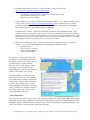
1
Strengthening Tsunami Warning and Emergency Responses: Training Workshop on the development of End-to-End Tsunami Standard Operating Procedures Course Manual 2008 - 2014 Tsunami Warning Decision Support Tools United Nations Educational, Scientific and Cultural Organization Intergovernmental Oceanographic Commission National Oceanic and Atmospheric Administration UNESCO/IOC-NOAA International Tsunami Information Center Organized by the UNESCO IOC - NOAA International Tsunami Information Center for Member States of the Tsunami and Other Coastal Hazards Warning System for the Caribbean and Adjacent Regions International Tsunami Information Center A UNESCO/IOC - NOAA Partnership 1845 Wasp Blvd Bldg 176,, Honolulu, Hawaii 96818 USA Phone: <1> 808 725-6050, Fax: <1> 808 725-6055 E-mail: [email protected] TSUNAMI WARNING DECISION SUPPORT TOOLS Compiled and distributed by International Tsunami Information Center (ITIC) September 2014 These following are useful decision support tools available free-of-charge to governments and other recognized authorities involved in tsunami warning hazard mitigation. For more information, contact the ITIC ([email protected]) or its Director (Laura Kong, [email protected]) TABLE OF CONTENTS 1. Real Time Earthquake Display (RTED) Tool - developed by US Geological Survey and the California Office of Emergency Services (California Integrated Seismic Network, CISN) with support from the US National Tsunami Hazard Mitigation Program. This GIS display provides real- time earthquake information as broadcast by the US Geological Survey National Earthquake Information Center (NEIC) and includes tsunami information from the PTWC and WC/ATWC. The USGS NEIC serves as the World Data Center for Seismology. Available since 2005. 2. Tsunami Warning Operations: Sea Level Monitoring – Tide Tool and IOC Sea Level Monitoring Facility Tide Tool is an operations tool developed and supported by the Pacific Tsunami Warning Center for the decode, display, and manipulation of sea level data (coastal and DART deepocean stations) transmitted over the WMO Global Telecommunications System (GTS). The tool continuously decodes sea level in real-time and displays the time series on a computer screen, along with station status and metadata. M a p c l i e n t s e n a b l e e a s y v i e w i n g . T s u n a m i travel times and estimated arrival time features implemented in May 2014. Non-operational versions also exist for data transmissions through the internet and for archived data. Available since 2005. The IOC Sea Level Monitoring Facility, developed originally under the IOC IODE Project for the ODINAFRICA sea level network in 2006, is a web-based real-time monitoring tool for sea level stations globally. The URL is http://www.ioc-sealevelmonitoring.org/map.php. The tool provides sea-level data, station status and metadata, data plots, and other database services. This tool should be used with caution for operational purposes since timely web access cannot be guaranteed all over the globe during emergencies. Available since 2008. 3. PTWC Tsunami Messages: RANET Alert Watcher SMS text message The PTWC, through the RANET project, provides an SMS Heads-up alert to government authoritative tsunami warning and response agencies. The messages are brief in order to alert the recipient that official message (which is longer) has been sent. Available since 2005. 4. Tsunami Bulletin Board (TBB) The TBB is an email list serve that provides immediate sharing of tsunami information by and among tsunami professionals (scientists, researchers, emergency officials, and other officials). PTWC and WC/ATWC bulletins are immediately posted to TBB. Its purpose is to provide an open, objective scientific forum for the posting and discussion of tsunami news, information, and research. It is not open to the media or the general public, and is not intended for advertising or activities of a commercial nature. The TBB began in 1995. 5. Tsunami Travel Time Software The World Data Center for Marine Geology and Geophysics (WDC-MGG), co-located at the NOAA National Geophysical Data Center, serves as the world’s recognized tsunami database and archiving centre. The WDC-MGG and the ITIC are providing free-of-charge, tsunami travel time calculation and display software to government organizations involved in providing tsunami warning and mitigation services. Other interested organizations and individuals are requested to obtain the software directly from the developer. The Tsunami Travel Time (TTT) software is used by the NOAA Pacific Tsunami Warning Center for its operations calculations. Map graphics are made using the open-source Generic Mapping Tools (GMT). TTT is included in TsuDig. Available since 2007. 6. Tsunami Historical Databases The WDC-MGG provides extensive online, web-based and offline tools and other hazards information and digital bathymetry services. In 2009, the WDC-MGG and ITIC began distributing an enhanced offline tool (TsuDig GIS tool) that accesses the WDC database and includes features of specific use and interest to tsunami warning and emergency response decision-makers; TTT calculations and displays are included in TsuDig. Since the 1990s with the last features update in 2005, the Novosibirsk Tsunami Laboratory (NTL) has provided the WinITDB as an offline, standalone tool working on Windows platform. 7. Google Earth Database Files The Google Earth visualization tool can be used to display a number of tsunami-related databases. These include files for USGS-located earthquakes (in near real-time), WDC/NGDC Historical Tsunami Database as well as Significant Earthquakes and Volcanic Eruptions, and the IRIS Global Seismic Network. 8. TsunamiTeacher Tsunami Resource Toolkit TsunamiTeacher brings together authoritative and reliable materials of interest to a range of stakeholders involved in tsunami warning and mitigation. Sections cover the roles of the media, educational systems, and the public (government) and private sectors. The tool is available as an electronic resource as an offline DVD from ITIC or IOC. Available since 2006. TsunamiTeacher has been translated into several languages to date. In 2011, the ITIC produced a 6-min Tsunami Basics video for US TsunamiTeacher. Real Time Earthquake Display (RTED) California Integrated Seismic Network (CISN) tool Version 1.7, August 2013 Summary: The RTED (or originally CISN) Display provides reliable delivery of real-time earthquake information, including rapid notification and ShakeMap to critical end users. Users are able to customize the tool according to their own local needs, including the setting of thresholds for display and alarming and import of additional graphics data layers. The tool was developed by the US Geological Survey in collaboration with the California Office of Emergency Services, and further supported by the US National Tsunami Hazard Mitigation Program. Recent program improvements included: Web Services middleware that allows data to get through firewalls; improved layers, including more detailed coastlines; integrated e-mail capability; new event sorting options; and a "T" for events for which a tsunami warning has been generated. The CISN has 4 servers online to provide reliable access to earthquake information. Eligibility: Freely available to everyone. ITIC is a CISN-registered organization serving as a focal point for institutions interested in using CISN for tsunami warning and mitigation in their country. Minimum System requirements for operating CISN Display: - Java Runtime Environment 1.5.X or higher (available from Sun at http://java.com/en/download/manual.jsp) - Pentium-III, 1GHz CPU speed or comparable hardware384 Mb RAM or more - IP Address (private or public) - Access to Internet on ports 39977/39988 Instructions for obtaining RTED/CISN: 1. Send request for account to ITIC Director ([email protected]). ITIC is the administrator for those wishing to register as tsunami institutions. Alternatively, you may register as your own institution directly with CISN. 2. ITIC will approve and send you a Registration Code (regcode). For the present, the Registration Code to use is KI1NZ1 or QCEA or JIQY1. 3. Create a User account by visiting http://www.cisn.org/software/login/index.php and clicking “Create a New User” and typing in regcode and personal information. Users must create their own CISN Display (CD) accounts in order to be registered in the CISN server database to receive information from the QuakeWatch server. After creating a user, you will receive an email asking you to confirm your contact information – please follow the directions given to validate. 4. ITIC will then approve the User, and send an email providing instructions on how to download and install the software. Your username is your email address and your password will be 6 characters. US Geological Survey, California Office of Emergency Svcs, FEMA, US Natl Tsunami Hazard Mit Program 5. Download and install the software, or copy the folder from the TWTools disk. http://www.cisn.org/software/QWClient/index.html Installation options: - Windows XP, Vista, Windows 7, Mac OS X, Linux, Solaris, UNIX - Cross-platform installer (Java .jar file) - Manual (not recommended) 6. Check to make sure you have a Java Runtime Environment (JRE) 1.5.X or higher installed. To get Java (it’s free), visit http://java.com/en/download/index.jsp. Note: installation of new software sometimes requires administrative privileges on the host machine. If any part of the installation fails, contact your local systems administrator for assistance. Download of the software. Follow the instructions as outlined in the installation shield. Once complete, launch the application, enter your user-account username/password and check the lowerright corner for a green status light that indicates a good connection to a QuakeWatch Server. There should be no need to specify a server address; the client comes preconfigured with one. A shortcut icon should be created on your desktop to use to access the software. 7. Refer to the CISN Display User’s Guide to learn more about customizing your user-interface settings… every organization should do this! Documentation available includes: - Revision History - User's Guide (v1.2, 2005) - Display Settings Manual - Event Viewer Manual For example, you may wish to have your organizations’ logo displayed instead of the default CISN logo. To do this, create a .gif file and place it in the “banners” directory of the “CISN_Display” folder. The banner is then selected from the Settings/Display menu once the program is started. This example is for Tonga. Tsunami messages, when issued by the WC/ATWC or PTWC, are also available by clicking on the “Tsunami” button. This opens another window where the message is shown. The example below is from a M4.7 earthquake in Barbados on 30 March 2007. To display the “Tsunami” button on the screen, choose it as a Product button from the Settings/Config tab. Acknowledgements: Developed as a cooperative project of the CISN. Funding provided by the OES, USGS, FEMA/OES Hazards Mitigation and Emergency Management Performance Grant Program, and the US National Tsunami Hazard Mitigation Program. Additional financial support was provided by Instrumental Software Technologies, Inc. (ISTI). This software was developed in partnership with ISTI. US Geological Survey, California Office of Emergency Svcs, FEMA, US Natl Tsunami Hazard Mit Program OTHER ALERTS: Receiving email/SMS alerts through RTED/CISN: The CISN tool allows the configuring of parameter thresholds for sending email and SMS text messages to customers. Systems administrator privileges may be required; you will need to know the name of your SMTP server. Because your own mail servers are used, SMS dissemination and its timeliness will be dependent on your servers and configuration. To receive alerts as earthquakes occur, the CISN must always be running (7x24 basis). While issuance may only take only a few seconds, message receipt may be much longer. Regular tests should be performed to monitor performance. USGS Earthquake Notification Server (ENS) - Alternative to RTED/CISN alerts: An easier-to-configure and maintain tool for receiving information is provided by the USGS. Visit https://sslearthquake.usgs.gov/ens/ to sign up and configure the thresholds for notification. ENS now supports messages from the WC/ATWC and PTWC (check these boxes when setting up an alert profile). This should work both in the USA and internationally, but has not been tested for SMS alerts nor for timeliness of receipt of messages/email. In 2009, the USA had 140,000+ registered users for its notification system, but the majority were in the US. RANET Alert Watcher (RAW, SMS Heads-Up Alert) A SMS tsunami message alert service (RAW) is available for PTWC messages through the RANET international project. This service provides a short summary text message to mobile phones whenever the PTWC issues a message. This service is provided as a courtesy only to national authorities and is not intended to replace any official and timely operational communications methods. The service has proven reliable for receipt internationally since its start in 2005; estimated time for receiving a SMS alert is within 5 minutes after message issuance. For sign-up contact ITIC ([email protected]) or Kelly Sponberg ([email protected]) IMPORTANT NOTES: - The above services have NOT been tested as operational tsunami warning tools. Users will need to assess the timeliness of information delivery to their own country and operations centers. - For highest reliability, enable all the services to ensure redundancy, and monitor to see if one service is more timely than the other. It is wise practice for any important message to always be received through at least two different communications methods. US Geological Survey, California Office of Emergency Svcs, FEMA, US Natl Tsunami Hazard Mit Program Quickinfo CISN Installation November 2013, L. Kong, [email protected], T. Fukuji, [email protected] Use: CISN is a real-time earthquake monitor that automatically receives and immediately plots earthquake epicenters on a GIS display as they are posted by the US Geological Survey. Agencies that are currently submitting their information include the Pacific Tsunami Warning Center and West Coast / Alaska Tsunami Warning Center; a “Tsunami” product button can be displayed, and when activated immediately indicates that the tsunami warning centers (TWC) have issued a tsunami message. The CISN will receive and post TWC earthquake observatory messages; these messages, which are preliminary, unofficial products, are the earliest notification that a sizeable earthquake has occurred and will be issued a few minutes before an official TWC message. The TWC earthquake observatory message is also the only TWC product that will be issued when a small earthquake occurs that is below the tsunami reporting threshold. ITIC and PTWC recommend the use of CISN are a means for displaying real-time earthquake information, and for alerting duty staff that PTWC has issued a tsunami message. Start: The program is started by double-clicking the desktop icon, or other method. Required internet bandwidth is minimal, so can be minimized and run in the ‘background’ on any desktop. Instructions for installation: The following are quick instructions for installing and using CISN. For details, consult the RTED_Info_wRegCode_nov2013.pdf, CISN User Guide, and other manuals (in Manual_info folder of installation disk). 1. Go to http://www.cisn.org/software/login/index.php 2. “Create a New User”, use registration code KI1NZ1 or QCEA or JIQY1. (see TWTools detailed instructions) 3. Check your email, and validate your username information (email address) 4. Check your email after ITIC approves. It will contain your 6-character password 5. Install software: a. Copy folder from TWTools DVD to your desktop b. Open install folder, find your installation and double-click on “Setup” to run. 6. Start CISN and input your username (email addr) and password (6 characters). Agencies with firewalls will need to ensure that CISN ports (and/or server domains) for information dissemination to the CISN software are allowed. 7. Customize as your CISN display to your needs. These might include the following options (access from tabs in Settings file menu). An example ITIC settings is found in CISN_Settings_ITIC; the configuration file (CISN_Display_ITIC.xml) can be loaded to set all display parameters). a. Set earthquake display threshold (M4 or M5, in Filters tab) b. Time zone display, if other than GMT (in Display tab) c. Magnitude threshold for Alarm (M4 or M5, in Alarm tab) d. Include “Tsunami” product button in display (in Config tab) e. Center “default view” to your region; for Pacific, try 20, 180, scale 125000000) f. Specify colors to use for symbols (for example if you would like to color code by single day, in Event Colors tab) g. Specify Banner for display; you can use the ITIC one (ITIC_USGS_banner.gif, move from your installation disk to Banners folder on your computer), or create your own (needs .gif file) (in Display tab) TSUNAMI WARNING OPERATIONS: SEA LEVEL MONITORING TIDE TOOL: DISPLAY AND DECODE OF SEA LEVEL DATA TRANSMITTED OVER THE WMO GLOBAL TELECOMMUNICATIONS SYSTEM (vers 10.2, May 2014) Pacific Tsunami Warning Center (NOAA) International Tsunami Information Center (NOAA-UNESCO/IOC) Tide Tool is a software application that provides end users with the ability to decode, display, and manipulate sea level data broadcast over the Global Telecommunications System (GTS) of the World Meteorological Organization (WMO). Data download through the internet is also available, but is not recommended because timely, complete delivery of all data packets cannot be guaranteed. Tide Tool is enabled by the Tide.tcl script and region-specific map clients that provide simple-to-use graphical user interfaces to the continuously-incoming sea level data streams; the tool uses the Tcl/Tk software package and its BLT extension. Tcl/Tk is an open source, platform-independent software package offering a powerful shell programming language and graphical toolkit. getTide, also included with Tide Tool, is a BLT script that can be used to read and analyze archived sea-level data log files. The software application was developed and is supported by the US NOAA NWS Pacific Tsunami Warning Center (PTWC) as an operational tool for the real-time continuous tsunami monitoring in the Caribbean, Indian and Pacific Oceans. Its primary users are National Tsunami Warning Centres, such as the National Meteorological and Hydrological Service (NMHS), or other agencies acting in this capacity, and with a downlink from the GTS or to a data file containing those data formatted in a similar manner. It has been tested under Unix/Linux, Windows 2000/XP/Vista/Windows 7 (32- and 64-bit) environments since 2005, and implemented using a non-GTS ‘ftp’ data transmission protocol in Linux and Windows systems for tsunami centers without GTS links. The ‘ftp’ method should be considered non-operational if commercial internet service is utilized since connection reliability and timeliness, especially during tsunami emergencies, cannot be guaranteed. A Tide Tool Manual is available providing information on its installation and use. The primary use of this software is as an operational programme run by tsunami warning centres, or other operational centres, which need to continuously monitor sea levels. Features of the tool include time series display, wave arrival time, height and amplitude measurement, tide prediction removal, de-spiking, and station state-of-health and metadata. Users are able to select which stations to receive and display through edits to input files or by mouse-selection from a station map. Mouse-clickable functions include the expansion of the time series to enable easy measurement and logging of the arrival time, wave height and wave period from the incoming signal. Station and data transmission information, raw data packets, and station health reports can be viewed from within Tide Tool. Calculated travel time contours can be overlain. Requirements: In order to decode and display the data, the following are required: Computer running Tcl/Tk software with BLT extension, or WIZE software package Sea level data that are continuously archived into a data file Tide.tcl and associated map client software. Computer and Tcl/Tk software with BLT extension The software requires the installation of the Tcl/Tk software package and the BLT extension, both of which are freely available for download and easy to install. The software is able to run under Unix/Linux, Windows 2000/XP/Vista, and Macintosh OSX (under BSD Unix) operating systems; the preferred platform is Unix or Linux because of its stability. For Windows 7, it is recommended to install the WIZE software package, which includes the newer Tcl/Tk v8.5.9. Use on other platforms is possible as it only depends on Tcl/Tk and BLT softwares being available. The software does not require substantial computing power, and can thus run easily on a Pentium III or higher PC system. US NOAA PTWC, UNESCO-IOC/NOAA ITIC Sea level data The input is assumed to be a continuously-appended, ascii text file containing transmissions of data from different sea level stations. Each station and its data transmission is described by a unique set of parameters, including a Satellite Product Headers, Station Platform ID, method of transmission and transmission time, and file formats (Figure 1). Figure 1. Sample of transmissions from field station Data Collection Platform (DCP) in formats used by the University of Hawaii Sea Level Center, Australia National Tidal Centre, and US National Ocean Service, respectively. SWIO40 RJTD 250015 :ENB 1 #1 M 3908 3908 3910 3909 3911 3909 3912 3910 3913 3913 3917 3917 3917 3917 3915 3918 3914 3917 3912 3913 3913 3913 3912 3913 3911 3908 3908 3905 3909 :ENC 1 #2 3409 3410 3411 3411 3413 3419 3419 3420 3419 3415 3414 3418 3411 3408 3410 3409 3409 3408 3409 3409 3414 3413 3409 3414 3414 3410 3412 3409 3410 3413 :BATTLOAD 0 12.83 :NAME= 91642 46/// /1205 10296 40080 22200 00287 555 77744 A0102 516`3 60029 6315B 03024 83030 00A07 02548 02901 29631 6B090 24520 2400A 13025 90036 00297 317B1 50240 60310 0A190 26230 38002 96317 B2102 37103 100A2 50266 50330 02973 18B27 02331 02800 A3102 70103 10029 8318B 33022 92026 00A37 02736 03401 29831 8B390 22570 2801A 43027 66028 00299 319B4 50222 50230 0A490 27960 34002 98319 B5102 19202 901A5 50282 20380 02983 19B57 02163 03200 BV289 134S1 41249 C0501 22080 00070 23677 44777= ^^33487552 206011307M94168411DZpQ^@@rI}0uW@1[Am@~@BsBYB\AG@BrBYBzAM@BqBZCUAB@BoBZCmA@@BmBZDMAI@BlBZDrAG@BlBZD?A D@BkBZETAL@BjBZEwAGABhBZ"@qv@oL3@[DvAI4B[5Ad6a`=OE0uVW>ZAnA|BYBkCRCqCsDWDnER"@us@so0uVV>YCqC?DBCtDSD [DnDxEGEa"@wh@wB _OLAoP 50+1NN 116W In general, sea level data is digitized and sampled at the field station. Ideally, the data transmitted for tsunami monitoring will be 1-minute (or better) averaged data values that are transmitted at least every 15 minutes, or more frequently for stations in tsunami source zones; currently, stations transmit every 3-60 minutes and data averages are at 1-15 minute sampling intervals. The data are transmitted over a number of different satellites to regional telecommunications hubs of the WMO, and onwards to customers such as the Pacific Tsunami Warning Center, the Japan Meteorological Agency (JMA), and to any requesting National Meteorological and Hydrological Service (Figure 2). Figure 2. Transmission from the Data Collection Platform at the field station to the warning centres. In the Indian Ocean, the primary satellites used for transmission from the field station are the Japanese MTSAT for the eastern Indian Ocean and the EUMETSAT operational satellite system for the central and US NOAA PTWC, UNESCO-IOC/NOAA ITIC western Indian Ocean. In the Pacific, the US GOES and Japan MTSAT satellite systems are used. The PTWC receives its data through the USA GOES satellite system and the US National Weather Service Telecommunications Gateway (NWSTG) and other dedicated communications links. The satellites are part of the GTS. The GTS is a semi-private, reliable communications system supported by the 187-member WMO for the transmission of environmental data, and information messages and / warnings. The GTS is the primary means by the PTWC and JMA receive sea level data and issue tsunami advisories and warnings. Tide.tcl The program is started by typing bltwish Tide.tcl The program decodes the received sea level data that are found in a single data logging file, creates individual station files containing the decoded data, and starts a graphical user interface display that allows each station to be displayed as a plot (Figures 3-5). Map clients for the Atlantic, Caribbean, Indian, and Pacific Oceans display a map from which the user may select several stations to show their time series. A strip chart window displaying multiple stations simultaneously is an option. V10.0 beta enables overlay of calculated travel time contours to graphically show wave propagation from the source. Figure 3a. Caribbean, Indian, and Pacific Map clients showing the coastal and DART stations, with color indicating when data last received (green = data received within last 7 hrs). Sea level records can be plotted by mouse-selecting the station and choosing the sensor to plot, or by enabling a ‘zoom’ client to choose and automatically plot several close-by stations. Station names can be displayed on the map if desired. US NOAA PTWC, UNESCO-IOC/NOAA ITIC Figure 3b. Tide.tcl GUI showing all stations that were decoded, arranged by region. Station sensor types, station metadata, and the raw data packet can also be viewed. Each time series can be displayed with or without the tidal signal removed, can be manipulated using a mouse in order to zoom/enlarge the time series and to pick an amplitude or wave period (Figure 4a), and can be ‘despiked’ to remove spurious ‘bad’ points (Figure 4b). A postscript plot of the time series window can be made and printed. Figure 4a. Sea level time series showing observed and tide-removed time series. A mouse is used to select the part that should be enlarged to pick the arrival time. Figure 4b. De-spike feature. US NOAA PTWC, UNESCO-IOC/NOAA ITIC Figure 5. Station metadata, as well as recent raw data transmissions of the sea level messages and a station transmission report, are available. A location map and tsunami travel times near the station are also provided for reference. Tide.tcl operates continuously once started. It will check every 20 seconds to see if any new data has arrived, and if so, it will decode and update the station time series that is plotted. When Tide.tcl is started it will read data from the current day data log. Tide.tcl will keep up to 24 hours of data. As more data arrives beyond what Tide.tcl is supposed to hold, it will discard the older data to make room for the new. For each station, multiple sensors are often available and decoded. The sensor code is given by three letters, where prs stands for pressure sensor, bub indicates bubbler, rad indicates radar. Tide Tool can also be used to viewing older or archived data log files. Another tool for viewing the current status of the sea level network and station metadata received by the PTWC is through the download of a stations.kml file from http://www.sealevelstations.org/ and viewing by the Google Earth viewer. To obtain the software, and for further information and questions, please contact Stuart Weinstein, Asst Director, NOAA Pacific Tsunami Warning Center ([email protected]), or Laura Kong, Director, UNESCO/IOC-NOAA International Tsunami Information Center ([email protected]). US NOAA PTWC, UNESCO-IOC/NOAA ITIC TIDE TOOL – QUICK INFO For more information, refer to Tide Tool Manual. OVERVIEW: The Tide Tool system downloads Pacific sea level data from the NWS Telecommunication Gateway (NWSTG), decodes the data, and displays it. Calculated tsunami travel time contours can also be overlain on the map client to graphically show the propagation of the tsunami from the earthquake epicenter. All stations that PTWC receives are available through Tide Tool. The system consists of 3 scripts (get_data.tcl, Tide.tcl, Client.tcl) that run simultaneously on 1 PC. Tide.tcl and Client.tcl (PACIFIC) are softwares that PTWC uses in their operations. For other oceans, please replace PACIFIC with INDIAN (IO), CARIBBEAN (CAR), or ATLANTIC (ATL) in the Quick Info text. Instructions refer to the generic names of scripts without a version number (Tide.tcl, Client.tcl, etc). CISN may be run on the same PC to monitor seismicity and alert Duty Staff when large earthquakes occur and when Tsunami messages are sent by PTWC or US NTWC (WC/ATWC). USE: 1. Monitor stations for tsunami confirmation after a large earthquake has occurred. To display sea level records (marigrams), use Tide.tcl or Client.tcl map To determine the estimated arrival time, you may: o Use TTT button in Tide.tcl to calculate tsunami travel times using actual earthquake epicenter (this will enable overlay onto Client.tcl map) o Use PTWC bulletins which give estimated tsunami arrival time at different locations o Use ttt_auto.bat (double click ttt_auto icon on desktop) or TsuDig to calculate tsunami travel time map (use either ‘bullseye map with your location (e.g., Pago Pago / Apia) as center’ or event map using actual earthquake epicenter) 2. Monitor state-of-health of your. Report if out of order. STARTUP AND TTT CALCULATION / OVERLAY: 1. Start get_data.tcl. Drop get_data.tcl in TideTool_bin folder (desktop icon) onto WIZE icon on desktop. This script downloads data every 200 seconds from the NWSTG. Data are accumulated in a file (in TideTool_data (desktop icon) / SR_LOG folder, file srxxxyr.log, where xxx is Julian day and yr equals year. The C:\Tcl\bin\wize.ex console window that opens should be regularly checked to ensure that data are still being collected. 2. Start Tide.tcl. Double click TIDE icon on desktop. This script looks to see if there is new downloaded data in srxxxyy.log and if yes, decodes the new data and updates the sea level station data file/display. 3. Start Client.tcl (PACIFIC OCEAN). Double click PACIFIC icon on desktop. Wait until Tide.tcl (Tide Tool) completes the decode of the initial file (may take up to 20-30 min if at the end of the Julian Day). To start Client.tcl for other regions do the same, double click on icon(s) (ATLANTIC, CARIBBEAN, INDIAN) on desktop. When an event occurs, calculate tsunami travel times. Click TTT button in Tide.tcl. Run ttt_tidetool.bat via TTT button (currently only for 64-bit machine) to calculate Tsunami Estimated Times of Arrival (ETA) and create a map to overlay on Client.tcl map (GET ETAs and TTT in Tide.tcl, PLOT TTs in Client.tcl to overlay). L. Kong, T. Fukuji, May 2010 - September 2014 IMPORTANT CHECKS DONE BY EACH DUTY SHIFT: 1. PC on GMT time. This is needed for correct time decoding. 2. get_data.tcl is running. Check C:/Tcl/bin/wize.exe console window to see if the last download is current (e.g., 5 minutes ago). If not, then data are not being collected. Restart programs. a. Close the inactive WIZE and start the get_data.tcl again. Refer to 1. in STARTUP b. Check to see if you also need to restart Tide and Client. If the softwares do not update or are frozen, then close and restart. Exit Tide and Client window(s) (e.g., PACIFIC OCEAN). Start each program again (refer to 2. and 3. in STARTUP) Notes: 1. Stations transmit data by satellite (generally GOES, MTSAT, EUMETSAT) at different intervals (every 3-60 min) and different times (in a given hour). Therefore, before deciding on the tsunami threat, sometimes you may have to wait until the next transmission if only part of the tsunami wave has arrived. 2. Stations have sensors that ‘damp’ the signal (see IOC Manual on Sea Level Measurement and Interpretation (2006) appendix for sensor types). Therefore, what you measure will probably underestimate the wave height reported by eyewitnesses. Coastal signals also depend on the gauge location and local features, e.g., some stations always amplify signals. 3. DART stations are located in the deep ocean (not on land). Therefore, signals measured will be much smaller (few cm / 10s of cm, or inches to 1-3 feet) than signals on coastal (land) gauges. When DART waves hit shallow water (the coast), tsunami wave physics says that wave height increases – therefore, a small DART wave in the deep ocean could end up as a large wave when it hits land. Tsunami modeling must be used to forecast what is expected at the coast. TIPS FOR EFFICIENT USE: 1. View individual sea level stations using Tide window (choose station using 4-letter station code, left mouse click, or use Sea Level Station map hard copy), or Client window (choose dot on map, left mouse double click). Choices are -‐ Sensor type (pressure gauge, encoder, aquatrak, bubbler, radar) -‐ Info (station and transmission information) -‐ Mess (actual data download, undecoded) -‐ MAP showing station location with travel time contours using station location as source 2. Marigram ZOOM widget: a. Measure wave height and wave period from an individual station by mouse-selecting (right) time window to expand time series (ZOOM widget), then mouse-select (left) points you want to measure – a time and height difference is automatically calculated if you select 2 points. b. You can record the picks made using the REC tab; picks are recorded to the file Tide_Tool_LOG in in the TideTool_data folder. c. Choosing MIN MAX in REC auto-picks the minimum and maximum height in the selected window; to then record the picks, click on the Peak to Peak REC menu item. L. Kong, T. Fukuji, May 2010 - September 2014 d. Marigram data can be written to a file by clicking WRITE tab (data are time, height including tide, height with tide removed); file is located in the in the TideTool_data/PLOTS directory. 3. Fast viewing of stations in a region is done using the Client – mouse-outline (right click & drag) a box of interested stations, and then Show Tile or Strip to display all stations. The Strip feature allows many stations to be displayed simultaneously, similar to a seismic record section. If ttt_tidetoolxx.bat has been run, then the order of the marigrams will be from the closest (1st-arriving tsunami wave) to farthest station from the source. The Tile feature shows each station as an individual window. 4. Station locations and 4-letter station names are found using the hard-copy maps (CaribbeanAtlantic_SL_Stations_nov2013.pdf, Indian_SL_Stations_2012.pdf, Pacific_SL_Stations_nov2013.pdf, in TideTool_data folder), or by Disp/Find button in Client 5. Estimated Tsunami Travel Times from the earthquake epicenter can be overlain on the map after running ttt_tidetool.bat. TTT button in Tide.tcl is used to run ttt_tidetool.bat. It will open a Tsunami Travel Times window to be used to input data to calculate travel times and create map overlay. Latitude and longitude are given at the location of mouse cursor. Origin time (OT) of the earthquake source is also shown. 6. To retain a picture of the screen, options are: -‐ Use Print Plot File Only option in time series window (postscript plot files found in TideTool_data/PLOTS directory, and viewed with Adobe Acrobat). -‐ Use Ctrl+Alt+Print Screen (individual window) or Print Screen (entire display), and then paste in MS Word file VIEWING ARCHIVED DATA: Tide Tool can be run in ‘archive’ mode to view past data (files in folder SR_LOG). 1. Use the correct station metadata file to view archived data. This should be the COMP_META file that was in use when the data was collected; it may not be the most current one. (Replace the current COMP_META file with this file, but be sure to save the current COMP_META file to another filename so you will have it for the real-time version) 2. Run Tide.tcl. To run: double click wize.exe in the TideTool_bin folder on the desktop. 3. Type “wize Tide.tcl H” 4. Enter JD, YR (2 digit), SPAN (1 or 2 corresponding to number of days of SRLOG files) 5. Tide.tcl will decode and then display the SRLOG files specified 6. Client.tcl (for all regions) can be run. Note that in this mode, all station dots will be red since there is not live data. 7. Once the SR_LOG file(s) have been decoded, station files by JD and sensor are created (in TideTool_data/Decoded_Data/JD/station.sensor.JD These time series files are then usable for later station plotting. L. Kong, T. Fukuji, May 2010 - September 2014 UNESCO Intergovernmental Oceanographic Commission (IOC) SEA LEVEL STATION MONITORING FACILITY URL: http://www.ioc-sealevelmonitoring.org/map.php The UNESCO IOC Sea Level Monitoring Facility is a web-accessible tool for viewing sea level data received in real time from different network operators. The IOC’s service is freely available to all. Please note that the data has not undergone any quality control and is provided as received. IOC, VLIZ and data suppliers accept no liability for errors and/or delays in data or for tsunami warning or other public safety decisions carried out on the basis of data viewed using this tool. The sampling frequency and data transmission frequency varies for the stations. This service should not be viewed as operationally robust since its access utilizes commercial Internet services that could become clogged during a large tsunami event. This service provides (i) information about the operational status of global and regional networks of real time sea level station, and (ii) a display service for quick inspection of the raw data stream from individual stations. The site initially focused on operational monitoring of sea level measuring stations in Africa and was developed from collaboration between Flanders Marine Institute (VLIZ) and the ODINAFRICA project of IODE. It has been expanded to a global station monitoring service for real time sea level measuring stations that are part of IOC programmes i.e. (i) the Global Sea Level Observing System Core Network; and (ii) the networks under the regional tsunami warning systems in the Indian Ocean (IOTWS), North East Atlantic & Mediterranean (NEAMTWS), Pacific (PTWS) and the Caribbean (CARIBE-EWS). As of September 2010, 89 organizations were contributing data. The data and products available are made available in accordance with the IOC Oceanographic Data Exchange Policy as adopted by the 22nd session of IOC Assembly in Resolution 6. Data and products available on this web-site may not be used for any commercial purposes. Commercial users should contact the relevant data originators. This IOC Sea Level Station Monitoring Facility web site provides the following capabilities: − Global sea level network map, showing color-coded operational status (working/not working) − Station listing, showing metadata (4-letter code, GLOSS ID number, Location, Collection method, Last Data Transmission date/time, Delay, and Transmit Interval) − Plotting and download of data received It does not provide low frequency and high frequency research quality sea level data, which is available from the GLOSS-designated data centers at the Permanent Service for Mean Sea Level (PSMSL), the British Oceanographic Data Center (BODC) and the University of Hawaii Sea Level Center (UHSLC). Station Listing screen, from which users may select stations to view: Station Data plotting. User-selectable time windows are also available. Partners: This project was made possible by the joint effort of: IOC Intergovernmental Oceanographic Commission of UNESCO GLOSS Global Sea Level Observing System IODE International Oceanographic Data and Information Exchange ODINAFRICA Ocean Data and Information Network for Africa CARIBE-EWS Tsunami and Other Coastal Hazards Warning System for the Caribbean and Adjacent Regions IOTWS Indian Ocean Tsunami Warning and Mitigation System NEAMTWS North-Eastern Atlantic, the Mediterranean and Connected Seas Tsunami Warning and Mitigation System PTWS Pacific Tsunami Warning and Mitigation System GFZ German Research Centre for Geosciences POL Proudman Oceanographic Laboratory UHSLC University of Hawaii Sea Level Center VLIZ Flanders Marine Institute WMO World Meteorological Organization JMA Japan Meteorological Agency KMI Royal Belgian Meteorological Institute Meteo-France Many operators of the WMO GTS network RANET Alert Watcher Short Message Service To participate in RAW, send an e-mail to: laura.kong@noaa. gov or [email protected]. Participants must be affiliated with a national government, regional organization, or UN affiliated entity. Service is available to participants in areas with mobile phone coverage, a phone and plan capable of receiving SMSes, and in regions covered by the PTWC -Indian Ocean Basin for Africa and Asia, the Pacific Ocean Region for Asia and the Americas, and the Caribbean. www.ranetproject.net www.ranet.mobi What the RAW system IS: RAW, SMS is a ‘heads-up’ notification system for important decision makers. The system broadcasts an abbreviated message as an SMS to mobile phones. This short message lets the recipient know that an official, lengthier message had been issued by the Pacific Tsunami Warning Center (PTWC). What the RAW system IS NOT: The RAW, SMS system is not meant to replace the existing formal and official means of communicating alerts or critical information. The system is not meant to become the sole means of receiving critical alert information -- warnings and communications should come through a ‘layered’ approach. It is not meant to be a mass-public communication system. The SMS system is intended for a select group of national officials and disaster managers, or members of international organizations, who need to be notified when information from regional centers becomes available. RANET Alert Watcher, SMS RANET is a collaborative effort of many National Hydro-Meteorological Services, non-government organizations, and communities. These varied partners come together to make weather and climate information available to rural and remote populations, which are often most in need of environmental forecasts, observations, and warnings. While significant advances have been made in our ability to predict and observe our environment, much of this valuable information remains inaccessible to those outside major cities. RANET has a simple mission: Help national and regional organizations get useful information locked in urban areas to rural and remote places in the hope of promoting sustainable development and reducing disaster impacts. To accomplish this mission, RANET works with partners to identify new and existing technologies that can be utilized by rural communities in a sustainable way. RANET therefore engages in system development, network deployment, but also stresses training and community ownership to ensure that the networks it helps to create are long-lasting. RANET Alert Watcher (RAW) – SMS May 2008 Overview and Background RANET is an international collaboration of meteorological services and related organizations working to improve access to weather, climate, and other earth science information. Following the December 26, 2004 Indian Ocean Tsunami, RANET developed a small application intended to deliver alert and notification summaries to the mobile phones of national emergency managers and other key officials. The RANET Alert Watcher (RAW) broadcasts an abbreviated message via SMS to mobile phones. This short message lets the recipient know that an official, lengthier message has been issued by a warning authority, such as the Pacific Tsunami Warning Center (PTWC). The service provided by RANET is meant as a ‘heads-up’ notification to augment other alert and notification systems. The intent is not to replace official lines of communication, but rather the purpose is to contribute to a larger alert and notification system by utilizing effective and inexpensive solutions. Any national warning infrastructure should utilize several redundant systems to receive official warnings from watch providers and other warning authorities. These systems should be layered in order to utilize a variety of networks and devices which posses diversified strengths and vulnerabilities. The RAW is therefore operated as a best effort system in order to provide additional communication capacity. How do I subscribe to the RAW-SMS service? The RANET Alert Watcher is NOT a mass public alert and notification solution. Due to inherent limitations of mobile networks, as well as respect for national and local warning authorities, the RAW service is available only to national officials and disaster managers, or members of international organizations, who need to be notified of message releases from regional centers. To participate in the RAW, send an e-mail to: [email protected] (Laura Kong, ITIC) or [email protected] (Kelly Sponberg, RANET). Applicants may be required to demonstrate or confirm their affiliation with a national government, regional organization, or UN entity. For the RAW-SMS service to be of use, participants will of course need to be in areas with mobile phone coverage, need to posses a mobile phone or similar device, and the service plan for their mobile device must support SMS – text messaging. At this time the RAW only carries messages from the PTWC, as a result participants will need to be in one of the covered regions. Once a service request is received and the applicant’s affiliation is confirmed, RANET will send several test messages. First and foremost these tests confirm that the RANET mobile-hub to SMS gateway can communicate with the applicant. The applicant should note the test numbers received and reply back (via e-mail) to RANET. RANET utilizes these numbers to determine which network carriers and modems are best matched for the subscriber’s phone. Similarly, RANET load balances outgoing messages across a number of modems and services to ensure quick messaging. What happens if during the registration tests, I fail to receive a message? The vast majority of subscribers will receive one or more test messages out of seven tests. In some cases, however, none of the test messages will reach the participant. The reason for this typically relates to how your local service provider configures its network and / or its agreement with foreign carriers. If there is a complete test failure, then RANET will work with you to determine if there are other carriers it can utilize to send a message to your mobile phone. If, however, no other carriers are found, then RANET may seek to deploy some equipment inside August 2008 your country – typically within a national government office. This equipment consists of GSM modems attached to a computer that is connected to the internet. In effect the equipment expands the RANET mobile hub onto a wireless network provider inside your country. What messages will I receive? Currently, all publicly posted PTWC messages are distributed to all recipients. By June 1, 2008 RANET hopes to be able to differentiate messages by region, thereby enabling subscribers to determine which messages to receive. SMSs sent by RAW contain the following information, which is automatically taken from the PTWC messages. • • • • • • • RANET (listed as title / subject to identify sender) PTWC (listed as first portion of message to identify source) <message type> (such as watch, bulletin, cancellation, etc.) <org. date/time> (date / time of event) <issue date/time> (date / time PTWC released message) <lat. / long> <country / geographic location> Once per month RANET also conducts a system wide test to benchmark message throughput and confirm overall performance. This test is currently scheduled for the 28th of every month. Received messages are well marked as test messages to avoid confusion. What are the subscription costs? RANET provides the RAW-SMS service for free. Users are responsible for their own mobile messaging and service costs, as well as that of their mobile device. Many wireless plans do not charge for receipt of text messages (SMSs), but concerned users should check with their wireless provider to be sure. As part of the registration tests, users may be asked to send an SMS from their mobile device to RANET. This may result in $1-2 worth of mobile charges. In cases where the RANET mobile hub is extended inside a country (RANET provides equipment), the host institution will be asked to purchase one or two SIM cards, as well as to cover messaging fees. Generally, this is less than $50. Where necessary, RANET can provide assistance. Finally, RANET is working to provide a message confirmation feature. This will utilize SMS as well, and participating users will inevitably be charged by their wireless provider for sending a text message. What are the reliability concerns and limitations of the RAW service? First and foremost it is important to underscore that any individual involved in disaster and emergency response should utilize a number of communication solutions to receive alerts and notifications. To this end the RAW is simply a small addition to what should be a larger communications infrastructure. Additionally, the RAW is a best effort network, so no service contracts or guarantees are made with regard to performance; nonetheless it is the intent of RANET to provide effective, reliable, and secure service. Most issues of reliability have less to do with RANET infrastructure and performance, but rather relate to mobile phone networks. Following the 2004 Indian Ocean Tsunami, as well as other major disasters throughout the globe, many activities have been undertaken to utilize SMS as an alert service. With the philosophy that it is best to utilize every communications tool available, this is an appropriate use of the commercial networks. It is important to understand, however, that August 2008 mobile phone networks have several vulnerabilities which limit their applicability in alert and notification applications. These limitations only underscore the need for layered communications in support of alert and notification services. The first limitation relates to the capacity of mobile networks. Most communication services are designed to cope with an average peak load -- often a communications network equivalent of ‘rush hour’. Network providers do not plan for situations that expect the average peak use to be exceeded, as the expense of maintaining infrastructure for extremely low probability and high demand events is too high. During disasters the public will often use mobile networks to communicate with family and other loved ones. As a result mobile networks easily become congested, thereby delaying communications significantly. In Indonesia during the 2004 tsunami, mobile network traffic increased in some locations by 25-30%. The only reason networks remained largely operable (where not destroyed by the tsunami) is that the event occurred on a Sunday when traffic was significantly below that expected during weekday maximums. Another limitation of SMS relates to the congestion issue articulated above. SMS is a store and forward method of communicating. This means that messages are queue in a system that does not assign priority. During periods of congestion, the queue will increase, thereby delaying the transmittal of text messages. Under normal circumstances messages are often received within 1-4 minutes of when RANET receives a message from the PTWC. Congested networks, however, can significantly delay receipt. Unfortunately, congestion is a carrier level issue, which RANET cannot directly address. The dependence of mobile networks on terrestrial infrastructure does represent a reliability concern for alert and notification applications. Simply, quite often the hazard event (earthquake, storm, etc.) may disable or destroy the mobile infrastructure. Fortunately such damage is generally very localized, thereby allowing some portion of a network to remain functioning. While not useful for alert and notification purposes, wireless networks can be restored very quickly after the event. In parts of Indonesia, following the 2004 Tsunami, some mobile network capacity was restored the day after the disaster by deploying new towers and rerouting traffic. As a final limitation of mobile phone devices in alert and notification services, user habits often affect whether or not a message is received. Simply, it is easy for a mobile phone to be accidently or purposefully turned off, quieted, or otherwise disabled. With regard to RANET reliability, RANET has purposefully designed a highly redundant and distributed system. The RAW is an entirely automated system that receives messages from the PTWC on two servers located in different physical locations. Similarly, the RAW continually monitors the PTWC website and a communication gateway to look for outgoing messages. To send messages, RANET relies on a mobile hub to SMS gateway architecture. This architecture consists of several servers with GSM modems attached. These messaging servers are located in different locations as well, such that failure of one unit will not significantly impact the RANET mobile hub. While RANET prefers to rely on a distributed mobile hub for a variety of cost, reliability, and scalability reasons, RANET also maintains linkages to commercial SMS gateway services as a messaging service of ‘last resort.’ In short while RANET provides the RAW service for free and as a best effort activity, thereby not allowing it to make guarantees, the program does take issues of security and reliability serious. *** August 2008 TSUNAMI BULLETIN BOARD International Tsunami Information Center The ITIC has hosted the Tsunami Bulletin Board (TBB) since 1995. The service is an email list serve providing tsunami information to 444 members (as of Oct 2013) in the tsunami field. PTWC and WC/ATWC bulletins are posted immediately to the TBB. Membership is open to any tsunami professional. To subscribe, please contact the ITIC ([email protected]). The TBB uses Lyris ListManager v.11 software maintained by the USA NOAA National Weather Service. The service is not guaranteed for timely delivery, and should not be used as a critical communication component by national tsunami warning centres. The purpose of the list serve is to provide an open, objective scientific forum for the posting and discussion of news and information relating to tsunamis and tsunami research. It is not open to the media or the general public. The ITIC provides this list serve to tsunami researchers and other technical professionals for the purpose of facilitating the widespread dissemination of information on tsunami events, current research investigations, and announcements for upcoming meetings, publications, and other tsunami-related materials. All members of the TBB are welcome to contribute. Messages are immediately broadcast to all members without modification. The TBB is available both as a regular email service and through the Web at http://infolist.nws.noaa.gov/read/login/. Users may view file attachments via their email program, or on the Web. Posting of documents as attachments, however, can only be done through your email program (not allowed in Web interface). - To post information, send email to [email protected] - To access mail via the Web, use http://infolist.nws.noaa.gov/read/login/ with your email address as the User. The TBB expects that members will carry out scientific discussions in an objective and respectful manner. Certain behaviors will not be tolerated, and by using the Tsunami Bulletin Board, you are agreeing to the following simple guidelines: 1. The TBB is intended for discussion, announcements and to assist those seeking information not readily available elsewhere. It is not intended for advertising or activities of a commercial nature. Please refrain from any form of commercial solicitation. 2. Please do not include any information in your message that you do not want to make available to all TBB members. If you wish to discuss personal/specific issues with an individual, please contact the individual personally and do not use the TBB. 3. No libelous remarks, hate propaganda or mongering, or profanity will be tolerated. Material which is untrue or which knowingly defames, personally attacks, abuses, harasses or threatens others will be removed. 4. Statements and/or images that are bigoted, hateful, mean-spirited, vulgar, obscene, pornographic, or indecent are not permitted. Any derogatory content or content deemed racist, sexist, or in any other way inappropriate will be removed. 5. Material that advocates illegal activity or discusses illegal activities with the intent to commit them is not permitted. 6. Unauthorized copyrighted material, including, but not limited to, text, sound or graphic files, shall not be posted. Tsunami Bulletin Board, October 2013 The ITIC reserves the right to delete, w/o prior notice, any content judged inappropriate or offensive from the bulletin board. The ITIC reserves the right to moderate users who repeatedly use inappropriate language, and may remove them permanently from the Tsunami Bulletin Board. Disclaimer: The contributions to the Tsunami Bulletin Board are the sole opinions of the individuals providing them. The ideas are not the opinion of the ITIC, nor are they presented to be facts. The ITIC posts the information as is, without any warranty of any kind, express or implied, and is not liable for its accuracy, for mistakes, errors, or omissions of any kind, nor for any loss or damage caused by a user's reliance on information obtained from these postings. If there are any concerns / suggestions regarding the Tsunami Bulletin Board, please contact the TBB administrator at [email protected]. The ITIC is also interested in receiving any comments on the usefulness of this tool. Tsunami Bulletin Board, October 2013 Tsunami Travel Time (TTT) Software Package Version 3.2, May 2014 TTT_README.DOC NOAA’s National Geophysical Data Center, as the World Data Service for Geophysics (WDS-Geophysics), and the International Tsunami Information Center (ITIC), a NOAA-UNESCO/IOC Partnership, are collaborating to provide, free of charge, tsunami travel time calculation and display software to government organizations involved in providing tsunami warning and mitigation services. Other interested organizations and individuals are requested to obtain the software directly from the developer Geoware. The Tsunami Travel Time software (TTT SDK v 3.3.2r1) was developed by Dr. Paul Wessel (Geoware, http://www.geowareonline.com), and is used by the NOAA Pacific Tsunami Warning Center. The ITIC and NGDC have purchased the TTT license to permit widespread free distribution. The public domain mapping software Generic Mapping Tools (GMT) was developed by Drs. Paul Wessel and Walter Smith (http://gmt.soest.hawaii.edu/). For this PC-environment distribution, the NGDC and ITIC are also providing easy-touse, sample scripts for running the software and producing maps such as shown to the right. The software included in this distribution is for systems using a Microsoft Windows XP, Vista and 7 operating system. The software code available is not platform-specific, so NGDC/ ITIC is able to provide other distributions, such as for Linux, Unix or Mac OSX, upon request. Components included on this CD 1. TTT (Tsunami Travel Time) software, TTT SDK version 3.3.2r1. Copyright Paul Wessel, Geoware, 2008. http://www.geoware-online.com. Licensed to NOAA/ITIC for redistribution. 2. Global bathymetry grids derived from NGDC’s ETOPO1 at varying resolutions (60, 30, 20, 15, 10, 5, 2 and 1 arc-minute, and 1 arc-minute grids for the Pacific, Atlantic, and Indian Oceans. 3. Easy-to-use scripts for automatically calculating and making a travel time maps. 4. Historical Earthquake and sea level station data sets. Historical Tsunamis TTT maps. 5. Hands-on exercises to illustrate how to make Indian Ocean, South China Sea, Pacific, and Caribbean region tsunami travel times maps. 6. GMT (Generic Mapping Tools), version 4.3.1. Released under the GNU General Public License (GPL). http://gmt.soest.hawaii.edu/ 7. Ghostscript, version 8.63. Released under the Aladdin Free Public License (AFPL). http://www.cs.wisc.edu/~ghost/ For technical questions, please email Paula Dunbar ([email protected]) or Jesse Varner ([email protected]) at NGDC. For general questions or copies, please email Laura Kong ([email protected]) at ITIC. Funding: NOAA Pacific Region Integrated Data Enterprise Program ITIC: FY05 Project “Analysis of Extreme Events and Trends in Pacific Ocean Water Level Data and its Application to Risk and Vulnerability Assessment (M. Merrifield, L. Kong, J. Marra).” NGDC: FY06 Project “Integrated Pacific Region Tsunami-related Data and Information Products (P. Dunbar)” and FY07 NGDC tsunami project money Technical Background Background information on the calculation of tsunami travel times is provided in TTTSDK3.3_Docs.pdf (in C:\TTT Package\Software\TTT\doc), Annex V: Methods for Tsunami Travel Time Calculation used by PTWC, WC/ATWC, and JMA of the PTWS Operational Users Guide (draft, December 2007, and Analysis of Observed and Predicted Tsunami Travel Times for the Pacific and Indian Oceans (Wessel, 2009) in C:\TTT Package\TTT_GMT_otherdocs). Accuracy is most dependent on the accuracy of the bathymetry file used for the calculations, e.g., the finer grid size of the bathymetric file, the more accurate the estimate - at the same time, however, computation time increases significantly as finer grid size bathymetric files are used (e.g., calculation using 2-min (distance, ~2 mile grid interval) bathymetry grid takes 10 minutes (time) or more to complete). Inadequate characterization of the tsunami source (epicenter point source vs. finite fault rupture length) can also result in significant differences between the predicted and observed times. Together, these errors can cause large delays (up to hours). TTTSDK3.3 improves the usefulness of the estimated tsunami time of arrival output file by allowing a text string to be output as well as ordering the location listings from earliest to latest arrivals. Installation Instructions If you have an older version of the TTT Software package, please uninstall first. This can be done through the Control Panel ->Add/Remove Programs. It may be required to run the installer as a user with administrative privileges. Run setup.exe to install the TTT software, examples, GMT, and Ghostscript. If you already have GMT or Ghostscript installed, you may choose not to install these packages at this time. All required software, except Ghostscript, will be installed in the directory specified (i.e. ‘C:\TTT Package’). The installer will ask if you would like to install Ghostscript, and will then launch a separate installer for Ghostscript (loaded in C:\Program Files\gs). Computer Requirements The software included in this distribution is for systems using a Microsoft Windows XP and Vista operating system. The software code available is not platform-specific, so NGDC/ ITIC is able to provide other distributions, such as for Linux, Unix or Mac OSX, upon request. The recommended computer specifications/requirements are: • PC running Windows (98/Me/NT/2000/XP/Vista/7) • At least 256 MB of RAM • At least 900 MB of hard disk space • No CPU speed requirements, but the software will run faster on faster CPUs. Directory Structure for Software Usage Files to be used for TTT calculation and plotting can be found in the following directories. Directory: C:\TTT Package\Software\TTT\bin TTT calculation: ttt_client.exe TTT mapmaking (using GMT): Fixed region: ttt_fancy_atl/ind/pac/world.bat User-specified: ttt_fancy.bat Examples using above scripts: C:\TTT Package\Examples\EXAMPLE_CARIBBEAN or IO_SCS/MAKRAN/PACIFIC Main Scripts for ttt_autoXX ttt_autoXX.bat 2 ttt_fancy_atl/ind/pac_auto.bat Output files from running ttt_auto.bat will be placed in sub-directory: C:\TTT Package\Examples\TTT_AUTO_xxxxxx, where xxxxxx equals computer clock HRMNSC Data files: Historical earthquakes (USGS Centennial List): GMT-plot format: centennial6_ed.txt Reference files: centennial6.txt, centennial.xyzm Sea level stations (as received by PTWC, Oct 2008): Data files: stations_atl/ind/pac.txt Maps: SLmap-AO/IO/PO.jpg Color pallets (as read by scripts): CPT\ttt1-30.cpt, centennial.cpt Software Usage Instructions The software included is to be run from the Windows command line, or by double-clicking on a .bat script in order to open a Window command window for running the software. Easy-to-use software (executable and scripts) for calculating travel times and making travel time maps are included in this distribution, and described in this section and the next (Easy TTT calculation and plotting). The executable ttt_client.exe and the plotting scripts are located in C:\TTT Package\Software\TTT\bin. Examples and hands-on exercises which utilize ttt_client.exe (calculation) and ttt_fancy (plotting) can be found in the Examples section of this document and in C:\TTT Package\Examples (for Caribbean, Indian Ocean, Pacific, South China Sea). Producing TTT plots is a 2-stage process. First, the TTT program is executed to calculate the tsunami travel times over the specified map boundaries (e.g., create a grid file of tsunami travel times). Second, the GMT software is used to make a postscript plot of the travel times, and to create raster images (such as in jpg or png formats). The GMT software is a general plotting software that can be customized to produce many types of plots. Further information and documentation on GMT can be found in C:\TTT Package\TTT_GMT_otherdocs\GMT_Manuals 1. The TTT program (ttt_client.exe) is executed to calculate the tsunami travel time to each point on a grid. This calculation is made using input files giving 1) the earthquake epicenter (or a series of point locations representing a long fault rupture) 2) the water depth, which is extracted from the bathymetric file. TTT is run with the following command (text in square brackets, i.e. [ ], should be replaced with the appropriate file name): ttt_client [bathymetry grid filename] -e[epicenter filename] -T[travel-time grid filename] -VL The travel-time grid is the output file. The bathymetric grid name is given without the .i2 extension, all other filenames should be given with the file extensions. Information on ttt_client.exe ttt_client is a command-line program that generates tsunami travel time grids (in GMT grdfile or GeoTIFF format) given an input bathymetry grid and a source location. It can also be used to report the travel times to a list of stations given an existing travel-time grid as input. Usage: ttt_client <input_bathymetry_file> [-A<stations_file>] [-R(w/e/s/n)] 3 [-E<lon/lat> or -e<file>] [-I] [-N<nodes>] [-O|o<yyyy/mm/dd/hh/mi/ss>] [S[<radius>][/<depth>]] [-T<output_ttt_file>] [-G<output_geotiff_file>] [-V[L]] [-U] ttt_client attempts to decode <input_bathymetry_file> using the following order: 1. If filename ends in ".b" it is read as bathymetry data [GMT binary float format]. 2. If $TTT_DIR/<input_bathymetry_file>.i2 exists it will be used as bathymetry data [GMT binary short format]. OPTIONS: -A Gives filename with multiple stations to which we will estimate the Estimated Tsunami Arrival time (ETA) if option –O is given (“tsunami origin time”). If –O is not given, ETA will output the tsunami travel time. -b Do NOT normalize the travel times to avoid bias [Default will correct for bias] -E Sets the location of the epicenter using the format <lon/lat> -e Gives filename with multiple "epicenters" to mimic a non-point source. -I Store travel times as 2 byte integers with units of 10 sec [Default is 4byte float in hours] -N Number of Huygens nodes to use (8, 16, 32, 48, 64) [64] -O Sets “tsunami origin time” (UTC), which is assumed to be the earthquake origin time in the simplest case. Use lower case -o if local time is used Note: this calculation will only work correctly for the years 1970 to 2038. -R Specify a sub-region of the grid [Use entire grid]. -S Substitute nearest ocean node if epicenter is on land. Optionally, append search radius in degrees [5]. Furthermore, you may append the shallowest depth you want to place epicenter [0]. -T Names the output grdfile with travel times in hrs [ttt.b or ttt.i2 (see -I)]. -U Use UTC time when reporting ETAs (requires -A). -V Run in verbose mode. Append L to get progress messages from within the tttAPI library. 2. The output is then plotted using GMT (Generic Mapping Tools), which is a general command line controlled graphics tool. To simplify the plotting stage, basic batch script files are provided. These are four hardwired scripts for plotting the individual and world oceans (ttt_fancy_atl.bat, ttt_fancy_ind,bat, ttt_fancy_pac.bat, ttt_fancy_world.bat), and one interactive script (ttt_fancy.bat) to plot any desired region and to specify contour plotting interval and other simple customization. However, plots are entirely customizable if GMT is learned. All the scripts have a similar run command format, e.g., ttt_fancy [travel-time grid filename] [bathymetry grid filename] [epicenter filename] [ps filename] ttt_fancy_atl/ind/pac [travel-time grid filename] [bathymetry grid filename] [epicenter filename] [ps filename] GMT batch script files: ttt_fancy_world, ttt_fancy_atl.bat, ttt_fancy_ind.bat, ttt_fancy_pac.bat, ttt_fancy_world.bat ttt_fancy.bat Each of these batch files, run from the Windows command line, runs a series of GMT commands to generate colored contour maps (with shaded-relief bathymetry) of tsunami travel time grids generated by ttt_client.exe. Each batch file is customized for a specific bounding-box defining a 4 global extent (world), or each ocean (Pacific, Indian, Atlantic/Caribbean), or can be interactively specified (ttt_fancy.bat). ttt_fancy_world/atl/ind/pac.bat creates output files under the current directory. ttt_fancy creates output files under a subdirectory (TTT_FANCY_timestamp) under C:\TTT Package\Examples, where timestamp is the current computer clock time (hr min sec). With knowledge of GMT commands (documentation at http://gmt.soest.hawaii.edu/, and also in C:\TTT Package\TTT_GMT_otherdocs), these files can be modified to create other desired output. By default, a Postscript document and PNG image files are created, but other formats (.jpg, tif, etc) are available. Usage: ttt_fancy_world <input_tttgrid> <input_bathygrid> <input_epicenter_file> <output_psfile> ttt_fancy_atl <input_tttgrid> <input_bathygrid> <input_epicenter_file> <output_psfile> ttt_fancy_ind <input_tttgrid> <input_bathygrid> <input_epicenter_file> <output_psfile> ttt_fancy_pac <input_tttgrid> <input_bathygrid> <input_epicenter_file> <output_psfile> ttt_fancy <input_tttgrid> <input_bathygrid> <input_epicenter_file> <output_psfile> Easy TTT calculation and plotting To provide for easier calculation and map-making, a user-friendly .bat script (Windows) named ttt_auto32.bat and ttt_auto64.bat (referred to as ttt_autoXX.bat) is provided which simplifies and automates the process. ttt_autoXX.bat and its associated scripts creates a travel time data file and two maps (ocean-wide and zoomed-in) using user-input information on the tsunami source location (latitude and longitude), magnitude (assumed to be from an earthquake), bathymetry file grid size, source origin time, and map region. To run quickly, 15-arc min bathymetry is recommended; for greater accuracy, a finer resolution bathymetric grid should be used. ttt_autoXX.bat runs specific regional ttt_fancy scripts (ttt_fancy_atl/ind/pac_auto.bat) to make the maps, Output files are created under C:\TTT Package\Examples\TTT_AUTO_xxxxxx), where is xxxxxx is the computer clock time (hr, min, sec) at the time the script is run. Instructions for using ttt_autoXX.bat and information on parameters that can be changed to customize plots are included in the file C:\TTT Package\Software\TTT\bin\ttt_auto_README_MAY14.doc Troubleshooting: Required environment variables If the software does not work correctly, please check that these environment variables are properly set: TTT_DIR should be set to the TTT data directory (i.e. C:\TTT Package\Software\TTT\data) GMTHOME should be set to the GMT home directory (i.e. C:\\TTT Package\Software\GMT) GMT_SHAREDIR should be set to the GMT share directory (i.e. C:\TTT Package\Software\GMT\share) The system PATH should contain: • the TTT bin directory (i.e. C:\TTT Package\Software\TTT\bin) • the GMT bin directory (i.e. C:\TTT Package\Software\GMT\bin) • the Ghostscript bin directory (i.e. C:\Program Files\gs\gs8.63\bin) 5 These variables can be modified by opening the Control Panel, clicking on System, then clicking on Environment Variables, and editing the PATH variable (with semicolons separating entries in the PATH). Examples Software Usage Examples (provided by NGDC) The software is to be run from the Windows command line, or by double-clicking on a .bat script in order to open a Window command window for running the script containing the software. You can run these examples from the “bin” directory (i.e. C:\TTT Package\Software\TTT\bin). Or, if using another directory, please copy the files ‘epicenter_1960.txt’, ‘epicenters_2004.txt’, and ‘epicenter_1964.txt’, and ‘stations_pacific_ocean.txt’ in “bin” to this new directory and run the scripts from there. In C:\TTT Package\TTT_Maps, you can also find some example TTT maps for historical events. • Generate a new global travel-time grid with the 1960 Chile earthquake as the source, using 5' bathymetry, and report the travel times to multiple stations listed in ‘stations_pacific_ocean.txt’: ttt_client ttt_topo_5m -eepicenter_1960.txt -Tttt_chile_1960_5m.b -Astations_pacific_ocean.txt -VL • Generate a colored contour map for the Pacific Ocean using the 'ttt_chile_1960_5m.b' global travel-time grid (this will create a Postscript file and a .PNG image as output): ttt_fancy_pac ttt_chile_1960_5m.b ttt_topo_5m epicenter_1960.txt ttt_chile_1960_5m.ps • Generate a new global travel-time grid in GMT grid format ('ttt_2004_1226.b') for the 2004 Indian Ocean tsunami, approximating the earthquake rupture with a list of multiple epicenters, then generate a global contour map (Postscript and .PNG image format) of the travel times: ttt_client ttt_topo_5m -eepicenters_2004.txt -Tttt_2004_1226.b –VL ttt_fancy_world ttt_2004_1226.b ttt_topo_5m epicenters_2004.txt ttt_2004_1226.ps • Generate a new travel-time grid ('ttt_alaska_1964.b') for the 1964 Alaska earthquake, automatically moving the epicenter to the nearest water node of at least 100 meters depth, then generate a colored contour map for the Pacific (Postscript and .PNG image format) of the travel times: ttt_client ttt_topo_5m -eepicenter_1964.txt -Tttt_alaska_1964.b -S5/-100 –VL ttt_fancy_pac ttt_alaska_1964.b ttt_topo_5m epicenter_1964.txt ttt_alaska_1964.ps 6 Converting Tsunami Travel Time grid output to GeoTIFF (for importing into GIS software) This series of commands will convert a tsunami travel time grid in GMT binary grid format (‘example_ttt.b’) into a GeoTIFF that can be imported into most GIS software (i.e. ArcGIS). The free software package GDAL/FWTools is required for this conversion (available at http://fwtools.maptools.org/) grdreformat example_ttt.b=bf example_ttt.grd=cs gdal_translate –a_ullr -180 90 180 -90 –a_srs epsg:4326 example_ttt.grd example_ttt.tif Software Usage Examples (provided by ITIC) Plots for Tsunami Warning Operations These files, located in C:\TTT Package\Software\TTT\bin and in C:\TTT Package\Examples, create commonly-used images to support tsunami warning operations. The “Hands-on exercise” examples have been used in trainings by the ITIC and so are accompanied by instructions for installing and running the scripts. EASY TTT CALCULATION AND PLOTTING (PRE-SET OPTIONS) – see previous section: ttt_autoXX.bat: easy and quick creation of travel time contour maps using user-specified arc-min bathymetry files ttt_autoXX.bat quickly outputs a map, one or two zoomed-in maps and a file of tsunami travel or arrival times to user-selected locations. Inputs are the earthquake epicenter, magnitude, region for the contour maps, and a location file where travel times (or arrival times if the origin time is specificd) are tabulated. Output files are placed in a directory that is automatically created under the “Examples” subdirectory using the computer clock time for each run. ttt_autoXX.bat calls ttt_client.exe and ttt_fancy_atl/ind/pac_auto.bat, and automatically creates pre-named output files.To run quickly, 15-arc min topography is recommended; for greater accuracy, especially for near-shore maps, a finer resolution bathymetric grid should be used but the travel time computation will take longer. ttt_autoXX.bat can be run from any directory, but all data files that are plotted should reside in C:\TTT Package\Software\TTT\bin. In other words, if epicenters, stations, and/or historical earthquakes will be plotted, these files should exist in C:\TTT Package\Software\TTT\bin. Alternatively, ttt_autoXX.bat can be edited to include the full path of the data files. For more detailed instructions for its usage, see ttt_auto_README_MAY14.doc GENERAL PLOTTING ttt_fancy.bat: Allows user-specified boundaries and several customization options, including option to color shade only some ttt contour intervals. ttt_fancy.bat requires 30 files (ttt1.cpt to ttt30.cpt) that are in the sub-directory “CPT” The .cpt files are color palettes that differ by the number of hours contoured in colors versus non-colored (white). If this script is run in another directory, the “CPT” directory and ttt_fancy.bat should be copied to that new directory, and the .bat file should be edited to designate the correct directory to use for the scripts and other input files. HANDS-ON TUTORIALS These handouts are hands-on exercises providing step-by-step instructions for creating travel time contour maps using the TTT and GMT softwares. Scenarios are from the Caribbean, Pacific Ocean, Indian Ocean, and South China Sea (C:\TTT Package\Examples\EXAMPLE_CARIBBEAN or IO_SCS / MAKRAN / PACIFIC) 7 QUICK INFO: TSUNAMI TRAVEL TIME CALCULATION For more info, see TTT_README_may2014.doc or ttt_auto_README_MAY14.doc in TTT Package folder PLOT INSTRUCTIONS 1. Start ttt_auto32.bat or ttt_auto64.bat (select based on 32 or 64 bit OS), double click the TTT_AUTO32 or TTT_AUTO64 icon on desktop 2. Follow directions in screen shot below, e.g., input latitude, longitude location of plots to be made (Pacific) output travel times (or arrival times) bathy file to use (10-min grid for fast plot; 2 min-grid for most accurate (takes longer)) if desired, map title - < 50 characters (Currently only available for Pacific), plot sea level stations, plot historical seismicity 3. The script will create a binary grid file of tsunami travel times (or arrival times) if desired, output file of tsunami arrival or travel times at user-input locations create up to 3 tsunami travel time plots (in .png format and .ps format). Plots are Pacific, regional, local map boundaries 4. Plot files are found in TTT_examples under folder TTT_AUTO_190806, where 190806 corresponds to plot time (hrmnsec) Nice versions (.png), with and without Sea Level stations plotted are found in TTT_examples/TTT_AUTO_NWSPago_SLsta and TTT_AUTO_NWSPago Notes: Tsunami travel times are calculated from sea floor bathymetry. Therefore, they are estimates predicting the arrival time. The actual time may differ by 10s of minutes For local tsunamis, because the source is near, calculated tsunami travel times using the actual epicenter may over- or under-estimate because of uncertainties in the near-source bathymetry and nature of the earthquake rupture. Example is source at NWS Pago Pago office. 2-min bathymetry is used and plots are made for the entire Pacific Ocean, near the source, and the SW Pacific region. L. Kong, T. Fukuji, Oct 2014 3 tsunami travel time maps automatically produced (.png format) L. Kong, T. Fukuji, Oct 2014 WORLD DATA SERVICE FOR GEOPHYSICS NOAA’s National Geophysical Data Center hosts the World Data Service for Geophysics (replaces former World Data Centers for Geophysics and Marine Geology and Solar-Terrestrial Physics). The solar data are not described. Maintained by: U.S. Department of Commerce, National Oceanic and Atmospheric Administration (NOAA). The WDS for Geophysics, Boulder, is operated by, and collocated with, the National Geophysical Data Center (NGDC). Summary of Data Held: WDS for Geophysics, Boulder manages geophysical data as well as marine geological data. This includes global gravity and magnetism, global relief (bathymetry and topography), data from the ocean floor, and global natural hazards. Data include descriptions, analyses, and images of sea floor samples, deep drilling data, underway, downhole and airborne geophysical measurements, natural hazards data, and derived gridded data sets. The WDS for Geophysics Global Natural Hazards data include global tsunami event and runup data, significant earthquake and volcanic eruption data, tsunami deposits and proxies, and sea level (coastal tide gauge and deep-ocean tsunameter) data. Historical tsunami data include the location, date, and description of the event generating a tsunami as well as location, date, description, maximum wave height, deaths, damage, and photographic evidence of coastal impacts. Significant earthquakes and significant volcanic eruptions data include descriptions of events that caused death, $1 Million in damage, or generated a tsunami. The global tsunami deposits and proxies data include descriptions of tsunami deposits for locations all over the world, extracted from published sources. The WDS-Geophysics also stewards the U.S. coastal and deep-ocean sea level data as well as over 5000 images of damage from past hazard events. Data are contributed by sources from around the world and were originally collected for a variety of purposes, including academic research, international and interdisciplinary scientific projects, commercial mineral resource evaluations, defense, and government environmental baseline studies. Data Access: The WDS for Geophysics natural hazards data or inventories are all stored and integrated in a relational database management system (RDBMS). The data are available on-line and can be searched by attribute (e.g. event, runup, location, date, deaths). The search results link to additional information, sources, imagery, plots and download screens for the Deep-ocean Assessment and Reporting of Tsunamis (DART™) buoys (if triggered), and tide-gauge data (where available). All of the natural hazards data are accessible via Open Geospatial Consortium (OGC) Web Map Services which allows any OGC-enabled client to incorporate a map image of the data. The Web maps operate off the same RDBMS. They provide limited GIS capability and are linked to photos, additional event information, and references. The NGDC/WDS website provides a Keyhole Markup Language (KML) file containing tsunami sources and runups, significant earthquakes, and volcanic eruptions. Many applications display KML, including Google Earth, Google Maps, NASA WorldWind, and ESRI ArcGIS Explorer. The KML file provides basic information on each event (date, magnitude, death, damage), updated nightly, and links to the NGDC database for the full content. User Services: The WDS for Geophysics is located in the David Skaggs Building at 325 Broadway, Boulder, Colorado. Visitors are welcome during normal working hours; advance notice is required. A visiting scientist program exists. Data processing, copying, and analysis facilities are available. Data are available on most media including DVD, via Internet, and other media on request. On-line access via Worldwide Web (URL http://www.ngdc.noaa.gov/) WDS for Geophysics inventories are fully searchable via the WWW and much of the data is available for download. Publications: WDS for Geophysics includes the publication series for the WDC-SEG and WDS for Geophysics. This includes color images, data reports, and scientific reports of interest to the GMG community. Posters and Icosahedrons: WDS for Geophysics in collaboration with the UNESCO/IOC – NOAA International Tsunami Information Center produced a global map showing tsunami sources and a global cut-out and fold-up model of the Earth displaying global relief in full color overlaid with tsunami sources. Special Projects: WDS for Geophysics participates in the Intergovernmental Oceanographic Commission (IOC) technical committee on International Oceanographic Data and Information Exchange (IODE), Intergovernmental Coordination Group for the Tsunami (ICG Pacific and CARIB), the General Bathymetric Chart of the Oceans (GEBCO), regional IOC international mapping projects, and cooperates extensively with the International Ocean Drilling Program (ODP), for which it operates a parallel data archive. The WDS for Geophysics is also active in the International Association of Geomagnetism and Aeronomy (IAGA) Division V and the World Digital Magnetic Anomaly Map Project. Special emphasis is given to data supporting IUGG, IOC, and UNEP programs. Dr. Eric A. Kihn, Acting Director Tel: +1 303 497 6215 WDS for Geophysics Fax: +1 303 497 6513 NOAA/NGDC Code E/GC3 E-mail: [email protected] 325 Broadway Home Page: http://www.ngdc.noaa.gov/ Boulder, CO 80305-3328 USA Online Access to Tsunami and Related Data http://www.ngdc.noaa.gov/hazard/hazards.shtml Paula K. Dunbar (303-497-6084; [email protected]), National Geophysical Data Center, WDS, NOAA, 325 Broadway, Boulder, CO 80305 USA Heather McCullough (303-497-3707, [email protected]), National Geophysical Data Center, WDS, NOAA, 325 Broadway, Boulder, CO 80305 USA George Mungov (303-497-6586; [email protected] ), CIRES, University of Colorado, Boulder, CO, USA 80309 Jesse Varner (303-497-7893; [email protected]), CIRES, University of Colorado, Boulder, CO, USA 80309 Global Natural Hazards Databases Ø NGDC/WDS’s hazards databases include the Tsunami Source Event, Tsunami Runup, Significant Earthquake, and Significant Volcanic Eruptions files. Ø The global historic event databases contain information such as the date, location, magnitude, deaths, and damage for all tsunami source events, tsunami runups (locations that observed tsunami effects), destructive and tsunamigenic earthquakes and volcanic eruptions. Ø Examples of search results, maps, DART and tide gauge plots, and images from NGDC/WDC’s hazards databases are shown. Natural Hazards Data Online Access Ø The natural hazards data are all stored in Oracle and integrated. The data are available on-line (http://www.ngdc.noaa.gov/hazard) and can be searched by attribute (e.g. event, runup, location, date, deaths, etc). The search results link to additional information, sources, imagery, plots and download screens of the Deep-ocean Assessment and Reporting of Tsunamis (DART) buoys (if triggered), and plots of tide-gauge data (where available). Ø All of the natural hazards data are accessible via Open Geospatial (OGC) Web Map Services which allows any OGCenabled client to incorporate a map image of the data. The Web maps operate off the same oracle databases as the traditional forms. They provide limited GIS capability and are linked to photos, additional event information, and references. Ø The DART Metadata are available via OGC Web Feature Service (Allows any OGC-enabled client to access DART metadata, links to NGDC to download high-resolution data) Ø The hazards data are also available via Google Earth (the NGDC/WDC Web site serves a KML file containing tsunami sources and runups, significant earthquakes and volcanic eruptions. The Google Earth view provides basic information on each event (death, damage, magnitude, date) and links to the to the NGDC/WDC database for the full content. Tsunami Deposits Database KML file is updated daily CEOS European data server displaying NGDC Hazards Data Ø NGDC/WDC has developed a tsunami deposits database to extend the tsunami database backwards in time. For example, the “Only a Matter of Time” image is a paleoseismic and paleotsunami record at Willapa Bay, Washington. A stack of layers dating from 1700 A.D. back to 900 B.C. is very distinctive. Each layer represents the downdropping of the marsh during a Cascadia subduction zone earthquake and subsequent depositing of locally generated tsunami sands. This database is available online and is linked with the historical tsunami event database. USGS Professional Paper Tsunami Inundation Digital Elevation Models (DEM) and DEM Portal Ø NGDC/WDC is building high-resolution digital elevation models (DEMs) for select U.S. coastal regions. These combined bathymetric-topographic DEMs are used to support tsunami forecasting and modeling efforts at the NOAA Center for Tsunami Research, Pacific Marine Environmental Laboratory (PMEL). Ø The DEMs are part of the tsunami forecast system SIFT (Short-term Inundation Forecasting for Tsunamis) currently being developed by PMEL for the NOAA Tsunami Warning Centers, and are used in the MOST (Method of Splitting Tsunami) model developed by PMEL to simulate tsunami generation, propagation, and inundation. Ø The project website allows for search, viewing and download of DEMs, detailed DEM development reports, and metadata. Ø NGDC/WDC has created a web-based interactive map portal for locating Digital Elevation Models (DEMs), or gridded representations of terrain data collected from above and below water. The “DEM Discovery Portal” makes it easier for researchers to locate, preview and download DEMs from organizations within and external to NOAA. In North Carolina, for instance, a high-resolution tsunami inundation DEM for Cape Hatteras is being used as a template for building a state-wide coastal DEM for hurricane storm-surge modeling. Once completed, the new DEM will be included in the portal. Within NOAA, scientists in just about every line office use DEMs, from ecologists mapping fish habitat to hurricane modelers estimating coastal inundation. http://www.ngdc.noaa.gov/mgg/dem/ TsuDig: WDS-Geophysics Historical Tsunami GIS ! &)#+)- &)&'0* *87&'0* *92&7#&++++ &%#&'0* #+ %+) 892 $ %+ %* *+&) # 1) +* & +*,%$ *2 * % %+ )+(,"*2 % -&#% ),'+ &%* )&$ % %+ + $* 8><<< 559 +& + ')*%+5 +* %#,* E=2B<< *,%$ -%+* 8-# +0 E<92 E=?2<<< *,%$ ,%,'* **& + . + *,%$ -%+* 8-# +0 E<92 E@2<<< % %+ )+(,"*2 % E@<< % %+ &#% ),'+ &%*5 % &)) +& $+ + %* & #&# ,+&) + * % +*,%$ .)% % %+)* )&$ &,%+) * )&,% + .&)#2 7&'0* * % + 6 7 %+)%+ &%#*,%$ %&)$+ &%%+)8 9-#&'*+%#&% ''# + &%+& %+)+. +#&# &'0&+ *+&) #1)*+*5*&+.) **&%, 8*)7) %#0*"+&' %+)%+ 92% &'%7*&,) )$.&)".) ++% %-2. *, #+,'&%+.##7*+# *# '* # %+#+&)$ 895 - ,*+&$ 1 + - &) & , 0 -#&' % '#, %* ++ ##&. + ,*) +& (,)0 + +* ,* % $%0 )%+ *) ')$+)*2 % +& *'#0 %&)$+ &% &,+ -%+* &% $' % % +#&)$+5 +,)*- ##. + %*, %#,4 • 7%+)2%+#%+ 7%+)$'*. ++ &##&. %+0)*4 - =+&'&)'06+0$+)0 - !&) + * - &,%+)0&,%) * - &#%&#&+ &%* - #+&,%) * - -#+.&)" - #&# *$ +.&)" - *+&) #)+(,"*8$% +,@D)&$=CA?7><<C9)&$+ • ,*+&$ 1*)*&*,%$ -%+*%*)-+ &%*2)+(,"*2%&#% ),'+ &%* +7&'0* * *+&) #1)+*3+ +* ** #0,'+ • *,%$ )-# $*89#,#+ &%% *'#0 • ,*+&$ 1+ &%&#%2*0$&#*2%&+) *'#0%'#&+ *+0#* • '/'&)++&222&)&+)&)$+* • $'&)+& #0)* 0&,-(,*+ &%*&,+++*2'#*&%++,#,%)8',#5,%):%&5&-9+5 &)%)#(,*+ &%*&)*&+.)6&' *2'#*&%++,)&%8#,)5"&%:%&5&-9+ 5 % ("(!)'(* TsuDig: WDS-Geophysics Historical Tsunami GIS %("*(,%(%&/))98%&/)):1%8"%****%$"%&/)"* $*( 9:1 #$*$) )*%(" 0( *) % *)+$#)1 )$$* (*'+!)1 $ ,%"$ (+&*%$) (%# $$* *#) 9?=== 33: *% * &()$*3 *) $"+) H>1E== )+$# ,$*) 9,"*/ H=:1 H>@1=== )+$# +$+&) ))%* -* )+$# ,$*) 9,"*/ H=:1 HB1=== $$* (*'+!)1 $ HB== $$* %"$ (+&*%$)3 $ %(( *% #* * $) % "%" +*%(*) $ *)+$# -($$ $*() (%# %+$*() (%+$ * -%("1 8%&/)) $ * 68 $*($*%$")+$#$%(#*%$$*(9:,"%&)*$"%$&&"*%$*%$*(*-*"%" %&/%*)*%("0()*)3)%*-())%$+9)(8($"/)!*%&$*($*:1$ %&$8)%+((#-%(!-(**$$ ,1-)+"*+&%$*-""8)*")"&)"$*"*%(# 9:3 , +)*%#0 * ,%( % + / ,"%&$ &"+$) ** ""%- * +)( *% '+(/ * *) +)$ #$/ ($* )( &(#*()1 $ *% )&"/ $%(#*%$ %+* ,$*) %$ #& $ $ *"%(#*3 >3 $$)*""&(,%+),()%$)%)+3 ?3 $)*"")+2%+""!&("("9$&)"8.*(*$":$.*(*$*%$-(*%(/ 933127)+:3*(.*(*%$1/%+#/-$**%(*)%(*+*$&" *%$%$*)!*%&%()())9(*8"!%$)+3.1*$4(*%(*+*5: @3 +$" A3 (*$-#&+)$+$%%)%$%*%""%-$#&&(% *%$)2 3 9=*%@C=()"%$*+: 3 (98>E=*%>E=()"%$*+: %*2+(($*"/)"*#&-"")&"/)( ()+"*)(%#**)3"*#&)%("/()/ (*"!$%$*#&$#$*#$ -$%-$)"*#$3 #&$"+)*%""%-$ /()2 • >*%&%(&/6*/#*(/ • %(*) • %+$*(/%+$() • %"$%"%*%$) • "*%+$() • ",")**%$) • "%"))#$*-%(!)**%$) • )*%("(*'+!)9#$*+BG(%#>FD@8?==F:(%#* <, $"'!"( "!2%3, !! ! ! "-$.! !"%!"*"!%!+ , !$" +!#$"! 2""+//%%%,,,$//!" #"!/ )"@878=<74!@>4@>3 , ! ! $" +!#! $"!2 ##!3 2""+//%%%,,,$//!" #"!/ )"@878=<74!@8==4@8==3 "# +" "#! , 2""+//%%%,,,$//!" #"!/ )"@878=<74!@84@83 , #" + #"! 2""+//%%%,,,$//!" #"!/ )"@879<<>4!@<74@<73 "!#$"!(+,**' !")""#! ##!"!"!" "" , " -8?77.""' -!## " !.", , "-!"!" "" . ! $" - ! $" " " !.", , - . "' 2,, "!$"18?771%!"3, , "# "!#$"!!'! !# ! • !"& "2 3""! $" "+ 8, "$"""'"2 3 9, ""!#$"" :, & %%%% ,"" ! $""","+"" &!' "$ "$ , ;, $"!# '%!'" ""& %%%, • %"!#$"!!"+ 8, ""!$"' 2" 3, 9, ""& %" %", :, "'"#!, ;, "$"2"'% " %" 3*" "0!"-%& ". 2" "%'"!'"& %%%! ! 5=3, " "# ! • !# $!()#+ , "!# $!-#"!# $! "#, , %( !!"!" #"% " !+ 8, #""" "2! #"!"#""# !3, 2, TsuDig Users Guide, Readme, August 2013 • / %%( !&%&$%&%!#%#$5%*%#*5<: #3&%6, #!)%%5 6, % &#%#'$5; B/ / * &(%% %&%!#%#$,$% !/ </ $"5<,?,;:,;?,<:,=:, #@:#3&%$6/ =/ %%!/%#!&%'&$ #$% # !#3)%%$. o 5:% =@: #3;B:% ;B:6 o 5C:% <C? %&,3A<% @?%%&6 o 5;:% ;?: %&,3@C% =<%%&6 o %%53;::% ?: %&,3@B% A?%%&6 o #53;::% 3?: %&,:% =?%%&6 o %##53;:% >: %&,<B% >A %%&6 >/ !%%&%0&$%%&%%#$% !%#$ /1 !# '&#* #$ (3(%#$ &#$,%*!% %&%% !# !%5! $%' '&6/%$3$%%!%#$ ## #( &#%( % &%/ ?/ 5!% 6%#$% $%% $$ %&%%&!#$/%#%'*,%#%$%% (% % !#*75//,B;/<==B/?@A7# ,#6/%#% !%#%%% &%%%$&%#'%/!*%%#'% &# % &# %#'$5//,:/? &#$,; &#,< &#$6/ @/ %(% # !&%% % !%/ A/ $01/ / &%!&%$5 , % &#$!, 6#$'D$%% #E2%%%4 &%!&%/$ $"&%#,$ * &*(%% !# *%$# %$#% #*/ $$ % / %%% 5 (!6/ / !01/ / $# 0#1,01,0 #%## (1 #0#1/ / %3 %$%01/ • """#"% / %3 % *#5%!6$% "/ / .%#%##5$* 6, #, %%*% #/ / #,#%3 *#$%0'"&, % $5%**#$#!% #6 / / &# &$'#&% D$%% #E2 # )!. #$%$& '%$*%$5 ,(,$ ,*,'#**6 • !. / %!$%, % ( "/ / $%!%5!$+- $% .0%%# $!%!%16/ / (% !%$#%$!*!* &%5&.%%,,$#6/ 3, TsuDig Users Guide, Readme, August 2013 0 !.&%."%'"!'+'"+&!,(&!'1" #"!!'&2!'(##%5 %'0"%+ #.%'!*'+'"+,&'!12.'!!%"!',"(')*'" %'"+0!"(5"!''"!''+'0 0 +#"%' #'"*'#& "%,!"!'& "!"!''"#'""% !"*!&&(/""%& ,""%!''!+#'*!)*!'!"%"'0""%&"" (%'!"(&'%'"%"%"'%#%"% &0 • ! 0 "*!"'&''%" '/''#/33!0!"0")3-%3'3>3-%&0-# 0 '"*!"-#!'"'B!&''"!6%C4>"%0 0 '*(#'('" ',*!&(&%&'%'0 • $%!'' • $"% • ' (&'!<5?@<%&"!'(7!"'5=A<'"=A<8'"&#,#%"#%,"!5!'%#0 • "!'' &&%!%7&&0)%!%9!"0")8"%!&'%('"!&"!"*'""!)%''(&!%0 ,"()#%" &.#&&!'"'" &&%!%"%(!7&&0)%!%9!"0")8'0 "&"'!B!&''"!%C4*"%( ''40" ,"()$(&'"!&"('''&.#&"!''((!%7#(0(!%9!"0")8'0 "%!%$(&'"!&"%&"'*%3"#&.#&"!''(%"!7(%0"!9!"0")8'0 4, TsuDig Users Guide, Readme, August 2013 GLOBAL TSUNAMI DATABASE FOR THE WORLD Dr.V.Gusiakov, Head, Novosibirsk Tsunami Lab ([email protected]) ICMMG SAD RAS, Novosibirsk, Russia Version 5.16, July 2007 The GTDB (formerly HTDB) is a joint IUGG/TC and ICG/PTWS Project under the IOC of UNESCO, with formerly additional funding assistance from the US NOAA National Weather Service, directed at the improvement of the catalogue of historical tsunamis in the world. The database consists of three main parts: the catalog of tsunamigenic events with their basic source parameters, the catalog of the observed run-up heights and a global catalog of historical earthquakes from pre-historic times to the present. The current version of the database covers the period from 2000 B.C. to 13 January 2007 (Kurils earthquake and small tsunami), and contains 2120 entries in the event catalog and more than 7000 run-up heights provided with the exact geographical coordinates of the observational sites. Additionally, the software includes a tsunami travel time calculator, making it a useful tool for tsunami warning centers and for emergency managers wishing to develop scenario events. The software calculates expected tsunami travel times to locations in and around the different oceans and marginal seas, and displays the information graphically at user-selectable map scales. The tsunami and earthquake catalogs, collected within the GTDB Project, are embedded inside a specially-developed GIS-type graphic shell (WinITDB) for easy data retrieval, visualization and processing. The WinITDB shell operates on Windows PC platforms with no additional co-located software required. The WinITDB graphic shell has been designed with an "easy-to-learn" and "easy-touse" graphic interface, that encourages a "try and see" approach to its learning. So, the most effective way is simply to run the system and to explore its possibilities. However, the graphic shell has many specific features for constructing and saving background maps as well as several different data retrieval modes (some of them can be not quite clearly understood from the beginning), that is why we recommend to familiarize yourself with the WinITDB user's manual before running the software. The full version of the database, including the textual descriptions of tsunami manifestation and some additional reference information related to the tsunami problem, is distributed on the CD-ROM. The Web-version of the database is maintained by the NTL/ICMMG on the following Web-site: http://tsun.sscc.ru/htdbpac. The GTDB data set contains almost all historical data published in the earlier tsunami catalogs and can be considered as a complete and reliable historical tsunami data set available in digital domain; these contain both verified tsunamis and reported observations of unexpected wave interactions which may not be tsunamis. Please note that the process of the data compilation and editing is still far from completion, and a wealth of additional and more accurate data still exists in regional and local sources. These data are scattered in numerous publications (reports of regional conferences, magazines, newspapers, original reports, etc.) and most of them are unavailable outside the region of origin, and quite often published in languages other than English. The further improvement of the database’s quality and completeness requires the help of regional or national coordinators who are working in the regions and have an access to local sources of information. The GTDB project welcomes the cooperation and collaboration of everyone interested in contributing new and corrected data to the tsunami database. Please contact ITIC ([email protected] or [email protected]) if you have questions or need further information or copies. GOOGLE EARTH DATABASE FILES FOR TSUNAMI WARNING Nov 2007, Feb 2009, Oct 2013 Google Earth is a popular graphical tool that can display a number of data layers simultaneously. Several organizations are now providing data files (.kml and/or .kmz) that can be imported into this user-friendly visualization. Tsunami-related database files include those for the USGS-located earthquakes (in near real-time), WDC/NGDC Historical Tsunami Database, Significant Earthquakes and Volcanic Eruptions, the IRIS Global Seismic Network, and the PTWC-received Sea Level Network. If you have other .kml files that are useful, please let ITIC know so we may add them to our list of available information. URLs for download: Software: Google Earth: http://www.google.com/earth/ Earthquakes: USGS Earthquakes: http://earthquake.usgs.gov/earthquakes/feed/v1.0/kml.php IRIS Global Seismic Network: Go to http://www.iris.edu/gmap/_GSN and then click on the Google Earth link in the upper right hand corner to download the KML file. For more information, refer to http://www.iris.edu/news/newsletter/vol9no3/page3.htm Tsunamis: World Data Center / National Geophysical Data Center: http://www.ngdc.noaa.gov/hazard/tsu.shtml Various data download formats are available in addition. IS PRODUCED AND DISTRIB UTEDBYTHE5NITED.ATIONS%DUCATIONAL3CI ENTIlC AND #ULTURAL /RGANIZATION 5.%3#/ AND ITS )NTERGOVERNMENTAL /CEANOGRAPHIC #OMMISSION)TWASPREPAREDUNDERTHESU PERVISION OF THE )/#S)NTERNATIONAL4SUNAMI )NFORMATION#ENTREIN(AWAII53! .KMF9EA.=9;@=J .KMF9EA.=9;@=J IS SUPPORTED BOTH AS A DYNAMIC ELECTRONIC ONLINE RESOURCE THAT WILLBECONTINUALLYREVIEWEDUPDATEDAND COMPLEMENTEDBYEXPERTSONADEDICATED WEBSITEWWWTSUNAMITEACHERORG ANDASANOFFLINESETOF$6$SWHICHWILLRUN ON0#AND-ACINTOSHPLATFORMS4HEBASELAN GUAGE IS %NGLISH WITH TRANSLATIONS PRESENTLY PLANNED INTO "AHASA )NDONESIA "ANGLADESH "ANGLA&RENCH3PANISHAND4HAI )NTERGOVERNMENTAL/CEANOGRAPHIC #OMMISSION)/# 5NITED.ATIONS%DUCATIONAL3CIENTIlC AND#ULTURAL/RGANIZATION RUE-IOLLIS 0ARIS#EDEX&RANCE 4EL &AX 7EBSITEHTTPIOCUNESCOORG .KMF9EA.=9;@=J 4HISPRODUCTISNOTINTENDEDFORSALE 4HEREAREAFURTHERTHREESECTIONSALWAYS READILYACCESSIBLEASBUTTONSONTHESCREEN n h2ESOURCES COLLECTIONv h'LOSSARYv AND h,INKSAND#ONTACTSv KMF9EA =9;@=J 4HE h 'ETTING STARTEDv h7ORKSHOPS AND%VALUATIONvANDh2ESOURCE#OLLEC TIONv SECTIONS ARE COMMON TO ALL USERS ANDCANBEACCESSEDATANYPOINTBYCLICK ING ON THE APPROPRIATE LINK BUTTON4RAIN . INGMODULESFORDIFFERENT. AUDIENCESAREINh4RAINING-ODULESv 4HE CONTENT OF IS DIVIDED INTOFOURMAINSECTIONS)TISRECOMMENDED THATALLUSERSREADCAREFULLYTHROUGHh'ET TING3TARTEDvBEFOREPROCEEDINGTO4RAINING -ODULES .KMF9EA.=9;@=JCONTENT 4HISCOURSEISDESIGNEDFOR-!#ORABOVE VERSIONS)NTHELOWERVERSIONSTHECOURSEWILLRUN PROPERLYBUTTHE0$&SWILLNOTBELAUNCHEDANDWILL HAVETOBEOPENEDMANUALLYFROMTHEIRRESPECTIVE FOLDER0ATHDATA<2ESOURCE<0$& /NA-ACINTOSH )NSERTTHE$6$DOUBLECLICKONTHE$6$ICON ANDTHENDOUBLECLICKON4SUNAMITOLAUNCHTHE COURSE /NA7INDOWSPLATFORM )NSERTTHE$6$ANDITWILL@!UTORUN %LSEGOTO7INDOWS%XPLORERANDDOUBLECLICKON THE$6$ICONANDTHENDOUBLECLICKON4SUNAMI EXETOENTERTHE#"4 .OINSTALLATIONREQUIRED Ú5.%3#/ !DDITIONAL3OFTWARE2EQUIRED !DOBES!CROBAT2EADERORHIGHER)FYOU DONTHAVEONETHEINSTALLERSAREPACKEDWITHTHE 4SUNAMI4EACHER$6$FORDIFFERENTPLATFORMS . . CANBERUNDIRECTLYFROMYOUR COMPUTERHARDDISK&ORTHISCOPYALLlLESONTHE $6$TOTHEHARDDISK 2ECOMMENDED3YSTEM2EQUIREMENTS 0ROCESSOR'(ZORHIGHER -EMORY-"2!-ORHIGHER #$2/-XORHIGHER $ISPLAYXBIT(IGH#OLOR /PERATING3YSTEM7INDOWSOR80ORHIGHER -!#/38ORHIGHER KMF9EA =9;@=J HOWTORUNTHISCOMPUTERBASEDTRAINING#"4 .=9;@=J .KMF9EA BUILDING TORESPONDTOANDMITIGATE !.).&/2-!4)/. !.$2%3/52#%4//,+)4 )/#-ANUALSAND'UIDES ! TSUNAMI IS AN UNSTOPPABLE NATU RAL HAZARD BUT THE EVENT MADE IT TRAGICALLY CLEAR THAT COUNTRIES WERE POORLY PREPARED FOR THE PHENOMENON 4HE GOALS NOW ARE TO RAISE THE ABILITY OFPEOPLETORECOGNIZEANDREACTINA TIMELYMANNERTOANAPPROACHINGTSU NAMI TO GROW THE CAPACITY OF NATIONS TO RESPOND RAPIDLY AND EFFECTIVELY TO TSUNAMI WARNINGS WHEN THEY ARE IS SUED AND TO MITIGATE THE IMPACTS WHENTSUNAMISOCCUR GLERELIABLEANDVERIlEDRESOURCE THATPULLSTHISMATERIALTOGETHERAT THE GLOBAL LEVEL AND MAKES THEM WIDELY ACCESSIBLE TO PEOPLE GROUPS AND GOVERNMENTS AROUND THEWORLD .KMF9EA.=9;@=JISTHElRSTSIN AWEALTHOFINFORMATIONONTSUNA MIS THAT ALREADY EXISTS GATHERED DOWN THE DECADES ON INDIVIDUAL EVENTS AND RESPONSES TO THEM ANDENRICHEDBYRESEARCHANDSCI ENTIlC ADVANCES -ANY ORGANIZA TIONSANDCOUNTRIESHAVEALSOPRO DUCED OR ARE DEVELOPING LOCALLY AND REGIONALLY RELEVANT MATERIALS ONTSUNAMIS .KMF9EA.=9;@=JPULLSTOGETHER )N THE AFTERMATH OF THE TSUNAMI NATIONAL AUTHORITIES ACROSS THE )NDIAN /CEAN REGION WERE CHARGED AMONG OTHERTHINGSWITHDEVELOPINGTSUNAMIIN FORMATIONAWARENESSEDUCATIONANDRE SOURCEMATERIALSFORTHEMEDIASCHOOLS DECISIONMAKERSANDTHEPUBLIC BUILD AWARENESS AND CAPACITY TO RESPOND AND MITIGATE THE IMPACT OF TSUNAMIS THROUGH THE SHARING OFKNOWLEDGERESEARCHANDBEST PRACTICES .KMF9EA.=9;@=JCONTRIBUTESTO TOTHEUSERS 3CHOOLS AND THE 0UBLIC AND 0RIVATE 3ECTORS INCLUDING GOVERNMENTS NON GOVERNMENT ORGANIZATIONS BUSINESSES AND COMMUNITY GROUPS 7ITHIN THE GOVERNMENT SECTOR A LARGE AMOUNT OF TRAINING MATERIAL HAS BEEN ASSEMBLED ONEARTHQUAKEANDTSUNAMISCIENCEAND RESEARCHTSUNAMIEVENTSANDTHEBUILD ING OF TSUNAMI WARNING AND MITIGATION SYSTEMS 4HESE TOPICS INCLUDE HAZARD ANDRISKASSESSMENTOPERATIONALWARN INGANDDISSEMINATIONSYSTEMSTSUNAMI EMERGENCYRESPONSEALERTINGANDPRE PAREDNESS ENVIRONMENTAL ENGINEERING MITIGATION AND POLICY AND EDUCATION AND OUTREACH 2ESOURCE MATERIALS ARE PROVIDEDASEXAMPLESANDGUIDANCEFOR DECISIONMAKERS 4RAINING -ODULES TARGET THE -EDIA 4HE)/#ENCOURAGESTHEDUPLICATIONANDWIDE DISTRIBUTIONOFTHISPRODUCTFREEOFCHARGE )NTERGOVERNMENTAL/CEANOGRAPHIC#OMMISSION5.%3#/ h4HEREFORETHETSUNAMIRISKANDVULNERABILITYOFPEOPLELIVING INCOASTALAREASWILLCONTINUETOINCREASEINTHEFUTUREv h!LTHOUGH UNDERSTANDING OF THE TSUNAMI PHENOMENON HAS IN CREASEDINTHEPASTFOURDECADESANDEARLYWARNINGSYSTEMSHAVE BEEN ESTABLISHED THESE ADVANCES HAVE BEEN PARTIALLY OFFSET BY POPULATIONGROWTHANDEXTENSIVEDEVELOPMENTOFCOASTALZONES h4SUNAMIDISASTERSPOSEAMAJORTHREATTOTHECOASTALPOPU LATIONSOFTHE0ACIlCANDOTHERWORLDOCEANSANDSEAS4HEY HAVEBEENRESPONSIBLEFORTHELOSSOFTHOUSANDSOFLIVESAND GREATDAMAGETOPROPERTY A SURGE IN THE DEATH TOLL FROM NATURAL DISASTERS IN TO GLOBALLY n THREE TIMES HIGHER THAN IN TIMES MORE THAN IN AND THREE TIMES THE ANNUAL AVERAGE FOR THE DE 4HETSUNAMIWASLARGELYTOBLAMEFOR STUNNINGTHEWORLDWITHITSDESTRUCTIVE POWERTHETSUNAMISTRUCKEVERYCOUN TRYINTHE)NDIAN/CEANWREAKINGMAS SIVEDAMAGEALONGCOASTSANDCAUSING DEATHS IN COUNTRIES )NDONESIA 3RI ,ANKA AND SOUTHEAST )NDIA WERE THE WORSTHIT )N JUST A FEW HOURS CADE TO n ACCORDING TO THE 7ORLD $ISASTERS 2EPORT OF THE )NTERNATIONAL &EDERATION OF 2ED #ROSS AND2ED#RESCENT3OCIETIES 4HE)NDIAN/CEANTSUNAMIOF$ECEMBERCLAIM MEDTHELIVESOFMORETHANPEOPLE THEHIGHESTTOLLINRECORDEDHISTORY