1
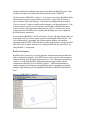
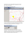
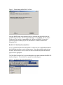
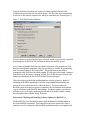
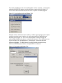
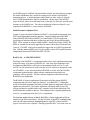
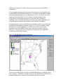
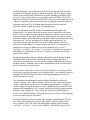
BASINS 4.0 – Flexible Integration of Components and Data for
Watershed Assessment and TMDL Development
Paul B. Duda, John L. Kittle, Jr., Mark H. Gray, Paul R. Hummel,
Russell S. Kinerson, Ph.D. 1 , Paul Cocca1 , David Wells1 ,
Marjorie Wellman1 , Ed Partington1 , Lauren MacWilliams1
AQUA TERRA Consultants
150 E. Ponce de Leon Ave., Suite 355
Decatur, GA 30030
ABSTRACT
BASINS is a multipurpose environmental analysis system designed for use by regional,
state, and local agencies in performing watershed and water quality-based studies. This
system makes it possible to quickly assess large amounts of point source and nonpoint
source data in a format that is easy to use and understand. Installed on a personal
computer, BASINS allows the user to assess water quality at selected stream sites or
throughout an entire watershed. This invaluable tool integrates environmental data,
analytical tools, and modeling programs to support development of cost-effective
approaches to watershed management and environmental protection, including TMDLs.
The latest release of BASINS is version 3.1. Like the previous release, BASINS includes
a data extractor, projector, project builder, GIS interface, various GIS-based tools, a
series of models, and custom databases. But instead of including that data on multiple
CDs as in version 3.0, data are available entirely through a web data extraction tool. This
web data extractor provides a tool for dynamic downloading of BASINS data from a
variety of sources. Other significant enhancements in version 3.1 include a new tool to
archive and restore BASINS projects, updated data holdings, and a tool to update the
BASINS software interactively.
The design of the BASINS 3.1 components lends itself to a more significant restructuring
in the release of version 4.0. One of the major challenges in the development of BASINS
4.0 will be the accommodation of different GIS software platforms, while removing the
current ArcView software as prerequisite to the use of BASINS. A new software product
in BASINS 4.0 will tie all of the BASINS components together through a single software
component not based upon any proprietary software package. This new software
component will be known as the BASINS System Application.
The BASINS 4.0 System Application will encompass all of the existing BASINS
components and more through a single new interface. As in BASINS 3.1, independent
access to individual components will still be available, but these components will be tied
together into one interface. The System Application will identify which (if any) ArcView
products are available on the user’s computer, and will thus indicate the GIS-based
1
U.S. Environmental Protection Agency
functionality available to the user. This design provides a migration path from the
ArcView 3.x components to the ArcView 8.x components.
KEYWORDS
BASINS, TMDLs, Geographic Information Systems, HSPF, Modeling, Software
BASINS 3.1 – EVOLVING TO MEET NEW CHALLENGES
Since the release of BASINS 3.0 in June of 2001, a number of enhancements have been
made to various components. These updates have been packaged as a series of patches to
the BASINS system, available for download from the BASINS web site. Since the first
release of BASINS in 1996, the BASINS system has been distributed as a set of CDs.
The BASINS team has also observed that data tend to age quickly, and thus the BASINS
CD sets are quickly out of date soon after their release.
As the BASINS system has evolved over the past few years, the incremental
enhancements have accumulated. But other factors have resulted in a need to re-package
the entire BASINS system as a new release. The most significant of the changes to the
BASINS system is a shift in data distribution. With unlimited data available on the
World Wide Web, the static picture of data on CDs is no longer adequate. The new
BASINS release takes advantage of the power of Internet connections to provide much
more dynamic data to the users.
In addition to providing dynamically updated data, several other trends have influenced
the development of this incremental release of BASINS. BASINS 3.0 is dependent upon
proprietary software from Environmental Systems Research Institute (ESRI), as most of
the interface is built using the scripting components of ArcView 3.x. Since ESRI is
changing the customization environment for its latest release of desktop GIS software
(now known as ArcGIS), the development team has observed that BASINS system
components will be most reusable in future releases of the application if components
evolve away from use of proprietary software tools. The core GIS functionality is being
separated from the rest of the BASINS system components, which will lead to a smoother
evolution to the latest GIS platform.
Other needs identified by the BASINS team are being met in this incremental release.
Users have noted that it is difficult to move a BASINS project from one computer to
another, because each project contains a large number of files distributed throughout a
directory structure. Users have also noted that archiving projects is important, especially
when the BASINS system is being used in a particularly high-stakes situation, with
reproducibility and defensibility taking on major importance. Another need identified by
the BASINS team is a clearer identity for the BASINS system. The structure of BASINS
3.0 was such that the user would run a number of different programs under different
situations, which led to confusion about what exactly defines the BASINS system. These
and other needs have been addressed in this incremental release of BASINS.
The latest release of BASINS is version 3.1. Like the previous release, BASINS includes
a data extractor, projector, project builder, GIS interface, various GIS-based tools, a
series of models, and custom databases. But instead of including that data on multiple
CDs as in version 3.0, data are available entirely through a web data extraction tool. This
web data extractor provides a tool for dynamic downloading of BASINS data from a
variety of sources. Other significant enhancements in version 3.1 include a new tool to
archive and restore BASINS projects, updated data holdings, and a tool to update the
BASINS software interactively.
Access to data in BASINS 3.1 will be web based. The user will either download the core
system from an EPA web site or obtain a single CD containing BASINS software. The
user will then specify a geographic area of interest and the software will download
appropriate data from EPA, USGS and other locations on the Internet. Existing BASINS
users will be able to update, from the web, existing BASINS data sets and software by
using BASINS 3.1 components.
BASINS 3.1 Interface
BASINS can be viewed as a set of utility programs, analytical tools and associated data
under a metaphorical umbrella. A BASINS 3.0 user can run separate software products
based on the stage of the BASINS application process. The component-based design of
version 3.1 ties all of the BASINS components together through a single software
component, the BASINS ArcView interface (Figure 1). While being maintained as
separate programs for development and updating, having the components tied together
through a single interface gives the metaphorical umbrella over BASINS substance and
form.
Figure 1: The BASINS 3.1 Interface
Thus when using BASINS, a user may always proceed by running the BASINS ArcView
interface and then choosing a function within this program. This design clarifies the
identity of BASINS and ties all of the BASINS components together as a cohesive whole.
Instead of running the Data Extractor program, followed by the Project Builder program,
followed by the BASINS GIS interface as in BASINS 3.0, the user may always begin a
BASINS session by clicking on the BASINS desktop icon. From that point the user
chooses whether to begin a new BASINS project or open an existing project. Software
components are available to run separately if desired, but each component has a menu
item within the BASINS interface so that each component may be accessed from the
same interface.
Web-Based Data Extractor
With BASINS 3.1 being released unencumbered by the extensive BASINS data holdings,
one of the most significant changes for a BASINS user is in setting up a new BASINS
project using the BASINS data holdings accessed through the World Wide Web. In
creating a new BASINS project, the user opens BASINS and chooses to create a new
BASINS project. Doing so invokes a GIS interface displaying the 48 contiguous United
States, the counties within those states, and the 8-digit hydrologic units or HUCs (Figure
2).
Figure 2: The BASINS 3.1 Data Extractor
From this interface a user may, using the standard ArcView map tools, zoom to any
portion of the map and select a region of interest. That region may be one or more
HUCs, counties, or states (Figure 3).
Figure 3: The Data Extractor with one HUC selected
To create a new BASINS project, the user selects a particular menu item in the interface.
BASINS prompts for the name of a project folder to create and the project name (Figure
4). The user is also prompted for a map projection to use for that project.
Figure 4: The Data Extraction Dialog
At this point, the ArcView interface invokes a new tool, known as the Web Data
Download tool. Program control has left the ArcView interface, a fact which is not
important for the user to know but which will allow for easier migration for later releases
of BASINS. The Web Data Download tool (Figure 5) finds the appropriate data from
among the core BASINS data holdings and downloads that data.
Figure 5: Downloading the BASINS Core Data
Once the BASINS data are downloaded, they are extracted and projected to the user
specified map projection. Once the projection change is accomplished, the new project
file (the ArcView .apr file) is automatically built. Where the BASINS 3.0 user ran a
separate program to build the project file, that function is combined with the Data
Extraction Tool.
BASINS 3.1 Web Data Download Tool
A new Web Data Download tool in BASINS 3.1 allows the user to add additional data to
the BASINS project from a variety of data sources. Since data available on the web are
not static, this tool allows a user to check for more recent data and update the BASINS
project data as appropriate.
The Web Data Download tool is accessed through a menu option within the BASINS GIS
interface (Figure 6). The tool itself is a separate executable program.
Figure 6: Invoking the Web Data Download tool
When the Web Data Download tool is started, a window appears listing all of the
available data types that the tool may add or update. The list of data types is determined
at run-time, so this list may expand as new data-type components are created (Figure 7).
Figure 7: Web Data Download Window
The user chooses as many of the data types as desired, and the tool accesses the specified
data through the World Wide Web and adds the data to the BASINS project.
A key feature of BASINS Web Data Download's architecture is the separation of each
data type into individual components. Thus, for each data type available for downloading,
there is a unique Dynamic Link Library (DLL). This greatly enhances the ability to
maintain the entire Web Data Download program. If a data type's web storage is changed
such that the code also requires changing, only the DLL for that data type will need to be
updated and distributed, not the whole Web Data Download program.
This tool provides great flexibility in pulling data from a variety of sources. Instead of
distributing all BASINS data through a specially compiled BASINS data holding, the
data can be retrieved from the source of the data directly. This design makes the
BASINS system easier and less expensive to maintain, since it eliminates having another
copy of each dataset in the BASINS data holdings. In addition, updates to the data are
available as soon as the agency producing the data makes the update available, making
the most updated data available directly to the user.
Interactively Checking and Installing Software Updates for BASINS 3.1
The BASINS Web Data Download tool has a built-in function for installing updates to
any of the BASINS components. This feature allows the user to interactively check a
particular server for components of the BASINS installation that have been updated; and
if any are found, download and install those updates. Through this feature the BASINS
users can be assured that are running the most up-to-date software.
The ‘Check for Updates’ feature is run from a menu option in the Web Data Download
tool. When that menu option is selected, a window entitled ‘Check for Software
Updates’ will appear (Figure 8). The Server URL defaults appropriately to the web
location of the updates since the previous software release.
Figure 8: The Check for Updates Window
If there are any updates posted on the server, a window will appear listing the updates
that are available to be installed (Figure 9). By default all available updates are checked;
if the user wishes to install only certain updates he or she may un-check any of the
updates. Clicking on the ‘Details’ button provides details of that component, which may
be useful in helping the user determine if that particular update is relevant to that user,
given which functions the user may or may not be using. Clicking ‘OK’ begins the
process of automatically downloading and installing updates.
Figure 9: The List of Available Updates
Since this feature is part of the Web Data Download tool, it is not tied to ArcView, and
thus it has the inherent flexibility to migrate to future versions of BASINS.
BASINS 3.1 Archive and Restore Tool
A BASINS project consists of a multitude of files, including GIS data layers, tables, and
model input and output files. The Archive and Restore Tool, new for BASINS 3.1,
provides a means to easily archive the current state of a BASINS project and restore it at
a later time. The project can be restored on the same or another computer, and it may be
restored under the same or a different name.
The Archive and Restore tool is accessed through an ArcView extension. A menu option
within the BASINS GIS interface provides the means to invoke this tool (Figure 10).
Like the Web Data Download tool, the tool itself is a separate executable program.
Figure 10: Accessing the Archive and Restore Tool
When the Archive and Restore tool is invoked, a window appears giving the user options
to archive a project, restore a project, view and compare archives, and build a new
BASINS project (Figure 11). The View/Compare option is useful for seeing and
understanding the differences between various archived projects. These differences may
be seen as a list of files with differences or, for map layers, viewed on a map with
differences highlighted. The Build function is a utility included so that the user may
build a new BASINS project from an existing BASINS core data set.
Figure 11: The Archive and Restore Tool
As BASINS projects, with their associated model scenario, get more and more complex,
the Archive and Restore tool is useful for keeping precise records of the BASINS
application process. A model application where much is at stake, such as is often the
case in TMDL determinations, must be reproducible. Having steps of the BASINS
project archived, where one could return to any of the steps at a later time, provides great
assistance to the BASINS user. The software architecture of this tool allows for easy
migration from BASINS 3.1 to later releases of BASINS.
Model Parameter Optimizer Tool
In order to assist with model calibration, BASINS 3.1 also includes an integration of the
PEST model independent parameter optimizer. Targeted initially toward the HSPF
model, BASINS-PEST takes an HSPF User Control Input (UCI) file (along with
specification of simulated and observed data sets) and creates all input files needed by
PEST. PEST can then be run from within BASINS. Detailed knowledge of PEST and
HSPF are essential for successful application, but much of the tedium of setup has been
removed. The HSPF code has been updated to support the use of PEST supplemental
files. With the enhanced HSPF code, it is also possible to have PEST update timeseries
multiplication factors and FTABLES in HSPF UCI files.
BASINS 4.0 – A NEW BEGINNING
The design of the BASINS 3.1 components lends itself to a more significant restructuring
in the next release, to be known as BASINS 4.0. One of the major challenges in the
development of BASINS 4.0 will be the accommodation of both ArcView 3.x and
ArcGIS 8 as GIS analysis tools, while removing ArcView software as prerequisite to the
use of BASINS. A new software product in BASINS 4.0 will tie all of the BASINS
components together through a single software component not based upon any
proprietary software package. This new software component will be known as the
BASINS System Application.
The BASINS 4.0 System Application will encompass all of the existing BASINS
components and more into a single new interface. As in BASINS 3.1, independent
access to individual components will still be available, but these components will be tied
together into one interface. The System Application will identify which (if any) GIS
software products are available on the user’s computer, and will thus indicate the GISbased functionality available to the user. This design provides a migration path from the
ArcView 3.x components to the ArcView 8.x components.
The dominant graphical feature within the BASINS 4.0 System Application will be an
interactive map of the United States. The map will show 8-digit HUC boundaries along
with state and county boundaries, highlighting those 8-digit HUCs where BASINS
projects exist on the user's computer. Selecting a particular HUC (or in some cases an
existing project within a HUC) allows the user to proceed into any of the BASINS
components.
A key advantage to this approach is the removal of ArcView 3.x as a prerequisite to the
use of BASINS, while allowing its continued use. The BASINS system will be available
with limited GIS functionality to a user without either ArcView 3 or ArcGIS. All of the
functionality from the BASINS 3 ArcView interface will still be available, while
components for ArcGIS can be developed over time and rolled out to the user
community. Specific BASINS functionality will require prerequisite GIS products, just
as Spatial Analyst is indicated as prerequisite to some functions of BASINS 3.
The dominant feature of the new BASINS System Application will be a map showing the
48 contiguous states and the 8-digit HUCs (Figure 12). The HUCs containing existing
BASINS projects will be highlighted. Users will be able to turn a layer of county
boundaries on or off and identify features from a selected layer using the ‘hold-over’
tool-tip text. This map will not use any proprietary mapping tools, so this application
will not require any run-time licensing.
Figure 12: The BASINS 4.0 System Application
To the left of the map will be a list of the current BASINS datasets, or watersheds, on the
user’s computer. A BASINS watershed is defined as any BASINS data set that has been
downloaded and extracted, and thus will correspond to the directories of the
/BASINS/data folder. The watersheds will be listed in a tree diagram, and within each
watershed will be listed the ‘Projects’ within that watershed. The term ‘Project’ will be
defined as any saved file from a BASINS tool or model, including the BASINS .apr for
ArcView 3.x, the .mxd for ArcView 8.x, the GenScn .sta file, the HSPF UCI file, and
status files from SWAT, PLOAD, and AQUATOX. There may be more than one of each
of these per watershed, because a user may have several projects, representing different
subsections of the same HUC or different model simulation scenarios, within one
watershed. Double-clicking on a project will open that project.
Above the Watersheds list will be a series of command buttons that apply to the
Watersheds list. The ‘Build’ button will be used to extract a watershed or create a new
Project. If no watersheds are selected in the Watersheds list, but one or more HUCs are
selected on the map, a click of the ‘Build’ button implies that the user wants to extract a
watershed. Doing so will prompt the user for the name of the new watershed and the map
projection to use. The new watershed will be added to the Watersheds list. If a
watershed is selected in the Watersheds list when the ‘Build’ button is clicked, the
software will assume that the user wants to create a new Project. A message box will
prompt the user to specify whether the new Project should be type ‘ArcView 3’,
‘ArcView 8’, or ‘GenScn’. If ‘ArcView 3’ or ‘ArcView 8’ is specified, the equivalent of
the BASINS 3.0 Project Builder will be run. If ‘GenScn’ is specified, a new GenScn
project will be created.
Another command button associated with the Watersheds list will be a ‘Delete’ button.
This button will be used to delete a watershed or project, depending upon which is
selected in the Watersheds list. The user will be prompted to confirm the request before
anything is deleted. If nothing is selected in the Watersheds list, the user will be asked to
specify a watershed or project to delete.
The ‘Re-Project’ button will be used to re-project the GIS data of an existing watershed,
and save the re-projected data under a new watershed name. If no watershed is selected,
clicking the ‘Re-Project’ button will result in a message prompting the user to specify
which watershed to re-project.
Three additional command buttons associated with the Watersheds list will be the
‘Archive’, ‘Restore’, and ‘Compare’ buttons. With an ArcView 3 project selected, the
‘Archive’ command will start the Archive tool with the specified project. Clicking the
‘Restore’ button will start the Restore tool. Once a BASINS project is restored it will be
reflected in the Watersheds list. The ‘Compare’ button will invoke the Compare function
within the Archive/Restore tool. The Compare tool requires two BASINS projects
selected. If one BASINS project is selected in the Projects list, the user will be prompted
to select the other project for comparison.
To the right of the map will be two frames, each containing command buttons. Each of
these frames will be populated at run-time based upon the software available on the
user’s computer. The ‘Tools’ frame will contain buttons including ‘Data Download’,
‘ArcView 3’, ‘ArcView 8’, ‘GenScn’, and ‘WDMUtil’. Each of these buttons will be
used to invoke the respective program. The ‘Data Download’ button will be used to run
the data download tool, pulling data to put into an existing BASINS project. The ‘Data
Download’ button will be available when one and only one BASINS project is selected.
The ‘ArcView 3’, ‘ArcView 8’, and ‘GenScn’ tools relate to specific projects; thus if one
project of the type corresponding to that tool is selected in the Projects list, the program
will open with that project active.
Also to the right of the map will be the ‘Models’ frame. This frame will contain
command buttons including WinHSPF, SWAT, PLOAD, and AQUATOX, depending
upon the software installed on the computer. Additional models will be added as they
become available (see below). The available models will be found at run-time.
Upon start-up of the BASINS System Application, the 8-digit HUCs corresponding to the
user’s BASINS Projects will be highlighted. In another color the current 8-digit HUC(s)
will be highlighted signifying the current selected HUC(s). The Watersheds list will be
linked to the map, so that when a HUC is selected on the map the corresponding
watersheds are highlighted. Note that there may be more than one ‘watershed’ per HUC,
since the same watershed’s data may be stored multiple times for multiple projections. If
the user clicks on a HUC with which multiple watersheds are associated, the user will be
prompted to select a particular watershed.
Class Architecture
The extension architecture, integral to BASINS since version 3.0, allows for the addition
of other models without re-releasing the core software. A similarly extensible
architecture will allow tools and models to be added at runtime for BASINS 4.0.
A BASINS 4.0 tool or model will implement a generic interface defined through a Visual
Basic class. Each tool or model will have its own class. Code specific to the tool will
reside in the class along with standard properties and methods used by the BASINS
System Application and other components. Tools will be discovered at runtime, allowing
tools to be added or updated independent of the BASINS core system.
Similarly, a Visual Basic class will implement an interface to the BASINS Watershed.
This class will be used to hold information about each watershed. When the BASINS
System Application is started, the BASINS Watersheds on a system are inventoried and
the class is built for each watershed. This information is displayed in the System
Application and passed to a BASINS Tool when it is invoked.
This flexible class-based architecture is especially important for the BASINS system,
which combines dynamic data sources with a suite of models. The data continually
evolve, as do the models as different agencies or organizations continually enhance and
refine these tools. The software architecture of BASINS 4.0 provides the flexibility
needed to keep BASINS always at the leading edge of watershed assessment and TMDL
development systems.
The BASINS 4.0 ArcMap Toolbar
One of the most significant enhancements in BASINS 4.0 will be support for ArcGIS 8.
A custom GIS interface for BASINS will be available in ArcGIS through a toolbar in
ArcMap. The BASINS Toolbar (Figure 13) will contain menus for accessing the suite of
BASINS GIS functions.
Figure 13: The BASINS Toolbar in ArcMap
The software underlying each menu option in the BASINS toolbar will be packaged as a
separate DLL, providing flexibility in the structure of the toolbar, as well as
expandability as other tools or models are added in the future. Each menu option will
invoke a tool developed in Visual Basic, using ESRI’s ArcObjects for GIS functions. All
of the tools and models will share a common component for interacting with ArcObjects.
This design enforces a clear separation between tool components and GIS functions.
This separation will help accommodate future updates to ESRI’s ArcObjects since only
one component would need to be updated. Should BASINS ever move away from using
ESRI products, this design even provides a clear migration path for using core GIS
functions from other GIS packages.
The HSPF tool, known as ‘BASINS HSPF for ArcGIS’, is the first of the menu options to
be implemented (Figure 14). The user interface for this tool was developed using Visual
Basic, making use of a number of Visual Basic custom controls and utilities developed
for other BASINS tools.
Figure 14: BASINS HSPF for ArcGIS
Through this interface the user specifies the GIS layers and fields within those layers to
be used in setting up a new HSPF project. The flexible design of this tool allows for use
of data layers developed outside of BASINS in setting up HSPF.
CONCLUSIONS
The flexible design of BASINS components provides a smooth migration path to
BASINS 4.0. BASINS has been presented with a considerable challenge in the
transition from ArcView 3 to ArcGIS 8, but the core BASINS system has flexibility in its
design. Enhancements provided in BASINS 3.1 will migrate to the new BASINS 4.0,
keeping BASINS at the leading edge of watershed assessment and TMDL development
systems.
REFERENCES
Better Assessment Science Integrating Point and Nonpoint Sources (BASINS), Version
3.0 User’s Manual: U. S. Environmental Protection Agency, EPA-823-C-01-001, Office
of Water, Washington DC.
Bicknell, B.R., J.C. Imhoff, J.L. Kittle, Jr., A.S. Donigian, Jr., and R.C. Johanson. 1997.
Hydrological Simulation Program - FORTRAN, User's manual for version 11. U.S.
Environmental Protection Agency, EPA-600-R-97-080, National Exposure Research
Laboratory, Athens, Ga., 755 p.
Bicknell, B.R., J.C. Imhoff, J.L. Kittle Jr., A.S. Donigian, Jr., T.H. Jobes, and R.C.
Johanson. 2000. (Draft Final). Hydrological Simulation Program - FORTRAN, User’s
Manual for Version 12. U.S. EPA, National Exposure Research Laboratory, Athens, GA.