1
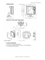
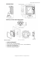
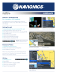
SEIWA PRODUCT SPECIFICATION
SW501i – Multifunction chartplotter
5 inches multifunction chartplotter with integrated GPS antenna. A compact, innovative, well-lit, 1/4 VGA
sunlight viewable chartplotter, featuring a unique sleek design and unsurpassed quality.
Product Description
SW501x Series is extremely fast responsive, completely waterproof (IP67), it can be flush mount
(completely built in, on a level with the helm) or bracket mounted.
The new revolutionary quick disconnect adjustable bracket can be both tilted and rotated, matching all
possible positioning and installation needs, plus offering the easiest removal solution.
SW501x Series supports advanced features such as free downloadable weather overlays and forecasts, 3D
perspective view, photos, tidal heights and currents as well as the Guardian Alarm which checks your route
for potential grounding issues.
If SW501x Series is combined with SEIWA Black Box Fish Finder, you can choose from a full screen
sounder display or split screen sounder/chart plotter, and can be coupled with various kinds of plastic stern
thru hull transducers, or in hull transducers, or bronze thru hull transducers: the unit works with Xid AIRMAR
transducers.
Soft Keys are available to guarantee maximum efficiency and easiness of use, which change function
depending upon the current display with an easy key label prompted on the screen.
User friendly state-of-the-art software with outstanding graphics and cutting edge functions such as
'Grounding Alarm', Anchor Alarm, Weather Forecast, Multilanguage.
SW501x Series is compatible with DSC and AIS equipments and is equiped with WAAS/EGNOS/MSAS
GPS active antenna.
The units are compatible with C-MAP by Jeppesen cartography, using SD cartridges.
Summary of Features
•
•
•
•
•
•
•
•
•
•
•
•
•
•
Worldwide Built-in Cartography showing detail up to 2.0 NM
C-MAP by Jeppesen MAX charts compatible
Object-oriented chart system with enhanced functionality including:
o Guardian alarm, Safety Status Bar, Safe Route Checking
o Perspective View
o Satellite Image Coverage (on worldwide background)
o Turbo and Smooth Zoom
o Multilanguage
o Enhanced Port Information database
o Tides & Currents data
o Photos & Diagrams
o Automatic Information on all chart objects and User Points
o Find function for Ports Services, Ports By Name, Ports By Distance, Tide Stations, Wrecks,
Obstructions, Lakes Information
5,000 User Points: Waypoints/Marks
1,000 Track Points
3 Tracks
25 Routes
User Points Icons 16
Create, Move, Insert, Edit, Delete, Send, Receive Waypoint
Create, Move, Edit, Delete, Send, Receive Mark/Event
Navigation to Goto
Create, Save, Name, Edit, Delete, Send, Receive or Follow a Route
Route Data Report and User Points (Marks/Waypoints) List pages
Display vessel's position, direction and Track
Copyright 2011 Seiwa S.R.L. All rights reserved
SEIWA PRODUCT SPECIFICATION
•
•
•
•
Man OverBoard (MOB) to navigate back to a missing person or object
Weather Service capability
Range & Bearing function
Simulation Mode with cursor control
Functions
•
•
•
•
•
•
•
•
•
•
•
•
BBFF compatible
AIS compatible
DSC compatible
WAAS/EGNOS/MSAS compatible
MOB (Man Over Board)
Time to Destination
Distance to Destination
Selectable track color
Compass Calibration
Navigation Info
Automatic Info on cartographic objects
Simulation Mode
Key pages
•
•
•
•
•
•
•
•
•
Positional information from GPS
Depth Graph Page (Split & Full)
Navigation Data page
3D Road page
GPS Status page
Gauges page
AIS Report List page
Fish Finder
User Points List Page
Alarms Handling
•
•
•
•
•
•
•
•
•
•
Auto Off
Arrival Alarm
XTE Alarm
Anchor Alarm
Depth Alarm
HDOP Alarm
Heading Alarm
Grounding Alarm
Grounding Depth Limit Alarm
Grounding Alarm Range
Technical specifications
•
•
•
•
•
•
•
•
•
•
•
Microprocessor: ARM9 S32442MSP3 300 Mhz
Display: 5" TFT LCD Colour
Sunlight viewable Display
Resolution: 240x320
Power consumption: 0.6A @ 12Vdc
Supply Voltage: 10-35 Vdc
Cartridge slots: 1 x SD-Card
GPS Antenna: SW501i internal
Operating temperature: 0-55 °C
NMEA inputs/outputs: 3 x Nmea 0183
Connectors:
o Supply and data bracket: 10 pins
Copyright 2011 Seiwa S.R.L. All rights reserved
SEIWA PRODUCT SPECIFICATION
The box contains:
•
•
•
•
•
#1 SW501i (P2CH9100SW);
#1 Suncover (HPC36AX/A);
#1 Fuse 2A + fuse holder (K0FUSHV003);
#1 quick disconnect bracket with Power I/O cable, 1,5mt (K10QDB004A);
#1 User Manual (English language);
Copyright 2011 Seiwa S.R.L. All rights reserved
SEIWA PRODUCT SPECIFICATION
SW501e – Multifunction chartplotter
5 inches multifunction chartplotter with external GPS antenna included. A compact, innovative, well-lit, 1/4
VGA sunlight viewable chartplotter, featuring a unique sleek design and unsurpassed quality.
Product Description
SW501x Series is extremely fast responsive, completely waterproof (IP67), it can be flush mount (completely
built in, on a level with the helm) or bracket mounted.
The new revolutionary quick disconnect adjustable bracket can be both tilted and rotated, matching all
possible positioning and installation needs, plus offering the easiest removal solution.
SW501x Series supports advanced features such as free downloadable weather overlays and forecasts, 3D
perspective view, photos, tidal heights and currents as well as the Guardian Alarm which checks your route
for potential grounding issues.
If SW501x Series is combined with SEIWA Black Box Fish Finder, you can choose from a full screen
sounder display or split screen sounder/chart plotter, and can be coupled with various kinds of plastic stern
thru hull transducers, or in hull transducers, or bronze thru hull transducers: the unit works with Xid AIRMAR
transducers.
Soft Keys are available to guarantee maximum efficiency and easiness of use, which change function
depending upon the current display with an easy key label prompted on the screen.
User friendly state-of-the-art software with outstanding graphics and cutting edge functions such as
'Grounding Alarm', Anchor Alarm, Weather Forecast, Multilanguage.
SW501x Series is compatible with DSC and AIS equipments and is equiped with WAAS/EGNOS/MSAS GPS
active antenna.
The units are compatible with C-MAP by Jeppesen cartography, using SD cartridges.
Summary of Features
• Worldwide Built-in Cartography showing detail up to 2.0 NM
• C-MAP by Jeppesen MAX charts compatible
• Object-oriented chart system with enhanced functionality including:
o Guardian alarm, Safety Status Bar, Safe Route Checking
o Perspective View
o Satellite Image Coverage (on worldwide background)
o Turbo and Smooth Zoom
o Multilanguage
o Enhanced Port Information database
o Tides & Currents data
o Photos & Diagrams
o Automatic Information on all chart objects and User Points
o Find function for Ports Services, Ports By Name, Ports By Distance, Tide Stations, Wrecks,
Obstructions, Lakes Information
• 5,000 User Points: Waypoints/Marks
• 1,000 Track Points
• 3 Tracks
• 25 Routes
• User Points Icons 16
• Create, Move, Insert, Edit, Delete, Send, Receive Waypoint
• Create, Move, Edit, Delete, Send, Receive Mark/Event
• Navigation to Goto
• Create, Save, Name, Edit, Delete, Send, Receive or Follow a Route
• Route Data Report and User Points (Marks/Waypoints) List pages
• Display vessel's position, direction and Track
Copyright 2011 Seiwa S.R.L. All rights reserved
SEIWA PRODUCT SPECIFICATION
•
•
•
•
Man OverBoard (MOB) to navigate back to a missing person or object
Weather Service capability
Range & Bearing function
Simulation Mode with cursor control
Functions
•
•
•
•
•
•
•
•
•
•
•
•
BBFF compatible
AIS compatible
DSC compatible
WAAS/EGNOS/MSAS compatible
MOB (Man Over Board)
Time to Destination
Distance to Destination
Selectable track color
Compass Calibration
Navigation Info
Automatic Info on cartographic objects
Simulation Mode
Key pages
•
•
•
•
•
•
•
•
•
Positional information from GPS
Depth Graph Page (Split & Full)
Navigation Data page
3D Road page
GPS Status page
Gauges page
AIS Report List page
Fish Finder
User Points List Page
Alarms Handling
•
•
•
•
•
•
•
•
•
•
Auto Off
Arrival Alarm
XTE Alarm
Anchor Alarm
Depth Alarm
HDOP Alarm
Heading Alarm
Grounding Alarm
Grounding Depth Limit Alarm
Grounding Alarm Range
Technical specifications
•
•
•
•
•
•
•
•
•
•
•
Microprocessor: ARM9 S32442MSP3 300 Mhz
Display: 5" TFT LCD Colour
Sunlight viewable Display
Resolution: 240x320
Power consumption: 0.6A @ 12Vdc
Supply Voltage: 10-35 Vdc
Cartridge slots: 1 x SD-Card
GPS Antenna: SW501e external with cable
NMEA input/output: 3 x Nmea 0183
Operating temperature: 0-55 °C
Connectors:
o Supply and data bracket: 10 pins
Copyright 2011 Seiwa S.R.L. All rights reserved
SEIWA PRODUCT SPECIFICATION
The box contains:
•
•
•
•
•
•
•
#1 SW501e (P2MH9100SW);
#1 Suncover (HPC36AX/A);
#1n Fuse holder + fuse (K0FUSHV003);
#1 quick disconnect bracket with Power I/O cable, 1,5mt (K10QDB004A);
#1 GPS antenna (UX0GSU42SE);
#1 GPS cable, 15,0 mt (CBCCFS0801);
#1 User Manual (English language);
Copyright 2011 Seiwa S.R.L. All rights reserved