1
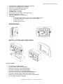
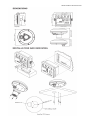
SEIWA PRODUCT SPECIFICATION
Explorer 3 w/o GPS antenna – Multifunction chartplotter
Multifunction chartplotter. The Explorer 3 is yet another improvement of the most reliable and affordable
controller in the world.
Product Description
Explorer3 is the smallest chartplotter in Black Box version capable to be connected to a wide range of
monitor, with 3 different display resolutions: 640x480 (VGA) or 800x600 (SVGA) or 1024x768 (XGA); this
multifunction chartplotter (cartographical plotter, fishfinder, radar, wind data) with up-to XGA resolution, is
ideal for installations where space is a plus and can be mounted indoors or outdoors and the ceiling or on
the board; the compact Explorer3 provides high performances without sacrificing any functionality on.
It is the perfect mate for the professional fishermen or high-tech dashboard.
It features a new 400Mhz microprocessor capable to manage the 5 I/O port and the optional equipment like
Black Box Fishfinder, Radar Antenna, AIS receiver, Autopilot, DSC VHF.
It is the fastest responsive chartplotter in the marketplace, completely waterproof (IP67), and can be flush
mount or bracket mounted.
Explorer3 can be transformed into a radar when connected to one of the Seiwa radar scanners.
Explorer3 features a powerful and user friendly state-of-the-art software, now updated with outstanding
graphics and cutting edge functions such as free downloadable weather overlays and forecasts, 3D
perspective view, HD photos, tidal heights and currents as well as the Guardian Alarm which checks your
route for potential grounding issues.
If Explorer3 is combined with SEIWA Black Box Fish Finder (50/200Khz, 100W), you can choose from a full
screen sounder display or split screen sounder/chart plotter, and can be coupled with various kinds of
plastic stern thru hull transducers, or in hull transducers, or bronze thru hull transducers: the unit works with
Xid AIRMAR transducers.
Soft Keys are available to guarantee maximum efficiency and easiness of use, which change function
depending upon the current display with an easy key label prompted on the screen.
Explorer3 Series is compatible with DSC and AIS equipments and is equiped with WAAS/EGNOS/MSAS
GPS active antenna (not included).
The units are compatible with C-MAP by Jeppesen cartography, using C-Card cartridges.
Summary of Features
• Worldwide Built-in Cartography showing detail up to 2.0 NM
• C-MAP by Jeppesen MAX charts compatible
• Object-oriented chart system with enhanced functionality including:
o Guardian alarm, Safety Status Bar, Safe Route Checking
o Perspective View
o Satellite Image Coverage (on worldwide background)
o Turbo and Smooth Zoom
o Multilanguage
o Enhanced Port Information database
o Tides & Currents data
o Photos & Diagrams
o Automatic Information on all chart objects and User Points
o Find function for Ports Services, Ports By Name, Ports By Distance, Tide Stations, Wrecks,
Obstructions, Lakes Information
• 10,000 User Points: Waypoints/Marks
• 10,000 Track Points
• 5 Tracks
Copyright 2011 Seiwa S.R.L. All rights reserved
SEIWA PRODUCT SPECIFICATION
•
•
•
•
•
•
•
•
•
•
•
•
50 Routes
User Points Icons 16
Create, Move, Insert, Edit, Delete, Send, Receive Waypoint
Create, Move, Edit, Delete, Send, Receive Mark/Event
Navigation to Goto
Create, Save, Name, Edit, Delete, Send, Receive or Follow a Route
Route Data Report and User Points (Marks/Waypoints) List pages
Display vessel's position, direction and Track
Man OverBoard (MOB) to navigate back to a missing person or object
Weather Service capability
Range & Bearing function
Simulation Mode with cursor control
Functions
•
•
•
•
•
•
•
•
•
•
•
•
•
BBFF compatible
Radar compatible
AIS compatible
DSC compatible
WAAS/EGNOS/MSAS compatible
MOB (Man Over Board)
Time to Destination
Distance to Destination
Selectable track color
Compass Calibration
Navigation Info
Automatic Info on cartographic objects
Simulation Mode
Key pages
•
•
•
•
•
•
•
•
•
•
•
•
Positional information from GPS
Depth Graph Page (Split & Full)
Navigation Data page
3D Road page
GPS Status page
Wind Data page
Gauges page
DSC Log and DSC Directory pages
AIS Report List page
Fish Finder Page
Radar Page
User Points List Page
Alarms Handling
•
•
•
•
•
•
•
•
•
•
•
Auto Off
Arrival Alarm
XTE Alarm
Anchor Alarm
Depth Alarm
HDOP Alarm
Heading Alarm
Grounding Alarm
Grounding Depth Limit Alarm
Grounding Alarm Range
External Alarm
Technical specifications
Copyright 2011 Seiwa S.R.L. All rights reserved
SEIWA PRODUCT SPECIFICATION
•
•
•
•
•
•
•
•
•
•
Microprocessor: ARM9 S4C2410 Samsung 400 MHZ
Type: Black Box Multifunction Chartplotter
Resolution: 640x480/800x600/1024x768
Power consumption: 0.6A @ 12Vdc
Supply Voltage: 10-35 Vdc
Cartridge slots: 2 x C-Card
GPS Antenna (not included): external with cable
Operating temperature: 0-55 °C
Nmea inputs/outputs: 5 x NMEA 0183
Connectors:
o 1x Supply and data cable: 8 pins, 2 nmea ports + external alarm
o 1x Aux data cable: 8 pins, 3 nmea ports + external alarm
o 1x GPS cable: 6 pins
o 1x Video Output: 1 VGA
The box contains:
•
•
•
•
•
•
•
•
•
#1 Explorer 3 (P2DC5110SW);
#2 Fuse holder + fuse (K0FUSHV002);
#2 Power I/O cables, 1,5mt (CBC0FS0804);
#1 Video Out adaptor cable (CHMS0700SE);
#1 Aux gps cable 6pin, 1,0 mt (CBC0FS0603);
#3 Cap for Aux I/O - GPS connectors (CAP-WABMMLA1);
#3 Cap for Supply/aux/gps cables (CAP-WABCFLB1);
#1 Bracket kit: metal bracket, washer, 2 knobs (K10DC4004A);
#1 User Manual (English language);
Copyright 2011 Seiwa S.R.L. All rights reserved
SEIWA PRODUCT SPECIFICATION
Explorer 3 with GPS antenna – Multifunction chartplotter
SPECIAL BUNDLE: multifunction chartplotter Explorer 3 with GPS antenna 12 channels
WAAS/EGNOS/MSAS.
Product Description
Explorer3 is the smallest chartplotter in Black Box version capable to be connected to a wide range of
monitor, with 3 different display resolutions: 640x480 (VGA) or 800x600 (SVGA) or 1024x768 (XGA); this
multifunction chartplotter (cartographical plotter, fishfinder, radar, wind data) with up-to XGA resolution, is
ideal for installations where space is a plus and can be mounted indoors or outdoors and the ceiling or on
the board; the compact Explorer3 provides high performances without sacrificing any functionality on.
It is the perfect mate for the professional fishermen or high-tech dashboard.
It features a new 400Mhz microprocessor capable to manage the 5 I/O port and the optional equipment like
Black Box Fishfinder, Radar Antenna, AIS receiver, Autopilot, DSC VHF.
It is the fastest responsive chartplotter in the marketplace, completely waterproof (IP67), and can be flush
mount or bracket mounted.
Explorer3 can be transformed into a radar when connected to one of the Seiwa radar scanners.
Explorer3 features a powerful and user friendly state-of-the-art software, now updated with outstanding
graphics and cutting edge functions such as free downloadable weather overlays and forecasts, 3D
perspective view, HD photos, tidal heights and currents as well as the Guardian Alarm which checks your
route for potential grounding issues.
If Explorer3 is combined with SEIWA Black Box Fish Finder (50/200Khz, 100W), you can choose from a full
screen sounder display or split screen sounder/chart plotter, and can be coupled with various kinds of
plastic stern thru hull transducers, or in hull transducers, or bronze thru hull transducers: the unit works with
Xid AIRMAR transducers.
Soft Keys are available to guarantee maximum efficiency and easiness of use, which change function
depending upon the current display with an easy key label prompted on the screen.
Explorer3 Series is compatible with DSC and AIS equipments and is equiped with WAAS/EGNOS/MSAS
GPS active antenna (not included).
The units are compatible with C-MAP by Jeppesen cartography, using C-Card cartridges.
Summary of Features
• Worldwide Built-in Cartography showing detail up to 2.0 NM
• C-MAP by Jeppesen MAX charts compatible
• Object-oriented chart system with enhanced functionality including:
o Guardian alarm, Safety Status Bar, Safe Route Checking
o Perspective View
o Satellite Image Coverage (on worldwide background)
o Turbo and Smooth Zoom
o Multilanguage
o Enhanced Port Information database
o Tides & Currents data
o Photos & Diagrams
o Automatic Information on all chart objects and User Points
o Find function for Ports Services, Ports By Name, Ports By Distance, Tide Stations, Wrecks,
Obstructions, Lakes Information
• 10,000 User Points: Waypoints/Marks
• Dynamic handling of User Points & Routes (the number of Routes and Waypoints per Route is
dynamic, for example 10,000 Routes with 1 Waypoint each or 1 Route with 10,000 Waypoints).
• 10,000 Track Points
Copyright 2011 Seiwa S.R.L. All rights reserved
SEIWA PRODUCT SPECIFICATION
•
•
•
•
•
•
•
•
•
•
•
•
•
Tracks 10.000
50 Routes
User Points Icons 16
Create, Move, Insert, Edit, Delete, Send, Receive Waypoint
Create, Move, Edit, Delete, Send, Receive Mark/Event
Navigation to Goto
Create, Save, Name, Edit, Delete, Send, Receive or Follow a Route
Route Data Report and User Points (Marks/Waypoints) List pages
Display vessel's position, direction and Track
Man OverBoard (MOB) to navigate back to a missing person or object
Weather Service capability
Range & Bearing function
Simulation Mode with cursor control
Functions
•
•
•
•
•
•
•
•
•
•
•
•
•
BBFF compatible
Radar compatible
AIS compatible
DSC compatible
WAAS/EGNOS/MSAS compatible
MOB (Man Over Board)
Time to Destination
Distance to Destination
Selectable track color
Compass Calibration
Navigation Info
Automatic Info on cartographic objects
Simulation Mode
Key pages
•
•
•
•
•
•
•
•
•
•
•
•
Positional information from GPS
Depth Graph Page (Split & Full)
Navigation Data page
3D Road page
GPS Status page
Wind Data page
Gauges page
DSC Log and DSC Directory pages
AIS Report List page
Fish Finder Page
Radar Page
User Points List Page
Alarms Handling
•
•
•
•
•
•
•
•
•
•
•
Auto Off
Arrival Alarm
XTE Alarm
Anchor Alarm
Depth Alarm
HDOP Alarm
Heading Alarm
Grounding Alarm
Grounding Depth Limit Alarm
Grounding Alarm Range
External Alarm
Technical specifications
Copyright 2011 Seiwa S.R.L. All rights reserved
SEIWA PRODUCT SPECIFICATION
•
•
•
•
•
•
•
•
•
Microprocessor: ARM9 S4C2410 Samsung 400 MHZ
Type: Black Box Multifunction Chartplotter
Resolution: 640x480/800x600/1024x768
Power consumption: 0.6A @ 12Vdc
Supply Voltage: 10-35 Vdc
Cartridge slots: 2 x C-Card
GPS Antenna (not included): external with cable
Operating temperature: 0-55 °C
Connectors:
o In/Out NMEA ports: 5 x Nmea 0183
o Video Output: 1 VGA/SVGA/XGA
o GPS connector: 6 pin
o Power In/Out: 8 pin
The box contains:
•
•
•
•
•
•
•
•
•
#1 Explorer 3 (P2DC5110SW);
#1 Fuse holder + fuse (K0FUSHV002);
#2 Power I/O cables, 1,5mt (CBC0FS0804);
#1 Video Out cable with adaptors (CHMS0700SE);
#3 Cap for Aux I/O - GPS connectors (CAP-WABMMLA1);
#1 Bracket kit: metal bracket, washer, 2 knobs (K10DC4004A);
#1 User Manual (English language);
#1 GPS antenna (UX0GSU42SE);
#1 cable, 10 mt (CBCCFS0801);
Copyright 2011 Seiwa S.R.L. All rights reserved
SEIWA PRODUCT SPECIFICATION
Copyright 2011 Seiwa S.R.L. All rights reserved