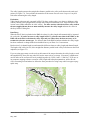
1
Vermont Stream Geomorphic Assessment
Phase 1 Handbook
WATERSHED
ASSESSMENT
USING MAPS, EXISTING DATA,
AND WINDSHIELD SURVEYS
Vermont Agency of Natural Resources
May, 2007
Authorship and editing of the Phase 1 Stream Geomorphic Assessment Handbook and Database
was the collaborative effort of:
Mike Kline
Christa Alexander
Shannon Pytlik
Staci Pomeroy
George Springston
Shayne Jaquith
Barry Cahoon
Larry Becker
DEC River Management Program
formerly of Vermont Department of Fish and Wildlife
DEC River Management Program
DEC River Management Program
Norwich University Dept of Geology
DEC River Management Program
DEC River Management Program
Vermont Geological Survey
Funding for assessment protocol development has been provided by the:
U.S. Environmental Protection Agency
U.S Fish and Wildlife Service – Conservation and Reinvestment Act Funding
Federal Emergency Management Agency
Lake Champlain Basin Program
Vermont Agency of Transportation Research Grant
Vermont Geological Survey State Map Grant
Acknowledgements: Other Agency of Natural Resources staff who worked on the Phase 1 Handbook
include Jim Ryan and Ethan Swift (of the Water Quality Division Planning Section), Jared Carrano,
Leslie Fernandez and Sacha Pealer (of the Water Quality Division River Management Program) and Joe
Zuccarello (Department of Fish and Wildlife). Special thanks and acknowledgement to Brenda Clarkson
and Andrew Tomczak of the ANR Information Technology Section for developing the Web-based data
management system (DMS). An initial draft outline of the Phase 1 Handbook was provided through
contracted services with Lori Barg of Step by Step Consulting. Pilot projects which greatly enhanced the
development of the Phase 1 Handbook were made possible by Michele Boomhower of the Lamoille
County Regional Commission; Marty Illick and Kristen Underwood (and many volunteers) of the Lewis
Creek Association; Amy Sheldon and Dan McKinley (and many volunteers) of the White River
Partnership; Shelly Stiles and Dick Schesinger (and many volunteers) of the Bennington area; and Jed
Wright of the USFWS Gulf of Maine Coastal program (Cove Creek pilot project, Central, Maine).
Request for technical assistance, training, questions and comments should be directed to:
Mike Kline, Fluvial Geomorphologist
River Management Program
DEC, Water Quality Division
103 South Main St., Building 10 North
Waterbury, Vermont 05671-0408
(802) 241-3774
Shannon Pytlik, River Scientist
River Management Program
DEC, Water Quality Division
430 Asa Bloomer State Office Building
Rutland, Vermont 05701-5903
[email protected]
(802) 786-2501
[email protected]
Larry Becker, State Geologist
Vermont Geological Survey
Laundry Building
103 South Main Street , Logue Bldg
Waterbury, VT 05671-2420
(802) 241-3496
[email protected]
Barry Cahoon, P.E. Chief River Mgt. Engineer
River Management Program
DEC, Water Quality Division
103 South Main Street
Waterbury, Vermont 05671-0408
(802) 751-0129 or (802) 241-4309
Barry.Cahoon@ state.vt.us
The Phase 1 Handbook may be downloaded from the River Corridor Management, Geomorphic
Assessment internet web page at: www.vtwaterquality.org/rivers.htm
Table of Contents
Step
Description
Page
1-9
Introduction
1
1
2
5
6
8
9
9
10 - 18
Where to Complete Phase 1 Assessments
Final Products of the Phase 1 Assessment
Basic Methods and Skills
Materials Needed
Getting Started
Phase 1 Quality Assurance Program
Phase I Meta Data
Expanded Menu Options
Starting the Assessment
Defining Stream Reaches
Delineating the primary watershed
Selecting assessment streams
Defining geomorphic reaches – a visual “first cut”
Reach Numbering
Special Circumstances – where not to collect data
Watershed Orientation – verifying reach breaks in the field
Step 1
Reach Locations
1.1
1.2
1.3
Step 2
Reach Description
Town
Latitude and Longitude
Determining Stream Types
2.1
2.2
2.3
2.4
2.5
2.6
2.7
2.8
2.9
2.10
2.11
Step 3
Downstream and Upstream Elevations
Valley Length
Valley Slope
Channel Length
Channel Slope
Sinuosity
Watershed Size
Reference Channel Width
Valley Width
Confinement
Reference Stream Type
Basin Characteristics: Geology and Soils
3.1
3.2
3.3
3.4
3.5
Alluvial Fan
Grade Controls
Geologic Materials
Valley Side Slopes
Soil Properties
4.1
4.2
4.3
4.4
Watershed Land Cover / Land Use
Corridor Land Cover / Land Use
Riparian Buffer Width
Groundwater and Small Tributary Inputs
Step 4
Land Cover and Reach Hydrology
Phase 1 Stream Geomorphic Assessment
VT Agency of Natural Resources
-i-
May, 2007
10
10
10
14
16
17
19
19
19
19
20 - 32
21
21
23
23
24
24
25
25
26
28
28
33 - 41
34
35
37
38
38
42 - 47
43
44
44
46
Step 5
Instream Channel Modifications
Quality Assurance Protocol
48 - 55
48
50
51
53
54
56 - 66
56
58
60
61
64
65
67 -70
68
69
71 - 73
71
72
74 - 77
74
76
77
78
78
79-81
Phase 1 References
82 - 83
5.1
5.2
5.3
5.4
5.5
Flow Regulations and Water Withdrawals
Bridges and Culverts
Bank Armoring or Revetments
Channel Straightening
Dredging and Gravel Mining History
6.1
6.2
6.3
6.4
6.5
6.6
Berms and Roads
River Corridor Development
Depositional Features
Meander Migration / Channel Avulsion
Meander Width Ratio
Wavelength Ratio
Step 6
Planform Changes and Floodplain Modifications
Step 7
Bed and Bank Windshield Survey
7.1
7.2
Bank Erosion – Relative Magnitude
Debris and Ice Jam Potential
8.1
8.2
Total Impact Score
Priority Rating
9.1
9.2
9.3
Channel Adjustment Process
Reach Condition
Reach Sensitivity
Step 8
Stream Impact Ratings
Step 9
Step 10
Stream Geomorphic Condition Assessment
Like Reach Evaluation
Phase 1 Stream Geomorphic Assessment
VT Agency of Natural Resources
- ii -
May, 2007
Figures
Figure Number
Figure 1.1
Figure 1.2
Figure 1.3
Figure 1.4
Figure 1.5
Figure 2.1
Figure 2.2
Figure 2.3
Figure 3.1
Figure 3.2
Figure 3.3
Figure 3.4
Figure 5.1
Figure 5.2
Figure 5.3
Figure 6.1
Figure 6.2
Figure 6.3
Figure 6.4
Figure 6.5 A & B
Figure 6.6
Figure 6.7
Figure 6.8
Figure 7.1
Figure 8.1
Figure 8.2
Figure 9.1
Figure 10.1
Description
Confined, narrow and broad valley types
Reach break based on a change in the valley width
Reach break due to a change in valley slope and confinement
Example of Impounded Reach
Example of reach numbering system
Valley length versus channel length
Example of delineating reach sub-watersheds
Example of valley width on a topographical map
Alluvial fan indicated by topographic lines
Natural and structural grade controls
Example of NRCS soil survey
Aggregated Bedrock Classes for Vermont
Perched culvert restricting fish movement and migration
Examples of Vermont hard-armored stream banks
Channel straightening as seen from a topographical map
Roads located within the river corridor
Berms and Roads within the river corridor
Developments within the river corridor
Mid-channel and point bars viewed on an ortho-photograph
Meander migration: high and low impacts
Belt width measurement example
Example of regular and irregular meanders
Wavelength measurement example
Ice jam formation at a dam on the Winooski River
Example of DMS report summarizing impacts by category
Downstream to upstream locations of impacted reaches
Example of database report of adjustment process scores
Example of like reach evaluation database report
Page
11
12
13
15
16
22
25
27
35
36
37
41
50
52
53
57
57
59
61
62 & 63
65
65
66
69
72
73
75
78
Tables
Table Number
Table 1.1
Table 1.2
Table 2.1
Table 2.2
Table 7.1
Table 9.1
Table 9.2
Description
Guide to valley slopes
Parameters and map codes for watershed orientation surveys
Confinement ratios
Phase 1 – Reference Stream Typing Chart
Phase 1 parameters benefiting from field verification
Phase I Adjustment Process
Reach Sensitivity Ratings based on reference stream type
Phase 1 Stream Geomorphic Assessment
VT Agency of Natural Resources
- iii -
May, 2007
Page
13
17
28
29
65
75
77
Appendices*
Appendix
Appendix A1
Appendix B
Appendix C
Appendix D
Appendix E
Appendix F
Appendix G
Appendix H
Appendix I
Appendix J
Appendix P
Appendix Q
Description
Phase 1 Data Sheets
Data Management System Instructions
Channel Evolution Models
Watershed Area Delineation,
Using Topographic Maps & Aerial Photography
River Corridor Delineation Process
Geologic Information
Phase 1 & 2 Bridge and Culvert Survey Protocols
Meander Geometry
Stream Classification Systems
Vermont Regional Hydraulic Geometry Curves
Mapping Channel Impacts using the Feature Indexing Tool
Glossary of Terms
Page
A1-A12
B1-B14
C1-C4
D1–D11
E1-E9
F1-F4
G1-G22
H1-H3
I1-I2
J1-J15
P1-P53
Q1-Q10
* The Vermont ANR Stream Geomorphic Assessment Handbooks, Phases 1 through 3, have a
shared set of appendices. Not all appendices are included with the Phase 1 Handbook.
Phase 1 Stream Geomorphic Assessment
VT Agency of Natural Resources
- iv -
May, 2007
PHASE 1 INTRODUCTION
This Handbook is a guide to the Phase 1 Watershed Assessment, the first of 3 phases of the Vermont
Stream Geomorphic Assessment protocols. Phase 1 is carried out using existing data such as topographic
maps, orthophotos, agencies’ and organizations’ databases, local and resource specialists’ knowledge, and
“windshield surveys.” Windshield surveys provide field data through quick observation without extensive field measurements.
The data collected in a Phase 1 assessment provide an overview of the general physical characteristics of
a watershed. Maps, aerial pictures, and historic information will be invaluable when combined with field
interpretations in piecing together the story of a stream’s response to the natural and human disturbances
that have occurred over time at the watershed scale.
Where to Complete a Phase 1 Watershed Assessment
Where to complete a Phase 1 watershed assessment is largely a question of scale, as well as local priorities. How much of the main stem should be assessed? Which tributaries should be looked at? It is highly
recommended that you and your team review the parameters (or characteristics) described in this handbook. A limited assessment of stream reaches and tributaries will produce information you need to solve
problems, but only if your team examines enough of the watershed to interpret the impacts associated
with upstream and downstream activities.
Final Products of the Phase 1 Watershed Assessment
Products of a Phase 1 Watershed Assessment include:
1. Reference Stream Typing, which involves dividing streams in the watershed into geomorphic
“reaches” that are assigned a “reference stream type” based on physical parameters such as geology,
valley landform, and valley slope. Note: These are NOT the stream types as described in the Vermont Water Quality Standards classification scheme (Water Resources Board, 1999).
2. A Stream Impact Rating that results in a priority ranking for each reach in your watershed (Step 8).
This is based on impact scores that you assign to channel, floodplain, and land use modifications for
each reach as you progress through the assessment. Reaches with high scores may be physically responding to disturbances and warrant further study in the field. Reaches with very low scores may
also be candidates for field assessment as they may be suitable reference reaches for streams in adjustment.
3. A Provisional Geomorphic Condition Evaluation for each reach (Step 9) that includes:
• Reach Condition, a descriptor that represents an estimate of channel and floodplain change or
departure from the reference condition given the types and extent of channel, floodplain, and land
use modifications documented in the watershed;
• Channel Adjustment Process, or type of change that may be underway in the stream channel
(e.g., vertical, lateral, or channel planform adjustment processes) due to natural causes or human
activity that may result in a change to the valley, floodplain, and/or channel; and
• Reach Sensitivity of the valley, floodplain, and/or channel to change due to natural causes and/or
human activity.
These assessment parameters are useful in evaluating the current and future conditions of:
¾ stream and riparian habitat, and
¾ erosion and flood hazards.
The Provisional Geomorphic Condition Evaluation is an appropriate tool for setting priorities and
problem solving in a watershed context because it will not only tell you the proximity of adjusting
Phase 1 Stream Geomorphic Assessment
VT Agency of Natural Resources
-1May, 2007
reaches to one another, but you will be able to ascertain how one reach may be affecting the condition
of another. If you or someone in your team does not have experience with predicting the channel adjustment processes and conditions that follow in response to channel and floodplain modifications
you may want to put the Provisional Geomorphic Condition Evaluation (Step 9) aside until you have
spent more time in the field completing Phase 2 and/or Phase 3 assessments. If you opt for going to
the field first, it is highly recommended that you revise the provisional condition evaluations in the
Phase 1 DMS before setting priorities for protection, management, or restoration projects. An interim
way to set priorities within your watershed is provided through the completion of a Stream Impact
Rating. The River Management Program has developed guidance for basin planners on reach prioritization that places a high priority on identifying reference-condition reaches for protection and redflagging “strategic sites” where certain channel adjustments may be occurring that would cause significant landowner conflicts.
4. A Like Reach Evaluation that groups the reaches in your watershed assessment by similar valley
and stream types and similar geomorphic condition or impact rating (Step 10). Grouping streams by
like reaches is useful in selecting a manageable number of reaches on which to conduct the Phase 2
and Phase 3 field assessments. By collecting detailed information on reaches that represent the different reach types in your watershed you are better able to characterize the entire watershed without
conducting extensive and time-consuming field surveys on the entire watershed. The information
collected on the representative reaches can be used to understand the other “like” reaches in the watershed.
5. Watershed Maps, including USGS maps where your assessment team has made field notations during the watershed orientation and windshield surveys, and computer generated GIS watershed maps
depicting Phase 1 reaches and data, the provisional geomorphic condition, and the like reach evaluation.
Basic Methods and Skills
Data Sources
The information collected in a Watershed Assessment comes from three primary sources: remote sensing,
existing data, and windshield surveys, as defined below. The type of information source used to evaluate
a parameter is listed next to each parameter in the Handbook.
1) Remote Sensing Data includes data collected from maps, aerial photographs, and orthophotos.
2) Existing Data includes, but is not limited to, studies such as NRCS soil surveys, and information,
such as dam locations, available from the Vermont Agency of Natural Resources. Other useful existing data, such as the regional hydraulic geometry curves, are included in the Appendices. Existing
data may also include first-hand knowledge from resource specialists.
3) Windshield Survey Data includes general observations made from a car as you drive about the watershed. These observations will help you verify information interpreted from maps and aerial photos. Please be careful when gathering data from a car. You need at least two people for this exercise: one to drive and one to record observations.
Using The GIS Stream Geomorphic Assessment Tool (SGAT)
To support the Phase 1 Watershed Assessment, the Vermont Agency of Natural Resources (ANR) has
developed a GIS extension for ArcView called the Stream Geomorphic Assessment Tool (SGAT). Use
of GIS and the SGAT program significantly streamlines many of the Phase 1 calculations and measurements. The SGAT program automatically populates dBase tables that can be imported into the Phase 1
DMS. The extension is set up in a user friendly interface format; however, it is expected that the user has
a basic understanding of ArcView. Currently SGAT is designed to work with ArcView 3.x.
Phase 1 Stream Geomorphic Assessment
VT Agency of Natural Resources
-2May, 2007
Evaluation with SGAT:
Throughout the Phase 1 handbook, the term “SGAT” appears in parentheses after each Step # (parameter)
for which SGAT can be used to generate data.
A separate handbook has been written to support the use of SGAT (contact the DEC River Management
Program). It is recommended that a new user read through the SGAT handbook before using the tool in
order to understand how the GIS extension works and which assessment steps can be completed or facilitated by the program. The SGAT user handbook and the extension tool can be obtained on computer CD
from the DEC River Management Program.
Using the SGAT Feature Indexing Tool (FIT)
Evaluation of some of these parameters requires identification and measurement of physical features or
characteristics such as bank armoring, channel straightening and locations of berms and roads in the corridor. Using the SGAT Feature Indexing Tool (FIT) provides an efficient means for documenting and
measuring features of interest. Use of the FIT also results in a data base file that can be imported into the
Phase 1 DMS, thus eliminating the need to manually enter the data. Instructions on acquiring and using
the FIT are contained in the SGAT manual.
Evaluation with FIT:
Throughout the Phase 1 handbook, the term “FIT” appears in parentheses after each Step # (parameter)
for which the FIT can be used to generate data.
The Feature Indexing Tool (FIT) should be used to document the following impacts to a stream during the
Phase I (and updated in Phase 2) Assessments:
Phase
1
3.1
Phase
2
1.2
Shape
Type
Point
5.3
3.1
Polyline
Bank Armoring
or Revetment
Rip-Rap
Hard Bank
Other
Right Bank
Left Bank
N/A
4.9
Point
Beaver Dam
N/A
N/A
Length
Affected
5.2
4.8
Point
Bridge and Culvert
Bridge
Culvert
Unknown
N/A
Length
Affected
4.3
3.2
Polyline
Buffer Less than 25 feet
N/A
Right Bank
Left Bank
N/A
2.x
Point
Cross Section Location
NOT Representative
Representative
N/A
N/A
4.4
Point
Debris Jam
N/A
N/A
Impact
Alluvial Fan
Sub-Impact
N/A
Location
N/A
Option
1
N/A
Number
6.2
1.3
Polyline
Development
N/A
Both Sides
One Side
5.5
5.5
Polyline
Dredging
Commercial Mining
Dredging
Gravel Mining
Exact Location
General Location
6.1
1.3
Polyline
Encroachment
Berm
Improved Path
Railroad
Road
Both Sides
One Side
Height
7.2
3.1
Polyline
Erosion
N/A
Left Bank
Rigth Bank
Height
Phase 1 Stream Geomorphic Assessment
VT Agency of Natural Resources
-3May, 2007
Option
2
N/A
5.1
4.5
Point
Flow Regulation and
Water Withdrawal
Large Bypass
Large Run of River
Large Store and Release Large Withdrawal
Small
Bypass
Small Run of River
Small Store and Release Small Withdrawal
Drinking
Flood Control
Hydro-electric
Other
Recreation
Picture
NO Picture
Height
Above
Water
3.2
1.6
Point
Grade Control
Dam
Ledge
Waterfall
Weir
N/A
3.1
Point
Gully
N/A
N/A
Height
Mass Failure
N/A
Left Bank
Right Bank
Height
N/A
3.1
Polyline
6.4
5.2
Point
Migration
Avulsion
Braiding
Flood Chute
Neck Cutoff
N/A
5.3
Point
Steep Riffle or Head
Cut
Head Cut
Steep Riffle
N/A
4.7
Point
Storm Water Input
Field Ditch
Other
Overland Flow
Road Ditch
Tile Drain
Urban Storm Water
Pipe
5.4
5.5
Polyline
Straightening
Straightening
With Windrowing
N/A
5.4
Point
Stream Crossing
Animal Crossing
Stream Ford
Total
Height
N/A = Not Applicable
Using the Web Based Data Management System (DMS)
Vermont ANR has also developed a web based data management system (DMS). The DMS can be used
to automatically upload the SGAT & FIT data (stream characteristics, soils, land use data & indexed features) and for manually entering Phase 1 information from data sheets. The DMS also has the following
capabilities:
• Built in QA checks to assure data accuracy and consistency between phases of assessment
• Built in reports that simulate the standard reports in Appendix A, as well as other reports that may
be of interest
• The ability to export all of the Phase I data in the .dbf format to be used in mapping or other database applications
• Automated upload of both SGAT and FIT data
Remote Sensing Skills
The following remote sensing skills will be needed to complete the Phase 1 Watershed Assessment are:
• Reading topographic maps
• Interpreting aerial/orthophotos
• Calculating some basic mathematical equations (examples are provided in the text)
• Reading soil and geologic surveys
• Use of ArcView 3.X mapping software and extensions
These skills are easily learned with some training. If you are assembling a team of people to complete a
Watershed Assessment it is very important to involve someone who has experience reading maps and aerial/orthophotos to assist you. The involvement and technical assistance of specialists in the fields of gePhase 1 Stream Geomorphic Assessment
VT Agency of Natural Resources
-4May, 2007
ology, aquatic ecology, and fluvial geomorphology is also highly recommended. Contact the DEC River
Management Program, the Vermont Fish and Wildlife Department, or the Vermont Geological Survey
about the availability of professionals in these fields and/or to learn about opportunities and requirements
for technical training to complete Phase 1 Assessments.
Reminder
The right bank and left bank of a channel are defined looking downstream. If you have any questions
about the definitions of any terms, please refer to the glossary in Appendix Q.
Materials Needed
You will need the following materials to complete the watershed assessment:
• A copy of the topographic maps covering your watershed
• Orthophoto series; two different time periods (most recent and a series from at least 20 years ago)
• Computer mapping program that can measure distances, areas, and latitude/longitude,
• Consistent access to the internet (the ANR data management system is web based)
Materials needed for using SGAT & FIT:
• Arc View 3.1, 3.2 or 3.3
• Most recent version of the SGAT extension and accompanying user handbook (Version 4.56 or
above)
• Digital topographic maps
• Digital orthophotos
• GIS layers for streams (1:5000 VHD)
• Manually digitized watersheds, meander center lines, valley walls
• Digital NRCS soils, and 2002 land use theme (lclu)
• GIS computer tools or computer mapping programs are commercially available and are very useful tools for measuring slopes, distances, and other assessment parameters; however, these tools
are not required to complete a Phase 1 assessment.
Published data resources are listed throughout this Handbook. Below is a summary table of sources for
acquiring topographic maps, orthophotos, and similar basic data sources. Many helpful data layers are
available as GIS coverages from the Vermont Center for Geographic Information (VCGI). Check their
website at www.vcgi.org.
Materials
Vermont Hydrography Dataset
Topographic maps
Orthophotos
Surficial geologic map
FEMA National Flood Insurance
Program (NFIP) maps
Soil Surveys
Wetland maps
Source
Vermont Center for Geographic Information
(VCGI) at http://www.vcgi.org
Retail outlets and Vermont Geological Survey
Vermont Mapping Program (VT Dept. of Taxes)
http://www.state.vt.us/tax/vermontmapping.htm
Vermont Geological Survey
Town Clerks, Dept. of Emergency Management,
DEC Division of Water Quality
Natural Resources Conservation Service (NRCS)
DEC Division of Water Quality
Phase 1 Stream Geomorphic Assessment
(802) 241-3608
(802) 241-3552
(802) 241-3608
(802) 241-3770
(802) 951-6796
(802) 241-3770
VT Agency of Natural Resources
-5May, 2007
Phone
(802) 882-3000
Getting Started
Read the Handbooks
Each member of your assessment team should read the Phase 1 Handbook before getting started. The
team member(s) running SGAT should read the SGAT manual. Understanding the entire protocol and the
rationale behind it can save a lot of questions that will undoubtedly arise otherwise.
Contact the ANR
It is IMPERATIVE that you set up a project-scoping meeting with the DEC River Management Program
before beginning an assessment. This offers several advantages: finding out whether there have been updates of the protocols; receive a login so data can be uploaded and entered into the DMS; receiving information on Phase 1 assessment training opportunities; receiving data quality assurance (QA) assistance;
and learning about other assessments that may have occurred or are currently underway in your study
area.
It is critical that you contact ANR to find out about other assessments in your watershed, as you
need to coordinate your reach numbering assignments with prior assessments completed upstream
or downstream from where you plan to work.
Have a Scoping Meeting
Before starting your project, the various constituents involved in the project should get together to be sure
the goals of the project are understood. It is also a good time to review the steps of the process, and if
there are multiple partners collecting data that each person understands their part in the project. A “Phase
1 Task Register” table (Appendix A) can be used to assist in this process.
Protocol Steps
Watershed characteristics evaluated as a part of this assessment protocol are referred to as “parameters”
and have been organized under seven assessment “steps.” For example a protocol for measuring watershed size is found in Step 2.7 (the seventh parameter evaluated in Step 2).
Data Sheets
Paper data sheets (Appendix A) are organized by step and parameter number and have a heading to record
the following information:
¾ Stream Name: The name of the stream or river printed on the USGS topographic map. For unnamed tributaries, use the tributary numbering system outlined in Step 1 of these protocols.
¾ Sub-watershed: It is also helpful to note the name of the receiving water in parentheses. Subwatersheds are generally at the scale of 16 sq.mls. to 63 sq.mls. (National Hydraulic Unit Code 10 Scale). Watershed delineations showing the 8 and 10 Scale Hydraulic Units and their codes
are available as GIS data layers from the Vermont Center for Geographic Information (VCGI) at
www.vcgi.org.
¾ Watershed: The name of the main river or lake at the downstream endpoint of your watershed.
Watersheds are generally at a scale greater than 63 mi2. (Hydraulic Unit Code - 8 Scale).
¾ U.S.G.S. Map Name: USGS map name(s) on which the watershed is located. Map names are
usually located in the bottom right hand corner of the maps.
¾ Observers: Name of observer(s) completing the assessment.
¾ Organization/Agency: Three (or more)-letter acronym(s) of the organizations and agencies represented in the assessment crew.
Paper Records
You are encouraged to use both the hard paper copy data sheets and DMS report forms to catalogue and
store assessment data for all data that is manually collected. It is not necessary to keep hard copies of
data that is collected in SGAT or the FITsince you will have a digital backup of the data.
Phase 1 Stream Geomorphic Assessment
VT Agency of Natural Resources
-6May, 2007
The following parameters are evaluated in SGAT and therefore do NOT need to be recorded on the
paper data sheets:
Town
Ortho Photo
Topographic Map
HUC 10
Reach Number
Latitude & Longitude
Northing & Easting
Upstream & Downstream Elevations
Valley Length
Channel Length
Valley Width
Watershed Size
Geologic Material (Dominant % and Subdominant %)
Hydrologic Group and %
Flooding and %
Water Table and % (shallow and deep)
Erodibility and %
Current dominant and Subdominant Land Cover in the Watershed – including % urban and
% crop in the Watershed
Current dominant and Subdominant Land Cover in the Corridor – including % urban and
% crop in the Corridor
Ideally, data sheets are accompanied with paper maps. These base maps will likely be USGS topographic
maps, but if you are using GIS you can create your own base maps that contain topography and other useful data layers you may have available. Be sure to include basic information on the map, such as the watershed boundary, the beginnings and ends of each stream reach, and any watershed orientation and windshield survey field notes. Step 7 gives a description of the map notation used in windshield surveys.
Computer Tools & Outputs
Use the DMS to store and manage your assessment data. Appendix B offers guidance on how to use the
Phase 1 DMS and provides examples of these forms and data queries used to complete Phase 1 products.
Entering the Phase I Geomorphic data into the web based DMS to the DEC River Management Program
to include in the state geomorphic dataset provides the following benefits:
¾ ensuring that a duplicate copy of the data exists in an alternate location;
¾ Automated QA reviews to check for data consistency and accuracy;
¾ building a statewide dataset that will result in a more powerful problem solving tool; and
¾ receiving assistance from other geomorphic assessment professionals in data interpretation.
Phase 1 Stream Geomorphic Assessment
VT Agency of Natural Resources
-7May, 2007
Phase 1 Quality Assurance Program
At the start of your Phase 1 assessment establish a QA team that includes the primary data collector(s).
This team will be responsible for reviewing the data collected. Members of this team need to be trained
in the protocols and use of the Phase 1 DMS, and at least one member of the team should be trained in
quality assurance techniques. Training can be obtained from the DEC River Management Program
(RMP).
Once data has been collected and entered into the DMS, the standard reports and tables in the DMS can
be generated and reviewed by the QA team. The team can determine if there is information that is missing, inconsistent with the protocols, or needs further evaluation. Data that raises concerns or problems
can then be assessed and the method of correcting or completing the information can be established. A
good first check to ensure data accuracy and completeness is to compare the original data sheets filled out
by hand to those generated by the DMS. Though tedious, comparing each data entry line for line will ensure there are no errors resulting from simple “typos” and improper transfers of data from the raw data
sheets to the DMS.
Many Phase 1 parameters are assessed in the field during Phase 2 and Phase 3 Stream Geomorphic Assessments. If you have confirmed or changed remote sensing data in the Phase 1 DMS as a result of
reach scale field assessments, the meta data (see below) needs to be changed. It is very important that
you do not characterize an entire reach in the Phase 1 DMS based on a field assessment of only a
segment or part of the reach. Wait until you have field assessed the entire reach before revising the
Phase 1 data.
Revising the Phase 1 DMS with new and/or field verified data may strengthen the use of the data in watershed analysis. After you make these revisions it is essential to document the changes. This should be
done by updating the meta data reach by reach, parameter by parameter to ensure that you preserve the
ability to pull out certain types of data (i.e., remote sensing versus field verified data).
Everyone who attempts to use your Phase 1 data will appreciate the efforts made to document its quality,
including its deficiencies. If you encounter problems with incomplete data for certain parameters, select
“Not Evaluated” for that reach and parameter and make a note in the comments box.
Before beginning a Phase 1 assessment read the QA protocol at the end of the Phase 1 Handbook to more
fully understand the data documentation process. After the Phase 1 assessment steps are completed, the
QA sheet and QA data entry form in the DMS (Appendices A and B) should be completed. The QA sheet
is a set of questions that documents which steps were completed and when; what assessment tools and
data sources were used; the level of training received by members of the assessment team; and the confidence level of the assessors towards the data collected at each assessment step. These QA sheets should
be reviewed and finalized by the QA team. When data is updated or changed, the same process of data
review should to be completed. The QA sheet can then be updated to indicate the change in data.
The portions of the QA sheet completed by the assessor will assist in incorporating the data into the State
Geomorphic DMS (see Appendix P). As the data is brought into the State DMS, ANR staff will review
the data, and the QA process (and QA sheet) will be completed. This ANR-level QA process will be
done each time data is updated or changed and resubmitted to ANR.
Phase 1 Stream Geomorphic Assessment
VT Agency of Natural Resources
-8May, 2007
Phase 1 Meta Data Description
Metadata is used to document the methods and sources used in collecting geomorphic assessment data.
The RMP has developed a list of standard metadata options for each of the Phase 1 parameters. Meta data
should be documented on the data form provided in Appendix A. The documentation of the metadata is
completed during the automated upload of the SGAT and RIT data as well as during the manual data entry task in the DMS where the user will find a drop-down menu listing the options for each parameter.
The default for each parameter is the data collection method most commonly used. If you did not use the
default method you must manually change the metadata for each applicable reach in the DMS.
If you find that none of the metadata options for a parameter adequately describes the method you used
please contact the RMP staff.
Menu Options – No Data versus None versus Not Evaluated:
In order to qualify the completeness and accuracy of a data set the following options are included for most
of the Phase I menu options:
No Data
None
Not Evaluated
No data sources are available to determine if the impact exists. A selection of “No
Data” indicates that the data collector has exhausted all options for obtaining the
data (as described by the meta data) and has found that no sources are available to
determine if the impact exists.
A selection of none indicates the data collector reviewed all available options for
obtaining data (as described by the meta data) and found that the impact is not
documented anywhere. A selection of “None” indicates that at the Phase I remote
sensing assessment level no evidence of the impact can be found.
All data sources (as described by the meta data) HAVE NOT been evaluated. Further work should be completed.
Example:
If you are collecting data for step 6.3, Depositional Features and in reviewing the 1:5000 ortho photos you
find that you can’t see the stream well enough to determine if any depositional features exist select the
“no data” option because you can’t tell if the impact exists.
However, if you are collecting data for Step 5.5, Dredging and Gravel Mining, and you have interviewed
the DEC, NRCS and town officials and locals and have found no existing evidence of dredging or gravel
mining you should select “None” because you have exhausted all reasonable Phase I data sources and
have found no evidence of the impact.
It is important to understand the difference between none, no data and not evaluated prior to beginning a Phase I Geomorphic Assessment. Please use these options where applicable.
Phase 1 Stream Geomorphic Assessment
VT Agency of Natural Resources
-9May, 2007
Starting the Phase 1 Assessment – Defining Stream Reaches
To start the Phase 1 assessment you must first do the following:
1. Delineate the primary watershed
2. Select streams within the watershed to be assessed
3. Visually define a “first cut” of geomorphic reaches for the assessment streams using the ground
rules and guidance provided in this section
4. Number reaches according to the numbering systems outlined in this section
5. Conduct a watershed orientation to verify reach delineations and to calibrate your eye as to how
features on the maps and orthophotos, which you will be using to complete the Phase 1 assessment,
appear on the ground.
1. Delineating the Primary Watershed
Detailed instructions on how to delineate watershed boundaries and how to read topographic maps are
provided in Appendix D.
Determine the boundary of the watershed that encompasses the stream(s) you are interested in assessing.
This is considered the “primary watershed”, and includes all the land area that contributes flow to the assessment stream(s). Draw this watershed boundary on USGS topographic maps, as described in detail in
Appendix D. Refer to the SGAT User Manual on how to develop a digital watershed data layer.
2. Selecting Assessment Streams
Once you have determined the primary watershed you are going to assess, you need to identify what sections of stream within the watershed you will complete the Phase 1. It is helpful to delineate the boundaries of the sub-watersheds for each major tributary to gain an understanding of what percentage of the
watershed those tributaries comprise. Your assessment goals, local priorities and available resources
should be considered when deciding how many tributaries to evaluate in the watershed. If resources are
limiting, you can delay conducting steps 1 through 10 of the assessment for some tributaries, but you
should define and number reaches for all of the mainstem and the tributaries that you plan to include in
the assessment over the long run.
3. Defining Geomorphic Stream Reaches – A Visual “First Cut”
Next, for those streams you have selected for assessment, define geomorphic stream reaches based on the
geomorphic characteristics of stream size, valley characteristics, and to some extent, underlying geology
as described below. Specifically, you will be looking at stream confinement (valley width compared to
stream width), valley slope, geologic materials, and tributary influence to determine distinct geomorphic
stream reaches within the watershed.
Background
On the broadest level, streams are classified by the shapes of the valleys in which they flow: steep and
confined; moderately steep and narrow; or gentle sloped and broad. Figure 1.1 below shows the different
valley types and the typical changes in sediment regime characteristics (source, transfer, and response)
and water discharge as a function of drainage area.
In general, these valley types have different physical characteristics. As you travel from steeper to gentler
sloped valley segments, the bed material transitions from larger boulders and cobbles to finer sands and
gravel. The amount of sediment deposited in the channel increases as the slope of the channel decreases.
Typically, steeper headwater streams flow in relatively straight channels through narrow valleys. The
streams are confined in the valleys. As the water moves downstream, valleys generally become wider and
Phase 1 Stream Geomorphic Assessment
Vermont Agency of Natural Resources
-10May, 2007
the slopes become gentler. Streams begin to wind around more, becoming more sinuous, with gentle
channel gradients and finer bed materials.
Source
Transfer
Response
Figure 1.1 Confined, narrow, and broad valley types (from the Stream Corridor Restoration
Manual, Federal Interagency Stream Restoration Working Group, 1998).
With these valley types in mind take a first cut at defining reaches based on the following reach defining
characteristics, generally listed in order of priority: stream confinement (or valley width), valley slope,
geologic materials, and tributary influence (described below).
Evaluation
Use the USGS 1:24,000 topographic maps overlain with the Vermont Hydrography Dataset (VHD)
1:5,000 stream layer to do this evaluation. There are no measurements taken during this first cut of defining reaches. It is based solely on the visual differences you observe on the maps for the reach-defining
characteristics.
Before you formally label the map with the reach numbers, complete the Watershed Orientation (described at the end of this section) and Step 2 to see if any of your reach determinations will need to be
refined. You may decide as you start measuring the various parameters in Step 2 that some reaches should
be combined or separated. If you are using SGAT, however, which automates most of the Step 2 measurements, you will likely not want to change reach breaks once you have digitized sub-watersheds for
these reaches. Be sure to give careful thought to your reach breaks and use the Watershed Orientation to
quickly verify them in the field. The Watershed Orientation is particularly helpful in identifying valley
walls and in understanding valley slope and confinement.
Phase 1 Stream Geomorphic Assessment
Vermont Agency of Natural Resources
-11May, 2007
By the end of Step 2, you will have assigned each reach a “reference stream type” classification (as defined in the Program Introduction). The following discussion offers general guidelines for determining
reach breaks and evaluating valley form, geology, and tributary influence to define distinct geomorphic
stream reaches.
Ground Rules for Defining Reaches: Stream reaches designate a length of channel based on reference
stream type characteristics that can be distinguished in some way from the reaches immediately upstream
or downstream. You are encouraged to verify initial reach breaks in the field during the Watershed Orientation to see if your visual “first cut” of reaches makes sense on the ground. During Phase 2 and Phase
3 field assessments, additional stream type characteristics beyond the Phase 1 parameters of stream size,
geology, valley confinement and valley slope, may influence where you decide to make reach breaks, either dividing or combining reaches based on your field observations and measurements. For reach breaks
defined later in the assessment process (i.e., during Phase 2 or Phase 3) there is a “sub-reach” numbering
and tracking system provided to allow for this later distinction of reaches without having to renumber and
reassess Phase 1 reaches. See the Phase 2 Handbook Introduction for guidance on numbering subreaches.
• Choose one person to review all the reaches visually defined in your watershed in order to ensure
consistency between different assessors’ reach designations.
• Start defining reaches from downstream to upstream on the mainstem first and then determine the
reaches on the major tributaries (again downstream to upstream).
• When a large tributary enters the mainstem, this defines a new reach on the mainstem just above
the confluence of the tributary. (See discussion under “tributary influence” later in this section.)
• Consider creating reach breaks on the upstream and downstream ends of large alluvial fans (see
Step 3.1 on alluvial fans) due to the sensitivity of these streams to both vertical and lateral adjustment.
• Consider creating reach breaks on the upstream and downstream ends of large impoundments that
have changed the general shape and fluvial processes of the stream or river. Impoundments that
warrant their own reach are those that are substantially wider than the natural channel. In addition,
the dams creating these impoundments are typically constructed on natural grade controls (i.e.,
bedrock), which influence vertical channel adjustments. Small riverine impoundments may not
warrant reach breaks. Though Phase 1 reaches are intended to represent reference conditions,
large impoundments are a necessary exception to this rule, as they are often too modified to determine reference valley confinement and slope, thus the reason for breaking them out as their own
reaches.
Evaluating Stream Confinement (valley
width): Reach breaks are often made
where the valley width changes. Valley
width is important because it is an indicator of how confined the stream is and
whether it will have access to a floodplain
at different flood levels. To determine
valley width differences look for relative
changes in the distance between toes of
opposing valley walls. The toe of a valley
wall can be identified as the bottom of the
more steeply sloped portion of the valley.
This is evident on a topographic map as
the place where the contour lines change
from being widely spaced (on the gentle
sloped valley floor) to being more closely
Reach Break
Approximate toes of valley walls
Figure 1.2 Reach break based on a change in the valley width.
Phase 1 Stream Geomorphic Assessment
Vermont Agency of Natural Resources
-12May, 2007
spaced (on the steep valley wall). A significant change in the confinement of the stream, for example
where a wide valley transitions to a narrow valley, is usually a good place to make a reach break (Figure
1.2). There may be small sections of valley that are somewhat narrower or wider than the average valley
width for a given stretch of stream. If the section is less than a ¼ mile long it may not be necessary to
break it out as its own reach, but rather to “lump it” within the larger section of stream. Use your judgment. If the section is significantly narrower or wider, make a reach break no matter how long the resulting reach is.
Evaluating Valley Slope: Another
Table 1.1 Guide to valley slopes in defining “first cut” stream reaches.
important valley characteristic to
consider when defining reaches is
Description of
Approximate contour inPercent Slope
the slope of the valley. To visualterval spacing on 1:24,000
slope
ize the valley slope look at the dismap
tance between contour lines that
> 4%
Very Steep
<0.2 in.
cross the stream and valley floor.
Widely spaced contour lines indi2-4%
Steep
~0.2 - 0.5 in.
cate a gentle slope and tightly
0.5-2%
Moderate
>0.5 in.
spaced contour lines indicate a
<0.5%
Gentle
>1 in.
steeper slope. Make reach breaks
where there is a substantial change
in the valley slope. If there is only a short section of valley, less than ¼ mile, which has a different slope
than the rest of the valley, it may not be necessary to break out that section as its own reach.
Another indication of valley slope and confinement is channel sinuosity, which is a ratio of channel
length to valley length. Changes in channel sinuosity can be determined on topographic maps. Generally, channels in steep, confined valleys have low sinuosity, and channels in broad, gentle-sloped valleys
have high sinuosity. Reach breaks may be appropriate where there is a significant change in valley slope
and confinement as indicated by a channel’s sinuosity (Figure 1.3). Caution is recommended, however,
in using sinuosity as the basis for making a reach break, especially in those situations where the straightness of the channel may be explained by changes in land use or modifications to the channel, valley or
floodplain. Do not make a separate reach for a section of a stream within a valley of similar characteristics based solely on a change in the channel sinuosity. If, for instance a high sinuosity stream within a
broad, gentle-sloped valley becomes straight (low sinuosity) for a short distance and then becomes sinuous again, do not create a separate reach if the straighter section cannot be explained by differences in
local soils and/or geology (as determined in Step 3).
Wider, more gentle
sloped valley with a
more sinuous channel
Narrower, slightly
steeper valley with a
less sinuous channel
Reach Break
Figure 1.3 Reach break due to a change in valley slope and confinement
as indicated by a change in the channel sinuosity.
Phase 1 Stream Geomorphic Assessment
Vermont Agency of Natural Resources
-13May, 2007
Evaluating Geologic Materials: A major change in the erodibility of soils or geologic materials along the
stream may justify a reach break. If you are familiar with evaluating the characteristics of soils and surficial geologic materials, you may want to consider using this type of information in determining reach
breaks. This data can be found on NRCS soil survey maps available through NRCS and surficial geologic maps available through the Vermont Geological Survey. To determine if there are any significant
geologic changes within your watershed, find the streams and rivers of interest on the soils and surficial
geologic maps, and note any major changes in the surficial materials’ characteristics, particularly erodibility. Consider these locations as possible reach breaks. Be sure to read about geologic materials in Step 3
of this Handbook and Appendix F before finalizing your reach breaks.
Evaluating Tributary Influence: The confluence of major tributaries is a place to consider making a
reach break on the mainstem stream receiving the tributary. Major tributaries are those that constitute
10 % or more of the primary watershed area at their confluence with the mainstem. Delineating the
watersheds of major tributaries within the primary watershed will help you identify where to make reach
breaks on the mainstem based on tributary watershed size. Break the mainstem reach just above the confluence of the major tributary. This same rule applies when breaking reaches on the tributaries themselves – consider the influence of minor tributaries (those that feed major tributaries).
In the interest of practicality, as you begin making reach breaks in the headwaters of the watershed, you
may choose to discontinue using tributary influence to determine reach breaks. In headwater areas the
mainstem typically becomes a steeper, more confined channel of similar stream type throughout. Often
numerous tributaries of similar watershed size come together over a short distance to make up the main
channel. In these cases, you may choose to consider all of these as minor tributaries together, and perhaps only break a reach on the mainstem upstream of a group of confluences of these tributaries, rather
than at each one.
4. Reach Numbering
Reach numbering is necessary to efficiently organize, track, and communicate reach-related data. The
following objectives are also met by the reach numbering conventions described below:
•
•
The ability to discern where a reach is located within its watershed and to be able to query for
data upstream of a reach, provided by the hydrologic number; and
The ability to link stream geomorphic and physical habitat data with other water resource data
that has been stored electronically in other State databases, by including fields for those databases’ record identifiers, such as the Vermont Waterbody ID.
Though the numbering system described below is a bit complex, this provides the flexibility needed to
permit users to conduct watershed assessments at different scales, at different levels of detail, and at different times, and still be able to mesh assessment data together into a single statewide database.
Hydrologic Number: The hydrologic number is an alpha-numeric identifier that describes where a reach
is located within the watershed drainage network. This number, combined with a unique project code
assigned by the Data Management System, creates unique reach identifiers for reaches from different watershed assessments. This numbering system indicates into which reach a tributary enters, allowing one
to evaluate the upstream watershed inputs to a reach through database queries that sort by reach number.
It also provides the information needed to locate a reach within the watershed. The SGAT program facilitates the assignment of reach hydrologic numbers. See the SGAT User Manual for details.
The following numbering conventions are used to assign reach hydrologic numbers:
•
R# designates reaches on the mainstem of select large streams within the state of Vermont (see list
below). These reaches are numbered sequentially from downstream to upstream as R01, R02, R03,
Phase 1 Stream Geomorphic Assessment
Vermont Agency of Natural Resources
-14May, 2007
etc. Rivers that should be labeled with R for the mainstem include the White, Missisquoi,
Lamoille, Winooski, Otter, Ompompanoosuc, Ottauquechee and the Passumpsic. If your assessment area is located within one of the watersheds listed above please contact the River Management section for further detail on how to number the reaches appropriately.
•
M# designates reaches on the mainstem of the remaining HUC 10 size streams (those not listed
above), which are numbered sequentially from downstream to upstream as M01, M02, M03…etc
(Figure 1.4).
•
M#T# or R#T# designates major tributaries on the mainstem, those that drain 10% or more of the
watershed area at their point of confluence with the mainstem. These major tributaries are numbered sequentially from downstream to upstream along the mainstem as T1, T2, T3… etc. They
are preceded by the M# (or R#) that designates the mainstem reach into which they flow. Individual reaches on each tributary are designated with a period and number following the tributary
number (e.g., T3.01 is assigned to the first reach on the third major tributary up the mainstem).
•
M#S# or R#S# designates minor tributaries to the mainstem river, those comprising less than
10% of the watershed at their confluence with the mainstem (e.g., M02S2 is assigned to the second minor tributary on the mainstem that flows into mainstem reach M02). Minor tributaries are
numbered sequentially from downstream to upstream; however, the S# sequence starts over for
each mainstem reach (Figure 1.5). For example, the first two minor tributaries entering into the
mainstem reach M01 would be M01S1 and M01S2, and the first two minor tributaries entering
into reach M02 would be M02S1 and M02S2. Individual reaches on each minor tributary are designated with a period and a number following the tributary number (e.g. M01S3.4 is assigned to
the fourth reach of the third minor tributary that enters the first reach of the mainstem).
•
M#T#S# or R#T#S# designates minor tributaries to the major tributaries. Additional “S” letters
are added as needed to designate tributaries of tributaries of tributaries, etc. Individual reaches on
minor tributaries are designated with a period and number following the tributary number. For example, M03T1.02S1.04 represents the fourth reach of the first tributary that flows into the second
reach of the first major tributary, which flows into the third reach of the mainstem.
Figure 1.4 The impounded segment of stream is assigned a reach number using the
SGAT ArcView extension. The reach is excluded from further geomorphic assessment in the DMS using the “exclude” option.
Phase 1 Stream Geomorphic Assessment
Vermont Agency of Natural Resources
-15May, 2007
When starting the assessment it is essential to determine all mainstem reaches and to label at least all the
major and minor tributaries to the mainstem (M#T# and M#S#) before starting to collect other data. Even
if you plan to complete a Phase 1 assessment over several iterations, you should label all mainstem tributaries on the topographic maps up front to ensure that you have included all major tributaries in your
numbering system. This will avoid reach numbering errors in future assessment work, preserving the capability to sort the watershed data hydrologically from downstream to upstream according to the drainage
pattern. If you need assistance on where to start the numbering process contact the DEC River Management Program.
Figure 1.5 Example of reach numbering system. All reaches on tributary T1
would be preceded by M01, for example, M01T1.01, M01T1.02, etc.; for graphical
presentation, it has been left off for this example.
5. Special Circumstances – Where NOT to collect data
Surface waters that are not functioning as a fluvial system, such as wetlands, ponds, lakes, and
impoundments, should not be assessed using this protocol. However, to run the SGAT ArcView tool the
surfacewater theme must be contiguous. Therefore if a wetland, pond, lake or other impoundment is
located between reaches in the stream system it should be assigned a reach number in SGAT (Figure 1.4).
SGAT will automatically collect some data, such as soils and land use, for the waterbody, and this data
will be imported into the DMS. You will have an oportunivy in the DMS to “exclude” the reach from
further assessment by selecting a checkbox that indicates the section of stream is impounded.
In order to prevent data entry and analysis errors in the DMS, the user can use the “exclude” button to
eliminate from the dataset those reaches for which data was collected in SGAT but the complete set of
Phase 1 data was not completed. Refer to the DMS directions in Appendix B for further detail on
excluding reaches.
Phase 1 Stream Geomorphic Assessment
Vermont Agency of Natural Resources
-16May, 2007
6. Watershed Orientation
While you may be familiar with your watershed, before beginning an assessment you may not have
viewed the watershed in the context of a watershed assessment. Getting out to see the watershed and its
streams by car or boat at the start of an assessment can facilitate the assessment process by answering
many questions that will arise later during the assessment.
The Watershed Orientation is useful in refining and verifying the “first-cut” reach breaks. Specifically, it
allows for a more detailed mapping of valley walls and field verification of valley confinement. It also
provides an on-the-ground look at parameters that you will later assess from maps and orthophotos, allowing you to calibrate your eye as to how features you see on the ground appear on the maps and orthophotos. The types of information that may be collected during the orientation are listed in the table
below. The Phase 1 protocol step number is listed next to each parameter and the “Notes” column suggests what to look for during the orientation.
First, read the Phase 1 protocols. Before starting the watershed orientation, overview the protocols, paying particular attention to the parameters listed in the table below so you know which features are important to note during the watershed orientation. For example, reading Steps 1 and 2 and Appendices D and
E will help you successfully identify valley wall features on the topographic map.
The Watershed Orientation is not intended to be an exhaustive survey of the entire watershed that captures all notable features in the watershed. Spend as much time as you can, but do not expend so much
time that it keeps you from completing the rest of the assessment. For example, it is not expected that
you will see every mile of stream in your watershed and record all grade controls present. The Windshield Survey in Phase 1 Step 7 and Phase 2 assessments are designed to confirm Phase 1 observations
and help fill in the data gaps over time.
Table 1.2 Parameters and map codes for use in watershed orientation surveys.
Step NumMap
Parameter
Notes
ber
Code
2.10 and
“First-cut
reach breaks”
Valley Type and Confinement
3.1
3.2
Alluvial Fan
Grade Controls
4.2
Corridor Land Use / Land Cover
4.3
Riparian Buffer
4.4
Groundwater Inputs
Map locations of any observed alluvial fans.
Map locations and types of any grade controls observed.
Become familiar with how land use/cover types appear on maps and orthophotos.
Become familiar with how riparian vegetation appears on orthophotos.
Generally note riparian buffer widths and vegetation types.
Map locations of any observed small tributaries and groundwater
Trib
inputs (wetlands, seeps, springs) not already visible on maps
SS
Dam
Map locations of any observed flow regulation and water withWeir
drawal structures
Snow
Irrig
AF
GC
Flow Regulation / Water Withdrawal
5.1
Record valley toe locations on map, and generally note valley widths relative to channel widths. Verify visual first-cut reach breaks.
Snowmaking withdrawal
Irrigation withdrawal
Channel and Bank Modifications
5.3 and 5.4
Rip-rap
Tree Revetments
rprp
trvt
Corridor Encroachments
6.1 and 6.2
Berms
Roads
Development-Resid./Comm.
B
RD
D-R/C
Sediment storage
Mid-channel bar
Point bar
Delta bar
6.3
Mbr
Pbr
Dtbr
Phase 1 Stream Geomorphic Assessment
Become familiar with how corridor encroachments appear on
maps and orthophotos. Map locations of observed features that
are not viewable on maps and photos.
Become familiar with how sediment deposits appear on orthophotos. Map locations and types of any observed sediment deposits not viewable on orthophotos.
Vermont Agency of Natural Resources
-17May, 2007
Become familiar with how channel modifications and bank revetments appear on orthophotos.
Make good field maps. Take field copies of your topographic maps and orthophotos with you on the orientation surveys to record the watershed features and characteristics you observe. . You can use the
maps to record new features that are not visible on the maps/photos and to verify those features that are
visible on the maps/photos. Reference the field maps when completing the rest of the assessment. Standard map codes for field mapping are provided in Table 1.2. See Appendix A for additional map codes
and symbols.
Using a GPS: You may choose to use a handheld GPS (Global Positioning System) unit to document
feature locations that can later be imported into GIS software as a data layer. This is particularly useful in
recording grade control and valley wall toe locations that are not apparent on the topographic maps, but
are obvious in the field. You can then use these GPS points later to create digital data layers of grade
controls and valley walls, the latter of which can be used in the SGAT program. Depending on how you
plan to use the data, you may or may not need the greater level of accuracy that GPS can provide. Using
a GPS unit is not required for the Phase 1 assessment and should only be considered when project goals
demand a high level of accuracy for location data, as data collection and management can be time consuming. See http://www.dnr.state.wi.us/maps/gis/documents/gps_tools.pdf for information on how to use
GPS.
Take good pictures to document unique features (such as grade controls) and general watershed characteristics (such as channel size and valley form) throughout the watershed. Be sure to record the number
of the picture and the location that it was taken using the standard photo log form (Appendix A). If you
change roles of film mark the roll with tape as to which area/locations the roll represents, and be sure to
transfer this information to the envelope in which you submit your film for processing. Reference these
pictures when completing the rest of the assessment.
Phase 1 Stream Geomorphic Assessment
Vermont Agency of Natural Resources
-18May, 2007
Step 1. Reach Location
Overview
Once the geomorphic reaches have been delineated and numbered, as described in the previous section,
you are ready to begin the first step in the Phase 1 assessment process, which is to formally locate your
reaches. Locating the reaches involves writing a location description, identifying the Vermont municipality in which the reach is located, and providing a latitude and longitude for the upstream and downstream
ends of the reach.
Reach location information serves the purpose of helping you and others find the reach on the ground during windshield surveys and later phases of Stream Geomorphic Assessment. The process of sorting,
mapping, retrieving, and collating Phase 1 data is also facilitated by reach location information.
Data Sheet 1. Reach Locations
1.1 REACH DESCRIPTION
Evaluation
The reach description should help someone unfamiliar with the area to locate the reach. Try to provide as
much detail to your description as you can; for example, give a distance and compass heading from a
named landmark, road crossing, or road mile marker to the upstream end of the reach. All reaches should
be marked on a topographic map and labeled with reach numbers.
Example: Reach M01: Off Rt. 100, 2 miles up from Rt.100 / Bridge St. intersection in Granville. Reach
begins NE approximately 1/2 mile off Rt.100 just above tributary entering on the east bank.
1.2 TOWN (SGAT)
Evaluation
Version 4.56 of SGAT will automatically determine the town(s) where the reach is located. If a reach is
located in more than one town, then SGAT lists all towns in which the physical stream, not the subwatershed, is located. When the SGAT data is uploaded to the DMS the town (s) will automatically be
imported for each reach.
1.3 LATITUDE / LONGITUDE & NAD 83 State Plane Coordinates (SGAT)
Evaluation
Latitude and longitude are north/south and east/west values, respectively, recorded as degrees, minutes,
and seconds. Record the latitude and longitude values for the upstream end of the reach and the downstream end of each reach. Computer mapping tools such as GIS, Maptech Terrain Navigator®, and
Delorme Topo USA® provide latitude and longitude as degrees/minutes/seconds. For example: Longitude 44o 17’ 00’’N and Latitude 73o 17’ 30’’W. If you plan to access the data in the future using ArcView or other GIS mapping software, it is important to use 1983 datum and to use decimal degrees. It is
possible to convert degrees/minutes/seconds into decimal degrees by dividing the minutes and the seconds each by 60 and then adding these to the degrees: [degrees + (minutes/60) + (seconds/60)]. GIS data
sets from VCGI and the ANR are generally in NAD 83 State Plane Coordinates (in meters). SGAT will
automatically generate the latitude and longitude and the NAD 83 State Plane Coordinates for each
reach break. When the SGAT data is uploaded to the DMS the latitude/longitude and NAD 83 state
plane coordinates will automatically be imported for each reach.
Phase 1 Stream Geomorphic Assessment
VT Agency of Natural Resources
-19May, 2007
Step 2. Reference Stream Types
Overview
Background:
Reference stream types are designated to describe stream channel forms and processes that would exist in
the absence of human-related changes to the channel, floodplain, and/or watershed. Given the long history of stream channelization and human-related changes to the Vermont landscape, reference stream
types are based largely on characteristics of the valley, geology, and climate of the reach.;
Evaluation:
In Step 2 you will measure stream characteristics, including valley slope and confinement, to start the
process of designating a reference stream type to each geomorphic reach in the watershed. Only those
stream characteristics that can be efficiently measured using maps and other remote sensing tools are
evaluated in Step 2 of the Phase 1 protocols. The refinement of reference reach characteristics will continue through the entire Phase 1, 2, and 3 protocols. Verification and refinement of reference stream types
is done by observing sediment and hydrologic characteristics, as well as channel, floodplain, and terrace
land forms. At the end of Phase 1 Step 2 you will have a preliminary reference stream type designated
for each reach in the watershed.
At this phase of assessment do not expect your measurements to reflect on-the-ground conditions exactly.
These measurements are broad characterizations for a large area of land.
Evaluation with SGAT:
You MUST use the SGAT GIS extension to complete the assessment.
The term “SGAT” appears in parentheses after each parameter for which SGAT can be used to generate
data. SGAT will generate data for the following Step 2 parameters:
2.2 valley length
2.4 channel length
2.8 valley width
Valley width and length values are only generated in SGAT for those reaches where you choose to delineate valley walls by creating a GIS polygon theme (usually done along most mainstem rivers, larger
tributaries, and in some cases smaller tributaries in wider valleys). The user MUST enter valley lengths
for all reaches where the valley walls were not drawn. This data can be entered directly into the
DMS or the SGAT Step 10 dialog. For those reaches which do not have valley walls in the usersupplied valley wall theme, the user has two options for determining the confinement ratio:
1) If you can accurately estimate the valley width you should measure it and enter the values into either the Step 10 SGAT dialog or directly into the DMS. When the SGAT data is uploaded to the
DMS the values will automatically be imported for each reach and the DMS will calculate the
confinement ratio for you.
2) If you cannot accurately estimate the valley width than you should not enter any values in the
Step 10 SGAT dialog box. Once the SGAT data is imported into the DMS you will have an opportunity to manually estimate the confinement for the reach.
Read the discussion under Valley Width (2.9) and Appendix E for further definition and explanation of
delineating valley walls. Refer to the SGAT User’s Manual for information on how to create a valley
wall GIS polygon theme.
Phase 1 Stream Geomorphic Assessment
VT Agency of Natural Resources
-20May, 2007
Data Sheet 2. Stream And Valley Type
2.1 DOWNSTREAM AND UPSTREAM ELEVATIONS (SGAT)
Meta Data:
• USGS 1:24,000 topographic maps
• 1:5,000 DEM
• 1:24,000 DEM
Evaluation:
Using one of the data sources listed above, record the elevation of the downstream end of each reach into
the SGAT Step 10 data entry dialog box. The DMS uses the elevations for successive reach breaks to
determine the change in elevation between reach breaks in calculating valley and channel slopes.
When reading elevations from computer mapping programs it is important to verify the elevations given
by the program with those interpreted from an original USGS topographic map. Not all computer programs use corrected digital elevation models (DEMs) for their base map and this can lead to incorrect
elevations. Do not assume that the elevation given by the computer is correct. Also, be sure that elevations on all of the topographic maps you are using are in feet (NOT METERS), as slope measurements
will be incorrect if elevation units are not in feet.
Record the elevation of the contour line crossing the stream nearest the reach endpoints. If contour lines
are far apart and a reach endpoint lies between, interpolate the elevation based on the distance between
the contour lines. For example, a reach endpoint located halfway between the 720’ and 740’ contour lines
would be recorded as 730’.
For reaches in gentle gradient valleys (typically < 2%), it may not be possible to discern between downstream and upstream elevations. Where this is the case, do not guess. Do not record elevations for these
reaches, and check the “Gentle Gradient” check box on the datasheet and in the DMS. Phase 3 field surveys involving an established elevation benchmark are required to accurately set upstream and downstream elevations for these gentle gradient stream reaches. If the elevations are determined with a survey
during a Phase 3 assessment change the meta-data in the DMS.
Data Entry:
If the downstream elevations are entered in the Step 10 dialog for each reach in SGAT then when the
SGAT data is uploaded to the DMS the elevations will automatically be imported for each reach. Otherwise you have an opportunity to enter both the upstream and downstream elevations for each reach directly into the DMS.
2.2 VALLEY LENGTH (SGAT)
Meta Data:
• SGAT automated
• 1:24K topos
• 1:24K topos & 1:5K orthos
Background:
Phase 1 Stream Geomorphic Assessment
VT Agency of Natural Resources
-21May, 2007
The valley length represents the straight-line distance parallel to the valley walls between the reach endpoints (see Figure 2.1). Do not follow the meanders of the stream. Be sure not to “leap over” any hillsides when measuring the valley length.
Evaluation:
Valley length values are only generated in SGAT for those reaches where you choose to delineate valley
walls by creating a GIS polygon theme (usually done along most mainstem rivers, larger tributaries, and
in some cases smaller tributaries in wider valleys). For those reaches which do not have valley walls in
the user-supplied theme, the user must manually measure the valley length and enter the values in
the Step 10 SGAT dialog box.
Data Entry:
When the SGAT data is uploaded to the DMS the values for valley length will automatically be imported
for each reach. If you do not enter a valley length in SGAT, you must enter them in the DMS, or the
DMS will not be able to calculate the valley slope and you will not have the data necessary to determine the reference stream type. Use the meta data in the DMS to indicate whether the valley length
has been confirmed or changed based on windshield surveys or Phase 2 or 3 assessments.
Read section 2.4 (channel length) to understand the difference between valley length and channel length.
The length of the valley (in feet) is the straight-line distance parallel to the valley walls between the reach
endpoints (see Figure 2.1).
If you are using paper maps, use the scale at the bottom of the map to determine the valley length, or read
the length directly from your map wheel if it has the same scale as your map. If necessary, lengths measured in miles can be converted to feet by multiplying miles by 5,280 (1 mile = 5,280 feet). If you are using computer mapping software to measure valley length and subsequent parameters, utilize the software’s measuring tool and otherwise follow the same procedure for using a map wheel on a paper topographic map.
Figure 2.1 Example of valley length versus stream length.
Phase 1 Stream Geomorphic Assessment
VT Agency of Natural Resources
-22May, 2007
2.3 VALLEY SLOPE (SGAT)
Data Sources:
• Step 2.1 and Step 2.2
Evaluation:
The DMS will automatically calculate the valley slope for each reach that has values for upstream and
downstream elevations as well as the valley length. The DMS uses the reach endpoint elevations recorded in the SGAT Step 10 dialog box to subtract the reach’s downstream elevation from its upstream
elevation to get the change in elevation for the reach. Next the DMS will divide the change in elevation
by the reach valley length determined in SGAT to calculate the reach valley slope. The valley slope is
multiplied by 100 to get percent slope.
Example – Calculating Valley Slope
1140 ft
- 1000 ft.
140 ft
upstream elevation
downstream elevation
change in elevation
difference in elevation (ft.) = 140 = 0.035 x 100 = 3.5 % valley slope
length of valley (ft.)
4,000
Data Entry:
If you did not enter upstream and downstream elevations in Step 2.1 due to an indiscernible change in
elevation along the reach, use the “Gentle Gradient” check box on the data sheet (and in the DMS) to indicate valley slope.
2.4 CHANNEL LENGTH (SGAT)
Meta Data:
• SGAT automated
• Field - tape measure
• Field – GPS
• Field - survey
Evaluation:
SGAT will generate the channel length based on the 1:5000 VHD surface water theme that is registered in
SGAT. Read section 2.2 (valley length) to understand the difference between measuring valley length
and channel length.
Data Entry:
When the SGAT data is uploaded to the DMS the values for channel length will automatically be imported for each reach. Use the meta data in the DMS to indicate whether the channel length has been confirmed or changed based on windshield surveys or Phase 2 or 3 assessments.
Phase 1 Stream Geomorphic Assessment
VT Agency of Natural Resources
-23May, 2007
2.5 CHANNEL SLOPE (SGAT)
Data Sources:
• Step 2.1 and Step 2.4
Evaluation:
The DMS will automatically calculate the channel slope for each reach that contains data for upstream
and downstream elevations as well as the channel length. The DMS uses the reach endpoint elevations
recorded in SGAT Step 10 to subtract the reach’s downstream elevation from its upstream elevation to get
the change in elevation for the reach. Next the DMS will divide the change in elevation by the reach
channel length recorded in Step 2.4 to calculate the channel slope. The channel slope is multiplied by 100
to get percent slope. See example below.
Example – Calculating Channel Slope
1140 ft
- 1000 ft.
140 ft
upstream elevation
downstream elevation
change in elevation
difference in elevation (ft.) = 140 = 0.023 x 100 = 2.3 % channel slope
length of channel (ft.)
6,000
Data Entry:
None, this is a calculation automated by the DMS.
2.6 SINUOSITY (SGAT)
Data Sources:
• Step 2.2 and 2.4 results
Evaluation:
Sinuosity is the ratio of channel length to valley length. The DMS will calculate sinuosity for those
reaches where SGAT was used to measure the channel length and either the SGAT generated valley
length or the valley length entered by the user into the SGAT Step 10 dialog.
In general, the narrower the valley, the closer the stream length is to the valley length, with both
becoming nearly equal in length in narrowly confined valleys, resulting in a sinuosity close to 1. If the
DMS generates sinuosity values less than 1 there is an error in how the valley length measurement was
generated in the program. Measure the valley length on-screen to determine if a different value should be
entered into the SGAT Step 10 dialog for valley length.
Example – Calculating Sinuosity
channel length (ft.) = 6000 / 4000 = 1.5 sinuosity
valley length (ft.)
Data Entry:
None, this is a calculation automated by the DMS.
Phase 1 Stream Geomorphic Assessment
VT Agency of Natural Resources
-24May, 2007
2.7 WATERSHED SIZE (SGAT)
Meta Data:
• 1:24K DEM
• 1:24K topos, 1:5K NHD
• 1:5K DEM
Background:
Watershed size, or drainage area is defined as
the area of a river basin, measured in a horizontal plane that is enclosed by a topographic
divide such that direct surface runoff from
precipitation normally would drain by gravity
into the river basin (The National Handbook
of Recommended Methods for Water-Data
Acquisition, USGS, 1977). Watershed size is
used for calculating reference channel width
(Step 2.8), which is in turn a factor in calculating confinement (Step 2.9), meander width
ratio (Step 6.5), wavelength ratio (Step 6.6),
and in delineating river corridors and subsequently evaluating them for soils and land
use/land cover and floodplain modification
impacts (Steps 4 and 5).
Reach sub-watershed boundaries
Primary watershed boundary
Evaluation:
Figure 2.2 Example of reach sub-watersheds.
SGAT will determine watershed size for each
reach, as well as the primary watershed size,
from manually digitized reach sub-watershed GIS polygons.
Data Entry:
When the SGAT data is uploaded to the DMS the values for watershed size will automatically be imported for each reach.
2.8 REFERENCE CHANNEL WIDTH (SGAT)
Meta Data:
• HGC - SGAT Automated
• Field - range finder
• Field - tape measure
• Field - survey
Background:
Channel width, as referred to in the phase 1 protocols, means the width of the reference condition stream
or river at bankfull flows, measured across the channel at the flood height that occurs on an annual to biennial basis. The channel width is generated for all reaches for the purpose of calculating confinement
ratios and generating river corridors.
Phase 1 Stream Geomorphic Assessment
VT Agency of Natural Resources
-25May, 2007
Evaluation:
At the Phase 1 stage of assessment you will have to rely on existing field data or a prediction of bankfull
channel width calculated from the Vermont regional hydraulic geometry curve (HGC). HGCs for bankfull discharge, and channel cross sectional area, width, and depth have been developed by the River Management Program (Appendix J). At this time the curves are recommended for estimating channel width
only on streams and rivers that are similar to those from which the curves were developed. This would
include mid-to-large sized streams in unconfined, moderate-gentle gradient, alluvial settings. You should
not rely on the curves to characterize channel dimensions for other types of streams throughout your watershed. The HGC for channel width follows the equation below, where “X” is drainage area in square
miles. The DMS automatically calculates the channel width in feet by using the watershed size in square
miles (calculated in section 2.7) to the 0.50 power (using the yx function key on your calculator), then
multiply this value by 10.18. Round the calculated value to the nearest foot.
Example – Calculating Channel Width
W = 13.1(X)0.44, where X = drainage area in sq. mi.
if X = 20 sq. mi. then,
W = 13.10 (20)0.44 = 49 feet
For some stream reaches field data exists from surveys that may have included measurements of bankfull
channel width. Check for stream-related studies and other developments that would have involved crosssectional surveys. You should consider all Phase 1 channel width data to be provisional until you can go
into the field and measure reference channel width. After conducting a Phase 2 assessment you can update the Phase 1 value for channel width in the Phase 1 DMS with the measured value for those reaches
where you are fairly certain that your Phase 2 data is representative of the reach’s reference condition.
You should not enter field measured channel width values into the Phase 1 DMS if they are from a segment or reach that is in adjustment, especially those measured on over-widened streams or streams undergoing planform adjustment.
Data Entry:
None, this is a calculation automated by the DMS. Use the meta data in the DMS to indicate whether the
channel width has been confirmed or changed based on Phase 2 or 3 assessments.
2.9 VALLEY WIDTH (SGAT)
Meta Data:
• SGAT automated
• 1:24K topos
• Field - range finder
• Field - tape measure
Background:
For purposes of Phase 1 assessment the valley may be described as that land area through which the river
is free to move laterally over time. A river can be prevented from moving laterally by geologic material
of specific quality or quantity. Material such as bedrock, which is resistant to erosion, will limit a river’s
ability to migrate laterally over time. Erodible material, if in large enough quantities, may also significantly impede the lateral migration of a river over time. For example, a river that migrates into a large
hillslope of erodible sand may erode the toe of the hillslope, but as material from the toe is transported
downstream it is replaced by sands that slide into the river from above. Therefore, the margins of nonerodible materials and tall hillslopes are considered valley walls.
Phase 1 Stream Geomorphic Assessment
VT Agency of Natural Resources
-26May, 2007
Valley width is the horizontal distance
across the valley floor that is between and
perpendicular to the valley side slopes
(valley walls). The change from the relatively flat valley bottom to the side slope
is marked by significant breaks in slope
indicated by the tightening of contour
lines as the valley side slopes become
steeper. Some low valley terraces, depending on their soil or geologic make-up,
may confine or effectively stop the lateral
movement of a stream channel. In such
instances it is helpful to have knowledge
of soils and geologic parent material when
determining valley walls, and thus valley
widths. Soil and geology maps will provide some insight as to whether a stream
has deposited material there before or
whether the soils are erodible.
Valley
Width
Figure 2.3 Example of valley width on a topographic map
Evaluation:
Valley width values are only generated in SGAT for those reaches where you choose to delineate valley
walls by creating a GIS polygon theme (usually done along most mainstem rivers, larger tributaries, and
in some cases smaller tributaries in wider valleys). For those reaches which do not have valley walls in
the user-supplied valley wall theme, the user has two options:
1) If you can accurately estimate the valley width you should enter the values in the Step 10
SGAT dialog box. When the SGAT data is uploaded to the DMS the values will automatically be imported for each reach and the DMS will calculate the confinement ratio for you.
2) If you cannot accurately estimate the valley width than you should NOT enter any values in
the Step 10 SGAT dialog box. Once the SGAT data is imported into the DMS you will have
an opportunity to manually select the confinement for the reach.
If you elect to manually measure the valley widths they should be measured using the USGS topographic
maps (Figure 2.3). Along the reach, measure several widths with a ruler, map wheel, or computer measuring tool and record the average valley width in feet. It may be hard to get a map-based measurement in
narrow, V-shaped valleys because there is not enough topographic detail to show the true valley bottom.
Use valley slope as a guide. Where it is difficult to get a sense for the width of the valley bottom and the
valley slope is greater than 1.5%, label the valley as “confined” (valley types 1-NC or 1-SC, Table 2.1)
pending field verification. Often in these cases, valley width is equal to or only slightly greater than
channel width, but do not be surprised if this does not always hold true. Valley floors that appear narrow
on a 1:24,000 topo map with 20-foot contour intervals may actually contain a floodplain that is broad in
comparison to the small stream that is flowing there.
Data Entry:
When the SGAT data is uploaded to the DMS the values for valley width will automatically be imported
for each reach. Use the meta data in the DMS to indicate whether the valley width has been confirmed or
changed based on windshield surveys or Phase 2 or 3 assessments.
Phase 1 Stream Geomorphic Assessment
VT Agency of Natural Resources
-27May, 2007
2.10 CONFINEMENT:
Ratio of Channel Width to Valley Width (SGAT)
Meta Data:
• 1:24K topos
• 1:24K topos, SG data
• Field observation
• Field - tape measure
Evaluation:
To calculate the confinement ratio the DMS divides the valley width measured in Step 2.9 by the channel
width calculated in Step 2.8. The DMS uses the categories listed in the table below to determine the confinement type. For those reaches that did not have a valley width come out of SGAT, use the table below
as well as the guidance under the valley width category to estimate and manually enter the confinement
ratio into the DMS.
Table 2.1 Confinement Ratios
Valley Type
Confinement
NC
Narrowly Confined
SC
Semi-confined
NW
Narrow
BD
Broad
VB
Very Broad
Ratio = Valley Width/Channel Width
≥ 1 and < 2
≥2 and <4
≥4 and <6
≥6 and <10
≥10 -with abandoned terraces on one or both sides
This ratio is only as accurate as the channel and valley widths used in the derivation. You should consider all Phase 1 confinement ratios and valley types to be provisional until you can go in the field, measure the reference condition channel width and the natural valley width. Where channel and valley widths
are difficult to determine using remote sensing techniques, it is recommended to at least nominate a valley
type for every reach. While there will be exceptions that will have to be corrected later, the analytical
power of the Phase 1 DMS will be much greater when provisional valley types have been assigned to
each reach.
Data Entry:
When the SGAT data is uploaded to the DMS the valley width will automatically be imported for each
reach and the DMS will calculate the confinement ratio and determine the appropriate valley type. For
those reaches that did not have a valley width come out of SGAT manually enter the estimated confinement type into the DMS.
2.11 REFERENCE STREAM TYPE
Meta Data:
• 1:24K topos
• Field observation
• Cross-sections, pebble counts
• Profile, cross-sections, pebble counts
Background:
Several stream classification systems have been developed to describe the physical characteristics of
streams. Two of the most commonly used systems
are those of Rosgen (1996) and MontgomeryPhase 1 Stream Geomorphic Assessment
VT Agency of Natural Resources
-28May, 2007
“Delineating stream types provides an initial
sorting of types within large basins and allows
a general level of interpretation. Field checking the “remote sensing” mapping effort that
utilizes aerial photographs and topographic
maps can lead to proper interpretations. Delineation of stream types at this broad level
leads to data organization and the ability to
develop a set of analysis priorities for the next,
more detailed level of stream classification inventory.” (Rosgen, 1996)
Buffington (1997). Table 2.2 below combines several features of these systems. The reference stream
type describes the natural central tendency of channel form and process that would exist in the absence of
human-related changes to the channel, floodplain, and/or watershed. Given the long history of stream
channelization and of human-related changes to the Vermont landscape, the reference stream type is
based largely on characteristics of the valley, geology, and climate of the stream.
The Phase 1 DMS serves as a repository for reference stream type information and other provisional data
until Phase 2 and Phase 3 field assessments can be conducted. Remote sensing data in the Phase 1 DMS
provide a powerful tool for guiding watershed-level decisions, especially when conducting field assessments on every reach in the watershed is impractical in the near term. As the Phase 1 DMS becomes
populated by reference stream type evaluations and impact ratings refined by field data, it will become an
even more rigorous guidance tool for watershed planners and managers.
In a Phase 1 assessment, reference stream types are defined for each reach by evaluating reach valley
slope and confinement in Step 2 and are further refined using bed form and channel substrate data collected during the windshield survey (Step 7). Assigning a reference stream type using remote sensing and
windshield survey data should be considered “provisional.” Field assessments (Phase 2 and Phase 3)
consider other channel characteristics to assign “existing” stream types, such as the degree to which the
channel can access its floodplain. Where field assessments indicate the absence of major human-related
stressors and little or no channel adjustment, the field data used to type the reference condition can be
used to refine the reference stream type assigned in the Phase 1 assessment (and to update the Phase 1
DMS). The Phase 1 DMS is reserved for reference stream type data in order to maintain a consistent data
layer for reaches throughout the watershed (even though some evaluations may be more provisional than
others). This reserves the data necessary to contrast reference stream types with the existing stream types
determined in Phases 2 and Phase 3.
Evaluation:
Using Table 2.2 as well as the more detailed descriptions below to determine the stream type for each
reach based on the confinement and valley slope. Record the letter/text description of the stream type on
the data sheet. During windshield surveys (Step 7) you may have an opportunity to verify valley confinement, dominant bed materials, and bed forms, and thus further define the reference stream type designation. More detailed information on the variables and descriptors used in field stream typing are provided in Appendix I and described further in the Phase 2 Handbook, Step 2.14 and in the Phase 3 Handbook, Step 6.
Table 2.2 Phase 1 – Reference Stream Typing Chart
Reference
Confinement
Stream
(Valley Type)
Type
Valley Slope
A
Narrowly confined (NC)
A
Confined (NC)
B
Confined or Semi-confined (NC, SC)
B
Confined or Semi-confined or Narrow (NC, SC, NW)
C or E
Unconfined (NW, BD, VB)
D
Unconfined (NW, BD, VB)
Phase 1 Stream Geomorphic Assessment
VT Agency of Natural Resources
-29May, 2007
Very Steep
> 6.5 %
Very Steep
4.0 - 6.5 %
Steep
3.0 - 4.0 %
Mod.- Steep
2.0 – 3.0 %
Mod.- Gentle
< 2.0 %
Mod.- Gentle
< 4.0 %
* Use the Gentle Gradient descriptor rather than a calculated slope value for those reaches where elevations were not recorded in Step 2.1. In this table the D / Braided channels may have the same valley
confinement and slope characteristics as C stream types. Only set the provisional reference stream type
as a D / Braided channel after observing a braided channel on the topographic maps, orthophotos, or
windshield survey, or based on the presence of an alluvial fan (see Step 3.1). Only choose the E stream
type (rather than C) where sinuosity values are greater than 1.5 and where windshield survey observations support this stream type assignment.
DOMINANT BED FORM / MATERIAL
Background:
The type and distribution (sorting) of material found in the bed of the stream reflects the source and supply of sediments as well as the competency of the channel to transport the sediment (a function of the
channel depth and slope). Measurements of the bed material and observation of bed form help characterize the stream’s ability to carry different size material.
The Phase 1 windshield survey will give you an opportunity to field verify your selected stream types
consistent with the Montgomery-Buffington Stream Classification System (1997). Bed forms are examined in more detail in Phase 2 and Phase 3 field assessments when the entire stream reach is assessed.
Steeper reaches of a watershed generally have cobbles and boulders sorted into step-pool bed forms. This
is because the stream easily transports smaller materials downstream and scours larger materials over
relatively shorter distances into lines called steps. As you go further down in the watershed, where slopes
are more shallow, the bed material generally becomes finer, moving towards sands and gravels near the
mouth of most large rivers in Vermont.
Evaluation:
Choose the bed form and dominant bed material size class which best describe the reach from the menus
below. Indicate “No Info” if you cannot see enough of the reach to make a determination.
Menu
Bed
Forms
Cascade
Step-Pool
Plane
Bed
RifflePool
Description
Generally occur in very steep channels, narrowly confined by valley walls. Characterized
by tumbling jet and wake flow, disorganized bed materials (typically bedrock, boulders,
and cobbles). Small, partial channel-spanning pools spaced < 1 channel width apart
common.
Often associated with steep channels in confined valleys. Characterized by longitudinal
steps formed by large particles (boulder/cobbles) organized into discrete channelspanning accumulations that separate pools, which contain smaller sized materials.
Occur in low to high gradient and relatively straight channels and may be either unconfined or confined by valley walls. Composed of sand to small boulder-sized particles, but
dominated by gravel and cobble substrates in reference stream condition. Channel lacks
discrete bed features (such as pools, riffles, and point bars) and may have long stretches
of featureless bed.
Occur in moderate to low gradient and moderately sinuous channels, generally in unconfined valleys, and have well-established floodplains. Channel has undulating bed that
defines a sequence of riffles, runs, pools, and point bars.
Phase 1 Stream Geomorphic Assessment
VT Agency of Natural Resources
-30May, 2007
Bed
Forms
(cont)
Description (cont.)
DuneRipple
Braided
Bedrock
Not
Evaluated
Usually associated with low gradient and highly sinuous channels. Dominated by sandsized substrates. Channel may exhibit point bars or other bed forms forced by channel
geometry. Typically undulating bed does not establish distinct pools and riffles.
Multiple channel system found on steep depositional fans and deltas. Channel gradient is
generally the same as the valley slope. Ongoing deposition leads to high bank erosion
rates. Bed features result from the convergence/divergence process of local bed scour
and sediment deposition. Unvegetated islands may shift position frequently during runoff
events. High bankfull widths and very low meander (belt) widths.
Lack a continuous alluvial bed. Some alluvial material may be temporarily stored in
scour holes, or behind obstructions. Often confined by valley walls.
The reach was not accessed during the windshield survey.
Be careful, as casual observations of dominant bed material type are often biased toward the larger particles. If you can get down close to the stream, observe the smaller particles that are often entrained around
larger substrates, and be sure to consider these in your evaluation of dominant bed material.
Menu
Bed Materials
Bedrock
Boulder
Cobble
Gravel
Sand
Silt
Not Evaluated
Millimeters
Inches
Relative Size
Ledge outcrop
256 – 4096
10.1 – 160
Basketball to Volkswagen Bug
64 – 256
2.5 – 10.1
Tennis ball to basketball
2 – 64
0.08 – 2.5
Pepper corn to tennis ball
0.062 – 2.00
0.002 -0.08
Silt size to pepper corn
<.062
<.002
Smaller than sand
The reach was not accessed during the windshield survey.
Sub Class Slope:
In a Phase 1 assessment, the slope subscript is only used if the confinement and slope do not fit into one
stream type category, as listed in Table 2.2. The “primary” stream type always describes the confinement
and a subscript is only used if the streams slope is not within the range for the confinement type.
For Example: If a stream is semi-confined with a slope around 1.0% that it would be a stream type Bc
based on a confinement of a “B” and the slope of a “C”.
Menu
Slope
Subscript
a
b
c
None
Slope %
>4
2-4
<2
N/A
Data Entry:
Enter stream type, subclass slope, bed form and dominant bed material size class data into the Phase 1
DMS under Step 2. Use the meta data in the DMS to indicate whether the reference stream type has been
Phase 1 Stream Geomorphic Assessment
VT Agency of Natural Resources
-31May, 2007
confirmed or changed based on windshield surveys or Phase 2 or 3 assessments.
Data Entry:
The Phase 1 DMS contains menus to choose from the full complement of stream type descriptors used in
the Rosgen (1996) and Montgomery-Buffington (1997) classification schemes. This way, further details
of reference stream characteristics determined later in Phase 2 or Phase 3 field assessments can be incorporated in the Phase 1 watershed-wide DMS. For instance, during a Phase 1 assessment you may provisionally set the reference stream type of a reach as “B / Plane bed.” Then in the field, you may determine
that the dominant bed material type of the reference condition is cobble-sized. In this case, you would
want to revise the reference reach stream type to a “B3 Plane bed.”
Use the meta data field in the DMS to indicate whether the reference stream type for the reach was refined or changed based on windshield surveys or Phase 2 or Phase 3 assessments.
Stream Types and Aquatic Habitat
As indicated in Table 2.2, stream types are associated with specific bed forms and valley characteristics, which determine, in part, the types of habitat available for stream-dwelling organisms. In
general, different species utilize different stream
types, as they have adapted to specific physical,
chemical, and biological components found in
these different stream types. Many species will
utilize more than one stream type, but few species
are adapted to utilizing all stream types well.
Some generalizations can be made about what
species you might expect to find in certain stream
types. For example, the Northern Spring salamander (Gyrinophilus porphyriticus) commonly inhabits very cold, well-oxygenated headwater streams
and spring seeps, which are usually associated
with A type, and possibly B type, streams. The
physical characteristics of A and B stream types that contribute to keeping these streams cold and welloxygenated are their narrow, steep valleys, which are typically still forested, since these valleys are often
unsuitable for other land uses. The narrow valley helps shade the stream, and the forest cover slows runoff, shades the ground surface, and enhances groundwater recharge, all of which contribute to cold water
temperatures in the stream. In addition, steep, confined valleys result in stream bed forms that are more
turbulent (cascades and steps) which, along with cold water temperatures, result in well-oxygenated water. In contrast, the Northern Spring salamander is not likely to be found in low gradient, large rivers that
are typically warmer and support other organisms, such as fish, which compete with and prey on these
salamanders. Similarly, a species which is adapted to warm water temperatures and is not a strong
swimmer, such as a Pumpkinseed (Lepomis gibbosus) will not likely be found in an A or B type streams,
which are typically cold water systems with faster flows. The pumpkinseed is common, however, in low
gradient, slow moving streams and rivers, which are usually C and E stream types. Due to their broad,
low gradient valleys, mix of land cover types, and generally larger watershed sizes, C and E type streams
are usually warmer, slower moving, and possibly less well-oxygenated than headwater A type streams
and most B type streams.
Phase 1 Stream Geomorphic Assessment
VT Agency of Natural Resources
-32May, 2007
Step 3. Basin Characteristics: Geology and Soils
Overview
Background:
The stream types identified in Step 2 provide basic information on how streams function, or work, to
transport the water and sediment produced in their watersheds. This is critical to understanding the adjustment processes a stream may go through in response to the channel and floodplain modifications examined in Steps 5 and 6. Sediment supply, as a factor in stream equilibrium, is also related to the geology
and soils of a stream’s watershed. The geologic materials underlying a watershed have a strong influence
on stream processes. These materials include both the solid ledge, or bedrock, and the unconsolidated
sediments that overlie the bedrock. A stream carries not only water, but also sediment. Geology determines the source material that the river is carrying, the way that material is carried, and the rate of channel adjustments.
Stream reaches that have beds and banks composed of surficial geologic materials such as gravel, sand,
silt, clay, or mixes of these are far more erodible than any of the types of unweathered bedrock found in
Vermont. This leads to a fundamental distinction between the bedrock-controlled reaches and those underlain by surficial deposits. Stream reaches that have bedrock-controlled beds and banks are relatively
static systems. The planform of a stream flowing over bedrock is largely controlled by preexisting weaknesses such as relatively soft geologic units, bedding and other layering within the rock units, and fractures in the rock such as faults or joints. Thus, a straight reach constrained by bedrock may owe its shape
to a fault in the underlying rocks and a sharp bend in the stream may be due to one or more joints in the
rock. Such fractures can provide an easy path for the stream to follow because the rock weathers faster
along the fractures. Under present stream flow conditions, bedrock-controlled streams in Vermont are
essentially fixed in position, even when viewed over time frames of a hundred years or longer.
Reaches underlain by surficial deposits can, in contrast, respond to changing watershed inputs over very
short time periods. A single flood may drastically alter such a channel and the stream may be able to respond to the new conditions over a period of months, years, or decades in order to reestablish the dynamic
equilibrium described in the Program Introduction.
Evaluation:
Step 3 will help you to make the distinction between bedrock and non-bedrock dominated stream systems
and to subdivide the non-bedrock systems based on the erodibility of the materials in the bed and banks.
You will also note features that control or accentuate certain erosion processes, such as grade controls and
the steepness of valley side slopes.
The River Corridor (Created in SGAT ): From Step 3 on you will be evaluating several parameters
within the river corridor, which is described in detail in Appendix E. It is highly recommended that you
secure the resources and expertise needed to undertake analysis of soils and geologic materials using GIS
software, the SGAT extension and digital data layers. The monetary investment is well worth the time
saved in reviewing and piecing together soils information from soils surveys and other geologic maps.
SGAT automates delineation of the river corridor and the characterization and summation of soil properties within the river corridor for each reach (see below). SGAT delineates the river corridor based on valley walls, meander centerlines, and standard buffer algorithms built into the software. Appendix E explains the general process that SGAT uses to draw the river corridor and the rationale behind the river
corridor delineation process.
Phase 1 Stream Geomorphic Assessment
Vermont Agency of Natural Resources
-33May, 2007
DATA SHEET 3: BASIN CHARACTERISTICS - GEOLOGY AND SOILS
3.1 ALLUVIAL FAN - CHANGE IN VALLEY SLOPE (FIT)
Meta Data:
1:24K topos
1:24K topos, SG data
1:24K topos, SG data, geologic studies
1:24K topos, field observation
Background:
An alluvial fan may form where a steep, confined stream valley becomes abruptly less confined and shallower in slope. When the stream becomes shallower, it loses velocity, which reduces its ability to transport sediment. The sediment drops out of the water, blocking the channel and leading to frequent shifts in
channel location. Viewed from above, an alluvial fan often has the shape of a wedge of pie, with the narrow point at the upstream end where the confined valley widens out (see Figure 3.2). In Vermont, these
fans can range from a few tens of feet to several hundred feet or more across. Excavations on alluvial
fans in Vermont show that although much of the material accumulated in the first few thousand years after the end of glaciation, sediment accumulation increased dramatically on many fans in the 19th century
in response to the large-scale land clearing associated with increased settlement throughout Vermont
(Bierman et.al., 1997 and Jennings et.al., 2003). Since the reforestation of much of Vermont’s landscape
in the late 19th century and the 20th century, sediment accumulation on the fans has decreased.
Evaluation:
It is difficult to determine from map-work alone if the reach has formed on an alluvial fan. This parameter is meant to assess the possibility that the reach is located on an alluvial fan. A “yes” answer to this
question indicates that further field work may be required. Figure 3.1 shows a possible alluvial fan.
Mark possible alluvial fan locations on the topographic map with the symbol “AF”. Be sure to only record an alluvial fan that occurs in the reach you are assessing, and not those in tributaries entering the
reach you are assessing. These fans should be recorded for the appropriate reaches in those tributaries.
Menu
Yes
No
No Data
Not Evaluated
Maps suggest an alluvial fan exists in the reach.
Maps do not suggest an alluvial fan exists in the reach.
No data sources are available to determine if an alluvial fan exists.
All data sources (as described by the meta data) HAVE NOT been evaluated.
Data Entry:
Use the Feature Indexing Tool (FIT) in SGAT to note the locations of alluvial fans. When the FIT data is
uploaded into the DMS the data will be automatically populated for each reaches where an alluvial fan is
indicated. For reaches with “no”, “no data” or “none” the data field must be manually entered into the
DMS.
Phase 1 Stream Geomorphic Assessment
Vermont Agency of Natural Resources
-34May, 2007
Figure 3.1 Large alluvial fan indicated by series of parallel, undulating
topographic lines.
3.2 GRADE CONTROLS (FIT)
Meta Data:
• 1:24K topos
• 1:24K topos, bedrock map
• 1:24K topos, bedrock map, dam inventories
• 1:24K topos, field observation.
Background:
Grade control, as defined here, is a permanent feature that may impound or slow the water upstream of
the feature and limit the ability of a river to cut down into its bed. These physical features provide grade
control (Figure 3.3). These features must be channel spanning, meaning they go from bank to bank
across the channel. Features that provide grade control include:
• dams and weirs;
• bedrock: waterfalls and ledge drops that span the width of the river channel
Grade control is important because it keeps the base elevation of a river from being lowered. When the
base elevation is lowered several adjustments typically occur:
• bed forms such as steps and riffles are eroded and floodplain access may be lost;
• vertical channel adjustments propagate upstream, causing channel incision and bank erosion;
• the channel widens during floods introducing sediment into the river system from bank erosion;
• the water table may lower, affecting channel flows, riparian vegetation, and domestic wells; and
• human investments, particularly roads and bridges, can be undermined.
Phase 1 Stream Geomorphic Assessment
Vermont Agency of Natural Resources
-35May, 2007
Some grade controls may serve as barriers to movement and migration of aquatic biota. Dams, weirs, and
falls, may prevent the upstream and, in the case of some dams, downstream movement of stream-dwelling
organisms, particularly fish. Phase 1 results for grade controls can be used to guide further assessments
of aquatic habitat connectivity in Phase 2. Bridge and culvert assessments are also important components
of assessing aquatic habitat connectivity (see Appendix G: ANR Bridge and Culvert Assessment protocols). Vermont Fish and Wildlife Department fisheries biologists can provide information about known
fish migration barriers and can help evaluate suspected barriers.
Evaluation:
Indicate known dams, weirs, waterfalls, or bedrock ledges that completely cross the channel. Mark these
on the topo map with the letters “GC.” Most grade controls are identified in the field, so make sure to
note them during the watershed orientation (Step 1) and during the windshield survey (Step 7).
Menu
Dam
Ledge
Waterfall
Weir
No Data
None
Not Evaluated
Constructed dam or weir
Bedrock ledge
Bedrock that extends across the channel and forms a vertical, or near vertical,
drop in the channel bed
At-grade or low cross-channel structures
No data sources are available to determine if grade controls exist.
The parameter was researched and no evidence of grade controls can be found.
All data sources (as described by the meta data) HAVE NOT been evaluated.
Data Entry:
Use the Feature Indexing Tool (FIT) in SGAT to note the locations of grade controls. When the FIT data
is uploaded into the DMS the data will be automatically populated for each reaches where a grade control
is indicated. For reaches with “none”, “no data” or “not evaluated” the data field must be manually entered into the DMS.
Figure 3.2 Natural, ledge grade control (left) and dam grade control (right).
Phase 1 Stream Geomorphic Assessment
Vermont Agency of Natural Resources
-36May, 2007
3.3 GEOLOGIC MATERIALS (SGAT)
Meta Data:
• NRCS digital soil survey
Background:
Stream equilibrium is, in large part, a function of the size and
quantity of sediment which is transported by the stream (i.e.,
stream type is dictated by sediment regime). Insights to stream
type and sediment regime may be made by evaluating the
surficial geologic materials available for transport in the watershed and river corridor. The Soil Surveys of the NRCS contain a wealth of information, including interpretations of the
surficial geologic materials. Every soil series (the basic soil
subdivision) has been assigned a parent material classification.
The parent material is defined by NRCS as “...the unconsolidated material, mineral or organic, from which the soil develops” (Natural Resources Conservation Service, 1999, Part
618.40). Geologic materials can also be determined from the
surface geologic maps produced by the Vermont Geological
Survey, though these maps are at a fairly coarse scale. Descriptions of geologic materials and sources of geologic information are provided in Appendix F.
Figure 3.3 Example of NRCS soil survey
Evaluation:
This step is automated with the use of SGAT. SGAT delineates the river corridor as a polygon and then
uses the corridor polygon to clip soils information from the NRCS soils maps. SGAT automatically excludes any surface water in the NRCS theme in the analysis. From this SGAT generates a table named
“S14SC12.” When the SGAT data is uploaded to the DMS the Soil Properties will automatically be
imported for each reach.
Menu
Soils
Material
Description
Alluvium
Alluvial – river sediments
A = alluvial
High
Ice-Contact
Glacio-fluvial – glacial river deposits
GF = outwash
High
Glacial Lake
Glacio-lacustrine – glacial lake deposits
GL = lacustrine
Moderate – High
Glacial Sea
Glacio-marine – glacial sea
Till
Till – glacially deposited sediments
Colluvium
Rock fall and landslide deposits
Bedrock
Bedrock
Top 20 Table* Codes
Erodibility
Moderate – High
DT = dense till
GT = glacial till
NA
NA
M = miscellaneous
O = organic deposits
Other
Moderate – High
Variable
Low
Data Entry:
When the SGAT data is uploaded to the DMS the percentage of each geologic material will automatically
be determined for each reach.
Phase 1 Stream Geomorphic Assessment
Vermont Agency of Natural Resources
-37May, 2007
3.4 VALLEY SIDE SLOPES
Meta Data:
• 1:24K topos
• 1:24K topos, soils slope data
• 1:24K topos, field observation.
Background:
Identifying the presence of steep adjacent side slopes in combination with data on the erodibility of the
soils and geologic materials in the river corridor will enable you to query the Phase 1 database for information on erosion potential, watershed sediment
supply, and potential mass failure sites.
Menu:
Classification
Evaluation:
Using topographic maps, describe the typical valFlat
ley side slopes on the right and left sides of the
Hilly
valley, as viewed looking downstream, using the
Steep
categories provided in the menu table. Valley
Very Steep
slopes can be measured off of USGS topographic
Extremely Steep
maps in the same way as described for calculating
valley and channel slopes in steps 2.3 and 2.5.
Use the Windshield Survey (Step 7) to verify valley side slope data.
Percent Slope
0-3%
4-8%
9-15%
16-25%
>25%
The NRCS soil surveys (Figure 3.4) are also useful for estimating valley side slopes. The last letter in the
three-letter abbreviation for soil types indicates the slope of the land. For example, on a soil survey map a
soil polygon may be labeled “BeC,” which is a Berkshire (Be) soil with a C slope. The breaks between
the various NRCS slope classes vary between soil series. Thus, in one soils series an “A” may range from
0 to 2%, while in another an “A” slope may range from 0-3%. There are guides in each NRCS soil survey explaining different soils and their properties.
With a GIS program digital topographic maps can be overlain, using the DRG Tools extension, onto the
digital soils layer. Since each soil type has a slope range, using the soil slope values in conjunction with
the topographic lines will result in a more accurate evaluation of valley side slope.
Link the attribute table of the soils layer with the NRCS Top20 table to determine the slope range of each
soil type.
Data Entry:
Manually enter the data for valley side slope for the right and left valley into the DMS for each reach.
Note: The right and left bank are determined facing downstream.
3.5 SOIL PROPERTIES (SGAT)
Meta Data:
• NRCS digital soil survey
Background:
Similar to geologic materials, soils information contributes to the understanding of sediment regime and
may be particularly useful in explaining the channel condition (stream type and departure) and the adjustment processes occurring in a reach. In addition, knowing the types of soil and their properties within
the river corridor may be valuable in an assessment of water quality, where soils are subject to erosion
during stages of channel evolution.
Phase 1 Stream Geomorphic Assessment
Vermont Agency of Natural Resources
-38May, 2007
There are several categories of information contained in the NRCS soil surveys that are particularly useful
in watershed analysis. These include detailed information on engineering properties of the different soil
types, such as permeability, grain size, hydrologic group, depth to bedrock, and depth to seasonal high
water table. Soils information can help to characterize the erodibility of the soils, the ability of water to
infiltrate into the soils, and the ways in which the soils were created.
Evaluation:
SGAT delineates the river corridor as a polygon and then uses the corridor polygon to clip soils data from
the digital NRCS soils surveys. SGAT generates a table named “S14SC12,” which sums the soil types
and dominant soil property characteristics (for the four soil properties discussed above) within the river
corridor for each reach. When the SGAT data is uploaded to the DMS the Soil Properties will automatically be imported for each reach.
Data Entry:
When the SGAT data is uploaded to the DMS the percentage of each of the soil properties will automatically be determined for each reach.
Hydrologic Group: Hydrologic groups for soil types are listed in the NRCS Top 20 table and are
grouped according to their runoff characteristics. Some soils are assigned to two hydrologic groups.
Dual grouping is used for one of two reasons: (1) Some soils have a seasonal high water table but can
be drained. In this instance the first letter applies to the drained condition of the soil and the second letter
to the undrained condition. (2) In some soils that are less than 20 inches deep to bedrock, the first letter
applies to areas where the bedrock is cracked and pervious and the second letter to areas where the bedrock is impervious or where exposed bedrock makes up more than 25 percent of the surface of the soil.
The chief consideration is the inherent capacity of soil, when bare of vegetation, to permit infiltration.
Soils are assigned to four groups. Group A consists of soils that have a high infiltration rate when thoroughly wet and a low runoff potential. They are mainly deep, well drained, and sandy or gravelly. Group
D, at the other extreme, consists of soils that have a very slow infiltration rate and thus, high runoff potential. They have a claypan or clay layer at or near the surface, have a permanent high water table, or are
shallow over impervious bedrock or other hard material.
Menu
Hydrologic
Group
A
A/D*
B
B/D*
C
C/D*
D
Not Rated
No Data
Not Evaluated
Description
High infiltration rate – low runoff potential.
Seasonally variable: high infiltration rate with low runoff potential
OR undrained, slow infiltration rate with high runoff potential.
Medium/High infiltration rate
Seasonally variable: Medium/High infiltration rate - low runoff potential
OR undrained, slow infiltration rate with high runoff potential.
Medium/Slow infiltration rate.
Seasonally variable: Medium/slow infiltration rate- low runoff potential
OR undrained, slow infiltration rate with high runoff potential.
Slow infiltration rate – high runoff potential.
Not rated or no hydrologic group assigned.
Soils data is not available for the study area.
All data sources (as described by the meta data) HAVE NOT been evaluated.
Phase 1 Stream Geomorphic Assessment
Vermont Agency of Natural Resources
-39May, 2007
Flooding: Flooding characteristics for soil types are listed in the Top 20 table under the “frequency of
flooding” category. Soils formed in floodplains are indicative of areas where historical channel migration
has occurred. Silts and sands are carried by floodwaters and deposited in the floodplain. Over time these
floodplain soils can build into deep, rich deposits. The presence of floodplain soils can be used to determine historic channel migration areas. This information is listed under the description of each soil.
Menu
Flooding
None or Rare
Occasional
Frequent
Not Rated
No Data
Not Evaluated
Description
Soil texture not indicative of frequent flooding.
Soil texture indicative of occasional flooding.
Soil texture indicative of frequent flooding.
Frequency of flooding not indicated for soil type.
Soils data is not available for the study area.
All data sources (as described by the meta data) HAVE NOT been evaluated.
HEL Class : Determine the erodibility of soils and estimate the percentage of the reach that contains soil
materials that are highly or potentially highly erodible. One option for evaluating this parameter is to read
the general description of each soil and use the erosion potential of the soil with no vegetation as the
erodibility value assigned to the soil. The overall percentage of highly and/or potentially highly erodible
soil values for the reach can be used to choose an appropriate value from the menu below. For example, if
the value for highly erodible is 20% and the value for potentially highly erodible is 35%, the overall percentage is 55% and the reach would be considered in the “severe” category for erodibility.
Highly Erodible Land (HEL) is soil erodibility factor which represents both susceptibility of soil to erosion and the rate of runoff, as determined by the USDA Natural Resource Conservation Service (NRCS).
The NRCS uses a number of equations, including the Universal Soil Loss Equation (USLE) to determine,
for each map unit, a relative index of susceptibility of bare, cultivated soil to particle detachment and
transport by rainfall.
This value is for the erosion caused by overland flow on unvegetated soils and does not directly indicate
the erodibility of the soils as it relates to the power of the stream working on them. So be aware that a
soil type that is listed as being “not highly erodible” may still erode when a stream is working against it.
Contact NRCS soil scientists for more information about soil erodibility
Menu
Erodibility
Slight
Moderate
Severe
Very Severe
No Data
Not Evaluated
Percentage of reach which contains soils with HELCLASS highly erodible
and/or potentially highly erodible
0 – 25 %
26 – 50 %
51 – 75 %
76 – 100 %
Soils data is not available for the study area.
All data sources (as described by the meta data) HAVE NOT been evaluated.
Water Table: Water Table information is usually listed in the Top 20 table or the Water Features table of
NRCS soil surveys. Enter the values under both the “watershall” and “waterdeep” categories. Choices
are in feet below ground surface, ranging from 0 to >6 feet. This information can be used to determine
groundwater inputs to the stream.
Phase 1 Stream Geomorphic Assessment
Vermont Agency of Natural Resources
-40May, 2007
Hydric: A hydric soil is a soil that formed under conditions of saturation, flooding or ponding long
enough during the growing season to develop anaerobic conditions in the upper part. The concept of hydric soils includes soils developed under sufficiently wet conditions to support the growth and regeneration of hydrophytic vegetation. The presence of a hydric soils may indicates that wetlands are present.
Vegetation and hydrology must also be considered when making a wetland determination.
Hydric
Yes
No
Unknown
Not Rated
Description
At least one of the major components in the map unit is hydric
None of the major components in the map unit is a hydric soil.
Unknown if the major components of the map unit is hydric.
Hydric classification was not noted for the map unit.
Geology and Aquatic Habitat
The geological setting in which a stream is
located influences a stream’s valley form
and bed and bank substrate size and erodibility. These geological influences affect
channel form and sediment transport processes, which in turn determine, in part, instream habitat suitability for streamdwelling organisms. Instream physical habitat is evaluated in detail in Phase 2.
In addition to these physical effects, geology
also largely determines a stream’s water
chemistry, another critical component of
aquatic habitat. The weathering of rocks
results in various carbonate compounds dissolved in surface waters. These compounds
determine a stream’s buffering capacity and
pH levels, the latter of which can directly
influence an organism’s health. In general,
highly calcareous rocks (those that contain a
lot of calcium carbonate, such as limestone)
foster streams with high buffering capacity
that can maintain a fairly stable pH level
within a range that supports aquatic biota.
Most igneous rocks, such as granite, do not
contain abundant carbonate minerals, and
typically result in streams with low buffering capacity. These streams have greater
susceptibility to pH swings and low pH levels that can be detrimental to aquatic biota.
Figure 3.5 shows a general distribution of
calcareous and non-calcareous bedrock
types in Vermont. Various studies have also
shown that streams rich in cations (especially calcium and magnesium, which are
often associated with bicarbonate) are more
productive biologically (Allan: 1995), supporting more abundant, and often more diverse, aquatic communities.
Figure 3.4 This map shows the distribution of calcareous and noncalcareous bedrock types in Vermont. Lake water quality studies conducted by the Vermont Department of Environmental Conservation have
shown that bedrock type heavily influences lake buffering capacity, with
those lakes having the lowest alkalinities (generally < 25 mg/l) occurring in areas dominated by non-calcareous bedrock types (Clarkson
1982). Though data is insufficient to compare stream alkalinity with
bedrock type in Vermont, it can be presumed that, in general, stream
alkalinity levels follow a similar pattern.
Phase 1 Stream Geomorphic Assessment
Vermont Agency of Natural Resources
-41May, 2007