1
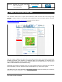
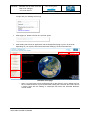
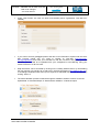
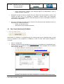
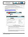
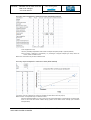
LACOVAL Validation tool for land cover and land cover changes ESA Contract No. 4000106151/12/I-BG Software Manual for LACOVAL open-source online tool Date of release: 10.07.2013 submitted by GeoVille Information Systems GmbH (GeoVille, AT) and Department of Geodesy and Geoinformation, Vienna University of Technology LACOVAL - Validation tool for land cover and land cover changes SOFTWARE MANUAL PROJECT COORDINATION & TOOL DEVELOPMENT SCIENTIFIC SUPPORT LACOVAL development funded by ESA - ESRIN Table of Contents 1 LACOVAL OBJECTIVES ................................................................................................ 3 2 MANUAL FOR LACOVAL ON-LINE TOOL .................................................................... 5 SYSTEM & INSTALLATION REQUIREMENTS ................................................................... 6 VALIDATION PRINCIPLE ............................................................................................... 7 USER MANAGEMENT & REGISTRATION ......................................................................... 9 STEP 1 INPUT DATA SET-UP (IN GEONODE) ............................................................... 12 STEP 2: GENERATE SAMPLES ................................................................................... 17 STEP 3: INTERPRET SAMPLES ................................................................................... 26 STEP 4: GENERATE REPORT ..................................................................................... 29 ANNEX 1: GENERATE A SLD (STYLED LAYER DESCRIPTOR) FILE ................................ 32 2.8.1 AtlasStyler ........................................................................................................................ 32 2.8.2 Manual for generation of SLD with QGIS ........................................................................ 32 2.8.3 ArcMap2SLD.................................................................................................................... 33 2.9 ANNEX 2: GENERATE STYLES IN GEONODE ............................................................... 34 2.10 ANNEX 3: TRANSFORMING KML TO SHP FILES............................................................. 36 2.1 2.2 2.3 2.4 2.5 2.6 2.7 2.8 LACOVAL – OPEN-SOURCE VALIDATION TOOL FOR LAND COVER AND LAND COVER CHANGES PAGE 2 OF 36 LACOVAL - Validation tool for land cover and land cover changes PROJECT COORDINATION & TOOL DEVELOPMENT SOFTWARE MANUAL SCIENTIFIC SUPPORT LACOVAL development funded by ESA - ESRIN 1 LACOVAL objectives Validation is a key requirement for users as well as providers of EO derived land cover and land cover change products in order to build trust and to provide potential users with evidence that a specific service yields information products of a known quality (usually expressed through the term “accuracy”). By validation we understand the process by which the accuracy of satellite-derived land products are evaluated and the associated uncertainties are quantified. In fact, accuracy assessment or validation is a key component of any project employing spatial data. There are a number of reasons why this assessment is so important including: For a map user: o The requirement to know about the fit-for-purposeness to use the information resulting from spatial data analysis and map making in subsequent decision-making processes For a map producer: o The need to know how well map production algorithms are working and to learn from weaknesses to improve the production chains; o The ability to quantitatively compare methods for subsequent design decisions; While procedures for global medium resolution Earth Observation data based land cover mapping are well established and described, transparent, documented and reproducible validation approaches for local, regional, national and supra-national land cover products based on very high resolution (better than 5m) and high resolution (5 to 30m resolution) image data are to a large extent non-existent. In this context, LACOVAL has made another important step towards comparable validation of map products at local to supra-national scales. LACOVAL has developed concepts, methods and tools for land cover and land cover change map validation according to the GEO Quality Assurance Framework for Earth Observation (QA4EO1) principles of transparency, traceability, independence, accessibility and representativeness. The software tools developed in LACOVAL comprise: the open-source LACOVAL on-line tool embedded in (http://lacoval.geo-wiki.org/), which is described in this manual. the Geo-Wiki platform The tool provides an easily accessible solution openly available to the whole EO community, in order to perform land cover map validation using basic, standardised methods in regional scales and applying online reference data such as Google Earth and user-furnished reference data available through WMS technology. the LACOVAL ArcGIS off-line tool integrated in GeoVille’s RegioCover land cover processing chain, for utilization of an advanced set of validation methods in commercial activities. If you are interested in applying the advanced LACOVAL ArcGIS tool, please contact GeoVille at [email protected]. 1 The Quality Assurance Framework for Earth Observation (QA4EO - http://qa4eo.org/background.html) was established and endorsed by the Committee on Earth Observation Satellites (CEOS) as a direct response to a call from the Group on Earth Observations (GEO). LACOVAL – OPEN-SOURCE VALIDATION TOOL FOR LAND COVER AND LAND COVER CHANGES PAGE 3 OF 36 LACOVAL - Validation tool for land cover and land cover changes SOFTWARE MANUAL PROJECT COORDINATION & TOOL DEVELOPMENT SCIENTIFIC SUPPORT LACOVAL development funded by ESA - ESRIN LACOVAL provides a software framework for assembling the map validation process in one interface including the set-up of all necessary input data. It guides the operator through the entire validation process, it enables the set-up of methodologically sound sampling designs and the convenient interpretation of sample in a user-friendly environment, and it serves to generate state-of-the-art accuracy reports ready for communication to map users. The LACOVAL tools offer methodological support for land cover validation with respect to the application of well-documented and accepted validation methods as well as transparent and reproducible sampling designs. As such, the tools are designed to be open and extendable for the validation of any other land cover product at comparable scale, in order to create a credible solution for a broader community. It is to be noted that LACOVAL does NOT relief the end user from a thoughtful consideration of any reference material employed for validation. Any geometric or thematic errors or mismatches between the reference material and the map will undoubtfully propagate into to the validation result. Here any tool is only as good as the data used to feed it. The tool therefore does not mitigate inadequacies in existing reference data (such as geometric inaccuracies, thematic differences, outdatedness), it does not improve the widespread lack of adequate reference or ground-truthing data (although it facilitates the inclusion of existing reference data networks), it does not investigate the reasons behind any error in a land cover map, and it does not trace back deficiencies of production algorithms for land cover (change) mapping. The application of the LACOVAL tools will therefore always require an operator familiar with the fundamentals and principles of land cover validation. The best validation approach can simply not work if unsuitable reference data are used or if improper sampling designs are established by an operator. LACOVAL – OPEN-SOURCE VALIDATION TOOL FOR LAND COVER AND LAND COVER CHANGES PAGE 4 OF 36 LACOVAL - Validation tool for land cover and land cover changes PROJECT COORDINATION & TOOL DEVELOPMENT SOFTWARE MANUAL SCIENTIFIC SUPPORT LACOVAL development funded by ESA - ESRIN 2 Manual for LACOVAL On-line tool The LACOVAL online tool is an open-source solution for land cover and land cover change map validation in regional scales. It is accessible as the regional branch of the validation platform Geo-Wiki through http://www.geo-wiki.org/branches/lacoval/ (entry page on Geo-Wiki) or http://lacoval.geo-wiki.org/ (direct link to application) Entry page of LACOVAL on Geo-Wiki The tool is openly available to the whole EO community tool and provides a set of basic, standardised validation procedures (point sampling for categorical data, pixel interpretation for continuous land cover variables) and easy access to online reference data such as Google Earth or user-furnished reference data available through WMS technology. Registration and usage of the portal is free. Use of the prototype tool and its outcomes are under the sole responsibility of the user. GeoVille cannot be held liable for any misuse of the system. The release as of July 2013 represents the final alpha prototype, extensively tested by the consortium partners and ready for testing by an external community. LACOVAL – OPEN-SOURCE VALIDATION TOOL FOR LAND COVER AND LAND COVER CHANGES PAGE 5 OF 36 PROJECT COORDINATION & TOOL DEVELOPMENT LACOVAL - Validation tool for land cover and land cover changes SOFTWARE MANUAL SCIENTIFIC SUPPORT LACOVAL development funded by ESA - ESRIN Please direct your feedback on the tool, its functionalities as well as any observed bugs to: Juergen Weichselbaum Project Manager of LACOVAL GeoVille Information Systems GmbH Sparkassenplatz 2, 6020 Innsbruck, Austria [email protected] LACOVAL development is funded by European Space Agency. 2.1 System & Installation Requirements Google Chrome or Mozilla Firefox browsers are recommended. The LACOVAL tool has been successfully tested on Microsoft Windows operating systems with the following browsers. Google Chrome (Version 25.0.1364.172 m; https://www.google.com/intl/en/chrome/browser) Mozilla Firefox (Versions 15 & 19; http://www.mozilla.org/), Opera (Version 12.02; http://www.opera.com). Internet Explorer (Versions explorer/download-ie) Not supported: Safari due to incompatibility with the Google Earth plug-in. 9 and 10; http://windows.microsoft.com/en-gb/internet- The application requires the Google Earth plug-in. Check if the plug-in is already installed on your system under http://www.google.com/earth/explore/products/plugin.html. Note that Linux systems do not support the Google Earth plug-in. Microsoft Excel 2007 or newer is required in order to open accuracy reports in xlsx-format. Google Earth installation needed to view exported point samples in kml-format. LACOVAL – OPEN-SOURCE VALIDATION TOOL FOR LAND COVER AND LAND COVER CHANGES PAGE 6 OF 36 LACOVAL - Validation tool for land cover and land cover changes SOFTWARE MANUAL 2.2 PROJECT COORDINATION & TOOL DEVELOPMENT SCIENTIFIC SUPPORT LACOVAL development funded by ESA - ESRIN Validation principle The LACOVAL online validation tool has been developed as a contribution to more standardised quality assessment of land cover data by using a documented approach and an easy-to-understand user interface, which allows people who are familiar with the basics of land cover mapping to evaluate the quality of a map by following a set of pre-defined basic validation steps. The following figure provides a schematic overview of the general validation steps in LACOVAL. LACOVAL online tool general validation scheme The validation tool assumes that the user of the tool is familiar with the data to be validated, i.e. what is the format of the data, what is the name of the data set, what are the attributes? This should be clarified in the “data preparation” step which needs to be carried out by the user before starting to use the LACOVAL tool. As the LACOVAL is sensitive to attribute names, it should be ensured that the data to be controlled reflect these prerequisites. LACOVAL – OPEN-SOURCE VALIDATION TOOL FOR LAND COVER AND LAND COVER CHANGES PAGE 7 OF 36 LACOVAL - Validation tool for land cover and land cover changes SOFTWARE MANUAL PROJECT COORDINATION & TOOL DEVELOPMENT SCIENTIFIC SUPPORT LACOVAL development funded by ESA - ESRIN Once the preparatory steps are done, the user can upload his / her own data – and reference data, if available – to the LACOVAL tool (“data upload”). In a next step the (“validation”) the data to be validated is specified and then the number of samples. If the user is not sure, the minimum number of samples can be determined by the tool after the user has specified the desired confidence level (normally 95% or 99%) and the desired confidence interval (normally a number between 3% and 5%). These values will then tell the user that the validated data set – for example – has an overall accuracy of 82% (+/- 5%) at a confidence level of 95%. The user can then compare these results with the product specifications and decide about the fitness-for-purpose of the data set. It should be noted that the results of the validation can be strongly influenced by the knowledge of the validation expert, the ambiguity of the land cover classes as well as the quality of the reference data (e.g. geometric shift, date). The LACOVAL online tool can provide any user with an initial, sound impression of the quality of the data, but it cannot fully replace a professional, independent validation. LACOVAL – OPEN-SOURCE VALIDATION TOOL FOR LAND COVER AND LAND COVER CHANGES PAGE 8 OF 36 LACOVAL - Validation tool for land cover and land cover changes SOFTWARE MANUAL 2.3 PROJECT COORDINATION & TOOL DEVELOPMENT SCIENTIFIC SUPPORT LACOVAL development funded by ESA - ESRIN User management & registration Access the LACOVAL open-source online tool through the entry page on Geo-Wiki (http://www.geo-wiki.org/branches/lacoval/) by clicking on the image or using the direct link to the application http://lacoval.geo-wiki.org (for bookmarking). Create a new account under "Registration": enter your name, Email address and choose a password LACOVAL registration o Note: The user is registered under his / her Email address on the LACOVAL portal as well as a sequential number which is automatically created for the GeoNode data management component. LACOVAL – OPEN-SOURCE VALIDATION TOOL FOR LAND COVER AND LAND COVER CHANGES PAGE 9 OF 36 LACOVAL - Validation tool for land cover and land cover changes SOFTWARE MANUAL PROJECT COORDINATION & TOOL DEVELOPMENT SCIENTIFIC SUPPORT LACOVAL development funded by ESA - ESRIN or login with your existing account (2) After logging in, please click link to LACOVAL portal After loading the LACOVAL application and the Google Earth plug-in (max. 10 seconds depending on your system resources and browser settings), the GUI looks like this: Manual & support User Profile Validation workflow controls Data navigation LACOVAL main page o Note: if you login with a newly registered user for the first time, it may appear that you have to make a refresh of your browser after loading the LACOVAL tool. This is due to a known issue with the loading of JavaScript files within the Geo-Wiki Refractor module loader. LACOVAL – OPEN-SOURCE VALIDATION TOOL FOR LAND COVER AND LAND COVER CHANGES PAGE 10 OF 36 LACOVAL - Validation tool for land cover and land cover changes PROJECT COORDINATION & TOOL DEVELOPMENT SOFTWARE MANUAL SCIENTIFIC SUPPORT LACOVAL development funded by ESA - ESRIN Under “User Profile”, the user can enter more details (name, organization, Geo-Wiki ID if needed) User Profile Management window If you want to access geotagged photos and land cover information acquired with the GeoWiki Pictures mobile app you need to register on Geo-Wiki (http://www.geowiki.org/registration) and enter your Geo-Wiki ID into the LACOVAL user profile (GeoWiki Identifier); photos need to be uploaded from your smartphone to Geo-Wiki.org using your mobile connection or Wi-Fi access. Help information can be accessed by clicking on the “Getting started” button, by downloading the user manual or by sending an e-mail to the LACOVAL developers ([email protected]). In all dialogue windows where user input is required, a dedicated help box can be opened by clicking “How to?”. The entire validation process is steered through the validation workflow controls on the left: Upload data Generate Sample Start/continue validation Generate report Validation menu LACOVAL – OPEN-SOURCE VALIDATION TOOL FOR LAND COVER AND LAND COVER CHANGES PAGE 11 OF 36 LACOVAL - Validation tool for land cover and land cover changes SOFTWARE MANUAL o PROJECT COORDINATION & TOOL DEVELOPMENT SCIENTIFIC SUPPORT LACOVAL development funded by ESA - ESRIN Fields “Start/continue validation” and “Generate Report” are deactivated in case no sample has been created yet. Navigation through the data is possible using the bottom left data navigation controls. This requires all data sets to be uploaded to GeoNode (“Upload data”) and subsequent configuration of the validation session (“Generate sample”) in order to make data accessible in the LACOVAL map window. Note: If the LACOVAL tool gets frozen or inactive at any time during the validation process, try the following to reinitiate the session o refresh your browser (F5) or o delete the cache and restart the browser 2.4 Step 1 Input data set-up (in GeoNode) Data upload for LACOVAL is managed through the external open-source GeoNode portal. All files must be uploaded to and configured in GeoNode in order to make these layers available for LACOVAL. Click on “Upload data” Upload is managed through GeoNode (http://geonode.org). GeoNode is an independent opensource solution for storing and managing geospatial data online. GeoNode can be accessed from LACOVAL through o an ‘iframe’ inside the LACOVAL portal (recommended) or o In a new browser window under the link http://geonode.geo-wiki.org/: GeoNode data upload functionality embedded in LACOVAL (upload data frame) LACOVAL – OPEN-SOURCE VALIDATION TOOL FOR LAND COVER AND LAND COVER CHANGES PAGE 12 OF 36 LACOVAL - Validation tool for land cover and land cover changes SOFTWARE MANUAL o PROJECT COORDINATION & TOOL DEVELOPMENT SCIENTIFIC SUPPORT LACOVAL development funded by ESA - ESRIN Note: Login is shown through an unique ID (not the name of your LACOVAL account) in the top right section of the GeoNode window Language of GeoNode is dependent on the language settings in your browser (English recommended) or can be set in the bottom line of the GeoNode window Use the GeoNode navigation buttons and the „back“/”forth”-buttons of your browser Data can be uploaded via “Upload layers”, existing data in your account can be viewed with “Explore layers” Further help for GeoNode upload functionality is available here: http://docs.geonode.org/en/latest/users/upload.html Upload layers to GeoNode o Switch to “Layers” section and go to “Upload layers” o Upload your land cover data and validation data sets GeoNode upload of data layers Choose a file from your file system (shapefile.shp or geotiff.tif); all land cover + reference data in ESRI shapefile (.shp) or geotiff (.tif without external world file) format can be uploaded to the GeoNode portal Remarks to the performance of the alpha prototype of the LACOVAL online tool: For larger sampling schemes (>250 samples) and due to the architecture of the tool (assignment of land cover code to new samples via WMS interface), it is recommended to use raster (geotiff) files. LACOVAL – OPEN-SOURCE VALIDATION TOOL FOR LAND COVER AND LAND COVER CHANGES PAGE 13 OF 36 LACOVAL - Validation tool for land cover and land cover changes PROJECT COORDINATION & TOOL DEVELOPMENT SOFTWARE MANUAL SCIENTIFIC SUPPORT LACOVAL development funded by ESA - ESRIN The following table provides an overview on average processing times for a random point sample for rather large datasets (1 mio pixels for raster data, 50,000 polygons for shapefiles); Land cover format Number of samples (random sampling method) Raster (geotiff) 100 5 seconds 250 10 seconds 500 30 seconds 1000 1 min 10 seconds 4-5 minutes 7-8 minutes >20-25 minutes >45-60 minutes (may time out in case of heavy server load with other users) (may time out in case of heavy server load with other users) with 1000x1000 pixels Vector (shp) with 50,000 polygons The commercial LACOVAL RegioCover validation tool offered by GeoVille does not pose any limitations in terms of performance except the standard constraints of ArcGIS and the corresponding operating system. WGS84 (EPSG:4326) projection with geographic coordinates required (data must be converted appropriately with your GIS software, the tool does not provide any reprojection functionality) Shapefiles must have a unique code field „lccode“ – this attribute field must contain the land cover codes for validation. Geotiff raster codes are retrieved from the pixel value Case sensitive & short integer as shown in the below ArcGIS window 8bit or 16 bit integer No float values allowed For change data, change polygons with “lccode” for the target date to be validated must be provided; for point samples to be used in augmentation, the prototype requires a “lccode” field containing the land cover code from the map to be validated (this can be done through a spatial join in GIS). Note: It is strongly recommended at this stage to keep a list of the land cover classes for validation in a separate txt-file (see definition how to define the land cover classes in LACOVAL in the next chapter). The alpha prototype version of LACOVAL does not provide direct retrieval of the layer’s class codes through a database query, as each file is accessed through WMS streaming technology (rendered PNG image of the geodata layers). LACOVAL – OPEN-SOURCE VALIDATION TOOL FOR LAND COVER AND LAND COVER CHANGES PAGE 14 OF 36 LACOVAL - Validation tool for land cover and land cover changes SOFTWARE MANUAL PROJECT COORDINATION & TOOL DEVELOPMENT SCIENTIFIC SUPPORT LACOVAL development funded by ESA - ESRIN In case you want to view your geodata with predefined colouring, follow these instructions: For shapefiles, specify external SLD file (Style Layer Descriptor file = legend file) to view your dataset with a predefined legend; a SLD file can be created through various tools (see Annex 1 for detailed manuals); otherwise follow Annex 2 for creating styles within GeoNode For geotiffs, a colormap must be embedded before upload (no SLD handling possible for raster data Specify XML metadata file (SLD must point to identical filename as defined in xml) IMPORTANT: Check permissions & security settings: in order to keep confidentiality of your data on this open-source portal, set “Who can view and download this data?” “Only users who can edit”; Note: otherwise the file will be visible to all GeoNode users “Who can edit this data?” “Only the following users or groups” and your user-ID o “Who can manage and edit this data?” Select your user-ID Start upload and edit/confirm metadata after successful upload Note: file sizes are not limited by GeoNode. The larger the file, the longer the upload will take (approx 5 minutes for 100 MB depending on your internet connection; large bandwidth and stable connection highly recommended). Repeat the steps for uploading any kind of additional reference or sample data (shp, geotiff) Explore layers in GeoNode o Switch to “Layers” section and go to “Explore layers” GeoNode data explorer LACOVAL – OPEN-SOURCE VALIDATION TOOL FOR LAND COVER AND LAND COVER CHANGES PAGE 15 OF 36 LACOVAL - Validation tool for land cover and land cover changes SOFTWARE MANUAL o o PROJECT COORDINATION & TOOL DEVELOPMENT SCIENTIFIC SUPPORT LACOVAL development funded by ESA - ESRIN Navigate to the uploaded LC dataset for validation; Click on the dataset shows you a map window with a quicklook of the uploaded file (proper colouring is given in case a SLD (vector) or colormap (raster) has been provided) and the metadata (extracted from the uploaded xml metadata file) GeoNode data viewer o Click on “Edit layer” and “Edit Metadata” to modify the data (e.g. name, category, owner etc.) as needed; Note: categories in GeoNode are according to ISO 19115 format and cannot be modified o In case no SLD (shapefile) was provided, the legend (style) of a vector dataset for visualization in LACOVAL can be edited through the “Create a map” function. This is only required if you want to view the dataset in LACOVAL, which is not mandatory for validation. A detailed manual for creating styles for vector file in GeoNode is provided in Annex 2. Uploaded reference data or sample data do not require any alterations of their representations / legends Note: Each layer accessible through the Explore layers tab and with a correct geographic placement in the preview map window can be successfully accessed through the LACOVAL tool; Maps for validation: Shapefiles with a “lccode” attribute field and geotiffs with an integer pixel value can be accessed as maps for subsequent validation. o o LACOVAL – OPEN-SOURCE VALIDATION TOOL FOR LAND COVER AND LAND COVER CHANGES PAGE 16 OF 36 LACOVAL - Validation tool for land cover and land cover changes PROJECT COORDINATION & TOOL DEVELOPMENT SOFTWARE MANUAL SCIENTIFIC SUPPORT LACOVAL development funded by ESA - ESRIN All layers are available through the “Additional data” area in the LACOVAL map window after concluding the “Generate Sample” process. If you want to search existing layers uploaded by other users (such as sample datasets for your area of interest), use the search function of GeoNode to list all datasets matching your search criteria GeoNode search function 2.5 Additional layers available from external WMSs (i.e. not uploaded to GeoNode) can be directly added to the LACOVAL map window as additional reference data for validation Close “Upload data” frame in LACOVAL data upon finalization of all data preparation work. An information box is shown explaining that the uploaded data can be viewed either in GeoNode (anytime during your LACOVAL session) or in the LACOVAL map window (once a validation session has been set-up using the ‘Generate Samples’ function). Step 2: Generate samples Click on “Generate Sample” to open the Sample Generation wizard, which consists a set of 5 consecutive specification steps: LACOVAL sample generator workflow Note: The current LACOVAL alpha prototype supports one sample per user stored on the portal. If a new sample is generated, the old sample will be overwritten. Please make sure to export your sample before creating a new one. LACOVAL – OPEN-SOURCE VALIDATION TOOL FOR LAND COVER AND LAND COVER CHANGES PAGE 17 OF 36 LACOVAL - Validation tool for land cover and land cover changes SOFTWARE MANUAL PROJECT COORDINATION & TOOL DEVELOPMENT SCIENTIFIC SUPPORT LACOVAL development funded by ESA - ESRIN 1. Define “Land Cover Dataset” LACOVAL sample generator workflow – step 1 of 5 o o o o Choose the Land Cover Dataset to be validated from the drop-down menu (name as defined in GeoNode); vector or raster format is automatically recognized; only files previously uploaded in GeoNode under your account are available here Choose the Land Cover Type Categorical land cover (if your vector or raster map consists of discrete land cover classes) Continuous land cover (if your raster map consists of continuous land cover values) Categorical change land cover (if your vector or raster map consists of discrete change classes) In case of continuous raster data, optionally set the number of “pixel columns” (lines in x-direction) and “pixel rows” (lines in y-direction). Ignore the field in case of categorical vector or raster data. This option automatically creates vector outlines as overlays to the pixels which will be selected for validation. Note: Information on pixel columns and rows of the raster dataset can be retrieved from any GIS (see example from ArcGIS below) or image processing software. Confirm with “Next” LACOVAL – OPEN-SOURCE VALIDATION TOOL FOR LAND COVER AND LAND COVER CHANGES PAGE 18 OF 36 LACOVAL - Validation tool for land cover and land cover changes SOFTWARE MANUAL PROJECT COORDINATION & TOOL DEVELOPMENT SCIENTIFIC SUPPORT LACOVAL development funded by ESA - ESRIN 2. Define “Land Cover Classes” LACOVAL sample generator workflow – step 2 of 5 o o o o The current LACOVAL prototype provides access to the land cover data via WMS (rendered PNG image) and not via a live-link to the attribute table of each layer. As highlighted during the Upload data procedure, it is therefore recommended to use an existing list of the Land Cover Code (number) and Land Cover Name (text or number) for validation in a text file (see definition below). This information can be retrieved from a GIS or from the layer’s metadata. Alternatively, land cover codes and names can be manually entered and added to text field below with “Save Class/Add Class”. Direct editing in the text field is possible. Once defined, save the land cover codes and names to an external text file For a new validation run, fields can be copied from the external text file and pasted to the text field. Make sure that you use the identical land cover codes as present in your uploaded land cover map, otherwise no samples can be created! Method for categorical data (vector or raster): Enter land cover code (lccode field or pixel value) Enter “;” as divisor Enter text description or number Note: for change data, the land cover code for the target date shall be provided Categorical data attribute example: 1;urban area 2;agriculture area 3;forest area 5;water area 255;NoData Line breaks required after each entry LACOVAL – OPEN-SOURCE VALIDATION TOOL FOR LAND COVER AND LAND COVER CHANGES PAGE 19 OF 36 LACOVAL - Validation tool for land cover and land cover changes PROJECT COORDINATION & TOOL DEVELOPMENT SOFTWARE MANUAL o SCIENTIFIC SUPPORT LACOVAL development funded by ESA - ESRIN Method for continuous data (raster) Enter land cover code (pixel value = % values; 1:1 relation) Enter “;” as divisor Enter number (no text allowed in case of continuous data) 1:1 relation – use single value for each % value Continuous data (1:1 relation) attribute example: 1;1 2;2 3;3 4;4 5;5 …. 100;100 255;255 Line breaks required after each entry 1:n relation – use grouped % values Continuous data (1:n relation) attribute example: 0;0 1;10 2;10 3;10 4;10 5;10 6;10 7;10 8;10 9;10 10;10 11;20 … 20;20 21;30 … 30;30 31;40 … 100;100 255;255 Line breaks required after each entry Hint: for validation of an 1:n relation a reclassification of the continuous raster to a categorical raster in GIS is recommended LACOVAL – OPEN-SOURCE VALIDATION TOOL FOR LAND COVER AND LAND COVER CHANGES PAGE 20 OF 36 LACOVAL - Validation tool for land cover and land cover changes SOFTWARE MANUAL o o PROJECT COORDINATION & TOOL DEVELOPMENT SCIENTIFIC SUPPORT LACOVAL development funded by ESA - ESRIN Notes: For many validations it is recommended to define an additional ‘backdoor’ class for doubtful cases (e.g. “999;unknown”). All samples for which no validation can be done, for example due to the lack of reference data, could be assigned to this class. In cases where a land cover map of a given area does not contain all classes of its underlying data model (e.g. a CORINE LC subset which contains only 25 classes out of the full range of 44 classes in the data model), it is recommended to use the full list of classes, as one or the other classes might have been simply omitted during map production and should thus be included in the validation. If no class code is defined for a class present in the dataset, no samples will be placed within that class; this is particularly helpful to exclude classes for which no samples should be generated as validation has no practical sense (e.g. “no data”, “clouds”) Avoid empty line at the bottom of the text editor field Confirm with “Next” LACOVAL – OPEN-SOURCE VALIDATION TOOL FOR LAND COVER AND LAND COVER CHANGES PAGE 21 OF 36 LACOVAL - Validation tool for land cover and land cover changes SOFTWARE MANUAL PROJECT COORDINATION & TOOL DEVELOPMENT SCIENTIFIC SUPPORT LACOVAL development funded by ESA - ESRIN 3. Define “Validation area” LACOVAL sample generator workflow – step 3 of 5 o Choose the Area of Interest Bounding box of the land cover data set (automatically calculated rectangle), or Draw your own polygon (Draw AOI) in which samples will be placed; the extent of the bounding box is indicated Limitation for LACOVAL online tool (functionality available in the commercial LACOVAL RegioCover validation tool offered by GeoVille) o No AOI definition using irregular polygons from external shapefiles (e.g. administrative boundaries, habitats) Confirm with “Next” LACOVAL – OPEN-SOURCE VALIDATION TOOL FOR LAND COVER AND LAND COVER CHANGES PAGE 22 OF 36 LACOVAL - Validation tool for land cover and land cover changes SOFTWARE MANUAL PROJECT COORDINATION & TOOL DEVELOPMENT SCIENTIFIC SUPPORT LACOVAL development funded by ESA - ESRIN 4. Define “Sampling Unit and Design” LACOVAL sample generator workflow – step 4 of 5 o Choose Sampling Unit: “Point” (for categorical vector or raster data) “Pixel” (for continuous raster data) Limitation for LACOVAL online tool (functionality available in the commercial LACOVAL RegioCover validation tool offered by GeoVille) o No polygons supported as sampling unit Chose Sampling Design: Simple random point sample: samples are placed randomly inside the AOI; number of samples must be defined in the field below Systematic point sample: samples are placed with a fixed spacing width inside the AOI; spacing width must be defined in the field below Augmentation of an existing point sample previously uploaded to GeoNode: please select an existing point sample which can be augmented through additional simple random or systematic point samples; number of samples must be defined in the field above If “number of samples” is set to “0” (zero) the existing point sample will be used without creating additional samples. If the “number of samples” is set to a value different from “0”, this number of samples will be created in addition to the existing point sample. Note: the existing point shapefile must have been previously uploaded to GeoNode with a properly defined lccode field (short integer). If the point sample has already land cover information from another source (e.g. field PAGE LACOVAL – OPEN-SOURCE VALIDATION TOOL FOR LAND COVER 23 OF 36 AND LAND COVER CHANGES LACOVAL - Validation tool for land cover and land cover changes SOFTWARE MANUAL PROJECT COORDINATION & TOOL DEVELOPMENT SCIENTIFIC SUPPORT LACOVAL development funded by ESA - ESRIN work), the lccode field must exactly follow the land cover code definition from the map to be validated (see section Define “Land Cover Classes”). If the points do not contain any thematic information, the lccode field must be left blank. If you want to make any other thematic reference information visible in LACOVAL, it is recommended to configure the point layer with an appropriate legend as an additional reference data set in GeoNode. Random selection: pixel samples are randomly selected from the continuous raster file; number of samples must be defined in the field below Note: for randomly selected pixels, vector outlines are automatically generated by the tool instead of points (requires specification of columns/rows) in the wizard Limitations for LACOVAL online tool (functionality available in the commercial LACOVAL RegioCover validation tool offered by GeoVille) o o No stratification is supported with this tool; in order to take into account area statistics of individual land cover classes, use your GIS No buffering possible, e.g. minimum distances to object boundaries or to other samples No point subsampling within pixels containing continuous land cover values No utilization of masks to facilitate efficient sampling of omission error in change maps No integration/augmentation of external polygon sample data sets Use the Calculator to Determine your sample size based on a given confidence interval (usually ~5%) and confidence level (95% or 99%) Determine your confidence interval based on a given sample size, percentage (probability of making a wrong decision, usually 50%) and confidence level (95% or 99%) Note: population size can usually be neglected and left blank in cases where only a little percentage (<5%) of the total number of polygons or pixels is sampled Once you have found an appropriate sample size, put the number into the “Number of Samples” field Confirm with “Next” LACOVAL – OPEN-SOURCE VALIDATION TOOL FOR LAND COVER AND LAND COVER CHANGES PAGE 24 OF 36 LACOVAL - Validation tool for land cover and land cover changes SOFTWARE MANUAL PROJECT COORDINATION & TOOL DEVELOPMENT SCIENTIFIC SUPPORT LACOVAL development funded by ESA - ESRIN 5. Define “Validation method” LACOVAL sample generator workflow – step 5 of 5 o Choose Validation Method “Blind”: user has no information about the classification at that sample and therefore needs to provide a “blind” interpretation “Plausibility”: user has information about classification at the sample and judges the plausibility of the thematic classification with yes or no Limitation for LACOVAL online tool (functionality available in the commercial LACOVAL RegioCover validation tool offered by GeoVille) o No Enhanced Plausbility Method supported Confirm with “Finish” and your sample is generated automatically (may take several minutes depending on your sample size and input format (raster / vector). After successfully creating all samples, an information box appears. Note: in case of a server time-out during sample generation (e.g. due to the wrong definition of land cover codes) an error message is shown. LACOVAL – OPEN-SOURCE VALIDATION TOOL FOR LAND COVER AND LAND COVER CHANGES PAGE 25 OF 36 LACOVAL - Validation tool for land cover and land cover changes SOFTWARE MANUAL 2.6 PROJECT COORDINATION & TOOL DEVELOPMENT SCIENTIFIC SUPPORT LACOVAL development funded by ESA - ESRIN Step 3: Interpret samples Click on “Start/Continue Validation” to start the interpretation process; After clicking the button, the map window zooms to the first sample point; use your mouse to zoom and pan through the map interface o Note: in case of a sample interpretation in very detailed scales (i.e. close to Google Earth terrain level), the map view switches from nadir to oblique. This may cause sample points to artificially change their location in the map view. Please switch back to nadir view and zoom out in such a case to avoid visual distortions. The land cover data set to be validated is loaded to the map window under “Land Cover Data” and can be switched on/off through the tick box; can also be loaded through the drop-down menu under “Additional Data” Note that all data from GeoNode is provided as WMS service as a rendered PNG image with a predefined raster resolution (the more you zoom in, the more detail will be shown). Click on “Start/Continue Validation” to start the interpretation process; LACOVAL – OPEN-SOURCE VALIDATION TOOL FOR LAND COVER AND LAND COVER CHANGES PAGE 26 OF 36 LACOVAL - Validation tool for land cover and land cover changes PROJECT COORDINATION & TOOL DEVELOPMENT SOFTWARE MANUAL SCIENTIFIC SUPPORT LACOVAL development funded by ESA - ESRIN The interpretation windows contains the following elements: 7 8 9 1 10 6 2 3 4 5 LACOVAL sample interpretation window 1… Map window centered on sample point with Google Earth in the background; 4…Geocoding can be used to zoom to a particular location Note: If the view is zoomed close the Earth surface, the view leaves the nadir and gets tilted. This is an automatic behavior of the Google Earth plug-in. Please zoom out and set the view to nadir again to avoid misinterpretation due to oblique view. 2… Land cover data set to be validated can be switched on/off; 3… Any additional data uploaded to GeoNode can be loaded in the map window; 5…Google Earth overlay data (labels, boundaries, roads) and access to time-series images can be switched on/off - Note: In case historical Google Earth data are set visible, the acquisition date of the image is shown in the bottom information line. - GeoNode WMS: access datasets uploaded to GeoNode Geo-Wiki Samples: access public Geo-Wiki sample point layer Geo-Wiki Pictures: access your Geo-Wiki photographs (requires your Geo-Wiki ID entered into the user profile) Panoramio: access Panoramio photos Confluence Points: access thematic information from the Degree Confluence project External WMS: paste the WMS link to the field and click in the map window to load the WMS layer (WGS84/EPSG:4326 and PNG must be supported). Format for WMS links must be as follows (example): http://geonode.geowiki.org/geoserver/wms?LAYERS= cite%3Araster (without geographic bounding box) http://geonode.geo-wiki.org/geoserver/wms?LAYERS= cite%3Araster&bbox=10,40,20,50 (with geographic bounding box) 6…Transparency slider for any overlay 7… Status information on the validation process (number of samples interpreted) 8… Panel for land cover validation (drop-down menu for “blind” validation, yes/no selection for “plausibility” validation 9… Navigation through (previous/next sample) samples 10… How to? help box LACOVAL – OPEN-SOURCE VALIDATION TOOL FOR LAND COVER AND LAND COVER CHANGES PAGE 27 OF 36 LACOVAL - Validation tool for land cover and land cover changes PROJECT COORDINATION & TOOL DEVELOPMENT SOFTWARE MANUAL LACOVAL development funded by ESA - ESRIN Viewing photographs and land cover information from the Geo-Wiki pictures mobile app (http://www.geo-wiki.org/mobile-apps) o The Geo-Wiki pictures app (available for iPhone, Android and Windows Phone) allows photographing landscapes with your smartphone and sharing them through GeoWiki.org using the visualization capacity of Google Earth. Photographs are automatically geo-referenced and tagged with information such as compass direction, the angle of tilt as well as a classification of the land cover type. o o SCIENTIFIC SUPPORT Upload the photos shot with the Geo-Wiki mobile app to Geo-Wiki.org using your uploaded mobile connection or Wi-Fi access. To access Geo-Wiki pictures with LACOVAL you need to register on Geo-Wiki and enter your Geo-Wiki ID into the LACOVAL user profile (see ‘User Management and Registration’) The land cover validation panel on the right is adapted according to specific method for land cover validation Blind validation: Plausibility validation user has no information about the classification at that sample and therefore gives a “blind” validation user has information about classification at the sample and judges the plausibility of the classification with yes or no Select correct land cover class at the sample point using the drop-down menu (uses text information as defined in the “Generate Sample” wizard) Confirm your selection with “Validate” Zoom to previous/next sample with “Previous / Next random sample” If you want to interrupt your validation session, click “Pause” – your validation session can be continued by chosing “Start/continue validation” from the left menu and the validation continues with the next unvalidated point from the database Confirm or reject the thematic plausibility of the mapped land cover – shown as text in the box above - by ticking the circle under the green checkmark or under the red X Continue the sample process as described on the left LACOVAL – OPEN-SOURCE VALIDATION TOOL FOR LAND COVER AND LAND COVER CHANGES PAGE 28 OF 36 LACOVAL - Validation tool for land cover and land cover changes PROJECT COORDINATION & TOOL DEVELOPMENT SOFTWARE MANUAL 2.7 SCIENTIFIC SUPPORT LACOVAL development funded by ESA - ESRIN After interpreting the last sample, an information box appears. Finally, an accuracy report can be generated (xlsx) and the sample dataset can be exported (kml). Step 4: Generate report Click on “Generate Report” to prepare an accuracy report with standardized accuracy measures. A separate tab contains all relevant parameters set for validation. The report can be downloaded as *.xlsx and is automatically opened in Microsoft Excel (if installed on your system). Accuracy report example for categorical vector (blind method) Top section: confusion matrix with land cover classes rows: mapped land cover, columns: reference land cover from interpretation with number of samples User’s accuracy (=measure of correctness), i.e. percentage of mapped samples (per class) which are correct, at 95% confidence level Producer’s accuracy (=measure of completeness), i.e. percentage of correct samples that have been mapped, at 95% confidence level Bottom lines: Overall accuracy at 95% confidence level & Kappa statistic LACOVAL – OPEN-SOURCE VALIDATION TOOL FOR LAND COVER AND LAND COVER CHANGES PAGE 29 OF 36 LACOVAL - Validation tool for land cover and land cover changes PROJECT COORDINATION & TOOL DEVELOPMENT SOFTWARE MANUAL SCIENTIFIC SUPPORT LACOVAL development funded by ESA - ESRIN Accuracy report example for categorical raster (plausibility method) Top section: confusion matrix with land cover classes rows: mapped land cover, columns: plausibility interpretation with number of samples accepted (TRUE) or rejected (FALSE) User’s accuracy (=measure of correctness), i.e. percentage of mapped samples (per class) which are correct, at 95% confidence level Bottom line: Overall accuracy at 95% confidence level Accuracy report example for continuous raster (blind method) Top section: accuracy measures for continuous variables (on first sheet of accuracy report) Bottom section: cross-plot with map vs. reference values; Note that automatic labeling of x-axis in the cross-plot and representation of points without connecting lines does not work with the current software library; please correct these issues manually (see corrected example above) LACOVAL – OPEN-SOURCE VALIDATION TOOL FOR LAND COVER AND LAND COVER CHANGES PAGE 30 OF 36 LACOVAL - Validation tool for land cover and land cover changes SOFTWARE MANUAL PROJECT COORDINATION & TOOL DEVELOPMENT SCIENTIFIC SUPPORT LACOVAL development funded by ESA - ESRIN All parameters used for the validation can be viewed under the “Session_parameters” tab (source data, sampling unit & design, sampling size, interpretation mode) To export and download your sample as a Google Earth kml file, please select o “Export all Samples” to download all created samples, regardless if these have been validated or not o “Export validated Samples” to download all validated samples; samples which have been not been validated yet will not be exported Note: in case of samples created for validation of continuous data, only points are exported (not the bounding box as shown in the validation tool) o The kml file will be exported with two attribute fields: a field containing the land cover from the validated map, and another field containing the land cover from the validation (will be empty in case unvalidated samples are exported with “export all samples”) o If you want to view your kml-sample in GIS, use the import functions of your GIS (ArcGIS or QGIS can directly import/export kmls); see Annex 3 for a detailed manual For making your samples publically available to all LACOVAL users (in order to allow this dataset to be found using the GeoNode search function), you can upload the point dataset to GeoNode (see Step 1 Input data set-up). The following workaround is needed as Geo-Wiki currently does not offer a database solution for automatically storing user-created samples. o As a first step, convert the exported sample file from kml to shp (see Annex 3) and save the legend of the actual land cover as a SLD file (see Annex 1), using the field containing the land cover from the previous validation. o Upload the converted sample as a shapefile to GeoNode using the “Upload data” function and set a legend using the SLD file or by creating a new style in GeoNode (see Annex 2) o In case you want to release the sample to the public, do not apply any permissions to restrict visibility; ideally, provide a self-explaining name (such as Sample_<validated_map>_<area>) and accompanying metadata, so that other users can search for sample datasets in their target areas. o If you want to prepare and use the sample dataset for future augmentation with an additional sampling (see Step 2: Generate samples, 4. Define “Sampling Unit and Design”), make sure that the point file has a lccode field (short integer) with existing land cover classification information. o During the next validation, you can access the sample through the “Additional data” box Click “Generate Sample” to delete the old sample and create a new one for a new validation run After finishing your validation work, close your browser window or navigate to http://lacoval.geo-wiki.org to actively log out from the session LACOVAL – OPEN-SOURCE VALIDATION TOOL FOR LAND COVER AND LAND COVER CHANGES PAGE 31 OF 36 LACOVAL - Validation tool for land cover and land cover changes PROJECT COORDINATION & TOOL DEVELOPMENT SOFTWARE MANUAL 2.8 SCIENTIFIC SUPPORT LACOVAL development funded by ESA - ESRIN Annex 1: Generate a SLD (Styled layer descriptor) file SLDs for GeoNode must fulfil three requirements (check with text editor) o No special characters (like ä, á, etc.) o Featuretypename must be identical to the layer name in GeoNode o Propertyname must be „lccode“ (case sensitive) 2.8.1 AtlasStyler AtlasStyler is an open source application based on Java that can be used independently to style any vector data. The resulting styles can be saved to XML files that follow the OGC SLD/SE standard 1.0. Please follow http://en.geopublishing.org/AtlasStyler for further information. Download/Install AtlasStyler o Open the link http://en.geopublishing.org/AtlasStyler and scroll down to “Start and Install AtlasStyler” and click on the green button “Start AtlasStyler” (stable version). Manual for AtlasStyler o Further information concerning the styling of geodata in AtlasStyler can be found here: http://en.geopublishing.org/AtlasStyler%20SLD%20Labeling%20Tutorial (in English) 2.8.2 Manual for generation of SLD with QGIS Install and start QGIS 1.8.0 (open-source) Download: http://hub.qgis.org/projects/quantum-gis/wiki/Download Add vector layer file (shp-format) Double-click on loaded file Style LACOVAL – OPEN-SOURCE VALIDATION TOOL FOR LAND COVER AND LAND COVER CHANGES PAGE 32 OF 36 LACOVAL - Validation tool for land cover and land cover changes SOFTWARE MANUAL PROJECT COORDINATION & TOOL DEVELOPMENT SCIENTIFIC SUPPORT LACOVAL development funded by ESA - ESRIN Within this window you can style your shapefile; to export the style of the shapefile, press “Save Style” In the next window select “SLD File” as data type Save 2.8.3 ArcMap2SLD Generation of SLD in ArcGIS o Download and install ArcMap2SLD software (open-source): http://wald.intevation.org/projects/arcmap2sld/ o Open ArcGIS (with release 1.3.0 ArcMap2SLD also supports ArcGIS 10.0) o Load Shapefile (shp) or Layerfile (lyr) you want to convert to SLD (only vector files supported)– load a single file for SLD export LACOVAL – OPEN-SOURCE VALIDATION TOOL FOR LAND COVER AND LAND COVER CHANGES PAGE 33 OF 36 LACOVAL - Validation tool for land cover and land cover changes PROJECT COORDINATION & TOOL DEVELOPMENT SOFTWARE MANUAL 2.9 SCIENTIFIC SUPPORT LACOVAL development funded by ESA - ESRIN o Start ArcMap2SLD and set the required parameters o Press blue SLD-Button to start the generation/export of the SLD Annex 2: Generate styles in GeoNode A legend for showing vector files in LACOVAL can be generated using the “Create a map” function – NOTE: this is only needed if no SLD is available; appropriate coloring for GeoTiff must be created with a colormap before uploading the file to LACOVAL After selecting the vector layer in GeoNode and clicking “Create a map”, a new map window appears showing the LC dataset as overlay (left menu); underlying base maps can be freely chosen Right-click on the layer to be edited and chose “Layer styles” from the context menu LACOVAL – OPEN-SOURCE VALIDATION TOOL FOR LAND COVER AND LAND COVER CHANGES PAGE 34 OF 36 LACOVAL - Validation tool for land cover and land cover changes SOFTWARE MANUAL PROJECT COORDINATION & TOOL DEVELOPMENT SCIENTIFIC SUPPORT LACOVAL development funded by ESA - ESRIN Provide a name for the style under “Styles” and add specific styles for each class to be drawn under “Rules” Choose “Edit” to create a representation for a LC class (use “Add” to create a new rule, use “Remove” to delete a rule) Representation can be edited: Name / fill / outline under “Basic” tab, Label under “Labels” tab, assignment of rule to specific classes must be defined as “Limit by condition” (e.g. LCCode = 1) LACOVAL – OPEN-SOURCE VALIDATION TOOL FOR LAND COVER AND LAND COVER CHANGES PAGE 35 OF 36 LACOVAL - Validation tool for land cover and land cover changes PROJECT COORDINATION & TOOL DEVELOPMENT SOFTWARE MANUAL SCIENTIFIC SUPPORT LACOVAL development funded by ESA - ESRIN Please confirm each editing - this might not be visible in the LACOVAL tool on small screens; use the browser-version instead NOTE: this whole procedure can be avoided if a SLD file is provided with the upload 2.10 Annex 3: Transforming kml to shp files The transformation between the both formats (*.shp & *.kml) can be done in different software: Online Tool: Zonum Solutions (Google Earth to Shapefile) http://www.zonums.com/online/kml2shp.php QGis: 1.8.0 KML files can be open with the “add vector layer” tool ArcGIS: 10.1 kml files can be open with the “km to layer” tool info: http://resources.arcgis.com/en/help/main/10.1/index.html#//00120000004w000000 LACOVAL – OPEN-SOURCE VALIDATION TOOL FOR LAND COVER AND LAND COVER CHANGES PAGE 36 OF 36