1
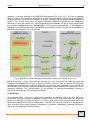
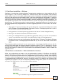
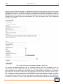
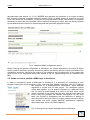
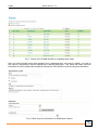
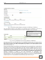
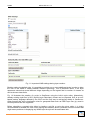
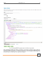
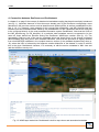
Report-Deliverable No. “2.4” Start date: 01/03/2012 End date: 30/06/2013 Lead Author: Michael Blaschek & Rainer Duttmann (3_CAU) Contributors: Supported by all partners TITLE: Prototype of a CLIMB WebGIS-Server for data management; Report, User Manual REPORT: 1. Objectives According to the description of work associated with deliverable 2.4, the desired WebGIS application is basically meant for processing, querying, evaluating and visualizing selected CLIMB-related data. The varying steps of data processing are mainly done outside the WebGIS-Server and were partly described in the report of deliverable 2.2. Querying CLIMB-relevant (base) datasets is realized through a metadata information system that is based on GeoNetwork in v2.6.4 and was already introduced in deliverable report 2.3. This particular report focuses on the visualization methods defined in task 2.1, especially on the steps that are needed to create standardised view services using GeoServer. After a brief review on view services, the installation, customization and usage of GeoServer as well as its interaction with the running metadata information system GeoNetwork will be described. In addition, a few comments will be given about different (web) applications that can be used to work with or test the established CLIMB-specific web map service. 2. Introduction into (INSPIRE) view services WebGIS applications and geoportals are important elements of spatial data infrastructures (SDIs) that are both based on GIS-related web services. In order to properly operate inside a high number of client solutions, these services need to follow certain standards and specifications. In Europe, the INSPIRE directive 2007/2/EC of the European Parliament set an essential framework in establishing a European SDI (EC 2007). The directive explicitly claims the dissemination of spatial information in forms of standardised web services that are amongst others grouped into view, download and discovery services. Whereas download services allow access to the data itself, view services only provide an image of a mapped geographic layer and discovery services are meant for searching and querying spatial resources. The creation of INSPIRE-compliant view services is defined more precisely in the COMMISSION REGULATION (EC) No 976/2009 and its associated technical guidance for implementation (INS NS, EC 2011). There are also guidance documents on national level, e.g. the ones from the GDI-DE coordination unit in Germany (GDI-DE 2011), that assist on the complex way towards INSPIRE-compliant view services. In general, INSPIRE makes use of several well-known standards and GIS-related specifications on spatial data, metadata and services as regulated by the Open Geospatial Consortium (OGC) and the ISO Technical Committee 211 (Nolde et al. 2010, p.247). In the context of view services, the OGC Web Map Service (WMS) standard, eventually defined in ISO 19128, is used within the CLIMB map server in its current version 1.3.0. It is a protocol for disseminating map images that defines three important operations: GetCapabilities, GetMap and GetFeatureInfo (see Sudra 2010, p.19). Particularly the GetCapabilities function, which is used for implementing the INSPIRE “Get View Service Metadata” CLIMB Deliverable no. 2.4 2 operation, is strongly affected by the INSPIRE requirements (EC 2011, p.17). The set of metadata which is written in the Capabilities document of an OGC-compliant WMS is not enough to be INSPIREcompliant as well and must be enhanced by certain elements (the so-called extended capabilities section). This can be done either by directly integrating INSPIRE metadata into the Capabilities document or using an external ISO 19139-compliant service metadata set that is simply linked inside the extended capabilities section (MetadataURL). The mentioned MetadataURL of the Capabilities document is an important element in the data/service/metadata coupling concept that is mandated by INSPIRE and illustrated in fig. 1 (in German). Fig. 1: INSPIRE-compliant data/service/metadata coupling (see GDI-DE 2011, p.21) INSPIRE requires a strong interconnection between the view service and its underlying data and metadata. The MetadataURL element is used many-times to reference both, the service with its service metadata set and each layer inside the WMS with its associated data metadata record. Service and data metadata are related through the operatesOn property. Unique identifiers are realizing the link to underlying datasets. The implementation of the principle of data/service/metadata coupling in GeoServer will be shown in the subsequent chapters. 3. GeoServer As mentioned earlier in the text, a map server represents an essential part of any SDI and is the responsible unit for the creation of standard-compliant web services from spatial data. We decided to base our CLIMB-SDI on GeoServer, since it is a widely used open source software server that is well documented and basically platform independent. It can also be easily connected to or integrated into other important SDI-relevant software components, for instance GeoNetwork (metadata information system) or GeoNode (geoportal framework). CLIMB Deliverable no. 2.4 3 3.1. GeoServer installation – Windows GeoServer is running here inside an Apache Tomcat servlet container on a virtual machine with 2,8 GHz processor, 2 GB of memory (RAM) and a Windows Server 2008 R2 Standard 64-bit operating system (SP1). In fact, it is the same machine that hosts the GeoNetwork metadata information system used in CLIMB and has been described in detail in the report associated with deliverable 2.3. Although GeoNetwork already comes with a GeoServer instance, we have upgraded our map server regularly in order to have the most recent functionality available, especially regarding its INSPIRE-compliance. The latest update in November 2013 used the web archive in version 2.4.2 which can be downloaded from geoserver.org. The following procedure is recommended for upgrading GeoServer in the given set-up (see http://spatialmounty.blogspot.de/2011/11/how-to-upgrade-geoserver-211-to-212.html, last access: 21.12.13): 1. Stop Apache Tomcat and backup the current directories: C:\geonetwork\data\geoserver-data and C:\Program Files\Apache Software Foundation\Tomcat 7.0\webapps\geoserver as well as the web.xml file from your WEB-INF directory 2. Unzip geoserver-2.4.2-war.zip and copy geoserver.war into the Tomcat webapps-directory 3. Delete your old GeoServer instance and restart Tomcat 4. Check your webapps-directory for subdirectory geoserver and try to run the new GeoServer version in your browser using its URL (here http://ukzfg-s11.gis.uni-kiel.de/geoserver/) 5. Substitute the new web.xml configurations file inside folder C:\Program Files\Apache Software Foundation\Tomcat 7.0\webapps\geoserver\WEB-INF by the old one and restart Tomcat once again. The proposed workflow worked well in most cases; however, it can happen that files and even the filestructure of the data folder are changing between GeoServer versions. Then it is necessary to use the new data folder and add those folders that were created in earlier versions, e.g. workspaces, one-byone from the backup. A restart of the virtual machine was sometimes needed in order to finalize the upgrade process. 3.2. GeoServer customization – Web administration interface Before any configurations are made in the web administration interface of GeoServer, the INSPIRE extension should be installed in order to load additional functionality that is required by the INSPIRE directive. The relevant zip release file can be downloaded from the GeoServer website. After extracting the archive and transferring the content into the C:\Program Files\Apache Software Foundation\Tomcat 7.0\webapps\geoserver\WEB-INF\lib directory, GeoServer needs to be restarted and extended WMS capabilities are available. The new corresponding INSPIRE configuration options can be found at the very end of the WMS section of the web administration interface: http://ukzfg-s11.gis.unikiel.de/geonetwork/srv/en/csw?service=CSW&ver sion=2.0.2&outputschema=http://www.isotc211.or g/2005/gmd&request=GetRecordById&elementset name=full&id=d500bb1d-fcea-4634-ae3d3054c0163966 Fig. 2: INSPIRE configuration options in GeoServer CLIMB Deliverable no. 2.4 4 Besides setting the default language, a metadataURL should be provided that links the service to either a standalone file or as in this case to an external catalogue service (GeoNetwork) holding the metadata information associated to the WMS according to the INSPIRE requirements. Regardless whether the INSPIRE extension is installed or not, a few basic metadata elements such as title, abstract and access constraints are collected through the administration tool, which are directly stored in the Capabilities document of the WMS: Fig. 3: Basic OGC service metadata elements in GeoServer The keyword infoMapAccessService and its vocabulary attribute ISO are mandated by the EC implementing rules on metadata (INS MD) in order to properly classify the current view service. Two other important entries regarding the root WMS layer are authorityURLs and identifiers. The authority name and URL are meant to inform about the responsible body that holds a particular WMS or layer. The namespace need to be registered in the “INSPIRE external object identifier namespace register” and is inherited by subordinated layers, whereas the (root layer) identifiers are unique. It is highly recommended to use UUIDs in order to locally identify a certain resource (EC 2011, p.36). UUIDs can be created, for instance, using an online generator under http://www.guidgenerator.com/online-guid- CLIMB Deliverable no. 2.4 5 generator.aspx (last access: 21.12.13). INSPIRE also demands the existence of an output bounding box for every supported coordinate reference system (CRS). As WMS usually do support a very long list of CRS, this is not very feasible, if there are a lot of layers inside a single view service. It is therefore necessary to restrict the list of possible CRS by explicitly allowing only those, who are actually affected by the datasets that the service is representing and their particular geographic region. Fig. 4: Additional WMS configuration options Before finishing the general configuration of GeoServer, the contact information in the About & Status section needs to be filled in properly, since these entries also directly affect the service metadata of the Capabilities document. Note that the position is not related to any job description of the contact but must be one of the responsible party roles defined in the EC implementing rules on metadata (INS MD). 3.3. Guide on how to publish a WMS-layer in GeoServer In order to successfully create a WMS-layer in GeoServer, it is necessary to understand its core concept including the terms workspace, store, layer and style. Adding a new layer (see fig. 5) requires the existence of a workspace/store combination, which basically represents a project and its data source. The workspace groups similar data together, e.g. all spatial information of a particular study site. Its name is usually added as a prefix to the layer name, which makes it possible to use more than one layer with the same name as long as they are grouped into different workspaces. On the other hand, the concept of workspaces and the behaviour of adding its name as prefix to the layer names is a rather unique procedure among map servers and works against INSPIRE requirements regarding harmonized layer names (see also chapter 5). Fig. 5: New layer from certain workspace-store combination CLIMB Deliverable no. 2.4 6 Fig. 6: List of possible layers that can be published from a chosen store In order to add a new workspace within the workspace section of GeoServer, just a name and URI need to be specified. The URI can be freely chosen and does not have to be a valid URL. After creating a new workspace, an associated data source needs to be declared. This can be either a local directory with, for instance, shapefiles, GeoTIFFs or other vector and raster formats that GeoServer supports or a spatial database such as the PostgreSQL/PostGIS backend used in CLIMB and introduced in deliverable report 2.2. In order to add a new store based on a spatial database, the connection parameters needs to be provided. An existing workspace must be selected during the creation process as well as name and description of the data source. Once you have properly set-up workspaces and associated stores, the stores section look like displayed in fig. 7 giving information about the particular data source type, too. Adding a new layer requires the selection of a certain workspace/store combination as shown in fig. 5. One can then chose from all datasets present in the selected store, e.g. all tables from a single schema of a PostgreSQL/PostGIS database (see fig. 6), and publish one of them as a WMS-layer. Hence, a WMS-layer is nothing but an expression of a database table or view or an individual (shape)-file depending on the data source type of the given store. CLIMB Deliverable no. 2.4 7 Fig. 7: Stores of the CLIMB-GeoServer regarding base maps Once you have decided upon which dataset from a particular store you want to publish, you end up with various configuration options regarding the desired WMS-layer. This starts with basic resource information like title, abstract and keywords followed by CRS definition and bounding box calculation: Fig. 8: Basic resource information for WMS-layer creation CLIMB Deliverable no. 2.4 8 Fig. 9: CRS definition and bounding box calculation for WMS-layer in GeoServer The last important segment of the data-bar on the edit-layer page of GeoServer is the link to a metadata sheet of an external CSW that holds an extensive description of the current layer: http://ukzfg-s11.gis.unikiel.de/geonetwork/srv/en/csw?service=CSW&ver sion=2.0.2&outputschema=http://www.isotc211.or g/2005/gmd&request=GetRecordById&elementset name=full&id=81e541b3-c64b-42cd-8db473aa8d4a1c0f Fig. 10: Link to metadata about the underlying dataset of a WMS-layer Note that the given ID in the URL field refers to the metadata file identifier and is not identical with the layer identifier specified in the WMS settings under the publish-tab of the edit-layer page. As done earlier for the root layer of the WMS, each additional layer needs its own unique identifier from the given authority (see fig. 11). Another important setting is the definition of the default style for the processed layer. A style holds the information on how to render the spatial data of the WMS. GeoServer already comes with a few predefined styles for different kinds of data and feature types. However, INSPIRE requires the use of a style named inspire_common:DEFAULT for every available layer (EC 2011, p. 40). How this default style actually looks like is defined in the annex I, II or III of the technical guidelines and depends on the layer type of the INSPIRE theme that the given layer is related to. For instance, the style symbology of catchment boundaries is defined in the data specification on hydrography (from http://inspire.jrc.ec.europa.eu/index.cfm/pageid/2, last access: 27.12.13) as no filled polygons with a solid blue border (p. 116). The complete, but slightly modified xml-code used to create the INSPIREcompliant style for a HY.PhysicalWaters.Catchments layer type is shown in fig. 12. CLIMB Deliverable no. 2.4 9 Fig. 11: Important WMS settings during layer creation Besides setting the default style, it is possible to provide one or more additional styles in order to allow the user of the WMS to switch between different symbology. This is particular useful, if the layer represents values that reveal different things depending on the legend and its number of classes as well as chosen class limits. Fig. 12 illustrates the creation of a style in GeoServer using the built-in style editor. Alternatively, already existing style-files in SLD (Styled Layer Descriptor) format can be imported. SLD is an xmlbased markup language defined by the OGC and the only way to add styling details in GeoServer. Other formats that store visualization rules for geospatial data such as ESRI layer files (lyr) used in ArcGIS products are not supported. Before submitting a created style either by loading a sld file or using the given editor, it is highly recommended to validate the code. After clicking the validation button, potential errors are shown that might cause problems in displaying any WMS layer the style will be associated with. CLIMB Deliverable no. 2.4 10 Fig. 12: Creating INSPIRE-compliant styles in GeoServer’s style editor After completing the WMS layer creation in GeoServer, one last step is needed in order to make the new layer available to the public. In the data security section, a new rule must be added that grants read access to the anonymous user. This can be done at once for all workspaces and all layers, but also specifically for a certain layer from a particular workspace. CLIMB Deliverable no. 2.4 11 4. Connection between GeoServer and GeoNetwork In chapter 2 on page 2 the concept of data/service/metadata coupling has been theoretically introduced (see fig. 1). Important elements of this idea were already part of the GeoServer configuration steps described in the previous section such as identifiers and authorityURLs as well as metadataURLs (see figs. 2, 10, 11). However, some aspects of this concept like operatesOn- and MD_identifier-tags are located inside the metadata sheets called by the metadataURLs of the Capabilities document and need to be configured directly in the used metadata information system GeoNetwork. Note that the UUID of the MD_identifier-tag (or RS_identifier) of a particular data metadata record is supposed to be the same as those defined as identifier during the GeoServer WMS-layer creation (see fig. 13). The operatesOn fields are part of the service metadata sheet and simply point to the several connected data metadata sets using as ID their metadata identifiers. Note that this procedure is slightly different from what INSPIRE mandates in the coupled resource section of the metadata implementing rules (p. 19), where the URL is followed by the fragment notation #identifier of the dataset. In order to achieve this in the given GeoNetwork instance, it is necessary to edit the service metadata in XML view and add the identifiers one-by-one. Fig. 13: WMS-layer loaded into GeoNetwork’s built-in map viewer and associated metadata CLIMB Deliverable no. 2.4 12 Using xlink within the operatesOn-tag as described here avoids the complete replication of the MD_DataIdentification element for the relevant dataset containing, for instance, citation, abstract and point of contact. It is just important to verify that the operatesOn-path in the service metadata points to a valid metadata-xml document (by URL) and that the identifier is correctly set in order to identify the according MD_DataIdentification section inside the data metadata sheet. In addition to these data/service/metadata coupling elements, GeoNetwork links metadata records with layers of a WMS defining an online resource element in the transfer options of the distribution information section. Correctly configured using the Capabilities-URL (see fig. 14) of the corresponding GeoServer that holds the WMS an interactive map button occurs while browsing the metadata sheet in GeoNetwork that offers the option to load the chosen layer into GeoNetwork’s built-in map viewer (see fig. 13). 5. WMS using and testing Besides loading and viewing layers of a WMS in the GeoNetwork interface using its built-in map viewer, it is a good idea to test the created view service in another, independent GIS-software such as QGIS. Fig. 14 (in German) illustrates the procedure of adding a WMS layer into the open source desktop GIS QGIS in v1.8.0. First, you have to specify the WMS connection by adding its correct URL. Once you are successfully connected, you can choose from the available layers of the linked WMS and add it to the map window. Fig. 14: Testing view service with QGIS After verifying that the created WMS is working properly and can be used successfully within different clients, its INSPIRE-compliance shall be tested. For that purpose, two web-based INSPIRE tester were considered: The WMS INSPIRE tester (http://inspire-tester.neogeo-online.net/, last access: 28.12.13) built by Neogeo Technologies directly checks the WMS GetCapabilities response, whereas the official INSPIRE Geoportal Metadata Validator (http://inspire-geoportal.ec.europa.eu/validator2/, last access: 28.12.13) works on the service metadata document. Looking at the results from the GetCapabilitiescheck using the WMS INSPIRE tester, three non-critical errors occur as shown in fig. 15: CLIMB Deliverable no. 2.4 13 … Fig. 15: WMS INSPIRE tester at http://inspire-tester.neogeo-online.net/ In order to receive further information on a particular error and to ease the solution process, the WMS INSPIRE tester provides the number of the related requirement explained in the technical guidelines regarding view services (EC 2011). However, the errors listed above were not solved yet, due to limitations of the current GeoServer instance as well as practical issues concerning the purpose of the presented WMS. Valid harmonized layer titles as mandated by INSPIRE and defined in the commission regulation regarding spatial datasets and services (INS DS) would be “Hydrography : Catchment” for the catchment boundaries and “Administrative Units : Administrative boundary” for the CLIMB study sites following administrative borders rather than particular drainage basins such as Nile and Gaza. Since there is more than one catchment represented by the CLIMB BASE MAPS WMS, these harmonized layer titles are not well distinguished enough and were substituted by more obvious and human-readable names including the name of the particular catchment or administrative unit. The layer names instead were chosen INSPIRE-compliant, but the concept of workspaces and the GeoServer specific behaviour of adding the workspace as a prefix to the layer name, prohibited a successful evaluation of this single element. On the other hand allows the concept of workspaces our WMS to be compliant with the INSPIRE requirement about the inspire_common:DEFAULT style. As there are two different themes represented using two different default styles that must be named the same, this is only possible due to the fact that a style can be exclusively associated in GeoServer to a certain CLIMB Deliverable no. 2.4 14 workspace. The last issue of an additional supported language need to be solved in future versions of GeoServer, too. Currently only one language is supported. After evaluating the Capabilities document of the CLIMB BASE MAPS WMS, we also examined the INSPIRE-compliancy of the service metadata record that is referenced in the Capabilities document but was not actually tested by the WMS INSPIRE tester. Fig. 16 displays the start page of the INSPIRE Geoportal Metadata Validator and shows the link to the investigated service metadata record. Fig. 17 subsequently presents a small piece of the metadata content recognised by the validator. The resource verification report stated problems with the coupled resource and operatesOn elements that could not be resolved for unknown reasons. Fig. 16: INSPIRE Geoportal Metadata Valdiator at http://inspire-geoportal.ec.europa.eu/validator2/ Fig. 17: Results of the INSPIRE validator regarding the EU-FP7-CLIMB BASE MAPS WMS CLIMB Deliverable no. 2.4 15 Fig. 18: Capabilities viewer of the Bavarian geoportal – WMS URL The Capabilities viewer provided by the Bavarian geoportal is not meant for testing or evaluating any WMS, but helps to view the GetCapabilities document in a more convenient way than as pure xml-code in a particular web browser. It clearly presents the information associated with the service itself partly shown in fig. 19 as well as regarding every single layer inside the given view service as displayed for the Noce – CLIMB catchment boundaries (fig. 20). Fig. 19: Selected Capabilities entries regarding the service … CLIMB Deliverable no. 2.4 16 Fig. 20: Selected Capabilities details about a particular layer inside the WMS 6. Conclusion and next steps This report described the set-up, configuration and usage of GeoServer as the core component of the CLIMB WebGIS-Server. It focused on the creation of a Web Map Service (WMS) visualising selected CLIMB base maps delivered by the project partners during the first three years. The presented WMS is almost compliant to the INSPIRE standard on view services, as revealed by different online test applications. Taking everything into conclusion, GeoServer turned out to be a good choice for creating GIS-related web services, although full INSPIRE-compliance could not be realised and despite the fact that only one single WMS can be hosted in a particular GeoServer instance. The next and final steps are dealing exclusively with CLIMB results focusing on hydrological modelling output. This outcome will be disseminated through a CLIMB geoportal based on the geospatial content management system GeoNode that uses again a built-in GeoServer in order to create download and view services for distribution purposes. The EU-FP7-CLIMB BASE MAPS WMS presented in this report will be available inside the WebGIS-client of the CLIMBPortal. 7. References EC (European Commission) (2007): DIRECTIVE 2007/2/EC OF THE EUROPEAN PARLIAMENT AND OF THE COUNCIL of 14 March 2007 establishing an Infrastructure for Spatial Information in the European Community (INSPIRE), http://eurlex.europa.eu/LexUriServ/LexUriServ.do?uri=OJ:L:2007:108:0001:0014:en:PDF (last access: 20.12.13) EC (European Commission) (2011): Technical Guidance for the implementation of INSPIRE View Services - European Commission (EC), Joint Research Centre, http://inspire.jrc.ec.europa.eu/documents/Network_Services/TechnicalGuidance_ViewServices_v3.0.pdf (last access: 20.12.13) GDI-DE (2011): Handlungsempfehlungen für die Bereitstellung von INSPIRE konformen Darstellungsdiensten (INSPIRE View Services) – AK Geodienste, GDI-DE Koordinierungsstelle, http://www.geoportal.de/SharedDocs/Downloads/DE/GDIDE/Handlungsempfehlungen_INSPIRE_Darstellungsdienste.pdf?__blob=publicationFile (last access: 20.12.2013) INSPIRE, INS DS, Commission Regulation (EU) No 1089/2010 of 23 November 2010 implementing Directive 2007/2/EC of the European Parliament and of the Council as regards interoperability of spatial data sets and services, http://eurlex.europa.eu/LexUriServ/LexUriServ.do?uri=OJ:L:2010:323:0011:0102:EN:PDF (last access: 28.12.13) INSPIRE, INS MD, Commission Regulation (EC) No 1205/2008 of 3 December 2008 implementing Directive 2007/2/EC of the European Parliament and of the Council as regards metadata (Text with EEA relevance). See also Corrigendum to INSPIRE Metadata Regulation, http://eurlex.europa.eu/LexUriServ/LexUriServ.do?uri=OJ:L:2008:326:0012:0030:EN:PDF (last access: 21.12.13) CLIMB Deliverable no. 2.4 17 INSPIRE, INS NS, Commission Regulation (EC) No 976/2009 of 19 October 2009 implementing Directive 2007/2/EC of the European Parliament and of the Council as regards the Network Services, http://eurlex.europa.eu/LexUriServ/LexUriServ.do?uri=OJ:L:2009:274:0009:0018:EN:PDF (last access: 20.12.13) INSPIRE, INS MDTG, INSPIRE Metadata Implementing Rules: Technical Guidelines based on EN ISO 19115 and EN ISO 19119, v1.1 (2009-02-28), http://inspire.jrc.ec.europa.eu/reports/ImplementingRules/metadata/MD_IR_and_ISO_20090218.pdf (last access: 27.12.13) Nolde, M., Duttmann, R., Blaschek, M. & Klein, U. (2010): Geodateninfrastrukturen und ihre Anwendungen in der Praxis. In: Praxis der Informationsverarbeitung und Kommunikation, 13, pp. 245-252 Sudra, P. (2010): INSPIRE-compliant web services - The case of Narew National Park, Poland. http://repository.tudelft.nl/assets/uuid:7aabb920-7ece-41bf-90e6-8d2b315e6f01/INSPIREcompliant_web_services.pdf (last access: 20.12.13)