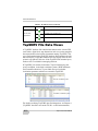
1
4OPCON,INK
$ATA)MPORT%XPORT3OFTWARE
2EFERENCE-ANUAL
P O S I T I O N I N G
S Y S T E M S
Topcon Link
Reference Manual
Part Number 7010-0522
Rev L
©Copyright Topcon Positioning Systems, Inc.
November, 2009
All contents in this manual are copyrighted by Topcon. All rights reserved.
The information contained herein may not be used, accessed, copied, stored,
displayed, sold, modified, published, or distributed, or otherwise reproduced
without the expressed written consent from Topcon.
ECO#3671
TOC
Table of Contents
Preface .................................................................. vii
Terms and Conditions ...................................................... vii
Manual Conventions ........................................................ x
Chapter 1
Introduction .......................................................... 1-1
Installing Topcon Link ....................................................
How to add a feature after installation ......................
Installing Microsoft ActiveSync for Use With
CE-based Devices .........................................................
Getting Acquainted ..........................................................
Main Screen ..............................................................
Menu Bar ...................................................................
Toolbar ......................................................................
Status Bar ..................................................................
TPS Device Directories in Windows Explorer .........
Sending Feedback and Bug Reports to Topcon Support .
1-2
1-10
1-11
1-13
1-13
1-14
1-15
1-17
1-18
1-20
Chapter 2
Setting up Topcon Link for Transferring Data ... 2-1
Adding and Formatting Devices ......................................
Adding a Sokkia GPS receiver ..................................
...................................................................................
Adding a Total Station Device ..................................
Adding a Digital Level Device .................................
Formatting a Topcon Memory Card .........................
Adding a Geoid ................................................................
About Geoids ............................................................
Creating a Regional Geoid Model .............................
P/N 7010-0522
2-1
2-3
2-6
2-6
2-8
2-11
2-13
2-15
2-16
i
Table of Contents
Chapter 3
File Operations and Data Views ......................... 3-1
File Operations .................................................................
Opening a File ............................................................
Creating a Custom Text File Format for a
Coordinate File ................................................
About Opening TS Raw Data Files .....................
Creating a Custom Text File Format for TS
Observation file ......................................................
...................................................................................
Saving a File ..............................................................
Saving the File as Another Format ............................
Closing a File .............................................................
Viewing and Entering File Properties ........................
Printing the Selected View ........................................
Applying Configuration Parameters for Viewing Data ....
Setting Tabular View Options ..........................................
Displaying Table Columns ........................................
Arranging Table Columns .........................................
Setting CAD View Options ..............................................
3-2
3-2
3-3
3-5
3-6
3-8
3-8
3-9
3-10
3-10
3-11
3-11
3-15
3-15
3-20
3-21
Chapter 4
Importing Data Files From a TPS Device ........... 4-1
Importing Files from a Topcon GPS Receiver .................
Importing Files from a Sokkia GPS Receiver ..................
Importing Files from a Mobile Device .............................
Importing Files from a Total Station ................................
Importing Files from a Digital Level ...............................
Importing Files from a Memory Card ..............................
Using Windows Explorer to Import Files from a Device
Viewing File and Device Properties .................................
4-2
4-4
4-5
4-7
4-9
4-11
4-13
4-17
Chapter 5
Converting Files Between Formats .................... 5-1
Converting A File .............................................................
Convert Coordinate Type and System .......................
Convert Height ...........................................................
Convert Coordinate Order .........................................
ii
5-2
5-5
5-8
5-9
Topcon Link Reference Manual
Table of Contents
Convert Metric Unit ..................................................
Convert Angular Unit ...............................................
Convert Vertical Angle .............................................
Convert Distance Format ..........................................
Change Geoid Bounds ...............................................
Filter Raw Data .........................................................
Code Library File Conversion Parameters ................
Coordinate File Conversion Parameters ....................
Example of Conversion Coordinates File ...........
Design and Surface File Conversion Parameters ......
Topcon Digital Level File Conversion Parameters ...
Geoid File Conversion Parameters ............................
GPS+ Raw Data File Conversion Parameters ...........
Example of Conversion TPS File to RINEX File
Localization GC3 File Conversion Parameters .........
Road File Conversion Parameters .............................
Topcon XML File Conversion Parameters ...............
TopSURV Job File Conversion Parameters ..............
Example of Conversion TopSURV File to
Topcon Vector File ..........................................
TS Obs File Conversion Parameters .........................
X-Section Template File Conversion Parameters .....
Adding a Custom Projection ............................................
Adding a Custom Datum .................................................
About Grid->Ground Parameters ....................................
5-9
5-10
5-10
5-11
5-11
5-11
5-12
5-13
5-14
5-18
5-20
5-20
5-21
5-21
5-24
5-24
5-26
5-27
5-29
5-33
5-34
5-34
5-38
5-39
Chapter 6
Editing Data in Topcon Link ................................ 6-1
Editing Points ...................................................................
Add a Point ................................................................
Edit on the Points Tab ...............................................
Edit in the Point Properties Dialog Box ....................
Editing GPS Occupations ................................................
Edit on the GPS Occupations Tab .............................
Edit in the GPS Occupations Properties Dialog Box
Add a Custom GPS Antenna .....................................
Editing TS Observations ..................................................
Edit on the TS Observations Tab ..............................
P/N 7010-0522
6-1
6-1
6-3
6-3
6-6
6-6
6-7
6-9
6-12
6-12
iii
Table of Contents
Edit in the TS Observations Properties Dialog Box ..
Editing GPS Observations ................................................
Edit on the GPS Observations Tab ............................
Edit and View in the GPS Observations Properties
Dialog Box .............................................................
Editing Digital Level Observations ..................................
Edit on the DL Observations Tab ..............................
Edit in the DL Observations Properties Dialog Box .
Editing Codes ...................................................................
Edit on the Codes Tab ................................................
Add a Code ................................................................
Add an Attribute ........................................................
Edit in the Code or Attribute Properties Dialog Box .
Editing Line ......................................................................
Edit on the Line Tab ..................................................
Edit and View in the Line Properties Dialog Box .....
Editing Tape Dimensions .................................................
Edit on the Tape Dimensions Tab .............................
Edit in the Tape Dimensions Properties Dialog Box .
Edit Image Properties .......................................................
View Image Properties ..............................................
Edit Image Point Properties .......................................
Edit Image Line Properties ........................................
Editing X-Section Templates ...........................................
Edit on the X-Section Templates Tab ........................
Edit in the X-Section Templates Properties
Dialog Box .............................................................
Editing Roads ...................................................................
Edit on the Roads Tab ................................................
Edit in the Horizontal Alignment Properties
Dialog Box .............................................................
Edit in the Vertical Alignment Properties
Dialog Box .............................................................
Edit in the X-Section Properties Dialog Box .............
Editing Layers ..................................................................
Edit on the Layers Screen ..........................................
Edit in the Layer Properties Dialog Box ....................
About Editing Offsets in Topcon Link .............................
iv
6-13
6-16
6-16
6-17
6-19
6-19
6-20
6-22
6-22
6-23
6-24
6-24
6-26
6-26
6-27
6-28
6-29
6-30
6-31
6-32
6-33
6-34
6-35
6-35
6-35
6-37
6-38
6-40
6-43
6-44
6-44
6-45
6-45
6-46
Topcon Link Reference Manual
Table of Contents
Chapter 7
Working with Point Data in Topcon Link ........... 7-1
Computing Point Coordinates for Raw Data and
TopSURV Files ............................................................ 7-1
Compute Coordinates ................................................ 7-1
Set Process Properties for Computations .................. 7-2
Chapter 8
Exporting Data Files to a TPS Device ................. 8-1
Exporting Files to a Mobile Device .................................
Exporting Files to a Total Station ....................................
Exporting an OAF to a GPS Receiver .............................
Using Windows Explorer to Export Files to a Device ....
8-2
8-3
8-5
8-7
Appendix A
Data Views Reference .......................................... A-1
Coordinate File Data View ..............................................
Points Tab ..................................................................
Icon Descriptions ......................................................
TS Observations File Data Views ....................................
Points Tab ..................................................................
TS Obs Tab ...............................................................
Icon Descriptions ......................................................
Digital Level File Data Views .........................................
Points Tab ..................................................................
DL Obs Tab ...............................................................
Icon Descriptions ......................................................
TopSURV File Data Views .............................................
CAD View for TopSURV Files ................................
Layers View for TopSURV Files ..............................
Points Tab ..................................................................
GPS Occupations Tab ...............................................
TS Obs Tab ...............................................................
GPS Obs Tab .............................................................
Codes Tab ..................................................................
Linework Tab ............................................................
Tape Dimensions Tab ...............................................
Images Tab ................................................................
P/N 7010-0522
A-2
A-2
A-3
A-3
A-3
A-4
A-6
A-7
A-7
A-8
A-9
A-10
A-11
A-12
A-12
A-13
A-15
A-16
A-17
A-18
A-19
A-20
v
Table of Contents
X-Section Templates Tab .......................................... A-21
Roads Tab .................................................................. A-22
Icon Descriptions ....................................................... A-27
Appendix A
Sample File Formats ............................................ B-1
Coordinate File Formats ...................................................
KOF Coordinates Format ..........................................
Name,E,N,Z,Code/Name,N,E,Z,Code
Coordinate Format ..................................................
Name,Lat,Lon,Ht,Code Coordinate Format ..............
FC-4 Coordinate Format ............................................
GTS-7 Coordinate Format .........................................
TopSURV Coordinate File ........................................
GPS Vector File Format ...................................................
vi
B-1
B-1
B-1
B-2
B-2
B-3
B-3
B-4
Topcon Link Reference Manual
Preface
Preface
Thank you for purchasing this Topcon product. The materials
available in this Manual (the “Manual”) have been prepared by
Topcon Positioning Systems, Inc. (“TPS”) for owners of Topcon
products, and are designed to assist owners with the use of the
receiver and its use is subject to these terms and conditions (the
“Terms and Conditions”).
NOTICE
Please read these Terms and Conditions carefully.
Terms and Conditions
USE This product is designed to be used by a professional. The user
should have a good knowledge of the safe use of the product and
implement the types of safety procedures recommended by the local
government protection agency for both private use and commercial
job sites.
COPYRIGHT All information contained in this Manual is the
intellectual property of, and copyrighted material of TPS. All rights
are reserved. You may not use, access, copy, store, display, create
derivative works of, sell, modify, publish, distribute, or allow any
third party access to, any graphics, content, information or data in this
Manual without TPS’ express written consent and may only use such
information for the care and operation of your receiver. The
information and data in this Manual are a valuable asset of TPS and
are developed by the expenditure of considerable work, time and
money, and are the result of original selection, coordination and
arrangement by TPS.
P/N 7010-0522
vii
Preface
TRADEMARKS Topcon, Topcon Link, TopSURV, HiPer, GR-3, and
Topcon Positioning Systems are trademarks or registered trademarks
of TPS. Windows® and ActiveSync® are registered trademarks of
Microsoft Corporation. The Bluetooth® word mark and logos are
owned by Bluetooth SIG, Inc. and any use of such marks by Topcon
Positioning Systems, Inc. is used under license. Other product and
company names mentioned herein may be trademarks of their
respective owners.
DISCLAIMER OF WARRANTY EXCEPT FOR ANY
WARRANTIES IN AN APPENDIX OR A WARRANTY CARD
ACCOMPANYING THE PRODUCT, THIS MANUAL AND THE
RECEIVER ARE PROVIDED “AS-IS.” THERE ARE NO OTHER
WARRANTIES. TPS DISCLAIMS ANY IMPLIED WARRANTY
OF MERCHANTABILITY OR FITNESS FOR ANY
PARTICULAR USE OR PURPOSE. TPS AND ITS
DISTRIBUTORS SHALL NOT BE LIABLE FOR TECHNICAL OR
EDITORIAL ERRORS OR OMISSIONS CONTAINED HEREIN;
NOR FOR INCIDENTAL OR CONSEQUENTIAL DAMAGES
RESULTING FROM THE FURNISHING, PERFORMANCE OR
USE OF THIS MATERIAL OR THE RECEIVER. SUCH
DISCLAIMED DAMAGES INCLUDE BUT ARE NOT LIMITED
TO LOSS OF TIME, LOSS OR DESTRUCTION OF DATA, LOSS
OF PROFIT, SAVINGS OR REVENUE, OR LOSS OF THE
PRODUCT’S USE. IN ADDITION TPS IS NOT RESPONSIBLE
OR LIABLE FOR DAMAGES OR COSTS INCURRED IN
CONNECTION WITH OBTAINING SUBSTITUTE PRODUCTS
OR SOFTWARE, CLAIMS BY OTHERS, INCONVENIENCE, OR
ANY OTHER COSTS. IN ANY EVENT, TPS SHALL HAVE NO
LIABILITY FOR DAMAGES OR OTHERWISE TO YOU OR ANY
OTHER PERSON OR ENTITY IN EXCESS OF THE PURCHASE
PRICE FOR THE RECEIVER.
LICENSE AGREEMENT Use of any computer programs or software
supplied by TPS or downloaded from a TPS website (the “Software”)
in connection with the receiver constitutes acceptance of these Terms
and Conditions in this Manual and an agreement to abide by these
Terms and Conditions. The user is granted a personal, non-exclusive,
non-transferable license to use such Software under the terms stated
viii
Topcon Link Reference Manual
Terms and Conditions
herein and in any case only with a single receiver or single computer.
You may not assign or transfer the Software or this license without
the express written consent of TPS. This license is effective until
terminated. You may terminate the license at any time by destroying
the Software and Manual. TPS may terminate the license if you fail to
comply with any of the Terms or Conditions. You agree to destroy the
Software and manual upon termination of your use of the receiver.
All ownership, copyright and other intellectual property rights in and
to the Software belong to TPS. If these license terms are not
acceptable, return any unused software and manual.
CONFIDENTIALITY This Manual, its contents and the Software
(collectively, the “Confidential Information”) are the confidential and
proprietary information of TPS. You agree to treat TPS’ Confidential
Information with a degree of care no less stringent that the degree of
care you would use in safeguarding your own most valuable trade
secrets. Nothing in this paragraph shall restrict you from disclosing
Confidential Information to your employees as may be necessary or
appropriate to operate or care for the receiver. Such employees must
also keep the Confidentiality Information confidential. In the event you
become legally compelled to disclose any of the Confidential
Information, you shall give TPS immediate notice so that it may seek a
protective order or other appropriate remedy.
WEBSITE; OTHER STATEMENTS No statement contained at the
TPS website (or any other website) or in any other advertisements or
TPS literature or made by an employee or independent contractor of
TPS modifies these Terms and Conditions (including the Software
license, warranty and limitation of liability).
SAFETY Improper use of the receiver can lead to injury to persons or
property and/or malfunction of the product. The receiver should only
be repaired by authorized TPS warranty service centers. Users should
review and heed the safety warnings in an Appendix.
MISCELLANEOUS The above Terms and Conditions may be
amended, modified, superseded, or canceled, at any time by TPS. The
above Terms and Conditions will be governed by, and construed in
accordance with, the laws of the State of California, without reference
to conflict of laws.
P/N 7010-0522
ix
Preface
Manual Conventions
This manual uses the following conventions:
Example
Description
File Exit
Connection
Frequency
Enter
NOTE
TIP
NOTICE
CAUTION
WARNING
DANGER
x
Click the File menu and click Exit.
Indicates the name of a dialog box or screen.
Indicates a field on a dialog box or screen, or a tab
within a dialog box or screen.
Press or click the button or key labeled Enter.
Further information to note about the configuration,
maintenance, or setup of a system.
Supplementary information that can help you
configure, maintain, or set up a system.
Supplementary information that can have an affect
on system operation, system performance,
measurements, or personal safety.
Notification that an action has the potential to
adversely affect system operation, system
performance, data integrity, or personal health.
Notification that an action will result in system
damage, loss of data, loss of warranty, or personal
injury.
Under no circumstances should this action be
performed.
Topcon Link Reference Manual
Chapter 1
Introduction
Welcome to Topcon Link, a full-featured data import/export and
conversion utility for Topcon instruments. Topcon Link contains
features and functions to perform the following activities:
• Import data files from all Topcon instruments.
• Convert all Topcon data files and many industry-standard data
files to corresponding file formats.
• Open and display data in easy to use tables and screens.
• Provide basic editing tools for some data types.
• Export an OAF to a Topcon GPS receiver, export coordinate files
to a total station, and export any data file to a TPS controller.
Topcon Link supports all Topcon file formats and an increasing
number of industry standard formats. Any format can be converted to
a Topcon format for export to a Topcon instrument. Many files can be
converted between third-party and proprietary formats.
P/N 7010-0522
1-1
Introduction
Installing Topcon Link
Topcon Link software comes either on a CD (as a standalone
application with TopSURV software), and also available as free
download from the TPS website to install on a computer. The
InstallAware® Wizard will save the earlier versions of Topcon Link
already installed, and will install the latest version in the folder the
user selects.
NOTICE
The CD version of Topcon Link contains all projections,
datums and geoids. The version downloaded from the
Topcon web site comes without the projections, datums
and geoids. They will be downloaded from the Internet and
installed on our computer during the installation process.
Make sure that your computer has Internet access during
installation.
Table 1-1 lists the recommended system requirements needed to
install this software on a computer.
Table 1-1. Topcon Link System Requirements for Installation
• Microsoft® Windows XP/Vista
operating system
• Processor compatible with Intel®
Pentium® 1000 MHz or faster
• 512 MB of RAM (1000MB
recommended)
• 100 MB of available hard-disk space
Before connecting the receiver’s USB port to the computer’s USB
port, the TPS USB driver must be installed on the computer. The
driver is available on the TPS website:
(http://www.topconsupport.com/documents/view/1743).
1. Navigate to the Topcon Link executable file or insert the software
CD-ROM.
• If downloading the software from the TPS website, save the
downloaded compressed file to an accessible location and
extract the Topcon Link executable file.
• If downloading the software from a TPS software CD, insert
the CD into the computer’s CD-ROM drive.
1-2
Topcon Link Reference Manual
Installing Topcon Link
2. The InstallAware Wizard starts up:
3. Click Next to start the installation process.
4. Check the ‘I accept the terms of the license agreement’ box, to
continue the installation (Figure 1-1). Type User Name and
Company Name information, then click Next (Figure 1-1)
Figure 1-1. Review License Agreement and Enter User Information
5. Select a needed setup type. Depending on the user’s selection,
either all program features or only highlighted features will be
installed. If the user selects Typical type and presses Next, the
installation software will do the following:
• automatically select all available datums and projections (except
the following Table Projections:
– rdtrans 2004 and rdtrans for Netherlands
– LB72 for Belgium
– KKJ for Finland
– USTNO2 for United Kingdom)
P/N 7010-0522
1-3
Introduction
• display the next installation dialog (Figure 1-2)
A
B
Figure 1-2. Typical Setup Type
If the user selects the Custom type and press Next, the Custom
Setup dialog displays (Figure 1-3).
Figure 1-3. Custom Setup Type
NOTICE
The typical installation does not allow one to install a geoid
on the computer. As against of the typical installation, the
custom installation allows one to install the highlighted
1-4
Topcon Link Reference Manual
Installing Topcon Link
geoid for the corresponding projection(s)/datum(s) of the
given region.
The user can highlight only those features (projection or
projection and geoid), which needed for the given job area. Such
regional selection allows one to economize the computer’s disk
size.
This dialog box contains the list of projections:
• with regional geoids
or
• without regional geoids
or
• with table projection
The Feature Description displays the list projection(s)/ formats/
geoid(s) which consist the highlighted item. To see what the
feature contains, select the desired feature:
If the selected projection contains a list of projection(s) and a
geoid file format, Topcon Link will be installed with the selected
projection(s) and format for adding the corresponding geoid to
the Topcon Link (but not a geoid file). In the given case:
P/N 7010-0522
1-5
Introduction
– the Setup tab of the Coordinate System item of the
Configuration dialog box will display the installed geoid file
format in the list of geoid:
– the installed projection(s) will be displayed in the list of
projections for conversion:
If the selected projection contains a list of projection(s) and the
geoid, Topcon Link will be installed with the selected
projection(s), format for adding the corresponding geoid and the
corresponding geoid(s) into the user’s computer. In the given
case:
– the Setup tab of the Coordinate System item of the
Configuration dialog box will display the geoid file format in
the list of geoid and installed geoid(s):
1-6
Topcon Link Reference Manual
Installing Topcon Link
– the installed projection(s) will be displayed in the list of
projections for conversion:
To add/remove the desired regional projection or geoid to/from
the installing, click the desired feature and select the
corresponding command from the pop-up menu:
The following rules is used for adding projection and geoid:
1. It is not possible to highlight a geoid without highlighting
of the corresponding projection:
or
2. It is possible to highlight only the desired
projection:
NOTICE
Without reference to the selected projection type, Topcon
Link installation will install all datums
If the user did not select any geoid file in the process of installation,
after finishing Topcon Link installation process it is possible to add
(using Configuration dialog box) only the following geoids (global
(*.glc), custom regional (*.rgm) and topcon geoid (*.jff and/or *.gff)
files):
It the user selected some regional geoid file in the process of
installation, after finishing Topcon Link installion process it is
possible to add (using Configuration dialog box) only the following
P/N 7010-0522
1-7
Introduction
geoids (selected official geoid, global (*.glc), custom regional
(*.rgm) and topcon geoid (*.jff and/or *.gff) files):
NOTICE
Without reference to the selected projection/geoid type,
Topcon Link installation saves geoid(s), which were added
in the previous version to the geoid list
To add the desired geoid(s) or the desired projection(s) after
finishing Topcon Link installion process, the user needs to do the
steps is described in “How to add a feature after installation” on
page 1-10
To continue Topcon Link installation, click Next.
3. Either keep the default installation folder or click Browse to
select a different folder in which to install the Topcon Tools.
Click Next to continue (Figure 1-2 on page 1-4, picture B)).
4. If desired, type in a new folder in which to add program icons.
For automatically creating Topcon Tools shortcut check the
‘Create on Desktop’ box. Then click Next (Figure 1-4).
5. Click Next to start the installation process (Figure 1-4)
1-8
Topcon Link Reference Manual
Installing Topcon Link
6. Topcon Tools is installed on the computer (Figure 1-4)
Figure 1-4. Select Program Folder and Installation Progress
7. Click Finish to exit the installation.
8. Before the user can use Topcon Link, we recommend restarting
your computer.
9. Create a shortcut on the computer’s desktop for easy access
(Figure 1-5).
Figure 1-5. Topcon Link Desktop Shortcut
P/N 7010-0522
1-9
Introduction
How to add a feature after
installation
The user can add any features from Custom Setup window after
finishing Topcon Link installion process and restarting Windows. To
do it, make the following steps:
1. Click Settings Control Panel Add or Remove Programs
2. Select Topcon Link v.7.3 in the Add or Remove Programs and
click Change (Figure 1-7):
Figure 1-6. Add and Remove Programs
3. Select Modify Available Options and click Next (Figure 1-8)
Figure 1-7. InstallAware Wizard
1-10
Topcon Link Reference Manual
Installing Microsoft ActiveSync for Use With CE-based Devices
4. Highlight the desired features (projection or projection and geoid)
in the Custom Setup window (Figure 1-9)
Figure 1-8. Custom Setup Window
Installing Microsoft
ActiveSync for Use With
CE-based Devices
ActiveSync® is free software from Microsoft® that establishes a
connection between a computer (with operation system Windows XP)
and an external device. ActiveSync is used for file transfers and
software downloads between a computer and mobile device running
the Windows® CE operating system, such as a hand-held controller
or CE-based Total Station.
After installing ActiveSync, it will be associated with a port on the
computer. This means that the port will be considered “busy”, and
may need to be freed up for use with other devices.
ActiveSync will start automatically when connecting a CE-based
device (such as, Topcon’s FC-120/FC-200/FC-2000/FC2200/FC2500,
GMS-2/GMS-2Pro, or GTS-720/GTS-750/GPT-7000/GPT-7000i/
GPT-7500/GPT-9000).
1. Log on to the Microsoft website (www.microsoft.com) to
download ActiveSync. Install the program onto the computer.
P/N 7010-0522
1-11
Introduction
2. After installing ActiveSync, start the application and click
File Connection Settings. Apply the following settings based on
the number of ports on the computer (Table 1-2).
NOTE
Refer to the help topics in ActiveSync for more
details on connecting with devices.
Table 1-2. About ActiveSync Connection Settings
ActiveSync Settings for Computers
With One Port
If using a port for multiple purposes,
select either “Work Network” or “The
Internet”. In this case, ActiveSync will
free up the port for other uses after
disconnecting a device.
ActiveSync Settings for Computers
With Two or More Ports
If multiple ports are available, the
default settings are sufficient. In this
case, ActiveSync will retain use of the
port after disconnecting a device.
If using a USB cable to connect the
device to the computer, select the option.
NOTICE
If the user's computer operates under Windows Vista,
ActiveSync is not needed. A connection between the
computer and an external device with Windows CE will be
automatically established after connecting your device to
your PC.
1-12
Topcon Link Reference Manual
Getting Acquainted
Getting Acquainted
The Topcon Link interface is designed for easy, integrated use with a
PC-compatible computer, a connected Topcon instrument, and
industry-standard data types. The following sections introduce the
various functions available in Topcon Link for transferring, viewing,
configuring/converting, and editing data files.
Main Screen
The main screen has the following components (Figure 1-9):
• Title bar – contains the program name and the name of the
currently active file.
• Menu bar – contains drop-down menus for all functions.
• Toolbar –contains shortcut buttons to frequently used functions.
• Work area – displays dialog boxes, job file information, and popup menus.
• Status bar – displays informative messages about Topcon Link
and various files, as well as pop-up boxes for quickly changing
units and coordinate systems (inactive if no file is open).
Toolbar
Menu Bar
Title Bar
Work Area
Status Bar
Figure 1-9. Topcon Link Main Screen Components
P/N 7010-0522
1-13
Introduction
Menu Bar
The menu bar (Figure 1-10) provides access to all available options.
Figure 1-10. Topcon Link Menu Bar
Table 1-3 briefly describes the functions in each drop-down menu.
Table 1-3. Topcon Link Menu Options
Menu
Functions
File menu
• opens and saves a file
• imports and exports data from a device
• converts a file from one format to another
compatible formata
• prints information from an active file
• displays configuration parameters
• displays file properties
• displays recently accessed files
• closes Topcon Link
Edit menu
•
•
•
•
View menu
• displays or hides the CAD view and/or layers
view
• displays or hides the Topcon Link toolbar and/
or status bar
• sets the pan or zoom mode
• sets view options for the tabular and CAD
views
Add menu
• adds a point
Process menu
• computes coordinates
• sets processing properties
1-14
allows an undo or redo of the last operation
cuts, copies, or deletes selected data
adds a point
displays the properties for selected data
Topcon Link Reference Manual
Getting Acquainted
Table 1-3. Topcon Link Menu Options (Continued)
Menu
Functions
Window menu
• closes the current window or all open windows
• arranges open windows in a cascade (stacked)
or tile (adjacent) order
• arranges icons
• shows all open windows, and selects a window
to be active
Help menu
• accesses the Topcon Link context help
• accesses customer feedback options for
sending bug reports and questions to TPS
support, and accesses the TPS website
• displays version, publisher, and build date
information for Topcon Link
a. Compatible formats - the formats containing the common data
Toolbar
The toolbar for Topcon Link (Figure 1-11) contains buttons for
frequently used functions.
Figure 1-11. Topcon Link Toolbar
Upon startup, the toolbar displays beneath the menu bar. To display or
hide the toolbar, click View Toolbar.
Table 1-4 describes the various buttons available on the toolbar.
Table 1-4. Topcon Link Toolbar Button Functions
Button
Description
Open File – Opens an existing file.
1. Click the button to display the Open dialog box.
2. Navigate to and select the desired file.
3. Click Open.
Save – Saves a file to the current directory.
Save As – Saves the current file with a new name and/or in a new
directory and/or to save in other compatible format.
P/N 7010-0522
1-15
Introduction
Table 1-4. Topcon Link Toolbar Button Functions (Continued)
Button
Description
Import File from Device – Imports files from TPS GPS+ receivers and
memory cards, TPS controllers, TPS Total Stations (CE-based, robotic,
conventional), or TPS digital levels
See Chapter 4 for details.
Export File to Device – Exports data to a TPS controller or Total Station
(CE-based, conventional, robotic), and exports an Option Authorization
File (OAF) to a TPS receiver.
See Chapter 8 for details.
Convert files between formats – Converts data in a file from one format
to another compatible format.
See “Converting A File” on page 5-2 for details.
Print – Prints the current window or table.
Undo – Reverses the last action.
Redo – Returns the last action.
Cut – Removes the selected object(s).
Copy – Copies the selected object(s).
Add point –Adds a point to the current file.
1. Click the button to display the Add point dialog box.
2. Enter the point name, coordinates, and codes for the new point.
3. Click Ok.
See “Add a Point” on page 6-1 for details.
Zoom In – Changes the pointer to a magnifying wand for zooming in on
a clicked area of the CAD view. You can also click and drag a square
around the area to zoom in on.
Zoom Out – Changes the pointer to a magnifying wand for zooming out
on a clicked area of the CAD view. You can also click and drag a square
around the area to zoom out on.
Zoom back – Returns the CAD view to the previous zoom
magnification.
1-16
Topcon Link Reference Manual
Getting Acquainted
Table 1-4. Topcon Link Toolbar Button Functions (Continued)
Button
Description
Restore All – Fits all data in the active CAD view into the viewable
extents of the view.
Pan – Changes the pointer to a “hand” with which to “grab” and
dynamically move the CAD view.
CAD View – Available for TopSURV PC Jobs, displays design data
(points, linework, roads, and surface).
Compute coordinates of points – Calculates the point coordinates in the
current file.
See “Computing Point Coordinates for Raw Data and TopSURV Files”
on page 7-1 for more details.
Context Help – Displays a pop-up tip with information about the
selected view, button, field, etc.
1. Click the button. The pointer changes to a question mark.
2. Click the object you want additional information on. A pop-up tip
gives further information.
3. Click outside the pop-up tip to close it.
Status Bar
The status bar (Figure 1-12 on page 1-18) displays:
• various informative messages about current Topcon Link
activities and opened file.
• the information boxes provide quick information about the
current linear/angular units and coordinate type/system used in
the file. These boxes also provide drop-down lists for quickly
P/N 7010-0522
1-17
Introduction
converting the linear or angular units used in the file, or the
coordinate type or system used in the file.
Coordinate Type
Linear Units
Angular Units
Coordinate System
Figure 1-12. Topcon Link Status Bar
TPS Device Directories in Windows
Explorer
The Topcon Link installation process also installs device directories
on the computer’s hard drive (Figure 1-13). These directories are used
1-18
Topcon Link Reference Manual
Getting Acquainted
to easily access data on a connected device for import/export
activities.
Figure 1-13. Topcon Device Folders in Windows Explorer
NOTE
On computers with Windows XP, the “Mobile
Device” folder displays after installing Microsoft
ActiveSync.
On computer with Windows Vista, the “Windows
CE” folder automatically displays after connecting
a external device with Windows CE.
This device directory displays the contents of the
connected TPS controller or TPS CE-based total
station.
After connecting a device to the computer, open Windows Explorer
and navigate to the My Computer window. Click the device icon/
directory to transfer data files.
NOTICE
P/N 7010-0522
Because some devices require special settings or
setups to use this feature, see the appropriate
section in Chapter 2 for more details.
1-19
Introduction
Sending Feedback and Bug
Reports to Topcon Support
The Feedback option in the Help menu offers a way for you to
provide feedback. An option to connect directly to the Topcon GPS
website is also available. These options require Internet access.
To send a bug report:
Click Help Feedback Send Bug Report. An email opens
with short descriptions of the current version of Topcon Link and
OS of the computer, and log files for Topcon Link are
automatically attached. Describe activities being performed when
the “bug” occurred and send the e-mail to TPS Support:
Figure 1-14. Example E-mail for the Send Bug Report Option
1-20
Topcon Link Reference Manual
Sending Feedback and Bug Reports to Topcon Support
To ask a question:
Click Help Feedback Question To Support. Enter any
questions, describing activities in detail, and send the email to
TPS Support:
Figure 1-15. Example E-mail for the Question to Support Option
P/N 7010-0522
1-21
Introduction
Notes:
1-22
Topcon Link Reference Manual
Chapter 2
Setting up Topcon Link
for Transferring Data
Topcon Link provides two methods for transferring data between the
computer and a connected device: via the Topcon Link interface or
the installed directories in Windows® Explorer. See “Adding and
Formatting Devices” on page 2-1 for a quick look at what each device
requires for data transfers.
• For Total Stations and Digital Levels, the instrument’ information
and connection parameters must be set up before it’s files can be
viewed. The instrument setup will only need to be done once per
computer.
• For Topcon Memory Cards (flash cards used for data storage in a
TPS receiver), the card must be formatted before data can be
recorded. The card will need to be formatted once.
Adding and Formatting
Devices
Depending on the device, an initial device setup may be required
before a successful data transfer can be completed. The following
table briefly describes the setups required for transferring data
between a computer and a connected device (Table 2-1 on page 2-2).
See the sections below for specific details.
P/N 7010-0522
2-1
Setting up Topcon Link for Transferring Data
Table 2-1. Setups Required for Connected TPS Devices
TPS GPS Receivers
No further setups are required.
After searching for connected
GPS receivers, an icon for the
receiver displays. Click the
icon to view the receiver’s data
files.
Sokkia GPS Receiver
Parameters for the Sokkia
Receiver must be set up using
Windows Explorer or the
Topcon Link Import function.
See for details“Adding a
Sokkia GPS receiver” on
page 2-3.
TPS Controllers
Microsoft ActiveSync needs to
be installed on the computer
with Windows XP. For details,
see “Installing Microsoft
ActiveSync for Use With CEbased Devices” on page 1-11“.
After connecting to the
controller (via ActiveSync for
computers under Windows XP,
or without ActiveSync for
computers under Windows
Vista), navigate to the
Compact Flash or Storage
Card card and the desired job
file.
2-2
for computer under Windows XP
for computer under Windows Vista
Topcon Link Reference Manual
Adding and Formatting Devices
Table 2-1. Setups Required for Connected TPS Devices (Continued)
TPS Total Stations
Parameters for the total station
must be set up using Windows
Explorer or the Topcon Link
Import function.
See “Adding a Total Station
Device” on page 2-6 for
details.
TPS Digital Levels
Parameters for the digital level
must be set up using Windows
Explorer or the Topcon Link
Import function.
See “Adding a Digital Level
Device” on page 2-8 for
details.
Memory Cards
The receiver’s memory card
must be formatted as a
“Topcon Memory Card”.
After connecting to the
computer’s card reader, the
memory card icon displays as
red or gray.
• A red icon indicates
compatible formatting.
• A gray icon indicates
formatting is required. See
“Formatting a Topcon
Memory Card” on page 211 for details.
Formatted
Unformatted
Adding a Sokkia GPS receiver
Before Topcon Link or Windows Explorer can read data on a Sokkia
GPS receiver, the device must be added to the directory.
P/N 7010-0522
2-3
Setting up Topcon Link for Transferring Data
1. Navigate to the Sokkia Receiver device directory (Figure 2-4 on
page 2-6).
• From Topcon Link – Click File Import from Device. In the
left pane, double-click the Sokkia Receiver directory.
• From Windows Explorer – Open the My Computer window.
Double-click the Sokkia Receiver directory.
The procedure will be the same whether using Topcon Link or
Windows Explorer.
2. Double-click Add New Sokkia receiver (Figure 2-4).
Figure 2-1. Add a New Sokkia receiver
3. On the General tab, enter and select the following information
(Figure 2-5 on page 2-7):
• Name – enter a unique name for the device
• Port – select the COM Port the device typically connects to
• Baudrate - select the baud rate for communication with the
Sokkia Receiver
• Device – enter the receiver type
4. On the Advanced tab, select the parity, byte size, stop bits, and
the way of the handshake for communication with the Sokkia
2-4
Topcon Link Reference Manual
Adding and Formatting Devices
receiver (Figure 2-5). Refer to the Sokkia receiver’s
documentation for details.
Figure 2-2. Enter New Sokkia Receiver Information
5. Click OK to save device information to the computer. When
connecting to this device, you will select the created device.
Figure 2-3. Created Sokkia Receiver for Import
P/N 7010-0522
2-5
Setting up Topcon Link for Transferring Data
Adding a Total Station Device
Before Topcon Link or Windows Explorer can read data on a Total
Station, the device must be added to the directory.
1. Navigate to the Total Station device directory (Figure 2-4 on
page 2-6).
• From Topcon Link – Click File Import from Device. In the
left pane, double-click the Topcon Total Station directory.
• From Windows Explorer – Open the My Computer window.
Double-click the Topcon Total Station directory.
The procedure will be the same whether using Topcon Link or
Windows Explorer.
2. Double-click Add New Station (Figure 2-4).
Figure 2-4. Add a New Station
3. On the General tab, enter and select the following information
(Figure 2-5 on page 2-7):
• Name – enter a unique name for the device
• Notes – enter any necessary notes
2-6
Topcon Link Reference Manual
Adding and Formatting Devices
• Port – select the COM Port the device typically connects to
• Model – enter the model number
4. On the Advanced tab, select the baud rate, parity, data bits, stop
bits, and protocol used for communication with the Total Station
(Figure 2-5). Refer to the Total Station’s documentation for
details.
Figure 2-5. Enter New Total Station Device Information
5. Click OK to save device information to the computer.
P/N 7010-0522
2-7
Setting up Topcon Link for Transferring Data
When connecting to this device, you will select the created device
and then follow the instructions on the Total Station.
Figure 2-6. Created Device
Adding a Digital Level Device
Before Topcon Link or Windows Explorer can read data on a Digital
Level, the device must be added to the directory.
1. Navigate to the Digital Level device directory (Figure 2-7).
• From Topcon Link – Click File Import from Device. In the
left pane, double-click the Topcon Digital Level directory.
• From Windows Explorer – Open the My Computer window.
Double-click the Topcon Digital Level directory.
The procedure will be the same whether using Topcon Link or
Windows Explorer.
2-8
Topcon Link Reference Manual
Adding and Formatting Devices
2. Double-click Add New Digital Level (Figure 2-7).
Figure 2-7. Add a New Digital Level
3. On the General tab, enter and select the following information
(Figure 2-5 on page 2-7):
• Name – enter a unique name for the device
• Port – select the COM Port the device typically connects to
• Baud rate and Parity – select the baud rate and parity used for
communication with the Digital Level. Refer to the Digital
Level’s documentation for details.
P/N 7010-0522
2-9
Setting up Topcon Link for Transferring Data
Figure 2-8. Enter New Digital Level Device Information
4. Click OK to save the device information to the computer.
When connecting to this device, you will select the created device
and then follow the instructions on the Digital Level.
Figure 2-9. Created Device
2-10
Topcon Link Reference Manual
Adding and Formatting Devices
Formatting a Topcon Memory Card
Before Topcon receiver can record data to a Topcon Memory Card the
card must be formatted. Formatting a Topcon Memory Card prepares
it for data recording.
• A card removed from a Topcon receiver has already been
formatted. The device icon is red.
• A card from another device will need to be formatted before
being used with a Topcon receiver. The device icon is gray.
CAUTION
Formatting an SD card will erase all data.
If a Topcon Memory Card is already installed in a Topcon receiver,
the device will have formatted the card. For some devices—such as
the GR-3 and NET-G3—the card can be manually inserted and
removed. While cards typically remain in the receiver once inserted, it
can be removed for accessing via a card reader connected to the
computer. The length of time required to format a card depends on the
size of the card and the device formatting the card. For example,
Topcon Link formats a card in a couple of minutes while the GR-3
can take around half an hour.
1. Navigate to the Memory Card device directory (Figure 2-7 on
page 2-9).
• From Topcon Link – Click File Import from Device. In the
left pane, double-click the Topcon Memory Card directory.
• From Windows Explorer – Open the My Computer window.
Double-click the Topcon Memory Card directory.
The procedure is the same whether using Topcon Link or
Windows Explorer.
2. Right-click the gray card icon and click Format (Figure 2-7 on
page 2-9).
3. Click Format to format the flash card for access by Topcon
programs (Figure 2-7 on page 2-9).
P/N 7010-0522
2-11
Setting up Topcon Link for Transferring Data
Figure 2-10. Format Memory Card
When selecting a formatted memory card device, you will view its
data in the corresponding screen/pane.
Figure 2-11. Formatted Memory Card Device
2-12
Topcon Link Reference Manual
Adding a Geoid
Adding a Geoid
When working with data in Topcon Link, a geoid may be required to
ensure correct elevation of the GPS network points. A geoid
transforms the ellipsoidal heights measured by GPS to heights based
on a physical reference surface. When working with coordinate data,
you may want add a geoid, or you can create a regional geoid.
NOTICE
Make sure:
- the geoid used to take point measurements is
loaded into Topcon Link before opening a file
- the geoid covers the area where file’s points are
located
- the geoid used to take point measurements is
loaded into Topcon Link before opening a file
The orthometric heights will be equal to ellipsoidal
heights if a geoid file is not downloaded to Topcon
Link and/or the geoid does not cover the area where
file’s points are located and/or if the geoid used to
take point measurements is missing.
1. Click File Configuration and click Coordinate Systems in the
menu tree.
2. Click Add.
Figure 2-12. Add Geoid
P/N 7010-0522
2-13
Setting up Topcon Link for Transferring Data
3. Navigate to the location of the geoid and select the format of the
geoid.
4. Select the desired geoid and click Open.
Figure 2-13. Select Geoid Format and Geoid
5. Repeat these steps for any other geoids. The geoids will be listed
in the right pane (Figure 2-14).
Figure 2-14. Added Geoids
6. Any Geoid from the list will be automatically used when Topcon
Link opens files.
7. Click OK to save the configuration and exit.
2-14
Topcon Link Reference Manual
Adding a Geoid
About Geoids
A geoid model is used to transform the ellipsoidal heights measured
by GPS (purely geometrical) to heights that are based on a physical
reference surface, such as mean sea level. Over small regions there is
little difference between the two reference surfaces, but for large
projects the differences may be unacceptable. Working with a geoid
model when surveying with GPS will ensure proper point
measurements.
Geoid models for the United States have been developed by the
National Geodetic Survey (NGS). The most recent model is called
Geoid 2003. To keep the file size smaller, the continental United
States is divided into a grid with eight zones; each zone has a geoid.
Use Figure 2-15 to help you determine the geoid file to use for your
project. For Geoid 2003, the files are numbered “g2003u01” to
“g2003u08” to correspond to grids 1 to 8. For other regions, or if you
have questions, contact your local representative or Topcon Support.
Grid #1
58 - 40 N & 111 - 130 W
Grid #2
58 - 40 N & 94 -113 W
Grid #3
58 - 40 N & 77 - 96 W
Grid #4
58 - 40 N & 60 - 79 W
Grid #5
42 - 24 N & 111 - 130 W
Grid #6
42 - 24 N & 94 -113 W
Grid #7
42 - 24 N & 77 - 96 W
Grid #8
42 - 24 N & 60 - 79 W
50
40
30
230
240
250
260
270
280
290
300
Figure 2-15. Geoid Grid Example – Approximate Grid for US
Using Topcon Link, you can create a Topcon geoid file for a specific
area from a supported geoid model, and then export the file into
P/N 7010-0522
2-15
Setting up Topcon Link for Transferring Data
TopSURV. See “Geoid File Conversion Parameters” on page 5-20 for
file conversion details.
Creating a Regional Geoid Model
If geoid heights (the differences between ellipsoidal and orthometric
heights) for the nodes of a regular grid are known, you can create a
Regional Geoid Model File (*.rgm). After creating the file, use
Topcon Link to convert the regional geoid model file to a Topcon
geoid file (*.gff).
1. Open an ASCII text editor (such as Notepad).
2. Enter geoid heights in the format shown in Table 2-2, where each
row in the table corresponds to a line in the file. See below for a
description of the fields in this format.
Table 2-2. Regional Geoid Model Format
Format Fields
Example
LAT, LON, n_row, n_column, step_lat,
step_lon, geoid_direction, ellipsoid;
40 36 10, -4 30 00, 3, 3, 2 00, 2 00, SE,
WGS84;
H1 H2 H3
16.16 11.11 6.6
H4 H5 H6
12.12 7.7 2.2
H7 H8 H9
8.8 3.3 19.19
3. Save the file with an “.rgm” extension.
4. Open Topcon Link and convert the regional geoid model file to a
Topcon geoid file. See “Converting A File” on page 5-2 and
“Geoid File Conversion Parameters” on page 5-20 for details.
The fields in the regional geoid model format correspond to the
following information:
• LAT, LON – latitude (GG MM SS) and longitude (GG MM SS)
of the start point for the Regional Geoid Model
– Latitudes are positive for the Northern Hemisphere.
– Longitudes are positive for the Eastern Hemisphere.
Enter latitudes and longitudes in this format:
• n_row – the number of rows in the file
2-16
Topcon Link Reference Manual
Adding a Geoid
• n_column – the number of columns in the file
• step_lat – grid step along parallels (MM SS)
• step_lon – grid step along meridians (MM SS)
• geoid_direction – direction for entering geoid heights along the
grid (Table 2-3)
Table 2-3. Entering Geoid Heights
NE
from north to east
EN
from east to north
WS
from west to south
• ellipsoid – the ellipsoid type that the given regional geoid is based
on
• H1,H2... – geoid height in the node (meter)
P/N 7010-0522
2-17
Setting up Topcon Link for Transferring Data
Notes:
2-18
Topcon Link Reference Manual
Chapter 3
File Operations and
Data Views
Topcon Link works with individual data formats rather than importing
data into an application-based, project-style file. This feature allows
Topcon Link to provide robust import/export and conversion utilities
for multiple data types, as well as the ability to work with a data type
in its native format. To this end, Topcon Link uses standard file
opening/closing and saving operations. Most files can be opened,
saved, and closed. However, a few formats may need to be converted
before opening and working with the data, or converted to another
format before saving changes.
• See “File Operations” on page 3-2 for details on opening/closing
files, and for details on setting file properties and printing.
• See “Saving the File as Another Format” on page 3-9 for details
on saving proprietary or device-specific formats.
Topcon Link includes a standard configuration for viewing data, such
as distance precisions, applicable coordinate systems, and
computation parameters. To change any of these settings, see
“Applying Configuration Parameters for Viewing Data” on
page 3-11.
The Tabular view initially contains default data columns and settings
for viewing and working with data. The CAD view can display
information for data points. These columns and settings can be
shown/hidden or re-arranged.
• See “Setting Tabular View Options” on page 3-15 for details on
setting up data columns for the different tabs.
• See “Setting CAD View Options” on page 3-21 for details on
viewing data information in the CAD view.
P/N 7010-0522
3-1
File Operations and Data Views
File Operations
Topcon Link uses standard file opening/closing and saving operations
for all file types. A properties feature allows job and company
specific information to be saved with the file. The selected view can
be printed for further study.
Opening a File
Because Topcon Link is a utility program that works with various file
types, it does not have a type of file specifically associated with this
software. Some types of files can be directly opened in Topcon Link.
Table 3-1 lists the file types that Topcon Link can open.
Table 3-1. File Types that can be Opened
File Type
Format Extensions
Code Library
*.las; *.dbf; *.tdd; *.xml
Coordinates
*.sdr; *.pt3; *.mgn; *.txt; *.xml; *.cr5; *.csv; *.xyz;
*.fc4; *.pnt; *.fc5; *.*
Digital Level Observations
*.dl;*.lev;*.txt
GPS+ Raw Data
*.pdc; *.tps; *.jps; *.tpd; *.??O; *.??D; *.??G; *.??N
TopSURV PC Jobs
*,tsj; *.tlsv
Total Station Observations
*.dat; *.raw; *.fc5; *.gts; *.gt6*, gts6; *.gts7; *.gt7;
*.*; *.xml
Other file types must be converted first before Topcon Link can read
the data. See Chapter 3 for details.
1.
2.
3.
4.
Open Topcon Link and click File Open File.
Select the file format.
Navigate to and select the file to Open.
If needed, select desired Advanced options.
NOTE
For Total Station observations measured using a
vertical angle, select the vertical angle mode.
5. Click Open.
3-2
Topcon Link Reference Manual
File Operations
Figure 3-1. Select Format and File to Open
Creating a Custom Text File Format for a
Coordinate File
To open or save a file of arbitrary coordinate format, you can create
and save a custom format. A custom text format allows you to
customize the data included in the coordinate file. Text formats are
saved as an ASCII format (*.txt, *.csv, etc.).
To create an arbitrary text coordinate file, take the following steps:
1. Click File Open File.
2. On the Open dialog box, navigate to and select a desired
coordinate file in the File name field.
3. On the Open dialog box, select the Custom text format from the
list of coordinate formats in the Format name field. Click Open.
4. On the Custom format properties dialog window select the
delimiter that separates data in a line and the coordinate system
used to create the data.
NOTICE
Do not use the “Space” delimiter if the file contains
codes with attributes.
5. Select data types for the custom format:
P/N 7010-0522
3-3
File Operations and Data Views
• In the left column, select the data type(s) to include and click
the Move Right button.
• In the right column, use the Move Up/Move Down button to
arrange the data types into the same order used in the opened
file.
NOTICE
Always include “PointNum” in the right column
and always have it as the first data type.
If including “FullCodes” in the right column,
always have it as the last data type.
6. Select the rule(s) to use for displaying data:
• Ignore first line – if the first line if informational only.
• FullCodes include Code, String and ControlCode – if these
codes are included as shown in Figure 3-2 on page 3-4.
• FullCodes include Code and Attribute – if these codes are
included as shown in Figure 3-2.
If the custom format has mixed FullCodes, select both options.
Includes Code, String, Control Code
Includes Code and Attribute
Figure 3-2. Examples of File Formats with FullCodes
7. Enter a name for the format and an extension type.
8. Click Ok to store the format in the Formats folder (installed with
Topcon Link) and include it in the format name list. This format
is added to the list of coordinate formats for Open, Save As and
Convert File dialog boxes.
3-4
Topcon Link Reference Manual
File Operations
2
3
4
5
6
7
Figure 3-3. Create Custom Text Coordinate Format
NOTICE
Topcon Link applies the default file name,
UnName*.*, if no file name accompanies the new
coordinate file format. In this case, Topcon Link
deletes the new file format when closed.
About Opening TS Raw Data Files
While TS raw data file do not record information about the vertical
angle mode (Figure 3-4 on page 3-6), you can select the mode under
Advanced options when opening the file in Topcon Link.
• Zenith – vertical angles are from zenith
• Horizontal Level – vertical angles are from horizontal
P/N 7010-0522
3-5
File Operations and Data Views
• Auto – no information available on the vertical angle mode. In
this case, angles from 0 to 45° are considered “horizontal” and
angles more than 45° are considered “zenith.”
CAUTION
If vertical angles measured in a TS raw data file
exceed 45°, select the same mode used for these
measurements when opening the file. If a different
mode or “Auto” is selected, the TS Obs tab will
display measurements in the wrong column:
• the Vertical Angle column will display values
read from zenith
• the Zenith Angle column will display values
read from horizontal level
Figure 3-4. Vertical Angle from Horizontal Level (A) and Zenith (B)
Creating a Custom Text File Format for TS
Observation file
To open or save a file of arbitrary TS observation format, you can
create and save a custom format. A custom text format allows you to
customize the data included in the TS observation file. Text formats
are saved as an ASCII format (*.txt, *.csv, etc.).
3-6
Topcon Link Reference Manual
File Operations
To create an arbitrary text TS observation file, take the following
steps:
1. Click File Open File.
2. On the Open dialog box, navigate to and select a desired TS
observation file in the File name field.
3. On the Open dialog box, select the Custom text format from the
list of TS observation formats in the Format name field. Click
Open.
4. On the Custom format properties dialog window select the
delimiter that separates data in a line
5. On the Custom format properties dialog window select data types
for the custom format:
• In the left column, select the data type(s) to include and click
the Move Right button.
• In the right column, use the Move Up/Move Down button to
arrange the data types into the same order used in the opened
file.
6. Enter a name for the format and an extension type.
7. Click Ok to store the format in the Formats folder (installed with
Topcon Link) and include it in the format name list. This format
are added (will be added) to the list of TS observation formats for
Open, Save As and Convert File dialog boxes.
P/N 7010-0522
3-7
File Operations and Data Views
2
3
4
5
6
7
Figure 3-5. Create Custom Text TS Obs Format
Saving a File
Topcon Link opens and imports many files types, but only saves
certain file types in a native Topcon format.
When saving a file that has been edited, Topcon Link automatically
saves the original version of the file as “*.*.initial” in the current
folder. Then the edited file is saved.
Use one of the following methods to save a file:
• Click the Save button on the Toolbar.
• Click File
Save File.
• Press Ctrl+S on the keyboard.
An error message displays if the format is not supported for a save
operation.
3-8
Topcon Link Reference Manual
File Operations
Saving the File as Another Format
Topcon Link allows one to save the current file with a new name and/
or in a new directory and/or to save in other format. Saving a file in
another format uses the same process as a file conversion. Topcon
Link allows the user to save files only to compatible formats (the
formats with the common data).
For details on converting files, see Chapter 5.
TIP
Use the Save As function to keep versions of the
same file to show progress. Simply add the date or
other indicator to the file name.
1. With the desired file open and active, click File Save As.
2. Navigate to the location in which to save the file.
3. Type in a name for the file.
4. Select the format to save to.
NOTICE
Topcon Link will display only compatible formats
in the File format field of the Save as dialog box.
5. If selecting a different format from the current format, select
applicable Advanced Options.
For details on the advanced options, see the applicable section in
“Converting A File” on page 5-2.
P/N 7010-0522
3-9
File Operations and Data Views
6. Click Save.
Figure 3-6. Save File As...
Closing a File
To close a file without closing Topcon Link, click the system close
button on the Tabular View.
Close File using System
Button on Tabular View
Figure 3-7. Close File
While several files can be open at the same time, it may take longer
for Topcon Link to read or compute data if the files have a lot of data.
Closing a file before opening another may speed up computations.
Viewing and Entering File Properties
The Properties dialog box is used for viewing and entering filespecific information. This dialog box also includes the location of the
file, file type, and date the file was last saved.
1. Click File
3-10
File Properties.
Topcon Link Reference Manual
Applying Configuration Parameters for Viewing Data
2. View the path and format of the file.
3. For some file types, you can type in a name for the job, the name
of the surveyor or company, and any associated notes.
4. Click OK to save and exit.
TopSURV PC Job File Properties
Digital Level File Properties
Figure 3-8. File Properties – Examples
Printing the Selected View
The Tabular and CAD views in Topcon Link can be printed for
viewing offline.
TIP
Some views print best with a landscape orientation.
• Use the File Page Setup option to apply page
and margin settings.
• Use the File Print Preview option to view the
potential result of the selected view.
To print the Tabular view, select the tab and click File
Print.
To print the CAD view, select the CAD view and click File
Print.
Applying Configuration
Parameters for Viewing Data
Configuration parameters apply basic settings for such items as how
to display angles and the decimal for digits, the coordinate systems
available and adding a geoid, and the settings to use for adjustments.
P/N 7010-0522
3-11
File Operations and Data Views
These parameters will be saved with Topcon Link and used when
opening a file. The default configuration is usually appropriate for
most operations.
1. Open Topcon Link and click File Configuration.
2. In the Display pane, select the following parameters for
displaying information (Figure 3-9 on page 3-12). Click Ok to
save and exit.
• In the Precisions tab, select the number of digits to display
after the decimal for measurements.
• In the Time tab, select the local time used for start and end
times for GPS occupations
• In the Roads tab, select the term to use for displaying
information on the centerline; either Chainage or Station.
• In the Angles tab, select the form for displaying angles and
latitudes/ longitudes.
Figure 3-9. Select Display Parameters
3-12
Topcon Link Reference Manual
Applying Configuration Parameters for Viewing Data
3. In the Coordinate Systems pane the user can view, add, or remove
available geoid file (Figure 3-10). Click Ok to save and exit.
To add a new Geoid to the list, see “Adding a Geoid” on
page 2-13.
Figure 3-10. Select Geoid
4. In the Save pane, select the interval in minutes for saving a
backup copy of the current file (Figure 3-11). Click Ok to save
and exit. Topcon Link uses the following rules for saving/
deleting backup copies:
• The file will be saved at the selected interval.
• If the file has been edited, a backup copy is automatically
saved.
• After saving the file (either click Ctrl+S, click on the Save
button, or click File Save/Save As), the backup copy is
deleted. A new backup copy is saved when at the end of the
next time interval.
• Type “0” into the field to turn off the backup save feature.
P/N 7010-0522
3-13
File Operations and Data Views
• If Topcon Link (or the system) shuts down unintentionally,
the backup copy of the current files opens and is marked
“reserved”.
Figure 3-11. Select File Backup Properties
5. In the Process Compute Coordinates pane (Figure 3-12), type in
distance and angle measurement errors to take them into account
when computing the coordinates of station using directions
observed from the station to points of known positions (resection
method). Click Ok to save and exit.
6. In the Process TS Computations pane, select the refraction
coefficient to be applied to total station observations during
calculation of the coordinate (Figure 3-12). Click Ok to save and
exit.
Figure 3-12. Set Processing Properties
3-14
Topcon Link Reference Manual
Setting Tabular View Options
Setting Tabular View Options
Topcon Link displays data in two views, a tab view and a CAD view.
The Tabular view groups data based on type and displays the
information in a series of tables on different tabs (Figure 3-13).
Figure 3-13. Tabular View
The tabs that display depend on the type of data in the current file.
Data columns for each tab can be shown/hidden and re-arranged
based on available data and the user’s preference.
Displaying Table Columns
1. To edit the order and visibility of a tab’s column, click View
Options Tabular View.
2. Click the options tab for the corresponding Tabular View tab.
3. For most of the tabs, select the desired field and use the following
buttons to set up the data columns. Figure 3-14 on page 3-16 uses
the Lines Tab options as an example.
• Move right (
move left (
) to include the field in the table and
) remove the field from the table.
• Move up (
) and move down (
order of the selected field.
P/N 7010-0522
) to arrange the
3-15
File Operations and Data Views
For the Road Graphic Views and Images tab options, select the
desired fields to display on a graphic tab. See page 3-18 and
page 3-19 for examples.
4. Click Ok to save and apply the settings.
Include Field in Tab
Arrange Field in Tab
Save Changes
Figure 3-14. Lines Tab Options – Editing Data Columns
3-16
Topcon Link Reference Manual
Setting Tabular View Options
Table 3-2 shows an example of, and the default settings for, each of
the Tabular View options tabs. See Figure 3-14 on page 3-16 for an
example of the Lines options tab.
Table 3-2. Tabular View Options Tabs
Points tab Options
GPS Occupations tab Options
GPS Observations tab Options
TS Observations tab Options
P/N 7010-0522
3-17
File Operations and Data Views
Table 3-2. Tabular View Options Tabs (Continued)
Digital Level Observations tab Options
Tape Observations tab Options
Road X-Sections tab Options
Road Graphic Views tab Options
3-18
Topcon Link Reference Manual
Setting Tabular View Options
Table 3-2. Tabular View Options Tabs (Continued)
X-Section Templates tab Options
Images tab Options
Horizontal Road Elements tab Options
Vertical Road Elements tab Options
P/N 7010-0522
3-19
File Operations and Data Views
Arranging Table Columns
The columns in the Tabular views can be sorted and arranged
(Table 3-3) to best display the file’s data. The arrangement is used the
next time you open a file.
To reset the table’s columns to default settings, right-click the
column’s header and click Reset Columns
.
Table 3-3. Arranging Table Columns
Column Arranging Options
Sort columns
Data in a column can be sorted in
decreasing/increasing order.
Examples
Decreasing Order
Increasing Order
Click the column’s header, or rightclick and click Sort.
Swap columns
Columns can be moved from one
location to another in the table.
Before
Click the column’s header and drag it
to the desired location.
During
After
3-20
Topcon Link Reference Manual
Setting CAD View Options
Table 3-3. Arranging Table Columns
Column Arranging Options
Size columns
Columns can be sized to display/hide
data.
Examples
Before
Click the column’s right edge and
drag left to decrease, right to increase
the width of the column.
After
Setting CAD View Options
Topcon Link displays data in two views: a tab view and a computer
aided drawing view. The CAD view is a two-dimensional, graphical
representation of linework road and surface data, with associated
points. To view the CAD graphic, click View CAD View.
Depending on the file’s data and the filters used, the following
information displays:
• Points with associated symbols
If the point does not have a symbol, its survey symbol is used.
• Lines using the associated code/layer color, style, and width.
• Control codes (/AS, /AE, /C) display as an arc or closed polyline,
respectively.
• Codes with a polygon entity display as closed and filled (if a fill
color has been set).
P/N 7010-0522
3-21
• Surfaces and road display in the color applied to the
corresponding layer(s).
Figure 3-15. CAD View
NOTE
The Roads tab and X-Section Templates tab have
independent CAD graphical views associated with
the selected data element.
1. To filter (show/hide) points, lines and codes in the CAD view,
click View Options CAD View.
2. On the Window tab, select to show/hide a grid on the CAD view.
3. On the Labels tab, select to show/hide the following information
on the CAD viewmap, as a pop-up with the cursor, or on the
Status bar.
• Name – the name of the point
• Code – any code associated with the point
• Height – the height (elevation) of the point
4. On the Selection tab, check on (off) the following parameters of
the selecting rectangle to show/hide them in the Status Bar:
• Show distance - the length of the selecting rectangle’s diagonal
• Show azimuth - the azimuth of the selecting rectangle’s diagonal
• Show dimension - the dimension (along the Easting and Northing
axis correspondingly) of the selecting rectangle
Setting CAD View Options
• Show area - the area of the selecting rectangle.
5. Click Apply to save changes, then Ok to exit.
Figure 3-16. CAD View Options
P/N 7010-0522
3-23
File Operations and Data Views
Notes:
3-24
Topcon Link Reference Manual
Chapter 4
Importing Data Files
From a TPS Device
Topcon Link provides a simple interface for importing data files
directly from a Topcon device (instrument). The imported file is saved
to the selected directory, and is immediately available for opening and
viewing in Topcon Link.
A unique feature of the software includes the ability to import data
from a connected device to the computer using Windows® Explorer,
without having to open Topcon Link. Then use Topcon Link to open
the files for viewing, editing, converting, or uploading.
NOTE
Before importing data from some devices, the
device must first be set up. See “Adding and
Formatting Devices” on page 2-1 for details.
This chapter first discusses the steps to view device properties, or file
properties on a device’s memory card. The remaining sections in this
chapter detail the steps required to import data files from a connected
device or an inserted memory card.
• See “Importing Files from a Topcon GPS Receiver” on page 4-2.
• See “Importing Files from a Mobile Device” on page 4-5.
• See “Importing Files from a Total Station” on page 4-7.
• See “Importing Files from a Digital Level” on page 4-9.
• See “Importing Files from a Memory Card” on page 4-11.
• See “Using Windows Explorer to Import Files from a Device” on
page 4-13.
P/N 7010-0522
4-1
Importing Data Files From a TPS Device
Importing Files from a Topcon
GPS Receiver
The Topcon family of GPS receivers have an internal data storage
device to record data in *.tps format. This family of products includes
the following receivers. Refer to the receiver’s documentation for
details on setup, operation, and connection with other devices.
• Odyssey-E, Odyssey-RS,
NET-G3
• HiPer+, HiPer Pro
• HiPer, HiPer GD, HiPer L1,
HiPer GGD
• GR-3
• HiPer XT, HiPer XR
• HiPer Lite, HiPer Lite+
• Map-HP, Map-RT
When importing files from a TPS GPS receiver, Topcon Link
automatically detects the receiver for importing data, and no further
setups are required.
Before connecting the receiver’s USB port to the computer’s USB
port, the TPS USB driver must be installed on the computer. The
driver is available on the TPS website: (http://
www.topconsupport.com/documents/view/1743)
NOTE
This section describes data import using the Topcon
Link interface.
To import data using Windows® Explorer, see
“Using Windows Explorer to Import Files from a
Device” on page 4-13.
1. Connect your receiver and computer according to the receiver’s
documentation.
Note that a Bluetooth® connection requires that both devices
have Bluetooth wireless technology capabilities.
2. With Topcon Link open, click File Import from Device.
3. In the left panel, double-click Topcon Receivers. Topcon Link
searches for connected devices.
4-2
Topcon Link Reference Manual
Importing Files from a Topcon GPS Receiver
Click Stop to quit the search and display detected devices.
Figure 4-1. Search For Connected Devices
4. Double-click the Topcon Receivers to access the device’s data
storage module and view the collected raw files.
5. In the right pane, navigate to the folder on the computer in which
to save data files.
6. In the left pane, select the desired *.tps file(s) and click the Move
Right button. The file import progress displays.
Figure 4-2. Import File from Receiver
P/N 7010-0522
4-3
Importing Data Files From a TPS Device
7. If Open File After Import was selected, the import function closes
and the *.tps file opens in Topcon Link:
Figure 4-3. Display data of the *.tps file
Importing Files from a Sokkia
GPS Receiver
The Sokkia family of GPS receivers have an internal data storage
device to record data in *.pdc format.
When importing files from a Sokkia receiver, Topcon Link connects
to the device and provides a path for the data transfer.
NOTE
This section describes data import using the Topcon
Link interface.
To import data using Windows® Explorer, see
“Using Windows Explorer to Import Files from a
Device” on page 4-13.
1. Connect your receiver and computer according to the receiver’s
documentation.
2. With Topcon Link open, click File Import from Device.
3. In the right pane, navigate to the folder on the computer in which
to save data files.
4. In the left pane, double-click Sokkia Receiver to connect with the
recreiver.
4-4
Topcon Link Reference Manual
Importing Files from a Mobile Device
5. Select the desired raw (*.pdc) file in the left panel and click the
Move Right button to start downloading the selected file to the
computer:
Figure 4-4. Import raw file from Sokkia receiver to Computer
Importing Files from a Mobile
Device
The Topcon family of controller software (such as TopSURV) runs on
several Topcon and third-party mobile devices.
Microsoft ActiveSync needs to be installed on the computer with
Windows XP. For details, see “Installing Microsoft ActiveSync for
Use With CE-based Devices” on page 1-11.
If the user’s computer operates under Windows Vista, ActiveSync is
not needed. A connection between the computer and an external
device with Windows CE will be automatically established after
connecting your device to your PC.
TopSURV supports two formats of the job files:
• TopSURV *. tsj. This job is created in TopSURV version 7.0 and
later.
• TopSURV *.tsv job. This job is created in TopSURV version
6.11.03 and earlier
P/N 7010-0522
4-5
Importing Data Files From a TPS Device
There is a difference in format of these files and a difference in using
these files in the computer’s software.
In TopSURV version 7.0 and later, the *.tsj file is saved on the
controller, that this file format can be opened by Topcon Link/Topcon
Tools/TopSURV PC. Topcon Link is used only for transferring the
*.tsj file from the controller to the computer without format changes.
Moreover, the user can use a movable memory card to transfer the
*.tsj file from the controller to the computer.
In TopSURV version 6.11.03 and earlier, the *.tsv file is saved on the
controller. But Topcon Link/Topcon Tools/TopSURV PC version can
not open this file format. Topcon Link has to convert mobile devicebased formats to computer-based formats.Topcon Link performs the
conversion during the import process the *.tsv file to the *.tlsv file.
This format (*.tlsv) is opened by Topcon Link/Topcon Tools/
TopSURV PC.
NOTE
This section describes data import using the Topcon
Link interface.
To use Windows® Explorer for data importing, see
“Using Windows Explorer to Import Files from a
Device” on page 4-13.
1. Connect your controller and computer according to the
controller’s documentation.
Note that a Bluetooth® connection requires that both devices
have Bluetooth wireless technology capabilities.
2. With Topcon Link open, click File Import from Device.
3. In the left panel, double-click Mobile Device. Topcon Link
connects to the internal memory of the controller.
4. Navigate to the location in the controller’s memory where data
files are saved. For example, TopSURV files are saved to the CF
Card/TopSURV/Jobs directory.
5. In the right pane, navigate to the folder on the computer in which
to save data files.
6. In the left pane, select the desired file(s) and click the Move Right
button. The file import progress displays.
4-6
Topcon Link Reference Manual
Importing Files from a Total Station
7. If Open File After Import was selected, the import function closes
and the file opens in Topcon Link.
Figure 4-5. Import File from Mobile Device
Importing Files from a Total
Station
The Topcon family of conventional and robotic Total Stations have an
internal data storage device to record data in various formats. Refer to
your Total Station’s documentation for details on setup, operation,
and connection with other devices.
When importing files from a TPS Total Station, Topcon Link
connects to the device and provides a path for the data transfer. The
actual file transfer is performed at the Total Station.
The connection procedure for TPS Total Stations varies, so refer to
the device’s documentation for details.
When connecting to a CE-based device, Microsoft ActiveSync
automatically starts up and connects with the device. This connection
is required to import files, if your computer operate under Windows
XP. If the computer operates under Windows Vista, ActiveSync is not
needed.
P/N 7010-0522
4-7
Importing Data Files From a TPS Device
If you need to install ActiveSync, see “Installing Microsoft
ActiveSync for Use With CE-based Devices” on page 111“Installing Microsoft ActiveSync for Use With CE-based
Devices” on page 1-11 for details.
NOTE
This section describes data import using the Topcon
Link interface.
To use Windows® Explorer for data importing, see
“Using Windows Explorer to Import Files from a
Device” on page 4-13.
1. Connect your controller and Total Station according to the
device’s documentation.
2. With Topcon Link open, click File Import from Device.
3. In the right pane, navigate to the folder on the computer in which
to save data files.
4. In the left pane, double-click Topcon Total Stations.
5. Double-click the desired device to connect with the Total Station.
Figure 4-6. Select Total Station to Import Data From
6. Select the “file.txt” file and click the Move Right button.
7. Follow all steps listed in the Download file from Total Station
dialog box. These steps may vary depending on the connected
device. Click Start.
4-8
Topcon Link Reference Manual
Importing Files from a Digital Level
8. Press the F3 key on the Total Station to import data.
9. If Open File After Import was selected, the import function closes
and the file opens in Topcon Link.
Figure 4-7. Import File from Total Station
Importing Files from a Digital
Level
The Topcon family of Digital Levels has an internal data storage
device to record data. Refer to your Digital Level’s documentation for
details on setup, operation, and connection with other devices.
When importing files from a TPS Digital Level, Topcon Link simply
connects to the device and provides a path for the data import. The
actual file transfer is performed at the Digital Level.
The connection procedure for TPS Digital Levels varies, so refer the
device’s documentation for details.
NOTE
P/N 7010-0522
This section describes data import using the Topcon
Link interface.
To use Windows® Explorer for data importing, see
“Using Windows Explorer to Import Files from a
Device” on page 4-13.
4-9
Importing Data Files From a TPS Device
1. Connect your controller and Total Station according to the
device’s documentation.
2. With Topcon Link open, click File Import from Device.
3. In the right pane, navigate to the folder on the computer in which
to save data files.
4. In the left pane, double-click Topcon Digital Levels.
5. Double-click the desired device to connect with the Total Station.
Figure 4-8. Select Digital Level to Import Data From
6. Select the “file.dl” file and click the Move Right button.
7. Follow all steps listed in the Download file from the Digital Level
dialog box (Figure 4-9 on page 4-11) to select a file and begin the
import. These steps may vary depending on the connected device.
4-10
Topcon Link Reference Manual
Importing Files from a Memory Card
8. If Open File After Import was selected, the import function closes
and the file opens in Topcon Link.
Figure 4-9. Import File from Digital Level
Importing Files from a Memory
Card
Most Topcon devices contain internal memory cards. These movable
memory cards are used to collect raw data and to transfer the
collected data from the device to the computer. The memory cards
can be divided into two different types:
• Memory cards formatted in Topcon receiver’s file system. These
cards are used in a TPS receiver, such as the GR-3 or NET-G3
• Memory cards formatted using the FAT32 file system. These
cards used in controllers, such as the FC-200 or GMS-2.
To download data from the first type of the memory card, use Topcon
Link/Topcon Tools. Only these software support such cards.
If a memory (SD) card was used in a TPS receiver, such as the GR-3
or NET-G3, and contains *.tps files, it has already been formatted.
Topcon Link can read files on a memory card formatted in the TPS
receiver file system. The device icon for a formatted card is red.
P/N 7010-0522
4-11
Importing Data Files From a TPS Device
Topcon Link can format a memory card for use in a TPS receiver,
such as the GR-3 or NET-G3. The device icon for an unformatted
card is gray. See “Adding and Formatting Devices” on page 2-1 for
details on formatting cards with a gray device icon.
NOTE
1.
2.
3.
4.
This section describes data import using the Topcon
Link interface.
To use Windows® Explorer for data importing, see
“Using Windows Explorer to Import Files from a
Device” on page 4-13.
Insert the memory card into the card reader.
With Topcon Link open, click File Import from Device.
In the left panel, double-click Topcon Memory Card.
Click the desired, formatted memory card device icon.
Wait while Topcon Link checks the card’s file system and
displays the card’s data.
Figure 4-10. Mount Memory Card
4-12
Topcon Link Reference Manual
Using Windows Explorer to Import Files from a Device
5. In the right pane, navigate to the folder on the computer in which
to save data files.
6. In the left pane, select the desired file(s) and click the Move Right
button. The file import progress displays.
7. If Open File After Import was selected, the import function closes
and the file opens in Topcon Link.
Figure 4-11. Import File from Memory Card
To download data from the second type of the memory card, one can
use the standard Windows procedure.
Using Windows Explorer to
Import Files from a Device
After installing Topcon Link, the computer’s hard drive contains up to
five virtual drives for accessing Topcon devices to import/export data.
These virtual drives provide a quick way to transfer data without
opening Topcon Link. Many of the steps are the same as for
importing/exporting data via the Topcon Link interface. See the
corresponding section above for further details on the steps listed in
sections below.
Import from Topcon/Sokkia GPS Receivers using Explorer
1. Connect the receiver to the computer. Turn on the receiver.
2. Navigate to the Topcon Receivers device directory and click the
device icon.
P/N 7010-0522
4-13
Importing Data Files From a TPS Device
3. After discovering devices, click the receiver’s icon.
4. Select and copy, or select and drag-and-drop, the desired files to a
directory on the computer.
from Topcon
receiver
from Sokkia
receiver
Figure 4-12. Import Using Explorer – Receiver
Import from TPS Mobile Device using Explorer
1. Connect the controller to the computer. Connect to the controller
via ActiveSync.
2. Navigate to the Topcon Mobile Devices device directory and
click the device icon.
3. Navigate to the CF card and the desired job file(s).
4. Select and copy, or select and drag-and-drop, the desired files to a
directory on the computer.
4-14
Topcon Link Reference Manual
Using Windows Explorer to Import Files from a Device
for the job created by TopSURV version 7.0 and later
for the job created by TopSURV version 6.11.03 and earlier
Figure 4-13. Import Using Explorer – Mobile Device
Import from TPS Total Station using Explorer
1. Connect the total station to the computer. If needed, connect to
the total station via ActiveSync.
2. Navigate to the Topcon Total Stations device directory and click
the device icon.
3. Click the icon for the connected total station and select the
“file.txt” file.
4. Copy, or select and drag-and-drop, this file to a directory on the
computer.
5. Follow all instructions on the Download from Total Station dialog
box.
P/N 7010-0522
4-15
Importing Data Files From a TPS Device
6. Click Start, then press F3 on the total station.
Figure 4-14. Import Using Explorer – Total Station
Import from TPS Digital Level using Explorer
1. Connect the digital level to the computer.
2. Navigate to the Topcon Digital Levels device directory and click
the device icon.
3. Click the icon for the connected digital level and select the
“file.dl” file.
4. Copy, or select and drag-and-drop, this file to a directory on the
computer.
5. Follow all instructions on the Download from Digital Level
dialog box.
Figure 4-15. Import Using Explorer – Digital Level
Import from Memory Card using Explorer
1. Insert the memory card into the card reader.
4-16
Topcon Link Reference Manual
Viewing File and Device Properties
2. Navigate to the Topcon Memory Cards device directory and click
the device icon.
3. Click the desired, formatted memory card device icon.
4. After mounting the card, select and copy, or select and drag-anddrop, the desired files to a directory on the computer.
Figure 4-16. Import Using Explorer – Memory Card
Viewing File and Device
Properties
The properties of a data file on a device can be viewed after
connecting to the device. Once set up in Topcon Link, device
properties can be viewed at any time.
P/N 7010-0522
4-17
Importing Data Files From a TPS Device
To view the properties of a file in a connected TPS controller or
TPS memory card, right-click the file and click Properties.
Figure 4-17 gives an example of the Properties dialog box for a data
file in a connected device.
Figure 4-17. Data File Properties (Example of a TopSURV File on a TPS
Controller)
To view the properties of a GPS, Total Station or Digital Level
device, right-click the device and click Properties. Table 4-1 gives
examples of the Properties dialog box for the different devices.
Table 4-1. Device Properties Dialog Boxes
TPS GPS Receiver
4-18
TPS Digital Level
Topcon Link Reference Manual
Viewing File and Device Properties
Table 4-1. Device Properties Dialog Boxes
TPS Total Station
For details on editing Digital Level and Total Station device
properties, see “Adding and Formatting Devices” on page 2-1.
P/N 7010-0522
4-19
Importing Data Files From a TPS Device
Notes:
4-20
Topcon Link Reference Manual
Chapter 5
Converting Files
Between Formats
One of the primary functions of Topcon Link is to convert files from
one format to another. A file format conversion may be required to
access or work with data from multiple, proprietary, or third-party
software or systems. The Topcon Link conversion function allows
data to be cross-functional and multi-disciplinary. For example, a
survey crew may take point measurements in a field adjacent to a city
park in preparation for a new shopping center. Using Topcon Link,
this data can be converted to a shape file for uploading into the city’s
GIS database, or it can be converted to a Topcon GC3 file for sharing
with the construction crew for three-dimensional grading.
When converting files, a custom projection or custom datum may
need to be created. Topcon Link includes a number of pre-defined
projections and datums from which to base a custom projection or
custom datum.
When applying a projection or datum to a data set, transformation
parameters between the jobsite’s “grid” and the projection’s “ground”
can also be specified.
P/N 7010-0522
5-1
Converting Files Between Formats
Converting A File
To perform a format conversion, Topcon Link checks the data and its
format in the selected file and converts it to the default settings of the
selected format. Topcon Link will offer the user to select the desired
format of the file to be created from those which are allowed for the
data included in the file being converted. If it is desired to change the
coordinate system, coordinate order and/or metric units during the
process of transformation, use the Advanced Conversion options.
These options provide further control over the resulting data format.
1. Click File Convert Files.
2. To select the file to convert, click Add files in the Convert Files
window.
3. In the Open dialog box select the appropriate format name.
Navigate to and select the desired file, then click Open. Also, the
user can activate the option for automatic recognition of the file
format in the process of opening the file. To do this, check the
“Recognize the file automatically” checkbox in the Open window
and do not select the desired file format.
4. If the selected file format is correct, the File status field displays
“File format is verified” and you can continue converting.
5. To create the file, select the appropriate format name and desired
folder where this file will be saved.
6. Topcon Link will use the name of the converted file to name of
the created file (except the RINEX file format). The extension for
the created file will be automatically assigned in accordance with
the selected file format. The Destination file name field displays
the name of the created file. To edit the name, click- pause-click
on this field.
7. To remove a file from the Convert Files window, select the
desired file and click Remove files.
8. To remove all files from the Convert Files window, click Clear
all.
5-2
Topcon Link Refenence Manual
Converting A File
9. If needed, click Advanced Conversion options and select the
parameters to apply to data during the conversion. See the
following sections for more details.
NOTE
Available parameters depend on data in the selected
file and the format being converted to.
10. Click Convert.
Topcon Link performs the conversion, saves the file in the
selected directory.
2
3
8
6
4
7
5
9
10
Figure 5-1. Convert File
If the file conversion is successful, the Convert Files dialog box
displays the following:
P/N 7010-0522
5-3
Converting Files Between Formats
To automatically overwrite the previously created file check the
checkbox:
The user can add unlimited number of files to the Convert Files dialog
box, if these files contain compatible data. If the user added the files
which have incompatible data, the conversion of these files is not
performed and the following alarm message displays:
To perform a conversion, delete file(s) containing data incompatible
with other file(s).
If the user selects other format for the converted file in the Open
widow, he can select the desired file format from the format list of the
Source file type column. To activate this list, double click on the name
of the selected format:
The Advanced conversion option dialog box contains a group of
fields. They are necessary to input the data used for the coordinate
transformation/metric unit/coordinate order, etc. during the file
conversion. Each converted file should be supplied with information
that is absent in the file but needed for the correct transformation. For
example, the user can set the coordinate system, metric units for the
converted coordinate file, if these data are available. These data are
entered to the From fields. For the created file, one should enter the
parameters that appear in this file after conversion. For example, the
5-4
Topcon Link Refenence Manual
Converting A File
coordinate system in the file should be NAD 83, metric units - US
Feet, orthometric heights - take into account the usage of Geoid 2003.
These data are entered to the To fields.
In general, the data entered to the Advanced conversion option dialog
box can be divided into following groups:
1. Convert coordinate type and system, including Grid to Ground
conversion
2. Convert ellipsoidal/orthometric height
3. Convert coordinate order
4. Convert metric unit
5. Convert angular unit
6. Convert vertical angle
7. Convert distance format
8. Change geoid bounds
9. Filter raw data
Topcon Link analyses the data type of the converted/created file,
automatically selects the needed group parameter(s) used for each
format. Advanced conversion option will display only those
parameters which are needed for given types of input/output data.
The groups are independent in selecting and can be enabled/disabled
independently.
Depending on the data type of the converted/created file some fields
of any group can be disabled or not presented.
Convert Coordinate Type and System
Using the fields in the Convert coordinate type and system tab the
user can specify a coordinate system for converting and creating file.
P/N 7010-0522
5-5
Converting Files Between Formats
Depending on the data type of the converted/created file, the user can
select the following coordinate type in the To/From fields:
If the user selected the Ground or Localization coordinate type, the
coordinate system is set to None for the converted/created file:
If the user selected the Grid (Grid coordinate system with orthometric
heights) or Grid Ell (Grid coordinate system with ellipsoidal height)
coordinate type, the user can select a desired projection type from the
list of projections available or create a new projection. For details on
how to create a projection, see “Adding a Custom Projection” on
page 5-34:
• If the user selected the Lat,Lon,Ell.H (a datum with ellipsoidal
heights) or Lat,Lon,Ellevation (a datum with orthometric heights)
coordinate type, the user can select a desired datum from the list
of datums available, or create a new datum. For details on how to
create a datum, see “Adding a Custom Datum” on page 5-38.
5-6
Topcon Link Refenence Manual
Converting A File
If the user selected the WGS-84 Lat,Lon,Ell.H coordinate type, the
datum will be selected automatically:
Using this tab the user can perform transformation between Grid and
Ground coordinate systems. The transformation will be enabled if:
• the converted file contains points in the Ground coordinate
system but a created file has to contain points in a Grid or a
Datum coordinate system. In this case Topcon Link performs
Ground to Grid transformation:
• the converted file contains points in the Grid coordinate system
but a created file has to contain the point in the Ground
coordinate system. In this case Topcon Link performs Grid to
Ground transformation:
For all other combinations of coordinate systems for input/output
files the Grid and Ground is disabled:
For details on setting these parameters, see “About Grid->Ground
Parameters” on page 5-39
P/N 7010-0522
5-7
Converting Files Between Formats
Convert Height
The conversation of heights is enabled if is needed to obtain
orthometric heights for the points of the created file from the
ellipsoidal heights of the points in the converted file and vise versa.
The transformation will be enabled if:
• the converted file contains points in the Ground or Grid/Datum
coordinate system with orthometric heights, but a created file
must contain points in a Grid/Datum coordinate system with
ellipsoidal heights:
• the converted file contains points in the Grid/Datum coordinate
system with ellipsoidal heights, but a created file has to contain
points in a Grid/Datum coordinate system with orthometric
heights:
In these cases Topcon Link offers to select the desired Geoid from the
list of geoids used. The user can add any Geoid file to this list by
clicking the Geoid List button (see“Adding a Geoid” on page 2-13):
TopSURV Job is the most informative file format. This format can
contain both ellipsoidal and orthometric heights and also the name of
the geoid used for height calculation. If TopSURV Job is converted,
Topcon Link automatically uses the height information contained in
5-8
Topcon Link Refenence Manual
Converting A File
the job. The height conversion will be available if the geoid used in
TopSURV is presented in the Topcon Link geoid list. In an example
below, the geoid selection from the geoid list is not available:
If the geoid used in TopSURV is not presented in the Topcon Link
geoid list, the following message will appear:
Convert Coordinate Order
This type of conversion allows one to select the order of the
horizontal coordinate (Easting and Northing) for the points of the
created file if Ground/Grid/Grid Ell coordinate system is set for this
file:
If the user selected Name,N,E,Z,Code or Name,E,N,Z,Code
coordinate file format, the fields of coordinate order selecting will
display the order which defined by the corresponding file format:
Convert Metric Unit
This type of conversion allows one to select the desired metric unit
for converted and created files:
P/N 7010-0522
5-9
Converting Files Between Formats
Convert Angular Unit
This type of conversion allows one to select the desired format of
angular values for converted/created Total Station raw files:
Convert Vertical Angle
If TS raw data file does not have information about vertical angle
mode, the user can select the mode under Advanced conversion option
when such file is converted/created by Topcon Link:
• ZA – vertical angles are from zenith
• VA– vertical angles are from horizontal
• Auto – no information available on vertical angle mode. In an
example below, angles from 0 to 45° are considered “vertical”
and angles more than 45° are considered “zenith.”
Figure 5-2. Vertical Angle from Horizontal (A) and Zenith (B)
5-10
Topcon Link Refenence Manual
Converting A File
Convert Distance Format
This type of conversion allows one to select the desired format of
distance values for a created Total Station raw file: the distance
between a station and a measured point can be recorded either as
slope distance and vertical angle or as horizontal and vertical
distances. Selecting Auto records distances into the created file using
the distance format of the converted file:
Change Geoid Bounds
This option allows one to define the area of a created geoid file from
any supported geoid model. When converting from a Geoid file, the
following parameters are available in the right pane:
• Minimum / Maximum Latitude – enter the minimum and
maximum latitude of the points that limit the use of this model.
Latitudes are positive for the Northern hemisphere.
Minimum / Maximum Longitude – enter the minimum and maximum
longitude of the points that limit the use of this model. Longitudes are
positive for the Eastern hemisphere.
Filter Raw Data
This option allows one to include:
• GPS or GLONASS satellites
• pseudorange and phase measurements on L1 or L2 frequency
to created RINEX/Compact RINEX/Topcon TPD file formats:
To remove any item, uncheck a desired checkbox.
P/N 7010-0522
5-11
Converting Files Between Formats
The following sections describe the file format conversions, as well
as list which files can be converted to which format.
• “Code Library File Conversion Parameters” on page 5-12
• “Coordinate File Conversion Parameters” on page 5-13
• “Example of Conversion Coordinates File” on page 5-14
• “Geoid File Conversion Parameters” on page 5-20
• “GPS+ Raw Data File Conversion Parameters” on page 5-21
• “Localization GC3 File Conversion Parameters” on page 5-24
• “Road File Conversion Parameters” on page 5-24
• “Topcon XML File Conversion Parameters” on page 5-26
• “TopSURV Job File Conversion Parameters” on page 5-27
• “TS Obs File Conversion Parameters” on page 5-33
• “X-Section Template File Conversion Parameters” on page 5-34
Code Library File Conversion
Parameters
A code library file contains a description of codes, such as code
name, plotting style, and attribute. Table 5-1 lists the formats that a
code library can be converted to.
Table 5-1. Code Library File Conversion Formats
From a...
To a...
Code Library file:
DBF Code Library, TDD Code Library,
XML Code Library, Autodesk Layer
States Code Library
Code Library file
TopSURV Job file
TopSURV Job file
Code Library file
When converting from a Code Library file, no further parameters are
required.
5-12
Topcon Link Refenence Manual
Converting A File
Coordinate File Conversion
Parameters
A coordinate file contains a list of points in some coordinate system.
Table 5-2 lists the formats that a coordinate file can be converted to/
from.
Table 5-2. Coordinate File Conversion Formats
From a...
To a...
Coordinate file:
Custom Text Format; Topcon FC-4;
Topcon FC-5; Topcon GTS-210/310-10;
Topcon GTS 210/310-12; Topcon GTS7; LandXML; Topcon XML; TopSURV;
Name,E,N,Z,Code; Name,N,E,Z,Code;
Name,Lat,Lon,Ht,Code; SBG Geo; SBG
Pxy; TDS; KOF
•
•
•
•
•
TopSURV Job file
• Coordinate file
Coordinate file
Design
GIS: ESRI Shape
Topcon XML file
TopSURV Job file
Design
• Coordinate file
TS Obs (if the format contains point
coordinates)
• Coordinate file
GIS: ESRI Shape
• Coordinate file
NOTE
Available parameters depend on the data in the
selected file and the format being created.
When converting from/to a coordinate file the user can select the
following parameters:
1. Convert coordinate type and system (see “Convert Coordinate
Type and System” on page 5-5)
2. Convert height (see “Convert Height” on page 5-8)
3. Convert coordinate order (see “Convert Coordinate Order” on
page 5-9)
4. Convert metric unit (see “Convert Metric Unit” on page 5-9)
P/N 7010-0522
5-13
Converting Files Between Formats
These parameters are selected independently and can be enabled/
disabled independently:
for converted coordinate file:
for created coordinate file
Figure 5-3. Convert Coordinate File – Example
Example of Conversion Coordinates File
The following pages describe the example of conversion of the
coordinate file (‘lat_lon_ell.txt’), which contains the points in the
datum coordinates (NAD83). This file has Lat, Lon, Ht, Code file
format, and height is ellipsoidal height in meters:
The task is to convert this file to other coordinates file, which will
contain the points in Grid coordinates system (SPC83-Ohio (North)),
with orthometric height in US Feet.
5-14
Topcon Link Refenence Manual
Converting A File
To create such a file, we do the following steps:
1. Click File->Convert Files and click Add Files in the
window. The Import window appears.
2. Navigate to the desired file, highlight it and select the
corresponding file format in the Format name field:
3. The converted file appears in the list of the converted
files:
4. Check the Advanced conversion option checkbox:
5. Select the format name for the grid coordinate system of
the created file in the Destination format field:
P/N 7010-0522
5-15
Converting Files Between Formats
6. Select or create the folder where this file will be saved
(by clicking
):
7. Change the name of the created file in the Destination
field name field:
8. Select the Grid coordinate system and Ohio (North)
projection in the corresponding fields:
9. Add the ‘g2003u07.bin’ geoid file to the list of geoids
used. To do this, click the Geoid List button, click Add
5-16
Topcon Link Refenence Manual
Converting A File
and select the folder where the desired geoid file is
located:
Then activate this geoid for conversion of the coordinate file:
10. Select ‘Meters’ for the converted and ‘Us Feet’ for the
created file in the Convert metric unit fields:
11. Click the Convert button.If the file conversion is
successful, the Convert Files dialog box displays the
following:
12. The created file has the following coordinates and
heights:
P/N 7010-0522
5-17
Converting Files Between Formats
Design and Surface File Conversion
Parameters
A design file contains CAD information (points, linework, surfaces).
Table 5-3 lists the formats that a design file can be converted to/from.
Table 5-3. DWG, DXF, LandXML Design File Conversion Formats
From a...
To a...
Design file: AutoCAD Drawing,
AutoCAD DXF; KOF; LandXML,
Microstation 95/ISFF, MX GENIO Line,
SBG Geo, SBG Pxy, Topcon 3D
Linework, Topcon 3D Surface,
•
•
•
•
Coordinate file
Design file: AutoCAD Drawing,
AutoCAD DXF; KOF; LandXML,SBG
Geo, SBG Pxy,
TS Obs
Design file: AutoCAD Drawing,
AutoCAD DXF; KOF; LandXML,SBG
Geo, SBG Pxy,
TopSURV Job file
Design file: AutoCAD Drawing,
AutoCAD DXF; KOF; LandXML,SBG
Geo, SBG Pxy, Microstation 95/ISFF,
Microstation V8, Topcon 3D Linework
Topcon XML file
Design file: AutoCAD Drawing,
AutoCAD DXF; KOF; LandXML,SBG
Geo, SBG Pxy,
GPS Obs
Design file: LandXML
5-18
Design file
Coordinate file
TopSURV Job file
Surface file
Topcon Link Refenence Manual
Converting A File
Table 5-3. DWG, DXF, LandXML Design File Conversion Formats (Continued)
From a...
Design file, Topcon 3D Surface
NOTE
To a...
Design file: AutoCAD Drawing,
AutoCAD DXF; LandXML
Available parameters depend on the data in the
selected file and the format being created.
When converting from/to a Design file, the user can enable and select
the following parameters:
1. Convert coordinate type and system (see “Convert Coordinate
Type and System” on page 5-5)
2. Convert height (see “Convert Height” on page 5-8)
3. Convert coordinate order (see “Convert Coordinate Order” on
page 5-9)
4. Convert metric unit (see “Convert Metric Unit” on page 5-9)
.
for converted design file:
for created design file:
Figure 5-4. Convert Design File – Example
P/N 7010-0522
5-19
Converting Files Between Formats
Topcon Digital Level File Conversion
Parameters
A digital level file contains level measurements from a station to
points. Table 5-4 lists the formats that a digital level file can be
converted to.
Table 5-4. Topcon Digital Level Conversion Formats
From a...
Topcon Digital Level:
DL, LEV, TXT, Topcon XML
To a...
• Topcon XML file
• TopSURV Job file
When converting from Topcon Digital Level file the user can select
only the Convert metric unit option (see “Convert Metric Unit” on
page 5-9).
Geoid File Conversion Parameters
A geoid file contains data on a physical reference surface. The shape
of the geoid reflects the distribution of mass inside the earth. The rise
and fall of the surface in a geoid is important for converting GPSderived ellipsoidal height differences to orthometric height
differences.
Using Topcon Link, you can create a Topcon geoid file (*.gff) for a
defined area from any supported geoid model—creating a sub-section
of the selected geoid file. This file can then be exported into
TopSURV. Table 5-4 lists the formats that a geoid file can be
converted to.
Table 5-5. Geoid Conversion Formats
From a...
Geoid file
To a...
Topcon Geoid file
When converting from a Geoid file, the user can enable and select
only the Change geoid bounds option (see “Change Geoid Bounds”
on page 5-11)
5-20
Topcon Link Refenence Manual
Converting A File
GPS+ Raw Data File Conversion
Parameters
RINEX is the standard format for exchanging GPS raw data between
devices and software. For a static/kinematic observation session
(occupation), two or three files are created.
• The first file stores the observations and has a *.O* extension.
• The second and third files store GPS and GLONASS navigation
data (orbits) for those observations and has a *.N* or *.G*
extension, respectively.
A Compact RINEX file (or Hatanaka compressed file) is the
compression of a RINEX observation file, and has a *.D* extension.
TPD (and TPS/JPS) files are a Topcon proprietary format for storing
and transferring GPS raw data.
Table 5-6 lists the formats that a GPS+ raw data file can be converted
to/from.
Table 5-6. Compact RINEX File Conversion Formats
From a...
To a...
Compact RINEX file
• RINEX file
• TPD file
RINEX file
• Compact RINEX file
• TPD file
GPS+ TPS/JPS and TPD
• RINEX file
• Compact RINEX file
When converting to a RINEX or Compact RINEX file, the user can
enable and select only the Filter raw data option (see “Filter Raw
Data” on page 5-11).
Example of Conversion TPS File to RINEX File
The following pages describe the example of conversion of the TPS
file (‘DER1-0303b.tps’). This file was collected by dual frequency
GPS/GLONASS Topcon receiver. It needs to create the RINEX file
with GPS L1 raw data only.
P/N 7010-0522
5-21
Converting Files Between Formats
To create this file, do the following steps:
1. Click File->Convert Files and click Add Files in the
window. The Import window displays
2. Navigate to the desired file, highlight it and select the
corresponding file format in the Format name field:
3. The converted file appears in the list of the converted
files:
4. Check the Advanced conversion option checkbox:
5. Select the RINEX file format for the created file in the
Destination format field:
6. Type in a name of a new folder in the Destination folder
name field:
5-22
Topcon Link Refenence Manual
Converting A File
The created files will be stored in the folder.
7. Uncheck the desired channels:
8. Click the Convert button. The following message
appears:
Press Yes to create this folder. If the file conversion is successful,
the Convert Files dialog box displays the following:
9. The created file has the following data:
P/N 7010-0522
5-23
Converting Files Between Formats
Localization GC3 File Conversion
Parameters
A localization file contains coordinate points in both the local and
global coordinate systems. These systems are used in the calculation
of localization points. Table 5-7 lists the formats that a localization
file can be converted to.
Table 5-7. Localization File Conversion Formats
From a...
To a...
Localization file: Topcon 3D
TopSURV Job file
TopSURV Job file
If the TopSURV file contains pairs of
point coordinates in WGS84 and local
system for each Control point.
Localization file
When converting from a Localization file, no further parameters are
required.
When converting to a Localization file, the user can enable and select
only the Convert metric unit option (see “Convert Metric Unit” on
page 5-9)
Road File Conversion Parameters
A road file contains information about the stations/chainages,
alignments, cross-sections, and grades required for creating a road.
Table 5-8 lists the formats that a road file can be converted to/from.
Table 5-8. Road File Conversion Formats
From a...
Road file: CLIP, ISPOL, LandXML,
MX GENIO, SBG, SSS, TDS, Tekla,
Topcon 3D, Topcon XML, TopSURV
To a...
•
•
•
•
•
Road file
TopSURV Job file
Topcon XML
X-Section Templates
Design file: LandXML
TopSURV Job file
Road file
If the TopSURV file contains road data.
5-24
Topcon Link Refenence Manual
Converting A File
When converting from a Road file, the user can select:
1. Convert coordinate type and system (see “Convert Coordinate
Type and System” on page 5-5)
2. Convert metric unit (see “Convert Metric Unit” on page 5-9.
3. Convert coordinate order (see “Convert Coordinate Order” on
page 5-9)
4. Convert metric unit (see “Convert Metric Unit” on page 5-9 no
further parameters are required.
for created road file:
for converted road file:
Figure 5-5. Convert Roads File – Example
P/N 7010-0522
5-25
Converting Files Between Formats
Topcon XML File Conversion
Parameters
A Topcon XML file can contains points, roads, TS measurements,
DL measurements, and/or any GPS observations. Table 5-9 lists the
formats that a Topcon XML file can be converted to/from.
Table 5-9. Topcon XML File Conversion Formats
From a...
To a...
Topcon XML file
•
•
•
•
•
•
•
•
•
•
Coordinate file
Design (except TN3) file
GIS: ESRI Shape file
TopSURV Job file
GPS Obs
DL Obs
TS Obs
Road
X-Section
Topcon XML
Coordinate file
Topcon XML file
Design (except TN3and LN3)
Topcon XML file
TopSURV Job file
Topcon XML file
DL obs
Topcon XML file
TS Obs
Topcon XML file
GPS Obs
Topcon XML file
Land XML
Topcon XML file
Road
Topcon XML file
X-Section
Topcon XML file
NOTE
Available parameters depend on the data in the
selected file and the format being created.
When converting from/to a Design file the user can select the
following options:
5-26
Topcon Link Refenence Manual
Converting A File
1. Convert coordinate type and system (see “Convert Coordinate
Type and System” on page 5-5)
2. Convert height (see “Convert Height” on page 5-8)
3. Convert coordinate order (see “Convert Coordinate Order” on
page 5-9)
4. Convert metric unit (see “Convert Metric Unit” on page 5-9)
5. Convert angular unit (see “Convert Angular Unit” on page 5-10)
6. Convert vertical angle (see“Convert Vertical Angle” on page 510)
TopSURV Job File Conversion
Parameters
A TopSURV Job file can contain the following measurements:
• Total Station measurements (the distance, vertical angle, and
horizontal angle measurements from a station to a point).
• Digital Level measurements (the level measurements from a
station to a point).
• GPS Observation (the coordinate increment in the current
projection and solution type for the measurement).
P/N 7010-0522
5-27
Converting Files Between Formats
Table 5-10 lists the formats that a TopSURV Job file can be
converted to/from.
Table 5-10. TopSURV Job File Conversion Formats
From a...
TopSURV Job file:
TopSURV 7 Job,
TopSURV PC Job
To a...
•
•
•
•
•
•
•
•
•
•
•
•
•
Code/Layer Library
Coordinate file
GPS Obs
TS Obs
DL Obs
GIS: ESRI Shape file
Design file
Topcon XML file
Localization file (if the TopSURV file
contains pairs of point coordinates in
WGS84 and local system )
Cut Sheet file (if the TopSURV file
includes Stakeout points)
Road file (if the TopSURV file
includes road data)
X-Section Template file (if the
TopSURV file includes an X-section
template)
TopSURV Job file
Coordinate file
TopSURV Job file
DL Obs
TopSURV Job file
TS Obs
TopSURV Job file
GPS Obs
TopSURV Job file
Topcon XMLr
TopSURV Job file
Localization file
TopSURV Job file
Design file
TopSURV Job file
Road file
TopSURV Job file
X-Section Template file
TopSURV Job file
Code/Layer Library
TopSURV Job file
TopSURV 7 Job/TopSURV PC Job
TopSURV PC Job/TopSURV 7 Job
5-28
Topcon Link Refenence Manual
Converting A File
NOTE
Available parameters depend on the data in the
selected file and the format being created.
When converting from a TopSURV Job file, no further parameters
are required.
When converting to a TopSURV Job file the following parameters
are available:
1. Convert coordinate type and system (see “Convert Coordinate
Type and System” on page 5-5)
2. Convert height (see “Convert Height” on page 5-8)
3. Convert coordinate order (see “Convert Coordinate Order” on
page 5-9)
4. Convert metric unit (see “Convert Metric Unit” on page 5-9)
5. Convert angular unit (see “Convert Angular Unit” on page 5-10)
6. Convert vertical angle (see“Convert Vertical Angle” on page 510)
Example of Conversion TopSURV File to
Topcon Vector File
The following pages describe the example of conversion of the
TopSURV 7 Job file (‘columbus_rtk_ts.tsj’). This file was collected
by Topcon Controller FC -200 with TopSURV version 7.0 and was
P/N 7010-0522
5-29
Converting Files Between Formats
saved on the controller’s removable flash memory card. This job
contains the TS measurements and GPS RTK observations:
The task is to create the Topcon Vector file and save this file on the
computer.
To create this file, we do the following steps:
1. Insert the controller’s removable flash memory card into
the computer’s card reader.
2. Click File->Convert Files and click Add Files in the
window. The Import window displays.
5-30
Topcon Link Refenence Manual
Converting A File
3. Navigate to the desired file, highlight it and select the
corresponding file format in the Format name field:
4. The converted file appears in the list of the converted
files:
5. Check the Advanced conversion option checkbox:
6. Select the Topcon vector file format for the created file in
the Destination format field:
7. Type in a name of a new folder in the Destination folder
name field:
The created files will be stored in this folder.
8. Select the desired metric unit for the created file:
P/N 7010-0522
5-31
Converting Files Between Formats
9. Click the Convert button. The following message
appears:
10. Press Yes to create this folder. If the file conversion is
successful, the Convert Files dialog box displays the
following:
11. The created file has the following data:
5-32
Topcon Link Refenence Manual
Converting A File
TS Obs File Conversion Parameters
A total station observation file contains the distance and vertical/
horizontal angles measurements from a station to a point. Table 5-11
lists the formats that a total station observation file can be converted
to.
Table 5-11. TS Obs File Conversion Formats
From a...
To a...
TS Obs file:
Custom Text Format, FC-5 Raw,
GTS-210_310 Raw, GTS-6 Raw, GTS7 Raw, GTS-7+ Raw, Topcon XML TS
Obs
•
•
•
•
•
•
•
TopSURV Job file
• TS Obs file
Topcon XML file
• TS Obs file
TS Obs file
• TS Obs file
NOTE
Measurement file
Coordinate file
Design file
GIS: ESRI Shape file
Topcon XML file
TopSURV Job file
TS Obs file
Available parameters depend on the data in the
selected file and the format being created.
When converting from/to a TopSURV Job file, the following
parameters are available:
1. Convert coordinate system (see “Convert Coordinate Type and
System” on page 5-5)
2. Convert height (see “Convert Height” on page 5-8)
3. Convert coordinate order (see “Convert Coordinate Order” on
page 5-9)
4. Convert metric unit (see “Convert Metric Unit” on page 5-9)
5. Convert angular unit (see “Convert Angular Unit” on page 5-10)
6. Convert vertical angle (see“Convert Vertical Angle” on page 510)
P/N 7010-0522
5-33
7. Convert distance format (see“Convert Distance Format” on
page 5-11)
X-Section Template File Conversion
Parameters
A cross-section template file contains information used for creating a
road. Table 5-12 lists the formats that a cross-section template file
can be converted to/from.
Table 5-12. X-Section Template File Conversion Formats
From a...
To a...
X-Section Template file
• X-Section Template file
• TopSURV Job file
TopSURV Job file
If the TopSURV file contains crosssection data.
X-Section Template file
When converting from/to X-section Template file, the user can select
only the Convert metric unit option (see “Convert Metric Unit” on
page 5-9).
Adding a Custom Projection
A projection contains pre-defined transformation data that is used for
conversions between local and global positions. While Topcon Link
includes a number of pre-defined projections, a custom projection
may be needed for your jobsite or geographical area. Custom
projections are included in the projection list.
1. On the Convert Files dialog box, click Custom next to the
Projection selection box.
Adding a Custom Projection
2. Click Add.
Figure 5-6. Custom Projections List
3. Enter a name for the new projection.
4. Select the type of projection and edit the parameters to create a
custom projection. See Table 5-13 on page 5-36 for details and a
description of editable parameters for each projection type.
5. Set remaining information for the custom projection.
• enter a region for the projection (for example: USA)
• enter any applicable notes, such as the projection used (for
example: CA, Zone 5)
• select the datum for the projection
3
4
5
7
6
Figure 5-7. Enter Custom Projection Parameters – Example
6. Click Apply to set the information, then Ok to add the projection
to the list of custom projections.
7. Click Close to exit the custom datum function.
P/N 7010-0522
5-35
Converting Files Between Formats
The following table (Table 5-13 on page 5-36) describes
projection types and lists the parameters available for creating a
custom projection. A map projection is a systematic representation of
all or part of the surface of a round body (the Earth) on a plane. Each
projection is specified using a particular set of parameters and can be
used for different territories or customized uses.
Table 5-13. Projection Types
Projection Type and Editable Settings
Examples (With Defaults)
Transverse-Mercator
A cylindrical projection of the Earth
rotated at 90° relative to the equator.
This projection creates little distortion of
scale where the projected surface is
tangent to the sphere representing the
Earth. This projection is useful in areas
of narrow longitudinal range.
Lambert
A conic conformal projection of the
Earth. This projection is useful in areas
with a predominant east-west expanse.
Double Stereographic
A spherical projection of the Earth first
on conformal sphere, then on a plane,
from a single point. This projection
provides a perspective view while
conformally mapping a sphere onto a
plane. This projection is useful in single
hemispheres.
5-36
Topcon Link Refenence Manual
Adding a Custom Projection
Table 5-13. Projection Types (Continued)
Projection Type and Editable Settings
Examples (With Defaults)
Stereographic
A spherical projection of the Earth on a
plane from a single point. This
projection conformally maps shapes and
angles, but creates areal distortion
farther from the projection point. This
projection is useful in single
hemispheres.
Oblique Mercator
A cylindrical projection of the Earth
rotated at some angle relative to a central
line. This projection creates little
distortion of scale where the projected
surface is tangent to the sphere
representing the Earth. This projection is
useful in areas that are oblique from a
other Mercator projections, that is an
area predominantly neither east-west nor
north-south.
Albers Equal Area
A conical, equal area projection of an
area that uses two standard parallels to
minimize distortion. This projection
creates little distortion of angle and scale
between two parallel lines. This
projection is useful in equal-area,
predominantly east-west regions.
P/N 7010-0522
5-37
Converting Files Between Formats
Table 5-13. Projection Types (Continued)
Projection Type and Editable Settings
Examples (With Defaults)
Cassini-Soldner
A cylindrical, equidistant projection of
the Earth rotated at 90° along the central
meridian with lines plotted along an X,Y
graph. This projection creates little
distortion of scale along the meridian
and lines perpendicular to the meridian.
This projection is useful in simple
mappings.
Adding a Custom Datum
While Topcon Link includes a number of pre-defined datums from
around the world, a custom datum may be needed for your particular
jobsite or geographical area. Custom datums are included in the
datum list.
1. On the Convert Files dialog box, click Custom next to the Datum
selection box.
2. Click Add.
Figure 5-8. Custom Datums List
3. Set the following information for the new datum:
• enter the new datum name
• select the ellipsoid used for the datum
• enter the DX, DY, DZ values for the ellipsoid’s shift
parameters (the default values are zero)
• enter the RX, RY, RZ values for the ellipsoid’s angle rotation
parameters (the default values are zero)
5-38
Topcon Link Refenence Manual
About Grid->Ground Parameters
• enter the Scale by which to adjust the ellipsoid (the default
value is zero)
• enter any identifying notes for the datum
NOTICE
X
Y
Z
WGS – 84
The shifts, rotations and scale parameters specify a
coordinate transformation from the newly created
reference datum to WGS84 according to the
following equation:
DX
1 RZ – RY
X
–6
= DY + ( 1 + Scale ⋅ 10 ) ⋅ – RZ 1 RX ⋅ Y
DZ
RY – RX 1
Z
new – datum
3
4
5
Figure 5-9. Enter Custom Datum Parameters
4. Click Apply to set the information, then Ok to add the datum to
the list of custom datums.
5. Click Close to exit the custom datum function.
About Grid->Ground
Parameters
A ground projection is a grid mapping projection re-scaled, rotated
and shifted to convertpoint coordinates to another reference surface
P/N 7010-0522
5-39
Converting Files Between Formats
(up to average project elevation) to produce near ground values. To
set a grid-to-ground transformation, Topcon Link rotates the ground
system relative to the origin of the grid coordinate system.
1. To enter grid->ground parameters, enable the corresponding
check box and click the browse button.
2. Set the scale factor using one of the following methods:
• Select Avg. Job Height. Then enter an average height from
all points in the job and enter the value of the Map Scale
Factor.
• Select Scale Factor. Then enter the value of the Map Scale
Factor.
3. Enter the northing and easting offsets in meters from the origin of
the grid coordinate system.
4. Enter the azimuth rotation angle in degrees/minutes/seconds
between the grid and ground coordinate systems. This angle
defines the reference direction for ground azimuths.
5. Click Ok.
Figure 5-10. Enter Grid->Ground Parameters
5-40
Topcon Link Refenence Manual
Chapter 6
Editing Data in Topcon
Link
After opening a file in Topcon Link, you may want to edit some data
before saving it for post-processing or exporting it to a device. The
following list describes just some of the edits you can perform to
prepare data for other activities.
• Add a point
• Edit/add a GPS antenna
• Assign photo notes
• Add codes/attributes
• Edit total station observation offsets
Because many editing activities are similar, the sections in this
chapter are set up to provide editing details based on data tables.
Editing Points
Among other editing activities, Topcon Link can be used to edit
coordinates or point names, delete a measurement taken for another
point, edit or enter the antenna height.
Add a Point
1.
2.
3.
4.
Open a file (excepting a GPS+ Raw Data file)
Click Edit Add Point (or click Add Point on the toolbar).
Enter a new name for the point.
Edit other parameters as needed. See “Edit in the Point Properties
Dialog Box” on page 6-3 for more details.
P/N 7010-0522
6-1
Editing Data in Topcon Link
5. Click Apply to save the new point. Click Ok to exit.
The new point is added to the end of point listing.
Figure 6-1. Edit New Point Parameters
If the user added a point with a code into a TopSURV file, the CAD
View displays this point:
Figure 6-2. Points tab and Cad View
6-2
Topcon Link Reference Manual
Editing Points
Edit on the Points Tab
You can edit all fields directly on the Points tab except the Icon and
Photo note. Click-pause-click to access editable fields. Figure 6-3
shows an example of editing fields on the Points tab.
Figure 6-3. Editable Fields on the Points Tab – Example (Coordinate File)
Edit in the Point Properties Dialog
Box
The available property tabs depend on the information in the file. For
example, the Offset tab is only available if a point-to-line offset was
measured.
NOTE
Note the following restrictions when editing a point
in a coordinate file:
• If the file currently lacks the data being edited in
the Properties dialog box, Topcon Link will ask
to save to another format before continuing.
1. To edit a point’s properties, double-click the desired point.
2. Edit the point’s general properties:
• Name – the name of the point
• Note – any notes associated with the point
• Code – the code of the point
P/N 7010-0522
6-3
Editing Data in Topcon Link
3. Edit the point’s coordinates (Latitude\Northing,
Longitude\Easting and Elevation).
Figure 6-4. Edit General and Coordinate Properties
4. Edit the point’s CAD information. The user can edit the data in
the following field: Code, String, Control Code and Control
Code2, Color and Point Symbol.
Figure 6-5. Edit CAD and Style Properties
5. The Photo Notes tab is available only for points of TopSURV
Job. The user can select a desired photo note from the list, or add/
remove a photo note for the point. (The user can add *.jpg or
*.bmp files of type).
• To add a photo note, click Add Photo Note. Browse for and
select the desired photo, click Open. The photo is added to
the list, in the order added, and automatically applied to the
point.
6-4
Topcon Link Reference Manual
Editing Points
• To delete a photo note, select the photo from the list and click
Delete Photo Note.
Figure 6-6. Edit Photo Note and Offset Properties
6. For PTL (point to line) points, edit the point’s offset. To obtain
new coordinates of the point after editing offset parameters, need
click Calculate Coordinates. See (“About Editing Offsets in
Topcon Link” on page 6-46) for more details
Figure 6-7. Edit Offsets for the PTL point
7. Click Apply to save the changes. Click OK to exit.
P/N 7010-0522
6-5
Editing Data in Topcon Link
Editing GPS Occupations
Among other editing activities, Topcon Link can be used to edit the
height of the antenna and the point name, associated with the
occupation. A custom antenna can also be created and applied to an
occupation.
Edit on the GPS Occupations Tab
You can edit the Point Name, Antenna Type/Height/Height Method,
and Note fields directly on the GPS Occupations tab. Click-pauseclick to access editable fields. Figure 6-8 shows an example of editing
fields on the GPS Occupations tab.
Figure 6-8. Editable Fields on the GPS Occupations Tab – Example
6-6
Topcon Link Reference Manual
Editing GPS Occupations
Edit in the GPS Occupations
Properties Dialog Box
The available property tabs depend on the information in the file. For
example, the Offset tab is only available if a line with known azimuth
offset was measured.
NOTE
Note the following restrictions when editing a GPS
occupation:
• If making changes to a GPS occupation in a
TopSURV PC Job file, the file must be saved to
the same file format.
• If the RTK base station does not have any
information about the antenna, Topcon Link will
recalculate the coordinates of the rover’s points
from the phase center of the base antenna. In the
given case, after clicking Compute Coordinate,
the following message appears:
1. To edit a GPS occupation’s properties, double-click the desired
occupation.
2. Edit the GPS occupation’s general properties. The Point Name
and Note can be edited.
P/N 7010-0522
6-7
Editing Data in Topcon Link
3. Edit the GPS occupation’s antenna. To create/edit a custom
antenna type, see “Add a Custom GPS Antenna” on page 6-9.
Figure 6-9. Edit General Coordinate Properties
4. Edit the GPS occupation’s offsets. See (“About Editing Offsets in
Topcon Link” on page 6-46) for more details.
Figure 6-10. Edit Offset Properties
6-8
Topcon Link Reference Manual
Editing GPS Occupations
5. View information for the occupation (the number of epochs, the
record interval, the GPS week and day of the occupation start
time):
Figure 6-11. View Occupation Properties
6. Click Apply to save the changes. Click OK to exit
Add a Custom GPS Antenna
Each antenna type has unique phase center parameters obtained
through factory calibration. These parameters are not viewable nor
editable, but a custom antenna can be added to the Topcon Link list of
antennas. You will need the measurements (calibrations) shown in
P/N 7010-0522
6-9
Editing Data in Topcon Link
Figure 6-12 to properly add a custom antenna and ensure correct
coordinate computations.
Phase Center (L1/L2)
Antenna Radius
C1/C2
nt
Sla
t
igh
He
Vertical Height
A1/A2
Antenna Reference Point
(ARP, Base of Antenna)
Survey Point or Marker
Figure 6-12. Determining Antenna Parameters
1. Measure or record the antenna’s offset parameters as shown in
Figure 6-12.
2. To add a custom antenna, double-click a GPS occupation.
3. On the Antenna tab, click Custom. Then click Add.
Figure 6-13. Add Custom Antenna
4. Enter the NGS name for the antenna and the display name for
Topcon Link. NGS (National Geodetic Services) provides a
common database for distributing official antenna designators
and offset measurements.
6-10
Topcon Link Reference Manual
Editing GPS Occupations
5. Enter the measured offsets for the antenna and select the method
used to measure the height.
Figure 6-14. Enter General and Offset Parameters
6. Enter the PCV values. These values represent the antenna phase
center variations.
7. Click OK to save the custom antenna and exit.
Figure 6-15. Enter PCV Parameters
P/N 7010-0522
6-11
Editing Data in Topcon Link
To edit a custom antenna, double-click the antenna on the antenna
in the custom antenna list. The antenna’s properties dialog box
displays.
Figure 6-16. Custom Antennas
Editing TS Observations
Among other editing activities, Topcon Link can be used to edit the
height of the reflector, the number of the observation, the point the
observation was made to. You can also apply sting and control code
values to the observation.
Edit on the TS Observations Tab
In the left panel, you can edit all fields except the Icon directly on the
TS Observations tab. In the right panel, you can only edit the
following fields: Point To, Type of measured point (except BKB
points), Azimuth (only for BKB points measured from the point with
unknown coordinates), Reflector Height, Note, String and Control
Code, Offsets, etc.—directly on the TS Observations tab. Clickpause-click to access editable fields. Figure 6-17 shows an example
of editing fields on the TS Observations tab.
6-12
Topcon Link Reference Manual
Editing TS Observations
Figure 6-17. Editable Fields on the TS Observations Tab – Example
Edit in the TS Observations
Properties Dialog Box
The available property tabs depend on the information in the file and
in the selected observation. For example, the Image tab is only
available if an image is associated with the observation.
Edit Left Panel TS Obs Properties
1. To edit a TS observation’s left panel properties, double-click the
desired observation in the left panel.
2. Edit the TS observation’s general properties (point name,
instrument height, order number).
Figure 6-18. Edit General Properties for the Left Panel
P/N 7010-0522
6-13
Editing Data in Topcon Link
Edit Right Panel TS Obs Properties
1. To edit a TS observation’s right panel properties, select the
observation in the left panel then double-click the desired
measurement in the right panel.
2. Edit the TS observation’s general properties. The following
information can be edited in the General tab: Note, Code, String
and Control Code.
Figure 6-19. Edit General Properties
3. Edit data in the Observation tab. The following information can
be edited:
• Point To,
• Type of measured point for side shot point (SS), backsight point
(the previous occupation point) (BS), foresight point (the next
occupation point) (FS), Horizontal/Vertical Resection/Resection
points,
• Azimuth only for backsight bearing point (BKB)
6-14
Topcon Link Reference Manual
Editing TS Observations
Figure 6-20. Edit Observation Properties
4. Edit the TS observation’s offset properties. See (“About Editing
Offsets in Topcon Link” on page 6-46) for more details.
Figure 6-21. Edit Offset Properties
5. View the image(s) associated with the observation measurement
in the Image tab.
6. View the adjustment results for the observation measurement in
the Adjustment tab.
P/N 7010-0522
6-15
Editing Data in Topcon Link
Figure 6-22. View Image and Adjustment Properties
Editing GPS Observations
Since GPS observations are based on GPS occupation measurements,
the user can select/add antenna parameters for the base and the rover
stations of the observation and can edit notes for the observation. To
edit an occupation, see “Editing GPS Occupations” on page 6-6.
Edit on the GPS Observations Tab
You can only edit the Note field directly on the GPS Observations
tab. All other fields are static in this tab. Click-pause-click to access
editable fields. Figure 6-17 shows an example of editing this field on
the GPS Observations tab.
6-16
Topcon Link Reference Manual
Editing GPS Observations
Figure 6-23. Editable Field on the GPS Observations Tab – Example
Edit and View in the GPS
Observations Properties Dialog Box
The antenna parameters for the base and the rover stations and the
notes associated with a GPS observation can be changed; all other
fields are informational.
1. To edit a GPS observation’s properties, double-click the desired
observation.
2. As needed, edit the GPS observation’s note in the General tab.
Figure 6-24. Edit General Properties
P/N 7010-0522
6-17
Editing Data in Topcon Link
3. As needed, edit the antenna parameters for the base/rover stations
in the corresponding tab:
Figure 6-25. Edit Antenna Parameters
4. View the quality information about the observation measurement
in the Quality tab (Precision, RTK Solution Type, Number of
epochs, the common number of SV’s observed by the base and
rover in the last common epoch, the horizontal/vertical/total
position dilution of precision in the last common epoch for RTK
observation).
5. View the GPS observations solution components in the
Observation tab.
Figure 6-26. View Quality and Observation Properties
6-18
Topcon Link Reference Manual
Editing Digital Level Observations
Editing Digital Level
Observations
Among other editing activities, Topcon Link can be used to edit the
level run of an observation, the point, and the vertical offset.
Figure 6-27 shows typical observations taken with a digital level.
Figure 6-27. Example Digital Level Observation
The DL Obs tab displays a table containing two panels. The left panel
displays the start and end level points of a job, and the right panel
displays all level measurements of the selected job.
Edit on the DL Observations Tab
In the left panel, you can directly edit order, note, and level run fields
directly on the DL Observations tab. In the right panel, you can only
edit fields that correspond to available data and non-static
information—such as Point, Vertical Offset, and Note—directly on
the DL Observations tab. Click-pause-click to access editable fields.
P/N 7010-0522
6-19
Editing Data in Topcon Link
Figure 6-28 shows an example of editing fields on the DL
Observations tab.
Figure 6-28. Editable Fields on the DL Observations Tab – Example
Edit in the DL Observations
Properties Dialog Box
The available property tabs depend on the information in the file and
in the selected observation. For example, the Image tab is only
available if an image is associated with the observation.
NOTE
If making changes to a digital level observation in a
TopSURV PC Job file, the file must be saved to a
*.tlsv or *.tsj file.
Edit Left Panel DL Obs Properties
1. To edit a DL observation’s left panel properties, double-click the
desired observation in the left panel.
6-20
Topcon Link Reference Manual
Editing Digital Level Observations
2. Edit the DL observation’s general properties (level run name,
note and level run order).
Figure 6-29. Edit General Properties for the Left Panel
Edit Right Panel DL Obs Properties
1. To edit a DL observation’s right panel properties, select the
observation in the left panel then double-click the desired
measurement in the right panel.
2. Edit the DL observation’s general properties.
Figure 6-30. Edit General Properties for the Right Panel
P/N 7010-0522
6-21
Editing Data in Topcon Link
3. Edit the Vertical offset and the measured point for the DL
observation in the Observation tab.
Figure 6-31. Edit Observation Properties
4. View the adjustment elevation for the DL observation.
Figure 6-32. View Elevation Adjustment Properties
Editing Codes
Among other editing activities, Topcon Link can be used to edit codes
and their attributes. New codes can also be created.
Edit on the Codes Tab
In the left panel, you can edit code and layer fields directly on the
Codes tab; you can also add codes and attributes to codes using the
pop-up menu. In the right panel, you can only edit the attribute name
and default value fields directly on the Codes tab. Click-pause-click
6-22
Topcon Link Reference Manual
Editing Codes
to access editable fields. Figure 6-28 shows an example of editing
fields on the Codes tab.
Figure 6-33. Editable Fields on the Codes Tab – Example
Add a Code
1. To add a code, right-click in the left panel and click New Code.
The new code is added to the bottom of the code list.
2. Double-click the new code and edit code/layer and plotting
properties. For more information, see “Edit in the Code or
Attribute Properties Dialog Box” on page 6-24.
Figure 6-34. Add New Code
P/N 7010-0522
6-23
Editing Data in Topcon Link
Add an Attribute
As many attributes can be assigned to a code as needed. Attributes
can be an integer, a real number, a text string, or selected from a
menu.
1. To add an attribute, right-click in the left panel, click New
Attribute, then click the type of attribute.
2. Enter a name and default value for the attribute. Click Ok to save.
Figure 6-35. Add New Attribute
Edit in the Code or Attribute
Properties Dialog Box
The property tabs create or edit a new code and assign plotting styles
to lines and points associated with that code.
Edit Left Panel Code Properties
1. To edit the properties for a code, double-click the desired code in
the left panel.
6-24
Topcon Link Reference Manual
Editing Codes
2. Edit the Code’s general properties (code name and layer).
3. Edit the Code’s plotting styles for line and points.
4. Click Ok to save.
Figure 6-36. Edit Properties for the Code
Edit Right Panel Attribute Properties
1. To edit the attribute properties for a code, select the code in the
left panel then double-click the desired attribute in the right
panel.
2. For Integer, Real Number, Text, and Menu attributes, edit the
name and default value properties.
Figure 6-37. Edit General Properties for Integer, Real Number, and Text Attributes
3. To add a value to a Menu attribute, type the value and click Add.
The value is saved in the file and with the attribute to be selected
for other attributes with the same name.
P/N 7010-0522
6-25
Editing Data in Topcon Link
To delete the value, select it and click delete.
Figure 6-38. Edit General Properties for a Menu Attribute
Editing Line
Among other editing activities, Topcon Link can be used to edit layer,
line type (line or area), and line segments.
Edit on the Line Tab
In the left panels, you can edit line type, plotting style (Line Style/
Line Width/Line Color), select new layer directly on the Line tab.
6-26
Topcon Link Reference Manual
Editing Line
In the left panels, you can edit only the name of the line’s vertex.
Click-pause-click to access editable fields. Figure 6-28 shows an
example of editing fields on the Line tab.
The left panel
The right panel
Figure 6-39. Editable Fields on the Line Tab – Example
NOTE
Line segments (in the right panel) can only be
edited in the Tabular view as shown above.
Edit and View in the Line Properties
Dialog Box
Only line information and plotting styles can be changed; all other
fields are informational.
Edit Left Panel Line Properties
1. To edit the properties for line, double-click the desired line in the
left panel.
2. Edit the line’s general properties and view its length.
3. Edit the line’s plotting styles.
4. View CoGo information.
P/N 7010-0522
6-27
Editing Data in Topcon Link
5. View and edit the photonotes of this line.
6. Click Ok to save.
Figure 6-40. Edit Properties for the Line
Editing Tape Dimensions
Among other editing activities, Topcon Link can be used to edit start
and end points, tape distance, and point to for a tape dimension.
Tape dimensions are measurements of lines perpendicular to a
reference line. The reference line is defined using two points with
known coordinates. Figure 6-41 shows tape dimensions measured
from a reference line (between points 1 and 2).
6-28
Topcon Link Reference Manual
Editing Tape Dimensions
Figure 6-41. Example Tape Dimension Measurements – CAD View
Edit on the Tape Dimensions Tab
In the left panel, you can edit all fields, except the Icon, directly on
the Tape Dimensions tab. In the right panel, you can edit all fields,
except the Icon and Date, directly on the Tape Dimensions tab. Clickpause-click to access editable fields. Figure 6-42 shows an example
of editing fields on the Tape Dimensions tab.
Figure 6-42. Editable Fields on the Line Tab – Example
P/N 7010-0522
6-29
Editing Data in Topcon Link
Edit in the Tape Dimensions
Properties Dialog Box
Available tabs depend on the selected object, either a tape or a
dimension.
Edit Left Panel Tape Dimension Properties
1. To edit the properties for the tape dimension, double-click the
desired tape in the left panel.
2. Edit the tape dimension’s start and end point.
3. Click Ok to save.
Figure 6-43. Edit Properties for the Tape Dimension
Edit Right Panel Dimension Properties
1. To edit the properties for the dimension, double-click the desired
dimension in the right panel.
2. Edit the dimension’s general properties and view the date it was
measured.
3. Click Ok to save.
Figure 6-44. Edit Properties for the Dimension
6-30
Topcon Link Reference Manual
Edit Image Properties
Edit Image Properties
The Images tab displays when the file contains data associated with
captured images, such as data obtained using the GPT-7000i total
station.
Adding a photo note to data will also cause the Images tab to display.
Note the following restrictions when editing Images:
NOTE
• Topcon Link expects images to reside in a folder
with the same name as the data file. For
example, data from the “050119.tlsv” file will
be associated with images in the “050119”
folder.
• The data file and image folder must reside in the
same directory for the images to display.
The image tab contains thumbnails of images in the file in the left
panel and the selected image, with associated points and line, in the
right panel. Figure 6-42 shows an example of the fields on the Images
tab.
• A red cross indicates the point that the image is associated with.
• The currently selected point(s) is indicated with corner edges.
• The currently selected line(s) is highlighted.
P/N 7010-0522
6-31
Editing Data in Topcon Link
Point image
is attached to
Select point
and line
Figure 6-45. Viewing Images
While photo images cannot be edited, any points or lines associated
and displayed on the image in the right panel can be edited. Doubleclicking the point/line will open the corresponding Properties dialog
box. See the following sections for editing this data:
• “Edit Image Point Properties” on page 6-33
• “Edit Image Line Properties” on page 6-34
View Image Properties
1. To view the properties for the image, double-click the desired
image in the left panel.
2. View the image’s general properties.
3. View a larger size of the image without associated points/line.
6-32
Topcon Link Reference Manual
Edit Image Properties
4. Click Ok to exit.
Figure 6-46. View Properties for the Image
Edit Image Point Properties
1. To view the properties for a point on an image, double-click the
point on the image in the right panel.
2. Edit desired fields as described in “Edit in the Point Properties
Dialog Box” on page 6-3.
3. View the image associated with the point.
4. Click Apply to save the changes. Click OK to exit.
Figure 6-47. Edit Properties for Point on Image
P/N 7010-0522
6-33
Editing Data in Topcon Link
Edit Image Line Properties
1. To view the properties for a line on an image, double-click the
line on the image in the right panel.
2. Edit the line’s general properties (line or area type, ordered
sequence, layer assigned to). View the line’s code and its from/to
points.
3. Edit the line’s plotting styles.
4. Edit the control codes used to for the line View the string
assigned to the code.
5. Click Apply to save the changes. Click OK to exit.
Figure 6-48. Edit Properties for Line on Image
6-34
Topcon Link Reference Manual
Editing X-Section Templates
Editing X-Section Templates
Among other editing activities, Topcon Link can be used to edit much
of the information associated with cross section template, including
the slopes, distances, and grades of the template items.
Edit on the X-Section Templates Tab
In the left panel, you can edit all fields, except the Icon, directly on
the X-Section Templates tab. In the right panel, you can edit all fields,
except the Icon and Hz/V Offset, directly on the X-Section Templates
tab. Click-pause-click to access editable fields. Figure 6-49 shows an
example of editing fields on the X-Section Templates tab.
Figure 6-49. Editable Fields on the X-SEction Templates Tab – Example
Edit in the X-Section Templates
Properties Dialog Box
Much of the information associated with cross section templates can
be edited, except segment offsets.
Edit Left Panel X-Section Template Properties
1. To edit the properties for the x-section template, double-click the
desired template in the left panel.
P/N 7010-0522
6-35
Editing Data in Topcon Link
2. Edit the x-section template’s name and cut/fill slopes.
3. Click Apply to save the changes. Click OK to exit.
Figure 6-50. Edit Properties for the X-Section Template
Edit Right Panel Segment Properties
1. To edit the properties for a segment of the cross section template,
double-click the desired segment in the right panel.
TIP
You can also double-click the segment in the graph
to open the Properties dialog box.
2. Edit the segment’s order, horizontal/vertical distance, percentage
of grade, and code. View the horizontal/vertical offsets from the
centerline.
3. Click Apply to save the changes. Click OK to exit.
Figure 6-51. Edit Properties for a Segment of the X-Section Template
6-36
Topcon Link Reference Manual
Editing Roads
Editing Roads
Among other editing activities, Topcon Link can be used to edit
alignment and cross-section information for a road.
A road as an object can be described through the horizontal and
vertical projections of the center line, called alignments, and the line
describing the surface of the road and lying in the plane perpendicular
to the center line, called a cross section (x-section). An alignment can
be divided into sections, each of which can be described using
algebraic functions.
• The horizontal alignment can be described through lines, spirals,
curves and intersection points.
• The vertical alignment can be described through either parabolas
long sections or arc long sections.
• The cross-section can be described using templates. (To edit the
templates for cross-sections, see “Editing X-Section Templates”
on page 6-35.)
1. To edit the properties for a road, double-click the desired road in
the left panel of the Roads tab:
2. Edit the name of the road, the coordinates of the start point, Start
Sta/Chainage and Stationing Stakeout Interval.
P/N 7010-0522
6-37
Editing Data in Topcon Link
3. Select a horizontal/vertical alignment and X-section from the list
of the used alignments/ X-sections in the given TopSURV job.
Figure 6-52. Edit Properties for the Road
Edit on the Roads Tab
In the horizontal alignment panel, you can edit the following fields
directly on the Roads tab. Click-pause-click to access editable fields.
• tangent
• azimuth
• tangential to
previous element
• length
• spiral direction
• external
• turn
• delta
• start degree chord
• start radius
• chord
• start degree curve
• order
6-38
• mid ord
Topcon Link Reference Manual
Editing Roads
Figure 6-53 shows an example of editing fields on the Roads tab,
horizontal alignment panel.
Figure 6-53. Editable Fields on the Roads Tab – Horizontal Alignment Example
• In the vertical alignment panel, you can edit only the Sta/
Chainage, Length, and Elevation fields directly on the Roads tab.
Click-pause-click to access editable fields. Figure 6-54 shows an
example of editing fields on the Roads tab, vertical alignment
panel.
Figure 6-54. Editable Fields on the Roads Tab – Vertical Alignment Example
In the x-sections panel, you can edit all fields, except the Icon,
directly on the Roads tab. Click-pause-click to access editable fields.
P/N 7010-0522
6-39
Editing Data in Topcon Link
Figure 6-55 shows an example of editing fields on the Roads tab, xsections panel.
Figure 6-55. Editable Fields on the Roads Tab – X-Sections Example
Edit in the Horizontal Alignment
Properties Dialog Box
The user can edit the type of element in the Properties dialog box. The
user can select the following horizontal element:
If the current type of element is changed, the corresponding
Properties dialog box will be appeared for the selected element.
Edit Line Segment Properties
1. To edit the properties for a line segment, double-click the desired
segment in the horizontal alignment table.
TIP
In the graph view, double-click the segment to open
the Properties dialog box.
2. View the end position for the line segment.
3. Edit the general properties for the line segment.
6-40
Topcon Link Reference Manual
Editing Roads
• The tangential to previous element is unavailable if the first
segment is a line.
• Edit the type of element, the azimuth, order, and length as
needed.
4. Click Apply to save the changes. Click OK to exit.
Figure 6-56. Edit Properties for a Line Segment in a Horizontal Alignment
Edit Curve Segment Properties
1. To edit the properties for a curve segment, double-click the
desired segment in the horizontal alignment table.
TIP
In the graph view, double-click the segment to open
the Properties dialog box.
2. View the end position for the curve segment.
3. Edit the general properties for the curve segment.
• Select whether or not the segment is tangential to the
previous element.
• Edit the type of element.
• Edit the azimuth and order of the curve segment.
• Edit the length for the curve segment.
• Edit the radius of the curve segment.
P/N 7010-0522
6-41
Editing Data in Topcon Link
4. Click Apply to save the changes. Click OK to exit.
Figure 6-57. Edit Properties for a Curve Segment in a Horizontal Alignment
Edit Spiral Segment Properties
1. To edit the properties for a spiral segment, double-click the
desired segment in the horizontal alignment table.
TIP
In the graph view, double-click the segment to open
the Properties dialog box.
2. View the end position for the spiral alignment.
3. Edit the general properties for the spiral alignment.
• Select whether or not the segment is tangential to the
previous element.
• Edit the type of element
• Edit the azimuth and order of the spiral segment.
• Edit the length and spiral constant for the spiral segment.
• Edit the spiral direction.
• Edit the radius of the spiral segment.
6-42
Topcon Link Reference Manual
Editing Roads
4. Click Apply to save the changes. Click OK to exit.
Figure 6-58. Edit Properties for a Spiral Segment in a Horizontal Alignment
Edit in the Vertical Alignment
Properties Dialog Box
1. To edit the properties for the vertical alignment, double-click the
desired alignment in the vertical alignment table.
In the graph view, double-click the alignment to
open the Properties dialog box.
TIP
2. Edit the type of the alignment (Parabola Long Section and Arc
Long Section), alignment’s station/chainage, length/radius, and
elevation.
3. Click Apply to save the changes. Click OK to exit.
Figure 6-59. Edit Properties for the Vertical Alignment
P/N 7010-0522
6-43
Editing Data in Topcon Link
Edit in the X-Section Properties
Dialog Box
Edit Template Properties
1. To edit the properties for the x-section template, double-click the
desired template in the x-section table.
2. View the name of used x-section template for the road.
3. Click Apply to save the changes. Click OK to exit.
Figure 6-60. Edit Properties for the X-Section
Editing Layers
Among other editing activities, Topcon Link can be used to edit the
layers in a file, including the layer name, line and point styles, and the
color to use for objects on the layer.
6-44
Topcon Link Reference Manual
Editing Layers
Edit on the Layers Screen
In the Layers screen, you can edit all fields directly on the screen.
Figure 6-61 shows an example of editing fields on the Layers screen.
Figure 6-61. Editable Fields on the Layers – Example
Edit in the Layer Properties Dialog
Box
NOTE
Use a color other than black (or the background
color) for lines and points.
1. To edit the properties for the layer, double-click the desired layer
in the Layers screen.
2. Edit the general properties for the layer.
• The notes.
• Whether the layer is visible or not.
• The layer’s breakline type.
3. Edit the plotting styles for the layer.
• The line style and width.
• The color to use for lines and points.
• The point symbol.
P/N 7010-0522
6-45
Editing Data in Topcon Link
4. Edit the fill for areas in the layer, either filled or not filled.
5. Click Apply to save the changes. Click OK to exit.
Figure 6-62. Edit Properties for the Layer
About Editing Offsets in
Topcon Link
Using the associated Properties dialog box, you can edit the offsets
for TS or GPS measurements and for PTL (point to line) points.
Topcon Link recognizes offsets from an observation line, point-toline offsets, and offsets from a line with a known azimuth.
Offsets from an observation line in Total Station measurements
• Offset Along – the distance from the Prism Point to the projection
of the Offset Point along the line of sight
• Offset Across – the distance from the offset Point to the line of
sight, either to the left or to the right of the line
6-46
Topcon Link Reference Manual
About Editing Offsets in Topcon Link
• Offset Height – the height difference from the prism point to the
offset point
Figure 6-63. Measuring/Editing Offsets From Observation Line
Offsets from the reference line formed by reference points
(point-to-line offsets) in TS and GPS measurements
• From Point – the start point of the reference line (Point 1)
• To Point – the end point of the reference line (Point 2)
• Offset Dist – the distance along the reference line from the prism
or the rover GPS antenna point to the offset point
• Offset Across – the distance perpendicular to the reference line
from the prism or the rover GPS antenna point to the offset point
• Height is relative – the height difference from the prism point to
the offset point
P/N 7010-0522
6-47
Editing Data in Topcon Link
• Height is absolute – the absolute height of the offset point
NOTE
TopSURV sets only absolute elevation for a PTL
point.
Figure 6-64. Measuring/Editing Offsets From Point-to-Line
Offsets from a line with a known azimuth in TS and GPS
measurements
• Azimuth – offset line azimuth
• Offset Dist – the distance along the line with known azimuth
from the rover GPS antenna point to the offset point
• Offset Across – the distance perpendicular to the line with known
azimuth from the rover GPS antenna point to the offset point
• Offset Ht – the height difference from the rover GPS antenna to
the offset point
• Height is relative – the height difference from the prism point to
the offset point
6-48
Topcon Link Reference Manual
About Editing Offsets in Topcon Link
• Height is absolute – the absolute height of the offset point
Figure 6-65. Measuring/Editing Offsets From Observation Line
P/N 7010-0522
6-49
Editing Data in Topcon Link
Notes:
6-50
Topcon Link Reference Manual
Chapter 7
Working with Point
Data in Topcon Link
Topcon Link includes a function for working with point data:
computing coordinates of TS and GPS network.
Computing Point Coordinates
for Raw Data and TopSURV
Files
Topcon Link allows computing point coordinates for raw data and
TopSURV files.
Compute Coordinates
Note the following restrictions for coordinate computations:
NOTE
WARNING
When editing data, coordinate computations
(re-calculation) are not automatic. You must
manually select the Compute Coordinate function.
If there is no antenna information (‘Antenna Type’
field is empty) for Base RTK station, the phase
center of the Base station will be used to compute
Rover positions.
For details on setting the parameters for computations, see “Set
Process Properties for Computations” on page 7-2.
1. Open a raw data or TopSURV PC Job File.
P/N 7010-0522
7-1
Working with Point Data in Topcon Link
2. Click Process Compute Coordinates.
Any new point coordinates are added and written to the file.
Figure 7-1. Coordinate Calculation – Before and After Example
Set Process Properties for
Computations
Typically, the default parameters are sufficient for most coordinate
computations of TS network. In the Process Compute Coordinates
pane, the user can set distance and angle measurement errors to take
them into account when computing the coordinates of the station
using directions observed from the station to points of known
positions (resection method):
Figure 7-2. Apply Coordinate Computation Parameters
3. Click TS Computations in the left pane and select the refraction
coefficient for total station observations.
The refraction coefficient corrects the vertical angle between the
earth’s curvature and refraction in the atmosphere.
7-2
Topcon Link Reference Manual
Computing Point Coordinates for Raw Data and TopSURV Files
4. Click OK to save the settings.
Figure 7-3. Apply Total Station Computation Parameters
P/N 7010-0522
7-3
Working with Point Data in Topcon Link
Notes:
7-4
Topcon Link Reference Manual
Chapter 8
Exporting Data Files to
a TPS Device
Topcon Link provides a simple interface for exporting data files
directly to a Topcon device (instrument). Topcon Link exports any
file type to a hand-held controller, coordinate files to a total station,
and an option authorization file (OAF) to a GPS receiver.
NOTE
Before you can export data to a total station, the
device must first be set up. See “Adding and
Formatting Devices” on page 2-1 for details.
This chapter discusses the steps to export data files to a connected
device.
• See “Exporting Files to a Mobile Device” on page 8-2.
• See “Exporting Files to a Total Station” on page 8-3.
• See “Exporting an OAF to a GPS Receiver” on page 8-5.
P/N 7010-0522
8-1
Exporting Data Files to a TPS Device
Exporting Files to a Mobile
Device
The Topcon family of controller software runs on several Topcon and
third-party mobile devices. Microsoft® ActiveSync® is used to read
the data on the mobile device.
TopSURV supports two formats of the job files:
• TopSURV *. tsj. This job is created in TopSURV version 7.0 and
later.
• TopSURV *.tsv job. This job is created in TopSURV version
6.11.03 and earlier
There is a difference in format of these files and a difference in using
these files in the computer’s software.
In TopSURV version 7.0 and later, the *.tsj file is saved on the
controller, that this file format can be opened by Topcon Link/Topcon
Tools/TopSURV PC. Topcon Link is used only for transferring the
*.tsj file from the controller to the computer without format changes.
Moreover, the user can use a movable memory card to transfer the
*.tsj file from the controller to the computer.
In TopSURV version 6.11.03 and earlier, the *.tsv file is saved on the
controller. But Topcon Link/Topcon Tools/TopSURV PC version can
not open this file format. Topcon Link has to convert mobile devicebased formats to computer-based formats.Topcon Link performs the
conversion during the import process the *.tsv file to the *.tlsv file.
This format (*.tlsv) is opened by Topcon Link/Topcon Tools/
TopSURV PC
When connecting to a CE-based device, Microsoft ActiveSync
automatically starts up and connects with the device. This connection
is required to properly export files. If you need to install ActiveSync,
see “Installing Microsoft ActiveSync for Use With CE-based
Devices” on page 1-11 for details.
8-2
Topcon Link Reference Manual
Exporting Files to a Total Station
NOTE
This section describes data export using the Topcon
Link interface.
To use Windows® Explorer for data exporting, see
“Using Windows Explorer to Export Files to a
Device” on page 8-7.
1. Connect your controller and computer according to the
controller’s documentation.
Note that a Bluetooth® connection requires that both devices
have Bluetooth wireless technology capabilities.
2. With Topcon Link open, click File Import from Device.
3. In the right panel, double-click Mobile Device. Topcon Link
connects to the internal memory of the controller.
4. Navigate to the location in the controller’s memory in which data
files are saved. For example, TopSURV files are saved to the CF
Card/TopSURV/Jobs directory.
5. In the left pane, navigate to the folder on the computer in which
the file is saved.
6. Select the desired file(s) and click the Move Right button. The
file export progress displays.
Exporting Files to a Total
Station
The Topcon family of conventional and robotic Total Stations have
an internal data storage device to record data to in various formats.
Refer to your Total Station’s documentation for details on setup,
operation, and connection with other devices.
When exporting files to a TPS Total Station, Topcon Link simply
connects to the device and provides a path for the data transfer. The
actual file transfer is performed at the Total Station.
The connection procedure for TPS Total Stations varies, so refer to
the device’s documentation for details.
P/N 7010-0522
8-3
Exporting Data Files to a TPS Device
When connecting to a CE-based device, Microsoft ActiveSync
automatically starts up and connects with the device. This connection
is required to properly export files. If you need to install ActiveSync,
see “Installing Microsoft ActiveSync for Use With CE-based
Devices” on page 1-11 for details.
NOTE
This section describes data export using the Topcon
Link interface.
To use Windows® Explorer for data importing, see
“Using Windows Explorer to Export Files to a
Device” on page 8-7.
1. Connect your controller and Total Station according to the
device’s documentation.
2. With Topcon Link open, click File Export to Device.
3. In the left pane, navigate to the folder on the computer in which
the file is saved.
4. In the right pane, double-click Topcon Total Stations.
5. Double-click the desired device to connect with the Total Station.
6. Select the coordinate file to export and click the Move Right
button.
Figure 8-1. Select File to Export and Total Station
7. Follow all steps listed in the Upload file(s) to Total Station dialog
box. These steps may vary depending on the connected device.
Press the F3 key on the Total Station.
8-4
Topcon Link Reference Manual
Exporting an OAF to a GPS Receiver
8. Click Start in Topcon Link to export the data and save it in the
Total Station.
Figure 8-2. Export File to Total Station
Exporting an OAF to a GPS
Receiver
Topcon Positioning Systems issues an Option Authorization File
(OAF) to enable the specific options that customers purchase. An
Option Authorization File allows customers to customize and
configure the receiver according to particular needs, thus only
purchasing those options needed.
Typically, all receivers ship with a temporary OAF that allows it to be
used for a pre-determined period of time. When the receiver is
purchased, a new OAF permanently activates desired, purchased
options. Receiver options remain intact when clearing the NVRAM
or resetting the receiver.
P/N 7010-0522
8-5
Exporting Data Files to a TPS Device
The OAF enables the following kinds of functions. For a complete list
of available options and details, visit the TPS website or consult your
TPS dealer.
• Type of signal (standard L1;
optional L2)
• Memory (standard 0Mb;
optional up to 128Mb)
• Update rate (standard 1Hz;
optional 5, 10, or 20Hz)
• RTK at 1Hz, 5Hz, 10Hz, and
20Hz
• RTCM/CMR Input/Output
• Event marker
• Co-Op tracking
• Advanced multipath
reduction
• Wide Area Augmentation
System (WAAS)
• Receiver Autonomous
Integrity Monitoring (RAIM)
• 1 PPS (Pulse-Per-Second; a
timing signal)
As job requirements expand, new options can be purchased and
uploaded to a Topcon GPS receiver as an OAF. The Topcon Link
installation creates a virtual directory for connecting to GPS
receiver’s via the Windows Explorer interface. Use this directory for
uploading an OAF to a connected receiver.
1. Connect the receiver to the computer. Turn on the receiver.
2. Navigate to the Topcon Receivers device directory and click the
device icon.
3. After discovering devices, right-click the receiver’s icon and
click Transfer options file.
4. Navigate to and select the OAF file for this TPS receiver. Click
Open to upload the file.
8-6
Topcon Link Reference Manual
Using Windows Explorer to Export Files to a Device
Figure 8-3. Export OAF to GPS Receiver
Using Windows Explorer to
Export Files to a Device
After installing Topcon Link, the computer’s hard drive contains up
to five virtual drives for accessing Topcon devices to import/export
data. These virtual drives provide a quick way to transfer data without
opening Topcon Link. Many of the steps are the same as for
importing/exporting data via the Topcon Link interface. See the
corresponding section above for further details on the steps listed in
sections below.
Export to a TPS Mobile Device using Explorer
1. Connect the controller to the computer. Connect to the controller
via ActiveSync.
2. On the computer, navigate to and copy the file(s) to export.
3. Navigate to the Topcon Mobile Devices device directory and
click the device icon.
4. Navigate to the CF card and the desired job file(s).
P/N 7010-0522
8-7
Exporting Data Files to a TPS Device
5. Paste, or drag-and-drop, the desired file(s) to the controller.
for the job created by
TopSURV version 7.0 and later
for the job created by
TopSURV version 6.11.03
version and earlier
Figure 8-4. Export Using Explorer – Mobile Device
Export to a TPS Total Station using Explorer
1. Connect the total station to the computer. If needed, connect to
the total station via ActiveSync.
2. On the computer, navigate to and copy the coordinate file to
export.
3. Navigate to the Topcon Total Stations device directory and click
the device icon.
4. Click the icon for the connected total station.
5. Paste, or drag-and-drop, the file to a directory on the computer.
6. Follow all instructions on the Upload file(s) to Total Station
dialog box.
8-8
Topcon Link Reference Manual
Using Windows Explorer to Export Files to a Device
7. Press F3, then click Start to upload the file.
Figure 8-5. Export Using Explorer – Total Station
P/N 7010-0522
8-9
Exporting Data Files to a TPS Device
Notes:
8-10
Topcon Link Reference Manual
Appendix A
Data Views Reference
Topcon Link has up to three views for displaying job file data: a
tabular view, a CAD view, and a layers view. The view that
displays—and any data in that view—depends on both the file format
and the data contained in the job.
For coordinate, total station raw data and digital level files, the same
tabs will always open, whether or not the data is present. However,
when opening a TopSURV database file, Topcon Link reads the file
and displays the appropriate tabs and graphical views associated with
the data.
• Coordinate file tab – Points
• Total Station raw data file tabs – Points and TS Obs
• Digital Level file tabs – Points and DL Obs
• TopSURV database file tabs – Points
– GPS Occupations, if the job contains GPS occupations
– TS Obs, if the job contains total station observations
– GPS Obs, if the job contains GPS observations
– Codes, if the job contains codes
– Linework, if the job contains linework
– Tap Dimensions, if the job contains tape measurements
– Images, if the job contains images (such as data obtained
using the GPS-7000i total station)
– X-Section Templates, if the job contains road data
– Roads, if the job contains road data
When viewing a TopSURV database file, the CAD view displays
points and linework, and a Layers view can be displayed if the job file
contains layers.
P/N 7010-0522
A-1
Data Views Reference
Coordinate File Data View
Coordinate files contain data on points taken with total station, digital
levels, or GPS receivers. The coordinate file data table contains only
one tab to display data. Because coordinate files do not store unit and
system information, you can select these settings using the advanced
options while opening or in the status bar.
For details on editing coordinate information, see Chapter 6
(coordinate data can be contained in TS, DL, or GPS measurements).
Points Tab
For coordinate files, the Points tab has the following default columns.
• Icon – the symbol used for the point
• Name – the name of the point
• Latitude\Northing – the measured northing coordinate for the
point and coordinate type
• Longitude\Easting – the measured easting coordinate for the
point and coordinate type
• Elevation – the elevation of the point
• Note – any notes associated with the point
• Code – any codes associated with the point
Figure A-1. Coordinate File Data Table
A-2
Topcon Link User’s Manual
TS Observations File Data Views
Icon Descriptions
Table A-1 lists the icons used to represent different information in the
data table.
Table A-1. Coordinate File Icons
Location
Icon
Description
Unknown point
Points Tab
Fixed coordinates point
Offset point (only for GTS-7 Points)
TS Observations File Data
Views
Total Station observation files contain data on points and
observations taken with a total station instrument. The TS
observations file data table contains two tabs to display data. Because
total station files do not store system information, you can select these
settings using the advanced options while opening or in the status bar.
For details on editing total station observation information, see
“Editing TS Observations” on page 6-12.
Points Tab
For TS Obs files, the Points tab has the following default columns:
• Icon – the symbol used for the point
• Name – the name of the point
• Latitude\Northing – the measured northing coordinate for the
point and coordinate type
• Longitude\Easting – the measured easting coordinate for the
point and coordinate type
• Elevation – the elevation of the point
P/N 7010-0522
A-3
Data Views Reference
• Code – any codes associated with the point
• Control – the coordinate fix of the point (None, Horizontal,
Vertical, Both)
• Note – any notes associated with the point
Figure A-2. TS Obs File Data Table – Points Tab
TS Obs Tab
For TS Obs files, the TS Obs tab has two panels, the left for points
with known coordinates, the right for points with unknown
coordinates measured from the point selected in the left panel.
The left panel contains the following default columns:
• Icon – the symbol of the point
• # – the number of the point
• Point Name – the name of the point
• Instrument Height – the height of the instrument in the selected
units (ft, m)
The right panel contains the following default columns:
• Icon – the symbol of the point
• # – the number of the point
• Point From – the beginning of the vector
A-4
Topcon Link User’s Manual
TS Observations File Data Views
• Point To – the end of the vector
• Reflector Height – the height of the reflector
• Azimuth, Horizontal Circle, Zenith Angle, Slope Distance –
angular and linear measurements in the selected units (DMS, qon,
mil, radian, ft, m)
• Note – any notes associated with the point
• Code – any code associated with the point
• Type – the type of point
– SS: side shot point
– BS: backsight point (the previous occupation point)
– FS: foresight point (the next occupation point)
– BKB: backsight bearing point
– Horizontal/Vertical Resection: plane or vertical coordinates
of station point are computed using measurements from two
(or more) points with known coordinates
– Resection: plane and vertical coordinates of station point are
computed using measurements from two (or more) points
with known coordinates
Figure A-3. TS Obs File Data Table – TS Obs Tab
P/N 7010-0522
A-5
Data Views Reference
Icon Descriptions
Table A-2 lists the icons that represent different Topcon Link
parameters in the data table.
Table A-2. Total Station Raw Data File Icons
Location
Icon
Description
TS station
TS point
Points Tab
Fixed coordinates point
Fixed Horizontal control
Fixed Vertical control
TS Obs Tab, Left
Panel
TS station
ForeSight measurement
TS Obs Tab,
Right Panel
SideShot measurement
BackSight
TS Obs Tab,
Right Panel
(Continued)
A-6
BackSightBearing point measurement
TS Resection Observation
Topcon Link User’s Manual
Digital Level File Data Views
Digital Level File Data Views
Digital level files contain data on points measured with a digital level
instrument. The DL observations file data table contains two tabs to
display data.
For details on editing level measurements, see “Editing Digital Level
Observations” on page 6-19.
Points Tab
For a Digital Level file, the Points tab has the following default
columns:
• Icon – the symbol used for the point
• Name – the name of the point
• Latitude\Northing – the measured northing coordinate for the
point and coordinate type
• Longitude\Easting – the measured easting coordinate for the
point and coordinate type
• Elevation – the elevation of the point
• Code – any codes associated with the point
• Control – the coordinate fix of the point (None, Horizontal,
Vertical, Both)
• Note – any notes associated with the point
Figure A-4. DL Obs File Data Table – Points Tab
P/N 7010-0522
A-7
Data Views Reference
DL Obs Tab
For a Digital Level file, the DL Obs tab has two panels, the left for
start and end points of a job, the right for all level measurements for
the job selected in the left panel.
The left panel contains the following columns:
• Icon – the symbol of the leveling job
• # – the number of the leveling job
• From – the start leveling point of the job
• To – the finish leveling point of the job
• Level Run – the name of the leveling job created in a Topcon
digital level
• Date – the start date (day/month/year) and time of job creation
• Note – displays user comments
• Distance – the sum of all backsight and foresight distances
• Balance – the sum of differences between DL to BS point and DL
to FS point of the job
The right panel contains the following columns:
• Icon – displays a symbol associated with turning points
• # – the number of the measurement
• Point – the name of the turning point
• BS – the measurement for backsight point
• FS – the measurement for foresight point
• Distance – measured distance
• Elevation – the orthometric heights of the point (or the height of
the point is calculated from a point with known height)
• Vert. Offset – displays the vertical offset from the horizontal
plane for traverse and sideshot points
• Note – any comment for the level measurement
A-8
Topcon Link User’s Manual
Digital Level File Data Views
• Std Dev – standard deviation for the level measurement. This
value is created in the digital level
• Date – the date and time of level measurement
• Level Run – the name of the leveling job created in a Topcon
digital level
Figure A-5. DL Obs File Data Table – DL Obs Tab
Icon Descriptions
Table A-3 lists the icons that represent different Topcon Link
parameters in the data table.
Table A-3. DL OBS File Icons
Location
Icon
Description
Traverse Point for digital level observation
Side Shot
Points Tab
Fixed coordinates point
Fixed Horizontal control
Fixed Vertical control
DL Obs Tab, Left
Panel
P/N 7010-0522
Leveling job
A-9
Data Views Reference
Table A-3. DL OBS File Icons (Continued)
Location
Icon
Description
BackSight level measurement
DL Obs Tab,
Right Panel
ForeSight level measurement
SideShot level measurement
TopSURV File Data Views
A TopSURV database file contains information on the various GPS,
total station, digital level, tape dimension, and cross-section template
data measured/recorded with an instrument running TopSURV. The
type of information in the TopSURV database file determines the tabs
that will display. TopSURV database files also display linework and
points in a graphical CAD view. If the TopSURV file includes layers,
another view is available for managing this data.
If TopSURV job contains localization, Topcon Link displays the
point coordinates in the both coordinate systems (WGS-84/Datum
and Ground/Localization). Topcon Link does not recalculate
localization parametes which were ctreated in TopSURV.
in local coordinate system
in Datum coordinate system
For details on editing TopSURV data file information, see Chapter 6
(TopSURV data files can contain TS, DL, or GPS measurements).
A-10
Topcon Link User’s Manual
TopSURV File Data Views
CAD View for TopSURV Files
The CAD view is a two-dimensional, graphical representation of
linework road and surface data, with associated points, in a
TopSURV file. To view the CAD graphic, click View CAD View.
Depending on the file’s data and the filters used, the following
information will be displayed. To set filters, see “Setting CAD View
Options” on page 3-21.
• Points display with the associated symbols. If the point does not
have a symbol assigned, its survey symbol will be used.
• Lines display with the associated code/layer color, style, and
width.
• Control codes (/AS, /AE, /C) display as an arc or closed polyline,
repectively.
• Codes with a polygon entity display as closed and filled (if a fill
color has been set).
• Roads display in the color applied to the corresponding layer(s).
Figure A-6. TopSURV File CAD View
NOTE
P/N 7010-0522
The Roads tab and X-Section Templates tab have
independent CAD graphical views associated with
the selected data element.
A-11
Data Views Reference
Layers View for TopSURV Files
The Layers view lists all layers in the file with associated properties.
To view the layers, click View Layers. The following information
will be displayed for each layer. To edit a layer’s properties, see
“Editing Layers” on page 6-44.
• Name – the name of the layer
• Visible – if the layer is visible in the CAD view
• Line Style – the style used for lines in this layer
• Line Width – the width of lines in this layer
• Color – the color of points and lines in this layer
• Point Symbol – the icon used for points in this layer
• Breakline Type – the type of breakline for the layer (Auto,
Breakline, Boundary, or Exclusion)
• Note – any notes associated with the layer
• Fill Area – any closed polylines will be filled with the color
associated with the layer
Figure A-7. TopSURV File Layers View
Points Tab
For a TopSURV database file, the Points tab has the following default
columns:
• Icon – the symbol of the point
• Name – the name of the point
A-12
Topcon Link User’s Manual
TopSURV File Data Views
• Latitude\Northing – the measured northing coordinate for the
point and the coordinate type
• Longitude\Easting – the measured easting coordinate for the
point and the coordinate type
• Elevation – the elevation of the point
• Code – any codes associated with the point
• Control – the coordinate fix of the point (None, Horizontal,
Vertical, Both)
• Note – any notes associated with the point
Figure A-8. TopSURV Data Table – Points Tab
GPS Occupations Tab
For a TopSURV database file, the GPS Occupations tab has the
following default columns:
• Icon – displays a symbol associated with the occupation
• Point Name – displays the name of the occupation
• Original Name – displays the original occupation name
• Antenna Type – the antenna type used on the occupation
• Antenna Height – the antenna height
P/N 7010-0522
A-13
Data Views Reference
• Antenna Height Method – the method used to measure the
antenna height, either Vertical or Slant
• Start Time and Stop Time– displays the beginning and end dates
(day/month/year) and starting and stopping epoch time of the
occupation
• Duration – the duration of time in which the observational data
was acquired (duration = start time - stop time)
• Method – the surveying method used at the occupation; either
Static or Kinematic
• Note – displays user comments
• Source – displays the path of the source information on the
computer disk drive, local area network, or storage media
• Interval – displays the occupation logging interval
• Receiver – displays the TPS receiver serial number used for the
occupation
• Offset Azimuth – defines the direction from occupation other
horizontal offsets (distance and cross) are given
• Offset Dist – displays the occupation’s distance offset
• Offset dHt – displays the occupation’s height offset
• Offset Across – displays the occupation’s across offset
Figure A-9. TopSURV Data Table – GPS Occupations Tab
A-14
Topcon Link User’s Manual
TopSURV File Data Views
TS Obs Tab
For a TopSURV database file, the TS Obs tab has two panels, the left
for points with known coordinates, the right for points with unknown
coordinates measured from the point selected in the left panel.
The left panel contains the following default columns:
• Icon – the symbol of the point
• # – the number of the point
• Point Name – the name of the point
• Instrument Height – the height of the instrument in the selected
units (ft, m)
The right panel contains the following default columns:
• Icon – the symbol of the point
• # – the number of the point
• Point From – the beginning of the vector
• Point To – the end of the vector
• Reflector Height – the height of the reflector
• Azimuth, Horizontal Circle, Slope Distance, Vertical Angle,
Zenith Angle – angular and linear measurements in the selected
units (DMS, qon, mil, radian, ft, m)
• Code – any code associated with the point
• Type – the type of point
– SS: side shot point
– BS: backsight point (the previous occupation point)
– FS: foresight point (the next occupation point)
– BKB: backsight bearing point
– Horizontal/Vertical Resection: plane or vertical coordinates
of station point are computed using measurements from two
(or more) points with known coordinates
– Resection: plane and vertical coordinates of station point are
computed using measurements from two (or more) points
with known coordinates
P/N 7010-0522
A-15
Data Views Reference
• Note – any notes associated with the point
• Date – date and time of the point measurement
Figure A-10. TopSURV Data Table – TS Obs Tab
GPS Obs Tab
For a TopSURV database file, the GPS Obs tab has the following
default columns for baseline measurements from the Base station to
the Rover point:
• Icon – the symbol of the point
• Point From – the starting point of the baseline measurement
• Point To – the ending point of the baseline measurement
• Start Time – the date and time of the start of the measurement
• Duration – the time during which the measurement was taken
• Note – any note for the baseline measurement
• Horizontal Precisions, Vertical Precisions – the horizontal and
vertical precisions of the measurement
• dN, dE, dU – the coordinate increments of the measurement in
the current projection
• Method – the measurement method (RTK Topo or RTK
AutoTopo)
• Solution type – the type of solution used for the measurement
– Float,Phase Diff: float phase difference measurement
– FixeMd,Phase Diff: fixed phase difference measurement
– Float,Phase Diff, mm GPS: float phase difference
measurement with mm GPS
A-16
Topcon Link User’s Manual
TopSURV File Data Views
– Fixed,Phase Diff, mm GPS: fixed phase difference
measurement with mm GPS
Figure A-11. TopSURV Data Table – GPS Obs Tab
Codes Tab
For a TopSURV database file, the Codes tab has two panels, the left
for all available codes, the right for all attributes associated with the
object (code) selected in the left panel.
The left panel contains the following default columns:
• Icon – the symbol of the object
• Code – the code of the object
• Layer – display the layer in which the code is used
The right panel contains the following default columns:
• Icon – the symbol of the attribute
• Name – a unique name for the attribute
• Default value – the value of the attribute
• Type – the type of attribute (integer, real number, text, or menu)
Figure A-12. TopSURV Data Table – Codes Tab
P/N 7010-0522
A-17
Data Views Reference
Linework Tab
For a TopSURV database file, the Linework tab has two panels, the
left for all lines (codes, layers, and strings) in the job, the right for all
line segments associated with the line selected in the left panel.
The left panel contains the following default columns:
• Icon – the symbol associated with the line
• Code – the primary code used for the line
• String – (enable in Tabular view options) the string for the line
• Layer – the layer for the selected line
• Color/Line Style/ Point Symbol/Line Width – the plotting style of
the selected line
The right panel contains the following default columns:
• Icon – the symbol associated with the line segment
• Order – the order of points associated with the line segment
• From – the beginning point of the line segment
• To – the end point of the line segment. If the line is closed, the
“To” point for the last segment will be the same as the start point
of the line.
• Control Code – (enable in Tabular view options) the control code
of the point
– Arc Start: the starting point of the arc
– Arc End: the ending point of the arc
– Close: the last point in a closed line
Figure A-13. TopSURV Data Table – Linework Tab
A-18
Topcon Link User’s Manual
TopSURV File Data Views
Tape Dimensions Tab
For a TopSURV database file, the Tape Dimensions tab has two
panels, the left for all tape dimensions in the job, the right for tape
measurements of the tape dimension selected in the left panel.
The left panel contains the following default columns:
• Icon – the symbol associated with the tape dimension
• Start Point – the name of the starting point for the dimension
• End Point – the name of the ending point for the dimension
The right panel contains the following default columns:
• Icon – the symbol of the point
• # – measurement sessions
• Point to – measurement direction
• Distance – the length of the line
– the “-” sign stands for a left turn
– the “+” sign stands for a right turn relative to the direction of
the measurement the last line
• Date – the date and time of the measurement finished
• Note – any notes associated with the measurement
Figure A-14. TopSURV Data Table – Tape Dimensions Tab
P/N 7010-0522
A-19
Data Views Reference
Images Tab
For a TopSURV database file, the Images tab has two panels, the left
for a thumbnail of all images in the job, the right for larger version of
the thumbnail image selected in the left panel.
NOTE
• Topcon Link expects images to reside in a folder
with the same name as the data file. For
example, data from the “050119.tlsv” file will
be associated with images in the “050119”
folder.
• The data file and image folder must reside in the
same directory for the images to display.
The left panel contains a thumbnail image of all images in the job,
with the lowest image title (either numerically or alphabetically)
listed first.
The right panel contains the selected image with measured points and
linework associated with the image. The symbols of the points
correspond to the settings selected in the Line and Code properties
dialog boxes. The size of the symbol depends on the distance from the
station.
Figure A-15. TopSURV Data Table – Images Tab
A-20
Topcon Link User’s Manual
TopSURV File Data Views
X-Section Templates Tab
For a TopSURV database file, the X-Section Templates tab has two
panels, the left for all cross-section templates in the job, the right for
segments used in the cross-section template selected in the left panel.
The left panel contains the following default columns:
• Icon – the symbol associated with the template
• Name – the name of the template
• Cut Slope (1:n) – the percentage of cut for the slope
• Fill Slope (1:n) – the percentage of fill for the slope
The right panel contains the following default columns and a graph
for the x-section template selected in the left panel:
• Icon – the symbol of the segment
• Order – the sequential order of the segment
• Code – the code used for the segment
• Hz. Dist – the horizontal offset from the central line for the
segment
• V.Dist – the vertical offset from the horizontal plane for the
segment. If a value is entered for this parameter, the Grade will be
automatically calculated.
• Grade% – the ratio of Hz. Dist and V.Dist multiplied by 100%. If
a value is entered for this parameter, the V.Dist will be
automatically calculated.
• Hz. Offset from CL (m) – horizontal offset from the central line
for the segment start point. Calculated using the corresponding
values of the previous segment(s).
P/N 7010-0522
A-21
Data Views Reference
• V. offset from CL (m) – vertical offset from the horizontal plane
for the start point of the segment. Calculated using the
corresponding values of the previous segment(s).
Figure A-16. TopSURV Data Table – X-Section Templates Tab
Roads Tab
For a TopSURV database file, the Roads tab has two panels, the left
for all roads in the job, the right for horizontal alignments/vertical
alignments/x-section templates for the road selected in the left panel.
The left panel contains a data tree with the following entries for each
road in the job.
• Horizontal alignment – select to show both table and graph;
expand to select and show just the table or graph
• Vertical alignment – select to show both table and graph; expand
to select and show just the table or graph
• X-Sections – select to show both table and graph; expand to
select and show just the table or graph
A-22
Topcon Link User’s Manual
TopSURV File Data Views
The right panel contains information for the object selected in the left
panel, whether a road or an alignment/x-section.
Figure A-17. TopSURV Data Table – Roads Tab
The horizontal alignment table has the following default columns
and/or a graph for the road or horizontal alignment selected in the left
panel.
• Icon – the symbol associated with the element of the alignment
• Order – the order of the element in the horizontal alignment
• Type – the type of element (line, curve, spiral, or intersection)
• Azimuth – the azimuth of the element
• Length – the length of the element; editable for all types of
elements except Intersection, where the length is calculated for
the compound curve consisting of two spirals and one curve
• Turn – the direction of the turn for a curve, a spiral, and
intersection; “Right” is a clockwise direction, “Left” is a counterclockwise direction
• Start Radius/End Radius – the radius of the curve or spiral
• Northing/Easting – the grid/ground coordinates of the
intersection point
• Spiral 1 Len/Spiral 2 Len – the length of the spiral at the
intersection point
• End Station – the number of the end station for the element
P/N 7010-0522
A-23
Data Views Reference
• Intersection Pt – the name of the intersection point
• Tangential to prev element – displays “True” if the azimuth for
this element is the end azimuth for the previous element; displays
“False” if the azimuth for this element is arbitrary
• End Northing /End Easting – the grid/ground coordinates of the
end station of the element
• End Azimuth – the azimuth that sets the tangent to the end station
of the element
• Spiral Dir – the spiral direction
• Delta – the angle between the radii corresponding to the curve
• Chord – the length of the segment joining start and end points of a
curve
• Tangent – the length of the segment which touches the given
curve
• Mid Ord – the distance from the midpoint of a chord to the
midpoint of the corresponding curve
• External – the distance from the midpoint of the curve to the
intersection point of the tangents
• Spiral Const – the square root of the product of the length and the
radius of the spiral
• Spiral Const 1/Spiral Const 2 – the spiral constants used to define
a compound curve
A-24
Topcon Link User’s Manual
TopSURV File Data Views
• Start Deg Chord/End Deg Curve – the angle in degrees used to
compute the radius of curve whose chord is 100 units long.
Figure A-18. TopSURV Data Table – Roads Tab, Horizontal Alignment Panel
The vertical alignment table has the following default columns and/
or a graph for the road or vertical alignment selected in the left panel.
• Icon – displays an image associated with the elements.
• Type – the type of the element (grade, parabola, or long section)
• Sta/Chainage – the number of the start station or chainage for the
grade, parabola, and long section element
• Order – the order of the element in the vertical alignment
• Length – the length of the vertical element for the grade and
parabola, and the length of the curve of the long section
• Start Grade / End Grade – the starting and ending percentages of
grade of the element. If the grade is rising, the value should be
positive; if the grade is falling, the value should be negative
• Elevation – the elevation value on the end station for the grade
and parabola and the elevation value of the station used for
creating of the long section
P/N 7010-0522
A-25
Data Views Reference
Figure A-19. TopSURV Data Table – Roads Tab, Vertical Alignment Panel
The x-section table has the following default columns and/or a
graph for the road or cross section selected in the left panel.
• Station – the station at which the template is applied
• Side – the left or the right side of the road relative to the central
line where this template is used
• Template – the name of the template (selected from the list of
existing templates in the current job)
Figure A-20. TopSURV Data Table – Roads Tab, X-Section Template Panel
A-26
Topcon Link User’s Manual
TopSURV File Data Views
Icon Descriptions
Table A-4 lists the icons that represent different Topcon Link
parameters in the data table. Note that the icons for codes and
linework are user-selectable, and are not listed below.
Table A-4. TopSURV File Icons
Location
Icon
Description
TS station
TS point
TS BackSight point
Point coordinates input manually
Point coordinates calculated by means of COGO
Design point
Stakeout point
Fixed coordinates point
Points Tab
Fixed Horizontal control
Fixed Vertical control
Base station
Topo pointa
Auto Topo pointb
PTL (point to line) offset point
GPS offset point
Tape Measurement Point
P/N 7010-0522
A-27
Data Views Reference
Table A-4. TopSURV File Icons (Continued)
Location
TS Obs Tab, Left
Panel
Icon
Description
TS station
ForeSight measurement
SideShot measurement
BackSight measurement
TS Obs Tab,
Right Panel
BackSightBearing point measurement
TS Resection Observation
TS MLM Observation
Base station occupation
Auto Topo occupationc
GPS Occupations
Tab
Topo occupationd
Baseline from the base station to a Topo point
GPS Obs Tab
Baseline from the base station to an Auto Topo
point
Tape Dimensions
Tab
Left Panel
Start reference line
Tape Dimensions
Tab
Right Panel
Tape Measurement Point
A-28
Topcon Link User’s Manual
TopSURV File Data Views
Table A-4. TopSURV File Icons (Continued)
Location
Icon
Description
Horizontal Alignment
Vertical Alignment
Roads Tab
X-Section Template
View Table
View Graphic
Line element
Roads Tab
Horizontal
Alignment Table
Curve element
Spiral element
Intersection element
Grade element
Roads Tab
Vertical
Alignment Table
Parabola element
Long Section element
a. Topo point – the point collected during a static RTK measurement
b. Auto Topo point – the point collected during a kinematic RTK
measurement
c. Auto Topo occupation – the kinematic occupation in the RTK survey
d. Topo occupation – the static occupation in he RTK survey
P/N 7010-0522
A-29
Data Views Reference
Notes:
A-30
Topcon Link User’s Manual
Appendix B
Sample File Formats
Coordinate File Formats
Topcon Link can send, receive, and convert a number of different
coordinate file data types. ASCII file formats are listed below.
KOF Coordinates Format
Name,E,N,Z,Code/Name,N,E,Z,Code
Coordinate Format
This file has the following format:
Name, Easting/Northing, Northing/Easting, Elevation, Code
If the code information is absence in the file:
P/N 7010-0522
B-1
Sample File Formats
Name,Lat,Lon,Ht,Code Coordinate
Format
This file has the following format:
Name, Lat, Lon, Ht, Code
If the code information is absence in the file:
FC-4 Coordinate Format
This file has the following format:
Name
Northing
Easting
Elevation
Code
B-2
Topcon Link Reference Manual
Coordinate File Formats
GTS-210/310-10 Coordinate Format
GTS-7 Coordinate Format
This file has the following format:
Name, Northing, Easting, Elevation, Code
If the code information is absent in the file
TopSURV Coordinate File
This file has the following format:
Name, Northing, Easting, Elevation, Note, Code
If the note information is absence in the file:
P/N 7010-0522
B-3
Sample File Formats
f the note and code information is absence in the file
Notes:
GPS Vector File Format
GPS Vector files have the following format:
Header(//Topcon Vector Format:v.number of the version,linear units,)
VPP(for
vector),Name_Point1,Name_Point2,dX,dY,dZ,sigma_dX,sigma_dY,sigma_dZ,co
r_XY,cor_XZ,cor_YZ,
P(for point),Nane_Point,Lat(DD MMSS.ss),Lon(DD
MMSS.ss),Ell.Height,Code,Note,
B-4
Topcon Link Reference Manual
Notes:
Notes
Notes:
Notes
Topcon Positioning Systems, Inc.
7400 National Drive, Livermore, CA 94550
800∙443∙4567 www.topcon.com
ISO 9001:2000
FM 68448
Topcon Link Reference Manual
P/N: 7010-0522 Rev L 11/09
©2009 Topcon Corporation All rights reserved. No unauthorized duplication.