1
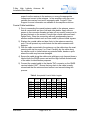
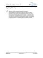
C-Nav High Latitude Antenna Installation/User Manual Kit C-Nav High Latitude Antenna Kit Installation/ User Manual Revision 4 Revision Date: July 25, 2013 C-Nav Solutions 730 E. Kaliste Saloom Road Lafayette, LA 70508 U.S.A. www.cnav.com Revision 4 Page 1 of 18 7/25/2013 C-Nav High Latitude Antenna Installation/User Manual Kit Release Notice This is the July 2013 release of the C-Nav High Latitude Antenna Kit Installation/ User Manual. Revision History 4 7/25/2013 Added Antenna Certification J. Hauschildt G. Herbert R. Morton 3 4/10/2013 Changed Operating Temperature J. Hauschildt G. Herbert R. Morton 2 3/7/2013 Correct Part #’s on line cords J. Hauschildt G. Herbert R. Morton 1 3/4/2013 Initial Release J. Hauschildt G. Herbert R. Morton 0 2/18/2013 Internal Release for Review J. Hauschildt G. Herbert R. Morton Revision Date Description Author Technical Manager Trademarks The C-Nav logo is a trademark of C & C Technologies, Inc. C-Nav and C-NaviGator III are trademarks of C & C Technologies, Inc. Microsoft, MS-DOS, Windows, Windows NT, Windows XP, Windows Vista, and Windows 7 are trademarks of Microsoft Corporation. All other brand names are trademarks of their respective holders. FCC Notice This device complies with Part 15 Subpart B Class B of the FCC Rules. Operation is subject to the following two conditions: 1. This device may not cause harmful interference, and 2. This device must accept any interference received, including interference that may cause undesired operation. The GNSS sensor has been tested in accordance with FCC regulations for electromagnetic interference. This does not guarantee non-interference with other equipment. Additionally, the GNSS sensor may be adversely affected by nearby sources of electromagnetic radiation. Revision 4 Page 2 of 18 7/25/2013 C-Nav High Latitude Antenna Installation/User Manual Kit Disclaimer of Warranty EXCEPT AS INDICATED IN “LIMITED WARRANTY” HEREIN, C & C TECHNOLOGIES, SOFTWARE, FIRMWARE AND DOCUMENTATION ARE PROVIDED “AS IS” AND WITHOUT EXPRESSED OR LIMITED WARRANTY OF ANY KIND BY EITHER C & C TECHNOLOGIES, INC., OR ANYONE WHO HAS BEEN INVOLVED IN ITS CREATION, PRODUCTION, OR DISTRIBUTION INCLUDING BUT NOT LIMITED TO THE IMPLIED WARRANTIES OF MERCHANTABILITY AND FITNESS FOR A PARTICULAR PURPOSE. THE ENTIRE RISK, AS TO THE QUALITY AND PERFORMANCE OF THE C & C TECHNOLOGIES HARDWARE, SOFTWARE, FIRMWARE AND DOCUMENTATION, IS WITH YOU. SOME STATES DO NOT ALLOW THE EXCLUSION OF IMPLIED WARRANTIES, SO THE ABOVE EXCLUSION MAY NOT APPLY TO YOU. Limitation of Liability IN NO EVENT WILL C & C TECHNOLOGIES, INC., OR ANY PERSON INVOLVED IN THE CREATION, PRODUCTION, OR DISTRIBUTION OF THE C & C TECHNOLOGIES SOFTWARE, HARDWARE, FIRMWARE AND DOCUMENTATION BE LIABLE TO YOU ON ACCOUNT OF ANY CLAIM FOR ANY DAMAGES, INCLUDING ANY LOST PROFITS, LOST SAVINGS, OR OTHER SPECIAL, INCIDENTAL, CONSEQUENTIAL, OR EXEMPLARY DAMAGES, INCLUDING BUT NOT LIMITED TO ANY DAMAGES ASSESSED AGAINST OR PAID BY YOU TO ANY THIRD PARTY, RISING OUT OF THE USE, LIABILITY TO USE, QUALITY OR PERFORMANCE OF SUCH C & C TECHNOLOGIES’ SOFTWARE, HARDWARE, AND DOCUMENTATION, EVEN IF C & C TECHNOLOGIES, INC., OR ANY SUCH PERSON OR ENTITY HAS BEEN ADVISED OF THE POSSIBILITY OF DAMAGES, OR FOR ANY CLAIM BY ANY OTHER PARTY. SOME STATES DO NOT ALLOW THE LIMITATION OR EXCLUSION OF LIABILITY FOR INCIDENTAL OR CONSEQUENTIAL DAMAGES SO, THE ABOVE LIMITATIONS MAY NOT APPLY TO YOU. Use of this Document This User Guide is intended to be used by someone familiar with the concepts of GNSS Sensor hardware installation and rack mounted equipment in a marine environment. It is intended as a quick-reference only; complete installation, operation and configuration information for system components are available via the user guides listed below in Related Documents. Revisions to this User Guide can be obtained on our website (www.cnav.com) or by contacting C-Nav Support: [email protected]. Revision 4 Page 3 of 18 7/25/2013 C-Nav High Latitude Antenna Installation/User Manual Kit Table of Contents Use of this Document ........................................................................................ 3 Table of Contents.................................................................................................. 4 Manual Organization ......................................................................................... 5 Appendix A- Antenna Location Tips ...................................................................... 5 Conventions ...................................................................................................... 5 Section 1 – Overview ............................................................................................ 6 Introduction ....................................................................................................... 6 Supplied Equipment .......................................................................................... 6 Section 2 – Installation .......................................................................................... 8 Part A: Bias Tee and Power Supply Installation ................................................ 8 Part B: High Latitude Antenna Installation ......................................................... 9 Power up and Test .......................................................................................... 10 Appendix A- Antenna Location Tips .................................................................... 11 Antenna Location Tips ..................................................................................... 11 Appendix B- Cable Installation and Routing Tips ................................................ 13 Coaxial Cable Installation and Routing Tips .................................................... 13 Cable Route ................................................................................................. 13 Coaxial Cable Installation ............................................................................ 14 Lightning Protection......................................................................................... 15 Appendix C- Technical Specifications AD493-2 .................................................. 16 Technical Specifications AD493-2 ................................................................... 16 Appendix D- Certification .................................................................................... 18 List of Figures Figure 1: C-Nav High Latitude Antenna Kit Basic Diagram .................................. 7 Figure 2: Cable connections to the AD493-2 ....................................................... 9 Figure 3: Certificate of Conformity ..................................................................... 18 List Of Tables Table 1: High Latitude Antenna Kit (CNVAD493HL) - Supplied Equipment ......... 6 Table 2: Acceptable Coaxial Cable Lengths ....................................................... 14 Revision 4 Page 4 of 18 7/25/2013 C-Nav High Latitude Antenna Installation/User Manual Kit Manual Organization This section describes how the manual is laid out. It gives one or two sentence descriptions about each major section. Section 1 – Overview (Page 6) gives a brief overview of the purpose of this document. Section 2 – Installation (Page 8) gives the full installation guidelines of the High Latitude Antenna. Appendix A- Antenna Location Tips (Page 11) gives tips on how to find the proper location for the High Latitude Antenna. Appendix B- Cable Installation and Routing Tips (Page13) gives tips on how to install the cable and its proper routing. Appendix C- Technical Specifications AD493-2 (Page16) gives electrical and mechanical specifications of the antenna Appendix D- Certification (Page18) is the Model Declaration of Conformity for the antenna. Conventions Arial font is used for plain text in this document. Arial italic font is used for settings names. Arial Blue font is used for cross-references. Arial Blue Underline font is used for hyperlinks. This symbol is used for warnings in which failure to take heed may cause severe injury or death. This symbol is used to caution the user that the improper installation and use of this product may damage this product and/or other devices connected to it. Important notes are displayed in shaded text boxes Please note: Such note box displays important information which should not be ignored. Revision 4 Page 5 of 18 7/25/2013 C-Nav High Latitude Antenna Installation/User Manual Kit Section 1 – Overview Introduction The C-Nav High Latitude Antenna Kit (P/N CNVAD493HL) is used to improve the quality of the L Band correction signals for those users who are located in high latitude areas where L Band coverage is marginal (ideal above latitudes >60°). This manual outlines the installation of the High Latitude Antenna Kit. This kit includes, along with this manual, a high latitude antenna (with mounting bracket), a Bias Tee (to provide power to the antennas), a one meter and three meters coax cables (preassembled with TNC connectors) and a power supply with various line cords. Table 1 lists the supplied equipment that comes with the CNav High Latitude Antenna Kit (CNVAD493HL). Figure 1 shows a basic diagram of the High Latitude Antenna Kit with its relation to the C-Nav3050 DGNSS antenna and receiver. Supplied Equipment Table 1: C-Nav High Latitude Antenna Kit (CNVAD493HL) - Supplied Equipment 1 2 3 4 5 6 7 8 9 1 ea. Antenna, Low Elevation. L band TNC (P/N ALIAD493-2-TNC) 1 ea. Power Supply, 12VDC, 1.25A (P/N ASTSPU15B-105) 1 ea. GPS Bias Tee, Waterproof (P/N GPSBT1-W-PM/5-TF-S) 1 ea. Cord, Power, IEC320-C7 (US) (P/N 4250011-110) 1 ea. Cord, Power, IEC320-C7 (EURO) (P/N 4250012-220) 1 ea. Cord, Power, IEC320-C7 (UK) (P/N 4250013-240) 1 ea. 1 meter of LMR-400 coaxial cable terminated with two TNC Male connectors 1 ea. 3 meters of LMR-400 coaxial cable terminated with two TNC Male connectors 1 ea. High Latitude Installation/ User’s manual (P/N CNVAD493HL-MANUAL) Revision 4 Page 6 of 18 7/25/2013 C-Nav High Latitude Antenna Installation/User Manual Kit GNSS Antenna ALIAD493-2-TNC High Latitude Antenna Coax Cable (Length Varies) 3 Meters (9.84 ft) LMR-400 Coaxial cable, terminated with 2 TNC (M) Crimp connectors) FROM ANTENNAS GPSBT1-W-PM/5-TF-S Bias Tee With Power Cord Choices: 4250011-110 IEC320-C7 (US) 4250012-220 IEC320-C7 (EURO) 4250013-240 IEC320-C7 (UK) 12VDC Output AC DC Positive (Printed) A (+) DC Negative (Unprinted/ribbed) B (-) ASTSPU15B-105 Power Supply 90-264VAC Input TO RECEIVER 1 Meter (3.28 ft) LMR-400 Coaxial cable, terminated with 2 TNC (M) Crimp connectors) C-Nav3050 Figure 1: C-Nav High Latitude Antenna Kit Basic Diagram Revision 4 Page 7 of 18 7/25/2013 C-Nav High Latitude Antenna Installation/User Manual Kit Section 2 – Installation This section provides guidance on hardware installation for optimum performance. Prior to commencing any installation, discuss proposed mounting locations/methods and cable routes with those involved to ensure all parties are aware of the work to be done and the risks involved. Always wear appropriate protective equipment, including a certified fall arrestor harness and hardhat when working at heights to prevent injury to personnel, or death. Prior to commencing any work on the mast, ensure that all radar systems are switched off and isolated. Consider the location and proposed cable routes prior to installing the C-Nav High Latitude Antenna Kit. Depending on the situation/location, it may be practical to connect and run data, power and antenna cables prior to mounting. The installation steps will be broken down into two parts: Part A: Bias Tee and power supply installation. Part B: High Latitude antenna installation. Part A: Bias Tee and Power Supply Installation Follow these steps for correct installation: 1. Power off the C-Nav3050 before installing. 2. Determine a good location for installing the Bias Tee and Power Supply. If the existing C-Nav3050 is mounted on a shelf in an equipment rack, then the Bias Tee and Power Supply should be mounted there as well. 3. Remove the bag containing the Bias Tee and Power Supply from the box containing the High Latitude Antenna Kit packaging; along with the one meter length of LMR-400 with terminate TNC connectors. 4. Disconnect the existing coax from the antenna (“ANT”) port from the back of the C-Nav3050; reconnect to the “IN” port on the Bias Tee. 5. Connect the one meter length of LMR-400 coax from the “OUT” port of the Bias Tee to the “ANT” port on the C-Nav3050. Revision 4 Page 8 of 18 7/25/2013 C-Nav High Latitude Antenna Installation/User Manual Kit Part B: High Latitude Antenna Installation Please Read Appendix A (Antenna location tips) and Appendix B (Coaxial cable installation and routing tips) prior to installing the AD493-2 High Latitude Antenna. 1. Once the antenna location has been determined based on the aforementioned criteria (Appendix A), mount the AD493-2 High Latitude Antenna, using the supplied mounting kit to a stanchion (Minimum diameter of stanchion: 1 1/8” (28.6 mm); Maximum diameter of stanchion: 2 1/8” (54 mm)) located no more than three meters away from the GNSS antenna. 2. Disconnect the coax cable from the GNSS antenna and connect it to the “Receiver” port of the AD493-2 antenna. (See Figure 2) 3. Using the three meter length of LMR-400 coax (With terminated TNC Male connectors) provided, connect from the “L1/L2 Antenna IP” port to the antenna connector on the GNSS antenna. (Also See Figure 2) 4. Use a level to ensure that the antenna is mounted vertically. 5. Weatherproof the antenna connectors and properly secure the coax cables. Figure 2: Cable connections to the AD493-2 Revision 4 Page 9 of 18 7/25/2013 C-Nav High Latitude Antenna Installation/User Manual Kit Power up and Test 1. If it has not been done, connect the ASTSPU15B-105 Power Supply to the Bias Tee. 2. Use the appropriate power cord and connect the “shotgun” side to the ASTSPU15B-105 Power Supply. Plug the other end of the power cord into the appropriate outlet. Check to see if the LED on the Power Supply is lit. 3. Power up the C-Nav3050. 4. Once the C-Nav3050 has been powered up, determine that it is operating properly by viewing the LED’s on the receiver indicator panel. 5. The C-Nav3050 may also be connected to either a PC utility, such as C-Setup or C-Monitor. The C-Nav3050 may also be connected to a CNaviGator. For more information, contact C-Nav Support. Revision 4 Page 10 of 18 7/25/2013 C-Nav High Latitude Antenna Installation/User Manual Kit Appendix A- Antenna Location Tips Antenna Location Tips 1) Locate the antenna where it has a clear view of the sky, to an elevation angle of -5º (below the horizon- to compensate with the vessel rolling), if possible. 2) Avoid placing the antenna where more than 90º azimuth of the sky is obstructed. When more than 90º of azimuth is shaded, it is often still possible for the receiver to navigate, however, poor satellite geometry (due to satellite shading) will provide poor positioning results. Even 10º of shading can have a negative effect on performance, though this generally is not the case. 3) Avoid placing the antenna on or near metal or other electrically reflective surfaces. 4) Do not paint the antenna enclosure with a metallic-based paint. 5) Secure the antenna to the mast firmly to avoid wind and vibration which can affect the performance of the High Latitude Antenna system. 6) Avoid placing the antenna near electrical motors (elevator, air conditioner, compressor, etc.) or other sources of of interference such as radar systems, satcom domes, HF antennas or whip antennas. 7) Do not place the antenna too close to other active antennas. The minimum acceptable separation between antennas is 1m (39 in), which provides 5.9dB of isolation. 8) Active antennas (those with LNA’s or amplifiers) create an electrical field around the antenna. These radiated emissions can interfere with other nearby antennas. Multiple GNSS antennas in close proximity to each other can create multipath and oscillations between the antennas. These add to position error or the inability to process the satellite signals. 9) Most antenna’s have better gain when the satellite is high in elevation. Expect tracking performance to fade as the satellite lowers in elevation. It is not unusual to see 10dB difference in antenna gain (which translates into signal strength) throughout the entire elevation tracking path. 10) Use satellite prediction software with a recent satellite almanac to assess the impact on satellite visibility at your location. An L-band Communication Satellite Locator tool is available on C-Nav’s website and Product CD to aid in determining potential obstructions to the CNav Signal: www.cnav.com/calculator Revision 4 Page 11 of 18 7/25/2013 C-Nav High Latitude Antenna Installation/User Manual Kit 11) A clear line of sight between the antenna and the local INMARSAT satellite is required to track the C-Nav Subscription Service signal. INMARSAT satellites are geo-synchronized 35,786kms (22,300 miles) above the Equator. Revision 4 Page 12 of 18 7/25/2013 C-Nav High Latitude Antenna Installation/User Manual Kit Appendix B- Cable Installation and Routing Tips Coaxial Cable Installation and Routing Tips Proper installation of coaxial cables is important to ensure successful communication between the antenna and the GNSS sensor. The connector used on the C-Nav3050 is a TNC female, labeled ANT on the rear panel of the sensor. The GNSS antenna connector, at the receiver, provides +5V 0.5V at 100mA. Do not disconnect the antenna when the GNSS unit is powered on. Cable Route 1) When choosing a cable route for coaxial cable, consider the following: 2) Avoid running coaxial cable across, or parallel too power cables and high power RF cables. 3) Ensure that the cable route is free of sharp edges or places where the cable could become pinched, kinked, sliced or damaged in any way. 4) Determine the manufacturer’s specifications for the coaxial cable in use. This should include: impedance, diameter, attenuation in dB/100ft and dB/100m at 1.575GHz, velocity of propagation and the minimum bend radius of the cable. 5) Ensure the cable does not exceed the recommended minimum bend radius suggested by the manufacturer. 6) Ensure there is sufficient space at the cable entry point to the bulkhead as to not damage the connector during installation. 7) Measure the length of the cable route and refer to Table 2 for acceptable cable lengths in relation to attenuation loss at the frequencies in use. The cable length between the antenna and CNav3050 should not exceed 7dB loss at 1.575GHz for optimum performance, though the system may tolerate up to 10dB of cable loss with minimal performance. Lower elevation satellite tracking suffers the most with more than 7dB insertion loss. 8) In-line amplifiers suitable for all GNSS frequencies may be used to increase the length of the antenna cable, but care should be exercised that tracking performance is not degraded due to multiple connections, noise from the amplifier, and possible ingress of moisture and dust to the in-line amplifier. In-line amplifier or splitter devices must pass DC Revision 4 Page 13 of 18 7/25/2013 C-Nav High Latitude Antenna Installation/User Manual Kit power from the receiver to the antenna, or source the appropriate voltage and current to the antenna. In-line amplifiers may also oversaturate the receiver front-end if improperly used. Contact C-Nav Support for more information on available in-line amplifier solutions. Coaxial Cable Installation 1) Prior to connecting the coaxial antenna cable to the antenna, ensure that all connections are free of dirt and other debris. Apply silicone grease to the connector threads and wipe off any excess, ensure not to get any lubricant on the contact. Connect the coaxial cable and handtighten firmly. Wrap the connection with self-amalgamating tape or another weather sealant such as Coax-seal® to prevent water ingress. 2) Slacken the coaxial cable and tape firmly to the antenna-mounting pole. This will prevent any undue strain on the cable connector and antenna. 3) With the cable connected to the antenna, run the cable down the mast, securing with zip ties every 2 or 3 feet. Carefully lay the cable along the chosen route to further detect any potential kinks, bends or spots where the cable may become damaged. 4) Secure the cable along the cable route with tape or zip ties and place a label at both the GNSS sensor end and the High Latitude Antenna end of the cable for identification purposes. 5) Connect the coaxial cable to the female TNC connector on the GNSS receiver labeled “ANT”. Ensure that any slack in the cable is neatly stowed and that the minimum bend radius is not exceed during this process. Table 2: Acceptable Coaxial Cable Lengths Cable Type Revision 4 Atten. (dB) per 100 Ft. Cable Length in Feet Loss in dB Atten. (dB) per 100 m Cable Length in Meters Loss in dB RG-58C 19.605 36.00 7.06 64.32 11.00 7.08 RG-142 16.494 43.00 7.09 54.12 13.00 7.04 RG-213 9.564 74.00 7.08 31.38 22.50 7.06 RG-223 17.224 41.00 7.06 56.51 12.50 7.06 LMR600 3.407 207.00 7.05 11.18 63.00 7.04 LMR400 5.262 133.00 7.00 17.26 41.00 7.08 LMR240 10.127 70.00 7.09 33.23 21.00 6.98 LMR195 14.902 47.00 7.00 48.89 14.00 6.85 Page 14 of 18 7/25/2013 C-Nav High Latitude Antenna Installation/User Manual Kit Lightning Protection Where the GNSS antenna is exposed to sources of electromagnetic discharge such as lightning, install a properly grounded in-line electrical surge suppressor between the GNSS receiver and antenna. Install protective devices in compliance with local regulatory codes and practices. Protective devices must pass DC power from the receiver to the antenna. Contact C-Nav Support for more information on available lightning protection solutions. Revision 4 Page 15 of 18 7/25/2013 C-Nav High Latitude Antenna Installation/User Manual Kit Appendix C- Technical Specifications AD493-2 Technical Specifications AD493-2 Electrical Specifications Antenna type: Quadrifilar Helix antenna Antenna pass-bands L-Band: 1525 – 1558 MHz (AD493 DGPS Operation) Through pass-bands GPS/GLONASS/L1: GPS L2/L5 / GLONASS L2: 1565 – 1615 MHz 1164 – 1254 MHz LNA LNA Gain: Total Noise Figure (NF) with pre-LNA band-pass filter: 39 dB (typical) 2 dB Connectors External antenna: GNSS receiver: Nominal impedance (Z): TNC-f TNC-f 50 ohms Power requirements Input voltage: Power consumption: +5V - +20V DC, +5V - +12V DC Nominal 50mA Revision 4 Page 16 of 18 7/25/2013 C-Nav High Latitude Antenna Installation/User Manual Kit Mechanical Specifications Material Hard anodized and dichromate and nickel acetate sealed Aluminum with GRP pressure molded radome rated to IP67 Dimensions: Ø225mm x 226mm (8.858” to 8.898”) Weight: 4.9 Kg (10.803 Lbs.) Environmental Operating temperature: Storage temperature: -40°C to +70°C (-40°F to 158°F) -40°C to +85°C (-40°F to 185°F) Certification: See Appendix D Revision 4 Page 17 of 18 7/25/2013 C-Nav High Latitude Antenna Installation/User Manual Kit Appendix D- Certification Figure 3: Certificate of Conformity Revision 4 Page 18 of 18 7/25/2013