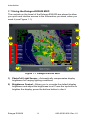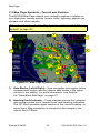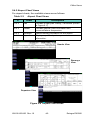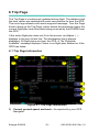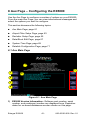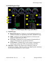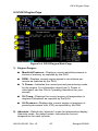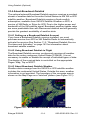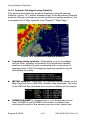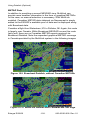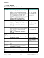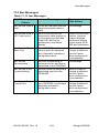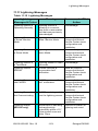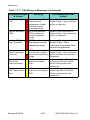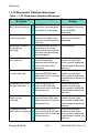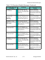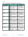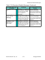
1
Piper PA28, PA32, PA44
Warrior III, Archer III, Arrow, Seminole,
6X, 6XT, Saratoga II HP, Saratoga II TC
Multi-Function Display
Pilot’s Guide
600-00105-000 Rev: 10
Document Revision History
Date
Revision
Description
Dec. 16, 2003
00
Released per ECO 03-289
Feb. 17, 2004
01
Updated per ECO 04-24
Sept. 7, 2004
02
Updated per ECO 04-168
Mar. 29, 2005
03
Updated per ECO 05-058
April 22, 2005
04
Updated per ECO 05-074
Sept. 14, 2005
05
Updated per ECO 05-157
Mar. 17, 2006
06
Updated per ECO 06-043
May 3, 2006
07
Updated per ECO 06-084
Aug. 8, 2007
08
Updated per ECO-07-261
Oct. 1, 2007
09
Updated per ECO-07-354
Apr. 25, 2008
10
Updated per ECO-08-051
System Configuration
When contacting your dealer or Avidyne technical support, and when
logging onto MyAvidyne.com for the first time, please have your
EX5000 serial number and Subscriber Communicator serial number
available:
EX5000 S/N: ________________________________
Datalink Subscriber Communicator S/N: ___________________
This document is applicable to Software Part Number 530-00195-002.
All materials copyrighted including images that represent this software
Copyright 2008 Avidyne Corporation. All rights reserved.
600-00105-000 Rev: 10
-i-
Entegra EX5000
About this Guide
This guide assumes that all available sensors and software options
have been installed in your airplane. The page layouts and button
descriptions in this guide may differ slightly from what you observe on
your EX5000. If your system is configured with a partial set of the
available sensors, then some views may differ from this guide.
Note: All images contained within this document, including screenshots and
other displays, are for reference use only and are subject to change. The
images contained herein may differ slightly from your actual equipment or
display.
Entegra EX5000
-ii-
600-00105-000 Rev: 10
Notes and Warnings
Notes and warnings provide guidance for the use of the EX5000.
Avidyne strongly suggests that you pay close attention to notes and
warnings for your own safety.
For example:
Note: Notes provide useful information about how to use the EX5000.
!
Warnings are prefaced with exclamation points and denote
information that can prevent serious injury or death on the
part of the user.
The instructions and warnings in this manual are not intended to
replace the instructions and warnings for other equipment on your
aircraft. It is critical that you as the pilot in command have a complete
understanding of the warnings, operating instructions, and limitations
for all equipment installed on your aircraft.
!
This manual assumes that the reader is an appropriately
licensed pilot. Avidyne strongly recommends that you use the
EX5000 only under VFR conditions until you are very familiar
with the EX5000.
If you have questions, please contact Avidyne at 800-2843963 (800-AVIDYNE) or 1-781-402-7400 before operating
with the EX5000 under IFR conditions.
!
Before conducting flight operations, be sure to verify that time
and date settings on the System Time Setup Page are correct
and in GMT (UTC). It is critical that the time be set to GMT to
provide accurate display of Datalink weather. See Section
8.1, "Aux Main Page" on page 61 for more information.
!
When using the EX5000, be sure to cross-check the data
displayed against other data sources for accuracy including
other flight deck instruments and charts.
600-00105-000 Rev: 10
-iii-
Entegra EX5000
!
The displayed terrain and obstacle indicators are only
advisory. Do not rely on the EX5000 as the sole source of
obstacle and terrain avoidance information. Always refer to
current aeronautical charts for appropriate terrain and
obstacle information.
!
The EX5000 is not intended to replace your navigation charts
or primary navigation aids. Use the EX5000 as a supplement
to other navigation sources, to enhance your overall
situational awareness. Do not rely on the navigation data in
your EX5000 as your sole reference for navigation.
!
While a properly updated database contains the latest official
information available, the manufacturers will not be held
responsible for any inaccuracy or omissions therein. Never
use the terrain displayed on the EX5000 as the only reference
for terrain avoidance.
!
The transmission of datalink weather information means there
is some delay from real time until the weather information is
displayed on the EX5000. Therefore, use datalink weather
information only for strategic route planning. Avoid severe
weather areas with a safe margin of distance. Do not use the
EX5000 to penetrate severe weather, thunderstorms, cells or
lines of cells.
!
By using Broadcast datalink, you can access weather
information made available from sources external to Avidyne
Corporation. Avidyne does not control, edit or review the
content of such information and is not responsible for such
information or the actions or conduct of any company that
provides sources of weather data through the Broadcast
datalink. Therefore, ALL WEATHER DATA ARE PROVIDED
AS-IS and neither Avidyne nor its suppliers, subcontractors,
or developers (collectively called “Suppliers”) are responsible
for: 1) the accuracy, completeness, timeliness, reliability,
content, or availability of the weather data or any other
datalink information accessed; 2) loss or damage to your
records or data; or 3) your use of, or results achieved from,
the weather data or any other information accessed.
Entegra EX5000
-iv-
600-00105-000 Rev: 10
Notice regarding NOTAM information
NOTAM information is subject to constant change and it is
extremely important that all pilots check with Flight Service for
applicable NOTAMs prior to EVERY flight. Call 1-800WXBRIEF (992-7433) for the latest information. Outside the
United States, call your local flight service or other official flight
advisory service.
The NOTAM information provided by the EX5000 is for
planning purposes only. Always consult official NOTAMS for
the latest restrictions.
!
Avidyne does not provide a complete list of NOTAMS. Local
NOTAMS, most laser light NOTAMS, and any NOTAMS other
than restricted airspace are not listed.
By using the Avidyne Services you are able to access
information made available from a variety of sources. Avidyne
does not control, edit or review the content of such information
and is not responsible for such information or the actions or
conduct of any company that provides sources of weather
data procured by Avidyne. Therefore, although Avidyne uses
diligent efforts to provide Services of high quality, ALL
SERVICES AND WEATHER DATA ARE PROVIDED AS-IS
and neither Avidyne nor its suppliers (including ORBCOMM
and its affiliates), subcontractors, information sources or
developers (collectively called “Suppliers”) are responsible for:
1) the accuracy, completeness, timeliness, reliability, content,
or availability of the Services or any information accessed; 2)
loss or damage to your records or data; or 3) your use of, or
results achieved from, the Services or any information
accessed.
600-00105-000 Rev: 10
-v-
Entegra EX5000
This page intentionally left blank.
Entegra EX5000
-vi-
600-00105-000 Rev: 10
Contents
1 Introduction .............................................................. 1
Using the Entegra EX5000 MFD ................................................. 2
Power Up..................................................................................... 4
2 Map Page .................................................................. 7
Map Page—Controls ................................................................... 8
Map Page Symbols—Terrain and Position................................ 12
Map Page Symbols—Runways and Flight Plan ........................ 16
Map Orientation Control ............................................................ 18
Errors Displayed on the Map Page............................................ 19
Loss of GPS Input ............................................................... 19
Loss of Heading Input ......................................................... 19
3 Traffic Mode and the Traffic Page ....................... 21
The Dedicated Traffic Page....................................................... 21
Traffic Symbols.......................................................................... 24
TIS Sensor Status ..................................................................... 25
4 TAWS Page (Optional)........................................... 27
TAWS Information ..................................................................... 27
TAWS Operation ....................................................................... 30
TAWS Reference....................................................................... 32
Auto-Range ......................................................................... 32
Simultaneous Alerts ............................................................ 32
Terrain Messages and Error Indications ............................. 32
5 CMax Chart Pages (Optional) .............................. 35
About CMax............................................................................... 35
About Geo-Referenced Charts .................................................. 37
CMax Chart Page ...................................................................... 37
CMax Views............................................................................... 41
Procedure Chart Views ....................................................... 41
Airport Chart Views ............................................................. 43
CMax Selection Page ................................................................ 45
Selecting an Airport ................................................................... 47
Chart NOTAMs Page .......................................................... 49
6 Trip Page................................................................. 51
Trip Page Information ................................................................ 51
7 Nearest Page (NRST) ............................................. 57
Nearest Page............................................................................. 57
600-00105-000 Rev: 10
-vii-
Entegra EX5000
Contents
Airport Info Page ........................................................................59
8 Aux Page – Configuring the EX5000 .................... 61
Aux Main Page...........................................................................61
Airport Filter Setup Page............................................................63
Declutter Setup Page .................................................................65
Data Block Edit Page .................................................................67
System Time Page.....................................................................69
Datalink Configuration Page ......................................................71
9 Engine Pages.......................................................... 75
Engine Page Overview ..............................................................76
PA28 Engine Page.....................................................................79
PA28 Initial Usable Fuel Page ...................................................83
PA28 Lean Assist.......................................................................84
Leaning for Best Economy ..................................................84
Leaning for Best Power .......................................................85
PA28 Data Blocks on Map Page .........................................86
Lean Data Block States .......................................................86
PA32 Engine Page.....................................................................87
PA32 Initial Usable Fuel Page ...................................................91
PA32 Non-Turbo Lean Assist ....................................................92
PA32 Turbo Lean Assist ............................................................94
PA32 Data Blocks on Map Page .........................................95
Lean Data Block States .......................................................96
PA44 Engine Page.....................................................................97
PA44 Initial Usable Fuel Page .................................................101
PA44 Lean Assist.....................................................................102
Leaning for Best Economy ................................................102
Leaning for Best Power .....................................................103
PA44 Data Blocks on Map Page .......................................104
Lean Data Block States .....................................................104
EMax Total Engine Management.............................................105
Engine Sensor Status Box.................................................105
10 Using Datalink (Optional) .................................... 107
About Datalink Services ...........................................................108
Overview of Datalink Weather .................................................109
About Narrowcast Datalink ......................................................111
Setting up a Narrowcast Datalink Account ........................111
Flight Tracking ...................................................................111
Using Narrowcast Datalink in Flight...................................112
Loss of Satellite Coverage.................................................112
Entegra EX5000
-viii-
600-00105-000 Rev: 10
About Broadcast Datalink ........................................................ 114
Setting up a Broadcast Datalink Account.......................... 114
Using Broadcast Datalink in Flight .................................... 114
About Broadcast Datalink Weather ................................... 114
Map Page with Datalink Weather ............................................ 116
Symbols Displayed using Datalink .................................... 118
Using Datalink without a Traffic Sensor ............................ 120
Trip Page with Datalink Weather ............................................. 121
Nearest Page with Datalink Weather....................................... 122
About MultiLink (Optional) ....................................................... 123
Using MultiLink.................................................................. 123
Setting up a MultiLink Account.......................................... 123
Using MultiLink Features................................................... 124
Viewing MultiLink Data...................................................... 124
Optimizing your MultiLink Setup........................................ 127
MultiLink Usage Guidelines............................................... 128
Datalink Messaging (Optional) ................................................ 129
Messaging Knobs and Buttons ......................................... 130
Using Datalink Messaging................................................. 132
11 Reference.............................................................. 135
Updating Your Databases ....................................................... 136
Loading NavData (the Navigation Database).................... 137
Loading CMax Chart Data................................................. 139
Downloading EMax Data................................................... 141
Broadcast Datalink Service Purchase and Activation.............. 143
Setting Up a Broadcast Datalink Account ......................... 143
Setting up a WSI Broadcast Datalink Account .................. 143
Activating WSI Satellite Weather ...................................... 144
Setting up a SIRIUS Audio Account.................................. 145
Activating SIRIUS Audio ................................................... 145
Creating Your XM WX Account......................................... 145
Activating Your Account .................................................... 146
Cleaning the EX5000 Screen .................................................. 147
Sensor Status Block Symbols ................................................ 148
Map Symbols........................................................................... 150
Line Styles ............................................................................... 152
Data Blocks .......................................................................... 154
TAWS Messages..................................................................... 157
Nav Messages......................................................................... 159
Traffic Messages ..................................................................... 161
Lightning Messages................................................................. 163
600-00105-000 Rev: 10
-ix-
Entegra EX5000
Contents
Engine Messages ....................................................................166
PFD Messages ........................................................................169
Narrowcast Datalink Messages ...............................................170
Broadcast Datalink Messages ................................................172
Avionics Abbreviations .............................................................176
12 Using the EX5000 Outside the US ...................... 179
Features Available in the US Only ...........................................179
Features Specific to International Flight...................................180
Entegra EX5000
-x-
600-00105-000 Rev: 10
List of Figures
Figure 1.1 Entegra EX5000 MFD ...................................................... 2
Figure 1.2 Entegra EX5000 Initialization Page .................................. 4
Figure 2.1 Map Page Controls ........................................................... 8
Figure 2.2 Map Page Symbols–Terrain and Position ...................... 12
Figure 2.3 Map Page Symbols—Runways and Flight Plan ............. 16
Figure 3.1 Map Page—Traffic Mode ................................................ 22
Figure 4.1 TAWS Information .......................................................... 27
Figure 4.2 Terrain Caution Condition ............................................... 30
Figure 4.3 Terrain Warning Condition .............................................. 31
Figure 5.1 CMax Chart Page (Airport) ............................................. 38
Figure 5.2 CMax Chart Page (Procedure) ....................................... 40
Figure 5.3 Procedure Chart views ................................................... 42
Figure 5.4 Airport Chart Views ......................................................... 43
Figure 5.5 Airport Departure Chart (Night View) .............................. 44
Figure 5.6 CMax Selection Page ..................................................... 45
Figure 5.7 Airport Selection Page .................................................... 47
Figure 5.8 Chart NOTAMs Page ...................................................... 49
Figure 6.1 Trip Page Information ..................................................... 51
Figure 7.1 Nearest Page .................................................................. 57
Figure 7.2 Airport Information Page ................................................. 59
Figure 8.1 Aux Main Page ............................................................... 61
Figure 8.2 Airport Filter Setup Page ................................................ 63
Figure 8.3 Declutter Setup Page ..................................................... 65
Figure 8.4 Data Block Edit Page ...................................................... 67
Figure 8.5 System Time Page ......................................................... 69
Figure 8.6 Datalink Configuration Page ........................................... 71
Figure 9.1 PA28 Engine Main Page (with EMax)............................. 79
Figure 9.2 PA28 Initial Usable Fuel Page ........................................ 83
Figure 9.3 Engine Information—Map Page...................................... 86
Figure 9.4 PA32 Engine Main Page................................................. 87
Figure 9.5 PA32 Initial Usable Fuel Page ........................................ 91
Figure 9.6 Engine Information—Map Page...................................... 95
Figure 9.7 PA44 Engine Main Page (with EMax)............................. 97
Figure 9.8 PA44 Initial Usable Fuel Page ...................................... 101
Figure 9.9 PA44 Engine Information—Map Page .......................... 104
Figure 10.1 Broadcast Datalink Weather Boundaries .................... 114
Figure 10.2 Datalink Weather—Map Page .................................... 116
Figure 10.3 Broadcast Datalink Weather ....................................... 118
Figure 10.4 Datalink Weather without Traffic Sensors................... 120
600-00105-000 Rev: 10
-xi-
Entegra EX5000
List of Figures
Figure 10.5 Trip Page with Datalink Weather.................................121
Figure 10.6 Nearest Page with Broadcast Datalink........................122
Figure 10.7 Broadcast Datalink NEXRAD Coverage......................125
Figure 10.8 Narrowcast and Broadcast Datalink
NEXRAD Coverage ........................................................................125
Figure 10.9 Broadcast Datalink, without Canadian METARs .........126
Figure 10.10 MultiLink Datalink with Canadian METAR flags ........126
Figure 10.11 Example NEXRAD Coverage Area ...........................127
Figure 10.12 Datalink Messaging Knobs and Buttons....................130
Figure 10.13 Receiving a Datalink Message ..................................133
Entegra EX5000
-xii-
600-00105-000 Rev: 10
List of Tables
Table 2.1 Track Indicator Graphics ................................................. 13
Table 2.2 Obstacle .......................................................................... 18
Table 3.1 Traffic Symbols ............................................................... 24
Table 4.1 EGPWS Display Color Formats ...................................... 33
Table 5.1 Airport Procedure Views ................................................. 42
Table 5.2 Airport Chart Views ......................................................... 43
Table 10.1 Message Status Indicators.......................................... 130
Table 10.2 NOC Message Text Colors ......................................... 131
Table 11.1 Sensor Status Block Symbols ..................................... 148
Table 11.2 Broadcast Datalink Sensor Status Block (Optional).... 149
Table 11.3 Map Symbols – Airports .............................................. 150
Table 11.4 Map Symbols – Navigational Fixes ............................. 151
Table 11.5 Map Symbols – Traffic Symbols ................................. 151
Table 11.6 Map Symbols – Other ................................................. 151
Table 11.7 Airspace and Airways Lines ........................................ 152
Table 11.8 SUA and TFR Status Lines ......................................... 152
Table 11.9 AIRMET and SIGMET Boundary Lines....................... 153
Table 11.10 Data Block Information.............................................. 154
Table 11.11 Engine Instrument Data Block Information ............... 155
Table 11.12 TAWS Messages ...................................................... 157
Table 11.13 Nav Messages .......................................................... 159
Table 11.14 Traffic Messages....................................................... 161
Table 11.15 Lightning Messages .................................................. 163
Table 11.16 PA28 and PA32 Engine Messages ........................... 166
Table 11.17 PA44 Engine Messages............................................ 167
Table 11.18 PFD Messages ......................................................... 169
Table 11.19 Narrowcast Datalink Messages ................................ 170
Table 11.20 Broadcast Datalink Messages .................................. 172
Table 11.21 Avionics Abbreviations .............................................. 176
600-00105-000 Rev: 10
-xiii-
Entegra EX5000
List of Tables
This page intentionally left blank.
Entegra EX5000
-xiv-
600-00105-000 Rev: 10
1 Introduction
The Entegra EX5000 Multi-Function Display (MFD) provides a
moving map view of your flight plan, broadcast datalink weather,
lightning, traffic, navigation data, obstacles, terrain, and CMax™
approach plates with an intuitive user interface. The EX5000 offers
the following standard and optional features:
●
Engine instruments display.
●
Lightning information display from a WX-500 or an Avidyne TWX670 lightning sensor, if installed.Full ARINC-429 databus
capability, allowing the EX5000 to display curved flight paths,
procedure turns, and holding patterns from a compatible GPS
navigator.
●
Traffic information display from Avidyne TAS600 Series, L-3
Skywatch, or Garmin TIS traffic systems.
●
Terminal procedure chart display using the CMax™ function.
●
Display of weather and flight restriction information when
interfaced with an external Broadcast Datalink receiver or internal
Narrowcast Datalink transceiver.
Note: Narrowcast Datalink is not installed or available on EX5000
MFDs manufactured after Jan. 1, 2008.
●
Display of TAWS terrain information when interfaced with an
installed EGPWS system.
Note: Consult the Flight Manual Supplement (FMS) provided with the
aircraft and/or sensors prior to operation. The FMS contains information
specific to your installation and may contain operating limitations applicable
to your aircraft configuration.
Entegra EX5000
-1-
600-00105-000 Rev: 10
Introduction
1.1 Using the Entegra EX5000 MFD
The controls on the bezel of the Entegra EX5000 are placed to allow
you quick and intuitive access to the information you need, when you
need it (see Figure 1.1).
2
3
1
4
4
7
5
6
Figure 1.1 Entegra EX5000 MFD
1) PhotoCell Light Sensor—Automatically compensates display
brightness for varying lighting conditions.
2) Brightness Control—Allows you to override the default display
brightness and adjust the brightness level. Press the top button to
brighten the display; press the bottom button to dim it.
Entegra EX5000
-2-
600-00105-000 Rev: 10
Using the Entegra EX5000 MFD
3) Data Port—Provides a front panel access point for loading
database updates.
Note: When removing the rubber cap from the data port, pull the cap
gently from the top until it pops out. Make sure the cap is out of the
way (but not removed) before plugging anything into the USB port.
Do not tug on the tab at the bottom of the cap; this can cause the loss
of the protective cap.
4) Buttons—Used to select modes or change the display as
indicated. Buttons are active when a label appears on the screen
adjacent to the key.
5) Page Control Knob—The left knob provides quick access to the
main EX5000 pages, including the Map Page, Trip Page, and
Aux Page, as well as the main pages for any optional features.
The current page is highlighted in the Page Bar on the lower left
corner of screen.
6) Selection & Range Control Knob—Depending on the page you
are viewing, the right knob controls functions such as selecting
items on the page or changing the view range. The label on right
knob changes as appropriate.
7) Message Bar—The message bar keeps you informed about
critical as well as routine information from the EX5000. When
information needs to be conveyed the message bar appears next
to the bottom right button.
Note: The message bar displays one message at a time. If more than
one message is available, the message bar will display the highest
priority message first. Press the ACK button to clear the current
message and view those underneath.
600-00105-000 Rev: 10
-3-
Entegra EX5000
Introduction
1.2 Power Up
On power up, the system performs a brief hardware self-test, then
systematically initializes its functions. After the system initializes
(about a minute after power-on), the title page, with database
currency information, is displayed. Check to ensure that you do not
have any expired databases before continuing.
When the EX5000 is ready the, “Press any bezel key to continue”,
message displays.
Figure 1.2 Entegra EX5000 Initialization Page
The EX5000 Startup Page reports the valid dates for the currently
loaded CMax™ chart data and NavData. Check to ensure that you do
not have any expired databases before continuing.
For CMax data:
●
If the issue date for the next update has passed, the Startup Page
displays, “Update Available”, in white.
●
If the current date is more than a week past the issue of the next
update, the message, “Update Required”, is displayed in yellow
cautionary text.
Entegra EX5000
-4-
600-00105-000 Rev: 10
Power Up
●
If CMax is more than 10 weeks out of date, access to the charts is
revoked until new CMax data is loaded.
For NavData, the date range is displayed if the data is valid; if it is not
valid, the word, “EXPIRED”, and the expiration data are displayed in
yellow.
For more information about updating CMax and NavData, see
Section 11.1, "Updating Your Databases" on page 136.
600-00105-000 Rev: 10
-5-
Entegra EX5000
Introduction
This page intentionally left blank.
Entegra EX5000
-6-
600-00105-000 Rev: 10
2 Map Page
The Map Page displays your current flight plan overlaying a map of
the area over which you are flying. The EX5000 allows you to select
the data you want to display on the Map Page.
Turn the Select knob on the Page Bar to Map to display the Map
Page.
This section discusses the following topics:
●
Map Page—Controls, page 8
●
Map Page Symbols—Terrain and Position, page 12
●
Map Page Symbols—Runways and Flight Plan, page 16
●
Map Orientation Control, page 18
●
Errors Displayed on the Map Page, page 19
Entegra EX5000
-7-
600-00105-000 Rev: 10
Map Page
2.1 Map Page—Controls
Buttons on the left side of the bezel provide access to sensor modes
and pages. Buttons on the right side of the bezel access the mapping
functions, and control how the Map is viewed.
1
2
3
Figure 2.1 Map Page Controls
Note: For information about the Map Symbols, see Section 11.5, "Map
Symbols" on page 150.
1) Sensor Functions—Control overlay and modes of available
sensors. Buttons only display for the sensors installed in your
aircraft:
■
Traffic—Cycles through traffic sensor modes.See
Chapter 3 "Traffic Mode and the Traffic Page ,” for more
information on traffic modes.
■
Lightning—Depending on your broadcast service level,
when both Broadcast Datalink and an on-board lightning
sensor are installed, cycles through lightning sensor modes
and overlays in the following order; Strike, Cell (WX-500
Entegra EX5000
-8-
600-00105-000 Rev: 10
Map Page—Controls
only), Datalink, Display Off. When only one source of
lightning data is installed, only the appropriate modes are
available. See your lightning sensor User’s Manual for further
details.
Note: The TWX670 can accurately display lightning strikes in all
selectable ranges, including within 25 NM.
Note: (WX-500 only) The lightning sensor maps thunderstorm
activity by monitoring electrical discharge activity within a 200-mile
radius of the aircraft. However, the WX-500 does not display
lightning strikes within 25 NM.
■
Clear Strikes—Removes current lightning symbols to allow
for the refresh of lightning data when using a on-board
lightning sensor. Does not remove Datalink lightning.
■
WX Rpts—Controls the type of Datalink weather information
displayed on the map, as follows:
◆
All—Displays graphical METARs, AIRMETs, and
SIGMETs.
◆
METARS—Displays graphical METARs only.
◆
AIRMET—Displays graphical AIRMETs only.
◆
SIGMET—Displays graphical SIGMETs only.
◆
DSPLY OFF—Turns off display of all weather
information.
For more information about Datalink functions, see Section
10.5, "Map Page with Datalink Weather" on page 116.
2) Map Functions—Controls basic look of the map in terms of
orientation, number of elements, and base map.
■
View—Orients the map for either Track/Heading Up or North
Up. FORWARD and CENTER views are oriented with Track/
Heading Up. North Up orients the map to true North, with the
ownship symbol rotated to show track/heading.
■
Declutter—Controls the four levels of navigation database
detail on the Map from most to least:
➡
600-00105-000 Rev: 10
➡
-9-
➡
Entegra EX5000
Map Page
■
■
Base Map—Controls the base map layers:
◆
TERRAIN—Color-contoured terrain, bodies of water, and
political boundaries.
◆
BASE—Bodies of water and Political boundaries
◆
NONE—No base map
WX Ovly—Controls the type of weather information
displayed on the map. Pressing this button toggles the
display between:
Note: (For WSI weather) If you have an Avidyne MLB700 Sirius
receiver installed, you have a WSI weather subscription. WSI's
premium radar product is called NOWRAD, which is data derived
from the NEXRAD doppler radar system and processed by WSI.
The EX5000 and this document use the generic term NEXRAD
throughout to refer to datalink radar imagery (NEXRAD or
NOWRAD).
◆
— If Narrowcast Datalink is installed,
displays Narrowcast NEXRAD information on the map.
Narrowcast uses two-way messaging to send your flight
plan to the Avidyne Network Operations Center (NOC),
which then sends you only the data pertinent to your
flight.
Note: Narrowcast Datalink is not installed or available on
EX5000 MFDs manufactured after Jan. 1, 2008.
◆
— Displays Broadcast NEXRAD information
on the map. Storm cell icons are not displayed.
For most operations, the EX5000 displays weather data
the same way regardless of which Datalink system is in
use. Both systems provide NEXRAD data; a composite
image depicting precipitation as seen by multiple groundbased weather radar sites. The image is color-coded to
show both intensity levels and precipitation types. For
more information about Datalink, see Section
10.1, "About Datalink Services" on page 108.
◆
— The (+) plus option shows the broadcast
NEXRAD overlay with storm cell icons. This option may
Entegra EX5000
-10-
600-00105-000 Rev: 10
Map Page—Controls
not be available depending on your broadcast
subscription level.
◆
NONE — Removes all NEXRAD data from the map
display.
3) Range Control Knob — The right knob controls the map’s range
and allows you to set the scale from 1NM out to 1500NM. The
selectable ranges are, in nautical miles, 1, 2, 5, 10, 15, 20, 30,
40, 50, 75, 100, 150, 200, 300, 400, 500, 750, 1000, and 1500.
Note: The terrain base map is automatically removed and Nav database
information is fully decluttered at 750NM and higher ranges.
Note: The Map Page monitors the “health” of the sensors (traffic and
lightning) by means of a signal pulse. Map looks for a signal every three
seconds from each sensor. If it doesn’t see this signal it assumes the sensor
has failed in some way. When this happens, the following occurs on the
display:
• Sensor data is removed from the overlay display.
• The word “FAIL” displays in the sensor's status line in yellow.
• The sensor symbol changes from cyan to yellow (if the sensor was on).
What to do:
Select the Setup Page and perform Self-Test for the applicable sensor.
600-00105-000 Rev: 10
-11-
Entegra EX5000
Map Page
2.2 Map Page Symbols—Terrain and Position
The EX5000 Map Page depicts your aircraft’s position in relation to
your flight plan, nearby airports, terrain, traffic, lightning, special use
airspace and other navaids.
Note: For information about the Map Symbols, see Section 11.5, "Map
Symbols" on page 150.
2
1
1
4
3
5
8
6
9
7
Figure 2.2 Map Page Symbols–Terrain and Position
1) Data Blocks (Left & Right)—View navigation and engine (when
equipped with engine monitor) data in data blocks in the upper
corners of the display. For more information, see Section
8.4, "Data Block Edit Page" on page 67.
2) Heading/Track Indicator—Three triangles around the compass
rose provide actual track, desired track, and heading indications.
The H/T Block provides digital readout of the current heading, or
actual track. Map orientation is indicated in the triangle to the
right of the H/T Block.
Entegra EX5000
-12-
600-00105-000 Rev: 10
Map Page Symbols—Terrain and Position
Table 2.1
Track Indicator Graphics
Heading
Track
Map Orientation
Heading
Desired
Track
North Up
Track
Heading
Heading Up
Actual
Track
Track Up
3) Sensor Status Box—Displays the status of the available sensors
including radar, traffic, lightning and both 2-Way Datalink and Broadcast
Datalink. The NEXRAD (NXR) display includes the NEXRAD data age,
which is the elapsed time since the product was created by the weather
provider. See Table 11.1 Sensor Status Block Symbols on page
148 for more information on status box symbols. (Optional
Engine Instrument Sensor Status information is described in
Table 11.11 Engine Instrument Data Block Information on page
155).
Note: NEXRAD is the only Broadcast Datalink product on the EX5000 that
displays the time since the product was created by the weather provider.
Refer to the Trip page for information on all other weather products.
!
When using Datalink weather, monitor the data age so you are
aware of the time elapsed since the last weather update.
Note: Broadcast Datalink times indicated on the Trip page display the time
since the product was received by the MFD (“time since reception”). There
is an inherent time delay between the creation and reception of the
broadcast weather data.
4) Terrain Scale—Shows highest and lowest limits of terrain in
displayed area. Legend colors in between these numerics
represent terrain elevations. Blue obstacle clearance number
shows the top of the highest obstacle, when greater than the
600-00105-000 Rev: 10
-13-
Entegra EX5000
Map Page
highest displayed terrain. Terrain data is not displayed when your
aircraft’s latitude is greater than 75 degrees (north or south).
!
The displayed terrain and obstacle indicators are only
advisory. It is dangerous to rely on the EX5000 as the sole
source of obstacle and terrain avoidance information. Always
refer to current aeronautical charts for appropriate terrain and
obstacle information.
5) Special Use Airspace—The EX5000 uses several different line
styles to convey special use and class airspaces. Class B is solid
blue line, Class C is solid magenta line. Class D is dashed blue
line, MOA, Warning, and Alert areas are solid yellow lines, and
restricted and prohibited areas are solid red lines. See Table
11.7 Airspace and Airways Lines on page 152.
6) Lightning Indications—If configured with WX-500 or TWX-670
sensor, shows geographically referenced lightning strikes.
Lightning strikes from on-board sensors display for three minutes.
Lightning display depends on the selected mode, as follows:
■
Datalink Mode—If Broadcast Datalink is installed and you
have an appropriate broadcast datalink service level, shows
as color-coded lightning symbols. Datalink strikes darken in
color until they are removed after 15 minutes.
■
WX-500 or TWX-670 Strike Mode—
■
WX-500 Cell Mode—
7) Storm Cells—If storm cells are present, the EX5000 displays the
cells along with the cell’s groundspeed, in knots, and direction of
travel, as well as the cell echo tops with a label. If there is a
greater than 50% chance of hail, the cell displays with a white
background.
Entegra EX5000
-14-
600-00105-000 Rev: 10
Map Page Symbols—Terrain and Position
8) METAR Flags—For each reporting airport, when Datalink is
installed and active, a METAR flag provides a quick overview of
the weather for that station. The METAR flags are color-coded as
follows:
9) Compass Rose/Range Ring—Displays a 360-degree or 120degree compass circle or arc and also indicates current range
setting. The range number is the distance from the airplane
symbol to the compass arc.
Note: If Broadcast Datalink is installed and available, it displays satellite,
signal and serial number information for the Broadcast Datalink system.
It also displays the elapsed time since reception of the various types of
weather data. If the time since reception for any particular weather product
is greater than the limits defined by the system, a cyan alert message will
display in the message box on the Aux Main Page and in the message bar.
For example, if 91 minutes has elapsed since the last TAF data was
received, a "Broadcast TAFs > 90 min" message will display in the message
bar and in the message list on the Aux page. When these messages are
displayed, all data for that product is removed from the MFD. The Trip page
will indicate that new data for that product has not been received for greater
than X minutes, where ‘X’ is the time limit defined for each product (typically
90 minutes).
600-00105-000 Rev: 10
-15-
Entegra EX5000
Map Page
2.3 Map Page Symbols—Runways and Flight Plan
When looking at the Map Page in short range, you can see details,
such as runway diagrams, that are not available at longer ranges.
Note that your flight plan is always shown.
1
4
5
2
3
6
Figure 2.3 Map Page Symbols—Runways and Flight Plan
1) Flight Plan—Displays the active flight plan from the GPS. The
current leg displays in magenta and all remaining legs are shown
in white. When you select an approach procedure on the Garmin
430, all approach segments including holds, DME arcs,
procedure turns, etc., are shown (when connected via the ARINC
429 bus).
Note: The Garmin 400W/500W can use the parallel track. For Garmin
400W/500W software at Release 2 or earlier, if a parallel track is active,
the current non-offset leg will be displayed in white. For Garmin 400W/
500W software at Release 3 or later, if a parallel track is active, the
parallel track leg will be displayed in white.
Entegra EX5000
-16-
600-00105-000 Rev: 10
Map Page Symbols—Runways and Flight Plan
Note: The Garmin GNS 430/GNC 420 does not differentiate curved flight
path segments from straight segments when interfaced with the EX5000 via
an RS232 interface. Therefore, the EX5000 will connect the beginning and
end waypoints of a curved segment, such as a DME arc, with a straight line.
Under these circumstances, the straight line must be ignored. Approach
procedures should be flown using the GNS 430/GNC 420 navigator’s CDI
as the primary reference. Consult your avionics installation facility to
determine if your EX5000 is interfaced to the GNS 430/GNC420 via ARINC
429 or RS232.
Note: For most GPS units, the EX5000 does not display the active course
leg when you are adjusting the desired track in OBS mode. The desired
track leg will display after you finish selecting the course and exit the OBS
mode of the GPS.
2) Ownship Symbol—Shows the position of your aircraft in relation
to the moving map and the selected view.
3) Airport Runway Diagrams—Displays runway layouts of nearby
airports when looking at the map at a less than 5NM range. As
you range in, the scaled runway diagram with heading labels
shows your exact location in proximity to the field.
4) Traffic Indications—Shows traffic symbol relative to current
position and includes relative altitude (when available) with
respect to airplane symbol. See your traffic sensor User’s Manual
for further details. When available, TIS installations will show a
ground track “stinger” for each intruder, indicating the intruder’s
track as measured by ground radar. Traffic Symbols are shown in
Table 3.1 Traffic Symbols on page 24.
5) Obstacles—The EX5000’s database contains towers and other
obstacles greater than 200 feet AGL. Obstacles can be displayed
with MSL altitude label.
Note: For example, a 2000 foot tall TV tower located in Denver (elevation
5300 feet MSL) will be depicted as being at 7300 feet MSL.
600-00105-000 Rev: 10
-17-
Entegra EX5000
Map Page
Table 2.2
Obstacle
Graphic
Meaning
Height (AGL)
Single Obstacle
200’ AGL to < 1000’ AGL
Obstacles within 1NM of each other
200’ AGL to < 1000’ AGL
Single Obstacle
1000’ AGL or higher
Obstacles within 1NM of each other
1000’ AGL or higher
6) Interstate Highways—Depicted as brown lines when terrain is
selected to be shown. Interstates are labeled in white. (e.g. I-95).
Highways are removed from the terrain map when the range is
greater than 300NM.
2.4 Map Orientation Control
The Map View button allows you to control the orientation of the map
and sensor data displayed on the EX5000. EX5000 traffic and
lightning sensor symbols are positioned relative to the aircraft nose.
When the Map View is North-Up you need to pay more attention to
locate traffic outside the aircraft. Set Map View to Center or Forward
to display this data consistent with typical dedicated traffic and
lightning sensor displays.
Entegra EX5000
-18-
600-00105-000 Rev: 10
Errors Displayed on the Map Page
2.5 Errors Displayed on the Map Page
In general, the following errors are generated externally to the MFD,
but you may notice them on the Map or other pages within FlightMax.
2.5.1 Loss of GPS Input
Loss of primary GPS is annunciated in a number of ways on your
EX5000.
●
The “Nav Source not communicating” message displays.
●
The aircraft symbol is removed.
●
There is no heading information displayed (if GPS is lost, no
heading is displayed regardless of heading source).
●
The desired track icon is removed from the compass rose.
●
There is no groundspeed information displayed.
The EX5000 continues to provide Datalink weather for your flight at
its last known position. If the primary GPS fails during flight and you
have a second GPS connected to the EX5000, you may switch your
GPS input to the backup source by pressing the Nav Src button on
the Aux Page.
2.5.2 Loss of Heading Input
The source for heading data on your aircraft is dependent upon the
particular complement of equipment you have installed in your
aircraft. Loss of heading is typically associated with the failure of one
of the following:
●
The WX-500 Stormscope system (if installed and a heading
source is connected to the WX-500).
●
The Skywatch system (if installed and a heading source is
connected to the TAS).
●
A problem with heading from a Primary Flight Display (PFD).
●
The GPS (This would be a pass through of the heading from
another source, such as an Avidyne PFD. The GPS does not
determine heading).
If an installed heading source becomes unavailable or invalid, the
EX5000 will automatically switch to using GPS track for map
alignment.
600-00105-000 Rev: 10
-19-
Entegra EX5000
Map Page
If the track source also becomes unavailable or invalid, the following
conditions will occur:
●
All traffic and lightning data is removed from the display.
●
The aircraft symbol is replaced by a direction-less symbol (a
white + symbol).
●
The compass labels (N,S, E, and W) are removed from the
display.
●
The map and flight plan data will continue to be displayed.
●
The map orientation annunciation is removed from the display
●
The heading/track indicator will display a series of dashes (“---”)
●
The map is oriented True North Up.
What to do:
●
Have the avionics wiring inspected.
When heading/track is restored, Map will resume normal operations.
Entegra EX5000
-20-
600-00105-000 Rev: 10
3 Traffic Mode and the Traffic Page
When a Traffic Advisory (TA) is reported from the traffic sensor, the
EX5000 displays a traffic alert message in the Message Bar.
Pressing the ACK button next to the message acknowledges the
traffic alert and displays the dedicated traffic page that provides you
maximum traffic situational awareness.
!
It is dangerous to rely on the EX5000 as your sole source of
data for collision avoidance. Traffic information is provided as
an aid to visually acquiring traffic. Maneuver your aircraft
based only on ATC guidance or positive acquisition of
conflicting traffic. It is your duty as pilot in command to see
and avoid.
Notes: The intruder track information provided by TIS traffic systems is only
accurate to within 45° of true intruder track. Take this into account when
visually acquiring the reported traffic.
Keep in mind that intruder traffic can maneuver at any time, and the current
intruder track direction does not guarantee the intruder will continue along
that track.
For traffic sensors without track information (e.g. TAS), traffic symbols are
shown without the “stinger”.
3.1 The Dedicated Traffic Page
The dedicated Traffic Page is a specially configured Map page with
the following settings:
●
View—Center, with heading (or track) up
●
Range—5 NM
●
Base Map—No terrain or political boundaries
●
Declutter—No symbol or airspace depictions
●
Lightning—Not displayed
●
Flight Plan—Displayed
●
Datalink Weather—Not displayed.
Entegra EX5000
-21-
600-00105-000 Rev: 10
Traffic Mode and the Traffic Page
Up to 5 non-bearing intruders (traffic threats reported by the traffic
sensor without valid bearing) are listed below the airplane symbol.
Acknowledging the TA message from the Traffic mode removes it
from the message bar, allowing other messages to be displayed. The
TA message is automatically removed when the threat is reduced or
the intruder is no longer present.
1
Figure 3.1 Map Page—Traffic Mode
1) Exit Traffic—Restores the Map Page to the previous settings. If
the Map Page is restored prior to acknowledging a TA, the
message will remain displayed and acknowledging it will once
again bring up the dedicated Traffic Page.
Note: Traffic limitations and operational ranges depend on the installed
traffic sensor. For TAS or TCAD sensors, see the corresponding sensor
Pilot Guide. For TIS sensors, see Section 1-3-5 of the Aeronautical
Information Manual.
The available Traffic button modes are listed below. For more
information on specific traffic sensor modes, consult the user
documentation for your traffic sensor.
Entegra EX5000
-22-
600-00105-000 Rev: 10
The Dedicated Traffic Page
●
Avidyne TAS600 series (including 9900BX) and Skywatch—
Traffic modes are ABOVE, NORMAL, UNLIMTD, BELOW, and
DSPLY OFF.
●
TIS—Traffic modes are DSPLY ON and DSPLY OFF.
●
TCAD 9900B—Traffic modes are GROUND, TERMINAL,
STANDARD, ENROUTE, UNLIMITED, APPROACH, and DSPLY
OFF. Note that some TCAD installations will support automatic
mode switching by the TCAD unit. The current mode is always
reported on the EX5000 screen.
600-00105-000 Rev: 10
-23-
Entegra EX5000
Traffic Mode and the Traffic Page
3.2 Traffic Symbols
On the EX5000, aircraft traffic detected by a Traffic Sensor (referred
to as intruders) are displayed as one of three symbols. If a compatible
TIS system is installed and intruder track information is available, the
appropriate symbol will be shown with a “stinger” which depicts the
current ground track of the intruder, as detected by ATC radar
systems. Traffic symbols are:
Table 3.1
Traffic Symbols
Non-TIS
TIS
Symbol Symbol
Type
Meaning
Traffic Alert (TA) Traffic within the alert zone
defined by the traffic sensor.
Proximate Traffic Traffic close to your position
but not within an alert zone.
Other Traffic
!
Traffic detected by the traffic
sensor, but determined not
to be a current threat.
Traffic sensors do not provide any traffic awareness data for
aircraft without operating transponders. Therefore, these
aircraft will not display on the EX5000. It is your responsibility
to see and avoid all other traffic and to maintain appropriate
separation.
1
2
3
Traffic alert information is displayed in the message bar as shown in
the example above.
1) Relative bearing of target.
2) Range in nautical miles.
3) Relative altitude of traffic to your current aircraft altitude. For
example, -200 would be 200 feet below your aircraft, as reported
by the traffic sensor.
Entegra EX5000
-24-
600-00105-000 Rev: 10
TIS Sensor Status
Intruders are displayed as they are received from and identified by
the sensor. The threat level assigned to an intruder is specified by the
sensor when it transmits the intruder data. Threat data, range,
bearing, altitude, ID and closing direction are defined by the sensor
and the type of sensor used in your system.
If the intruder altitude and vertical speed are known, they are
displayed alongside the intruder symbol. The number immediately
above or below the traffic symbol indicates the relative altitude of the
intruder to your position, in hundreds of feet. An arrow next to an
intruder symbol shows the direction of any vertical movement of the
intruder that is in excess of 400 feet per minute.
For example, in the Traffic Alert example shown in Table 3.1, the
intruder is 500 feet below and is climbing. In addition, this example
with an intruder track shows the intruder is moving along a track
approximately 45 degrees to the right of our current map alignment.
(i.e. if the EX5000 map is set for North Up, the intruder is flying a track
somewhere between 023 and 067. This is the accuracy limit of the
intruder track data.)
3.3 TIS Sensor Status
For TIS installations, the following may be reported in the Traffic
status block on the EX5000 Map Page:
●
OPER—The TIS sensor is operating normally.
●
CST 00:00—The TIS sensor has temporarily lost the information
feed from ground-based radar and is in “coast” mode. The
EX5000 will continue to display the traffic last received, while the
CST timer will count the seconds since the last valid data.
●
RMV 00:00—After 12 seconds of coasting, the TIS sensor will
remove the traffic display and display RMV, and continue to count
the time since the last valid data.
●
UNAVAIL—More than 60 seconds have passed since valid data
was received, or TIS data is not available at the current aircraft
location.
●
SBY—The TIS sensor is in standby mode.
●
DATA FAIL—The TIS sensor has reported an internal fault.
Traffic information will be removed from display.
600-00105-000 Rev: 10
-25-
Entegra EX5000
Traffic Mode and the Traffic Page
This page intentionally left blank.
Entegra EX5000
-26-
600-00105-000 Rev: 10
4 TAWS Page (Optional)
If your EX5000 system has been configured with a Terrain
Awareness and Warning System (TAWS), turn the Page knob to
“TAWS” to view the TAWS Page.
!
Any display of yellow or red on the TAWS page indicates an
imminent terrain or obstacle hazard.
!
The TAWS display on the EX5000 is an optional component
of any TAWS-B installation, and is intended only to enhance
situational awareness. All terrain avoidance maneuvering
must be predicated on indications from the installed TAWS
system, and not from the EX5000.
4.1 TAWS Information
1
2
3
4
5
6
8
7
9
Figure 4.1 TAWS Information
Entegra EX5000
-27-
600-00105-000 Rev: 10
TAWS Page (Optional)
1) Range Annunciation—The range number indicates the currently
selected range as selected by the Range knob. The supported
ranges are 2.5, 5, 10, 20, 40, 80, 160, 240, and 320 nm. At start
up, the EX5000 TAWS range defaults to 80nm.
2) Display Orientation—This annunciation describes the
orientation of the TAWS display. If heading is available to the
EGPWS, the TAWS display orientation is “heading up”, with the
aircraft's heading to the top of the display. HDG ### MAG
displays, where ### is the aircraft's magnetic heading as reported
by the EGPWS.
If Heading is lost or not available to the EGPWS, the EGPWS
may use magnetic ground track instead, and TRK ### MAG
displays, where ### is the aircraft's magnetic ground track.
In certain locales, such as near the magnetic poles, magnetic
variation may become unreliable. The Display Orientation will
switch to the “true” value, for example, HDG ### TRU or TRK ###
TRU.
If neither heading nor ground track is available, the terrain will be
replaced by the cyan message “TAWS Display Unavailable”.
3) Scan Marker—The marker is a short white line that moves
across the top of the display area. It indicates the current position
of the scan.
4) Peaks Mode Elevations—Appears only when your EGPWS has
been installed with the “Peaks Mode” option selected. The two
numerical values correspond to the highest terrain/obstacle
elevation displayed and the bottom elevation of the lowest color
band displayed. Elevations are expressed in feet above sea level,
with the hundreds digit displayed half size, i.e. 108 is equal to
10,800 feet and 010 is equal to 1,000 feet. If there is no
appreciable difference in elevation (flat terrain) only the highest
value displays. The color of each elevation value is the same as
the color of the terrain display containing that elevation (green,
yellow, or red). During a terrain alert, threatening terrain will be
displayed as bright red and/or bright yellow. The elevation value
colors are not modified in this case, but continue to correspond to
the colors that would appear in the TAWS display under normal
circumstances, and represent the actual elevation of the terrain
relative to the aircraft.
Entegra EX5000
-28-
600-00105-000 Rev: 10
TAWS Information
5) Range Rings—Range rings are shown as solid white lines. The
distance to the outer ring is shown in the Range annunciation.
The inner ring is one half the range of the outer ring.
6) Terrain Data—Terrain data is depicted as color areas
representing various elevations relative to your aircraft and
potential hazard situations.
7) Azimuth Lines—When pressed, labeled azimuth lines appear
every 20 degrees. Press it again to remove the azimuth lines.
8) Geometric Altitude—Presents current geometric altitude as
calculated by the EGPWS. The geometric altitude is calculated
via GPS altitude reporting.
9) Range Knob—Changes the TAWS display range. During the
short delay between the request for a new range (by turning the
range knob) and the actual display of data at the new range, a
“Requested Range Annunciation” displays. This is a dashed box
immediately below the Range Annunciation, containing the new
range that has been requested. If too many TAWS range
requests are made before the EGPWS completes a full scan, the
display may temporarily say “TAWS Failed”, but will resume
normal operation within a few seconds.
Note: The EX5000 displays TAWS data that is received from the TAWS
sensor. TheEX5000 does not generate its own TAWS data.
!
MSL-G is based on an internally calculated geometric altitude
by the TAWS. Geometric altitude is the height above MSL
derived from GPS. It represents the aircraft's calculated height
above MSL and serves as the reference altitude for colorcoding of the TAWS terrain display and as the input to the
TAWS look-ahead algorithm. Because it is derived from GPS
altitude, this reference altitude will often differ from corrected
barometric altitude. The geometric altitude, which may be in
error by 100 feet or more, is not to be used for navigation. It is
presented to provide the crew with additional situational
awareness of true height above sea level upon which TAWS
terrain alerting and display is based.
600-00105-000 Rev: 10
-29-
Entegra EX5000
TAWS Page (Optional)
4.2 TAWS Operation
Terrain and obstacle alerts are the most critical situations displayed
by TAWS. There are two levels of alerts:
●
Caution—Possible terrain or obstacle conflict within 40-60
seconds.
●
Warning—Possible terrain or obstacle conflict within 30 seconds.
Note: At the maximum range settings of 240nm and 320nm, terrain data for
portions of the display beyond 320 nm may not be available. At these range
settings, portions of the display representing distances greater than 320 nm
may be black even though significant terrain may be present. The
occasional loss of this display data occurs at the extreme limits of the
EGPWS, but does not compromise safety or terrain awareness.
When a caution alert is triggered, the terrain or obstacle that caused
the alert displays in bright yellow, as shown below. In addition, a
message describing the nature of the alert is presented in the
message bar.
Figure 4.2 Terrain Caution Condition
Entegra EX5000
-30-
600-00105-000 Rev: 10
TAWS Operation
When a warning alert is triggered, the terrain or obstacle that caused
the alert displays in bright red. In addition, a message describing the
nature of the alert is presented in the message bar.
Figure 4.3 Terrain Warning Condition
When a caution or warning alert is active, the display image
surrounding the target is enlarged somewhat to allow the terrain or
obstacle to be better seen on the display. See Table 11.8 TAWS
Messages on page 157 for a complete listing of TAWS messages.
If a terrain or obstacle alert occurs while a page other than TAWS
Display is being displayed, a terrain or obstacle alert message
displays in the Message Bar. When you acknowledge this message,
the EX5000 automatically switches to the TAWS Display Page. The
message bar is removed from the display when the EGPWS is no
longer in alert status, or if you acknowledge the message from the
TAWS Page.
600-00105-000 Rev: 10
-31-
Entegra EX5000
TAWS Page (Optional)
4.3 TAWS Reference
4.3.1 Auto-Range
If the EGPWS has been installed with the “auto range” option
selected, the terrain display range is automatically set to 10nm
whenever a terrain or obstacle alert takes place, overriding the
current range selection. To remind you that the range has been
automatically changed, the text “Auto” is added in the range
annunciation. Manual range control is not disabled by auto-range.
You can reset the range to any desired value.
4.3.2 Simultaneous Alerts
If a terrain or obstacle alert and Traffic Advisory (TA) are issued at the
same time, TAWS will have priority, and the terrain or obstacle alert
message will be presented in the Message Bar. When you
acknowledges the alert, the EX5000 switches to the TAWS Display
Page. After you acknowledge the TAWS message from the TAWS
Page, the TA is shown in the Message Bar. If you then acknowledge
the TA, the dedicated Traffic Page will pop up.
If a TA occurs while a terrain or obstacle alert is in progress and the
TAWS Display Page is being displayed, the EX5000 will remain in
TAWS Display and the TA message will appear in the Message Bar.
Acknowledging the TA message displays the dedicated Traffic Page,
discussed in Section 3.1, "The Dedicated Traffic Page" on page 21.
4.3.3 Terrain Messages and Error Indications
The TAWS display may present messages in the Message Bar.
Press ACK button to acknowledge TAWS Page messages and
remove them from the message bar. Large text annunciations will
remain. See Table 11.8 TAWS Messages on page 157 for a listing of
possible TAWS messages.
If the TAWS Page is accessed immediately after you turn on the
EGPWS, the system may still be initializing and the TAWS Page will
display the text “TAWS Initializing” rather than the expected terrain.
The EGPWS and TAWS Page will begin normal operation when
initialization is complete.
Entegra EX5000
-32-
600-00105-000 Rev: 10
TAWS Reference
Table 4.1
EGPWS Display Color Formats
Color
Meaning
Solid Red
Terrain/Obstacle threat area, a warning is generated.
Solid Yellow
Terrain/Obstacle threat area, a caution is generated.
50% Red
Dots
Terrain/Obstacle that is more than 2,000 feet above
aircraft.
50% Yellow
Dots
Terrain/Obstacle that is between 1,000 and 2,000 feet
above aircraft.
25% Yellow
Dots
Terrain/Obstacle that is 500 (250 with gear down) feet
below to 1,000 feet above aircraft altitude.
Solid Green
Peaks mode only. Shown only when no Red or Yellow
Terrain/ Obstacle areas are within range on the display.
Highest Terrain/Obstacle not within 500 (250 with gear
down) feet of aircraft altitude.
50% Green
Dots
Terrain/Obstacle that is 500 (250 with gear down) feet
below to 1,000 feet below aircraft altitude.
50% Green
Dots
Peaks mode only. Terrain/Obstacle that is the middle
elevation band when there is no Red or Yellow terrain
areas within range on the display.
16% Green
Dots
Terrain/Obstacle that is 1,000 to 2,000 feet below aircraft
altitude.
16% Green
Dots
Peaks mode only. Terrain/Obstacle that is the lower
elevation band when there is no Red or Yellow terrain
areas within range on the display.
Black
No significant terrain/obstacle.
16% Blue
Peaks mode only. Water at sea level elevation (0 feet
MSL).
Magenta
Dots
Unknown terrain. No terrain data in the data base for the
magenta area shown.
600-00105-000 Rev: 10
-33-
Entegra EX5000
TAWS Page (Optional)
This page intentionally left blank.
Entegra EX5000
-34-
600-00105-000 Rev: 10
5 CMax Chart Pages (Optional)
CMax™ is an optional Avidyne feature that allows you to view
Jeppesen Terminal Procedure charts on your EX5000. If CMax is
installed on your aircraft, you can select Charts from the Page Bar to
view the CMax charts. This section discusses the following topics:
●
About CMax, page 35
●
About Geo-Referenced Charts, page 37
●
CMax Chart Page, page 37
●
CMax Views, page 41
●
CMax Selection Page, page 45
!
As pilot in command, it is your duty to have alternate sources
of approach data available to you. Do not rely upon CMAX
charts as your sole source of navigation information.
!
It is critical that you update the Jeppesen database regularly
and prior to conducting flight operations to insure accurate
data. Use of an outdated database is entirely at your own
risk.
5.1 About CMax
CMax charts include instrument approach procedures, arrivals,
departures, airport diagrams, and various taxiway and airspace
diagrams typical of Jeppesen printed charts. CMax requires that you
have a valid chart data subscription from Jeppesen Sanderson, Inc.
For information on obtaining a CMax subscription, see the Avidyne
Data Update Guide or the Jeppesen website at www.jeppesen.com.
The Data Update Guide also contains instructions for loading the
chart data to your Zip Drive or USB Flash Memory Drive. See Section
Entegra EX5000
-35-
600-00105-000 Rev: 10
CMax Chart Pages (Optional)
11.1, "Updating Your Databases" on page 136 for information about
loading CMax Data onto your EX5000.
Note: You can load new CMax Chart data into the MFD as soon as you
receive each data cycle. Any charts that have changes that are effective on
a certain date are controlled within the data. The MFD will display the proper
Chart data based on the current date and the effective date of the changes
to the chart.
Entegra EX5000
-36-
600-00105-000 Rev: 10
About Geo-Referenced Charts
5.2 About Geo-Referenced Charts
The greatest additions to situational awareness come from charts that
are geo-referenced. A chart is geo-referenced when the chart data
supports a correlation of chart position to actual latitude and longitude
coordinates. This allows an ownship symbol and flight plan legs to be
accurately represented on the chart. If a chart is not geo-referenced,
the ownship and flight plan legs cannot be drawn on the chart. Most
Jeppesen approach charts and airport diagrams are geo-referenced;
most arrival, departure, and miscellaneous charts are not.
5.3 CMax Chart Page
The CMax function is found on the EX5000 as the “Chart” Page,
listed in the Page Selector bar if CMax is enabled on your EX5000.
The Chart Page is capable of having two charts ready for viewing at
any one time: an airport diagram, and a procedure chart (or other
miscellaneous chart associated with that airport). The airport and
associated charts are selected on the Chart Selection Page,
described in Section 5.5, "CMax Selection Page" on page 45.
The EX5000 Startup Page reports the valid dates for the currently
loaded chart data. If the date for the next update has passed, the
Startup Page will report this in yellow cautionary text. If the chart data
becomes more than 10 weeks out of date, access to the charts shall
be revoked until new chart data is loaded.
On power up, if your EX5000 is receiving a valid position from your
GPS unit, the Chart Page will default to display the airport diagram of
your current position. An approach procedure chart will not be
displayed until one is selected. If no valid GPS position is available at
start-up, the Chart Page will default to the Chart Selection Page for
manual selection of a chart.
If you select the Chart Page immediately upon power up, CMax may
still be initializing and will display the following message: “CMax
Initializing/Please Wait.” The Chart Page will begin normal operation
when initialization completes.
On landing, if the Chart Page is being displayed, the EX5000 will
automatically switch to display the Airport diagram for the current
location when the GPS Ground Speed drops below 50 knots.
600-00105-000 Rev: 10
-37-
Entegra EX5000
CMax Chart Pages (Optional)
The Chart Page shows the airport diagram of the current airport, with
ownship symbol for current aircraft position, if the airport diagram is
geo-referenced.
1
2
3
4
10
5
9
6
7
8
11
Figure 5.1 CMax Chart Page (Airport)
1) Airport Identifier—The airport identifier for the current airport
displays in green.
2) Chart Name—The name of the current chart being displayed,
also in green.
3) Geo-referenced Symbol—When the displayed chart is georeferenced, a small globe displays. If the chart is not georeferenced, the globe symbol is crossed out.
4) Flight Plan Symbol—an FPL symbol indicates the option to
display the current flight plan is turned on. If the display of flight
plan is turned off, the FPL symbol is crossed out. Note that if a
chart is not geo-referenced or no flight plan is received from the
GPS, the flight plan cannot be displayed even if the option is
selected.
Entegra EX5000
-38-
600-00105-000 Rev: 10
CMax Chart Page
5) Select Chart—Displays the Selection Page to allow you to select
a new chart for display. For more information, see Section
5.5, "CMax Selection Page" on page 45.
6) Display—Display allows you to toggle between displaying Airport
and Procedure charts.
■
Display Airport shows when the current Procedure chart
displays. Press Display Airport to display the Airport chart.
■
Display Procedure shows when the current Airport chart
displays. Press Display Procedure to display the Procedure
chart.
7) View—Controls which portion of the chart is being displayed. See
details below.
8) Remove Labels—Removes the button labels from the page to
allow a full view of the current chart. Press any button again to
redisplay the labels.
9) Ownship—Displays the current position of the aircraft. The chart
nominally remains fixed and the ownship symbol moves across
the chart with aircraft movement.
10) Pan Buttons—The right-hand buttons allow you to manually
move the chart on the screen. The pan buttons are only active
when the current view can be panned. The Plan view of each
chart can generally be panned; many information pages, such as
header and departure views, cannot.
Not shown: Center—When you use Pan, the Center button is
displayed to allow you to re-center the chart. When panning, the
aircraft position, and ownship symbol, may move towards or off
the edges of the chart area. Press Center to re-center the chart
on the current position hide the Center button.
11) Zoom Control Knob—The right knob allows you to zoom the
chart for close-up examination of a specific area. The label only
appears when the current view can be zoomed. Most information
view pages, such as headers, cannot be zoomed. If you have
panned the chart, zooming all the way out to the full-screen chart
size also re-centers the chart on the screen.
A typical approach procedure chart is shown in Figure 5.2:
600-00105-000 Rev: 10
-39-
Entegra EX5000
CMax Chart Pages (Optional)
1
2
Figure 5.2 CMax Chart Page (Procedure)
1) Flight Plan—The flight plan is overlaid on the Plan View when
you select the flight plan display option (on Selection Page) and
the chart is geo-referenced. If a flight plan does not display,
check that you selected the correct airport and approach.
2) Flight Plan Active Leg—The active leg of the current flight plan,
if displayed, is magenta. Non-active legs are shown in green.
Note: The Garmin 400W/500W can use the parallel track. For Garmin
400W/500W software at Release 2 or earlier, if a parallel track is
active, the current non-offset leg will be displayed in white. For Garmin
400W/500W software at Release 3 or later, if a parallel track is active,
the parallel track leg will be displayed in white.
Note: The ownship symbol on the Chart page is always oriented
according to the current GPS ground track. Therefore, the ownship is
always pointed in the direction the aircraft is moving, and does not
show any crab angle induced by crosswind components.
Entegra EX5000
-40-
600-00105-000 Rev: 10
CMax Views
Note: For a flight plan to be displayed on a given chart there must be a
waypoint on that chart in the flight plan. For example, a direct flight plan
from KBED to KLAX passes over KEMT. If you bring up KEMT charts,
the KBED-KLAX flight plan will not display. To display the flight plan
over KEMT, a waypoint on an approach for KEMT must be included in
the flight plan.
5.4 CMax Views
The EX5000 provides two sets of charts, Procedure and Airport. For
ease of use and readability, each chart is divided into sections that
are shown individually. Use the Display button to toggle between
Procedure charts and Airport charts. Press View to cycle through the
available views for that chart.
Note: If CMax detects non-standard data for a particular chart, a full chart
view will be the only available view for that chart, and the geo-referenced
ownship and flight plan will not be displayed.
5.4.1 Procedure Chart Views
For the Procedure chart, the Header, Profile, and Minimums views
also feature a small “preview pane” of the Plan View, which, although
too small to read all chart details, gives the user a general overview of
the approach for situational awareness. The flight plan and ownship
symbol are also displayed on the preview pane. See the Table and
Figure on the next page.
600-00105-000 Rev: 10
-41-
Entegra EX5000
CMax Chart Pages (Optional)
The available views are:
Table 5.1
#
Airport Procedure Views
View
Description
1 of 4
Plan
Includes a flight plan overlay if available (shown
in Figure 5.2).
2 of 4
Header
Contains general chart information and
appropriate communication frequencies.
3 of 4
Profile
Includes the profile view of the approach
procedure.
4 of 4
Minimums
Shows the descent minimums for the approach.
Header View
Profile
View
Minimums View
Figure 5.3 Procedure Chart views
Entegra EX5000
-42-
600-00105-000 Rev: 10
CMax Views
5.4.2 Airport Chart Views
For airport charts, the available views are as follows:
Table 5.2
#
Airport Chart Views
Chart
Description
1 of 4
Plan
Includes a flight plan overlay, if available (shown
in Figure 5.1).
2 of 4
Header
Includes general chart information and
communications frequencies.
3 of 4
Runways
Shows runway information for the airport.
4 of 4
Departure
Displays specific departure procedure
information.
Header View
Runways
View
Departure View
Figure 5.4 Airport Chart Views
600-00105-000 Rev: 10
-43-
Entegra EX5000
CMax Chart Pages (Optional)
Note that not all charts will have all information sections. Airport
charts, for example, may or may not have runway or departure
information. For larger airports, this information is often large enough
to warrant a separate chart, which can be selected from list on the
Selection Page.
Charts that cannot be split into smaller sections are shown as a
complete chart, with the View button not displayed, since only one
View type is available.
Figure 5.5 Airport Departure Chart (Night View)
Entegra EX5000
-44-
600-00105-000 Rev: 10
CMax Selection Page
5.5 CMax Selection Page
1
2
3
4
6
5
7
Figure 5.6 CMax Selection Page
1) Chart Selection list—A list of all charts available for the
identified airport. Although the majority of charts listed are indeed
instrument approach procedure charts and are generally referred
to in this documentation as procedures, the list also includes
other types of charts such as airspace diagrams, taxi diagrams,
special instructions, and other miscellaneous charts.
Note: The EX5000 shows only those charts covered by your Chart data
subscription. The Charts are listed in the Jeppesen chart index order.
2) Chart NOTAMs—The Chart NOTAMs button only displays if
chart NOTAMs exist for the currently-selected airport. Press
Chart NOTAMS to bring up a window that lists any associated
chart NOTAMs for the airport currently entered in the Airport
Entry Field. See Section 5.6.1, "Chart NOTAMs Page" on page
49 for more information.
600-00105-000 Rev: 10
-45-
Entegra EX5000
CMax Chart Pages (Optional)
3) Day/Night—Toggles the chart display between Day and Night
modes. Day mode displays black text on a white background;
Night mode is white text on a black background. Other colors
such as water or shaded terrain are also adjusted for Day or
Night mode. The EX5000 starts in Night mode to preserve night
vision.
4) Flight Plan—Toggles the display of the flight plan overlay on the
chart Plan View between DISPLAY and DSPLY OFF. Changes to
this selection are effective immediately.
5) Back to Active—Returns to the current active chart display
screen. Any inputs to the Airport Entry Field or Chart list are
abandoned. Changes to flight plan display status, however, are
preserved.
6) Change Airport—Moves the cursor to the Airport Entry field,
described in Section 5.6, "Selecting an Airport" on page 47.
7) Display Chart—Loads the selected chart and displays it on the
Chart Page. Remember that the associated Airport diagram is
also automatically made available on the Chart Page when a
procedure chart is loaded by pressing Display Chart.
Note: As a valid chart, the Airport diagram is listed in the Chart Selection
list, however, it is not usually necessary to load the Airport chart, since it is
always accessible on the Chart Page by pressing the Display Airport button.
Entegra EX5000
-46-
600-00105-000 Rev: 10
Selecting an Airport
5.6 Selecting an Airport
Use the Airport Entry Field to specify the airport you want to view.
1
2
3
4
5
Figure 5.7 Airport Selection Page
1) Airport Entry Field—This field accepts airport identification
codes (such as KCAD, etc.). The EX5000 will try to autocomplete an airport entry as the first characters are entered.
Press the AutoFill button to immediately fill this field with the
destination airport. Only those airports within the coverage area
are auto-completed.
A list of all charts available for the identified airport appears in the
chart list area. The name of the airport in the Airport Entry Field is
listed next to the entry field.
600-00105-000 Rev: 10
-47-
Entegra EX5000
CMax Chart Pages (Optional)
2) AutoFill—When pressed, moves the detected destination airport
listed on the button into the Airport Entry Field.
Note: The AutoFill button automatically detects the destination airport if the
final waypoint is an airport or a waypoint that is part of an instrument
approach procedure. However, for some approaches, AutoFill may detect
another nearby airport rather than the intended destination. Make sure the
desired airport is displayed before pressing the button. AutoFill does not
display under the following conditions:
• An Airport cannot be determined due to GPS limitations.
• When the feature is not supported by some GPS models.
• The current airport destination is not available in your chart data
coverage area.
3) Select Chart—Moves the active selection cursor from the Airport
Entry Field to the Chart Selection list.
4) Next Letter—Use Next Letter to move the cursor within the
Airport Entry Field to the next character location.
5) Select Knob—Use the right knob to select the character for the
current cursor position when entering an airport identifier. The
character selection scrolls through A to Z, 0 to 9, and common
punctuation marks and symbols before returning to A.
Entegra EX5000
-48-
600-00105-000 Rev: 10
Selecting an Airport
5.6.1 Chart NOTAMs Page
Displays the chart NOTAMs associated with the currently displayed
airport.
1
Figure 5.8 Chart NOTAMs Page
1) Close—Press Close to close the Chart NOTAMs window and
return to the Selection Page.
Press the Chart NOTAMs button from the Selection Page to display
the chart NOTAMs associated with that airport. Chart NOTAMs
specific to that airport are listed first, followed by any general chart
NOTAMs.
Note: Chart NOTAMs address changes to information contained on the
charts, and do not include local or regional operational NOTAMs. Always
obtain local and regional NOTAMS before any flight.
600-00105-000 Rev: 10
-49-
Entegra EX5000
CMax Chart Pages (Optional)
In the unlikely event of data corruption during operations, the
EX5000 may exhibit one of the following symptoms:
• EX5000 reports that no chart data is available at all.
• Chart page is not accessible.
!
• Expected airports are not available for chart selection.
If you observe any of these, reload the CMax chart data using
the CMax Dataloader, described in the Avidyne CMax Data
Update Guide or in the Jeppesen JeppView for MFD Quick
Start Guide. If problems persist, contact your dealer or
Avidyne Technical Support.
As pilot in command, it is your duty to have backup sources
of data available.
Entegra EX5000
-50-
600-00105-000 Rev: 10
6 Trip Page
The Trip Page is continuously updated during flight. The distance and
the time values are updated with each new positive fix from the GPS.
The route legs advance with each waypoint message. Turn the Page
knob to bring up the Trip Page, which shows the remaining legs in the
current flight plan and other data being received by the EX5000 from
the GPS.
If the entire flight plan does not fit on the screen, an ellipsis (...)
displays in the next to last line. The destination line is always
displayed. All flight plans are from the GPS. A “No Flightplan
Available” message displays if there is no flight plan entered or if the
GPS has failed.
6.1 Trip Page Information
1
2
3
4
5
7
6
8
9
10
Figure 6.1 Trip Page Information
1) Current ground speed and track—As reported by your GPS
Navigator.
Entegra EX5000
-51-
600-00105-000 Rev: 10
Trip Page
2) Course Deviation Indicator (CDI)—Shows lateral distance
(Crosstrack deviation) from desired course, providing continuous
navigation reference when viewing the Trip Page.
3) Time—Local and UTC time in HH:MM:SS using a 24-hour clock
format.
4) Flight Plan Waypoints—Flight Plan information from your GPS.
Active waypoint is shown in magenta.
■
For Flight Plan waypoints, the following data displays:
◆
WPT—Waypoint identifier as received from the GPS.
◆
BRG—Bearing to current waypoint.
◆
DTK—Desired track to waypoint.
◆
NM —Cumulative great circle distance of each flight plan
leg.
◆
ETE—Cumulative estimated time enroute to waypoint in
H:MM format for each flight plan leg at current ground
speed.
◆
ETA—Estimated time of arrival to waypoint in HH:MM
formatted for local time.
◆
Fuel (Gals)—Available with Engine and Fuel Monitor
function. Displays remaining fuel at each waypoint.
Note: For the Garmin 430W, if the parallel track is active, the above
data, WPT, BRFDG, DTK, NM, ETE, ETA and Fuel (Gals) are not
displayed.
◆
Chart Icon—Indicates that an Instrument Procedure
chart is available for the associated airport. An “I” on the
icon indicates that at least one ILS approach chart is
available for the associated airport, on the CMax Chart
page. Chart icons only display for those airports for which
you have JeppView subscription coverage. For more
information, see Section 5.1, "About CMax" on page 35.
Entegra EX5000
-52-
600-00105-000 Rev: 10
Trip Page Information
■
Intermediate waypoints are shown with the prefix Wx:. The
Trip Page includes distance (NM), waypoint name, and
METAR, if available.
Intermediate waypoints are determined by your current flight
plan. The EX5000 adds intermediate waypoints along your
flight path to provide weather information between flight plan
waypoints for longer flight plan legs. This can provide you
with a fuller picture of enroute conditions.
5) METAR Symbol—A METAR report is shown for each flight plan
waypoint that uses the same METAR condition symbols as
described in Section 2.2, "Map Page Symbols—Terrain and
Position" on page 12.
6) Trip Display Area—Displays the information that you select with
the Display button for the selected waypoint, when available.
7) Destination Airport Info—Provides quick access to airport
information for the destination airport, when available.
8) Display—Controls the display shown in the lower portion of the
screen. The selections are:
■
METAR—Displays the decoded text METAR for the selected
waypoint, when available. If METAR cannot be decoded, raw
text METAR will be displayed.
■
Legend—If Broadcast Datalink is installed, shows the types
of data used in graphical METAR and NEXRAD displays.
600-00105-000 Rev: 10
-53-
Entegra EX5000
Trip Page
■
Broadcast Status—Displays satellite, signal, and serial
number information for the Broadcast (WSI or XM WX)
Datalink system. Also displays the elapsed time since
reception of the various types of weather data.
Note: Broadcast Datalink times indicated on the Trip page display
the time since the product was received by the MFD (“time since
reception”). There is an inherent time delay between the creation
and reception of the broadcast weather data.
■
Narrowcast Status—Displays satellite and signal
information for the Narrowcast (ORBCOMM) Datalink
system. Also displays the elapsed time since reception of the
various types of weather data.
Note: Narrowcast Datalink is not installed or available on EX5000
MFDs manufactured after Jan. 1, 2008.
For Satellite Status, the following information displays:
◆
Satellite in View—Displays the name of the satellite the
system is currently using.
◆
Signal Strength/Signal Quality—Signal Status
represents the overall health of the satellite signal. The
higher these values are, the better the signal strength.
You should normally see values between 7 and 10.
◆
Message Quality—Even when the signal strength is
good, messages may be dropped if the local interference
level is too high. You should see values between 7 and
10 during normal operation.
Entegra EX5000
-54-
600-00105-000 Rev: 10
Trip Page Information
Winds Aloft and Freezing Level/Temperatures Aloft—
Depending on your WSI or XM WX service level, displays
Winds Aloft and Freezing Level (XM) or Temps Aloft (WSI)
data from Broadcast Datalink, if available. The Winds Aloft
direction is measured from true (not magnetic) North. Winds
are interpolated for each Trip Page waypoint and are based
on a computer forecast model that is updated hourly. The XM
Freezing Level forecast (see figure) displays the expected
altitude of the freezing level for the waypoint, while the WSI
Temperatures Aloft forecast provides temperature data for
each winds aloft flight level.
For XM only (see figure). The Freezing Level forecast
displays the expected altitude of the freezing level for the
waypoint.
600-00105-000 Rev: 10
-55-
Entegra EX5000
Trip Page
■
TAFs—The EX5000 provides text Terminal Aerodrome
Forecasts (TAF) from the National Weather Service via
Broadcast Datalink, if available. TAFs are not decoded.
Note: Winds Aloft and TAFs are only available with certain broadcast
packages. See the broadcast datalink documentation for more information.
9) Chart—If CMax approach charts are installed and available,
provides a quick jump to the Chart Page with the highlighted
airport pre-selected. For more information about CMax, see
Section 5, "CMax Chart Pages (Optional) " on page 35.
10) Select Knob—Use the right knob to move the cursor over the
desired waypoint in the flight plan, which selects the plain-text
METAR to be displayed along the bottom half of the screen.
!
Garmin GNS400/500-series users: When the EX5000 is
interfaced to a Garmin GNS400/500-series GPS via RS-232,
the GPS may send duplicate waypoints while in approach
mode. These duplicate waypoints may affect the distance
and time readings on the Trip Page. Use the GPS as the
primary source of navigation information for approach
procedures. Consult your avionics installation facility to
determine if your EX5000 is interfaced to the Garmin GNS430 via ARINC 429 or RS-232.
Entegra EX5000
-56-
600-00105-000 Rev: 10
7 Nearest Page (NRST)
The Nearest Page displays the nearest airports within 100NM of your
present position or the nearest airports to your destination. Through
the buttons, you can access detailed information about each airport.
The buttons also allow you to view the nearest VORs, NDBs,
Intersections, and Obstacles.
7.1 Nearest Page
1
3
4
2
5
6
7
Figure 7.1 Nearest Page
1) Airport details—By default, displays the following details about
the airports nearest to your current location:
■
METAR and Chart Symbols— Waypoints with METAR
reporting stations display a color-coded METAR flag when
Datalink is active. If CMax approach charts are installed, a
chart icon displays next to any METAR reporting station for
which an Instrument Procedure chart is available. An “I” on
the icon indicates that at least one ILS approach chart is
available. See Chart, below, for more information.
■
ID—Airport identifier of the airport.
Entegra EX5000
-57-
600-00105-000 Rev: 10
Nearest Page (NRST)
■
BRG—Bearing to the airport.
■
NM—Distance to the airport.
■
Freq—Radio frequency to contact this airport.
■
Name—Airport common name.
2) METAR Conditions— Displays the decoded text METAR for the
selected airport when Broadcast Datalink is enabled and a
METAR is available.
3) Airport Info—Provides quick access to airport information for the
airport highlighted. Airport Info only appears when viewing the
Airports Nearest to Position and Airports Nearest to Destination.
Airport Info displays a page similar to Figure 7.2.
4) TYPE—Cycles through the various Nearest data types in the
following order:
■
PPOS APT (Airports Nearest Present Position)—
Graphical METARs, airport identifier, bearing, distance from
the aircraft present position, frequency, and airport name.
■
DEST APT (Airports Nearest Destination)—Graphical
METARs, airport identifier, bearing, distance from the
destination airport, frequency, and airport name.
■
VORs—Identifier, bearing, distance, frequency, and name.
■
NDBs—Identifier, bearing, distance, frequency, and name.
■
Intersections—Identifier, bearing, and distance.
■
Obstacles—MSL (and AGL) height, bearing, and distance.
5) FILTER—Press to see all airport types (SHOW ALL) or only the
airport types as defined on the Airport Filter Page (ON) (see
Section Figure 8.2, "Airport Filter Setup Page" on page 63). Filter
is only visible on the Nearest Airport Pages.
6) Chart—If CMax charts are installed and you select an airport that
has a chart icon, the Chart button appears, which provides a
quick jump to the selected approach charts. For information
about CMax, see Chapter 5 "CMax Chart Pages (Optional) .”
7) Select Knob—Use the right knob to move the cursor up or down
to highlight a specific airport or other data type.
Entegra EX5000
-58-
600-00105-000 Rev: 10
Airport Info Page
7.2 Airport Info Page
When you press Airport Info from the Nearest Page, the Airport
Information Page displays for the selected Airport, as shown:
1
2
2
Figure 7.2 Airport Information Page
1) Back to Nearest—Returns to the Nearest Page.
2) Step and Jump Knobs—If the communications frequencies list
is long enough so that it does not fit on a single page, the Step
and Jump labels appear on the left and right knobs:
■
Step—Scrolls the page one line.
■
Jump—Scrolls an entire page (or to the end of the list).
600-00105-000 Rev: 10
-59-
Entegra EX5000
Nearest Page (NRST)
This page intentionally left blank.
Entegra EX5000
-60-
600-00105-000 Rev: 10
8 Aux Page – Configuring the EX5000
Use the Aux Page to configure a number of options on your EX5000.
From the main Aux Page, you can view informational messages and
select the options you want to configure.
This section discusses the following topics:
●
Aux Main Page, page 61
●
Airport Filter Setup Page, page 63
●
Declutter Setup Page, page 65
●
Data Block Edit Page, page 67
●
System Time Page, page 69
●
Datalink Configuration Page, page 71
8.1 Aux Main Page
1
7
3
2
4
5
6
Figure 8.1 Aux Main Page
1) EX5000 Version Information—Software part number, serial
number, and media part number are displayed here. Expiration
dates for on-board databases are also shown on this page.
Entegra EX5000
-61-
600-00105-000 Rev: 10
Aux Page – Configuring the EX5000
2) Message List including sensor status—A record of the
messages displayed in the message bar. If more messages are
active than space allows, the right knob allows scrolling.
3) Datalink Setup—If only Narrowcast Datalink is installed, this
button is labeled Datalink Setup and provides configuration
options for the Narrowcast Datalink. If both Broadcast and
Narrowcast systems are installed, this button is labeled Datalink
and provides access to both Datalink Messaging and MultiLink
setup options.
Note: Narrowcast Datalink is not installed or available on EX5000
MFDs manufactured after Jan. 1, 2008.
For information about Datalink Setup, see Section 8.6, "Datalink
Configuration Page" on page 71.
For information about MultiLink, see Section 10.8, "About
MultiLink (Optional)" on page 123.
4) Lightning Strike Test—Initiates a self-test of the lightning
sensor, if installed.
5) Traffic Standby/Traffic Self-Test—If a SkyWatch traffic sensor
is installed:
■
Traffic Standby switches the sensor back into standby mode
only while on the ground. To view traffic data while on the
ground press Traffic in Map Page.
■
Traffic Self-Test replaces Traffic Standby after the Traffic
sensor has entered Standby. Initiates a 30 second self test of
the SkyWatch traffic sensor only while on the ground.
6) Nav Src—If your aircraft is equipped with multiple GPS units,
switches between GPS1 and GPS2 to provide position
information and flight plan data to the moving map.
7) Setup Menus—Buttons to select specific setup functions
including Airport Filter, Declutter Settings, Data Block Editing,
and System Time.
Scroll Knob—(Not shown) If there are more messages than fit
on the current page, Scroll allows you to scroll the message list to
see the remainder of the messages.
Entegra EX5000
-62-
600-00105-000 Rev: 10
Airport Filter Setup Page
8.2 Airport Filter Setup Page
The Airport Filter Setup Page allows you to set criteria for nearest
airport searches of the database. You can select towered and/or nontowered airports, the type of surfaces you prefer to land on, and the
minimum runway length based on your particular aircraft or type of
flying. The values selected on this page also dictate the types of
airports that get displayed on the map.
1
4
2
3
5
6
7
Figure 8.2 Airport Filter Setup Page
1) Airport Type—Select Towered, Non-Towered, or both.
2) Surface—Select between hard, soft, and/or water surfaces.
Note: To display airports with both hard surface and water runways check
the hard surface box.
3) Minimum Runway Length—select the minimum runway length
from 2000ft.—7000ft. or show all lengths.
4) Save—Saves settings and returns to the Aux Main Page.
5) Cancel—Cancels any changes and returns to the Aux Main
Page.
600-00105-000 Rev: 10
-63-
Entegra EX5000
Aux Page – Configuring the EX5000
6) Change Knob—The left knob changes the value or status of the
selected field.
7) Select Knob—The right knob moves the blue field selector.
Entegra EX5000
-64-
600-00105-000 Rev: 10
Declutter Setup Page
8.3 Declutter Setup Page
The Declutter Setup Page is used to define the navigation symbols
and other default display settings for the Declutter button. Individual
items can be selected for display or a pre-defined group of items can
be selected by choosing VFR or IFR defaults.
3
2
4
5
1
6
7
8
Figure 8.3 Declutter Setup Page
1) IFR & VFR Defaults—Sets the declutter settings to predefined
factory settings based on typical usage.
2) Display—Each item has three possible display settings:
■
On—The item displays all the time.
■
Auto—The item displays automatically and declutters
automatically based on pixel density of the display at a given
range.
■
Off—The item is never displayed.
Note: The EX5000 may limit the number of symbols displayed based on the
total symbol density.
600-00105-000 Rev: 10
-65-
Entegra EX5000
Aux Page – Configuring the EX5000
3) Label—A check in the label box indicates that the item name will
be displayed along with the symbol.
4) Range Dots—The circles represent the seventeen available map
scales. A cyan-colored circle indicates that the item is displayed
at that range. The vertical dash line indicates the map current
scale.
Note: The 1000NM and 1500NM columns are not displayed because
this data is never displayed at these ranges.
5) Save—Saves settings and returns to the Aux Main Page.
6) Cancel—Cancels any changes and returns to the Aux Main
Page.
7) Change Knob—The left knob changes the value or status of the
selected field.
8) Select Knob—The right knob moves the blue field selector.
Note: If all display elements are forced on via the Declutter Setup Page, the
quick declutter setting on Map Page is set to maximum, and the Map Range
is set greater than 400NM, Map performance may be slow, and in some
cases, may cease to operate. If this occurs, you will need to recycle the
EX5000 power to restore functionality.
To avoid this situation, Avidyne suggests that you select the IFR or VFR
Default declutter setting.
Entegra EX5000
-66-
600-00105-000 Rev: 10
Data Block Edit Page
8.4 Data Block Edit Page
Data blocks in the upper corners of the Map Page can be edited to
display information from a list of available data types. A series of
dashes represents data that is invalid or unavailable.
2
2
1
4
3
5
6
7
Figure 8.4 Data Block Edit Page
1) Factory Defaults—Resets the Data Blocks to the original display
mode.
2) Left & Right Data Blocks — The Upper Left and Upper Right
Data Blocks are user-configurable data blocks that appear in the
upper left and upper right corners of Map Pages. You can keep
these data blocks at the default factory configuration or you can
customize the data that appears in the data blocks. The factory
default uses the data blocks as follows:
■
Upper left data block contains engine and fuel data
■
Upper right data block contains navigation data.
Each data block can have as many as 6 lines of data. If you
configure BLANK lines, the data block is resized to show only
600-00105-000 Rev: 10
-67-
Entegra EX5000
Aux Page – Configuring the EX5000
lines with valid data. The data block disappears if all lines are set
to BLANK.
For information on the fields available in the data blocks, see
Section 12.6, "Data Blocks" on page 161.”
3) Engine Status Graph Block — This field enables you to display
bar graphs for an engine selection such as:
■
Blank - The field is not displayed
■
Fuel Qty/TIT
■
Fuel Qty/CHT
■
Fuel Qty
■
CHT
Note: The selections for the Engine Status Block may vary depending
on your aircraft model and configuration.
Note: Tthis field appears in addition to the Sensor Status Block and
does not affect the Sensor Status Block which displays traffic and/or
weather sensor status.
4) Save—Saves settings and returns to the Aux Main Page.
5) Cancel—Cancels any changes and returns to Aux Main Page.
6) Change Knob—The left knob changes the value or status of the
selected field.
7) Select Knob—The right knob moves the green field selector.
Entegra EX5000
-68-
600-00105-000 Rev: 10
System Time Page
8.5 System Time Page
The System Time Page allows you to set the “time zone offset” based
on your location relative to UTC. In addition, you can set the amount
of time the button labels stay up on the Map Page before decluttering
or set to never declutter.
!
Before conducting flight operations, verify that time and date
settings are correct and in GMT (UTC). It is critical that the
time be set to the correct GMT to provide accurate display of
Datalink weather.
1
5
2
3
4
6
7
8
Figure 8.5 System Time Page
1) Time Source—Select the time source. If “Auto” is selected, the
EX5000 will first try to receive current time data from the attached
GPS unit. If the GPS signal is not available, it will try to receive
current time data from Narrowcast Datalink. If neither are
available, the EX5000 will use the last known time data.
2) Time and Date Setting—If manual time source is selected, it
allows you to manually adjust the current UTC value.
600-00105-000 Rev: 10
-69-
Entegra EX5000
Aux Page – Configuring the EX5000
3) Time Zone—Set the time zone for your location, based on an
offset from UTC.
Note: The EX5000 maintains a constant offset from UTC and does not
adjust local time for daylight savings.
4) Menu Timeout—Set the amount of time that the menus remain
visible on Map Page from the following choices (in seconds): 2, 5,
10, 20, 30, 40, 50, 60, Never.
5) Save—Saves settings and returns to the Aux Main Page.
6) Cancel—Cancels any changes and returns to the Aux Main
Page.
7) Change Knob—The left knob changes the value or status of the
selected field.
8) Select Knob—The right knob moves the blue field selector.
Entegra EX5000
-70-
600-00105-000 Rev: 10
Datalink Configuration Page
8.6 Datalink Configuration Page
The Datalink Configuration Page allows you to set Datalink options,
including enabling MultiLink™. MultiLink leverages the capabilities of
the internal Narrowcast Datalink receiver when an external Broadcast
Datalink is also installed. MultiLink expands the available weather
coverage areas, as well as adding new features such as text
messaging
➤ To access the Datalink Configuration Page, press Datalink from
the Aux Main Page:
■
If Broadcast Datalink is installed, the Datalink Messaging
Page displays. From the Datalink Messaging Page, press
Datalink Setup to configure MultiLink. For information about
Datalink Messaging, see Section 10.9, "Datalink Messaging
(Optional)" on page 129.
■
If Broadcast Datalink is not installed, the Datalink
Configuration Page displays directly.
1
7
2
3
8
4
5
6
9
11
10
Figure 8.6 Datalink Configuration Page
600-00105-000 Rev: 10
-71-
Entegra EX5000
Aux Page – Configuring the EX5000
1) MultiLink/Datalink Enabled—If both Broadcast and Narrowcast
Datalink receivers have been installed, you can click the MultiLink
Enabled check box to turn on MultiLink.
Note: Narrowcast Datalink is not installed or available on EX5000
MFDs manufactured after Jan. 1, 2008.
Setting MultiLink to Enabled “arms” Narrowcast Datalink so that it
will automatically provide weather data if the Broadcast system is
unable to do so. In addition, both Datalink Messaging and Flight
Tracking require that MultiLink be Enabled, although in these
cases no weather data types need be selected.
If Broadcast Datalink is not available, the check box will read
Datalink Enabled, which enables Narrowcast Datalink to transmit
the select weather information.
Note: If the Broadcast system becomes unusable or unavailable, the
types of weather data enabled on the Datalink configuration page are
automatically set via the Narrowcast.
2) Coverage Area—Switches weather coverage area between
“Current Position” and “Flight Plan.”
3) Coverage Radius (NM)—Selects 50, 100, 200, 300 or 400
nautical mile radius around the aircraft or flight plan as the display
area for depicting weather.
4) NEXRAD Resolution—Selects High, Medium, Low, and Off
NEXRAD resolution. The “Low” setting uses the least message
units and “Off” setting turns the NEXRAD requests and overlay
off.
5) Request Interval—Selects the time between weather updates.
Options are: High, Normal, and Hourly update intervals. High
Rate provides weather updates as soon as they become
available.
6) Additional Data Reporting—Allows you to turn on or off the
display of the following data on the Map Page:
■
Text METARs
■
METAR Symbols
■
AIRMETs / SIGMETs
Entegra EX5000
-72-
600-00105-000 Rev: 10
Datalink Configuration Page
■
SUA Status
■
TFR Status
7) Datalink Defaults—Sets the Datalink Configuration Page to the
following values:
■
Coverage area—Flight Plan
■
Coverage Area—200 NM
■
NEXRAD Resolution—Medium
■
Request Interval—Normal Mode
■
METARS and AIRMETS/SIGMETS —ON
■
SUA Status/TFRs—ON
8) Save—Saves your changes and returns to the previous page.
9) Cancel—Returns to the previous page without saving your
changes.
10) Change Knob—The left knob changes the value or status of the
selected field.
11) Select Knob—The right knob moves the blue field selector.
600-00105-000 Rev: 10
-73-
Entegra EX5000
Aux Page – Configuring the EX5000
This page intentionally left blank.
Entegra EX5000
-74-
600-00105-000 Rev: 10
9 Engine Pages
The Engine Page displays the health and performance status of the
aircraft engine. Most of the engine indications are transmitted to the
EX5000 via a remotely mounted Data Acquisition Unit (DAU) while
the remainder are calculated by the Entegra EX5000 or acquired from
the Entegra Primary Flight Display (PFD).
This section discusses the following topics:
●
Engine Page Overview, page 76
●
PA28 Engine Page, page 79
●
PA28 Initial Usable Fuel Page, page 83
●
PA28 Lean Assist, page 84
●
PA28 Data Blocks on Map Page, page 86
●
PA32 Engine Page, page 87
●
PA32 Initial Usable Fuel Page, page 91
●
PA32 Non-Turbo Lean Assist, page 92
●
PA32 Turbo Lean Assist, page 94
●
PA32 Data Blocks on Map Page, page 95
●
PA44 Engine Page, page 97
●
PA44 Initial Usable Fuel Page, page 101
●
PA44 Lean Assist, page 102
●
PA44 Data Blocks on Map Page, page 104
●
EMax Total Engine Management, page 105
Entegra EX5000
-75-
600-00105-000 Rev: 10
Engine Pages
9.1 Engine Page Overview
The information displayed on your Engine Page depends on:
●
Your aircraft type
●
Whether you have the optional EMax™ Total Engine
Management package installed. With EMax installed, the
following additional information is available from the Engine
Page:
■
Extended Fuel Flow data and temperature displays on the
Engine Page and Map Page data blocks.
■
Initial Usable Fuel Page to simplify fueling and fuel
calculations.
■
Automated Lean Assist Functions.
■
Additional EGT and CHT information
The Engine Page is divided into five main sections plus an OAT
gauge, as follows:
1) Gauges:
■
PA28 and PA44—Provides graphic and numeric readouts of
Manifold Pressure (PA28-201 and PA44 only), RPM, Oil
Temperature, and Oil Pressure.
■
PA32—Provides dial and numeric readouts of Manifold
Pressure, RPM, Percent Power, Oil Temperature, and Oil
Pressure.
2) Electrical—Monitors electrical bus voltage and alternator output
current.
3) OAT—Monitors the outside air temperature (OAT).
PA44 only—DENS ALT (Density Altitude)—Displays the
Density Altitude to the nearest 100 feet. The density altitude is
calculated from Pressure Altitude and OAT. Use the density
altitude, along with the performance charts in your aircraft’s Pilot
Operating Handbook, to determine aircraft performance.
Entegra EX5000
-76-
600-00105-000 Rev: 10
Engine Page Overview
4) Fuel:
■
■
5)
PA28 and PA44:
◆
Fuel Quantity—Displays the current level of fuel in each
tank as measured by the fuel tank sensors.
◆
Fuel Flow—Displays Fuel Flow in GPH. The optional
EMax™ package adds Fuel Used, Fuel Remaining, Time
Remaining, and Fuel Economy information.
PA32—Displays Fuel Quantity, Fuel Flow, Fuel Used, Fuel
Remaining, Time Remaining, and Fuel Economy information.
Temperatures:
■
PA28—Display of Exhaust Gas Temperatures (EGT). A
single EGT is standard on the PA28-181 and PA28-201
(without EMax, the EGT is not shown on the PA28-161
Engine Page). With the optional EMax package, four EGTs
display for all PA28 aircraft.
■
PA32—Displays the EGTs or TITs as well as the cylinder
head temperature (CHT).
■
PA44—Displays the EGT and CHT. Without EMax, only one
EGT displays; with EMax, the EGT of each cylinder displays.
Note: Turbo-charged aircraft display a Turbine Inlet Temperature (TIT)
in place of the EGT indicators.
Engine Instruments—Cautions and Warnings—When
monitoring engine health, the EX5000 highlights any engine
parameters that are not within normal operating conditions.
“Caution zone” readings cause the appropriate annunciation
to show yellow while “Warning zone” readings are in red.
!
The warning zone engine parameter conditions sound a horn
and display a message bar on the bottom of the EX5000
screen if the condition persists for more than 5 seconds (10
seconds for TIT). If the condition returns to normal, the
message bar is automatically removed and the cockpit horn
turns off.
When you acknowledge the message (by pressing the ACK
button) the Engine Page displays.
600-00105-000 Rev: 10
-77-
Entegra EX5000
Engine Pages
In the event of an engine Data Acquisition Unit (DAU) failure,
affected indicators will show a failure as follows:
• Numeric Readouts: Displayed as three white dashes
• Bar Graphs: Disappear
!
What to do:
For failure of single indicators, land as soon as practical and
consult a maintenance facility
If all indicators fail, check and/or cycle the circuit breaker for
the engine DAU. If functionality is not restored, land as soon
as practical and have a maintenance facility inspect the
system.
Entegra EX5000
-78-
600-00105-000 Rev: 10
PA28 Engine Page
9.2 PA28 Engine Page
1
5
6
7
2
8
3
4
9
10
Figure 9.1 PA28 Engine Main Page (with EMax)
1) PA28 Gauges
■
Manifold Pressure—Displays current manifold pressure in
inches of mercury as reported by the DAU. (PA28-201 only)
■
RPM —Displays current engine speed in revolutions per
minute as reported by the DAU.
■
Oil Temp—Displays the current engine oil temperature in
degrees Fahrenheit as reported by the DAU.
■
Oil Pressure—Displays the current engine oil pressure in
pounds per square inch (PSI) as reported by the DAU.
2) Absolute—(EMax only) Selects the “absolute” mode for
temperature display. Absolute mode, the default mode, indicates
the current temperature for each cylinder.
600-00105-000 Rev: 10
-79-
Entegra EX5000
Engine Pages
3) Normalize—(EMax only) Normalizes the
temperature readings for the temperature
display. When activated, the display establishes
the current temperature as a zero point. The bar
graph indicates overall changes in temperature
since you entered Normalized mode rather than
displaying the actual temperature values.
4) Lean Assist Button—(EMax only) Begins the
lean process as described in Section 9.4, "PA28
Lean Assist" on page 84.
5) EGT—Indicates the exhaust gas temperature
(EGT) of each cylinder in degrees Fahrenheit as a bar graph. The
EGT for each cylinder is also displayed as a numeric indication
above bar. An up or down trend arrow appears below this
numeric indication to indicate whether the EGT is rising or falling.
The PA28-161 without EMax does not display EGT.
6) Electrical Gauges
■
ALT—Indicates the amount of current in Amps being produced
by the alternator as reported by the DAU.
■
BUS—Indicates the bus voltage in volts as reported by the
DAU.
7) Outside Air Temperature (OAT)—Indicates the ambient air
temperature as reported by the Avidyne PFD. Press OAT Units to
change the display between degrees Fahrenheit and degrees
Celsius.
8) Fuel Quantity and Fuel Flow:
■
Fuel Quantity—Shows the current fuel quantity as reported
by the aircraft fuel tank sensors.
■
Flow—Displays the current fuel flow in gallons per hour as
reported by the DAU.
9) Fuel Usage—If EMax is installed, the EX5000 displays the
following information in the fuel flow area of the Engines Page. If
EMax is not installed, only Fuel Flow is displayed.
Entegra EX5000
-80-
600-00105-000 Rev: 10
PA28 Engine Page
■
Used—Displays the total amount of fuel used since the last
engine start as reported by the DAU.
■
Fuel Rmng—Displays the total amount of fuel remaining as
calculated by the EX5000 based on the starting fuel you
entered on the Initial Usable Fuel Page and fuel flow as
reported by the DAU.
■
Time Rmng—Displays the amount of time remaining before
the total usable fuel on board will be consumed as calculated
by the EX5000 based on the setting from the Initial Usable
Fuel Page and fuel flow as reported by the DAU. This value is
only displayed when the GPS ground speed is greater than
50 knots.
!
■
The Time Remaining depends on the current fuel flow, and
does not factor in any required reserves. Changes to power
settings or winds aloft encountered can drastically alter your
range or endurance.
Econ—Displays the current fuel economy in nautical miles
per gallon based on the fuel flow as reported by the DAU and
the groundspeed as reported by the GPS. This value is only
displayed when the GPS ground speed is greater than 50
knots.
It is critical that you accurately enter the actual onboard fuel
quantity on the Initial Usable Fuel Page to ensure accuracy of
the fuel totalizer functions.
!
Include visual identification of the actual fuel in each tank in
accordance with aircraft POH procedures as part of the
aircraft pre-flight inspection. After the amount of fuel has been
visually confirmed, enter the amount into the Initial Usable
Fuel Page.
Inaccurate fuel entry can result in a misleading indication of
fuel or time remaining, which could lead to fuel starvation, loss
of engine power, and forced landing.
600-00105-000 Rev: 10
-81-
Entegra EX5000
Engine Pages
Be sure to cross-check fuel quantity and fuel remaining during
flight.
!
• Fuel quantity is the amount of fuel in the tanks, as
measured by the tank probes. See the aircraft POH for any
limitations on the fuel measurement.
• Fuel remaining is based on a calculation using the initial
fuel amount entered by the pilot, and the fuel flow
integrated over the time of the flight so far.
10) Initial Fuel—(EMax only) Opens the Initial Usable Fuel Page,
described on page 83.
Entegra EX5000
-82-
600-00105-000 Rev: 10
PA28 Initial Usable Fuel Page
9.3 PA28 Initial Usable Fuel Page
If the EMax Total Engine Management System is installed, the Initial
Usable Fuel Page displays on startup or when you press the Initial
Fuel button. The EX5000 displays the Initial Usable Fuel Page and
asks you to input the amount of fuel added to the aircraft.
A button for Fuel Full is available so you can quickly set the amount of
fuel to full. In addition, you can use the right knob to fine-tune the
amount of fuel added.
The PA28’s Initial Usable Fuel Page displays the amount of fuel in
gallons or liters. To switch between US gallons or liters, press Fuel
Units.
When the desired amount has been entered, press Fuel Done to exit
the Initial Usable Fuel Page.
Figure 9.2 PA28 Initial Usable Fuel Page
600-00105-000 Rev: 10
-83-
Entegra EX5000
Engine Pages
9.4 PA28 Lean Assist
When the optional EMax package is installed, the EX5000 is
equipped with a Lean Assist function that allows you to set the
optimum mixture for various operating conditions. The EX5000
automatically detects whether you are leaning for best power or best
economy and provide visual messages to guide you toward the
correct mixture setting.
The Lean State is displayed in the “Lean” data block on the Map
Page.
!
It is very important that you adjust the mixture slowly and
continuously. Leaning the mixture too quickly can disrupt the
EX5000’s ability to accurately track the peak EGT, and could
result in a mixture setting that can damage the engine. Always
be sure to monitor Oil Temperature and CHT readings, to
ensure they stay within specified limits.
!
If at any time during the Lean Assist process the engine
begins to run roughly, richen the mixture slightly until the
roughness abates.
9.4.1 Leaning for Best Economy
1) To lean the engine for best economy, begin by pressing Lean
Assist and smoothly lean the mixture control. Only lean for Best
Economy at power levels below 75%.
Note: If the percent power display is not available, consult the aircraft
POH performance charts to determine current aircraft percent power
prior to engine leaning.
2) The EX5000 will annunciate “Looking for Peak” at the top of the
temperatures section of the display.
3) As the EGT rises and reaches a peak, the EX5000 Engine Page
will annunciate “Best Economy,” indicating that the best economy
mixture has been achieved. The numeric EGT value will now
display the differential temperature from the peak EGT.
Entegra EX5000
-84-
600-00105-000 Rev: 10
PA28 Lean Assist
4) If the mixture is leaned too far to the lean
side, past the Best Economy setting, the
EX5000 annunciates “Too Lean.” Slowly
enrichen the mixture until the annunciation
switches pack to “Best Economy.”
5) When you are happy with the engine lean
setting, exit the Lean Assist function by
pressing Normalize or Absolute.
9.4.2 Leaning for Best Power
1) To lean the engine for best power, begin by
pressing Lean Assist and smoothly lean the
mixture control.
2) The EX5000 will annunciate “Looking for First Peak” at the top of
the temperatures section of the display.
3) As the EGT rises and reaches a peak, the EX5000 Engine Page
will annunciate “Best Economy.”
4) At this point you can begin to richen the mixture. As the mixture is
richened, the display annunciates “Power: Enrich to -100°F” as it
determines the peak temperature. The Numeric EGT value will
now display the differential temperature from the peak EGT.
5) Continue to enrichen the mixture until the
EX5000 displays “Best Power” when the
optimum best power mixture has been
achieved, between 90-110° rich of peak.
If the mixture is adjusted too far to the rich
side, past the Best Power setting, the MFD
shall annunciate “Rich of Best Power.” Slowly
lean the mixture until the annunciation
switches back to “Best Power.”
6) When you are happy with the engine lean
setting, exit the Lean Assist function by
pressing Normalize or Absolute.
7) To return to a Best Economy setting after using Best Power,
move the mixture to full rich and then press the Lean Assist
button to go to the beginning of the Lean Assist procedure.
600-00105-000 Rev: 10
-85-
Entegra EX5000
Engine Pages
9.4.3 PA28 Data Blocks on Map Page
The Engine Sensor Status Box provides textual and graphical
representation of the left and right fuel quantities and other data. If
selected, it is positioned below the other left data blocks.
Figure 9.3 Engine Information—Map Page
Data blocks in the upper left and right corners of the Map Page can
be configured to show engine instrument information. For more
information, see Table 11.11 Engine Instrument Data Block
Information on page 155.
For PA28 aircraft, certain data blocks are available only with the
EMax package.
9.4.4 Lean Data Block States
The Lean data block shows the status of the Lean function.
On the Map Page, the Lean data block will show “Economy” or
“Power” when the Lean Assist procedure is completed and exited.
Other Lean data block states are:
●
Leaning—Displayed when you switch back to the map page
before exiting Lean Assist mode.
●
Incomplete—Displays when you exit Lean Assist mode before
achieving the desired lean state.
●
FF Change—Displays when the lean state is changed by a fuel
flow adjustment.
●
Pwr Change—Displays when the lean state is changed by a
power adjustment.
Entegra EX5000
-86-
600-00105-000 Rev: 10
PA32 Engine Page
9.5 PA32 Engine Page
1
5
7
6
2
8
3
4
9
Figure 9.4 PA32 Engine Main Page
1) Engine Gauges:
■
Manifold Pressure—Displays current manifold pressure in
inches of mercury as reported by the DAU.
■
RPM—Displays current engine speed in revolutions per
minute as reported by the DAU.
■
% Power—Indicates the current percent power being made
by the engine. For information about how % Power is
calculated, see the Pilot’s Operating Handbook for your
aircraft.
■
Oil Temp—Displays the current engine oil temperature in
degrees Fahrenheit as reported by the DAU.
■
Oil Pressure—Displays the current engine oil pressure in
pounds per square inch (PSI) as reported by the DAU.
2) Absolute—Selects the “absolute” mode for temperature display.
Absolute mode, the default mode, indicates the current
temperature for each cylinder.
600-00105-000 Rev: 10
-87-
Entegra EX5000
Engine Pages
3) Normalize—Normalizes the
temperature readings for the
temperature display. When
activated, the display establishes
the current temperature as a zero
point. The bar graph indicates
overall changes in temperature
since you entered Normalized
mode rather than displaying the
actual temperature values.
4) Lean Assist Button—Begins the
lean process as described in Section 9.7, "PA32 Non-Turbo Lean
Assist" on page 92 or Section 9.8, "PA32 Turbo Lean Assist" on
page 94.
5) Cylinder Temperatures:
■
Exhaust Gas Temperature (EGT)—For non-turbo engines,
the EGT indicates the exhaust gas temperature of each
cylinder in degrees Fahrenheit as a bar graph. The individual
EGT of each cylinder is also displayed as a numeric
indication above each bar. An up or down trend arrow will
also appear below this numeric indication to indicate whether
a cylinder's EGT is rising or falling.
■
Turbine Inlet Temperature
(TIT)—For turbo-charged
engines (Saratoga II-TC and
Piper 6XT), indicates the
Turbine Inlet Temperature in
degrees Fahrenheit. The
numeric TIT indication is above
the bar along with an up/down
trend arrow.
■
Cylinder Head Temperature
(CHT)—Indicates the temperature in degrees Fahrenheit of
each engine cylinder head as reported by the DAU. The
individual temperature of each cylinder is also displayed as a
numeric indication above each bar. A white up or down trend
arrow will also appear above or below this numeric indication
Entegra EX5000
-88-
600-00105-000 Rev: 10
PA32 Engine Page
to indicate whether a cylinder is rising or falling in
temperature.
6) Electrical Meters and Vacuum—The Electrical meters display
the following information:
■
ALT—Indicates the amount of current in Amps produced by
the alternator as reported by the DAU.
■
VOLTS —Indicates the bus voltage in volts as reported by
the DAU.
■
BATT— Indicates the amount of current in Amps being
discharged from or charged to the battery as reported by the
DAU.
■
Vacuum Pressure Gauge— (Optional) Indicates the current
vacuum pressure, used by the backup gauges, as reported
by the DAU. The Vacuum Pressure gauge depends on your
particular aircraft installation. If your aircraft does not have a
compatible vacuum system, the Vacuum Pressure gauge
does not display.
7) OAT—Indicates the ambient air temperature as reported by the
PFD. Press OAT Units to change the display between degrees
Fahrenheit and degrees Celsius.
8) Fuel Data—The fuel gauge shows the current fuel quantity as
reported by the aircraft fuel tank sensors. Additionally, the Fuel
Data section displays the following.
■
Fuel Quantity—Displays the current measured fuel quantity
in U.S. gallons as two vertical bars, one each for the left and
right main wing tanks.
■
Flow—Displays the current fuel flow in gallons per hour as
reported by the DAU.
■
Used—Displays the total amount of fuel used since the last
engine start as reported by the DAU.
■
Fuel Rmng—Displays the total amount of fuel remaining as
calculated by the EX5000 based on the starting fuel you
entered on the Initial Usable Fuel Page and fuel flow as
reported by the DAU.
600-00105-000 Rev: 10
-89-
Entegra EX5000
Engine Pages
■
!
■
Time Rmng—Displays the amount of time remaining before
the total usable fuel on board will be consumed as calculated
by the EX5000 based on the setting from the Initial Usable
Fuel Page and fuel flow as reported by the DAU. This value is
only displayed when the GPS ground speed is greater than
50 knots.
The Time Remaining depends on the current fuel flow, and
does not factor in any required reserves. Changes to power
settings or winds aloft encountered can drastically alter your
range or endurance.
Econ—Displays the current fuel economy in nautical miles
per gallon based on the fuel flow as reported by the DAU and
the groundspeed as reported by the GPS. This value is only
displayed when the GPS ground speed is greater than 50
knots.
It is critical that you accurately enter the actual onboard fuel
quantity on the Initial Usable Fuel Page to ensure accuracy of
the fuel totalizer functions.
!
Include visual identification of the actual fuel in each tank in
accordance with aircraft POH procedures as part of the
aircraft pre-flight inspection. After the amount of fuel has been
visually confirmed, enter the amount into the Initial Usable
Fuel Page.
Inaccurate fuel entry can result in a misleading indication of
fuel or time remaining, which could lead to fuel starvation, loss
of engine power, and forced landing.
Be sure to cross-check fuel quantity and fuel remaining during
flight.
!
• Fuel quantity is the amount of fuel in the tanks, as
measured by the tank probes. See the aircraft POH for any
limitations on the fuel measurement.
• Fuel remaining is based on a calculation using the initial
fuel amount entered by the pilot, and the fuel flow
integrated over the time of the flight so far.
9) Opens the Initial Usable Fuel Page, described on page 91.
Entegra EX5000
-90-
600-00105-000 Rev: 10
PA32 Initial Usable Fuel Page
9.6 PA32 Initial Usable Fuel Page
The Initial Usable Fuel Page displays on startup or when you press
the Initial Fuel button. The EX5000 displays the Initial Usable Fuel
Page and asks you to input the amount of fuel added to the aircraft.
A button for Fuel Full is available so you can quickly set the amount of
fuel to full. In addition, you can use the right knob to fine-tune the
amount of fuel added.
The PA32’s Initial Usable Fuel Page displays the amount of fuel in
gallons or liters. To switch between US gallons or liters, press Fuel
Units.
When the desired amount has been entered, press Fuel Done to exit
the Initial Usable Fuel Page.
Figure 9.5 PA32 Initial Usable Fuel Page
600-00105-000 Rev: 10
-91-
Entegra EX5000
Engine Pages
9.7 PA32 Non-Turbo Lean Assist
The EX5000 is equipped with a Lean Assist function that allows you
to set the optimum mixture for cruise conditions. The EX5000
provides visual messages to guide you toward the correct mixture
setting.
The Lean State is displayed in the “Lean” data block on the Map
Page.
!
It is very important that you adjust the mixture slowly and
continuously. Leaning the mixture too quickly can disrupt the
EX5000’s ability to accurately track the peak EGT, and could
result in a mixture setting that can damage the engine. Always
be sure to monitor Oil Temperature and CHT readings, to
ensure they stay within specified limits.
!
If at any time during the Lean Assist process the engine
begins to run roughly, richen the mixture slightly until the
roughness abates.
Note: Lean Assist is exited if Fuel Flow or Percent Power is invalid. The
message “Lean Assist Disabled” displays at the top of the temperatures
section.
1) To lean the engine for the cruise setting, begin by pressing Lean
Assist and smoothly lean the mixture control. Only undertake
leaning at power levels below 75%.
Note: If the percent power display is not available, consult the aircraft
POH performance charts to determine current aircraft percent power
prior to engine leaning.
2) The EX5000 will annunciate “Looking for Peak” at the top of the
temperatures section of the display. When leaning, the final
mixture setting is based on first cylinder to peak.
3) As the mixture is leaned look for a rise in EGT.
4) As the EGTs rise, the first cylinder will reach peak EGT and the
Engine Page will annunciate “Peak, Enrich for Cruise”.
Entegra EX5000
-92-
600-00105-000 Rev: 10
PA32 Non-Turbo Lean Assist
5) At this point, begin to richen the
mixture until the annunciation
reads “Cruise Setting.”
6) As the mixture is richened the
display will first annunciate
“Looking for #x to Peak (Rich),”
and then “Peak Detected
(Rich)” as it determines the
peak temperature, using the
same cylinder that was the first
to peak in the lean direction.
Finally, it will display “Cruise
Setting” when the optimum mixture has been achieved, between
40-60° rich of peak.
If the mixture is adjusted too far to the rich side, the EX5000 will
annunciate “Too Rich.” Slowly lean the mixture until the
annunciation switches back to “Cruise Setting.”
7)
After the desired engine lean setting is achieved, press the
Normalize or Absolute to exit the Lean Assist function.
8) To restart the Lean Assist process, move the mixture to full rich
and then press the Lean Assist button. After the EGTs have had
time to stabilize, you can restart the Lean Assist procedure.
600-00105-000 Rev: 10
-93-
Entegra EX5000
Engine Pages
9.8 PA32 Turbo Lean Assist
The EX5000 is equipped with a Lean Assist function that allows you
to set the optimum mixture for cruise conditions. The EX5000
provides visual messages to guide you toward the correct mixture
setting.
The Lean State is displayed in the “Lean” data block on the Map
Page.
!
It is very important that you adjust the mixture slowly and
continuously. Leaning the mixture too quickly can disrupt the
EX5000’s ability to accurately track the peak TIT, and could
result in a mixture setting that can damage the engine.
!
Caution: If any of the CHT’s exceed 435°F or if the TIT
exceeds 1660°F, the Lean Assist function will be halted.
Reduce power and enrichen the mixture immediately.
!
If at any time during the Lean Assist process the engine
begins to run roughly, richen the mixture until the roughness
abates.
Note: Lean Assist is exited if Fuel Flow or Percent Power is invalid. The
message “Lean Assist Disabled” displays at the top of the temperatures
section.
1) To lean the engine for the cruise setting, begin by pressing Lean
Assist and smoothly lean the mixture control. Only undertake
leaning at power levels below 75%.
Note: If the percent power display is not available, consult the aircraft
POH performance charts to determine current aircraft percent power
prior to engine leaning.
2) The EX5000 will annunciate “Looking for Peak” at the top of the
temperatures section of the display.
3) As the TIT rises, the peak TIT will be detected and the EX5000
Engine Page will annunciate “Cruise Setting,” indicating that the
proper mixture has been achieved. Cruise Setting is indicated for
Entegra EX5000
-94-
600-00105-000 Rev: 10
PA32 Turbo Lean Assist
temperatures between peak TIT and 20°F to the lean side of
Peak.
4) If 1650°F is detected prior to the
TIT peak, the EX5000 indicates
“Cruise Setting.” Cruise Setting
will be shown for temperatures
from 1630°F to 1660°F.
If the mixture is leaned too far to
the lean side, the EX5000
annunciates “Too Lean.” Slowly
enrichen the mixture until the
annunciation switches back to
“Cruise Setting.”
If the mixture is adjusted too far to the rich side, the EX5000 will
annunciate “Too Rich.” Slowly lean the mixture until the
annunciation switches back to “Cruise Setting.”
5)
After the desired engine lean setting is achieved, press the
Normalize or Absolute to exit the Lean Assist function.
6) To restart the Lean Assist process, move the mixture to full rich
and then press the Lean Assist button. After the EGTs have had
time to stabilize, you can restart the Lean Assist procedure.
9.8.1 PA32 Data Blocks on Map Page
The Engine Sensor Status Box provides textual and graphical
representation of the left and right fuel quantities and other data. If
selected, it is positioned below the other left data blocks.
Figure 9.6 Engine Information—Map Page
Data blocks in the upper left and right corners of the Map Page can
be configured to show engine instrument information. For more
600-00105-000 Rev: 10
-95-
Entegra EX5000
Engine Pages
information, see Table 11.11 Engine Instrument Data Block
Information on page 155.
9.8.2 Lean Data Block States
The Lean data block shows the status of the Lean function.
On the Map Page, the Lean data block will show “Cruise” when the
Lean Assist procedure is completed and exited.
Other Lean data block states are:
●
Leaning—Displayed when you switch back to the map page
before exiting Lean Assist mode.
●
Incomplete—Displays when you exit Lean Assist mode before
achieving the desired lean state.
●
FF Change—Displays when the lean state is changed by a fuel
flow adjustment.
●
Pwr Change—Displays when the lean state is changed by a
power adjustment.
Entegra EX5000
-96-
600-00105-000 Rev: 10
PA44 Engine Page
9.9 PA44 Engine Page
1
5
7
2
9
3
6
10
8
4
11
Figure 9.7 PA44 Engine Main Page (with EMax)
1) Engine Gauges:
■
Manifold Pressure—For each engine, indicates the current
engine intake manifold pressure reported by the DAU.
■
RPM—For each engine, displays current engine speed in
revolutions per minute as reported by the DAU.
■
Oil Temperature—For each engine, indicates the current
engine oil temperature in degrees Fahrenheit as reported by
the DAU.
■
Oil Pressure—For each engine, indicates engine oil
pressure in pounds per square inch (PSI) as reported by the
DAU.
2) Absolute Button—(EMax only) Displays engine temperatures in
Absolute mode (the default), which indicates the current
temperature.
600-00105-000 Rev: 10
-97-
Entegra EX5000
Engine Pages
3) Normalize Button—(EMax only) Displays engine temperatures
in Normalized mode. When activated, the display establishes the
current temperature as a zero point. The bar graph indicates
overall changes in temperature since you entered Normalized
mode rather than displaying the actual temperature values.
4) Lean Assist Button—(EMax only) Begins the lean process as
described in Section 9.11, "PA44 Lean Assist" on page 102.
5) Electrical Meters—The Electrical meters display the following
information:
■
ALT L and R—Indicates the output current of the left and
right Alternators as reported by the DAU.
■
BUS—Indicates the voltage of the main bus in volts as
reported by the DAU.
■
BATT—Indicates the charge or discharge condition of the
aircraft battery in amps. BATT indicates the battery discharge
rate to help you shed electrical load.
6) Temperatures:
■
Exhaust Gas Temperature (EGT)—Exhaust Gas
Temperature (EGT)—If the optional EMax engine monitor is
installed, indicates the exhaust gas temperature of each
cylinder (in degrees Fahrenheit) as a bar graph. The
individual EGT of each cylinder is displayed as a numeric
indication above each bar. An up or down trend arrow will
also appear below this numeric indication to indicate whether
a cylinder's EGT is rising or falling.
If EMax is not installed, only the cylinder with the temperature
probe displays.
■
Cylinder Head Temperature (CHT)—For each engine,
indicates the temperature in degrees Fahrenheit of one
engine cylinder head as reported by the DAU. The cylinder
temperature is also displayed as a numeric indication above
each bar. A white up or down trend arrow will also appear
above or below this numeric indication to indicate whether
the cylinder is rising or falling in temperature.
Entegra EX5000
-98-
600-00105-000 Rev: 10
PA44 Engine Page
7) Fuel Quantity and Flow:
■
Fuel Quantity—The fuel quantity gauge shows the current
fuel quantity as reported by the aircraft fuel tank sensors.
■
Flow—Displays the current fuel flow in gallons per hour as
reported by the DAU.
8) Fuel Usage—If the optional EMax package is installed, the
EX5000 displays the following information in the fuel flow area of
the Engines Page. If EMax is not installed, only Fuel Flow is
displayed.
■
Used—Displays the total amount of fuel used since the last
engine start as reported by the DAU.
■
Fuel Rmng—Displays the total amount of fuel remaining as
calculated by the EX5000 based on the starting fuel you
entered on the Initial Usable Fuel Page and fuel flow as
reported by the DAU.
■
Time Rmng—Displays the amount of time remaining before
the total usable fuel on board will be consumed as calculated
by the EX5000 based on the setting from the Initial Usable
Fuel Page and fuel flow as reported by the DAU. This value is
only displayed when the GPS ground speed is greater than
50 knots.
!
■
The Time Remaining depends on the current fuel flow, and
does not factor in any required reserves. Changes to power
settings or winds aloft encountered can drastically alter your
range or endurance.
Economy—Displays the current fuel economy in nautical
miles per gallon based on the fuel flow as reported by the
DAU and the groundspeed as reported by the GPS. This
600-00105-000 Rev: 10
-99-
Entegra EX5000
Engine Pages
value is only displayed when the GPS ground speed is
greater than 50 knots.
It is critical that you accurately enter the actual onboard fuel
quantity on the Initial Usable Fuel Page to ensure accuracy of
the fuel totalizer functions.
!
Include visual identification of the actual fuel in each tank in
accordance with aircraft POH procedures as part of the
aircraft pre-flight inspection. After the amount of fuel has been
visually confirmed, enter the amount into the Initial Usable
Fuel Page.
Inaccurate fuel entry can result in a misleading indication of
fuel or time remaining, which could lead to fuel starvation, loss
of engine power, and forced landing.
Be sure to cross-check fuel quantity and fuel remaining during
flight.
!
• Fuel quantity is the amount of fuel in the tanks, as
measured by the tank probes. See the aircraft POH for any
limitations on the fuel measurement.
• Fuel remaining is based on a calculation using the initial
fuel amount entered by the pilot, and the fuel flow
integrated over the time of the flight so far.
9) OAT—Indicates the ambient air temperature as reported by the
Entegra PFD. Press OAT Units to change the display between
degrees Fahrenheit and degrees Celsius.
10) DENS ALT (Density Altitude)—Displays the Density Altitude to
the nearest 100 feet. The density altitude is calculated by the
Entegra PFD from Pressure Altitude and OAT. Use the density
altitude, along with the performance charts in your aircraft’s Pilot
Operating Handbook, to determine aircraft performance.
11) Initial Fuel—(EMax only) Opens the Initial Usable Fuel Page,
described on page 101.
Entegra EX5000
-100-
600-00105-000 Rev: 10
PA44 Initial Usable Fuel Page
9.10 PA44 Initial Usable Fuel Page
If EMax Total Engine Management System is installed, the Initial
Usable Fuel Page displays on startup or when you press the Initial
Fuel button. The EX5000 displays the Initial Usable Fuel Page and
asks you to input the amount of fuel added to the aircraft.
A button for Fuel Full is available so you can quickly set the amount of
fuel to full. In addition, you can use the right knob to fine-tune the
amount of fuel added.
The PA44’s Initial Usable Fuel Page displays the amount of fuel in
gallons or liters. To switch between US gallons or liters, press Fuel
Units.
When the desired amount has been entered, press Fuel Done to exit
the Initial Usable Fuel Page.
Figure 9.8 PA44 Initial Usable Fuel Page
600-00105-000 Rev: 10
-101-
Entegra EX5000
Engine Pages
9.11 PA44 Lean Assist
When the optional EMax package is installed, the EX5000 is
equipped with a Lean Assist function that allows you to set the
optimum mixture for various operating conditions. The EX5000
automatically detects whether you are leaning for best power or best
economy and provide visual messages to guide you toward the
correct mixture setting.
Lean Assist for both engines is initiated by the Lean Assist button, but
the engine parameters for each engine are monitored separately.
Check the Pilot Operating Handbook for your aircraft for guidance as
to the proper technique for leaning both engines.
The Lean States are displayed in the “Lean” data block on the Map
Page.
!
It is very important that you adjust the mixture slowly and
continuously. Leaning the mixture too quickly can disrupt the
EX5000’s ability to accurately track the peak EGT, and could
result in a mixture setting that can damage the engine. Always
be sure to monitor Oil Temperature and CHT readings, to
ensure they stay within specified limits.
!
If at any time during the Lean Assist process the engine
begins to run roughly, richen the mixture slightly until the
roughness abates.
Note: Lean Assist is exited if Fuel Flow is invalid. The message “Lean
Assist Disabled” displays at the top of the temperatures section.
9.11.1 Leaning for Best Economy
1) To lean the engine for best economy, begin by pressing Lean
Assist and smoothly lean the mixture control. Only lean for Best
Economy at power levels below 75%.
Note: If the percent power display is not available, consult the aircraft
POH performance charts to determine current aircraft percent power
prior to engine leaning.
2) The EX5000 will annunciate “Looking for Peak” for each engine
(L and R) at the top of the temperatures section of the display.
Entegra EX5000
-102-
600-00105-000 Rev: 10
PA44 Lean Assist
3) As the EGT for each engine rises
and reaches a peak, the EX5000
Engine Page will annunciate “Best
Economy,” indicating that the best
economy mixture has been
achieved. The numeric EGT value
will now display the differential
temperature from the peak EGT.
4) If the mixture is leaned too far to
the lean side, past the Best
Economy setting, the EX5000 annunciates “Too Lean” for that
engine. Slowly enrichen the mixture until the annunciation
switches pack to “Best Economy.”
5) When you are happy with the engine lean settings for both
engines, exit the Lean Assist function by pressing Normalize or
Absolute.
9.11.2 Leaning for Best Power
1) To lean the engine for best power, begin by pressing Lean Assist
and smoothly lean the mixture control.
2) The EX5000 will annunciate “Looking for First Peak” for each
engine (L and R) at the top of the temperatures section of the
display.
3) As the EGT rises and reaches a peak, the EX5000 Engine Page
will annunciate “Best Economy” for each engine.
4) At this point you can begin to richen the mixture. As the mixture is
richened, the display annunciates “Power: Enrich to -125°F” as it
determines the peak temperature. The Numeric EGT value will
now display the differential temperature from the peak EGT.
5) Continue to enrichen the mixture until the EX5000 displays “Best
Power” when the optimum best power mixture has been
achieved, between 115-135° rich of peak.
If the mixture is adjusted too far to the rich side, past the Best
Power setting, the MFD shall annunciate “Rich of Best Power” for
that engine. Slowly lean the mixture until the annunciation
switches back to “Best Power.”
600-00105-000 Rev: 10
-103-
Entegra EX5000
Engine Pages
6) When you are happy with the engine lean setting, exit the Lean
Assist function by pressing Normalize or Absolute.
7) To return to a Best Economy setting after using Best Power,
move the mixture to full rich and then press the Lean Assist
button to go to the beginning of the Lean Assist procedure.
9.11.3 PA44 Data Blocks on Map Page
The Engine Sensor Status Box provides textual and graphical
representation of the left and right fuel quantities and other data. If
selected, it is positioned below the other left data blocks.
Figure 9.9 PA44 Engine Information—Map Page
Data blocks in the upper left and right corners of the Map Page can
be configured to show engine instrument information. For more
information, see Table 11.11 Engine Instrument Data Block
Information on page 155.
For PA44 aircraft, certain data blocks are available only with the
EMax package.
9.11.4 Lean Data Block States
The Lean data block shows the status of the Lean function. On the
Map Page, the Lean data block will show “Economy” or “Power” when
the Lean Assist procedure is completed and exited. Other Lean data
block states are:
●
Leaning—Displayed when you switch back to the map page
before exiting Lean Assist mode.
●
Incomplete—Displays when you exit Lean Assist mode before
achieving the desired lean state.
●
FF Change—Displays when the lean state is changed by a fuel
flow adjustment.
●
Pwr Change—Displays when the lean state is changed by a
power adjustment.
Entegra EX5000
-104-
600-00105-000 Rev: 10
EMax Total Engine Management
9.12 EMax Total Engine Management
The EMax™ Total Engine Management feature provides the
following information:
●
Extended Fuel Flow information on the Engine Page and Map
Page data blocks.
●
Initial Usable Fuel Page to simplify fueling and fuel calculations.
●
Automated Lean Functions.
●
Full CHT/EGT/TIT temperature displays on the Engine Page and
Map Page data blocks. For information about the engine data on
the Map Page, see Table 11.11 Engine Instrument Data Block
Information on page 155.
●
Real-time recording of time, position, and critical engine
performance parameters. EMax records engine and position data
for the last 100 hours of flight. The data is recorded every six
seconds whenever the MFD is operating.
The output, which you can download via the EX5000's bezelaccessible data port, is in two files:
■
An ASCII text file (.txt) containing the engine performance
data, can be opened by most spreadsheet programs for
analysis.
■
A Jeppesen Track file (.log), containing position data that is
compatible with Jeppesen FliteStar. For more information
about the FliteStar track file, see www.Jeppesen.com.
For PA28 and PA44 aircraft, EMax is an option available from your
aircraft dealer. See your aircraft dealer for more information.
For PA32 aircraft, EMax is part of your EX5000 package.
9.12.1 Engine Sensor Status Box
If EMax is installed on your aircraft, the Engine Sensor Status Box on
your Map Page provides numeric and graphical representation of a
number of engine sensors, that may include Fuel Quantity, Percent
Power, EGT or TIT, and CHT. The available sensors depend on your
aircraft and can be set on the Aux Data Block Edit Page, described in
Section 8.4, "Data Block Edit Page" on page 67 Numeric readouts for
EGT and CHT show the current hottest cylinder temperature.
600-00105-000 Rev: 10
-105-
Entegra EX5000
Engine Pages
This page intentionally left blank.
Entegra EX5000
-106-
600-00105-000 Rev: 10
10 Using Datalink (Optional)
This section discusses the following topics:
●
About Datalink Services, page 108
●
Overview of Datalink Weather, page 109
●
About Narrowcast Datalink, page 111
●
About Broadcast Datalink, page 114
●
Map Page with Datalink Weather, page 116
●
Trip Page with Datalink Weather, page 121
●
Nearest Page with Datalink Weather, page 122
●
About MultiLink (Optional), page 123
●
Datalink Messaging (Optional), page 129
Entegra EX5000
-107-
600-00105-000 Rev: 10
Using Datalink (Optional)
10.1 About Datalink Services
For the EX5000, Avidyne offers three types of optional Datalink
service:
●
Narrowcast Datalink—Narrowcast Datalink is provided via a
built-in transceiver that uses two-way messaging and receives
data from the ORBCOMM satellite system. (However, not all
EX5000 MFDs are manufactured with built-in transceivers.) For
more information, see Section 10.3, "About Narrowcast Datalink"
on page 111.
Note: Narrowcast Datalink is not installed or available on EX5000
MFDs manufactured after Jan. 1, 2008.
●
●
Broadcast Datalink—Broadcast Datalink is provided via an
optional external receiver that receives weather data via WSI or
XM WX satellite weather. For more information, see Section
10.4, "About Broadcast Datalink" on page 114.
!
Use Datalink weather only for strategic planning purposes. Do
not use the EX5000 to penetrate severe weather,
thunderstorms, cells or lines of cells.
!
Datalink does not qualify as (and is not intended to replace)
an FAA-approved weather briefing. Do not rely upon Datalink
to replace pre-flight or inflight briefings and other sources.
MultiLink—When both Narrowcast and Broadcast Datalink
systems are installed and enabled, you can enjoy Avidyne’s
unique MultiLink features, which include expanded coverage
areas and in-flight Text Messaging. For more information, see
Section 10.9, "Datalink Messaging (Optional)" on page 129.
Entegra EX5000
-108-
600-00105-000 Rev: 10
Overview of Datalink Weather
10.2 Overview of Datalink Weather
For most operations, the EX5000 displays weather data the same
way regardless of which Datalink system is in use. Both Narrowcast
and Broadcast systems can provide:
●
NEXRAD—A composite image depicting precipitation as seen by
multiple ground-based weather radar sites. The image is colorcoded to show both intensity levels and precipitation types. The
“WX OVLY” button on the Map Page cycles between Narrowcast
NEXRAD and Broadcast NEXRAD, as available.
●
Text METARs—The full text of recent surface weather
observations. Text METARs appear on the Trip Page. With
Broadcast Datalink, Text METARs also appear on both types of
Nearest Airport Pages: Nearest to Position, and Nearest to
Destination. If the METAR parser fails, raw text METAR will be
displayed.
●
Graphical METARs—Color-coded flag symbols that summarize
a recent surface weather observation. Graphical METARs appear
on the Map Page, Trip Page, and on both types of Nearest Airport
Pages. They allow a “big-picture” view of general weather
conditions in an area. The presence of a graphical METAR does
not necessarily mean that the corresponding Text METAR is
viewable.
●
AIRMETs and SIGMETs—Areas for which the National Weather
Service has issued advisories for various types of hazardous
weather. These areas are depicted on the Map Page, along with
an abbreviated description of the hazard, such as “ICE” (icing),
“MTN” (mountain obscuration) or “IFR” (instrument flight
conditions.)
●
TFRs—Temporary Flight Restrictions are areas depicted on the
Map Page for which the FAA has issued some type of flight
restriction. Contact a local Flight Service Station (FSS) for
information. The EX5000 does not display any details of the flight
restriction.
The optional Narrowcast Datalink can also provide the effective times
and dates of the Special Use Airspace (SUA) contained in the
EX5000’s navigation database, allowing the Map Page to differentiate
between active (“hot”) and inactive (“cold”) areas.
600-00105-000 Rev: 10
-109-
Entegra EX5000
Using Datalink (Optional)
Depending on your level of service, Broadcast Datalink can provide
Winds Aloft, TAF, storm cell and lightning strike data. Broadcast
lightning data allows the Map Page to display Datalink as a source of
strike data controlled by the Lightning button.
When you power-up the EX5000 with Datalink enabled, weather data
automatically begins transferring to your airplane via the satellite
networks. No further action is required on your part (if necessary, you
may have to move your airplane out of the hangar so that the satellite
receiver can “see” a satellite).
For information about setting up Datalink, see Section 8.6, "Datalink
Configuration Page" on page 71.
Entegra EX5000
-110-
600-00105-000 Rev: 10
About Narrowcast Datalink
10.3 About Narrowcast Datalink
Some EX5000 MFDs are shipped with a built-in Narrowcast Datalink
transceiver, which offers the most affordable satellite-based weather
delivery system available. Narrowcast uses two-way messaging to
send your flight plan to the Avidyne Network Operations Center
(NOC), which then sends you only the data pertinent to your flight and
provides a web-based flight tracking capability. Due to variability in
the ORBCOMM satellite signal used by the Narrowcast Datalink
system, weather update rates may vary.
10.3.1 Setting up a Narrowcast Datalink Account
To activate and use Narrowcast Datalink, visit www.MyAvidyne.com
and follow the simple account setup instructions to immediately
activate your system. Several different price plans are available,
including a no-minimum, pay-as-you-go plan and a flat-rate unlimited
usage plan. You will need to provide your Datalink subscriber
communicator (SC) serial number, which can be found on the
Datalink Configuration Page, described in Section 8.6, "Datalink
Configuration Page" on page 71. Write this number down on the first
page of this manual for future reference.
Your MyAvidyne account provides access to your billing and usage
statements. You can also set your Narrowcast Datalink user
preferences online prior to your flight, and they will be downlinked to
your EX5000 via satellite the next time you fly.
10.3.2 Flight Tracking
Regular automatic aircraft position reporting is built in to the
Narrowcast system. Your MyAvidyne account page provides a list of
past flights, from which you can view a map showing departure and
destination airports and approximate route of flight. In addition, the
website password you create will allow others to view a similar map of
a flight in progress.
600-00105-000 Rev: 10
-111-
Entegra EX5000
Using Datalink (Optional)
10.3.3 Using Narrowcast Datalink in Flight
When you turn on the EX5000, it immediately begins to send position
data to the satellite network to indicate where you are and that you
are about to begin a flight. Weather data is sent to your airplane
based upon user preferences – no action is required to begin
receiving weather.
Note: To function correctly, the satellite receiver must have a clear view of
the sky, and generally will not work inside a hangar.
Note: There may be occasions when Narrowcast Datalink satellites are not
in view while on the ground and in flight, which may result in delayed
transmissions of Datalink information.
When you enter a flight plan or a direct-to waypoint, the EX5000
automatically downloads the weather for your route of flight.
Additional updates are provided in flight based on the settings that
you select either online or on the Datalink Setup Page. The boundary
of the available NEXRAD data is shown with diagonal stripes.
Narrowcast can provide NEXRAD data within the contiguous United
States (CONUS) as well as portions of Canada and Mexico.
NEXRAD coverage is bounded by the following limits:
●
North—52 degrees N
●
West—127 degrees W
●
South—22 degrees N
●
East—63 degrees W
METARs are provided for CONUS, all of Canada, Mexico and the
Caribbean.
10.3.4 Loss of Satellite Coverage
For normal atmospheric causes and for occasional satellite
maintenance periods, the satellite and/or Network Operations Center
may be inoperative for some period of time. If this occurs during your
flight, revert to traditional methods of gathering weather data. The
loss of satellite coverage for your Datalink function will not adversely
effect the remaining navigation, map, and other functions of your
EX5000. If installation problems and/or satellite network problems do
occur, you will be able to determine this by observing:
●
That you are no longer receiving any weather, SUA or TFR data.
Entegra EX5000
-112-
600-00105-000 Rev: 10
About Narrowcast Datalink
●
The Satellite in view field on the Trip Page indicates “NONE” (this
is normal for brief periods during normal operations – usually no
more than 5 minutes).
●
All signal strength indicators are dashed (“- - -”).
There is no pilot action that can be taken to re-acquire a satellite in
the event of satellite and/or network problems. The EX5000 will
continue to try to acquire satellites as long as Datalink is enabled.
Normal operation will automatically resume once a satellite is reacquired.
600-00105-000 Rev: 10
-113-
Entegra EX5000
Using Datalink (Optional)
10.4 About Broadcast Datalink
The optional external Broadcast Datalink receiver receives a constant
stream of weather data for the entire United States via XM WX or WSI
satellite weather. Broadcast Datalink requires a fixed monthly
subscription, available from XM WX Satellite Weather or WSI, a
service of XM Radio or Sirius for WSI. Due to the higher power and
bandwidth of the XM satellite signal, Broadcast weather update rates
are more predictable than with Narrowcast datalink and will generally
provide the greatest availability of weather data.
10.4.1 Setting up a Broadcast Datalink Account
If you have a Broadcast Datalink receiver installed, you must
purchase service from WSI or XM Satellite Radio to automatically
activate the receiver.See Section 11.2, "Broadcast Datalink Service
Purchase and Activation" on page 143 for information about
broadcast satellite weather.
10.4.2 Using Broadcast Datalink in Flight
The Broadcast Datalink receiver continuously receives all weather
data for the entire contiguous United States (CONUS). It is not
necessary to enable or disable the receipt of individual types of data.
The display of the received data is controlled on the appropriate
Pages: Map, Trip or NRST.
10.4.3 About Broadcast Datalink Weather
Weather data coverage from the XM WX or WSI satellite weather
includes the continental United States. Outside this area, weather
information is not provided. The boundary of the coverage area is
shown on the Map Page as a “hatched” pattern (see Figure 10.1).
Figure 10.1 Broadcast Datalink Weather Boundaries
Entegra EX5000
-114-
600-00105-000 Rev: 10
About Broadcast Datalink
Some remote areas of the United States may not have NEXRAD
coverage. See the Aeronautical Information Manual (AIM) for more
information on NEXRAD coverage areas.
Note: If your weather data subscription has recently been activated, the
Service Level may temporarily display as “None defined” until the Datalink
receiver confirms your Service Level. This process may take a day or two,
but you will still receive Datalink weather information. Until the Service Level
has been confirmed, your Broadcast Datalink receiver will enter an
“activation mode” to confirm the Service Level, which will cause a delay in
receiving weather data.
600-00105-000 Rev: 10
-115-
Entegra EX5000
Using Datalink (Optional)
10.5 Map Page with Datalink Weather
The Map Page is the primary display for the Datalink weather
information. Displayed on the Map Page are NEXRAD radar images,
lightning strike information, AIRMETs/SIGMETs, graphical METAR
symbols, and TFRs.
1
2
3
4
6
5
Figure 10.2 Datalink Weather—Map Page
1) Sensor Status Block—The Sensor Status Block gives the status
of the weather information presented. The Lightning sensor
status reflects whether the lightning information displayed on the
Map is from Datalink or from an on-board lightning sensor, if
installed. If space is available, the Datalink sensor status, which
includes the age of the most recent NEXRAD radar image, is
shown on the bottom line of the upper block. If optional sensors
are installed, the Datalink sensor icon is displayed in the lower
left portion of the screen.
For more information about the Sensor Status Block icons, see
Table 11.1 Sensor Status Block Symbols on page 148.
2) Traffic—Cycles through traffic sensor modes.See
Chapter 3 "Traffic Mode and the Traffic Page ,” for more
Entegra EX5000
-116-
600-00105-000 Rev: 10
Map Page with Datalink Weather
information on traffic modes. This button is only available when a
traffic sensor is installed.
3) Lightning—Depending on your broadcast service level, controls
the display of lightning information on the Map Page. When
Broadcast Datalink is not installed, lightning data can still be
obtained from a WX-500 Stormscope or TWX-670. For more
information, see Section 2.1, "Map Page—Controls" on page 8.
4) Clear Strikes—Clears the current lightning strike symbols from
the screen for WX-500 or TX-670, if installed. Does not clear
Datalink Lightning. This button is only available when a TWX-670
or WX-500 lightning sensor is installed.
5) Wx Rprts—Depending on your broadcast service level, controls
the display of METAR symbols, AIRMETs, and SIGMETs on the
Map Page. Press the button to cycle through All, METARS,
SIGMET, AIRMET, and Display Off. If METARS or AIRMETS/
SIGMETS are disabled from the Datalink Configuration Page,
these options will not display on the Wx Rprts button.
6) Wx Ovly—Controls the display of the NEXRAD overlay on the
Map Page. Press the button to toggle between Broadcast
NEXRAD radar images, NEXRAD with storm cells (NEXRAD+),
and Display Off.
■
Displays Broadcast NEXRAD information on the
map. Depending on your Broadcast Datalink service level,
the NEXRAD overlay also displays Storm Cell symbols when
significant weather formations are determined by the weather
provider.
■
—The (+) plus option shows broadcast
NEXRAD overlay with storm cell icons. This option may not
be available depending on your broadcast subscription level.
■
DSPLY OFF—Removes all NEXRAD data from the map
display.
600-00105-000 Rev: 10
-117-
Entegra EX5000
Using Datalink (Optional)
10.5.1 Symbols Displayed using Datalink
This section describes the symbols displayed using Broadcast
Datalink. Figure 10.3, below, displays many of the Broadcast Datalink
symbols (though one hopes you are not flying in similar weather). For
a complete list of Map symbols, see Chapter 2 "Map Page.”
Figure 10.3 Broadcast Datalink Weather
●
Lightning strike symbols—Depending on your broadcast
service level, lightning information from broadcast satellite
weather is matched to grid coordinates with a resolution of
approximately 2 NM. Overlapping lightning symbols may be
decluttered for clarity:
●
METAR symbols—Each METAR reporting station shown on the
Map Page will have a METAR condition flag displayed. The color
of the METAR flag indicates the current conditions at that airport:
●
AIRMETs/SIGMETs—Depending on your broadcast service
level, AIRMETs and SIGMETs are shown as ribbed lines
enclosing the area of the advisory and are color coded and
Entegra EX5000
-118-
600-00105-000 Rev: 10
Map Page with Datalink Weather
labeled as to their type. For more details, see Section Table
11.7, "Airspace and Airways Lines" on page 152.
●
NEXRAD Radar Images—The WSI and XM satellite weather
NEXRAD images are delivered with a resolution of approximately
1 NM. The EX5000 smooths the edges of the NEXRAD images,
so that the images are not distracting at smaller zoom ranges.
The NEXRAD colors conform to aviation standards: green,
yellow, red, and magenta depict varying intensities of rainfall, and
shades of blue for snow and pink for mixed precipitation. A handy
legend for the NEXRAD colors is found on the Trip Page:
●
Storm Cells—If storm cells are present, the EX5000 displays the
cells along with the cell’s groundspeed, in knots, and direction of
travel. If there is a greater than 50% chance of hail, the cell
displays with a white background. It also shows echo tops.
●
TFR—Temporary Flight Restrictions (TFRs) are reported over the
Broadcast Datalink. TFRs are shown with solid red lines on the
Map Page. Note that at a full Map Declutter setting (all navigation
data and airspace removed), TFRs will also be removed from the
display.
600-00105-000 Rev: 10
-119-
Entegra EX5000
Using Datalink (Optional)
10.5.2 Using Datalink without a Traffic Sensor
Without a Traffic sensor installed, the EX5000 takes advantage of the
available buttons and the WX Reports button is split into two buttons,
Air/Sig and Metars, as shown below.
1
2
Figure 10.4 Datalink Weather without Traffic Sensors
1) Metar—Controls display of the graphical METAR symbols on the
Map Page. Press Metar to toggle between ON and DSPLY OFF.
2) Air/Sig—Controls the display of AIRMETs and SIGMETs. Press
Air/Sig to cycle between ALL, AIRMET, SIGMET, and DSPLY
OFF.
If either METAR or AIRMET/SIGMET displays are disabled on the
Datalink Configuration Page, the corresponding button does not
display on the Map Page. For more information, see Section
8.6, "Datalink Configuration Page" on page 71.
Entegra EX5000
-120-
600-00105-000 Rev: 10
Trip Page with Datalink Weather
10.6 Trip Page with Datalink Weather
The EX5000 Trip Page also displays weather information from the
weather Datalink. Each waypoint on the current active flight plan is
associated with a METAR reporting point. For non-airport waypoints,
the nearest METAR is used. The general conditions are reported with
the same METAR flags as used on the Map Page, here shown in a
column for each waypoint. If legs on the flight plan exceed 100 miles
in length, the EX5000 selects “intermediate waypoints” in between
the waypoints of the leg, to provide greater situational awareness of
the weather conditions along the route.
Figure 10.5 Trip Page with Datalink Weather
For information about Datalink weather on the Trip Page, see the
discussion of the Display button options beginning on page 51.
600-00105-000 Rev: 10
-121-
Entegra EX5000
Using Datalink (Optional)
10.7 Nearest Page with Datalink Weather
The EX5000 Nearest Page also displays METAR information
received via Datalink. Similarly to the Trip Page, the METAR symbols
are displayed in a column next to the Nearest airports list, for all
airports that have weather reporting stations. Airports that do not
report METARs do not have a METAR symbol shown.When
Broadcast Datalink is enabled, the text METAR for the currently
selected airport is displayed on the lower half of the Nearest Page.
Figure 10.6 Nearest Page with Broadcast Datalink
For more information about the Nearest Page, see
Chapter 7 "Nearest Page (NRST) on page 57.
Entegra EX5000
-122-
600-00105-000 Rev: 10
About MultiLink (Optional)
10.8 About MultiLink (Optional)
The Avidyne MultiLink feature leverages the capabilities of the
optional internal Narrowcast Datalink receiver when Broadcast
Datalink is also installed. MultiLink expands the weather coverage
areas, as well as adding new features such as Datalink Messaging.
10.8.1 Using MultiLink
Avidyne’s MultiLink features are available only on installations with
both Narrowcast (ORBCOMM) and Broadcast (SIRIUS or XM)
Datalink systems active. MultiLink offers the following features:
1) Expanded Coverage—Broadcast Datalink only includes data for
areas within CONUS (the lower 48 United States). With MultiLink
enabled, the Narrowcast system will automatically provide
weather data when your flight plan extends outside of CONUS.
See Section 10.4.2, "Using Broadcast Datalink in Flight" on page
114 for a description of the Narrowcast service area.
2) Datalink Messaging—The unique 2-way Narrowcast system
provides simple text messaging between the flight deck and a
password-protected page on www.MyAvidyne.com. You control
access to this page by creating a password which is used by
anyone with whom you want to exchange messages during flight.
3) Backup—The Narrowcast system automatically provides
weather data if the Broadcast receiver has failed, if the Broadcast
network is unavailable or if you have simply cancelled your
Broadcast subscription.
10.8.2 Setting up a MultiLink Account
To set up a MultiLink account, you first need to have your Narrowcast
and Broadcast Datalink accounts activated. See Section
10.3.1, "Setting up a Narrowcast Datalink Account" on page 111 and
Section 10.4.1, "Setting up a Broadcast Datalink Account" on page
114.
Once these accounts have been activated, the Network Operations
Center (NOC) will automatically detect a MultiLink configuration and
enable the features accordingly. You can turn MultiLink on or off from
the Datalink Configuration Page, described in Section 8.6, "Datalink
Configuration Page" on page 71.
600-00105-000 Rev: 10
-123-
Entegra EX5000
Using Datalink (Optional)
10.8.3 Using MultiLink Features
● Expanded Coverage—When MultiLink is enabled, the EX5000
sends the current destination and flight plan to the Avidyne
Network Operations Center (NOC) just as it does with standard
Narrowcast. On a MultiLink-enabled unit, however, the NOC only
starts sending weather data if it determines that the desired
Narrowcast coverage area extends outside of CONUS. In that
event, the NOC starts sending Narrowcast weather. Whether in
Flight Plan or Current Position mode, the NOC will send the
selected weather data for the selected coverage area.
●
Backup—When MultiLink is enabled, the EX5000 checks the
status of the Broadcast system at power up and every 10 minutes
thereafter. If the Broadcast system becomes unusable or
unavailable, the types of weather data enabled on the Datalink
Setup Page will automatically be sent via the Narrowcast system.
●
Datalink Messaging—Datalink Messaging is described in detail
in Section 10.9, "Datalink Messaging (Optional)" on page 129.
10.8.4 Viewing MultiLink Data
NEXRAD Data
If NEXRAD is received from both Narrowcast and Broadcast, there
will be a separate NEXRAD overlay available for each on the Map
Page. Press WX OVLY to cycle through the available NEXRAD radar
displays.
As an example, consider a flight from Caribou, ME to Pellston, MI.
Even though this flight originates and ends within CONUS, a large
portion of the route is over Canada and outside the coverage area of
Broadcast Datalink.
Figure 10.7 on page 125 shows the Map Page seen on a Broadcast
Datalink-only unit for this flight, and Figure 10.8 shows the same page
on a MultiLink-enabled unit with the Narrowcast NEXRAD overlay
selected. Note the difference in the hatched area of both images,
which clearly shows the expanded coverage area of Narrowcast. In
this case, some very significant weather sat just outside the
Broadcast NEXRAD area. With MultiLink, NEXRAD for your flight
plan coverage area can extend far beyond the limits of Broadcast
Datalink.
Entegra EX5000
-124-
600-00105-000 Rev: 10
About MultiLink (Optional)
All weather data other than NEXRAD (i.e. Text and Graphical
METARs, AIRMETs, SIGMETs and TFRs) are depicted as usual,
whether received from Broadcast or from Narrowcast. No specific
action is required to choose between Datalink systems for this data.
Note: The following images are from a different model of the Avidyne MFD,
but the concepts shown are identical.
Figure 10.7 Broadcast Datalink NEXRAD Coverage
Figure 10.8 Narrowcast and Broadcast Datalink
NEXRAD Coverage
600-00105-000 Rev: 10
-125-
Entegra EX5000
Using Datalink (Optional)
METAR Data
In addition to providing a second NEXRAD view, MultiLink can
provide more weather information in the form of graphical METARs.
In this case, no manual selection is necessary. With MultiLink
enabled, Canadian METAR data obtained via Narrowcast is simply
added to the EX5000’s available pool of data and is displayed along
with Broadcast data.
Consider a flight from Watertown, NY to Pellston, MI. Again, this route
is largely over Canada. While Broadcast NEXRAD covers this route
fairly well, there are no Canadian METAR reports received via
Broadcast Datalink. Note the expanded graphical METAR coverage
in Canada provided by the MultiLink system in the following images:
Figure 10.9 Broadcast Datalink, without Canadian METARs
Figure 10.10 MultiLink Datalink with Canadian METAR flags
Entegra EX5000
-126-
600-00105-000 Rev: 10
About MultiLink (Optional)
10.8.5 Optimizing your MultiLink Setup
Your MultiLink setup can be fine-tuned to provide the MultiLink
features you desire.
In general, Narrowcast obtains the best performance when the
amount of data being requested is limited to only what is necessary.
If, for example, large amounts of weather data are requested, the
performance of Datalink Messaging may suffer. Remember too, that
your Narrowcast Datalink account is charged for all weather data
sent, even if it is redundant with data already received via the
Broadcast system.
Since weather data will be transmitted whenever the selected
Coverage Area extends outside of CONUS, it is a good idea to be
sure that your Coverage Area is selected appropriately.
Figure 10.11 Example NEXRAD Coverage Area
For example, consider a flight from Norfolk, VA to Frederick, MD. If
the Coverage Area settings are “Flight Plan” and “400 nm” with all
weather types selected, the MultiLink system will attempt to send
complete Narrowcast weather coverage for the route. The reason is
that Frederick is only 396 nm from Montreal! In this case, the “400
nm” setting causes the NOC to determine that the flight extends
outside of CONUS, and it initiates full weather service via
Narrowcast. A better Coverage Area setting might be “Current
Position” and “200 nm”. With these values, the NOC will not send
Narrowcast weather data for this flight unless the Broadcast system
fails.
600-00105-000 Rev: 10
-127-
Entegra EX5000
Using Datalink (Optional)
10.8.6 MultiLink Usage Guidelines
Use the following guidelines as a starting point. As you gain familiarity
with the system, you can strike your own balance between
Narrowcast usage and data availability:
●
Expanded Coverage—If you regularly fly outside of CONUS and
plan to use MultiLink for expanded data coverage, consider
setting the coverage area to “Flight Plan” and “200 NM.
●
Backup—If you plan to use MultiLink mainly as an active backup
for Broadcast, consider setting the coverage area to “Current
Position” and “200 nm” or even “100 nm” if you regularly fly in the
northeastern United States. Remember that in the Boston area,
for example, a setting of “200 nm” puts the Coverage Area
outside of CONUS and will cause the NOC to send Narrowcast
data for every flight.
●
Datalink Messaging & Flight Tracking Only—If you plan to
enable MultiLink weather only when specifically needed and want
to have Datalink Messaging and Flight Tracking available on all
flights, you can de-select all weather types but leave MultiLink
enabled. This will cause the system to use a minimum of
Narrowcast data on each flight for session management and
position reporting.
Entegra EX5000
-128-
600-00105-000 Rev: 10
Datalink Messaging (Optional)
10.9 Datalink Messaging (Optional)
For EX5000 MFDs that contain an internal satellite transceiver, the
Multilink system provides the unique ability to send and receive
simple text messages between the aircraft and the ground. Messages
sent from the cockpit can be up to 30 characters in length, while
messages sent from the ground can be approximately 200 characters
in length. Transmission times will vary and may be as little as a
minute or two, but in general messages will be delivered within
approximately 20 minutes.
!
Due to the unpredictable nature of the speed of delivery, do
not rely on Datalink Messaging for delivering critical
messages.
Only use Datalink Messaging during low workload situations.
Do not use Datalink Messaging in terminal or high traffic
areas.
On the ground side, messages are sent and viewed via a passwordprotected web page. By logging in to your user account at
www.myavidyne.com, you can create a password that allows people
of your choice to exchange messages with your aircraft and track the
progress of flights. You can share this password with any number of
people, who may then simultaneously access your account. Please
visit www.myavidyne.com for complete details.
On the EX5000, Datalink Messaging is accessed via the Datalink
view of the Aux Page. If the Aux Page is set to the System view,
press Datalink to change to the Datalink view.
Note: Avidyne cannot guarantee the privacy of your Datalink Messaging
communications. For more information, see the Avidyne Privacy Policy.
600-00105-000 Rev: 10
-129-
Entegra EX5000
Using Datalink (Optional)
10.9.1 Messaging Knobs and Buttons
The Datalink Messaging Page consists of a message display area, a
text entry box and several buttons.
1
2
3
4
6
5
7
8
9
10
Figure 10.12 Datalink Messaging Knobs and Buttons
1) Message Status Indicator—Indicates the status of the
message. These are the following possible states and arrows:
Table 10.1
Message Status Indicators
Indicator
Meaning
Description
Successfully sent
A solid white arrow indicates a
message that was successfully sent
from the EX5000.
Pending transmission
A hollow white arrow indicates a
message entered on the EX5000
but still pending transmission.
Message received from
your MyAvidyne account.
A solid green arrow indicates a
message received from a password
holder via myavidyne.com.
Message received from
Avidyne NOC
A solid blue arrow indicates a
message received from the Avidyne
Network Operations Center.
Entegra EX5000
-130-
600-00105-000 Rev: 10
Datalink Messaging (Optional)
2) Message Timestamp—The time stamp (Zulu) shows the time of
reception for received messages, and the time of entry (queuing
for transmission) for transmitted messages. Note that it may take
as much as 20 minutes to transmit the message.
3) Message Text—The text of the message. Text color indicates
the source of the message as follows:
Table 10.2
NOC Message Text Colors
Color
Description
Green
Messages received from the ground.
White
Messages entered into the EX5000 for transmission.
Blue
Messages received from Avidyne’s Network Operations Center.
4) System Setup—Displays the Aux Main Page. The selected view
(Datalink or System Setup) is retained when returning to the Aux
Page from any other page.
5) Datalink Setup—Displays the Datalink Configuration Page which
provides MultiLink options. Allows you to enable or disable
MultiLink, and to select individual Narrowcast weather data types.
For more information, see Section 8.6, "Datalink Configuration
Page" on page 71.
6) Send (or Delete Pending)—When labeled Send, press to move
the text to the message display area and queue it for
transmission. When labeled Delete Pending, press to remove any
message awaiting transmission from the queue and the display.
7) Clear—Press to clear the text in the Compose message box. The
cursor moves to the first position in the box.
8) Prev Letter/Next Letter—Use these buttons to move to the next
or previous letter in the message you are writing. To add a space,
push Next Letter twice.
9) Compose Text Box—Displays the text of an outgoing message
as it is being composed. Press Send to queue the message in the
Compose box for transmission.
10) Select (Select Character) Knob—Use the right knob to select
letters from the standard alphanumeric string set (A-Z, 0-9, and
standard symbols). When the letter you want is displayed, press
Next Letter to move to the next letter in the message.
600-00105-000 Rev: 10
-131-
Entegra EX5000
Using Datalink (Optional)
Scroll Up / Scroll Down buttons—These buttons appear if the
message display area is full and new messages are sent or
received. Press either button to scroll the message display area
up or down by one full message.
10.9.2 Using Datalink Messaging
Sending a Datalink Message
Sending a message consists of two steps: composing the message
and then sending it.
➤ To compose a message on the EX5000:
1) Use the Select knob and the Next Letter/Prev Letter buttons,
described in Section 10.9.1, "Messaging Knobs and Buttons" on
page 130, to position the cursor in the text entry box.
2) Select letters and punctuation. If needed, press Clear to clear the
text entry box and start over.
3) Once text has been entered in the text entry box, the Send button
displays. Press Send when the outgoing message has been
entered and is ready for transmission.
The text will then appear in the message display area, along with
a hollow white arrow indicating that transmission is pending.
Additionally, the Send button changes to Delete Pending. Only
press Delete Pending if you want to delete the pending message
completely from both the transmission queue and the message
display area.
Only one Datalink message may be pending for transmission at any
time. If an outgoing message is pending, you can still enter text may
for the next message, but the Send button will not be available until
the pending message is either delivered or deleted.
Note: Messages sent from the ground to the airplane will be re-attempted
for 24 hours. It is possible to miss a message that was sent after landing, for
example, and receive it the next day.
Entegra EX5000
-132-
600-00105-000 Rev: 10
Datalink Messaging (Optional)
Receiving a Datalink Message
When the EX5000 receives an incoming Datalink Message, a
message pops up at the lower right corner of the screen. The
message says “Incoming Mail:” followed by the first few words of the
new message. Press the bottom right bezel button to acknowledge
and dismiss this message display. Your current page selection does
not change.
Figure 10.13 Receiving a Datalink Message
To view the new message, turn to the Aux Page and select the
Datalink view if it is not already present. The full text of the new
message displays in the message display area.
600-00105-000 Rev: 10
-133-
Entegra EX5000
Using Datalink (Optional)
This page intentionally left blank.
Entegra EX5000
-134-
600-00105-000 Rev: 10
11 Reference
This section contains the following information:
●
Updating Your Databases, page 136
●
Broadcast Datalink Service Purchase and Activation, page 143
●
Cleaning the EX5000 Screen, page 147
●
Sensor Status Block Symbols, page 148
●
Map Symbols, page 150
●
Line Styles, page 152
●
Data Blocks, page 154
●
TAWS Messages, page 157
●
Nav Messages, page 159
●
Traffic Messages, page 161
●
Lightning Messages, page 163
●
Engine Messages, page 166
●
PFD Messages, page 169
●
Narrowcast Datalink Messages, page 170
●
Broadcast Datalink Messages, page 172
●
Avionics Abbreviations, page 176
Entegra EX5000
-135-
600-00105-000 Rev: 10
Reference
11.1 Updating Your Databases
Avidyne makes use of three different types of data that can be
uploaded to or downloaded from your EX5000:
●
●
●
NavData—For the Map Page, Avidyne uses NavData from
Jeppesen Sanderson, Inc. it is your duty as pilot in command to
ensure that the data you fly with remains up to date.
CMax™ Chart Data—An optional Avidyne feature that allows you
to view JeppView chart data on your EX5000.
EMax™ Total Engine Management—EMax tracks engine and
other data, which you can download from the EX5000 to your PC
for analysis.
You can use a Zip Drive or USB Flash Memory Drive to move data
between your PC and the EX5000. For more information about the
databases, and about loading data from your PC to a Zip Drive or
USB Flash Memory Drive, see the Avidyne Data Update Guide.
USB Flash Memory Drives come in many sizes and configurations. A
sample USB Flash Memory Drive is shown below. For a list of
approved USB Flash Memory Drives, see the Avidyne website at
www.avidyne.com.
Entegra EX5000
-136-
600-00105-000 Rev: 10
Updating Your Databases
This section describes moving data from your Zip Drive or USB Flash
Memory Drive to the EX5000.
If using a Zip Drive Dataloader:
• Allowing the portable Zip Drive to dangle by the cable can
result in damage to your MFD, or the Drive, as well as a
dataload failure.
!
• Do not insert the Zip disk into the Zip Drive until the
regular start screen displays on the MFD. The disk may be
damaged if it is already in the Zip Drive when power is
applied.
• After loading the CMax data into your MFD, wait until the
disk is ejected from the drive before unplugging the Drive,
or powering off the MFD. Unplugging the Zip Drive with
the disk still engaged may cause damage to the disk.
If using a USB Flash Memory:
!
• Avidyne strongly suggests that, to avoid confusion, you
reserve a USB Flash Memory Drive solely for EX5000
database transfers.
• After uploading data, do not remove the USB Flash
Memory Drive until you see and acknowledge the regular
EX5000 Startup screen.
Note: When removing the rubber cap from the data port, pull the cap gently
from the top until it pops out. Make sure the cap is all the way out before
plugging anything into the USB port.
Do not tug on the tab at the bottom of the cap, this could separate the cap
from the EX5000 bezel.
11.1.1 Loading NavData (the Navigation Database)
Your new EX5000 will be loaded with an up-to-date navigation
database. Updates to the EX5000 NavData database are available
from Jeppesen Sanderson, Inc. every 28 days and can be purchased
either individually or on a subscription basis.
600-00105-000 Rev: 10
-137-
Entegra EX5000
Reference
Once you have downloaded the Nav from your PC to either a Zip Disk
Dataloader or USB Flash Memory Drive, as described in the Avidyne
Data Update Guide, you will need to upload the data to your EX5000.
➤ To load NavData to your EX5000:
1) Bring either the Zip Drive and disk or the USB Flash Memory
Drive to the EX5000 at the aircraft.
2) Turn power OFF to the EX5000.
3) Connect the data source to the EX5000:
■
If using a USB Flash Memory Drive, plug it into the data port
on the front of the EX5000.
■
If using a Zip Drive Dataloader, put the Zip disk into the Zip
Drive. Connect one end of the cable to the Zip Drive and the
other end to the EX5000 data port.
Note: Ensure that the Dataloader is supported and not dangling by
the cable. Letting the Dataloader dangle can cause permanent
damage to the data port. It can also cause an intermittent connection,
which will result in an unsuccessful data update
4) Turn on the master switch to power up the EX5000. The
Dataloader Page displays.
Note: If the regular start screen displays, the EX5000 did not detect
the Zip Drive. Check the connection between the Zip Drive and the
EX5000, then restart the procedure.
5) Press Proceed. Do not turn off the EX5000 or disconnect the
cable during a data load.The data load is complete when the
regular startup Page displays.
6) After the startup Page displays, turn off power to the EX5000,
remove your USB Flash Memory Drive or Zip Drive, and then turn
the EX5000 power back on.
This step ensures that all data has been checked in self-test and
the MFD is ready for use.
7) Store the Zip Drive and cable or USB Flash Memory Drive in a
safe place.
Entegra EX5000
-138-
600-00105-000 Rev: 10
Updating Your Databases
11.1.2 Loading CMax Chart Data
Once you have downloaded the CMax data from your PC to either a
Zip Disk Dataloader or USB Flash Memory Drive, as described in the
Avidyne Data Update Guide, you will need to upload the data to your
EX5000.
➤ To load CMax Data to your EX5000:
1) With the MFD power OFF:
■
If using a USB Flash Memory Drive, plug it into the data port
on the front of the EX5000.
■
If using a Zip Drive Dataloader, connect one end of the cable
to the Zip Drive and the other end to the EX5000 data port Do
not insert the Zip disk into the Zip Drive until after you turn on
the MFD (in step 2).
Note: Ensure that the Dataloader is supported and not dangling by
the cable. Letting the Dataloader dangle can cause permanent
damage to the data port. It can also cause an intermittent connection,
which will result in an unsuccessful data update.
2) Turn on the MFD. If you are using a Zip Drive, insert the Zip disk
into the Zip Drive when the initial Avidyne logo screen displays.
3) The Dataloader Page displays.
➥
If this is the first-ever update, you may see a warning that you
are about to load older data than the MFD already contains.
This is because the preloaded demo charts expire in the year
2020, so the warning message is normal.
Press Proceed to start the chart data load.
4) The Dataloader Page shows the progress as it loads the data into
the MFD. After loading the data, the Dataloader performs an
integrity check on the data and displays a successful data load
message if all data is valid.
5) Follow the Dataloader on-screen instructions to disconnect the
USB Memory device or Zip disk. When done, press any key to
restart the MFD.
600-00105-000 Rev: 10
-139-
Entegra EX5000
Reference
6) Confirm the valid dates of the Chart data as reported on the
Startup Screen.
7) Go to the Chart Page and select a chart from an airport known to
be in your subscription coverage area. Confirm that the chart is
available.
8) Store the Zip Drive and cable or USB Flash Memory Drive in a
safe place.
Entegra EX5000
-140-
600-00105-000 Rev: 10
Updating Your Databases
11.1.3 Downloading EMax Data
You can download the engine log files from the EX5000 using either a
Zip Drive and Zip disk or a USB Flash Memory Drive.
Note: If any of the downloaded engine log files contains file format errors,
you may receive an erroneous caution that the data transfer failed. Check
your Zip disk or USB memory device for the transferred files.
➤ To download the stored engine data log files:
1) Turn power OFF to the EX5000
2) Connect the data source to the EX5000:
■
If using a USB Flash Memory Drive, plug it into the data port
on the front of the EX5000.
■
If using a Zip Drive Dataloader, connect one end of the cable
to the Zip Drive and the other end to the EX5000 data port.
The Zip Drive must be empty.
Note: Ensure that the Dataloader is supported and not dangling by
the cable. Letting the Dataloader dangle can cause permanent
damage to the data port. It can also cause an intermittent connection,
which will result in an unsuccessful data download.
3) Turn on the master switch (which turns on the EX5000).
4) If using a Zip Drive, put a compatible blank disk into the Zip Drive
when the Avidyne screen displays.
5) The EX5000 will display a message similar to the following:
Ready to Write Engine/Narrowcast Data to Removable Media.
6) To begin the download, press Proceed. Do not turn off the
EX5000 or disconnect the cable or USB Flash Memory Drive
during data transfer.
To cancel the download, press Cancel.
7) When the data transfer is complete the regular start screen
displays. If you are using a Zip Drive, the disk is automatically
ejected from the Zip Drive.
600-00105-000 Rev: 10
-141-
Entegra EX5000
Reference
8) At this point, turn off power to the EX5000, remove your USB
Flash Memory Drive or Zip Drive, and then turn the EX5000
power back on. This step ensures that all data has been checked
in self-test, and the MFD is ready for use.
9) You can now bring the Zip Drive or USB Flash Memory Drive to
your PC and download the EMax data. See the Avidyne Data
Update Guide for more information.
Entegra EX5000
-142-
600-00105-000 Rev: 10
Broadcast Datalink Service Purchase and Activation
11.2 Broadcast Datalink Service Purchase and Activation
To receive and display Broadcast Datalink weather, you must
purchase a service plan from WSI Weather or XM WX Satellite
Weather.
11.2.1 Setting Up a Broadcast Datalink Account
To set up your service, you will need to provide the following
information:
●
Your name
●
The Weather Service Package that you want. They are available
at one of the following sites:
For WSI\SIRIUS, go to,
www.wsi.com/aviation/products/inflight
For XM, go to,
www.xmwxweather.com.
Choose the Satellite Weather service that you want based on the
weather data products you would like to receive.
●
Broadcast Receiver ID Number
To obtain the ID of the Broadcast receiver installed in your
aircraft, open the EX5000 Trip Page. Press the Display button
until “↓Status” (Broadcast Datalink status) is shown, and carefully
record your Serial Number. (Note that XM Radio does not use “I”
(eye), “O” (oh), “S” or “F”.)
●
Credit Card Information
11.2.2 Setting up a WSI Broadcast Datalink Account
If you have an MLB700 series Broadcast Datalink receiver installed,
to use WSI Broadcast Weather on the SIRIUS Satellite Network, you
must set up a WSI Broadcast Datalink Account and activate WSI
Broadcast Satellite Weather as described in this section and the next
section.
600-00105-000 Rev: 10
-143-
Entegra EX5000
Reference
First, you need to purchase service from www.myavidyne.com to
activate the receiver. You will be required to provide the following:
● Your name
● The Weather Service Package you want. (The details are
available at www.MyAvidyne.com.) Choose the Satellite Weather
service you want based on the weather data products you would
like to receive.
● EX5000 unit serial number
●
MLB700 series s/n. To obtain the s/n of the receiver installed in
your aircraft, open the EX5000 Trip Page. Press the Display
button until “Status” (Broadcast Datalink status) appears.
Carefully record your Serial Number.
●
Aircraft make/model
●
Aircraft tail number
●
Credit Card Information
11.2.3 Activating WSI Satellite Weather
To verify that your receiver is activated, do the following:
1) Move your aircraft outside to an area with a clear view of the sky
and power up both the EX5000 and the Broadcast receiver.
2) When the activation code from SIRIUS is received, the EX5000
will display information on the following EX5000 pages:
●
Trip Page - will display textual METARS and TAFS, Winds Aloft,
Temperatures Aloft, and time elapsed since the last weather data
was received.
●
Map Page - will display Nexrad data, AIRMETs/SIGMETs, TFRs,
and graphical METARs
●
Nearest Page - will display METARS
Note: If you are planning to enable MultiLink, leave the EX5000 and
Broadcast receiver powered on for at least an hour. This ensures
that the Broadcast activation is recorded by the Avidyne Network
Operations Center (NOC). If 24 hours pass before you can get to
your aircraft, contact Avidyne to have another test signal sent to your
aircraft.
Entegra EX5000
-144-
600-00105-000 Rev: 10
Broadcast Datalink Service Purchase and Activation
Note: The EX500’s Service Level indication might take several
flights to synchronize to the correct level, but you will still receive
and see the weather products you have purchased.
11.2.4 Setting up a SIRIUS Audio Account
If you have an MLB700 series Broadcast Datalink receiver installed,
and you have registered the product on www.myavidyne.com, you
will need to contact SIRIUS at 1-888-539-7474 to activate it.
You will be required to provide the following:
●
Your name
●
The Audio Package you want (details available at
www.SIRIUS.com). Choose the Audio service you want based on
the channels that you would like to receive.
●
Audio s/n - please power up your Avidyne Remote Control and
the s/n is located on the first screen.
●
Credit Card Information
11.2.5 Activating SIRIUS Audio
To verify that your receiver is activated, do the following:
1) Move your aircraft outside to an area with a clear view of the sky
and power up both the EX5000 and the Broadcast receiver.
2) When your receiver receives the activation code, music can be
heard through the pilot’s audio panel.
Note: There is no interface between the EX5000 and the SIRIUS
Audio receiver.
11.2.6 Creating Your XM WX Account
To create your account, you will need to provide the following
information.
●
Your Name
●
Weather Service Package
●
Broadcast Receiver ID Number (to locate this read below)
600-00105-000 Rev: 10
-145-
Entegra EX5000
Reference
●
Credit Card Information
Select the weather service you want based on the weather data
products you would like to receive. See www.xmradio.com/weather/
aviation.html for information on product offerings and pricing. To
obtain the ID of the Broadcast receiver installed in your aircraft, open
the EX5000 Trip Page. Press the Display button until “↓Status”
(Broadcast Datalink status) displays, and carefully record your XM
Serial Number. (Note that serial numbers do not include the letters “I”
(India), “O” (Oscar), “S” or “F”.)
To place your order, contact XM Satellite Radio's Listener Care
Center at 1-800-985-9200 and speak with an XM representative. Be
prepared with all of the information above.
11.2.7 Activating Your Account
Your receiver is activated when XM sends a unique activation code to
your receiver for 24 hours after your call. Your receiver will be
enabled once it has received this code.
➤ To activate the XM WX Satellite Weather:
1) Move your aircraft outside and power on the EX5000 and
receiver.
2) When your receiver receives the activation code the EX5000
begins to display weather data and indicates the XM weather
service you purchased on the Broadcast Status section of the
Trip Page (in the Service Level field).
Note: The EX5000’s Service Level indication may take several flights
to synchronize to the correct level but you will still receive and see the
weather products you have purchased.
If 24 hours passes before you can get to your aircraft, contact XM
Satellite Radio's Listener Care Center again or go to
www.xmradio.com/refresh. Enter your XM WX ID number to enable
the activation code for an additional 24 hours.
For problems relating to your receiver, contact Heads Up
Technologies:
E-mail: [email protected]
Phone: (972) 980-4890 Ext. 142.
Entegra EX5000
-146-
600-00105-000 Rev: 10
Cleaning the EX5000 Screen
11.3 Cleaning the EX5000 Screen
If your EX5000 screen should become dirty due to fingerprints or
dust, clean the screen using the following materials and methods:
●
A clean, soft lint free cloth such as 3M Ultra-Brite Cloth # 2011 or
similar.
●
A cleaning solution composed of de-ionized water or isopropyl
alcohol (IPA).
Always apply the cleaning solution directly onto the cloth. Never
spray cleaner directly onto the screen.
Note: Use caution when using IPA as it is flammable.
!
Using any other chemicals or materials voids the warranty.
The EX5000 screen is made of a plastic film that is vulnerable to
scratches, damage by a sharp articles or improper cleaners. Use care
when cleaning.
600-00105-000 Rev: 10
-147-
Entegra EX5000
Reference
11.4 Sensor Status Block Symbols
Table 11.1
Sensor Status Block Symbols
Symbol
Type
Traffic
Lightning
Traffic
Lightning
Traffic
Lightning
Traffic
Lightning
Entegra EX5000
Status
A solid cyan symbol indicates that the
sensor system is reporting a healthy
status and is being displayed in the mode
listed in the sensor status block.
A hollow cyan symbol indicates that the
function is reporting a healthy status, but
is turned off for display on the Map Page.
A solid yellow symbol indicates that the
EX5000 is unable to display data from that
particular sensor. This may be due to a
communication error, the sensor is not
healthy, or there is a configuration
problem.
A hollow yellow symbol indicates that the
function is not able to display data due to
the same reasons as above, and is turned
off from display on the Map Page.
-148-
600-00105-000 Rev: 10
Sensor Status Block Symbols
Table 11.2
Broadcast Datalink Sensor Status Block (Optional)
Symbol
Status
A solid cyan arrow indicates that NEXRAD imagery is
currently displaying on the Map Page, but the
Broadcast signal is Marginal, Weak, or None.
An animated black and cyan arrow indicates that
NEXRAD imagery is turned off for display on the Map
page, but the NEXRAD data is valid and the broadcast
signal quality is Good.
An animated cyan arrow indicates that NEXRAD
imagery is currently displaying on the Map Page. The
broadcast signal quality is Good.
An empty (hollow) arrow indicates that NEXRAD
imagery is turned off for display on the Map Page and
the broadcast signal quality is Marginal, Weak, or
None.
A solid yellow arrow indicates that NEXRAD imagery is
selected for display, but is not shown because the
NEXRAD data is invalid. The broadcast signal quality
is Marginal, Weak, or None.
An animated black and yellow arrow indicates that
NEXRAD imagery is turned off for display on the Map
Page and the NEXRAD data is invalid. The broadcast
signal quality is Marginal, Weak, or None.
An animated yellow arrow indicates that NEXRAD
imagery is selected for display, but it is not shown
because the NEXRAD data is invalid. The broadcast
signal quality is Good.
600-00105-000 Rev: 10
-149-
Entegra EX5000
Reference
11.5 Map Symbols
The EX5000’s Map uses symbols contained in its navigational
database, based on your navigational mode and flight situation. Map
can display the following database items:
●
Airports
●
Navaids (VORs, NDBs and Waypoints)
●
Airways (Victor and jet)
●
Intersections, waypoints and other named fixes
●
Class B and Class C controlled airspace
●
Tower Zone Airspace
●
Obstacles (>200’ AGL)
●
Certain classes of special use airspace (Prohibited, Restricted,
Warning, Alert and Military Operating Areas)
Navigational symbols used by Map are shown in this section.
Table 11.3
Map Symbols – Airports
Airport Type
Surface
Hard
Soft
Water
Towered
Towered
Non-Towered
Non-Towered
Notes:
• The larger airport symbols are displayed as the map scales are reduced
to the smaller ranges.
• Airport types are derived directly from the Jeppesen navigation database.
Entegra EX5000
-150-
600-00105-000 Rev: 10
Map Symbols
Table 11.4
Symbol
Map Symbols – Navigational Fixes
Item
Description
NDB
All NDBs
VOR
All VORs
Intersection
Terminal, Jet, and Victor airway waypoints
(intersections)
Table 11.5
Map Symbols – Traffic Symbols
Non-TAS
TIS
Symbol Symbol
Type
Meaning
Traffic Alert (TA) Traffic within the alert zone
defined by the traffic sensor.
Proximate Traffic Traffic close to your position
but not within an alert zone.
Other Traffic
Table 11.6
Symbol
Traffic detected by the traffic
sensor, but determined not
to be a current threat.
Map Symbols – Other
Item
Symbol
Item
Flight Plan
(active leg)
Single Low Obstacle >=
200° AGL < 1000° AGL
Flight Plan
(inactive leg)
Low Obstacles within
1NM of each other >=
200° AGL < 1000° AGL
Map Orientation
Single Obstacle >= 1000°
AGL
Ownship Symbol
Obstacles within 1NM of
each other >= 1000° AGL
Interstate Highway
Flight Plan, Course
Waypoints
600-00105-000 Rev: 10
-151-
Entegra EX5000
Reference
11.6 Line Styles
Table 11.7
Airspace and Airways Lines
Item
Color
Line
Label
Class B
Blue
Elevation
Class C
Magenta
Elevation
Tower Zone Airspace
Dashed Blue
None
Victor Airways
Blue grey
ID Label
Jet Airways
Blue grey
ID Label
Note: When Narrowcast or MultiLink is active, SUA status displays as
shown in Table 11.8. If Narrowcast is not in use, all SUA status displays as
Unknown, except for TFRs that are received via Broadcast Datalink. In this
case, TFRs display as Active.
Table 11.8
Region
Type
SUA and TFR Status Lines
Status
Inactive
Line
Unknown
Pending
Active
Label Line Label Line Label Line Label
Prohibited, Dashed Inact
Restricted
Single Unk
Single Pend
Triple Act
Warning,
Dashed Inact
Alert, MOA
Single Unk
Single Pend
Triple Act
TFR
N/A
Single N/A
Triple N/A
Dashed N/A
N/A
N/A
Note: For adjacent or overlaying types of Special Use Airspace (e.g.
Restricted Areas or Prohibited Areas within larger MOAs), some masking of
the border lines may occur. See current aeronautical charts for accurate
boundaries.
Entegra EX5000
-152-
600-00105-000 Rev: 10
Line Styles
Table 11.9
AIRMET and SIGMET Boundary Lines
Line Color
Type
Label
Bright blue
Mountain AIRMET
MTN
Dark yellow
IFR AIRMET
IFR
Orange
Turbulence AIRMET
TURB
Blue
Icing AIRMET
ICE
Dark Red
SIGMET AIRMET
SIG
Blue grey
Convective SIGMET
CSIG
600-00105-000 Rev: 10
-153-
Entegra EX5000
Reference
11.7 Data Blocks
Table 11.10 Data Block Information
Name
TO WPT
Description
Range
Name of, bearing and distance to the “To”
waypoint in the active flight plan. The
bearing is from your present position
directly to the fix. If you are off course, it
will differ from your planned course.
Distance is measured direct. Also
displays ETE (Estimated Time En route).
Note: For parallel track, there is no
waypoint label. All other data is
displayed only if supplied by GPS.
5 characters
(Name)
1 to 360 degrees
0.0 unlimited NM.
NEXT WPT Name of, bearing and distance to the “To”
waypoint in the active flight plan.
Also displays ETE (Estimated Time En
route).
Note: For parallel track, all data is
removed.
5 characters
(Name)
1 to 360 degrees
0.0 unlimited NM.
HH:MM:SS
DEST WPT Name of and distance to the final
destination waypoint in system distance
units. Distance is measured along
planned route.
Note: For parallel track, all data is
removed.
5 characters
NRST
ARPT
Identifier of, bearing and distance to the
nearest airport.
5 characters
(Name)
LAT/LON
Current latitude and longitude in degrees N/S 0 to 90o 0’
and decimal minutes.
E/W 0 to 180o 0’
HH:MM:SS
0.0 unlimited NM
BARO ALT Barometric Altitude.
Based on data from
FMS (if available) or
GPS (see Note)
GND SPD
Current ground speed in system speed
units.
0.0 to 999.9 knots
TRUE
AIRSPD
True Airspeed
(TAS not available from most panelmounted GPS systems).
From FMS
UTC TIME
UTC (Greenwich or “Zulu”) time.
0 to 23h 59m 59s
LOCAL
TIME
Local data and time. Derived from UTC
time with time zone setting applied.
0 to 23h 59m 59s
Blank
Blank space
Entegra EX5000
-154-
600-00105-000 Rev: 10
Data Blocks
Note: The Baro Altitude may be received from the FMS or GPS (via 429).
The FMS/GPS calculates the altitude based on the barometric pressure
entered into the FMS by the pilot. This display verifies what has been put
into the FMS/GPS. Do not rely on this display for terrain separation.
Table 11.11 Engine Instrument Data Block Information
Name
POWER
Description
Range
RPM
0 - 3,500 RPM
Aircraft
All
Manifold Pressure (MP) 0- 36 Inches of Hg PA32 &
PA28-201
Percent Power (%)
0 - 200%
PA32
Fuel Flow
0.0 to 44 GPH
0.0 to 30 GPH
PA32
PA28
Gallons Used
0.0 to tank size
PA32 or PA28
with EMax
FUEL RMNG Fuel Remaining
Time Remaining
0.0 to tank size
Time Remaining
PA32 or PA28
or PA44 with
EMax
OIL
-20 - 260º
0 - 150 PSI
PA28
FUEL
Oil Temperature
Oil Pressure
LEAN STATE Lean setting status:
■ Best Economy
■ Best Power
■ In process of
leaning
■ Leaning interrupted
■ Power change after
lean
■ Throttle change
after lean
■ Not leaned
OAT
Outside Air
Temperature
600-00105-000 Rev: 10
Economy
Power
Leaning...
PA32 or PA28
with EMax
Incomplete
Pwr Change
FF Change
-- (Blank)(
-40ºF to 212º F
-40ºC to 100ºC
PA32
-40ºF to 131º F
-40ºC to 55ºC
PA28
-155-
Entegra EX5000
Reference
Table 11.11 Engine Instrument Data Block Information
Name
Electrical
Description
Range
Aircraft
Bus Voltage (Volts) and 0 - 36 VDC
0 - 18 VDC
PA28-161,181
PA28-201
Alternator outputs
(Amps)
Battery Output (Amps)
PA28
Entegra EX5000
0 - 99 A
-99 - +100A
-156-
600-00105-000 Rev: 10
TAWS Messages
11.8 TAWS Messages
Table 11.12 TAWS Messages
TAWS Messages &
Colors
Meaning
Recommended
Pilot Action
Caution Obstacle
EGPWS Obstacle caution.
Fly to avoid obstacle.
Caution Terrain
EGPWS Terrain caution.
Fly to avoid terrain.
OBSTACLE
AHEAD,
PULL UP
EGPWS Obstacle Warning. Pull up to avoid
obstacle.
TERRAIN AHEAD,
PULL UP
EGPWS Obstacle Warning. Pull up to avoid
terrain.
TAWS Display
Initializing
During its startup phase, this
Message displays. While
TAWS display is initializing,
the TAWS Page is painted
with magenta dots overlaid
by the large text
annunciation TAWS
DISPLAY INITIALIZING.
The message should
clear spontaneously.
If the test fails or
does not terminate
refer to the EGPWS
pilot’s guide.
TAWS Sensor Self
Test
The EGPWS is performing a
Self-Test. A distinctive color
test pattern will be
displayed. The large text
annunciation, “TAWS
SENSOR SELF-TEST” is
presented over the test
pattern. The text will remain
until the self-test is finished.
If the test fails or
does not terminate
refer to the EGPWS
pilot’s guide.
600-00105-000 Rev: 10
-157-
Entegra EX5000
Reference
Table 11.12 TAWS Messages (Continued)
TAWS Messages &
Colors
Meaning
Recommended
Pilot Action
TAWS Display
Inhibited
When you inhibit EGPWS
alerts by means of the
separate EGPWS control
panel, the TAWS Display
Page is painted with
magenta dots overlaid by
the large text annunciation
TAWS DISPLAY
INHIBITED.
Check to see if the
control settings are
correct. If the
EGPWS is not
inhibited and if this
message persists,
contact an Avidyne
Entegra Authorized
Service Center.
TAWS Display
Unavailable
The EGPWS is unable to
supply the EX5000 with a
reliable TAWS display,
probably because one if its
inputs from another device
in the aircraft is incorrect or
unreliable.
When the TAWS Display is
unavailable due to this
condition, the TAWS Display
Page is painted with
magenta dots overlaid by
the large text annunciation
TAWS DISPLAY
UNAVAILABLE.
Check to see that
EGPWS is powered
up. Have an Avidyne
Entegra Authorized
Service Center
check configuration
and installation.
TAWS Not
Communicating
Indicates that the EGPWS
sensor is powered down or
incorrectly attached to the
EX5000. Whenever the
TAWS Display is unavailable
due to this failure, the TAWS
Display Page is painted with
magenta dots overlaid by
the large text annunciation
TAWS NOT
COMMUNICATING.
Check to see that
EGPWS is powered
up. Have an Avidyne
Entegra Authorized
Service Center
check configuration
and installation.
Entegra EX5000
-158-
600-00105-000 Rev: 10
Nav Messages
11.9 Nav Messages
Table 11.13 Nav Messages
NAV Messages and
Colors
Meaning
Recommended
Pilot Action
Nav Source Data is
valid
GPS/FMS indicates that the
computed position data is
valid.
Acknowledge.
Nav Source Data is
NOT valid (err=x)
Your GPS/FMS has not
computed a valid position or
is not supplying valid data.
Flight Plan will not be
presented on the Radar
display.
Check GPS for valid
position. Have an
Avidyne Entegra
Authorized Service
Center check GPS/
FMS and installation
Nav Source: Can't
Open Port
The GPS/FMS interface
cannot open the assigned
port. Generally indicates a
configuration error.
Have an Avidyne
Entegra Authorized
Service Center
check configuration
and installation
Nav Source
Reconnecting…
EX5000 is attempting to
Acknowledge.
reconnect to the port that is
connected to the GPS/FMS.
Nav Source is Not
Communicating
EX5000 does not detect any Have an Avidyne
data being sent from the
Entegra Authorized
GPS/FMS.
Service Center
check configuration
and installation
Nav Source Data
Format Error
Invalid data is coming from
your GPS/FMS. If persistent,
generally indicates a
configuration error.
600-00105-000 Rev: 10
-159-
Have an Avidyne
Entegra Authorized
Service Center
check configuration
and installation
Entegra EX5000
Reference
Table 11.13 Nav Messages (Continued)
NAV Messages and
Colors
Recommended
Pilot Action
Meaning
Heading Data is
NOT Valid
GPS/FMS is configured as
the Map heading source and
that data ceases to be
available or becomes invalid.
Heading Data is
Valid
GPS navigator is configured Acknowledge.
as the Map heading source
and that data becomes valid
following an
acknowledgement of an
invalid message.
Parallel Track
Active
430W is operating in parallel Acknowledge
track mode. Certain flight
plan information will not be
available.
Entegra EX5000
-160-
Have an Avidyne
Entegra Authorized
Service Center
check configuration
and installation
600-00105-000 Rev: 10
Traffic Messages
11.10 Traffic Messages
Table 11.14 Traffic Messages
Traffic Messages
& Colors
Meaning
Recommended
Pilot Action
Traffic Sensor is
Operating Normally
Traffic sensor is operating Acknowledge.
in a normal state from a
recoverable fault that was
previously acknowledged.
Traffic <Bearing> /
<Distance > /
<Relative Altitude>
Traffic Advisory
Acknowledge to go to
Dedicated Traffic Page
and begin looking for
traffic.
Traffic <Distance> /
<Relative Altitude>
Traffic Advisories with no
bearing information.
Acknowledge to go to
Dedicated Traffic Page
to look for traffic.
Traffic <Bearing> /
<Distance>
Traffic Advisories with no
relative altitude
information.
Acknowledge to go to
Dedicated Traffic Page
to look for traffic.
Traffic <Distance>
Traffic Advisories with no
bearing and no relative
altitude information.
Acknowledge to go to
Dedicated Traffic Page
and begin looking for
traffic.
Traffic Sensor is in
Stand- By
EX5000 receives a “StandBy” transmission from the
traffic sensor. Press
“Traffic” button to select a
traffic mode.
Have an Avidyne
Entegra Authorized
Service Center check
configuration and
installation if message
persists.
Traffic Sensor is in
Self-Test
Traffic sensor is in self-test Acknowledge.
mode.
Traffic Sensor is
Not Communicating
Traffic sensor is not
transmitting data.
600-00105-000 Rev: 10
-161-
Have an Avidyne
Entegra Authorized
Service Center check
configuration and
installation.
Entegra EX5000
Reference
Table 11.14 Traffic Messages (Continued)
Traffic Messages
& Colors
Meaning
Recommended
Pilot Action
TCAD Altitude
Unavailable
TCAD sensor is not
receiving altitude
information.
Have an Avidyne
Entegra Authorized
Service Center check
configuration and
installation
Traffic Heading
Source Failed
TAS/ TCAS is configured
as the Map Heading
source and a “fatal
heading fault” is received.
Have an Avidyne
Entegra Authorized
Service Center check
configuration and
installation
Traffic Heading
Source is Valid
Traffic sensor is configured Acknowledge.
as the Map Heading
source and is valid.
Entegra EX5000
-162-
600-00105-000 Rev: 10
Lightning Messages
11.11 Lightning Messages
Table 11.15 Lightning Messages
Lightning
Messages & Colors
Meaning
Recommended Pilot
Action
Lightning Sensor is
Operating Normally
Lightning source is
operating in a normal
state from a recoverable
fault that was previously
acknowledged.
Acknowledge.
Lightning Sensor is
in Noise- Monitor
Mode
Lightning source is in
Noise- Monitor Mode.
Have an Avidyne
Entegra Authorized
Service Center check
configuration and
installation.
Lightning Sensor is
in Demo Mode
Lightning source is in
Demo Mode.
Have an Avidyne
Entegra Authorized
Service Center check
configuration and
installation.
Lightning Sensor is
in Test Mode
Lightning sensor in a self- Acknowledge.
test mode.
Lightning Sensor
ERROR
EX5000 receives a
“recoverable fault”
notification.
Have an Avidyne
Entegra Authorized
Service Center check
configuration and
installation.
Lightning Sensor
has FAILED
EX5000 receives a “fatal
fault” notification.
Have an Avidyne
Entegra Authorized
Service Center check
configuration and
installation.
Lightning Sensor is
Not Communicating
EX5000 receiving no data Have an Avidyne
from the lightning sensor. Entegra Authorized
Service Center check
configuration and
installation.
Lightning Ahead
(WX-500 only)
Stormscope is indicating
discharge activity
horizontally within ± 22 °
of the aircraft nose and
within 75nm.
600-00105-000 Rev: 10
-163-
Determine location of
lightning and avoid.
Entegra EX5000
Reference
Table 11.15 Lightning Messages (Continued)
Lightning
Messages & Colors
Meaning
Recommended Pilot
Action
Lightning Heading
Source Failed
Stormscope is configured
as a heading source and
a “fatal heading fault” is
received.
Lightning Heading
Source OK
Stormscope is configured Acknowledge.
with heading input.
Lightning Antenna
Location Changed
(WX-500 only)
Stormscope antenna
location disagrees with
EX5000 setting.
Have an Avidyne
Entegra Authorized
Service Center check
configuration and
installation.
Lightning Position
Source Failed
(TWX-670 only)
The position reporting
source (GPS or FMS)
connected to the TWX670 has encountered a
fatal fault.
Have configuration
checked at an
Avidyne Authorized
Entegra Service
Center.
Lightning Position
Source OK
(TWX-670 only)
The position reporting Acknowledge.
source (GPS or FMS)
connected to the TWX670 has returned to
normal operation.
Entegra EX5000
-164-
Have an Avidyne
Entegra Authorized
Service Center check
configuration and
installation.
600-00105-000 Rev: 10
Lightning Messages
Table 11.15 Lightning Messages (Continued)
Lightning
Messages & Colors
Meaning
Recommended Pilot
Action
Noise Present
(TWX-670 only)
The TWX-670 has
detected excessive
noise in the system.
Accuracy and
efficiency of the
lightning sensor may
be negatively affected.
Have configuration
check at an Avidyne
Authorized Entegra
Service Center.
Stuck MK
(TWX-670 only)
Microphone PTT
switch is stuck open.
Lightning strikes will
not be displayed until
the problem is fixed.
Check the aircraft
PTT switches. If the
problem persists,
have the aircraft
checked at an
Avidyne Authorized
Entegra Service
Center.
No Position Data
(TWX-670 only)
The position reporting Cycle position sensource (GPS or FMS)
sor power.
connected to the TWX670 is not sending
Have configuration
position data.
checked at an
Avidyne Authorized
Entegra Service
Center.
600-00105-000 Rev: 10
-165-
Entegra EX5000
Reference
11.12 Engine Messages
Table 11.16 PA28 and PA32 Engine Messages
Engine Messages
& Colors
Meaning
Recommended Pilot
Action
Engine Sensor
Unit is Operating
Normally
Engine DAU is
Acknowledge.
operating in a normal
state from a
recoverable fault that
was previously
acknowledged.
Check Oil Temp
MFD has detected an
oil temperature
outside the normal
operating range.
Examine Oil Temperature on
Engine Page. Take corrective
action and land immediately, if
necessary.
Check Volts
MFD has detected
bus voltage outside
the normal operating
range.
Examine Voltage Indicator on
Engine Page. Take corrective
action and land as soon as
practical.
Check CHT
MFD has detected a
cylinder head
temperature higher
than the normal
operating range.
Examine CHT indicators on
Engine Page. Take corrective
action as required.
Check RPM
MFD has detected
RPM outside the
normal operating
range.
Examine RPM indicator on
Engine Page. Take corrective
action as required.
Check Manifold
Pressure
If applicable, MFD
has detected
Manifold Pressure
outside the normal
operating range.
Examine Manifold Pressure
indicator on Engine Page.
Adjust engine power setting as
required.
Check TIT
If applicable, MFD
has detected TIT
outside the normal
operating range.
Examine TIT indicator on
Engine Page. Take corrective
action as required.
Low Left/Right
Fuel Quantity
MFD has detected Examine Fuel indicators on
fuel below normal Engine Page. Take
operating range.
corrective action and land
as soon as practical.
Entegra EX5000
-166-
600-00105-000 Rev: 10
Engine Messages
Table 11.16 PA28 and PA32 Engine Messages (Continued)
Engine Messages
& Colors
Meaning
Recommended Pilot
Action
MFD has detected an
oil pressure outside
the normal operating
range.
Examine Oil Pressure on
Engine Page. Take corrective
action and land immediately, if
necessary.
Engine Sensor
Unit is Not
Communicating
MFD receiving no
data from Engine
DAU.
Have an Avidyne Entegra
Authorized Service Center
check configuration and
installation.
Engine Sensor
Unit Configuration
Error
MFD receiving invalid Have an Avidyne Entegra
data from the Engine Authorized Service Center
DAU.
check configuration and
installation.
Check Vacuum
If applicable, MFD
has detected
Vacuum outside
the normal
operating range.
Check Oil Press
Examine Vacuum indicator
on Engine Page. Take
corrective action as
required.
Table 11.17 PA44 Engine Messages
Engine Messages
& Colors
Meaning
Recommended Pilot
Action
Engine Sensor
Unit is Operating
Normally
Engine DAU is
Acknowledge.
operating in a normal
state from a
recoverable fault that
was previously
acknowledged.
Check Left/Right
Oil Temp
MFD has detected an
oil temperature
outside the normal
operating range.
Examine Oil Temperature on
Engine Page. Take corrective
action and land immediately, if
necessary.
Check Left/Right
Volts
MFD has detected
bus voltage outside
the normal operating
range.
Examine Voltage Indicator on
Engine Page. Take corrective
action and land as soon as
practical.
600-00105-000 Rev: 10
-167-
Entegra EX5000
Reference
Table 11.17 PA44 Engine Messages (Continued)
Engine Messages
& Colors
Meaning
Recommended Pilot
Action
Check Left/Right
CHT
MFD has detected a
cylinder head
temperature higher
than the normal
operating range.
Examine CHT indicators on
Engine Page. Take corrective
action as required.
Check Left/Right
RPM
MFD has detected
RPM outside the
normal operating
range.
Examine RPM indicator on
Engine Page. Take corrective
action as required.
Low Left/Right
Fuel Quantity
MFD has detected Examine Fuel indicators on
fuel below normal Engine Page. Take
operating range.
corrective action and land
as soon as practical.
Check Left/Right
Oil Press
MFD has detected an
oil pressure outside
the normal operating
range.
Examine Oil Pressure on
Engine Page. Take corrective
action and land immediately, if
necessary.
Engine Sensor
Unit is Not
Communicating
MFD receiving no
data from Engine
DAU.
Have an Avidyne Entegra
Authorized Service Center
check configuration and
installation.
Engine Sensor
Unit Configuration
Error
MFD receiving invalid Have an Avidyne Entegra
data from the Engine Authorized Service Center
DAU.
check configuration and
installation.
Entegra EX5000
-168-
600-00105-000 Rev: 10
PFD Messages
11.13 PFD Messages
Table 11.18 PFD Messages
PFD Messages &
Colors
Meaning
Recommended Pilot
Action
PFD is Operating
Normally
PFD is operating in a Acknowledge.
normal state from a
recoverable fault that
was previously
acknowledged.
PFD is Not
Communicating
MFD is receiving no
data from PFD
600-00105-000 Rev: 10
-169-
Have an Avidyne Entegra
Authorized Service Center
check configuration and
installation.
Entegra EX5000
Reference
11.14 Narrowcast Datalink Messages
Note: MFD status messages that refer to “Narrowcast ” are in reference to
the internal datalink transceiver, while MFD status messages that refer to
“Broadcast” refer to the external XM receiver. Additionally, MFD messages
that refer to “Datalink” also refer to Narrowcast Datalink.
Table 11.19 Narrowcast Datalink Messages
Datalink Messages &
Colors
Meaning
Recommended
Pilot Action
Datalink Sensor is
Operating Normally
Satellite communicator is Acknowledge.
operating normally after a
recoverable fault was
previously
acknowledged.
Datalink Sensor is
NOT Communicating
Satellite communicator
has stopped
communicating.
Datalink Sensor
Configuration Error
COMM port is configured Restart system. If
incorrectly.
problem persists,
contact Avidyne.
Datalink Sensor Data
is Invalid
EX5000 receives a
“recoverable fault”
notification.
Have an Avidyne
Entegra Authorized
Service Center check
configuration and
installation.
Narrowcast METAR
symbols > 90 minutes
METARs are older than
90 minutes from their
time of reception.
Acknowledge.
Narrowcast AIRMETs/
SIGMETs > 90
minutes
AIRMETs/ SIGMETs are Acknowledge.
older than 90 minutes.
Narrowcast SUA
Status > 90 minutes
SUA Status data are
older than 90 minutes.
Acknowledge.
Narrowcast TFRs > 90
minutes
TFR data are older than
90 minutes.
Acknowledge.
Narrowcast Data not
yet received
Datalink is Enabled and
no Datalink data has
been received within 10
minutes of EX5000
initialization complete.
Acknowledge.
Entegra EX5000
-170-
Restart system. If
problem persists,
contact Avidyne.
600-00105-000 Rev: 10
Narrowcast Datalink Messages
Table 11.19 Narrowcast Datalink Messages (Continued)
Datalink Messages &
Colors
Meaning
Recommended
Pilot Action
Narrowcast Airmets/
Sigmets not yet
received
AIRMETs/ SIGMETs are Acknowledge.
selected and they are not
received within 15
minutes of the initial
Datalink update.
Narrowcast SUA
Status not yet
received
SUA Status/ TFRs are
Acknowledge.
selected and SUA Status
is not received within 15
minutes of the initial
Datalink update.
Narrowcast TFRs not
yet received
UA Status/ TFRs are
selected and TFRs are
not received within 15
minutes of the initial
Datalink update.
Narrowcast METARs
Symbols not yet
received
METARs are selected
Acknowledge.
and they are not received
within 15 minutes of the
initial Datalink update.
Datalink: Idle
No data being sent or
received.
NXR Invalid
NEXRAD temporarily not Wait for next
able to be displayed.
NEXRAD update.
600-00105-000 Rev: 10
-171-
Acknowledge.
None necessary.
Entegra EX5000
Reference
11.15 Broadcast Datalink Messages
Table 11.20 Broadcast Datalink Messages
Datalink Messages
& Colors
Meaning
Recommended Pilot
Action
Broadcast Receiver
Not Communicating
EX5000 has received no Have the wiring from
data from the broadcast the broadcast receiver
receiver for 10 minutes
to the EX5000
inspected.
Broadcast Antenna
is Disconnected
The Broadcast Datalink Have the Broadcast
antenna or cable is not
antenna connection
properly connected to the inspected.
receiver.
Broadcast Receiver
is Operating
Normally
The Broadcast receiver is Acknowledge.
operating in a normal
state from a recoverable
fault that was previously
acknowledged.
Broadcast Data not
yet received
The EX5000 did not
receive Broadcast
weather data within the
first 10 minutes after
power-on.
Monitor Broadcast
system during flight,
have system inspected
if performance does not
improve.
Broadcast NEXRAD
not yet received
The EX5000 did not
receive NEXRAD data
within the first 15 minutes
after power-on.
Monitor Broadcast
system during flight,
have system inspected
if performance does not
improve.
Broadcast METARs
not yet received
The EX5000 did not
receive METAR data
within the first 15 minutes
after power-on.
Monitor Broadcast
system during flight,
have system inspected
if performance does not
improve.
Broadcast Storm
Cells not yet
received
The EX5000 did not
receive Storm Cell data
within the first 15 minutes
after power-on.
Monitor Broadcast
system during flight,
have system inspected
if performance does not
improve.
Broadcast Winds
Aloft not yet received
The EX5000 did not
receive Winds Aloft data
within the first 15 minutes
after power-on.
Monitor Broadcast
system during flight,
have system inspected
if performance does not
improve.
-172-
600-00105-000 Rev: 10
Entegra EX5000
Broadcast Datalink Messages
Table 11.20 Broadcast Datalink Messages (Continued)
Datalink Messages
& Colors
Meaning
Recommended Pilot
Action
Broadcast TAFs not
yet received
The EX5000 did not
receive TAF data within
the first 15 minutes after
power-on.
Monitor Broadcast
system during flight,
have system inspected
if performance does not
improve.
Broadcast Freezing
Level not yet
received
(XM only)
The EX5000 did not
receive Freezing Level
data within the first 15
minutes after power-on.
Monitor Broadcast
system during flight,
have system inspected
if performance does not
improve.
Broadcast Temps
Aloft not yet received
(WSI only)
The EX5000 did not
receive Temps Aloft data
within the first 15 minutes
after power-on.
Monitor Broadcast
system during flight,
have system inspected
if performance does not
improve.
Broadcast AIRMETs
not yet received
The EX5000 did not
receive AIRMET data
within the first 15 minutes
after power-on.
Monitor Broadcast
system during flight,
have system inspected
if performance does not
improve.
Broadcast SIGMETs
not yet received
The EX5000 did not
receive SIGMET data
within the first 15 minutes
after power-on.
Monitor Broadcast
system during flight,
have system inspected
if performance does not
improve.
Broadcast TFRs not
yet received
The EX5000 did not
receive TFR data within
the first 15 minutes after
power-on.
Monitor Broadcast
system during flight,
have system inspected
if performance does not
improve.
Broadcast Lightning
not yet received
The EX5000 did not
receive Lightning data
within the first 15 minutes
after power-on.
Monitor Broadcast
system during flight,
have system inspected
if performance does not
improve.
600-00105-000 Rev: 10
-173-
Entegra EX5000
Reference
Table 11.20 Broadcast Datalink Messages (Continued)
Datalink Messages
& Colors
Meaning
Recommended Pilot
Action
Broadcast NEXRAD
> 120 min
Broadcast NEXRAD data
age since creation is
greater than 120
minutes. NEXRAD data
will not display.
Monitor Broadcast
system during flight,
have system inspected
if performance does not
improve.
Broadcast METARs
> 90 min
Broadcast METAR data
age since creation is
greater than 90 minutes.
METAR data will not
display.
Monitor Broadcast
system during flight,
have system inspected
if performance does not
improve.
Broadcast AIRMETs
> 90 min
Broadcast AIRMET data
age since creation is
greater than 90 minutes.
AIRMET data will not
display.
Monitor Broadcast
system during flight,
have system inspected
if performance does not
improve.
Broadcast SIGMETs
> 90 min
Broadcast SIGMET data
age since creation is
greater than 90 minutes.
SIGMET data will not
display.
Monitor Broadcast
system during flight,
have system inspected
if performance does not
improve.
Broadcast TFRs > 90
min
Broadcast TFR data age
since creation is greater
than 90 minutes. TFR
data will not display.
Monitor Broadcast
system during flight,
have system inspected
if performance does not
improve.
Broadcast Storm
Cells > 20 min
Broadcast Storm Cell
data age since creation is
greater than 20 minutes.
Storm Cells will not
display.
Monitor Broadcast
system during flight,
have system inspected
if performance does not
improve.
Broadcast Winds
Aloft > 90 min
Broadcast Winds data
age since creation is
greater than 90 minutes.
Winds data can no longer
be displayed.
Monitor Broadcast
system during flight,
have system inspected
if performance does not
improve.
-174-
600-00105-000 Rev: 10
Entegra EX5000
Broadcast Datalink Messages
Table 11.20 Broadcast Datalink Messages (Continued)
Datalink Messages
& Colors
Meaning
Recommended Pilot
Action
Broadcast TAFs > 90
min
Broadcast TAF data age
since creation is greater
than 90 minutes. TAFs
can no longer be
displayed.
Monitor Broadcast
system during flight,
have system inspected
if performance does not
improve.
Broadcast Freezing
Level > 90 min
(XM only)
Broadcast Freezing Level
data age since creation is
greater than 90 minutes.
Freezing Level data can
no longer be displayed.
Monitor Broadcast
system during flight,
have system inspected
if performance does not
improve.
Broadcast Temps
Aloft > 90 min
(WSI Only)
Broadcast Temps Aloft
data age since creation is
greater than 90 minutes.
Freezing Level data will
not be displayed.
Monitor Broadcast
system during flight,
have system inspected
if performance does not
improve.
600-00105-000 Rev: 10
-175-
Entegra EX5000
Reference
11.16 Avionics Abbreviations
The following avionics abbreviations are used in this manual:
Table 11.21 Avionics Abbreviations
Abbreviation
AGL
Meaning
Above Ground Level
AIM
Aeronautical Information Manual
AIRMET
AIRman's METeorological advisory
CDI
Course Deviation Indicator
CONUS
Continental United States
EGPWS
Enhanced Ground Proximity Warning System
GPS
Global Positioning System
IFR
Instrument Flight Rules
ILS
Instrument Landing System
METAR
Meteorological Aerodrome Report
MFD
Multi-Function Display
MSL
Mean Sea Level
NDB
Non-Directional Beacon
NEXRAD
Next Generation Radar. A network of advanced
Doppler radars that operates throughout the US.
NM
Nautical Mile
NOTAM
NOTices to AirMen - Important information provided
by the FAA or similar international organizations.
PFD
Primary Flight Display
SIGMET
SIGnificant METeorological advisory
SUA
Special Use Airspace
TA
Traffic Advisory
TACAN
Tactical Air Navigation
TAF
Terminal Aerodrome Forecasts
TAS
Traffic Advisory System
TAS
True Air Speed
TAWS
Terrain Awareness and Warning System
TCAD
Traffic and Collision Alert Device
TCAS
Traffic Alert Collision Avoidance System
TFR
Temporary Flight Restrictions
Entegra EX5000
-176-
600-00105-000 Rev: 10
Avionics Abbreviations
Table 11.21 Avionics Abbreviations (Continued)
Abbreviation
Meaning
UTC
Universal Coordinated Time (Zulu) (Greenwich Mean
Time)
VFR
Visual Flight Rules
VOR
VHF Omnidirectional Radio Beacon
WX
Weather
600-00105-000 Rev: 10
-177-
Entegra EX5000
Reference
This page intentionally left blank.
Entegra EX5000
-178-
600-00105-000 Rev: 10
12 Using the EX5000 Outside the US
When flying outside the United States, certain features of the Entegra
EX5000 will not be available or will only be available under some
circumstances. This section describes these differences.
!
NOTAM information is subject to constant change. It is
extremely important that you check with your local flight
service or other official flight advisory service for applicable
NOTAMs before EVERY flight.
12.1 Features Available in the US Only
The following features are generally not available on the Entegra
EX5000 when flying outside the United States.
●
Obstacle Display—The obstacle database is valid only for the
United States.
●
TIS Traffic—TIS Traffic is only available in the US where Mode-S
radar service is available. For more information about TIS
sensors, see Section 1-3-5 of the Aeronautical Information
Manual.
●
XM WX Weather—XM WX Satellite Weather (Broadcast
Datalink), and therefore the EX5000 Datalink features, are not
currently available outside CONUS.
●
WSI\SIRIUS Weather—WSI\SIRIUS Satellite Weather
(Broadcast Datalink), and therefore the EX5000 Datalink
features, are not currently available outside CONUS.
●
Narrowcast Weather—While Orbcomm Satellites operate
worldwide, Avidyne only provides data for North America
(including the United States and Canada).
●
MultiLink—Because Broadcast Datalink and Narrowcast
Datalink are not fully supported outside the United States,
MultiLink is unavailable.
●
TFR and SUA Status—Temporary Flight Restrictions and
Special Use Airspace are displayed only within the United States
when Narrowcast is in use.
Entegra EX5000
-179-
600-00105-000 Rev: 10
Using the EX5000 Outside the US
12.2 Features Specific to International Flight
●
CMax Chart Data—Terminal procedure chart availability is
determined by your CMax chart subscription coverage. For
questions regarding your coverage area, contact Jeppesen at
www.jeppesen.com, or by phone (for western hemisphere,
including South America, call +1-303-799-9090, for eastern
hemisphere, including Europe, call +49 6102 5070).
●
Terrain Data—Avidyne provides terrain data for two areas: the
Americas, and International (everything else). If you are flying in
an area where your current terrain data is not supported, terrain
will not display (similar to the Base view on the Map Page).
When purchasing an EX5000, you can specify which terrain data
you want on your MFD. An International Conversion Utility is
available from Avidyne that changes the MFD terrain data
between Americas and International. The utility can be installed
in the field at an Avidyne Authorized Entegra Service Center. For
information about the International Conversion Utility contact
Avidyne Technical Support.
Entegra EX5000
-180-
600-00105-000 Rev: 10
Copyright
This document is applicable to Software Part Number 530-00195-002.
Copyright © 2008 Avidyne Corporation. All rights reserved. All trademarks
and trade names are the property of their respective owners. All materials are
copyrighted including images that represent this software. This manual has
been provided pursuant to an agreement containing restrictions on its use.
This manual is also protected by United States and worldwide copyright laws.
No part of this manual may be reproduced or distributed, transcribed, stored
in a retrieval system, translated into any spoken or computer language or
transmitted in any form or by any means whatsoever without the prior written
consent of:
Avidyne Corporation
Lincoln Office
55 Old Bedford Road
Lincoln, MA 01773 USA
781-402-7400
www.avidyne.com
600-00105-000 Rev: 10
-181-
Entegra EX5000
AVIDYNE EXCLUSIVE LIMITED WARRANTY
and LIMITATIONS ON LIABILITY
Avidyne warrants the Product manufactured by it against defects in material and workmanship for a
period of twenty-four (24) months from delivery. If Avidyne's Product fails to conform to this
warranty, Avidyne, in its sole discretion, will either repair or replace the Product or provide a refund
of the purchase price paid for the Product. This warranty is made upon the express conditions that:
(a) Avidyne is given prompt written notice of any claimed non-conformity in the Product, with a
reasonable explanation thereof;
(b) The Product is returned to Avidyne or to an Avidyne authorized service facility;
(c) The Product has not been altered in any manner other than as previously authorized by Avidyne
in writing; and
(d) Repairs to the Product have not been made by anyone other than Avidyne or an Avidyne
authorized service facility.
This warranty does not apply to any Product which is not installed, maintained and operated in
accordance with Avidyne's written instructions or which is otherwise misused, including, without
limitation, to any Product which is damaged due to improper installation, maintenance or operation,
tampering, alteration of serial numbers or other manufacturers data, lightning or other electrical
source, or otherwise.
If warranty protection is applicable to the Product, Avidyne will use reasonable efforts to repair or
replace Product within ten (10) business days of its receipt of the Product.
Any Product that has been repaired by Avidyne or replaced by Avidyne under this warranty will be
subject to remainder of the original warranty term applicable to the repaired or replaced Product or
will be warranted under the warranty terms above for ninety days from the date of repair or
replacement, whichever period is longer.
THIS EXCLUSIVE LIMITED WARRANTY APPLIES IN LIEU OF AND EXPRESSLY
SUPERCEDES AND EXCLUDES ALL OTHER REPRESENTATIONS, AFFIRMATIONS
AND/OR WARRANTIES, WHETHER EXPRESS OR IMPLIED, ORAL OR WRITTEN,
INCLUDING, WITHOUT LIMITATION, ANY WARRANTY OF MERCHANTABILITY, OF
FITNESS FOR A PARTICULAR PURPOSE, OF TITLE AND/OR OF NON-INFRINGEMENT.
PURCHASER EXPRESSLY AND KNOWINGLY AGREES THAT NO OTHER
REPRESENTATIONS, AFFIRMATIONS OR WARRANTIES, WHETHER EXPRESS OR
IMPLIED, ORAL OR WRITTEN, FORM PART OF ANY PURCHASE AND SALE
TRANSACTION RELATED TO THE PRODUCT.
AVIDYNE'S (AND ITS AFFILIATES') AND ANY PRODUCT COMPONENT SUPPLIER'S
SOLE RESPONSIBILITY AND LIABILITY RELATED TO THE PRODUCT OR ARISING OUT
OF OR RELATED TO ITS PURCHASE, SALE, PERFORMANCE, RELIABILITY OR USE
ARE LIMITED TO ITS REPAIR OR REPLACEMENT, OR TO A REFUND OF THE
PURCHASE PRICE, IN AVIDYNE'S SOLE DISCRETION. IN NO EVENT WILL AVIDYNE
(OR ITS AFFILIATES) OR ANY SUPPLIERS OF PRODUCT COMPONENTS BE
RESPONSIBLE OR LIABLE FOR ANY OTHER DAMAGE OF ANY NATURE
WHATSOEVER, INCLUDING DIRECT, INDIRECT, INCIDENTAL, CONSEQUENTIAL,
SPECIAL, LOSS OF USE, LOSS OF REVENUE OR PROFIT, PROPERTY DAMAGE,
PERSONAL INJURY, WRONGFUL DEATH, OR OTHER DAMAGE (WHETHER OR NOT
Entegra EX5000
-182-
600-00105-000 Rev: 10
AVIDYNE (OR ITS AFFILIATES) WERE NOTIFIED OF THE POSSIBILITY THAT ANY
DAMAGE MIGHT BE INCURRED), ARISING OUT OF OR RELATED TO THE PRODUCT,
ITS PURCHASE OR SALE, ITS PERFORMANCE OR RELIABILITY, OR THE USE OR
INABILITY TO USE THE PRODUCT, FOR ANY REASON, INCLUDING DUE TO ANY
PRODUCT DEFECT OR DEFECTS OR ANY ACTION OR INACTION OF ANY NATURE
(INCLUDING CLAIMED OR ACTUAL NEGLIGENCE OR GROSS NEGLIGENCE) BY
AVIDYNE OR ANY SUPPLIERS OF PRODUCT COMPONENTS. NEITHER THIS
EXCLUSIVE LIMITED WARRANTY NOR AVIDYNE'S OR ANY PRODUCT COMPONENT
SUPPLIER'S RESPONSIBILITY OR LIABILITY WILL IN ANY WAY BE ENLARGED OR
OTHERWISE ALTERED DUE TO AVIDYNE'S PROVISION OF TECHNICAL SUPPORT OR
TRAINING RELATED TO THE PRODUCT.
WITHOUT LIMITING THE FOREGOING, NEITHER AVIDYNE (NOR ITS AFFILIATES)
MAKE ANY REPRESENTATIONS, AFFIRMATIONS OR WARRANTIES REGARDING OR
RELATED TO PRODUCTS NOT MANUFACTURED BY AVIDYNE OR REGARDING OR
RELATED TO THE PERFORMANCE OR RELIABILITY OF ANY SUCH PRODUCT, EITHER
ALONE OR WHEN USED WITH ANY PRODUCT MANUFACTURED BY AVIDYNE, OR THE
SUITABILITY OF ANY SUCH PRODUCT FOR USE WITH ANY PRODUCT
MANUFACTURED BY AVIDYNE. AVIDYNE (AND ITS AFFILIATES) EXPRESSLY
DISCLAIM ANY AND ALL REPRESENTATIONS, AFFIRMATIONS AND/OR WARRANTIES
REGARDING OR RELATED TO ANY SUCH PRODUCTS. IN NO EVENT WILL AVIDYNE
(OR ITS AFFILIATES) BE RESPONSIBLE OR LIABLE FOR ANY DAMAGE OF ANY
NATURE WHATSOEVER, INCLUDING DIRECT, INDIRECT, INCIDENTAL,
CONSEQUENTIAL, SPECIAL, LOSS OF USE, LOSS OF REVENUE OR PROFIT,
PROPERTY DAMAGE, PERSONAL INJURY, WRONGFUL DEATH, OR OTHER DAMAGE
(WHETHER OR NOT AVIDYNE (OR ITS AFFILIATES) WERE NOTIFIED OF THE
POSSIBILITY THAT ANY DAMAGE MIGHT BE INCURRED), ARISING OUT OF OR
RELATED TO PRODUCTS NOT MANUFACTURED BY AVIDYNE, THE PURCHASE OR
SALE OF SUCH PRODUCTS, THEIR PERFORMANCE OR RELIABILITY, EITHER ALONE
OR WHEN USED WITH ANY PRODUCT MANUFACTURED BY AVIDYNE, OR THE
SUITABILITY OF ANY SUCH PRODUCT FOR USE WITH ANY PRODUCT
MANUFACTURED BY AVIDYNE.
THIS EXCLUSIVE LIMITED WARRANTY ALSO APPLIES IN LIEU OF AND EXPRESSLY
SUPERCEDES AND EXCLUDES ALL OTHER RIGHTS ANY PURCHASER HAS OR MAY
HAVE RELATED TO THE PRODUCT AND/OR ARISING OUT OF OR RELATED TO ITS
PURCHASE, SALE, PERFORMANCE, RELIABILITY OR USE, EITHER ALONE OR WITH
ANY OTHER PRODUCT OR PRODUCTS, WHETHER IN CONTRACT, IN TORT
(INCLUDING RIGHTS SOUNDING IN NEGLIGENCE, STRICT LIABILITY AND
MISREPRESENTATION), UNDER STATUTE, AT LAW, IN EQUITY, OR OTHERWISE, AND
PURCHASER EXPRESSLY AND KNOWINGLY WAIVES ALL SUCH RIGHTS TO THE
FULLEST EXTENT PERMITTED BY LAW. PURCHASER ALSO EXPRESSLY AND
KNOWINGLY AGREES THAT THE PRODUCT IS NOT A CONSUMER GOOD.
THE FOREGOING PARAGRAPHS DEFINE AND LIMIT AVIDYNE'S SOLE
RESPONSIBILITY AND LIABILITY AND PURCHASER'S SOLE AND EXCLUSIVE
REMEDIES RELATED TO THE PRODUCT.
Some jurisdictions may not allow the exclusion or limitation of warranties or liabilities, in which case
the above limitations or exclusions, or some of them, may not apply in those jurisdictions.
600-00105-000 Rev: 10
-183-
Entegra EX5000
Software License
Avidyne Corporation (“Avidyne”) is willing to license this software, pilot's
guide, and related materials (the “Software”) only on the condition that you
agree to all the terms of this agreement. Please read these terms carefully.
Trademarks
Avidyne and the Avidyne logo are trademarks of Avidyne Corporation. Other
brands or products are the trademarks or registered trademarks of their
respective holders and should be treated as such.
License and Certain Restrictions
You may use the Software on the Entegra EX5000 on which it was delivered.
You may not copy the Software for any purpose. You may not transfer the
Software or any rights under this Agreement to another party without this
Agreement. The other party must agree to accept the terms of this
Agreement. The Software contains trade secrets. You may not decompile,
reverse engineer, disassemble, or otherwise reduce the Software to humanreadable form. You may not modify, adapt, translate, rent, sublicense, assign,
lease, loan, resell for proof, distribute, or network the Software, disk or related
materials or create derivative works based upon the software or any part
thereof. Title, ownership rights, and intellectual property rights in and to the
Software belongs to Avidyne and its licensors. The Software is protected by
the copyright laws of the United States and by international copyright treaties.
Title, ownership rights and intellectual property rights in and to the content
accessed through the Software is the property of Avidyne, and where
applicable, to the licensor content owners and may be protected by
applicable copyright or other law. This Agreement gives you no rights to such
content.
Note, the Software includes an internal capability to record certain of the
operations and data generated by or provided to the Entegra EX5000,
hereinafter referred to as "data files". These data files are an integral part of
the Software as they assist Avidyne in testing and assessing the performance
of the Software and the Entegra EX5000. You agree in partial consideration
for this license that such data files are the property of Avidyne and that you
will neither tamper with nor destroy such data files. Further you agree to
make such data files (or the Entegra EX5000) available to Avidyne at
reasonable times and upon reasonable notice. Avidyne will endeavor to keep
the information contained in the data files confidential, except to the extent
required by reasonable exercise of its obligations to the FAA or other
governmental agency or as a part of a court order. Avidyne makes no
commitment to review or share the information contained within the data files
with you, and you agree that you have no expectation that this information will
be reviewed or shared.
Entegra EX5000
-184-
600-00105-000 Rev: 10
Government Licensee
If you are acquiring the Software on behalf of any unit or agency of the United
States Government, this provision applies. The Government acknowledges
Avidyne's representation that the Software and its documentation were
developed at private expense and no part of them is in the public domain.
The Government acknowledges Avidyne's representation that the Software is
“Restricted Computer Software” as that term is defined in Clause 52.227-19
of the Federal Acquisition Regulations (FAR) and is “Commercial Computer
Software” as that term is defined in Subpart 227.401 of the Department of
Defense Federal Acquisition Regulation Supplement (DFARS). The
Government agrees that: If the Software is supplied to the Department of
Defense (DoD), the Software is classified as “Commercial Computer
Software” and the Government is acquiring only “restricted rights” in the
Software and its documentation as that term is defined in Clause 52.2277013(c)(1) of the DFARS, and If the Software is supplied to any unit or
agency of the United States Government other than DoD, the Government's
rights in the Software and its documentation will be as defined in Clause
52.227-19(c)(2) of the FAR.
Restricted Rights Legend
Use, duplication, or disclosure by the Government is subject to restrictions as
set forth in subparagraph (c)(1)(ii) of the Rights in Technical Data and
Computer Software clause at DFARS 52.227-7013, and when applicable
subparagraphs (a) through (d) of the Commercial Computer-Restricted rights
clause at FAR 52.227-19, and in similar clauses in the NASA FAR
Supplement. - Avidyne Corporation, 55 Old Bedford Road, Lincoln, MA
01773.
Export Law Assurances
You acknowledge and agree that the Software is subject to restrictions and
controls imposed by the United States Export Administration Act and Arms
Export Control Act (the “Acts”) and the regulations thereunder. You agree and
certify that neither the Software nor any direct product thereof is being or will
be acquired, shipped, transferred or exported, directly or indirectly, into any
country prohibited by the Acts and the regulations thereunder or will be used
for any purpose prohibited by the same.
Miscellaneous
This Agreement will be governed by the internal laws of the State of
Massachusetts. If any provision of this Agreement is held to be
unenforceable, that provision will be removed and the remaining provisions
will remain in full force. This Agreement is the complete and exclusive
statement of the agreement between us which supersedes any other
communications between us in relation to the subject matter of this
Agreement. This Software contains dated information. Use of the Software is
based on your understanding that this Software may not include all the
information or the most current information relevant to your particular
situation. If you have any questions concerning this Agreement, you may
600-00105-000 Rev: 10
-185-
Entegra EX5000
contact Avidyne by writing to Avidyne Corporation, 55 Old Bedford Road,
Lincoln, MA 01773. You acknowledge that, in providing you with the
Software, Avidyne and its licensors rely upon you to read this Agreement,
understand it, and agree to be bound by its terms and not those contained in
your purchase order.
If you do not agree to the terms of this license, Avidyne is unwilling to license
the product to you. In such event, you may not use or copy the product, and
you should promptly contact Avidyne for instructions on return of the unused
product(s) for a refund.
Copyright
© 2008 Avidyne Corporation. All rights reserved. Reproduction of this
publication or any portion thereof by any means without the express written
consent of Avidyne Corporation is prohibited. For further information contact
Avidyne Corporation, 55 Old Bedford Road, Lincoln, MA 01773, 781-4027400. Information in this document is subject to change without notice.
Avidyne reserves the right to change or improve their products and to make
changes in the content of this material without obligation to notify any person
or organization of such changes or improvements.
Entegra EX5000
-186-
600-00105-000 Rev: 10
AVIDYNE CORPORATION
55 Old Bedford Road
Lincoln, MA 01773
Telephone: 781-402-7400
Toll Free: 800-AVIDYNE (800-284-3963)
FAX:781-402-7599
www.avidyne.com
P/N 600-00105-000 Rev: 10
Apr. 25, 2008