1
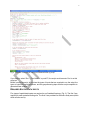
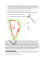
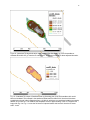
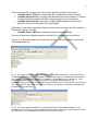
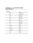
6
1) Point elevations on river sandbars from topographic surveys.1 This file must include a
field called ELEV for each record, with measured elevations reported in 100ths of US
survey feet (e.g., 608.45). This field must have the following properties in ArcGIS: it must
be of the type: “double”, with a “precision” of 11 and a “scale” of 3.
2) Polygons delimiting portions of the sandbar with vegetation cover.
3) Polygons that delineate the outer boundaries of sampling areas for each sandbar.
4) Line files indicating large trees near sandbars.
5) Line files delineating the boundaries of the active river channel.
Fig. 3. Image that illustrates the required spatial data inputs for running the SandbarCreator.py script.
Red plus signs indicate points where field crews collected high-accuracy elevation data (see Lott and
Wiley 2011 for protocols). The dark green polygon at the top of the image represents a patch of low
vegetation that was originally delineated as a line in the field and later closed to complete a polygon (Lott
and Wiley 2011). The light green frame around elevation sampling points represents the “clip” file that
was created in ArcGIS after field sampling to define the outer boundaries of the sampling site. The dark
green line indicates large trees (or lines of trees) within 500 meters of the sandbar, which were delineated
from aerial photography near the time of field sampling. The brown line indicates the edge of the active
channel, also delineated from aerial photography. See Lott and Wiley (2011) and Appendix K2 for a more
detailed discussion of how these spatial inputs may be collected or prepared prior to analysis.
1
If continuous elevation surfaces (e.g., digital elevation models prepared from LIDAR data) are available, the script
can be modified so that these are used as inputs instead of point elevations from field topographic surveys. To do
this, contact Casey Lott at [email protected].
2
Lettered appendices refer to appendices in Lott et al. (2011)