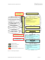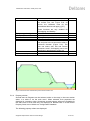
1
Ringtoets Requirements and
Design
Deltores
1207804-001-DSC-0002, 16 May 2013, final
Keywords
Summary
Ringtoets is the provisional name of new software for the compulsory safety assessment of
the primary Dutch flood defences (dike rings). Ringtoets will support the new Dutch
regulations, called VTV-2017 (Voorschriften Toetsen op Veiligheid). These regulations will
introduce a new assessment level, based on the failure probability of a dike ring. The
probabilistic method required for this purpose will also be used to calculate characteristic
water levels, to calculate characteristic overtopping levels, and to calibrate the required safety
factors for a traditional deterministic assessment, per dike section and failure mechanism.
Version 1.1 of this document contains the final specification of the functional and nonfunctional requirements for Ringtoets, together with a third draft of the functional design and a
second draft of the technical design. The content is based on input and response from an
advisory group, consisting of representatives from regional water authorities and consultants.
The introduction and requirements are contained in chapter 1 to 3. Chapter 1 describes the
context and background. Chapter 2 describes the scope and the tentatively supported
workflow. Chapter 3 lists the functional and non-functional requirements, including priority
indications. The Waterdienst has formally approved the final content of these chapters in April
2012. This content is therefore closed for further discussion since version 1.0.
Chapter 4 (Functional Design) translates the workflow and requirements to so-called usecases, describing the interaction between the user and Ringtoets, during different workflow
steps. Chapter 5 (Technical Design) translates the use-cases to a more detailed technical
description of screens for the different activities, and to the data-model underneath.
Compared to version 1.0, chapters 4 and 5 contain the result of a review of version 1.0, in the
course of June 2012. Additionally, these chapters contain further improvements, following
from the preparation and execution of three actual implementation stages between
September 2012 and May 2013. Continuous further improvement during future stages is part
of the development strategy.
References
Masterplan WTI-2017. Deltares report: 1201617
Version
0.1
0.2
1.0
Date
Oct 2011
Dec 2011
June 2012
Author
Initials
Review
1.1
May 2013
Marcel Visschedijk
~
Kin Sun Lam
Robert Kamp
Rob Brinkman
State
final
Ringtoets Requirements and Design
Initials Approval
Cl-
Jan-Aart van
Twillert
Initials
qJ
1207804-001-DSC-0002, 16 May 2013, final
Contents
1 Introduction
1.1 Ringtoets
1.2 Purpose and scope of this document
1.3 Status and process
1.4 Background
1.4.1 WTI-2017 project
1.4.2 Assessment method according to the VTV-2017
1.4.3 Global Assessment Work flow
1.4.4 Stakeholders and users
1.5 System documents
1.6 Assumptions and Constraints
1.7 Summary of relevant concepts and procedures
1.7.1 Failure mechanisms
1.7.2 Assessment levels and section divisions
1
1
1
1
2
2
3
5
6
6
7
9
9
11
2 Scope
2.1 System definition
2.2 Main features
2.3 Supported tasks and workflow
2.3.1 Overview
2.3.2 Detailed Workflow
12
12
14
15
15
16
3 Requirements
3.1 Introduction
3.2 General requirements
3.3 Functional requirements
3.3.1 Data connections
3.3.2 Import already available flood defence key data
3.3.3 User input or modification of flood defence data
3.3.4 Schematization support
3.3.5 Visualisation of input and schematization data
3.3.6 Execute calculations
3.3.7 Reporting and visualization of results
3.3.8 Export input and results
3.3.9 Design rules for the Graphical User Interface
3.4 Non-functional requirements
3.4.1 Standards and requirements Rijkswaterstaat
3.4.2 Additional conventions and standards
3.4.3 Operational and accessibility requirements
3.4.4 Logging and error handling
3.4.5 General Performance
3.4.6 Capacity
3.4.7 Reliability requirements
3.4.8 Validation Rules
3.4.9 Recoverability
3.4.10 System availability and support
22
22
22
24
24
24
25
25
26
26
27
28
29
30
30
30
30
31
31
31
32
32
32
32
ii
Ringtoets Requirements and Design
1207804-001-DSC-0002, 16 May 2013, final
4 Functional Design – Use Cases
4.1 Introduction
4.2 Installation of Ringtoets
4.3 Getting started
4.4 Create or open a project
4.5 Import of key data
4.6 Input or modification of key data
4.7 Schematization for hydraulic boundary conditions, including overtopping
4.8 Calculate hydraulic boundary conditions and overtopping per cross section
4.9 Schematization for level 1 assessment of height and stability
4.10 Execute level 1 assessment for height and stability
4.11 Additional schematization for level 2 assessment
4.12 Execute level 2a assessment
4.13 Additional schematization for level 2b assessment
4.14 Execute level 2b assessment
4.15 Report and Export input and/or results
4.16 Strip results from database and close the project
5 Technical Design
5.1 Introduction
5.2 System architecture
5.2.1 Modular User Interface design, with the Delta-Shell Light library
5.2.2 Menu and toolbar
5.3 Data model
5.3.1 Key data
5.3.2 Assessment model (schematized data and results)
5.3.3 Import and export
5.3.4 Failure mechanisms
5.3.5 UI
5.3.6 Ringtoets plugin
5.4 Project management
5.4.1 Start a new project
5.4.2 Automatic Locking of data
5.4.3 Saving data and configuration
5.5 Import and Export
5.5.1 Import and export data model
5.5.2 Import user interface
5.5.3 Format of imported and exported data
5.6 Editing data
5.6.1 Modification of key-data
5.6.2 Map window
5.6.3 Cross section editor
5.6.4 Property window
5.6.5 Tables and charts
5.7 Validation
5.8 Assessments
5.8.1 Assessment Level 0
5.8.2 Assessment Level 1
5.8.3 Assessment level 2a
5.8.4 Assessment Level 2b
Ringtoets Requirements and Design
34
34
36
37
37
38
39
43
45
48
49
50
52
53
54
55
56
57
57
57
60
63
68
68
76
81
81
82
82
82
82
82
83
84
84
87
87
87
87
88
95
97
99
100
101
101
103
105
107
iii
1207804-001-DSC-0002, 16 May 2013, final
6 References
111
Appendices
A Glossary of terms (English to Dutch)
A-1
B Glossary of terms (Dutch to English)
B-1
iv
Ringtoets Requirements and Design
1207804-001-DSC-0002, 16 May 2013, final
1 Introduction
1.1
Ringtoets
Ringtoets is the provisional name of a new software system for compulsory safety
assessment of the primary Dutch flood defence systems (dike rings), according to new Dutch
regulations called VTV-2017 (Voorschriften Toetsen op Veiligheid). Ringtoets connects for the
calculation of failure probability to separately defined software, called Hydra-Ring.
1.2
Purpose and scope of this document
The document in hand defines the functional and non-functional requirements for Ringtoets,
as well as the functional and technical design.
• First purpose of this document is to allow the principal to check if both the requirements
and the functional design are according to expectations. The purpose of intermediate
versions of the functional requirements and functional design is also to gather and use
feedback from the Ringtoets Advisory Group. This group consists of both the regional
water authorities responsible for assessment and the consultants to which assessment
tasks are usually delegated.
• Second purpose is to provide the Ringtoets developer with all required information for
implementation, testing and (future) maintenance. Especially the technical design in
chapter 5 serves this purpose.
For a description of the new VTV-2017 assessment procedure, the reader is referred to the
first framework description [Lit 6.6]. For a description of the requirements and the design of
the probabilistic part, the reader is referred to the Hydra-Ring design document [Lit 6.2]. For
the scientific background on the implemented methods and algorithms in the probabilistic
part, the reader is finally referred to Hydra-Ring’s scientific documentation [Lit 6.1].
1.3
Status and process
Version 0.2 (December 2011) contained already a second draft for the requirements
(chapters 1 to 3) and a first draft for the functional design (chapter 4). This version has been
discussed with the Advisory Group on March 30, 2012. After that, all received feedback from
the principal and the advisory group has been discussed with the principal on April 10, 2012.
This discussion has resulted in agreement on the required modifications to the chapters 1 to 3
[Lit 6.13].
Version 1.0 (June 2012) contained the amended final requirements, together with a second
draft of the functional design and a first draft of the technical design. Version 1.0 served also
as input for the first development period in September 2012.
Version 1.1 contains an update of both the functional and technical design (chapter 4 and 5).
This update reflects the new insights, gathered during the first three development stages, up
to and including April 2013. The update also reflects all received feedback from the principal
and the Advisory Group. Further improvement will take place during the following stages of
development.
Ringtoets Requirements and Functional Design
1 of 127
1207804-001-DSC-0002, 16 May 2013, final
1.4
1.4.1
Background
WTI-2017 project
Rijkswaterstaat has commissioned Deltares to develop a new set of methods and tools for
assessing and designing the Dutch flood defence systems based on the failure probability of
a dike ring. Since 2012, this development is a part of the project WTI-2017 [Lit 6.11]. A first
version of the new regulations and supporting software needs to be available in the course of
2013, in order to start an evaluation and improvement period that will run until the end of
2016.
2009
TOI: Preliminary
development
2011
WTI-2017: further
development and evaluation
2016
New instruments
Figure 1.1 Global time schedule TOI project
Figure 1.2 presents a sketch of the view of Rijkswaterstaat on the context of the assessment
instruments. The figure originates from the TOI Project Start Architecture document [Lit 6.7]
Figure 1.2 Rijkswaterstaat view on system context, according to [Lit 6.7]
Figure 1.3 shows the shared failure mechanism and UI libaries for WTI dike assessing and
designing tools. Shared libraries allow for generic tool development and implementation,
which fits into the Rijkswaterstaat’s vision to optimize the total support and maintenance costs
of software applications.
2 of 127
Ringtoets Requirements and Functional Design
1207804-001-DSC-0002, 16 May 2013, final
Figure 1.3 Shared libaries for WTI dike assessement and designing tools
1.4.2
Assessment method according to the VTV-2017
The current set of regulations (VTV-2006) and supporting set of software (Hydra’s,
Steentoets, Grastoets, Golfklap, D-GeoStability/MStab, Duros etc) is based on a partly
probabilistic and partly deterministic safety assessment of dikes, dunes and structures. The
Hydra software determines first in a probabilistic fashion the water level, wave parameters
and overtopping characteristics per cross section. Further assessment for other failure modes
(mechanisms) is executed per failure mode and per section, using a characteristic water level
with allowed exceedance frequency (toetspeil) as calculated by the Hydra’s. After an initial
relevance check (level 0), a simple assessment by a decision rule (level 1) can be followed by
a detailed assessment (level 2). The simple assessment usually requires only the geometrical
properties to be known, whereas a detailed assessment usually requires additional physical
model parameters. This deterministic method is also called semi-probabilistic, because
prescribed partial safety factors implicitly ensure that the annual failure probability stays
always below an allowed value per section and mechanism.
The new VTV-2017 regulations will also support this VTV-2011 type deterministic assessment
per mechanism and section. Part of the TOI project will therefore aim at the calibration of the
safety factors for the final VTV-2017 mechanism models in 2017. Additionally, the new VTV2017 regulations and supporting software will allow an explicit probabilistic assessment,
taking into account the combined contributions from different failure modes and different
sections. The prescribed failure mechanism models for detailed probabilistic and semiprobabilistic analysis will be identical. The VTV-2017 will also prescribe how to combine the
results from sections and mechanisms that were assessed with different methods.
Ringtoets Requirements and Functional Design
3 of 127
1207804-001-DSC-0002, 16 May 2013, final
VTV-2011
VTV-2017
0: relevance check (per mechanism and section)
Conservatism
1: Simple Assessment (per mechanism and section)
2a: Detailed semi-probabilistic
assessment (per mechanism and section)
2b: Detailed probabilistic assessment
(for combinations of mechanisms and sections)
Figure 1.4 VTV-2017 assessment scheme, with additional new level 2b. Level 3 (advanced) is not shown. Also not
shown is the additional assessment, based on criteria defined by the regional water authority
(beheerdersoordeel)
The result of a semi-probabilistic assessment is usually a certain factor of safety (FOS) per
mechanism and section. A FOS is determined by the ratio between the allowed and actual
value of certain load type (e.g. an overtopping discharge, a differential head for piping or a
driving moment for slope instability). The result of a probabilistic analysis is an integrated
failure probability for (a part of) a dike ring, which has to be compared with the allowed value.
The failure probability is influenced by the uncertainty in both hydraulic loading and strength,
as well as by the length and number of the sections. A probabilistic analysis for combined
mechanisms and sections is always less conservative than a separate semi-probabilistic
assessment per mechanism and section.
4 of 127
Ringtoets Requirements and Functional Design
1207804-001-DSC-0002, 16 May 2013, final
1.4.3
Global Assessment Work flow
Figure 1.5 depicts the global assessment work flow which is to be supported by Ringtoets.
Flood Defences
key data
(water authorities)
Hydrodynamic and
statistical data (RWS)
Geometry dependent schematization
• Location and dimensions of the flood defence system
Calculation of Hydraulic Boundary
Conditions, per cross section or
per output location
Water levels and waves
Further schematization per failure mechanism
• Division in sections, with representative cross section
• Simple models (less data required)
• Detailed models (less conservativeness required)
Flood Defence schematization
Iteration
loop
Safety assessment
• Deterministic per section and mechanism
• Probabilistic for combined sections and mechanisms
Assessment results
Report results
Figure 1.5 Work Flow Safety Assessment. Ringtoets covers all tasks which are coloured green. The additional
containers show the initial data (white) and project data (yellow). The Water authorities are responsible for
delivering the flood defences key data and for executing the schematization and assessment.
Rijkswaterstaat (RWS) is responsible for delivering the hydrodynamic and statistical data, and delegates the
production to Deltares. The hydrodynamic data is contained in different physical databases for different
regions. The project database content (flood defence schematizations, hydraulic boundary conditions, and
assessment results) is coloured yellow.
Section 2.3 contains a more detailed description.
Ringtoets Requirements and Functional Design
5 of 127
1207804-001-DSC-0002, 16 May 2013, final
1.4.4
Stakeholders and users
•
Rijkswaterstaat is responsible for delivering the assessment tools, including the format
and content of the hydrodynamic database, as well as for the data format of the
schematization and assessment results and the format of the final assessment report.
•
The regional water authorities (waterschappen) and Rijkswaterstaat are the end-users,
responsible for the execution of the actual assessment, including data acquisition,
schematization, analysis and reporting.
•
The regional water authorities commission their assessment tasks mostly to specialized
civil engineering consultants. The total number of consulting employees doing actual
assessments is not more than two hundred.
During the Ringtoets definition and development stage, Deltares will frequently consult the
Ringtoets Advisory Group in order to get feedback on intermediate results. This group
consists of both the regional water authorities responsible for assessment and the consultants
to which assessment tasks are usually delegated.
Related to the WTI as a whole, the “Directoraat-Generaal Waterstaat” is primary responsible
for all formal communication with public administration representatives and the Waterdienst is
primary responsible for all formal communication with the regional water authorities (in
coordination with the “Directoraat-Generaal Waterstaat”). Deltares is finally responsible for
communication with the civil engineering consultants (in coordination with the Waterdienst).
1.5
System documents
Together with the document in hand, the following documents comprise the currently
available system documentation for Ringtoets and Hydra-Ring. All these documents are
under continuous development, until the VTV-2017 regulations and associated software will
be formally released in 2017.
Document
Project Start Architektuur TOI [Lit 6.7]
Het raamwerk en de aanpak van het
toetsproces: voorstel [Lit 6.6]
Hydra-Ring Design document [Lit 6.2]
Hydra-Ring Scientific documentation [Lit
6.1]
6 of 127
Content
Gives constraints for usage of TOI within the
infrastructure of Rijkwaterstaat and the water
boards.
Proposes a structure and approach for the new
safety assessment procedures (VTV-2017), which
are to be supported by Ringtoets.
Describes the requirements for Hydra-Ring, as
well as the design of the software structures, the
data structures and the databases (project
database, general configuration database,
statistical configuration database, hydrodynamic
databases per region).
Describes the methods and algorithms used in
Hydra-Ring. Serves as the basis for the scientific
background in the final User’s manual of
Ringtoets.
Ringtoets Requirements and Functional Design
1207804-001-DSC-0002, 16 May 2013, final
1.6
Assumptions and Constraints
Ringtoets has to comply with the following assumptions and constraints (CNS), related to the
different purposes of Ringtoets at the different stages of the development. The reason for
defining these assumptions and constraints prior to the definition of the requirements in
chapter 3, is that each of them will affect multiple requirements. Assumptions are also
needed to specify the still undefined or uncertain parts of the WTI project context to a
sufficient detail.
CNS 1 The draft document “Project Start Architektuur TOI” [Lit 6.7] defines the constraints
provided by Rijkswaterstaat 1.
CNS 2 The Deltares report “Uitgangspunten WTI” [Lit 6.12] defines the general assumptions
and constraints for the Deltares WTI project as a whole.
CNS 3 The first evaluation version of Ringtoets must be available at the start of the evaluation
period, which is tentatively in the course of 2013. The aim of the evaluation version of
Ringtoets, in combination with the evaluation version of Hydra-Ring, is to support
semi-probabilistic and probabilistic analysis of all Dutch primary flood defences, with a
functionality similar to the Hydra’s and to PC-Ring.
CNS 4 Ringtoets will support the deterministic and/or probabilistic analysis of all mechanisms
contained in a new VTV-2017 software library of failure mechanisms. The
specifications of different VTV-2017 failure mechanism models however, as well as
the subsequent specification and development of the software library itself are not a
part of the Ringtoets specification and development.
CNS 5 The requirements and limitations for probabilistic analysis with Ringtoets (level 2b) are
already defined in the Hydra-Ring design document [Lit 6.2]. This includes the
requirements on the failure mechanism models and hydraulic load models to be
supported probabilistically for respectively the evaluation version and the product
version. This includes also the requirements and limitations with regard to the use of
mechanism sections. And it finally includes the specification of the Hydra-Ring
interface.
CNS 6 Besides level 2b, Ringtoets needs to support also the decision rules in level 1 and a
semi-probabilistic assessment in level 2a, as well as the combination of
probabilistically assessed parts with semi-probabilistically assessed parts. Ringtoets is
not expected to support decisions with regard to the relevance check (level 0).
Ringtoets is also not expected to support a level 3 assessment (Toetsen op maat) and
additional assessment procedures, such as Beheerdersoordeel.
CNS 7 The first product version of Ringtoets is planned in 2016, before the start of the next
assessment period in 2017. The aim of this product version is to supply full support for
assessment with prescribed VTV-2017 models and procedures for at least 9 failure
mechanisms (including simple or detailed deterministic assessment), with the help of
Hydra-Ring.
1.
The general constraints for Rijkwaterstaat software (such as huisstijl and web-based design) are not applicable for
RIngtoets.
Ringtoets Requirements and Functional Design
7 of 127
1207804-001-DSC-0002, 16 May 2013, final
CNS 8 The applicability of Ringtoets will be limited to safety assessment for all Dutch primary
flood defences (category a, b and d), based on the VTV-2017.
CNS 9 According to Rijkswaterstaat, the final reporting of assessment results by the regional
water authorities, in a fixed digital format, is not a part of the required Ringtoets
functionality. Instead, a connection to an external reporting module such as Toetsrap
is envisaged. The specification of such a module is therefore not a part of the current
Ringtoets definition 2.
CNS 10
The first product version of Ringtoets is not expected to offer automated
design capabilities (i.e. functionality for automated determination of the required
geometrical and physical properties, similar to the DAM software). The Ringtoets
design must however allow for such an extension in the future.
CNS 11
Ringtoets will supply some basic data visualization and data elaboration
options as found in GIS systems and spreadsheets, and use data-connections to
existing external GIS systems and/or spreadsheet software for further functionality.
This means that Ringtoets will not fully replace the functionality of already existing GIS
and spreadsheet software. This philosophy is shared with the Hydra’s and with the
DAM software. Further details on the supported options will be supplied as part of the
definition of the requirements (chapter 3) and the use-cases (chapter 4).
CNS 12
Possible access to a remote Ringtoets installation via a Citrix web client is a
minimum requirement for Rijkswaterstaat. It is however not a Rijkswaterstaat
requirement or user requirement that the user-interface is fully web-based (meaning:
access via a web browser, without Citrix client software).
CNS 13
Ringtoets must be capable to import a snapshot of all key data from the
original data sources maintained by the regional water authorities, using the same
exchange formats and methods as DAM (Dike strength Analysis Module) already
does. The reason for this constraint is that that the water authorities obviously want to
maintain only one single data source for both DAM and Ringtoets.
CNS 14
The models and algorithms supported by Ringtoets are not expected to be
exactly equal to the models and algorithms supported by PC-Ring and the Hydra’s.
Therefore, the numerical results are also not expected to be exactly equal. However,
the trends and ratio of results are expected to be comparable.
CNS 15
Ringtoets will not offer capabilities for direct import of PC-Ring or Hydra input,
as the input data model of Ringtoets will be different. Instead it is assumed here that
re-use of existing PC-Ring data (from the VNK project) during the test and evaluation
period will be achieved via preprocessing. Automation of this preprocessing will
however be not a part of the Ringtoets development.
CNS 16
Rijkswaterstaat allows the use of third party software as part of Ringtoets, as
long as this software does not require a separate user licence fee, and as long the
2.
The structure of the workflow supported by Ringtoets will be different from the formal VTV-2017 structure to report
the final assessment results.
8 of 127
Ringtoets Requirements and Functional Design
1207804-001-DSC-0002, 16 May 2013, final
availability is guaranteed for a minimum period of 10 years. This constraint does not
apply to existing external software that has to be used in conjunction with Ringtoets.
1.7
Summary of relevant concepts and procedures
Some important concepts and terms for understanding the functional requirements are
explained globally hereafter. A full glossary of terms is presented in appendix A and B. For
more detail on the mentioned concepts, models and procedures, the reader is referred to the
scientific documentation [Lit 6.1].
1.7.1
Failure mechanisms
A flood defence system consists of sections of dikes and/or dunes, with interjacent structures.
A flood defence system can fail (meaning: lose its water retaining function) due to different
failure mechanisms. An overview of relevant mechanisms for dikes is shown in Figure 1.6.
Overflow
Overtopping
Slope stability inwards
Slope stability outwards
Seepage face erosion
Piping (internal erosion)
Liquefaction
Revetment failure
Figure 1.6 Illustration of different failure mechanisms for dikes.
Sometimes, actual failure will depend on the occurrence of more than one submechanism. An
example is failure due to piping (internal erosion of sand underneath the dike or structure),
which can only occur after preceding uplift of the protecting cover layer at the land side, see
Figure 1.7. Another example is the failure of the inner slope due to erosion or instability, after
a preceding occurrence of overtopping.
Ringtoets Requirements and Functional Design
9 of 127
1207804-001-DSC-0002, 16 May 2013, final
Failure due to piping
AND
Uplift
Piping (incl. heave)
Figure 1.7 Example of the fault tree for failure mechanism piping
Submechanism failure is predicted on the lowest level by cross sectional models, requiring
input that is partially model specific. A cross section can contain different zones of revetment,
which need to be assessed per zone.
10 of 127
Ringtoets Requirements and Functional Design
1207804-001-DSC-0002, 16 May 2013, final
1.7.2
Assessment levels and section divisions
The safety assessment for different failure mechanisms according to the VTV-2017 must be
executed stepwise on different levels, according to Figure 1.4 and Table 1.1.
Table 1.1: Overview of assessment levels
Level
0
Type of assessment
Relevance check per cross
section and mechanism
1
Simple
semi-probabilistic
assessment per cross section
and mechanism
Detailed semi-probabilistic
assessment per section and
mechanism
2a
2b
Detailed probabilistic
assessment (for combinations
of sections and mechanisms)
Outcome
When the failure mechanism is not relevant for a
cross section, the annual failure probability (FP) is
assumed to be zero.
When the result of the simple assessment is positive,
the annual FP is below a certain allowed value as
derived from the ‘failure probability budget’
The ratio between the conservatively determined
deterministic strength and load is usually expressed
via a factor of safety (FOS). The use of partial safety
factors ensures that, when the FOS is larger than 1,
the failure probability is below a certain allowed value
as derived from the ‘failure probability budget’.
The result of the detailed probabilistic assessment
will be the annual FP for the each failure mechanism
per section, as well as an overall failure probability for
the combined failure mechanisms and sections.
As part of a level 2 assessment, the total stretches of dunes and dikes are divided by the user
into different longitudinal mechanism sections. Inside each of these sections, the different
input parameters for the considered mechanism model(s) are assumed to be more or less
constant, but uncertain. The length of a section should be sufficient large for a failure
mechanism to occur.
In case of a semi-probabilistic assessment (level 2a), the assessment results from different
mechanism sections (OK or not OK) are combined on so-called combination sections. The
joined boundaries of all different mechanism sections determine implicitly the division into
combination sections. The purpose of combination sections is to decide for which parts a
semi-probabilistic assessment is sufficient, when considering all mechanisms together.
In case of a probabilistic assessment (level 2b), the user will be able to define additional
presentation sections. A presentation section consists of one or more combination sections. A
presentation section is used for combination of the failure probability contributions from
different mechanism sections, in order to determine if physical improvement of the section is
required.
See section 2.3 for further details on the stepwise assessment and section divisions.
Ringtoets Requirements and Functional Design
11 of 127
1207804-001-DSC-0002, 16 May 2013, final
2 Scope
2.1
System definition
The main goal of Ringtoets is to support the required model schematizations by the user and
afterwards execute an automated assessment of primary Dutch flood defences, according to
the VTV-2017 regulations. Schematization means the process of producing model input for a
subsequent assessment, starting from already available key data. Automated means that
Ringtoets will execute the assessment for combinations of multiple mechanisms and sections.
It is intended that Ringtoets will finally replace PC-Ring and the Hydra’s, which together offer
similar functionality.
Ringtoets will have four main functionalities:
1. Support for schematization using imported or inputted data, for the purpose of
assessment;
2. Calculation of the hydraulic boundary conditions;
3. Execution of safety assessments on different levels (simple, semi-probabilistic and full
probabilistic calculations) and combination of the assessment results;
4. Presentation of assessment results.
Figure 2.1 shows the global Ringtoets design. The main functions are steered by a controller,
connecting to a graphical User-Interface (UI), an input/output (IO) layer and a business layer.
•
The user interface enables tabular or graphical presentation and manipulation of the
project-data, the model schematization and the calculation results.
•
The input/output layer connects to the internal project database, and to different types of
external databases and files. The external data sources are shown at the left hand side3.
A GIS and a subsoil database (D-Soilmodel) are expected to be used increasingly by the
waterboards as the original source for processed key data. Data exchange with Ringtoets
is expected to be performed through CSV or SHP files. The CSV format allows also for
connection to external spreadsheet software. The additional XML format is expected to be
used mostly for archiving and exchanging project data, as well as for connection to
external software, such as a formal VTV-2017 report module. Map data is expected to be
imported through shp files.
•
The business layer performs the tasks for assessment on all relevant levels and contains
also the definition of the shared data-model. The business layer connects to the HydraRing component for the probabilistic assessment (level 2b).
Ringtoets connects to software libraries containing components that are shared with other
tools, including the stand-alone VTV tools and DAM (Dijksterkte Analyse Module). Sharing
libraries between these tools will enable uniform connections to single data sources, a
uniform look and feel and equivalent results from the shared mechanism models. Using
shared libraries will also reduce the maintenance effort for each of these tools.
3.
Import and export to NetCDF is currently not foreseen as a user requirement.
12 of 127
Ringtoets Requirements and Functional Design
1207804-001-DSC-0002, 16 May 2013, final
Ringtoets User Interface
shp
• Regional and Flood defence data
shp
• Characteristic water levels + waves
• Assessment results
Subsoil database
csv
• Profiles and parameters
Files for exchange or
archiving
xml,
csv
• (selection from) project data
Input for relevant
stand-alone tools
l level 2a
• Schematizations for
Project database
• Data Region, Flood Defence and Subsoil
• Schematization choices
Ringtoets Input/Output
GIS Waterboard
Mapping table
UI + IO Library
(Delta-Shell Light)
xml
Failure Mechanism Library
• Schematizations
• Characteristic water levels and waves
• Assessment results for all levels
Ringtoets Controller
Ringtoets Business layer (level 0, 1, 2a, 2b)
Model adaptor
Hydra-Ring invoer en uitvoer
• Input: schematizations
• Output: characteristic water levels + waves
• Output: failure probabilities
Probabilistic Library
interface
Hydra-Ring (level 2b)
Ringtoets software
Internal Water database
Ringtoets project database
Hydra-Ring software
Hydra-Ring databases
• Water level and waves as a function of
stochastic variables
• Statistical distributions for the stochastic
Libraries which are part of different VTV tools
variables
Figure 2.1 Global design of Ringtoets
Ringtoets Requirements and Functional Design
13 of 127
1207804-001-DSC-0002, 16 May 2013, final
2.2
Main features
Schematization using imported or inputted data
Ringtoets will have functionality for input or import of data, and support the schematization
process from processed data to the required model input for assessment, either semiprobabilistic or probabilistic. The user can specify the geometrical and physical properties of
flood defence sections per mechanism. The user can connect these sections to predefined
locations of hydrodynamic data, already available in databases. The graphical user interface
will support the schematization process by offering tools for visualising, editing and modifying
the properties per mechanism and longitudinal section.
Calculation of hydraulic boundary conditions
Ringtoets will offer a probabilistic calculation of the water levels, waves and overtopping
characteristics at different locations. Ringtoets will use the output at cross section locations
for a subsequent semi-probabilistic assessment of different failure modes.
Execution and combination of safety assessment on different levels
The main functionality of Ringtoets is to execute safety assessments on different levels. This
means that a user can perform simple geometry based assessment, detailed semiprobabilistic assessment and detailed probabilistic assessments with the help of Ringtoets.
Ringtoets will also support the combination of assessment results from different mechanisms
and different sections, potentially assessed at different levels.
Presentation of assessment results
Ringtoets can present the primary calculation results in tabular format. Additionally, some
basic support will be supplied for graphs in time or space, and for visualization of results on
map/GIS layers. Output of detailed semi-probabilistic results per mechanism and section is
very important for a user, in order to gain confidence in the quality of the output. The
contribution to the total probability of each individual failure mechanism at a certain section is
of great use for the engineers. Post-processing will also be supported by output of data to xml
or csv files (section 3.3.8).
14 of 127
Ringtoets Requirements and Functional Design
1207804-001-DSC-0002, 16 May 2013, final
Overview
A schematic overview of the tasks to be supported at different levels for a regular assessment
procedure is given in Figure 2.2. This scheme enables a part of the required assement
according to the VTV-2017, as far as currently known [Lit 6.6]. It should be noted in advance
that Ringtoets will not support “Toetsen op maat” and “beheerdersoordeel”, see CNS 5.
The presented scheme indicates that the initial relevance checks (level 0), calculation of
hydraulic boundary conditions and further geometry based assessments (level 1) could be
executed in principal at all considered cross sections. The result of such a cross section
analysis reveals which stretches per mechanism require a more detailed level 2 assessment.
A level 2a or 2b assessment is executed at the level of longitudinal sections (“dike sections”),
containing one or more cross sections. The definition of the section division per mechanism
within the relevant stretches should be performed with the help of: (a) the result from the
preceding cross section analysis and (b) an analysis of the spatial variability of the boundary
conditions and the additionally required model data per mechanism.
Level 2a
Level 0 / Level 1
Data import/input
2.3.1
Supported tasks and workflow
Safety assessment
2.3
A1. Define flood defence
B1. Add model input
system
for level 2 assessment
- dike location line
- subsoil data
- cross sections
- revetment properties
Level 2b
- characteristic points
- hydraulic structures
- polder heads etc
A2. Compute Hydraulic
B2. Division of flood
Boundary conditions
defence system into
- water levels + overtopping
dike sections per
- wave parameters
mechanism
A3. Perform relevance
B3. Perform semi-
C1. Perform
check (Level 0)
probabilistic
probabilistic
assessment (Level 2a)
assessment (Level 2b)
A4. Perform geometry
B4. Combine semi-
C2. Combine
based assessment
probabilistic results for
probabilistic results for
(Level 1)
mechanisms and
mechanisms and
sections
sections
Assessment on cross section
Assessment on dike section
Figure 2.2 Schematic tasks for safety assessment, as far as supported by Ringtoets.
Ringtoets Requirements and Functional Design
15 of 127
1207804-001-DSC-0002, 16 May 2013, final
2.3.2
Detailed Workflow
Details on the workflow that needs to be supported are presented below, in bullet style. The
purpose of this description is mainly to help in deriving and understanding the related
requirements. The workflow description will be restricted to three typical mechanisms
(overflow/wave overtopping, revetment, heave/piping). Extension of the description to
additional mechanisms is however quite straightforward.
A. Definition of cross section geometry and determination of the required assessment
level per cross section, with the help of relevance checks (level 0) and geometry
based checks (level 1).
Determine the required assessment level per mechanism and per cross section
• Characteristic values of hydraulic boundary conditions per cross section
• Check if mechanism is irrelevant (level 0), if level 1 is sufficient, or if level 2 is
required
Mechanism 1
1
1
1
1
1
1
0
0
0
0
0
0
0
Mechanism 2
2
2
2
2
2
1
1
1
2
2
2
2
2
Mechanism 3
2
2
1
1
1
1
1
2
2
2
2
2
2
Figure 2.3 – Determination of required assessment level per mechanism and cross section.
A1. Define Flood defence system
• Input or import the actual dike location line of the flood defence system 4
• Input or import processed cross section surface lines (from Digital Terrain Model in
GIS).
• Optional: import existing definitions of characteristic point verticals along the dike line
(such as outer levee toe, outer levee crest, inner levee crest, inner levee toe, berm
crest, berm toe etc.)
• Define or update the locations of the characteristic points
• Import or define the inland piezometric head (polder head) distribution along the dike
location line
• For revetments and wave overtopping/overflow: import or input the location and
properties of different revetment zones
• For revetments and wave overtopping/overflow: import or input the locations and
properties of breakwaters and foreland, both causing wave reduction.
See UC 10 (page 40) to UC 17 (page 42) for details on the required key data. Note that the
full key data includes already processed data, such as surface descriptions, subsoil
schematizations and model parameters.
4.
Two different versions of the dike line can exist (the global location according to the Rijkswaterstaat administration,
and the actual location according to the water authority)
16 of 127
Ringtoets Requirements and Functional Design
1207804-001-DSC-0002, 16 May 2013, final
A2. Compute water level, overtopping level and wave data
• Use Hydra-Ring to calculate the characteristic assessment water level (the water level
with a certain annual exceeding probability) along the flood defence system, at the toe
of each location where measured cross section geometry is available, or at each
output location. See UC 25 (page 45) for details.
• If wave parameters are not available directly from the internal database with
hydrodynamic data: import or input fetch lengths per wind direction.
• Use Hydra-Ring to calculate the wave data for a revetment assessment5. See 0
details.
• Use Hydra-Ring to compute overtopping probabilities as a function of crest height,
using a schematized surface. See UC 27 for details.
A3. Perform level 0 assessment
• Select the mechanisms that can be excluded in advance along which part of the flood
defence system, based on a relevance check 6.
A4. Perform level 1 assessment 7
• For heave/piping and slope stability checks: input or import the piezometric heads at
polder side
• For all mechanisms: apply geometry based (level 1) decision rules along the defence
system when applicable and decide which parts of the flood system can be excluded
for further assessment
• View results per mechanism: cross sections along the dike location line requiring level
1 or level 2 assessment. The associated output is illustrated in Figure 2.3.
• Optional: export previously inputted or modified data.
See from UC 28 (page 48) to UC 31 for details on step A4.
5.
Wave parameters for revetment at different heights need to be determined in the so-called “design point” (illustratie
punt), with a special approximated limit state function, such as:
6.
7.
R − H s aTp b , where R
is some user-defined
measure of strength.
According to CNS 6, Ringtoets will not support the decision rules for a relevance check
According to [Lit 6.12], it is assumed that a cross section passing the level 1 assement does not consume any
failure probability budget.
Ringtoets Requirements and Functional Design
17 of 127
1207804-001-DSC-0002, 16 May 2013, final
B. Semi-probabilistic assessment
Create sections and perform semi-probabilistic check (level 2a)
• Characteristic values of hydraulic boundary conditions per level 2 section
• FOS (factor of safety) value per level 2 section, per sub mechanism and per layer
• Check if FOS is sufficiently large per level 2 section, per sub mechanism and per
layer. If not: a probabilistic analysis is required (level 2b)
FOS Check Mechanism 1
FOS Check Mechanism 2
FOS Check Mechanism 3
1
2a
OK
2a
0
OK
2a
1
OK
OK
2a
2a
2a
1
OK
OK
OK
2a
OK
2a
Semi-probabilistic output for combination sections
• Check where FOS is sufficiently large for all combined mechanisms
Combined FOS Check
OK
OK
OK
OK
OK
OK
Figure 2.4 – Semi-probabilistic assessment per mechanism section
B1. Add model input for level 2 assessment, for selected stretches
• For revetments:
– Import of input for each revetment zone the physical properties to be used inside
mechanism models: (a) mean value, (b) statistical standard deviation, (c) standard
deviation.
• For heave/piping:
– import or input a material library with different soil types and physical properties, if
available. This library contains for each property: mean value, statistical standard
deviation, standard deviation for mechanism model(s).
– import or input a set of possible 1D soil profiles (a stack of different soil layers)
including a link for each layer to the soil library.
– For one or more characteristic lines along the flood defence (river axis, outer toe,
levee axis, inner toe, ditch axis, polder side): attach one or more probable soil
profiles to certain stretches along the line and define the probability of occurrence
along the stretch. Or use imported soil profile distributions along the characteristic
lines.
• Optionally: export previously inputted or modified data.
B2. Per mechanism: divide into sections for level 2 analysis.
• import existing section divisions from previous assessment, when available, to
support the decision process.
• Overflow/wave overtopping: decide for a (modified) division into sections, based on
the difference between crest height and characteristic water level.
• Revetment: decide for a (modified) division into sections, based on the location and
types of revetment layers.
• Heave/Piping: decide for a (modified) division into sections, based on the variation in
subsoil conditions, in geometrical properties and in hydraulic loading.
18 of 127
Ringtoets Requirements and Functional Design
1207804-001-DSC-0002, 16 May 2013, final
•
Optionally: export previously inputted or modified section divisions.
B3. Optional: Perform semi-probabilistic analysis (level 2a)
• Revetment
– Define the partial safety factors to be used for physical properties and hydraulic
loading
– Per section:
∙ Define the characteristic cross section surface.
∙ Compute the characteristic wave parameters and characteristic load durations
at different heights along the flood defence system with Hydra-Ring.
∙ Determine the partial factor for the influence of section length
∙ Per revetment layer along the outer slope:
Compute characteristic values of physical properties, using mean values and
standard deviations from the material library.
∙ Compute the factor of safety for failure by wave attack (damage and
subsequent erosion), depending on the revetment type, using the prescribed
mechanism models.
∙ View relevant output details.
• Uplift/Heave/Piping:
– Define the partial safety factors to be used for physical properties and hydraulic
loading
– Per section
∙ Determine the partial factor for the influence of section length.
∙ Define the characteristic cross section surface.
∙ Select the characteristic subsoil profiles in the cross section direction from the
set of probable profiles and determine the associated schematization factor.
This results in a 1D or 2D schematization in cross section direction.
∙ Import or define the schematized hydraulic head distribution in the
characteristic cross section aquifers as a function of the external water level,
by an entrance point and a damping factor at the inner toe for each aquifer.
∙ Compute characteristic values of physical properties for the mechanism
models, using mean values and standard deviations from the material library.
∙ Check if heave will occur at some location along the polder side.
∙ In case of heave: compute the critical differential head, the minimum piping
length and the Factor of Safety, using the prescribed mechanism models.
∙ View relevant output details.
• Overflow/overtopping
– Define the partial safety factors to be used
– Per section:
∙ Select the characteristic cross section surface (already schematized in step
A2).
∙ Compute and view relevant output details on that cross section.
B4. Optional: Combine semi-probabilistic results from different mechanisms and sections.
• Check at which stretches the result from semi-probabilistic analysis for any of the
mechanisms is insufficient. Stop if semi-probabilistic checks along the total flood
defence are sufficient for all mechanisms.
• Optionally: export the semi-probabilistic schematization and results.
See from UC 32 (page 50) to UC 36 for details on step B.
Ringtoets Requirements and Functional Design
19 of 127
1207804-001-DSC-0002, 16 May 2013, final
C. Partially probabilistic assessment (Level 2b + level 1)
Partially probabilistic check per relevant mechanism section (level 2b + level 1)
• FP value per mechanism and layer (either probabilistically calculated value for level
2 sections or semi-probabilistic upper limit for level 1 sections)
FP Mechanism 1
1
2b
FP Mechanism 2
FP Mechanism 3
0
2b
2b
1
2b
2b
1
2b
2b
2b
Probabilistic output for presentation sections
•
•
Combined FP for all mechanisms per presentation section
Overall FP for all mechanisms and presentation sections
Overall OK?
Combined FP
Figure 2.5 – Partially probabilistic assessment of the combination of mechanism sections
C1. Perform probabilistic analysis, using the same section division and model input as for
semi-probabilistic analysis
• If required: modify default settings for probabilistic procedures.
• Overflow/wave overtopping:
– (Define the model uncertainties to be used and the allowed factor of safety).
– Per section:
∙ Re-use the characteristic cross section defined for level 2a assessment.
∙ Define the characteristic allowable overtopping discharge, or select the model
to compute the allowable discharge as part of the probabilistic procedure.
∙ Compute the annual failure probability per section with Hydra-Ring.
• Revetment
– (Define the model uncertainties to be used and the allowed factor of safety).
– Per section:
∙ Re-use the characteristic cross section defined for level 2a assessment.
∙ Compute the annual failure probability per section by wave attack (damage
and subsequent erosion), depending on the revetment type.
• Uplift/Heave/Piping:
– (Define the model uncertainties to be used and the allowed factor of safety).
– Per section
∙ Define the characteristic cross section surface, or use a stochastically defined
cross section geometry.
∙ Either use a characteristic 1D or 2D subsoil profile in cross section direction
with associated schematization factor, or use a set of probable profiles
(scenarios) with a probability of occurrence for each possibility.
∙ Define the schematized hydraulic head distribution in the characteristic cross
section aquifers as a function of the external water level, by input of an
entrance point and a damping factor at the inner toe for each aquifer.
20 of 127
Ringtoets Requirements and Functional Design
1207804-001-DSC-0002, 16 May 2013, final
∙
∙
Determine the partial factors, including the influence of section length.
Compute the failure probability with Hydra-Ring, using the prescribed
mechanism models.
C2. Combine failure probability contributions from mechanisms and sections
– Calculate the allowed failure probability of the combination of probabilistically
assessed parts, after subtracting the failure probability budget for semiprobabilistically assessed parts.
– Import or define a division in presentation sections for the probabilistically
assessed parts for combination of mechanism contributions.
– Calculate the failure probability per presentation section and for all probabilistically
assessed parts and view the resulting FP values for the different sections.
– If the total FP is too large: decide if the model schematization should be refined
with the help of additional data.
– If the total FP is still too large: Give an indication of the presentation sections that
need to be improved based on probabilistic assessment (the sections with the
largest contributions).
– Optionally: export the probabilistic schematization and results.
See from UC 38 (page 53) to UC 44 for details on step C.
Final remarks concerning section divisions and output per assessment water level:
1. In case of a semi-probabilistic level 2a analysis, the FOS is the basic output per
(sub)mechanism, per layer and per section.
2. In case of a semi-probabilistic analysis, a FOS check (OK or not OK) is the basic
output for combined mechanisms and sections.
3. In case of a semi-probabilistic analysis, the FP budget values per mechanism and
section are also required as output, for combination with probabilistically assessed
parts.
4. In case of probabilistic analysis, the model input is assumed to be equal as for
detailed semi-probabilistic analysis.
5. In case of probabilistic analysis, Hydra-Ring will be capable to calculate the combined
FP on presentation sections, taking into account the contributions from parts of
different mechanism sections.
6. For the purpose of combining probabilistic and semi-probabilistic parts, the possible
locations of presentation section ‘cuts’ should be limited to the locations of
mechanism section cuts. Or in other words: a presentation section consists of one or
more combination sections.
Ringtoets Requirements and Functional Design
21 of 127
1207804-001-DSC-0002, 16 May 2013, final
3 Requirements
3.1
Introduction
The following sections present an overview of the general, functional and non-functional
requirements. The functional requirements also include some rules and constraints for the
design of the graphical user interface. One of the following importance indicators is attached
to each of these requirements.
•
•
•
3.2
Must have: minimally required for basic usage.
Should have: additionally required for practical usage.
Nice to have: additionally desired to support practical usage.
General requirements
General requirements focus on the main functionalities of Ringtoets. The general
requirements are system qualities that the Ringtoets program must have, to support the
assessment methodology of dikes. Ringtoets should meet for this purpose the following
general functional requirements (GR).
GR 1 Ringtoets must comply with general requirements and preferences for the TOI project,
as much as practically possible. These preferences are derived from [Lit 6.5]. (must
have)
GR 2 The first product version in 2016 needs to support a probabilistic and semiprobabilistic assessment for multiple mechanisms and sections. The probabilistic
analysis tasks will be executed by Hydra-Ring must have).
GR 3 The features of Hydra-Ring and supporting tools must include the output features of
the existing Hydra software and supporting tools, as well as all calculation and output
features of the existing PC-Ring software, as far as required for an assessment
according to the VTV-2017 8. (must have)
GR 4 The first product version in 2016 must support all final mechanism models, hydraulic
load models and assessment procedures as prescribed by the VTV-2017 and the
defining documents to which the VTV-2017 refers, as far as these models are part of
the VTV-2017 software library for failure mechanisms. See Table 3.1 for a tentative
list. (must have)
GR 5 The initial evaluation version of Ringtoets (at the start of the evaluation period) must
already offer capabilities for probabilistic production of hydraulic boundary conditions
(water level and wave parameters), as well as a probabilistic assessment for a
selected number of mechanisms (Table 3.1), in combination with the TMR2006
hydraulic data set. (must have)
GR 6 Multiple users should be able to work simultaneously (collect data, schematize and
calculate) on different mechanisms, and/or on different parts of one dike ring area.
8.
It is not required that the supported models and algorithms are equal to PC-Ring and the Hydra’s, see CNS 14
22 of 127
Ringtoets Requirements and Functional Design
1207804-001-DSC-0002, 16 May 2013, final
This requires ideally a locking mechanism, to restrict the input access for selected
mechanisms and sections to a certain user. (should have)
GR 7 The user must be able to supply model input either by importing data or by adding
data via the graphical user interface (GUI). (must have)
GR 8 Semi-automated schematization from processed key project data to model data will be
supported where possible. (should have)
GR 9 Ringtoets will supply clear and sufficient feedback to the user (e.g. progress, error and
warning). (must have)
GR 10 Ringtoets will support tabular and (limited) graphical output presentation options.
(must have)
GR 11 The User Interface, the feedback messages and the reports will have a Dutch and
English language mode. (must have)
GR 12 The full theoretical background of Hydra-Ring will be available in English language.
(must have)
GR 13 The User Manuals will be in available in Dutch language, and contain a reference part,
a tutorial part and a summary of the theoretical background. In the theoretical part,
references will be made to the full theoretical documentation of Hydra-Ring (in English
language). (must have)
Table 3.1: Expected support of mechanism models in Ringtoets in 2017 (depending on results from other WTI and
SBW subprojects)
Type of flood defence
Evaluation version
Product version
Dike sections
-
-
Overflow / wave overtopping
Heave/Piping
Instability of the inner slope
Failure of the revetment
Overflow / wave overtopping
Piping
Instability of the inner slope
Failure of the revetment
Instability of the outer slope
Micro instability*
Dunes
Dune erosion
Wind erosion*
Hydraulic Structures
- Overflow / wave overtopping
Overflow / wave overtopping
- Piping
Piping
Structural failure*
Non closure of gates or doors*
General
Strength and stability of transitional
structures*
- Foreland instability*
- Failure due to non water-retaining
structures*
- Failure of vertical walls and other structural
elements in dike sections (i.e. sheet pile
walls)*
* provided the timely availability of suitable software models in the VTV-2017 failure mechanisms library
Ringtoets Requirements and Functional Design
23 of 127
1207804-001-DSC-0002, 16 May 2013, final
3.3
Functional requirements
The functional requirements will elaborate the relevant general requirements from section 3.2
to a more detailed level, in order to define what a user must be able to do with Ringtoets.
See several use cases in chapter 4 for a more detailed specification.
3.3.1
3.3.2
Data connections
FR 1
Ringtoets will supply a neutral XML interface for import and export of all processed
and schematized data in the project database, enabling third party development of
connectors to specific formats, and also enabling connection to web services. (must
have)
FR 2
Ringtoets will have an import and export connector to GIS, via shp files and a
configurable mapping table (or translation table) between the GIS data and the
Ringtoets data. This mapping table will relate data items in the different shp files to the
Ringtoets data items (must have)
FR 3
Ringtoets will have an import connector to the same subsoil database as the one to
which DAM (Dike Analysis Module) connects, via CSV files. (must have)
FR 4
For import from and export to spreadsheet tables, Ringtoets will connect to CSV files
(supported by MS-Office and others). (must have)
FR 5
Ringtoets will offer options for exporting schematized data per cross section to standalone tools. (should have)
Import already available flood defence key data
FR 6
Import processed measurements, such as surface profile, piezometric polder heads
etc. (must have)
FR 7
Import the locations of relevant objects, such as different revetment zones, different
characteristic lines along the flood defence, breakwaters etc. (must have)
FR 8
Import existing properties of relevant flood defence objects, such as revetment
properties, breakwater properties etc. (must have)
FR 9
Import an existing subsoil model (profile plus properties). (must have)
FR 10 Import selected already existing schematization choices for different mechanisms and
models, such as a dike section partitioning. (must have)
FR 11 Validation of data integrity during import, e.g. check on missing data, consistency and
ranges. (should have)
FR 12 All imported data must be saved to the project-database. (must have)
24 of 127
Ringtoets Requirements and Functional Design
1207804-001-DSC-0002, 16 May 2013, final
3.3.3
User input or modification of flood defence data
FR 13 All user input data must be saved to and retrieved from the project-database. (must
have)
FR 14 A different dike section partitioning can be made for every failure mechanism. (must
have)
FR 15 Input or modification of locations, dimensions, material properties, additional
parameters and schematizations must be possible for all relevant mechanisms and
models. (must have)
FR 16 Give suggestions for default values where possible. (must have)
FR 17 Validation of input data in user interface forms (on the fly). For example validation on
syntax, completeness, limits and consistency. (should have)
FR 18 For probabilistic assessment with the help of externally defined models (advanced
models and perhaps also D-GeoStability/MStab), the input of fragility curves (or
actually: the linearized limit state surface for different values of the external water
level) has to be supported, together with the definition of the associated stochastic
model parameters (nice to have)
3.3.4
Schematization support
FR 19 Graphically supported definition of the location of mechanism sections and
presentation sections. (must have)
FR 20 Start with default parameters for dike section partitioning based on generic Water
Board methodology if available (should have).
FR 21 Selection of dike sections with ‘snap’-control. (should have)
FR 22 Graphically support the selection of one characteristic measure surface profile from a
couple of measured profiles. (nice to have).
FR 23 Schematize the cross section surface profile from processed geometry data, by
graphically selecting or modifying characteristic points. (must have)
FR 24 It must be possible to assign different parts of the project to different users (GR 6),
based on a division by failure mechanism, and optionally also a division by sections or
division by data groups as indicated in datatree. (should have)
FR 25 It must be possible to undo and redo a sequence of user actions. (must have).
FR 26 Modify relevant model schematization parameters (y-axis) in a space-graph, based on
dike reference system (x-axis). (should have)
Ringtoets Requirements and Functional Design
25 of 127
1207804-001-DSC-0002, 16 May 2013, final
FR 27 Functionality to suggest and connect the nearest hydraulic boundary locations
(hydrodynamic output locations, sometimes also referred to as “stations”) to dike
sections and/or vice versa. (must have)
FR 28 Highlight the hydrodynamic output locations linked to a cross section location when
selecting the cross section in top view. (should have)
3.3.5
Visualisation of input and schematization data
FR 29 Usage of GIS-layers, with the possibility to change the layer sequence and to toggle
layers on/off. (must have)
FR 30 Option to change background layers (e.g. topology maps, satellite images). (must
have)
FR 31 Option to use Web Map Services for background layers (should have).
FR 32 Show the location of the flood defence system with the attached points, the connected
location labels (e.g. hectometrering) and the axial reference coordinate in the dike
(GIS-) layers. (must have)
FR 33 Show the different section partitions per mechanism and the additional partitioning into
presentation section in the dike (GIS-) layers. (must have)
FR 34 Show the schematized dike profile cross section per section and per mechanism. Put
all relevant dike items in one overall dike form. Dike form items include: dike
geometry, soil profile scenarios, construction elements, ditches, summer quays (winter
bed), measured profile. Visual distinction between imported data and input data to
actual calculation is necessary (must have).
FR 35 Show graphs of dike properties in axial direction, using the axial coordinate as x-axis.
(should have)
3.3.6
Execute calculations
FR 36 Define or modify settings for different calculation methods (including the selected
probabilistic method with associated parameters). (must have)
FR 37 Select output locations, cross sections, mechanism sections and presentation sections
for the calculation of results. (must have)
FR 38 Define calculation options equal to the Hydra’s and PC-Ring, such as including or
excluding the effect of foreland. (must have)
FR 39 Start one or more of the following calculation types:
a. Characteristic 9 water level at the output locations (river axis), as well as a
table of water levels per output location for different exceeding probabilities.
(must have)
9.
a characteristic value is a value with an allowed exceeding probability
26 of 127
Ringtoets Requirements and Functional Design
1207804-001-DSC-0002, 16 May 2013, final
b. Characteristic water level at the toe of selected cross sections, for a
subsequent semi-probabilistic assessment, as well as a table of water levels
per cross section for different exceeding probabilities. (must have)
c. Wave parameters per cross section location at different heights, for a
subsequent semi-probabilistic revetment assessment. According to the Hydra
software, these wave parameters need to be determined with a special
approximated limit state function R − H s aTp b , where R is some user-defined
measure of strength. (must have)
d. The required crest level per selected cross section to limit the characteristic
overtopping discharge to a user-defined allowed value, as well as a table of
different crest levels with different overtopping exceeding probabilities
(hydraulisch belastingniveau). (must have)
e. Assessment results and FP budget per selected mechanism and section,
following from semi-probabilistic analysis (level 1 or level
2a), with
mechanism dependent output details. (must have)
f. FP per selected mechanism and section (incl. design point data), following
from probabilistic analysis (level 2b). (must have)
g. Combination of results from semi-probabilistic and/or probabilistic analysis.
(must have)
h. Fragility curves (tables of a FOS or FP as a function of stepwise variation of
water level and other uncertain parameters) for different mechanisms and
sections. (should have)
FR 40 Validate the complete input data (from import and additional input) before the
calculation starts, resulting in a clear message of what is missing or incorrect. This
type of validation is equal to the validation of imported data only (FR 11). A calculation
can not start if any errors are found (must have).
FR 41 For the purpose of design, enable switching from the default assessment period (e.g.
6 or 12 years) to a longer assessment period (e.g. 50/100 year). This is achieved
internally by switching to a pre-defined set of modified distributions for the stochastic
variables that determine the hydraulic load. (nice to have)
FR 42 For policy studies, enable the selection of a different databases for Hydraulic
boundary conditions. (nice to have)
3.3.7
Reporting and visualization of results
The following requirements reflect the input from the Advisory Group, as recorded during the
first meeting. See also several use cases in chapter 4. Additional mock-ups will be prepared
in an early development stage and presented to the Advisory Group, in order to refine the
specifications.
FR 43 In general, Ringtoets must supply output for all the calculation types mentioned in FR
39. This comprises most of the output as given by PC-Ring, as well as all the output
given by the Hydra’s. (must have).
FR 44 Improve the report format compared to PC-Ring and Hydra output, give it a modern
look. Use convenient defaults for configurable parameter combinations, for example
Ringtoets Requirements and Functional Design
27 of 127
1207804-001-DSC-0002, 16 May 2013, final
cluster results per water depth vs dike system (dijkring). A good example is the 4-D
table in the PC-Ring application. (should have)
FR 45 Start multiple sessions on one computer to compare different Ringtoets assessments.
(should have)
FR 46 Import results from previous sessions and compare results in combined graphs. (nice
to have)
FR 47 Present a report with the tabular output of different calculation types, see FR 39. (must
have)
FR 48 The results report format must be such that information is grouped from
general/aggregated information to detailed information. (should have)
FR 49 Add a summary table at the beginning of the report and an overview of all input
parameters and settings. (should have)
FR 50 Show graphs of the different results for different divisions in axial direction, using the
axial coordinate as x-axis. (should have)
FR 51 Present the semi-probabilistic assessment results graphically and tabular for different
mechanism sections and combination sections. (must have)
FR 52 Present the assessment results graphically and tabular for different mechanism
sections and presentation sections. (must have)
FR 53 Make the report format suitable for exporting to MS Excel. (must have)
FR 54 Make the report also suitable for exporting to HTML, PDF, XLS and other formats.
(should have)
FR 55 Create a new copy of the report when specifying a new name. (must have)
FR 56 If parameters are reported with quantiles, the quantiles should be accompanied with
the corresponding parameter value. (nice to have)
FR 57 Show results of individual failure mechanisms in their ‘design points’ (illustratie
punten). Show contribution of single failure mechanism to the overall failure probability
(including length effects). (must have)
3.3.8
Export input and results
FR 58 Export input and calculation settings via the GIS connector as much as possible, see
FR 39. Hydra-Ring will not write directly into the central water board databases. (must
have)
FR 59 Export the output of different calculation types via the different connectors for GIS,
spreadsheets and text, see FR 39. (must have)
28 of 127
Ringtoets Requirements and Functional Design
1207804-001-DSC-0002, 16 May 2013, final
FR 60 Export all input, calculation settings and results via the neutral XML connector. (should
have)
FR 61 Link meta-data to exported data (program version, date, data description, etc.). (must
have)
3.3.9
Design rules for the Graphical User Interface
This section presents first rules and constraints that will be adopted during the actual design
of the graphical user interface. These rules are based on opinions from expert users of
existing assessment tools and/or GIS tools such as PC-Ring, Hydra’s, D-GeoStability/MStab,
PC-Vink, DAM and ARC-GIS.
FR 62 The work-process is leading in the design and hierarchy of the content in menu bars.
(must have)
FR 63 The main-window contains a combination of a navigation pane, a Map window,
tables/graphs and property screens. Beneath the central form there is room for a
message box. (must have)
FR 64 Let the way to use GIS functionality in Ringtoets resemble the way to use it in existing
GIS tools. (should have)
FR 65 Input of all data and display of all results should be possible via the menu.
Additionally, data and results should be accessible via a GIS map and/or via the data
navigation tree, wherever applicable. (must have)
FR 66 The active mechanism is to be selected for assessment one level higher than the
active mechanism section. The selection of the active mechanism can be controlled
via the menu-bar, separate navigation pane, extra form (docking) or tabs in the central
form. (must have)
FR 67 The navigation pane will give access to different sections and cross sections along the
dike location line, and to the (filtered) data connected to these sections and cross
sections. (should have)
FR 68 The main menu will be unfoldable to a limited number of levels (two). (should have)
FR 69 Modeless forms are preferred above modal forms. Information in modeless form is
actively linked to selected objects in another form (e.g. maps in project canvas). A
modal form cannot lose focus within the program and has to be closed before you can
continue with the program. (should have)
FR 70 Toolbars will be necessary. Critical aspects are overview and scalable graphics. (must
have)
FR 71 The user must have the possibility to open, dock, hide/unhide, move and resize (sub)
forms/windows. The latest window configuration must be stored and used at the next
session. (must have)
Ringtoets Requirements and Functional Design
29 of 127
1207804-001-DSC-0002, 16 May 2013, final
FR 72 It must be possible to work with multiple screens (e.g. by spreading the several subwindows over multiple screens). (must have)
FR 73 The usage of tabs is encouraged as a means to order large amount of parameters in
forms, graphs, tables and also maps. (should have)
FR 74 Data can be partly imported from already available data sources, for example the
subsoil library. When the user changes the imported data it should be made visible
that the data has been changed (e.g. by showing the data in a different (background)
colour). (must have)
3.4
3.4.1
Non-functional requirements
Non-functional requirements, also called quality requirements, describe the qualities of a
program. A non-functional requirement (NFR) is a requirement that specifies the operation of
a system, rather than specific behaviour or functions. Implementing the quality requirements
will be detailed in the system architecture. The quality requirements are described in the
following sections.
Standards and requirements Rijkswaterstaat
NFR 1 According to CNS 1, the Project Start Architecture document [Lit 6.7] will define to
which extend Ringtoets has to comply with the following general requirements for
Rijkswaterstaat software 10.
•
Usage of open standards.
http://www.open-standaarden.nl/open-standaarden/lijsten-met-open-standaarden/
•
Requirements for web-interfaces.
http: //rijkshuisstijl.communicatieplein.nl/.
•
Algemene Richtlijnen Applicaties, versie 1.0
•
overheidsarchitecturen NORA en MARIJ:
http://www.e-overheid.nl/onderwerpen/e-overheid/architectuur/nora-familie/nora
http://www.wikixl.nl/wiki/ictu/index.php/Inleiding
3.4.2
Additional conventions and standards
NFR 2 The regular conventions, standards, tools and libraries for Deltares Systems
software will be used. (must have).
NFR 3 Data definitions will follow existing and emerging standards such as IRIS as much as
possible. (must have)
3.4.3
Operational and accessibility requirements
10. The applicability of these general requirements for Ringtoets is limited
30 of 127
Ringtoets Requirements and Functional Design
1207804-001-DSC-0002, 16 May 2013, final
NFR 4 The installation program for Ringtoets must allow installation of an application with
relevant hydrodynamic databases on individual MS Windows PC’s or on Citrix
servers. According to Rijkswaterstaat, the preferred installation will be on Citrix
servers, offering access by multiple users inside and outside the local area network.
Installation on local MS-Windows PC’s needs to be possible also, for situations
where a Citrix based installation is not (yet) feasible. (must have)
NFR 5 Ringtoets must allow multi-user access to the project database, which can optionally
be located on an external network server. A central database on a network server
can be used for direct access during assessment by users working in a Citrix
environment, or for the purpose of exchanging and sharing data between users
working locally on different assessment branches. (must have)
3.4.4
Logging and error handling
NFR 6 Ringtoets and its computational core must perform sufficient error checks on the
validity and completeness of data during import or input, as well as during a
computation. Ringtoets needs to show warnings and error messages in an errormessage dialog, and write them also to a log file. The message text needs to be
clear in what went wrong and where it went wrong (context). The message finally
needs to supply suggestions for improvement wherever possible. (must have)
NFR 7 Ringtoets must support the selection of different logging modes for the computational
core. The logging form should show the log information of the latest computation.
This information can help the user when a computation does not succeed or when
the user wants to analyse the quality of the calculation results. (must have)
NFR 8 Output of detailed deterministic results must enable all users to trace back the
correctness of the implemented mechanism models. (should have)
NFR 9 Output of intermediate probabilistic results, in combination with documentation of the
theoretical background, must enable expert users to trace back the correctness of
the probabilistic procedures. (must have)
3.4.5
General Performance
No formal performance requirements have been set. During the evaluation period it will be
determined if the computational performance is satisfactory under practical circumstances.
3.4.6
Capacity
NFR 10 The maximum number of simultaneous users that view results of a single project
database is limited to 5. (should have)
NFR 11 The maximum number of users that simultaneous can edit one single project
database is limited to 3. The users can only edit part of the project area. (should
have)
Ringtoets Requirements and Functional Design
31 of 127
1207804-001-DSC-0002, 16 May 2013, final
3.4.7
Reliability requirements
NFR 12 The user-interface may not cause crashes during regular usage. (must have)
NFR 13 The computational core must be robust in the sense that: (a) input parameters or
stochastic variation of parameters cannot upset the computations; (b) iterative
procedures converge to the true solution; (c) output parameters are checked for valid
ranges. (must have)
NFR 14 Consistency between the input data and the output data must be guaranteed. (must
have)
3.4.8
Validation Rules
NFR 15 A documented test bench of unit tests and integration tests is required, to guarantee
that numerical results are reliable and to prove that new versions give no unintended
differences with previous versions. The current requirement is that at least 95% of
the code of the computational core will be covered. (should have)
NFR 16 Additional evaluation and acceptance tests need to emphasize the following
aspects:
a. The calculated boundary conditions should be comparable to those of the Hydra
systems, if common procedures are used. (must have)
b. The results should be comparable to those of PC-Ring, for the water systems and
probabilistic procedures common to both. (should have)
c. The results from deterministic mechanism models must be comparable to the results
from existing VTV software for deterministic cross section analysis, as long as the
schematization and boundary conditions are equal. (must have)
d. The practical applicability, robustness and performance under representative
circumstances must be proven during the evaluation period. (must have)
3.4.9
Recoverability
NFR 17 Ringtoets should have an auto-save function, enabling recovery in case of
unexpected disruptions during a user session. (should have)
Recovery of the project database by means of an external backup will be the full responsibility
of the system administrator.
3.4.10
System availability and support
NFR 18 Version 1 of Ringtoets (software plus hydraulic databases) requires the folllowing
support in the period from 2017 up to and including 2029. (must have)
The required support includes:
a. a download server with the most recent version of software, databases and
documentation;
b. updates of the software, databases and documentation whenever required;
c. a helpdesk, available during office hours;
d. a training program.
32 of 127
Ringtoets Requirements and Functional Design
1207804-001-DSC-0002, 16 May 2013, final
NFR 19 In case of emerging new models after 2017, the Ringtoets development version will
be separated from the product version, by using branches in the version control
system, in combination with version tags.
The system availability for a particular user will depend on the server or local PC on which
Ringtoets and the databases are installed.
Ringtoets Requirements and Functional Design
33 of 127
1207804-001-DSC-0002, 16 May 2013, final
4 Functional Design – Use Cases
4.1
Introduction
The use cases, presented hereafter, intent to describe all different steps in the process of
input, schematization and assessment, based on the detailed workflow in section 2.3.2 and
based on the requirements in chapter 3. The interaction between the user and Ringtoets will
be defined in terms of input, forms, GUI elements and output.
The use cases supply a basis for the technical design in chapter 5, and additionally define the
required functionality, which needs to result from different implementation tasks. The
description of the Use Cases and the technical design in chapter 5 both assume that the main
window of Ringtoets will consist of a number of specific bars and subwindows. These
windows and theire functions are depicted in Figure 4.1, and listed below.
•
•
•
•
•
•
Menu bar: access to all supported tasks and settings
NL: Bestand/Bewerken/Beeld/Toetsen/Gereedschap/Help,
EN: File/Edit/View/Assess/Tools/Help
Tool bar: quick access to often used tasks and settings
Data Filter: for filtering the presented data in the different sub-windows, based on the
selected data. By default, all is shown.
o NL: Data (Kerndata, Schematisatie, Resultaten, Alles)
o EN: Data (Key data, Schematization, Results, All)
Task Filter: for filtering the presented data and available options, based on the selected
activity/task. There are tasks for the computation of hydraulic loads and for the
assessment of dikes, structures and dunes. The hydraulic load and the assessement
computations are further specified for different mechanisms.
o NL: Hydraulische belastingen: Waterpeilen in uitvoerlocaties, waterpeilen in
doorsneden,
overslag
debiet,
overslag
kruinhoogte,
golfparameters.
EN: Hydraulic loads: Water level in output locations, water level in cross section,
overtopping discharge, overtopping crest level, wave parameters.
o NL: Toetsen – dijken: Overslag, bekleding, stabiliteit binnenwaarts, piping.
EN: Assessment – dike: Overtopping, revetment, stability inward, piping.
o NL: Toetsen – constructies: Overslag, piping, stabiliteit, sterkte constructie, nietsluiten.
UK: Assessment – structures: Overtopping, piping, stability structure, Structure failure,
Nonclosing of structures
o NL: Toetsing – duinen
UK: Assessment – Dune erosion
o NL: Toetsen – combinatie
UK: Assessment – Combination
Assessment level: For assessment levels for tasks (NOT for Hydraulic load):
o NL: Toetsniveau: Releventie (0), Eenvoudig (1), Gedetailleerd (2a),
Probabilistisch(2b)
UK: Assessment level: Relevance (0), Simple (1), Detailed (2a), Probabilistic (2b).
Kaart/Map window: for topview presentation of the location of objects, for focus selection
of one or more objects, using selectable layers for viewing object groups. Standard GIS
functions like zooming and panning are available as well. Other GIS functions, such as
34 of 127
Ringtoets Requirements and Functional Design
1207804-001-DSC-0002, 16 May 2013, final
•
•
graphically defining or modifying locations of points, lines and objects will not be
supported, except for the graphical definition of the locations of mechanism sections.
Eigenschappen/Properties tabs:
o for editing all properties of a focused object
o for editing settings for the project and for specific models and methods.
Lists and Charts section
o Object lists with Key data and Schematization data
The different tabs containing key data and schematization data are object lists,
allowing the selection, adding, removing of objects or the editing of certain object
properties.
o Charts with Results. The different tabs with Results are charts, containing a tabular
and graphical presentation of input and results per cross section, or along the
dikeline.
o The Meldingen/Messages list contains warnings and errors, with associated repair
actions.
o The Log Uitvoer/Log Output list contains the progress information and statistics as
produced during an assessment run
Tool bar
Navigation
window
Task Filter
Data Filter
Map
window
Assessment level
Cross section
window
Properties
section
Lists and Charts section (key data lists, schematization
data lists, result charts, messages, log output)
Figure 4.1
Components of Ringtoets User-Interface
Ringtoets Requirements and Functional Design
35 of 127
1207804-001-DSC-0002, 16 May 2013, final
Furthermore, the following concepts and rules apply to more than one case.
1
2
3
4
5
6
7
8
9
10
11
4.2
Ringtoets will allow for input or modification of the location of all objects in a tabular list
and/or property window, and present the (modified) location in a map window.
Ringtoets will not support the graphical definition or modification of key data in the map
itself, as the regular procedure will be to use a fully featured external GIS system for
that purpose.
Ringtoets will support additional graphical definition of mechanism sections in the map
itself, as this schematization task is primary executed in Ringtoets itself.
Each tabular object list and chart will have the option for import and export of CSV data,
additional to import and output through XML on a system level.
User modifications to imported data in property window and in object lists will be
recognizable by a different presentation.
Any data modification and all calculation results are first stored in the Ringtoets’
memory. Only when a user invokes a Save command, the data are stored in central
project database.
Each main item in the menu bar will preferably have only a single layer of sub menus.
Sub menus will give easy access to data windows for data manipulation and to action
forms for user invoked actions.
User invoked actions such as import, export and different calculations will be started
from action forms, giving access to single or grouped actions as well as to related
settings.
Settings for different calculation procedures and models will be accessible: (1) through a
tabbed settings form: (2) through an easy access button on action forms.
For relevant settings and parameters that can change per cross section or mechanism
section, Ringtoets will give the option to define global defaults, and then define per
cross section whether these defaults should be overruled.
When a user changes input of certain parameters or settings, Ringtoets will
automatically remove all already calculated results affected by this input. A subsequent
calculation action will be limited to the (re)calculation of the missing part.
Installation of Ringtoets
Installation of Ringtoets starts with reading the installation manual and starting the program
setup.
UC 1 Install Ringtoets. The system administrator downloads the installation software and
associated manual from the download server or uses a CD-ROM. The system
administrator reads the installation manual. This manual provides information on the
setup procedure, project file names, hardware and network requirements for the
Ringtoets application.
The system administrator starts the program setup of Ringtoets for installation on a
local PC or on a Citrix server farm. The install program asks for: (a) a destination
folder for the Ringtoets application and the selected hydraulic databases; (b) the
selection of one or more hydraulic databases to install, from a list.
Finally, the setup checks the operating system (incl. version), physical requirements
(access rights, disk space etc.), copies the program modules and selected hydraulic
databases, adds a start-up icon in ‘Windows start menu’, etc. The program will ask
the user to place a Shortcut on the Desktop (Yes and No button). At the end of the
36 of 127
Ringtoets Requirements and Functional Design
1207804-001-DSC-0002, 16 May 2013, final
installation, the program pops up a message box with a message of a successful
installation, and asks whether the administrator directly want to open Ringtoets (or
not).
UC 2 Configure GIS connector(s). The basic Ringtoets installation will have a default,
configured GIS-connector. The GIS-connector is necessary for the import of key-data.
A mapping table relates the objects in different GIS files to the data objects required
by Ringtoets. The system administrator can make (configure) a custom mapping table
for different GIS databases with key-data. The system administrator can create a new
mapping table for a custom GIS connector in the installation directory of Ringtoets, or
by installing an already pre-configured file (for example for standardized IRIS data).
The default installed GIS-connector will link to (standardized) IRIS data.
4.3
Getting started
UC 3 When starting Ringtoets for the first time, Ringtoets will open with an example input,
equal to the example described in the tutorial part of the Users manual. The main
structure of the menu bar of Ringtoets will show the following items: Bestand/File –
Bewerken/Edit –Beeld/View – Toetsen/Assess – Gereedschap/Toos – Help. The user
can access the Users manual via Help > Handleiding/Manual. The Dutch language
manual contains, besides the tutorial part, also a reference part and a scientific part.
The tutorial part supplies a step-by-step example description, covering the input and
assessment process for different types of mechanisms and for different assessment
levels. After reading this section, the user is aware of the steps to follow and the input
data to supply. When starting Ringtoets thereafter, Ringtoets will open with the last
opened project.
4.4
Create or open a project
UC 4 Optional: setup access to a project database server. In case of an intended project
database on a remote server, the server administrator needs to grant access to the
users which are allowed to create or modify the project database(s). A server location
in a ‘demilitarized zone’ is required, if people from outside the local area network need
to have direct access11.
UC 5 After each start of the program, Ringtoets will check the software version plus
hydrodynamic databases (including the output locations database) and give a warning
if they are not available or out-of-date. An internet connection is required for this
functionality. The user can now create a new project. In the menu bar he selects
Bestand/File > Nieuw/New. Ringtoets opens a dialog where the user must define a
project name and select the location of the project. After confirmation, Ringtoets will
create and configure the project database in the designated location.
UC 6 The user that has defined a new project has also to define the project settings. The
project form, which is displayed when the user selects Gereedschap/Tools >
Opties/Options, provides the possibility to define the project settings as defined in par
5.6.4.
11. If the central Ringtoets project database is not accessible outside the local area network, then it is still possible to
share project data manually, by using the import of XML files (UC 46).
Ringtoets Requirements and Functional Design
37 of 127
1207804-001-DSC-0002, 16 May 2013, final
UC 7 Each user can open an existing project. In the menu bar, the user selects
Bestand/File > Openen/Open… Ringtoets opens a dialog in which the user can select
a certain project database in a local folder, on a LAN folder or on a remote server.
Ringtoets will load the project data and show the objects in the Map window.
UC 8 Intermediate save. At any time during the session, the user can select from the
Bestand/File menu the commands Opslaan/Save, Opslaan als / Save as.
UC8.a The Opslaan/Save command will cause an intermediate save of the project
data to the project database including all changes and calculation results.
Untill that moment, the data changes and any calculation results are only
stored in Ringtoets’ memory and are not part of the project database yet.
UC8.b After the Opslaan als / Save As command, Ringtoets writes a full project
database including the latest changes and calculation results under a new
user-defined name and/or folder location.
UC8.c Ringtoets will have an Auto Save function which frequently saves the changes
and calculation results since the last normal save to a recovery file. The auto
save function will not save to the database. If Ringtoets terminates in an
exceptional manner, the recovery file is used restore the previous session
after a restart. The same kind of recovery file is used when exporting latest
changes (UC 46).
4.5
Import of key data
When starting a new project, the user will usually import key data from existing GIS based
databases or from archived project data. Key data includes all already processed data that is
required for assessment. Examples of key data are the dike line, the cross section surface,
the structures in the dike system, the revetment data and the subsoil library.
UC 9 In the menu bar, the user will choose Bestand/File > Importeren/Import. Ringtoets
opens the Importeren/Import dialog, where the location, type and name(s) of the files
can be specified. The supported file types are: (a) XML files; (b) shp and csv files.
38 of 127
Ringtoets Requirements and Functional Design
1207804-001-DSC-0002, 16 May 2013, final
The shp files are a “snap shot” of the databases maintained with GIS by the water
boards. The subsoil csv files are a snapshot from a MDB database, maintained with
the DSoilModel software.
According to the more detailed use cases in section 4.6, Ringtoets can import the
following key data from one or more XML files:
UC9.a
UC9.b
UC9.c
UC9.d
UC9.e
UC9.f
UC9.g
UC9.h
Dike line (referentie lijn).
Characteristic lines (karakteristieke lijnen)
Structures (kunstwerken)
Breakwaters (golfbrekers)
Revetment (bekleding)
Piezometric heads and inland water levels (stijghoogtes en polderpeilen)
Surface lines (hoogte dwarsprofielen)
Subsoil data (grondprofielen + grondsoorten).
UC9.i
XML files allow exchange of user input or reuse of archived input.
In this
case, links to modified or deleted data objects could be broken. To prevent
that, Ringtoets will strictly check all imported XML files on broken or nonexisting links. If a broken or non-existing link is detected, Ringtoets will give a
warning and decline the entire import file.
UC9.j
If the user selects a SHP or CSV source, Ringtoets will show which files with
their pre-configured names (UC 2) are available at the specified location. The
import dialog will ask for names of all the required files. Ringtoets will use the
configured mapping table to connect the data items in the different files to the
Ringtoets data items.
UC9.k A user can select a “read” or add mode for import of XML, SHP and CSV files.
In case of the “read” mode, Ringtoets will clear all existing input tables before
importing data from the selected source. In case of the “add” mode, Ringtoets
will add new database tables, and give a warning when a certain table is
already available and data will be overwritten. Ringtoets will import all
available data in the selected source file(s). Ringtoets will check the used
reference system of the data source and transform it to a default geographic
reference system.
UC16.a and others will show how Ringtoets offers also import facilities via CSV files
on a lower level, by user selection of the corresponding CSV file from within one of
the specific object lists, input tables and property window forms.
4.6
Input or modification of key data
This section describes optional modifications to the imported key data, or manual input of the
key data. Basic functions are adding, selecting, moving or viewing objects. Modifying includes
showing of object properties, editing or input of data, adding or deleting objects, selecting
objects, moving or copying objects. For all uncertain input variables for strength models,
Ringtoets will allow input of a distribution type and distribution parameters such as a mean
value and a standard deviation, and present the design value. The latter is used in a level 2a
analysis, and derived by using a partial safety factor.
Ringtoets Requirements and Functional Design
39 of 127
1207804-001-DSC-0002, 16 May 2013, final
UC 10 The dike line (referentie lijn) is the geometrical ‘backbone’ of the schematization per
cross section and mechanism. The dike line is a line element consisting of (multiple
bending) points. Ringtoets will only allow for manual input or modification of one or
more dike lines at the initial stage, before any other input or import of key data has
taken place. After selecting Beeld/View > Tabellen/Tables > Referentielijnen / Dike
lines from the menu bar, the user is able to define or modify the points defining the
dike line, via the property window.
UC 11 The characteristic lines (karakteristieke lijnen) along the dike line define the
horizontal location of characteristic points in different cross sections. Examples of
such help lines include: (from water side to land side):
•
start voorland / start foreland,
•
Intredepunt piping / entrance point piping,
•
buiten teen / outer toe,
•
start buitenberm nr i. / start outer berm nr i,
•
einde buitenberm nr. i./ end outer berm nr i,
•
buiten kruin / outer crest,
•
binnen kruin / inner crest,
•
binnen teen / inner toe
•
start sloot / start ditch
•
einde sloot / end ditch
etc. The object list with characteristic lines and property window are displayed via the
Beeld/View > Tabellen/Tables > Karakteristieke lijnen / Characteristic lines command
from the menu bar.
UC 12 Relevant structures (kunstwerken) are defined, either as a point, as a line or as an
area, depending on the type of structure. The object list with structures and the
property window are displayed via the Beeld/View > Tabellen/Tables >
Kunstwerken/Structures command from the menu bar. In the map window, different
types of objects are marked differently (e.g. circle, diamond etc.). The user can select
structures, add or remove structures. Part of the structure properties will be specific for
mechanisms.
UC 13 Breakwaters (golfbrekers) like caissons, dammen / rubble mounds and verticale
wanden / vertical walls can be edited in a properties window after selection of a
breakwater in table or map. The object list with structures and the property window
are displayed via the Beeld/View > Tabellen/Tables > Golfbrekers/Breakwaters
command from the menu bar. In the map window, different types of objects are
marked differently (e.g. circle, diamond etc.). The user can select breakwater
structures, add structures or remove structures and change the properties of the
structures.
UC 14 Revetment (bekleding) can consist of different zones along a cross section, each
zone spanning multiple cross sections. Every revetment zone has its own revetment
properties. The revetment zones locations and properties are usually imported, but
they can also be defined or modified by the user.
UC14.a The available revetment zones are listed in a Bekledingzones / Revetment
Zones List, with the last added ones by default in front. New zones can be
40 of 127
Ringtoets Requirements and Functional Design
1207804-001-DSC-0002, 16 May 2013, final
added to or removed from that list with the help of buttons. A user can select a
revetment zone in that list and then edit the properties in a Properties window.
The required properties depend on the revetment type and subtype and on
the mechanism model. It is possible to select a Revetment Zone in the List
and use the Copy button to make a duplicate with a new name, and initially
the same revetment properties.
UC14.b Revetment in the map. The user starts by selection via the menu bar
Beeld/View > Tabellen/Tables > Bekledingszones / Revetment Zones. The
location of the available revetment zones will be shown in the map window via
colour lines along the dike line. The user can edit the revetment features and
properties in the map.
UC 15 For the purpose of a uplift/heave/piping assessment: Add or modify the inland
piezometric heads (stijghoogtes) and inland water levels (polderpeilen) along the
dike line, after selecting the Beeld/View > Tabellen/Tables > Stijghoogtes /
Piezometric Heads and the Beeld/View > Tabellen/Tables > Polderpeil / Inland water
levels command from the menu bar. The object list will show the available sets,
consisting of an upper and lower limit for both the piezometric heads and the inland
water levels. Ringtoets will display already imported or inputted piezometric heads and
inland water levels in the chart window, as a function of the dike line coordinate, in a
graph or in a table. The user can add, delete or modify points and values in this table.
The graph will show the name labels of location points along the dike line at certain
distances. The user can modify or extend the piezometric data table when required.
UC 16 After selecting the Beeld/View > Tabellen/Tables > Dwarsprofielen / Cross Sections
Surface command, the user can add or select a cross section via a cross section
object list or via the GIS map. The Dwarsdoorsnede / Cross Section window shows
graphically the selected cross section surface line, including the cross section name
and the characteristic points. For good readability the surface line diagram has a
horizontal and vertical fixed axis and clear marks of the characteristic points. Zoom
and panning tools are available as well.
UC16.a In the Eigenschappen / Property window, the user can define (in case of
manual input) or modify (in case of already imported key data) a surface line,
defining the relevant part from the water side to the land side. Instead of
manual input of a single surface line, the window offers also the possibility to
import the list of coordinates locally, from a CSV file. He can also add a new
point. Ringtoets will redraw the surface line. The cross section editor’s axes
system is LZ oriented. L is perpendicular to dike line. Ringtoets automatically
translates the LZ-coordinates to XYZ (RD)-coordinates in the map, and vice
versa.
UC16.b In the Dwarsdoorsnede / Cross Section window, the characteristic help lines
(UC 11) are displayed as verticals. Ringtoets can use these lines to
determine the associated characteristic surface points (karakteristieke
punten) automatically. The user can graphically select one or multiple surface
line points and move or delete them. The user can define or redefine the
location of characteristic points manually, by dragging them to the desired
surface points.
Ringtoets Requirements and Functional Design
41 of 127
1207804-001-DSC-0002, 16 May 2013, final
UC16.c In the Cross Section window, the initial revetment zone locations are
projected on the surface line. The user can adjust the initial location manually
by dragging the revetment zone boundaries horizontally. Ringtoets will give a
repair action if the revetment zones do not cover the whole surface from outer
toe to outer crest.
UC 17 For an uplift/heave/piping assessment: Select the Beeld/View > Tabellen/Tables >
Grondprofielen / Soil profiles command from the menu bar, to add or modify Subsoil
profiles (grondprofielen). Select the Beeld/View > Tabellen/Tables > Grondsoorten /
Soil parameters command from the menu bar, to add or modify Subsoil parameters
(grondparameters). Editing and presentation options for the subsoil data will be
completely equal to the options provided by the DSoilModel application.
When a sub soil library has already been imported or defined, then the available 1D or
2D soil profiles, soil types and soil type properties for piping and slope stability will be
available as a start, together with a definition of the stretches (segments) along which
one or more subsoil profiles are valid.
UC17.a A user can define soil materials in the object list window and edit properties in
both the object list window and the properties window.
UC17.b A user can add, delete and edit the different segments along the dike in the
Object list window. The 1D or 2D soil profiles connected to a certain segment
are visualised in the Cross section window.
UC17.c A user can define or change the soil profile geometry in the properties
window. The soil profile geometry must comply with the constraints posed by
the piping model to be used (a cluster of cover layers, combined with one
aquifer layer. The horizontal 2D cross section coordinate is defined relative to
the dike location line (LZ-coordinates instead of RD-coordinates).
The required soil properties for a level 1 heave/piping assessment are only the cover
layer thicknesses and densities. The required additional soil type properties for a level
2 heave/piping assessment may include the dimensions and physical properties of
one or two aquifers.
UC 18 Multi-user edit. Ringtoets will have multi-user functionality. This means that multiple
users can work simultaneously on one project, by using storage of project data in a
central project database with multiple user access.
UC18.a If a certain user has made nonsaved changes to certain key data or
schematization data, this data will automatically be locked for editing by
others. The lock will automatically be released after a save to the database.
The locking of data is necessary to prevent data inconsistency. When setting
focus to an already locked object, the user will be warned that modification is
not possible. Another (nonpreferred) method for working simultaneously is to
work on local databases (UC 46).
UC18.b Ringtoets will automatically lock blocks of data (both key data and
schematized data) when a user starts assessment calculations that need to
use this data.
42 of 127
Ringtoets Requirements and Functional Design
1207804-001-DSC-0002, 16 May 2013, final
4.7
Schematization for hydraulic boundary conditions, including overtopping
UC 19 Activity and Data Filtering for hydraulic boundary conditions.
UC19.a Selecting Toetsen/Assess > Taak/Task > Hydraulische belastingen /
Hydraulic load or using the equivalent activity filter option, optionally followed
by selecting Toon Data > Schematisatie / Show Data > Schematization, will
limit the visible data and options to those required/available for schematization
of Hydraulic boundary conditions.
UC19.b Ringtoets will show in the messages window (and/or the tentative workflow
window) which schematization actions the user needs to perform before a run
can start.
UC 20 Linking cross sections to output locations.
UC20.a Selecting Beeld/View > Tabellen/Tables > Dwarsdoorsneden / Cross sections
will activate the object list with cross sections. After selecting the Auto-verbind
uitvoer locaties / Auto-link output locations option for one or more cross
sections, Ringtoets will automatically connect these cross sections to the
nearest output location, with search paths restricted to the waterside. The
resulting links will be visible in the table, as well as in the map window. If the
distance to the nearest output location exceeds a certain threshold, Ringtoets
will give a warning and not link that cross section.
UC20.b The thresholds can be altered by the user in a settings tab.
UC20.c Ringtoets will automatically repeat the automated linking for a selected cross
section when the location of that cross section changes.
UC20.d The user can manually establish or modify links in the list, by first unselecting
the Auto-Link selection for a cross section and then selecting one or two
output location id’s from a list. In case of a connection to two output locations,
the user has to specify the relative contribution of the second location. The
user can also remove links.
UC 21 Linking cross sections to breakwaters
Selecting Beeld/View > Tabellen/Tables > Dwarsdoorsneden / Cross sections will activate the
object list with cross sections. The user can manually establish or modify a link between a
cross section and a breakwater in the list, by selecting a breakwater location id from a list.
The user can also remove links. The resulting links will be visible in the map window.
UC 22 All hydrodynamic databases in 2017 are expected to contain directly the wave
parameters that are required for a revetment and overflow/overtopping assessment.
The databases of most regions in 2006 and 2011 however, do not yet supply these
wave parameters. Therefore, Ringtoets has to support temporary the import and/or
input of fetch area (strijkvak) parameters for selected output locations, for the wave
generation model according to Bretschneider.
UC22.a Selecting an output location will give access to the Strijkvakken / Fetch areas
tab in the Properties window. In this window, the user defines a bodem
ligging / bottom location and a strijklengte / fetch length for different wind
directions. The number of shown wind directions is therefore 12 or 16,
depending on the hydraulic load region in which the connected output point is
located.
UC22.b Ringtoets displays the inputted fetch areas for all wind directions and output
locations in the map window.
Ringtoets Requirements and Functional Design
43 of 127
1207804-001-DSC-0002, 16 May 2013, final
UC 23 View or input other Hydraulic Load parameters and settings.
UC23.a Selecting the command Toetsen/Assess > Instellingen/Settings will give
access to a Instellingen / Settings tab in the Properties window, to view the
following non-editable Hydraulic Load settings.:
X
Omschrijving
Een-
Type
Parameters
Ruimtelijke
Variatie in
spreiding
de tijd
heid
ligging
spreiding
dx
ρx
∆t
ρt
∆d
fout in bodemligging
m
nor
0,0 m
σ = 0,30 m
900 m
0
1 jaar
0,5
mgH
modelfactor
-
log
1,0
σ = 0,15
900 m
0,7
-
1
mgT
modelfactor
-
log
1,0
σ = 0,15
900 m
0,7
-
1
m
nor
0,0
σ = 0,15
6000
0,5
-
1
Bretschneider voor Hs
Bretschneider voor Ts
∆hloc
fout
in
lokale
waterstand
β*
afwijking golfrichting
ts
stormduur
P1
Model factor overslag,
m
o
nor
0,0
σ = 20o
vak
0
1 jaar
0,5
V = 0,25
-
1
12 uur
0
uur
log
7,5
-
Det
1,75
golfoploop 1
P2
Model factor overslag,
-
det
4,3
-
det
1,6
-
det
4,3
-
det
2,3
-
det
0,21
golfoploop 2
P3
Model factor overslag,
golfoploop 3
P4
Model factor overslag
voor brekende golven.
P5
Model factor overslag
voor
niet-brekende
golven.
P6
Model factor overslag
voor ondiepe golven.
The stochastic properties are the following:
(1) verdelingstype/ distribution type (deterministisch/deterministic or
normal/normal or lognormal/lognormal);
(2) verwachtingswaarde / mean value
(3) standaardafwijking / standard deviation or variatie coefficient / variation
coeffient;
(4) correlatie lengte / correlation length;
(5) ruimtelijke restcorrelatie / spatial correlation coefficient rho_x;
(6) correlatieperiode / correlation period
(7) restcorrelatie voor de tijd / temporatal correlation coefficient rho_t.
Contrary to PC-Ring, Ringtoets will not give the option for input of auxiliary user-defined
Hydraulic Load parameters, in case these parameters are not part of the hydraulic boundary
conditions database. These auxiliary parameters are specifically: a golfhoogte / wave height
and golfperiode / wave period per wind direction for deining/swell and a combined water level
opzet/setup for the effect of seiches/squall..
UC 24 For the purpose of an overflow/overtopping/revetment assessment per cross
section: Select the cross section in the Navigator window. The Overslag
Profiel/Overtopping Profile tab in the Properties window will give the possibility to
44 of 127
Ringtoets Requirements and Functional Design
1207804-001-DSC-0002, 16 May 2013, final
define a schematized surface line for the selected cross section 12. Ringtoets will
display in the cross section window the selected cross section surface (UC16.a) with
characteristic points and revetment zone locations (UC16.c).
UC24.a The automated schematization proposal by Ringtoets is already invoked for
all applicable cross sections when a user selects the Toets/Assess >
Taak/Task > Hydraulische belasting / Hydraulic load option. A cross section is
applicable for automated schematization if no schematized overtopping
surface is available yet. Ringtoets uses characteristic points and revetment
boundaries for this automated schematization. The user views the results of
this proposal in the table.
UC24.b The user views the schematized profile also in the cross section window.
UC24.c The user views the repair actions in the messages window for the selected
cross section when automatized schematization is not possible. A repair
action is required when the constraints to the geometry for foreland and dike
are not met..
•
The schematized profile must comply with the overflow/overtopping
model constraints for a deterministic geometry definition according to
the Hydra software (see section 5.7).
•
Ringtoets will check if the schematized surface contains a foreland, by
using the characteristic points defining the foreland start and end.
Ringtoets will check if the schematization of the foreland complies to the
foreland model constraints (e.g. slopes steeper than 1 to 10 are not
allowed, etc. (section 5.7)) and give a message if not.
UC24.d The user inputs or modifies the coordinates and roughness’s of the segments
of the surface line in the list, wherever required.
4.8
Calculate hydraulic boundary conditions and overtopping per cross section
The probabilistic calculation of the hydraulic boundary conditions per cross section is required
for a subsequent (semi-probabilistic) level 1 or level 2a assessment. Calculation of these
conditions at the schematized cross sections (task A2) is possible after linking cross section
locations to output locations for hydraulic boundary conditions and after schematization of
linked breakwaters, foreland and fetch areas.
UC 25 Ringtoets can calculate and/or display the water level with a certain exceeding
probability, at both the output locations (river axis) and at the toe of selected cross
section locations.
UC25.a In the menu bar, the user selects Toetsen/Assess > Taak/Assessment >
Hydraulische belasting/Hydraulic boundary conditions. With Toetsen/Assess >
Instellingen/Settings the Rekeninstellingen/Calculation settings tab opens in
the properties window. In the Toetspeilberekening/Water level computation
section of this tab it is possible to select whether the influence of foreland and
relevant hydraulic parameters should be included during a calculation at the
toe (Voorland meenemen/Include foreland).
UC25.b Cross section selection for calculation of the water level is possible via the
navigation window. By default, none of the cross sections are selected.
12. Compared to PC-Ring, Ringtoets will not support the input of a stochastically defined surface geometry
Ringtoets Requirements and Functional Design
45 of 127
1207804-001-DSC-0002, 16 May 2013, final
UC25.c After Toetsen/Assess > Start/Start, Ringtoets will calculate the water levels at
the selected output locations and the selected cross sections with linked
output locations. Ringtoets will interpolate the calculated water levels along
the dike line, in order to find values for the other cross sections. This enables
a subsequent level 1 assessment at these cross sections without the need to
compute the hydraulic boundaries for each cross section. Start is only
enabled, if not all required results are available already.
UC25.d During the calculation, a progress indicator will display the progress, while
warnings, log messages and error messages will be written to the
Meldingen/Messages table.
UC25.e The calculation results are initially only stored in the Ringtoets’ memory. Only
after a user invoked Save command the calculation results are saved to the
project database.
After the calculation has finished, the following results will be available as chart tabs:
UC25.f The resulting graph along the dike reference line displays the distribution of
the calculated characteristic water level (toetspeil) at the output locations
(river axis) and at the toe of all cross sections (if available), as well as the
value of the water level with an exceeding probability which is ten times
higher. The names of different cross sections are added to the x-axis of the
graph, at certain distances.
UC25.g For a selected cross section or output location, Ringtoets will also present a
table or graph of the water level (including the characteristic water level) as a
function of exceeding frequency. Location selection will be possible via the
map, or from a list. Output should also include the value of the difference
between the characteristic water level (toetspeil) and the water level at a ten
times higher exceeding frequency (decimeringshoogte).
For all water levels with different exceeding probabilities at different locations,
RIngtoets will offer also the associated reliability index and design point value(s) as
output. Each design point is defined by the values of the stochastic variables in the
design point, optionally per wind direction.
UC 26 Ringtoets can calculate and/or display the wave parameters for a revetment
assessment at the toe, for different water levels along the slope, and for different wind
directions.
UC26.a In the menu bar, the user selects Toetsen/Assess > Taak/Assessment >
Hydraulische Belasting/Hydraulic Boundary Conditions. With Toetsen/Assess
> Instellingen/Settings the Rekeninstellingen/Calculation settings tab opens in
the properties window. The Golfparameters/Wave parameters section of the
form will give the possibility to set whether the influence of foreland or
breakwaters should be included, as well as the influence of different hydraulic
parameters. Ringtoets will calculate the wave parameters from the design
point of a dedicated revetment strength limit state function, similar to the
Hydra software, see also FR 39c.
UC26.b Cross section selection for calculation of the wave parameters is possible via
the navigation window. By default, none of the cross sections are selected.
UC26.c After Toetsen/Assess > Start/Start, Ringtoets will calculate the wave
parameters for different water levels at cross sections with linked output
locations. Ringtoets will interpolate the calculated wave parameters along the
dike line, in order to find values for the other cross sections. This enables a
46 of 127
Ringtoets Requirements and Functional Design
1207804-001-DSC-0002, 16 May 2013, final
subsequent level 1 assessment at these cross sections for different failure
mechanisms, without the need to compute the wave parameters for each
cross section. Selecting Start will only be possible, if not all required results
are available already.
UC26.d During the calculation, a progress indicator will display the progress, while
warnings, log messages and error messages will be written to the
Meldingen/Messages table.
UC26.e The calculation results are initially only stored in the Ringtoets’ memory. Only
after a user invoked Save command the calculation results are saved to the
project database.
After the calculation has finished, the following results will be available as chart tabs:
UC26.f For a selected cross section or output location, Ringtoets will present a table
or graph for each characteristic wave parameter (wave period, wave height) at
the toe as a function of the water level, for different wind directions. Cross
section location selection will be possible via the map, or from a list. For each
level in the table, Ringtoets will also present the design point (illustratiepunt)
of the stochastic variables, optionally per wind direction. Ringtoets will
additionally give the associated wave parameters at the toe and at the start of
a foreland and/or a breakwater, when applicable.
For all calculated wave parameters with different exceeding probabilities at different locations,
Ringtoets will offer also the associated design point value(s) as output. This means the
values of the stochastic variables, optionally per wind direction.
UC 27 Ringtoets can calculate and/or display overtopping results per schematized cross
section.
UC27.a In the menu bar, the user selects Toetsen/Assess > Taak/Assessment, and
Toetsen/Assess > Spoor/Mechanism > Overslag/Overtopping. To open the
overtopping calculation settings select Toetsen/Assess > Instellingen/Settings
and the Overslag/Overtopping window opens in the property window. In this
form it is possibility to select whether the influence of foreland or breakwaters
should be included, as well as the influence of different hydraulic parameters.
UC27.b Cross section selection for calculation of overtopping discharges is possible
via the navigation window. By default, none of the cross sections are selected.
UC27.c After Toetsen/Assess > Start/Start, Ringtoets will start the overtopping
calculation. Ringtoets will calculate the overtopping discharges at cross
sections with linked output locations and with schematized cross section
surface. Ringtoets will interpolate the calculated results along the dike line, in
order to find values for the other cross sections. Clicking the Selecting Start
will only be possible, if not all required results are available already.
UC27.d During calculation of missing results, a progress indicator will display the
progress, while warnings, log messages and error messages will be written to
the Meldingen/Messages table.
UC27.e The calculation results are initially only stored in the Ringtoets’ memory. Only
after a user invoked Save command the calculation results are saved to the
project database.
After the calculation has finished, the following results will be available as chart tabs:
Ringtoets Requirements and Functional Design
47 of 127
1207804-001-DSC-0002, 16 May 2013, final
UC27.f At a selected cross section: a table or graph of different crest levels with
associataed different probabilities of exceeding a user-selected critical
overtopping discharge (default equal to 1 m^2/sec). This chart is called:
hydraulisch belastingniveau.
UC27.g Along the dike reference line: a table or graph of the actual crest level and the
required crest levels (the levels where a user-defined critical overtopping
discharge is equal to different user defined exceeding probabilities).
UC27.h Along the dike reference line: the characteristic overtopping discharge with a
specified exceeding frequency, calculated at the actual crest level.
For all calculated values of height or discharge with different exceeding probabilities at
different locations, Ringtoets will offer also the associated design point value(s) as output.
This means the values of the stochastic variables, optionally per wind direction. Ringtoets will
additionally give the associated wave parameters at the toe, including the amount of
reduction caused by breakwaters and/or foreland.
4.9
Schematization for level 1 assessment of height and stability
This section describes the definition or modification of the additional data required for a
level 1 assessment of the different stability mechanisms per cross section. A level 1
assessment uses geometry based decision rules to decide if a more detailed assessment is
required or not. Modifying includes showing of object properties, editing or input of data,
adding or deleting objects, selecting objects, moving or copying objects.
UC 28 Selecting the task filter Level 1 in combination with selecting the task filter for the
appropriate mechanism will limit the required input and options for all mechanisms to
the required assessment level.
UC 29 For the purpose of a level 1 or level 2 uplift/heave/piping assessment, different
schematizations are possible, depending on the available data.
UC29.a Selecting the Toetsen/Assess > Piping Dijken / Piping Dikes command from
the menu bar will show the relevant tables and options for Piping. For a
selected cross section, Ringtoets will display the selected surface (UC16.a) in
the cross section window, together with the connected sub soil profile(s) (UC
17), the polder level and the ‘inland piezometric head’. If the number of
connected soil profiles is larger than 1, then a probability of occurrence for
each scenario must be available.
UC29.b The initial location of the piping entrance point in the cross section follows
from a characteristic line (UC 11), and can be modified by the user. If no
characteristic line is available, then Ringtoets will assume that the entrance
point is located in the outer toe.
48 of 127
Ringtoets Requirements and Functional Design
1207804-001-DSC-0002, 16 May 2013, final
UC29.c If no subsoil data is available, then Ringtoets will use as a conservative
assumption that the exit point is located at the inner toe, and that uplift and
heave will occur.
UC29.d If subsoil data is available for the considered cross section, then Ringtoets will
use a procedure similar to the DAM software to check if uplift and heave can
occur, assuming that a damping factor of zero and an infinite leakage length.
In this conservative case, the required minimum factor of safety for uplift is 1.
Ringtoets will use a minimally required FoS and the weight and thickness of
the cover layers to check if uplift can occur [Lit 6.14], [Lit 6.15]. If the answer
is true, Ringtoets will also determine the location of the exit point en check if
heave at that location can occur.
UC29.e Ringtoets will graphically display in the cross section window the resulting
distribution of pore pressures and cover layer weight from the inner toe to the
polder side, together with an indication of the exit point (the first location
where the FoS for both uplift and heave are smaller than the minimally
values).
UC 30 Export/import project data for a level1 assessment. For the purpose of data
exchange, the user can export the project data for a level 1 assessment via the File >
Export command. Another user can import this data via the File > Import command, in
order to create an exact project database copy.
4.10
Execute level 1 assessment for height and stability
When the input for level 1 is completed and when the hydraulic boundary conditions and
overtopping results are calculated per cross section, the user can start the level 1
assessment procedure on cross section level.
UC 31 Perform a level 1 assessment (task A3/A4).
UC31.a In the menu bar, the user selects the mechanism (toetsspoor) and the
assessment level 1 (eenvoudig).
UC31.b Cross section selection is possible via the navigation window. By default, all
valid cross sections are selected.
UC31.c The user inspects the input data and applies modifications when required.
UC31.d After clicking the Run button, Ringtoets will execute a level 1 assessment per
selected mechanism and cross section, based on geometric dike
characteristics. Clicking the Run button will only be possible, if not all required
results are available already.
UC31.e During assessment, a progress indicator will display the progress, while
warnings, log messages and error messages are written to different tabs of
the messages window.
UC31.f The assessment results are initially only stored in the Ringtoets’ memory.
Only after a user invoked Save command the calculation results are saved to
the project database.
The following results will be available after the assessment calculation is completed.
Ringtoets Requirements and Functional Design
49 of 127
1207804-001-DSC-0002, 16 May 2013, final
UC31.g The available results for all assessed mechanisms are displayed in the map
window for all cross sections along the dike ring. The user can change the
selected mechanism via a drop down box. Each cross section will show per
selected mechanism an indicator of the required assessment level (0, 1 or 2),
see Figure 2.3. If overtopping results per cross section are available, the map
view will also show indicate at which cross section the crest height of the
cross section is sufficient.
UC31.h The available results are also presented in a chart tab. The table displays in
the columns the cross section ID (name), the ring coordinate, and the required
assessment level (0, 1, 2) per different stability mechanism. The table will also
indicate in a number columns if the crest height of the cross section is
sufficient with regard to different values of the overtopping criterion.
4.11
Additional schematization for level 2 assessment
The result of the level 1 assessment is per mechanism a dike line divided in stretches where
the mechanism is irrelevant (0), where simple assessment is sufficient (1) or where a detailed
assessment level (2) is required. The stretches marked with 2 are input for the detailed level 2
assessment, as described in this section. Input of additional soil and revetment properties for
a detailed level 2 analysis will be analogous to UC 14 and UC 17.
UC 32 Selecting the assessment task Level 2a in combination with selection of the
appropriate mechanism will limit the required input and options for the selected
mechanism to the required assessment level.
50 of 127
Ringtoets Requirements and Functional Design
1207804-001-DSC-0002, 16 May 2013, final
UC 33 Specify user-defined parameters to calculate a piezometric distribution in the aquifer
for the purpose of a piping assessment.
UC33.a Selecting the Toetsen/Assess > Piping Dijken / Piping Dikes command from
the menu bar will show the relevant tables and options for Piping. For a
selected cross section, Ringtoets will display the selected surface (UC16.a) in
the cross section window, together with the connected sub soil profile(s) (UC
17), the polder level and the ‘inland piezometric head’. If the number of
connected soil profiles is larger than 1, then a probability of occurrence for
each scenario must be available.
UC33.b The initial location of the piping entrance point in the cross section follows
from a characteristic line (UC 11), and can be modified by the user.
UC33.c Ringtoets will use a procedure similar to the DAM software to define the
location of the exit point and the piezometric head distribution in the aquifer
for each subsoil scenario, with the help of a damping factor, a leakage length,
a minimally required FoS and the weight of the cover layers [Lit 6.14], [Lit
6.15]. The default damping factor is 0.3, the default leakage length is infinite
and the default minimum Fos for uplift is 1.2.
UC33.d Ringtoets will graphically display in the cross section window the resulting
distribution of piezometric head and cover layer weight for uplift from the
inner toe to the polder side, together with an indication of the exit point (the
first location where the FoS for both uplift and heave are smaller than the
minimally value.
UC33.e If no subsoil profile are available, then Ringtoets will assume that the location
of the exit point is at the
UC33.f If there is an uplift location found and if the heave criterion at that location is
also exceeded, then Ringtoets will perform a simple piping check,
UC 34 Define mechanism sections and link to a characteristic cross section. The dike
line and the location of the cross sections is the same for all mechanism
schematizations. However, the dike section division and the cross section
configuration can be different for each failure mechanism. A dike section is defined by
the ring coordinate of the begin and end of the section, implicitly encapsulating a
group of one or more adjacent cross sections.
UC34.a The user select from the menu bar: Schematize > Mechanism Sections. The
map window and list tab shows the required assessment level indicators per
cross section, for the (via the data filter) selected mechanism (0, 1 or 2). The
screen shows also the imported section divisions, when available.
UC34.b When a user wants to define a separate mechanism section for each cross
section (implying that the mechanism section division is equal for all
mechanisms), then Ringtoets must give the possibility to generate such a
division via the action form.
UC34.c If there is no mechanism section per cross section generated, the user can
select and mark groups of adjacent cross sections as level 1 and level 2
sections, either graphically in the map window or in a list tab for mechanism
sections (the latter by entering a ring coordinate for the start and end point.
For a decision on the required division, the user can use the previously
calculated indication of the required assessment level per cross section, as
well as an analysis of the spatial variability of boundary conditions, physical
Ringtoets Requirements and Functional Design
51 of 127
1207804-001-DSC-0002, 16 May 2013, final
properties and geometrical properties. During this process, a user can deviate
from the cross section indication, when he or she feels that this is allowed
under the specific circumstances.
UC34.d After the cross section group selection or generation of mechanism sections,
the user can modify the initial ring coordinate of each section boundary
manually. Ringtoets will give a warning if the mechanism section length
becomes small, compared to the mechanism length.
UC34.e When mechanism sections divisions are equal for two or more mechanisms, a
user must have the option to copy a mechanism section list for one
mechanism to a mechanism section list for one or more other mechanisms.
UC34.f The user links each mechanism section to a schematized characteristic cross
section, either in the map window or in the mechanism section list tab. This
applies to overtopping/overflow/revetment (see UC 24) as well as to
heave/piping (see UC 29).
UC 35 Inspect the default partial safety factors. The View > Defaults menu gives access
to a tabbed form, containing amongst others an overview table of the partial factors for
the relevant strength and load parameters, in relation to the models for the
selected/locked mechanism(s).
4.12
Execute level 2a assessment
Level 2a (task B3) is a detailed semi-probabilistic assessment. This assessment is per
mechanism and per mechanism section. The mechanisms include all relevant stability
mechanisms, in combination with preceding overtopping when relevant.
UC 36 Perform level 2a assessment and inspect results.
UC36.a In the menu bar, the user selects Toetsen/Asses > Deterministisch (2a) /
Level 2a, after preceeding selection of the mechanism group (toetsspoor).
Ringtoets will display a form to input the data relevant to the selected
mechanism group.
UC36.b Mechanism section selection is possible via the navigation window. By
default, all valid mechanism sections are selected.
UC36.c After clicking the Execute button, Ringtoets will execute a level 2a
assessment for the selected mechanisms and sections. Clicking the Execute
button will only be possible, if not all input and assessment levels are
available already.
UC36.d During assessment, a progress indicator will display the progress, while
warnings, log messages and error messages are written to different tabs of
the messages window.
UC36.e The assement results are initially only stored in the Ringtoets’ memory. Only
after a user invoked Save command the calculation results are saved to the
project database.
The primary output of the computation is a FOS (factor of safety) or another
mechanism dependent safety indicator for all available mechanism sections. The
following results will be available after the assessment calculation is completed.
UC36.f The map window will show the FOS in all calculated sections for the selected
mechanism. The user can change the selected mechanism.
52 of 127
Ringtoets Requirements and Functional Design
1207804-001-DSC-0002, 16 May 2013, final
UC36.g Tables or graphs of the FOS for one or more selected mechanisms along the
dike line will be given also.
Ringtoets will display the combined results of different mechanisms on so-called
combination sections, after selection of the combination from the mechanism list.
UC36.h The map window will give an overview of the combination sections where the
FOS is sufficiently large for a level 2a assessment.
UC36.i A list tab of the combination sections will give the same results.
Mechanism specific detailed output per mechanism section will be available also, as
far as required for tracing back the reliability of the computed FOS. The specific output
is mechanism dependent.
UC36.j An example for piping is a graph along the dike line of the minimally required
piping length versus the actual piping length.
UC36.k Another example for uplift/heave/piping is a graph of the actual characteristic
water level (toetspeil) versus the allowed external head.
4.13
Additional schematization for level 2b assessment
Level 2 dike sections that do not pass a level 2a assessment are automatically input for the
level 2b assessment (fully probabilistic check). For level 2b additional information per
mechanism is required.
UC 37 Selecting the data filter Level 2b in combination with selection the data filter for the
appropriate mechanism will limit the required input and options for all mechanisms to
the required assessment level.
UC 38 Optional stochastic subsoil model for piping. The user can re-use the
characteristic sub soil model (sub soil layers and materials) from level 2a, or switch to
a stochastically defined subsoil model. For the latter purpose, the user can select the
Schematize > Piping command, and check the “Use sub soil scenarios” check box in
the properties window. The dike stretches along which a certain set of probable
subsoil profiles (scenarios) is valid, as well as the probabilities of the different
scenarios along that stretch, can be defined manually by the user in the list or
properties tab, or the required information can be directly imported from an external
database which also contains the subsoil library. Ringtoets will automatically connect
the subsoil scenarios along a stretch to the sections in that stretch, and give a warning
if a single section is part of two or more subsoil stretches.
UC 39 Define presentation sections. A presentation section is a part of the dike line used to
calculate the combined failure probability for all selected mechanisms. The user
activates the Presentation Sections form, via a menu bar command. An initial GIS
screen or table shows the combination sections resulting from a level 2a analysis, with
FoS indication. Initially, Ringtoets will use every combination section as a presentation
section. The user can join two or more combination sections to one presentation
section via GIS or via a table.
Ringtoets Requirements and Functional Design
53 of 127
1207804-001-DSC-0002, 16 May 2013, final
UC 40 Inspect and modify the default autocorrelation parameters in space and time.
The View > Defaults menu gives access to an overview of the different autocorrelation
factors in space and time for the relevant strength and load parameters, in relation to
the selected/locked mechanism(s). A user can modify one or more of these
parameters when required 13.
UC 41 Export/Import project data for a level2 assessment. In order to share project data,
one user can export the mechanism specific project data for the locked mechanism,
and another user can import this data in a central database and then execute a
level2a and level2b assessment.
4.14
Execute level 2b assessment
Perform assessment level 2b (task C1). Level 2b is a detailed probabilistic assessment. This
assessment is per level 2 mechanism section and also for combined mechanisms and
mechanism sections, on so-called presentation sections.
UC 42 Perform level 2b assessment. In the menu bar the user chooses Assess > Level 2b.
A Level 2b form will open.
UC42.a After clicking the Select button, the form offers the possibility to select one or
more available mechanisms and to select one or more available mechanism
sections for either level 2a or level 2b assessment. The selected mechanisms
are marked with a check symbol (√).
UC42.b After clicking the Settings button, the user can change the default settings for
various calculation options, including the probabilistic method (including start
method) and the calculation scheme. Additionally, the user can overrule the
default settings per mechanisms section, when desired.
UC42.c After clicking the Calculate Mechanisms button, Ringtoets will calculate the
separate failure probabilities contributions and the associated design points
per mechanism section, for all selected mechanisms and mechanism
sections, based on input for the detailed mechanism models.
UC42.d After clicking the Combine Mechanisms button, Ringtoets will calculate the
combined failure probability and design point for all each of the selected
presentation sections, using all available contributions from selected
mechanisms and mechanism sections.
UC42.e During calculation, Ringtoets will present progress and log information via a
progress window. Ringtoets will also write the log information to a log file
which can be inspected at any time via the Show Log button from the Level 2b
form.
UC 43 The user can inspect the results per mechanism section from the last executed
level 2b assessment via the menu bar command Assess > Level 2b. The results for a
selected mechanism are displayed for all selected mechanism sections. The user can
change the selected mechanism via a drop down box. Toggling between a GIS view
and a tabular presentation is possible. The Map window will show the dike line and the
location of the dike sections and characteristic cross section.
UC43.a The primary output of the computation is a failure probability and a design
point (values of stochastic variables) for all available mechanism sections.
13. It is still under discussion whehter the user should be able to change those values.
54 of 127
Ringtoets Requirements and Functional Design
1207804-001-DSC-0002, 16 May 2013, final
UC43.b Secondary output is the failure probability per failure mechanism.
UC43.c The log file contains additional intermediate results. These results include the
different reliability indices and design points per wind direction, per revetment
layer, per subsoil alternative, per cross section etc.
UC43.d Conditional failure probabilities for design parameters. For example, what is
the remainig failure probability if the water level has a reached a certain level
(optional Ringtoets functionality).
UC 44 The user can inspect the results per presentation section from the last executed
level 2b assessment via a menu bar command.
• Ringtoets will display the combined results of different mechanisms on
presentation sections, after selection of the combined option from the
mechanism list. Toggling between a GIS view and a tabular presentation
is possible. The combined result is a probability of failure (or reliability
index) with a design point for each presentation section, as well as a total
failure probability (or reliability index) for all available presentation
sections.
• The output will also show the failure probability budget for stretches that
are assessed at level 1 or level 2a, and the remaining budget that is
available for the combined level 2b presentation sections.
4.15
Report and Export input and/or results
UC 45 Report intput and results
UC45.a After selection the menu bar command View > Report. A dockable report
window will appear. This report will first give an overview of the most
important input data and results, (it has to be decided which data this is)
followed by tables with complete results for cross sections, mechanism
sections, combination sections and presentation sections.
UC45.b The report can be written to different formats, including pdf and docx.
Ringtoets Requirements and Functional Design
55 of 127
1207804-001-DSC-0002, 16 May 2013, final
UC 46 Export. Via the menu bar command File > Export, the user starts the Export form. In
this form, the user selects first an export destination (SHP, XML, CSV) and then
chooses whether input, output or both need to be exported. This functionality is of use
if project data is exchanged with users outside the organization (UC 1). Exporting and
importing the latest changes is useful when working offline or parallel to a project. The
latest changes are all data changes since the last Save of data to the central project
database. When working offline, a user first makes a complete copy of the (online)
project database and starts working on it in an offline environment. When he is
finished, he exports the latest changes to the (original) online project database.
When working parallel, a user makes a complete copy of the (online) project database
and at the same time exports the latest (unsaved) changes. He then opens the copy of
the project database and imports the latest changes. He now can work parallel
(offline) to the original project. He can modify and change the model until he is
satisfied with the calculation results. To use the changes het exports the latest
changes from his offline copy and imports the changes to the online project database .
The project manager must manage the data and file exchange to be sure that for
example data is imported from the correct external user with the correct adjustments.
Ringtoets can not see if a data file is the correct version or an older one.
• Export of input to an editable XML file enables archiving of input, as well
as exchange of input data between different users.
• Export of input and results to XML facilitates also connection to external
software, such as a potential dedicated report module for a presentation
assessment schematization and results.
• Export of latest changes to XML files (changes made since last Save to
project database). See also Import of Key data (section 4.5).
• Export of input and/or output tables to CSV files facilitates coupling to
spreadsheet software.
• Export to SHP files facilitates update of key data in the waterboard GIS
database, as well as storage of final assessment results.
• Tentative: Export the deterministic schematizations per cross section to
stand-alone tools such as Steentoets, D-GeoStability, PC-Overslag etc.
This facilitates examination of output details with the stand-alone tools, as
well as usage of the schematizations for further analysis and design.14
4.16
Strip results from database and close the project
UC 47 When choosing File > Clear results, Ringtoets will remove the results from the
database, after a final user confirmation. This is to be sure that storage of new and old
results in one database is prevented.
UC 48 Intermediate saving of input is already described in UC 8. The user will finally invoke a
Close form, directly or indirectly, before Ringtoets will actually exit.
• When choosing File > Close without intermediate save, the user can
choose to a) save and accept the changes, b) go back to project
database after last save and discard changes. Both actions require a final
user confirmation.
When choosing File > Exit, Ringtoets will first switch to the Close form if unsaved changes
exist.
14. This feature will only be available for the new generation of stand-alone tools based on the Delta-Shell Light library
56 of 127
Ringtoets Requirements and Functional Design
1207804-001-DSC-0002, 16 May 2013, final
5 Technical Design
5.1
Introduction
This chapter describes the technical design of Ringtoets, based on the functional
design as described in the previous chapter. The intended reader for this chapter is
the programmer of Ringtoets. The two purposes of this chapter are:
1. to define the required structure, prior to the actual development.
2. to serve as system documentation for future maintenance.
As already explained in section 1.3, this chapter will be further improved and
detailed during the development periods.
5.2
System architecture
The global Ringtoets design has been depicted already in Figure 2.1. This design
corresponds to the generic design of a new generation of dike strength software
applications (Ringtoets, stand-alone VTV tools and DAM), as presented in Figure
5.1.
Each application in the collection of new generation software consists of the
following four layers.
1
The control layer contains the data model and steers the execution of different
tasks in the three other layers.
The User Interface (UI) layer enables presentation and manipulation of input
data and results.
The I/O-layer connects the internal or external databases to the UI layer and
business layer.
The business layer contains all functionality to derive the user-requested
output from the user-supplied input.
2
3
4
12
13
All layers connect to libraries for the functions that are shared with one or
more other applications, such as the stand-alone VTV tools and/or DAM.
Ringtoets Requirements and Functional Design
57 of 127
1207804-001-DSC-0002, 16 May 2013, final
Control layer
Internal I/O files
for input and
intermediate
results
I/O
UI
Business layer
External I/O
files for data
management,
exchange and
archiving
Application 1
Application 2
(control,,
layer
components
(to
UI-library
Business
IO library
read/write, convert and visualize)
compute output from input)
Probabilistic library
Data and I/O components
Failure mechanism
library
Application 3
DeltaShell Light
Figure 5.1 Generic architecture for the new generation of dike strength software
The supported tasks in the main control layer are depicted in Figure 5.2.
58 of 127
Ringtoets Requirements and Functional Design
1207804-001-DSC-0002, 16 May 2013, final
Figure 5.2 Technical design of the main control layer
The different Ringtoets packages (groups of software components) in the different
layers are described below, and depicted in Figure 5.15.
Main Control Layer
Ringtoets plugin
Business Layer
Key data model
Assessment model
Failure
mechanisms
UI Layer
Assessment UI
Key and boundary
conditions UI
Delta Shell Light
IO Layer
Import and Export
Code which brings all other components together, such as
registration of UI components into the Delta Shell Light library
Contains all data and methods for the imported or inputted key
data. Note that this package doesn’t depend on any other
package.
Contains all schematized data and results related to assessments
on either cross section level or mechanism section level. This
package will use HydraRing as one of its components.
Library of all failure mechanism models
User interface components for the data in assessment model
User interface components for the key data in soil model
Library with General facilities to build a user interface.
Facilities to import and export project data to certain file formats
(including the internal database format)
Ringtoets Requirements and Functional Design
59 of 127
1207804-001-DSC-0002, 16 May 2013, final
Figure 5.3 Software Packages
5.2.1
Modular User Interface design, with the Delta-Shell Light library
The Ringtoets UI an IO layers will be based on the Delta Shell Light library of
software components, with a standardized look and feel. Delta Shell Light is a C#
framework developed by Deltares and already used in different applications (DAM,
D-SoilModel, Koswat, D-GeoStability).
The main philosophy behind the design of the Delta Shell Light components is that
a user should be able to start with execution of his tasks without a steep learning
curve. To accomplish this, the UI based on Delta Shell Light has the following
features.
•
•
A cross section editor and a map editor are placed centrally in the application.
Besides the map and cross section editor, there are a couple of windows. Each
window has its own way of presenting data. For example, there is a table
section which displays data in tabular form. The same data can be presented on
the map and/or a cross section. The following windows are available in Delta
Shell Light:
60 of 127
Ringtoets Requirements and Functional Design
1207804-001-DSC-0002, 16 May 2013, final
Window
Map window
Navigation window
Cross section
window
Report viewer
Property window
List and chart
section
Messages section
Output section
Description
Displays geographical located data. The map editor supports
layers, which can be switched on and off on user request.
The map editor is accompanied by a legend, which explains
colours and symbols.
Displays a list with the most important objects to navigate to
quickly and/or to select for specific actions. Often a list of
locations is displayed here
Displays a cross section of the vertically arranged data in two
dimensions, for example a sub soil cross section. The cross
section editor supports layers and has a legend.
Displays a print preview of a report. A report can be printed
or exported to a file format of choice.
Displays properties of a certain object, for example the
selected object on the map or in a table. Depending on the
type of object, there may be a different way of presentation.
For example, a dike ring might contain a table of dike
sections, a soil might have a long list with properties and a
Q-h relation might display a small diagram.
Contains several tables and charts. All data which can be
presented in a table can be displayed here. Also charts can
be displayed, with or without connection with a table.
Gives the user feedback about the data he has entered. This
can be information about the validity of data or suggestions
about which task to perform. For example, a message is
displayed if a value exceeds the maximum allowed value.
The suggested resolution is to assign the maximum allowed
value, which will be performed on user request. The user will
be able to start a calculation if all error messages have been
resolved.
The output section is to be used for display of log messages
generated by a calculation. The contents are purely
informative for the user.
Figure 5.4 displays an example of a user interface based on Delta-Shell Light. This
example shows that a map display, a cross section display, a property window, a
table section and a feedback section are used.
Ringtoets Requirements and Functional Design
61 of 127
1207804-001-DSC-0002, 16 May 2013, final
Figure 5.4 Example of an User Interface based on Delta Shell Light
The following generic features are provided as part of the different Delta-Shell Light
components.
Feature
Multi
language
support
Multi unit support
Track changes
Startup behaviour
Selection behaviour
Description
The application can be displayed in multiple languages
The application can be displayed with different units. In this way
the user can select units appropriate to the size of values or what
he is familiar with.
The application keeps track the original data source of data and
whether it has been modified by the user.
The application can be configured what to do on startup, load a
new project or load the last used project.
The selected object is synchronized among all windows. This
helps the user to understand what is displayed in all windows. For
example: the map window, cross section, property window and
table section all display the same selection of a certain object.
Delta-Shell Light uses C# components of the DevExpress and DotSpatial libraries.
These libraries contain many different components for editing, visualization,
reporting and exporting. Delta-Shell Light uses these features to create applications
with a standardized look-and-feel.
62 of 127
Ringtoets Requirements and Functional Design
1207804-001-DSC-0002, 16 May 2013, final
Toolkit
DotSpatial
components
DevExpress
components
5.2.2
Description
Display a map; open shapefiles/grids/rasters and images in a
map; render and reproject map data etc.
Various UI components : navigation pane, editors, grids, tree lists,
ribbon bars, reports and charts, printing and exporting in various
formats (HTML, PDF, XLS, CSV ) etc
Menu and toolbar
The main form will have a menu and toolbar. The menu will tentatively contain the
following menu and submenu items:
Bestand/File
Nieuw/New
Description
Creates a new Ringtoets project dabase
UC
UC 5
Selects an existing Ringtoets project database
UC 7
(Re)defines the properties of the open project
UC 6
Opslaan/Save
Saves the current ringtoets project data or, if not
saved before, performs save as behaviour
UC 8
Opslaan als/Save
As
MRU
Opens a dialog asking where to save the Ringtoets
project database
List of most recently used projects
UC 8
Importeren/Import
Import key-data (from GIS and soil database) using
a preconfigured mapping table
UC 9
Importeren/Import
Import archived project data in XML format
UC 41, UC
44
Exporteren/Export
Archive project data in XML format
UC 41, UC
44
Closes the project
UC 48
Terminates Ringtoets
UC 48
Openen/Open
Project
eigenschappen
/Properties
Afsluiten
Project/Close
Afsluiten
Ringtoets/Exit
Bewerken/Edit
Ongedaan
maken,Opnieuw
/Undo/Redo
Verwijderen/Remove
Description
Undo and Redo recent actions
Ringtoets Requirements and Functional Design
-
UC
FR 26
???
63 of 127
1207804-001-DSC-0002, 16 May 2013, final
Beeld/View
Herstel/Restore
Map/Kaart
Dwarsdoorsnede/Cross Section
Navigator/Navigator
Meldingen/Messages
Description
Restore the visibility of tabs to the initial
settings
Set focus to the map window
Set focus to the cross section window
Set focus to the navigator window
Set focus to the Messages table
Log uitvoer / Log output
Set focus to the Log output table
Toon data / Show data
• Alles / All
• Kerndata / Key data
• Schematisatie/Schematization
• Resultaten/Results
Select visible data
Show all available data
Show only key data
Show only schematized data
Show only Results
Tabellen/Tabels
Set focus to a selected table with input
or results
Input data for the dike reference line(s).
• Referentie lijnen
Reference Lines
/
Dike
• Karakteristieke
lijnen
Characteristic lines
/
UC
UC
10
Input data for the characteristic lines,
defining start foreland, toe outer berm,
entrance point piping, outer toe, outer
crest, inner crest, inner toe, toe inner
berm, start ditch etc
Input data for structures like gates,
concrete defence walls, and other water
works
Input data for breakwaters like caissons,
rubble mounds and vertical walls
UC
11
• Bekleding / Revetment
Input
data
for
revetmentrevetment zones
different
UC
14
• Stijghoogtes
head
Input data for the piezometric heads at
land side on different horizontal
locations along the dike location line
Input data for the cross section locations
and surfaces, including links to output
locations
Input data for the subsoil profiles, soil
types and parameters of soil types for
different 1D or 2D subsoil profiles in
different areas (bodemvakken)
The available output locations of the
hydraulic loading, with the input option to
define fetch areas.
UC
15
• Kunstwerken / Structures
• Dammen en
Breakwaters
Caissons
/
Piezometric
• Dwars profielen
section profiles
•
/
/
Cross
Ondergrond / Subsoil
• Uitvoer locaties
locations
/
Output
UC
12
UC
13
UC
16
UC
17
……
64 of 127
Ringtoets Requirements and Functional Design
1207804-001-DSC-0002, 16 May 2013, final
Werkproces / Work
process
Work process
Description
Kerndata / Key data
View and modify key-data
Schematisatie
Schematize
/
UC
Select work process to limit the amount of visible
tables, Map data and property data.
UC 10
~ UC
17
Schematize mechanism related data
Resultaten / Results
Link cross sections to output locations
Link cross sections to rouble mounds
Define fetch areas at the output locations
View/edit auxiliary parameters and settings
View results
Alle / All
View all.
Toetsen/Assess
Toetstaak / Task
Description
Select an assessment task, in order to limit the visible
options and data to this task.
Hydraulische
belasting / Hydraulic
load
There are five tasks related to hydraulic load.
Ringtoets Requirements and Functional Design
UC 20
UC 13
UC 22
UC 23
UC
31,
UC
36,
UC 43
UC
UC
19,
UC 28
65 of 127
1207804-001-DSC-0002, 16 May 2013, final
• Waterpeilen in
uitvoerlocaties /
water level at
output locations
Calculate water level data per output location.
UC 25
• Waterpeilen in
doorsneden /
Water level at
cross sections.
• Overslag debiet /
Overtopping /
Overtopping
discharge.
• Overtopping
kruinhoogte /
Overtopping crest
level.
• Golfparameters /
Wave parameters.
Toetsen /
Assessment
• Dijken – Overslag
/ Dike –
Overtopping.
• Dijken – Bekleding
/ Dike –
Revetment.
Calculate water level data per cross section.
UC 25
Calculate overtopping discharge per cross section
given a required frequency and (existing) crest height.
UC 27
Calculate required crest height per cross section
given the maximum allowed discharge for a given
frequency.
UC 27
Calculate wave parameters per cross section, for a
revetment assessment on level 1 or 2a
There are assessments per failure mechanism and
for dikes and structures.
Calculate results per overtopping dike section for a
level 2a or 2b analysis
UC 26
• Dijken –
Macrostabiliteit
binnenwaarts /
Dike – macro
stability inner
slope.
• Dijken – Piping /
Dike - Piping
• Constructies –
Overslag /
Structures –
Overtopping.
• Constructies Piping / Structures
– Piping
• Constructies Stabiliteit /
Structures Stability
66 of 127
Assess the cross section surface for overtopping and
revetment. Schematize for revetment (stone, asphalt
or grass), and calculate results per cross section for a
level 1 analysis, or per macro-stability dike section for
a level 2a or 2b analysis
Schematize for macro-stability, and calculate results
per cross section for a level 1 analysis, or per dike
section for a level 2a or 2b analysis
Schematize and calculate piping results per cross
section for a level 1 analysis, or per piping dike
section for a level 2a or 2b analysis
Schematize for overtopping of structures, and
calculate results per structure. Calculate results per
structure for a level 2b analysis
UC 27
UC 24
UC 27
Schematize and calculate piping results per structure
for a level 1 or 2a analysis
Schematize for structures, and calculate results per
structure for a level 1, 2a or 2b analysis
Ringtoets Requirements and Functional Design
1207804-001-DSC-0002, 16 May 2013, final
• Constructies
–
constructie sterkte
/
Structures
–
Structural Strength
• Constructies
Niet-sluiten
/
Structures
Nonclosure
• Duinerosie / Dune
erosion
• Combinatie/
Combine
Toetsniveau
Assessment level
Assessment level
Schematize for structures, and calculate results per
structure for a level 1, 2a or 2b analysis
Calculate results for non-closure of structures for a
level 1, 2a or 2b analysis
Schematize for dune erosion, and calculate results
per cross section for a level 1 analysis, or per dike
section for a level 2a or 2b analysis
Combine the results on cross sections (level 1),
combination sections (level 2a) or presentation
sections (level 2b)
/
Description
UC
Select assessment level from pull down menu.
Relevantie
(0)
/
Relevance (0)
Eenvoudig (1) / Simple
(1)
Gedetailleerd
Detailled (2a)
UC
44
(2a)
/
Probabilistisch (2b)
Probabilistic (2b)
/
Assess the relevance of a failure mechanism based on dike
geometry, dike location and expert judgment.
Execute assessment on level 1 for selected mechanisms
Inspect results for all selected mechanisms on level 1 (for
cross sections)
Execute assessment on level 2a
Inspect results for different mechanisms on level 2a for
mechanisms sections
Inspect results for different mechanisms on level 2a for
combination sections
Execute assessment on level 2b
Inspect level 2b results on different mechanisms sections
Inspect level 2b results on presentation sections
CNS 6
UC 31
UC 36
UC 42
UC 43
Gereedschap / Tools
Opties / Options
Eenheden / Units
Instellingen / Settions
Description
Define various options in an option window.
Define units for input and output of various properties
Gives information on the Ringtoets version etc.
UC
Help
Handleiding / Manual
Over / About
Description
Gives access to the users manual (in pdf)
Gives information on the Ringtoets version etc.
UC
Ringtoets Requirements and Functional Design
67 of 127
1207804-001-DSC-0002, 16 May 2013, final
5.3
Data model
Before starting the technical design related to different functions, this section will
first provide a description of the datamodel that is underneath in the different
packages. The reason for using this sequence is that the technical design of
functions will refer back to the datamodel. The datamodel itself will implicitely need
to cover all the data.
5.3.1
Key data
The key data class contains the imported or inputted key data.
The following sections are present in the model for key data:
1. Sub soil data
2. Water defence data
5.3.1.1
Key data Sub soil
The soil database contains extended soil data including soil profiles and soil
properties. The data is stored in 3D-spatial databases. In top view the available soil
data are point objects. Advance GIS-tools can calculate a soil profile at any location
in the area. In Ringtoets soil profiles at dike cross sections are necessary as input
for failure mechanisms, for example stability and piping. The soil profile is either 1D
or 2D. In a 2D profile, the boundary between two layers can vary along the
horizontal cross section axis (perpendicular to the dike line).
The subsoil profiles will either be stored at mechanism sections or at regions. A
choise between the two options must still be made.
The soil profiles are mechanism dependend. For piping a 1D profile is required, for
other mechanisms a 2D profile is needed. Technically, 1D and 2D profiles are
stored separately. For visualization routines are designed for 2D profiles.
Conversion routines translate 1D profiles to ‘2D’ profiles when profiles are
visualised. The presentation of 1D and 2D profiles will be different.
68 of 127
Ringtoets Requirements and Functional Design
1207804-001-DSC-0002, 16 May 2013, final
Figure 5.5 Data Classes for subsoil key data
The classes have the following meaning:
Class
SoilProfile
Description
The sub soil library contains a large number of 1D or 2D soil profiles. The
locations of the imported profiles will be visible in the map meter as a
symbol and a name (ID) label. Ringtoets will automatically link each dike
cross section to the nearest soil profile. A tiny (dotted) line can make this
link visible in the map meter. It is possible to change the links manually.
In the cross section editor, the sub soil data will be visible as soil layers
under the dike. By default the dike material is equal to the top layer
Ringtoets Requirements and Functional Design
69 of 127
1207804-001-DSC-0002, 16 May 2013, final
Class
DeterministicSoilPro
file
StochasticSoilProfile
SoilProfile1D
SoilLayer1D
Soil
SoilProfile2D
SoilLayer2D
SoilSurfaceProfile
SurfaceLine
SchematizedSurfac
eLine
CharacteristicPoint
70 of 127
Description
material.
Soil profile which defines the appearance of a soil in a deterministic way,
this means it is exactly defined which soil is present at which location.
Collection of deterministic soil profiles, with each soil profile having a
certain probability
Describes a sub soil divided in horizontal layers
Horizontal layer of a soil, with indication of top and bottom level resulting
in layer thickness and layer position. The bottom level is always equal to
the top level of the underlying soil layer.
Piping indication (upper subsoil layer, shallow aquifer at dike, shallow
aquifer next to dike, second deep aquifer).
NL: naam, ligging bovenkant (laagdikten), type voor piping (deklaag,
ondiepe watervoerende laag onder de dijk, ondiepe watervoerende laag
buiten de dijk, tweede diepe watervoerende laag), ligging, laagdikte.
Contains all soil properties, such as mass density (dry and wet), piping
parameters, damping factor, is aquifer or aquitard and stability
parameters.
NL: soortelijke dichtheid, parameters voor pipingmodel, bijv.
erosiebestendigheid toplaag, weerstandscoëfficiënt onderlaag (afhankelijk
van ligging). Stabiliteits parameters.
Describes a sub soil, where the appearance of the soil depends on the
horizontal coordinate
Describes a 2D layer, i.e. the thickness and position of the soil depends
on the horizontal coordinate. One can think of a polygon indicating the
position of the soil.
Piping indication (upper subsoil layer, shallow aquifer at dike, shallow
aquifer next to dike, second deep aquifer).
NL: naam,
Soil profile which consists of a deterministic soil profile and a surface line.
The surface line truncates the soil profile from the air.
The surface line is a collection of points on the surface in such a way that
it describes the contour of the dike. Usually the points are collected from
DTM and corrected for riverbed and ditch. The points are supposed to be
perpendicular to the dike line. The surface line has a surface line location,
which is a point in RD coordinates, and an angle, which indicates the
angle of the line with surface points with the RD latitude. The points are
defined with relative coordinates to the surface line location and angle (X
is distance to surface location, Y is zero, Z is real depth)
A surface line which is based on a surface line, but modified in such a way
that it can be used by a failure model. This includes the definition of a
number of characteristic points and possibly some additional bending
points on the surface.
Characteristic lines run parallel to the dike line and are imported as keydata. In the cross section editor the lines are visible as characteristic
points at intersections with the surface line. The user can select, move,
add and delete these characteristic points. Adding and moving is only
possible along the surface line. Characteristic points must be labeled as:
begin point fore land, entrance point piping, toe outer slope, outer crest,
crest, inner crest, inner slope, toe inner slope, start ditch, end ditch, etc.
NL: karakteristieke punte op dijkprofiel: begin voorland, intreepunt
Ringtoets Requirements and Functional Design
1207804-001-DSC-0002, 16 May 2013, final
Class
GeometryPoint
Stochast
Description
(piping), teen buitenberm, buitenteen, buitenkruin, kruin, binnenkruin,
binnenteen, teen binnenberm, start sloot, eind sloot, enz.
3D Point, which indicates a point in a surface line. The X and Y
coordinates indicate the geographic location, but defined relatively to the
location of the surface line.
Defines the stochastic distribution of a property in, for example, soil. The
distribution type and parameters define the stochastic values. The number
of values depend on the distribution type. The following distribution types
exist: Deterministic (1 value), Normal (2), LogNormal (3), Uniform (2)
For each stochastic parameter there is an associated property in a class,
for example DryUnitWeight stochastic parameter is associated with the
DryUnitWeight base property (being a double) in the soil class. This is
defined by the owner and property in this class.
5.3.1.2
Key data water defence
This comprise all key data related to the water defence geometry and properties.
Ringtoets Requirements and Functional Design
71 of 127
1207804-001-DSC-0002, 16 May 2013, final
Figure 5.6 Data Classes for hydraulic key data and boundary conditions
The classes have the following meaning:
Class
DeltaModel
DikeLine
CharacteristicLine
72 of 127
Description
Container of all key data, such as soil profiles, dike lines and
revetment location and properties
A dike line is a ‘backbone’ of a dike and applicable for all failure
mechanisms. The user can select points along the dike line to
view properties such as a name.
Points have global XYZ-coordinates and local L-coordinates
along dike line. Locations can have name (labels) or Lcoordinate
indications
(km-pole)
NL: naam locatie, km-palen
Line of points of the same characteristic type. These points are
used to derive the characteristic points per schematized
Ringtoets Requirements and Functional Design
1207804-001-DSC-0002, 16 May 2013, final
Class
Fetch (*)
WindFetch (*)
FetchLength (*)
Revetment
Structure
Breakwater
PiezometricHead
Description
surface line. The Characterstic points are the intersections of
characterstic lines with SurfaceLines.
Fetch area. The incoming angle is relative to the dike normal
(perpendicular to dike line)
Fetch data per wind direction
Fetch data per wind direction and layer
Revetment zones are visible in the map editor and cross
section editor. Revetment zones are defined by two paths in the
horizontal plane, indicating the left and right border of the
revetment zone. The distance is related to crest axis. Such a
path is expected to be close to the dike line, but not
necessariliy so. A path is a line consisiting of points.
The actual top and bottom at a certain location become clear in
combination with a (schematized) surface line (intersections
revetement paths with surface line). The user can select, add,
edit and remove revetment zones.
Revetment types: grass, stone, asphalt, with sub-types.
Revetment has physical revetment properties such as size and
parameters for mechanism models. The model parameters are
different per revetment type and sub-type. Inpuft for each
property the mean value, statistical standard deviation and
standard deviation used for mechanism.
There can be more than one revetment zones in one cross
section (profile sections or revetment zone sections on the
surface line).
NL: Bekledingszone, zonenaam, bekledingstype (gras, steen,
asfalt met onderverdelingen), onder en bovengrens zone,
bekledingseigenschappen
(afmetingen,
faalmechanisme
specifieke parameters).
Hydraulic Structures like gates, concrete defense walls, etc
Structurs are line objects and have a begin and endpoint
(location points). Their line symbology in the map is different
from the dike. They have a name, type, geometry, and other
assessmemt specific properties.
NL: kunstwerk; verticale muren. Eigenschappen: naam, type,
afmetingen, overige eigenschappen voor toetsing.
Breakwaters like dam caisson, rubble mound, are line objects.
They have a begin and end point (location points). The
structures have a symbology that is different from the dike line.
(e.g. line width, colour) in the map editor. The user can select a
the structure and open its project property form for: name, type,
geometry and other assessment specific properties.
NL: dam, caisson, strekdam.
NL: eigenschappen: naam, type, afmetingen, overige
eigenschappen voor toetsing.
Piezometric Head is imported with key-data in the map editor
as polygons. It is applied to all cross sections inside a particular
polygon. Cross sections outside the polygon will need
additional, manual input of the Piezometric head in the cross
section editor.
Ringtoets Requirements and Functional Design
73 of 127
1207804-001-DSC-0002, 16 May 2013, final
Class
PolderLevel
WaterLevelSetup (*)
Swell (*)
WaterLevel
Wave (*)
Seiche (*)
Description
Water level at the polder side, to be used as water level in a
ditch on the polder side.
NL: polderpeil.
User defined water level setup value per wind direction. NL:
opzethoogte, windrichtingsector.
Wave parameters due to swell, no user data.
NL: deining, golfhoogte, golfperiode.
Water level at dike toe at the river side (if available).
Wave data at dike toe. Properties are peak period and angle,
i.e. angle of attack onto dike
Defines a seiche, i.e. a long standing wave
(*) should not be part of project data, but part of internal database.
Default values for hydraulic parametes will be applied if available.
5.3.1.3
Linking routines key data
Key data is translated to object classes. The relations between object classes are
defined in class diagrams, which can be found in the following secions of this
chapter. The class diagrams tell us what data is linked but not how the links are
created. This section elaborates the basic design principles for linking object
classes geographically. The purpose of these design principles is to guarantee
correct and validated links of object classes. The principles will be used to design
the linking routines (methods). The exact moment of activating linking routines is
important for the performance of the UI. Timely activating also guarantees that the
most recent data is used.
Design princples for linking routines of key-data
• The dike line is the ‘backbone’ of the model. Every linking routine must check
on the availability of it. If a dike line does not exist, the linking routine must be
aborted. Furthermore, if there is any change or modification to the dike line, all
linking routines must be updated.
• All data is projected on the dike line. A point on the dike line is called location
point. Generic projection methods are necessary for the projection of different
types of data on the dike line using a perpenducular. A point object, for example
a hydraulic boundary point, must be projected on the closest dike location using
the perpendicular. On that particular spot a location point is inserted on the dike
line and linked to the hydraulic boundary point. The projection of a line on the
dike line is somewhat different. Both the begin and end point of the line must be
projected on the dike line. A polygon is another data type. Its boundary can
cross the dike line twice. The dike line between these two intersections (location
points) lies inside the polygon.
• Soil data are imported in soil segments being areas (polygons) with a set of 1D
or 2D soil profiles. Each profile has a probability of occurance.
• Every location point on the dike line has a XYZ-coordinate in the global
coordinate system and dike line coordinate (L-coordinate).
• The connecting algorithms use spatial imaging technique to optimize the search
algorithm.
• After the data has been projected on the dike line, it can be projected on the
cross sections including the dike surface lines.
74 of 127
Ringtoets Requirements and Functional Design
1207804-001-DSC-0002, 16 May 2013, final
•
In Ringtoets, importing, editing and manually adding key-data is possible. All of
these actions can affect the data and the associated data links. To guarantee
that the most recent and actual data is used for calculations and visualization,
the linking routines must be called only when it is necessary. This is the case if
any object data has been added, deleted or moved and at the same time:
a) a dike cross sections is open(ed), or
b) a calculation routine is called.
The following tables is a list of key-data, the linking routine, and the associated
object class.
Data item (shape type)
Start
Background (picture)
Dike line (‘Backbone’)
Dike line (line)
Hydraulic structure (line)
Dike cross section
Surface lines (line)
Cross section (point)
Characteristic lines (lines)
Revetment
zone
(polygons)
Soil data
Soil
profiles
from
DSoilBase (polygons)
Dike material (point).
Boundary Conditions
Piezometric
head
Linking routine
Class
N.a.
Dike points are added to list of
dike locations. Existiance of a
Dike line is prerequest for any
linking routine.
Begin- and end point projected on
dike line.
DikeLine,
DikeLocation
Surface line has a location point.
Link location point to dike line.
Surface line has angle relative to
dike
line
orientation
(perpendicular).
Cross section is a location point
on dike line. In cross section the
dike geometry, soil data and
hydraulic
boundaries
are
combined.
Intersect characteristic lines with
surface
lines.
Create
characteristic points.
SurfaceLine,
DikeLocation
Intersect zones with surface lines.
Create dike surface points.
Structure
DikeLocation
DikeLocation,
DikeCrossSection
CharacteristicLn,
CharacteristicPnt,
GeometryPoints,
SurfaceLine
Revetment,
GeometryPoints
Import
SoilSegments
with
soilprofiles per segment, including
probability.
Segements
have
either 1D or 2D profiles. Project
soil segment (polygon) on dike
line. Assign cross sections to
SoilSegments (thus soil profiles).
Assign top soil layer to dike profile
as dike material.
SoilProfile1D/2D,
DikeLocation,
DikeSegments,
DikeCrossSection
Project polygon on dike line.
DikeLocation,
Ringtoets Requirements and Functional Design
SoilLayer1D,
SoilLayer2D, Soil,
DikeCrossSection
75 of 127
1207804-001-DSC-0002, 16 May 2013, final
5.3.1.4
Data item (shape type)
(polygon)
Linking routine
Apply to nearby cross section.
Polder level (polygon)
Project polygon on dike line.
Apply to nearby cross sections.
Breakwater (line)
Project breakwater on dike line.
Mark begin and endpoint as dike
locations. Link breakwater to
affected cross sections.
Class
PiezometricHead,
DikeCrossSection
DikeLocation,
PolderLevel,
DikeCrossSection
Breakwater,
DikeLocation,
DikeCrossSection
Partial safety factors
Partial safety factors are necessary for the semi-probabilistic assessment (level 2a).
The partial factors will only be applied to strength parameters (resistance) and not
to the load parameter. In theory, it is possible to apply partial safety factors either on
the overall calculated strength of a mechanism, or on the individual strength
parameters such as material properties. There will be a switch per failure
mechanism to distinguish between an overall partial safety factor or partial safety
factors per strength parameter.
The above mentioned switch and all partial safety factors are part of configuration
data. This means that the user can inspect the factors in the userinteface per
mechanism (UC 35), but cannot modify them.
If the switch is set to ‘overall’, the strength parameters accepts only μ and σ as
input and have a characteristic values as output. If the switch is set to ‘parameters’,
the individual strength parameters accept μ, σ and γi as input. The output is the
design value.
5.3.2
5.3.2.1
Assessment model (schematized data and results)
Schematized data
Dike lines are subdivided for a level 2 assessment into dike sections (mechanism
sections, combination sections and presentation sections). A mechanism section
relates key data and additional hydraulic boundary data via the location of a
characteristic cross section inside the mechanism section.
76 of 127
Ringtoets Requirements and Functional Design
1207804-001-DSC-0002, 16 May 2013, final
Figure 5.7 Data Classes for Dike location.
The classes have the following meaning:
Class
DikeLineDivision
DikeLocation
DikeCrossSection
DikeSection
Description
Definition of a division of dike into sections. Note that soil
model doesn’t refer to this class. It will be used by the
assessment model.
NL: vakindeling dijklijn, mechanisme vakken.
Location or stretch along a dike
Cross section which is used at level 0 and 1. The location
coincides with a schematized surface line. Cross sections
have (default) names.
Dike section which is defined as a stretch along a dike and
using the key and hydraulic boundary data from a
Ringtoets Requirements and Functional Design
77 of 127
1207804-001-DSC-0002, 16 May 2013, final
Class
Description
representive DikeCrossSection
Since dike sections refer to hydraulic data, which are considered representive for
the dike section, sometimes combined hydraulic boundary conditions are used.
They are modeled as follows:
Figure 5.8 Data Classes for Hydraulic Boundary parameters.
Class
CombinedSwell
CombinedWaterLevelSetup
CombinedFetch
5.3.2.2
Description
Has swell properties, which are the result of a
weighted combination of underlying swells
Similar as combined swell
Similar as combined swell
Assessment control model
The assessment model contains data needed by assessments and the failure
mechanisms they use. The assessment model will refer to key data. Soil profiles
are essential input data for a dike cross section. The collection of soil data for the
assessment also depends on the failure mechanism and the failure mechanism
section division (DikeLineDivision / MechanismDikeSection). Some additional soil
parameters are mechanism specific, for example the damping factor for the failure
mechanism piping.
78 of 127
Ringtoets Requirements and Functional Design
1207804-001-DSC-0002, 16 May 2013, final
Figure 5.9 Classes for Assessment control
Ringtoets Requirements and Functional Design
79 of 127
1207804-001-DSC-0002, 16 May 2013, final
Figure 5.10 Classes for probabilistic configuration
The classes have the following meaning:
Class
AssessmentModel
AssessmentMechanism
AssessmentNeeded
DikeLocation
DikeLineDivision
Mechanism
MechanismDikeSection
OvertoppingDikeSection
80 of 127
Description
Gives access to all data needed for an assessment
Calculates the limit state value for
Indicates whether assessment is needed per
assessment level, failure mechanism and dike section
Location or stretch along a dike, either a
DikeCrossSection or a DikeSection
Defines a division of a dike line into dike locations or dike
stretches. Per failure mechanism a dike line division
exists, but also for combined and presentation sections
and for cross sections for assessment level 0 and 1.
The dike line division contains a list of division points.
This is a list of IGeograpics which define the limits of the
dike sections. The same IGoegrapic instances are
present in the dike sections.
A failure mechanism calculation
A dike section defined for a certain mechanism.
A dike section defined for overtopping. An overtopping
dike section is linked to a (user defined) mechanism
section
(via
DikeLineDivision,
DikeLocations,
MechanismDikeSection). The mechanism section is
Ringtoets Requirements and Functional Design
1207804-001-DSC-0002, 16 May 2013, final
Class
OvertoppingMechanism
PipingDikeSection
PipingMechanism
RevetmentDikeSection
RevetmentMechanism
5.3.3
Description
linked to a schematized surface line and cross section
(via a DikeLocation). The cross sections is linked to
geometric data, soil data and hydrodynamic data. This
schematized surface line is called ‘charcteristic cross
section’ (UC34.d).
List of non-default values for allowable overtopping
discharge.
NL: non-default waarde voor toelaatbaar overslagdebiet.
Performs an overtopping calculation for one dike section.
List of allowable overtopping discharge.
NL: toelaatbare overslagdebieten.
A dike section defined for piping. See comments on
mechanism sections at ‘OvertoppingDikeSection’.
Characteristic cross section can also link to probabilistic
soil profile.
Default piping model.
Optional: non-default damping factor (user defined).
For piping two additional points must be added:
1) Entrance point using support lines or toe outer slope
(conservative assumption).
2) Excess point using determined by algorithm or inner
toe (conservative assumption).
NL: intreepunt, uittreepunt, binnenteen, buitenteen.
Performs a piping calculation for one dike section
Default value damping factor hydraulic pressure
difference between entrance point and inner crest toe.
NL: dempingsfactor stijghoogte (tussen intredepunt en
binnenteen).
A dike section defined for revetment. See comments on
mechanism sections at ‘OvertoppingDikeSection’.
Per mechanism type and sub-type non default model
parameters.
Performs a revetment calculation for one dike section.
Default model parameters per mechanism type and subtype.
Import and export
This section contains classes for facilitating import. Export is handled by
DeltaShellLight components. The classes are described together with their
interaction in section 5.5.
5.3.4
Failure mechanisms
The failure mechanisms package contains classes to calculate a failure mechanism.
Its input and output data are part of key data, except calculation options.
Ringtoets Requirements and Functional Design
81 of 127
1207804-001-DSC-0002, 16 May 2013, final
5.3.5
UI
Two UI packages contain the forms specific for items in the key data and
assessment model classes. The naming of these classes is <item>PropertyControl,
so the form where the user can enter swell data is called SwellPropertyControl.
For drawing items in the cross section editor, there will be specific classes per item
(as far as needed), called Drawing<item>. For example, the class
DrawingRevetment draws the revetment zones in the cross section editor.
Other kind of UI controls don’t need a specific class, because DeltaShellLight
provides sufficient components already, for tables, charts and display of data in
GIS.
5.3.6
Ringtoets plugin
The Ringtoets plugin has some control classes which configure and control
Ringtoets. This comprises the registration of property controls for certain item types,
the configuration how data should be displayed in GIS and the behaviour of the GIS
and cross section editor.
These classes are mentioned in the description how these editors behave, see
sections 5.6.2 and 5.6.3.
5.4
5.4.1
Project management
Start a new project
At the start of a new project, input of project settings is necessary, like the project
database name and location. Ringtoets will come up with one Project Start Form
that holds all those items together. The form pops up directly after selecting ‘Create
new project’. The form also pops up if one of the items in the Project Start Form is
missing of an existing project. After the users confirms these data, the data are
imported and saved immediately. If the project exists already, the user is prompted
to overwrite.
When starting the application, the user is prompted with a form to create a new
project or to open a previous project. This form is merged with the previous form.
See UC 5, UC 6 and UC 7.
5.4.2
Automatic Locking of data
The Ringtoets application allows concurrent use of one project database. But users
are not allowed to edit the same data at the same time, or to alter data which is in
use for a running assessment calculation, see UC 18. Therefore locks are used: A
user requests a lock for a certain part of the data and if granted, he is allowed to
edit it. If refused, he can still view the data, but isn’t allowed to modify them.
82 of 127
Ringtoets Requirements and Functional Design
1207804-001-DSC-0002, 16 May 2013, final
Locking is performed implicitly on a first come, first served basis. Users do not have
to identify themselves. Locks can be set on key data and on failure mechanisms.
The following table indicates the required locks per action.
Action
View data
Edit data
Calculate hydraulic boundary conditions
Perform level 1 assessment
Perform level 2a assessment
Perform level 2b assessment
Lock
None
Changed but unsaved
data
All used data
All used data
All used data
All used data
Figure 5.11 Activity diagram for mechanism dependent locking
The locker class sets a semaphore for the selected lock type. This semaphore is a
file, which is opened exclusively. Only when this open action succeeds, the lock is
granted. It doesn’t matter whether the file existed already, because this prevents the
whole system being locked up if an application terminates unexpectedly.
5.4.3
Saving data and configuration
All Ringtoets project data is saved in a project database. Import and export of
project data occurs via a separate xml file for the key data and general project data
and separate xml files for data related to the the different mechanism branches for
level2 assessment. In this way, concurrent data updates for different mechanism
branches are possible.
Ringtoets Requirements and Functional Design
83 of 127
1207804-001-DSC-0002, 16 May 2013, final
Figure 5.12 Data Classes for writing to the project database
The classes which are not accessible by the RingtoetsProject are used to control
and configure the user interface. The RingtoetsPlugin makes the connection with
the Delta Shell Light framework.
5.5
5.5.1
Import and Export
Import and export data model
Importing data is performed from several file formats. As long as a file format
targets one data type of object, this is done in a generic way. The file format is
described by attributes or in an xml file. Then the data is read and corresponding
data classes are populated. The soil model is queried for providing appropriate data
classes. This is visualized in the figure below:
84 of 127
Ringtoets Requirements and Functional Design
1207804-001-DSC-0002, 16 May 2013, final
Figure 5.13 Activity diagram for importing data
This is implemented in the following classes:
Ringtoets Requirements and Functional Design
85 of 127
1207804-001-DSC-0002, 16 May 2013, final
Figure 5.14
Data classes for importing data
The classes have the following meaning
Class
Importer
ShapeImporter
CSVImporter
MultiImporter
FieldDefinition
PropertyDefinition
FieldDefinitionImporter
AttributeFieldDefinitionImporter
XMLFieldDefinitionImporter
IDataFactory
86 of 127
Meaning
Takes care of populating data classes
based on data read from file
Imports data from shape file
Imports data from CSV files
Starts import from several data sources
and runs them in parallel.
Collects property definitions for one
class type
Defines the relation between a field
name (e.g. the header in a CSV file)
and a property in a data class
Fills the field definition
Fills the field definition based on
attributes defined in the data classes
Fills the field definition based on an xml
definition
Interface which defines a data factory,
i.e. a data source which is capable to
provide an instance of a data class
based on a type definition. The
UC
Ringtoets Requirements and Functional Design
1207804-001-DSC-0002, 16 May 2013, final
Class
Meaning
following methods are provided:
Method
GetObject
DeltaModelFactory
DeltaModel
5.5.2
UC
Description
Retrieves or creates an
object of the requested
type and key and
locates it in the proper
place, e.g. a swell is
added to the list of
swells.
Implementation of the IDataFactory for
the delta model
Top object of the delta model, see
elsewhere.
Import user interface
When the user wants to import data, a form is displayed in which he can select per
data type whether it should be imported and if so, its file location. Pressing the OK
button will start the import.
Next to the OK and Cancel button, there is the possibility to save and load file
locations from an import definition file.
5.5.3
5.6
5.6.1
Format of imported and exported data
Imported data and exported has either a csv, shp or xml format. Different types of
data can be contained in different files.
Editing data
Modification of key-data
The UI of Ringtoets will use Delta Shell Light components (§ 5.2.1) such as a map
and cross section window. Other UI components are property editors and tables.
The user can select and modify objects through one of these components. The
content of all these UI components is synchronized. With synchronization the
property editor is for example updated if a user selects a new object in the mapeditor. Some key-data is mechanism specific. The user must select the assessment
level and mechanism with the Map Editor controls, for the purpose of data filtering.
Initially, the key-data is used for all mechanisms. When editing the key-data for one
specific mechanism, Ringtoets implicitly will make a duplicate (copy) which can be
altered per mechanism.
Key-data is imported from external source and saved to the l project database. It is
a ‘snap-shot’ of the external data. Modifications on the project data will not be
stored (or otherwise synchronized) in the original data source.
Ringtoets Requirements and Functional Design
87 of 127
1207804-001-DSC-0002, 16 May 2013, final
General User Interface functionalities are described § 5.2, together with the access
to specific menu functions for modification and visualization of key-data.
5.6.2
Map window
This section describes the functionality of the map window in detail. The Map
window shows the dike geometry in top view, so only georeferenced data is visible.
Data can be selected and then their properties are displayed in the property form.
The following items are visible on the map.
Item
Layer
Description
UC
Background picture (local or Achtergrondkaarten
from server)
Geographic
coordinate Coördinaat definities
system
Layer definitions (optional)
Laag definities
Dike line
A line with bending points, which indicates the location of the UC 10
dike
Soil segment Dike stretch representing the location of a soil segment
Structure
Dike stretch representing the location and type of a structure
Breakwater The location of a breakwater
UC 13,
UC 21
Fetch
Group of lines pointing towards wind directions, see examples UC 22
from Hydra-VIJ and PC-Ring below.
Swell
Revetment
88 of 127
Import of precalculated fetch tables.
Automatically calculate fetch lengths (nice-to-have).
Symbol representing the location of swell input
Indicates the revetment zones along a dike. Per revetment zone
there is a line, so there may be multiple lines together, see the
example below.
Ringtoets Requirements and Functional Design
1207804-001-DSC-0002, 16 May 2013, final
Item
Description
UC
Figure 5.15 Revetment zones in Map Editor for dike with three revetment layers
(upper line) and two revetment layers (bottom line)
Dike section A dike section (mechanism section, presentation section) is
indicated by small dike section points, indicating the begin and
end of the dike section. Editing dike sections comes down to
adding, moving or deleting dike section points.
Coloring dike sections and dike lines can be done in the following ways. The user
can select this with a drop down list in the toolbar of the map editor.
Draw mode
Input
Assessment level
Section failure probability
Dike line failure probability
Display
Input values for the selected failure mechanism, such
as revetment.
The needed assessment level and whether it fails or
passes
The failure probability per dike section. This depends
on the selected failure mechanism or combined or
presentation sections
Same as section failure probability, but for the whole
dike line
Labels appear with appropriate information about what is displayed.
5.6.2.1
General map operations
The user can perform the following general GIS actions
Action
Zoom and pan
Select item
Description
General GIS features, including mouse scroll functions.
Select an item with the mouse pointer. Its properties are
shown in the property window at the right side of the screen.
Move point
Move selected cross section along the dike line (optional)
Show / hide layers Each of the items listed in the table before appears in a layer.
This layer can be hidden or made visible.
Display
layer Colors and symbols and their meaning can be displayed and
information
edited in a legend.
Ringtoets Requirements and Functional Design
89 of 127
1207804-001-DSC-0002, 16 May 2013, final
Action
Description
Save layer
Each layer (except a WMS layer) can be saved to a shape file
Add
/ remove Background layers can be loaded from shapefile or retrieved
background layers via a WMS server (e.g. OpenStreetMap). They can be
removed as well.
Reorder layers
The layers can be reordered with the following limitations
• The WMS layer is the bottom layer always
• A polygon layer is always behind a point or line layer
Display fetch area Show fetch areas per cross section. Each fetch area points
towards a wind direction.
5.6.2.2
Linking Output Points to Cross Sections
Cross sections are points on the dike line that contain dike geometry and soil data.
Additional data from the Hydrodynamic Database is also required in the dike profile.
Hydrodynamic data is located in geographic output points. A link between a cross
section and a hydrodynamic output point is necessary. Because there are typically
many cross sections, and automated linking routine is necessary (UC 20).
It will be assumed here that hydraulic structures are also linked to a representive
cross section plane.
With the ‘Link’ button on the form, the user can start the automated linking routine.
Ringtoets will pop up a warning message that says that any existing link will be
removed. After a final confirmation, Ringtoets will start the automated linking
routine.
Ringtoets will look for a nearby output point for every single cross section point. For
every point, Ringtoets looks for the closest output point within an inner threshold
distance. If there is one (or more) points within the threshold distance, only the
closest point is linked to that cross section. If none output point is found, the search
area is enlarged to a larger, outer threshold distance. When there are two output
points in that area, Ringtoets will couple both output points to that cross section
(Figure 5.16). The database parameters are calculated by interpolating the values
from both output points using the mutual distances to determine their relative
influence. No link is made if one or zero output points are found inside the outer
threshold.
The links between the cross sections to the output points are displayed. A thin, light
colored line in the Map Editor visualizes the links. The cross sections without a link
get a different, striking color (e.g. orange).
Manual linking of cross sections to one or two output locations is possible via the
cross section list window or via the map, see UC 20. Removing links is possible as
well.
90 of 127
Ringtoets Requirements and Functional Design
1207804-001-DSC-0002, 16 May 2013, final
Figure 5.16 Automated linking of cross sections to output points of hydrodynamic database
Cross sections without a linked output point are allowed for level 1 assessment. In
that situation, additional interpolation of the hydraulic boundaries from adjacent
cross sections is necessary. For level 2a a linked output point is required to a
characteristic cross section of every mechanism section.
5.6.2.3
Linking Breakwaters to Cross Sections
For linking breakwaters to cross sections, see UC 21
5.6.2.4
Editing dike sections
A level 2a or 2b assessment requires dike sections instead of cross sections. The
two user-defined types of dike sections are ‘mechanism sections’ and ‘presentation
sections’. The mechanism sections are homogenous dike stretches used as input
for failure mechanisms. Presentation sections are dike stretches used for the
combined failure probability of multiple mechanisms (level 2b).
Initially the entire dike line is one large section. The user can split a dike section in
two parts by adding a division point. A division point is a point in between two
adjacent cross sections. It is only possible to apply a division points at one of the
available dike points. A dike point divides the dike line between two cross sections.
As a consequence, the smallest dike section possible contains only one cross
section. The mouse pointer automatically snaps to those dike points. It is for
example possible to move a division point along the dike line and release it at one
of the existing mid points. Removing a point is possible as well. For convenience,
the adjacent dike sections get contrasting coloring (dark/light) for good visibility.
Ringtoets Requirements and Functional Design
91 of 127
1207804-001-DSC-0002, 16 May 2013, final
Figure 5.17 Splitting a dike section by adding a division point
The user can add or remove a dike point. Ringtoets automatically redraws the
mechanisms sections.
Revetment zones (§ 4.5) and subsoil scenario’s for piping and slope stability are
expected to be defined already as key data along the dike line. A toolbar button
‘Use Revetment Division’ is enabled if the mechanism Revetment is selected in
combination with a level 2 assessment. When clicking this button, the existing
division points are removed and the revetment zone boundaries are imported as
new division points. Manually adjustment is possible thereafter. The same
procedure applies for using the subsoil scenarios division (button “Use Subsoil
division”) to determe a first division of mechanism sections for piping and slope
stability.
If the length of a mechanism section becomes smaller than the minimum value,
Ringtoets will give an error. The first proposed repair action is to remove the endpoint of that small section and as a result merge it with the next mechanism section.
If the end-point is the end-point of the dike line, than the begin point of the small
section is removed.
During a level 2a assessment, Ringtoets will create Combination sections (for level
2a assessment) from the user input of mechanism sections. The division points of
the mechanisms sections are projected on one dike line. Ringtoets uses
combination sections to indicate the stretches for which all different level1 or
level2a assessments pass the associated assessment criteria of the different
mechanisms.
For level 2b the user can define presentation sections for the output. The begin and
end-point of a presentation section must coincide with the division points of the
combination sections. In a way, presentation sections are groups of combination
sections. The location of the begin and end-points of presentation sections can
therefore not be edited, since they must coincide with the begin and end-points of
mechanisms sections.
Initially the presentation sections are a copy of the combination sections. The user
can edit them by removing division points. As said before, adding division points is
only possible at begin and end points of combinations sections.
92 of 127
Ringtoets Requirements and Functional Design
1207804-001-DSC-0002, 16 May 2013, final
Figure 5.18 Activity diagram for map based editing
Ringtoets Requirements and Functional Design
93 of 127
1207804-001-DSC-0002, 16 May 2013, final
Figure 5.19 Activity diagram for changing the dike location line
5.6.2.5
Linking characteristic cross section to mechanism section
Level 2 uses mechanism sections instead of cross sections. Mechanism sections
are stretches of a flood defense with more or less homogeneous properties and
boundary conditions for a considered failure mechanism. A mechanism section
contains one or more adjacent cross sections. A mandatory prerequisite is that one
cross section is indicated as the characteristic cross section of the mechanism
94 of 127
Ringtoets Requirements and Functional Design
1207804-001-DSC-0002, 16 May 2013, final
section. Characteristic means that the cross section is characteristic for the entire
mechanism section. The properties attached to the cross section location become
the input for the considered failure mechanism.
In the Map Editor there is a button to activate the ‘Link characteristic cross section’
mode. In that mode the user can mark a cross section inside a mechanism section
as the characteristic section. First the user selects a mechanism section on the dike
line. Second the user selects a cross section. Manual input in a mechanism
sections list is possible too. The characteristic cross section gets a more striking
color or shape (Figure 5.20).
In the Map Editor toolbar there is also a button ‘Link to the most central cross
section’. When pressing this button, a dialog appears in which the user must
confirm that all existing characteristic cross sections for a certain mechanism
branch will be removed. After confirmation, Ringtoets will remove all existing
indications of characteristic cross sections and then look for the cross section
location which is most close to the center of the mechanism section. Manual
adjustments thereafter are possible.
Figure 5.20 Manually select characteristic cross section for mechanism section.
5.6.3
Cross section editor
This section describes the functionality of the cross section editor in detail. The
purpose of the cross section editor is to provide a comprehensive view of data
defined at a dike section. The data will be visualized in the LZ plane. Only data
which can be visualized in this plane will be displayed, for example sub soil data, a
surface line, water level, etc., but not dike lines and computational settings.
The figure below schematically displays the cross section editor:
Ringtoets Requirements and Functional Design
95 of 127
1207804-001-DSC-0002, 16 May 2013, final
Figure 5.21 Modifying characteristic points along surface line in dike cross section editor
The following items are displayed:
Item
Surface line
SchematizedSurfaceLine
Characteristic point
Actions
Selectable
Points can be added, moved and deleted.
By default a characteristic point is located
on the dike surface line. Its position is
editable by dragging a vertical cursor line,
which
appears
after
selecting
a
characteristic point. The line can be
dragged to the left or right, which leads to
a repositioning of the characteristic point
on the surface line. The point ‘snaps’ to
dike points only (default).
UC
21
21
Characteristic lines determine the location
of characteristic points on the surface line.
After a modification of a characteristic
point, the characteristic line will not be
updated. This means that updates to
charactersitc lines are not saved. In the
map, the imported characterstic line is
displayed.
When selecting a characteristic point, the
user can select ‘Disconnect’ option in the
context menu (right mouse button).
Disconnect is a point property. With this
option, it is possible to drag the
96 of 127
Ringtoets Requirements and Functional Design
1207804-001-DSC-0002, 16 May 2013, final
Item
Piping entry and exit point
Soil layer (1D and 2D)
Soil
Piezometric head
Revetment
Swell
Water level setup
Actions
UC
characteristic point to a position free from
the surface line, see Figure 5.22. Of
course, the validation rules for the
schematized dike line still apply (§ 5.7).
Those functions are only enabled for
Overtopping and Stability.
Selectable
A soil layer can be added or removed
Displayed in the soil layer
Selectable for Piping and Stability.
Selectable. A revetment zone has a start
and end point in the cross section editor in
horizontal direction (Figure 5.21). The
user can select, add, edit and remove
revetment zones. Overlapping zones are
not allowed, gaps between zones are.
Selectable
Selectable
21
21
21
18
19
Figure 5.22 Disconnect characteristic point from dike surface line
5.6.4
Property window
Several items in Ringtoets can be selected, either on the map, in the cross section
editor, in a table or via the main menu. When selected, their properties are
displayed in a property editor. Sometimes several property editors are available for
the same item. In that case they are displayed in different tabs in a tab control.
Property forms are not linked to a Configuration Database.
The following property editors are displayed:
Ringtoets Requirements and Functional Design
97 of 127
1207804-001-DSC-0002, 16 May 2013, final
Item
SoilProfile1D
SoilProfile2D
StochasticSoilProfile
SurfaceLine
Fetch
Swell
Water level setup
Revetment
Structure
Breakwater
Dike section
Dike line
Characteristic line
Property editor contents
Geographical location and list of all soil layers,
with top and bottom and assigned soil
Soil properties assigned to the soil profile and
possibility to select another soil. Available soils
are retrieved from the soilbase model
Geographical location and list of all soil layers
with assigned soil
Soil properties assigned to the soil profile and
possibility to select another soil. Available soils
are retrieved from the soilbase model
Geographical location and list of all soil
profiles with their probability
Geographical location and list of all points and
their coordinates and characteristic type
Geographical location and list of all fetch data
per wind direction
Swell properties
Water level setup properties
List of all revetment zones with all properties
Structure properties
Breakwater properties
Geographical and administrative information
and assessment options (whether to include in
assessment).
Assigned (combined) hydraulic boundaries. In
case of combined hydraulic boundaries, a list
is supplied with contributions of underlying
hydraulic boundaries.
Soil profile with the possibility to select another
soil profile
Surface line with the possibility to select
another surface line
Failure mechanism specific data for the dike
section. Reliability and design point details.
Probabilistic method and indication whether
default is used
Administrative values of the dike line and a
table with combined failure probabilities, per
mechanism
and
combined
over
all
mechanisms
List with all bending points in dike line.
Meaning of characteristic line and list with all
bending points
UC
Project
Attributes
Name
Client
Project
administrator
98 of 127
NL
Naam
Opdrachtgever
Projectadministrator
Ringtoets Requirements and Functional Design
1207804-001-DSC-0002, 16 May 2013, final
Item
Failure mechanism
Assessment model
Property editor contents
Main
project Hoofd
database location
projectdatabase
locatie
Main
project Hoofd
database checked projectdatabase
out sections
uitgecheckte delen
Location Hydraulic Locatie
Boundary database Hydraulische
randvoorwaarden
database
Location temporary Locatie
tijdelijke
files
bestanden
Pre-configured
Vooraf
mapping table
geconfigureerde
koppeltabel
General properties of the selected failure
mechanism
Default properties of the selected assessment
model. General calculation options including
the calculation scheme and probabilistic
method.
UC
For assessment model 2b probabilistic
properties are displayed for the selected
mechanism.
For 2a and 2b, a list is displayed with all
available failure mechanisms, where the user
can specify whether it should be used in the
assessment.
5.6.5
Tables and charts
Tables and charts are displayed with close relationship to each other. Within a
table/chart window, both a table and a chart are displayed. The chart is displayed
right or below of the table, depending on the available space. The user can switch
off one of them if he wishes.
The following data are available in the tables. By default the number of columns
equals the number of item properties. Hiding of columns of for example
intermediate results is possible.
Item
Dike sections
Dike
division
Table
Dike sections for the selected
failure mechanism. In case no dike
division has been set up yet, each
dike line is assumed to be a dike
section. Group per dike line.
The table includes the failure
probability for the dike section
All division points for the current
Ringtoets Requirements and Functional Design
Chart
The L coordinate
indicates the offset
along the dike line.
UC
No chart.
99 of 127
1207804-001-DSC-0002, 16 May 2013, final
Item
points
Dike lines
Charaterisic
lines
Soil
profiles
1D
Soil
profiles
2D
Stochastic soil
profiles
Surface lines
Swells
Fetches
Water
level
setups
Breakwaters
Structures
5.7
Table
failure mechanism. Group per dike
line
Contains all failure probabilities
valid for the whole dike linel
Displayes meaning of line and
allows focusing in map and
property editor
All available 1D soil profiles in the
soilbase model.
All available 2D soil profiles in the
soilbase model.
All available stochastic soil profiles
in the soilbase model.
All surface lines in the soilbase
model.
All swell data
All fetch data
All water level setup data
Chart
All breakwater data
All structure data
No chart.
No chart.
UC
Bar
chart
with
failure probability
No chart
No chart.
No chart.
No chart.
No chart.
No chart.
No chart.
No chart.
Validation
Validation is run automatically after each change in the input data. It runs in a
separate thread, so it won’t block the application. After validation finishes, a list of
messages is displayed. These messages are either errors or warnings. If errors are
present, running an assessment is not allowed.
The following validations take place:
Type
Error
Warning
Warning
Error
Warning
Error
Validation
Exceedance of minimum or maximum of various objects
Check if cross sections are linked to one or two HB-output point(s) for
level 1 assessment. Note: cross sections without HB-output point(s)
can use interpolation (0) to get a characteristic water level and wave
parameters.
Check if cross sections have characteristic points for the foreland and
outer dike slope as input for the computations. If not, give a warning
that interpolation is necessary.
Check if characteristic cross sections (one for each mechanism
section) are linked to one or two HB-output point(s) for level 2a and
level 2b assessment.
Dike section consists of complete dike ring
Dike surface line validation in the Cross section editor for Overflow and
Wave overtopping.
Foreland:
- The horizontal surface point coordinates must increase going from
start foreland to outer dike toe (important for tabular input).
100 of 127
Ringtoets Requirements and Functional Design
1207804-001-DSC-0002, 16 May 2013, final
Type
Validation
- Slopes steeper than 1 to 10 are not allowed (both rising and
downward parts); gentle slopes are allowed.
- The minimum distance between surface points is 10 m: too much
detail in foreland is not allowed.
- The surface points cannot go lower than the first foreland point.
Dike:
The dike consists of one or multiple dike line segments. The segments
are either slope segments or berm segments:
- Slope segments have a minimum inclination of 1 to 8.
- Berm segments have a minimum inclination of 1 to 100 and a
**maximum inclination of 1 to 15.
As a result, dike segments between 1 to 15 and 1 to 8 are not allowed.
These ‘intermediate’ area’s cannot be calculated by the wave run-up
routine.
- A maximum of two berm segments are allowed.
- The minimum distance between dike points is 2 meter. Too much
detail in the dike profile is not allowed.
- The horizontal point coordinates must increase looking from dike toe
to dike crest.
- The vertical point coordinates must increase looking from dike toe to
dike crest.
- Slope segments are steeper than 1 to 8 but cannot be steeper than 1
to 1 (almost vertical slopes or vertical walls are not allowed).
- The first and last slope section must be steeper than 1 to 8.
Revetment:
- A revetment segment, to determine the roughness, cannot be smaller
than 1 meter.
- The revetment cannot be positioned lower than the lowest slope point
or lower than the endpoint of the foreland.
- Overlapping revetments segments are not allowed, gaps between
revetments are.
Note: These revetment segments validation rules apply to the main
mechanism Overflow and Wave Overtopping and not for the main
mechanism Revetment. The main mechanism Overflow and Wave
Overtopping just need the revetment surface roughness to calculate the
hydraulic conditions on the outer dike slope.
5.8
Assessments
5.8.1
Assessment Level 0
Some failure mechanisms are irrelevant for a certain stretch at a certain location. In
Assessment level 0 the user can exclude these failure mechanisms for further
assessments.
5.8.1.1
Execute Level 0 assessment
Starting point for level 0 assessment is imported dike key-data as described in
§5.3.1. In the map-editor the user can view that data such as the dike line with the
Ringtoets Requirements and Functional Design
101 of 127
1207804-001-DSC-0002, 16 May 2013, final
characteristic lines and the cross-section points. With the basic GIS-functions and
controls in the map editor, the user can open the dike cross-sections in the cross
section editor. The expert can then view and inspect the dike geometry in the cross
section editor.
The level 0 assessment must be performed for each failure mechanism. The user
can switch between failure mechanisms by the drop down box failure mechanisms
located on top of the map editor.
The expert assesses the relevance of a failure mechanism based on dike geometry,
dike location and expert judgment. When a failure mechanism is assessed as not
relevant, the dike section will be marked as a level 0 assessment section. The cross
sections will get a different marking in the map editor. The map legend must link
that specific mark with the status ‘Level 0’. The failure probability of a Level 0
section will be assumed to be zero. The remaining cross sections are input for
further assessment (level 1 or 2).
The user will be able to mark a dike section as level 0 in four different ways: in the
cross section editor, in the map editor, in the property editor and in a table. Methods
to mark a dike section as Level 0 section include the following:
•
•
•
•
By a button in the cross section toolbar.
In the map editor by drawing a box with the mouse pointer. The cross sections
inside the box will become ‘selected’. With a button on the map editor toolbox,
the user can mark the selected cross sections as Level 0.
With a check box in the property editor of an activated (selected) cross
section.
In a table that lists all available cross sections. A column ‘Level 0’ will be
available in that table, giving the user the possibility to set the Level 0 status
for multiple cross sections in one go.
102 of 127
Ringtoets Requirements and Functional Design
1207804-001-DSC-0002, 16 May 2013, final
Figure 5.23 Activity diagram for a level 0 assessment (relevance check)
5.8.2
Assessment Level 1
A Level 1 assessment is a simple assessment (Table 1.1) based on deterministic
decision rules for different failure mechanisms. Input for the dike strength
calculations are characteristic points in the dike geometry but also other variables
like entrance points and Piezometric heads. Most input variables for the failure
mechanisms, both load and strength, are imported or inputted as key-data at the
start of the project.
5.8.2.1
Execute level 1
Assessment Level 1 is a simple assessment based on (deterministic) design rules.
The assessment is performed per mechanism at cross section locations. The
assessment will only be applied to cross sections that are not marked with a level 0
status.
Ringtoets will call Hydra-Ring for the computation of the characteristic water level
and wave parameters per cross section, usually in combination with an overtopping
calculation. For this purpose a schematization of both the foreland and outer dike
slope are necessary. The user can select certain cross sections for this first
hydraulic boundary schematization. For the cross sections in between, Ringtoets
will use interpolation to determine the hydraulic boundary conditions. Ringtoets will
need to pass data from the project database to Hydra-Ring and vice versa.
Ringtoets Requirements and Functional Design
103 of 127
1207804-001-DSC-0002, 16 May 2013, final
Figure 5.24 Activity diagram for a level 1 assessment
5.8.2.2
Inspect level 1 results
Ringtoets will execute a level 1 assessment at the cross sections that were not
marked by the user with ‘level 0’. Level 1 is a simple, deterministic assessment
based on decision rules. The result indicates only if cross section passes the
assessment or not. Ringtoets will mark the cross sections that pass with a ‘level 1’
status. The remaining cross sections will be marked for further assessment (‘level
2’). The results will be visible if ‘Assessment Level 1’ is activated in the Ringtoets
toolbar.
104 of 127
Ringtoets Requirements and Functional Design
1207804-001-DSC-0002, 16 May 2013, final
The user can inspect the results in the Map editor. A button ‘Show results’ on the
map editor toolbar displays the results on the dike line per cross section. The
possible statuses are 0 (irrelevant for this mechanism), 1 (passing a level 1
assessment), or 2 (level 2 assessment is required). The same information will also
be available in the table presentation.
Ringtoets will also store the maximum allowed failure probability per level 1
approved mechanism and cross section, unless this value is zero. The user can
inspect these values in a table presentation. The maximum failure probability will
be affected by the dike length associated to a cross section.
5.8.3
5.8.3.1
Assessment level 2a
Additional schematization for level 2 assessment
Level 2 is a detailed analysis using a semi-probabilistic calculation (2a) or a full
probabilistic calculation (2b). The difference with the previous assessment levels is
that the level 2 assessments use mechanism sections instead of cross sections.
A mechanism section is a stretch of a flood defense with more or less
homogeneous properties and boundary conditions for the considered mechanism. A
mechanism section is built from multiple, adjacent cross sections. Initially the entire
dike line is one mechanism section. The user can split one mechanism in two
separate mechanism sections by adding a point on the dike line. Merging of
mechanism sections is possible as well.
Import of existing mechanism sections divisions will also be possible, eventually in
combination with manual adjustments. For the revetment mechanisms branch,
Ringtoets will automatically propose a first distribution, based on the location of
different revetment zones.
For every mechanism section the user must select one characteristic cross section.
The properties of that cross section will be used as input for following level 2a
assessments. By default, Ringtoets will automatically link the cross section that is
most close to the middle of the centerline of the dike section. Manual selection of
another cross section is possible.
5.8.3.2
Execute level 2a assessment
Level 2a assessment is a semi-probabilistic assessment. The assessment is per
mechanism section. If the assessment is positive, the failure probability is below a
certain maximum derived from the failure probability budget by using characteristic
values for strength and loading, in combination with partial safety factors. The
length of a single mechanism influences that failure budget (length effect) via partial
safety factors.
Ringtoets Requirements and Functional Design
105 of 127
1207804-001-DSC-0002, 16 May 2013, final
Figure 5.25 Activity diagram for a level 2a assessment
106 of 127
Ringtoets Requirements and Functional Design
1207804-001-DSC-0002, 16 May 2013, final
5.8.3.3
Inspect level 2a results
The result of a 2a assessment is a check on the Factor of Safety (FOS). The results
show whether the FOS is sufficiently large enough (‘OK’,) or not (‘Not OK’). The
user will also have the possibility to inspect the actual calculated FOS.
The results will be shown in the Map Editor where mechanism sections are
indicated with a green color (‘OK’) or orange color (‘Not OK’). The user can inspect
the results per mechanism (pull down menu in Ringtoets toolbar). The mechanism
sections with a green color are either stretches marked as ‘level 0’, ‘level 1’, or ‘level
2a OK’. The ‘level 2a Not OK’ stretches will have the orange color. Those sections
are input for the 2b assessment.
In the ‘Combined’ mode (combined for all mechanisms) the map editor shows the
results projected on combination sections. Ringtoets creates the combination
sections by projecting the begin and end points of all mechanism sections of all
mechanisms on the dike (Figure 2.5). The ‘Combined’ mode can be activated by a
button on the Ringtoets toolbar. This mode is additional to the failure mechanisms
(e.g. Overtopping | Revetment | Piping | Combined).
The table below the bottom of the Map Editor shows the results per mechanism
section or per presentation section. If a mechanism is activated (in the pull down
menu), there will be at least columns with the mechanism section’s name (Id), the
assessment level (0, 1, 2) and level 2a results (OK, Not OK). If the item ‘Combined’
is selected, the table shows the presentation section Id’s and the level 2a results
(OK, Not OK).
The FOS can be displayed per failure mechanism as well (combined for mechanism
sections). In the Map Editor the user must select the ‘FOS’ button. The color of the
mechanism sections and the legend will change to a ‘FOS’ display. Additionally the
actual, digital FOS value can be displayed in a mechanism section label. The FOS
value can be displayed in the table presentation.
Detailed assessment results for overtopping/overflow will also be presented in the
table presentation.
5.8.4
Assessment Level 2b
Assessment Level 2b is full probabilistic check. Initially the 2a mechanism sections
that did not pass the semi-probabilistic check are input for 2b. Additional input
(probabilistic data) is necessary but not mandatory. The level 2b results can be
displayed on user defined presentation sections.
5.8.4.1
Additional schematization for level 2b assessment
By default the input for level 2b are the level 2a section that did not pass the semiprobabilistic check. Initially all mechanism sections that did not pass the semiprobabilistic test are input for the full probabilistic assessment. Additionally, it will
also be possible to manually select mechanism sections with the status ‘level 1 OK’
or ‘level 2a OK’ sections as input for the level 2b assessment. With the check box
‘Select all’ the user can select all available mechanism sections as input for level 2b
(except for level 0 stretches) at once. This check box is located in the level 2b
assessment calculation form (§ 5.8.4.2).
Ringtoets Requirements and Functional Design
107 of 127
1207804-001-DSC-0002, 16 May 2013, final
Ringtoets can accept a stochastic definition for many model parameters. These
model parameters are imported as key-data and/or edited in property forms and
tables.
The user must modify (move) characteristic points if they don’t comply with the
(more) stringent constraints. Probabilistic input is possible for the mechanisms
overflow/overtopping and revetment. At writing of this report, this functionality will
not be implemented yet.
It is possible to input stochastic soil profiles for piping. For one cross section the
user can for example select three 1D soil profiles from the soil database. Each
profile gets a certain probability and the summed probabilities is 100%. If only one
soil profile is available, it automatically has a probability of 100%.
The level 2b assessment computes the combined failure probabilities of all failure
mechanisms on presentation sections. Presentation sections are groups of the
combination sections from level 2a. The user must define the presentation sections
in advance of the level 2b calculation. By default the presentation section division is
equal to the combination section division from level 2a.
To combine level 2b results with level 1 and level 2a results, the failure probability
budgets of these dike stretches are needed.
5.8.4.2
Execute level 2b assessment
Level 2b assessment is a full probabilistic assessment, which means that stochastic
variables are used for load and strength computations. Note that it is not mandatory
to model all parameters as stochastic variables. Instead, Ringtoets can also use for
selected parameters also the same unfavorable values as in a semi-probabilistic
analysis. A level 2a assessment can be easily replaced by a level 2b assessment,
as no additional data is needed. In case of a combination with level 1 assessed
parts, Ringtoets wil need to reduce the admissible failure probability for level 2b, if
the maximum failure probability of some level 1 assessed parts is significantly larger
than zero.
Ringtoets will call Hydra-Ring twice for the execution of Assessment level 2b.
• First for the calculation of failure probabilities per mechanism section (the
mechanism section loop is expected to be part of Hydra-Ring). Output are the
Failure Probabilities (FP) and design points per mechanism section.
• Second for combination of failure probabilities to presentation sections and to
combinations of presentation sections.
Ringtoets will need to pass data from the database to Hydra-Ring and vice versa.
108 of 127
Ringtoets Requirements and Functional Design
1207804-001-DSC-0002, 16 May 2013, final
Figure 5.26 Activity diagram for a level 2b assessment
The following classes are involved in controlling HydraRing:
Ringtoets Requirements and Functional Design
109 of 127
1207804-001-DSC-0002, 16 May 2013, final
Figure 5.27 Class diagram for controlling HydraRing
5.8.4.3
Inspect level 2b results
Output of level 2b assessment are failure probabilities and design points. Ringtoets
combines the FP of separate mechanism sections to FP for presentation sections
and the total dike ring.
The user can inspect the FP per mechanism section in the Map Editor. The Map
Editor shows the FP on the dike line for each failure mechanism section with a
color. The FP value can be displayed in a mechanism section label. With a pull
down menu the user can switch between the results for different mechanisms. In
level 2b the pull down menu also has the item ‘Presentation sections’, showing the
FP per presentation section. The results are also visualized in the dike line graph.
If ‘Presentation sections’ is selected, the Map Editor shows the total FP for the
(entire) dike ring. The total FP as a numerical value is shown in a label located at
the center of the dike ring. The color scheme is similar to the previous used FP
legend colors.
110 of 127
Ringtoets Requirements and Functional Design
1207804-001-DSC-0002, 16 May 2013, final
If the user double clicks the dike line, a property form opens. The tab ‘Level 2b’ in
that property form will show the total FP per failure mechanism and the (entire) dike
ring.
The numerical values of the FP per mechanism sections are also shown in the table
presentation below the Map Editor. The values are updated whenever the user
selects another mechanism in the pull down menu. The table also shows the
previously used failure probability budget for level 1 and level 2a sections. If the
user chooses ‘Presentation section’, the table shows the FP for presentation
sections. In this mode, the table not only presents the FP values but also the
available failure probability budget per presentation section.
The table lists the design points as well. A design point is a collection of values of
stochastic variables. The number (columns) of displayed stochastic variables may
be limited to key-variables if there are too many. The user can set the application in
a mode to display design point values. Then all property editors and tables show
data values according to the design points. This is taken care for by the
StochasticParameter class.
6 References
[Lit 6.1] Roscoe, Vrouwenvelder, Steenbergen (2011, august), Hydra-Ring,
Scientific Documentation. draft Deltares rapport 1202575-005-ZWS-0001
[Lit 6.2] Markus, Steenbergen, Kamp, Brinkman, Visschedijk, Hydra-Ring (2011,
august), Hydra-Ring Design Document, draft Deltares rapport 1204145-004-ZWS0003
[Lit 6.3] Geerse, Kuijper, Stijnen, Vrouwenvelder, Diermanse, den Heijer,
Visschedijk (2010), Belastingmodel TOI HKV rapport 1951.10
[Lit 6.4] Visschedijk (2010), Definitiestudie Hydra-Ring
rekenhart voor proefperiode, Deltares report: 1202575-004.
[Lit 6.5] F. den Heijer (2010, december), Toets- en ontwerpinstrumentarium Aanpak, activiteiten 2010, discussieverslagen en programma van eisen en wensen.
Deltares report: 1202575-001-ZWS-0006
[Lit 6.6] Jongejan (2011, june), Het raamwerk en de aanpak van het toetsproces:
voorstel Deltares report: 1202575-001
[Lit 6.7] Dirksen, F (2011, june), Project Start Architektuur TOI, draft RWS report,
v0.3
[Lit 6.8] Van der Wouden, F., Grashoff P.S. (2009). PC-Ring 5.3.0
Gebruikershandleiding. Demis rapport W152-2009-04
[Lit 6.9] projectbureau VNK (2009), Van ruwe data tot overstromingsrisico, versie
2.01. Handleiding ter bepaling van het overstromingsrisico
Ringtoets Requirements and Functional Design
111 of 127
1207804-001-DSC-0002, 16 May 2013, final
[Lit 6.10] Duits, M (2010). Hydra-Zoet Gebruikershandleiding Versie 1.0
[Lit 6.11] F. Den Heijer, H. Knoeff, F. Hamer (2012), Masterplan WTI-2017. Deltares
report: 120489-000-ZWS-0013.
[Lit 6.12] H. Knoeff (2012), Uitgangspunten voor het WTI, Deltares report1206004002-GEO-0001
[Lit 6.13] M. Visschedijk (2012), Ringtoets Requirements and Functional Design
v0.2 – Verwerking van het commentaar vanuit RWS en vanuit de adviseursgroep,
Deltares memo 1206004-002-GEO-0006
[Lit 6.14] Data Protocol DAM, I. van der Zwan, FC2015 report (2010)
[Lit 6.15] Technisch Rapport Waterspanningen bij dijken (2004), TAW report DWW2004-057, ISBN 90-369-5565-3
112 of 127
Ringtoets Requirements and Functional Design
1207804-001-DSC-0002, 16 May 2013, final
A Glossary of terms (English to Dutch)
(Terms in italic are not used in the current report)
English
Dutch
Description
APT
APT
Arbitrary point in time – refers to a alternative
method for FBC, modelling the time position in a
trapezoidal shaped evolution of a discharge wave
or lake level by using an additional stochastic time
variable.
Assessment
Toets
refers to the assessment of flood defences to
determine if they comply with legally mandated
protection levels during the assessment period
Assessment
water level
Toetspeil
Block
Blok
Block duration
Blokduur
Central form
Characteristic
lines
Characteristic
value
Combining
Centrale dialoog
Karakteristieke lijnen
Combination
sections
Combinatie vakken
Cross section
D
Doorsnede
Dagenlijn
DAM
DAM
Design point
Illustratiepunt
/Ontwerppunt
Design water
level
MHW, Ontwerppeil
Detailed
assessment
Gedetailleerde
toetsing
Dike
Dijk
Karakteristieke waarde
Oprollen
Ringtoets Requirements and Functional Design
Characteristic water level associated with a legally
mandated exceeding probability at the end of the
assessment period.
Refers within the FBC calculation scheme to the
rectangular shape of a temporal process, such as
a discharge wave.
The width (in time) of a temporal process
represented by a block
The central form of the program screen.
Lines parallel to the dike, which combine a certain
characteristic point in different dike cross sections.
Value with a certain exceedance probability
Combining failure probabilities for elements with
unequal design points, using the Hohenbichler
method
Dike sections, with a division following from the
joined mechanism sections, for a semiprobabilistic assessment of combined
mechanisms
A dike cross section
D(Q). The average number of days per winter
period that the discharge Q exceeds a certain
value
Dike strength Analysis Module, for automated
schematization, analysis and design, based on
geotechnical failure mechanisms.
The combination of parameters at failure with the
highest probability. The FORM method linearizes
the Limit State function in this point, after
estimating it by a gradient search method.
Characteristic water level associated with a legally
mandated exceeding probability at the end of the
design life
A semi-probabilistic or probabilistic assessment
(level 2a or level 2b), based on failure mechanism
models requiring detailed input.
A dike as part of a defence system.
A-1
1207804-001-DSC-0002, 16 May 2013, final
Dike line
Dijk lijn
Dike point
Dijkpunt
Dike ring
Dijkring
Dike section
Dijkvak
Discharge
Discharge
peak
Discharge
wave
Drop down
menu
DS
Dune
Discharge
exceedance
frequency
curve
Failure
Mechanism
afvoerdebiet
Afvoerpiek
Faalmechanisme
A fundamental process or defect causing failure of
the water retaining function. Examples are:
overtopping/overflow, slope instability, piping,
revetment failure, dune erosion etc.
Failure
mechanism
model
Failure
probability (FP)
FBC
Faalmechanisme
model
FBC
Fetch area
Strijklengte
File format
Flood defence
Bestandsformaat
Waterkering
Foreland
Voorland
FORM
FORM
FOS
Veiligheidsfactor
A failure mechanism can have more failure
mechanism models. The failure mechanism piping
can have one or more sub soil models.
The annual probability that a flood defence fails,
i.e. that water enters the protected area.
calculation scheme named after Ferry, Borges
and Castanheta, with a blockwise description of
the temporal evalution of a discharge wave or lake
level..
The fetch area per wind direction for the
development of wind waves according to the
Bretschneider model.
File formats are defined for specific data sets.
A water retaining object (dike, dune, structure),
protecting the hinterland.
Area outside the dike, from dike toe to (hydraulic
boundary) point with undisturbed hydraulic
conditions.
Probabilistic method: First Order Reliability
Method, determines the so-called design point
and associated FP using iterative linearization of
the limit state function
Factor of Safety. Ratio between allowed and
actual value of a certain load type.
A-2 of 127
Afvoergolf
Drop down menu
Directional Sampling
Duin
Werklijn, Frequentielijn
Faalkans
The dike location line, usually connecting the
points at the approximate centre of the dike crest.
Point on dike line marking the begin/end point of a
dike section.
A dike ring is a continuous line of flood defences
(dikes, dunes, structures, barriers or high ground),
protecting a certain region.
A part of the dike for which strength and load
properties are homogeneous
The river discharge Q
The highest discharge in a modelled discharge
wave
The assumed development in time of the river
discharge during a high water period.
A drop down menu with a number of predefined
selection options.
Monte carlo directional sampling
Dune as part of a defence system.
F(Q).The average number of occurrences per
winter period that the discharge Q exceeds a
certain value
Ringtoets Requirements and Functional Design
1207804-001-DSC-0002, 16 May 2013, final
FP budget
Faalkansenbudget
GIS
GIS-layer
GIS-map
Heave
GIS
GIS kaartlaag
GIS kaart
Opbarsten
Hydraulic load
Hydraulische belasting
Hydrodynamic
database
Key data
Hydraulische
randvoorwaarden
kerngegevens
Length effect
Lengte effect
Limit State
Function (LSF)
LSF
Loop sequence
Rekenschema
MC-C
MC-C
MC-IS
MC-IS
Mechanism
Mechanism
section
mechanisme
Mechanismevak
Menu bar
Menubalk
N
Overschrijdingsduurlijn
Navigation
pane
Navigatie paneel
NTI
Numerieke
tijdsintegratie
NI
Numerieke integratie
Ringtoets Requirements and Functional Design
The allocated allowed failure probability for
different mechanisms and sections, in case of a
sem-probabilistic assessment
Geographic Information System
Layers in a GIS map of a certain theme.
A map with geographic background and objects.
Mechanism of heave of the cover layer, due to
the upward pore pressure in the aquifer
underneath .
Load of a construction due to hydrodynamic
processes.
Database with the hydrodynamic parameters.
Key data, for setting up a dike schematisation.
Most key data will be imported from existing
databases, maintained by the water boards.
The increase in failure probability that results from
considering longer stretches of dike (or dunes)
Describes the interface between failure and nonfailure for different combinations of stochastic
parameters
Refers to the sequence of loops (e.g. over time
periods, wind directions and mechanisms) in
programming code
Probabilistic method: Crude Monte Carlo
sampling.
Probabilistic method: Monte Carlo importance
sampling
see Failure mechanism
A stretch of a flood defence with more or less
homogeneous properties and boundary conditions
for the considered mechanism.
Duration line. N(Q) = D(Q)/F(Q). The average
duration of the period in which Q exceeds a
certain value
Navigation pane with lists of editable GIS-objects
such as cross sections, dike line and hydraulic
boundary points.
Refers to a method for modelling the shape of a
temporal evolution of a discharge wave or lake
level, by discretizing it into sections of width Δt,
and combining the failure probability contributions
of all sections. The combination of NTI with NI
gives characteristic water levels equal to the
Hydra’s.
Probabilistic method: Numerical Integration.
Discretizes random variables and for each
combination computes the probability of
occurrence and subsequently sums over all
combinations that led to failure
A-3
1207804-001-DSC-0002, 16 May 2013, final
Overflow
Overloop
Overtopping
Overslag
Piping
Piping
Presentation
section
Presentatievak
Probabilistic
analysis
Probabilistische
analyse
Project
database
Project database
Relevance
check
Revetment
Relevantie toets
Screen
Beeldscherm
Semiprobabilistic
analysis
Semi-probabilistische
toets
Section
vak
Simple
assessment
Eenvoudig toetsing
Slope
instability
Structures
Macro-instabiliteit
Submechanism
Subsoil
Subsoil profile
Subsoil
scenario
Surface line
Deelmechanisme
System
Architecture
Tab
Tidal period
A-4 of 127
Bekleding
Kunstwerken
Ondergrond
Ondergrondprofiel
Ondergrondscenario
Dijkoppervlak
Systeemarchitectuur
Tabblad
Getijperiode
failure mechanism that occurs when the water
level is higher than the crest height of the defence
failure mechanism that occurs when the waves
run over the crest height of the defence (water
level + wave > crest height)
The mechanism that causes loss of stability by
internal erosion
Sections consisting of one or more combination
sections, for the purpose of presenting the
combined contribution from different mechanisms
in case of a probabilistic analysis.
Probabilistic determination of failure probabilily,
using stochastically distributed variables for
loading and strength.
Database with all project data, except for the
results database and hydrodynamic database of
the active project.
Relevance check for a certain failure mechanism
for a certain dike section (level 0).
Revetment of a dike, defined by different zones,
each consisting of a certain revetment type with
associated properties.
The screen user interface of the Ringtoets
application.
A deterministic assessment (level 1 or 2a), using
conservative characteristic values for loading and
strength parameters, together with partial safety
factors. The safety factors are calibrated such,
that the failure probability will always stay below
the allowed value.
Part of the flood defence system with more or less
homogeneous loading and strength properties.
Simple assessment of a dike section (level 1),
using failure mechanism models requiring only
geometrical data.
The mechanism that causes slope shear failure of
dike embankments
Civil structures build as part of the defence
system.
A submechanism which only causes failure when
combined together with another submechanism
Subsoil of the dike’s basement.
A sequence of subsoil layers, either 1D or 2D.
A subsoil profile with certain occurrence
probability, in case of stochastic subsoil modelling.
The surface line of the dike in the cross section,
including the relevant part of the waterbed and the
hinterland.
The hardware design of an application.
Tabs are used to switch between different forms.
A period of (approximately) one tide, relevant in
the load modelling for an arbitrary discharge wave
Ringtoets Requirements and Functional Design
1207804-001-DSC-0002, 16 May 2013, final
Upscaling
Opschalen
XML
XML
Ringtoets Requirements and Functional Design
shape
Combining failure probabilities for a number of
elements (time elements or spatial elements) with
equal FP
Self describing data format, suited for exchange
through files or web-services
A-5
1207804-001-DSC-0002, 16 May 2013, final
B
Glossary of terms (Dutch to English)
(Begrippen in schuinschrift worden in het rapport niet gebruikt)
Dutch
English
Beschrijving
Afvoerdebiet
Discharge
De rivierafvoer (Q)
Afvoergolf
Discharge wave
De aangenomen ontwikkeling in tijd van de
rivierafvoer gedurende een hoogwaterperiode.
Afvoerpiek
Discharge peak
The hoogste afvoer in een gemodelleerde
afvoergolf.
APT
Arbitrary Point in
Refereert naar een alternatief rekenschema voor
Time
FBC, waarin een trapeziumvormig verloop van
een afvoergolf of het meerpeil wordt
gemodelleerd middels een extra stochastische
variabele voor het evaluatietijdstip binnen de
afvoergolf.
Beeldscherm
Screen
Het beeldscherm van het programma Ringtoets
Bekleding
Revetment
Bekleding van een dijklichaam. Deze bestaat
doorgaans uit verschillende geometrische
zones, met elk een bepaald bekledingstype en
daaraan verbonden eigenschappen.
Bestandsformaat
File format
Bestandsformaat, meestal gedefinieerd voor de
uitwisseling van specifieke gegevens.
Blok
Block
Refereert binnen het FBC rekenschema naar de
rechthoekige vorm van een tijdsafhankelijk
proces zoals een hoogwatergolf.
Blokduur
Block duration
De duur (in de tijd) van een tijdsafhankelijk
proces dat geschematiseerd is als een blok.
Centrale dialoog
Central form
Centrale dialoog van het programma
beeldscherm.
Combinatievakken
Combination
Vakindeling die resulteert uit het “opbossen” van
sections
de indelingen voor verschillende mechanismen,
ten behoeve van een semiprobabilistisch
toetsresultaat voor gecombineerde
mechanismen.
Dagenlijn
D(Q).
D(Q). Het gemiddelde aantal dagen in de
winterperiode waarbij de rivierafvoer een
bepaalde waarde overschrijdt.
DAM
DAM
Dijksterkte Analyse Module voor
geautomatiseerde schematisatie, analyse en
ontwerp op basis van geotechnische
faalmechanismen. DAM wordt ontwikkeld onder
regie van STOWA
Deelmechanisme
Sub-mechanism
Een deelmechanisme dat alleen kan leiden tot
falen in combinatie met een ander
deelmechanisme.
Deterministische
Deterministic safety De
deterministische
toetsing
van
de
toetsing veiligheid
assessment
dijkveiligheid, gebaseerd op deterministisch
vastgestelde processen, vaak leidend tot ruimte
(conservatieve) veiligheidsmarges.
Dijk
Dike
Een dijk of dijklichaam
Ringtoets Requirements and Design
B-1
1207804-001-DSC-0002, 16 May 2013, final
Dijklijn
Dike line
Dijkoppervlak
Surface line
Dijkpunt
Dike point
Dijkring
Dike ring
Dijkvak
Dike section
Doorsnede
Drop down menu
Cross section
Drop down menu
DS
DS
Duin
Eenvoudige toetsing
Dune
Simple Assessment
Faalkans
Failure probability
(FP)
Faalkansen budget
FP budget
Faalmechanisme
Failure Mechanism
Faalmechanisme
model
Failure Mechanism
model
FOS
FBC
FBC
FORM
FORM
B-2 of 127
De hartlijn van het dijklichaam, meestel gelegen
in het midden van de dijkkruin.
De oppervlaktelijn van een dijk in een
dwarsdoorsnede, inclusief het relevante deel
van het waterbed en het achterland.
Punt op dijklijn die het begin/einde van een
dijkvak markeert.
Een dijkring is gedefinieerd als ondoorbroken lijn
van waterkeringen (dijken, duinen, stuwen of
hoge gronden), die een bepaald gebied
beschermt.
Een deel van de dijk (in as-richting) met min of
meer homogene eigenschappen en belasting
Een dwarsdoorsnede van de dijk
Een keuze menu met vooraf gedefinieerd aantal
mogelijkheden.
Probabilistische methode: Monte Carlo
directional sampling
Een duin als onderdeel van een waterkering.
Een eenvoudige toetsing (level 1), met
faalmechanismodellen waarvoor doorgaans
geometrische informatie volstaat
Op systeem niveau is dit de jaarlijks kans dat
een waterkering faalt, dus dat water het
beschermde gebied binnengaat. Hydra-Ring
gebruikt een combinatie van technieken om de
faalkansbijdragen van verschillende
faalmechanismen en dijksecties te combineren.
De toedeling van de toelaatbare faalkans over
verschillende mechanismen en vakken, voor
een semi-probabilistische toets
Een proces dat kan leiden tot het falen van de
waterkerende functie. Bijvoorbeeld:
overloop/golfoverslag, helling instabiliteit, piping,
bekleding falen, duin erosie etc.
Het eenvoudige of gedetailleerde model dat
wordt gebruikt om het faalmechanisme te
beschrijven.
Zie veiligheidsfactor
Ferry, Borges en Castanheta model voor het
modelleren van tijdelijke processen binnen een
faalkansberekening, zoals PC-Ring dat ook
doet.
Probabilistische methode: Eerste orde
betrouwbaarheidsberekeningen, bepaalt het
ontwerppunt en de bijbehorende faalkans
gebruikmakend van iteratieve linearisatie van de
faalkansfunctie.
Ringtoets Requirements and Functional Design
1207804-001-DSC-0002, 16 May 2013, final
Gedetailleerde toets
Detailed
assessement
Getijperiode
Tidal period
GIS
GIS kaart
GIS
GIS-map
GIS kaartlaag
GIS-layer
Hydraulic Load
Hydraulische
belasting
Hydrodynamic
database
Design point
Hydraulische
randvoorwaarden
Illustratiepunt
/Ontwerppunt
Karakteristieke lijn
Characteristic line
Karakteristieke warde
Kerngegevens
Characteristic value
Key data
Kunstwerken
Structures
Lengte effect
Length effect
LSF
Limit State Function
(LSF)
Macro-instabiliteit
Mechanismevak
Slope instability
Mechanism section
MC-C
MC-C
MC-IS
MC-IS
Mechanisme
Menubalk
Mechanism
Menu bar
MHW, Ontwerppeil
Design water level
Ringtoets Requirements and Design
Gedetailleerde toets: semi-probabilistisch
(niveau 2a) of probabilistisch (niveau 2b). In
beide gevallen wordt gebruik gemaakt van een
faalmechanismemodel dat gedetailleerde invoer
nodig heeft.
Een periode van getijde periode, relevant voor
het modelleren van de vorm van een
willekeurige afvoergolf.
Geografisch Informatiesysteem
Een GIS kaart waarin de gebruiker kan
navigeren en objecten bekijken.
Kaartlagen in een GIS kaart met verschillende
thema’s.
De hydraulische belasting op een dijklichaam.
De hydraulische belasting zoals vastgelegd in
het Hydraulische Randvoorwaardenboek.
De combinatie van parameters waarbij falen
optreedt met de hoogste kans op voorkomen.
De FORM methode maakt gebruik van een
gelineariseerde faalkansfunctie. Het punt wordt
gevonden door het afschatten van de gradiënten
in het ontwerppunt.
Lijn parallel aan de dijk lijn, die een bepaald
karakteristieke punt in verschillende
dwarsdoorsneden verbindt.
Waarde met een bepaalde overschrijdingskans.
Onmisbare gegevens voor het opzetten van de
dijk schematisatie. Deze kerngegevens worden
doorgaans beheerd door de waterschappen, in
een GIS.
Civieltechnische constructies die onderdeel zijn
van de (primaire) waterkering.
De toename van de faalkans bij toename van de
dijklengte.
Beschrijft de grens tussen falen/niet-falen voor
verschillende combinatie van stochastische
parameters.
Afschuiven van het dijktalud.
Een dijkvak waarop de sterkte-eigenschappen
en belastingvariabelen voor een zeker
mechanisme homogeen zijn.
Probabilistische methode: Crude Monte Carlo
sampling.
Probabilistische methode: Monte Carlo
importance sampling
Zie Faalmechanisme
Een balk met keuze opties bovenin het
beeldscherm.
Waterniveau aan het eind van een ontwerp
verbonden aan de wettelijk opgelegde
herhalingstijd.
B-3
1207804-001-DSC-0002, 16 May 2013, final
Navigatie paneel
Navigation pane
Numerieke integratie
(NI)
Numerical
Integration
Numerieke
tijdsintegratie (NTI)
Numerical Time
Integration
Ondergrond
Ondergrondprofiel
Subsoil
Subsoil profile
Ondergrondscenario
Subsoil scenario
Opbarsten
Heave
Oprollen
Combining
Opschalen
Upscaling
Overloop
Overflow
Overschrijdingsduurlijn
Overslag
Overtopping
Piezometric head
Stijghoogte
Piping
Piping
Presentatievakken
Presentation
sections
Probabilistische
analyse
Probabilistic
analysis
Project database
Project database
Rekenschema
Loop sequence
Relevantie toets
Relevance check
B-4 of 127
Navigatievenster met model items van het
geopende project.
Probabilistische methode: berekent de faalkans
door numerieke integratie over alle
stochastische variabelen.
Refereert naar een alternatieve methode voor
FBC, waarbij de vorm van het verloop van een
afvoergolfof meerpeil wordt gemodelleerd door
hem op te delen in stukjes met elk een duur van
Δt. De NTI methode in combinatie met NI is
vergelijkbaar met de methode die de Hydra’s
gebruiken voor de berekening van toetspeilen
en hydraulische belastingniveaus.
Ondergrond van het dijklichaam.
Opbouw van de ondergrond in grondlagen (1D o
f 2D).
Ondergrondprofiel met een bepaalde kans op
voorkomen in de ondergrondmodellering.
Opbarsten van de deklaag door opwaartse
grondwaterdruk in de onderliggende
watervoerende laag.
Combineren van faalkansen voor elementen met
ongelijke ontwerppunten, gebruikmakend van
Hohenbichler
Combineren van faalkansen voor een aantal
elementen (tijd of ruimte elementen) met gelijke
faalkansen.
Faalmechanisme dat optreedt wanneer het
water niveau hoger is dan de dijkkruin.
N(Q) = D(Q)/F(Q). De gemiddelde duur van een
periode waarin Q een bepaalde waarde
overschrijdt.
Faalmechanisme dat optreedt als golven over
de dijkkruin slaan.
Stijghoogte grondwater in een bepaald punt of
van een bepaalde laag.
Het mechanisme dat leidt tot stabiliteitsverlies
door interne erosie.
De onderverdeling van de dijk in
presentatievakken , voor combinatie van de
faalkansbijdragen van verschillende
mechanismen (niveau 2b). Een presentatievak
bestaat uit een of meer combinatievakken.
Een berekening van de faalkans, gebaseerd op
stochastische verdelingen van variabelen voor
belasting en sterkte.
De database met daarin de projectgegevens van
het geopende project.
Refereert naar de volgorde van rekenlussen
(bijv. over de windrichtingen, en over de
faalmechnismen) in de programma code.
Relevantie toets voor een bepaald mechanisme
langs een dijkring (niveau 0).
Ringtoets Requirements and Functional Design
1207804-001-DSC-0002, 16 May 2013, final
Semi-probabilistische
toets
Semi-probabilistic
assessment
Strijklengte
Fetch area
Systeemarchitectuur
System architecture
Tabblad
Tab
Via tabbladen kan tussen verschillende dialogen
worden gewisseld.
Toets
Assessment
Toetspeil
Assessment water
level
Vak
Section
Refereert naar de toetsing van waterkeringen
om te bepalen of ze voldoen aan de wettelijk
vastgelegde normen voor de jaarlijkse faalkans.
De karakterististieke waterstand met een
jaarlijkse overschrijdingskans gelijk aan de
toelaatbare.
Zie dijkvak
Veiligheidsfactor
Factor of Safety
Waterkering (systeem)
Voorland
Flood defence
(system)
Discharge
Exceedance
frequency curve
Foreland
XML
XML
Werklijn, Frequentielijn
Ringtoets Requirements and Design
Een deterministische toets (niveau 1 en niveau
2a), met conservatieve karakteristieke waarden
voor belasting en sterkte variabelen, in
combinatie met partiële veiligheidsfactoren. De
veiligheidsfactoren zijn zo gekozen dat de
faalkans altijd beneden een toelaatbare waarde
blijft.
De strijklengte per windrichting voor het
ontwikkelen van windgolven, voor het
Bretschneider model.
Het fysieke ontwerp van een systeem.
De veiligheidsfactor is de verhouding tussen de
toelaatbare en actuele belasting voor een zeker
faalmechanisme.
Waterkering (dijk, duin, vaste en bewegende
constructies).
F(Q). Het gemiddeld aantal keren dat een
afvoer een bepaalde waarde overschrijdt in één
winterperiode.
Gebied buitendijks van de dijk vanaf de teen tot
aan het (hydraulische randvoorwaarde) punt met
ongestoorde hydraulische condities.
Zelfbeschrijvend data formaat, geschikt voor
uitwisseling via files of via web-services
B-5