1
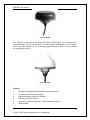
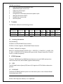
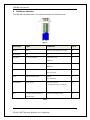
TW5340 Integrated GPS/ GLONASS Receiver/Antenna User Manual Visit us on the web: www.tallysman.com Document # 61-0009-0 TW5340 User Manual Document Amendment Record Revision Date Comments Rev 1_0 7 Nov 2014 Initial release Rev 1_1 11 Nov 2014 Minor edits Rev 1_2 10 Dec 2014 Edit of wake up pin Rev 1_3 4 Mar 2015 TW5340 Rev 3 Standby Mode support Rev 1.4 6 May 2015 Correction to configurator and clarification regarding 10 Hz operation Copyright Copyright 2014 2015 Tallysman Wireless Inc. All Rights Reserved. This document and the subject matter herein are proprietary items to which Tallysman Wireless Inc. retains an exclusive right to reproduction, manufacture and sale. This document is submitted in confidence, for the use of the recipient alone, or in conjunction with Tallysman Wireless Inc. and its licensees, and for no other purpose whatsoever unless permission for further disclosure is expressly granted in writing. Information in this document is subject to change without notice. Tallysman Wireless Inc. 106 Schneider Road, Unit 3 Ottawa ON K2K 1Y2 Canada Tel: 613 591 3131 Fax: 613 591 3121 2 ©2014 -2015 Tallysman Wireless, Inc. Confidential TW5340 User Manual Table of Contents 1 Introduction ................................................................................................................ 5 2 Variants ....................................................................................................................... 7 2.1 3 Ordering Information ........................................................................................... 7 GNSS Systems.............................................................................................................. 7 3.1 GPS ....................................................................................................................... 7 3.2 GLONASS .............................................................................................................. 7 4 NMEA Packet Format .................................................................................................. 8 5 Software Utilities ........................................................................................................ 8 5.1 6 Open Source GPS Software Utilities ..................................................................... 8 Hardware Interface ..................................................................................................... 9 6.1 TW5340 Installation ........................................................................................... 10 6.2 Testing ................................................................................................................ 10 Test Adaptor Pin outs ............................................................................................... 11 NMEA Output test..................................................................................................... 11 Satellite Output Test ................................................................................................. 12 6.3 Power ................................................................................................................. 12 6.4 1PPS .................................................................................................................... 12 Cable Delays: ............................................................................................................. 14 Fix Quality (1PPS Qualification)/Standby .................................................................. 14 6.5 7 Wake Up Input ................................................................................................... 15 Operating Modes ...................................................................................................... 15 7.1 Navigation Mode ................................................................................................ 15 7.2 Standby Mode .................................................................................................... 16 Initialize GPS time ..................................................................................................... 16 7.3 Low Power Mode ............................................................................................... 17 8 Satellite Based Augmentation System (SBAS) .......................................................... 18 9 TW5340 Configuration .............................................................................................. 19 9.1 GENERAL ............................................................................................................. 19 Setting new default parameters ............................................................................... 19 3 ©2014 -2015 Tallysman Wireless, Inc. Confidential TW5340 User Manual Loading new Firmware.............................................................................................. 20 9.2 INTERFACE TAB................................................................................................... 21 9.3 GENERAL TAB ..................................................................................................... 21 9.4 MESSAGES TAB ................................................................................................... 23 9.5 CONSTELLATIONS ............................................................................................... 27 9.6 TRACKING ........................................................................................................... 28 9.7 1 PPS TAB............................................................................................................ 29 9.8 STANDBY TAB ..................................................................................................... 31 10 NMEA Message Reference........................................................................................ 32 RMC ........................................................................................................................... 32 GGA ........................................................................................................................... 33 GSA ............................................................................................................................ 34 GSV ............................................................................................................................ 35 VTG ............................................................................................................................ 36 GLL............................................................................................................................. 36 GNGNS ...................................................................................................................... 37 ZDA ............................................................................................................................ 38 Usage......................................................................................................................... 38 WAAS ........................................................................................................................ 39 4 ©2014 -2015 Tallysman Wireless, Inc. Confidential TW5340 User Manual 1 Introduction The TW5340 GNSS receiver/antenna incorporates the ST STA8088 state of the art receiver which provides 32 high sensitivity tracking channels which can be assigned to acquire and track GPS and GLONASS signals simultaneously. The TW5340 is designed for use in professional grade applications such as precision timing, network synchronization, low current battery and vehicle tracking applications. The TW5340 family of GNSS receiver/antennas employs Tallysman’s Accutenna™ dual feed antenna patch technology which greatly improves rejection of multi-path signals across the whole GNSS band, resulting in much higher precision than single feed antennas which are typically tuned to a single GNSS frequency. The TW5340 supports ST Microelectronics Autonomous A-GPS which accelerates GPS positioning by predicting satellite ephemeris data based on previous observations, this results in extremely fast Time-To-First- Fix. The TW5340 supports 3 modes of operation; Navigation, Standby and Low Current (expert mode parameters only). A hardware interface is provided for external application to control the Standby mode, this is especially useful in applications that require low current drain. The TW5340 outputs standard NMEA 0183 output with navigation updates rates up to 10Hz are supported. Three (3) messages lists can be output each with different output rates. The TW5340 is available with RS232, and CMOS interfaces and input voltage options of 3,3V, 5.0V and 12V. A standard one pulse-per-second 1PPS output is available as a single ended output or as a differential output at RS422 levels. The 1PPS can be configured to be synchronized to UTC, GPS or GLONASS reference time. Tallysman Windows™ based TW5340 Configurator application provides for simple configuration of TW5340 parameters such as tracking, Standby mode operation, 1 PPS timing, constellations, SBAS etc. 5 ©2014 -2015 Tallysman Wireless, Inc. Confidential TW5340 User Manual Figure 1 TW5340 The TW5340 is housed in an industrial grade weatherproof IP67 enclosure for 19mm diameter (¾”) thru-hole mount or mast mount installations. It is available with low profile radome for use in tracking applications and with a conical radome for timing applications. Figure 2 TW5340 Features Standalone Integrated GPS/GLONASS Receiver/Antenna 32 channel simultaneous operation High performance tracking (-162dBm) Fast time to first fix (35mS) Accutenna – Dual feed antenna ( high multipath rejection) SBAS Capable 6 ©2014 -2015 Tallysman Wireless, Inc. Confidential TW5340 User Manual Low noise LNA and SAW band-pass filter NMEA 0183 output; up to 3 lists Differential 1PPS output 1PPS Qualification Configuration information saved across power cycles Waterproof enclosure (IP67) Standby low current mode RoHS compliant 2 Variants The TW534X is offered in the following variants: PRODUCT PWR GND TW5340 (RS232) 3.3V,5V,12V ☑ TX (RS232) RX (RS232) TW5340 (CMOS) 3.3V, 5V ☑ TX (CMOS) RX (CMOS) SIGNALS 1PPS _ A 1PPS_B (RS422) RS422 1PPS _ A 1PPS_B (RS422) RS422 Fix Qual /Standby Fix Qual /Standby Table 1 2.1 Ordering Information Part Numbering: 33-5340-X-YY GPS/GLONASS Smart Antenna 33-5341-X-YY Non-magnetic, GPS/GLONASS Smart Antenna 27-0045-1 TW5340 Test Adaptor Where X= interface/voltage (0= RS232 12V; 1 = RS232 5V; 2 = CMOS 5V, 3 = CMOS, 3.3V, 4 = N/A, 5 = RS232 3.3V), YY= Radome (00= grey conical, 10=grey low profile, 01=white conical, 11=white low profile). 3 GNSS Systems Tallysman TW5340 family of GNSS Receiver/Antennas are multi-GNSS receivers that receive and track GPS, and GLONASS, signals simultaneously. 3.1 GPS The US Global Position System (GPS) uses L1C/A signals at 1575.42 MHz to determine position. 3.2 GLONASS The Russian GLONASS satellite system is an alternative system to the US-based Global Positioning System (GPS). 7 ©2014 -2015 Tallysman Wireless, Inc. Confidential Wake Up Wake up TW5340 User Manual 4 NMEA Packet Format The TW5340 serial interface is based on the NMEA-0183 protocol standard. The NMEA -0183 protocol starts with a “$” character followed by a NMEA Talker ID. “GP” indicates Talker ID for the GPS constellation “GL” indicates Talker ID the GLONASS constellation “GN” indicates Talker ID for all constellations 5 5.1 Software Utilities Open Source GPS Software Utilities The following open source GPS utility can be used to display the GPS and GLONASS GGA and GSV messages with Talker ID’s GP and GL. http://www.visualgps.net/VisualGPSView/ Note: “GN”Talker ID’s are not currently supported by this application. This VisualGPS application can log data which can subsequently be imported into the following data conversion application for easy display tracking data on Goggle maps: http://www.gpsbabel.org/ 8 ©2014 -2015 Tallysman Wireless, Inc. Confidential TW5340 User Manual 6 Hardware Interface The TW5340 is provided with a 5 m cable terminated in a RJ45 connector. Figure 3 Wire Color Signal Comments Pin # Brown Power 12V, 5V or 3.3V depending on model 8 Brown/White Gnd 0V 7 Blue/White RX into the TW5340 RS232 level (+/-6V) 5 CMOS 3.3V Orange TX out of the TW5340 RS232 level (+/-6.6V) 6 CMOS 3.3V Green/White Differential 1PPS output 1PPS_B 1 (0 to 2.0V levels). Green Differential 1PPS output 1PPS_A 2 (0 to 2.0V levels). Orange/White Wake up Input Wake Up -input Low 3 ‘”not supported on Rev 1_0 release” Blue Fix Quality (1PPS Qualification) Continuous mode (0 to 3.3V) 4 /Standby status Table 2 9 ©2014 -2015 Tallysman Wireless, Inc. Confidential TW5340 User Manual Note 1 : TW5340 Hardware has been changed on Rev 3 to provide better noise immunity of the 1PPS outputs. The following pin changes were made: 1PPS B was pin 3 & is now pin 1 1PPS A was pin 4 & is now pin 2 Wake up input was pin 1 & is now 3 Fix Quality/Standby status was pin 2 & is now pin 4 Note 2: There is no change in the Test Adaptor cable 27-0045-0 6.1 TW5340 Installation For best results the TW5340 GPS Receiver/Antenna should installed with a clear view of the sky. The GPS Receiver/Antenna will obtain a 3D fix GPS fix with a minimum of 4 satellites. 6.2 Testing Tallysman TW5340 DB9 Test adaptor (part # 27-0045-1) connects to the RJ45 connector on the TW5430 and provides a DB 9 COM port connection to a PC for testing purposes. Figure 4 shows the test system set-up, connect the adaptor RED wire to the positive supply and the Black wire to Gnd. If the TW5340 outputs at RS232 levels the Test Adaptor can be plugged directly into the PC Com Port, if the TW5340 outputs at CMOS levels a CMOS to RS232 converter will be required between the Test Adaptor and the PC COM port. Baud Rate The default output from the TW5340 is 5 digit resolution GGA, GSV and Usage messages at 115,200 baud. See section 10 for message format information. 10 ©2014 -2015 Tallysman Wireless, Inc. Confidential TW5340 User Manual Figure 4 Test Adaptor Pin outs TW5430 DB9 Test Adaptor (27-0045-1) Power (Pin 8 Brown) Gnd (Pin 7 Brown/White) Pin 5 Gnd TX out (Pin 6 Orange) Pin 2 RX into PC RX in (Pin 5 Blue/White) Pin 3 TX out of PC Table 3 NMEA Output test Run the VisualGPS application (see section 5.1), select the NMEA tab to display message output. Set COM Port: Select Tools/Connect to GPS Figure 5 11 ©2014 -2015 Tallysman Wireless, Inc. Confidential TW5340 User Manual Satellite Output Test To display GPS/GLONASS satellite outputs the TW5340 must be configured to output a GSV and GGA messages (default configuration). Run the VisualGPS application (see section 5.1), select the Front Panel Status tab to display: Figure 6 To read and write the TW5340 configuration parameters the same hardware test configuration is can be used while running the Tallysman Windows based Configurator application on the PC. See section 9 for configuration details. The SBAS satellite is indicated by its NMEA ID and not the PRN #. See Table 5 for details. 6.3 Power The TW5340 operates from 3.3V, 5V and 6to 16 volts. Overvoltage and transient protection is provided making it suitable for installation in the harshest of vehicle installations. On the RJ45 connector shown in Figure 3: Connect the BROWN wire on the TW5340 to Positive supply Connect the BROWN/WHITE wire on the TW5340 to Gnd 6.4 1PPS The TW5340 provides a one (1) pulse-per second output signal for timing purposes. Differential 1PSS outputs are provided at RS422 levels. The 1PPS signal can be synchronized to GPS or GLONASS reference times to an accuracy within 50 nanoseconds. 12 ©2014 -2015 Tallysman Wireless, Inc. Confidential TW5340 User Manual 250 ms 750ms 3V 1PPS_A 0V 3V 1PPS_B 0V Figure 7 The default pulse width is 250 ms, but is configurable from 100 ms to 500 ms. Typical jitter is 20ns. Signal levels are differential, 0.V to 2.03V. After obtaining a GPS fix, the 1PPS output will be accurately maintained even when tracking only one satellite. Once synchronized the 1PPS maintains synchronization accuracy with no GPS reception by fly-wheeling for a period. The following examples are provided for termination of the 1PPS signals. 13 ©2014 -2015 Tallysman Wireless, Inc. Confidential TW5340 User Manual Figure 8 The balanced driver in the TW5430 is an Intersil 3179E. Please check the data sheet for additional information. Cable Delays: The timing of the 1PPS pulse depends on the length of both antenna and interface cables, to account for cable delays add 3ns for each meter of cable. Fix Quality (1PPS Qualification)/Standby This output has a dual function, by default it is a Fix Quality (1PPS qualification) output. 14 ©2014 -2015 Tallysman Wireless, Inc. Confidential TW5340 User Manual If the device is configured to operate in Standby mode the output provides positive feedback that the device has entered Standby mode. Fix Quality (1PPS Qualification) A 1PPS qualification signal is provided to indicates when the 1PPS output is valid, qualification is based on the configured Fix Quality PDOP value, see section 9.3. Figure 9 shows the internal 1PPS qualification status of the TW5340. Once the 1PPS status is detected as good, a Fix Quality Start Delay can be inserted before the 1PPS qualification signal is output to ensure that the TW5340 has time to average out the satellite clocks and provide a stable 1PPS output. On loss of 1PPS qualification status the 1PPS qualification output is maintained for the Fix Quality Flywheel time, see section 9.3. 1 PPS Qualification status 1PPS Qualification output 2.0 V 0V 1PPS Qual stop delay 1PPS Qual Start delay Figure 9 6.5 Wake Up Input The Wakeup input is pulled high by the TW5340. It must be left in this state to enter standby mode. When in standby, the wakeup input must be pulled to ground to cause the TW5340 to exit Standby mode and return to Navigation mode. 7 Operating Modes The TW5340 has three operating modes: 7.1 Navigation Mode The TW5340 uses the acquisition engine continually resulting in the shortest time to first fix. It searches all possible satellites until the almanac is completely downloaded, the receiver then switches to the tracking engine to lower power consumption. 15 ©2014 -2015 Tallysman Wireless, Inc. Confidential TW5340 User Manual 7.2 Standby Mode Standby mode stops the navigation operation and all supply inputs are powered down and power drain is reduced to approx. 200 uA. Standby mode can be configured to periodically enter and exit standby mode for specified times see section 9.8 The general purpose output pin provides a positive feedback that the device has entered Standby mode. When Not In standby the output is pulled high, when in standby the output is floating. External control The W5340 can enter Standby mode by issuing a “$PSTMGOTOSTANDBY” command. $PSTMGOTOSTANDBY,1,<sleep time>,0,<sleep time> <Sleep time> is the number of seconds to remain in standby mode. Note the two sleep times in the command must be identical. The TW5340 can be woken from standby state by the wakeup pin, otherwise it will wake after the specified “sleep time” Pin 3 on the TW5340 can be used to wake the device up. To exit Standby mode the Wake-Up pin must be pulsed low for approximately 1 ms by an open collector output. Note: If the TW5340 is in Standby mode for greater 30 minutes the ephemeris data may old and have to be re-acquired before a GNSS position can be resolved resulting in a cold start of approximately 50 to 90 seconds. As a rule of thumb the TW5340 should be on for 30 seconds every 30 minutes to guarantee a hot start of less than 10seconds. Note: For applications that need to conserve power by waking up quickly from standby mode and getting a fix as quickly as possible it is recommended that both GPS & GLONASS constellations are enabled Initialize GPS time Acquisition of a position fix can be sped up by initializing the TW5430 with the GPS time. The following NMEA command can be used $PSTMINITTIME $PSTMINITTIME,<Day>,<Month>,<Year>,<Hour>,<Minute>,<Second><cr><lf> 16 ©2014 -2015 Tallysman Wireless, Inc. Confidential TW5340 User Manual Parameter Format Description Day dd - decimal, 2 digits Day of month (01 to 31) Month mm – Decimal, 2 digits Month (01 to 12) Year YYYY – Decimal, 4 digits Year (194 - ….) Hour HH – Decimal, 2 digits Hour (00 to 23) Minute MM _ Decimal, 2 digits Minute (00 to 59) Second SS – Decimal, 2 digits Second (00 to 59 Table 4 The following message will be output on the NMEA communications channel $PSTMINITTIMEOK<cr><lf> If success $PSTMINITTIMEERROR<cr><lf> 7.3 If no success Low Power Mode Contact Tallysman Wireless for details on enabling low power mode. After the TW5340 has acquired a position fix, and ephemeris and almanac data has been obtained the receiver is ready to enter Low Power Mode. The TW5340 receiver’s adaptive power management algorithm switches off RF hardware resources whenever possible while maintaining a specified performance level. During low power operation only the highest satellites are tracked and the GLONASS constellation is switched OFF when not required. 17 ©2014 -2015 Tallysman Wireless, Inc. Confidential TW5340 User Manual 8 Satellite Based Augmentation System (SBAS) The TW5340 can be configured to use satellite corrections transmitted by SBAS satellites to provide greater positioning accuracy. There are three compatible SBAS systems which are integrated to provide a seamless worldwide navigation system. Configure the SBAS satellite ID closest to your Location. Service Satellite Name NMEA Satellite ID (PRN) Location WAAS Inmarsat 4-F3 46 133 (longitude) 98⁰ W WAAS Galaxy 15 48 135 133⁰ W WAAS Anik F1R 51 138 107.3⁰ W EGNOS Inmarsat 3-F2 33 120 15.5⁰ W EGNOS Inmarsat 4-F2 39 126 25⁰ E EGNOS Inmarsat 3-F1 44 131 64.5⁰ E MSAS MTSAT-1R 42 129 140⁰ E MSAS MTSAT-2 50 137 145⁰ E Table 5 Table The default satellite ID is 133 (Suitable for longitudes of those of the Eastern US). The TW5340 configurator supports the addition of two future SBAS satellite ID’s. 18 ©2014 -2015 Tallysman Wireless, Inc. Confidential TW5340 User Manual 9 TW5340 Configuration Tallysman provides downloadable software package (part # 45-0030-0) which includes a Windows based “Configurator” for reading and writing of operating parameters and a user manual. Figure 10 Connect the PC to the TW5340 using the Test Adaptor (27-0045-1) Set the TW5340 Configurator to the COM port speed of the TW5340 (115300 baud is default). - Select Program/Read to read the parameters in the TW5300. (Note It is recommended that the default parameters are saved, so that you can always retrieve and Write them back if required). - To write a new set of parameters to the TW5340 select Program/Write - The configuration file can be save by selecting File/Save. Note: Most configuration parameters changes do not take effect until the TW5340 is reset i.e. power cycled. The configurator provides configuration of the “general” parameters of the TW5340. Contact Tallysman Wireless to discuss specific parameters that may not be listed. 9.1 GENERAL Setting new default parameters If you are operating with STANDBY MODE enabled it is recommended that you write your parameters to protected flash using the TW5430 configurator. Select Program/Create Custom firmware with new default configuration 19 ©2014 -2015 Tallysman Wireless, Inc. Confidential TW5340 User Manual Figure 11 Select the current firmware build you are running. Select where your custom firmware build will be output too Select Create Firmware button. Loading new Firmware In the event that Tallysman Wireless releases an upgrade to the TW5340 firmware, or you wish to write custom firmware ( including new default parameters) to the TW5340. Select Program/Load firmware Figure 12 To load Custom firmware using new default parameters select “Use Custom Firmware” And select the “bin” file to load. To load a new firmware update to the TW5340 select “Official Firmware” Select the “Write Speed” based on PC Comm port capability. 20 ©2014 -2015 Tallysman Wireless, Inc. Confidential TW5340 User Manual 9.2 INTERFACE TAB Baud Rate: (default 115200) Sets the operating baud rate of the TW5340. If the baud rate is changed and written to the TW5340 remember to change the Configurator baud rate to match. 9.3 GENERAL TAB Enable watchdog: Enable to set the internal watchdog. TW5340 resets when watchdog times out. Enable Fix Quality output: Enables output on Pin 2 of the TW5340 to indicate Fix Quality OK (1PPS Qualification) Fix Quality Start Delay: (default 10 ms) Inserts a delay before asserting Fix Quality OK. This is the period that the TW5340 waits after detection of a good fix before outputting a 1PPS qualification signal. The TW5340 uses this period to ensure that the TW5300 has time to average out the satellite clocks and provide a stable 1PPS output. Fix Quality Flywheel: (default 10ms) On loss of Fix the Fix quality output flywheels for a period set by this parameter. Fix Quality PDOP Threshold: (default 12) The Dilution of precision (DOP) required for Fix Quality OK. 21 ©2014 -2015 Tallysman Wireless, Inc. Confidential TW5340 User Manual DOP Value Rating Description 1 Ideal This is the highest possible confidence level to be used for applications demanding the highest possible precision at all times. 1-2 Excellent At this confidence level, positional measurements are considered accurate enough to meet all but the most sensitive applications. Good Represents a level that marks the minimum appropriate for making business decisions. Positional measurements could be used to make reliable in-route navigation suggestions to the user. Moderate Positional measurements could be used for calculations, but the fix quality could still be improved. A more open view of the sky is recommended. Fair Represents a low confidence level. Positional measurements should be discarded or used only to indicate a very rough estimate of the current location. Poor At this level, measurements are inaccurate by as much as 300 meters with a 6 meter accurate device (50 DOP × 6 meters) and should be discarded. 2-5 5-10 10-20 >20 Table 6 FIX Rate (Sec) : Defines the time in seconds between fixes. E.g., if a Message list output rate of 10 Hz is required, then the Fix Rate per second should be set to 0.1 sec, or ( 1/ 10 Hz). 22 ©2014 -2015 Tallysman Wireless, Inc. Confidential TW5340 User Manual Text Message: The user modifiable text message which is output on reset. CPU Clock Speed: Sets the CPU clock rate to support the required fix rate. The lower the speed the less current draw. 52Mhz (Osc) provides the lowest operating power. Higher speeds (104 Mhz minimum) will be required to support higher fix rates or accurate timing i.e. 1PPS or NMEA output relative to a fix. The “Usage” message provides information on % of CPU usage, see section 10 for Usage message format. 9.4 MESSAGES TAB SBAS Satellite on GSV Message: The SBAS satellite information is output in a GSV message. NMEA 3.01 Mode field on RMC, VTG, and GLL messages: Setting this option will enable a “mode” field to be appended to the RMC, VTG and GLL sentences, as required by the NMEA 3.01 specification. (See the “mode indicator” in the GNGNS NMEA message, section 10 under GNGNS). Start Up header message: Outputs device information on reset, including version, model, ESN, and user text message. Current Configuration message on startup: Outputs the configuration parameters of the TW5340 on startup. Use GNGSV in place of GLGSV or GPGSV: The GSV message can be configured to be output with GN talker ID. Use GNGSA in place of GLGSA or GPGSA: The GSA message are be configured to be output with GN talker ID. 23 ©2014 -2015 Tallysman Wireless, Inc. Confidential TW5340 User Manual Decimal digits in GGA: Sets the number of decimal digits in GGA output. Decimal Digits in RMC and GLL Sets the number of decimal digits in RMC and GLL output. NMEA Talker ID: (Default is “P”) Assign a unique talker ID to these non-constellation message types. This NMEA talker ID relates to the following message types; RMC, GGA, VTG, GST, GLL, and ZDA. Note: Constellation related messages are automatically assigned on selection of constellation type. • GP” indicates the GPS constellation • “GL” indicates the GLONASS constellation • “GN” indicates satellites for all constellations Delay from Fix to Start of Output: Message output can be delayed related to time of the current fix. This establishes a known offset from the receipt of the NMEA message to the time stamp within the message; thus permitting reliable time transfer. This feature only applies to the high priority message list 3. If the start of a NMEA out message is being used for timing purposes the “fix rate” should be set to 1 second and message list 3 used. For >5Hz fix rate operation this parameter should be set to zero. GLONASS satellite Format: (default ID is based on slot) Selects satellite ID based on “frequency” or “slot” (as reported in almanac and ephemeris data). NMEA output: The TW5340 will output messages that are specified in up to 3 lists. Each of the message lists can be output at a different rates. 24 ©2014 -2015 Tallysman Wireless, Inc. Confidential TW5340 User Manual Message List 1 rate: Sets message list 1 output rate. The rate is specified as the number of fixes between message output. Message List 2 rate: Sets message list 2 output rate. There is No Message List 3 rate: Messages from list 3 are always output at the fix rate. NMEA Message List 1 The basic output message list is shown in Figure 13. Additional outputs are available in expert mode, contact Tallysman for details. Figure 13 Message list 1 is the standard message list. Use message list 1 if the NMEA multiple output rate feature is not required. NMEA Message List 2 Use to output messages at a different rate. For example GSV and GSA can be output at a much lower rate than RMC or GGA. NMEA Message List 3 Message list 3 is reserved for those messages which need to be sent at a high rate (10hz) and /or require accurate message output timing (low jitter). If high rate messages or low jitter messages are not required, this message list should not be used. If you are outputting message list 3 at 10 Hz, message list 1 & 2 should be disabled. If additional lists outputs are required the output message rate of list 1 will need to be 25 ©2014 -2015 Tallysman Wireless, Inc. Confidential TW5340 User Manual reduced e.g. if you configure message list 3 to output GGA at 8 Hz then message list 1 can be configure to output once per second (by setting the Message List 1 Rate to 8). Note 1: When configuring additional NMEA lists check that the baud rate is high enough to ensure there is enough time to output all messages. 10 Hz. Operation For 10 Hz operation the following configuration settings are required: [1] In the “Interface” tab: set the “NMEA Baudrate” to at least 115200. The next time the configurator is run be sure to set the “COM Port Baudrate” in the “Program” Menu “COM Port…” tab to the same value. [2] In the “General” tab set: [a] “Fix Rate (sec)” option to “.1” [b] “CPU Clock Speed” option to “208 MHz (PLL)” [3] In the “Message” tab set: [a] “Delay from Fix to Start of Output (ms)” option to 0 [b] Uncheck all items from List #1 and List #2 (*) [c] Check just one item for List #3 (*) If more NMEA sentence outputs are required, then set the “Message List #1 Rate” option to 10 , so the selected sentences in List #1 are output at most once per second. [4] If fix rate is > 5Hz. [a] In the “Tracking” tab check “High Dynamics”. This enables a higher DSP sample rate. 26 ©2014 -2015 Tallysman Wireless, Inc. Confidential TW5340 User Manual 9.5 CONSTELLATIONS Enable GPS Constellation and fix Enables GPS constellation. (Note for GNS messages the talker ID is “GP” unless GLONASS is also selected, in which case, the talker ID will be “GN”). Enable GLONASS Constellation and Fix: Enables GLONASS constellation. (Note for GNS messages the talker ID is “GL” unless GPS is also selected, in which case, the talker ID will be “GN”). Enable SBAS (WAAS): When set and if data is currently received from an SBAS satellite, then the TW5340 includes the SBAS corrections in the calculated position. SBAS Auto-Search: (default ON) The TW5340 will automatically search for an appropriate satellite in view. SBAS PRN Set the SBAS satellite number to track. SBAS -1 Parameter: PRN Two additional SBAS satellites can be added to the SBAS search list. Enter PRN, Longitude, and Service for each SBAS satellite. SBAS -1 Parameter: Longitude See Table 5 column 5 SBAS -1 Parameter: Service See Table 5, column 1 SBAS -2 Parameter: PRN See Table 5 column 4. SBAS -2 Parameter: Longitude See Table 5 column 5 27 ©2014 -2015 Tallysman Wireless, Inc. Confidential TW5340 User Manual SBAS -2 Parameter: Service See Table 5 column 1 9.6 TRACKING 2 D Fix: ( default off) Enables a two-dimensional GPS position fix that includes only horizontal coordinates (no GPS elevation). It requires a minimum of three visible satellites. Walking mode: (default off) The receiver engine uses different filters in walking mode i.e. does not include velocity in position calculations. Stop Detection: (default on) The receiver engine adjusts filters when a stop condition is detected. This feature should be disabled when doing ‘wander’ testing. High Dynamics: (default off) The receiver engine uses different filters for high acceleration applications. Must be enabled when the fix rate is >5Hz. Acquisition Mask Angle (degrees): The elevation angle of a GNSS satellite below which data will be ignored when acquiring a fix. A lower mask angle may lead to faster acquisition. Positioning Mask Angle: The elevation angle of a GNSS satellite below which data will be ignored once a fix has been acquired. Once a fix has been acquired the mask angle can be increased so that only high satellites are tracked. By setting this parameter to a value less than the acquisition mask angle the satellite will always be used in a fix once it is acquired. Having larger values helps reduce multipath errors. 28 ©2014 -2015 Tallysman Wireless, Inc. Confidential TW5340 User Manual Tracking Threshold (SNR): This parameter sets the minimum C/N0 threshold to track a satellite. Any GNSS satellite, with C/N0 less than the threshold value is dropped and the engine searches for another satellite with a stronger signal level. Increasing the tracking threshold decreases the GNSS sensitivity, but helps prevent errors due to multipath. The value must be in the range 10 to 40. The default is 10. Positioning Threshold (SNR): A satellite must have a signal strength above this threshold to be included in a fix calculation. The default is 15, which helps reduce multi-path errors. Default 2D DOPS A low DOP value represents a better positional precision due to the wider angular separation between the satellites used to calculate a unit's position. These are the maximum allowable values for calculating a 2D fix. Default 3D DOPS: These are the maximum allowable values for calculating a 3D fix. Startup 2D DOPS Set these values the same as the default 2D DOPS. Startup 3D DOP: Set these values the same as the default 3D DOPS. 9.7 1 PPS TAB 1PPS Enable: 1PPS is output when set. Invert 1PPS Polarity: The polarity of the 1PPS output is inverted. 1 PPS Hold Position: The configured Hold Position is used in Timing application as the current position. 29 ©2014 -2015 Tallysman Wireless, Inc. Confidential TW5340 User Manual TRAIM Enable: Enable/disable the TRAIM algorithm Timing Receiver Autonomous Integrity Monitoring allows the receiver to remove satellites with timing errors in excess of a given timing threshold. 1PPS Clock (Mhz) Set to 64 Mhz for highest accuracy 1PPS pulse Duration (ms): Duration of 1 PPS pulse, the default configuration is 250ms. 1PPS Correction (Delay in ns): This is a time correction to compensate for any 1PPS delays due to cable length or the RF chain. Hold Position Latitude (degrees): Sets the latitude for the position hold mode. Hold Position Longitude (degrees): Set the longitude of the position hold mode. Hold Position Height (meters): Set altitude for the position hold mode. 1PPS Elevation Mask (degrees): Sets the elevation mask angle of 1PPS. 1PPS Satellite Threshold (snr): Fix quality evaluation only use satellites above SNR threshold. 30 ©2014 -2015 Tallysman Wireless, Inc. Confidential TW5340 User Manual 1PPS Fix condition: GNSS fix condition for PPS generation. NO FIX: PPS signal is present even in GNSS NO fix conditions. 2D FIX: the PPS is present if the GNSS is at least in 2D fix condition 3D FIX: the PPS is present only if the GNSS is in 3D fix conditions. 1PPS reference time: Sets the 1PPS time reference. 1PPS Output: 1PPS output enabled base on selection. 1PPS Constellations: The 1 PPS derived from GPS, GLONASS or both. 9.8 STANDBY TAB Enable Periodic Standby: Enables the Standby mode low current consumption feature. Sleep Time (seconds) Sets the sleep time in seconds. Fix Time (seconds) Sets the navigation wake time to acquire a fix. In order to refresh satellite ephemeris data the receiver should be configured to transitions to full power every 30 minutes and can remain awake for up to 3 minutes. Maximum Awake Time (Fix count) The maximum number of attempts to get a fix before resuming standby mode. 31 ©2014 -2015 Tallysman Wireless, Inc. Confidential TW5340 User Manual 10 NMEA Message Reference NMEA 0183 sentences are all ASCII. Each sentence begins with a dollar sign ($) and ends with a carriage return linefeed (<CR><LF>). Data is comma delimited. A checksum is optionally added. The first two letters following the „$” are the talker identifier. The next three characters (sss) are the sentence identifier, followed by a number of data fields separated by commas, followed by an optional checksum, and terminated by carriage return/line feed. The data fields are uniquely defined for each sentence type. RMC Recommended Minimum Navigation Information Fields UTC Time Status, V=Navigation receiver warning A=Valid Latitude N or S Longitude E or W Speed over ground, knots Track made good, degrees true Date, ddmmyy Magnetic Variation, degrees E or W FAA mode indicator (NMEA 2.3 and later) Checksum A status of V means the GPS has a valid fix that is below an internal quality threshold, e.g. because the dilution of precision is too high or an elevation mask test failed. 32 ©2014 -2015 Tallysman Wireless, Inc. Confidential TW5340 User Manual GGA Global Positioning System Fix Data Time, Position and fix related data for a GPS receiver. Field : Universal Time Coordinated (UTC) Latitude Direction of latitude N or S (North or South) Longitude Direction of Longitude E or W (East or West) GPS Quality Indicator, 0 - fix not available, 1 - GPS fix, 2 - Differential GPS fix (values above 2 are 2.3 features) 3 = PPS fix 4 = Real Time Kinematic 5 = Float RTK 6 = estimated (dead reckoning) 7 = Manual input mode 8 = Simulation mode Number of satellites in view, 00 - 12 Horizontal Dilution of precision (meters) Antenna Altitude above/below mean-sea-level (geoid) (in meters) Units of antenna altitude, meters Geoidal separation, the difference between the WGS-84 earth ellipsoid and mean-sealevel (geoid), "-" means mean-sea-level below ellipsoid Units of geoidal separation, meters Age of differential GPS data, time in seconds since last SC104 type 1 or 9 update, null field when DGPS is not used Differential reference station ID, 0000-1023 Checksum 33 ©2014 -2015 Tallysman Wireless, Inc. Confidential TW5340 User Manual GSA GPS DOP and active satellites Field : Selection mode: M=Manual, forced to operate in 2D or 3D, A=Automatic, 3D/2D Mode (1 = no fix, 2 = 2D fix, 3 = 3D fix) PRN number, 01 through 32 for GPS, 33 through 64 for SBAS, 64+ for GLONASS ID of 1st satellite used for fix ID of 2nd satellite used for fix ID of 3rd satellite used for fix ID of 4th satellite used for fix ID of 5th satellite used for fix ID of 6th satellite used for fix ID of 7th satellite used for fix ID of 8th satellite used for fix ID of 9th satellite used for fix ID of 10th satellite used for fix ID of 11th satellite used for fix ID of 12th satellite used for fix PDOP HDOP VDOP Checksum 34 ©2014 -2015 Tallysman Wireless, Inc. Confidential TW5340 User Manual GSV GSV - Satellites in view These sentences describe the sky position of a UPS satellite in view. Typically they’re shipped in a group of 2 or 3. Field: Total number of GSV messages to be transmitted in this group Origin number of this GSV message within current group Total number of satellites in view (leading zeros sent) Satellite PRN number (leading zeros sent) Elevation in degrees (00-90) (leading zeros sent) Azimuth in degrees to true north (000-359) (leading zeros sent) SNR in dB (00-99) (leading zeros sent) more satellite info quadruples like 4-7 n) checksum Example: $GPGSV,3,1,11,03,03,111,00,04,15,270,00,06,01,010,00,13,06,292,00*74 $GPGSV,3,2,11,14,25,170,00,16,57,208,39,18,67,296,40,19,40,246,00*74 $GPGSV,3,3,11,22,42,067,42,24,14,311,43,27,05,244,00,,,,*4D Some GPS receivers may emit more than 12 quadruples (more than three GPGSV sentences), even though NMEA-0813 doesn’t allow this. (The extras might be WAAS satellites, for example.) Receivers may also report quads for satellites they aren’t tracking, in which case the SNR field will be null. 35 ©2014 -2015 Tallysman Wireless, Inc. Confidential TW5340 User Manual VTG VTG - Track made good and Ground speed Field : Track Degrees T = True relative to true North Track Degrees M = Magnetic Speed Knots N = Knots Speed Kilometers per Hour over ground K = Kilometers per Hour FAA mode indicator (NMEA 2.3 and later) Checksum GLL Geographic Position - Latitude/Longitude Field : Latitude N or S (North or South) Longitude E or W (East or West) Universal Time Coordinated (UTC) Status A - Data Valid, V - Data Invalid FAA mode indicator (NMEA 2.3 and later) Checksum 36 ©2014 -2015 Tallysman Wireless, Inc. Confidential TW5340 User Manual GNGNS Outputs GPS and Glonass information in the same message list GNSS capable receivers will also output this message with the GP and/or GL talker ID when using more than one constellation for the position fix. An example of the GNS message output from a GNSS capable receiver is: $GNGNS,014035.00,4332.69262,S,17235.48549,E,RR,13,0.9,25.63,11.24,,*70<CR><LF> $GPGNS,014035.00,,,,,,8,,,,1.0,23*76<CR><LF> $GLGNS,014035.00,,,,,,5,,,,1.0,23*67<CR><LF> 1 = Message ID $GNS 2 = UTC of position fix 3 = Latitude 4 = Direction of latitude, N: North, S: South 5 = Longitude 6 = Direction of longitude, E: East, W: West 7 = Mode indicator: Variable character field with one character for each supported constellation. First character is for GPS Second character is for GLONASS Subsequent characters will be added for new constellation Each character will be one of the following: N = No fix. Satellite system not used in position fix, or fix not valid A = Autonomous. Satellite system used in non-differential mode in position fix D = Differential (including all OmniSTAR services). Satellite system used in differential mode in position fix P = Precise. Satellite system used in precision mode. Precision mode is defined as: no deliberate degradation (such as Selective Availability) and higher resolution code (P-code) is used to compute position fix R = Real Time Kinematic. Satellite system used in RTK mode with fixed integers F = Float RTK. Satellite system used in real time kinematic mode with floating integers E = Estimated (dead reckoning) Mode M = Manual Input Mode S = Simulator Mode 8= Number of SVs in use, range 00–99 9=HDOP calculated using all the satellites (GPS, GLONASS, and any future satellites) used in computing the solution reported in each GNS sentence. 10= Orthometric height in meters (MSL reference) 11= Geoidal separation in meters - the difference between the earth ellipsoid surface and mean-sea-level (geoid) surface defined by the reference datum used in the position solution “-” = mean-sea-level surface below ellipsoid. 12= Age of differential data - Null if talker ID is GN, additional GNS messages follow with GP and/or GL Age of differential data 37 ©2014 -2015 Tallysman Wireless, Inc. Confidential TW5340 User Manual 13= Reference station ID1, range 0000-4095 - Null if talker ID is GN, additional GNS messages follow with GP and/or GL Reference station ID 14= The checksum data, always begins with * ZDA ZDA - Time & Date - UTC, day, month, year and local time zone Field : UTC time (hours, minutes, seconds, may have fractional subsecond) Day, 01 to 31 Month, 01 to 12 Year (4 digits) Local zone description, 00 to +- 13 hours Local zone minutes description, apply same sign as local hours Checksum Example: $GPZDA,160012.71,11,03,2004,-1,00*7D Usage $PSTMCPU, 53.13,0,52*6d Field : % of CPU usage Clock Source Clock Speed 38 ©2014 -2015 Tallysman Wireless, Inc. Confidential TW5340 User Manual WAAS $PSTMSBAS,1,2,133,,,43*2C Field: Status ( 1= WAAS ON) Acquire flag PRN Elevation Azimuth Two SBAS channels can be tracked: $PSTMSBASCH,0,133,,,26*76 Field: Channel # PRN Elevation Azimuth $PSTMSBASCH,1,0,0,,,,*42 Field : Channel # PRN Elevation Azimuth 39 ©2014 -2015 Tallysman Wireless, Inc. Confidential