1
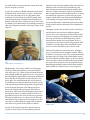
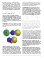
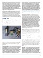
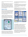
ENY-728
An Introduction to GPS1
Jorge R. Rey2
GPS (Global Positioning System) is a navigation system
composed of a flotilla of satellites put into orbit by the
Department of Defense, and their ground stations. With
GPS, one can automatically determine the precise location
(latitude and longitude) at any point on earth using a
ground device that picks up signals from multiple satellites.
It works continuously in any part of the world and is
available to anyone free of charge. With origins in secret
military applications, GPS is now part of everyday life.
Dedicated receivers are small and inexpensive, and GPS
technology is now found in airplanes, boats, automobiles,
cell phones, personal digital assistants, and many other
common products.
History of GPS
GPS originated from the need of the armed forces for
precise navigation systems that could be used in a variety
of applications. Development of GPS technology rests on
advancements in physics, electronics, materials science,
and many others, but it was the development of extremely
accurate time-keeping devices - atomic clocks, together
with advancements in space technology - that really made
GPS possible. Accurate time-keeping is essential because
GPS relies on timing of signals from satellites to ground
receivers to determine position, and the signal travel times
are very short (see below).
Accurate time keeping - All atoms emit electromagnetic
waves of a characteristic and highly precise frequency when
they switch energy states due to rearrangement of their
electrons. These waves are known as resonant frequencies.
In 1944, I. I. Rabi, winner of that year’s Nobel Prize for
his development of the magnetic resonance technique to
measure the resonant frequencies of atoms, suggested that
because of the precision of atomic resonances, they could
be used to create extraordinarily accurate clocks.
In 1948, the National Bureau of Standards (NBS) in the
USA built the world’s first atomic clock. It used molecules
of ammonia, and the beam tube was a copper pipe wrapped
around the clock face. It was never used for timekeeping
because it was less reliable than quartz clocks, with an error
of about one second in four months. The first functional
atomic clock was built in 1955 and occupied a complete
room at the National Physics Laboratory, UK. It used
resonant frequencies of cesium atoms and was accurate to
within 1 second in 300 years. In 1956, a portable version,
the “Atomichron” that could be easily moved from one
place to another was developed.
Other versions of the atomic clock soon followed using
resonant frequencies from atoms such as cesium and
rubidium, and the hydrogen maser, which used hydrogen
atoms and ammonia molecules. The rubidium-based clocks
1. This document is ENY-728, one of a series of the Entomology and Nematology Department, Florida Cooperative Extension Service, Institute of Food
and Agricultural Sciences, University of Florida. Original publication date April 2006. Revised June 2009. Reviewed July 2012. Visit the EDIS website at
http://edis.ifas.ufl.edu.
2. Jorge R. Rey, professor, Entomology and Nematology Department, Florida Medical Entomology Laboratory, Vero Beach, Cooperative Extension
Service, Institute of Food and Agricultural Sciences. University of Florida, Gainesville, FL 32611.
The use of trade names in this publication is solely for the purpose of providing specific information. UF/IFAS does not guarantee or warranty the
products named, and references to them in this publication do not signify our approval to the exclusion of other products of suitable composition.
The Institute of Food and Agricultural Sciences (IFAS) is an Equal Opportunity Institution authorized to provide research, educational information and other services only to
individuals and institutions that function with non-discrimination with respect to race, creed, color, religion, age, disability, sex, sexual orientation, marital status, national
origin, political opinions or affiliations. U.S. Department of Agriculture, Cooperative Extension Service, University of Florida, IFAS, Florida A&M University Cooperative
Extension Program, and Boards of County Commissioners Cooperating. Thomas A. Obreza, Interim Dean
are smaller and less expensive than the cesium clocks, but
they are not quite as accurate.
In 1967, the second was officially redefined in terms of the
oscillations of the cesium atom (1 second = the duration
of 9,192,631,770 cesium-133 cycles).The primary time
standard in the United States is the NIST-7 atomic clock
at the National Institute of Standards and Technology in
Boulder, Colorado, with an estimated accuracy of 1 second
in 3 million years! Advancements in technology continue to
allow for development of smaller and cheaper atomic clocks
(Figure 1).
Figure 1. Dr. John Kim with the ultra-miniature Rubidium atomic
clock.
Credits: Office of Naval Research
The Space Age - The seed for satellite-based navigation
system was really planted almost concurrently with the
start of the Space Age. When the Soviets launched the first
earth-orbiting satellite, the Sputnik I, in 1957, researchers at
the Johns Hopkins Applied Physics Laboratory in Baltimore
discovered that since they knew exactly where they were
on the globe, they could determine the exact location of
the satellite by measuring the shifts in the frequency of the
radio signal being transmitted by Sputnik as it approached
and moved away from them. This shift in frequencies,
know as the Doppler effect or Doppler shift, had been
known since 1842, when Christian Doppler proposed that
the frequency of waves in motion relative to an observer
apparently increases as the source of the waves approaches
the observer and decreases as it moves away. It was only a
small intuitive leap to figure out that the opposite was also
true; that one could similarly determine one’s position on
earth if the exact position of the satellite was known.
submarines that could stay submerged for weeks and even
months at a time. It consisted of six satellites in polar
orbits. Position was determined using the Doppler shift,
where the satellites transmited a signal that provided the
time of transmission and orbital information to a receiving
unit which then computed its position using the signal
frequency shifts and the time and positional information
corresponding to the signal with no Doppler shift. The
system could determine 2-dimensional position to within
25 meters and it took the submarines six to 10 minutes to
get a fix.
Throughout the 60s, various branches of the armed forces
worked on their own versions of satellite navigation
systems. In 1973, the Department of Defense directed the
services to cooperate on development of a unified system.
The result was the Navstar Global Positioning System,
which relied on satellites that carried atomic clocks (a
concept that was tested on an earlier Navy program called
“Timation”), ground stations that controlled the system,
and user receivers that did not rely on atomic clocks.
The first GPS satellite was launched in 1978. Starting in
1989, a second generation of navigation satellites (“Block
II satellites”) was put into service. The system became fully
operational in 1995. Today’s GPS satellite flotilla consists
of at least 24 Block II satellites (Figure 2). In 1983, after the
Soviets shot down a Korean civilian airliner that intruded
into Soviet Union airspace because of navigational errors,
Ronald Reagan announced that the GPS system would be
made available for civilian uses once it was completed.
Figure 2. Artist rendering of a NAVSAT satellite.
Credits: NASA
In 1965, the US Navy developed the Transit system, in
response to the need of an accurate guiding system for
2
Because the GPS system was developed primarily as a
military application, timing errors (selective availability,
SA) were applied to GPS transmissions that limited the
accuracy of non-military receivers. During the Persian
Gulf War in 1991, GPS had become so essential that not
enough military receivers were available for the troops, so
the Department of Defense had to use civilian units and
temporarily remove SA. Global SA was eliminated in the
year 2000, but the US military can still introduce inaccuracies in the signals over defined geographic areas.
How Does GPS Work?
GPS depends on each satellite on the constellation to
transmit its exact location and an extremely accurate time
to receivers on earth. With this information, GPS receivers
can calculate the distance from the satellite, and by combining this information from four different satellites, the
receiver can calculate its exact position by a process knows
as trilateration.
Trilateration - Once you know the distance to one satellite,
you know that you are located on a sphere centered on the
satellite with a radius equal to your distance to the satellite
(Figure 3A).
represents an absurd location, such as far out in space, or
a point that is moving at an impossible velocity, and can
be rejected without measuring. The fourth measurement,
however, is still needed as explained below.
The fourth satellite - Distance to the satellites is determined by measuring the amount of time that it takes a
radio signal from the satellite to reach the receiver (Distance = velocity X time). Because radio signals travel at the
speed of light (186,000 miles per second) the travel times
are extremely short, thus you need an extremely precise
timing device to measure it accurately, hence the need for
atomic clocks on the satellites. However, the receivers do
not have atomic clocks so there will be measurement errors
on that side of the system and even small timing error can
results in large position error. Here is where the fourth
measurement comes in.
If all measurements are accurate, the sphere defined by
the fourth measurement should intersect the other three
spheres at a point representing our true location. If there
are errors, however, the four sphere will not intersect all
other spheres. Because the receiver error will be the same
for all four measurements, a computer in the receiver can
calculate the correction needed to make all four spheres
intersect and then apply that correction to the measurements to determine the true position.
A fourth measurement also allows the system to compute a
three-dimensional position that includes not only latitude
and longitude, but also elevation. Elevation measurements,
however, are referenced to a mathematical model of the
earth so that they can be expressed in relation to a conventional datum (usually mean sea level). This model is only
an approximation so the elevation readings are usually less
accurate than the latitude and longitude readings, and the
errors are different at different locations around the globe.
Figure 3. Determining position from 3 satellites.
Credits: Jim Newman
With similar information from a second satellite, the
position is narrowed to the area held in common by the
two spheres (shaded area, Figure 3B). Adding information
from a third satellite further narrows down the position
to the two points were the three spheres intersect (small
squares, Figure 3C). To determine which point represents
our exact location we can make a fourth measurement, but
usually one of the two points obtained from three satellites
Other errors - Other errors enter into the GPS signal
measurements, these include atmospheric interference and
reflection from ground obstacles such as buildings and
trees. Several techniques such as dual frequency correction,
signal filters, and mathematical modeling are used to
minimize these errors.
Increased accuracy - Techniques are constantly being
developed to make GPS systems even more accurate and
reliable. The most widely used at this time are differential
GPS (DGPS) and Wide Area Augmentation System
(WAAS). DGPS basically uses land based stations, whose
locations are exactly known, to receive GPS signals, apply
corrections (since they know exactly were they are, they can
3
determine the errors from the GPS signals) and broadcast
them so that properly equipped receivers can use them to
correct their own signals. WAAS is a secondary satellite
system developed by the Federal Aviation Administration
that not only transmits GPS signals, but also monitors and
reports the status of GPS satellites, and transmits differential GPS information. The system is available only over
North America and the Pacific Ocean.
Most GPS units available today are capable of accuracies
of 10 meters or less. Use of advanced techniques such as
the ones mentioned above can bring accuracies down to
a meter or less. Specialized applications which employ
sophisticated data manipulation techniques and high end
equipment can achieve accuracies measured in centimeters.
Uses of GPS
The development of accurate and reasonably priced GPS
receivers (Figure 4), and the continuous miniaturization of
electronic components have made GPS available to almost
everyone, and GPS is rapidly becoming a necessity in many
aspects of everyday life.
intensity of planting, application of fertilizer and pesticides,
watering schedules and many others. These systems can
also help farmers keep track of their farm operations by
maintaining records of yields, chemical application history,
soil analysis results, profit/loss records by field, and many
more. Modern applications of GPS technology in agriculture also include positioning and operation of robotic farm
equipment in the field. For more information on uses of
GPS in agriculture and precision agriculture consult: http://
deathstar.rutgers.edu/projects/gps/web_page/web_page.
html
Land and Sea Navigation - In addition to direct uses
of GPS for determining exact position and for plotting
courses with in-vehicle navigation systems, GPS is being
used to improve the accuracy of nautical charts, for driving
auto-pilot systems, for marking underwater objects such
as dangerous obstructions or that favorite fishing hole, and
for determining exact positions of ships at sea. Emergency
agencies now rely heavily on GPS to improve response
times, and delivery and shipping companies use GPS
systems to keep track of their vehicles more efficiently,
schedule pick-ups and deliveries, and maintain detailed
operational and maintenance records. GPS is also used to
track property, such as motor vehicles, and for roadside
assistance systems such as OnStar.
Military - In addition to the more mundane applications
such as general navigation, GPS is used in the military for
a wide variety of applications, including targeting missiles
and “smart bombs,” force deployment, field coordination
and many others.
Mapping and Surveying - GPS has allowed the creation
of more accurate maps and charts, and is used routinely by
surveyors to map projects and to locate survey markers,
structures, boundaries, and natural features.
Figure 4. Accurate and reasonably priced GPS receivers are now
generally available.
Listing all applications of GPS technology is an impossible
task. Below are just a few examples of current day GPS
applications.
GPS in Agriculture - Satellite navigation is helping farmers
and agribusiness to become more productive and efficient
in their farming practices. Tractor-based GPS systems
together with sophisticated geographic information systems
(GIS) use a variety of techniques to gather data such as
soil condition, humidity, temperature and other variables,
which the system then uses to control things such as
Science - The applications of GPS in science are numerous.
GPS is particularly useful to field researchers for mapping
and locating sampling stations, for defining habitat boundaries, for spatial analysis of natural features, for tracking
populations and many others. GPS is also used widely in
seismology, physics, space sciences and in many other
fields.
Recreation - GPS is used by boaters to track courses and
find favorite locations, by campers, hikers, and bikers to
track their positions and paths and by travel clubs to share
trip information and directions. A recent development is
the game called “geocaching,” which is, basically, a GPSguided scavenger hunt. Players use GPS to travel to specific
4
geographic coordinates and find objects hidden by other
geocachers.
Time reference - GPS is often used as a source of accurate
time. For example GPS may be used to synchronize
multiple scientific recording instruments deployed in the
field or for experiments requiring precise timing. GPS
based timing is also being used for synchronizing cellular
phone towers, telecommunications networks, and many
others. GPS timing was used at the Olympic Games for the
first time in the 2000 games.
Receiver Set-up
In most cases, the average user will employ GPS to pinpoint
their exact location, follow directions to a desired point,
determine the distance and direction to a desired destination, determine altitude, automatically mark a traveled
route so that it can be retraced, mark points of interest
along a route, show general direction of desired travel, or
use it as a traditional compass.
pages with detailed instructions and suggestions for use of
their units. Below are some of the initial steps necessary to
operate a GPS receiver.
User information - Set-up of your receiver starts with entry
of your personal information such as name and address (in
case unit is lost), and of general information and settings
such as the local date, fonts to use, brightness of display,
computer interface, etc.
Display settings - Modern GPS receivers can display a
wealth of information and most give you options on what
information to display on a given screen (Figure 6). Learn
how to change these display settings so that you can always
access the information you need.
In addition to giving you geographic information, many
reasonably priced GPS receivers today can give you a
graphical map display with an overlay of your position,
tracks, and destination (Figure 5). However, in many
cases you need to purchase the terrain data (map) for your
particular location separately.
Figure 6. Learn how to access all receiver’s data screens and how to
modify the data display.
Figure 5. Terrain overlays are available for many receivers.
Operation of GPS receivers varies widely depending
upon the type of receiver and the particular task at hand.
Detailed instructions are found in each unit’s user manual
and should be studied carefully before use. Most major
GPS receiver manufacturers maintain informational web
Select a map datum - A map datum is a reference surface,
which is defined mathematically and approximates the
shape of the earth in particular areas and is used to
calculate the coordinates on any map, chart, or survey
system. Another way to look at it is that a map datum is
a mathematical formula for translating coordinates in a
flat map to the actual shape of the earth and vice-versa. In
North America, the most common datums are the NAD27,
NAD83, and WGS83. WGS83 is rapidly becoming the
worldwide standard, and for North America, it is practically
identical to NAD83 for most common applications. The
NAD27 datum has been replaced by the newer and more
accurate NAD83, but you may still find some old maps
based on the NAD27 datum.
5
If you are working with a printed map, make sure that your
GPS unit is set to the same datum as the map (which should
have the information printed somewhere). Also, if you are
following waypoints or navigating to given coordinates
make sure that your GPS receiver is using the same datum.
Many modern GPS receivers will automatically convert
locations stored in the unit or added by the user to the
correct map datum coordinate system when the datum is
changed in system set-up.
the unit is acquiring satellites, the display usually shows
a circular “chart of the sky” showing the satellites that are
available at that particular location and time, and a bar
graph showing which satellites you are receiving and the
signal “strength” of each (Figure 8). This screen can be
accessed at any time to check on the receiver’s communication status.
Select a coordinate system - Your GPS can report position
information in two major ways, lat-lon and UTM. Lat-lon
is the familiar latitude and longitude and is reported in
degrees minutes seconds north or south (latitude) and east
or west (longitude), for example, 33°12’ 29”N, 80° 23’ 59”E
(or as decimal minutes, 33°12.4833’N, 80°23.9833’W).
UTM stands for Universal Transverse Mercator. In this
system, the world is divided into 60 equal zones from
west to east starting at the180° meridian, and position is
described in kilometers east from the start of each zone
(easting) and away from the equator (northing). In the
northern hemisphere, the northing is the distance from
the equator, whereas south of the equator, the northing is
the distance from the South Pole. You must know which
hemisphere and zone you are in to interpret your location
globally.
UTM coordinates will appear as a series of numbers
starting with the zone number, then the easting and then
the northing (Figure 7).
Figure 8. Screen showing available satellites and their reception by
the receiver.
The first time a unit is used or if it is moved to widely
different geographic locations, the process can be made
more efficient by giving the GPS unit an initial calibration,
which is basically a hint to the receiver of the general area
in which it is located.
Figure 7. Typical display of UTM coordinates (without the text labels).
In the example in Figure 7 the indicated location is 558
kilometers and 365 meters east of the start of zone 17 and
3053 kilometers and 311 meters north of the equator. Most
modern maps will have 1-km UTM grid overlays, which
simplify locating UTM coordinates on maps.
Acquire satellites - The first step in the actual operation
of a GPS receiver is to turn the unit on and let it find
(acquire) at least four satellites Once this is done, the unit
“knows” its exact location and is ready for work. While
Have a backup - Never rely completely on a GPS unit for
navigation in unknown areas. As all electronic/mechanical
devices, GPS units can malfunction (one very common
“malfunction” is running out of batteries, so always carry
spare batteries with your unit). In some areas, such as under
a heavy tree canopy, reception may be bad so you must rely
on other means, such as a map and compass, until you can
re-acquire reception.
Conclusion
Satellite navigation technology has evolved from one
with strictly military applications to a common tool used
throughout the globe. With advances in GPS technology,
falling prices, and simpler human interfaces, we can expect
GPS to continue to make inroads into many aspects of
6
every day life where accurate position information is
relevant.
Additional Web Resources
Geospatial Resource Portal - Global Positioning System http://www.geospatialworld.net.
Grant F. Walton Center for Remote Sensing and Spatial
Analysis - http://deathstar.rutgers.edu/projects/gps/
web_page/web_page.html.
Lowrance, What is GPS? - http://www.lowrance.com/en/
Support/Tips-and-Tutorials/GPS-Tutorial.
Map Tools - http://www.maptools.com/FreeTools/UTMtools.html.
OnStar Technology - http://www.onstar.com/web/portal/
home.
7