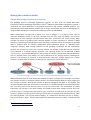
1
Project No. 249024
NETMAR
Open service network for marine environmental data
Instrument:
Please tick
CA
9STREP
IP
NOE
ICT - Information and Communication Technologies Theme
D7.9.2 ICAN semantic interoperability pilot cookbooks
Reference: D7.9.1_ICAN_semantic_cookbooks_r2_20120731
Due date of deliverable (as in Annex 1): M0 + 30
Actual submission date: 31 July 2012
Start date of project:
1 February 2010
Duration: 3 years
Coastal and Marine Resources Centre (CMRC)
Revision 1
Project co-funded by the European Commission within the Seventh
Framework Programme (2007-2013)
Dissemination Level
PU
Public
PP
Restricted to other programme participants (including
the Commission Services)
RE
Restricted to a group specified by the consortium
(including the Commission Services)
CO
Confidential, only for members of the consortium
(including the Commission Services)
X
NETMAR
Open service network for marine environmental data
Project Reference: 249024
Contract Type: Collaborative Project
Start/End Date: 01/03/2010 - 31/01/2013
Duration: 36 months
Coordinator: Prof. Stein Sandven
Nansen Environmental and Remote Sensing Center
Thormøhlensgate 47, Bergen, Norway
Tel.: +47 55 20 58 00
Fax. +47 55 20 58 01
E-mail: [email protected]
Acknowledgements
The work described in this report has been partially funded by the European Commission under the
Seventh Framework Programme, Theme ICT 2009.6.4 ICT for environmental services and climate
change adaptation.
Consortium
The NETMAR Consortium is comprised of:
• Nansen Environmental and Remote Sensing Center (NERSC), Norway (coordinator).
Project Coordinator: Prof. Stein Sandven ([email protected])
Deputy Coordinator: Dr. Torill Hamre ([email protected])
Quality Control Manager: Mr. Lasse H. Pettersson ([email protected])
• British Oceanographic Data Centre (BODC), National Environment Research Council, United
Kingdom
Contact: Dr. Roy Lowry ([email protected])
• Centre de documentation de recherche et d'expérimentations sur les pollutions accidentelles
des eaux (Cedre), France.
Contact: Mr. François Parthiot ([email protected])
• Coastal and Marine Resources Centre (CMRC), University College Cork, National University of
Ireland, Cork, Ireland.
Contact: Mr. Declan Dunne ([email protected])
• Plymouth Marine Laboratory (PML), United Kingdom.
Contact: Mr. Steve Groom ([email protected])
• Institut français de recherche pour l'exploitation de la mer (Ifremer), France.
Contact: Mr. Mickael Treguer ([email protected])
• Norwegian Meteorological Institute (METNO), Norway.
Contact: Mr. Øystein Torget ([email protected])
Author(s)
•
•
•
Declan Dunne ([email protected])
Adam Leadbetter ([email protected])
Yassine Lassoued ([email protected])
Document approval
•
•
•
•
Document status: Revision 1
WP leader approval: 2012-07-30
Quality Manager approval: 2012-07-31
Coordinator approval: 2012-07-31
NETMAR Deliverable
D7.9.1: ICAN semantic interoperability cookbooks
i
Revision History
Issue
Draft
Date
2011-12-05
Draft
2011-12-16
Draft
2011-12-19
Draft
2011-12-20
Draft
2011-12-22
Draft
2011-12-23
1
Draft
2011-12-29
2012-07-18
Draft
Draft
2012-07-18
2012-07-19
Draft
2012-07-26
Draft
2012-07-26
Draft
2012-07-27
Draft
2012-07-30
Draft
2012-07-31
2
2012-07-31
© 2012 NETMAR Consortium
Change records
Added first draft of the “Understanding semantics”
cookbook.
Added first draft of the “Connecting your Atlas”
cookbook.
Revised the “Understanding semantics” cookbook
according to comments from quality control.
Added first draft of the “Metadata” and “CSW
metadata catalogue” cookbooks.
Revised the “Connecting your Atlas” cookbook
according to comments from quality control.
Revised the “Metadata” and “and “CSW metadata
catalogue” cookbooks according to comments from
quality control.
Final release approved by coordinator.
Updated version of the “Understanding semantics”
cookbook.
Updated version of the “Metadata” cookbook.
Updated version of the “CSW metadata catalogue”
and “Connecting your Atlas” cookbook.
Revised the “Understanding semantics” cookbook
according to comments from quality control.
Revised the “Connecting your Atlas” cookbook
according to comments from quality control.
Revised the “CSW metadata catalogue” cookbook
according to comments from quality control.
Revised the “Metadata” cookbook according to
comments from quality control.
Revised the Executive Summary according to
comments from quality control.
Final release approved by coordinator.
Author(s)
A. Leadbetter
Y. Lassoued
A. Leadbetter
D. Dunne
D. Dunne
D. Dunne
T. Hamre
A. Leadbetter
D. Dunne
D. Dunne
A. Leadbetter
D. Dunne
D. Dunne
D. Dunne
D. Dunne
T. Hamre
EC FP7 Project No. 249024
NETMAR Deliverable
D7.9.1: ICAN semantic interoperability cookbooks
ii
Executive Summary
The NETMAR project will develop a pilot European Marine Information System (EUMIS) that
will enable users to search, download and integrate satellite, in situ and model data from
ocean and coastal areas. EUMIS will be a user-configurable system offering flexible service
discovery, access and chaining facilities based on open and widely adopted web GIS
standards. EUMIS will be a distributed system where a number of services and subsystems
will be integrated and made interoperable by means of semantic technologies.
NETMAR’s ICAN (International Coastal Atlas Network) pilot is scoping and implementing
data interoperability approaches for distributed coastal web atlases (CWAs). The ICAN
community wish to make their ongoing digital atlas developments more interoperable to
better support data discovery, data visualisation, and data sharing across administrative,
natural and thematic borders. Data discovery is central to this pilot as it enables subsequent
data visualisation and data sharing. Data discovery includes smart search functionality
utilising “semantic” resources.
If data in a distributed system are to be understood elsewhere in that system, or externally to
the system, they must be labelled (or “marked up”) using a common set of meaningful terms
or phrases. These common phrases must be consistent throughout the full data system, or
there must be a means of translating between the phrases used at different points of the
system, using common “semantics”. The aim of the “semantic web” is to provide these
consistent phrases and to define the relationships in a formal manner, resulting in what is
often called a “knowledge organization system”, fulfilling the vision of Tim Berners-Lee to
make a world wide web of data which may be queried in the same way as a traditional
relational database system.
Atlas developers require guidelines to support improved semantic interoperability and
connectivity between distributed atlases, both legacy and new. This document contains short
documents or “cookbooks” which explain key information behind the NETMAR ICAN pilot.
Central to these cookbooks is material to help atlas developers connect to the International
Coastal Web Atlas (ICWA) prototype. It is a prototype atlas mediator which provides a
common interface for accessing distributed local atlases, such as MIDA (Marine Irish Digital
Atlas), OCA (Oregon Coastal Atlas), and Washington Coastal Atlas (WCA). It uses a
knowledge organization system to improve data discovery by exploiting the semantics of
keywords and allowing users to search data by “meaning” rather than by “mere keywords”.
The ICWA prototype version 3 is being funded by the NETMAR project.
In order for an atlas to connect to the ICWA prototype, the atlas developer must, at a
minimum, install a CSW metadata catalogue. This CSW metadata catalogue is then
registered with the ICWA Administrator to connect to the prototype. The ICWA requires
CSW version 2.0.2 supporting the ISO Metadata Application Profile version 1.0.0, that is
able to deliver metadata in Dublin Core and ISO 19115/19139. ISO 19119/19139 service
metadata is also supported by the ICWA. There is no particular requirement as to the
metadata profile used, but metadata records need to include keywords. However, to fully
exploit semantics for data discovery, the atlas developer must use semantic resources for
metadata keywords.
Four cookbooks are included in this document which covers key material concerning the
technologies and standards utilised by the ICWA prototype:
© 2012 NETMAR Consortium
EC FP7 Project No. 249024
NETMAR Deliverable
D7.9.1: ICAN semantic interoperability cookbooks
iii
1. Understanding Semantics.
2. Understanding Metadata.
3. Establishing a CSW metadata catalogue with GeoNetwork opensource.
4. Connecting your Atlas to the ICWA prototype.
The “Understanding Semantics” cookbook provides a tutorial for those who wish to
investigate and make use of semantic web and knowledge organization system
technologies. These technologies fall broadly into three groups: vocabularies, thesauri and
ontologies. This cookbook includes material explaining how to deploy semantics which are
required by the ICWA prototype, utilising the NERC Vocabulary Server (NVS) infrastructure.
The “Understanding Metadata” cookbook provides a tutorial for those who wish to
understand metadata. Included is a description of metadata and why we need it, metadata
standards in use today, description of different metadata hierarchy levels, and a list of some
metadata editing tools available. The section also references example metadata records
aimed at system developers who are familiar with ISO 19115/19119 metadata implemented
in ISO 19139 XML. These metadata examples include semantic keywords which are
registered in the NVS.
The “Establishing a CSW metadata catalogue with GeoNetwork opensource” cookbook
provides a tutorial for those who wish to understand CSW (Catalog Services for the Web)
metadata catalogues. Included is a description of a metadata catalogue, the CSW standard,
and a list of selected CSW servers. The document also contains initial pointers to
establishing a CSW server using GeoNetwork opensource and examples of selected CSW
query operations aimed at system developers. GeoNetwork is recommended and used by
the NETMAR project.
The “Connecting your Atlas to the ICWA prototype” cookbook provides a step-by-step guide
explaining how to connect a local atlas as a node in the ICWA prototype utilising
technologies and standards described in the other cookbooks. This cookbook specifies the
ICWA connection requirements including metadata (ISO 19115/19119/19139), CSW
metadata catalogues (CSW 2.0.2, ISO Metadata Application Profile version 1.0.0), and
supported ISO 19139 encoding forms for semantic keywords.
© 2012 NETMAR Consortium
EC FP7 Project No. 249024
Concept map taken from the ICAN Coastal Erosion Thesaurus - http://vocab.nerc.ac.uk/scheme/ICANCOERO/current/
Table of Contents
Introduction ............................................................................................................................................3
Why use a “knowledge organization system”?.........................................................................................3
What are vocabularies, thesauri and ontologies?.....................................................................................4
How to discover existing knowledge organization systems?.....................................................................6
Can I reuse existing resources? ............................................................................................................6
Where might I find existing knowledge organization systems?.............................................................6
How to define the content of a knowledge organization system? ............................................................7
What is the scope of the knowledge organization system? ..................................................................7
Identifying the content ........................................................................................................................7
How narrow or broad should a term definition be?..........................................................................7
Linking term definitions together .....................................................................................................7
Ensuring the quality of the content of the Knowledge Organization System.........................................8
Making the content available...................................................................................................................9
Simple Knowledge Organization System ..............................................................................................9
Deploying ICAN semantics in the NETMAR semantic framework ........................................................10
Bridging to existing Knowledge Organization Systems........................................................................13
Incorporating knowledge organization systems in ICAN metadata .........................................................14
Acknowledgements ...............................................................................................................................14
Document Information ..........................................................................................................................15
2
Introduction
"If HTML and the [World Wide] Web made all the online documents look like one huge book,
[semantics] will make all the data in the world look like one huge database"
Tim Berners-Lee1
If data in a distributed system are to be understood elsewhere in that system, or externally to the
system, they must be labelled (or “marked up”) using a common set of meaningful terms or phrases.
These common phrases must be consistent throughout the full data system, or there must be a means
of translating between the phrases used at different points of the system, using common “semantics”.
Semantics is the study of meaning; it focuses on the relationships between words and what they stand
for or mean. The aim of the “semantic web” is to provide these consistent phrases and to define the
relationships in a formal manner, resulting in what is often called a “knowledge organization system”.
This document provides a tutorial for those who wish to investigate and make use of these technologies,
aimed specifically at members of the International Coastal Atlas Network community and more
generally at environmental scientists and data managers.
Why use a “knowledge organization system”?
One scenario for using knowledge organization systems in the International Coastal Atlas Network2
(ICAN) is to search through the local atlases for a given data keyword from a central portal. For example,
as illustrated below, a user arrives at the ICAN portal and request “coastline” data. The portal software
is connected to a global knowledge organization system which is aware that “coastline” is related to
both “shoreline” and “high resolution coastline”. The user request and this information from the global
knowledge organization system are then passed on to the local atlases which search on “coastline”,
“shoreline” and “high resolution coastline”. The local atlases then return the relevant data to the portal
and then to the user. This is an implementation of so-called “smart-search”3.
1
Berners-Lee, T. (1999) Weaving the Web: The Past, Present and Future of the World Wide Web by its Inventor.
Orion Business. ISBN-100752820907
2
http://ican.science.oregonstate.edu/
3
Latham, S. E.; Cramer, R.; Grant, M.; Kershaw, P.; Lawrence, B. N.; Lowry, R.; Lowe, D.; O'Neill, K.; Miller, P.;
Pascoe, S.; Pritchard, M.; Snaith, H.; Woolf, A. (2009) The NERC DataGrid services. Philosophical Transactions of the
Royal Society A, 367 (1890). 1015-1019.
3
A diagram illustrating one use for knowledge organization systems in the ICAN community.
Other uses of knowledge organization systems include populating metadata elements with standardized
content which can be verified and validated by software services; dynamically populating drop down
lists in websites and software applications; dynamically moving a metadata record from one metadata
scheme to another; and the validation of input parameters and their associated units in Open Geospatial
Consortium Web Processing Services.
What are vocabularies, thesauri and ontologies?
Knowledge organization systems fall broadly into three groups: vocabularies, thesauri and ontologies.
These three groups show increasing complexity in their structure as illustrated in the diagram below.
The "semantic spectrum" shows the increasing complexity of different forms of knowledge organization
4
system. After McGuinness (2003) .
4
Deborah L. McGuinness. (2003) Ontologies Come of Age. In Dieter Fensel, James Hendler, Henry Lieberman, and
Wolfgang Wahlster (eds). Spinning the Semantic Web: Bringing the World Wide Web to Its Full Potential.
Massachusetts Institute of Technology Press.
4
A vocabulary can be either a list of terms or a list of terms and some text providing a definition of the
term. A vocabulary ensures that terms are used, and spelt, consistently. A vocabulary can be extended in
its power by providing definitions of concepts.
Thesauri expand the knowledge contained within a vocabulary by adding information about the
relationships between the terms of the vocabulary. These relationships fall broadly into three
categories:
•
•
•
Synonyms – the current term is synonymous with a given, different term. e.g. “dogs” is
synonymous with “canines”.
Broader relations – the current term has a more specific definition than a given different term.
e.g. “dogs” has a broader relationship to “pets”
Narrower relations – the current term has a less specific definition than a given different term.
e.g. “dogs” has a narrower relationship to “terriers”
In a more complex thesaurus, the concepts at the top of the hierarchy of broader and narrower relations
may be stated explicitly, rather than being inferred by software agents. A well known example of this
form is the Yahoo! web directory5 or the categorisation of auctions on the eBay homepage6. eBay has
terms such as “Antiques”, “Coins” and “Sporting Goods” as the top level in its hierarchy. Narrower terms
sit below these, for example “Sporting Goods” contains “Football”, “Golf” and “Sailing”. These terms sit
above those which are narrower still, “Sailing” having such narrower terms as “Clothing & Shoes”, “Life
Jackets” and “Rope”. In the context of environmental sciences, the Global Change Master Directory7 can
be seen to work in this way. For example, “Oceans” is at the top level, with “Coastal Processes” beneath
it and terms such as “Beaches” and “Coastal Elevation” beneath that.
These more complex thesauri also introduce a fourth category of relationship between concepts, that of
a “loose relationship”. That is where two terms have a relationship that is not of the broader or
narrower type or a synonymous relationship, e.g. “domesticated dogs” are “loosely related” to “wild
dogs”. These loose relationships may allow different pathways to the discovery of a term, making the
resource what is known as “orthogonal”. For example, eBay has “Walking, Hiking, Trail” in its “Fashion”
auction categories and “Boots & Shoes” in its “Sporting Goods” auction categories. If these two were
loosely mapped a search for “walking boots” could yield auction results from both categories.
A thesaurus may be expanded to an ontology by declaring a term to belong to a particular class; or the
addition of property information to the term; or the restriction of values that data associated with the
term may take. An ontology class is used to define a type which can be used to group related terms. For
example, if eBay defined the class of “auction” particular individual terms belonging to the “auction”
class could be “English auction”, “blind auction” or “Dutch auction”.
5
http://dir.yahoo.com/
http://www.ebay.com/
7
http://gcmd.nasa.gov/
6
5
How to discover existing knowledge organization systems?
Can I reuse existing resources?
Where possible it is best to make use of existing knowledge organization systems. This increases the
ability to reuse data across systems, known as interoperability. If the reuse of existing systems is not an
option, the section below explains how to generate a new knowledge organization system. Any new
system should have some specified relationships to an existing system to promote interoperability and
flexibility (see page 13). Details of how to access an existing knowledge organization system relevant to
the International Costal Atlas Network are provided on page 12 of this document.
It is also possible to extended existing resources by creating mappings between them and other
resources. This activity is described on page 13, below.
Where might I find existing knowledge organization systems?
In order to reuse existing resources, it is essential to know where to find them and how to asses their
quality. Existing resources which may be of interest can often be found in ontology registries, for
instance the Marine Metadata Interoperability Ontology Registry and Repository8 or the NERC
Vocabulary Server9. The former has a search facility on its home page; the latter may be searched most
easily through the SeaDataNet vocabulary pages hosted by Maris10. Both of these systems provide
publication mechanisms for knowledge organization systems which may be created by a range of
authorities, and the creating authority is acknowledged in the systems’ output. An additional benefit of
these systems is that they provide versioning of the content of the knowledge organization systems that
they serve.
Other resources that are of interest to the Earth Sciences domain exist outside of these registry systems.
These include the NASA’s Global Change Master Directory7 and Semantic Web for Earth and
Environmental Terminology11; the European Environment Agency’s General Multilingual Environmental
Thesaurus (GEMET)12; the GeoSciML vocabularies13; and the United States Geological Survey
thesaurus14.
When considering the use of an existing knowledge organization system, the key things to look for are:
an individual web address (or URL) to each term defined – this is how you will mark up your metadata; a
well documented version control system; and an authoritative body in control of the content of the KOS.
8
http://mmisw.org/orr/
http://vocab.nerc.ac.uk/
10
http://seadatanet.maris2.nl/v_bodc_vocab/welcome.aspx/
11
http://sweet.jpl.nasa.gov/ontology/
12
http://www.eionet.europa.eu/gemet/
13
http://srvgeosciml.brgm.fr/eXist2010/brgm/client.html
14
http://www.usgs.gov/science/about/
9
6
How to define the content of a knowledge organization system?
What is the scope of the knowledge organization system?
While it might be tempting to want to describe and define every imaginable concept in a new
knowledge organization system, this would be a very time consuming and frustrating process, and
would not make best use of other, pre-existing resources. Instead, it is much better to take the time to
identify the specific domain that needs to be described by the terms you wish to define, for example
coastal erosion, or names and extents of beaches. In this way work in building the knowledge
organization system is tightly defined and the content is coherent, well understood and should not
replicate existing resources.
Identifying the content
How narrow or broad should a term definition be?
The challenge of integrating data and information of different kinds at different levels of detail is well
defined in computer science literature15,16. In the area of semantics on the World Wide Web, the level of
detail a term can describe is known as its granularity. For a given level of a knowledge organization
system the definitions of a term may be as broad or as narrow as is necessary, as long as they are not
ambiguous.
However, when building a hierarchical thesaurus, it is important that concepts defined at the same level
of the hierarchy maintain a similar degree of granularity. If the thesaurus is imagined as a pyramid,
making a concept at a given level too narrow or broad in its definition is like placing a too small or too
large brick in the wall of the pyramid, and makes the structure unstable. For example, “body of water”
should not sit at the same level as “lake” or “reservoir”, as these are terms with a narrower relationship
or a finer granularity.
Linking term definitions together
As described above, the definition of terms by themselves is useful but the impact of the work can be
greatly extended by providing relationships which link the terms together to form networks of
knowledge. This enhances the ability of a user to find data labelled with a given term or to translate the
metadata from one mark up scheme to another. Relationships can be thought of simply as broader and
narrower (for example, in the diagram below the BODC Parameter Discovery Vocabulary is narrower
than the SeaDataNet Agreed Parameter Groups and vice versa); loosely related (the BODC Parameter
Usage and MEDATLAS Parameter Usage vocabularies are of similar granularity and are linked this way);
and synonyms where two terms may be used interchangeably.
15
Fonseca, F., Egenhofer, M., Davis, C., and Câmara, G. (2002) Semantic Granularity in Ontology-Driven Geographic
Information Systems. AMAI Annals of Mathematics and Artificial Intelligence - Special Issue on Spatial and
Temporal Granularity 36(1-2): 121-151.
16
Yan, X., Lau, R.Y.K, Song, D., Li, X., Ma, J. (2011) Towards a Semantic Granularity Model for Domain Specific
Information Retrieval. ACM Transactions on Information Systems (TOIS). In press.
7
9
An example from the NERC Vocabulary Server to show how identifying relationships between terms builds a
network of parameter definitions.
Ensuring the quality of the content of the Knowledge Organization System
There are two aspects to providing quality assurance, or governance, for a knowledge organization
system. The first is to ensure the quality of the content of the knowledge organization system. This
includes the names and definitions of terms and the relationships between the terms. A well tested
mechanism for managing content governance is setting up an e-mail list of interested parties on which
requests for new terms and mappings can be discussed. This is the model which has been implemented
by: the Climate and Forecast17 netCDF metadata conventions group; the SeaDataNet and MarineXML
Vocabulary Content Governance Group (SeaVoX)18; and the NETMAR ontology governance body19. The
role of the content governance group is analogous to the International Organization for Standardization
(ISO) definition of a “control body”20.
The second aspect is assuring the technical quality of the system. This includes ensuring that the
knowledge organization system is available with the greatest possible up-time; the representation of the
system is valid in the chosen scheme (e.g. extensible markup language, XML); and the various versions
of the concepts, collections and scheme are maintained and accessible. For example, within the
NETMAR project this technical governance is provided by the British Oceanographic Data Centre as the
developer and maintainer of the NERC Vocabulary ServerError! Bookmark not defined. (NVS). The role
of the technical governance group is analogous to the ISO definition of a “register manager”20.
17
http://cf-pcmdi.llnl.gov/
https://www.bodc.ac.uk/data/codes_and_formats/seavox/
19
http://netmar.nersc.no/
20
http://www.dgiwg.org/Terminology/faq-other.php
18
8
Making the content available
Simple Knowledge Organization System
The NETMAR project’s knowledge organization systems are built upon the World Wide Web
Consortium’s Simple Knowledge Organization System21 (SKOS) standard. SKOS is designed to provide a
method for the online publication of controlled vocabularies and thesauri. NETMAR publishes two
International Coastal Atlas Network thesauri and an Oregon Coastal Atlas thesaurus as XML documents
using the SKOS standard. A brief overview of SKOS is therefore provided below.
SKOS is based upon concepts that it defines as a “unit of thought”, i.e. an idea or notion such as
“shoreline emergency access” or “oil spill”. Concepts may also carry other information, such as their
relationships to other concepts and information about their provenance and version history. SKOS
provides the means for grouping those concepts together as either collections or schemes. A SKOS
collection is a grouping of concepts which share something in common and can be conveniently grouped
under a common label, for example “SeaDataNet agreed parameter groups” or “ISO19115 topic
categories”. Similarly, SKOS concept schemes are also groupings of concepts but the relationships
between the concepts are a part of the concept scheme. For example, if the eBay auction categories
were published as a concept scheme, “Antiques” and “Sporting Goods” can be identified as SKOS
topConcepts, the broadest definitions in the pyramids of concepts. The narrower concept definitions
such as “Antique Clocks” and “Sailing” can also be delivered in the concept scheme, including their
position in the hierarchy of concepts, as illustrated below. Therefore, concept schemes are a useful
model for the publication of thesauri, for example the “ICAN coastal erosion thesaurus.”
An illustrative example of top concepts in SKOS, and the first level of their associated narrower terms.
SKOS also defines three forms of relationship between concepts. A concept may be broader or narrower
than another concept, or related to another concept. The related attribute allows the loose mapping of
one concept to another, allowing the resource to become orthogonal (see page 5). The broader and
narrower attributes allow the construction of a hierarchy. If a concept belongs to a hierarchical scheme
and is an entry point to that hierarchy (that is, at the top of the tree) it can be declared as a SKOS
topConcept. For concepts in the same scheme, the broader and narrower relations may be said to be
transitive; that is a concept two levels below a given concept can be inferred to be narrower than the
concept in question without explicitly stating a relationship. For example (and illustrated below), eBay
has “Sporting Goods” as a top level auction category, or a topConcept. Narrower than this is “Sailing”,
and still narrower is “Rope”. If these relationships were declared as transitive “Rope” could be inferred
21
http://www.w3.org/2004/02/skos/
9
to be narrower than “Sporting Goods”, which is not explicit in the non-transitive SKOS narrower
relationship.
An illustration of transitive relations in SKOS using terms from the eBay classification of auctions.
The differences between SKOS concept collections and concept schemes are very limited in the W3C’s
specification. The NETMAR project has chosen to use schemes as a discovery tool for concepts, and
collections to store and publish concepts and for referencing their identifiers.
The NETMAR semantic framework has additionally extended the SKOS model to allow synonyms to be
identified using the Web Ontology Language’s22 sameAs attribute. This clearly allows the labelling of
the relationship between two concepts which are identical, which is not a feature of the basic SKOS
model.
Deploying ICAN semantics in the NETMAR semantic framework
Incorporating a Knowledge Organization System
The simplest way for an ICAN community member to develop a new controlled vocabulary or thesaurus
(or propose new content for an existing vocabulary or thesaurus) for incorporation within the
framework is to create two worksheets in a spreadsheet: one for concept names and definitions; the
other for relationships between concepts.
The first worksheet, illustrated below, should contain columns for
1. Concept key
• An identifier for the concept, unique within the vocabulary. It does not need to carry
any meaning.
2. Concept name and title
3. Concept alternative name (e.g. abbreviation)
4. Concept definition.
22
http://www.w3.org/TR/owl2-overview/
10
Concept Key
Concept name
and title
Concept alternative
name
74PQ
Plymouth
Quest
PQ
Concept definition
{"title":
"RV","callsign":
"MEEU8",
"platformClass":
"research
vessel",
"commissioned":
"2004-0324","previous_name": "Sigurbjorg"}
Each concept must only occupy one row of the worksheet. If the definition needs to carry some
structured information (such as information regarding the identity of a ship’s hull or the bounding box of
a geographic area), this should be encoded using an alternative to XML, such as the JavaScript Object
Notation (JSON) standard, i.e. enclosed in curly brackets and formed of “key”:”value” pairs separated by
commas. For example:
{"title": "RV", "callsign": "MEEU8", "platformClass": "research
"commissioned": "2004-03-24","previous_name": "Sigurbjorg"}
vessel",
The second worksheet should contain three columns describing the relationship between concepts:
1. Subject
• The subject of the sentence describing the relationship.
2. Relationship
• Narrower, broader, related or sameAs mapping.
3. Object
• The object of the sentence describing the relationship.
Subject
74PQ (“Plymouth Quest”)
Relationship
Is narrower than
Object
http://vocab.nerc.ac.uk/collection/L06/current/31/
(“research vessel”)
74PQ (“Plymouth Quest”)
Is narrower than
http://vocab.nerc.ac.uk/collection/L19/current/SDNKG04
(“platform”)
Once complete, the spreadsheet should be submitted to [email protected] along with supporting
information about the domain scope of the concepts, the content governance for the knowledge
organization system and the name and contact details for those authorised to make changes to the
resource. The supporting information for the ICAN Coastal Erosion thesaurus, for example, is:
11
•
Domain scope: “Thesaurus containing coastal erosion dataset (including GIS layer) terms
compiled by ICAN and mapped to a global thesaurus. Includes both markup and discovery terms
from the mapped components.”
•
Content governance: “International Coastal Atlas Network”
The knowledge organization system will be deployed in the NETMAR semantic framework and further
updates can be made by authorised persons through a web interface accessed from the British
Oceanographic Data Centre website23.
Accessing the Knowledge Organization System
Once deployed within the NETMAR semantic framework, a knowledge organization system can be
accessed in much the same way as a web site, using Uniform Resource Locators24 (URLs) to navigate the
NVS. The base URL for the NVS is:
http://vocab.nerc.ac.uk
Catalogues of the SKOS concept collections and schemes hosted on the NVS can be accessed at:
http://vocab.nerc.ac.uk/collection/
http://vocab.nerc.ac.uk/scheme/
Once the identifier for an individual collections or schemes is known, it can then be accessed from:
http://vocab.nerc.ac.uk/collection/collection_id/current/
e.g. http://vocab.nerc.ac.uk/collection/C17/current/ is the URL for the International
Council for the Exploration of the Seas platform codes collection from which the
example worksheets above were taken
http://vocab.nerc.ac.uk/scheme/scheme_id/current/
e.g. http://vocab.nerc.ac.uk/scheme/ICANCOERO/current/ is the URL for the ICAN
Coastal Erosion thesaurus
Finally, an individual concept can be accessed through this form of URL:
http://vocab.nerc.ac.uk/collection/collection_id/current/concept_id/
e.g. http://vocab.nerc.ac.uk/collection/C17/current/74PQ/ gives access to the concept
definition for “Plymouth Quest” which was described in the example worksheets
above
23
24
https://www.bodc.ac.uk/data/codes_and_formats/vocabulary_editor/
http://en.wikipedia.org/wiki/Url
12
The collection URLs also provide a mechanism for accessing any concepts which have been removed
from the collection (known as deprecation), or only those concepts which are currently accepted
members of the collection or all the concepts which have ever been part of the collection (the default if
neither deprecated, accepted or all is specified as a suffix to the collection URL):
http://vocab.nerc.ac.uk/collection/collection_id/current/deprecated/
http://vocab.nerc.ac.uk/collection/collection_id/current/accepted/
http://vocab.nerc.ac.uk/collection/collection_id/current/all/
The ../current/../ portion of the URLs given in this section is a shortcut to the most recent version of the
collection or scheme. This can be replaced with an integer value in order to retrieve a given version of a
collection or scheme.
In addition to this URL based access, application developers can make use of Simple Object Access
Protocol (SOAP)25 based access described in the associated Web Services Description Language (WSDL)
document26.
Bridging to existing Knowledge Organization Systems
Labelling data and metadata using a knowledge organization system is a first step to making those data
interoperable with other datasets. However, if the knowledge organization system has defined
relationships to other systems the likelihood of the metadata and data being discovered and reused
alongside other data increases. Linked data is an initiative of the World Wide Web Consortium to create
a web of data described knowledge organization systems. The diagram on the next page shows how this
web of data is highly interconnected.
A range of environmental science and geospatial knowledge organization systems exist that may be of
interest for bridging a new knowledge organization system too. These include those stored in the NVS
and the Marine Metadata Interoperability Ontology Registry and Repository8; the European
Environment Agency General Multilingual Environmental Thesaurus12; and GeoNames27. Relationships
between a concept in the NVS and any external concept can be specified in the same way as the internal
mappings (see page 7) but with the NVS URL replaced by the URL of the external concept as the object
of the relationship. For example:
http://vocab.nerc.ac.uk/collection/P21/current/MS10360/ (sulphides)
“broader”
http://www.eionet.europa.eu/gemet/concept/4350 (inorganic substances)
http://vocab.nerc.ac.uk/collection/C19/current/3_1_2_1/ (Adriatic Sea)
“sameAs”
http://sws.geonames.org/3183462/
25
http://en.wikipedia.org/wiki/SOAP
http://vocab.nerc.ac.uk/v2.wsdl
27
http://www.geonames.org/
26
13
28
The Linking Open Data project cloud .
Incorporating knowledge organization systems in ICAN metadata
This is described in detail in the accompanying cookbook: “Connecting Your Atlas.” However, in
overview, the web address (URL) of a term defined in a knowledge organization system should be
incorporated within a metadata document, in the appropriate field. This may be as either a string, in an
XML element such as gco:CharacterString, or as a reference from an anchor field, using the
xlink:href=”http://...” syntax.
Acknowledgements
This cookbook was written for the International Coastal Atlas community under the auspices of the
NETMAR (Open Service Network for Marine Environmental Data) project. NETMAR is partially funded by
the European Commission under Theme ICT-2009.6.4 ICT for environmental services and climate change
adaptation of the Information & Communication Technologies FP7 Programme.
This document has been reviewed by, and incorporates comments from, Jennifer Andrew and Roy
Lowry of the British Oceanographic Data Centre; Torill Hamre of the Nansen Environmental and Remote
Sensing Center; Yassine Lassoued of the Coastal and Marine Research Centre, University College Cork;
François Parthiot of CEDRE; Peter Walker of Plymouth Marine Laboratory; and John Helly of the San
Diego Supercomputer Center. Thanks go to the reviewers for their help in making the document clear
28
http://richard.cyganiak.de/2007/10/lod/imagemap.html
14
and readable. Further feedback on this document is welcomed, and may be provided by contacting the
author whose details are below.
Document Information
Author
Adam Leadbetter, British Oceanographic Data Centre
Contact
[email protected]
Version
2.1
Date
2012 July 26
Revisions
2.1
Responses to NETMAR internal review. Fixing spelling mistakes;
adding new definitions; clarifying some existing definitions; additional
concept scheme diagram.
2.0
2012 July 17: Comments from ICAN community with respect to
discovery of existing resources included
1.0
2011 December 19
15
International Coastal Atlas Network Cookbook:
Understanding Metadata
Table of Contents
Introduction ............................................................................................................................................3
What is metadata? ..................................................................................................................................3
Why do you need metadata?...................................................................................................................3
Metadata standards and profiles .............................................................................................................4
ISO 19115 / 19119 / 19139 ..................................................................................................................5
Dublin Core..........................................................................................................................................5
INSPIRE................................................................................................................................................5
FGDC / NAP .........................................................................................................................................6
Metadata hierarchy levels .......................................................................................................................6
Metadata editing tools ............................................................................................................................7
Metadata encoding .................................................................................................................................8
Metadata examples.................................................................................................................................9
Metadata and the ICWA prototype........................................................................................................11
Acknowledgements ...............................................................................................................................11
Document Information ..........................................................................................................................12
2
Introduction
This document provides a brief tutorial for those who wish to get an overview of metadata, with a focus
on the ISO 19115 metadata standard. It is aimed specifically at members of the International Coastal
Atlas Network (ICAN) community and more generally at scientists, data managers, and system
developers. Aimed at scientists and data managers, this document includes a description of metadata
and why we need it, metadata standards in use today, description of different metadata hierarchy
levels, and a list of selected metadata editing tools available. Aimed at system developers, this
document also includes information on metadata encoding using ISO 19139 XML and a reference to
example metadata records located on the NETMAR WIKI. ISO 19115/19139 metadata is a requirement
to connect to the International Coastal Web Atlas (ICWA) prototype.
What is metadata?
Geospatial metadata is “data about data”. It contains information that documents the basic
characteristics of a geospatial data resource. It can also document basic characteristics of geospatial
applications or services. Metadata falls into broad categories where it answers the “what, why, when,
who, where and how” questions about the resource. These questions include1:
•
What:
Title and description of the data.
•
Why:
A narrative summary detailing the reasons for data collection and its uses.
•
When:
When the data was created and the update cycles, if any.
•
Who:
Originator, data supplier, and possibly the intended audience.
•
Where:
The geographical extent based on latitude and longitude coordinates,
geographical names or administrative areas.
•
How:
How the data was produced and how to access the data.
Why do you need metadata?
Metadata helps a user to find or discover the data that they need and, thereafter, evaluate whether this
resource satisfies the user’s requirements. Once a user has chosen the resource, usage metadata is then
required to help fully understand and interpret the data. Metadata can be used in-house to help locate
and use internal data resources. If a staff member leaves an organisation, important knowledge may
also leave the organisation too. New staff members may have difficulty in taking up new responsibilities
and fully understanding the organisation’s data resources. Such undocumented data resources may lose
1
Wilson, M., 2009, Chapter Three: Metadata -- Describing geospatial data, Spatial Data Infrastructure Cookbook.
3
value or cost time to relearn its value. Metadata can also be used to locate data resources published by
other organisations, helping to minimise duplication of data collection and enabling more efficient and
cost-effective use of this data. Specific examples of business cases for using metadata outlined by the
Federal Geographic Data Committee (FGDC) include2:
Data Management:
•
Preserve data history so that the data resource can be reused or adapted.
•
Assess the age and character of data holdings to determine which data should be maintained,
updated or deleted.
•
Improve data accountability.
•
Limit data liability by explicitly stating data limitations of use.
Project Management:
•
Plan and document the data resources required for a project.
•
Monitor data resources’ development progress.
•
Share data resources’ development progress with project participants.
•
Ability to access data characteristics for outsourced data production by ensuring metadata is a
contract deliverable.
Metadata standards and profiles
In order for geospatial metadata to operate effectively between different organisations and data users,
metadata must be compliant with international standards. Such standards provide a common structure
and format to describe metadata. Standards enable improved metadata interoperability and integration,
thus, facilitating more seamless sharing, searching, and discovery of metadata between organisations
and users of geospatial data and services. Discovery metadata is the minimum amount of information
that needs to be provided to help users find geospatial resources. Prominent metadata standards in use
today include:
2
•
ISO 19115 (Geographic information – Metadata)
•
ISO 19119 (Geographic information – Services)
•
ISO 19139 (Geographic information – Metadata – XML schema implementation)
•
Dublin Core (ISO 15836)
Business Case for Metadata (http://www.fgdc.gov/metadata/metadata-business-case)
4
•
FGDC Content Standard for Digital Geospatial Metadata (CSDGM)
ISO 19115 / 19119 / 19139
The ISO 19115 standard provides a model or structure for describing geospatial data resources (e.g.
digital datasets), while the ISO 19119 standard extends ISO 19115 to describe geospatial service
resources (e.g. dataset view services). In turn, the ISO 19139 standard defines an XML schema for the
physical implementation of these standards. As these are international standards, they are being widely
adopted by governments and organisations around the world. While metadata entities and elements are
well defined within the ISO standards, there is an extensive list of optional metadata elements on top of
the mandatory metadata element set. It is left up to the system developer to define a specific
information model or profile. There is no single metadata profile that fits all users’ needs. Therefore,
there is a need for metadata profiles to be adopted to support various regional, national, organisational,
and communities’ requirements.
The ISO 19115 standard is currently under formal review. The proposed ISO 19115-1 (Geographic
information - Metadata - Part 1: Fundamentals) standard is expected to be approved in 2013, with the
proposed XML schema implementation expected in 2015. The existing ISO standards are recommended
until these revisions and associated implementations are formally approved and mature.
Dublin Core
The Dublin Core (ISO 15836) standard defines a cross-domain model or structure for describing web
resources, typically general electronic documents. The Dublin Core Metadata Element Set contains
fifteen properties. While Dublin Core can be successfully applied to describe geospatial resources, the
ISO 19115 standard is more specialised in describing such geospatial resources. Since Dublin Core and
19115 are independent standards, therefore, a crosswalk is required to map from one standard to the
other3 4. Some metadata tools (e.g. GeoNetwork opensource), automatically provide a mapping from
ISO 19115 to Dublin Core.
INSPIRE
Within Europe, the INSPIRE Directive5 has defined a base metadata profile which is specified in
European legislation. INSPIRE adopts the underlying ISO 19115 standard. However, full conformance to
the ISO 19115 mandatory element set implies the provision of additional metadata elements which are
not mandated by INSPIRE legislation. However, the INSPIRE metadata encoding guidelines respects
these ISO 19115 mandatory elements by ensuring they are included as implementation
recommendations. In addition, INSPIRE is defining thematic dataset specifications. Individually these
dataset specifications have adapted some additional ISO 19115 elements on top of base INSPIRE
metadata profile to help data evaluation.
3
ftp://cenftp1.cenorm.be/PUBLIC/CWAs/e-Europe/MMI-DC/cwa14857-00-2003-Nov.pdf
OpenGIS Catalogue Services Specification 2.0.2 - ISO Metadata Application Profile, Version 1.0.0, OGC 07-045
5
http://inspire.jrc.ec.europa.eu
4
5
FGDC / NAP
Within the U.S., the Content Standard for Digital Geospatial Metadata (CSDGM) standard is the U.S.
federal standard, while the North American Profile (NAP) of ISO 19115 is the U.S. national standard. The
Federal Geographic Data Committee (FGDC) developed CSDGM in the 1990s for federal agencies.
CSDGM is often referred as the ‘FGDC metadata standard’. This standard preceded the ISO 19115
standard. The American National Standards Institute (ANSI), the U.S. member body of the ISO, adopted
ISO 19115 in December of 2003. The U.S. and Canada have aligned national profile development efforts
with the cooperative development of the NAP. An initial profile was adopted in 2009. In September
2010, the FGDC formally endorsed the NAP. However, once the NAP profile is fully developed, the FGDC
will process it as a federal standard. Therefore, transition from CSDGM to NAP is an on-going process6.
Metadata hierarchy levels
Metadata may exist at different levels of granularity. The most common implemented levels are
“dataset” and “series”. A dataset is defined by ISO 19115 as an: “identifiable collection of data” (e.g. a
raster map). A dataset series is defined by ISO 19115 as a: “collection of datasets sharing the same
product specification” (e.g. a collection of raster maps captured from a common series of paper maps).
Metadata for which no hierarchy is listed are interpreted to be “dataset” metadata by default. Finer
levels of granularity include feature and attribute metadata. Examples include: feature type (e.g. a
tunnel), feature instance (e.g. the Mont Blanc Tunnel), attribute type (e.g. overhead clearance
associated with a tunnel), and attribute instance (e.g. overhead clearance associated with the Mont
Blanc Tunnel). These data hierarchical relationships are illustrated in Figure 1.
In addition, metadata can also be used to describe geospatial services, which typically includes
information on how to access and invoke such services. Service metadata is defined by ISO 19119 as: “a
service metadata record describes a service instance, including a description of the services operations
and an ‘address’ to access the specific service instance”. An example of a service metadata is a
description of a Web Map Service (WMS) that enables viewing of a raster map collection.
7
Figure 1: Metadata hierarchy
6
7
Preparing for International Metadata, Federal Geographic Data Committee, October 20, 2011
ISO 19115:2003, Geographic information - Metadata
6
Metadata editing tools
A metadata editor is a program that is used for creating and editing metadata. It typically uses an
intuitive graphical user interface which protects the user from the details of the underlying ISO 19139
XML document. A metadata editing tool may include functionalities such as:
•
Creating, editing, deleting and viewing of metadata and metadata templates
•
Metadata validation (support for XML schema and Schematron validation)
•
Import and export of metadata
•
Metadata search
•
Automatic metadata generation
•
Pre-processing and post-processing of metadata
•
Extraction and transformation of metadata to different standards and formats
•
Additional functionalities such as automatic selection of bounding box coordinates, thesaurus
functions, etc.
Several metadata editing tools have been developed. Commonly used commercial metadata editing
tools include:
1. ESRI ArcGIS Desktop (http://www.esri.com/)
2. Intergraph GeoMedia (http://www.intergraph.com/)
3. MapInfo Manager (http://www.pbinsight.com/)
Commonly used Opensource/freeware metadata editing tools include:
1. CatMDEdit (http://catmdedit.sourceforge.net/)
2. GeoNetwork opensource (http://geonetwork-opensource.org/)
3. M³Cat (http://www.intelec.ca/)
A screenshot of the GeoNetwork opensource metadata editor is shown in Figure 2. Example metadata
fields illustrated include:
•
title of the dataset (name in which the dataset is known)
•
creation, publication and revision dates of the dataset
•
identification code for the dataset (“SeaLevelRise” in the example)
•
original owner of the dataset (orgainisation’s name and contact details)
7
Figure 2: GeoNetwork opensource metadata editor
•
dataset’s abstract (narrative summary)
•
purpose of dataset (summary of intentions)
An alternative to using geographic metadata editing tools is to directly edit the ISO 19139 XML
document metadata using an XML editor (e.g. XMLSpy). However, this is only recommended for
advanced users who have knowledge of ISO 19139 XML.
Metadata encoding
Metadata can be stored internally within a digital dataset or in a separate external file. Metadata can
also be stored in a database to facilitate more efficient searching. The underlying metadata model (an
8
ISO 19115 profile) is the first important aspect to metadata interoperability. At the physical
implementation level, ISO 19139 defines an XML implementation of the ISO 19115 metadata model
using XSD (XML Schema Definition) schemas. The 19139 schemas define the structure of the XML
metadata document. Therefore, an ISO 19139 XML implementation is the second important aspect to
achieve interoperable metadata sharing and exchange between organisations and users of data. The
details of the ISO 19139 encoding are not required to be understood by the typical metadata user. Most
users typically use graphical based metadata search, view and editing tools. However, for system
developers building spatial data infrastructures and who wish to understand more about the ISO 19139
encoding, some useful guidance resources include:
1. UK Gemini Encoding Guidance, version 1.2
http://location.defra.gov.uk/wp-content/uploads/2010/04/UKGEMINI-EncodingGuidance_20110505v1-2.pdf
2. Guidance notes for the production of discovery metadata for the Marine Environmental Data
and Information Network (MEDIN), version 2.3.7
http://www.oceannet.org/marine_data_standards/medin_approved_standards/documents/me
din_schema_documentation_2_3_7_14mar12.pdf
ISO 19139 XSD schema sets for the full ISO 19115/19119 element set are available in the official ISO
repository8 and the OGC repository9. The unofficial EDEN repository10 is a useful alternate as it has
implemented patches to fix schema issues identified by users. It is recommended that metadata is
validated against the ISO 19139 XML schema to ensure compliance with the standard. For metadata
profiles which have specific requirements or constraints, then Schematron validation is also
recommended in addition to XML schema validation. Schematron is a rule based validation language. Its
strength is its ability to enforce additional constraints which XML schema cannot (e.g. specific attribute
validation).
Metadata examples
For system developers who are familiar with XML, example metadata records can be downloaded from
the NETMAR WIKI:
•
http://eumis.nersc.no/en/wiki/-/wiki/Main/Metadata
Examples include 19115/19139 dataset metadata for vector and raster datasets, and ISO 19119/19139
service metadata examples for WMS and WPS. The details of this ISO 19139 XML are best described in
the MEDIN and UK Gemini documents (referenced in the previous section).
Metadata keywords can be selected from a controlled vocabulary. A metadata user should decide if a
controlled vocabulary should be used for their metadata keywords, and if so, whether an existing
8
http://standards.iso.org/ittf/PubliclyAvailableStandards/ISO_19139_Schemas/
http://schemas.opengis.net/iso/19139/
10
http://eden.ign.fr/xsd/isotc211/isofull/
9
9
vocabulary can be reused or a new vocabulary created. Please refer to the “Understanding Semantics”
cookbook for future details regarding vocabularies, thesauri and ontologies.
Figure 3 illustrates an example segment of a MIDA (Marine Irish Digital Atlas) metadata record which
uses thesauri for keywords. These thesauri are registered in the NERC Vocabulary Server11 (NVS). This
metadata example can be downloaded from the NETMAR WIKI.
Figure 3: GeoNetwork opensource metadata editor
(contains two “Descriptive keywords”, each containing a keyword URI registered in NVS)
11
http://vocab.nerc.ac.uk/
10
The two metadata keyword fields illustrated in Figure 3 are:
•
Keyword name:
NVS URI:
Thesaurus:
Oceanographic geographical features
http://vocab.nerc.ac.uk/collection/P22/current/28
INSPIRE themes
•
Keyword name:
NVS URI:
Thesaurus:
Sea Level Change
http://vocab.nerc.ac.uk/collection/A04/current/SeaLevelChange
MIDA Coastal Erosion Thesaurus
Other metadata fields illustrated in Figure 3 include:
•
Dataset’s use limitations (e.g. fitness for use) and access constraints (e.g. intellectual property
rights)
•
Dataset spatial type (i.e. “vector” dataset in the example)
•
Dataset scale (i.e. “1:100000” in dataset in the example)
•
High level thematic classification (i.e. “Oceans” in the example)
•
Dataset’s geographic area description, code identifier (i.e. “Northeast Atlantic” in the example)
and geographic latitude/longitude coordinates
Metadata and the ICWA prototype
ISO 19115/19119/19139 metadata is required to connect to the International Coastal Web Atlas (ICWA)
prototype. Profiles conforming to these standards should, in practice, connect to the ICWA. However,
specific ICWA requirements regarding the encoding of semantic keywords are described in detail with
snippet examples in the “Connecting your Atlas to the ICWA prototype” cookbook. In addition, a CSW
(version 2.0.2) metadata catalogue server is required to publish and query metadata via the web. This is
described in the “Establishing a CSW metadata catalogue with GeoNetwork opensource” cookbook.
Acknowledgements
This cookbook was written for the International Coastal Atlas community under the auspices of the
NETMAR (Open Service Network for Marine Environmental Data) project. NETMAR is partially funded by
the European Commission under Theme ICT-2009.6.4 ICT for environmental services and climate change
adaptation of the Information & Communication Technologies FP7 Programme.
This document has been reviewed by, and incorporates comments from, Torill Hamre of the Nansen
Environmental and Remote Sensing Center; Peter Walker of Plymouth Marine Laboratory; and John
Helly of the San Diego Supercomputer Center. Thanks to the reviewers for their help in making the
document clear and readable. Further feedback on this document is welcomed, and may be provided by
contacting the author whose details are below.
11
Document Information
Author
Declan Dunne, Coastal and Marine Research Centre
Contact
[email protected]
Version
2.1
Date
2012 July 30
Revisions
2.1
Responses to NETMAR internal review
2.0
Comments from ICAN community
1.0
2011 December 23
12
International Coastal Atlas Network Cookbook:
Establishing a CSW metadata catalogue
with GeoNetwork opensource
Table of Contents
Introduction ............................................................................................................................................3
What is a metadata catalogue?................................................................................................................3
What is CSW? ..........................................................................................................................................3
CSW Application Profiles..........................................................................................................................3
CSW Servers ............................................................................................................................................4
Installing and configuring GeoNetwork 2.6.4 ...........................................................................................5
Installing GeoNetwork 2.6.4.................................................................................................................5
Configuring the database for GeoNetwork 2.6.4 ..................................................................................6
Configure GeoNetwork for Tomcat (optional) ......................................................................................8
Starting GeoNetwork 2.6.4 (required for Jetty) ....................................................................................9
Stopping GeoNetwork 2.6.4 (required for Jetty).................................................................................10
GeoNetwork 2.6.4 Administration .....................................................................................................10
Adding metadata records in GeoNetwork 2.6.4..................................................................................10
Examples of CSW operations .................................................................................................................12
CSW GetRecordById operation request..............................................................................................12
CSW GetRecords operation request...................................................................................................13
Acknowledgements ...............................................................................................................................14
Document Information ..........................................................................................................................14
2
Introduction
This document provides a tutorial for those who wish to understand CSW (Catalog Services for the Web)
metadata catalogues, with a focus on the ISO Metadata Application Profile of CSW. It is aimed
specifically at members of the International Coastal Atlas Network community and more generally at
scientists, data managers, and system developers. Included in this document is a description of a
metadata catalogue, the CSW standard, and a list of selected CSW severs. The document also contains
initial pointers to establishing a CSW server using GeoNetwork opensource, and examples of selected
CSW query operations aimed at system developers. GeoNetwork is recommended and used by the
NETMAR project.
What is a metadata catalogue?
A metadata catalogue stores and publishes collections or sets of metadata records describing data,
services, and related information resources. A user can search for and discover these resources within
the metadata catalogue. Distributed metadata catalogues enable searching of metadata catalogues
across the Internet between organisations.
What is CSW?
Standards are required to enable interoperable searching of distributed metadata catalogues between
organisations. This is achieved using the CSW (Catalog Services for the Web) standard1. CSW is an OGC
(Open Geospatial Consortium) specification that defines common interfaces and operations to query
and retrieve metadata contained in metadata catalogues. It enables a client application to search or
query metadata across organisational boundaries. Formal query languages supported by CSW are Filter
encoding and CQL (Common Query Language). Filter Encoding is an XML encoded query language, while
CQL is a text encoded query language which attempts to be more human readable. Filter encoding is a
joint OGC2 and ISO3 standard. A simple Filter encoding example is outlined in a later section of this
document.
CSW Application Profiles
While the common interfaces and operations of OGC catalogue services are well defined, it is left up to
the system developer to define a specific information model for the catalogue service implementation.
This includes mandatory and optional metadata elements to be incorporated in the catalogue,
supported query languages, available search terms, results, etc. Experience has shown there is no single
1
OpenGIS Catalogue Service: http://www.opengeospatial.org/standards/specifications/catalog
OpenGIS Filter Encoding: http://www.opengeospatial.org/standards/filter
3
ISO 19143:2010, Geographic information -- Filter encoding:
http://www.iso.org/iso/iso_catalogue/catalogue_tc/catalogue_detail.htm?csnumber=42137
2
3
solution for catalogue services that fits every user’s needs. Therefore, there is a need for application
profiles4. OGC has developed these profiles against CSW version 2.0.2:
1. ISO Metadata Application Profile (version 1.0.0)
2. ebRIM Profile (version 1.0.1)
3. OWL Application Profile (version 0.3)
Metadata catalogues that use ISO 19115 and ISO 19119 as its underlying information model should
use the ISO Metadata Application Profile of CSW. The Filter encoding query language is mandatory for
this profile, with CQL optional. Upon CSW client query requests, such CSW catalogues return ISO 19115
or ISO 19119 metadata records implemented using an ISO 19139 XML schema encoding. Also upon CSW
client query requests, the return of Dublin Core encoded metadata is supported by the ISO Metadata
Application Profile of CSW. The CSW specification defines the mappings between ISO 19115/19119 and
Dublin Core.
CSW Servers
A CSW server is software that implements a metadata catalogue with a CSW interface. A CSW server
may also implement ancillary metadata management functionality such as metadata editing tools,
harvesting and synchronisation of metadata between distributed catalogues, group and user
management, etc.
Several CSW servers have been developed. Commercial CSW servers include:
1. ESRI ArcGIS Server (http://www.esri.com/)
2. Intergraph GeoMedia (http://www.intergraph.com/)
3. MapInfo Manager (http://www.pbinsight.com/)
Opensource/freeware CSW servers include:
1. Constellation (http://constellation.codehaus.org/)
2. Degree (http://www.deegree.org/)
3. GeoNetwork opensource (http://geonetwork-opensource.org/)
4. GI-cat (http://essi-lab.eu/cgi-bin/twiki/view/GIcat/)
GeoNetwork opensource is recommended and used by the NETMAR project as a CSW server. It is open
source, supports ISO 19115/19119 and ISO 19139, supports the OGC CSW ISO Metadata Application
Profile, has a strong user community, and is used by many government agencies across Europe to
support the implementation of the INSPIRE Directive. For static metadata it is recommended to use
4
OpenGIS Catalogue Services Specification 2.0.2 - ISO Metadata Application Profile, Version 1.0.0, OGC 07-045
4
GeoNetwork as an editing tool, unless specific organisations have special requirements which require
the use of an alternative tool. For more dynamic metadata which needs to be automated in a processing
chain, it is recommended that a data provider use alternative tools or scripting/programming languages
to automate metadata production. However, for such dynamic metadata production environments,
GeoNetwork can still be utilised as a CSW server. Guidance notes regarding the installation and
configuring of GeoNetwork are outlined in the next section. Methods for metadata ingestion into
GeoNetwork are also included.
Installing and configuring GeoNetwork 2.6.4
This section contains some guidance notes regarding the installation and configuring of GeoNetwork
opensource version 2.6.4 aimed at system developers. GeoNetwork is an open source implementation
of the CSW 2.0.2 ISO Metadata Application Profile 1.0.0 standard. It can run on Microsoft Windows,
Linux and Mac OS X. The latest version can be downloaded from:
•
http://sourceforge.net/projects/geonetwork/
A detailed user manual can be found on the GeoNetwork opensource website:
•
http://geonetwork-opensource.org/manuals/2.6.4/users/
For software developers, a detailed developer manual can also be found on the GeoNetwork
opensource website:
•
http://geonetwork-opensource.org/manuals/2.6.4/developer/
By default GeoNetwork comes embedded with the Jetty Servlet container. However, Apache Tomcat
(version 5.5+) is also supported via a custom install. GeoNetwork requires an RDBMS database in order
to store metadata and ancillary information. The default database in GeoNetwork 2.6.4 is an embedded
McKoiDB RDBMS database. However, other RDBMS databases including MySQL, PostGreSQL, Oracle and
generic JDBC (Java Database Connectivity) connections are supported. It is recommended to use a
standalone database instead of McKoiDB in a production environment. These installation instructions
deal with configuring the MySQL database.
Installing GeoNetwork 2.6.4
Before installing GeoNetwork 2.6.4, please make sure you have a Java Runtime Environment (JRE 1.5.0+)
installed. You can use the GeoNetwork Windows installer (.exe file) for the Windows platforms, or the
platform independent installer (.jar file) for any platform (also works on Windows). For example, to start
the graphical installation wizard in Windows double click on:
geonetwork-install-2.6.4-0.exe
To run the platform independent graphical installation wizard double click on:
5
geonetwork-install-2.6.4-0.jar
To run the platform independent graphical installation wizard from the command line type:
java -jar geonetwork-install-2.6.4-0.jar
Once the wizard is running, simply follow the onscreen instructions.
Configuring the database for GeoNetwork 2.6.4
After GeoNetwork 2.6.4 is installed we next need to configure the GeoNetwork database. For these
installation instructions we are using MySQL. You can download the open source MySQL Community
Server from the MySQL website: http://dev.mysql.com/downloads/. Alternatively on UNIX systems, you
may be able to download and install MySQL Community Server via a UNIX distribution stream. Once you
have successfully installed the MySQL server, next you can create a dedicated database for GeoNetwork
2.6.4, e.g. by using the following commands:
mysql -u root –p
create database myDatabase;
CREATE USER 'myUsername'@localhost IDENTIFIED BY 'myPassword';
GRANT SELECT, INSERT, UPDATE, DELETE, CREATE, INDEX, DROP ON *.*
TO 'myUsername'@'localhost';
To start configuring the GeoNetwork database we need to run GeoNetwork’s GAST software GeoNetwork’s Administrator Survival Tool. GAST is a standalone Java application. It performs
administration tasks such as the configuration of the JDBC connection to the RDBMS database, database
initialisation, etc. More detailed information on GAST can be found in the GeoNetwork user manual.
To start GAST on Windows, simply click:
Start GAST (under Start > Programs > GeoNetwork opensource)
GAST can also be started by double clicking on:
gast.jar (in the .../geonetwork/gast directory)
GAST can also be started from the command line by typing:
java -jar gast.jar (in .../geonetwork/gast directory)
Next, we need to configure and connect GeoNetwork to this new database. Once GAST is running, click
the DBMS link (Figure 1). In this example, we configure GeoNetwork to connect to the MySQL database
that we created previously. Then click the Save when finished.
6
Figure 1 GeoNetwork GAST – DBMS configuration
Next, we need to initialise this new database for GeoNetwork 2.6.4 by creating tables that are required
by GeoNetwork. Within the GAST, click the Setup link in the left menu, and then the Setup button within
the main menu (Figure 2). This will recreate and reinitialise GeoNetwork’s internal tables (note: this will
overwrite and reinitialise existing tables if the database has previously been setup with GAST).
Figure 2 GeoNetwork GAST – Database setup
Note: in GeoNetwork 2.6.4 the following error message may appear in a dialog box when setting up the
MySQL database for the first time via the GAST tool:
Error: Cyclic reference found:
[relations, categories, settings, languages, sources, isolanguages,
isolanguagesDec, Regions, RegionsDes, Users, Operations,
OperationsDes, Groups, GroupsDes, UsersGroups, CategorisesDes,
Metadata, MetadataCateg, OperationAllowed]
7
This error message can be ignored. Please click “OK” in this dialog box, and the GeoNetwork database
setup will continue.
Configure GeoNetwork for Tomcat (optional)
If you wish to deploy GeoNetwork on Apache Tomcat as opposed to the embedded Jetty, then you have
a number of options. If you installed GeoNetwork using the steps outlined in the previous sections, then
you have two main options to configure for Tomcat:
1. Leave the existing GeoNetwork installation in the “.../geonetwork/web/geonetwork/” directory
and point a Tomcat context file (named geonetwork.xml) to this directory. An example
geonetwork.xml file is:
<Context docBase=".../geonetwork/web/geonetwork/"
privileged="true"
antiResourceLocking="false"
antiJARLocking="false">
</Context>
The context file is usually placed in the $CATALINA_HOME/conf/Catalina/localhost directory.
Make sure that the Tomcat user has the appropriate permissions to access the GeoNetwork
installation directory.
2. An alternative option is to copy the installation from “.../geonetwork/web/geonetwork/” to
Tomcat’s webapps directory. Tomcat will then automatically pick up the GeoNetwork
installation. Make sure that the Tomcat user has the appropriate permissions to access this
copied installation directory.
If you did not install GeoNetwork using the steps outlined in the previous sections, then you have a third
option to configure for Tomcat:
3. Download the geonetwork.war file from the GeoNetwork download website. This file can be
placed in the Tomcat’s webapps directory where it will be automatically deployed by
GeoNetwork. However, if you are configuring this deployment with a MySQL database then you
still need to create a MySQL database. You also need to install the GAST tool independently to
initialise this MySQL database. Once the database is setup you then need to modify the
config.xml file located in the “.../webapps/geonetwork/WEB-INF” directory.
The default McKoiDB RDBMS database must be removed from config.xml:
<resource enabled="true">
<name>main-db</name>
<provider>jeeves.resources.dbms.DbmsPool</provider>
<config>
<user>BayACrsQ</user>
<password>Qf7Po9T0</password>
8
<driver>com.mckoi.JDBCDriver</driver>
<url>jdbc:mckoi://localhost:9157/</url>
<poolSize>10</poolSize>
</config>
<activator class="org.fao.geonet.activators.McKoiActivator">
<configFile>WEB-INF/db/db.conf</configFile>
</activator>
</resource>
The following should be inserted in its place:
<resource enabled="true">
<name>main-db</name>
<provider>jeeves.resources.dbms.DbmsPool</provider>
<config>
<user>myUsername</user>
<password>myPassword</password>
<driver>com.mysql.jdbc.Driver</driver>
<url>jdbc:mysql://localhost/myDatabase</url>
<poolSize>10</poolSize>
</config>
</resource>
This config.xml modification was tested in GeoNetwork 2.6.4. Please ensure Tomcat is shut
down when making these changes.
Starting GeoNetwork 2.6.4 (required for Jetty)
If you installed GeoNetwork using the embedded Jetty and successfully configured the database, then
you can start GeoNetwork. On Windows click:
Start Server (under Start > Programs > GeoNetwork opensource)
Or from the Windows command line by typing:
sh start-geonetwork.bat (in .../geonetwork/bin directory)
Under UNIX, you can start GeoNetwork from the command line by typing:
sh start-geonetwork.sh (in .../geonetwork/bin directory)
Once started (can take up to 1 minute), you can access GeoNetwork in your web browser at:
•
http://localhost:8080/geonetwork/
9
Stopping GeoNetwork 2.6.4 (required for Jetty)
If you installed GeoNetwork using the embedded Jetty, you can stop GeoNetwork on Windows by
clicking:
Start Server (under Start > Programs > GeoNetwork opensource)
Or from the Windows command line by typing:
sh stop-geonetwork.bat (in .../geonetwork/bin directory)
Under UNIX, you can stop GeoNetwork from the command line by typing:
sh stop-geonetwork.sh (in .../geonetwork/bin directory)
GeoNetwork 2.6.4 Administration
Once GeoNetwork is up and running, an important first time administration step is to change the default
GeoNetwork administrator username/password which is admin/admin. The first time you start
GeoNetwork, login as the administrator and select the “Administration” link in the tab bar. Then reset
the administrator password via the “User management” link. For more information on all GeoNetwork
2.6.4 administration features, please consult the GeoNetwork manual.
Adding metadata records in GeoNetwork 2.6.4
There are a number of ways to add metadata records to the GeoNetwork 2.6.4 database. You must login
with appropriate privileges to add metadata. These methods are documented in the user manual. A
summary of these methods are outlined here:
1. Creating a new metadata record with the GeoNetwork metadata editor:
You can choose this method by first selecting the “Administration” link in the tab bar, and then
clicking “New metadata”. Next, you need to select an appropriate metadata template. The ISO
19139 templates for vector and raster data are preferred. Once you select the template you can
start editing metadata (e.g. Figure 1). Note, when setting up GeoNetwork, you may wish to add
the default metadata templates as they are not activated by default. This can be done via “Add
templates” under the “Administration” tab. You can also create your own template via the
metadata editor. In this case, when saving the new metadata template in the editor you choose
“Template” from the “Type” dropdown list.
2. Uploading pre-existing metadata with the GeoNetwork metadata insert tool:
You can choose this method by first selecting the “Administration” link in the tab bar, and then
clicking “Metadata insert”. You can choose to upload the XML file directly or else to paste the
XML contents into a textbox. This method is useful for uploading pre-existing metadata created
by other tools or scripts. You can also choose to upload the XML as a metadata template by
selecting “Template” from the “Type” dropdown list.
10
Figure 1: GeoNetwork opensource metadata editor
3. Batch uploading pre-existing metadata from a server-side directory:
You can choose this method by first selecting the “Administration” link in the tab bar, and then
clicking “Batch Import”. Next, you enter the full directory path located on the server’s file
system. Once activated, GeoNetwork will scan this directory and load all metadata records
contained in the directory. This is a useful method where a user can batch upload numerous
pre-existing metadata records in one go, where these metadata records have typically been
created by another tool or script.
4. Harvesting pre-existing metadata:
You can choose this method by first selecting the “Administration” link in the tab bar, and then
clicking “Harvesting management”. Click “Add” to configure a new metadata harvesting task.
GeoNetwork is able to harvest from a number of remote sources including: another
11
GeoNetwork node, a CSW server, a WebDAV server, an OAI-PMH server, a local file system, etc.
You can decide to schedule the harvesting task (e.g. every hour, every week, etc.) or just run a
once-off harvest. Harvesting is a useful method for collecting remote metadata and storing
them locally for faster access. It is also a useful method for the automatic pulling of local file
system metadata into the catalogue, where this metadata is being dynamically produced by an
independent processing chain.
5. XML services (advanced):
GeoNetwork provides access to several functionalities through the use of XML web services.
These web services support the insertion of metadata records into the GeoNetwork database.
There are two main methods: Metadata Service5 and CSW Service6. With the Metadata Service,
metadata can be added using the “metadata.insert” operation. With the CSW Service, metadata
can be added using the CSW “Transaction” operation. The CSW Service is more standards
compliant as it uses the OGC CSW 2.0.2 specification. These two metadata insertion methods
are useful for the automatic pushing of metadata into the catalogue by a processing chain,
where this metadata is being dynamically produced by the same processing chain. These two
methods require software developer skills to implement. Further details, with examples, are
documented in the developer manual.
Examples of CSW operations
This section gives examples of the CSW GetRecordById and GetRecords operation requests aimed at
system developers who wish to understand better, explore and test the engineering details of CSW in
more detail using examples. Full details of these operations can be referenced in CSW 2.0.2 - ISO
Metadata Application Profile v1.0.0.
CSW GetRecordById operation request
This operation enables a client CSW application to request one or more specific metadata records from
the CSW server using their metadata identifiers (mapped to the fileidentifier of an ISO 19139
document). This example, tested against GeoNetwork 2.6.4, requests a full ISO 19139 metadata record
with an identifier of “64c8493d6bd95d93b7e04fb868fd568e”:
http://netmar.ucc.ie/geonetwork/srv/en/csw?
SERVICE=CSW&
REQUEST=GetRecordById&
VERSION=2.0.2&
elementSetName=full&
outputSchema=csw:IsoRecord&
ID=64c8493d6bd95d93b7e04fb868fd568e
5
6
http://www.geonetwork-opensource.org/manuals/2.6.4/developer/xml_services/metadata_xml_services.html
http://www.geonetwork-opensource.org/manuals/2.6.4/developer/xml_services/csw_services.html
12
The example below contains the response with an extract of the requested ISO 19139 metadata record:
<csw:GetRecordByIdResponse>
<gmd:MD_Metadata>
<gmd:fileIdentifier>
<gco:CharacterString>
64c8493d6bd95d93b7e04fb868fd568e
</gco:CharacterString>
</gmd:fileIdentifier>
.
.
.
</gmd:MD_Metadata>
</csw:GetRecordByIdResponse>
CSW GetRecords operation request
This operation enables a client CSW application to search for metadata in the catalogue service. This
example, tested against GeoNetwork 2.6.4, requests the CSW server to return full ISO 19139 metadata
for any records which contain the word “GEBCO_08” (note: the XML Filter below needs to be URL
encoded before pasting into a web browser):
http://netmar.ucc.ie/geonetwork/srv/en/csw?
SERVICE=CSW&
REQUEST=GetRecords&
VERSION=2.0.2&
resultType=results&
elementSetName=full&
outputSchema=http://www.isotc211.org/2005/gmd&
typeNames=csw:Record&
constraintLanguage=FILTER&
constraint_language_version=1.1.0&
constraint=
<Filter xmlns="http://www.opengis.net/ogc"
xmlns:gml="http://www.opengis.net/gml">
<PropertyIsLike>
<PropertyName>any</PropertyName>
<Literal>GEBCO_08</Literal>
</PropertyIsLike>
</Filter>
The example below contains the response with an extract of the one ISO 19139 metadata record that
was discovered:
<csw:GetRecordsResponse>
<csw:SearchStatus timestamp="2012-07-26T17:07:29"/>
<csw:SearchResults numberOfRecordsMatched="1"
numberOfRecordsReturned="1"
elementSet="full"
nextRecord="0">
<gmd:MD_Metadata>
13
.
.
.
<gmd:title>
<gco:CharacterString>
General Bathymetric Chart of the Oceans GEBCO_08 Grid
</gco:CharacterString>
</gmd:title>
.
.
.
</gmd:MD_Metadata>
</csw:SearchResults>
</csw:GetRecordsResponse>
Acknowledgements
This cookbook was written for the International Coastal Atlas community under the auspices of the
NETMAR (Open Service Network for Marine Environmental Data) project. NETMAR is partially funded by
the European Commission under Theme ICT-2009.6.4 ICT for environmental services and climate change
adaptation of the Information & Communication Technologies FP7 Programme.
Thanks to Roy Lowry of the British Oceanographic Data Centre for supplying the baseline GEBCO
metadata example which has been tuned for the NETMAR project.
This document has been reviewed by, and incorporates comments from, Peter Walker of Plymouth
Marine Laboratory; Torill Hamre of the Nansen Environmental and Remote Sensing Center; and John
Helly of the San Diego Supercomputer Center. Thanks to the reviewers for their help in making the
document clear and readable. Further feedback on this document is welcomed, and may be provided by
contacting the author whose details are below.
Document Information
Author
Declan Dunne, Coastal and Marine Research Centre
Contact
[email protected]
Version
2.1
Date
2012 July 27
Revisions
2.1
Responses to NETMAR internal review
2.0
Comments from ICAN community
1.0
2011 December 23
14
International Coastal Atlas Network Cookbook:
Connecting your Atlas to the
ICWA prototype
Table of Contents
Introduction ............................................................................................................................................3
The ICWA prototype ................................................................................................................................3
Connection Requirements .......................................................................................................................5
CSW Requirements ..............................................................................................................................5
KOS Requirements...............................................................................................................................7
What is Next? ..........................................................................................................................................8
Acknowledgements .................................................................................................................................9
Document Information ............................................................................................................................9
2
Introduction
This document is a step-by-step guide explaining how to connect your atlas as a node in the
International Coastal Web Atlas (ICWA) prototype hosted at http://ican.ucc.ie/. This document is aimed
specifically at members of the International Coastal Atlas Network community and more generally at
scientists, data managers, and system developers.
The ICWA prototype
The ICWA prototype is developed by the Technical Working Group (TWG) of the International Coastal
Atlas Network (ICAN), with the current prototype (version 3) being funded by the NETMAR project. It
provides a common interface for accessing distributed local atlases, such as MIDA (Marine Irish Digital
Atlas), OCA (Oregon Coastal Atlas), and Washington Coastal Atlas (WCA). The current version of ICWA
only supports catalogue search, including “smart search”. The ICAN TWG are currently investigating the
extension of ICWA to support web mapping. ICWA version 3 is based on five components (Figure 1):
•
Ontology Browser (OB)
•
Discovery interface (Geo Finder)
•
Metadata viewer (Meta Viewer)
•
ICWA Mediator (CSW Mediator)
•
Semantic Web Service (SWS)
Figure 1: Main components of the ICWA prototype
3
The first three components are frontend graphical user interfaces hosted at http://ican.ucc.ie/. A user
can interact with these components in a web browser, and perform tasks such as ontology browsing,
data search and metadata visualisation across distributed atlases.
The other components are backend web services. The ICWA mediator (CSW Mediator) communicates
with local atlases through standard OGC CSW (Catalogue Service for the Web) interfaces. It queries the
knowledge organisation system (KOS) through the semantic web service (SWS) interface. ICWA uses a
knowledge organisation system to improve data discovery by exploiting the semantics of keywords and
allowing users to search data by “meaning” rather than by “mere keywords”.
For example, as illustrated in Figure 2, a user arrives at the ICAN portal and requests “coastline” data.
The ICWA mediator is connected to a global knowledge organisation system that is aware that
“coastline” is related to both “shoreline” and “high resolution coastline”. The user request, together
with this information from the global knowledge organisation system, is then passed on to the local
atlases that search for “coastline”, “shoreline” and “high resolution coastline”. Each local atlas then
returns the relevant metadata results to the ICWA mediator. In turn, these individual metadata results
are aggregated and passed to the graphical user interface. This is an implementation of the so-called
“smart-search”1.
I’d like
“coastline”
data
“Coastline”
“Shoreline”
“High Res. Coast”
Global
KOS
ICWA Mediator
“Coastline”
“High Res. Coast”
“Shoreline”
MIDA
OCA
MIDA
KOS
OCA
KOS
…
WCA
WCA
KOS
Figure 2: Illustrating the use for knowledge organisation systems in the ICWA
1
Latham, S. E.; Cramer, R.; Grant, M.; Kershaw, P.; Lawrence, B. N.; Lowry, R.; Lowe, D.; O'Neill, K.; Miller, P.;
Pascoe, S.; Pritchard, M.; Snaith, H.; Woolf, A. (2009) The NERC DataGrid services. Philosophical Transactions of the
Royal Society A, 367 (1890). 1015-1019.
4
Connection Requirements
In order to connect your atlas as a node in the ICWA, you need to:
1. Provide access to your metadata through a CSW2 interface supporting the CSW ISO Metadata
Application Profile2, which supports both Dublin Core3 and the ISO 191154/191195/191396
metadata standards.
2. Optionally, provide your local KOS that defines the terms used as keywords in your metadata
records and specifies how they semantically relate to the ICAN global KOS terms.
The subsequent sections explain these two requirements. Any feedback regarding these requirements
and technology compatibility to implement and test these requirements is welcome, and may be
provided by contacting the author whose details are listed at the end of this document.
CSW Requirements
The ICWA mediator supports CSW 2.0.2 fully and CSW 2.0.1 partially. Therefore, we recommend that
you use CSW 2.0.2 for delivering your metadata to the ICWA mediator.
The ICWA mediator requires CSW 2.0.2 supporting the ISO Metadata Application Profile version 1.0.0,
that is able to deliver metadata in Dublin Core and ISO 19115/19139. ISO 19119/19139 service metadata
is also supported by the ICWA mediator.
The ICWA mediator has been tested with GeoNetwork 2.4 and later versions. GeoNetwork automatically
provides a mapping from ISO 19115/19119 to Dublin Core. The mediator should support other CSW
2.0.2 implementations. Currently, all ICAN CSW nodes use GeoNetwork, and ICWA functionality is tested
against this. Other CSW servers will be tested in future, but please contact the author if you have a
particular CSW server that requires testing.
There is no particular requirement as to the ISO 19115/19119 metadata profile used, but metadata
records need to include keywords expressed in one of the following four encoding forms:
1. As character strings (gco:CharacterString), each containing the URI of a concept from your local
KOS (if any). This encoding form is currently the favoured recommendation as it uses a direct
URI link to the semantic keyword concept. An example:
<gmd:descriptiveKeywords>
<gmd:MD_Keywords>
<gmd:keyword>
<gco:CharacterString>
http://vocab.nerc.ac.uk/collection/A03/current/Beach
</gco:CharacterString>
</gmd:keyword>
<gmd:thesaurusName>
2
http://www.opengeospatial.org/standards/cat/
http://www.dublincore.org/
4
http://www.iso.org/iso/catalogue_detail.htm?csnumber=26020
5
http://www.iso.org/iso/catalogue_detail.htm?csnumber=39890
6
http://www.iso.org/iso/catalogue_detail.htm?csnumber=32557
3
5
<gmd:CI_Citation>
<gmd:title>
<gco:CharacterString>
Oregon Coastal Atlas Coastal Erosion Thesaurus discovery terms
</gco:CharacterString>
</gmd:title>
<gmd:date>
<gmd:CI_Date>
<gmd:date>
<gco:Date>2011-08-19</gco:Date>
</gmd:date>
<gmd:dateType>
<gmd:CI_DateTypeCode
codeList="http://standards.iso.org/ittf/PubliclyAvailableStandards/ISO_19139_Schemas/
resources/Codelist/gmxCodelists.xml#CI_DateTypeCode" codeListValue="revision">
Revision
</gmd:CI_DateTypeCode>
</gmd:dateType>
</gmd:CI_Date>
</gmd:date>
</gmd:CI_Citation>
</gmd:thesaurusName>
</gmd:MD_Keywords>
</gmd:descriptiveKeywords>
2. As character strings, each containing the label of a concept from your local KOS (if any).
However, this does not support a direct link to the concept. Instead, the mediator must search
all the local KOS for the relevant concept based on the label. Therefore, this encoding form is
not preferred. An example:
<gmd:descriptiveKeywords>
<gmd:MD_Keywords>
<gmd:keyword>
<gco:CharacterString>Beach</gco:CharacterString>
</gmd:keyword>
<gmd:thesaurusName>
<gmd:CI_Citation>
<gmd:title>
<gco:CharacterString>
Oregon Coastal Atlas Coastal Erosion Thesaurus discovery terms
</gco:CharacterString>
</gmd:title>
<gmd:date>
<gmd:CI_Date>
<gmd:date>
<gco:Date>2011-08-19</gco:Date>
</gmd:date>
<gmd:dateType>
<gmd:CI_DateTypeCode
codeList="http://standards.iso.org/ittf/PubliclyAvailableStandards/ISO_19139_Schemas/
resources/Codelist/gmxCodelists.xml#CI_DateTypeCode" codeListValue="revision">
Revision
</gmd:CI_DateTypeCode>
</gmd:dateType>
</gmd:CI_Date>
</gmd:date>
</gmd:CI_Citation>
</gmd:thesaurusName>
</gmd:MD_Keywords>
</gmd:descriptiveKeywords>
3. As anchor elements (gmx:Anchor), each containing both the URI and label of a concept from
your local KOS (if any). This encoding form is currently not supported by GeoNetwork (version
6
2.6.4 and earlier) and, therefore, has not been tested by ICWA. In the long term this will be the
preferred encoding form as it supports both a direct URI link to the concept and a label of this
concept. An example:
<gmd:descriptiveKeywords>
<gmd:MD_Keywords>
<gmd:keyword>
<gmx:Anchor xlink:href="http://vocab.nerc.ac.uk/collection/A03/current/Beach">
Beach
</gmx:Anchor>
</gmd:keyword>
<gmd:thesaurusName>
<gmd:CI_Citation>
<gmd:title>
<gco:CharacterString>
Oregon Coastal Atlas Coastal Erosion Thesaurus discovery terms
</gco:CharacterString>
</gmd:title>
<gmd:date>
<gmd:CI_Date>
<gmd:date>
<gco:Date>2011-08-19</gco:Date>
</gmd:date>
<gmd:dateType>
<gmd:CI_DateTypeCode
codeList="http://standards.iso.org/ittf/PubliclyAvailableStandards/ISO_19139_Schemas/
resources/Codelist/gmxCodelists.xml#CI_DateTypeCode" codeListValue="revision">
Revision
</gmd:CI_DateTypeCode>
</gmd:dateType>
</gmd:CI_Date>
</gmd:date>
</gmd:CI_Citation>
</gmd:thesaurusName>
</gmd:MD_Keywords>
</gmd:descriptiveKeywords>
4. As character strings containing free text keywords. This is the simplest encoding form. It is not
recommended because of its lack of a KOS, but it is supported to enable non-semantic metadata
catalogues to be readily connected to the ICWA. Therefore, smart search functionality will not
be supported for this encoding form.
<gmd:descriptiveKeywords>
<gmd:MD_Keywords>
<gmd:keyword>
<gco:CharacterString>Beach</gco:CharacterString>
</gmd:keyword>
</gmd:MD_Keywords>
</gmd:descriptiveKeywords>
KOS Requirements
Local knowledge organisation systems are used in ICWA to define the semantics of metadata keywords
used within a local atlas and how these relate semantically to the global KOS concepts. A local KOS is a
SKOS thesaurus organised into one or many concept schemes and collections. It defines:
•
The concepts represented by keywords (themes, parameters, instruments, etc.), their labels
(terms), and definitions (free text explaining the meaning of the concepts).
7
•
The semantic relationships between the local concepts.
•
The semantic relationships between the local concepts and the global ones. These relationships
are referred to as mappings.
You are not required to define your metadata keywords in a KOS. However, you are recommended to do
so as this would improve data search as explained earlier in this document.
The ICWA mediator has a built-in SWS connector for querying global and local KOS. Therefore, for your
KOS to be accessed and used by the mediator, it must be delivered through SWS. You can implement
your own SWS (source code available from CMRC), but this means an extra maintenance load for you.
BODC are hosting and maintaining an operational vocabulary server (NERC Vocabulary Server, NVS) that
feeds the NETMAR SWS hosted by CMRC. You are strongly recommended to profit from this existing
infrastructure and provide BODC with your KOS for inclusion in the NVS. BODC have made available two
worksheets in an Excel document for defining your concepts, relationships, and mappings in a very
intuitive way, avoiding the hassle of RDF, SKOS and ontology editing tools. Please refer to the
“Understanding Semantics” cookbook for examples of these worksheets.
Once you have finished filling out the worksheets, BODC can load it onto the NVS.
What is Next?
If your atlas fills the requirements above (CSW and KOS), adding it as a node in ICWA is a very easy
process. All you need to do is provide the ICWA administrator (CMRC) with the following details:
1. URL of your CSW server;
2. Login and password for accessing metadata through your CSW server (if metadata records are
not public);
3. Optionally, but ideally, a logo of your atlas (250x250 PNG image);
4. Method used for encoding keywords (c.f., methods 1 to 4 listed in the CSW Requirements
section above);
5. If you are using method 1, 2 or 3 for keyword encoding then you will need to provide the ICWA
with the following information:
a. URL of the SWS responsible for delivering your KOS if other than the NVS and the CMRC
SWS;
b. URI of the concept schemes containing the concepts used as metadata keywords.
Once provided with this information, the ICWA administrator can add your atlas in the ICWA
configuration file and it becomes an active node of ICWA.
8
Acknowledgements
This cookbook was written for the International Coastal Atlas community under the auspices of the
NETMAR (Open Service Network for Marine Environmental Data) project. NETMAR is partially funded by
the European Commission under Theme ICT-2009.6.4 ICT for environmental services and climate change
adaptation of the Information & Communication Technologies FP7 Programme.
This document has been reviewed by, and incorporates comments from Declan Dunne of the Coastal
and Marine Research Centre, University College Cork; Torill Hamre of the Nansen Environmental and
Remote Sensing Center; Peter Walker of Plymouth Marine Laboratory; and John Helly of the San Diego
Supercomputer Center. Thanks to the reviewers for their help in making the document clear and
readable. Further feedback on this document is welcomed, and may be provided by contacting the
author whose details are below.
Document Information
Author
Yassine Lassoued, Coastal and Marine Research Centre
Contact
[email protected]
Version
2.1
Date
2012 July 30
Revisions
2.1
Responses to NETMAR internal review
2.0
Comments from ICAN community
1.0
2011 December 22
9