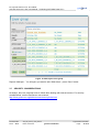
1
geoland2, FP7-SPACE-2007-1 Date Issued: 28.01.2011 Issue: D/IX.YY 2 geoland Towards an Operational GMES Land Monitoring Core Service AGI SDI Server 2011 G2 User Manual – Publishing SATChMo Data CCC-DDD-NNNN [example: BP-RP-D_BP010] Draft 1.4 EC Proposal Reference No. FP-7-218795 Due date of deliverable: ________ ____ Actual submission date: May 05, 2011 Start date of project: 01.09.2008 Organisation name of lead contractor for this deliverable: Astrium GmbH Book Captain: Vytautas Jonaitis (AGI) Contributing Authors: Gedas Vaitkus (AGI) Duration: 50 months geoland2, FP7-SPACE-2007-1 Date Issued: 28.01.2011 Issue: D/IX.YY Project co-funded by the European Commission within the Seventh Framework Programme (2002-2006) Dissemination Level PU Public PP Restricted to other programme participants (including the Commission Services) RE Restricted to a group specified by the consortium (including the Commission Services) CO Confidential, only for members of the consortium (including the Commission Services) EC Proposal Reference No.: FP-7-218795 AGI SDI Server 2011 G2 User Manual – Publishing SATChMo Data/ D??? 2 geoland Document Release Sheet Book captain: Vytautas Jonaitis (AGI) Sign Date Approval Erwin Goor (VITO) Sign Date Endorsement: Co-ordinator (ITD) Sign Date Distribution: All Geoland consortium, or Sub-task members, or Selected partners (Comment: please respect IPR issues !) Document-No. Issue: D1.4 AGI_SDI_Server_User_Manual Date: 10.05.2011 geoland confidential © geoland2 consortium Page: 3 of 74 2 EC Proposal Reference No.: FP-7-218795 geoland AGI SDI Server 2011 G2 User Manual – Publishing SATChMo Data/ D??? Change Record Issue/Re v Date Page(s) - 29.11.2010 40 Release of Draft 1 I1.00 21.01.2011 62 Release of Draft 1.1 – added classification results metadata creation instructions, removed raster data publishing instructions. I1.10 28.01.2011 69 Release of Draft 1.2 – considerable restructuring of the document, adding the introduction sections and many textual explanations and practical instructions wherever needed to make the document operational I1.20 29.04.2011 74 Release of Draft 1.3 – review for AGI SDI Server 2011 G2 support; installation and service configuration chapters were moved to System Administration Manual. I1.30 10.05.2011 74 Release of Draft 1.4 – final proof-reading and cosmetic edition of the document done by G.Vaitkus I1.40 Document-No. Issue: D1.4 Description of Change AGI_SDI_Server_User_Manual Date: 10.05.2011 geoland confidential Release © geoland2 consortium Page: 4 of 74 EC Proposal Reference No.: FP-7-218795 AGI SDI Server 2011 G2 User Manual – Publishing SATChMo Data/ D??? 2 geoland TABLE OF CONTENTS 1 BACKGROUND OF THE DOCUMENT.........................................................................................9 1.1 EXECUTIVE SUMMARY............................................................................................................9 1.2 SCOPE AND OBJECTIVES.......................................................................................................9 1.3 CONTENT OF THE DOCUMENT..............................................................................................9 1.4 RELATED DOCUMENTS.........................................................................................................10 1.4.1 Input...................................................................................................................................... 10 1.4.2 Output................................................................................................................................... 10 2 PUBLISHING DATA - OVERVIEW.............................................................................................11 3 PUBLISH DATA ON GEOSERVER............................................................................................13 3.1 UPLOAD DATA TO GEOSERVER DATA DIRECTORY..........................................................14 3.2 CREATE A WORKSPACE.......................................................................................................15 3.3 ADD A STYLE FOR VECTOR DATA.......................................................................................16 3.4 UPLOAD DATA TO GEOSERVER DATA DIRECTORY..........................................................18 3.5 PUBLISH VECTOR DATASETS IN GEOSERVER..................................................................18 3.5.1 Create new vector data source..............................................................................................18 3.5.2 Publish vector layers............................................................................................................. 19 3.6 CREATe THE LAYERS GROUP..............................................................................................28 3.7 SECURITY CONSIDERATIONS..............................................................................................30 4 CREATE METADATA RECORDS..............................................................................................31 4.1 LOGGING IN, CREATING NEW GROUP................................................................................31 4.2 UPLOADING DATASET SERIES XML FILE............................................................................32 4.3 CREATING DATASET METADATA DOCUMENT...................................................................35 4.3.1 Metadata on metadata........................................................................................................... 38 4.3.2 Identification.......................................................................................................................... 39 4.3.3 Temporal reference............................................................................................................... 42 4.3.4 Spatial information................................................................................................................. 43 4.3.5 Reference system information...............................................................................................44 4.3.6 Classification of data and keywords.......................................................................................45 4.3.7 Distribution information.......................................................................................................... 46 4.3.8 Quality and validity................................................................................................................ 47 Document-No. Issue: D1.4 AGI_SDI_Server_User_Manual Date: 10.05.2011 geoland confidential © geoland2 consortium Page: 5 of 74 EC Proposal Reference No.: FP-7-218795 AGI SDI Server 2011 G2 User Manual – Publishing SATChMo Data/ D??? 2 geoland 4.3.9 Constraints related to access and use...................................................................................48 4.4 EXPORTING TO XML DATASET METADATA DOCUMENT...................................................48 5 PUBLISH METADATA RECORDS (OPTIONAL).......................................................................50 5.1 UPLOAD METADATA XML FILES TO CSW............................................................................50 5.2 LIST METADATA RECORDS, UPLOADED TO CSW..............................................................51 5.2.1 Generic client........................................................................................................................ 51 5.2.2 catalogueManager search.....................................................................................................52 5.3 DELETE METADATA RECORDS FROM CSW.......................................................................53 5.3.1 Generic client........................................................................................................................ 53 5.3.2 catalogueManager editor.......................................................................................................54 6 TECHNICAL SUPPORT............................................................................................................. 57 7 ANNEX 1 – SATCHMO VHR LAND COVER DATA.XML...........................................................58 8 ANNEX 2 – G2_SATCHMO.SLD................................................................................................68 9 ANNEX 3 – G2 SATCHMO DATASET FILE NAMING CONVENTION.......................................73 Document-No. Issue: D1.4 AGI_SDI_Server_User_Manual Date: 10.05.2011 geoland confidential © geoland2 consortium Page: 6 of 74 EC Proposal Reference No.: FP-7-218795 AGI SDI Server 2011 G2 User Manual – Publishing SATChMo Data/ D??? 2 geoland List of Figures Figure 1: GeoServer Data menu..................................................................................................13 Figure 2: Geoserver Data directory.............................................................................................15 Figure 3: Create new workspace.................................................................................................16 Figure 4: Create new style........................................................................................................... 17 Figure 5: Adding new vector data source..................................................................................19 Figure 6: Choosing new layer......................................................................................................20 Figure 7: Detected layers in store...............................................................................................20 Figure 8: Configure the resource information for the current layer (part 1)............................21 Figure 9: Configure the resource information for the current layer (part 2)............................23 Figure 10: Proceed to publishing information...........................................................................24 Figure 11: Configure the publishing information for the current layer (part 1).......................25 Figure 12: Configure the publishing information for the current layer (part 2).......................26 Figure 13: Configure the publishing information for the current layer (part 3).......................27 Figure 14: Add new layer group..................................................................................................28 Figure 15: New layer group properties.......................................................................................29 Figure 16: Add layers to the group.............................................................................................30 Figure 17: Creating new group for SATChMo datasets.............................................................32 Figure 18: Importing dataset series XML file.............................................................................34 Figure 19: Uploading dataset series XML file............................................................................35 Figure 20: Creating dataset metadata document.......................................................................36 Figure 21: Selecting proper metadata parent identifier.............................................................37 Figure 22: Metadata on metadata................................................................................................38 Figure 23: Identification (part 1)..................................................................................................39 Figure 24: Identification (part 2)..................................................................................................40 Figure 25: Identification (part 3)..................................................................................................41 Figure 26: Temporal reference....................................................................................................42 Figure 27: Spatial information.....................................................................................................43 Figure 28: Reference system information..................................................................................44 Figure 29: Classification of data and keywords.........................................................................45 Document-No. Issue: D1.4 AGI_SDI_Server_User_Manual Date: 10.05.2011 geoland confidential © geoland2 consortium Page: 7 of 74 EC Proposal Reference No.: FP-7-218795 AGI SDI Server 2011 G2 User Manual – Publishing SATChMo Data/ D??? 2 geoland Figure 30: Distribution information.............................................................................................46 Figure 31: Quality and validity.....................................................................................................47 Figure 32: Constraints related to access and use.....................................................................48 Figure 33: Selecting document to export as XML......................................................................48 Figure 34: Export as XML............................................................................................................ 49 Figure 35: Prepare request field to insert data..........................................................................50 Figure 36: Transaction summary...............................................................................................51 Figure 37: Generic client............................................................................................................. 52 Figure 38: catalogueManager search........................................................................................53 Figure 39: Delete records from generic client...........................................................................54 Figure 40: catalogueManager editor..........................................................................................55 Figure 41: Delete metadataset....................................................................................................56 List of Tables Table 1: GeoServer Data menu....................................................................................................13 Table 2: New workspace properties............................................................................................16 Table 3: New style properties......................................................................................................17 Table 4: New Vector Data Source properties.............................................................................19 Table 5: Configure the resource information for the current layer (part 1)..............................22 Table 6: Configure the resource information for the current layer (part 2)..............................23 Table 7: Configure the publishing information for the current layer (part 1)...........................25 Table 8: Configure the publishing information for the current layer (part 2)...........................26 Table 9: Configure the publishing information for the current layer (part 3)...........................27 Table 10: New layer group properties.........................................................................................29 Table 11: Classification output archive naming convention.....................................................73 Table 12: Contents of classification output archive naming convention.................................73 Table 13: File naming convention example................................................................................74 Document-No. Issue: D1.4 AGI_SDI_Server_User_Manual Date: 10.05.2011 geoland confidential © geoland2 consortium Page: 8 of 74 EC Proposal Reference No.: FP-7-218795 AGI SDI Server 2011 G2 User Manual – Publishing SATChMo Data/ D??? 1 2 geoland BACKGROUND OF THE DOCUMENT 1.1 EXECUTIVE SUMMARY The current document describes main procedures and practical steps for establishment of on-line data distribution and portrayal services, as well as creating and publishing metadata records on the G2 SDI portal. Taking G2 SATCHMO datasets as practical example, all the procedures of installing dedicated SDI servers and establishment of SDI services are described. 1.2 SCOPE AND OBJECTIVES The manual provides practical instructions and guidelines for G2 data providers on establishment of a minimum set of SDI services and populating those with corresponding data files and metadata records. The list of described SDI services includes − conventional data download services (FTP/HTTP), − SDI data portrayal services (WMS), − and SDI metadata catalog services (CSW). Implementation of all the services is demonstrated on open source GeoServer and Deegree software packages. The report also provides detailed instructions on creation and editing of metadata records with the help of on-line GMES Metadata Editor developed by G2 SDI Team. All the examples and instructions are customized to the G2 SATCHMO datasets and metadata. The current report is part of deliverables produced by G2 SATCHMO and SDI components. 1.3 CONTENT OF THE DOCUMENT This document consists of these major sections: − Publishing the datasets as GeoServer WMS layers; − Creating the matadata records with GMES metadata editor; − Uploading metadata to CSW server (optional). There are also 3 annexes with examples of metadata XML document, WMS style sheet document and file naming specifications of SATChMo VHR datasets. Document-No. Issue: D1.4 AGI_SDI_Server_User_Manual Date: 10.05.2011 geoland confidential © geoland2 consortium Page: 9 of 74 EC Proposal Reference No.: FP-7-218795 AGI SDI Server 2011 G2 User Manual – Publishing SATChMo Data/ D??? 1.4 1.4.1 2 geoland RELATED DOCUMENTS Input Overview of former deliverables acting as inputs to this document. Document ID Descriptor CCC-DDD-NNNN Practical guidelines for setting up SDI services with datasets and metadata -- 1.4.2 AGI SDI Server User Manual (2010) Output Overview of other deliverables for which this document is an input. Document ID Descriptor CCC--DDD-NNNN Document-No. Issue: D1.4 AGI_SDI_Server_User_Manual Date: 10.05.2011 geoland confidential © geoland2 consortium Page: 10 of 74 EC Proposal Reference No.: FP-7-218795 AGI SDI Server 2011 G2 User Manual – Publishing SATChMo Data/ D??? 2 2 geoland PUBLISHING DATA - OVERVIEW For practical demonstration of data and metadata publishing on the G2 SDI, we will further use an example of SATChMo VHR datasets. There are minimum four elements of information to be published on-line by SATChMo data providers in order to complete integration of any dataset (processed image) on the G2 SDI after the dataset passes the QC procedure. Three of those elements should be hosted on the internet services established and maintained by the data providers, and the fourth one should be hosted by external SDI service. SATChMo VHR Land Cover Data classification results should be published as follows: • Archives (zip) containing actual vector and raster files with classification results should be published for ordinary download on ordinary FTP or HTTP web services hosted by data providers. Those files will be downloaded and directly used by project partners and other clients. There is an abundant market of hosting those internet services by external public or commercial service providers, alternatively – if G2 data providers are willing to establish their own web services – there is a lot of detailed documentation on-line for different operating systems and implementation of internet services. Anyway, we will not focus on this issue in the current report – please consult your System Administrator. • The same was as with datasets, the data providers must publish so-called quick-looks (preview pictures in GIF, JPEG or PNG formats and reasonable dimensions/file size) of the corresponding datasets on their HTTP servers. This is particularly requested by G2 SDI Portal to complete metadata records on your datasets. So – to stress it again – publishing (at least one, but can be several pictures per one datset, if necessary) quicklook picture of your datasets is oblicatory. • Image classification results – vector datasets (.shp files) also should be made accessible via WMS server(s) to the web mapping applications. For this purpose, dedicated WMS servers should be established and further maintained by data providers, and vector datasets should be loaded into those WMS services and configured appropriately (definition of color styles, projections, etc.) - as secribed in further sections of this report. • Each dataset of image classification results must have it's own dataset metadata record, created by data providers using a simple GMES metadata editor – http://land.eu/gmesmetadata-editor/login/auth. For the SATChMo component, those dataset metadata records will be hosted by AGI on its CSW server. Dataset metadata records must have common parent identifier code (this will be provided by AGI), defined in “dataset series” metadata. Metadata about a dataset series called “SATChMo VHR Land Cover Data classification results” has been created once by AGI, submitted and currently published on Geoland2 portal. So, to conclude, each data provider should have the following on-line services accessible directly from the internet in the form of static URLs: • WWW or FTP server to host archived datasets with image classification results AND datasets quicklook images. Document-No. Issue: D1.4 AGI_SDI_Server_User_Manual Date: 10.05.2011 geoland confidential © geoland2 consortium Page: 11 of 74 EC Proposal Reference No.: FP-7-218795 AGI SDI Server 2011 G2 User Manual – Publishing SATChMo Data/ D??? • 2 geoland WMS server to host vector datasets with classification results. Note, that all these servers do not need to have the same IP address – there are separate fields in metadata profile for each of them. To complete the preparation for publishing their completed and QC'd datasets on the G2 SDI, the data providers should perform the following tasks should on each of their datasets archive: 1. Unpack quicklook image (GIF/JPEG/PNG) from the archive. 2. Upload both archive zip file AND the quicklook image to the web server accessible directly from the internet. It is strongly recommended that the quicklook images are published on HTTP service. You need to record exactly what are the URLs (internet links) pointing to the dataset archives and quicklook images. This information will be essential in completing the metadata records. 3. Unpack the vector dataset from the archive and upload it to your WMS server. Record the URL of your WMS layers presenting SATChMo datasets (see further chapters of the corrent Manual). Access to your WMS services should be also configured on G2 SDI portal. 4. Create metadata XML documents for each of the dataset archives and send it to the data provider responsible for maintaining the CSW server (in case of SATChMo VHR datasets that should be AGI). Document-No. Issue: D1.4 AGI_SDI_Server_User_Manual Date: 10.05.2011 geoland confidential © geoland2 consortium Page: 12 of 74 EC Proposal Reference No.: FP-7-218795 AGI SDI Server 2011 G2 User Manual – Publishing SATChMo Data/ D??? 3 2 geoland PUBLISH DATA ON GEOSERVER Publishing data in GeoServer consists of two steps: 1. Files, containing vector (and raster) data has to be uploaded to the computer, where GeoServer is installed (for example, by using ftp service remotely). 2. After placing the datasets on the server running your WMS, the service is configured and datasets published by using GeoServer's web interface. GeoServer data management menu has several main components to be configured: Figure 1: GeoServer Data menu Here is a quick explanation of GeoServer Data menu components and the required operations to publish your datasets: Table 1: GeoServer Data menu Component Description Workspaces Workspace is a container which is used to organize other items. In GeoServer, a workspace is (often) used to group similar layers together. For instance, typical workspace could be called SATChMo to contain G2 SATChMo dataset. Stores A store connects to a data source that contains raster or vector datasets. A data source can be a file or group of files such as a table in a database, a single file (such as a shapefile), or a directory. The store construct is used so, that connection parameters are defined once, rather than for each piece of data in a source. As such, it is necessary to register a store before loading any data. Layers In Geoserver, the term layer refers to raster or vector data that contains geographic features. Layer groups Document-No. Issue: D1.4 A layer group, is a group of layers that acts as a single layer. This is useful when creating a basemap, or other situations when more than one separate layer needs to be requested simultaneously or frequently. Since layers tend AGI_SDI_Server_User_Manual Date: 10.05.2011 geoland confidential © geoland2 consortium Page: 13 of 74 2 EC Proposal Reference No.: FP-7-218795 geoland AGI SDI Server 2011 G2 User Manual – Publishing SATChMo Data/ D??? to contain only a single type of geometry, this allows to combine data types in one request. A layer group is relevant to WMS (map image) requests only. There is no equivalent to WFS requests. Styles Geospatial data has no inherent visualization. Therefore additional information, in the form of a style, needs to be applied to data in order to visualize it. GeoServer uses the Styled Layer Descriptor (SLD) markup language, a subset of XML, to describe geospatial data. See the Styling section in GeoServer user manual for more information on working with styles. So, to publish your vector datasets on the WMS after you place them physically on the server running WMS service, it is necessary to complete at least those three steps: 1. Create a workspace (call it SATChMo for example); 2. Register a data store for your uploaded dataset(-s); 3. Create a new WMS layer and point to a certain newly uploaded dataset (to be repeated for all new datasets); 4. Create (if not done already) a new style and assign it to your newly created layers. The procedure will be described in detail in the following sections of the corrent report. While publishing large amounts of spatial data on-line, it is essential to follow the standard file naming rules and conventions. In case of G2 SATChMo VHR component, the agreed specifications of file naming are described in detail in Appendix 3 of the current report. 3.1 UPLOAD DATA TO GEOSERVER DATA DIRECTORY Before publishing data in GeoServer, it should be uploaded into Data Directory first. Again, please make sure that file naming conventions are properly followed. The following example shows how a typical sequence of dataset deployment operations on Ubuntu Linux server may look like this: 1. Create folder SATChMo in $GEOSERVER_DATA_DIR/data, for example sudo mkdir /sdi/geoserver/data/data/SATChMo 2. In SATChMo folder, create a subfolder shp for vector data. For example: cd /sdi/geoserver/data/data/SATChMo sudo mkdir shp 3. Copy your vector data to shp folder. For example, for UK_20090912_3970_K_v1.zip (unpack archive before copying): sudo cp V_UK_20090912_3970_K_v1.* /sdi/geoserver/data/data/SATChMo/shp 4. Change SATChMo directory permissions: sudo chown -R tomcat6:tomcat6 /sdi/geoserver/data/data/SATChMo Document-No. Issue: D1.4 AGI_SDI_Server_User_Manual Date: 10.05.2011 geoland confidential © geoland2 consortium Page: 14 of 74 EC Proposal Reference No.: FP-7-218795 AGI SDI Server 2011 G2 User Manual – Publishing SATChMo Data/ D??? 2 geoland Where is current GeoServer data directory, can be found in variable $GEOSERVER_DATA_DIR at WEB-INF/web.xml file for the GeoServer application (in our case, it is located at /var/lib/tomcat6/webapps/geoserver/WEB-INF/web.xml), or using web interface: Figure 2: Geoserver Data directory 3.2 CREATE A WORKSPACE The first step in data loading is creation of a workspace (unless you already have created one earlier). This creates a certain container for your datasets related methodologically or thematically under one project. Creating a workspace is also essential, because it will allow to distinguish between different groups of WMS layers published on the same WMS server. As for G2, you will have to provide a link to a certain workspace on your WMS server which contains SATChMo VHR datasets in order to publish them on the G2 Portal. To create a GeoServer workspace, you will need to follow these steps: 1. Navigate to the main GeoServer Web Administration page (http://LOCALHOST:8080/geoserver , replace LOCALHOST with your GeoServer address). 2. Click on the Workspaces link on the left column, under Data. 3. Click on the “Add new workspace” link at the top centre of the page. Document-No. Issue: D1.4 AGI_SDI_Server_User_Manual Date: 10.05.2011 geoland confidential © geoland2 consortium Page: 15 of 74 EC Proposal Reference No.: FP-7-218795 AGI SDI Server 2011 G2 User Manual – Publishing SATChMo Data/ D??? 2 geoland Figure 3: Create new workspace In the next page, you will be prompted to enter the workspace name and URI. Table 2: New workspace properties Field Value Name SATChMo Namespace URI http://www.geoland2.eu Default workspace Yes (select checkbox) Note: you can add data to non-default workspace, too. 4. Click on “Submit” to add new workspace into your WMS server. 3.3 ADD A STYLE FOR VECTOR DATA Before uploading vector data (shape files), their visualization style must be defined, because with WMS client it is not possible to change style of datasets in client application. In other words, if a certain style is not assigned to a vector dataset published by your WMS server, on all the “clients” (desktop GIS or on-line mapping applications) it will all appear single-coloured, and the clients will NOT be able to change the thematic colouring, making your WMS service practically useless for any thematic mapping purposes. Another important aspect of styling WMS datasets is that they Document-No. Issue: D1.4 AGI_SDI_Server_User_Manual Date: 10.05.2011 geoland confidential © geoland2 consortium Page: 16 of 74 EC Proposal Reference No.: FP-7-218795 AGI SDI Server 2011 G2 User Manual – Publishing SATChMo Data/ D??? 2 geoland must be defined the same way in all the WMS services hosted by separate data providers in order to maintain thematic integrity in large-scale (regional) thematic mapping applications. In order to set up the style(-s) of your datasets published over WMS services, you need to complete the following steps: 1. Navigate to the main GeoServer Web Administration page. 2. Click on the Styles link on the left column, under Data. 3. Click on the “Add new style” link at the top centre of the page. 4. Click on “Validate” to check new style, then, if no errors are found, on “Submit” to add new style. Figure 4: Create new style In next page, you will be prompted to enter the style name. Style itself can be typed (or copy/pasted) in editor or uploaded as file. See Appendix 2 for complete style. Table 3: New style properties Field Value Name G2_SATChMo Editor or SLD file Copy/paste XML data from Appendix 1 into editor in “New style” page or save it as SATChMo_2010.sld and upload it by clicking “Browse”, selecting this file, clicking on “Upload...”. Document-No. Issue: D1.4 AGI_SDI_Server_User_Manual Date: 10.05.2011 geoland confidential © geoland2 consortium Page: 17 of 74 2 EC Proposal Reference No.: FP-7-218795 geoland AGI SDI Server 2011 G2 User Manual – Publishing SATChMo Data/ D??? See GeoServer documentation for detailed information about style creation: http://docs.geoserver.org/stable/en/user/styling/index.html 3.4 UPLOAD DATA TO GEOSERVER DATA DIRECTORY Before publishing data in GeoServer, it should be uploaded into Data Directory first. Again, please make sure that file naming conventions are properly followed. The following example shows how a typical sequence of dataset deployment operations on Ubuntu Linux server may look like this: 5. Create folder SATChMo in $GEOSERVER_DATA_DIR/data, for example sudo mkdir /sdi/geoserver/data/data/SATChMo 6. In SATChMo folder, create a subfolder shp for vector data. For example: cd /sdi/geoserver/data/data/SATChMo sudo mkdir shp 7. Copy your vector data to shp folder. For example, for UK_20090912_3970_K_v1.zip (unpack archive before copying): sudo cp V_UK_20090912_3970_K_v1.* /sdi/geoserver/data/data/SATChMo/shp 8. Change SATChMo directory permissions: sudo chown -R tomcat6:tomcat6 /sdi/geoserver/data/data/SATChMo 3.5 PUBLISH VECTOR DATASETS IN GEOSERVER The overall procedure of datasets publishing on GeoServer WMS is rather straightforward. At first, you need to create new store to define a connection to the directory (on your server) containing your vector datasets. When data store is defined, you can start publishing individual datasets. The following chapters will illustrate the whole process in detail. 3.5.1 Create new vector data source Defining the new data source on GeoServer is done by the following procedure: 1. Navigate to the main GeoServer Web Administration page. 2. Click on the Stores link on the left column, under Data. 3. Click on the “Add new store” link at the top centre of the page. 4. In “New data source” window, select “Directory of spatial files” Document-No. Issue: D1.4 AGI_SDI_Server_User_Manual Date: 10.05.2011 geoland confidential © geoland2 consortium Page: 18 of 74 EC Proposal Reference No.: FP-7-218795 AGI SDI Server 2011 G2 User Manual – Publishing SATChMo Data/ D??? 2 geoland Figure 5: Adding new vector data source 5. In next page, enter following: Table 4: New Vector Data Source properties Field Value Workspace SATChMo Data Source Name shp Description Enabled Yes (tick checkbox) URL file:data/SATChMo/shp 6. Click „Save“. If there is already files in data source folder, list of detected layers will be shown (you can ignore it now – layers will be published in next step). 3.5.2 Publish vector layers To publish vector datasets recently added to Vector Data Source, you need to complete the following steps: 1. Navigate to the main GeoServer Web Administration page. Document-No. Issue: D1.4 AGI_SDI_Server_User_Manual Date: 10.05.2011 geoland confidential © geoland2 consortium Page: 19 of 74 EC Proposal Reference No.: FP-7-218795 AGI SDI Server 2011 G2 User Manual – Publishing SATChMo Data/ D??? 2 geoland 2. Click on the Layers link on the left column, under Data. 3. Click on the “Add a new resource” link at the top centre of the page. 4. In next page, from drop-down menu choose appropriate Workspace:Store (for example: SATChMo:shp) Figure 6: Choosing new layer 5. Detected in chosen store layers will be shown – both published and unpublished. Figure 7: Detected layers in store Document-No. Issue: D1.4 AGI_SDI_Server_User_Manual Date: 10.05.2011 geoland confidential © geoland2 consortium Page: 20 of 74 2 EC Proposal Reference No.: FP-7-218795 geoland AGI SDI Server 2011 G2 User Manual – Publishing SATChMo Data/ D??? 6. Select layer you want to publish, click on “Publish” next to that layer's name. 7. In next page, enter some metadata about layer (follow the screen-shots): Figure 8: Configure the resource information for the current layer (part 1) It would be very useful if you could provide an abstract and at least some other information for each of your datasets published as WMS layers. In fact, this is the only way the clients will be able get any metadata information on your WMS broadcasts, as there will be NO DIRECT LINK between WMS layers published on your server and metadata records on the downloadable dataset files published on the G2 Portal Web Catalog Service. Document-No. Issue: D1.4 AGI_SDI_Server_User_Manual Date: 10.05.2011 geoland confidential © geoland2 consortium Page: 21 of 74 EC Proposal Reference No.: FP-7-218795 AGI SDI Server 2011 G2 User Manual – Publishing SATChMo Data/ D??? 2 geoland Table 5: Configure the resource information for the current layer (part 1) Field Value Name (leave default) Title (leave default) Abstract (abstract is highly recommended) New Keyword (keywords, if any) Metadata links (metadata links, if any) Continue on the same page. Next part is coordinate reference systems properties. If native SRS is not detected, enter it manually, then calculate bounding boxes (by clicking on link “Calculate ...”). Document-No. Issue: D1.4 AGI_SDI_Server_User_Manual Date: 10.05.2011 geoland confidential © geoland2 consortium Page: 22 of 74 2 EC Proposal Reference No.: FP-7-218795 geoland AGI SDI Server 2011 G2 User Manual – Publishing SATChMo Data/ D??? Figure 9: Configure the resource information for the current layer (part 2) Table 6: Configure the resource information for the current layer (part 2) Field Value Native SRS (if not detected – enter in “Declared SRS” field below) Declared SRS Enter corresponding coordinate system in EPSG format (for example: EPSG:32630) Document-No. Issue: D1.4 AGI_SDI_Server_User_Manual Date: 10.05.2011 geoland confidential © geoland2 consortium Page: 23 of 74 2 EC Proposal Reference No.: FP-7-218795 geoland AGI SDI Server 2011 G2 User Manual – Publishing SATChMo Data/ D??? SRS handling Force declared (if native SRS is undetected, otherwise – leave default) Native Bounding Box If native SRS is undetected, enter it in “Declared SRS” field, then press “Compute from data” link. Otherwise it will be calculated automatically. Lat/Lon Bounding Box If native SRS is undetected, enter it in “Declared SRS” field, then press “Compute from native bounds” link. Otherwise it will be calculated automatically. DO NOT press “Save” yet – you need to configure publishing information as well! Figure 10: Proceed to publishing information In the Publishing tab you will have to enter layer's publishing properties. Document-No. Issue: D1.4 AGI_SDI_Server_User_Manual Date: 10.05.2011 geoland confidential © geoland2 consortium Page: 24 of 74 EC Proposal Reference No.: FP-7-218795 AGI SDI Server 2011 G2 User Manual – Publishing SATChMo Data/ D??? 2 geoland Figure 11: Configure the publishing information for the current layer (part 1) Table 7: Configure the publishing information for the current layer (part 1) Field Value Name (leave default) Enabled Yes (tick checkbox) Response Cache Headers (leave default) Cache Time (seconds) (leave default) Per-Request Feature limit (leave default) Maximum number of decimals (leave default) Document-No. Issue: D1.4 AGI_SDI_Server_User_Manual Date: 10.05.2011 geoland confidential © geoland2 consortium Page: 25 of 74 EC Proposal Reference No.: FP-7-218795 AGI SDI Server 2011 G2 User Manual – Publishing SATChMo Data/ D??? 2 geoland Figure 12: Configure the publishing information for the current layer (part 2) Table 8: Configure the publishing information for the current layer (part 2) Field Value Default style G2_SATChMo Additional styles (none) Default WMS Path (leave default) Document-No. Issue: D1.4 AGI_SDI_Server_User_Manual Date: 10.05.2011 geoland confidential © geoland2 consortium Page: 26 of 74 EC Proposal Reference No.: FP-7-218795 AGI SDI Server 2011 G2 User Manual – Publishing SATChMo Data/ D??? 2 geoland Figure 13: Configure the publishing information for the current layer (part 3) Table 9: Configure the publishing information for the current layer (part 3) Field Value Attribution text (leave default) Attribution link (leave default) Logo URL (leave default) Logo Content Type (leave default) Logo Image Width (leave default) Logo Image Height (leave default) Document-No. Issue: D1.4 AGI_SDI_Server_User_Manual Date: 10.05.2011 geoland confidential © geoland2 consortium Page: 27 of 74 EC Proposal Reference No.: FP-7-218795 AGI SDI Server 2011 G2 User Manual – Publishing SATChMo Data/ D??? Default Regionating Attribute (leave default) Default Regionating Method (leave default) Features Per Regionated Tile (leave default) 2 geoland 8. Press “Save”. Congratulations, new WMS layer is published! The web clients will be able to “see” your layers immediately. 3.6 CREATE THE LAYERS GROUP After layers are published, they should be assigned to layer group. This step otherwise is not obligatory, but on the G2 Portal there is a so-called “SATChMo VHR Land Cover Dataset Catalogue”, which is configured to access a layer group, not separate layers – so for SATChMo datasets published on your WMS server creation of a layer group is obligatory. Later, you can add/update layers in that group without reconfiguring Geoland2 catalog. The procedure is simple: you must select “Data – Layer” groups in left menu, then select “Add new layer group”. Figure 14: Add new layer group In next page, enter layer group name, coordinate system (EPSG:4326), then add layers. After that, press “Generate Bounds” button. Document-No. Issue: D1.4 AGI_SDI_Server_User_Manual Date: 10.05.2011 geoland confidential © geoland2 consortium Page: 28 of 74 2 EC Proposal Reference No.: FP-7-218795 geoland AGI SDI Server 2011 G2 User Manual – Publishing SATChMo Data/ D??? Figure 15: New layer group properties Table 10: New layer group properties Field Value Name SATChMo VHR – [data provider] Bounds (Press “Generate bounds” after adding layers) (coordinate system) EPSG:4326 Finally, select “Add layer” link (below “Generate bounds” button). In pop-up window, select layer, you want to add to the group: Document-No. Issue: D1.4 AGI_SDI_Server_User_Manual Date: 10.05.2011 geoland confidential © geoland2 consortium Page: 29 of 74 EC Proposal Reference No.: FP-7-218795 AGI SDI Server 2011 G2 User Manual – Publishing SATChMo Data/ D??? 2 geoland Figure 16: Add layers to the group Repeat “Add layer...” for all layers you want to add. When done – press “Save” button. 3.7 SECURITY CONSIDERATIONS As always, there are essential rules to follow while dealing with internet servers. For security considerations, see the GeoServer user manual: http://docs.geoserver.org/stable/en/user/security/index.html Document-No. Issue: D1.4 AGI_SDI_Server_User_Manual Date: 10.05.2011 geoland confidential © geoland2 consortium Page: 30 of 74 EC Proposal Reference No.: FP-7-218795 AGI SDI Server 2011 G2 User Manual – Publishing SATChMo Data/ D??? 4 2 geoland CREATE METADATA RECORDS Before going into details of metadata creation, we need to define the “minimum” set of G2 requirements related with publishing the projects data and metadata. Due to the formal requirement to deliver the datasets as downloadable files (archives) to the G2 clients, also for the purpose of data exchange between partners, it was decided that archived dataset files will be published on “download” services (FTP/HTTP) by the data providers. To make those datasets “discoverable”, a central catalogue is established on G2 portal, where metadata records on all downloadable datasets are searched and download links, as well as dataset quicklooks, are provided to the clients through those dataset metadata records. This part of SDI implementation is completely under the responsibility of the data providers. In order to structure the massive amount of G2 metadata, it was decided to create thematic G2 metadata search services on the G2 portal. Those services are defined by service metadata records, created by project partners maintaining metadata CSW catalogues where all dataset metadata records from data providers are published. Those partners hosting G2 “component catalogs” also maintain their metadata search services on the G2 portal. For instance, AGI has established a metadata service catalog called “SATChMo VHR Land Cover Dataset Catalogue” on G2 portal and connected it to a CSW metadata dataset catalogue hosted on AGI CSW server. AGI will also maintain the G2 configures the G2 “SATChMo VHR Land Cover Dataset Catalogue” setup while dataset metadata XML records and URLs of newly established WMS services will be sent to AGI by the SATChMo data providers. After a considerable effort within G2 SDI team and data providers to find a reasonable solution for creation/editing of metadata, it was decided that the best option would be to create a new on-line application for metadata creation and editing, that would be compliant with the INSPIRE specifications and fully satisfy the needs of the project. Therefore it is HIGHLY RECOMMENDED to use GMES metadata editor for creating metadata records for the datasets containing SATChMo VHR Land Cover Data classification results. The following chapters will describe and illustrate the whole procedure of metadata creation based on a real example of one of AGI SATChMo VHR datasets. You can follow this example closely with only minor simple changes to be included while creating your own metadata records. Although Deegree CSW 2.4 has it's own catalogueManager metadata editor, DO NOT use it for creating or editing G2 metadata records - it does not support all required fields. catalogueManager editor can be used to delete unnecessary metadata records from CSW, and Deegree catalogueManager search - to display what records are served by CSW. 4.1 LOGGING IN, CREATING NEW GROUP If you are a new metadata provider, you will first of all need to register on the Geoland2 Expert Portal at http://www.geoland2.eu before starting to create your own metadata records. Registration is free and rather simple, so we will not focus on that in detail. Document-No. Issue: D1.4 AGI_SDI_Server_User_Manual Date: 10.05.2011 geoland confidential © geoland2 consortium Page: 31 of 74 EC Proposal Reference No.: FP-7-218795 AGI SDI Server 2011 G2 User Manual – Publishing SATChMo Data/ D??? 2 geoland After completing your registration, open the G2 GMES metadata editor page on http://land.eu/gmes-metadata-editor/login/auth and log in. Metadata records are organized by assigning them to appropriate group, so first thing you will have to do is create new group for metadata records on your SATChMo VHR Land Cover datasets. To create a metadata group, select Goup/Create from the right side menu, add the name, description and save changes. Note that you will need to select a parent group if your dataset groups are arranged into some complicated hierarchy. In our generic case this option may be ignored. Wherever you see fields marked with red arrows and colour, please be careful to provide the requested information there – those metadata fields are obligatory! Figure 17: Creating new group for SATChMo datasets Fill in required information, then press „Save changes“. Press „Back to overview“ - you can see new just created group. 4.2 UPLOADING DATASET SERIES XML FILE For creating a searcheable thematic metadata catalog (e.g. for SATChMo datasets) on the G2 Portal, it is necessary to create a so-called dataset series metadata XML file. This initial operation is done by the partner hosting the corresponding datasets metadata catalog (in case of SATChMo VHR that would be AGI). But it is also essential that all the data providers load this metadata series XML document into their GMES metadata editor workspaces before starting to create their own dataset metadata XML documents, which will need a „Parent ID“ field to be filled in by simply pointing to that previously imported dataset series metadata record. Document-No. Issue: D1.4 AGI_SDI_Server_User_Manual Date: 10.05.2011 geoland confidential © geoland2 consortium Page: 32 of 74 EC Proposal Reference No.: FP-7-218795 AGI SDI Server 2011 G2 User Manual – Publishing SATChMo Data/ D??? 2 geoland The dataset series metadata XML record is like a „summary“ of all datasets which will be present in that series. Structurally this XML file is identical to the datasets metadata XML files. However, there is one essential difference. Dataset series defines a so-called „Parent ID“ code, which must be further replicated in all the dataset metadata XML files as their „parent“ identificator. This code is the only XML element binding all metadata records into a certain searcheable „series“ on the G2 Portal, although all those datasets and corresponding metadata documents are produced independently by different data providers. GMES metadata editor does not allow to edit metadata file identifiers – they are generated automatically. To ensure, that correct metadata parent identifier is assigned to all dataset metadata records belonging to the same dataset series, the original dataset series metadata XML document with a unique file identifier („parent ID“) must be uploaded to the group by each data provider in their GMES metadata editor environments. See Appendix 1 for the metadata XML file contents, and contact AGI for a digital copy of the dataset series metadata XML file called SATChMo VHR Land Cover Data.xml , or just re-create it by copy-pasting the text from the Appendix 1. In the overview window (if you are not there – press „Back to overview“ link), select your group, then in the right side menu select „Collection (series) Document – Import from XML“. Document-No. Issue: D1.4 AGI_SDI_Server_User_Manual Date: 10.05.2011 geoland confidential © geoland2 consortium Page: 33 of 74 EC Proposal Reference No.: FP-7-218795 AGI SDI Server 2011 G2 User Manual – Publishing SATChMo Data/ D??? 2 geoland Figure 18: Importing dataset series XML file In next page, click „Browse“, select SATChMo VHR Land Cover Data.xml file. Then press „Import from XML“ button above. Document-No. Issue: D1.4 AGI_SDI_Server_User_Manual Date: 10.05.2011 geoland confidential © geoland2 consortium Page: 34 of 74 EC Proposal Reference No.: FP-7-218795 AGI SDI Server 2011 G2 User Manual – Publishing SATChMo Data/ D??? 2 geoland Figure 19: Uploading dataset series XML file Parent document uploaded, now you will be able to refer to it in your datasets metadata. 4.3 CREATING DATASET METADATA DOCUMENT Now you are ready to start creating metadata records for your own SATChMo VHR datasets. The whole process is really simple and straightforward, it is also quite nicely documented (see the left column on the metadata editor allpication window – it will be interactively changing with short descriptions as you navigate over the certain fields). The oblidatory fields are marked with red color and arrows, but we strongly recommend to fill in as much information as possible. If you do so for the first metadata record, you will be able to save it as XML document, load again and use as a template for the following records, with only minor changes to be made (as the datasets will be thematically identical). This is a really good practice which would save you a lot of time and improve the overall quality of your metadata. To start creating a new dataset metadata record, return to overview, then select group where you want to create metadata for dataset. In the right side menu select „Dataset document – Create“. Document-No. Issue: D1.4 AGI_SDI_Server_User_Manual Date: 10.05.2011 geoland confidential © geoland2 consortium Page: 35 of 74 EC Proposal Reference No.: FP-7-218795 AGI SDI Server 2011 G2 User Manual – Publishing SATChMo Data/ D??? 2 geoland Figure 20: Creating dataset metadata document In the next page, do not forget to select correct „Metadata parent identifier“! Also, because metadata editor is web based, press „Save changes“ every few minutes – when there are no activity for a certain period of inactivity, the editing session will expire and you will have to log in again (unsaved data, of course, will be lost in this case). Document-No. Issue: D1.4 AGI_SDI_Server_User_Manual Date: 10.05.2011 geoland confidential © geoland2 consortium Page: 36 of 74 EC Proposal Reference No.: FP-7-218795 AGI SDI Server 2011 G2 User Manual – Publishing SATChMo Data/ D??? 2 geoland Figure 21: Selecting proper metadata parent identifier Below we present an example of how a dataset document is created, based on a real ES_1052_20100801_K_v1 dataset produced by AGI. Please fill in the fields of your metadata records accordingly. Document-No. Issue: D1.4 AGI_SDI_Server_User_Manual Date: 10.05.2011 geoland confidential © geoland2 consortium Page: 37 of 74 EC Proposal Reference No.: FP-7-218795 AGI SDI Server 2011 G2 User Manual – Publishing SATChMo Data/ D??? 4.3.1 2 geoland Metadata on metadata Figure 22: Metadata on metadata Document-No. Issue: D1.4 AGI_SDI_Server_User_Manual Date: 10.05.2011 geoland confidential © geoland2 consortium Page: 38 of 74 EC Proposal Reference No.: FP-7-218795 AGI SDI Server 2011 G2 User Manual – Publishing SATChMo Data/ D??? 4.3.2 2 geoland Identification Figure 23: Identification (part 1) Resource abstract is a critically important field in the metadata record. It will show up in all metadata search engines presented along with your dataset title. Please be careful to briefly, but clearly define your datasets here. Please note that the classification schema (class names and codes) will only be listed within this field – there is no other place in the metadata document to do that. The same is for reference data (source imagery), classification methodology, post-processing, etc. Document-No. Issue: D1.4 AGI_SDI_Server_User_Manual Date: 10.05.2011 geoland confidential © geoland2 consortium Page: 39 of 74 EC Proposal Reference No.: FP-7-218795 AGI SDI Server 2011 G2 User Manual – Publishing SATChMo Data/ D??? 2 geoland Figure 24: Identification (part 2) Document-No. Issue: D1.4 AGI_SDI_Server_User_Manual Date: 10.05.2011 geoland confidential © geoland2 consortium Page: 40 of 74 EC Proposal Reference No.: FP-7-218795 AGI SDI Server 2011 G2 User Manual – Publishing SATChMo Data/ D??? 2 geoland Figure 25: Identification (part 3) Document-No. Issue: D1.4 AGI_SDI_Server_User_Manual Date: 10.05.2011 geoland confidential © geoland2 consortium Page: 41 of 74 EC Proposal Reference No.: FP-7-218795 AGI SDI Server 2011 G2 User Manual – Publishing SATChMo Data/ D??? 4.3.3 2 geoland Temporal reference Figure 26: Temporal reference Document-No. Issue: D1.4 AGI_SDI_Server_User_Manual Date: 10.05.2011 geoland confidential © geoland2 consortium Page: 42 of 74 EC Proposal Reference No.: FP-7-218795 AGI SDI Server 2011 G2 User Manual – Publishing SATChMo Data/ D??? 4.3.4 2 geoland Spatial information Figure 27: Spatial information The bounding box can be calculated automatically. Document-No. Issue: D1.4 AGI_SDI_Server_User_Manual Date: 10.05.2011 geoland confidential © geoland2 consortium Page: 43 of 74 EC Proposal Reference No.: FP-7-218795 AGI SDI Server 2011 G2 User Manual – Publishing SATChMo Data/ D??? 4.3.5 2 geoland Reference system information Figure 28: Reference system information Note, that different datasets may be in different reference systems! If there is no CRS of your particular dataset in this list, you can easily define one. The only thing to know is the EPSG code of the CRS used in your dataset. Document-No. Issue: D1.4 AGI_SDI_Server_User_Manual Date: 10.05.2011 geoland confidential © geoland2 consortium Page: 44 of 74 EC Proposal Reference No.: FP-7-218795 AGI SDI Server 2011 G2 User Manual – Publishing SATChMo Data/ D??? 4.3.6 2 geoland Classification of data and keywords Figure 29: Classification of data and keywords Kewords used in all the dataset metadata records within a certain dataset series should be the same, so this issue should be discussed by the production tem and a clear recommendation made on how this part of metadata should be filled in. Document-No. Issue: D1.4 AGI_SDI_Server_User_Manual Date: 10.05.2011 geoland confidential © geoland2 consortium Page: 45 of 74 EC Proposal Reference No.: FP-7-218795 AGI SDI Server 2011 G2 User Manual – Publishing SATChMo Data/ D??? 4.3.7 2 geoland Distribution information Figure 30: Distribution information Document-No. Issue: D1.4 AGI_SDI_Server_User_Manual Date: 10.05.2011 geoland confidential © geoland2 consortium Page: 46 of 74 EC Proposal Reference No.: FP-7-218795 AGI SDI Server 2011 G2 User Manual – Publishing SATChMo Data/ D??? 4.3.8 2 geoland Quality and validity Figure 31: Quality and validity Document-No. Issue: D1.4 AGI_SDI_Server_User_Manual Date: 10.05.2011 geoland confidential © geoland2 consortium Page: 47 of 74 EC Proposal Reference No.: FP-7-218795 AGI SDI Server 2011 G2 User Manual – Publishing SATChMo Data/ D??? 4.3.9 2 geoland Constraints related to access and use Figure 32: Constraints related to access and use 4.4 EXPORTING TO XML DATASET METADATA DOCUMENT After filling in the required fields, dataset document is ready to be saved in XML format. To do that, return to overview, go to group and select the document you want to save as XML file. Figure 33: Selecting document to export as XML Document-No. Issue: D1.4 AGI_SDI_Server_User_Manual Date: 10.05.2011 geoland confidential © geoland2 consortium Page: 48 of 74 EC Proposal Reference No.: FP-7-218795 AGI SDI Server 2011 G2 User Manual – Publishing SATChMo Data/ D??? 2 geoland Then select „Dataset document – Export as XML“ in the right-side menu bar. After that, save that page, selecting „File – Save Page As“/“File – Save As“ in the web browser menu. Figure 34: Export as XML The resulting XML file should be sent to SATChMo CSW server administrators at AGI for uploading into their CSW server. Document-No. Issue: D1.4 AGI_SDI_Server_User_Manual Date: 10.05.2011 geoland confidential © geoland2 consortium Page: 49 of 74 EC Proposal Reference No.: FP-7-218795 AGI SDI Server 2011 G2 User Manual – Publishing SATChMo Data/ D??? 5 2 geoland PUBLISH METADATA RECORDS (OPTIONAL) This section is provided for reference only - SATChMo dataset metadata records will be hosted by AGI on its CSW server. 5.1 UPLOAD METADATA XML FILES TO CSW Metadata XML file to Deegree CSW server can be uploaded using it's Generic OGC WebService Client. Navigate to http://your.server.name:8080/deegree-csw/client/client.html Then prepare request field to insert data - replace it with these lines: <?xml version="1.0" encoding="UTF-8"?> <csw:Transaction service="CSW" version="2.0.2" xmlns:csw="http://www.opengis.net/cat/csw/2.0.2"> <csw:Insert> </csw:Insert> </csw:Transaction> Figure 35: Prepare request field to insert data Then copy/paste your XML file contents (except first line - "<?xml version="1.0" encoding="UTF-8"?>") between <csw:Insert> and </csw:Insert> tags. Document-No. Issue: D1.4 AGI_SDI_Server_User_Manual Date: 10.05.2011 geoland confidential © geoland2 consortium Page: 50 of 74 2 EC Proposal Reference No.: FP-7-218795 geoland AGI SDI Server 2011 G2 User Manual – Publishing SATChMo Data/ D??? Press SEND button. If record was inserted successfully, there <csw:totalInserted>1</csw:totalInserted> line in transaction response. should be Figure 36: Transaction summary 5.2 LIST METADATA RECORDS, UPLOADED TO CSW There are two ways to view, what metadata records are uploaded to Deegree CSW: 1. In Generic OGC WebService Client execute "GetRecords_title.xml" request. 2. Use Deegree catalogueManager search. 5.2.1 Generic client Navigate to http://your.server.name:8080/deegree-csw/client/client.html, then select and execute "GetRecords_title.xml" request. <gmd:MD_Metadata> fields can be expanded to view more detailed information. Document-No. Issue: D1.4 AGI_SDI_Server_User_Manual Date: 10.05.2011 geoland confidential © geoland2 consortium Page: 51 of 74 2 EC Proposal Reference No.: FP-7-218795 geoland AGI SDI Server 2011 G2 User Manual – Publishing SATChMo Data/ D??? Figure 37: Generic client 5.2.2 catalogueManager search Starting with Deegree CSW 2.4, there is new tool available - catalogueManager. It is a collection of client and server applications for managing ISO and INSPIRE compliant metadata. It provides HTTP/SOAP interfaces for searching, accessing, harvesting and manipulating metadata for geographic data and services. Metadata can be searched by their title, topic, date etc. and the spatial extent of the described data/service. deegree supports Dublin Core and INSPIRE compliant ISO 19115/19119/19139 metadata encoding. If the ISO metadata format is used, data metadata and service metadata can be coupled. This enables a user to first search for data metadata matching, for example, a specific topic and area and then finding a WMS, WFS etc. serving the data described by the data metadata sets matching the initial search. Search client can be accessed at http://your.server.name:8080/deegree-csw/md_search.jsp Document-No. Issue: D1.4 AGI_SDI_Server_User_Manual Date: 10.05.2011 geoland confidential © geoland2 consortium Page: 52 of 74 EC Proposal Reference No.: FP-7-218795 AGI SDI Server 2011 G2 User Manual – Publishing SATChMo Data/ D??? 2 geoland Figure 38: catalogueManager search Since catalogueManager is very recent addition to Deegree CSW, it's functionality is quite limited. It can search by text and date (search by spatial definition is restricted to Germany, Utah and Hessen). "show envelope in map" button displays data, described by metadata, location in the map on the right side. 5.3 DELETE METADATA RECORDS FROM CSW Metadata records from Deegree CSW can be deleted using generic client or catalogueManager editor. 5.3.1 Generic client Navigate to http://your.server.name:8080/deegree-csw/client/client.html, then select "delete.xml" request. Replace "%" in <ogc:Literal>%</ogc:Literal> with file identifier of record you want to delete. Press SEND button. Document-No. Issue: D1.4 AGI_SDI_Server_User_Manual Date: 10.05.2011 geoland confidential © geoland2 consortium Page: 53 of 74 2 EC Proposal Reference No.: FP-7-218795 geoland AGI SDI Server 2011 G2 User Manual – Publishing SATChMo Data/ D??? Figure 39: Delete records from generic client 5.3.2 catalogueManager editor Deegree 2.4 catalogueManager editor is NOT suitable for metadata editing. Howevet, it can be used to delete existing records in CSW: 1. Press "Edit existing metadata set" button. 2. New window with metadata records list will open. Select desired record. 3. Press "ubernehmen" button. Document-No. Issue: D1.4 AGI_SDI_Server_User_Manual Date: 10.05.2011 geoland confidential © geoland2 consortium Page: 54 of 74 EC Proposal Reference No.: FP-7-218795 AGI SDI Server 2011 G2 User Manual – Publishing SATChMo Data/ D??? 2 geoland Figure 40: catalogueManager editor 4. Then, press "delete metadataset" button. Confirm your choice by pressing "OK" button. Document-No. Issue: D1.4 AGI_SDI_Server_User_Manual Date: 10.05.2011 geoland confidential © geoland2 consortium Page: 55 of 74 EC Proposal Reference No.: FP-7-218795 AGI SDI Server 2011 G2 User Manual – Publishing SATChMo Data/ D??? 2 geoland Figure 41: Delete metadataset Document-No. Issue: D1.4 AGI_SDI_Server_User_Manual Date: 10.05.2011 geoland confidential © geoland2 consortium Page: 56 of 74 EC Proposal Reference No.: FP-7-218795 AGI SDI Server 2011 G2 User Manual – Publishing SATChMo Data/ D??? 6 2 geoland TECHNICAL SUPPORT A limited technical support on installation, configuration and maintenance of AGI SDI Server will be provided free of charge within FP7 "Geoland 2" project. Requests for technical support, comments, inquiries and suggestions and can be addressed to the main designer of this system, who is also responsible for it's further development: Dr. Gediminas VAITKUS Applied Research Center UAB “Aerogeodezijos institutas” Pramones pr. 13 LT-51327 Kaunas LITHUANIA tel.: +370-37-755226 fax.: +370-37-451497 mob.: +370-620-72870 e-mail: [email protected] Document-No. Issue: D1.4 AGI_SDI_Server_User_Manual Date: 10.05.2011 geoland confidential © geoland2 consortium Page: 57 of 74 EC Proposal Reference No.: FP-7-218795 AGI SDI Server 2011 G2 User Manual – Publishing SATChMo Data/ D??? 7 2 geoland ANNEX 1 – SATCHMO VHR LAND COVER DATA.XML <?xml version="1.0" encoding="UTF-8"?> <gmd:MD_Metadata xmlns:gml="http://www.opengis.net/gml" xmlns:xlink="http://www.w3.org/1999/xlink" xmlns="http://www.isotc211.org/2005/gmd" xmlns:gco="http://www.isotc211.org/2005/gco" xmlns:gmd="http://www.isotc211.org/2005/gmd"> <gmd:fileIdentifier> <gco:CharacterString>PARENT ID – ask service provider</gco:CharacterString> </gmd:fileIdentifier> <gmd:language> <gco:CharacterString>eng</gco:CharacterString> </gmd:language> <gmd:characterSet> <gmd:MD_CharacterSetCode codeList="MD_CharacterSetCode" codeListValue="utf8">utf8</gmd:MD_CharacterSetCode> </gmd:characterSet> <gmd:hierarchyLevel> <gmd:MD_ScopeCode codeList="MD_ScopeCode" codeListValue="series">series</gmd:MD_ScopeCode> </gmd:hierarchyLevel> <gmd:hierarchyLevelName> <gco:CharacterString>Put hierarchy level here</gco:CharacterString> </gmd:hierarchyLevelName> <gmd:contact> <gmd:CI_ResponsibleParty> <gmd:individualName> <gco:CharacterString>Gedas Vaitkus</gco:CharacterString> </gmd:individualName> <gmd:organisationName> <gco:CharacterString>Aerogeodezijos institutas UAB</gco:CharacterString> </gmd:organisationName> <gmd:contactInfo> <gmd:CI_Contact> <gmd:phone> <gmd:CI_Telephone> <gmd:voice> <gco:CharacterString>+370-37-755226</gco:CharacterString> </gmd:voice> <gmd:facsimile> <gco:CharacterString>-370-37-451497</gco:CharacterString> </gmd:facsimile> </gmd:CI_Telephone> </gmd:phone> <gmd:address> <gmd:CI_Address> <gmd:deliveryPoint> Document-No. Issue: D1.4 AGI_SDI_Server_User_Manual Date: 10.05.2011 geoland confidential © geoland2 consortium Page: 58 of 74 EC Proposal Reference No.: FP-7-218795 AGI SDI Server 2011 G2 User Manual – Publishing SATChMo Data/ D??? 2 geoland <gco:CharacterString>Pramones pr. 13</gco:CharacterString> </gmd:deliveryPoint> <gmd:city> <gco:CharacterString>Kaunas</gco:CharacterString> </gmd:city> <gmd:postalCode> <gco:CharacterString>51327</gco:CharacterString> </gmd:postalCode> <gmd:country> <gco:CharacterString>Lithuania</gco:CharacterString> </gmd:country> <gmd:electronicMailAddress> <gco:CharacterString>[email protected]</gco:CharacterString> </gmd:electronicMailAddress> </gmd:CI_Address> </gmd:address> </gmd:CI_Contact> </gmd:contactInfo> <gmd:role> <gmd:CI_RoleCode codeList="CI_RoleCode" codeListValue="pointOfContact">pointOfContact</gmd:CI_RoleCode> </gmd:role> </gmd:CI_ResponsibleParty> </gmd:contact> <gmd:dateStamp> <gco:DateTime>2010-12-21T13:25:29</gco:DateTime> </gmd:dateStamp> <gmd:metadataStandardName> <gco:CharacterString>ISO 19115:2003, 19119:2006 (LMCS profile)</gco:CharacterString> </gmd:metadataStandardName> <gmd:metadataStandardVersion> <gco:CharacterString>1.0</gco:CharacterString> </gmd:metadataStandardVersion> <gmd:referenceSystemInfo> <gmd:MD_ReferenceSystem> <gmd:referenceSystemIdentifier> <gmd:RS_Identifier> <gmd:code> <gco:CharacterString>4326</gco:CharacterString> </gmd:code> <gmd:codeSpace> <gco:CharacterString>EPSG</gco:CharacterString> </gmd:codeSpace> </gmd:RS_Identifier> </gmd:referenceSystemIdentifier> </gmd:MD_ReferenceSystem> </gmd:referenceSystemInfo> <gmd:identificationInfo> Document-No. Issue: D1.4 AGI_SDI_Server_User_Manual Date: 10.05.2011 geoland confidential © geoland2 consortium Page: 59 of 74 EC Proposal Reference No.: FP-7-218795 AGI SDI Server 2011 G2 User Manual – Publishing SATChMo Data/ D??? 2 geoland <gmd:MD_DataIdentification uuid="2825a96c-1b75-49d3-bdcc-2e972eedcfa8"> <gmd:citation> <gmd:CI_Citation> <gmd:title> <gco:CharacterString>SATChMo VHR Land Cover Data</gco:CharacterString> </gmd:title> <gmd:date> <gmd:CI_Date> <gmd:date> <gco:DateTime>2010-12-21T00:00:00</gco:DateTime> </gmd:date> <gmd:dateType> <gmd:CI_DateTypeCode codeList="CI_DateTypeCode" codeListValue="publication">publication</gmd:CI_DateTypeCode> </gmd:dateType> </gmd:CI_Date> </gmd:date> <gmd:date> <gmd:CI_Date> <gmd:date> <gco:DateTime>2010-12-21T00:00:00</gco:DateTime> </gmd:date> <gmd:dateType> <gmd:CI_DateTypeCode codeList="CI_DateTypeCode" codeListValue="revision">revision</gmd:CI_DateTypeCode> </gmd:dateType> </gmd:CI_Date> </gmd:date> <gmd:date> <gmd:CI_Date> <gmd:date> <gco:DateTime>2010-12-15T00:00:00</gco:DateTime> </gmd:date> <gmd:dateType> <gmd:CI_DateTypeCode codeList="CI_DateTypeCode" codeListValue="creation">creation</gmd:CI_DateTypeCode> </gmd:dateType> </gmd:CI_Date> </gmd:date> <gmd:edition> <gco:CharacterString>1.0</gco:CharacterString> </gmd:edition> <gmd:editionDate> <gco:Date>2010-12-21</gco:Date> </gmd:editionDate> <gmd:identifier> <gmd:MD_Identifier> <gmd:authority> Document-No. Issue: D1.4 AGI_SDI_Server_User_Manual Date: 10.05.2011 geoland confidential © geoland2 consortium Page: 60 of 74 EC Proposal Reference No.: FP-7-218795 AGI SDI Server 2011 G2 User Manual – Publishing SATChMo Data/ D??? 2 geoland <gmd:CI_Citation> <gmd:title><gco:CharacterString>Institute of Aerial Geodesy (AGI)</gco:CharacterString></gmd:title> <gmd:date /> </gmd:CI_Citation> </gmd:authority> <gmd:code> <gco:CharacterString>2825a96c-1b75-49d3-bdcc2e972eedcfa8</gco:CharacterString> </gmd:code> </gmd:MD_Identifier> </gmd:identifier> <gmd:otherCitationDetails> <gco:CharacterString>http://www.gmesgeoland.info/fileadmin/geoland2/redakteur/pdf/Project_Documentation/Promotional_ Material/201003_geoland2_SatChMo.pdf</gco:CharacterString> </gmd:otherCitationDetails> </gmd:CI_Citation> </gmd:citation> <gmd:abstract> <gco:CharacterString>VHR land cover datasets produced by partners of FP7 Geoland2 project SATCHMO (seasonal & annual change monitoring) component within the AFS (area frame sampling) scheme of Europe. All datasets are created from VHR satellite imagery (KOMPSAT-2) using object-based segmentation techniques with MMU=0.25 ha and using 10 LC classes: Urban/artificial; Agricultural areas; Grassland; Forest/woodland/trees; Sparse woody vegetation; Other vegetation; Water, Bare ground; Snow/ice; Cloud, voids, etc.</gco:CharacterString> </gmd:abstract> <gmd:purpose> <gco:CharacterString>Dataset series description</gco:CharacterString> </gmd:purpose> <gmd:status> <gmd:MD_ProgressCode codeList="MD_ProgressCode" codeListValue="onGoing">onGoing</gmd:MD_ProgressCode> </gmd:status> <gmd:pointOfContact> <gmd:CI_ResponsibleParty> <gmd:individualName> <gco:CharacterString>Gedas Vaitkus</gco:CharacterString> </gmd:individualName> <gmd:organisationName> <gco:CharacterString>Aerogeodezijos institutas UAB</gco:CharacterString> </gmd:organisationName> <gmd:contactInfo> <gmd:CI_Contact> <gmd:phone> <gmd:CI_Telephone> Document-No. Issue: D1.4 AGI_SDI_Server_User_Manual Date: 10.05.2011 geoland confidential © geoland2 consortium Page: 61 of 74 EC Proposal Reference No.: FP-7-218795 AGI SDI Server 2011 G2 User Manual – Publishing SATChMo Data/ D??? 2 geoland <gmd:voice> <gco:CharacterString>+370-37-755226</gco:CharacterString> </gmd:voice> <gmd:facsimile> <gco:CharacterString>-370-37-451497</gco:CharacterString> </gmd:facsimile> </gmd:CI_Telephone> </gmd:phone> <gmd:address> <gmd:CI_Address> <gmd:deliveryPoint> <gco:CharacterString>Pramones pr. 13</gco:CharacterString> </gmd:deliveryPoint> <gmd:city> <gco:CharacterString>Kaunas</gco:CharacterString> </gmd:city> <gmd:postalCode> <gco:CharacterString>51327</gco:CharacterString> </gmd:postalCode> <gmd:country> <gco:CharacterString>Lithuania</gco:CharacterString> </gmd:country> <gmd:electronicMailAddress> <gco:CharacterString>[email protected]</gco:CharacterString> </gmd:electronicMailAddress> </gmd:CI_Address> </gmd:address> </gmd:CI_Contact> </gmd:contactInfo> <gmd:role> <gmd:CI_RoleCode codeList="CI_RoleCode" codeListValue="pointOfContact">pointOfContact</gmd:CI_RoleCode> </gmd:role> </gmd:CI_ResponsibleParty> </gmd:pointOfContact> <gmd:graphicOverview> <gmd:MD_BrowseGraphic> <gmd:fileName> <gco:CharacterString>http://www.agi.lt/SATChMo/SATChMo_VHR_LC_data set_series_(AGI).png</gco:CharacterString> </gmd:fileName> </gmd:MD_BrowseGraphic> </gmd:graphicOverview> <gmd:descriptiveKeywords> <gmd:MD_Keywords> <gmd:keyword> <gco:CharacterString>land cover</gco:CharacterString> </gmd:keyword> Document-No. Issue: D1.4 AGI_SDI_Server_User_Manual Date: 10.05.2011 geoland confidential © geoland2 consortium Page: 62 of 74 EC Proposal Reference No.: FP-7-218795 AGI SDI Server 2011 G2 User Manual – Publishing SATChMo Data/ D??? 2 geoland <gmd:keyword> <gco:CharacterString>land use</gco:CharacterString> </gmd:keyword> <gmd:type> <gmd:MD_KeywordTypeCode codeList="MD_KeywordTypeCode" codeListValue="theme">theme</gmd:MD_KeywordTypeCode> </gmd:type> <gmd:thesaurusName> <gmd:CI_Citation> <gmd:title> <gco:CharacterString>GEMET - INSPIRE themes, version 1.0</gco:CharacterString> </gmd:title> <gmd:date> <gmd:CI_Date> <gmd:date> <gco:Date>2009-06-30</gco:Date> </gmd:date> <gmd:dateType> <gmd:CI_DateTypeCode codeList="http://standards.iso.org/ittf/PubliclyAvailableStandards/ISO_19139_Sch emas/resources/Codelist/ML_gmx Codelists.xml#CI_DateTypeCode" codeListValue="publication">publication</gmd:CI_DateTypeCode> </gmd:dateType> </gmd:CI_Date> </gmd:date> </gmd:CI_Citation> </gmd:thesaurusName> </gmd:MD_Keywords> </gmd:descriptiveKeywords> <gmd:resourceConstraints> <gmd:MD_LegalConstraints> <gmd:useLimitation> <gco:CharacterString>Free for non-commercial use</gco:CharacterString> </gmd:useLimitation> <gmd:accessConstraints> <gmd:MD_RestrictionCode codeListValue="otherRestrictions" codeList="MD_RestrictionCode">otherRestrictions</gmd:MD_RestrictionCode> </gmd:accessConstraints> <gmd:otherConstraints><gco:CharacterString>Free for non-commercial use</gco:CharacterString></gmd:otherConstraints> </gmd:MD_LegalConstraints> </gmd:resourceConstraints> <gmd:resourceConstraints> <gmd:MD_SecurityConstraints> <gmd:useLimitation> Document-No. Issue: D1.4 AGI_SDI_Server_User_Manual Date: 10.05.2011 geoland confidential © geoland2 consortium Page: 63 of 74 EC Proposal Reference No.: FP-7-218795 AGI SDI Server 2011 G2 User Manual – Publishing SATChMo Data/ D??? 2 geoland <gco:CharacterString>Free for non-commercial use</gco:CharacterString> </gmd:useLimitation> <gmd:classification> <gmd:MD_ClassificationCode codeListValue="unclassified" codeList="MD_ClassificationCode">unclassified</gmd:MD_ClassificationCode> </gmd:classification> </gmd:MD_SecurityConstraints> </gmd:resourceConstraints> <gmd:spatialRepresentationType> <gmd:MD_SpatialRepresentationTypeCode codeListValue="grid" codeList="MD_SpatialRepresentationTypeCode">grid</gmd:MD_SpatialRepresentationTy peCode> </gmd:spatialRepresentationType> <gmd:spatialRepresentationType> <gmd:MD_SpatialRepresentationTypeCode codeListValue="vector" codeList="MD_SpatialRepresentationTypeCode">vector</gmd:MD_SpatialRepresentation TypeCode> </gmd:spatialRepresentationType> <gmd:spatialResolution> <gmd:MD_Resolution> <gmd:equivalentScale> <gmd:MD_RepresentativeFraction> <gmd:denominator> <gco:Integer>10000</gco:Integer> </gmd:denominator> </gmd:MD_RepresentativeFraction> </gmd:equivalentScale> </gmd:MD_Resolution> </gmd:spatialResolution> <gmd:language> <gco:CharacterString>eng</gco:CharacterString> </gmd:language> <gmd:characterSet> <gmd:MD_CharacterSetCode codeList="MD_CharacterSetCode" codeListValue="utf8">utf8</gmd:MD_CharacterSetCode> </gmd:characterSet> <gmd:topicCategory> <gmd:MD_TopicCategoryCode>biota</gmd:MD_TopicCategoryCode> </gmd:topicCategory> <gmd:topicCategory> <gmd:MD_TopicCategoryCode>economy</gmd:MD_TopicCategoryCode> </gmd:topicCategory> <gmd:topicCategory> <gmd:MD_TopicCategoryCode>environment</gmd:MD_TopicCategoryCode> </gmd:topicCategory> <gmd:topicCategory> <gmd:MD_TopicCategoryCode>farming</gmd:MD_TopicCategoryCode> </gmd:topicCategory> Document-No. Issue: D1.4 AGI_SDI_Server_User_Manual Date: 10.05.2011 geoland confidential © geoland2 consortium Page: 64 of 74 EC Proposal Reference No.: FP-7-218795 AGI SDI Server 2011 G2 User Manual – Publishing SATChMo Data/ D??? 2 geoland <gmd:extent> <gmd:EX_Extent> <gmd:geographicElement> <gmd:EX_GeographicBoundingBox> <gmd:extentTypeCode> <gco:Boolean>1</gco:Boolean> </gmd:extentTypeCode> <gmd:westBoundLongitude> <gco:Decimal>-25.0</gco:Decimal> </gmd:westBoundLongitude> <gmd:eastBoundLongitude> <gco:Decimal>45.0</gco:Decimal> </gmd:eastBoundLongitude> <gmd:southBoundLatitude> <gco:Decimal>30.0</gco:Decimal> </gmd:southBoundLatitude> <gmd:northBoundLatitude> <gco:Decimal>72.0</gco:Decimal> </gmd:northBoundLatitude> </gmd:EX_GeographicBoundingBox> </gmd:geographicElement> </gmd:EX_Extent> </gmd:extent> </gmd:MD_DataIdentification> </gmd:identificationInfo> <gmd:distributionInfo> <gmd:MD_Distribution> <gmd:transferOptions> <gmd:MD_DigitalTransferOptions> <gmd:onLine> <gmd:CI_OnlineResource> <gmd:linkage> <gmd:URL>http://www.geoland2.eu/portal/service/ShowServiceInfo.d o?serviceId=C2809780&categoryId=B5808B80</gmd:URL> </gmd:linkage> <gmd:function> <gmd:CI_OnLineFunctionCode codeList="CI_OnLineFunctionCode" codeListValue="information">information</gmd:CI_OnLineFunctionCode> </gmd:function> </gmd:CI_OnlineResource> </gmd:onLine> </gmd:MD_DigitalTransferOptions> </gmd:transferOptions> </gmd:MD_Distribution> </gmd:distributionInfo> <gmd:dataQualityInfo> <gmd:DQ_DataQuality> <gmd:scope> <gmd:DQ_Scope> Document-No. Issue: D1.4 AGI_SDI_Server_User_Manual Date: 10.05.2011 geoland confidential © geoland2 consortium Page: 65 of 74 EC Proposal Reference No.: FP-7-218795 AGI SDI Server 2011 G2 User Manual – Publishing SATChMo Data/ D??? 2 geoland <gmd:level> <gmd:MD_ScopeCode codeList="MD_ScopeCode" codeListValue="dataset">dataset</gmd:MD_ScopeCode> </gmd:level> </gmd:DQ_Scope> </gmd:scope> <gmd:report> <gmd:DQ_CompletenessCommission> <gmd:result> <gmd:DQ_QuantitativeResult> <gmd:valueUnit> <gml:BaseUnit gml:id="ID9"> <gml:identifier codeSpace="SI">percent</gml:identifier> <gml:unitsSystem /> </gml:BaseUnit> </gmd:valueUnit> <gmd:value> <gco:Record>required >85%</gco:Record> </gmd:value> </gmd:DQ_QuantitativeResult> </gmd:result> </gmd:DQ_CompletenessCommission> </gmd:report> <gmd:report> <gmd:DQ_DomainConsistency> <gmd:result> <gmd:DQ_ConformanceResult> <gmd:specification> <gmd:CI_Citation> <gmd:title> <gco:CharacterString>INSPIRE Implementing rules laying down technical arrangements for the interoperability and harmonisation.</gco:CharacterString> </gmd:title> <gmd:date> <gmd:CI_Date> <gmd:date> <gco:Date>2011-05-15</gco:Date> </gmd:date> <gmd:dateType> <gmd:CI_DateTypeCode codeList="CI_DateTypeCode" codeListValue="publication">publication</gmd:CI_DateTypeCode> </gmd:dateType> </gmd:CI_Date> </gmd:date> </gmd:CI_Citation> </gmd:specification> <gmd:explanation> Document-No. Issue: D1.4 AGI_SDI_Server_User_Manual Date: 10.05.2011 geoland confidential © geoland2 consortium Page: 66 of 74 EC Proposal Reference No.: FP-7-218795 AGI SDI Server 2011 G2 User Manual – Publishing SATChMo Data/ D??? 2 geoland <gco:CharacterString>See the referenced specification</gco:CharacterString> </gmd:explanation> <gmd:pass> <gco:Boolean>true</gco:Boolean> </gmd:pass> </gmd:DQ_ConformanceResult> </gmd:result> </gmd:DQ_DomainConsistency> </gmd:report> <gmd:lineage> <gmd:LI_Lineage> <gmd:statement> <gco:CharacterString>SATCHMO object-based classification tool with manual re-coding</gco:CharacterString> </gmd:statement> </gmd:LI_Lineage> </gmd:lineage> </gmd:DQ_DataQuality> </gmd:dataQualityInfo> </gmd:MD_Metadata> Document-No. Issue: D1.4 AGI_SDI_Server_User_Manual Date: 10.05.2011 geoland confidential © geoland2 consortium Page: 67 of 74 2 EC Proposal Reference No.: FP-7-218795 geoland AGI SDI Server 2011 G2 User Manual – Publishing SATChMo Data/ D??? 8 ANNEX 2 – G2_SATCHMO.SLD This is GeoServer style document, used to visualize SATChMo vector data. <?xml version="1.0" encoding="UTF-8"?> <StyledLayerDescriptor version="1.0.0" xsi:schemaLocation="http://www.opengis.net/sld StyledLayerDescriptor.xsd" xmlns="http://www.opengis.net/sld" xmlns:ogc="http://www.opengis.net/ogc" xmlns:xlink="http://www.w3.org/1999/xlink" xmlns:xsi="http://www.w3.org/2001/XMLSchema-instance"> <NamedLayer> <Name> SatchMo Landcover Classes </Name> <!-- The 10 Core SatchMo Landcover Classes --> <UserStyle> <FeatureTypeStyle> <FeatureTypeName>Feature</FeatureTypeName> <!-- 01 Urban Artificial --> <Rule> <ogc:Filter> <ogc:PropertyIsEqualTo> <ogc:PropertyName>Class_name</ogc:PropertyName> <ogc:Literal>01_Urban_artificial</ogc:Literal> </ogc:PropertyIsEqualTo> </ogc:Filter> <PolygonSymbolizer> <Fill> <CssParameter name="fill"> <ogc:Literal>#FF0000</ogc:Literal> </CssParameter> <CssParameter name="fill-opacity"> <ogc:Literal>1.0</ogc:Literal> </CssParameter> </Fill> <!-- no border <Stroke> <CssParameter name="stroke"> <ogc:Literal>#000000</ogc:Literal> </CssParameter> </Stroke> --> </PolygonSymbolizer> </Rule> <!-- 02 Bare Ground (soil, rock, sand dunes, dry lakes) --> <Rule> Document-No. Issue: D1.4 AGI_SDI_Server_User_Manual Date: 10.05.2011 geoland confidential © geoland2 consortium Page: 68 of 74 EC Proposal Reference No.: FP-7-218795 AGI SDI Server 2011 G2 User Manual – Publishing SATChMo Data/ D??? 2 geoland <ogc:Filter> <ogc:PropertyIsEqualTo> <ogc:PropertyName>Class_name</ogc:PropertyName> <ogc:Literal>02_Bare_ground</ogc:Literal> </ogc:PropertyIsEqualTo> </ogc:Filter> <PolygonSymbolizer> <Fill> <CssParameter name="fill"> <ogc:Literal>#FF8000</ogc:Literal> </CssParameter> <CssParameter name="fill-opacity"> <ogc:Literal>1.0</ogc:Literal> </CssParameter> </Fill> </PolygonSymbolizer> </Rule> <!-- 03 Water --> <Rule> <ogc:Filter> <ogc:PropertyIsEqualTo> <ogc:PropertyName>Class_name</ogc:PropertyName> <ogc:Literal>03_Water</ogc:Literal> </ogc:PropertyIsEqualTo> </ogc:Filter> <PolygonSymbolizer> <Fill> <CssParameter name="fill"> <ogc:Literal>#0000FF</ogc:Literal> </CssParameter> <CssParameter name="fill-opacity"> <ogc:Literal>1.0</ogc:Literal> </CssParameter> </Fill> </PolygonSymbolizer> </Rule> <!-- 04 Snow and Ice --> <Rule> <ogc:Filter> <ogc:PropertyIsEqualTo> <ogc:PropertyName>Class_name</ogc:PropertyName> <ogc:Literal>04_Snow_and_ice</ogc:Literal> </ogc:PropertyIsEqualTo> </ogc:Filter> Document-No. Issue: D1.4 AGI_SDI_Server_User_Manual Date: 10.05.2011 geoland confidential © geoland2 consortium Page: 69 of 74 2 EC Proposal Reference No.: FP-7-218795 geoland AGI SDI Server 2011 G2 User Manual – Publishing SATChMo Data/ D??? <PolygonSymbolizer> <Fill> <CssParameter name="fill"> <ogc:Literal>#E9FFFF</ogc:Literal> </CssParameter> <CssParameter name="fill-opacity"> <ogc:Literal>1.0</ogc:Literal> </CssParameter> </Fill> </PolygonSymbolizer> </Rule> <!-- 05 Agricultural Areas --> <Rule> <ogc:Filter> <ogc:PropertyIsEqualTo> <ogc:PropertyName>Class_name</ogc:PropertyName> <ogc:Literal>05_Agricultural_areas</ogc:Literal> </ogc:PropertyIsEqualTo> </ogc:Filter> <PolygonSymbolizer> <Fill> <CssParameter name="fill"> <ogc:Literal>#FFFF00</ogc:Literal> </CssParameter> <CssParameter name="fill-opacity"> <ogc:Literal>1.0</ogc:Literal> </CssParameter> </Fill> </PolygonSymbolizer> </Rule> <!-- 06 Forest Woodland Trees --> <Rule> <ogc:Filter> <ogc:PropertyIsEqualTo> <ogc:PropertyName>Class_name</ogc:PropertyName> <ogc:Literal>06_Forest_woodland_trees</ogc:Literal> </ogc:PropertyIsEqualTo> </ogc:Filter> <PolygonSymbolizer> <Fill> <CssParameter name="fill"> <ogc:Literal>#008000</ogc:Literal> </CssParameter> <CssParameter name="fill-opacity"> <ogc:Literal>1.0</ogc:Literal> Document-No. Issue: D1.4 AGI_SDI_Server_User_Manual Date: 10.05.2011 geoland confidential © geoland2 consortium Page: 70 of 74 2 EC Proposal Reference No.: FP-7-218795 geoland AGI SDI Server 2011 G2 User Manual – Publishing SATChMo Data/ D??? </CssParameter> </Fill> </PolygonSymbolizer> </Rule> <!-- 07 Sparse Woody Vegetation --> <Rule> <ogc:Filter> <ogc:PropertyIsEqualTo> <ogc:PropertyName>Class_name</ogc:PropertyName> <ogc:Literal>07_Sparse_woody_vegetation</ogc:Literal> </ogc:PropertyIsEqualTo> </ogc:Filter> <PolygonSymbolizer> <Fill> <CssParameter name="fill"> <ogc:Literal>#A3C000</ogc:Literal> </CssParameter> <CssParameter name="fill-opacity"> <ogc:Literal>1.0</ogc:Literal> </CssParameter> </Fill> </PolygonSymbolizer> </Rule> <!-- 08 Grassland (natural grasslands) --> <Rule> <ogc:Filter> <ogc:PropertyIsEqualTo> <ogc:PropertyName>Class_name</ogc:PropertyName> <ogc:Literal>08_Grassland</ogc:Literal> </ogc:PropertyIsEqualTo> </ogc:Filter> <PolygonSymbolizer> <Fill> <CssParameter name="fill"> <ogc:Literal>#A0FFC0</ogc:Literal> </CssParameter> <CssParameter name="fill-opacity"> <ogc:Literal>1.0</ogc:Literal> </CssParameter> </Fill> </PolygonSymbolizer> </Rule> <!-- 09 Other Vegetation (moorland, reed beds) --> <Rule> Document-No. Issue: D1.4 AGI_SDI_Server_User_Manual Date: 10.05.2011 geoland confidential © geoland2 consortium Page: 71 of 74 EC Proposal Reference No.: FP-7-218795 AGI SDI Server 2011 G2 User Manual – Publishing SATChMo Data/ D??? 2 geoland <ogc:Filter> <ogc:PropertyIsEqualTo> <ogc:PropertyName>Class_name</ogc:PropertyName> <ogc:Literal>09_Other_vegetation</ogc:Literal> </ogc:PropertyIsEqualTo> </ogc:Filter> <PolygonSymbolizer> <Fill> <CssParameter name="fill"> <ogc:Literal>#FF57C0</ogc:Literal> </CssParameter> <CssParameter name="fill-opacity"> <ogc:Literal>1.0</ogc:Literal> </CssParameter> </Fill> </PolygonSymbolizer> </Rule> <!-- 10 Cloud, voids, etc --> <Rule> <ogc:Filter> <ogc:PropertyIsEqualTo> <ogc:PropertyName>Class_name</ogc:PropertyName> <ogc:Literal>10_Cloud_voids_etc</ogc:Literal> </ogc:PropertyIsEqualTo> </ogc:Filter> <PolygonSymbolizer> <Fill> <CssParameter name="fill"> <ogc:Literal>#000000</ogc:Literal> </CssParameter> <CssParameter name="fill-opacity"> <ogc:Literal>1.0</ogc:Literal> </CssParameter> </Fill> </PolygonSymbolizer> </Rule> </FeatureTypeStyle> </UserStyle> </NamedLayer> </StyledLayerDescriptor> Document-No. Issue: D1.4 AGI_SDI_Server_User_Manual Date: 10.05.2011 geoland confidential © geoland2 consortium Page: 72 of 74 2 EC Proposal Reference No.: FP-7-218795 geoland AGI SDI Server 2011 G2 User Manual – Publishing SATChMo Data/ D??? 9 ANNEX 3 – G2 SATCHMO DATASET FILE NAMING CONVENTION It is recommended to name your files according to particular project naming convention. Naming convention for G2 SATChMo classification outputs archive: CT_ID_DATE_S_v1.zip Table 11: Classification output archive naming convention Element Explanation CT Name of country for example PL, UK etc. ID ESA ID, can be found in acquisition status excel file, LUZ row. For example, 10907 for Finnish site FI_003a. DATE Acquisition date YYYYMMDD. For example, 20100715. S Sensor type, K or F v1 Version number. For the first version, please put v1. In case product do not pass validation process and needs to be corrected, it will get v2 etc. Inside archive, there should be following files: Table 12: Contents of classification output archive naming convention Element Explanation C_CT_ID_DATE_S_v1.tiff classification output T_CT_ID_DATE_S_v1.tiff thematic raster T_CT_ID_DATE_S_v1.csv classes and colours of thematic raster V_CT_ID_DATE_S_v1.shp shapefile and all files related (.dbf .prj .shp .shx) ql_CT_ID_DATE_S_v1.jpg name for quick look of site ql_C_CT_ID_DATE_S_v1.jpg name for quick look of classification Document-No. Issue: D1.4 AGI_SDI_Server_User_Manual Date: 10.05.2011 geoland confidential © geoland2 consortium Page: 73 of 74 2 EC Proposal Reference No.: FP-7-218795 geoland AGI SDI Server 2011 G2 User Manual – Publishing SATChMo Data/ D??? File naming example: For the scene 2009-NTO-0146-EUROPE-UK005A-Ortho-BUNDLE-20090912-1-1-1 from 2009 acquisition (Batch1) the classification results files should be named as follows: Table 13: File naming convention example File Explanation UK_20090912_3970_K_v1.zip archive C_UK_20090912_3970_K_v1.tiff classification output T_UK_20090912_3970_K_v1.tiff thematic raster T_UK_20090912_3970_K_v1.csv classes and colours of thematic raster V_UK_20090912_3970_K_v1.shp shapefile and all files related (.dbf .prj .shp .shx) ql_UK_20090912_3970_K_v1.tiff quick look of site ql_C_UK_20090912_3970_K_v1.tiff quick look of classification Document-No. Issue: D1.4 AGI_SDI_Server_User_Manual Date: 10.05.2011 geoland confidential © geoland2 consortium Page: 74 of 74