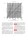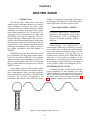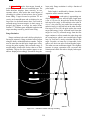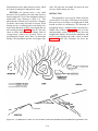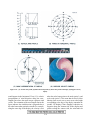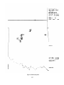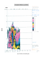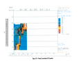
1
NONRESIDENT
TRAINING
COURSE
April 1999
Aerographer's Mate
Module 3—Environmental
Satellites and Weather Radar
NAVEDTRA 14271
NOTICE
Pages 2-35, 2-39, 2-41, 2-42, 2-44, 2-45, 2-47, 2-53,
2-54 must be printed on a COLOR printer.
DISTRIBUTION STATEMENT A: Approved for public release; distribution is unlimited.
Although the words “he,” “him,” and
“his” are used sparingly in this course to
enhance communication, they are not
intended to be gender driven or to affront or
discriminate against anyone.
DISTRIBUTION STATEMENT A: Approved for public release; distribution is unlimited.
PREFACE
By enrolling in this self-study course, you have demonstrated a desire to improve yourself and the Navy.
Remember, however, this self-study course is only one part of the total Navy training program. Practical
experience, schools, selected reading, and your desire to succeed are also necessary to successfully round
out a fully meaningful training program.
THE COURSE: This self-study course is organized into subject matter areas, each containing learning
objectives to help you determine what you should learn along with text and illustrations to help you
understand the information. The subject matter reflects day-to-day requirements and experiences of
personnel in the rating or skill area. It also reflects guidance provided by Enlisted Community Managers
(ECMs) and other senior personnel, technical references, instructions, etc., and either the occupational or
naval standards, which are listed in the Manual of Navy Enlisted Manpower Personnel Classifications
and Occupational Standards, NAVPERS 18068.
THE QUESTIONS: The questions that appear in this course are designed to help you understand the
material in the text.
VALUE: In completing this course, you will improve your military and professional knowledge.
Importantly, it can also help you study for the Navy-wide advancement in rate examination. If you are
studying and discover a reference in the text to another publication for further information, look it up.
1999 Edition Prepared by
AGC(SW) Stephen M. Volpe
AGC(SW) Daniel T. Hoffman
Published by
NAVAL EDUCATION AND TRAINING
PROFESSIONAL DEVELOPMENT
AND TECHNOLOGY CENTER
NAVSUP Logistics Tracking Number
0504-LP-026-9020
i
Sailor’s Creed
“I am a United States Sailor.
I will support and defend the
Constitution of the United States of
America and I will obey the orders
of those appointed over me.
I represent the fighting spirit of the
Navy and those who have gone
before me to defend freedom and
democracy around the world.
I proudly serve my country’s Navy
combat team with honor, courage
and commitment.
I am committed to excellence and
the fair treatment of all.”
ii
CONTENTS
PAGE
CHAPTER
1. Environmental Satellites . . . . . . . . . . . . . . . . . . . . . . . . . 1-1
2. Weather Radar. . . . . . . . . . . . . . . . . . . . . . . . . . . . . . 2-1
APPENDIX
I. Glossary. . . . . . . . . . . . . . . . . . . . . . . . . . . . . . . . . AI-1
II. Octants of the Globe . . . . . . . . . . . . . . . . . . . . . . . . . . AU-1
III. Refractive Index Nomogram . . . . . . . . . . . . . . . . . . . . . AIII-1
IV. Definition and Symbols of Radar Coded Message Components . . . AIV-1
V. Reference List . . . . . . . . . . . . . . . . . . . . . . . . . . . . . AV-1
INDEX.........................................INDEX-1
Nonresident Training Course Follows The Index
iii
SUMMARY OF THE
AEROGRAPHER’S MATE
TRAINING SERIES
The following modules of the AG training series are available:
AG MODULE 1, NAVEDTRA 14269, Surface Weather Observations
This module covers the basic procedures that are involved with conducting
surface weather observations. It begins with a discussion of surface observation
elements, followed by a description of primary and backup observation equipment
that is used aboard ships and at shore stations. Module 1 also includes a complete
explanation of how to record and encode surface METAR observations using WMO
and NAVMETOCCOM guidelines. The module concludes with a description of
WMO plotting models and procedures.
AG MODULE 2, NAVEDTRA 14270, Miscellaneous Observations and
Codes
This module concentrates on the observation procedures, equipment, and codes
associated with upper-air observations and bathythermograph observations.
Module 2 also discusses aviation weather codes, such as TAFs and PIREPs, and
includes a chapter on surf observation procedures. Radiological fallout and
chemical contamination plotting procedures are also explained.
AG MODULE 3, NAVEDTRA 14271, Environmentul Satellites and
Weather Radar
This module describes the various type of environmental satellites, satellite
imagery, and associated terminology. It also discusses satellite receiving
equipment. In addition, Module 3 contains information on the Weather
Surveillance Radar-1988 Doppler (WSR-88D). It includes a discussion of
electromagnetic energy and radar propagation theory, and explains the basic
principles of Doppler radar. The module also describes the configuration and
operation of the WSR-88D, as well as WSR-88D products.
AG MODULE 4, NAVEDTRA 14272, Environmental Communications
and Administration
This module covers several of the most widely used environmental
communications systems within the METOC community. It also describes the
software programs and products associated with these systems. The module
concludes with a discussion of basic administration procedures.
NOTE
Additional modules of the AG training series are in development. Check the
NETPDTC website for details at http://www.cnet.navy.mil/netpdtc/nac/neas.htm.
For ordering information, check NAVEDTRA 12061, Catalog of Nonresident
Training Courses, which is also available on the NETPDTC website.
iv
SAFETY PRECAUTIONS
Safety is a paramount concern for all personnel. Many of the Naval Ship’s
Technical Manuals, manufacturer’s technical manuals, and every Planned
Maintenance System (PMS) maintenance requirement card (MRC) include safety
precautions. Additionally, OPNAVINST 5100.19 (series), Naval Occupational
Safety and Health (NAVOSH) Program Manual for Forces Afloat, and
OPNAVINST 5100.23 (series), NAVOSH Program Manual, provide safety and
occupational health information. The safety precautions are for your protection and
to protect equipment.
During equipment operation and preventive or corrective maintenance, the
procedures may call for personal protective equipment (PPE), such as goggles,
gloves, safety shoes, hard hats, hearing protection, and respirators. When specified,
your use of PPE is mandatory. You must select PPE appropriate for the job since the
equipment is manufactured and approved for different levels of protection. If the
procedure does not specify the PPE, and you aren’t sure, ask your safety officer.
Most machinery, spaces, and tools requiring you to wear hearing protection are
posted with hazardous noise signs or labels. Eye hazardous areas requiring you to
wear goggles or safety glasses are also posted. In areas where corrosive chemicals
are mixed or used, an emergency eyewash station must be installed.
All lubricating agents, oil, cleaning material, and chemicals used in
maintenance and repair are hazardous materials. Examples of hazardous materials
are gasoline, coal distillates, and asphalt. Gasoline contains a small amount of lead
and other toxic compounds. Ingestion of gasoline can cause lead poisoning. Coal
distillates, such as benzene or naphthalene in benzol, are suspected carcinogens.
Avoid all skin contact and do not inhale the vapors and gases from these distillates.
Asphalt contains components suspected of causing cancer. Anyone handling
asphalt must be trained to handle it in a safe manner.
Hazardous materials require careful handling, storage, and disposal. PMS
documentation provides hazard warnings or refers the maintenance man to the
Hazardous Materials User’s Guide. Material Safety Data Sheets (MSDS) also
provide safety precautions for hazardous materials. All commands are required to
have an MSDS for each hazardous material they have in their inventory. You must
be familiar with the dangers associated with the hazardous materials you use in your
work. Additional information is available from you command’s Hazardous
Material Coordinator. OPNAVINST 4110.2 (series), Hazardous Material Control
and Management, contains detailed information on the hazardous material
program.
Recent legislation and updated Navy directives implemented tighter constraints
on environmental pollution and hazardous waste disposal. OPNAVINST 5090.1
(series), Environmental and Natural Resources Program Manual, provides detailed
information. Your command must comply with federal, state, and local
environmental regulations during any type of construction and demolition. Your
supervisor will provide training on environmental compliance.
Cautions and warnings of potentially hazardous situations or conditions are
highlighted, where needed, in each chapter of this TRAMAN. Remember to be
safety conscious at all times.
v
INSTRUCTIONS FOR TAKING THE COURSE
assignments. To submit your
answers via the Internet, go to:
ASSIGNMENTS
The text pages that you are to study are listed at
the beginning of each assignment. Study these
pages carefully before attempting to answer the
questions. Pay close attention to tables and
illustrations and read the learning objectives.
The learning objectives state what you should be
able to do after studying the material. Answering
the questions correctly helps you accomplish the
objectives.
http://courses.cnet.navy.mil
Grading by Mail: When you submit answer
sheets by mail, send all of your assignments at
one time. Do NOT submit individual answer
sheets for grading. Mail all of your assignments
in an envelope, which you either provide
yourself or obtain from your nearest Educational
Services Officer (ESO). Submit answer sheets
to:
SELECTING YOUR ANSWERS
Read each question carefully, then select the
BEST answer. You may refer freely to the text.
The answers must be the result of your own
work and decisions. You are prohibited from
referring to or copying the answers of others and
from giving answers to anyone else taking the
course.
COMMANDING OFFICER
NETPDTC N331
6490 SAUFLEY FIELD ROAD
PENSACOLA FL 32559-5000
Answer Sheets: All courses include one
“scannable” answer sheet for each assignment.
These answer sheets are preprinted with your
SSN, name, assignment number, and course
number. Explanations for completing the answer
sheets are on the answer sheet.
SUBMITTING YOUR ASSIGNMENTS
To have your assignments graded, you must be
enrolled in the course with the Nonresident
Training Course Administration Branch at the
Naval Education and Training Professional
Development
and
Technology
Center
(NETPDTC). Following enrollment, there are
two ways of having your assignments graded:
(1) use the Internet to submit your assignments
as you complete them, or (2) send all the
assignments at one time by mail to NETPDTC.
Grading on the Internet:
Internet grading are:
•
•
assignment
Do not use answer sheet reproductions: Use
only the original answer sheets that we
provide—reproductions will not work with our
scanning equipment and cannot be processed.
Follow the instructions for marking your
answers on the answer sheet. Be sure that blocks
1, 2, and 3 are filled in correctly. This
information is necessary for your course to be
properly processed and for you to receive credit
for your work.
Advantages to
COMPLETION TIME
you may submit your answers as soon as
you complete an assignment, and
you get your results faster; usually by the
next working day (approximately 24 hours).
Courses must be completed within 12 months
from the date of enrollment. This includes time
required to resubmit failed assignments.
In addition to receiving grade results for each
assignment, you will receive course completion
confirmation once you have completed all the
vi
PASS/FAIL ASSIGNMENT PROCEDURES
For subject matter questions:
If your overall course score is 3.2 or higher, you
will pass the course and will not be required to
resubmit assignments. Once your assignments
have been graded you will receive course
completion confirmation.
E-mail:
Phone:
[email protected]
Comm: (850) 452-1001, Ext. 1713
DSN: 922-1001, Ext. 1713
FAX: (850) 452-1370
(Do not fax answer sheets.)
Address: COMMANDING OFFICER
NETPDTC (CODE N315)
6490 SAUFLEY FIELD ROAD
PENSACOLA FL 32509-5000
If you receive less than a 3.2 on any assignment
and your overall course score is below 3.2, you
will be given the opportunity to resubmit failed
assignments. You may resubmit failed
assignments only once. Internet students will
receive notification when they have failed an
assignment--they may then resubmit failed
assignments on the web site. Internet students
may view and print results for failed
assignments from the web site. Students who
submit by mail will receive a failing result letter
and a new answer sheet for resubmission of each
failed assignment.
For enrollment, shipping,
completion letter questions
grading,
or
E-mail:
Phone:
[email protected]
Toll Free: 877-264-8583
Comm: (850) 452-1511/1181/1859
DSN: 922-1511/1181/1859
FAX: (850) 452-1370
(Do not fax answer sheets.)
Address: COMMANDING OFFICER
NETPDTC (CODE N331)
6490 SAUFLEY FIELD ROAD
PENSACOLA FL 32559-5000
COMPLETION CONFIRMATION
After successfully completing this course, you
will receive a letter of completion.
NAVAL RESERVE RETIREMENT CREDIT
ERRATA
http://www.cnet.navy.mil/netpdtc/nac/neas.htm
If you are a member of the Naval Reserve, you
will receive retirement points if you are
authorized to receive them under current
directives governing retirement of Naval
Reserve personnel. For Naval Reserve
retirement, this course is evaluated at 2 points.
(Refer to Administrative Procedures for Naval
Reservists on Inactive Duty, BUPERSINST
1001.39, for more information about retirement
points.)
STUDENT FEEDBACK QUESTIONS
COURSE OBJECTIVES
We value your suggestions, questions, and
criticisms on our courses. If you would like to
communicate with us regarding this course, we
encourage you, if possible, to use e-mail. If you
write or fax, please use a copy of the Student
Comment form that follows this page.
In completing this nonresident training course,
you will demonstrate a knowledge of the
subject matter by correctly answering questions
on the following subjects:
environmental
satellite and weather radar.
Errata are used to correct minor errors or delete
obsolete information in a course. Errata may
also be used to provide instructions to the
student. If a course has an errata, it will be
included as the first page(s) after the front cover.
Errata for all courses can be accessed and
viewed/downloaded at:
vii
Student Comments
Course Title:
Aerographer's Mate, Module 3—Environmental Satellites and Weather Radar
NAVEDTRA:
14271
Date:
We need some information about you:
Rate/Rank and Name:
SSN:
Command/Unit
Street Address:
City:
State/FPO:
Zip
Your comments, suggestions, etc.:
Privacy Act Statement: Under authority of Title 5, USC 301, information regarding your military status is
requested in processing your comments and in preparing a reply. This information will not be divulged without
written authorization to anyone other than those within DOD for official use in determining performance.
NETPDTC 1550/41 (Rev 4-00)
ix
CHAPTER 1
ENVIRONMENTAL SATELLITES
The inclination angle of a satellite’s orbit is the
angle the satellite’s path makes as the satellite crosses
the equator (fig. l-1). This term is usually referred to
as the satellite inclination.
INTRODUCTION
Satellite images, or pictorial representations of
satellite-sensed information, are some of the most
frequently used tools in the fields of meteorology and
oceanography.
Satellites that have an inclination of 0 degrees
circle the earth over the equator in an equatorial orbit.
When a satellite in an equatorial orbit moves from west
to east in the same direction that the earth rotates, its
speed and altitude may be adjusted so that it is always
located in a stable orbit over the same position on the
equator. Satellites in these orbits are called
geostationary, earth-synchronous, or geosynchronous
since they are stationary relative to their position over
the equator. Their fixed location provides continuous
coverage of the same area over a 24-hour period.
As a Navy or Marine Corps observer, one of your
primary duties will be to acquire satellite imagery. You
may also be required to process the imagery to better
display features of interest to the analyst. Later, as you
begin to analyze meteorological and oceanographic
situations, you will use satellite imagery as one of your
most important sources of information.
In this chapter, we begin with an explanation of
some of the basic terminology used to describe satellite
orbits and satellite tracking. Next, we introduce
environmental satellite programs, and then describe
the various types of environmental satellites and
explain their purposes. We then discuss some of the
most common types of satellite imagery, and acquaint
you with a few basic imagery enhancement techniques.
We complete the chapter by taking a brief look at some
of the equipment and methods that you will use to
acquire and process satellite imagery.
As shown in figure 1-1, satellites with high orbital
angles generally cross over the polar regions and are
called polar-orbiting satellites. These satellites orbit
the earth about 14 times a day and provide global
coverage every 12 hours. A single orbit of a polarorbiting satellite is composed of an ascending node,
which is the period of time when the satellite is
traveling from south toward the north, and a
descending node, which is the period of time when the
satellite is traveling from north toward the south.
SATELLITE TERMINOLOGY
The position directly under a satellite on the
surface of the earth is called the satellite subpoint or
nadir, while the track of the satellite subpoint along the
surface of the earth is called the satellite path.
LEARNING OBJECTIVES: Define basic
terminology used in relation to satellite orbits
and satellite tracking.
Now let’s consider some additional terms used in
satellite orbits and satellite tracking.
Before you can effectively acquire and use satellite
imagery, it is important that you become familiar with
some basic satellite terminology.
Because the earth rotates, each time a polar
orbiting satellite crosses the equator, its position is
further west than its position on the previous orbit.
This change in position is called the nodal increment
(fig. l-2). The total time it takes the satellite to
complete an orbit is called the nodal period. The term
epoch refers to a specific reference point in a satellite’s
orbit.
Environmental satellites orbit the earth at various
altitudes. Some environmental satellites operate lower
than 800 kilometers (500 statute miles), while others
operate as high as 35,800 kilometers (22,300 statute
miles). To stay in orbit, lower altitude satellites must
orbit faster than higher altitude satellites. As a result,
satellites in orbit at 800 kilometers complete an orbit in
a little over 100 minutes, while satellites in orbit at
35,800 kilometers require 24 hours to complete an
orbit.
Most polar-orbiting environmental satellites use a
nodal increment and a nodal period that keep pace with
the rotation of the earth and keep the satellite path
crossing the equator at the same local mean time
1-1
POLAR ORBITS
POLAR ORBITING
SATELLITE
AGMf101
Figure 1-1.—Satellite inclination.
Figure 1-2.—Nodal increment–the westward change in position of a polar-orbiting satellite’s path on earth on successive orbits.
1-2
(LMT) during each orbit. These types of orbits are
called sun-synchronous orbits—they are synchronized
with the movement of the sun across the earth’s surface.
For instance, an orbit may be calculated so that the
satellite path crosses the equator on the descending node
2 hours after sunrise on each orbit.
moving north, and it will always be over the dark side
of the earth when traveling south. Night-ascending
satellites will move northward over the dark side of the
earth and southward over the sunlight side of the earth.
The National Oceanic and Atmospheric
Administration (NOAA) normally maintains at least
two operational polar-orbiting satellites. One is in a
sun-synchronous morning orbit and the other is in a
sun-synchronous afternoon orbit. Thus, each satellite
provides two images every 24 hours (one day image
and one night image), producing a total of four images
a day over any given area.
The ascending and descending nodes may
additionally be identified by the relative time of day,
such as day-ascending, day-descending, nightascending or night-descending node (fig. l-3). When
an ascending node crosses the equator at a particular
relative time, the descending node of the same orbit
will cross the opposite side of the earth at a LMT about
12 hours opposite the ascending node LMT (plus onehalf the nodal period). For example, if a satellite has a
sun-synchronous orbit with a day-ascending node,
then the descending node on the other side of the earth
will be a night-descending node. To simplify the situation, only the relative time of day of the ascending
node is referenced. For example, an environmental
satellite known as a day-ascending satellite will
always be over the sunlight portion of the earth when
When a satellite achieves orbit around the earth,
the orbit is rarely a perfect circle. Most orbits are
actually elliptical and they change over time because
the earth is not a perfect sphere; it flattens over the
poles and bulges near the equator. The gravitational
pull of the earth, sun, and moon also plays a role. When
the satellite comes closest to the earth, the satellite is
said to be at perigee, and when it is farthest away from
the earth, the satellite is said to be apogee. When at
Figure 1-3.—Day-ascending and night-ascending polar orbits.
1-3
perigee, satellites move faster. When at apogee,
satellites travel slower. This change in velocity
complicates tracking of polar-orbiting satellites. For
convenience and ease of orbit calculations, time is
referenced to zero when a polar-orbiting satellite
passes the equator northbound, and increases through a
complete orbital period. Figure 1-4 illustrates the
changes that can occur in the perigee and apogee of a
satellite over time.
Q5. If a satellite has an ascending node time of 1400
local, what would be the approximate
descending node time at the same location?
Q6.
What are the major factors that would cause
changes in a satellites apogee and/or perigee
position?
TYPES OF ENVIRONMENTAL
SATELLITES
Most polar-orbiting satellites also have anomalies
in their orbits. An anomaly in an orbit is any change or
deviation from a perfectly stable orbit. Some
anomalies are planned into an orbit so that the orbit
will remain sun synchronous as earth revolves around
the sun during the course of a year. Anomalies further
complicate satellite orbital predictions.
LEARNING OBJECTIVES: Recognize the
various functions performed by environmental
satellites. Identify the major satellite programs
operated in the United States. Identify specific
types of geostationary satellites, polar-orbiting
satellites, DMSP satellites, and foreign
satellites. Recognize the advantages and
disadvantages of geostationary and polarorbiting satellites.
REVIEW QUESTIONS
Q1. A satellite with an equatorial orbit would have
an inclination angle of how many degrees?
The first meteorological satellite was launched in
April of 1960, and was known as TIROS-1 (Television
and InfraRed Observation Satellite). Since that time,
numerous satellites with more advanced technology
have been introduced, and today there are many
different designs of meteorological and oceanographic
satellites. Most of these satellites have a variety of
sensor packages that survey electromagnetic energy at
several different wavelengths.
Q2. What term is used for a satellite with an
equatorial orbit moving with the same speed and
direction as the earth?
Q3. What term is used to describe the period of time
when a polar orbiting satellite is traveling south
to north?
Q4. What is meant by the term "sun-synchronous"
satellite?
Figure 1-4.—Typical elliptical satellite orbit and changes in the orbital shape over a period of time.
1-4
Besides collecting imagery, most environmental
satellites perform additional functions. Some
satellites contain communications packages designed
to receive and relay signals between earth stations and
other satellites and to collect and relay observation
reports from automatic observation sites or buoys.
Some satellites carry search and rescue (SAR) beacon
locators. More advanced satellites carry sophisticated
instruments known as "atmospheric sounders." These
systems use infrared and microwave energy to provide
vertical temperature and moisture profiles of earth’s
atmosphere from the surface up to 30 miles. They also
evaluate atmospheric stability. In addition, satellites
can be used to measure a variety of other
environmental parameters, such as sea surface
temperature, wave height, snow/ice cover, low-level
wind speed and direction, and ozone distribution.
Although these functions are very important to
meteorology and oceanography, you will not normally
be involved in this type of data collection or data
processing. In this module, we discuss only the
differences in satellites that are important to you in
acquiring satellite imagery.
National Environmental Satellite, Data, and
Information Service (NESDIS). Their primary
meteorological satellite programs are the
Geostationary Operational Environmental Satellite
(GOES), and the Advanced Television InfraRed
Observation Satellite-NOAA (ATN) polar-orbiter
(also called a TIROS-N or NOAA satellite). Both
systems are energized with solar power while in orbit.
The Department of Defense oversees the Defense
Meteorological Satellite Program, usually referred to
as the DMSP.
GEOSTATIONARY SATELLITES
Geostationary satellites are placed at an altitude
(35,800 km) where their orbital period exactly matches
the rotation of the earth. The satellite sensors scan the
earth in horizontal lines, starting near the North Pole
and working down towards the South Pole.
Geostationary satellites are ideal for making largescale, frequent observations of a fixed geographical
area centered on the equator. Thus, they are better
suited to track rapidly moving large-scale disturbances
in the atmosphere, or to look closely at small-scale or
short-duration changes in the atmosphere. However,
their distance from the earth limits the resolution of the
imagery. In addition, these satellites do not "see" the
poles at all, and to achieve global coverage of just the
equatorial regions, a network of 5 to 6 geostationary
satellites is required. Figure 1-5 shows atypical GOES
satellite.
In the United States, both the U.S. Department of
Commerce and the U.S. Department of Defense
operate meteorological satellite programs. The
National Oceanic and Atmospheric Administration
(NOAA), a division under the Department of
Commerce, operates its satellite programs through the
Figure 1-5.—GOES satellite.
1-5
Figure 1-6.—Data coverage of GOES East and GOES West satellites.
POLAR ORBITING SATELLITES
NOAA operates two geostationary satellites
known as GOES East and GOES West. The GOES
East satellite (currently GOES-8), is located over 75°
west longitude while GOES West (currently GOES-9)
is located over 135° west longitude. Figure 1-6 shows
the area of the earth covered by GOES East and GOES
West.
Polar orbiting satellites closely parallel the earth’s
longitude lines. They pass over the vicinity of the
North and South Poles with each revolution. As the
earth rotates to the east beneath the satellite, each pass
monitors an area to the west of the previous pass. Since
AGM3107
Figure 1-7.—Advanced TIROS-N satellite.
1-6
Figure 1-8.—Data coverage on successive orbits of a polar-orbiting satellite.
polar-orbiting satellites circle the earth at a much lower
altitude (about 850 km), they have the advantage of
photographing clouds directly beneath them at
relatively high resolution. Although nearly every
environmental satellite provides both infrared and
visual imagery, polar-orbiting satellites are better
suited to gathering imagery from the high-latitude and
polar regions. They also provide imagery as they cross
the equatorial regions. This makes them extremely
well suited for oceanographic applications where slow
changes in water temperature are adequately tracked
by only two or four images a day.
The width of the usable image from a polarorbiting satellite is a function of the satellite’s altitude.
The average swath width is about 2700 km (1500 nmi).
Polar-orbiting environmental satellite orbits are
planned so that the usable image area overlaps slightly.
Figure 1-7 shows a typical TIROS-N satellite, while
figure 1-8 shows the area covered by usable imagery
on successive orbits of a polar-orbiting satellite.
As of this writing, NOAA 12 (TIROS-ND) and
NOAA 14 (TIROS-NJ) are the two fully operational
polar-orbiting satellites in the TIROS-N series. A new
series of polar-orbiting satellites will be launched by
the spring of 1998, and will be referred to as NOAAPOES (NOAA-Polar-orbiting Operational
Environmental Satellite). Table 1-1 compares various
characteristics between geostationary and polarorbiting satellites.
Table 1-1.—Geostationary Versus Polar-orbiting Characteristics
1-7
DMSP SATELLITES
DMSP satellites are polar-orbiting satellites
managed by the Department of Defense that provide
very high-resolution imagery. These satellites can
provide real-time worldwide support to operating
forces for both shipboard and selected shore sites.
Near real-time (stored) environmental imagery can
also be provided by the Fleet Numerical Meteorology
and Oceanography Command (FNMOC) at Monterey,
California. Because imagery from DMSP satellites is
encrypted for transmission, special processing
equipment is required for download.
Each direct transmission received from DMSP
contains two channels, visible and infrared. The
channels are transmitted so that one channel will
provide "fine" data (0.56 km resolution) and the other
will provide "smooth" data (2.7 km resolution).
Unique sensors aboard DMSP satellites allow for the
collection of visual imagery at night by using lunar
illumination. The determination of channel
assignment is made by the Air Force Weather Agency
located at Offutt AFB, Nebraska.
scatterometer measures reflected microwave signals
from ocean waves. This data is then used to estimate
low-level wind speed and direction over data sparse
ocean areas. Scatterometry data is available from
FNMOC.
FOREIGN SATELLITES
Several other countries also support active
meteorological satellite programs. China operates a
geostationary satellite called the Fengyun. Russia has
Meteor polar-orbiting satellites and GOMS
geostationary satellites in service. They also support a
joint project with India that has a geostationary
satellite—the INSAT, in place over the Indian Ocean.
Japan supports a geostationary satellite called the GMS
over the western Pacific Ocean. In Western Europe,
several nations jointly support the European Space
Agency (ESA). ESA maintains a geostationary
meteorological satellite called METEOSAT in place
over the Mediterranean region. Figure 1-9 shows the
global-scale monitoring program of the World
Weather Watch Global Observation System.
New satellites are routinely placed in orbit to
replace older satellites as they wear out and fail. Each
new satellite usually incorporates new technology and
may provide slightly higher image resolution or an
entirely new type of sensor. As you read this, the
satellites just mentioned may be out of service and
replaced by newer models.
DMSP satellites also have a special passive
microwave sensor known as a SSM/I (Special Sensor
Microwave/Imager). The SSM/I measures thermal
energy emitted and reflected by the earth’s surface and
atmosphere by using the microwave portion of the
electromagnetic spectrum. SSM/I data is particularly
useful in water vapor and sea ice analysis. In addition,
wind speeds over ocean areas can be estimated by
evaluating the brightness temperatures of the white
caps of the waves. DMSP satellites are launched as "F"
series satellites (F-12, F-13, etc.).
Information concerning the operational status of
all environmental satellites is available via the Internet
at the NOAASIS world wide web site operated by
NOAA/NESDIS. This site provides updated position
data for geostationary satellites as well as tracking
information bulletins for polar-orbiting satellites. The
A few satellites are equipped with a highfrequency radar device known as a scatterometer. A
The WWW Global Observation System
AGM3f109
Figure 1-9.—The World Weather Watch Global Observation System.
1-8
Q7.
What is the purpose of a satellite atmospheric
sounder?
Polar-orbiting satellites are in much lower orbits
than geostationary satellites; therefore, the satellite
can only see a limited portion of the earth as the
satellite sensors scan from horizon to horizon.
Because of the acute view angle near the horizon, the
satellite image near the horizon is usually of little value
and is usually not processed or displayed by receiver
station equipment.
Q8.
What is the main advantage of geostationary
satellites?
IMAGERY RESOLUTION
Q9.
Which GOES satellite provides imagery over all
of South America?
site also contains transmission schedules and
transmitting frequencies for various United States and
foreign-operated satellites.
REVIEW QUESTIONS
Q1O.
What type of satellite is the NOAA 14?
Q11.
What are the main advantages of polar-orbiting
satellites?
Q12.
What is the average swath width of a polarorbiting satellite?
Q13.
Which organization is responsible for providing
near real-time DMSP environmental imagery to
the fleet?
Q14.
Which geostationary satellite will provide
imagery for Spain and Portugal?
Satellite sensors designed to produce pictures or
images of earth, its oceans, and its atmosphere are very
different from the cameras used to take a photograph.
They are more like a video camera, only much more
specialized. These scanning sensors are called
radiometers, and instead of film, an electronic circuit
sensitive only to a small range of electromagnetic
wavelengths measures the amount of energy that is
received. Satellites may can-y several different image
sensors, each of which is sensitive to only a small band
of energy at a specific wavelength. The radiometer
used by the TIROS-N and POES series satellites is
known as the Advanced Very High Resolution
Radiometer (AVHRR) and contains many types of
sensors.
SATELLITE IMAGERY
Satellite sensors scan across the surface of the
earth in consecutive scan lines along a path normal to
the direction of travel of the satellite. As the sensor
moves through a scan line, it very rapidly measures
energy levels for only a very small portion of the earth
at a time. Each individual energy measurement will
compose a single picture element or pixel of the overall
satellite image. The sensor then assigns an intensity
level from 0 to 256 for each pixel. The size of the area
(field-of-view) scanned by the sensor determines the
spatial resolution of the overall image. Thus, the
smaller the area scanned for each pixel, the higher the
spatial resolution. Some sensors may scan an area as
small as 0.5 km across (high resolution), while others
scan areas as large as 16 km (low resolution). When
composed into an image, smaller pixels allow the
image to be much clearer and show greater detail.
Clouds and land boundaries appear better defined. If
objects are smaller than the sensor resolution, the
sensor averages the brightness or temperature of the
object with the background. Normally, the sensors
aboard satellites are able to provide better resolution
for visual imagery than for infrared imagery. DMSP
satellites have very high-resolution capabilities in both
visual and infrared.
LEARNING OBJECTIVES: Recognize the
particular advantages of imagery from
geostationary satellites and polar-orbiting
satellites. Define spatial resolution,
radiometer, electromagnetic wave, and albedo.
Define the terms visual, infrared, near
infrared, and water vapor as they relate to
satellite imagery. Recognize the advantages of
visual, infrared, and water vapor imagery.
The pictures or images available from
environmental satellites vary, depending on the type of
satellite and the type of sensor in use. Geostationary
satellites continuously "look" at the same geographical
area of the earth. However, the image area is centered
on the satellite subpoint on the equator. At the
subpoint, clouds are seen from directly overhead.
Further away from the subpoint, clouds seen in the
image are viewed from an angle, and feature distortion
occurs. Cloud cover is often overestimated toward
image edges because the sensor is actually viewing the
clouds from the side. Near the horizon, the image is
considered unusable due to distortion.
1-9
longer wavelengths of between 4 and 25 µm. For this
reason, the earths radiation is referred to as long-wave
radiation and the sun’s energy is referred to as
shortwave radiation. The atmosphere is a strong
absorber of radiation at certain wavelengths and is
relatively transparent to others. Generally, the
atmosphere is transparent to wavelengths associated
with incoming solar radiation; but because of the
presence of water vapor, carbon dioxide, and other
elements, the atmosphere is largely opaque to the
outgoing terrestrial wavelengths.
TYPES OF IMAGERY
All things (with a temperature above absolute
zero) emit radiation in the form of electromagnetic
waves. The wavelengths emitted by each object
depend primarily on the object’s temperature. Higher
temperatures cause electrons to vibrate faster and
therefore produce shorter wavelengths. The sun emits
radiation at several different wavelengths, and the
range of these wavelengths is known as the
electromagnetic spectrum (fig. 1-10, view A).
Electromagnetic wavelengths in the visual and
infrared region are usually measured in micrometers.
A micrometer is equal to one-millionth of a meter and
is represented by the symbol µm. Micrometers are also
referred to as microns.
When data signals from a satellite sensor scan are
compiled at the satellite receiver on earth, the pixels
and scan lines form an image. The image composed of
measurements of energy in the visual range forms a
visual image. The data from sensors that measure
energy in the infrared band compose an infrared
image.
The sun emits a maximum amount of radiation at
wavelengths near 0.5 µm. The earth, which is
obviously much cooler, emits most of its radiation at
ELECTROMAGNETIC SPECTRUM
Figure 1-10.—(A) The electromagnetic spectrum, and (B) the distribution of solar energy incident to the earth.
1-10
The more direct sunlight reaching objects, the
brighter they will appear. The amount of reflectivity of
an object is termed albedo, and is dependent on the
object’s surface texture and color. In visual-range
images, areas of low reflected light (low albedo), such
as water and forest regions, appear black. Areas of
high reflected light (high albedo), such as snow, appear
white (fig. 1-11). Cloud tops reflect a lot of light, so
they are usually very light shades. Space surrounding
earth reflects no light, so it appears black.
Visual Imagery
The electromagnetic energy that your eyes can see,
visible light, ranges from a wavelength of .7 µm for red
light, through the visible spectrum (red, orange,
yellow, green, blue, indigo and violet) to .4 µm for
violet light. Figure 1-10, view B, shows the
distribution of the various wavelengths of solar energy
incident on the earth’s atmosphere. About 44 percent
of the sun’s energy falls on the earth in the form of light.
Although some light is absorbed, much of the light
incident on the earth’s atmosphere and surface is
reflected back into space.
Visible imagery is very useful in both atmospheric
and oceanographic analysis because reflectivity varies
considerably among atmospheric, land, and oceanic
features. An obvious disadvantage of visible imagery
is that it is only available during daylight hours.
The reflected light from the earth is measured by a
sensor aboard the satellite that is sensitive only to
electromagnetic energy in the visual range. The sensor
measures the energy seen in each pixel and assigns it a
reading from 0 for no energy sensed to 256 for very
high energy sensed. Measurements are transmitted to
the earth, and the consecutive pixels and scan lines are
processed to compose an image.
Infrared Imagery
Look again at figure 1-10, view B. You can see
that most of the sun’s energy that falls on the earth is in
the infrared band. Most of the shorter wavelengths of
infrared energy are reflected from the earth much the
Figure 1-11.—GOES visual (VIS) image. Space and low reflective areas appear black, while high reflective areas, such as cloud
tops, appear white.
1-11
same as visible light (longer wavelength infrared
energy is absorbed). Satellites normally carry sensors
that measure energy levels in several specific bands of
infrared wavelengths, and the radiation measured is
directly related to the temperature of the different
radiating surfaces. Since all surfaces radiate some
amount of thermal (heat) energy, a major advantage of
infrared satellite imagery is that it is available even
when the earth is dark. Energy levels are measured
much the same way that visual-range energy is
measured. The individual measurements from each
pixel, when composed into an image of the earth, form
an infrared image.
Most infrared satellite imagery is measured at
wavelengths of 10.2 µm to 12.8 µm (far infrared).
Some satellites are able to augment visual and far
infrared imagery by also measuring near infrared
(NIR) wavelengths (.74 µm to 2.0 µm). NIR imagery
generally shows better land/water contrast and
simplifies low-level feature identification, such as
shorelines, snow/ice, and vegetation.
The satellite receiver and processor control how
the composed image will look. Normally, the energy
measurements for infrared image pixels are assigned
g-ray shades with low-energy readings appearing white
and high-energy readings appearing black. The lighter
the gray shade, the colder the object seen. With IR
images, space surrounding the earth is white, and
warm land or water masses are dark gray or black.
Infrared imagery is an excellent tool for
oceanographic analysis, such as evaluating sea surface
temperatures and determining ocean front and eddy
locations. It is also very helpful for identifying high
clouds and upper-level wind flow, but less reliable for
identifying low-level features. Look at figure 1-12.
Notice how lower level clouds, very distinct in the
visual image, are more difficult to determine in the
Figure 1-12.—GOES visual image on left compared to GOES infrared (IR) image on right. Space and cold cloud tops appear white
and warm water and land areas appear dark gray to black in an IR image.
1-12
infrared image when surface temperatures and cloud
top temperatures are relatively the same.
into an image, the result, shown in figure 1-13, is called
a water-vapor channel or WV image. Areas of high
water-vapor content (high humidity) appear in the
lighter gray shades while lower humidity areas appear
darker.
Water Vapor Imagery
Concentrations of water vapor in the atmosphere
absorb essentially all 6.7 µm radiation coming from
below. Thus, one of the infrared sensors carried
aboard the GOES and the METEOSAT measures
radiation at this wavelength. When the energy
measurements from this type of sensor are composed
The main advantage of the water vapor channel is
better definition of the moisture distribution in the
upper atmosphere. If moisture is present in the upper
levels, we associate this with upward vertical motion.
Conversely, upper-level dryness is a good indication
Figure 1-13.—GOES full disk (hemisphere) infrared water-vapor (WV) channel image (top) and full disk visual (VIS) image
(bottom) at the same time. The WV image shows a better depiction of the extent of the system than the VIS image.
1-13
definition. Infrared imagery is often enhanced to
better define a small range of critical temperatures.
of downward vertical motion. Water vapor imagery
can detect these motions without clouds present.
Circulation patterns in the upper atmosphere,
including the jet stream, are easily identified using WV
imagery.
TYPES OF ENHANCEMENT CURVES
Unenhanced imagery displays a linear transition of
gray shades from black (warm) to white (cold). It is a
steady increase in brightness that produces little
contrast. Enhanced imagery displays a transition of
mostly non-linear gray shades. The result is an
improved contrast of various key temperatures that
makes specific temperature assessment much easier.
There are two methods of enhancing satellite imagery:
brilliance inversions and thresholding (curves).
Brilliance inversion enhancements use a range of gray
shades (or color) to identify a range of specific
temperatures. With threshold enhancements, a single
gray shade is used to identify a whole range of
temperatures. In other words, all the temperatures in
a particular range have the same gray contour. Figure
1-14 shows enhanced infrared images.
REVIEW QUESTIONS
Q15. What is the image-scanning sensor of a satellite
called?
Q16.
Which sensor would provide higher resolution
data, one with a spatial resolution of 1 kilometer
or one with a spatial resolution of 4 kilometers?
Q17. Consider two objects, one cold the other hot.
Which object is emitting electromagnetic energy
at relatively longer wavelengths?
Q18.
The majority of the radiation emitted by the
earth is known by what term?
Q19. In the visible spectrum, what color has the
longest wavelength?
User-Defined Enhancement Curves
Q20. Of the following objects, sand or grass, which
one would have a higher albedo?
When possible, enhancement curves should be
locally developed and evaluated. Most satellite
receiving equipment used by the Navy, such as the
AN/SMQ-11, allow for the creation of custom
designed enhancement curves. Keep in mind that
when you are developing enhancement curves, you
should limit the number of features to be enhanced.
You must allow for enough detail as possible without
making the display too confusing. There are always
compromises between simple enhancement curves,
which sacrifice detail but can quickly be interpreted in
an operational environment, and complex curves,
which maximize information content but require more
time to interpret.
Q21. What are the major advantages of infrared
imagery?
Q22. How do relatively cold objects appear on IR
imagery?
Q23. How do high humidity areas appear on water
vapor images?
Q24.
What are the advantages of water vapor
imagery?
IMAGERY ENHANCEMENT
LEARNING OBJECTIVES: Identify various
types of user-defined and predefined satellite
enhancement curves. Identify information
contained in the GOES legend and temperature
scale.
Figure 1-15 is a graphic illustration of a basic
enhancement curve table. Count values as input would
be plotted on the horizontal axis, and modified count
values for the final display would be plotted on the
vertical axis. These count values range from 0 to 255,
where 0 appears as black and 255 appears as white.
Values in between produce varying shades of gray. By
adding, deleting, and positioning points within the
graph, an input color or gray shade is mapped to an
output color or gray shade. As points of reference, six
count values on the horizontal axis correspond to the
six sets of temperatures at the bottom of the graph.
Count values on the vertical axis result in the gray
shade range as referenced at the right of the graph. The
Most satellite data processors have the capability
to assign colors or various gray shades to specific JR
imagery energy readings. When an image is produced
by using either color or an alternating gray shade rather
than the straight black-to-white or white-to-black
shading, the color or gray shade assignment is called an
enhancement. An enhanced satellite image allows the
user to see specific details of an image with better
1-14
Figure 1-14.—Processed GOES infrared images with temperatures added to gray-shade scale. (A) A predefined "ZA" enhancement
(straight black to white shading) and (B) a predefined "MB" enhancement used to better define cloud-top temperatures (cloud
height) in thunderstorms at points A, B, and C.
1-15
COUNT VALUE INPUT
Figure 1-15.—Illustration of a basic enhancement curve table.
solid line (AB) represents a case of no enhancement.
As an example, if you acquired an image and the
warmer (darker) end of the spectrum required greater
definition, the data could be modified as illustrated by
the segment (AC). In this case, all the gray shades from
+56.0°C to 5.8°C would be displayed.
sea surface temperatures, you might only enhance the
image in a range from +20°C to -10°C, as shown in
figure 1-16. Any areas on the image colder than the
lower limit will appear white. Areas warmer than the
upper limit will appear black.
HIGH-LOW ENHANCEMENT.—For highlow enhancement curves, two ranges are selected. For
each of these, a unique part of the gray-shade and count
value scale is applied to each range. Thus, warm
temperatures may be in the gray-black range, while
cold temperatures may be in the white off-white range.
Figure 1-17 is an example of a high-low enhancement
curve with temperature ranges of +30°C to +05°, and
-20°C to -40°C. Areas colder than the lowest
minimum temperature will appear white. Areas
warmer than the highest maximum temperature will
appear black. Areas which are temperatures between
the upper and lower ranges will appear black.
Enhancement curves for high-resolution imagery
from DMSP and NOAA satellites are usually
developed based upon three basic configurations,
depending on desired results. They are the single
enhancement, the high-low enhancement, and the split
enhancement.
SINGLE ENHANCEMENT.—The single
enhancement curve is defined over a complete count
value range, but for either a default or specified
temperature range. This curve will give you all gray
shades across your defined temperature range. For
example, if you were interested in only low clouds or
1-16
Figure 1-16.—Single enhancement curve.
Figure 1-17.—High-low enhancement curve.
1-17
SPLIT ENHANCEMENT.—For
split
enhancements, two ranges are also selected. For each,
the complete gray-shade and count value scale applies.
This means that the complete gray shade scale is
applied twice over the image, except for temperatures
lying between the two defined ranges. Figure 1-18
displays a split enhancement curve for temperatures of
+30°C to 0°C and -10°C to -30°C. Areas colder than
the lower minimum temperature will appear white.
Areas warmer than the higher maximum temperature
will appear black. Areas which are temperatures
between the upper and lower ranges will appear gray.
application. One of the most common is the MB
Curve. This is a very good, all-purpose curve, but was
specifically designed for summertime convective
activity. The MB curve has very distinct contours
(thresholding) around specific temperatures, and is
especially helpful in picking out thunderstorms.
Figure 1-19 shows the configuration of the MB curve.
The GOES User’s Guide contains detailed information
on various predefined enhancement curves.
Visible imagery can also be enhanced by adjusting
brightness values vice temperature values as with IR
imagery. Enhanced visible imagery is especially
useful in cases of fog and thick stratus.
Predefined Enhancement
Curves
GOES LEGEND INFORMATION
Besides locally developed enhancement curves,
there are several predefined enhancement curves
available for GOES imagery that have been tested and
evaluated over many years. Each of these
enhancements was developed for a specific
Much information about a particular GOES
satellite image is available from the GOES legend that
appears at the top of each image received over the
GOES Telecommunications Access Program (GOESTAP). An example of a GOES legend is shown at the
Figure 1-18.—Split enhancement curve.
1-18
MB Enhancement
Figure 1-19.—The GOES MB enhancement curve.
1-19
top of figure 1-20. Column 1 is the Universal
Coordinated Time (UTC) and column 2 is the date of the
image. The first number in column 3 indicates line
stretcher/data buffer identification data and the first
letter is the satellite identification indicator (I=GOES 8,
J=GOES 9). The second letter in column 3 is the image
type, which will be either "F" for full disk IR, "E" for the
equivalent IR sector, or "A", "B", "C", "D" for the
visible sectors. The next number in column 3 is the
resolution in kilometers, and the last two letters in
column 3 indicate the type of enhancement curve (IR
imagery only). Columns 4 and 5 are for use by satellite
specialists.
Column 6 of the GOES legend indicates the sector
identification of the image. The term sector refers to
the segments of a GOES image that are expanded or
contracted to the desired geographic region of a
particular GOES-TAP distribution site. The first letter
indicates the satellite field distribution site for which
Figure 1-20.—A GOES 8 EC1 infrared sector taken at 2145 UTC, June 21,1995. The GOES legend is at the top of the image.
1-20
charts and satellite imagery on a fixed schedule.
Schedules and frequencies for facsimile broadcasts
originating from CONUS stations (San Francisco,
New Orleans, Boston, and Kodiak) are available over
the Internet. Several other countries, such as Japan and
India, also transmit weather charts and satellite
imagery via HF. A listing of all maritime weather
broadcast frequencies is available in the latest edition
of Worldwide Marine Radiofacsimile Broadcast
Schedules published by NOAA.
the sector was generated, such as "D" for Washington,
D.C, or "S" for San Francisco. The next letter indicates
the sector resolution in kilometers, that is A= 1 km, B =
2 km, C = 4 km, and D = 8 km (IR only). The last digit
indicates the identification number of the specific
sector.
GOES TEMPERATURE SCALE
The temperature scale appears only on IR and WV
imagery, and it appears below the legend. The
temperature scale is divided into 10°C increments with
a range from +50°C to -100°C. It has 15 temperature
blocks separated by white or black vertical lines. The
temperature scale is very useful in cloud and non-cloud
identification.
NAVY OCEANOGRAPHIC DATA
DISTRIBUTION SYSTEM
The Navy Oceanographic Data Distribution
System (NODDS) is a dial-up data service available
from FNMOC. Although originally designed to
transmit graphical data fields for portable computer
systems, selected satellite imagery is now available
within a few hours of sensing. Authorized users may
access the system from anywhere in the world via
computer modem through the U.S. Govemmentowned Internet routing networks or via direct longdistance telephone connection on commercial or
Defense Switched Network (DSN) lines. Information
on NODDS satellite imagery is available in the Navy
Oceanographic Data Distribution System Products
Manual.
REVIEW QUESTIONS
Q25. What is the purpose of enhancing satellite
imagery?
Q26. What is a major disadvantage of providing too
much definition to user-defined enhancement
curves?
Q27. Which type of user-defined enhancement curve
applies two complete gray-shade and count
value scales for two separate temperature
ranges?
All of the satellite data available on NODDS is
from DMSP satellites. The pictures that actually
appear on your computer monitor may not be quite as
clear as imagery from other sources. The imagery is
considered near real-time in that it is available to the
user usually within a few hours of sensing. The DMSP
satellites collect imagery, store the information as
digital data aboard the satellite, and then dump the
imagery data on command as it comes within range of a
receiver site capable of copying high-resolution
imagery. DMSP imagery for specific, high-interest
areas around the world may be requested from
FNMOC after some coordination.
Q28. What is indicated in column 6 of the GOES
legend?
Q29. The GOES temperature scale is normally
divided into segments of how many degrees?
METHODS OF ACQUIRING IMAGERY
LEARNING OBJECTIVE: Identify the various
methods used to acquire environmental
satellite imagery.
There are several ways to receive satellite
imagery: weather facsimile broadcast; Navy Oceanographic Data Distribution System (NODDS); GOES
Telecommunications Access Program (GOES-TAP);
satellite direct-readout service; weather facsimile service (WEFAX); the Internet; and AUTODIN message.
GOES TELECOMMUNICATIONS ACCESS
PROGRAM (GOES-TAP)
Ashore, Navy and Marine Corps weather stations
receive satellite imagery primarily from the GOESTAP service. The GOES-TAP service is operated by
NESDIS, and satellite images are provided via
dedicated telephone circuits. The circuits are leased
from commercial telephone companies and are
maintained by the telephone companies that own them.
Routine satellite images are transmitted at 15-minute
intervals. The imagery is normally displayed on a
WEATHER FACSIMILE BROADCAST
Some ships may receive a low quality satellite
image as part of the U.S. Coast Guard facsimile
broadcast. Transmitted via high-frequency (HF) radio,
this broadcast transmits National Weather Service
1-21
Almost all satellite imagery processors have
looper capability. The primary application of any
looper system is to store and display a series of
geostationary satellite images of the same area in a
sequence that shows the movement of clouds and
weather systems. Individual satellite images may also
be displayed and studied. The various other display
options, such as map overlay and enhancement, are
menu-driven for both the GTIS and the MIDDS as is
the channel selection. Instructions for using GTIS are
contained in the User’s Manual provided with each
installation.
computer monitor that has control access to the various
channels of the GOES-TAP system.
GOES-TAP users may be connected to one of
several satellite field distribution facilities or be
connected to another user.
When connected to a distribution hub, the user
may select several different channels of imagery signals. There are several hubs located at various National
Weather Service (NWS) forecasts offices, such San
Francisco, Miami, and Kansas City, to name a few.
If the user is not connected directly to a hub, but
connected to another user, this arrangement is appropriately called a slave connection. The secondary user
has no direct choice of incoming imagery signal and
only receives the data on the channel selected by the
primary user. Several Navy and Marine Corps weather
stations are connected as slaves. Slaved GOES-TAP
users must coordinate with the primary user if a
different channel of imagery is desired.
The MIDDS has a colorized custom enhancement
function and a few systems have the additional capability of obtaining satellite images via WEFAX
broadcast, HF radio, or Automatic Picture
Transmission (APT) receiver. Instructions for obtaining satellite information via MIDDS is contained in the
Meteorology and Oceanography (METOC) Integrated
Data Display System (MIDDS) User’s Guide.
Each channel of GOES-TAP is a separate
broadcast of imagery. One channel, for example, may
contain only alternating visual and infrared GOES
satellite images of the full disk (hemisphere) of the
earth. Another channel may contain visual and infrared
GOES images of only the southeastern United States.
A third channel may contain imagery from the
European METEOSAT. Yet another channel may
contain high-resolution picture transmission (HRPT)
imagery from a NOAA satellite. Enhanced infrared
imagery from GOES is also routinely available via
GOES-TAP.
DIRECT-READOUT SERVICE
Direct-readout service is an image-data
transmission designed to be received by user-operated
satellite receiver stations, such as the AN/SMQ-11
satellite terminal and the Interim Mobile
Oceanography Support System (IMOSS) satellite
module. The raw satellite signals are converted to an
image by the receiver station. Direct-readout service is
available from all polar-orbiting meteorological
satellites. This service is generally not available from
geostationary satellites, although a few weather
activities have acquired geostationary direct-readout
systems from commercial contractors.
Most GOES-TAP data is processed and analyzed
by using a desktop computer with a color video
monitor. The monitor is used to display both the
imagery and the control menus. Initial issue
equipment was the GOES-TAP Imaging System
(GTIS), which used a Unisys 80386 desktop computer.
Most of these systems have been replaced by the
Meteorology and Oceanography (METOC) Integrated
Data Display System (MIDDS). A laser printer may be
connected to either system to provide hard copy prints
of the imagery. Although hard copies of selected
images may be made, hard copy quality is a function of
the printer or imagery connected to the system. Similar
equipment called the Naval Satellite Display SystemEnhanced (or NSDS-E) is used at most
NAVMETOCCOM centers. This system has the
additional capability of copying NOAA polar-orbiter
and DMSP imagery. Further changes to GOES-TAP
processing equipment are very likely in the future.
One type of direct-readout service that is provided
by the NOAA satellites is the Automatic Picture
Transmission (APT) service. APT service provides a
continuous transmission of both visual and infrared
satellite imagery. The NOAA satellites transmit a pair
of images, one visual and one infrared, over sunlight
portions of the earth, and two different infrared
channels over the dark side of the earth. The scan rate
is 120 lines per minute at 4-kilometer resolution. The
amount of data received by a station depends on the
location of the satellite subpoint; the further the
subpoint falls from the station, the smaller the area of
coverage becomes.
The received APT images are ungridded—no
latitude/longitude lines nor land/water or geographical
boundaries are added to the image (fig. 1-21). APT
service is also available from foreign polar-orbiting
1-22
Figure 1-21
1-23
satellites and varies from relatively low resolution to
high resolution.
APT direct-readout imagery is normally
transmitted in the 136-MHz to 139-MHz band. The
data signals are transmitted from the satellite to earth
within seconds of being scanned by the satellite
sensors. This is sometimes called real-time imagery;
the image is available as the satellite scans the earth.
APT service is designed to be received by anyone with
a standard, relatively low-cost satellite receiver.
Signals from DMSP satellites also provide APT.
However, the signals are encrypted. Additional
information on APT direct-readout services may be
found in the NOAA KLM User’s Guide.
The IMOSS satellite module can receive, process,
display, grid, and enhance APT direct-readout service
from nearly all polar-orbiting environmental satellites.
It is not equipped to decrypt the imagery signal from
the DMSP satellites. The AN/SMQ-11 is capable of
copying both APT data as well as DMSP encrypted
signals.
A second type of direct-readout service available
from both the NOAA and DMSP satellites is the HighResolution Picture Transmission (HRPT) service.
This is data scanned at a rate of 360 lines per minute to
provide 1.1-kilometer resolution (fig. 1-22). Highresolution imagery can be, and usually is, transmitted
from satellites as a continuous broadcast. HRPT
Figure 1-22.—HRPT imagery.
1-24
The WEFAX signal is much weaker than the APT
or HRPT signal from polar-orbiting satellites.
Normally, a directional antenna with antenna polarity
control circuits is necessary to copy the WEFAX
signal. The AN/SMQ-11 is fully capable of capturing
the WEFAX signal. The IMOSS satellite module can
also receive and process the WEFAX signal by using a
special directional antenna specifically designed to
copy the broadcast.
imagery, like the APT direct-broadcast imagery, is
received unprocessed and ungridded. Many useroperated satellite receiver systems are unable to
receive and process I-IRPT imagery. The IMOSS
satellite module cannot receive or process HRPT,
while the AN/SMQ-11 is able to receive and process
the signal.
High-resolution imagery may also be stored
aboard the satellite, downloaded to a Command Data
Acquisition (CDA) station on command, and sent to
NESDIS in Suitland, Maryland. NESDIS processes
the imagery, adds gridding, and forwards the
processed signal to other imagery services. NESDIS
operates two CDA stations for both the NOAA and
GOES satellites: Wallops Island, Virginia, and
Fairbanks, Alaska. The Department of Defense
operates its own CDA stations for the DMSP satellites.
Directional antennas should be aimed at the
broadcasting geostationary satellite for the best
WEFAX reception. Instructions for aiming the
IMOSS WEFAX antenna are available in the Interim
Mobile Oceanography Support System (IMOSS)
User’s Guide. Appendix C of the guide contains
diagrams for calculating elevation and azimuth angles
for different geostationary satellites.
Be aware that although international agreements
call for five operational geostationary satellites,
problems occasionally arise that require satellites to be
moved temporarily to slightly different locations.
WEFAX may also be broadcast from older
geostationary satellites that have been moved out of
the primary position. Figure 1-23 is a diagram
frequently used to calculate the azimuth (degrees true)
and elevation angles needed to find any geostationary
satellite located over the equator.
WEFAX SERVICE
Another method for receiving satellite imagery at
your ship or station is to copy a WEFAX (weather
facsimile) broadcast from a geostationary satellite.
WEFAX is the retransmission of low-resolution
infrared and visible satellite imagery from U.S. GOES
satellites to any receiver capable of copying the signal.
WEFAX transmissions are also available via
METEOSAT, GMS, and other foreign satellites.
The U.S. GOES WEFAX service provides visual
and infrared sectors as well as full disk imagery. The
service also includes selected meteorological and
oceanographic charts, TBUS bulletins, and
operational messages. You can check the NOAASIS
web site for information on active WEFAX broadcasts,
broadcast content, and frequencies. Information
concerning GOES schedules is also available via the
Internet. Detailed information on WEFAX services is
provided in the WEFAX User’s Guide issued by
NOAA/NESDIS.
To use the diagram, the user subtracts the
longitude of the receiver location (site longitude) from
the longitude of the satellite to find delta (∆), (ignore
the sign). Using the value of ∆ (scale on the left side of
the diagram with 80 degrees at the bottom and
3 degrees at the top), follow parallel to the drawn lines
sloping downward toward the right. Using the receiver
station latitude (site latitude) on the Γ scale (right side
of the diagram), follow parallel to the lines sloping
downward toward the left to the intersection of the ∆
value. The antenna elevation angle (look elevation) is
found by drawing a horizontal line toward the left to
the look elevation scale. The antenna azimuth is found
by drawing a vertical line downward to the look
azimuth scale. The four azimuth scales are used as
follows:
Each GOES satellite provides high-resolution
imagery that is transmitted on a high-frequency signal
to the CDAs and processed at NESDIS. NEDSIS
processes t h e s i g n a l t o a d d g r i d d i n g
(latitude/longitude), geographical boundaries, borders
for land and water masses, and enhancement. The
CDAs then retransmit the processed signal back to the
satellite for WEFAX transmission. In turn, the satellite
retransmits the WEFAX signal back to earth on a lower
frequency signal for reception by user-operated
satellite receivers. The service is generally provided at
frequencies near 1691 MHz.
SW - When receiver is south of the equator and
west of the satellite’s position
SE - When the receiver is south of the equator
and east of the satellite’s position
NE - When the receiver is north of the equator
and east of the satellite’s position
1-25
Figure 1-23.—Geostationary satellite antenna-aiming diagram.
In the example shown on the diagram, azimuth and
elevation angles are determined for the 75°W GOES
NW - When the receiver is north of the equator
and west of the satellite’s position
1-26
from a receiver site at 103.4°W longitude, 23.0°N
latitude. The ∆ value of 28.4° is the difference
between 103.4° and 075.0°, ignoring the sign. The
antenna elevation is about 48 degrees, and the azimuth
on the NW scale is 126 degrees.
REVIEW QUESTIONS
Q30. Which U.S. Government agency provides HF
broadcasts of satellite imagery?
Q31. What type of satellite imagery is available from
NODDS?
INTERNET
Q32. How is satellite imagery acquired by most
shore-based weather stations?
In recent years, the Internet has become a very
efficient method of acquiring satellite imagery. The
worldwide web is the fastest way to acquire a wide
variety of real-time satellite imagery. NOAA/NEDSIS
has its own website (NOAASIS) along with several
private companies and universities. Of particular
importance is that these sites can be reached aboard
ships equipped with Internet access. FNMOC can also
transmit satellite imagery over the military Internet
(NIPRNET and SIPRNET). This imagery can then be
viewed using Joint METOC Viewer (JMV) software
with any computer system able to process the data.
Details on the JMV and the NIPRNET/SIPRNET
routing networks is covered in later modules. The
Naval Research Laboratory in Monterey, California,
has an outstanding Internet homepage that provides a
tremendous amount of satellite imagery data. It
contains general information relating to environmental
satellites and provides guidance packages for new and
experimental satellite products. The website also
provides links to various other satellite imagery
sources.
Q33. What is the purpose of a satellite looper?
Q34. What is the advantage of APT direct-readout
imagery?
Q35. How does the resolution between APT and
HRPT data compare?
Q36. What type of information is available from the
WEFAX broadcast?
Q37. What is the fastest way to acquire a wide variety
of satellite imagery?
Q38. How can units with no environmental satellite
reception capability or Internet access still
receive satellite imagery?
SATELLITE RECEIVER SYSTEMS
LEARNING OBJECTIVES: Identify the two
primary satellite receiver systems used to
acquire direct-readout imagery and WEFAX
products. Identify the operator’s manuals that
provide detailed instructions for use of the
systems.
AUTODIN MESSAGE
The Automatic Digital Network (AUTODIN) is
the U.S. Navy’s most common method of transmitting
message traffic between commands. Satellite images
can also be sent via AUTODIN in greatly compacted
form. This method is only used in rare cases, most
often used by at-sea platforms with little or no
environmental satellite reception capability and no
Internet access. Portions ofreceived images that are of
interest to a ship can be extracted, compacted, encoded
for transmission, and sent via AUTODIN link to the
ship from any other command (normally Meteorology
and Oceanography centers). The AUTODIN encoded
images are then available for reprocessing and display
by the ship. Requests for satellite imagery via
AUTODIN are carried out on a case-by-case basis.
Requests should be limited to information that is
essential to operations, as too much data will slow
other AUTODIN message traffic.
Two satellite receiver systems are routinely
operated by Navy and Marine Corps weather
observers. The AN/SMQ-11 system is used at major
shore installations and aboard all aircraft carriers.
Navy Mobile Environmental Teams (METS) use the
optional satellite module of the IMOSS to receive
satellite imagery.
AN/SMQ-11 METEOROLOGICAL
DATA SET
The AN/SMQ-11 satellite receiver station is
installed aboard most U.S. Navy ships staffed by
Aerographer’s Mates, at many Naval Meteorology and
Oceanography Command activities, and in Marine
Corps Mobile Meteorological Vans (METVANs).
The ANISMQ-11 may receive, process, display, grid,
and enhance DMSP imagery and both APT and HRPT
1-27
direct-readout imagery. The system can also receive
WEFAX imagery, but cannot command a data
download of stored HRPT data. The AN/SMQ-11
produces imagery on dry-silver film (which requires
no chemicals for development), or by using a highresolution laser printer.
Figure 1-24 shows the two AN/SMQ-11
equipment cabinets that are installed inside the
workspaces. Each AN/SMQ-11 is equipped with a
Tactical Advanced Computer, Version Four (TAC-4),
that includes a workstation, color monitor, an
uninterruptible power supply, and a power distribution
unit. The ANLSMQ-11B has a dual frequency array
antenna (figure 1-25) and is normally installed on a
rooftop ashore. Some systems are equipped with a
multi-frequency array antenna (ANLSMQ-11C). The
shipboard version of the AN/SMQ-11 contains
additional circuits for control and stabilization of the
antenna to compensate for ship motions. Operation of
the ANISMQ-11 is described in detail in NAVAIR 5030SMQ-11, Organizational Maintenance with
Illustrated Parts Breakdown, Receiver/Recorder Set,
A. Electronic Cabinet CY-8839/SMQ-11
B. Receiver-Demodulator R-2590/SMQ-11
C. Antenna Control C-l1933(P)/SMC-11
D. Television Monitor TV-4/SMQ-11
E. Processor Computer CP-2368/SMQ-11
Meteorological Data, AN/SMQ-11. This manual
includes operator instructions.
At most sites, the AN/SMQ-11 satellite receiver
system is cross connected to the Tactical
Environmental Support System (TESS). Imagery
received by the AN/SMQ-11 may be "called into" the
TESS terminal for processing, display, and analysis.
Additionally, much of the operation and control of the
AN/SMQ-11 can be performed through the TESS
keyboard.
The directional antenna of the AN/SMQ-11
system must be aimed at the satellites to receive either
direct-readout imagery or GOES and WEFAX
broadcasts. The aiming operation is performed
automatically by the system, provided the ephemeris
data has been entered properly for each polar-orbiting
satellite, and the position data has been updated for the
geostationary satellites.
IMOSS SATELLITE MODULE
The Interim Mobile Oceanography Support
System (IMOSS) is a combination of three
F. Data Security Equipment KG-44/TSEC
G. Electronic Cabinet CY-8838/SMQ-11
H. Power Distribution Control Assembly C-12539/SMQ-11
I. Printer Assembly PT-566/SMQ-11
J. Uninterruptible Power Supply Assembly PP-8467/SMQ-11
Figure 1-24.—AN/SMQ-11 equipment cabinets.
1-28
Figure 1-25.—AN/SMQ-11 dual frequency array antenna.
subsystems, the main subsystem, the communications
module subsystem (COMM MOD), and the satellite
module subsystem (SAT MOD). Each subsystem
consists primarily of a laptop computer that can be
used as a stand-alone system, depending upon mission
requirements. The main subsytem contains a multiple
application software library dedicated to many aspects
of METOC support. The IMOSS comes equipped with
a printer.
computer. Satellite imagery received via the satellite
module may be transferred to the main IMOSS
computer by using a 1.44MB data disk. All components are equipped with protective cases (fig. 1-26).
Because the APT antenna is omnidirectional, no
antenna aiming is required to track polar-orbiting
satellites or geostationary satellites. When the system
is powered up, the receiver will automatically scan
satellite frequencies, detect imagery signals, and
acquire the imagery. The WEFAX antenna must be
manually oriented toward the geostationary satellite
during initial setup of the system. For planning, the
system contains software that displays orbital
predictions and line-of-sight receiver ranges for the
polar-orbiting APT and geostationary satellite
WEFAX transmissions. Menu options on the liquid
crystal display (LCD) screen guide the operator
The SAT MOD consists of a laptop computer that
contains a built-in satellite receiver and processor. It
also includes a VHF receiver/demodulator and two
antennas. One antenna is an omnidirectional antenna
used to copy APT signals and the other is used to copy
signals from the WEFAX broadcast. The SAT MOD is
equipped with special software modifications that can
be used independently from the main IMOSS
1-29
Figure 1-26.—Interim Mobile Oceanography Support System (IMOSS) satellite module.
Q41.
through processing, gridding, and enhancement
options for various APT direct-readout and WEFAX
imagery.
The operator must update satellite ephemeris data
for each polar-orbiting satellite at least once every 2
weeks. Selected prediction information from Part IV
of the TBUS or NASA-2 line bulletins may be
manually entered via the keyboard or copied directly
from a data disk. Orbital-prediction information is
available via message over the Automated Weather
Network (AWN), by standard AUTODIN message, or
by using a computer modem connection to various
sources, such as the Internet.
Which satellite antenna of the IMOSS satellite
module must be manually oriented towards
geostationary satellites?
EPHEMERIS INFORMATION
LEARNING OBJECTIVES: Identify the
various orbital prediction bulletins and explain
how they are obtained. Recognize how data
from satellite orbital prediction bulletins is
used to update user-operated satellite receivers.
One of the most critical operations on any of the
direct-readout satellite imagery receiving systems is
the updating of ephemeris data. Ephemeris data is
information that describes the type, orientation, and
shape of a particular satellite’s orbit. Ephemeris data is
critical to satellite tracking as it provides key
information that allows you to determine where a
satellite will be located at any given moment. This
information is also used to allow the receiver system to
predict where polar-orbiting satellites will be at any
moment in relation to the location of the receiver site.
More importantly, ephemeris information enables
your receiver system to earth-locate the image, that is,
to establish what area of the earth is depicted in an
Complete information on the operation of the
IMOSS satellite module, including antenna
orientation procedures, updating ephemeris data,
gridding, and display of satellite imagery is contained
in the IMOSS user’s guide. The manual is provided
with each module by the Naval Oceanographic Office.
REVIEW QUESTIONS
Q39. Which types of satellite imagery may be
acquired by using the AN/SMQ-11?
Q40. Which types of satellite imagery may be
acquired by using the IMOSS satellite module?
1-30
available on the meteorological/oceanographic data
channel of the fleet multichannel communications
broadcast, as well as via AUTODIN message. TBUS
data can also be obtained from the Internet through the
NOAASIS website.
image received from a polar-orbiting satellite. Once
an image has been earth-located, you can then merge
appropriate geographical boundaries and a
latitude/longitude grid with the image. Without
accurate placement of a grid system, even the clearest
high-resolution images are nothing more than
interesting pictures. Environmental applications
require the analyst or forecaster to be able to determine
where a feature is and how fast it is moving, which is an
impossible task without an accurate reference grid.
The TBUS bulletins are in a special U.S. national
code form. The code form is only used for orbital
prediction information for satellites operated by the
United States. Complete information on this code is
available in the NOAA KLM User’s Guide. Satellites in
the TBUS bulletin are identified in the message header
by name, such as NOAA 14, and by the U.S. satellite
identification number, such as 37 for NOAA 12, and 38
for NOAA 14. In Part IV of the bulletin, the satellites
are identified by an internationally recognized satellite
number, such as 1994 089A for NOAA 14.
Since geostationary satellites do not move relative
to the earth, their ephemeris data does not need
frequent updates. However, they are moved
periodically and their positions are updated via special
bulletins as necessary. These bulletins are posted on
the Internet at the NOAASIS web site.
Several software programs are in use in various
systems to automatically calculate polar-orbiting
satellite orbits and antenna-aiming data. The
AN/SMQ-11 system and the SAT MOD both perform
these functions, but rather differently. TESS, which
may be used to control the AN/SMQ-11, also has a
separate orbital prediction function. Software
upgrades are in development that will alleviate some of
these differences.
A separate NOAA APT predict bulletin is
composed daily for each operational NOAA series
satellite. TBUS 1 bulletins are used to indicate north to
south (descending) daylight orbits, and TBUS 2
bulletins are used to indicate south to north (ascending)
daylight orbits. Each bulletin is composed of six parts:
In this section, we will discuss how to interpret
various elements of ephemeris information from the
most common polar-orbiting satellite prediction
bulletins. The exact information required, as well as
data entry methods for each system, are discussed in
the individual operator’s manuals.
Day Part II contains satellite altitude and
subpoint coordinates in 2-minute intervals for
reference orbits over the Northern Hemisphere
in the sunlight portion.
Ephemeris data for each polar-orbiting satellite is
available from several sources. Information for the
NOAA satellites is available from the National
Weather Service telecommunications center as NOAA
APT Predict bulletins and from NASA as Two-Line
Orbital Elements bulletins. Orbital information for the
DMSP satellites and all foreign-operated, polarorbiting satellites is available from the Naval Space
Surveillance Center, Dahlgren, Virginia, as C-Element
Orbital Data and Satellite Equator Crossings
bulletins.
Night Part II contains 2-minute coordinates for
the portion of the orbit over the Northern
Hemisphere in the dark sector.
Part I contains equator-crossing reference
information.
Day Part III contains the altitude and subpoint
coordinates for the portion of the reference orbits
over the Southern Hemisphere in the sunlight
portion.
Night Part III contains coordinates for the
portion of the orbit over the Southern
Hemisphere in the dark sector.
Part IV contains high-precision orbital
calculation elements, transmission frequencies,
and remarks.
NOAA APT PREDICT BULLETINS (TBUS)
NOAA APT Predict bulletins, because of the
message’s data identifier TBUS, are more commonly
referred to as TBUS data. These bulletins are routinely
provided over the WEFAX broadcast and the
automated weather network (AWN). They are also
Parts II and III (day and night) are useful only when
satellite orbits must be manually plotted and will not
bediscussed further. TESS requires information from
both Parts I and IV, while the SAT MOD and AN/SMQ11 require only information from Part IV.
1-31
Table 1-2.—Typical NOAA APT Predict Bulletin
Directly under the APT Predict line is an identifier
for the date of the beginning of the prediction period
and the U.S. satellite identification number. In our
example in the table, 0105038 means the prediction
period begins on January 05 (0105) for satellite 38
(NOAA 14). The orbital predictions are carried out to
several days. Note that the message date-time-group
021900 shows that the bulletin is transmitted 3 days
before the prediction period covered by the message.
Table 1-2 shows a typical TBUS bulletin with the
information in Parts II and III deleted. We have added
a symbolic code form in italics to help you understand
what information is included in the message. Table 1-3
references this symbolic code form and identifies the
information. We have concentrated on the information
needed for input to the various ephemeris update
programs currently in use. Appendix II is a diagram of
the octants of the globe.
1-32
Table 1-3.—Explanation of Important TBUS Bulletin Elements
1-33
NASA TWO-LINE DATA
In the TBUS bulletin Part IV, all information
necessary to calculate a satellite’s orbit and variations
in the orbit is provided. This information includes an
epoch orbit number, two forms of an epoch date,
position and velocity coordinates, the nodal period,
and anomaly values used to determine the change in
position of the satellite over any period of time.
Another predict message is the NASA Two-Line
Orbital Elements (TLE) bulletin. This bulletin
contains orbital information very similar to Part IV of
the TBUS bulletin. The message is divided into 16
elements and can be input into the SAT MOD and
AN/SMQ-11 in lieu of TBUS data. Keep in mind that
while similarly named elements appear in both the
NASA Two-Line and TBUS bulletins, the values are
NOT interchangeable between systems to compute
satellite tracks. Table 1-4 is an example of a NASA
Two-line bulletin and table 1-5 is a description of the
information.
SAT MOD Ephemeris Updates
Like the TESS, the SAT MOD may update
ephemeris information by reading a TBUS message
file. If the appropriate TBUS bulletin is not available
directly from a disk file, the system may be updated
with manual entries by using information in the TBUS
bulletins. Only certain elements from each TBUS
bulletin are required for each satellite in the SAT
MOD. The resulting ephemeris files need only be
updated every 2 weeks. Instructions for imputing
TBUS bulletin data is contained in the IMOSS user’s
guide.
NAVSPASURCEN ORBITAL DATA
The Naval Space Surveillance Center
(NAVSPASURCEN) in Dahlgren, Virginia, tracks all
U.S. and foreign-operated satellites and space debris.
Navy and Marine Corps satellite-receiver system users
may request message support for satellite tracking
information. The AN/SMQ-11 contains software
designed to use and interpet separate messages of data
known as Satellite Equator Crossings. TESS uses a
product known as C-Element Orbital Data to calculate
orbits for the AN/SMQ-11.
TESS Ephemeris Updates
TESS allows satellite ephemeris data files to be
updated manually by entering selected data via the
keyboard. TESS, interfaced with a communications
system, may be directed to read a saved TBUS message
file to automatically update ephemeris information.
TESS may only use each particular TBUS bulletin
during a 7-day valid period following the prediction
date; in this case January 05 to January 12. Since
predict bulletins are sent out daily, TESS may store
more than one file of ephemeris information for each
satellite, and prediction periods may overlap.
A Satellite Equator Crossings message contains
information similar to TBUS Part I. The AN/SMQ-11
needs to be updated frequently (about every 2 days) by
using the information from this product. The message
contains information on all U.S. and foreign-operated
environmental satellites. Table 1-6 contains a portion
of a Satellite Equator Crossings message with
explanations of the elements required to update the
AN/SMQ-11. The underlined elements are required
input.
AN/SMQ-11 Ephemeris Updates
The AN/SMQ-11 does not have the capability to
interpret imported TBUS messages to update its
ephemeris files. Various parameters from the TBUS
bulletin Part IV may be manually entered. The SMQ11 requires the epoch calendar date-time-group be
entered vice the epoch decimal date-time-group.
C-Element orbital data also contains information
similar to Part IV of the TBUS bulletin. See table 1-7
for an example of a typical message containing Celement orbital data and table 1-8 for an explanation of
the data. In the C-element orbital data message, each
line of data is repeated three times. This is done so that
Table 1-4.—Sample NASA Two-line bulletin
1-34
Table 1-5.—Explanation of NASA Two-line bulletin elements
Table 1-6.—A Portion of a NAVSPASURCEN Satellite Equator Crossings Message
1-35
Table 1-7.—C–Element Orbital Data Message
REVIEW QUESTIONS
any "hits" on the signal during transmission may be
detected and corrected by the user. Because of this
format, the message is sometimes called "3-line Charlie
data." The periods separate individual data elements,
and in most cases, indicate a decimal point.
Be aware that the NAVSPASUR-assigned
identification numbers do not correspond to either U.S.
satellite numbers or to the international satellite
identification. The Satellite Equator Crossings
message provides both NAVSPASURCEN's satellite
number and the satellite name, such as 21263, NOAA
12.
Q42.
What is the purpose of ephemeris data?
Q43.
What are the most common methods of
obtaining TBUS data?
Q44.
What information is contained in Part I of the
TBUS message?
Q45.
What general information is contained in Part
IV of a TBUS message?
Q46.
What is the second element of a NASA Two-line
message?
Table 1-8—Format of C-Element Data
1-36
Q47. How often should equator-crossings ephemeris
data be updated for the AN/SMQ-11?
Q48. Where does ephemeris data for DMSP satellites
originate?
SUMMARY
In this chapter we have discussed the various
applications of satellite data and some basic terms used
to discuss satellite orbits and satellite imagery
acquisition. We have identified several types of
1-37
environmental satellites and explained the advantages
and disadvantages of each. We have also discussed the
use of various types of satellite imagery, and also
introduced you to some basic imagery enhancement
techniques. We described several methods used to
acquire satellite imagery, and the basic equipment used
at Navy and Marine Corps shore stations and aboard
ships to receive imagery. We also discussed some of the
bulletins that provide the orbital data required as input
for satellite receiver-processors.
ANSWERS TO REVIEW QUESTIONS
A1. Zero degrees (0°).
A2. Geostationary, earth-synchronous, or geosynchronous.
A3. Ascending-node.
A4. The satellite’s orbit is synchronized with the movement of the sun across the earth’s
surface.
A5. 0200 local.
A6. Major changes in a satellite’s apogee and perigee positions are caused by the shape of
the earth, and the gravitational pull of the earth, sun, and moon.
A7.
Atmospheric sounders provide vertical temperature and moisture profiles, and
atmospheric stability data.
A8.
Geostationary satellites are ideal for making large-scale, frequent observations over
a fixed geographical area
A9. GOES East.
A10. Polar-orbiting.
A11. Because of their relatively low-altitude orbits, polar-orbiting satellites provide higher
resolution data than geostationary satellites. They also provide imagery for the highlatitude and polar regions.
A12. 2700 km (1500 nmi).
A13. Fleet Numerical Meteorology and Oceanography Center (FNMOC).
A14. METEOSAT
A15. A radiometer.
A16. The sensor with 1 kilometer spatial resolution.
A17. The cold object.
A18. Longwave radiation.
A19. Red.
A20. Sand.
A21. Infrared imagery is available day and night. It is also an excellent tool for
oceanographic analysis and is also helpful for identtfiing upper-level features.
A22. White.
A23. Relatively light gray shades.
A24. Water vapor imagery produces better definition of the moisture distribution and
circulation patterns in the upper atmosphere.
A25. An enhanced satellite image provides better definition, which allows the user to view
specific details.
1-38
A26. Too much definition in an enhancement curve may make the the imagery difficult to
interpret.
A27. A split enhancement curve.
A28. Sector identification information.
A29. 10°C.
A30. U.S. Coast Guard.
A31. DMSP.
A32. The GOES-TAP system.
A33. A satellite looper stores and displays a series of satellite images over the same area,
which, in turn, shows the movement of cloud and weather systems.
A34. APT satellite transmissions provide real-time data and are relatively inexpensive to
obtain.
A35. APT is at I-kilometer resolution and HRPT is at 1-kilometer resolution.
A36. Low- and high-resolution imagery meteorological and oceanographic charts, TBUS
data, and operational messages.
A37. The Internet.
A38. AUTODIN message.
A39. DMSP, APT and HRPT (NOAA), and WEFAX.
A40. Both APT (NOAA) and WEFAX
A41. The WEFAX antenna.
A42. Ephemeris data allows satellite receiver systems to predict when and where satellites
will be at any given moment. It also allows receiver systems to earth-locate satellites,
which aids in gridding.
A43. TBUS data can be obtained via AUTODIN message, AWN the fleet multichannel
broadcast, or via the Internet.
A44. Part I of the TBUS message contains equator-crossing reference information.
A45. Part IV of the TBUS message contains high-precision orbital calculation elements,
transmission frequencies, and remarks.
A46. The launch year, launch number, and number of launch pieces.
A47. About every 2 days.
A48. Naval Space Surveillance Center, Dalhgren, Virginia
1-39
CHAPTER 2
WEATHER RADAR
INTRODUCTION
Finally, we complete the chapter with a discussion of
the advantages and limitations of WSR-88D products,
and the publications associated with the system.
Since the late 1940’s, radar has been used to track
weather systems. Subsequent advances were made in
radar transmitters, receivers, and other system
components. However, with the exception of transistor
technology, few changes were made to basic weather
radar systems through the 1970’s. In the late 1970's,
work began on the "next-generation” of weather radar
(NEXRAD) using Doppler technology. The use of
Doppler technology enabled weather radar systems to
not only detect meteorological targets with greater
detail, but also measure target motion and velocity. By
the mid 1980’s, a new weather radar that used this
technology was introduced. This system is known as
the weather surveillance radar-1988-Doppler, or
WSR-88D.
ELECTROMAGNETIC ENERGY
LEARNING OBJECTIVES: Describe the
properties of electromagnetic energy. Define
electromagnetic wave, electromagnetic
spectrum, wavelength, amplitude, frequency,
and Rower.
Understanding t h e f u n d a m e n t a l s o f
electromagnetic (EM) energy will enhance your ability
to use weather radar. No matter how sophisticated the
radar system, theoretical limitations always exist. This
background knowledge will also help you to
understand the operation of the WSR-88D and to
effectively use the products it produces. In the
following text, we will begin with a general discussion
of electromagnetic energy followed by a description of
several properties related to electromagnetic waves.
WSR-88D systems have been installed at several
Navy and Marine Corps shore-based weather stations.
Even if you do not have a WSR-88D at your command,
almost all weather radar information you will receive
is derived from Doppler radar. Thus, it is important
that you understand basic Doppler theory and the
WSR-88D system.
ELECTROMAGNETIC WAVES
In this chapter we discuss the Doppler weather
radar (WSR-88D). We begin with a general explanation of electromagnetic energy and radar propagation
theory followed by a discussion of Doppler radar
principles. We will then concentrate on the
configuration and operation of the WSR-88D system.
As discussed in chapter 1 of this module, all things
(whose temperature is above absolute zero) emit
radiation. Radiation is energy that travels in the form of
waves. If this energy were visible, it would appear as
sine waves, with a series of troughs and crests (fig.
2-1). Because radiation waves have electrical and
Figure 2-1.—Electromagnetic energy as sine waves.
2-1
magnetic properties, they are called electromagnetic
waves.
Most of the electromagnetic energy on the earth
originates from the sun. The sun’s electromagnetic
waves propagate through space and into the earth’s
atmosphere. The sun actually radiates electromagnetic
energy at several different wavelengths and
frequencies, ranging from gamma rays to radio waves.
Collectively, these wavelengths and frequencies make
up the electromagnetic spectrum, as shown in figure
2-2. Here on earth, radar systems transform electrical
energy into electromagnetic energy in the form of
radio waves.
Each region of the electromagnetic spectrum can
be subdivided into narrower frequency bands as shown
in figure 2-2. As you can see, electromagnetic waves
from radar energy normally fall between 200 MHz and
300 GHz. A radar transmitter emits this energy into the
atmosphere through an antenna. While only a fragment
of the energy returns, it provides a great deal of
information. The entire process of energy propagating
through space, striking objects, and returning occurs at
the speed of light. Targets struck by electromagnetic
energy are said to have been radiated, and the return
signals they produce are called radar echoes.
PROPERTIES OF ELECTROMAGNETIC
WAVES
An electromagnetic wave consists of two fields, an
electrical field and a magnetic field, which are
perpendicular to each other and to the direction of
propagation of the wave front (fig. 2-3). Polarization
refers to the orientation of the electrical field
component of an electromagnetic wave. Polarization
can be either linear or circular. With linear
polarization, the electromagnetic waves are either
horizontally or vertically polarized relative to the
earth’s surface (fig. 2-3).
Most weather radars, including the WSR-88D, are
horizontally polarized. There are two major benefits to
this. The first is that energy returns from man-made
ground targets that have a greater vertical extent than
horizontal extent (like buildings) are greatly reduced.
The second benefit relates to the returned energy from
raindrops. Since raindrops tend to flatten as they fall,
the surface area that the radar is able to detect
increases, thus increasing energy return. Other
important terms relating to electromagnetic waves you
need to know are wavelength, amplitude, frequency,
and power.
Figure 2-2.—The electromagnetic spectrum.
2-2
Figure 2-3.—Horizontally and vertically polarized electromagnetic waves.
Wavelength
As radar energy is emitted into the atmosphere, it
encounters particles of dust, dirt, and salts, in addition
to water vapor and precipitation. Collectively, these
are known as scatterers, and they have an important
effect on radar effectiveness. Wavelength plays a
critical role in a weather radar’s ability to see scatterers,
that is, water droplets. Shorter wavelengths provide
more detail and allow detection of small droplets,
while longer wavelengths are best for larger targets,
such as precipitation from rain showers and
thunderstorms. It is important that a radar wavelength
The distance from wave crest to wave crest (or
trough to trough) along an electromagnetic wave’s
direction of travel is called wavelength. Each
measurement equals one complete wave, or wave
cycle, and is typically expressed in centimeters. Each
wavelength can also be described in terms of degrees,
with one wavelength equal to 360° (fig. 2-4). This
concept will become very important later, when we
discuss Doppler radar.
Figure 2-4.—Wavelength of an electromagnetic wave.
2-3
that differ greatly, such as transmitter and receiver
power. Values for dB are measured logarithmically,
not linearly. With this in mind, you must be aware that
every change of 3 dB corresponds to a doubling (or
halving) of power. Doppler reflectivity values, which
will be discussed later, are indicated by the
abbreviation "dBZ."
be short enough to detect fine scatterers without
sacrificing severe weather detection abilities.
Amplitude
Wave amplitude is simply the wave’s height (from
the midline position) and represents the amount of
energy or power contained within the wave. Simply
put, greater amplitude means more power. Amplitude
is usually expressed as some fraction of a meter (fig.
2-5).
REVIEW QUESTIONS
Q1.
What is an electromagnetic wave?
Frequency
Q2.
Radar energy occupies what portion of the
electromagnetic spectrum?
Frequency refers to the number of completed wave
cycles per second. Radar frequency is expressed in
units of hertz (Hz); one hertz being equal to one cycle
per second. Frequency and wavelength are closely
related as a change in one has a direct impact on the
other. Essentially, higher frequency transmitters
produce shorter wavelengths and lower frequency
transmitters produce longer wavelengths. All wave
characteristics in some way affect radar power. When
more energy is available to strike targets, both signal
strength and data reliability are increased and the radar
performs more efficiently.
Q3.
Wavelength is usually measured in what units?
Q4. How does wavelength affect a radar’s ability to
detect different types of targets?
Q5. Define radar frequency.
Q6.
Given a frequency of 200 MHz and a frequency
of 100 GHz, which one has a shorter
wavelength?
Q7. How can different radar power values be
compared?
BASIC RADAR CONFIGURATION
Electromagnetic waves can be described in terms
of either frequency or wavelength. Looking back at
figure 2-2, you can see the function of frequency
versus wavelength.
LEARNING OBJECTIVES:
Define
reflectivity. Identify the major parts of a radar
system. Define radar sensitivity.
Power
Power is the rate at which energy is used, With
electromagnetic energy, the decibel system is used to
compare two power values. A decibel, abbreviated
"dB” is one tenth of a bel, the fundamental unit. The
decibel system is useful for comparing power values
The acronym RADAR stands for RAdio Detection
And Ranging. Radio waves, like light waves, are
reflected from objects. The term reflectivity refers to
the amount of energy returned from an object and is
dependent on the size, shape, and composition of the
Figure 2-5.—Amplitude of an electromagnetic wave.
2-4
interference generated by the radar (self noise) against
the minimum signal it is able to detect.
object. Through short bursts of radio EM energy,
weather radar equipment displays the location and
intensity (reflectivity) of meteorological targets such
as rain showers and thunderstorms.
REVIEW QUESTIONS
Figure 2-6 is a block diagram for a simple radar
system that consists of the following components:
Q8. What is meant by the term "reflectivity"?
Q9. Which part of a radar system shapes energy into
a beam?
A modulator that tells the transmitter when to
transmit and for what duration.
Q10.
What is meant by the term "radar sensitivity "?
A transmitter that generates power.
PRINCIPLES OF RADAR
PROPAGATION
An antenna that concentrates the radiated power
into a shaped beam, which points in the desired
direction and collects the echo signal for delivery to the
receiver.
LEARNING OBJECTIVES: Distinguish
various radar pulse characteristics, including
pulse length, listening time, range ambiguity,
range folding, and pulse volume. Define range
resolution and pulse repetition frequency.
Compute Rmax. Recognize the effects of
beamwidth, beam broadening, and sidelobes on
radar energy. Define azimuthal and range
resolution.
A duplexer that connects the transmitter to the
antenna during the transmission of the radiated pulse
and connects the receiver to the antenna during the time
between radiated pulses.
A receiver that amplifies the weak echo signals
picked up by the antenna to a level sufficient to display
them.
A signal processor that evaluates the signal from
the receiver.
Rather than transmit one long continuous wave
(CW), weather radar uses short, powerful bursts of
energy called pulses. Pulsed energy travels along a
focused path called a beam, and occupies a specific
amount of space. Pulses are separated by silent periods
that allow the antenna to listen for a return pulse. The
information gained from these pulses is critical in
A visual display unit that presents the
information contained in the echo signal to an operator
for interpretation.
Of prime importance concerning all these
components is the radar’s sensitivity. A radar’s
sensitivity, or signal to noise ratio, is a measure of the
Figure 2-6.—Block diagram for a simple radar system.
2-5
RANGE RESOLUTION.—A radar’s resolution
is its ability to display multiple targets clearly and
separately. Range resolution refers to targets oriented
along the beam axis as viewed from the antenna’s
position. Longer pulses have poorer range resolution.
Targets too close together lose definition and become
blurred. They must be more than one-half pulse length
apart or they will occupy the pulse simultaneously and
appear as a single target. The problem of range
resolution will be discussed in more detail later.
determining target size, strength, and location (fig.
2-7).
RADAR PULSE CHARACTERISTICS
Radar pulses travel at the speed of light (186,000
miles per second). Thus, the distance to a target can
easily be calculated by monitoring a pulse’s elapsed
time from transmission until its return. Half the
distance traveled by the pulse determines the target’s
range from the antenna.
Pulse Length
Pulse length (or pulse duration) is the
measurement taken from the leading to trailing edge of
a pulse and is a good indicator of the amount of power
contained within the pulse (fig. 2-7). Generally, longer
pulses emitted from a radar return more power, thus
increased target information and data reliability.
Longer pulses have the disadvantage in that fine details
within the return echo may be lost. Pulse length is
usually expressed in microseconds, but is also
measured in kilometers. The WSR-88D incorporates a
variable pulse length that may be as short as 1.57
microseconds (1,545 feet). Important aspects ofaradar
pulse include minimum range, range resolution, and
pulse repetition frequency.
MINIMUM RANGE.—Pulse length determines
a radar’s minimum range or how close a target can get
to the antenna without adversely affecting operations.
Minimum radar range is defined as any distance
greater than one-half the pulse length. In other words,
targets more than one-half pulse length from the
antenna can be correctly processed, while approaching
targets that get too close pose serious problems. If
targets come within one-half pulse length or less of the
antenna, the pulse’s leading edge will strike the target
and return before the radar can switch into its receive
mode. Some portion of the return energy is lost and the
radar may become confused and discard the pulse.
PULSE REPETITION FREQUENCY
(PRF).—PRF is the rate at which pulses are
transmitted (per second). It controls a radar’s
maximum effective range by dictating the duration of
its listening time. Increased PRF speeds the rate at
which targets are repeatedly radiated. This increased
sampling results in greater target detail, but the
maximum range of the radar is reduced because of the
shorter periods between pulses. The WSR-88D can
emit anywhere from 318 to 1304 pulses per second. It
has a maximum range of approximately 250 nautical
miles (nmi).
Listening Time
Following the transmission of each pulse, the radar
switches to receive mode awaiting its return. This
break in transmission is appropriately called "listening
time." When pulses do not return during their
prescribed listening time, the radar assumes no targets
were encountered and that the pulse has continued on
its outward direction.
Listening time determines a radar’s maximum
effective range as it, in effect, limits the distance a pulse
can travel. If listening time is reduced, pulses can cover
less distance and effective range is decreased. Thus, a
50-percent reduction in listening time cuts maximum
radar range in half. Only targets within the maximum
effective range are detectable.
Figure 2-7.—Radar Pulses
2-6
accounts for the pulse traveling to the target and then
back to the radar.
Range Ambiguity
As described earlier, the pulse repetition
frequency largely determines the maximum range of
the radar set. If the period between successive pulses is
too short, an echo from a distant target may return after
the transmitter has emitted another pulse. This would
make it impossible to tell whether the observed pulse is
the echo of the pulse just transmitted or the echo of the
preceding pulse. This produces a situation referred to
as range ambiguity. The radar is unable to distinguish
between pulses, and derives range information that is
ambiguous (unreliable).
Range Folding
While it’s true that only targets within a radar’s
normal range are detected, there are exceptions.
Occasionally, a pulse strikes a target outside of normal
range and returns during the next pulse’s listening time.
This poses a complex problem known as range folding.
Range folding may cause operators to base crucial
decisions on false echoes. The data received from this
stray pulse could be misanalyzed and echoes may be
plotted where nothing exists. The data may look
reliable and the radar may appear to be functioning
properly, adding to the deception of normal operation.
In theory, it is best to strike a target with as many
pulses of energy as possible during a given scan. Thus,
the higher the PRF the better. A high PRF improves
resolution and range accuracy by sampling the position
of the target more often. Since PRF can limit maximum
range, a compromise is reached by selectively
increasing the PRF at shorter ranges to obtain the
desired accuracy of measurements.
Refer to figure 2-8. Assume a pulse was emitted
during the radar’s previous scan. While it travels
beyond normal range and strikes a target, the radar
emits a second pulse. Since no targets exist within
normal radar range, these pulses will pass each other in
flight. The first pulse now returns while the radar is
expecting the second pulse (during the listening time
of the second pulse). The radar believes that the second
pulse has struck a target 124 nmi from the antenna and
displays. an echo accordingly (target "X"). The
operator is fooled by target "X" and issues a severe
weather warning, when in fact, no clouds are present.
Target "X" was an illusion, a reflection of a
thunderstorm located 372 nmi from the antenna.
Fortunately, the WSR-88D is equipped with a range
unfolding mechanism that attempts to position all
echoes properly.
The maximum unambiguous range (Rmax) is the
longest range to which a transmitted pulse can travel
and return to the radar before the next pulse is
transmitted. In other words, Rmax is the maximum
distance radar energy can travel round trip between
pulses and still produce reliable information. The
relationship between the PRF and Rmax determines
the unambiguous range of the radar. The greater the
PRF (pulses per second), the shorter the maximum
unambiguous range (Rmax) of the radar. The
maximum unambiguous range of any pulse radar can
be computed with the formula: Rmax = c/(2xPRF),
where c equals the speed of light (186,000 miles per
second). Thus, the maximum unambiguous range of a
radar with a PRF of 318 would be 292 miles (254 nmi),
186,000/2 x 318 = 292. The factor of 2 in the formula
Pulse Volume
As pulses travel they look like a cone with its point
cut off (fig. 2-9). They expand with the beam and
increase in volume. The volume of a pulse is the space
Figure 2-9.—Radar pulse volume. Pulse volume increases with
distance from the antenna as the pulse expands in all
directions.
Figure 2-8.—Radar range folding.
2-7
Figure 2-10.—Half-power points and beamwidth.
beamwidth. Beamwidth varies directly with
wavelength and inversely with antenna size. Radar
systems that produce relatively small beam widths
generally provide greater target resolution.
it occupies along the beam at any point in time. Unlike
pulse length, volume does not remain constant. While
the amount of power within a pulse is determined by its
length and remains constant, power density decreases
with distance. This occurs because the pulse’s fixed
amount of energy is spread over a greater area (pulse
volume) as the beam broadens. The further a pulse
travels, the weaker and less effective it becomes due to
increased pulse volume.
Beam Broadening
As pulses travel away from the antenna, the beam
takes on a cone-like appearance and expands in all
directions. This expansion or beam broadening
increases pulse volume, resulting in decreased signal
strength (fig. 2-11). Distant targets appear distorted, in
fact, they may not be seen at all. Beam broadening also
causes "partial beam filling," which implies that
distant targets occupy proportionally less of an
expanded beam. Thus, the true characteristics of a
target may be hidden or altered during display.
RADAR BEAM CHARACTERISTICS
The characteristics of a radar beam refer to
beamwidth, beam broadening, and the presence of
sidelobes.
Beamwidth
Beam broadening reduces azimuthal resolution
and produces a form of radar nearsightedness. As the
beam diameter increases with distance, closely spaced
targets may occupy the beam simultaneously and
Since EM energy contains properties similar to
light, it can be pointed and controlled much like a
flashlight. A suitable antenna can easily focus it into a
beam and direct its movement. A radar beam is the path
that guides a pulse’s travel. Energy emitted into the
atmosphere remains concentrated along the beam axis.
As you move outward at right angles to this axis, power
density gradually decreases. At some point, power
density equals one-half of that found at the beam axis.
These half-power points wrap completely around the
beam and define its shape in terms of height and width,
or more appropriately, its circumference. The area
within these half-power points is defined as the beam,
and it contains nearly 80 percent of all energy (fig.
2-10). The angular distance between half-powerpoints
in a plane passing through the beam centerline is the
Figure 2-11.—Radar beam broadening.
2-8
Azimuthal Resolution
appear as one echo. In short, multiple targets at a
distance are difficult to see correctly.
Azimuthal resolution is often called bearing or
directional resolution. It is a radar’s ability to display
side-by-side targets correctly. Azimuthal resolution is
controlled by beam width as only targets separated by
more than one beamwidth can be displayed separately.
Sidelobes
In addition to the main beam, antennas produce
rays of energy called sidelobes, which surround the
main beam (primary lobe) like haloes (fig. 2-12).
Sidelobes extend outward only a short distance from
the radar and contain very low power densities.
However, even though they are weak, sidelobes can
detect strong non-meteorological targets near the radar
and are also disturbed by nearby g-round reflections.
This leads to confusion in interpreting close targets
because sidelobe targets are displayed along with the
main beam targets.
As the radar antenna rotates, targets too close
together occupy the beam simultaneously. This causes
them to be displayed as one wide target, stretched
azimuthally (sideways). Since azimuthal resolution
depends on beamwidth, which changes with distance,
targets near the antenna require less separation than
those further out. Near the antenna, a narrower beam
allows the radar to recognize tighter gaps and display
targets separately. At greater distances, more
separation is required. If targets are not separated by
the prescribed amount, distortion occurs and
resolution suffers. With the WSR-88D, azimuth
distortion is approximately 1 mile at a 50-nmi range.
Thus, at 250 nmi, two targets must be about 5 miles
apart before they will appear as two separate targets.
RADAR RESOLUTION
Radar resolution is the radar’s ability to display
targets correctly. Both azimuthal resolution and range
resolution are problems that commonly effect all
radars. Recall our earlier discussion about distant
objects and their distorted appearance. Resolution
affects radar much the same way.
Figure 2-12.—Radar sidelobes.
2-9
In figure 2-13, notice that targets located at
position "A" are more than one beamwidth apart. The
radar therefore displays them correctly, as two
separate echoes. Also notice that some degree of
stretching is evident, in both echoes, due to partial
beam filling. Targets located at position "B" are
exactly one beamwidth apart and are displayed as one
large echo. As the beam rotates, there is no break in
returned energy between targets. As their energy is
merged, they appear to occupy the entire beam.
Position "C" illustrates poor azimuthal resolution and
target stretching caused by partial beam filling.
Range Resolution
Range resolution is the radar’s ability to display inline targets separately. Range resolution affects targets
along the beam, oriented behind one another. Targets
must be more than one-half pulse length apart or they
occupy the pulse together; their returned energy is
merged making it impossible for the radar to see their
separation. Targets too close together appear as one
and are displayed accordingly (stretched along the
beam axis). Range resolution is solely a function of
pulse length.
Pulse length is unaffected by distance, therefore
separation criteria remains constant.
In figure 2-14, a radar pulse is approaching two
objects (targets) that are one-half pulse length apart
(view A). In view (B), the pulse has hit the first target
and some of the energy is reflected back to the radar. In
view (C), the pulse has just reached the second target
and more energy is reflected back to the radar from the
first target. In view (D), the pulse strikes the second
target and energy is now reflected back from that
target: In view (E), reflected energy from the first
target continues to reflect towards the radar along with
the second target, which is now one-half pulse length
long. Its "front end’ is nearly coincident with the first
target. From this, we learn why it’s impossible for the
radar to tell where one pulse ends and another begins.
The radar sees one continuous signal. The slightest
increase in target separation will overcome this
limitation and enable the radar to display both targets
correctly.
Figure 2-13.—Azimuthal resolution and target stretching.
2-10
Figure 2-14.—Pulse length versus range resolution.
REVIEW QUESTIONS
Q11. How does pulse length affect the amount of
energy returned from each pulse?
Q12. Pulse length is usually measured in what units?
Q13. What is described by the term "resolution"?
Q22. How does the presence of sidelobes affect radar
performance?
Q23. What is the main cause of degraded azimuthal
resolution?
Q24. What is the main radar characteristic affecting
range resolution?
Q14. What is a radar’s ‘pulse repetition frequency"?
Q15. What happens when a radar’s PBF is increased?
FACTORS AFFECTING RADAR
PROPAGATION
Q16. What is meant by the term "range ambiguity"?
Q17. If a radar had a pulse repetition frequency
(PRF) of 1000, what would be its maximum
unambiguous range?
LEARNING OBJECTIVES: Define refraction
and refractive index. Recognize the effects of
refractivity on radar systems. Identify effects of
subrefraction, superrefraction, and ducting on
radar systems. Define and identify effects of
diffraction and ground clutter on radar systems.
Identify effects of scattering, absorption, and
solar activity on radar systems.
Q18. What causes the phenomena of range folding?
Q19. How does pulse volume affect radar power?
Q20. Which beamwidth would provide better target
resolution, a large beamwidth or a small
beamwidth?
Q21. What is the effect of beam broadening on radar
pulses?
2-11
As a radar pulse travels through the atmosphere,
various physical actions cause the energy of the pulse
to decrease. In this section, we will describe these
physical actions and their effect on radar systems.
REFRACTION
moisture, but larger with decreasing temperature. All
of these variables usually decrease with increasing
altitude. However, the increase in N due to decreasing
temperature is not sufficient to offset the decrease in N
due to a decrease in moisture and pressure. As a result,
refractivity values will normally decrease with
increasing height.
A common misconception about a radar beam is
that it travels in a straight line, much like that of a laser
beam. In reality, the beam (electromagnetic wave) is
actually bent due to differences in atmospheric
density. These density differences, both vertical and
horizontal, affect the speed and direction of
electromagnetic waves. In some regions, a wave may
speed up, while in other regions it may slow down.
When one portion of a wave is slowed and another
portion is not, the wave bends in the direction of the
slower portion of the wave. This bending is known as
refraction. Refraction in the atmosphere is ultimately
caused by variations in temperature, moisture, and
pressure, with changes in moisture having the greatest
impact.
Several software programs such as GFMPL
automatically compute N-units and M-units from
radiosonde data. N-units can also be computed from a
special Skew-T, Log P diagram with a refractivity
overprint (DOD-WPC 19-16-2). A refractivity
nomogram, such as the one in Appendix II, can also be
used.
Refractive Index and Refractivity
Refractive Conditions
In free space, an electromagnetic wave will travel
in a straight line because the velocity of the wave is the
same everywhere. The ratio of the distance a wave
would travel in free space to the distance it actually
travels in the earth’s atmosphere is called the refractive
index. The refractive index is symbolized by "n" and a
typical value at the earths surface would be 1.000300.
Thus, "n" would gradually decrease to 1.000000 as
you move upward toward the theoretical interface
between the atmosphere and free space. For example,
in the time it takes for electromagnetic energy to travel
a distance of one wavelength in air at 1000 hPa, 15°C
temperature, and 40 percent relative humidity, it could
have traveled 1.0003 wavelengths in free space, which
makes 1.0003 the refractive index. The normal value
of n for the atmosphere near the earths surface varies
between 1.000250 and 1.000400.
Under normal atmospheric conditions, when there
is a gradual decrease of pressure, temperature, and
humidity with height, a radar beam’s curvature is
slightly less than the earth’s curvature. This causes it to
gradually climb higher with distance and is called
standard or normal refraction (fig. 2-15, view A).
When there is an unusual or other-than-normal vertical
distributions of moisture and/or temperature,
nonstandard refraction or anomalous propagation
(AP) takes place. This causes exaggerated bending of
the beam either up or down. There are three categories
of anomalous propagation: subrefraction,
superrefraction, and ducting.
Since the refractive index produces a somewhat
unwieldy number, we use a scaled refractive index
called refractivity. Refractivity is symbolized by "N"
and is a function of pressure, temperature, and vapor
pressure (moisture). A result is that atmospheric
refractivity near the earth’s surface normally varies
between 250 and 400 N units (the smaller the N-value,
the faster the propagation; the larger the N-value, the
slower the propagation). Refractivity values become
smaller with decreasing pressure and decreasing
2-12
NOTE: It is sometimes advantageous to compute
refractivity in terms of waves traveling in a straight
line. This may be approximated by replacing the actual
earth’s radius (curved earth) with one approximately
four-thirds as great ("flat earth"). The refractivity
using this orientation is called modified refractivity
and is expressed in M units.
SUBREFRACTION.—-Occasionally, motions in
the atmosphere produce a situation where the
temperature and humidity distributions create an
increasing value of N with height. This occurs when
density contrast in the atmosphere is weak, such as
when water vapor content increases and/or
temperature decreases rapidly with height. The beam
bends less than normal and climbs excessively
skyward. This phenomenon is known as subrefraction.
Subrefraction causes the radar to overshoot targets that
are normally detected (fig. 2-15, view B).
Subrefractive conditions are generally rare, and
usually occur in desert regions and on the lee sides of
mountain ranges.
Figure 2-15.—(A) Normal refraction, (B) Subrefraction, (C) Superrefraction, (D) Ducting.
Table 2-l.—Refractive Conditions as a Function of N-gradient
SUPERREFRACTION.— If the atmosphere’s
temperature increases with height (inversion) and/or
the water vapor content decreases rapidly with height,
the refractivity gradient will decrease from the
standard (table 2-1). This situation is known as
superrefraction, and causes the radar beam to deflect
earthward below its normal path (fig. 2-15, view C).
Generally, radar ranges are extended when
superrefractive conditions exist. However, some
targets may appear higher on radar than they would
under standard atmospheric conditions.
2-13
Superrefraction occurs under strong inversions, which
are typical in subtropical, high-pressure zones.
DUCTING.— In extreme cases, a very rapid
decrease in the N-gradient will cause radar waves to
become trapped in a layer of the atmosphere and travel
abnormally long distances (table 2-l). This
phenomenon is known as ducting and is a frequent
occurrence when strong inversions are present. When
ducting occurs, a returning pulse may display low
targets from hundreds of miles away-targets that are
not normally detected (fig. 2-15, view D). This may
cause an effect similar to range folding. False or
exaggerated echoes are plotted where no
meteorological targets exist. Keep in mind that
ducting is also dependent upon the wavelength of the
radar. The larger the wavelength, the deeper the layer
has to be before ducting can occur.
DIFFRACTION
Electromagnetic waves tend to follow along the
curved surface of an object. Diffraction is the process
that causes waves traveling in a straight path to bend
around an object or obstruction. The direction of
propagating energy is changed so that it spreads into a
shadow zone, as shown in figure 2-16, view (A). ln the
earth-atmosphere system, diffraction occurs where the
straight-line distance between the transmitter and
receiver is just tangent to the earth’s surface as shown
figure 2-16, view (B). Generally, the lower the
Figure 2-16.—(A) Diffraction of a radar wave front around an obstruction. (B) Radar horizon and diffraction region shadow zone.
2-14
Attenuation occurs in the form of scattering or
absorption, but in either case, it reduces radar
performance. The degree of attenuation is dependent
on several factors, particularly radar frequency and
atmospheric water vapor content.
frequency (longer wavelength), the more the
electromagnetic wave is diffracted. Sidelobes are a
direct result of diffraction occurring near the edges of a
radar antenna.
GROUND CLUTTER
Scattering
Another factor affecting radar performance is
ground clutter. Ground clutter is an unavoidable form
of radar contamination. It occurs when fixed objects,
such as buildings, trees, or terrain, obstruct the radar
beam and produce non-meteorological echoes. Echoes
resulting from ground clutter are usually exaggerated
in both size and intensity and may cause radar systems
to overestimate precipitation intensity near the radar.
Scattering occurs when energy strikes a target and
is deflected in all directions (fig. 2-17). Forward
scattering is re-radiation of energy away from the
antenna, and all of this energy is permanently lost to
the radar. Not all forms of scattering are attenuation.
Backscattering, for example, occurs when energy is
reflected back toward the antenna resulting in a net
gain. Larger targets tend to backscatter significantly
more energy than smaller ones do, and therefore, result
in stronger returns. Without backscattering, no targets
would be detected and no echoes would be plotted. The
bottom line is that scattering may or may not be
attenuation. The type and amount of scattering present
determines radar performance.
Clutter is normally found close to the antenna
where the radar beam is nearest to the ground. Further
out, the beam points gently skyward and overshoots
most obstacles. Under certain circumstances,
however, clutter may exist far away. A tall mountain
range would be a good example of this. The key to
dealing with ground clutter is operator awareness and
experience.
OTHER FACTORS AFFECTING EM
ENERGY
The degree of scattering is not only dependent on
particle size and composition, but also wavelength.
Wavelengths used in weather radar are selected to
minimize scattering by particles smaller than the radar
was designed to detect (i.e. clouds and precipitation).
As energy travels through space, it interacts with
millions of scatterers. This interaction causes a
significant amount of energy to be lost or attenuated.
Figure 2-17.—Scattering of radar energy.
2-15
Absorption
The atmosphere absorbs some amount of EM
energy, mainly by oxygen and water vapor. It becomes
trapped within these parcels long enough to become
unrecognizable to the radar. Absorption, like any form
of attenuation, results in lost power and decreased
radar performance. Like scattering, the degree of
absorption is dependent on particle size, particle
composition, and wavelength. The longer the
wavelength, the smaller the attenuation due to
absorption.
Solar Effects
Due to the high sensitivity of the WSR-88D,
anomalous returns near sunrise or sunset may occur.
These false returns are generated because the sun
radiates energy in the same region of the
electromagnetic spectrum as the WSR-88D. These
echoes are recognized by their continuous, narrow
"baseball bat" appearance.
REVIEW QUESTIONS
Q25.
What is refraction?
Q26.
What atmospheric parameter has the greatest
impact on refraction and refractivity?
Q27.
What normally happens to N-units with
increasing altitude?
targets, which refractive condition might be
present ?
DOPPLER SHIFT
The phenomenon of ducting is most likely to
occur under what atmospheric condition?
Q30.
What is the cause of ground clutter?
Q31.
What type of scattering is NOT attenuation?
Q32.
What are the main absorbers of EM energy in
the atmosphere?
Doppler is a means to measure motion. Doppler
radars not only detect and measure the power received
from a target, they also measure the motion of the
target toward or away from the radar. Although
Doppler radar enjoyed widespread use for many years,
cost made it an impractical tool for weather detection.
Only recently has expense been offset by the
technological breakthroughs of the Doppler
meteorological radar, WSR-88D. This shore-based
radar has capabilities that far exceed those of older
Doppler systems. These capabilities include a
complementary mix of velocity detection, increased
power and sensitivity, and the integration of high tech
computers. This automation provides forecasters with
a wealth of information. The WSR-88D not only can
detect target motion and velocity, but can also examine
internal storm circulations as well as detect
atmospheric motions in clear air.
The WSR-88D excels in detecting severe weather
events, and more important, increases advance
warning time. In addition, the increased sensitivity of
the WSR-88D allows various meteorological
boundaries to be identified. These boundaries include
synoptic fronts, gust fronts, drylines, land and sea
breeze fronts, and thunderstorm outflows.
Q28. If a radar beam is consistently overshooting
Q29.
So far, we have discussed basic principles of
electromagnetic energy common to all radar systems.
The following text expands on the theory and
principles already discussed and introduces concepts
unique to Doppler radar.
In 1842, the Austrian physicist Johann Christian
Doppler first related motion to frequency changes in
light and sound. Doppler discovered that the shift in
frequency caused by moving sources of sound was
directly proportional to the speed of the source. He
then developed mathematical formulas to describe this
effect called the Doppler Shift. While not given much
thought, you experience Doppler shifts many times
each day. The change in pitch of a passing train whistle
and a speeding automobile horn demonstrate its
effects. When you hear a train or automobile, you can
determine its approximate location and movement.
PRINCIPLES OF DOPPLER
RADAR
LEARNING OBJECTIVES: Define Doppler
and Doppler shift. Define phase shift and radial
velocity. Recognize the effects of target motion
on radial velocity. Define velocity aliasing.
Recognize the effects of velocity aliasing on
Doppler radar. Compute Nyquist velocity.
Identify Doppler dilemma.
Doppler radar accomplishes much the same thing,
but to a higher degree of accuracy. As a target moves
toward a radar, frequency is increased; if the target is
moving away from a radar, the frequency is reduced.
The radar then compares the received signal with the
frequency of the transmitted signal and measures the
2-16
frequency shift, giving the motion and speed of the
target.
While frequency of electromagnetic energy is
modified by moving targets, the change is usually too
slight to measure precisely. Therefore, Doppler radar
focuses on the phase of electromagnetic energy, as this
aspect experiences a greater degree of displacement
and increases the likelihood of detecting motion.
Using phase shifts instead of frequency changes can be
compared to viewing an insect under a magnifying
glass. Features that might otherwise go unseen take on
a new dimension and become observable.
PHASE SHIFT
The phase of a wave is a specific point or
benchmark along that wave. A phase shift is an
observable repositioning of this benchmark between
successive transmissions. A pulse Doppler radar, in its
simplest form, provides a reference signal by which
changes in the frequency phase of successively
received pulses may be recognized. The known phase
of the transmitted signal allows measurement of the
phase of the received signal. The Doppler shift
associated with the echo from which the return
originated is calculated from the time rate of change of
phase.
The phase of a wave, measured in degrees, where
360 degrees equals one wavelength, indicates the
current position of the wave relative to a reference
position. For example, look at figure 2-18. At time T1
(fig. 2-18, view A), the position of the wave along the
vertical line was as shown, while at time T2 (fig. 2-18,
view B), the position of the wave along the vertical line
was as shown. Notice that the wavelength did not
change from T1 to T2. However, the wave’s position
relative to the vertical line changed 1/4 wavelength, or
90 degrees. This change is the phase shift.
Figure 2-18.—Wavelengths and phase shifts. (A) T-l is wave reference position. (B) T-2 wave’s position has changed 90° from
reference position (T-l).
2-17
Figure 2-19.—(A) Stationary target causing no visible change in wave characteristics, (B) Moving target displacing energy causing
observable phase shifts.
As another example, look at figure 2-19, view (A).
Imagine a Doppler radar repeatedly striking a
stationary target such as a building. Since the speed at
which energy travels is constant, each wave returns in
exactly the same phase as those before it. Now look at
figure 2-19, view (B). Consider a large balloon moving
slowly toward the antenna. Unlike the stationary
building, the balloon’s motion causes a change in the
appearance of each successive wave. If the radar
observes these changes (phase shifts) it will realize that
motion has occurred and can then convert this
information into target velocity. Keep in mind that the
ability of a Doppler radar to detect phase shifts and
compute velocity depends upon the system
maintaining a consistent transmitter frequency and
phase relationship from one pulse to the next.
crystals, etc.). This sensitivity allows the radar to
determine the wind speed from the size of the phase
shift. Even dust or insects can act as scatterers and
enable the WSR-88D to determine wind speeds in clear
air.
The WSR-88D will not always detect every
motion in the atmosphere, nor will it display them with
little or no confusion. Since only pulsed energy that
returns directly to the antenna can be detected, it stands
to reason that phase shifts are only observable when
they occur directly along the radar beam (radial).
RADIAL VELOCITY
We know that Doppler radars can tell whether a
target is moving toward or away from the radar.
Doppler radars can also measure the velocity of the
target toward or away from the antenna. Take a look at
figure 2-20. At time T1 a pulse is sent towards a target
and it returns at target distance "Y." At time T2,
another pulse is sent towards the same target and
returns a target distance of "Y+Z." The distance to the
target has changed from time Tl to T2, resulting in a
phase shift between the two return signals. By
measuring the phase shift, the wavelength, and the
time interval from T1 to T2, the velocity the target
moved toward or away from the radar can be
computed.
By convention, motion towards a Doppler radar is
expressed in negative values and green (cool) colors
on a display screen. Motion away from a Doppler
radar is expressed in positive values and red (warm)
colors.
The WSR-88D’s sensitivity enables it to detect
extremely weak reflectivities (light drizzle, ice
Figure 2-20.—Radial velocity.
2-18
Motion Diagonally Across Radial Axis
When a parcel’s motion becomes diagonal to the
radial axis, only some portion of its phase shift is
observed. Since less than maximum motion is realized,
an underestimation of target speed is plotted and
displayed. The degree of error depends entirely on the
parcel’s angle and orientation. In figure 2-21
(component B), the wind is still blowing from the west
at 20 knots, but the antenna is pointing toward 315°.
Only a portion of the wind is blowing directly toward
the antenna and the WSR-88D measures only 15 knots.
Motion Perpendicular to Radial Axis
Figure 2-21.—Affects of return component on radial velocity.
Thus, Doppler radars can only measure the component
of a target’s motion that occurs along the radial axis.
This component is called the radial velocity.
Motion Parallel Along Radial Axis
If a parcel moves directly toward or away from the
antenna, we say its motion is parallel to the radial axis
(beam). Truly parallel motions allow the phase shift of
each wave to become fully visible to the radar. The
result is that displayed velocities reflect the parcel’s
true speed. In figure 2-21 (component A), the wind is
blowing from the west at 20 knots, and the antenna is
pointing toward 270°. The WSR-88D views the full
component and measures all 20 knots.
Since the radar antenna rotates in a full circle
(360°), the parcel’s orientation (to the beam axis) is
ever changing. At some point, the parcel’s motion
becomes perpendicular to the radial and exhibits zero
motion toward or away from the antenna (fig. 2-21,
component C). This does not necessarily mean that the
target is stationary. It simply means that the target is
remaining at a constant distance from the radar and
because of the radar’s perpendicular viewing angle, no
phase shift is observed. As far as the radar is
concerned, the return pulse remains unchanged and no
phase shift has occurred. From this information, the
parcel is considered stationary. Zero velocity is
displayed while the parcel’s actual speed goes
undetected. In the following text, we will show how the
WSR-88D deals with this problem.
VELOCITY ALIASING
Imagine two trains connected back-to-back. Since
trains have the unique ability to go full speed in either
direction, their orientation poses no problem. Notice
the method that trains use to display speed (fig. 2-22).
Figure 2-22.—Train speedometer.
2-19
Forward speeds are on the right half of the
speedometer, while reverse speeds are on the left.
Speeds of less than 50 mph are clear-cut
(unambiguous), and cause no confusion. However,
speeds of 50 mph or more are ambiguous and cause a
phenomenon known as velocity aliasing. Velocity
aliasing is a process that causes a Doppler radar to
display untrue velocity values because of the motion of
the target.
Consider the following scenario. A train departs
the station traveling forward at 40 mph (fig. 2-23, view
A). Beyond city limits, its cruising speed is increased
another 20 mph (fig. 2-23, view B). Suddenly
something is wrong! The speedometer reads 40 mph in
reverse. The train did not change direction; it has
simply exceeded the limits of its instrument. The
train’s speed appears aliased as 40 mph in reverse,
obviously an ambiguous velocity.
While radars don’t use speedometers, they do
measure phase shifts and experience velocity aliasing
in much the same way as the train. Consider the 360° of
one wavelength as the radar’s speedometer. When
phase shifts are less than 180° (one-half wavelength),
they are clearly detectable. However, shifts of 180° or
more are ambiguous. The radar is unsure if motion is
inbound toward the antenna at 60 knots, or outbound at
40 knots.
Look at figure 2-24. In views (A) and (B), the
target’s motion poses no problem to the radar as both
motions produce phase shifts of less than 180° (onehalf wavelength), regardless of direction. Illustration
(C) depicts a phase shift? of 180°. Here is where the
problems begin. Remember, that to unambiguously
measure the phase shift, the shift must be less than onehalf the wavelength (180°). In this case, we cannot
distinguish whether the 180° shift represents motion
toward or away from the radar. This measurement is
ambiguous. Illustration (D) depicts a phase shift of
270° resulting from energy striking a target that is
moving away from the radar. Since a shift of 270° is
more than one-half wavelength (180°), it is
ambiguous. This 270° shift is seen as a 90° phase shift
of motion toward the radar. This can result in an
aliased velocity being displayed.
While aliased velocities are subject to
misinterpretation, the WSR-88D has a unique way of
dealing with them. Computer programs are designed to
recognize that direction reversal is impossible. They
determine that wind speeds are exceeding radar
tolerance and calculate the amount of aliasing
occurring. All necessary corrections are then applied
to the products you receive.
Nyquist Velocity
As just explained, velocity detection is wavelength
dependent. As soon as the one-half wavelength limit is
passed, the determination of velocity becomes
ambiguous. Anytime we speak of wavelength, the
same arguments hold for frequency, since they are
inversely related. Ultimately, the pulse repetition
frequency (PRF) of a radar determines the maximum
speed that can be detected without confusion. The
maximum unambiguous velocity that can be detected
at a given PRF is called the Nyquist velocity. Nyquist
Figure 2-23.—(A) Speedometer showing true velocity. (B) Speedometer showing ambiguous velocity.
2-20
270° OF PHASE SHIFT (AWAY) SEEN AS 90° OF PHASE SHIFT (TOWARD)
Figure 2-24.—Several phase shifts. (A) 90° of phase shift (away), (B) 90° of phase shift (toward), (C) 180° of phase shift, (D) 270° of
phase shift (away) SEEN AS 90° of phase shift (toward).
detectable velocities, and that lower PRFs will
increase the chances of velocity aliasing.
intervals are those velocities from zero up to and
including the Nyquist velocity. The Nyquist cointerval is the entire range of detectable velocities both
negative and positive. For example, if the Nyquist
velocity is 25 knots, then the Nyquist interval is any
velocity from 0-25 knots, and the Nyquist co-interval
is -25 through +25 knots.
Doppler Dilemma
We learned earlier that Doppler radar is subject to
range folding. This resulted when the radar detected a
previous pulse while listening for the most recent
pulse. Reducing the pulse repetition frequency (PRF)
and allowing for a longer listening time will alleviate
the problem of range folding. However, as just
discussed, low PRFs may then lead to the problem of
velocity aliasing. These two difficulties combine to
define what is known as the Doppler dilemma. For
example, in order for the WSR-88D to detect radial
velocities of 200 mph without aliasing, the PRF would
have to be increased to about 4,000 pulses per second.
However, this would reduce the maximum
unambiguous range of the radar to about 20 nmi. To
have an unambiguous range of 100 nmi, the PRF would
Since the WSR-88D has a fixed wavelength of
10.7 cm, we can compute the Nyquist velocity (Vm a x )
for any given PRF from the following formula: Vmax =
(PRF) x (Wavelength) ÷ 4. For example, a WSR-88D
radar operating with a PRF of 1000 would have a
Nyquist velocity of 52 knots. This is found by
multiplying 1000 by 10.7 and dividing by four (2675
cm/sec). This can then be converted to 26.75 meters
per second (100 centimeters in a meter). Multiply this
value by 1.94 to convert to knots. From this formula,
you can see that higher PRFs yield higher maximum
2-21
have to be approximately 810 pulses per second. This
would cause the maximum unambiguous velocity to
decrease to 45 mph.
The Doppler Dilemma is caused by physical
restrictions based on the laws of nature. One of the
ways the WSR-88D works around this dilemma is to
operate at variable PRFs, collecting reflectivity
information at low PRFs and velocity information at
high PRFs. The two sets of information collected are
compared and processed to estimate true radial
velocities and ranges.
WSR-88D SYSTEM FUNDAMENTALS
LEARNING OBJECTIVES: Identify the major
components of the WSR-88D. Identify the
purpose of the RDA, RPG, UCP, and PUP.
Recognize the various WSR-88D system users
and their capabilities. Distinguish between
wideband and narrowband communication
links. Recognize the basic configuration of the
National Weather Radar Network. Identify the
various data archive levels. Identify the major
volume coverage patterns of the WSR-88D.
Range Versus Height
The WSR-88D samples through 360° at a series of
fixed elevation angles. At each elevation angle, the
distance outward along the radar beam represents an
increase in height above the ground. In other words,
the further you move away from the antenna, the
higher the beam is off the ground. You must remember
that the very center of a product display represents only
the height of the radar tower, while the outer edges of
the display are thousands of feet above the ground.
You can now see how the WSR-88D gives you a
pseudo three-dimensional display.
REVIEW QUESTIONS
The following text provides an overview of the
WSR-88D system layout, communication
configuration, and data flow. The WSR-88D is much
more than just a radar-it is actually a carefully
integrated system of basic radar components,
sophisticated computer hardware and software, and a
unique communications network. Minimum system
configuration includes four major components: an
RDA (Radar Data Acquisition), an RPG (Radar
Product Generator), a UCP (Unit Control Position) and
a PUP (Principal User Processor). While these
components might be separated by many miles, they
remain linked to each other through an intricate
communication network (fig. 2-25).
Q33. Doppler is used to measure what property?
RADAR DATA ACQUISITION (RDA)
Q34. What are some of the advantages of the WSR88D over conventional weather radars?
The RDA consists of an antenna and all
subcomponents necessary to process backscattered
(reflected) energy into useful radar information. The
RDA is considered to be the radar’s eyes and ears
because it provides a detailed snapshot of the radar’s
surrounding environment. It strategically scans
thousands of square miles, and controls transmission
and receipt of all radar energy. Any accumulation of
data is then passed on to the RPG for in-depth analysis.
Q35. What happens to a return frequency when a
target moves toward a radar?
Q36. What is a "phase shift "?
Q37. The phase of a wave is measured in what units?
Q38. Which three measurements are required to
compute radial velocity?
Q39. How is the detected velocity of a target affected
as the target moves more perpendicular to a
Doppler radar antenna?
Q40. What is "velocity aliasing"?
Q41. What is meant by the term "Nyquist velocity"?
Q42. What would be the Nyquist velocity of a WSR88D radar operating with a pulse repetition
frequency (PRF) of 1100?
Q43.
The "Doppler dilemma" is a combination of
what two difficulties?
2-22
Radar Moments
Since all atmospheric scatterers provide valuable
information, the ability to see them is useful in
forecasting, observing, and warning weather
customers. Obviously we want to see as many of these
scatterers as possible. The RDA is responsible for this
detection process. The RDA performs signal
processing of Doppler weather radar data and transfers
this data based upon three radar moments. A radar
moment is a measurement of a scatterer’s reflectivity,
velocity, and/or spectrum width at a specific period in
time.
Figure 2-25.—WSR-88D system configuration.
variance ofparticles (scatterers) in the atmosphere that
results from dispersion and mixing. Within a single
sample volume of the atmosphere, many particles of
varying size, shape, and composition move in different
directions and speeds. Because of their differences,
each particle moves about independently of the others.
Within this single sample volume, the WSR-88D does
not sense each individual motion, but rather a
combination of all velocities for the overall sample.
This combination of different velocities is what
spectrum width measures.
REFLECTIVITY.—Recall, some degree of
energy is likely to be returned to the antenna as a result
of backscattering, and that size, shape, and
composition all contribute to a target’s ability to
backscatter this energy. Stronger targets have higher
levels of reflectivity and return more energy. Thus,
stronger targets have higher reflectivity values; that is,
higher dBZ levels. For example, large raindrops
backscatter many times more power than drizzle and
will produce reflectivity levels 5 to 10 dBZ higher.
Because of its characteristics, hail tends to have
exceptionally high reflectivity values. And, since the
WSR-88D displays information in the form of echo
intensity levels, a severe thunderstorm with hail will
appear much more intense than an area of light rain or
drizzle.
Spectrum width data is quite useful in determining
atmospheric stability, and is a good indicator of
environmental turbulence. By itself, it offers very little
guidance. Combined with other products, the user can
determine radar performance and reliability of the data
being displayed. The concept of evaluating spectrum
width data is still relatively new and operational uses
are still being developed.
VELOCITY.—Velocity is used to determine
wind speed, direction, and target motion (perhaps the
movement of a thunderstorm cell). The WSR-88D can
detect small areas of convergence, divergence, and
even circulation. This has proven valuable in alerting
whole communities to the onset of strong surface
winds and tornadic activity.
RDA Subcomponents
The RDA consists of all the hardware and software
needed to transmit and receive radar energy. It also
preprocesses raw data by filtering inconsistencies. The
transmitter, receiver, and signal processor are housed
together in a small building near the antenna, as
SPECTRUM WIDTH.—Spectrum width data is
another method of determining atmospheric motion.
Spectrum width examines the degree of velocity
2-23
pictured in figure 2-26. These components, together
with the antenna, make up the RDA. Only a single
RDA exists for each system.
ANTENNA.—The WSR-88D uses a 28-ft dishshaped antenna to focus radar energy along a
concentrated beam. This same antenna is used to
receive backscattered energy from targets and
atmospheric scatterers.
PEDESTAL.—A cast aluminum structure that
secures the antenna to the top of a 98-ft steel tower. The
pedestal controls antenna movement with pinpoint
accuracy. It rotates the antenna continuously at a
maximum speed of 5 revolutions per minute and
automatically changes elevation angles in
predetermined increments.
RADOME.— A spherical cover that protects the
antenna. Made of rigid fiberglass, the radome
measures about 39 ft in diameter and resembles a giant
golf ball. Its design inhibits ice and snow buildup.
Figure 2-27 shows the antenna, pedestal, and radome.
Figure 2-26.—WSR-88D Radar Data Acquisition (RDA).
2-24
Figure 2-27.—WSR-88D antenna, pedestal, and radome.
RDA Special Processes
TRANSMITTER.— The transmitter is an
amplifier that generates high-powered pulses which
are then radiated by the antenna. By producing nearly
triple the power of earlier radars, the transmitter is the
driving force behind the WSR-88D sensitivity. The
transmitter has an operating frequency range of 2,700
to 3,000 MHz (2.7 to 3.0 GHz).
The significance of range folding and ground
clutter were discussed earlier in this chapter. Two
special features of the RDA signal processor include a
range unfolding process and a ground clutter filtering
process.
RANGE UNFOLDING.—The process of
cleaning up range folded data must begin by
comparing each echo to previous scans. If continuity
exists for an echo, the target is considered real and the
test is terminated. However, if an echo has
mysteriously appeared with no prior history, a
secondary test is performed. In such cases, the signal
processor compares mystery echoes to energy received
from beyond the radar’s displayable range. Through
pattern matching, it determines the likelihood of each
target’s true existence, or the probability that such
targets are a result of range folded data. If range folding
is confirmed, false echoes are removed from products.
If the processor is unsure, suspect areas are shaded
purple. This purple area is easily recognized and alerts
you to the possibility of range folding. When
preprocessing is complete, data is transmitted to the
RPG.
RECEIVER.—Backscattered energy generally
travels many miles before returning at a fraction of its
original strength. This makes it difficult to interpret.
Much like a stethoscope helps a doctor hear sounds
from deep within your chest, the receiver boosts signal
strength of backscattered energy to levels at which the
radar can extract crucial target information. Amplified
energy is then routed to the signal processor.
SIGNAL PROCESSOR.—The signal processor
is the first of four computers within the WSR-88D to
encounter radar data. Here, data coming from the
receiver is digitized, and contaminants, such as range
folding and ground clutter, are reduced or eliminated.
This preprocessing converts raw (analog) data into a
digitized "base data" format.
2-25
Figure 2-28.—WSR-88D Radar Product Generator (RPG).
2-26
thunderstorms) are among the more popular criteria
used to trigger alerts.
GROUND CLUTTER FILTERING.—The
process of reducing the effects of ground clutter begins
as the data (radar returns received at the RDA) leaves
the RDA’s signal processor. A ground clutter
suppression algorithm is then applied. This algorithm
is designed to suppress power (reduce reflectivity)
from echoes that return a lot of energy but are not
moving (buildings, trees etc.). Two clutter suppression
maps are created during this process: one map is used
by the RDA to determine which echoes are of a
permanent nature (buildings, trees), and a second map
that is used by the operator to select areas for specific
clutter suppression. Once built, these maps can be
referenced by the radar to apply suppression to clutter
that has been identified with each new scan of the
radar. Obviously, this process increases product
reliability.
The RPG may be located many miles from the
RDA, but remains critical to the production process.
Without it, NO radar products are available. It is
important to mention the links that exist between these
components. Considering the volume of data
collected, the communications link between the RPG
and RDA is crucial. Without it, the system is nonfunctional. For this reason, the RDA and RPG are
connected via a "wideband" communications link,
which acts as an information superhighway on which
massive volumes of data can flow freely (refer to fig.
2-25). Like the RDA, only a single RPG exists for each
WSR-88D system. It supports all users who subscribe
for products of that system.
RADAR PRODUCT GENERATOR (RPG)
PRINCIPAL USER PROCESSOR (PUP)
The RPG is considered the "brains" of the WSR88D. It is a bulky mainframe computer, housed in what
resembles an oversized wall locker (fig. 2-28). An
alphanumeric input terminal allows user interface. The
RPG creates all WSR-88D radar products by
performing sophisticated analyses of data through a
multitude of computer programs called algorithms.
The RPG provides hundreds of new and unique
products every 5 to 10 minutes. Because of the vast
quantities available, products themselves are
categorized as either base or derived products. Base
products are near real-time images. They display
targets as seen by the radar during its most recent scan.
Derived products, on the other hand, are specialty
products. Derived products evolve from base products
that have been modified or enhanced to produce
special results. Derived products are often used
specifically to examine features that are not easily seen
on base products. We will discuss the more important
base and derived products later.
Up to this point we’ve discussed the RDA (which
transmits and receives radar energy) and the RPG
(which builds products from that energy). Now let’s
discuss how you will gain access to these products. The
PUP is a sophisticated computer workstation that
allows human interface with the WSR-88D (fig. 2-29).
Here, the observer or forecaster can display or
manipulate products freely and perform such functions
as zooming (to study tornadic activity), or screen
roaming (to examine other weather features). Products
can also be time-lapsed. This allows the PUP operator
to extrapolate movement of features. Products may be
stored locally on the PUP’s hard disk, or sent to the
printer for a color hard copy.
PUPS are connected to the RPG via a narrow band
(ordinary telephone lines). Like other components,
PUPS may be geographically separated from the host
system (RDA/RPG) by many miles. A minimum of one
PUP must exist to constitute a complete system.
However, since the WSR-88D is designed to support
several users, numerous PUPS can be configured to
access a single RPG; the actual number of users varies.
Each PUPS distance from their respective RPG depends
solely on their geographical location. Common PUP
sites include military installations, National Weather
Service forecast centers, Federal Aviation
Administration airport offices, and the Air Force
Weather Agency (AFWA) to name a few. PUP
hardware includes the following:
Once products are built, the RPG stores and
distributes them according to predefined system
commands. In some cases the RPG is instructed to
generate audible alarms (alerts) when special weather
conditions are detected. Once alerted, users may
examine conditions more thoroughly by using all
available products. Conditions that trigger these alerts
are user definable and can be tailored to meet the
mission of your base. Strong wind velocities,
rotational shear, or intense reflectivity values (from
2-27
AGM3F229
Figure 2-29.—WSR-88D Principal User Processor (PUP).
forwards them to the RPG. The PUP processor is
housed in a cabinet much like the RPG but its other
components resemble a computer workstation.
Two 19" color/graphic monitors that are used to
display products in full or 1/4 screen mode.
A graphic tablet and "puck" that are the primary
input devices used to make product selections or request
actions of the PUP processor. The graphic tablet’s
surface is flat and is organized as color-coded work
areas. The puck is a mouse-like device that acts as a
hand-held pointer to invoke desired processor
commands.
A system console alphanumeric terminal that is
usually located in close proximity to the PUP work
space. It consists of a monochrome monitor and
keyboard. The system console controls the processor by
invoking hardware and software commands that affect
PUP functions. It also receives alphanumeric products
or messages that are not displayed on the graphic
monitors.
A color/graphics printer that provides hard
copies on demand.
A processor that computes or executes user
commands (such as zooming, roaming, displaying
maps or overlays, and implementing time-lapse loops of
products). It also lets you annotate (write, or draw on)
products to highlight features such as fronts. The
processor also executes special product requests and
UNIT CONTROL POSITION
(UCP)
The UCP is the fourth major component required
to complete a WSR-88D system. Because of its
function, the UCP is regarded as the radar’s central
2-28
nervous system (fig. 2-30). It ensures system integrity
and reliability by monitoring and regulating each
component’s activities. It is used to set all adjustable
parameters that determine PRF, antenna position, and
all processing thresholds. The UCP is tasked with
resolving operational conflicts, such as load control
when overload conditions occur. The UCP executes
commands via a narrowband link with the RPG (fig.
2-25). It manages both an "application" function and a
"system console" function. These functions control
hardware and software throughout the entire system.
Application Terminal
The applications terminal manipulates or changes
hardware performance. It controls RDA and RPG
operations including product generation, distribution,
and storage. It manages internal communications and
allows the isolation of individual components, or the
disconnection of any user. It controls all message
traffic between individual users and the UCP operator,
and may restrict system access. The UCP operator can
monitor system status to ensure smooth operation.
System Console Terminal
This function primarily affects software
performance. It provides user interface to the RPG.
Specific operations include start-up and shutdown of
application software, executing system diagnostics,
and performing maintenance operations.
The UCP normally consists of two monochrome
monitors and two keyboards (one for each function).
Some UCPs, however, use only a single
monitor/keyboard combination that toggles back and
fourth between application and system control
functions.
SYSTEM USERS
The WSR-88D is uniquely supported by a
triagency program that includes the Department of
Figure 2-30.—WSR-88D Unit Control Position (UCP).
2-29
Commerce (National Weather Service), the
Department of Defense (Navy/Marine Corps/Air
Force), and the Department of Transportation (Federal
Aviation Administration). Day-to-day product
interpretation and hardware troubleshooting support
for the WSR-88D can be obtained through the
Operational Support Facility (OSF) located in
Norman, Oklahoma. The OSF maintains a 24-hour
hotline to respond to technical problems and questions
that may arise while operating any component of the
WSR-88D. A Naval Oceanographic Component has
been assigned by the Naval Oceanographic Office to
act as a liaison representative, and to specifically assist
any Navy/Marine Corps activity that has a WSR-88D
PUP.
It would be helpful to know the different users of
the WSR-88D and how they interface with one
another. Let’s begin by defining all WSR-88D system
users (fig. 2-31).
Principal Users
Principal users of the WSR-88D are the National
Weather Service (NWS), the Department of Defense
(DOD), the Federal Aviation Administration (FAA),
and the subagencies they represent. Principal users can
be further classified by their mode of access to the
RPG. Every principal user needs a PUP to access the
RPG (except PUES).
furnished with the option to dial-in via commercial
telephone lines. This enables continued receipt of
products in emergency (backup) situations. APUPs
exercising this option lose their "associated" status and
become "non-associated" user (NAPUP).
Non-associated Principal Users (NAPUPs)
Non-associated principal users are identified as
customers that dial-in for access. NAPUPs experience
more restrictions than an APUP would. NAPUPs
cannot request specialty products, nor can they
increase RPG workload in any fashion. In fact, even
routine products, maps, and overlays might be
unavailable to NAPUPs (restrictions vary from system
to system).
Principal Users, External Sources (PUES)
PUES are defined as principal users who access
RPGs through nonstandard means. In other words,
they do not use a PUP to interface with the RPG. The
AFWA is only one of many PUES. The AFWA is a
primary user that requires access to hundreds of radars
each hour. Its mission is to mass-produce charts for
DOD weather stations around the globe. In this
example, the customer’s own computer meets their
needs more efficiently than a PUP would. All PUES
are granted RPG access through reserved ports on a
space available basis.
External Users
Associated Principal Users (APUPs)
An associated principal user is the priority
customer supported by each system. Most Navy and
Marine Corps weather offices are APUP sites. APUPs
gain RPG access through a dedicated narrowband link
(phone lines) and generally reside within 100 nmi of
the host RDA. APUPs may request any product which
the RPG is capable of producing, even those that are
unavailable to other principal users. They may also
request the creation of unique products, even if such
requests result in increased RPG workload. While
APUPs are connected via dedicated link, they’re
"External users" consist of anyone other than a
principal user. External users are normally nongovernmental agencies who are authorized access to
WSR-88D data and products. These agencies may
include news media, private weather services,
broadcast meteorologists, airlines, universities,
aviation facilities, commercial contractors, and more.
These organizations generally pay for dial-in access,
and their product selection is severely limited.
Specialty products are unavailable to external users
and cannot be requested.
SYSTEM COMMUNICATIONS
Good communications is the backbone of any
complicated computer network and the WSR-88D is
no exception. The WSR-88D communications system
consists of two bands that fuse individual components
into one efficiently run operation. The two bands
(wideband and narrowband) are designed to quickly
route data and products between components and
users.
Figure 2-31.—WSR-88D system users.
2-30
Wideband
Wideband is a high-speed link between the RDA
and RPG used to transfer massive amounts of data
quickly (refer back to fig. 2-25). It also conveys system
commands to the RDA (recall, system commands
originate at the UCP). Should this crucial link be
broken, all antenna functions halt, the processing of
real-time data ceases, and communications to and from
the RDA are terminated. Wideband link may consist of
either hard-wired (direct cabling) to the RPG, or a fiber
optic connection. The type of connection used depends
largely on distance.
Narrowband
Narrowband consists of a series of dedicated
telephone lines that link all remaining components
(PUPs) to the RPG (refer back to fig. 2-25). It is
primarily used to disseminate products to users and
relay UCP commands to the appropriate radar
component. Narrowband also carries message traffic
between the UCP operator and system users.
If a single narrowband link becomes disabled, only
that specific user (PUP) is affected. Since dial-in
capability exists, impact to the user is minimal. All
access ports on the RPG are designated as either
dedicated for APUPs and PUPS or dial-in for part-time
users.
NATIONAL WEATHER RADAR
NETWORK (NWRN)
The National Weather Radar Network (NWRN) is
a composite of WSR-88D sites from around the
country. Each site is tasked with the challenge of
continuous collection of radar data while ensuring the
availability of WSR-88D products to all system users.
Currently, this network consists of over one hundred
sites providing nearly complete coverage of
precipitation and severe weather events throughout the
us.
The NWRN increases the WSR-88D’s versatility
and establishes greater flexibility for system users. The
NWRN allows users to access far away sites, providing
live data for aircrew briefings and other types of
mission support. Connections are made via
commercial phone lines; therefore, access to a remote
site defines you as a non-associated user (NAPUP).
Once contact is terminated, you can freely return to
your host system as an APUP. This capability is a
breakthrough for weather briefers as it improves
2-31
aviation safety. Before its existence, the availability of
radar data was extremely limited. Radar charts were
often old and unrepresentative of current conditions.
WSR-88D systems have been installed in parts of
Alaska and at various sites throughout the Pacific,
allowing for even more versatility. For example, you
may be stationed stateside and be asked to brief your
commanding officer on tropical storm conditions in
Guam. As a non-associated user, you can examine live
radar information for storm movement, strength, and
wind velocity. You can also analyze for tornadic
activity, squall lines, and other severe weather
signatures-all from the safety and comfort of your
own weather office thousands of miles from the event.
This is all made possible through the WSR-88D’s
advanced communications system. Note that any
WSR-88D site that is located outside of the
conterminous United States (CONUS) is considered a
non-network site.
In addition to the WSR-88D PUP workstations, a
Supplemental Weather Radar (SWR) is being installed
at selected weather stations overseas that do not have
access to information provided by the WSR-88D
network. The SWR is a commercially developed
Doppler radar capable of providing real-time radar
surveillance. It consists of a mini antenna and a
desktop workstation similar to a WSR-88D PUP. It
also produces interperative products similar to the
WSR-88D.
ARCHIVING
Archiving is simply the process of preserving data
for long-term storage. As information passes from one
component to another, archiving may be accomplished
in different formats. The WSR-88D uses two types of
storage devices, an 8mm magnetic tape and a 5 l/4inch optical laser disc. The act of archiving occurs at
four locations throughout the system. These are
identified as Archive Levels I, II, III, and IV. Archive
Levels I and II are accomplished at the RDA. This
archived data consists of system maintenance
information and digital base data from the signal
processor. The Archive Level III interface is located at
the RPG. At this level, all products produced by the
RPG can be saved. The Archive Level IV interface is
located at each PUP. Only data available at the PUP
may be recorded at Archive Level IV, at the discretion
of the user.
VOLUME COVERAGE PATTERNS
Unfortunately, VCP 11 requires a high degree of data
processing, significantly increasing RPG workload.
Smart scanning strategies are extremely important
in optimizing the WSR-88D’s detection capability.
Unlike older units, the WSR-88D has several different
operating modes that can function automatically and
continuously. The antenna is also capable of scanning
(rotating) at several different elevation angles.
VCP 21.—This scans nine elevations in 6 minutes.
It provides adequate coverage for non-severe events
(continuous rain, drizzle). Increased data gaps (less
scans) effect performance close to the RDA. However,
adequate coverage is provided for distant storms.
Mode B (clear-air mode)
The WSR-88D has a beamwidth of 1° and thus
creates 360 "beams" or radials of information per
elevation angle. The area covered by one complete
360° rotation at one elevation angle is called an
elevation scan. The area covered by the radar beam as
the antenna rotates through several elevation scans (0°
through 20°) is known as a volume scan.
The RDA can invoke computer-driven
instructions known as Volume Coverage Patterns
(VCPs). VCPs determine how thoroughly the
atmosphere is to be scanned. They dictate the number
of areas to scan, the specific elevation angles to
examine, and the time allotted for this task. The
scanning process is repeated indefinitely, or until a
change in VCP is made. Some products may be
displayed after just one elevation scan. Thus, each
"slice" of the atmosphere is immediately available for
examination. Other products are not available until all
elevation angles have been scanned for that particular
VCP. These products are called volumetric products
because the entire volume of radar coverage must be
scanned before they can be produced.
Two operational modes exist with the WSR-88D:
mode A (precipitation mode) and mode B (clear air
mode). Each mode contains two VCPs designed
specifically for that type of environment. Each VCP
possesses certain capabilities, as well as limitations.
"Clear-air" does NOT imply cloud-free skies, but
rather the absence of precipitation from radar. In other
words, the criteria for the WSR-88D to use the
precipitation mode (VCP’s 11 and 21) has not been met
over the coverage area of the radar. Mode "B" contains
VCPs 31 and 32; both complete five elevations in 10
minutes, both scan slower than mode A, and both
contain larger data gaps than VCP 11 or 21. However,
in precipitation-free environments, these VCPs are
extremely helpful in detecting the early formation of
convective precipitation. They are also helpful in
detecting air mass discontinuities and monitoring
precipitation onset.
VCP 31.—This pattern contains the longest pulse
(4.7 microseconds) and the lowest PRF of all VCPs
(recall, a longer pulse contains more power and
increase sensitivity). VCP 31 scans slowly, to allow
sufficient return of energy from clear-air scatterers.
The greatest drawback to using VCP 31 is its reduced
Doppler capability. While winds and motions are still
observed, stronger winds are more likely to aliase
when scanning with VCP 31.
VCP 32.—This pattern uses relatively shorter
pulses and a higher PRF than VCP 31. It remains
sensitive enough to observe most scatterers while
increasing Doppler thresholds in clear-air mode. Of
course, the weakest features may be lost.
Mode A (precipitation mode)
In clear-air mode, the decision to use VCP 31 or 32
(long pulse vs short pulse) is dictated by the
meteorological situation and is not always an easy
choice to make. For example, on windy days where
ample scatterers are present (clouds, moisture, etc.),
VCP 32 may be the best choice. Its shorter pulse makes
it less likely to aliase velocities. When the atmosphere
contains few scatterers, such as on cold, dry days,
longer pulses may be required (VCP 31).
Mode "A" is used during periods of precipitation
and convective activity. This mode consists of two
short pulse (1.57 microsecond) modes, VCP 11 and
VCP 21.
VCP 11.—This pattern scans 14 elevations in 5
minutes. It contains fewer data gaps than other VCPs.
This increases radar accuracy, making VCP 11 a
logical choice for examining nearby storms. VCP 11
provides the most complete coverage of all VCPs, and
it is normally used when significant echoes are present
or severe weather is occurring or anticipated. Weather
events are more accurately depicted on final products.
The radar makes some decisions by itself. The
WSR-88D is designed to operate continuously in "B"
mode, but switches automatically to "A" mode
whenever precipitation is detected. Precipitation is
2-32
classified as the return of reflectivity values greater
than or equal to 18.0 dBZ. A return to the "Clear Air
Mode" must be manually selected at the UCP.
REVIEW QUESTIONS
Q44. The antenna of the WSR-88D is part of what
major system component?
Q45. Which hydrometeor would provide higher dBZ
values, hail or drizzle?
Q46. The RDA is capable of reducing or eliminating
what type(s) of radar problems?
Q47. Which component of the WSR-88D contains
algorithms that create products?
Q48. What is the difference between "base" products
and "derived" products?
Q49. Which component of the WSR-88D does the
observer or forecaster use to request and obtain
products?
In this section, we will explain how products are
acquired from the WSR-88D. Next, we discuss in
detail the difference between base and derived data.
We then examine some of the most commonly used
products. Our operational overview of these products
will include a simple description, along with a
discussion of the purpose, strengths, and limitations of
each product.
PRODUCT ACQUISITION
Products from the WSR-88D can be grouped into
three general areas of application: precipitation
measurement, storm warning, and wind profiling.
These products become available to users in one of
three ways. They are either specifically identified on a
routine product set (RPS) list, solicited as a "one-time
request" (OTR), or are automatically generated as an
"alert" condition (alert-paired product).
Routine Product Set (RPS)
Q50. What is the primary input device when operating
a PUP workstation?
Q51. Most Navy and Marine Corps stations with
Principal User Processor (PUP) workstations
are classified as being what type of WSR-88D
system user?
Q52. WSR-88D narrowband links are maintained by
what mode of communication?
Q53. Data available at the PUP workstation is
recorded at which archive level?
Q54. What is meant by the term "volumetric
product"?
Q55. Which operational mode and volume coverage
pattern should be selected when severe weather
is present or expected?
An RPS list provides an automated way of
managing RPG workload. It allows associated users to
identify and access routinely required products. Each
PUP site tailors its own list according to mission
requirements and modifies this list as needs change
(via the UCP applications terminal). Each RPS list
contains up to 20 products catalogued by name and
distinguishing characteristics (i.e., elevation angle,
range/resolution, etc.). Products found on the RPS list
are generated every volume scan and then distributed
to the appropriate user.
One-time Request (OTR)
Products that are not routinely needed are not
usually placed on the RPS list. When such products are
needed, associated users may obtain them via a onetime request. All one-time requests made by associated
users will be honored by the RPG. Products not on the
RPS list will be built on demand. With NAPUPs,
however, this is not the case. Since non-associatedusers
cannot increase the RPG’s workload, new or unusual
products are NOT built on demand for them. OTRs
made by NAPUPs are only honored for pre-existing
products stored in the RPG database.
WSR-88D PRODUCTS
LEARNING OBJECTIVES: Identify how
WSR-88D products are acquired. Recognize
the difference between base data and derived
data. Identify the more commonly used base
and derived products. Identify the uses and
limitations of base and derived products.
2-33
Alert-paired Product
The WSR-88D is capable of producing alert
messages, accompanied by audible alarms. Such
alarms are sounded at each PUP site when prescribed
conditions occur. Alert criteria are usually based upon
severe weather parameters. All alert conditions are
user-definable and should be established jointly since
they affect each user of an associated RDA. Once
criteria are established at the UCP, selected products,
known as alert-paired products, will be transmitted
automatically with each alert. These products aid in
severe weather evaluation. Each PUP site receives
both the alert message and any alert-paired products.
This eliminates the need for one-time requests and
allows forecasters to assess the situation rapidly. Alert
messages and alert-paired products are given the
highest priority by the system.
Significant weather events may be missed under
certain circumstances. Thus, alert-paired products
reduce the potential of operator oversight resulting
from poor product selection. Alert-paired products
might mean the difference between ample warning of
severe weather or no warning at all. For example, if
50-knot winds will trigger an alert, a base velocity
product would most likely confirm the phenomena and
assist the forecaster in evaluating the circumstances
surrounding that event. This saves time and provides
forecasters with the best product for validating the alert
occurrence.
BASE PRODUCTS
Recall that the WSR-88D creates two types of
products: base and derived. Base products provide a
broad overview of the meteorological situation and are
the next best thing to viewing electromagnetic energy
in its raw state. They graphically illustrate returned
energy as reflectivity, velocity, or spectrum width
data.
Base Reflectivity (REF) Product
As previously discussed, a radar measures the
amount of electromagnetic energy returned to the
antenna. The strength of this energy defines a target’s
intensity. With this in mind, it stands to reason that
stronger intensities ofprecipitation from severe storms
will contrast sharply from that of surrounding
precipitation. In this respect, the WSR-88D truly pays
off by transforming backscattered energy into useful,
colorful, and interpretable displays.
2-34
The practice of displaying reflectivity values from
backscattered energy is nothing new. However the
process and methods used are becoming more
sophisticated. The increased accuracy of the WSR88D along with the addition of color, makes older
radars obsolete. Color-coded targets placed on
geographical background maps increase the
effectiveness of radar interpretation by providing a
clear and informative visual presentation. Operators
can quickly compare target strengths and distinguish
severe cells at a glance.
Figure 2-32 is an example of the Base Reflectivity
(REF) product. Reflectivity data levels are indicated
by the color scales found along the product’s right
margin. With base reflectivity, the data levels refer to
target reflectivity intensity (dBZ). Rainfall rates can
easily be estimated from REF. Reflectivities from light
rain average around 20 to 25 dBZ, while reflectivities
from thunderstorms average around 45 to 55 dBZ.
Normally, it is difficult to distinguish precipitation
type based on reflectivity alone. For example, snow
and light drizzle both produce nearly the same
reflectivity values. Very high reflectivity values are
usually associated with hail. Although base
reflectivity has a maximum range of 248 nmi, its best
resolution (.54 nmi grid size) is limited to 124 nmi
from the RDA. All range folded areas are displayed as
purple shading.
Base reflectivity provides a weather snapshot of
the entire radar coverage area. Highly reflective storm
cores and embedded thunderstorms appear quite nicely
in color. These same features were difficult to observe
on conventional radarscopes.
Using base reflectivity, an operator can also
identify distinct radar signatures and correlate targets
to their geographical location. Radar signatures are
visible patterns commonly associated with certain
phenomena. Meteorologists have, over many years,
linked a number of weather events with the signatures
they produce. Classic radar signatures are often the key
to identifying severe weather potential before it
occurs. Some of the more important signatures are
briefly discussed here.
HOOK ECHO.—The hook is a pendant-shaped
echo, resembling the figure 6. It is produced by
precipitation being wrapped around a vortex.
Therefore, hooks are typically associated with
tornadoes. The hook is not the actual tornado; it is
merely an indicator. The right/rear quadrant of a storm
(with respect to storm movement) is the best place to
monitor development, since tornadoes commonly
2-35
form there. Figure 2-33 exhibits a classic hook
signature.
development and imply a transition to severe status
(fig. 2-34, view B).
Hook detection is difficult under any
circumstances. Hooks are a small, short-lived feature,
often obscured by surrounding storm mass. Due to
beam broadening, distant hooks might be missed
altogether. While the vertical extent of a tornado might
exceed 35,000 feet, hooks are most commonly
observed on radar at lower elevation angles.
LINE ECHO WAVE PATTERN (LEWP).—A
LEWP is simply a line of convective echoes that has
become subjected to uneven acceleration. When this
occurs, some portion of the line is propelled faster than
other portions, causing the line to bend or arch.
Because of accelerated movements, severe weather is a
regular feature normally occurring ahead of LEWP, at
and slightly south of the crest. With this in mind,
position "2" in figure 2-35 stands at great risk of these
fast-moving storms. The speed of the LEWP itself is a
good indicator of its severity.
WEAK ECHO REGIONS (WER).—A weak
echo region is that portion of a storm exhibiting below
normal returns. WERs are normally found at the
storm’s core. They are formed from the absence of
water droplets and hail. As intensifying updrafts lift
mass to greater heights, they create an area that is void
of scatterers (no reflectivity). This area of weak echoes
appears hollow within the storm. Notice the weak echo
region forming in the lower portions of figure 2-34,
view (A).
BOUNDED WEAK ECHO REGION
(BWER).—If a WER continues to develop, it will
eventually become bounded on all sides by much
stronger reflectivities. This occurs as water droplets
and hail exit the column at great heights, encircling the
updraft core as they fall back toward earth. Bounded
weak echo regions (BWERs) generally confirm storm
STRONG REFLECTIVITY GRADlENTS.—
From a radar perspective, monitoring rapid changes
can best be accomplished by monitoring reflectivity
gradients (transition zones). For instance, if the
temperature in Chicago is 55°F and the temperature in
Biloxi is 65°F, the thermal gradient between these two
cities is weak. However, if this same amount of change
occurred between New Orleans and Biloxi, the
gradient would be much stronger. For radar purposes,
reflectivity gradients illustrate the sharpness, or
contrast, between a storm and its surroundings. The
sharper the gradient, the greater potential for severe
weather. Enhanced resolution, color, and digitized
displays make reflectivity gradients more observable
than ever.
AGM3F233
Figure 2-33.—Thunderstorm cell exhibiting a classic hook signature.
2-36
Figure 2-34 .—Thunderstorm cell exhibiting (A) Weak Echo Region (WER), (B) Bounded Weak Echo Region (BWER).
We tend to place a great deal of emphasis on severe
weather detection. However, reflectivity serves many
other practical uses on a daily basis. For example, we
know that precipitation produces a minimum of 18.0
dBZ reflectivity return. Therefore, returns of less than
18.0 dBZ might be attributed to nonprecipitable cloud
droplets or other minute scatterers. From this we can
estimate cloud heights (bases, tops), the thickness of
cloud layers, and the height of the freezing level
(altitude at which the air temperature equals 0°C).
In addition, reflectivity can also be used to locate
the melting level. The melting level is very close to and
just below the freezing level; therefore, the melting
level is slightly warmer. As frozen particles descend
through the melting level, they become lightly coated
2-37
with water. This makes them highly reflective and
produces returns that are stronger than either the frozen
particles above or the liquid droplets below. When
stratiform clouds are present, the melting level appears
as a halo around the RDA (referred to as the bright
band).
Keep in mind that the presence of either ground
clutter, anomalous propagation, or hail can
significantly contaminate reflectivity data and all
products built from such data. The Base Reflectivity
product may be severely biased, resulting in
exaggerated intensities. The product can become
deceiving, indicating the presence of strong storms,
which may or may not be real. Range folded areas can
also cause misinterpretation or obscure valuable data
Figure 2-35.—Line Echo Wave Pattern (LEWP). Uneven acceleration causes the line to crest at position (1) and bulge at the point
of acceleration, position (2).
range folded areas, as on base reflectivity, are
displayed in purple.
beneath the purple shaded areas. And, as with all radar
products, successful coverage depends on the
availability of scatterers.
All velocity data from this product must be
referenced to a "zero-Doppler" velocity line. The zeroDoppler velocity line depicts points along the radar
beam where no Doppler motion is being detected.
Remember from our discussion of velocity that this
does not mean that no motion is occurring. It simply
implies that motion in this region is not being detected
by the radar.
Base Velocity (VEL) Product
Doppler radar measures only the radial component
of motion (directly toward or away from the antenna).
The Base Velocity product (VEL) presents the mean
radial velocity data. While only two-dimensional data
is received, a pseudo 3-D analysis is displayed.
Weather features are extracted in both the horizontal
and vertical, producing valuable information. As with
Base Velocity, a separate product is available for each
elevation angle in the current volume coverage pattern
(VCP).
The Base Velocity (VEL) product can be used to
examine internal storm motions, as well as overall
atmospheric flow. In the horizontal, this includes
convergence, divergence, rotation, and wind shifts. In
the vertical, this product helps locate low and midlevel jet streams and inversion layers. Base Velocity is
also useful in locating aviation hazards, such as
turbulence and low-level wind shear (LLWS). Any
Doppler velocities are color-coded while wind
directions are not. Cooler colors, such as blues and
greens, depict velocities moving toward the antenna
(negative values). Conversely, warm colors (red,
orange, yellow) are outbound (positive values). Gray
colors indicate where the wind component is
perpendicular to the radial direction from the radar
(zero velocity). Determining the wind direction from
Base Velocity data can be difficult and requires
practice.
Look at figure 2-36. View (A) shows a vertical
profile of uniform wind speed that veers with height.
View (B) depicts the same general wind field as it
2-38
Figure 2-36.—(A) Vertical wind profile, (B) Horizontal wind profile, (C) Basic interpretation of display, (D) Doppler velocity
display.
would appear in the horizontal. View (C) is a basic
interpretation of wind direction along the zeroDoppler line where the small arrows represent wind
vectors. The orientation of the zero-Doppler line in this
figure indicates the wind direction is perpendicular to
the radar beam at that particular azimuth. For example,
along the outer edge of the display, the velocity is zero
when the radar beam points to the north (point l), and
to the south (point 3). This means that the wind is either
blowing from west to east or east to west at the height
corresponding to the edge of the display (remember the
pseudo 3-D display). Since Doppler velocities are
negative along the western side of the display and
positive along the eastern side, the wind must be
2-39
The CR offers a “sneak-peek” advantage over
base reflectivity, but should never replace the use of
other reflectivity products. When using CR, operators
are less likely to miss significant targets since only
reflectivity maximas are displayed. The major
downside of this product is its loss of target heights.
This limitation poses serious problems since echo
heights relate closely to storm development. Without
height data, targets become deceiving. This product is
normally accompanied by an attribute table that ranks
storms according to severity and includes forecast
movement and the likelihood of each storm to produce
a variety of conditions (hail, mesocyclones, tornadoes,
etc.).
blowing from west to east at the height of the display.
At point 2, the zero line is oriented east to west. In this
instance, inbound velocities are to the south so the
wind direction must be 180° near the surface.
Figure (D) is an example of the WSR-88D velocity
display. As you can see, areas of red and orange
indicate flow away from the radar, while areas of green
and blue indicate flow toward the radar. The colors can
then be compared to the color scale above to determine
wind speed.
Again, successful coverage from this product
depends on the size and amount of scatterers available.
When ground clutter or anomalous propagation
contaminate the radar beam, all velocities will be
biased toward zero. When range folding occurs, purple
shading might obscure valuable data, causing you to
miss significant features. Keep in mind that all
velocities are relative to the RDA, not the PUP.
Keep in mind that values displayed for a given
location could have come from any altitude or
elevation angle. In fact, extensive ground clutter may
severely contaminate this product, creating the illusion
of intense storms where nothing exists. This
occurrence is common when superrefractive
conditions are present. Figure 2-37 is an example of the
Composite Reflectivity product.
DERIVED PRODUCTS
Derived products are enhanced renditions of base
products that provide observers and forecasters with a
unique perspective of radar information. In the
following text, we will discuss some of the more
commonly used derived products.
Vertically Integrated Liquid (VIL) Product
Most WSR-88D products emphasize a target’s
horizontal details. The Vertically Integrated Liquid
(VIL) product provides an estimate of atmospheric
liquid-water content in the vertical. It serves a
multitude of purposes, but is primarily designed to
evaluate storm severity.
Composite Reflectivity (CR) Product
Recall that base reflectivity provides a “birds eye”
view of the radar coverage area. While this is very
useful, base products provide data from only a single
elevation angle. Thus, only a slice of the overall
atmosphere is presented, and valuable information
above or below the radar beam may be overlooked. To
sample the entire volume scan, radar operators must
view each slice individually. This time-consuming
process is impractical for the operational user. The
WSR-88D offers Composite Reflectivity (CR) as a
partial solution.
The VIL product is compiled from extensive
reanalysis of base reflectivity data. It totals reflectivity
within a given column of the atmosphere and then
displays a product of tallied values. The function of the
VIL algorithm is to estimate the amount of liquid water
contained in a storm, and then display that value
(kilograms/meter squared) in a graphical form. In its
initial stages, the VIL algorithm holds many
similarities to composite reflectivity. It builds a
volumetric product by compiling reflectivity data from
all elevation angles. The difference is that VIL
displays tallied values for the entire column (fig. 2-38).
CR displays only the reflectivity maxima regardless of
altitude. Users can quickly evaluate storms by
comparing VIL columns.
The CR product contains information found in
base reflectivity. However, one very important
difference exists:
composite reflectivity operates on a summation
principle. That is, the algorithm first compiles data
from all elevations (volumetric), and then produces a
product which displays only the strongest returns for
all regions of the radar coverage area. In building the
CR product, the algorithm considers only intensity as
its criteria. Size, shape, characteristic, and altitude are
not factored.
VIL is useful when monitoring general echo patterns for signs of development. In convective situations, VIL is directly related to updraft strength, which
translates into storm severity. The VIL, product was
designed to distinguish severe from nonsevere storms,
but it is also used as a hail indicator (very high dBZs).
2-40
AGM3F237
Figure 2-37.—Composite Reflectivity (CR) product.
Figure 2-38.—Velocity Integrated Liquid (VIL) product.
Q60. A hook echo signature is associated with what
phenomena?
VIL values will change with the seasons and from
location to location. For instance, warm, moist air
masses exhibit higher VIL values during severe
weather occurrences than cooler, dry air masses do.
Therefore, the product must be tailored to the area of
interest. In addition, strongly tilted or fast-moving
storms may produce unrepresentative VIL values.
Q61.
What does the color blue represent on the Base
Velocity product (VEL)?
Q62.
Velocities from the Base Velocity product (VEL)
are relative to what major component of the
WSR-88D?
Q63.
What is the most serious drawback to the
Composite Reflectivity (CR) product?
Q64.
What is the primary purpose of the Vertical
Integrated Liquid (VIL) product?
Q65.
What might a lack of data indicate when using
the VAD Wind Profile (VWP) product?
VAD Wind Profile (VWP) Product
One of the most useful and unique products
generated by the WSR-88D is the VAD Wind Profile
(VWP). VAD stands for velocity/azimuth display, and
this program produces current upper wind information
on a continuous basis. The VAD Wind Profile is like
having real-time rawinsonde data at your disposal
every few minutes. It shows wind velocities at various
altitudes above the earth in l,000-foot increments, up
to 70,000 feet (fig. 2-39).
Echo Tops (ET) Product
Echo Tops (ET) is yet another specialty product
derived from base reflectivity. Its simplistic display
makes for easy interpretation, but also limits the
product’s usefulness.
VWP provides easy-to-read climb winds for pilot
briefings. The wind plots of VWP are similar to the
wind plots on the Skew-T diagram and are updated
each volume scan. VWP depicts environmental flow
around the RDA and provides valuable insight into
general circulation patterns. Be aware that changes in
the vertical wind profile are clues to the location of
turbulence, inversions, boundary layers, and shear.
They’re also helpful in determining frontal slope,
thermal advection, and the evolution of jet streams.
The ET product indicates heights of echoes, in
hundreds of feet above mean sea level (MSL). The ET
product shows only the highest echoes over a given
location and uses different colors to represent heights
(fig. 2-40). Targets returning less than 18.0 dBZ
(clouds) are completely omitted from the display. ET
provides forecasters with a valuable “first look” tool. It
allows them to monitor the highest echo tops
throughout the radar viewing area. Echo heights paint a
very good picture of current weather and make
excellent indicators of things to come. For this reason,
ET is of particular interest to forecasters and aviators.
For example, rapidly increasing echo tops might warn
of storm intensification, while decreasing tops indicate
weakening. A rapid collapse of echo tops may indicate
the onset of downburst conditions at the surface. Other
products should be used for additional guidance in
understanding the cause of such changes.
Different colors are used to indicate the reliability
of the wind data. For instance, green wind barbs
indicate that plenty of scatterers were available at that
particular azimuth and elevation, thus highly accurate
wind values are displayed. VWP is unique in that the
mere absence of data (plotted as “ND”) can itself be an
indicator. It suggests fewer scatterers, which implies
dryer air (common behind cold fronts). This same
technique also allows operators to view changes in
overall cloud coverage above the radar’s viewing area.
REVIEW QUESTIONS
The ET algorithm does not tally a column’s
reflectivity like VIL, nor does it depict the strongest
returns like CR. ET merely depicts the highest echoes
observed. The ET product can also be deceiving.
Plotted heights are not actual cloud tops, but rather the
tops of precipitation. The clouds themselves are
probably less than 18.0 dBZ, and thus extend well
beyond the ET heights.
Q56. Products from the WSR-88D are grouped into
what three areas of application?
Q57. What is the purpose of the Routine Product Set
(RPS) list?
Q58. What is the purpose of an alert-paired product?
Q59. What does the Base Reflectivity product (REF)
display?
2-43
Figure 2-39.—VAD Wind Profile (VWP) product.
AGM3FZ39
2-45
at adjacent levels. For this reason, 2-D shear is said to
be "uncorrelated" shear.
Severe Weather Probability (SWP) Product
The Severe Weather Probability (SWP) product
provides an objective assessment of each storm’s
potential to produce severe weather. Unfortunately, its
sole input is VIL, and inaccuracies in VIL values will
affect the SWP output. Like VIL, SWP is a volumetric
product that uses vertically stacked grids to calculate
severe potential. Why then would SWP be any better
than VIL? SWP grid boxes are much larger than VIL
(24.2 x 24.2 nmi). Each SWP box contains 121 VIL
grids. Since SWP analyses more area, it builds a larger,
more reliable picture of each storm and is less likely to
miss or underestimate them.
3-D SHEAR.—3-D shear has vertical consistency
and can be linked to other elevations. However, 3-D
shear fails the symmetry tests required for
mesocyclone classification. The shear area is not
balanced or uniform. 3-D shear is termed “correlated”
shear because of its vertical link.
MESOCYCLONE.— This category identifies
shear regions that meet all algorithm requirements of
size, shape, symmetry, and vertical consistency
associated with a mesocyclone.
SWP automatically extracts strong convective
cells from current reflectivity patterns and estimates
their probability to produce severe weather. Each
convective cell is assigned a number that represents the
probability that the cell will develop into a severe storm
within 30 minutes. By assigning percentage values,
SWP draws the user’s attention to these dangerous cells
and provides an objective tool for evaluating them.
SWP can be displayed alone, but is best used as an
overlay on other products, perhaps VIL or Base
Reflectivity (REF). Figure 2-41 is an example of the
Severe Weather Probability product.
MESO, like any product, is just a tool. It should
NEVER be used as a stand-alone source of
information, and its findings should always be
confirmed with other products such as VEL. Although
velocity data is processed up to 124 nmi from the RDA,
the optimum effective range of this product is severely
restricted by beam broadening. The mesocyclone
detection algorithm does not establish time continuity;
this is left up to the operator. Figure 2-42 is an example
of the MESO product. It indicates that a single
mesocyclone (large circle) has been identified just
northwest of the station.
SWP data is calculated from VIL and ultimately
base reflectivity. Therefore, SWPs are affected by all
of the same factors that affect VIL and REF.
Tornadic Vortex Signature (TVS) Product
Mesocyclone (MESO) Product
Just as with the MESO product, the Tornadic
Vortex Signature (TVS) algorithm performs extensive
reanalysis of base velocity data to build each TVS
product. This product is designed to search out
tornadic signatures within mesocyclone bearing
storms.
Mesocyclones are areas of strong cyclonic rotation
found in supercell thunderstorms. Such storms are
normally accompanied by severe weather, although
not all mesocyclones produce tornadoes.
The WSR-88D uses extensive computer
processing of velocity data to build an extremely
valuable product called MESO (mesocyclone). The
algorithm continuously searches for rotating wind
fields produced by areas of strong shear. Shear is a
speed and/or directional variation in the wind field
with height. The algorithm is designed to identify
three types of shear and categorize them accordingly;
2-D shear, 3-D shear, or mesocyclone.
The TVS product is a small area of abnormally high
shear commonly associated with tornadoes. Like
mesocyclones, TVSs are first detected at the storm’s
mid-section and grow, both up and downward, with
time. They reach cloud bases coincident with the
appearance of a funnel cloud (as viewed from below).
Studies suggest that TVSs are detectable 20 minutes
prior to tornado touchdown (on average). Most TVSs
detected by the WSR-88D are associated with
tornadoes. However, not all tornadoes produce a TVS.
Like the mesocyclone product, TVSs primary function
is to alert users of high rotation and shear. An area with
possible tornadic activity is indicated by an inverted
2-D SHEAR.—This is an area of horizontal
rotation that meets the algorithm’s shear and symmetry
tests. Symmetry determines the area’s balance and
uniformity. 2-D shear lacks vertical consistency. It is
only found at one elevation angle and cannot be linked
2-46
Figure 2-41.—Severe Weather Probability product.
Figure 2-42.—Mesocyclone (MESO) product.
red triangle (fig. 2-43). Immediately upon the
identification of a TVS, you should notify the forecaster
and turn your attention toward other products for further
investigation (e.g. base velocity).
thunderstorms within a 250-nmi radius of the RDA. It
also estimates future movement of isolated storms.
These forecasts can be used to generate automated
alerts.
As with the MESO product, TVS should not be
used as a stand-alone source of information. The
algorithm of TVS searches only mesocyclones.
Tornadoes formed outside of mesocyclone bearing
storms go undetected. All limitations associated with
the MESO product will also effect the TVS product.
Unfortunately, the range of this product is limited to
approximately 60 nmi.
STI monitors the movement of isolated storms by
correlating each storm’s current position to a storm
found in the previous volume scan. These storms are
then related to each other in time and space. If a storm
cannot be correlated to the previous scan, it is
designated as "new." STI also provides users with
best-guess guidance on storm paths throughout the
radar coverage area. Each storm is assigned a unique
alphanumeric identifier (fig 2-44). Movements are
forecast in 15-minute increments, for up to 1 hour
(represented by each tic mark). The algorithm’s
internal confidence factor rates each storm
Storm Track Information (STI) Product
The Storm Track Information (STI) product
monitors the position and movement of isolated
2-48
Figure 2-43.—Tornadic Vortex Signature (TVS) product.
independently and determines whether the product
will forecast an entire hour’s movement, a 45-, 30-, or
15-minute movement, or simply omit a forecast for any
given storm. Up to 100 storms may be monitored
simultaneously.
the algorithm might misidentify them and in extreme
cases, identify them as a single storm.
Hail Index (HI) Product
The Hail Index (HI) product scans all storms
within the radar coverage area and searches for very
high reflectivity values located above the freezing
level. It then provides an indication of which storms
are expected to produce hail. All storms are examined
for hail potential, then categorized accordingly. While
the algorithm is not foolproof, it provides a valuable
first guess. The hail product provides estimates on the
probability of hail, probability of severe hail, and
maximum expected hail size. The hail product
provides an extremely simple display, making it a good
overlay for other products. As you can see in figure
If a storm’s motion exceeds certain thresholds, the
STI algorithm may become confused. It bases
forecasts on linear extrapolation of past movement.
Therefore, storms traveling in a curved path or
changing direction will not be accurately forecast. STI
is intended for well-defined, isolated thunderstorms.
Under any other circumstance (i.e., squall lines,
LEWPs, etc.) the algorithm becomes confused,
resulting in a questionable product. If storms have
crossing paths, or are in close proximity to one another,
2-49
Figure 2-44.—Storm Track Information (STI) product.
2-50
2-45, each storm is assigned a unique alphanumeric
identifier. The small green triangles that are not filled in
indicate the probability of hail of any size within that
particular storm. The small green filled triangles
indicate the probability of hail equal to or greater than
3/4 of an inch. The numbers inside the larger green
triangles indicate maximum expected hail size to the
nearest whole inch. In any case, the Hail Index product
quickly indicates the possibility of severe weather in the
radar coverage area.
Hail is a volumetric product, therefore, it is only
available at the end of a volume scan. It requires input
from several sources, and contamination at any level
results in a loss of the product. While the hail product is
nice to have, it should be routinely verified using VIL
and VEL.
result in misanalysis of anticipated features (hooks,
BWER, etc.). Also be aware that targets displayed by
RCS are not always meteorological, but may be the
result of birds, insects, etc.
Velocity Cross-Section (VCS) Product
When it comes to storm interrogation, no analysis
is complete without a thorough look at velocity data.
The Velocity Cross-Section (VCS) product provides a
vertical cross section of velocity data. It is available in
two different modes; clear-air and precipitation.
In clear-air mode (mode A), the Vertical CrossSection (VCS) product can determine the existence
and depth of turbulent layers and determine the
intensity of wind shear. Boundaries and frontal slopes
are evident by significant changes in wind speed or
direction. These features are often more visible here
rather than on an RCS product. In precipitation mode
(mode B), the existence, strength, and vertical depth of
vortices (areas of rotation) are analyzed. These may
confirm the presence of mesocyclones or tornadoes
and make a strong case for severe weather when linked
to other products. VCS is an excellent tool for
determining divergence, convergence, and cyclonic
and anticyclonic rotation. Figure 2-47 is an example of
the Velocity Cross-Section product.
Reflectivity Cross-Section (RCS) Product
Cross sections provide a unique perspective of the
atmosphere. They create an illusion that places you,
the operator, into the heart of a target. This allows you
to view meteorological targets, such as mesocyclones,
from the inside. Cross-section products can be built
from any of three radar moments (reflectivity,
velocity, and spectrum width) and are primarily used to
examine vertical storm structure. All cross-section
products operate on essentially the same principle.
That is, they allow a vertical depiction of the
atmosphere by compiling base data vertically, along a
user-defined direction. Data from a cross-section
product is presented in a range (up to 124 nmi) versus
height (up to 70,000 feet) format.
The limitations of this product are similar to the
Reflectivity Cross-Section product. Keep in mind that
the plane along which the cross section is built MUST
be either parallel or perpendicular to the radar viewing
direction. If the cross section is cut at any other angle,
you are viewing the radial component of radial
velocities. This makes the data extremely hard to
interpret.
The Reflectivity Cross-Section (RCS) product is
helpful even during nonconvective events. The depth
of moist layers can be determined by the vertical extent
(thickness) of scatterers. When cross sections are cut
across frontal boundaries, frontal slope can be
determined. For observing purposes, RCS is a good
tool for measuring cloud bases and tops, and inversion
boundaries. Clouds generally appear as well-defined
layers, with a significant decrease in energy (dBZs) at
the cloud‘s edge. Of course, RSC is very useful when
evaluating severe weather potential. It permits threedimensional analysis of storm dynamics and lets you
determine the extensiveness or depth of a given
feature. RCS is also an excellent product for locating
WERs, BWERs, and maximum reflectivity cores.
Figure 2-46 is an example of the RCS product.
RADAR CODED MESSAGES
The Radar Coded Message is a high-resolution
product that provides summary radar information. It is
primarily used in the preparation of the National Radar
Summary Chart. The message is composed of three
parts. Part A is a reflectivity graphic product that is
automatically generated by the system. The local grid
at each antenna site is designed to become part of the
national radar grid. Part B contains a single profile of
the horizontal wind information derived from the
output of the Velocity Azimuth Display (VAD)
algorithm. It is also produced automatically and is
presented to the user as an alphanumeric message. Part
C contains remarks in an alphanumeric format.
Remarks, such as tornadic vortex signatures,
The selection and placement of the cross section is
extremely important. Even slight deviations often
2-51
Figure 2-45.—Hail Index (HI) product.
2-52
Figure 2-46.—Reflectivity Cross-Section (RCS) product.
2-54
mesocyclones, centroids, storm tops, and hail indices
are all automatically generated. In addition to the
automatically generated remarks, Part C provides for
optional manual entries. Appendix III provides a
listing of definitions and symbols that are routinely
used in the remarks section.
REVIEW QUESTIONS
Q66. What do the plotted heights on the Echo Tops
(ET) product indicate?
Q67. What is displayed on the Severe Weather
Probability (SWP) product?
Q68. What is a mesocyclone?
Q69. The Tornadic Vortex Signature (TVS) product is
derived from what data?
Q70. How long will the Storm Track Indicator (STI)
product track an individual storm?
Q71. What information does the Hail Index (HI)
product provide?
Q72. What is the primary purpose of the Reflectivity
Cross-section (RCS) product?
Q73. How could the Reflectivity Cross-Section (RCS)
product be useful to an observer?
Q74. What information can be obtained from the
Vertical Cross-Section (VCS) product in clearair mode?
The Federal Meteorological Handbook No. 11
(FMH-11), Doppler Radar Meteorological
Observations, is the governing manual for Doppler
weather radar observations and consists of four parts.
Part A, System Concepts, Responsibilities. and
Procedures, explains the overall concept of the WSR88D program and details site responsibilities and
outlines general procedures. It also contains default
values for the WSR-88D. Part B, Doppler Radar
Theory and Meteorology, contains a detailed
description of the WSR-88D along with a functional
overview of system components. It also contains
valuable information on the interpretation of Doppler
velocity patterns. Part C, WSR-88D Products and
Algorithms, describes the various products and
algorithms of the WSR-88D, and provides information
on the different operational modes. Part D, WSR-88D
Unit Description and Operational Applications,
provides an in-depth description of the various
components of the WSR-88D and discusses the
operational applications of meteorological and nonmeteorological echoes.
The Operator’s Handbook, Principal User
Processor, consists of three volumes and is the best
guide to learning the operation of the PUP workstation.
Volume I contains information on the graphic tablet
and Volume II contains information on the
applications terminal. Volume III details information
on the system console.
SUMMARY
In this chapter, we covered the WSR-88D Doppler
weather radar system. We began with a discussion of
electromagnetic energy and radar theory. Then we
discussed the basic principles of radar propagation and
the effects of atmospheric variables on this propagation.
We then introduced you to Doppler radar theory and
discussed the configuration and communications
system of the WSR-88D. We completed the chapter
with an overview of the strengths and limitations of the
products available from the WSR-88D.
Q75. What does the symbol "ZR " indicate in a Radar
Coded Message?
WSR-88D PUBLICATIONS
LEARNING OBJECTIVE: Identify the
publications associated with the WSR-88D
system.
2-55
ANSWERS TO REVIEW QUESTIONS
A1.
An electromagnetic wave is radiation energy in the form of a sine wave with both
electrical and magnetic properties.
A2.
Radio (microwave) region.
A3. Centimeters or degrees.
A4. Shorter wavelengths provide finer detail. Longer wavelengths are more effective
when evaluating larger targets.
A5. Frequency is the number of completed wave cycles per second, measured in hertz.
A6. 100 GHz.
A7. By using the decibel system.
A8. Reflectivity is the amount of energy returned from an object and is dependent on the
size, shape, and composition of the object.
A9. The antenna.
A10. The sensitivity of a radar is the measure of the radar’s internal interference against the
minimum signal it is designed to detect.
A11. Longer pulses return more power, thus increased target information and data
reliability.
A12. In seconads or kilometers.
A13. Resolution refers to the ability of the radar to display multiple targets clearly and
separately.
A14. The rate at which pulses are transmitted per second.
A15. An increase in PRF provides greater target detail; however, the maximum range of the
radar is reduced.
A16. The inability of the radar to distinguish between return pulses, producing ambiguous
(unreliable) range information.
A17. 93 miles (81 nmi).
A18. A pulse from a distance outside the radar’s normal range returns during the next
pulse’s listening time, causing confusion.
A19. As the pulse moves away from the radar, volume expands and power density
decreases.
A20. The smaller beam.
2-56
A21. Beam broadening increases pulse volume resulting in decreased signal strength.
A22.
The presence of sidelobes leads to confusion in interpreting targets because shortrange, non-meteorological targets are displayed along with main beam targets.
A23. An increase in beamwidth or target distance.
A24. Pulse length.
A25. The bending of (electromagnetic) waves.
A26. Moisture.
A27. N-units normally decrease with height.
A28. Subrefraction.
A29. A strong inversion,
A30. The existence of buildings, trees, or rough terrain near the radar antenna.
A31. Backscattering.
A32. Absorbers are mainly oxygen and water vapor.
A33. A means to measure motion.
A34. The outstanding capabilities of the WSR-88D include velocity detection, increased
power and sensitivity, and the integration of high tech computers.
A35. It increases.
A36. A phase shaft is an observable repositioning of a point on a wave between successive
transmissions.
A37. In degrees.
A38. By measuring phase shift, wavelength, and the time interval between pulses.
A39. As a target moves more perpendicular to a radar, the velocity detected becomes less
than the true velocity.
A40. Velocity aliasing is a process that causes a Doppler radar to display untrue velocities
because of the motion of the target.
A41. The Nyquist velocity is the maximum unambiguous velocity that can be detected at any
given pulse repetition frequency (PRF).
A42. 29.4 mps (57 knots).
A43. Velocity aliasing and range folding.
2-57
A44. Radar Data Acquisition (RDA).
A45. Hail.
A46. Ground clutter and range folding.
A47.
The Radar Product Generator (RPG).
A48. Base products are near real-time displays and are available after each scan. Derived
products are base products that have been modified or enhanced to produce special
results.
A49. Principal User Processor (PUP).
A50. A graphic tablet and puck
A51. Associated Principal Users (APUPs).
A52. Dedicated telephone lines.
A53. Archive Level IV
A54. A volumetric product requires the entire volume of radar coverage (all elevation
angles) to be scanned.
A55. Mode A, VCP 11.
A56. Precipitation measurement, storm warnings, and wind profiling.
A57.
The RPS provides an automated way of managing RPG workload and allows users to
identify and access up to 20 routinely required products.
A58. Alert-paired products are transmitted whenever criteria for severe weather is met.
They are sent in conjunction with an alert message.
A59. Reflectivity values from scatterers in the radars viewing area.
A60.
Tornadoes.
A61.
Velocities moving toward the radar (negative values).
A62. The RDA.
A63. Lack of target height information.
A64.
To display an estimate of the atmosphere’s liquid water vapor content in the vertical.
A65. Few scatterers in the atmosphere, thus drier air.
A66. Precipitation.
2-58
A67. The Severe Weather Probability (SWP) product displays only strong convective cells
and assigns percentage values based on each cell’s chances of producing severe
weather.
A68. A mesocyclone is an area of strong cyclonic rotation found in supercell
thunderstorms.
A69. Base velocity
A70.
One hour.
A71. The Hail Index product provides estimates on the probability of hail, the probability of
severe hail, and the maximum expected hail size.
A72. To view meteorological targets in the vertical (from the side).
A73. The observer can determine cloud layer height and inversion layer height.
A74. Depth of turbulent layers, wind shear intensity, boundaries and frontal slopes.
A75. Freezing rain.
2-59