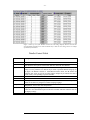
1
WIPE
USER MANUAL
- ii -
Table of Contents
PREFACE...........................................................................................................................................................................II
WHO SHOULD READ THIS MANUAL ...................................................................................................................................... II
WIPE OVERVIEW ............................................................................................................................................................1
INTRODUCTION ......................................................................................................................................................................1
What is WIPE?..................................................................................................................................................................1
WIPE as a Tool for Different Types of Users....................................................................................................................1
OVERVIEW OF WIPE FEATURES ............................................................................................................................................2
Ingestion Engine ...............................................................................................................................................................2
Data Server Engine...........................................................................................................................................................3
Built-in Interpreter Language...........................................................................................................................................4
Supported Data Types.......................................................................................................................................................4
Supported Data Formats ..................................................................................................................................................4
Middleware Used ..............................................................................................................................................................4
Satellite Data Sources Presently Supported .....................................................................................................................5
Customization Support......................................................................................................................................................5
SUPPORTED DATA PROVIDERS AND RESPECTIVE DATA SETS ................................................................................................6
SERVER SIDE REQUIREMENTS................................................................................................................................................7
Server Side Minimum Hardware Requirements................................................................................................................7
Client Side Minimum Hardware Requirement ..................................................................................................................7
CLIENT SIDE REQUIREMENTS .................................................................................................................................................8
Browser Requirements ......................................................................................................................................................8
Hardware Requirements ...................................................................................................................................................8
Data Access Rights ...........................................................................................................................................................8
HIGH LEVEL SEARCH BROWSER ..............................................................................................................................9
DESCRIPTION OF THE HLSB SCREEN .....................................................................................................................................9
HLSB MENU OPTION DESCRIPTIONS...................................................................................................................................11
Tool Bar Menu ................................................................................................................................................................11
Pop-Up Menu..................................................................................................................................................................12
Interaction With Session Profile Administrator ..............................................................................................................13
IMAGE ANIMATION ..............................................................................................................................................................14
Applet Based Animation..................................................................................................................................................14
Javascript Animation ......................................................................................................................................................14
INTERACTIVE DATA BROWSER ...............................................................................................................................16
DESCRIPTION OF THE IDB SCREEN ......................................................................................................................................16
IDB MENU OPTIONS DESCRIPTIONS ....................................................................................................................................20
ToolBar Menu .................................................................................................................................................................20
Volumetric Visualization.................................................................................................................................................23
OVERLAYING OPTIONS ON IMAGE SCREEN ..........................................................................................................................25
IMAGE ANIMATIONS ............................................................................................................................................................25
IDB Animation ................................................................................................................................................................25
APPLIED COHERENT TECHNOLOGY CORP. (ACT)
- iii -
Volumetric Visualization through Java Movie Sequence................................................................................................25
ACCESS TO BUILT-IN INTERPRETER LANGUAGE ...................................................................................................................26
Custom Script Tab in Image Display Screen ..................................................................................................................26
Custom Scripting via DataSet Control............................................................................................................................26
GLOSSARY OF TERMS.................................................................................................................................................26
WIPE TUTORIALS .........................................................................................................................................................31
INTRODUCTION ....................................................................................................................................................................31
HLSB TUTORIALS ...............................................................................................................................................................31
High Level Search Browser Basic Operations................................................................................................................31
INTERACTIVE DATA BROWSER TUTORIALS..........................................................................................................................34
Interactive Data Browser Basic Operations ...................................................................................................................34
Basic Plotting Functions - IDB.......................................................................................................................................35
Volumetric Visualization Guide ......................................................................................................................................36
IMAGE ANIMATION ..............................................................................................................................................................38
Applet Based Animation..................................................................................................................................................38
JavaScript Animation......................................................................................................................................................38
CUSTOM SCRIPT EXAMPLES.................................................................................................................................................39
APPLIED COHERENT TECHNOLOGY CORP. (ACT)
-i-
APPLIED COHERENT TECHNOLOGY CORP. (ACT)
- ii -
PREFACE
Who Should Read This Manual
The WIPE USER’s MANUAL provides an in depth description of the
WIPE system and how to use it. This manual contains the information
needed for an end-user of WIPE to view datasets, perform analysis, and
create custom scripts. A separate manual for the WIPE administrator
provides the information on making changes to the server, such as
adding or removing users, creating custom menus, and ingesting new
datasets.
APPLIED COHERENT TECHNOLOGY CORP. (ACT)
-1-
WIPE OVERVIEW
Introduction
What is WIPE?
The WWW Image Processing Environment (WIPE) - is a WEB based
Image Processing and Geographical Information System (IP/GIS) that
provides network centric manipulation of geo-spatial/temporal data
associated to Earth observing sensors.
Web based users can
interactively produce high-level products resulting from the data fusion
of recent and historical satellite imagery with other static/dynamic data
sets.
WIPE was originally implemented to support the US and NATO’s
Rapid Environmental Assessment (REA) exercises during FY96-98.
That particular version of WIPE was called the Warfighter Image
Processing Environment. The present version of WIPE has evolved to
support both military and non-military communities.
WIPE as a Tool for Different Types of Users
From a high level, the WIPE system provides support for major classes
of users associated with the flow of geo-spatial/temporal data. These
are: the data manager, the data provider, and the end-user accessing one
or multiple sources of data.
Data Manager Perspective
WIPE solves the problems of efficiently ingesting/archiving/serving
large data volumes and quickly geo-referencing recent and legacy geospatial/temporal data. For a data manager, WIPE provides a key
building block in the implementation of a LAN based geo-spatial datawarehouse. Depending on the specific project constraints, it may be
optimum to locate the WIPE server(s) at the:
•
Data provider facility, i.e. a satellite ground station where the data
is collected
APPLIED COHERENT TECHNOLOGY CORP. (ACT)
-2-
•
Main data fusion center
•
Regional fusion center
or all of the above.
Data Provider Perspective
Once a data provider moves data into a pre-established directory, the
data assimilation engine will automatically pre-process, geo-reference,
and get the data ready for remote access via the WIPE server engine.
End-User Perspective
For the end-user WIPE facilitates going all the way from high level
searches on the metadata to interactive access and download to the
actual data or virtual data products. Remote end-users can access the
server engine via:
1.
User application that is HTTP or CORBA enabled, e.g. ProVIEW.
2.
WIPE’s High Level Search Browser (HLSB) Applet
3.
WIPE’s Interactive Data Browser (IDB) Applet
Overview of WIPE Features
WIPE provides a fully integrated hardware/software system for the
assimilation, processing, and fusion of different satellite image data sets
via a simple to use WEB based interface. A single WIPE system
consists of an automatic data ingestion engine, and a network enabled
server engine. Both the ingestion and server engines provide:
Low Cost Hardware – servers are implemented in Windows NT
systems
Multiprocessor capability – the computational load can be distributed
over multiple Windows/NT servers. The ingestion and server engines
can reside on different machines.
Effective use of the Available Bandwidth – imagery data is
automatically geo-referenced and re-sampled for display at the selected
user resolution!
Ingestion Engine
The ingestion engine is constantly checking for the arrival of new data
to be processed. It also captures all the methods for the processing of
the recently received data.
As part of the ingestion process the source image data is stored in an
intermediate format (virtual file format [VFF]) which provides rapid
data access over the WWW at any resolution. Conversion to the VFF is
optional.
The system is modular enough such that new data formats can be
rapidly added into the ingestion engine.
APPLIED COHERENT TECHNOLOGY CORP. (ACT)
-3-
Data Server Engine
The WIPE server engine is constantly checking for the arrival of data
requests from a user. The server engine also captures all the different
methods to make data available to the remote or local user. Highlights
of the server engines include:
Modular Design – servers can be configured to access data in other
WIPE servers
Data Access Restrictions – multiple access layer restrictions are built
on top of the Windows NT operating system.
Client/Server – the data can be accessed from anywhere over the
WWW. The user has the flexibility to process the data on the server in
the client side. WIPE's architecture allows transferring portions of the
data to the client side and performing sophisticated data analysis in his
computer.
Long term archival - Once the hard disk quota is reached, the WIPE
system administrator can specify what to do with data sets that can be
off-loaded from the system.
For users connecting to the server engine via a WEB browser there are
two basic JAVA applets that facilitate the interaction: the High Level
Search Browser (HLSB), and the Interactive Data Browser (IDB).
High Level Search Browser (HLSB) Features
The HLSB is used to find where data is available as a function of
sensor, time, and spatial location. The HLSB provides:
Spatial/Temporal/Sensor Queries – metadata queries are done using
time, spatial, and sensor constraints via the HLSB simple to use
graphical user interface.
Classification Status of Data –products can be labeled according to
their classification status, unclassified, confidential, secret, top secret.
Manual Geo-referencing Adjustments - the user can manually fine
tune the registration of an image with respect to known ground control
point features, e.g. coastal database, or river database.
Flexible image sizing – the user has the ability of interactive zoom (in
and out) and scrolling over an image.
Data Coverage Maps – easy to interpret data availability is overlaid on
different Earth Maps.
Interactive Data Browser (IDB) Features
The IDB provides direct access to the numeric values of the data, and
products. Highlights of the IDB include:
Generation of Image Mosaics on the Fly – the user can specify which
images to use for a mosaic generation and establish the overlay order.
Relational Region of Interests – simple interface to locate and/or
identify pixel locations on one image based on the pixel values of other
images
APPLIED COHERENT TECHNOLOGY CORP. (ACT)
-4-
Extensive Visualization Options – the user can visualize the data as an
image, 2d-plots, 3d-plots, or video clip.
Extensive Download Options – access is provided to the actual data
for user-defined regions of interest. The data can be downloaded in a
number of industry wide formats, e.g. NetCDF, float files, ASCII files,
JPEG, etc.
Dynamically generated products - most of the products are generated
on the fly depending on the user requests
Disk Caching system - intermediate products are cached for a
predetermined amount of time for rapid serving of future requests.
Extraction of Image features on the fly - the analyst/end-user can
dynamically decide which region he wants to process and what type of
features/algorithms he wants to apply to the data.
Image Mensuration - Latitude and longitude information is
dynamically provided to the user as the pointer is moved over the
image. The user can make distance measurements over arbitrary paths.
Session Profiles – the user can save, edit, and recall the state of a
WIPE server (a session profile). This is particularly useful to share
information with other users.
Built-in Interpreter Language
Because WIPE’s engine is built on top of ProVIEW, it inherits many of
ProVIEW’s built in capabilities. A detailed description of ProVIEW
can be obtained from the on-line manual at http://wipe.actgate.com. In
addition, a user in ProVIEW can access the services in WIPE via
CORBA and HTTP interfaces.
Supported Data Types
WIPE supports points, vectors, gridded, non-gridded, volumetric,
image blobs, and N-dimensional data.
Supported Data Formats
SQL relational databases, Vector Product Format, Arc View GIS
Shapefiles, NetCDF, CEOS, ASCII Tables, and Planetary Data System
(PDS/NASA) formats (See table following this section for additional
information)
Middleware Used
WIPE can be accessed from a WWW browser running the WIPE applet
or from a stand-alone application. The middleware interfaces are,
respectively, HTTP/CGI and CORBA. Building on top of WIPE’s
CORBA capabilities, ACT has been demonstrating the NAVY’s Data
Exchange Interface (DEI/CORBA) middle-ware.
This has
demonstrated access to the NAVY/TEDS servers via WIPE.
APPLIED COHERENT TECHNOLOGY CORP. (ACT)
-5-
Satellite Data Sources Presently Supported
Satellite imaging sensors supported under WIPE are: ERS-2/SAR,
ERS-GSST,
LANDSAT,
SPOT,
SeaWIFS,
RADARSAT,
TOPEX/Poseidon, SeaWIFS, SSM/I, and NEMO. Examples of static
data sets are bathymetry (water depth) and digital terrain elevation
(DTED) from the National Imagery Mapping Agency, and the Naval
Oceanographic Office. A complete list of supported data sources and
data formats is provided on the following page.
Customization Support
An organization can contract ACT to create a custom version of WIPE
to add functionality not present in the base system.
APPLIED COHERENT TECHNOLOGY CORP. (ACT)
-6-
Supported Data Providers and Respective Data Sets
ACT has developed automatic data ingestion modules for many key
remote sensing sensor systems and data formats, e.g. ERS-2/SAR,
NOAA GOES data, ERS-GSST, LANDSAT, SPOT, SeaWIFS,
RADARSAT, TOPEX/Poseidon, AVIRIS, ArcInfo Shape files, text
data, SQL Tables. The following table provides a comprehensive list of
all data sources/formats presently supported by WIPE.
Data Provider to WIPE
CIA (static file)
NATO/SACLANTC/DERA
FNMOC via TEDS
NASA via NRL
National Global Data Center
NATO/SACLANTC
NATO/SACLANTC
NATO/SACLANTC
NATO/SACLANTC
NATO/SACLANTC
NATO/SACLANTC
NATO/SACLANTC
NATO/SACLANTC
NATO/SACLANTC
Naval Oceanographic Office
Naval Oceanographic Office
Naval Oceanographic Office
Naval Oceanographic Office
Naval Oceanographic Office
Naval Oceanographic Office
Naval Oceanographic Office
Naval Oceanographic Office
Naval Research Laboratory
Naval Research Laboratory
NIMA data via NRL
NIMA data via NRL
NOAA
NOAA
Sensor
Dataset Name in WIPE
Source Data Format
Internal Format
WDB Coastal Outline
GSST
TEDS_3Dtemp
AVIRIS Hyper-spectral
NGDC_Global Relief
Water/Land Mask
LANDSAT
Med_AVHRR
Med_SeaWIFS
Med_TOPEX
RADARSAT
SAR
SeaWIFS
Topex_Gridded
NAVO Wrecks
NAVO_ACOUSTIC
NAVO_Bathy
NAVO_Mines
NAVO_Roughness
NAVO_Sediments
NAVO_SPOT
NAVO_Temperature
NEMO
TEDS
DBDB V1.0
DTED
FNMOC
CW_SAR
Custom vector format
Float flat file
NetCDF
BIL, BIP
GIF Color Image
Shapefiles
CEOS format
NetCDF
NetCDF
NetCDF
CEOS
CEOS
Float flat files
Float flat file
DBF
CHAR
Float flat file
DBF
Shapefiles
Shapefiles
GeoTiff
NetCDF
ORASIS Compressed
NetCDF via DEI
NIMA’s format
NIMA’s format
GRIB format
CEOS
Same as Source
WIPE’s Internal VFF
NetCDF
BIL, BIP
WIPE’s Internal VFF
Shapefile format
WIPE’s Internal VFF
WIPE’s Internal VFF
WIPE’s Internal VFF
NetCDF
WIPE’s Internal VFF
WIPE’s Internal VFF
WIPE’s Internal VFF
WIPE’s Internal VFF
DBF
WIPE’s Internal VFF
WIPE’s Internal VFF
DBF
Shapefiles
Shapefiles
WIPE’s Internal VFF
NetCDF
ORASIS Compressed
REMOTE ACCESSS
WIPE’s Internal VFF
WIPE’s Internal VFF
NetCDF
WIPE’s Internal VFF
NOAA
NOAA
NOAA
NOAA
N/A - Static data
ERS
N/A Simulation
AVIRIS
NGDC VAP
N/A – Static data
LANDSAT
AVHRR
SeaWIFS
TOPEX/Poseidon
RADARSAT-1
ERS-2 SAR
SeaWIFS
TOPEX
UNK
UNK
P3-OWL
UNK
UNK
N/A
SPOT
MODEL
MODEL
N/A – Simulation
N/A – Static Data
N/A
MODEL
RADARSAT-1 &
ERS-2 SAR
NOAA Buoy’s
GOES
GOES
SSM/I
BUOY Measurements
GOES_IR
GOES-8
SSMI_Wind
ASCII files
Flat file
Float flat time
ASCII Table
NOAA
NOAA / JHU/APL
NOAA / ERIM International
NRL and NASA
NOAA-14/15
SAR VAP
N/A –VAP
Clementine
SST_14Km
APL_SAR_Wind
Derived Ship locations
Clementine
Float Flat file
NetCDF
ASCII Table
PDS
SQL Table
WIPE’s Internal VFF
WIPE’s Internal VFF
SQL & Float file with
0.3deg resolution
NetCDF
WIPE’s Internal VFF
DB Table
PDS
APPLIED COHERENT TECHNOLOGY CORP. (ACT)
-7-
Server Side Requirements
Server Side Minimum Hardware Requirements
The minimum hardware requirement for WIPE is a fully dedicated
Windows NT machine (4.0 or higher). Hard disk requirement depends
on the data ingestion and serving needs. Note: A high-end WIPE
system can consist of a network of WIPE servers with terabyte archive
storage capabilities.
Client Side Minimum Hardware Requirement
The minimum hardware requirement on the client side is any computer
with a recent version of Netscape or Internet Explorer (IE) browser. At
this time WIPE has been tested with:
•
Netscape (version 4.0 or above)
•
Internet Explorer (5.0 or above)
In either case we use the SUN’s swingjar JAVA classes to provide a
consistent graphical user interface between platforms. The swingjar
classes can be downloaded from http://wipe.actgate.com.
In WIPE most of the work is done at the server. Hence, the basic load
on the on the client computer is to run the WIPE applets. As the user
downloads more images, the applet will use more memory resources to
facilitate easy access to previously downloaded images quickly.
APPLIED COHERENT TECHNOLOGY CORP. (ACT)
-8-
Client Side Requirements
Browser Requirements
The basic interface to a WIPE server is via a WEB browser. At this
time the two browsers under which WIPE has been tested are:
Netscape (version 4.0 or above)
Internet Explorer (5.0 or above)
In either case we use the SUN’s swingjar JAVA classes to provide a
consistent graphical user interface between platforms. The swingjar
classes can be downloaded from SUN or from ACT
http://wipe.actgate.com.
Hardware Requirements
Almost any computer with a browser can connect to a WIPE server
over the INTERNET. In WIPE most of the work is done at the server.
Hence, the basic load on the on the client computer is to run the WIPE
applets. As the user downloads more images, the applet will use more
memory resources to facilitate easy access to those previously
downloaded quickly.
Data Access Rights
Security in WIPE is build on TOP of the Windows/NT security. Each
user must have a dedicated login and password. In addition to the
Windows/NT security the WIPE administrator can control:
•
IP addresses that can have access to the WIPE server
•
Data-set level user group access. For example, if a given user
belongs to the NATO group, then all NATO data will be
accessible.
•
WIPE commands that the user can execute in the interpreter
engine
APPLIED COHERENT TECHNOLOGY CORP. (ACT)
-9-
HIGH LEVEL SEARCH
BROWSER
Description of the HLSB Screen
The WIPE High Level Search Browser is used to simplify the process
of finding data. Data is found by specifying constraints in region of
interest (ROI), time of interest (TOI), and dataset types. These
constraints are checked against the Meta-data records in WIPE. The
HLSB is the equivalent of a catalog for data available at the particular
WIPE server to which the user is connected.
The following figure shows an example of the High Level Search
Browser applet. The applet display, buttons, and menu tabs are
explained in the tables below the figure.
APPLIED COHERENT TECHNOLOGY CORP. (ACT)
- 10 -
Figure 1 Sample Screen of 'High Level Search Browser'
HLSB Controls
Screen Item
TOI
ROI
Background
Data Sets
(List)
Overlays
Data Sets
On Display
Xfactor
V.PixelRes
Description
TOI or Time-of-Interest – this block of data is used to specify the window of
time to use in the meta-data query. It allow the user to request an absolute time
range, or a relative time range, e.g. the last 5 months, or 5 hours, etc. TOI is
defined in UTC time (more commonly known as GMT).
Region of Interest to be used in the construction of the spatial query. Must be in
Rectangular Mode in HLSB. The user can either draw a box over the image to
specify the ROI, or enter the bounding latitude and longitude values.
Click on pull down menu to display the list of available background data sets to
use in the image display. Available backgrounds depend on the particular WIPE
server configuration.
Select any dataset from this list of datasets by clicking on checkbox. Click on
the UPDATE button to view the dataset coverage on the Image Display Screen.
Change the position of the dataset in the list by clicking on the dataset name to
highlight it and click on the up and down arrow buttons. The double-arrow
buttons move the highlighted dataset to the top or bottom of the list.
Select the optional overlays to be used in the display. Some of the normally used
overlays are: vector shore lines, lat-lon grid, rivers, etc.
Displayed above the image window. Provides a summary of the data sets
displayed on the image screen.
N/A - this field does not have useful information in the HLSB
Vertical Pixel Resolution. Provides the actual vertical screen resolution of a
APPLIED COHERENT TECHNOLOGY CORP. (ACT)
- 11 -
pixel.
Click to reset the applet. The Image Display Screen will reset to default zoom,
overlay, and background. All datasets will be unselected and cleared from
image display.
Click to update the display with newly selected datasets, overlays, ROI, and
TOI. NOTE: the update button MUST be clicked to enable any changes in the
above items. The applet can also be updated using the pop-up menu accessed in
the image display (see Pop-Up Menu table below).
Reset
Update
HLSB Image Display Tabs
Image
Display Tabs
Description
Image
URL_Info
Server messages
Options
Image Display Screen. Shows datasets, overlays, and background image. At
zoomed-in mode the navigation arrows surrounding the display can be clicked
on to move the viewing window. Also, right clicking while in the image display
brings up a pop-up menu (see Pop-Up Menu table below).
Displays the separate variables that are passed to the WIPE server via the URL
at the top of the screen. The variables themselves are described in the WIPE
Server Manual. This will help in the creation of custom scripts by showing the
current values of the more commonly used variables.
Displays a time-ordered list of command calls made by applet. Used primarily to
trace errors that may have occurred while running WIPE.
Customized for individual institutions. Some examples of options are: selecting
lat/lon format display (decimal notation vs. hours, minutes, seconds notation)
and view centering on specific longitudes.
HLSB Menu Options
Main Menu
Menu Item
Preferences
Menu Item List
Session Profile
Admin
Resize Applet/Image
TimeSeries
By Months
Access
By Days
By Hours
Get Data in Box
Description
Click to access the Session Profile Administrator (SPA) and the
SPA will open in a separate window. From the SPA the user can
save, edit, and recall the state of a WIPE server (a session
profile). This allows for easy distribution of information
between different users.
Allows the user to Resize Applet/Image. Click on menu choice
to edit the display properties (Width,Height) of the Applet and
Image Display. Click SUBMIT to enable changes.
Displays in tabular format, by month, the datasets found within a
user-defined ROI and TOI.
Same as above, with datasets sorted by days
Same as above, with datasets sorted by hours
Opens the Interactive Data Browser (IDB) window for more
detailed user manipulation of the selected datasets. See the IDB
section for more detailed explanation of the browser functions.
APPLIED COHERENT TECHNOLOGY CORP. (ACT)
- 12 -
Get Metadata in Box
Info
Overlay Info
Storage Statistics
Shows the datasets and content type of the datasets found within
the user-defined ROI. Content information includes: Date, Time,
Size of image (row by column, in pixels), File Format, approx.
area covered, and bounding box lat-long coordinates.
Describes the overlays currently selected in the HLSB screen.
Shows how much data has been processed over certain periods
of time (last hour, last 24 hours, total) as well as how much data
is currently being processed by the WIPE server.
Usage Statistics
Displays access statistics such as number of times accessed,
number of files downloaded, and number of pages viewed.
Animation
Play Animated Data
GeoLocator
Country
State/Province
City
Get Pixel Values
About
Opens a WIPE Animated Data Viewer browser, which starts
playing stored frames of the Image Display screen. See the
Image Animation section for further detail on how to use the
Viewer.
Select a country to view in the Image Display Screen.
Select a State or Province to view in the Image Display Screen.
Select a city to view in the Image Display Screen.
Not applicable to the HLSB; menu choice is grayed out.
Displays an overview of WIPE in PDF file format.(A PDF
reader, such as Acrobat Reader 4.0 is needed).
Opens a separate browser which lists the available datasets,
gives a brief description of them, and links to web sites which
can provide more information.
Displays the Wipe User’s Manual. This requires Adobe Acrobat
Reader or Adobe Acrobat 4.0 or higher to read the PDF file.
Displays Proview User’s Manual. This requires Adobe Acrobat
Reader or Adobe Acrobat 4.0 or higher to read the PDF file.
Image
Help
DataSets Info
Wipe User Manual
ProviewUser Manual
Pop-Up Menu
Right-click while the pointer is on the image display screen in order to
bring up a pop-up menu. This allows for greater flexibility in interacting
with the image. Close by left clicking outside of the menu.
Menu Item
Center on Point
(Dbl-Click)
Zoom In
Zoom Out
Previous – Next
Update – Reset
Clear ROI Selection
Description
Centers the Image Display window on the mouse pointer.
Double clicking in the Image Display Screen performs the same
function.
Zooms into the user-defined ROI. If no ROI is defined, a
rectangular ROI will be created, with corner points at the upper
left corner of the image display, and the mouse pointer. The
applet will then zoom into the rectangular ROI.
Zoom out to the next highest scale factor
WIPE will cache the applet state such that the user can switch
back and forth between already created states using the Previous
and Next buttons. A state is cached when the user presses the
zoom, update, or reset buttons.
Functions the same as the Update and Reset buttons on the
HLSB main display.
Removes a user-defined ROI from the Image Display Screen.
APPLIED COHERENT TECHNOLOGY CORP. (ACT)
- 13 -
Iterate All
Go to Full Resolution
Starts the applet based animation. (see Image Animation below)
Displays the selected dataset in full-scale resolution. (xfactor=1)
Interaction With Session Profile Administrator
The Session Profile Administrator screen allows the user to manage
different session profiles. These profiles allow the user to save an
applet state for later analysis and sharing of information with other
users. The next figure shows an example Session Profile Administration
Window.
Figure 2 Sample Screen of 'Session Profile Administratorr'
Save Session Profile
Perform the following steps to save a session profile:
1.
Click on the “Save Current Applet Settings” button and type in
the name of the profile you wish to save in.
2.
Click on the “Share with:” pull down menu and select NONE,
ALL or WIPE ADMIN. Note: this can be further customized
to allow access to certain groups.
3.
Enter any comments in the “Comments” message box.
4.
Click on the SUBMIT button.
Load and Delete Session Profile
Perform the following steps to load a session profile:
APPLIED COHERENT TECHNOLOGY CORP. (ACT)
- 14 -
1.
Click on the “Invoke a Profile from List:” button and select a
session profile from the pull-down list.
2.
Select the “Image Size Factor” desired.
3.
Click on the SUBMIT button.
To delete a session profile from the list:
1.
Click on the “Delete a Session Profile” button and select the
desired profile to delete from the pull down list.
2.
Click on the SUBMIT button
Image Animation
Image Animation refers to the cycling of cached image displays in
succession, either through the applet itself, or through the WIPE
Animated Data Viewer (WADV). The WADV is a custom JavaScript
executed by the applet when the user selects certain animation
commands. When describing the image animation methods, the
individual images may sometimes be referred to as frames.
Applet Based Animation
Applet based animation in the High Level Search Browser (HLSB) is
done by cycling through a series of cached images or frames and
displaying them in the Image Display Screen (IDS). Please refer to the
tutorial at the end of this document for detailed steps on how to create
an animation sequence.
Javascript Animation
This method uses the Animated Data Viewer (JavaScript viewer) for
finer control of the animation. The method used to create the images is
the same as the one for applet-based animation.
Once a sufficient series of images has been created, click on the DATA
button in the ToolBar Menu, and select PLAY ANIMATED DATA.
This should bring up the WIPE Animated Data Viewer. The following
page shows an example of the Viewer, along with a table describing the
different Viewer controls.
APPLIED COHERENT TECHNOLOGY CORP. (ACT)
- 15 -
Figure 3 Screenshot of WIPE Animated Data Viewer
Animated Data Viewer Menu Options
Menu Item
Loop Mode
Animate Frames
Dwell First
Dwell Last
Adjust Speed
Advance One
Frame No:
Omit Frame
Link to Zip File
Description
Set the continuous looping method used by the Viewer. The left button sets looping
to start with frame 0, cycle to last frame, then start back at frame 0. The right button
sets looping to go from frame 0 to last frame, then reverse direction back to frame 0.
Start and stop frame animation and determine the looping direction for the frames
displayed. Left and right buttons determine direction, center button stops animation
Left and right buttons decrement and increment the amount of dwell time spent on
the first frame in the frame list.
Left and right buttons decrement and increment the amount of dwell time spent on
the last frame in the frame list.
Increase and decrease the frame cycle time with the left and right buttons
Advance or Step back in one frame increments with these buttons.
Current frame displayed in viewer window
Select frames to omit from animation cycle by clicking on checkbox
The hypertext link at the bottom of the Animated Data Viewer starts an on-the-fly
zip file creation process, which the user can download to the client machine. The zip
file contains all the images and an html page needed to view the animation on the
client machine.
APPLIED COHERENT TECHNOLOGY CORP. (ACT)
- 16 -
INTERACTIVE DATA
BROWSER
Description of the IDB Screen
The Interactive Data Browser (IDB) contains the menu choices and list
boxes that allow the user to select, in detail, the data content that will be
displayed on the image display screen. It also allows the user to
analyze the data using various visualization tools. The layout of the
IDB screen is very similar to that of the HLSB screen. The TOI section
is no longer displayed because the user is now concentrating on the data
sets that fit within the Time-of-Interest specified in the HLSB. The
menu toolbar, data set list and other items contain choices that deal
more directly with the data sets of interest and tools necessary to
process the data.
APPLIED COHERENT TECHNOLOGY CORP. (ACT)
- 17 -
Figure 4 Sample Screen of 'Interactive Data Browser’, depicting derived Wind directions with
shoreline and latlon grid overlays. Note the additional layers displayed in the ‘Layers’ window,
which indicate the availability of data at different altitudes.
IDB Applet Controls
Screen Item
ROI
xFactor
V.PixelRes
Zoom
Prev – Next
Arrows
Navigation
arrows
Data Sets
(List)
Layers
Description
The drop-down menu allows the user to choose the method of defining the Region of
Interest (ROI). It can be defined as a rectangular ROI, a line, or a series of points. The
ROI method is used in conjunction with various plotting tools, e.g. Line method must be
used in order to use the ‘ROI Line Plot’ Menu Item.
The “N,S,W,E” boxes show the current latitude, longitude bounds of the Image Display
and can be user-edited to quickly change the viewing window location.
Displays the scaling factor used by the Image Display Screen.
Displays the actual vertical resolution of a pixel on the Image Display Screen.
Perform same function as in HLSB. Click to zoom into or out of the ROI.
Located below the zoom buttons are 2 arrows facing left and right. They allow the user
to go back and forth between the previously cached applet states. An applet state is
cached when the user presses the zoom and update buttons.
Surrounding the Image Display are navigation arrows. They allow the user to move the
viewing window in the direction indicated by the arrows.
Select any dataset from this list of datasets by clicking on checkbox. Then click on the
Update button to view the dataset coverage on the background. This list provides a more
detailed breakdown of the datasets chosen in the HLSB; ex. the user selects the “IR”
dataset in the HLSB, then the IDB will show a list of IR bands within the “IR” dataset.
The data set may be further subdivided into layers, e.g. altitude bands for atmospheric
data. If so, then the layers will be displayed here for selection by the user.
APPLIED COHERENT TECHNOLOGY CORP. (ACT)
- 18 -
Overlays
As in the HLSB, the Overlays list allows the user to display other information of interest
over the datasets in the Image Display. Some examples of useful overlays are: LatLon
grid, Magnification Factor, shorelines, etc.
IDB Image Display Tabs
Display Tab
Description
Image
Image Display Screen. Clicking on this tab displays the image mosaic of the currently
selected datasets.
Displays the variables passed to the ProviewWeb script as well as the script that is
called. Useful for determining the kind of variables needed to generate a custom script
that will generate the same image as that currently displayed in the Image tab. See the
Wipe Server Manual for more information about the commonly used WIPE variables.
Shows the status messages returned by the WIPE server after it has finished processing
commands generated by the WIPE applet. These commands could be the generation of
an image mosaic, javaviewer animation or plot function. The status messages are useful
for tracking down any errors encountered in processing and to verify the list of selected
datasets. NOTE: The status messages are specific to the current applet. For example,
updating the display in the HLSB would not update the trace list in the IDB. Also, two
IDB applets would have their own separate list of server messages.
Shows a listing of the currently selected datasets and various parameters. (See figure for
Dataset Control). Also allows the user to customize the region of interest of each
individual dataset via the MSHELL scripting language.
From the list of currently selected datasets, the user can click on the EDIT button under
XROI to bring up a mini console screen display. Within the display, the user can click
on EXAMPLE CODE to examine a sample script, type in a script of their own, and
click OK to enable the script or cancel to exit out of the mini-console. The user must
then click UPDATE in the IDB to execute the script.
Allows the user to build and execute a custom script for execution (via MSEHLL, the
image processing interpreter language). See “Built-In Interpreter Language (MSHELL
& PROVIEW)” for more detail.
Customized for individual institutions. An example option is: selecting lan/lon format
display (decimal degrees notation vs. hours, minutes, seconds notation).
URL Info
Server
Messages
Dataset
Control
Custom Script
Options
DataSet Control
The DataSet Control tab shows a table of parameters being used to
control how the data values are displayed in the Image Display Screen
(IDS). These values are set to the defaults when the applet is initialized.
The default values are specified in the SQL table ‘Data Control’. The
user may then change the values that control the way the data is
displayed. Any changes are then stored by the applet for the current
session. These changes are applet specific. Thus, multiple users may
work on the same dataset, each using a separate applet and assigning
different parameters to the dataset.
This table will display the parameters for a dataset as soon as the user
selects it by clicking on the checkbox in the dataset window. However,
the dataset itself will not be shown until the user hits the Update button.
This allows configuration of parameters before dataset display.
APPLIED COHERENT TECHNOLOGY CORP. (ACT)
- 19 -
Figure 5 Close up view of the DataSet Control tab in the Image Display Browser.Note that the
selected DataSet and ID are the same but that the layer values are increasing. This is an example
of a multi-layered dataset.
DataSet Control Fields
Field Name
Description
DataSet
ID
Shows the currently selected datasets.
Displays the DataSet ID. It is usually a string based on the data collection time or some
other identifier that separates it from other data files within the same DataSet.
The selected layer within a particular DataSet-ID. The figure above illustrates the
ability to set the parameters for different layers within a particular DataSet-ID group. In
the figure, the DataSet consists of Wind Direction data values, the ID defines the
particular data values are for Jun 24, 2000 and the multiple layers indicate the data is
stored in arrays corresponding to specific altitudes.
The minimum value to use.
The maximum value to use.
Clicking the ‘EDIT’ button brings up a text window which allows the user to specify a
GROI for the dataset by using the ProVIEW scripting language.
Displays the type of interpolation used on the data values. 0 to use zero order
interpolation, 1 to use first order interpolation.
Displays the Image Mapping Function and min, max values to use for the function. See
below for a more detailed description of the three available functions and their effect on
the displayed image.
Specifies the palette file to use when mapping data values to color values.
Layer
Rmin
Rmax
XROI
Interpolation
IMF
Palette
APPLIED COHERENT TECHNOLOGY CORP. (ACT)
- 20 -
IDB Menu Options
ToolBar Menu
Menu Item
Preferences
Menu Item List
Session Profile Admin
Resize Applet/Image
Image
Geo-register
Get Pixel Values
Legend
Legend Info
Overlay Info
Plot
ROI Line Plot
ROI 3D Plot
Layer Plot
Topo Drape
Download
Flat File
Description
Functions the same as the ‘Session Profile Admin’ item in the
HLSB. See the “HLSB ToolBar Menu” table for more details.
Functions the same as the “Resize Applet/Image” item in the
HLSB. See the “HLSB ToolBar Menu” table for more details.
Allows the user to affix the dataset image to a geographical
feature (such as a shoreline). Must first select ROI Line and
draw a line from the image to the geographical feature before
calling this function.
Enables the Image Display Screen to show actual data values
for each pixel as the user moves the mouse pointer over the
image. A small display at the base of the pointer will show the
lat, lon, and pixel values.
Displays information about the ROI selected in the Image
Display Screen on a separate window. This includes the
dataset name, overlays used, image size, and area of interest.
Shows information about the overlays selected by the user.
Creates a line plot which corresponds to an ROI line drawn on
the image display. The x-axis is the distance along the ROI
Line (in units corresponding to the dataset) and the y-axis is
the value of the data along the line. WIPE will also generate a
hypertext link to an ASCII file containing the data used in the
plot creation.
NOTE: The user must first select the ROI Line method and
click-and-drag an ROI Line across the image display.
Creates a 3-dimensional data plot corresponding to a
rectangular ROI.
NOTE: The user must first select the ROI Rectangular method
and click-and-drag a rectangular box across the image display.
Used for multi-layered dataset plots. At least 2 layers must be
selected before clicking this menu item. The plots depend on
the ROI type selected by the user:
Rectangular ROI results in one 3-D plot per layer.
Line ROI results in a line plot for each layer.
Points ROI returns a single, multi-line plot.
The dataset image is mapped to internal digital terrain
elevation and bathymetry databases in order to create an image
of the data draped over topological features. This allows for
instant visual referencing of the data to known geographical
features. Topo Drape can also be customized via several menu
options. Explained in Topo Drape Options (see below).
Displays a hypertext link to a downloadable file containing the
pixel values as shown in the Image Display Screen along with
a short description of the file type and a jpeg of the image to be
downloaded.
APPLIED COHERENT TECHNOLOGY CORP. (ACT)
- 21 -
Volumetric Visualization
Info
Storage Statistics
Usage Statistics
Animation
Play Animated Data
Execute
Edge Detection
METOC
Data Probe for Points
Selected
Flight Path Profile
Help
DataSets Info
Wipe Users Manual
ProVIEW Users Manual
About
Allows the user to choose between different display methods
for viewing multiple image planes in the same volumetric
space. See Volumetric Visualization Methods for more detail.
Shows how much data has been processed over certain periods
of time (last hour, last 24 hours, total) as well as how much
data is currently being processed by the WIPE server.
Displays access statistics such as number of times accessed,
number of files downloaded, and number of pages viewed.
Opens the Animated Data Viewer, which starts playing stored
frames of the Image Display Screen. The stored frames are
specific to the IDB, and will not impact the frames stored for
the HLSB. Otherwise, the instructions for creating an
animation are the same as in the HLSB Image Animation
section.
Displays results of a script that tries to detect “edges” of an
image, as defined by sharp contrast differences.
Generates a plot of meterological conditions at user selected
points on the image. Requires that the WIPE server have
access to meteorological data.
Generates plots of meterological conditions along a flight path
traced by the user across the image. Requires the WIPE server
to have access to meteorological data.
Opens an HTML table which lists the available datasets, a
brief description of each dataset, and a URL link to a site
containing more information about the dataset.
Opens the Wipe Users Manual (in PDF file format).
Opens the ProVIEW users Manual (in PDF file format).
Displays an overview of WIPE, its features and a sample
animated gif created by a WIPE module.
ROI Line Plot
APPLIED COHERENT TECHNOLOGY CORP. (ACT)
- 22 -
Figure 5 Sample Output of "Plot|ROI LINE PLOT" The x-axis shows the
distance from the starting point along the ROI LINE. The y-axis shows the
pixel values along the line. The hypertext link allows downloading of plot data
to the client computer.
ROI 3D Plot
Figure 6 Sample Output of "Plot|ROI 3D PLOT"
APPLIED COHERENT TECHNOLOGY CORP. (ACT)
- 23 -
Topo Drape
Figure 7 Sample Output of "Plot|Topo_Drape" option. Note the menus at the
top that allow for user rotation, tilt, size, scale, and topo choice. This plot
allows for easy identification of the mountain region in the upper left corner,
as well as the island at the entrance to the harbor.
Topo Drape Options
The topo drape view window also contains several drop-down menus
which both show the current settings for the topo drape options and
allow the user to change those settings. The menu headers will also
display the following information via tool tips (shown when the pointer
rests on the header):
APPLIED COHERENT TECHNOLOGY CORP. (ACT)
- 24 -
Topo Drape Option
Description
Current Rotation
The rotation angle (in degrees) of the topo
image relative to the original orientation.
Rotation is measured positive counterclockwise along the vector normal to the
image.
The tilt angle of the topo image (in degrees)
relative to the original orientation. Tilt is
measured positive clockwise along a vector
in the plane of the image and normal to the
right side of the image.
The size of the image measured as an N by
N box, where N is selected by the user.
The amount by which height differences are
exaggerated. A higher scale number
increases the exaggeration.
Choose whether to use only DTED (digital
terrain elevation data), only Bathymetry
(ocean depth data), or both
Current Tilt
Current Image Size
Current Scale Num
Current Topo Choice
Volumetric Visualization
There are many instances where datasets will overlap a given region of
interest. Several examples are, infrared sensor collections, bathymetry
measurements, and repeated satellite images of the same location at
different times. In addition, each dataset type may have different layers
depending upon the data format. It is often valuable to the user to be
able to view different datasets for one particular region. WIPE contains
different methods of viewing data in this manner, using the Volumetric
Visualization menu item (located under the DATA tab in the IDB
toolbar).
Visualization Method
Description
Create a NetCDF file
Creates a NetCDF file and a hyperlink to
the file to be downloaded. See Tutorial for
more details on the NetCDF file option.
Creates a 3D image cube which contains
the datasets as images arranged in layers
parallel to the top face of the cube. See
figure below for example output.
Creates a separate frame for each image
layer and opens the Animated Display
Viewer to cycle through each frame.
Generate a 3D Layer
Cube
Generate a Java Movie
Sequence
Data Visualization and Formatting For Download
APPLIED COHERENT TECHNOLOGY CORP. (ACT)
- 25 -
Figure 8 Sample output of "Data |Volumetric Visualization|Generate 3d layer
cube". This visualization option allows for simultaneous viewing of the same
region from different sensor datasets.
Overlaying Options on Image Screen
Image Animations
Image animations in the IDB are created in the same manner as in the
High Level Search Browser. The two animation options are appletbased and JavaScript based. There are two different display modes that
utilize the javascript viewer – IDB animation and Volumetric
Visualization.
IDB Animation
IDB Animation is the cycling of frames created in the IDB Image
Display Viewer. The frames are stored separately from the frames in
the HLSB, and thus can be manipulated, and even RESET without
affecting the HLSB animation frames.
Volumetric Visualization through Java Movie Sequence
The Volumetric Visualization menu item (under the DATA tab in the
Toolbar) is used to visualize multiple datasets, and multiple layers
within those datasets, covering the same region of interest. One method
of visualization is via a Java movie sequence. The Java movie sequence
essentially cycles between the selected datasets and layers that fall
within the bounds of the Image Display Screen.
APPLIED COHERENT TECHNOLOGY CORP. (ACT)
- 26 -
Access to Built-in Interpreter Language
WIPE allows the user access to its internal engine via various “custom
script” menu choices. This allows for a highly customizable processing
environment. The user is able to directly enter custom commands via
the Custom Script Tab in the Image Display Screen (for both the HLSB
and the IDB). Within the IDB the user is also able to enter custom
scripts for individual datasets using the Database Control tab and
selecting the XROI button. The scripts are written in MSHELL, the
WIPE image processing interpreter language.
Custom Script Tab in Image Display Screen
The Custom Script Tab transforms the IDS into a rudimentary text
editor used to enter MSHELL code. The user should first select the
Output Type. This not only determines the output format, but also
allows for different scripting methodologies. For example, the output
could be unformatted MSHELL output intended for quick problem
resolution or output in nicely formatted HTML for use in sharing
information. WIPE currently supports the following output types:
•
ProVIEW Calculator (HTML preformatted) – used for quick
calculations or scripting with minimal output formatting. The
output is sent to a separate browser window and is contained
within default HTML code.
•
HTML Text (Using HTML formatting) – allows for greater
customization of output by using HTML code. Formatting is
done through the use of PRINT statements containing HTML
code, i.e. print “<HTML><BODY> Hello World
</BODY></HTML>”
•
User-defined (Must specify content-type) – Allows for even
greater customization through the use of different contenttypes to display on the web page. Some examples are, image
content-type (for displaying jpeg output) and message contenttype (for email and/or download).
Custom Scripting via DataSet Control
Occasionally the user may need to define a region of interest that is not
spatially dependent, but rather dependent on dataset values. Or the user
may want to automate the definition of a region of interest such that it
can be quickly and easily applied to a dataset. Through the Dataset
Control tab in the IDB display, the user can edit the XROI of a
particular dataset and enter custom MSHELL scripts.
Common WIPE applet variables
The following table shows the more common WIPE variables a user
can manipulate via custom scripts:
Variable
Description
APPLIED COHERENT TECHNOLOGY CORP. (ACT)
- 27 -
CenterLong
M_longlat0
M_longlat
M_longlat_2d
LongDif
M_H
M_W
$ipaddr
$count
$x1
$y1
$x2
$y2
$c1
$r1
$c2
$r2
$vx1
$vy1
$vx2
$Ax1
$Ay1
$Ax2
$Ay2
$adjust
$DataSet
$GROI
$Scaling
Center longitude as calculated by the following formula: CenterLong = str2float($Ax1) +
(str2float($Ax2)-str2float($Ax1))/2
Global variable which contains the corners of the world (in lat-lon coordinates) in a rectangular
ROI going from upper-left, upper-right, lower-right, lower-left (UL,UR,LR,LL).
Global variable which defines the corner boundaries of the image display in lat-lon coordinates,
going from UL,UR,LR,LL.
Global variable which defines the corner boundaries of the rectangular ROI defined by the user in
the image display (in lat-lon coordinates).
Absolute difference (degrees) between the two longitude lines that define the sides of the image
display.
Global variable which defines the image display size height in pixels, can be changed by selecting
Resize Applet/Image in the applet menu bar.
Global variable which defines the image display size width in pixels, can be changed by selecting
Resize Applet/Image in the applet menu bar.
The IP address of the client computer displaying the WIPE applet.
Each image on the image display window is actually a jpeg file with a specific filename. The
filename is based on $ipaddr, the current time, and $count, which increments by 1 in order to
prevent files being overwritten when 2 requests for images are sent to the applet within a very
small period of time (such as when a user enters a rapid succession of clicks to the applet).
Longitude of upper left-hand corner of rectangular ROI. Same as $vx1 for no user defined ROI.
Latitude of upper left-hand corner of rectangular ROI. Same as $vy1 for no user defined ROI.
Longitude of lower left-hand corner of rectangular ROI. Same as $vx2 for no user defined ROI.
Latitude of lower left-hand corner of rectangular ROI. Same as $vy2 for no user defined ROI.
Column number of the upper left-hand corner of a rectangular ROI box on the image display
screen (IDS). This number starts at zero (at the upper left-hand corner of the IDS) and increases
toward the right hand side of the IDS. The upper limit of $c1 is M_W. If the user does not define
an ROI then the entire image display screen is treated as the ROI.
Row number of the upper left-hand corner of a rectangular ROI box on the image display screen
(IDS). This number starts at zero and increases toward the bottom of the IDS. The upper limit of
$r1 is M_H. If the user does not define an ROI then the entire image display screen is treated as
the ROI.
Number of columns in the rectangular ROI on the image display screen.
Number of rows in the rectangular ROI on the image display screen.
Longitude of upper left-hand corner of image display.
Latitude of upper left-hand corner of image display.
Longitude of lower left-hand corner of image display.
Longitude of upper left-hand corner of world as projected on a rectangular flat surface.
Latitude of upper left-hand corner of world as projected on a rectangular flat surface.
Longitude of lower right-hand corner of world as projected on a rectangular flat surface.
Latitude of lower right-hand corner of world as projected on a rectangular flat surface.
Defines the amount by which M_longlat has to be adjusted in order to center the world view on a
different longitude. Set by the user in the Options/Center View at Longitude field in the applet.
List of datasets in the following format:
“dataset1|dataset1id@layer1,dataset2|dataset2id@layer2”. Note that each dataset-id-layer string is
comma delimited. The dataset and dataset ID should correspond exactly to that shown in the
datasets list window in the applet. Also, the layer number corresponds to the layer selected for that
particular dataset. Note that this variable is updated only after the user has clicked on the
UPDATE button on the applet
The Generalized Region Of Interest for each dataset in $DataSet, in the creation of the image
shown in the image display. If it is not specified it defaults to “[s1][s1][s2][s1][s1]” where [s2] is
the separator between the GROI for each dataset.
The scaling factors used for each dataset in $DataSet, in the creation of the image shown in the
image display. If it is not specified it defaults to “Default[s1][s1]” with “[s2]” being the separator
APPLIED COHERENT TECHNOLOGY CORP. (ACT)
- 28 -
$Palette
$ContourControl
$SelLayers
$Overlays
$BackGround
$roitype
$lsc
$lsr
$lsx
$lsy
$M_Institution
$Applet_Width
$Applet_Height
$Image_Width
$Image_Height
$ProfileType
$start_date
$end_date
$M_TOD_min
$M_TOD_max
$Time_Delta
$Time_Delta_Units
$Time_Option
$runcode_IDB
$M_Applet_Type
$Cov_Type
$SelDataSets_Laye
rs
$M_Start_Date
$M_End_Date
$M_Layer
$M_Overlays
$M_H
$M_W
between the scaling factors. Scaling factors are two numbers corresponding to min scale and max
scale.
The palette used for each dataset in $DataSet with “[s2]” being the separator between the palettes.
The palette choices are the numbers used in the wcolut table (defined in the ProVIEW manual).
Currently set to “Default[s1][s1]” for each dataset in $DataSet with [s2] being the separator. Not
currently implemented, but will be used in a future version to create contour lines as an overlay on
the image.
Column vector where each row shows the layers used in $DataSet. If the layers are all the same,
then it returns a single value.
Comma delimited string containing all the overlays used in the creation of the image.
Defines which background is used in the creation of the image in the IDS.
Defines the ROI type currently selected in the applet. “0” is line, “1” is rectangular, and “2” is
point ROI.
Contains the column coordinates for a line segment, used in the creation of line and layer plots.
Contains the row points for a line segment, used in the creation of line and layer plots.
Longitude coordinates for the points in $lsc,$lsr.
Latitude coordinates for the points in $lsc,$lsr.
Name of the institution for which the WIPE server is running and processing data. Used to identify
the SQL database (or databases) used by the WIPE server.
Width of the entire applet in pixels
Height of the entire applet in pixels
Width of the image display screen in pixels
Height of the image display screen in pixels
Selects which applet type to use – HLSB or IDB
Starting date and time of interest.
Ending date and time of interest.
Global variable which defines the time to use as the start of a day, usually “00:00:00”.
Global variable which defines the time to use as the end of a day, usually “23:59:59”.
Defines the number of $Time_Delta_Units to search for.
Defines the time unit used when performing a relative time search. Ex. “hour”, “month”, “day”.
Sets method used to determine time of interest in the applet. For a “0” value it uses the Start Time
and End Time fields in the applet to define the time of interest. For a “1” value it searches for data
in the last $Time_Delta amount of $Time_Delta_Units. Ex, “Last 24 hours” would be
$Time_Delta=24, $Time_Delta_Units=”hour”
Contains the code entered by the user in the “Custom Script” tab on the IDS as well as supporting
code needed to run it and output to a browser window.
Global variable which sets which applet type to use – HLSB or IDB
Used in various external functions to describe the data currently being processed. In the context of
the IDB for example it describes the image shown in the IDB as “Compiled_Data”.
Column vector where each row is a string corresponding to the dataset-id-layer item contained in
$DataSets
Global variable defining the start date and time of interest.
Global variable defining the end date and time of interest
Global variable defining the layers being used
Global variable defining the overlays used in the image displayed.
Same as M_H except in string variable format
Same as M_W except in string variable format
APPLIED COHERENT TECHNOLOGY CORP. (ACT)
- 29 -
Glossary of Terms
Applet State
Refers to the state of the WIPE applet with regard to the selected ROI,
TOI, datasets, overlays and layers. The applet does not change its state
until it is called by WIPE, and is executed whenever the user clicks the
UPDATE, or ZOOM buttons. Also, each WIPE applet has its own
associated state. Thus, the state of an IDB and a HLSB will be separate
and not interfere with each other, or with other IDB and HLSB applets
currently being run.
GROI
The Generalized Region Of Interest. Defines the regions of an image
that satisfy a user-defined set of criteria. The regions may be spatially
separate or even exist as a series of points. For example, a GROI of an
image could be any pixel that is 10 units above the mean pixel intensity
value. Also referred to as an “image blob”. GROI may be specified by
utilizing custom MSHELL scripts.
Image Plane
An arbitrarily defined plane which contains the image information for a
specific dataset. In the case of datasets with multiple layers, each layer
selected occupies its own image plane. Used in the creation of a
volumetric visualization cube or NetCDF file.
Metadata
Data about data. It describes how, when, and by whom a particular set
of data was collected and how the data is formatted. Used to understand
the dataset information stored in WIPE.
MSHELL
A 32-bit interpreted image/signal processing language, used to generate
custom WIPE interfaces. MSHELL scripts allow the user to customize
the power of existing WIPE processing functions to fulfill his specific
needs.
NetCDF
The Network Common Data Form, a file format that contains array
oriented data in a form that is self-describing and network transparent.
APPLIED COHERENT TECHNOLOGY CORP. (ACT)
- 30 -
“Self-describing” refers to the file containing information about the data
it contains. “Network transparent” means that the file is such that it can
be accessed by computers with different ways of storing integers,
characters, and floating point numbers. Within the WIPE process a
NetCDF file can be visualized as a cube of data, where the length and
width of the cube are the N X M dimensions of the data arrays, and the
height of the cube is the number of data arrays contained. NetCDF
variables then can store data such that they contain the same sized
arrays (N X M) and varying numbers of such arrays within the cube.
This works well when dealing with layered datasets such as atmospheric
temperature data which is collected at different altitudes. A complete
explanation of the NetCDF format can be found at
http://www.unidata.ucar.edu/packages/netcdf/guide.txn_toc.html.
ROI
Region of Interest. A spatial area of interest defined by using WIPE
methodology for selection: Rectangular, Line and Points. Rectangular
method specifies an area of interest by clicking and dragging a box on
the Image Display Screen. Line defines the area by clicking and
dragging a line. Points allows for ROI definition by clicking at various
points on the IDS.
Universal Time Coordinated (UTC)
Also known as Coordinated Universal Time, formerly and widely
known as Greenwich Mean Time (GMT). UTC is based on an atomic
clock to which adjustments of a second (leap second) are sometimes
made to allow for variations in the solar cycle. It nominally reflects the
mean solar time along the Earth’s prime meridian, which runs through
the Greenwich Observatory outside of London.
Viewing Window
The field of view of the Image Display Screen with respect to the image
plane. The ZOOM buttons change the field of view. The IDS size itself
is changed by using the RESIZE APPLET/IMAGE menu item.
APPLIED COHERENT TECHNOLOGY CORP. (ACT)
- 31 -
WIPE TUTORIALS
Introduction
The following tutorials cover the basic operations of WIPE and are
intended to enable the user to start processing and analyzing data as
quickly as possible. The datasets shown in these examples will not
necessarily be the same as that in the user’s own WIPE server due to the
fact that each server is configured to the specific needs of each
institution. However, WIPE offers the same functionality regardless of
dataset, and the user is encouraged to follow along, substituting his own
datasets for those in the example.
HLSB Tutorials
High Level Search Browser Basic Operations
This tutorial will explain how to select datasets for display in the
HLSB, zoom in on the datasets, manipulate them, and change the
viewing window. Before following the tutorial, please make sure of the
following:
•
WIPE HLSB is running and user is logged into a WIPE Server
with access to at least 1 dataset.
•
HLSB is in default view. The view should show a world
background and have no datasets selected. Press the RESET
button near the upper right corner of the HLSB if this is not
the case.
Selection of Datasets in HLSB
1.
Select a dataset to display by clicking on a checkbox next to
one of the available datasets in the DATA SETS list.
2.
Check the OVERLAY list and make sure the LatLon Grid
overlay is selected. Click in the checkbox if it is not.
APPLIED COHERENT TECHNOLOGY CORP. (ACT)
- 32 -
3.
Click the UPDATE button. The status bar along the lower left
edge of the HSLB should show “status: Updating applet”.
When the applet is done updating the display the status bar
should return to “Status:”.
4.
The Image Display Screen (IDS) should now show at least one
small colored polygon. The colored polygon serves to
illustrate the dataset coverage. The “Data Sets on Display” bar
above the IDS should also show the name of the selected
dataset. There may be more than one colored polygon
depending on the institution. If there is no polygon visible,
then the area covered by the dataset may be smaller, and
harder to visualize against the background.
5.
Ensure that the ROI menu tab is showing ROI:Rectangular.
The user will now use the zoom features to zoom in closer to a
selected dataset.
6.
Move the mouse pointer over the left hand corner of a colored
polygon then click the left mouse button down and drag it such
that a dotted rectangle encloses the polygon.
7.
Click on the UPDATE button. The HLSB will now update the
display such that the dotted rectangle fills the IDS. You can
also update the display by right-clicking and selecting ZOOM
IN from the pop-up menu.
8.
Notice how the colored polygon now fills a larger portion of
the IDS. Use the arrows bordering the IDS to move the
viewing window left, right, down, and up. Then double-click
on the center of the colored polygon. The display will update
and center itself on that point.
Feel free to experiment with the ZOOM buttons on the HSLB and
on the pop-up menu (right-click on the IDS to bring up the menu).
When no ROI is selected the ZOOM buttons utilize the center of
the IDS as a reference point.
Displaying Available DataSets for a Given Time
In some cases the user may have need to determine the amount of
dataset coverage for a given time window, as well as having a means of
tabulating this information. The TimeSeries menu item in the HLSB
serves this purpose. It allows the user to quickly see which sensors
have coverage for a given area and time span as well as seeing which
sensors have concurrent data for a given time increment. The following
demonstrates the use of the TimeSeries menu.
1.
Set the TOI to the desired time span. The time span can be
defined in absolute terms (Start Time and End Time) or in
relative terms (last 24 hours, or last 12 months).
2.
Set the desired ROI by drawing a box around the region in the
image display screen.
3.
Select the datasets for which the coverage information is
desired, and click on the update button.
APPLIED COHERENT TECHNOLOGY CORP. (ACT)
- 33 -
4.
Now select the TimeSeries menu and select either Get Data in
Box by Hours, or Days, or Months depending on the desired
time increment. The time increment determines how the
datasets will be grouped when the results table is formed. For
example, selecting Get Data in Box by Months groups the
datasets according to the month in which they were found.
5.
The results will be shown in another browser window, and will
be similar to that shown in the example figure below:
Figure 9 Sample output of TimeSeries, Get Data in Box by Months menu
choice. The blue underlined numbers indicate that they are a hypertext link to
an IDB applet which will display the datasets on that row.
Note the color coding of the cells in the table.
•
Yellow indicates 1 or more data items found for that particular
dataset
•
Green indicates a dataset that is time invariant (and would
therefore be found regardless of the TOI)
•
Black shows no coverage for that dataset at that particular
time.
Dataset Manipulation in the HSLB
Make sure at least a portion of the dataset is shown in the IDS before
continuing. The dataset manipulation in the HLSB is limited to
selecting datasets and displaying the coverage areas of those datasets.
However, one can also get more detailed information about the type of
APPLIED COHERENT TECHNOLOGY CORP. (ACT)
- 34 -
datasets being displayed. In addition, the HLSB serves as the starting
point for data content analysis by starting up the Interactive Data
Browser( IDB).
1.
Click on the DATA menu in the HLSB Tool bar. A menu list
should drop down.
2.
Select GET METADATA IN BOX. This will open a browser
window displaying information about the type of dataset
shown in the IDS. These include date and time, file format,
area covered, and size of the dataset image.
3.
Close the Metadata window. Click on the DATA menu again,
and select GET DATA IN BOX.
An ITERACTIVE DATA BROWSER applet will be started. The IDB
will contain the datasets selected in the HLSB. This concludes the
tutorial on basic HLSB operations. The image animation feature is
covered in another tutorial, as it is common to both the HLSB and IDB.
Interactive Data Browser Tutorials
Interactive Data Browser Basic Operations
This tutorial covers basic IDB operations such as the selection of
datasets for display, basic plotting functions, and use of the volumetric
display methods. The Interactive Display Browser is executed when the
user selects a dataset in the HLSB and clicks the “GET DATA IN
BOX” menu item.
Dataset selection and Display Screen
Manipulation
Dataset selection in the IDB refers to the selection of specific data
images contained within the dataset. For example, a dataset could be
“Satellite X sensor images” in the HLSB, and would contain hundreds
of data images – the list of which would be contained in the IDB. This
tutorial assumes the following:
•
A valid dataset (one containing actual data) has been selected
by the HLSB.
•
The user has centered on a dataset polygon in the HLSB
before executing the GET DATA IN BOX command.
1.
The first thing to notice is that there should be a dataset
already selected and displayed in the IDS (Image Display
Screen).
2.
Select another dataset by right-clicking on the list and click the
UPDATE button. Note that this dataset will be displayed in
addition to the previous one.
3.
If the dataset selected has additional layers, they will be shown
in the Layers List Box. Click on a layer to select it and click
APPLIED COHERENT TECHNOLOGY CORP. (ACT)
- 35 -
UPDATE. The layer should be displayed on the screen. If not,
it may be obscured by other datasets and will be more visible
in another display (such as a 3D plot).
4.
Use the navigation arrows surrounding the image display to
move the viewing window around the dataset. Experiment
with the zoom buttons and see how they affect the IDS.
Basic Plotting Functions - IDB
The Interactive Data Browser allows the user to plot the data values and
visualize the data in various 3-dimensional representations. This section
will show the user how to access the plotting functions covered under
the PLOT menu item on the IDB Tool Bar.
ROI LINE PLOT
The ROI Line PLOT is generally used to view data values along an
arbitrary line for a given dataset and dataset layer (if more than 1 layer
exists).
1.
First select LINE from the ROI pull-down menu. Center the
dataset within the Interactive Display Screen if you have not
already done so.
2.
Click and hold the left mouse button down on a starting point
in the display and drag a line across the image. This will be the
line along which the IDB will extract values for the plot.
3.
Click on PLOT in the IDB Tool bar, and select ROI LINE
PLOT. This will bring up another window showing a plot of
the data values.
4.
The output window also displays a hypertext link below the
plot which allows you to download an ASCII file containing
the x,y values used in generating the plot.
ROI 3D PLOT
The ROI 3D Plot is used to view data values across a rectangular area
for a given dataset and dataset layer.
1.
Select RECTANGULAR from the ROI pull-down menu.
Center a portion of the dataset within the IDS.
2.
Click and hold the left mouse button down on a starting point
in the display and drag a rectangular box across the image.
This will define the region from which data values will be
extracted to form the plot.
3.
Click on PLOT in the IDB Tool Bar, then ROI 3D PLOT. A
window containing the 3D plot will be created.
LAYER PLOT
LAYER PLOT is used in instances where the dataset is composed of
many layers (such as a dataset consisting of ocean temperature collected
APPLIED COHERENT TECHNOLOGY CORP. (ACT)
- 36 -
at different depths). WIPE will issue a warning message if this plotting
method is used on a dataset containing only 1 layer. Layer Plot can be
done using the LINE and POINTS ROI. In LINE ROI mode, LAYER
PLOT shows a plot of data values along a user-defined line for each
layer selected. In POINTS ROI mode, LAYER PLOT shows a plot of
data values at each layer for each of the selected points.
1.
Select ROI LINE or ROI POINTS from the ROI pull-down
menu. Center the dataset within the IDS.
2.
Select the layers of interest from the Layer list. Hold down the
SHIFT key and left-click to select consecutive layers or hold
down the CNTRL key and left click to pick specific layers.
3.
Click and hold the left mouse button down to drag a line
across the image or click at several points on the image,
depending on whether ROI LINE or ROI POINTS is selected.
4.
Click on PLOT in the Tool Bar menu and select LAYER
PLOT. A window containing the layer plot will be created.
TOPO DRAPE
Topo drape is used in instances where it would be useful to visually
reference the data to topological features. An example would be to map
temperature data in order to visualize terrain dependencies. The dataset
is geo-referenced to internal WIPE databases of terrain elevation and
bathymetry data.
1.
Select ROI RECTANGULAR from the ROI pull-down menu.
Be sure to center the dataset region of interest in the IDS.
2.
Click an hold the left mouse button down to drag a rectangular
box across the image. This defines the ROI for the plot.
3.
Click on PLOT in the Tool Bar menu and select TOPO
DRAPE. The applet will create a window containing the plot.
4.
Notice the drop down menu bars along the top of the plot.
They show the current settings for various options (described
in Topo Drape Options). Change them to suit various needs.
Volumetric Visualization Guide
There are many instances where several datasets may overlap a given
region of interest. The Interactive Data Browser allows the user to view
the different datasets in a volumetric representation where each dataset
is displayed as a layer of a 3-D cube. This volumetric visualization lets
the user quickly evaluate several datasets and see their relationships at
the same or nearly the same time. Follow the steps below to learn the
different visualization methods.
Create a NetCDF File
1.
Click on the ROI selection menu and select RECTANGULAR
2.
Center the region of interest (ROI) in the IDS
APPLIED COHERENT TECHNOLOGY CORP. (ACT)
- 37 -
3.
Left-click and hold on a starting point in the IDS and drag a
rectangular box around the ROI.
4.
Select the DATA item on the Tool Bar and click on
VOLUMETRIC VISUALIZATION.
5.
Another window will pop up with the visualization choices.
Select “Create a NetCDF file”
6.
The WIPE server will process the data within the ROI and
create a hypertext link to the NetCDF file containing the data
7.
Click on the hypertext link to download the file.
8.
The NetCDF file will have embedded MSHELL code that will
unpack the datasets and display them as separate images in
ProVIEW.
Using Proview to View the NetCDF file
The NetCDF file format makes it very easy to store different data arrays
as variables within a file, specify the units and have attributes attached
to those variables. The file format can be easily visualized as a cube of
data, where the length and width of the cube are the N X M dimensions
of the data arrays, and the height of the cube is the number of NetCDF
variables in the file. This leads to the use of special commands to read
and write to the file, as well as commands needed to view the attributes
attached to the variables themselves. To simply view the variables as
image files, the user just needs to run the following code in ProVIEW:
[out] = xcodencdf[$fname]
where xcodencdf loads the NetCDF file $fname, and executes the
MSHELL code. The code is located in the MSHELL_SCRIPT attribute
attached to the first variable contained in the file. Type out.text in
ProVIEW to view the MSHELL_SCRIPT code.
Generate a 3D Layer Cube
1.
Follow steps 1-4 in the “Create a NetCDF File”method to
select the ROI and enter the Volumetric Visualization menu
2.
Select “Generate a 3D Layer Cube” from the menu choices.
3.
The server will generate a 3D image cube that contains the
datasets as images arranged in layers parallel to the top face of
the cube.
Generate a Java Movie Sequence
1.
Follow steps 1-4 in the “Create a NetCDF File” method for the
ROI and to enter the Visualization menu
2.
Select “Generate a Java Movie Sequence” from the menu
choices
APPLIED COHERENT TECHNOLOGY CORP. (ACT)
- 38 -
3.
The server will launch the Animated Display Viewer and begin
cycling through the different datasets. The Animated Display
Viewer is a JavaScript application; details of the operation are
contained in the Image Animation section of the WIPE
Tutorial.
4.
Click on the hypertext link at the bottom of the Viewer to
download it to your local machine as a zip file. The zip file
contains an html file and gif and jpeg images needed to view
the animation.
Image Animation
Most of the Image Animation functions are available in either the
HLSB or the IDB. The only animation option that is applet specific is
the “Generate a Java Movie Sequence” option in the IDB. However, the
animation controls are still the same and can be separated into two
types: animation through the applet itself or by using the WIPE
Animated Data Viewer.
Applet Based Animation
The following are the detailed steps to follow when creating the appletbased animation:
1. First create the frames to be displayed. Frames are the images
shown in the Image Display Window. They are cached every time
the user updates the screen information with the UPDATE button,
moves the viewing window, or zooms the viewing window in or out.
Caching allows for quicker retrieval when going back and forth
between previous and current applet states.
2. Right-click while in the IDS to bring up the Pop-Up Menu. Select
ITERATE ALL. This will place a check in the checkbox and start
the animation.
3. The display screen should now cycle the frames. The frames cycle
from first frame to last, and loop back to first.
4. Once the user is done viewing, right-click to view the Pop-Up Menu
and re-select ITERATE ALL. This will uncheck the menu item and
stop the animation.
5. Pressing the RESET button will clear the frames from the cache and
allow the user to create a new sequence of frames for animation.
JavaScript Animation
A JavaScript viewer is used to display the frames and allow the user
finer control of the animation. The method used to create the images is
the same as the one for applet-based animation.
APPLIED COHERENT TECHNOLOGY CORP. (ACT)
- 39 -
1. Once a sufficient series of images has been created click on the
DATA button in the Tool Bar menu and select PLAY ANIMATED
DATA.
2. The WIPE Animated Data Viewer will be shown and will
immediately start playing the frames within the display screen.
3. Press the STOP button under the “Animate Frames” control to stop
the animation.
4. Select the looping method. The left button sets the Viewer to loop
back from the last frame to start from the initial frame. The right
button sets the Viewer to loop back and forth from initial to end
frame.
5. Select the dwell time (time spent paused on the frame) for the first
and last frames in the frame list. Leave at the default setting to have
these frames cycle at the same speed as the rest.
6. Press the Forward Arrow button under the “Animate Frames”
control to restart the animation.
7. There will also be a hypertext link at the bottom of the viewer which
allows you to download the viewer and animation to your local
machine as a zip file.
The user may also click on specific frames under the “Omit Frame”
control to remove them from the frame cycle. The other controls let the
user tune the speed of the animation and conduct a frame by frame
cycle. A complete listing of the controls and their functions is provided
in a table under the HLSB JavaScript Animation section.
Custom Script Examples
This section of the tutorial offers several example situations where the
user would benefit from writing custom scripts within WIPE to perform
operations. These custom scripts are written in MSHELL, which is the
interpreter language used by ProVIEW. Thus most of the proVIEW
commands are available to the WIPE user. This allows for full
customization, data manipulation and processing through user-made
custom MSHELL algorithms. Note that there are two interfaces where
the user can write custom scripts. One is the ‘Custom Script’ tab in the
HLSB. The other is the ‘Dataset Control’ tab in the IDB. The two initial
script examples below assume a familiarity with programming code (C,
C++, etc). The third example assumes more familiarity with ProVIEW
commands.
•
Basic code style convention in the examples is 9pt. Courier
New font for example code and 10 pt. Times New Roman
italics when referencing or explaining ProVIEW commands.
Basic Custom Script Example
This example is meant to show the process of entering custom scripts
into WIPE for execution. This will serve as the basis for later, more
APPLIED COHERENT TECHNOLOGY CORP. (ACT)
- 40 -
advanced scripting examples. NOTE: ProVIEW is case sensitive so
commands should be entered exactly as shown in the examples and
variables should have the same case throughout the code (i.e. variable
‘x’ is not the same as ‘X’)
1.
Click on the Custom Script tab in the IDS.
2.
Select Output type
preformatted <pre>)”
3.
Type the following code shown below:
“ProVIEW
Calculator
(HTML
print “Hello World”
x = randu(1,10)
y = sin(x)
plot(y)
4.
Click on the EXECUTE button at the bottom of the Custom
Script window. Another window should open with the results
of the script execution, such as the figure shown below.
5.
The window should show a very familiar example output –
“Hello World” and a sine plot of 10 random points. The print
command is a standard command for outputting text (and text
strings) to the screen. The ProVIEW random number
generator, randu, is told to generate a 1 X 10 row vector of
random numbers. The sine function is called by sin.
Basic WIPE Extraction Example
This example illustrates the use of custom scripting to view datasets
without using the applet controls. The example can be extended to
automate the viewing of several dataset images, and to analyze several
images using ProVIEW commands. This example assumes the user
already running the Interactive Data Browser containing at least 1
dataset in the dataset list. If not, consult the HLSB tutorial on how to
select a dataset and run IDB.
APPLIED COHERENT TECHNOLOGY CORP. (ACT)
- 41 -
1.
Click on the Custom Script tab in the IDS.
2.
Select “ProVIEW Calculator (HTML preformatted <pre>)”
for output type
3.
Type the following code. Substitute your own dataset, sensor,
and layer names according to the following syntax (this should
be the same syntax used in the IDB dataset list):
DatasetName|DatasetRegion@Layer
This should be similar to the format of the datasets shown in
the IDB dataset list. The difference is “@layer” where layer is
the value of the layer of interest. Enter “0” if the dataset
contains no layers.
$dset = "NAVO_Temperature|test1@0"
[out] = getI[$dset]
out255 = scale255(out)
view out255
4.
The output window should show an image retrieved by getI
(the ‘get Image’ function) and scaled from 0-255 via the
scale255 function. The $dset_layer variable specifies the data
for getI to retrieve. Notice how the getI function utilizes
brackets, which is the syntax for external functions, versus the
parentheses for scale255- internal to ProVIEW.
5.
The sample output from the above code is shown below:
Output of ‘getI’ function. The function applies a grayscale palette to the data.
For more customization of the palette and other parameters, use the
‘Wipe_Extraction’ function, shown in a later example.
Wipe Extraction and Analysis Example
The getI function in the previous example can be used as part of a
larger custom script. In this case it will be used to extract two datasets
and perform a comparative analysis. The example will cover different
analytical functions accessed through various ProVIEW commands and
APPLIED COHERENT TECHNOLOGY CORP. (ACT)
- 42 -
is meant to illustrate the customization power available to the user.
Because each WIPE server configuration is unique to the institution, the
example is intended as a general showcase tutorial. However, the user is
welcome to use any part of the code as a building block for custom
scripts.
The two datasets in the example represent bathymetry data collected off
the region of North Carolina. The “DBDB” dataset will be considered
the baseline data, and it would be useful to compare it with the data in
the “NAVO_Bathy” dataset. This example steps through one such
custom script that performs that comparison.
The following is the example code entered in the Custom Script
window:
// retrieve DBDB data
$DataSet_Layer = "DBDB|DBDB_V1.0@0"
[bathy]=getI[$DataSet_Layer]
bathy255 = bathy.scale255
view bathy255
// retrieve navo bathymetry data
$DataSet_Layer = "NAVO_Bathy|3sec_onslow@0"
[nbathy]=getI[$DataSet_Layer]
nbathy255 = nbathy.scale255
view nbathy255
The code generates two output arrays containing data from the
NAVO_Bathy and DBDB datasets. It then scales the data values to 0255 to create two image arrays. The output of the image arrays is shown
below.
The output images are bathy255 on the left, and nbathy255 on the right. The
images will be displayed vertically in the actual window, in the order of the
‘view’ commands.
The custom script can be extended (via the code below) to compute the
percentage error between the two arrays. A figure containing the output
image is also shown.
//correct for sign differences
bathy = bathy.abs
nbathy = nbathy.abs
//define region of bathy with pixel values > 0)
APPLIED COHERENT TECHNOLOGY CORP. (ACT)
- 43 -
groi = gtindex(bathy,0)
//create error array with same size as bathy
error = zeros(bathy.nrows,bathy.ncols)
//assign %error between datasets to valid pixels
error(groi) = abs( (bathy(groi)-nbathy(groi)) //
/.bathy(groi) ) * 100
//clip error values above 255 to 255
error = gtclipto(error,255,255)
//find region of bathy where pixel values = 0
//and set the same region in error = 0
groi2 = eqindex(bathy,0)
error(groi2) = 0
//view the error image
“the percentage error between the two datasets is
shown below”
view error
The ‘error’ array viewed as an image. The large black area is a region of no
dataset values (since it is over land). The gray area is the coverage of ‘bathy’,
which is larger than ‘nbathy’.
Note how WIPE is able to display the percent difference between the
two data arrays as an image, for better visualization of the error. In
addition, since the data for both datasets was already geo-referenced to
lat-lon coordinates, WIPE was able to compare two different sized data
arrays with a subset region common to both.
Building Blocks, System Variables, and Additions
to the Applet
The ability to build upon other functions is what gives the user a
tremendous power to customize WIPE features and build larger,
simpler, or more detailed functions out of smaller function blocks. This
APPLIED COHERENT TECHNOLOGY CORP. (ACT)
- 44 -
section of the tutorial shows the code contained within the getI function
to illustrate the building block capability.
The following code makes up the getI function:
FUNCTION [out]=getI[$DataSet_Layer]
$GROI = ""
$Scaling = ""
$Palette = ""
[out,r_image,g_image,b_image]=Wipe_Extraction[
$DataSet_Layer,M_longlat_2d,M_longlat0,M_W,M_H,$GROI,
$Scaling,$Palette]
Note that actual MSHELL syntax would require the parameters in the
call to the Wipe_Extraction function to be on the same line, but it is
separated into several lines for purposes of this example.
As seen from the code, getI is really a simple function which passes the
$DataSet_Layer variable into a more complicated external function
Wipe_Extraction. Also, getI sets $GROI, $Scaling, and $Palette to
empty strings which tells Wipe_Extraction to use the default settings.
Suppose the user wants to be able to view a particular dataset, out of
several selected datasets in the IDB, and have more control over the
palette used. The following function code would serve this purpose.
Note that for this example the datasets are assumed to have only 1 layer
each.
FUNCTION [out] = getIselected[dset,paletteused]
$GROI = “”
$Scaling = “”
$Palette = int2str(paletteused)
$dsetsarray = smodify($SelDataSets_Layers,”,”,”\n”)
$datasetwanted = $datasetsarray[dset]
[out,r_image,g_image,b_image]=Wipe_Extraction[
$DataSet_Layer,M_longlat_2d,M_longlat0,M_W,M_H,$GROI,
$Scaling,$Palette]
The $GROI and $Scaling variables are once again left as default.
$Palette is set to the value paletteused (specified by the user) after it
has been converted to string format. The values for paletteused range
from 0 (grayscale) to 4 (user-defined color look-up table). Paletteused
could have been made a string variable but then the user would need to
put double quotes “” around the palette number. Once the function is
entered into the WIPE scripts subdirectory (ask the WIPE Server
Administrator or consult the WIPE Server Manual for details), the user
APPLIED COHERENT TECHNOLOGY CORP. (ACT)
- 45 -
can call the function using the Custom Script Window as shown in the
example below:
//want first dataset in the selected datasets list
dset = 0
paletteused = 2 //use pseudocolor palette
[out] = getIselected[dset,paletteused]
view out
WIPE also maintains a series of system variables which are applied to
any function being executed. An extremely powerful system variable is
M_echo. Typing M_echo = 1 in the beginning of any custom script sets
the output display to echo the commands being executed. This is just a
brief sample of the MSHELL commands, which can be used in building
custom scripts. The ProVIEW manual has a detailed listing of all the
system variables and MSHELL commands, most of which can be used
in a WIPE server.
As a final note, a custom script can be sent to the WIPE Server
Administrator for inclusion into the applet as a menu item. The getI
function is a good example of a function that can be turned into an
applet control, such that the user can select a dataset and then click on
the a button to instantly browse dataset images. The advantage of this is
the output will be shown in a separate window, leaving the IDS intact
and bypassing the use of navigation arrows, zoom buttons, and other
applet controls.
APPLIED COHERENT TECHNOLOGY CORP. (ACT)