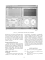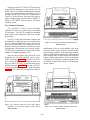
1
NONRESIDENT
TRAINING
COURSE
April 1999
Aerographer’s Mate
Module 4—Environmental
Communications and
Administration
NAVEDTRA 14272
DISTRIBUTION STATEMENT A: Approved for public release; distribution is unlimited.
Although the words “he,” “him,” and
“his” are used sparingly in this course to
enhance communication, they are not
intended to be gender driven or to affront or
discriminate against anyone.
DISTRIBUTION STATEMENT A: Approved for public release; distribution is unlimited.
PREFACE
By enrolling in this self-study course, you have demonstrated a desire to improve yourself and the Navy.
Remember, however, this self-study course is only one part of the total Navy training program. Practical
experience, schools, selected reading, and your desire to succeed are also necessary to successfully round
out a fully meaningful training program.
THE COURSE: This self-study course is organized into subject matter areas, each containing learning
objectives to help you determine what you should learn along with text and illustrations to help you
understand the information. The subject matter reflects day-to-day requirements and experiences of
personnel in the rating or skill area. It also reflects guidance provided by Enlisted Community Managers
(ECMs) and other senior personnel, technical references, instructions, etc., and either the occupational or
naval standards, which are listed in the Manual of Navy Enlisted Manpower Personnel Classifications
and Occupational Standards, NAVPERS 18068.
THE QUESTIONS: The questions that appear in this course are designed to help you understand the
material in the text.
VALUE: In completing this course, you will improve your military and professional knowledge.
Importantly, it can also help you study for the Navy-wide advancement in rate examination. If you are
studying and discover a reference in the text to another publication for further information, look it up.
1999 Edition Prepared by
AGC(SW) Stephen M. Volpe
AGC(AW) Kristopher W. Blom
Published by
NAVAL EDUCATION AND TRAINING
PROFESSIONAL DEVELOPMENT
AND TECHNOLOGY CENTER
NAVSUP Logistics Tracking Number
0504-LP-026-9030
i
Sailor’s Creed
“I am a United States Sailor.
I will support and defend the
Constitution of the United States of
America and I will obey the orders
of those appointed over me.
I represent the fighting spirit of the
Navy and those who have gone
before me to defend freedom and
democracy around the world.
I proudly serve my country’s Navy
combat team with honor, courage
and commitment.
I am committed to excellence and
the fair treatment of all.”
ii
CONTENTS
Page
CHAPTER
1. Environmental Communications . . . . . . . . . . . . . . . . . . . 1-1
2. Environmental Software Programs. . . . . . . . . . . . . . . . . . 2-1
3. Administration . . . . . . . . . . . . . . . . . . . . . . . . . . . . 3-1
APPENDIX
I. Glossary. . . . . . . . . . . . . . . . . . . . . . . . . . . . . . . AI-1
II. MANOP Codes. . . . . . . . . . . . . . . . . . . . . . . . . . . AII-1
III. Reference List. . . . . . . . . . . . . . . . . . . . . . . . . . . . AIII-1
INDEX . . . . . . . . . . . . . . . . . . . . . . . . . . . . . . . . . . INDEX-l
Nonresident Training Course Follows The Index
iii
SUMMARY OF THE
AEROGRAPHER’S MATE
TRAINING SERIES
The following modules of the AG training series are available:
AG MODULE 1, NAVEDTRA 14269, Surface Weather Observations
This module covers the basic procedures that are involved with conducting
surface weather observations. It begins with a discussion of surface observation
elements, followed by a description of primary and backup observation equipment
that is used aboard ships and at shore stations. Module 1 also includes a complete
explanation of how to record and encode surface METAR observations using WMO
and NAVMETOCCOM guidelines. The module concludes with a description of
WMO plotting models and procedures.
AG MODULE 2, NAVEDTRA 14270, Miscellaneous Observations and
Codes
This module concentrates on the observation procedures, equipment, and codes
associated with upper-air observations and bathythermograph observations.
Module 2 also discusses aviation weather codes, such as TAFs and PIREPs, and
includes a chapter on surf observation procedures. Radiological fallout and
chemical contamination plotting procedures are also explained.
AG MODULE 3, NAVEDTRA 14271, Environmental Satellites and
Weather Radar
This module describes the various type of environmental satellites, satellite
imagery, and associated terminology. It also discusses satellite receiving
equipment. In addition, Module 3 contains information on the Weather
Surveillance Radar-1988 Doppler (WSR-88D). It includes a discussion of
electromagnetic energy and radar propagation theory, and explains the basic
principles of Doppler radar. The module also describes the configuration and
operation of the WSR-88D, as well as WSR-88D products.
AG MODULE 4, NAVEDTRA 14272, Environmental Communications
and Administration
This module covers several of the most widely used environmental
communications systems within the METOC community. It also describes the
software programs and products associated with these systems. The module
concludes with a discussion of basic administration procedures.
NOTE
Additional modules of the AG training series are in development. Check the
NETPDTC website for details at http://www.cnet.navy.mil/netpdtc/nac/neas.htm
For ordering information, check NAVEDTRA 12061, Catalog of Nonresident
Training Courses, which is also available on the NETPDTC website.
iv
SAFETY PRECAUTIONS
Safety is a paramount concern for all personnel. Many of the Naval Ship’s
Technical Manuals, manufacturer’s technical manuals, and every Planned
Maintenance System (PMS) maintenance requirement card (MRC) include safety
precautions. Additionally, OPNAVINST 5100.19 (series), Naval Occupational
Safety and Health (NAVOSH) Program Manual for Forces Afloat, and
OPNAVINST 5100.23 (series), NAVOSH Program Manual, provide safety and
occupational health information. The safety precautions are for your protection and
to protect equipment.
During equipment operation and preventive or corrective maintenance, the
procedures may call for personal protective equipment (PPE), such as goggles,
gloves, safety shoes, hard hats, hearing protection, and respirators. When specified,
your use of PPE is mandatory. You must select PPE appropriate for the job since the
equipment is manufactured and approved for different levels of protection. If the
procedure does not specify the PPE, and you aren’t sure, ask your safety officer.
Most machinery, spaces, and tools requiring you to wear hearing protection are
posted with hazardous noise signs or labels. Eye hazardous areas requiring you to
wear goggles or safety glasses are also posted. In areas where corrosive chemicals
are mixed or used, an emergency eyewash station must be installed.
All lubricating agents, oil, cleaning material, and chemicals used in
maintenance and repair are hazardous materials. Examples of hazardous materials
are gasoline, coal distillates, and asphalt. Gasoline contains a small amount of lead
and other toxic compounds. Ingestion of gasoline can cause lead poisoning. Coal
distillates, such as benzene or naphthalene in benzol, are suspected carcinogens.
Avoid all skin contact and do not inhale the vapors and gases from these distillates.
Asphalt contains components suspected of causing cancer. Anyone handling
asphalt must be trained to handle it in a safe manner.
Hazardous materials require careful handling, storage, and disposal. PMS
documentation provides hazard warnings or refers the maintenance man to the
Hazardous Materials User’s Guide. Material Safety Data Sheets (MSDS) also
provide safety precautions for hazardous materials. All commands are required to
have an MSDS for each hazardous material they have in their inventory. You must
be familiar with the dangers associated with the hazardous materials you use in your
work. Additional information is available from you command’s Hazardous
Material Coordinator. OPNAVINST 4110.2 (series), Hazardous Material Control
and Management, contains detailed information on the hazardous material
program.
Recent legislation and updated Navy directives implemented tighter constraints
on environmental pollution and hazardous waste disposal. OPNAVINST 5090.1
(series), Environmental and Natural Resources Program Manual, provides detailed
information. Your command must comply with federal, state, and local
environmental regulations during any type of construction and demolition. Your
supervisor will provide training on environmental compliance.
Cautions and warnings of potentially hazardous situations or conditions are
highlighted, where needed, in each chapter of this TRAMAN. Remember to be
safety conscious at all times.
v
INSTRUCTIONS FOR TAKING THE COURSE
assignments. To submit your
answers via the Internet, go to:
ASSIGNMENTS
The text pages that you are to study are listed at
the beginning of each assignment. Study these
pages carefully before attempting to answer the
questions. Pay close attention to tables and
illustrations and read the learning objectives.
The learning objectives state what you should be
able to do after studying the material. Answering
the questions correctly helps you accomplish the
objectives.
http://courses.cnet.navy.mil
Grading by Mail: When you submit answer
sheets by mail, send all of your assignments at
one time. Do NOT submit individual answer
sheets for grading. Mail all of your assignments
in an envelope, which you either provide
yourself or obtain from your nearest Educational
Services Officer (ESO). Submit answer sheets
to:
SELECTING YOUR ANSWERS
Read each question carefully, then select the
BEST answer. You may refer freely to the text.
The answers must be the result of your own
work and decisions. You are prohibited from
referring to or copying the answers of others and
from giving answers to anyone else taking the
course.
COMMANDING OFFICER
NETPDTC N331
6490 SAUFLEY FIELD ROAD
PENSACOLA FL 32559-5000
Answer Sheets: All courses include one
“scannable” answer sheet for each assignment.
These answer sheets are preprinted with your
SSN, name, assignment number, and course
number. Explanations for completing the answer
sheets are on the answer sheet.
SUBMITTING YOUR ASSIGNMENTS
To have your assignments graded, you must be
enrolled in the course with the Nonresident
Training Course Administration Branch at the
Naval Education and Training Professional
Development
and
Technology
Center
(NETPDTC). Following enrollment, there are
two ways of having your assignments graded:
(1) use the Internet to submit your assignments
as you complete them, or (2) send all the
assignments at one time by mail to NETPDTC.
Grading on the Internet:
Internet grading are:
•
•
assignment
Do not use answer sheet reproductions: Use
only the original answer sheets that we
provide—reproductions will not work with our
scanning equipment and cannot be processed.
Follow the instructions for marking your
answers on the answer sheet. Be sure that blocks
1, 2, and 3 are filled in correctly. This
information is necessary for your course to be
properly processed and for you to receive credit
for your work.
Advantages to
COMPLETION TIME
you may submit your answers as soon as
you complete an assignment, and
you get your results faster; usually by the
next working day (approximately 24 hours).
Courses must be completed within 12 months
from the date of enrollment. This includes time
required to resubmit failed assignments.
In addition to receiving grade results for each
assignment, you will receive course completion
confirmation once you have completed all the
vi
PASS/FAIL ASSIGNMENT PROCEDURES
For subject matter questions:
If your overall course score is 3.2 or higher, you
will pass the course and will not be required to
resubmit assignments. Once your assignments
have been graded you will receive course
completion confirmation.
E-mail:
Phone:
[email protected]
Comm: (850) 452-1001, Ext. 1713
DSN: 922-1001, Ext. 1713
FAX: (850) 452-1370
(Do not fax answer sheets.)
Address: COMMANDING OFFICER
NETPDTC (CODE N315)
6490 SAUFLEY FIELD ROAD
PENSACOLA FL 32509-5000
If you receive less than a 3.2 on any assignment
and your overall course score is below 3.2, you
will be given the opportunity to resubmit failed
assignments. You may resubmit failed
assignments only once. Internet students will
receive notification when they have failed an
assignment--they may then resubmit failed
assignments on the web site. Internet students
may view and print results for failed
assignments from the web site. Students who
submit by mail will receive a failing result letter
and a new answer sheet for resubmission of each
failed assignment.
For enrollment, shipping,
completion letter questions
grading,
or
E-mail:
Phone:
[email protected]
Toll Free: 877-264-8583
Comm: (850) 452-1511/1181/1859
DSN: 922-1511/1181/1859
FAX: (850) 452-1370
(Do not fax answer sheets.)
Address: COMMANDING OFFICER
NETPDTC (CODE N331)
6490 SAUFLEY FIELD ROAD
PENSACOLA FL 32559-5000
COMPLETION CONFIRMATION
After successfully completing this course, you
will receive a letter of completion.
NAVAL RESERVE RETIREMENT CREDIT
ERRATA
http://www.cnet.navy.mil/netpdtc/nac/neas.htm
If you are a member of the Naval Reserve, you
will receive retirement points if you are
authorized to receive them under current
directives governing retirement of Naval
Reserve personnel. For Naval Reserve
retirement, this course is evaluated at 2 points.
(Refer to Administrative Procedures for Naval
Reservists on Inactive Duty, BUPERSINST
1001.39, for more information about retirement
points.)
STUDENT FEEDBACK QUESTIONS
COURSE OBJECTIVES
We value your suggestions, questions, and
criticisms on our courses. If you would like to
communicate with us regarding this course, we
encourage you, if possible, to use e-mail. If you
write or fax, please use a copy of the Student
Comment form that follows this page.
In completing this nonresident training course,
you will demonstrate a knowledge of the
subject matter by correctly answering questions
on the following subjects: environmental
communications, environmental software programs, and administration.
Errata are used to correct minor errors or delete
obsolete information in a course. Errata may
also be used to provide instructions to the
student. If a course has an errata, it will be
included as the first page(s) after the front cover.
Errata for all courses can be accessed and
viewed/downloaded at:
vii
Student Comments
Course Title:
Aerographer's Mate, Module 4—Environmental Communications and
Administration
NAVEDTRA:
14272
Date:
We need some information about you:
Rate/Rank and Name:
SSN:
Command/Unit
Street Address:
City:
State/FPO:
Zip
Your comments, suggestions, etc.:
Privacy Act Statement: Under authority of Title 5, USC 301, information regarding your military status is
requested in processing your comments and in preparing a reply. This information will not be divulged without
written authorization to anyone other than those within DOD for official use in determining performance.
NETPDTC 1550/41 (Rev 4-00)
ix
CHAPTER 1
ENVIRONMENTAL COMMUNICATIONS
Unclassified information has been evaluated, but
disclosure of the information would not effect the
security of the country. Classified information, if
disclosed, could effect national security to some degree.
Access restrictions are assigned to protect classified
information.
INTRODUCTION
In the field of meteorology and oceanography, we
depend heavily on information to do our jobs. We must
collect raw observation reports and processed data, and
both collect and disseminate forecast products. Today,
we must rely heavily on computer systems to process
information. Your responsibilities as an observer will
include processing data received from various
communications systems and retrieving environmental
data for the forecaster. In addition, you will be asked to
compose various types of message reports for
transmission to other activities. Most of these tasks
involve the use of computers and computer systems.
The program to protect sensitive information and to
prevent its intentional or inadvertent disclosure to other
nations is discussed in depth in OPNAVINST 5510.1,
Department of the Navy Information and Personnel
Security Program Regulation, often called the Security
Manual. The manual defines three general categories of
classified information in increasing order of restriction:
Confidential (C), Secret (S), and Top Secret (TS).
Additionally, the Security Manual provides definitions
and guidelines for handling both unclassified and
classified information and information with specialhandling markings.
In this chapter, we begin with a brief discussion
about communications security. We then take a look at
several environmental communications systems, such
as telephone systems, computer networks, and digital
facsimile. Next, we discuss environmental computer
workstations, naval message transmission networks,
and voice radio systems. We complete the chapter with
a discussion of environmental communications systems
designed specifically for use aboard ship.
The Naval Telecommunications Procedure--Three
(NTP 3), Telecommunications Users Manual further
explains the use of special-handling markings. Some of
the most common include the following:
EFTO (Encrypt For Transmission Only): Used
to identify and protect messages during electrical
transmission that do not meet the criteria for
classification but have potential value if
subjected to analysis.
COMMUNICATIONS SECURITY
LEARNING OBJECTIVES: Identify the
classification markings and special handling
markings authorized for naval correspondence
and message traffic. Identify the publication
that outlines information and personnel
security procedures for the Navy.
FOUO (For Official Use Only): Unclassified
material not given a security classification, but
for various reasons, may not be discussed or
released to the public.
NATO RESTRICTED: Information treated
similar to FOUO with access only for official
purposes to North Atlantic Treaty Organization
(NATO) member nations.
Environmental information, for the most part, is
freely exchanged between countries of the world.
Within the Navy and Marine Corps, some
environmental information, if released to the wrong
person or country, could threaten the defenses of the
United Stated or our allies. This type of information
must be classified according to Department of Defense
and Department of the Navy security guidelines to
prevent its unauthorized disclosure. Information
evaluated for its impact on the defense of the United
States is defined as either "unclassified" or "classified."
ALLIED RESTRICTED: Information so marked
is treated as Confidential information when
received by U.S. activities.
NOFORN or NF (NOt releasable to FOReign
Nationals): Classified material that may not be
released to any foreign government, foreign
national, or non-United States citizen, even if
1-1
that person is employed by the U.S.
Government.
handling marking at the beginning of each paragraph or
section. Figure 1-1 shows an example of these
markings.
SPECAT (SPEcial CATegory): Message traffic
associated with a special project or subject, with
access and handling limited to only those
personnel designated in writing by the
commanding officer.
OPNAVINST 5510.1 also discusses requirements
for granting a security clearance for access to classified
information. Access to classified information is
granted only on a "need-to-know" basis. You will only
be granted access to classified information that is
necessary to perform your assigned duties.
LIMDIS (LIMited DIStribution): Distribution
within the receiving activity is limited only to
those personnel with specific access and needto-know.
Within your command, the Security Officer
maintains a list of all permanent party and visitor
security clearances and levels of access. Classified
information may not be discussed with anyone whose
clearance and access level cannot be verified.
PERSONAL FOR: A classified or unclassified
message with distribution limited only to the
named recipient(s), normally commanding
officers or flag officers.
As we discuss communications systems in the next
section, you will see that most of the environmental
information is handled and stored on computers and
automated systems. The Department of the Navy has
instituted a special security program to protect
automated information systems. Your activity has an
Automatic Data Processing Security Officer (ADPSO)
who is responsible for the security of all personal
computers (PCs) and PC based data handling, data
processing, and communication systems. The ADPSO
is also responsible for the security of other ADP
systems, such as the Tactical Environmental Support
System (TESS). The ADPSO will provide special
security training for personnel that use automated
systems as well as control access to these systems.
WNINTEL: This is a control marking that
denotes "Warning Notice-Sensitive Intelligence
Sources or Methods Involved." Classified
intelligence so marked must not be disseminated
in any manner outside of authorized channels
without the permission of the originator.
All classified information or information that
requires special handling must be clearly marked.
Normally, printed pages are marked at the top and
bottom with a stamp or large machine-printed letters.
Classified words, subjects, or titles are marked at the
end of the subject line in parentheses. Information
within each paragraph or section of a narrative is
identified with the security classification and special
SECRET-NOFORN
Subj:
THIS IS AN EXAMPLE OF A CONFIDENTIAL NOFORN SUBJECT (C-NF)
Ref:
(a) This is an example of an unclassified reference used in a classified message or other correspondence
(U)
(b) This is an example of a confidential reference title (C)
1. (C) This is an example of a confidential paragraph within a narrative.
2. (U) The second paragraph in this example is unclassified. The (U) only precedes a paragraph of unclassified
information in a document containing classified information.
3. (S-NF) This is an example of a secret, no forn paragraph. The entire document must be classified equal to the
highest classification and strictest special handling markings of any material contained within the document.
S E C R E T - NOFORN
(SECURITY MARKINGS FOR ILLUSTRATIVE PURPOSES ONLY)
Figure 1-1.—Example of security markings in a Naval message.
1-2
type of information that may be provided to other
government agencies, private companies, and to the
public. Usually, a written request for information must
be approved by the commanding officer before any
information may be transferred. All non-routine
requests for weather forecasts should be referred to the
duty forecaster.
REVIEW QUESTIONS
Q1.
Which publication governs security procedures
for the United States Navy?
Q2.
What does the special-handling marking
"FOUO" indicate?
Q3.
What does the special-handling marking
"NOFORN" indicate?
When answering the telephone, always speak
clearly. In a standard military telephone greeting, first
identify your command, then your rank and last name.
Then ask, "May I help you, Sir/or Madam?" Your
activity may use a slight modification to this greeting.
The caller should identify him/herself by name, rank,
and command before proceeding with the conversation.
Never discuss, or allow the caller to discuss, classified
information on a standard telephone. Use telephone
conversation memo pads or record sheets to document
the details of a telephone conversation.
The area of telecommunications is the most rapidly
changing aspect of environmental support. Since many
changes will continue to occur in the future, the
remainder of this chapter will only summarize the basic
components of the most widely used communications
systems.
TELECOMMUNICATIONS SYSTEMS
When placing a telephone call, think about what
you want to say before you dial the phone. Organize
your thoughts to allow your phone call to be as brief as
possible. Unless you are transmitting data, your call
should be limited to 10 minutes or less.
LEARNING OBJECTIVES: Identify the
various telecommunications equipment and
systems used to transfer environmental
information. Discuss general procedures used
to transfer data on these systems.
Telephone System Access
Navy and Marine Corps weather personnel will use
many different telecommunications systems to
exchange environmental information. These systems
make use of dedicated landline, radio wave, and
satellite communications technology. The following
telecommunications systems are discussed in this
section:
Normally, you can access the local commercial
network, a commercial long-distance network, and the
Defense Switched Network (DSN) from the telephone
instrument provided with the local base telephone
system. Many Navy and Marine Corps stations are
supported by a customized telephone system that allows
on-base calls to be made by dialing only four- or fivedigit numbers. Other networks are accessed by dialing a
one- or two-digit access code.
Telephone systems
Computer networks
Complete instructions on the use of your local
telephone system and how to access other available
systems is normally provided in your base telephone
book. Your command will also provide additional
guidance on the use of the telephone. This guidance is
usually found in a station instruction or in your
command’s standard operating procedures (SOPs).
Dedicated meteorological communications
systems
Digital facsimile systems
TELEPHONE COMMUNICATIONS
SYSTEMS
COMMERCIAL LONG-DISTANCE SERVICE.—Commercial long-distance telephone service is
available on all government telephone networks. Your
command must pay for all commercial long-distance
services. Virtually all military activities require that a
long-distance phone call record slip or log entry be
completed by the person placing the call. Some
commands require specific authorization for each longdistance call before the call can be placed.
Commercial telephone systems and the Defense
Switched Network (DSN) in military communications,
especially in the field of meteorology and
oceanography, are the most common forms of
communication for official business ashore.
Navy and Marine Corps activities may provide
environmental information to any Department of
Defense activity. However, there are restrictions on the
1-3
caller and the destination. Higher precedence calls may
initially be connected even if all circuits are in use by a
process called "preemption." When no free circuits are
found, the computer checks the precedence on calls in
progress. A lower precedence call in progress will be
terminated by the system to allow a higher precedence
call to proceed. The calling parties of the lower
precedence call hear a brief high-pitched tone on the
line just before the line goes dead to indicate that their
call has been preempted. The effectiveness of this
system depends on the proper use of the precedence
system. Each user should ensure that his or her call is
not assigned a precedence higher than that justified by
the circumstance or information involved.
Government telephones are intended for official
business only. Most commands permit limited, brief,
local telephone calls to be made to take care of personal
matters that cannot be conducted during off-duty hours.
However, the use of commercial long-distance services
for personal business is prohibited and is always
investigated. Detailed records of every commercial
long-distance call (telephone bills) are forwarded
monthly to each command for verification with the
long-distance phone call records.
DEFENSE SWITCHED NETWORK.—The
Defense Switched Network (DSN) is a telephone
network servicing most military installations in the
continental United States and overseas. This system is
an upgraded, all-digital network that has replaced the
former Automatic Voice Network (AUTOVON). The
DSN incorporates many special features, such as
automatic callback, call forwarding, call transfer, and
call waiting. Instructions for use of the service and
special options are included in the DSN User Services
Guide, DISA Circular 310-225-1.
Local command policy normally states that the
DSN is to be used for official calls only. Personal or
unofficial calls must never be initiated into the DSN
system.
Telephone circuits, particularly those routed by
high frequency and microwave, are susceptible to
monitoring and interception. The DSN is not a secure
system! Users must take care and use common sense to
avoid divulging classified information. Giving hints or
talking "around" a classified subject can lead to the
compromise of classified information.
All telephone connections on the DSN are
connected and maintained on a precedence basis (see
table 1-1). Low precedence calls are initially connected
only if there are free circuits available between the
Table 1-1.—DSN Telephone Network Precedence System
DESCRIPTION
PRECEDENCE
FLASH OVERRIDE (FO)
Takes precedence over and preempts all calls on the DSN and is not preemptible.
FO is reserved for the President of the United States, Secretary of Defense,
Chairman of the Joint Chiefs of Staff, chiefs of military services, and others as
specified by the President .
FLASH (F)
Preempts lower precedence calls and can be preempted by FLASH OVERRIDE
only. Some of the uses for FLASH are initial enemy contact, major strategic
decisions of great urgency, and presidential action notices essential to national
survival during attack or pre-attack conditions.
IMMEDIATE (O)
Preempts PRIORITY and ROUTINE calls and is reserved for calls pertaining to
situations that gravely affect the security of the United States. Examples of
IMMEDIATE calls are enemy contact, intelligence reports essential to national
security, widespread civil disturbance, and vital information concerning aircraft,
spacecraft, or missile operations.
PRIORITY (P)
Preempts only ROUTINE calls. For calls requiring expeditious action or
furnishing essential information for the conduct of government operations.
Examples of PRIORITY calls are intelligence reports, movement of naval, air,
and ground forces, and important information concerning administrative military
support functions.
ROUTINE (R)
For official government communications that require rapid transmission by
telephone. These calls do not require preferential handling.
1-4
telephone networks do not provide the high-quality,
low-noise circuits necessary for data transmission.
Telephone Equipment
Most weather offices are equipped with multi-line
telephones to handle normal business. Multi-line
telephones contain six or more buttons in addition to the
normal keypad. Depressing a button will switch the
telephone to the number shown by the lighted button.
Incoming calls activate a flashing light corresponding
to the number of the incoming call. Normally, these
telephones are on unprotected circuits, and classified
information may not be discussed.
The STU-III is operated the same way as any
regular telephone. That is, you pick up the handset, wait
for a dial tone, and then dial the number of the person
you want to call. Calls on the STU-III are always
initiated in the clear voice mode. Once the party you
have called (at another STU-III terminal) has answered,
you have the option of talking to that person in the clear
voice or secure voice mode.
The STU-III terminal uses special keys with a
designator of KSD-64A. The KSD-64A is a plastic
device that resembles an ordinary key. Two types of
KSD-64A keys are used with the STU-III, the seed key
and the crypto ignition key (CIK). The seed key is
special keying material used for the initial electronic
setup of the terminal. The CIK is used by the operator to
activate the secure mode. CIKs work only on the STUIII that they are issued with, and are unusable on all
other terminals. More than one CIK may be issued with
a terminal.
Additionally, secure telephones are found in many
offices, and just about every weather activity has at least
one telephone facsimile send and receive terminal.
SECURE TELEPHONE.—The
Secure
Telephone Unit-Third Generation (STU-III) is a
communications system that meets the need for the
protection of vital and sensitive information over a
telephone system. The STU-III is a compact, selfcontained, desktop unit capable of providing the user
with both clear as well as secure voice and data
transmissions (fig. 1-2). The STU-III is unique in that it
works as an ordinary telephone and as a secure
telephone network to other STU-III terminals. STU-III
equipment may be used to provide secure
communications on all commercial and military
telephone networks. Full feature STU-III telephone
terminals are equipped with modems that also allow
clear and secure data transfer. However, some
Calls are always initiated in the clear voice mode,
exactly the same as a normal telephone call. For users to
go from clear to secure voice transmission, both the
calling and the receiving STU-III terminals must have
the CIK inserted and turned a quarter turn clockwise.
Then either caller may initiate the secure mode by
pressing the "SECURE" button. Once a secure link has
been initiated, the two STU-III terminals begin
Figure 1-2.—STU-III terminal.
1-5
AGM4F102
exchanging information. When two terminals
communicate in the secure mode, each terminal
automatically displays the authentication
(identification) information of the distant terminal, and
a list of compromised CIKs. This information is
scrolled through the display window during secure call
setup. The first line of the identification information
and the classification level are displayed for the
duration of the secure call. The information displayed
indicates the approved classification level for the call,
but does not authenticate the person using the terminal.
The terminal users are responsible for viewing this
information to identify the distant party and the
maximum security classification level authorized for
the call.
1-3 shows an example of a pregummed 1.5-inch by
4-inch label containing certain information that should
be included on every telefax. Some commands use a
pre-printed cover-page containing this information.
# OF PAGES:
FROM
TO:
COMMAND:
COMMAND:
OFFICE CODE:
OFFICE CODE:
PHONE #:
FAX #:
FAX #:
Figure 1-3.—Example of a telefax address label.
Operation of telefax equipment is usually very
simple. You place the original information on the feed
tray, dial the destination fax number on the key pad or
on the attached telephone instrument, and press the
"send" key when a high pitched tone is heard in the
receiver. Detailed instructions are normally attached to
each terminal. The receive mode is fully automatic.
Secure data transmissions using STU-IIIs may be
made by connecting a computer modem phone plug into
the MODEM plug receptacle on the backside of the
unit, and then activating the "SECURE DATA" mode.
The STU-III terminals and keys are
Communications Security (COMSEC) material and
require special handling. The terminals and keys are
administered through the STU-III COMSEC Account
(SCA) Custodian. Both the terminals and keys that are
issued to users must be signed for. Since the seed key is
classified, it must be afforded protection in accordance
with Secure Telephone Unit Third Generation STU-III
COMSEC Material Management Manual, CMS 6.
Although unkeyed STU-III terminals may be carried on
mobile operations or exercises, the seed key is never
transported, and the CIK key must be transported
separately from the STU-III unit.
TELEPHONE MODEMS.—Telephone modems
are electronic equipment that allow computers to
transmit data directly over telephone circuits. Modems
are also used to connect desktop computers to Local
Area Networks (LANs) or to Wide Area Networks
(WANs). There are many different modems in use
throughout the Naval Meteorology and Oceanography
Command. Most desktop computers now contain a
built-m modem.
Modems are controlled via the computer with a
special type of software program called a
communications protocol program. These programs
allow the operator to specify the telephone number to be
accessed and to specify various communications
parameters for the transmitted signal. It is beyond the
scope of this training module to discuss the operating
procedures for the various protocol programs or
communications parameters. Operating instructions for
each program are included with the program manual
issued with the software. Specific protocol parameters
allow the user to access programs such as NODDS.
Because CIKs permit the STU-III terminals to be
used in the secure mode, the CIKs must be protected
against unauthorized access and use. CIKs may be
retained by the users who sign for them on local
custody. Users must take precautions to prevent
unauthorized access and must remember to remove the
CIKs from the associated terminals.
When the terminal is unkeyed, it must be provided
the same protection as any high-value government item,
such as a personal computer. When the terminal is
keyed, the terminal assumes the highest classification
of the key stored within it and must be protected in
accordance with the classification of that key.
The Naval Meteorology and Oceanography
Command Telephone and Address Listing contains
addresses, telephone numbers, and telefax numbers for
all Naval Meteorology and Oceanography Command
activities, Marine Corps weather activities, and offices
of other military activities associated with meteorology
and oceanography (METOC) support. Your Leading
Chief usually maintains the directory and may provide
copies at key telephone locations throughout your
activity.
TELEFAX.—Nearly every command uses
automatic telephone facsimile (telefax or fax) send and
receive terminals to transfer graphic and written
environmental information. This equipment may be
used to transfer unclassified information only. Figure
1-6
Gradually, other government agencies, universities,
and scientific organizations began to tap into the
network. By 1983, newer networking protocols were
developed, laying the foundation of the Internet we use
today.
COMPUTER NETWORKS
The latest and fastest growing method of
disseminating environmental information is through
the use of computer networks. The advent of the
information revolution has brought dramatic changes to
the METOC community. Aerographer’s Mates must
now be proficient in accessing and transferring
information in an automated environment. Almost all
METOC activities, including those aboard ship, have
access to some type of computer network.
The development of Hypertext Markup Language
(HTML) in 1990 significantly increased speed and
capacity, and enabled users to transmit graphical
information over the Internet for the first time. As an
additional feature, HTML created the ability to insert
hypertext links into a document. Hypertext links allow
a user to load another document into their computer
simply by clicking on an on-screen "link" from the
current document. Subsequently, a huge hypertext
network known as the World Wide Web (WWW) came
into being in 1992. These developments enabled any
individual or organization to create their own "website",
and thus disseminate information over the Internet.
Each website normally has an index or introductory
document commonly referred to as a "homepage."
A computer network consists of two or more
computers connected for the purpose of exchanging
messages and sharing data and system resources. A
local area network (LAN) connects personal computers
and workstations (each called a node) over dedicated,
private communications links. A wide area network
(WAN) connects large numbers of computers (nodes)
over long distance communications links, such as
common carrier telephone lines. An internet is a
connection between networks.
The Internet consists of several networks linked
together via Internet Service Providers (ISPs) that use
high-speed digital and fiber optic circuits. Each
computer (client) must be connected to an Internet hub,
known as a sewer. Servers are fast computers that are
connected to the Internet full-time. They are located at
different sites throughout the world, and direct Internet
traffic to its proper destination. Today, the term
"Internet" is used to refer to the physical structure of the
Net, including client and server computers and the lines
that connect them (fig. 1-4). The term "World Wide
The Internet
The Internet is a WAN that connects thousands of
different networks all over the world, enabling anyone
with a computer and Internet access to transmit and
retrieve information worldwide. The Internet is not
owned or funded by any one institution, organization, or
government. It was originally developed by the
Department of Defense in the late 1960’s as a reliable
communications network that, because of its simple
design and versatility, could survive a nuclear attack.
Figure 1-4.—The Internet.
1-7
enterprises, private organizations, universities, the
government, and the military (fig. 1-5). Each network
contains thousands of individual websites that reside on
web servers. The governing body of the Internet is an
international organization known as InterNIC; it is
Web" or "Web" is generally used to refer to the
collection of sites and the information that can be
accessed from them when using the Internet.
There are several layers of the World Wide Web.
These layers include networks operated by commercial
Figure 1-5.—Various layers of the Internet.
1-8
information on command history and mission, as well
as provide access to various environmental products.
Figure 1-6 is an example of the Naval Training
Meteorology and Oceanography Facility (NTMOF),
Pensacola, Internet homepage.
located in Herndon, Virginia. InterNIC controls all
Internet addresses and naming conventions.
Each website is identified by an address indicator
known as a Uniform Resource Locator (URL). The
URL is a unique alphanumeric code that allows you to
quickly locate and access a specific website. A typical
URL might read: http://www.weather.edu. The first
part of the URL indicates the type of Internet protocol
your computer must use. In this case, http:// (hypertext
transfer protocol), is used. The second part of the URL
represents the name of the web server (www) followed
by the website’s domain (weather.edu). Most URLs end
with an extension identifier that is used to access a
particular network domain, such as .edu (educational
institutions), .com (commercial websites), and .mil
(military websites).
A tremendous amount of environmental
information can be downloaded from various METOC
activities. The NIPRNET and SIPRNET can be used to
access environmental data from the website at the Fleet
Numerical Meteorology and Oceanography Center
(FNMOC), Monterey, California, including Navy
Oceanographic Data Distribution System (NODDS)
products and products from the Joint METOC Viewer
(JMV). User manuals for NODDS, JMV, and other
software programs can also be downloaded via the
FNMOC website. In addition, there are several
nonmilitary and nongovernment websites that contain
valuable environmental information, which include
looped satellite images, current weather maps,
climatological data, and so forth. Many METOC
websites include links to other sites with related
information. Table 1-2 contains a listing of some of the
most frequently accessed METOC-related websites.
Websites can be easily accessed by using
commercial software known as a web browser. As soon
as you type in the URL of the website you wish to
access, your browser goes to the web server that holds
the page and retrieves it. If a specific website address is
unknown, there are Internet search engines that can be
used to rapidly locate websites pertaining to a particular
area of interest. For example, a keyword such as
"aircraft," or a more specific term, such as "F-14
Tomcat," may be used to easily locate information
concerning that topic.
Bulletin Board Systems
There are still a few environmental software
programs that are available via bulletin board systems.
Bulletin board services are acquired by dialing a
telephone number for access to government computer
networks. All government bulletin board services,
including NODDS, require user identification codes
and passwords. These are provided along with detailed
operating instructions for all registered system users.
All user identification codes and passwords must be
protected and should never be disclosed to unauthorized
users. Once user identification and passwords have
been entered, your computer will be connected to the
bulletin board system.
A wealth of information is available via the
Internet. But keep in mind that since any individual or
organization can develop their own website, not all the
information is accurate or reliable. Also, keep in mind
that the Internet is not a secure telecommunications
network.
Military Networks
The U.S. military operates its own environment on
the Internet that provides more security than
commercial methods. This environment, known as the
Defense Information Systems Network (DISN), is
managed by the Defense Information Services Agency
(DISA). It consists of two primary networks, the
NIPRNET (Nonsecure Internet Protocol Routing
Network) and the SIPRNET (Secure Internet Protocol
Routing Network). These networks require special
dedicated circuits as directed by higher authority. Most
Navy and Marine Corps METOC activities have
NIPRNET access, and many also have SIPRNET
access. In addition, almost all METOC activities,
including most ships, maintain their own website (or
homepage). Each of these websites may contain
Electronic Mail
Electronic mail or e-mail is the electronic
transmission of messages, letters, documents, and other
materials via a communications network, such as the
Internet. It allows computer-based messages to be
electronically edited, replied to, or pasted into another
electronic document. Most e-mail allows messages to
be sent to multiple recipients. E-mail may even contain
graphics, sound, and video attachments. Messages or
files are sent to "accounts" or electronic mail addresses.
An e-mail address is a unique identifier that is used to
1-9
Naval Training
Meteorology and
Oceanography Facility
Pensacola, FL
YOU HAVE JUST ENGAGED AN OFFICIAL
UNITED STATES NAVY WEB INFORMATION SERVICE
DOD Warning Statement
METOC Products
Pascagoula Support
About NTMOF
Fleet Training
Department
Privacy and Security Notice
General Disclaimer
Command Mission
To provide within areas of responsibility (AOR), as assigned by the
Commander, Naval Meteorology and Oceanography Command,
operational meteorology and oceanography (METOC) services to the
Armed Forces of the Department of Defense (DoD).
Feedback, Products
request
Forecast Duty Officer:
DSN 922-3644
COM 850-452-3644
Mail to NTMOF
WebMaster c/o
[email protected]
Click Here for Todays Forecast
Click Here for the Latest Satellite
Picture
Figure 1-6.—NTMOF Pensacola Internet homepage.
WEATHER COMMUNICATIONS
NETWORKS
send electronic mail to a specified destination. The
recipient can be on the same server as the sender or on a
server halfway across the world. The only restriction is
that you must know the address of the person you wish
to send e-mail to. An e-mail address usually appears as
a user name, followed by an @ symbol, followed by the
host name of the destination computer, such as
"[email protected]. The addresses are normally case
sensitive, and the spelling of the surname and of the site
must be exact, or the message will not arrive at the
recipient’s computer.
There are several telecommunication networks
dedicated solely to environmental information. The
largest is the DOD Global Weather Communications
System (GWCS). It is operated by the U.S. Air Force
and provides rapid transmission of aviation weather
support information to military facilities. The system
includes the Automated Weather Network (AWN) and
the Air Force Global Weather Intercept Program
(GWIP) network.
1-10
Table 1-2.—METOC Related Websites
WEBSITE URL
ORGANIZATION
CNMOC Stennis Space Center
www.cnmoc.navy.mil
NAVO Stennis Space Center
www.navo.navy.mil
FNMOC Monterey, CA.
www.fnmoc.navy.mil
NLMOC Norfolk, VA.
www.nlmoc.navy.mil
NPMOC Pearl Harbor, HI.
www.npmoc.navy.mil
NPMOCW Guam
www.npmocw.navy.mil
NEMOC Rota, Spain
www.nemoc.navy.mil
NEPRF Monterey, CA.
www.neprf.navy.mil
NTMOF Pensacola, FL
www.ntmof.navy.mil
FNMOD Asheville, NC
waves.ncdc.noaa.gov/temp/fnmod.htm
FNMOD Tinker AFB
www.fhmoc.navy.mil/~tinker
AFWA Offutt AFB, NE
afwin.afwa.af.mil:443
NWS Climatic Data
tgsv5.nws.noaa.gov/climate.shtml
NWS Eastern Region
tgsv5.nws.noaa.gov/er/hq/index.html
NWS Southern Region
www.srh.noaa.gov
NWS Western Region
www.wrh.noaa.gov/wrhg
NWS Pacific Region
tgsv5.nws.noaa.govlprlpacific.shtml
NWS Alaska Region
www.alaska.netf-nwsar/
Weather Channel
www.weather.com
John Hopkins University
www.jhuapl.edu/weather
University of Wisconsin
www.meteor.wisc.edu/weather.html
Penn State University
www.psu.edu/weather
University of Michigan
cirrus.sprl.umich.edu/wxnet
the National Weather Service (NWS), the Air Force
Weather Agency (AFWA) at Offutt AFB, Nebraska,
and the Fleet Numerical Meteorology and
Oceanography Center. International environmental
information is forwarded from the World
Meteorological Organization (WMO) data collection
center via the NWS and is also collected and entered
into the AWN through the GWIP network.
Automated Weather Network
The AWN is a global network of satellite and
landline circuits linked with Automated Weather Data
Switch (AWDS) computers used to collect and
disseminate environmental data and other aviation
related information. The military segment of the AWN
is composed of two major subsystems: the Air Force
Meteorological Data System (AFMEDS), and the
Notice to Airmen (NOTAM) service for all DOD
activities. The center of the network is a computer
complex at Tinker AFB, Oklahoma. These computers
collect large quantities of unclassified environmental
observations, forecast bulletins, and specialized
guidance products from a variety of sources, including
The Fleet Numerical Meteorological and
Oceanography Detachment (FNMOD) at Tinker AFB,
Oklahoma, is responsible for coordinating and
validating Navy and Marine Corps environmental data
requirements for the AWN. They also manage and
schedule Navy data requirements on the Fleet
1-11
TTAA(ii) CCCC YYGGgg (mod)
Environmental Broadcast circuits that are keyed to the
AWN. FNMOD Tinker also provides guidance on
AWN data formats and can assist with preparing
request messages for AWN products. Detailed
information on the AWN can be obtained from
the
FNMOD
Tinker
homepage
at
http://www.fnmoc.navy.mil/~tinker/.
where
TT is the data content identifier—a twoletter code for the type of data contained
in the bulletin or message;
AA
AFMEDS.—The data network used to support Air
Force, Navy, and Marine Corps meteorological
facilities within the United States is called the
Continental United States (COWS) Meteorological
Data System, or COMEDS. In the early 1970's, the
service was expanded to include the European
Meteorological Data System (EURMEDS), the Pacific
Meteorological Data System (PACMEDS), the Atlantic
Meteorological Data System (ALTMEDS), and an
Alaskan Meteorological Data System (AKMEDS).
These services are subsystems of the Air Force
Meteorological Data System, or AFMEDS. Most of
these dedicated landline circuits will be phased out by
early next century as the NIPRNET becomes the
primary method of transmitting AWN data. Software
known as the Message Format Transmitter (MFT)
module will be incorporated into the Meteorological
and Oceanographic (METOC) Interactive Data Display
System (MIDDS) to complete this changeover.
However, the actual AWN data formats will not change.
Ships will continue to receive AWN data via the Fleet
Environmental Broadcast, which is discussed later in
the chapter.
is the Geographical designator—a twoletter code for the region covered by the
data in the bulletin or message;
ii is a two-digit series number assigned to
products containing similar data for
similar areas, and issued by the same
originating station;
CCCC is the four-letter ICAO station identifier
for the station originating or compiling
the information in the bulletin;
YYGGgg is the UTC date-time group (DTG) of
the information within the bulletin or
message, with YY as the day, GG as the
hour, and gg as the minutes; and
Mod is a modification indicator-an
abbreviation showing that a change has
occurred in an otherwise routinely
scheduled message. Mod indicators are
"RTD" (routine delayed) and "COR"
(correction).
Each product entered in the system must contain the
proper MANOP header before being entered into the
system. However, transmissions of some routine
products, such as standard military station weather
observations and terminal aerodrome forecasts (TAFs)
are normally sent through the system without
MANOPs. Instead, they are grouped into a collective by
the system, and then assigned a MANOP by the AWN
computer.
ARQ Requests.—Incoming environmental
information is stored in the AWN computers in files
identified with a MANOP heading. (MANOP headings
will be discussed in more detail shortly). As each
observation or product is received in the computer, the
data is forwarded to all units that have listed that
particular MANOP as part of their data requirements.
Additionally, any activity connected to the system may
request individual products that are not on their data
requirements list by a process called Automatic
Response to Query, or ARQ. Individual activities may
also use the system to transfer specific support products
from a forecast activity, such as a detachment, to any
other activity on the system.
Appendix II provides a breakdown of the various
MANOP data type identifiers (TT) and geographical
designators (A A) used within the system. A complete
listing of available data in the AWN system can be
obtained from the AFWA Detachment 7, Tinker AFB
website: http://137.240.101.95, and the FNMOD
Tinker website.
MANOP Headings.—The use of MANOP
headings is the key to data retrieval from the system.
MANOP headings conform to WMO product
identification guidelines as well as to the International
Civil Aviation Organization (ICAO) guidelines for
station identification. Every MANOP must follow the
general format
NOTAMS.—The
AWN
also
provides
communications for the worldwide military NOTAM
system. The Air Force Central NOTAM Facility
(AFCNF) in Washington, D.C. collects and retransmits
NOTAMs from all military airfields as well as civil
aviation NOTAMs from the FAA NOTAM facility in
Atlanta, Georgia. NOTAMs report items of interest to
1-12
The DIFAX uses product codes for each product.
Operators access the command function via the
computer keyboard, and use the product codes to
specify which products are to be displayed or printed,
and which products are to be ignored. The product
codes are included on the facsimile transmission
schedule. Transmission schedules are periodically
broadcast and are also available via the Internet from the
DIFAX service offices at NCEP.
aviators, such as temporary or permanent runway
closures, radar, communications, or guidance systems
outages, or changes in available facilities at an airfield.
At most military airfields, NOTAMs are directed to a
separate AWN terminal in the base operation office.
During terminal outages, these NOTAMs may be
redirected to the AWN terminal in the weather spaces.
Navy and Marine Corps weather observers should
coordinate directly with the local base air traffic
controllers to arrange for pickup of NOTAMs when
received over a weather circuit.
The DIFAX broadcast should be discontinued by
late 1999 as the NWS Advanced Weather Interactive
Processing System (AWIPS) becomes fully
operational. Most products currently available from
this service and routinely used by military weather
personnel are now available via NODDS and JMV.
Air Force Global Weather
Intercept Program
The Air Force Global Weather Intercept Program
(GWIP) is another major function of the GWCS. Air
Force radio intercept sites around the world routinely
intercept meteorological and oceanographic
information broadcast from other nations that would
otherwise be unavailable for use. This information is
transmitted by other nations knowing that it will be
intercepted and used. This is part of the data exchange
program governed by the World Meteorological
Organization data exchange agreements. The
intercepted data is entered into the AWN, and large
amounts are forwarded to the National Weather Service
and FNMOC to supplement foreign data received from
other sources. Most of the data is used for automated
global scale analysis programs. Some selected data is
directed to the Fleet Environmental Broadcast, which is
discussed later in this chapter.
So far, we have covered the various
telecommunications systems you will use in the Navy.
In the next section, we will discuss how you will access
this information.
REVIEW QUESTIONS
Q4. Before a long distance commercial call can be
made from a government telephone system, what
action must be completed?
Q5.
What is the purpose of the STU-III?
Q6.
What are Internet "links" used for?
Q7.
What is the function of a network server?
Q8. How are military URLs identified?
Q9. What Internet routing system is used to transfer
classified information between military
activities?
DIGITAL FACSIMILE
Several shore sites receive the National Weather
Service Digital Facsimile (DIFAX) satellite broadcast.
The broadcast originates at the National Centers for
Environmental Prediction (NCEP) located at Camp
Springs, Maryland, and it is then distributed via a
continuous satellite broadcast from the National
Weather Service office at Silver Spring, Maryland. A
small 18-inch dish antenna is used to capture the
broadcast signal at each receiver site.
Q10. What types of information may be obtained from
a METOC-related military website?
The MIDDS is equipped with a special receiver
module that can ingest DIFAX products as necessary.
A few weather offices still use a desktop computer to
analyze the signal and print the graphic products on a
standard printer. No operator maintenance is required
for the equipment other than periodically reloading
paper, replacement of printer ribbons, and a periodic
vacuuming of lint and dust from the printer.
Q14. How can you obtain weather information via the
AWN that is not routinely received by your
command?
Q11. What information must be included in an e-mail
address?
Q12. What is the purpose of the AWN?
Q13. What organization is responsible for
coordinating and validating Navy and Marine
Corps AWN data requirements?
Q15. The TT and AA indicators of a MANOP header
are used to identify what information?
Q16. What information is contained in a NOTAM?
Q17. How are DIFAX products copied?
1-13
capable of simultaneously sending, receiving, storing,
recalling, printing, and processing alphanumeric data.
It also generated color graphics from processed data.
By the late 1990's, the CMW was being replaced by the
Meteorology and Oceanography Integrated Data
Display System (MIDDS), which is discussed in the
following text. A shipboard version of an
environmental workstation known as the Tactical
Environmental Support System (TESS) will be
discussed later in the chapter.
ENVIRONMENTAL WORKSTATIONS
LEARNING OBJECTIVES: Identify the
primary environmental workstation used by
NAVMETOCCOM. Identify the major
features and software programs associated with
this system.
Over the past decade the Navy has developed
various METOC related PC-based systems designed to
take advantage of computer technology. The original
PC-based systems were integrated into Navy and
Marine Corps weather offices to acquire, process,
display, and disseminate meteorological and
oceanographic data. Unfortunately, these original
"stand-alone" PC systems took up much workspace and
required more operator personnel than were available.
METEOROLOGY AND OCEANOGRAPHY.
(METOC) INTEGRATED DATA DISPLAY
SYSTEM (MIDDS)
The Commander Naval Meteorology and
Oceanography Command (CNMOC) tasked the Naval
Oceanographic Office (NAVO) to develop the
Meteorology and Oceanography (METOC) Integrated
Data Display System (MIDDS). This system combines
both government and commercial application software.
The Windows-NT operating system is the base
software.
In the early 1990's, the first computer workstation
developed for the shore-based Navy METOC
community was introduced. This system, known as the
CONTEL Meteorological Workstation (CMW), was a
desktop computer system with multiple communication
and display functions. It consolidated the various standalone systems into a single client-server system and was
MIDDS provides three primary functions. First,
MIDDS is an environmental workstation where the
weather forecaster or observer retrieves, processes, and
Figure 1-7.—MIDDS workstation.
l-14
automatically activates the router and receiver modules.
To display the router window, you must click on the
Router icon found in the "Ingest Monitor Window," as
shown in figure 1-8. Your system administrator
normally accomplishes all initial settings for the router
during installation.
displays various weather products. Second, MIDDS is
a briefing station that features high-quality graphics and
enhancement features. Finally, MIDDS distributes
meteorology and oceanography products locally over a
Bulletin Board System (BBS), the Internet, or Local
Area Network (LAN). The MIDDS workstation is
normally equipped with a four-monitor display unit that
is used for pilot briefings and product visualization.
Figure 1-7 shows the MIDDS workstation.
There are nine major system management functions
of the router and they must be activated to run. Some of
the most important router functions include an audio
alarm option, an auto printing option, and automatic file
conversion for ingested products. A few other
important functions are discussed in the following text.
The MIDDS workstation requires the user to have a
working knowledge of Windows NT and its functions.
The hardware includes a dual-processor 486 Pentium
computer with 64 megabytes of RAM, a 2-gigabyte
hard drive, a CD-ROM drive, 21- and 17-inch highresolution monitors, modems, uninterrupted power
supply (UPS), keyboard, and receiver card. Complete
information concerning the operation of MIDDS can be
found in the Meteorology and Oceanography
(METOC) Integrated Data Display System (MIDDS)
User’s Guide. We will discuss the various features and
software programs of the MIDDS in the following text.
PURGING.—Purging is the most important
system management function of the router module. The
purger maintains the correct number of each type of
product on the hard drive. The purger deletes the oldest
version of a product file and replaces it with the newest
version. In the original MIDDS, purging was optional.
With MIDDS 2.0 and later, purging will be
accomplished automatically and continually in the
background.
DISK MIRRORING.—In a few cases, you may
want to copy products to a different location other than
where they are normally stored. This function will
automatically copy specified products to another disk
drive or to another computer over the network. The
Disk Mirroring function allows you to maintain a suite
of products in case the main MIDDS server fails.
Router Modules
The MIDDS router (and receiver) modules are
software programs that run continuously in the
background and can be accessed only from the main
server of the system. The router module controls all
data reception and is responsible for all the system
management functions. The router identifies, sorts,
stores, and sends data to the appropriate directories.
When the MIDDS is turned on, Windows NT
FTP (FILE TRANSFER PROTOCOL)
PROCESSING.—This function is responsible for
automatically sending products and files to another
Figure 1-8.—MIDDS Ingest Monitor screen.
1-15
computer system over a network. The operator may
choose to reroute selected files and products to remote
sites on a predetermined schedule. The FTP function
can be used to send critical tiles to a remote site. Only
one file may be sent at a time.
ARCHIVING. —Aircraft accidents, storm tracks,
and high interest areas provide good reasons to save
environmental data. The archive function allows you to
save individual products and files to floppy disk. As
data is received, it is automatically copied to the
destination path and drive.
this database, specific stations can be selected
(activated), and desired products can then be selected
from that particular station. Keep in mind that only
those radars sites near your station need be activated.
After you select the WSR-88D station, you then select
from a list of products that you desire. Your system
administrator can establish a predefined product list for
each WSR-88D station. At some activities, the MIDDS
computer is directly connected to a WSR-88D Principal
User Processor (PUP) circuit by using a CODEX
modem.
FUSION GENERATOR.—This function allows
you to overlay various METOC products, such as a
satellite image with a radar image. The operation can be
set up automatically for predefined products at
specified time intervals. There are several map
projection and color scheme options available. In
addition, alphanumeric data ingested from the AWN
can also be fused with other geo-referenced products.
This allows you to overlay any type of data, such as sea
level pressure contours with temperature contours,
surface winds with precipitation, and so forth.
AWN RECEIVER.—This module allows
observation and forecast data from the AWN to be
ingested into the MIDDS. MIDDS is designed to
receive AWN data, identify desired stations and
products, and store the data in appropriate directories.
The number of active stations can be selected from the
master station database. Data requirements are usually
determined through the system administrator. MIDDS
ingests AWN data continuously, and a large volume of
data is received. Thus, the amount of data selected for
ingest must be determined very carefully.
LIGHTNING-DATA RECEIVER (LDR).—
The LDR receives input from the Lightning Detection
and Tracking System (LDATS). The LDATS system
displays lightning data collected by the National
Lightning Detection Network (NLDN), which consists
of over 100 remote sensing stations that monitor cloudto-ground lightning in the continental United States.
The LDR receives LDATS data so that MIDDS can
display it on a user-defined map background. This
display can be an individual LDATS product or
overlaid on top of radar and satellite products. MIDDS
can also display the lightning data at specified time
intervals.
Receiver Modules
The MIDDS has several receiver modules that
define which products to receive from satellite data,
radar data, AWN data, and digital facsimile data.
SATELLITE (DSP) RECEIVER.—This module
allows for the reception of satellite images from GOESTap, HF receiver, APT, or WEFAX. The images are
stored in PCX format and can be captured in several
sizes. Images can be viewed as they are being received,
and a looper display capability is provided. A database
of several different satellites is loaded during
installation. (Digital GOES 8 and 9 imagery will be
received over the Internet or via the Dial RX receiver.)
Weather Group Applications Software
DIFAX RECEIVER.—This module allows you to
receive digital facsimile products from the National
Weather Service. Your system administrator will
establish a DIFAX product database during installation.
The primary function of MIDDS is to display
satellite imagery, radar imagery, alphanumeric text, and
weather charts. MIDDS has several data-display
applications available for weather briefings, along with
numerous other data manipulation and display features.
The main display applications in MIDDS are SAND
(Satellite, AFOS, NEXRAD, and DIFAX) and FOS
(Family of Services).
DIAL RX RECEIVER.—This module acquires
radar images from WSR-88D radar sites by using a
commercial dial-up service or the Internet. It can also
be used to receive GOES satellite images, alphanumeric
products, and DIFAX products.
SAND (SATELLITE, AFOS, NEXRAD, and
DIFAX).—The SAND application is used to display
three types of products: Satellite imagery, NEXRAD
(WSR-88D next-generation radar data), and digital
facsimile data. AFOS is the commercial way of
The DIAL RX accesses a master database that
contains all meteorological stations, including those
stations with WSR-88D radars. (The database also
contains all satellite and DIFAX product types.) From
1-16
MIDDS can display information by using three
different formats: areas (a geographical area, such as
Nevada), routes (two weather stations connected by a
line), and groups (a random group of stations). As with
the SAND application, the operator selects from various
menu boxes and bars using the Windows format.
Individual stations can be sorted by either station ID or
name. Once the desired station is selected, the required
products for that station are then selected. The data can
be viewed, edited, printed, or archived.
displaying alphanumeric data and is not used in
MIDDS. SAND gives the user the ability to manipulate
and display these products in several ways. The
operator selects from various menu boxes and bars
using the Windows format. Additional menu options
allow the user to pan/zoom and rotate images, add
weather symbols to displays, loop images, and
automatically display range-bearing information.
Customized color enhancements can also be created.
The SAND application also executes automatic station
plots, contour plots, Skew-T plots, and even time-series
plots (fig. 1-9).
Briefing Support
MIDDS contains a briefing support program
designated as "Weather Brief." It provides the
capability to create an environmental brief composed of
satellite, radar, alphanumeric products, or other userdefined products from MIDDS application programs.
Two different types of briefs can be created, dynamic or
static. In a "dynamic" brief, products in the brief are
automatically updated when new ones are ingested into
FOS (FAMILY OF SERVICES).—The Family
of Services (FOS) is the applications module used to
display and manipulate alphanumeric data. Forecasters
need TAFs, station observations, and general text
messages to successfully provide quality forecasts. The
type, age, amount, and location of the data can be
tailored for the needs of each forecaster.
Figure 1-9.—MIDDS time-series plot.
1-17
(fig. 1-10). All DD-175-1 briefs may be archived to a
floppy diskette or another hard drive.
the MIDDS. In a "static" brief, the products are saved
and are not updated when new ones are ingested into the
MIDDS. A static brief is essentially a snap shot of
weather data at a specific point in time. This
information can be quite useful during major weather
events. The idea is to preserve your data for future
reference. MIDDS can also display a brief over a LAN
through a web browser with Hypertext Markup
Language (HTML). You may create multiple briefs
tailored for many users.
Automated Surface Observing System (ASOS)
A communications link between MLDDS and the
Automated Surface Observing System (ASOS) may be
established. The software for this application is divided
into two main sections, ASOS Data Server and ASOS
Data Manager. The ASOS Data Server is a software
program providing ingest and dissemination of 1minute surface observation data from the ASOS. The
other software program is the ASOS Data Manager.
This application provides a display of both current and
historical ASOS data in an easy-to-use method. The
main display consists of a menu bar, two graphs, panes
for the latest reported observation, wind speed and
direction dials, and a "current status" banner (fig l-l 1).
The two graphical displays are "strip charts," which can
provide visual analysis of weather phenomena trends,
such as temperature and wind speed. As an additional
feature, alarms can be set to go off when station
In addition, the MIDDS weather brief program will
enable aviation weather forecasters to provide
computerized flight weather briefing forms (DD Form
175-l) while remaining in accordance with
NAVMETOCCOMINST 3140.14, Procedures
Governing Flight Weather Briefings and Preparing DD
Form 175-1 and U.S. Navy Flight Forecast Folder.
This program contains the entire DD Form 175-1 and is
subdivided into its respective parts (I through IV). The
program is designed to automatically ingest TAF and
observation data from the AWN and place it on the form
Figure 1-10.—Flight weather briefing form (DD Form 175-l) constructed using MIDDS.
1-18
Figure 1-11.—ASOS Data Manager main display window from MIDDS.
meteorological, electromagnetic, oceanographic,
hazard avoidance, and acoustic support for fleet
operations. MIDDS includes the "Unclassified"
portion of GFMPL integrated into a Windows NT
format. Certain electromagnetic assessment
parameters are omitted from the standard GFMPL
modules available in the classified version. Some of the
GFMPL programs that are available include tidal
prediction, tropical cyclone track, and surf prediction.
An on-line user’s guide is available with the MIDDS.
The GFMPL program is discussed in detail in chapter 2
of this module.
minimums, such as ceiling and visibility are reached.
When the Message Format Transmitter (MFT) software
is installed, it will provide templates for surface
observations and TAFs, perform quality control checks
for observations, and automatically transfer
observation data to the AWN and to FNMOD,
Asheville, for archive.
Internet and Bulletin Board Access
MIDDS provides direct dial-in and Internet
connectivity into the Navy Oceanographic Data
Distribution System (NODDS), the Optimum Path
Aircraft Routing System (OPARS), and the Joint
METOC Viewer (JMV). All of these programs
originate at FNMOC and are discussed in detail in
chapter 2 of this module.
REVIEW QUESTIONS
Q18. What are the primary functions of MIDDS?
GFMPL GROUP APPLICATION
SOFTWARE
Q19. What is the purpose of the MIDDS Fusion
Generator module?
The Geophysics Fleet Mission Program Library
(GFMPL) is a software library that provides
Q20. What products are acquired by using the MIDDS
Dial RX receiver?
1-19
Q21. The MIDDS SAND application is used to display
what types of information?
Q22. What is the function of the MIDDS FOS module?
Q23. A Flight Weather Briefing form (DD-175-1) can
be completed by using which MIDDS
application?
Q24. Which MIDDS software application tool can
provide temperature trend graphs for your
station?
system. It is managed by the Defense Communications
Agency (DCA). AUTODIN provides for the
transmission of both narrative and graphic data traffic
on a store-and-forward basis. AUTODIN provides
reliable, secure, and efficient communications using
high-speed transmission equipment that incorporates
error detection. Interface equipment translates all input
into common machine language, thereby making
AUTODIN compatible with many computer codes,
speeds, and other media, such as cards and tapes.
The Naval Communications Processing and
Routing System (NAVCOMPARS) is an automated
communications system that serves as the interface
between AUTODIN, other networks ashore, and
operational units of the Navy. AUTODIN traffic is
entered into NAVCOMPARS for distribution.
NAVCOMPARS forwards messages to fleet units and
provides broadcast management and HF or satellite
broadcast keying. It also provides on-line
communications with the Common User Digital
Information Exchange System (CUDIXS) and the Fleet
Multichannel Broadcast (FMCB).
NAVAL MESSAGE TRAFFIC
LEARNING OBJECTIVES: Identify the
primary message traffic system used by the
Navy. Identify the various parts of a standard
Naval message. Identify the publication that
outlines procedures for formatting Naval
messages. Identify the message formatting
software used by the Navy. Interpret and
format a Naval message readdressal. Explain
the term minimize.
The Gateguard subsystem is an AUTODIN
Gateway Terminal (AGT) that provides the user a
"gateway" into the AUTODIN system. It essentially
provides secure electronic message service from the
telecommunications center to the user’s desktop
computer. Gateguard also acts as a security guard
device, hence the name Gateguard. Users may also use
Gateguard to route incoming messages to various
offices via their local area networks (LANs).
The Navy sends thousands of messages each day.
As an Aerographer’s Mate, you will be required to draft
naval messages. You must be able to recognize the
various parts of a standard Naval message as well as
possess a working knowledge of the message drafting
software used by the Navy.
The primary message traffic system currently used
by the Navy is the Automatic Digital Network
(AUTODIN). As communications technology
continues to develop, this system will be phased out as
the Navy moves to desktop message creation and
transmission. Within the next few years, all message
traffic will be transmitted via an e-mail type system
known as the Defense Message System @MS). The
goal of DMS is to retain the easy-to-use and less
expensive individual messaging capabilities employed
in DOD e-mail systems. This will shift message
handling functions away from manpower intensive
communications centers to the user’s desktop. The
changeover to DMS will continue through the late
1990’s and into the next century.
As was previously mentioned, AUTODIN will
eventually be phased out in favor of DMS. Many of the
changes will be transparent to the user. The mechanics
of either system do not concern the average weather
observer. The main point is that you understand the
Navy message format.
NAVAL MESSAGE FORMAT
For message traffic to be properly routed to
intended recipients, message traffic must be properly
formatted. Naval messages are usually composed on
desktop computers using specialized message
composition programs that assist the user in selecting
proper format entries. The software endorsed Navywide is known as Message Text Format (MTF) Editor.
The software assists the user in composing United
States Message Text Formatted (USMTF) messages as
well as non-formatted messages. The software is menudriven and allows the user to draft a formatted message
by using a "fill in the blank" template. Within each MTF
AUTOMATIC DIGITAL NETWORK
(AUTODIN)
The Automatic Digital Network (AUTODIN) is a
joint-use, worldwide, computerized, communications
l-20
message are specific blocks of information known as
sets. Each set begins with the set identifier, followed by
a field marker (/). Double slants (//) are used as end-ofset markers. Each set contains only certain information
as specified by NTP 3. Some sets are mandatory while
others are not. We will discuss the use of each MTF set
shortly.
transmitted by Navy units are discussed in NWP 1-03.1,
Operational Reports. Instructions for completing
USMTF formatted messages and free form messages
are outlined in the Telecommunications Users Manual,
NTP 3.
USMTF messages, free form messages, and other
formatted messages all contain a message header and a
message body that contains the text or information.
Figure 1-12 is an example of an USMTF GENADMIN
message.
Nearly all messages are formatted by USMTF
procedures. The most common type of USMTF
message is a General Administrative message, which
follows a GENADMIN format. Other USMTF
message types include special purpose messages such
as CASREP (casualty reports), LOGREQ (logistic
requirements), and SORTS (maritime ship reports).
Other formatted messages are currently in use by Navy
and Marine Corps units, and do not follow the USMTF
guidelines, such as the remaining RAINFORM
formatted messages, and Movement Reports
(MOVREPS). The different types of reports routinely
FORMAT SECTION
HEADER
Message Header
AUTODIN message headers contain several
elements that must be included in each header, as well
as some elements that are only required on a case-bycase basis. The specific format of a message
transmission heading and the routing indicator lines is
discussed in JANAP 128, Automatic Digital Network
(AUTODIN) Operating Instructions.
EXAMPLE
PTTCZYUW RULYNMU5678 2391235-CCCC-RULYSUU.
ZNY CCCCC
P 271020Z AUG 98
FM NAVLANTMETOCCEN NORFOLK VA//N30//
TO USS SHIP//JJJ//
INFO CINCLANTFLT NORFOLK VA//N5//
BT
ITEM
Transmission ID
Classification
Precedence & DTG
Originator
Addressee
Info Addee
Text separator
BODY OF A
C O N F I D E N T I A L //N03145//
USMTF GENADMIN OPER/codename//
Operation
MESSAGE
MSGID/GENADMIN/NAVLANTMETOCCEN/1215/JUL//
Message ID
SUBJ/AVWX (U)//
Subject
REF/A/DOC/NAVMETOCCOM/SEP 96//
Reference
REF/B/GENADMIN/USS SHIP/270103Z AUG 98//
Reference
NARR/REF A PROVIDES PRODUCT DESCRIPTION AND Narrative
REF B REQUESTS PRODUCT BE PROVIDED.//
POC/rank and name/command/telephone number//
Point of contact
AKNLDG/acknowledge instructions//
Acknowledgements
RMK/1.(U) METEOROLOGICAL SITUATION AT 271200Z: Remarks-the actual
STRONG HIGH PRESSURE CENTERED OVER TRANSIT text of the message.
AREA.
2. (C) 24HR FORECAST FOR PERIOD 271200Z TO 281200Z
ALONG TRACK FM 35 00N 075 00W TO 31 00N 070 00W .
A. SKY, WEATHER: CLEAR.
B. VSBY (NM): UNRSTD.
(and so forth. . . )
DECL/30JAN99//
Declassification
(CLASSIFIED FOR ILLUSTRATIVE PURPOSES ONLY)
Figure 1-12.—Example of a USMTF GENADMIN message.
1-21
administrative and operational information, as well as
notification of outages.
TRANSMISSION ID AND CLASSIFICATION.—This data identifies the sending and receiving
station routing indicators, and the message sequence
number. This data is usually added by the
telecommunications center entering the message into
NAVCOMPARS, or by the ships communications
office. The third group of the top line indicates the
Julian date and time of transmission. The fourth group
indicates the classification level. The second line of the
header is also a classification indicator.
Most of the PLAs and CADs used within the
Department of Defense are listed by the Distributed
Plain Language Address Verification System (DPVS).
The purpose of DPVS is to provide naval message
originators immediate electronic access to current
single and collective PLA information. It is designed
primarily to be used with the MTF Editor message
preparation program. Updates are sent via BBS,
Internet, and record message.
PRECEDENCE AND DTG.—A single letter
identifies the message precedence, which is the
message delivery time objective. Z (flash) means as
fast as possible with an objective of less than 10
minutes, O (immediate) 30 minutes, P (priority) 3
hours, and R (routine) 6 hours. The date-time group is
normally the UTC date (two digits), time (four digits),
three-letter month abbreviation, and two-digit year that
the message was released by the originating command.
The times 0000Z and 2400Z are not used. Instead, use
0001Z or 2359Z. Keep in mind that certain METOCrelated messages must be assigned specific precedence
codes. This information can be found in the United
States Navy Meteorological and Oceanographic
Support System Manual, NAVMETOCCOMINST
3140.1.
INFO ADDEE.—The INFO portion of the header
identifies PLAs of commands who need the information
provided in the message for information purposes only;
no action is required on their part.
EXEMPT LISTING.—If a command normally
included in a CAD should not receive a specific
message, an exempt listing must be included in the
message header immediately following the last action
or info addressee. The exempt listing is identified by
the abbreviation XMT. The PLA for the exempt
command follows the XMT.
TEXT SEPARATOR.—The text separator is the
letters BT. This indicates the separation or break
between the heading and the body of a message.
ORIGINATOR.—After the FM designator, the
command that originated the message is indicated by a
Plain Language Address (PLA) listing, followed by the
originating office code set-off within double slants.
CLASSIFICATION AND SSIC.—Although
actually apart of the message body, we will consider the
classification and SSIC line to be part of the message
header since this line must be included in all AUTODIN
messages. The classification and SSIC line uses an
identical style in all of the various message formats.
The message classification is entered on a message by
the classification word plus any special handling
instructions. The classification is entered either as
UNCLAS, CONFIDENTIAL, SECRET, or as
TOP SECRET, with each letter separated by a space.
After the last special handling instructions, the Standard
Subject Identification Code (SSIC) is entered,
bracketed by double slants. For example, //N03145// is
the SSIC for Enroute Weather Forecast (WEAX)
messages. SSIC codes are found in Department of the
Navy File Maintenance Procedures and Standard
Subject Identification Codes (SSIC,), SECNAVINST
5210.11.
ADDRESSEE. —The TO portion of the header
identifies by PLA, specific commands that must act on
the information contained within the message. Instead
of, or in addition to, specific commands, the message
may be addressed to one or more Collective Address
Designators (CADS), or Address Indicating Groups
(AIGs). CADS are made up of predetermined lists of
commands or communities of like interest. CADS may
be as encompassing as ALCOM, a CAD for all
commands (general messages), or limited to just several
commands, such as OCEANO EAST, used to send
weather observation from ships in the Atlantic Fleet to
the Naval Atlantic Meteorology and Oceanography
Center in Norfolk and to FNMOC in Monterey. CAD
listings for various types of METOC-related messages
are listed in NAVMETOCCOMINST 3140.1.
USMTF GENADMIN Message Body
An AIG is defined as an address designator
representing a list of specific and frequently recurring
combination of ACTION and/or INFORMATION
addresses. For example, AIG 76 is used by FNMOC to
send message traffic to certain activities concerning
The GENADMIN format is used for all
administrative traffic and most outgoing weather
forecast products. Terminal aerodrome forecast (TAF)
messages also follow this format when transmitted via
1-22
secondary sub-plan nickname (if used), all set off by
slants.
AUTODIN. However, ship observations use a free
format. Refer again to figure 1-12. The message body
follows a USMTF GENADMIN message format used
for an outgoing Aviation Enroute Weather Forecast
(AVWX). We use this as an example only. Consult
NAVMETOCCOMINST 3140.1 for complete content
and examples of USMTF GENADMIN forecast
formats. Passing instructions, such as "PASS TO
EMBARKED MOBILE TEAM," may be included
following the SSIC. Passing instructions are used only
for exceptional cases not covered by the use of office
codes.
MESSAGE ID.—The USMTF message type
abbreviation line, beginning with the set identifier
MSGID/, is used to identify the message type, such as
GENADMIN. It is followed by the message
originator’s short title, and optionally by the originators
serial number, and the month, all set off by slants. The
Message ID set is mandatory.
OPERATION OR EXERCISE.—Immediately
following the classification line, an optional line is used
to indicate that the message concerns a naval or joint
exercise, or an actual military operation. The indicator
OPER/, used for operations, is followed by the
operation code word, the operation plan number, the
primary operation sub-plan nickname, and the
REFERENCE.—References, entered following
the REF/ set identifier, are optional. References may be
any identifiable message, document, correspondence,
conference, meeting, or telephone conversation that is
pertinent to the message. Each reference cited must be
followed by an AMPN/, or amplification data line
providing the title of the reference. Figure 1-13
SUBJECT.—The subject line is a mandatory entry
beginning with the set identifier SUBJ/, and followed by
the subject of the text of the message.
CONFERENCE
REF/A/CON/CDR 82ND AB DIV/20SEP98//
AMPN/AIRBORNE COMMANDERS CONFERENCE, FT BENNING GA//
MEETING
REF/A/CON/COMNAVWEPS CTR/02NOV98//
AMPN/JOINT ORDNANCE WORKING GROUP MEETING, DAHLGREN VA//
DISCUSSION/CONVERSATION (other than by telephone)
REF/A/CON/CINCFOR/l1MAR98//
AMPN/BETWEEN MAJ SMITH CINCFOR(FCJ3J) AND CDR JONES USACOM(J36)//
TELEPHONE
REF/A/TEL/COMSPAWARSYSCOM/08DEC98//
AMPN/TELCON BETWEEN SPAWAR/LCDR SMITH AND NPMOC/LT JONES//
DOCUMENT (publication, instruction, regulation, etc.)
REF/A/DOC/JCS J7/15AUG98//
AMPN/JCS PUB 1-01, CHAP II, PARA 3.//
REF/A/DOC/DOD/14MAR98//
AMPN/DIR 5000.1, SUBJECT: MAJOR AND NON-MAJOR DEFENSE
ACQUISITION PROGRAMS, PG 3, PARA D3.//
LETTER (correspondence, memorandum, E-mail, etc.)
REF/A/LTR/COMNAVMETOCCOM N411/09DEC98/
AMPN/TASKING LTR TO NLMOC, SUBJ: TESS EVAL SER N411/123//
REF/A/LTR/NLMOD PATUXENT RIVER/11NOV98//
AMPN/E-MAIL FROM NLMOC/CAPTSMITH/LT JOHNSON, SUBJ:RAINFALL MEASUREMENTS//
VOICE MESSAGE
REF/A/VMG/NAVY PC188/151232ZNOV98//
AMPN/PIREP RCVD BY NLMOF JACKSONVILLE ON 271.6MHZ//
RECORD MESSAGES (Other than MTF formatted messages)
REF/A/MSG/JCS J7-JETD/240700ZMAR98/ /
AMPN/ALERT ORDER: OPERATION DEAL CARDS (U)//
Figure 1-13.—Examples of GENADMIN references.
1-23
C O N F I D E N T I A L //N03141//
SUBJ: SYNOP WEA OB (U)
BBXX SHIP 01124 99251 70803 41998 03210 10245 20232 30132 40136 54000
70154 80000 22211 00230 20401 30000 40000 50000 80226;
DECL 31MAR99
(CLASSIFIED FOR ILLUSTRATIVE PURPOSES ONLY)
Figure 1-14.—Example of a free form message body.
DECLASSIFICATION. —Declassification
instructions must be included on every classified
message. This entry is not used on unclassified, EFTO,
or FOUO messages. Insert the date or event (which
must be less than 10 years from the origination date of
the message). Certain categories of information are
exempt from the 1 O-year rule and are indicated with the
codes X1 through X8.
includes examples of several types of references used in
messages. When two or more references are provided, a
narrative line, indicated by the identifier NARR/, must
be included. The narrative line explains the importance
of the references. The acronym NOTAL (not to or
needed by all) is used to indicate that some addressees
do not hold the referenced material. The acronym
PASEP (passed separately) is used to indicate that the
reference has been passed separately to some or all
addresses of the message.
While many forecast products transmitted via
AUTODIN follow the USMTF GENADMIN format,
certain coded products, such as synoptic ship surface
weather observations and ship upper-air observations
follow a free format.
POINT OF CONTACT.—The set identifier
POC/ indicates the message or information point of
contact (POC) at the originating command. The rank
and name of the POC is followed by the command name
or code, and by the telephone number, all set off by
slants. This field is mandatory on all GENADMIN
messages.
Free Format Message Body
The free format message uses the same style header
and classification line, but the remaining message body
is much simpler (fig. 1-14). Notice that none of the
information included in the body is set off in slants.
Free form messages may also use a numbered
paragraph and lettered subparagraph convention if
necessary for clarity. When numbered paragraphs are
used in classified free-form messages, a classification
marking for each paragraph follows the paragraph
number, as shown previously in figure l-12.
ACKNOWLEDGEMENT INSTRUCTIONS.—If receipt of the message is required in
writing or by message, special message
acknowledgement instructions may be entered
following the set identifier AKNLDG/.
REMARKS.—Now look back at figure l-12.
Following the RMK/ set identifier is the actual text of
the message. Numbered paragraphs may be used, but
are not required. Be sure to mark paragraphs of
classified messages with the appropriate classification
symbol.
Message Readdressals
A message originator and/or recipient may find it
necessary to transmit a message to an activity that has a
RTTUZYUW RULSWCA0032 0020059-UUUU-RHMCSUU
ZNR UUUUU
R 020059Z JAN 98 ZYB
FM NAVPACMETOCCEN PEARL HARBOR HI//N31//
TO NAVPACMETOC DET BARBERS PT HI//N01//
BT
RADDR 123456
(Processing sequence number (PSN) of original message)
USS NIMITZ//010030Z JAN 98 (PLA and date/time group of original message)
BT
Figure 1-15.—Example of a message readdressal.
1-24
REVIEW QUESTIONS
need to know, but which was not an addressee of the
original message. This process is called message
readdressal. The originator or action addressee of a
message may readdress that message to another activity
for action or info. Information addressees may
readdress a message to another activity for information
only. Separate readdressal requests must be made for
each message and/or section being readdressed. Figure
1-15 is an example of a message readdressal. The MTF
editor program will provide all required fields.
Q25. Which subsystem of AUTODIN acts as a security
screen for incoming messages?
Q26. Which computer software is used by the Navy to
format electronic messages?
Q27. What publication outlines procedures for
formatting USMTF messages?
Q28. Where can a listing of METOC-related
Collective Address Designators (CADs) be
found?
Reduction in Transmission of Message Traffic
(MINIMIZE)
Q29. What is the fastest way to obtain correct Plain
Language Address (PLA) information?
When an actual or simulated emergency arises or is
anticipated, it may become necessary to reduce the
volume of record and/or voice communications by
imposing MINIMIZE on all military circuits. This
action is designed to reduce message traffic during high
tempo operations. Only traffic directly related to
mission accomplishment or safety of life is considered
essential and therefore appropriate for electronic
transmission. Even high precedence messages that do
not meet this criteria cannot be transmitted during
MINIMIZE. In most cases, MINIMIZE is imposed
only for a particular geographical region or operating
area. Certain METOC-related messages, such as high
wind and high seas warnings, are exempt from
MINIMIZE as per NAVMETOCCOMINST 3140.1.
Weather and oceanographic observations are
considered significant and should be transmitted during
MINIMIZE when any conditions listed in table 1-3
exist.
Q30. When is the set identifier "NARR/" used in a
GENADMIN message?
Q31. Declassification dates are valid for what
maximum period?
Q32. What are the two essential considerations for
sending electronic message traffic during
MINIMIZE conditions?
PMSV RADIO COMMUNICATIONS
LEARNING OBJECTIVES: Recognize the
purpose of PSMV. Discuss proper PMSV radio
operation procedures and proper voice radio
communications protocol.
Pilot-to-Meteorological Service (PMSV) radio
transceivers are found at most military aviation weather
offices ashore. PMSV is used to relay meteorological
information between airfield weather offices and
aircraft pilots. Operating frequencies for each site are
assigned by the Federal Communications Commission
(FCC). PMSV transceivers operate in the VHF and
UHF frequency ranges, with assigned frequencies
generally around 200 to 400 MHz. The frequencies for
PMSV services are listed in the DOD Flight
Information Publications (Enroute), IFR Supplements,
commonly called DOD FLIP IFR Supplements. If an
airfield has a PMSV radio, the frequency is listed for the
airfield as the METRO frequency, under the
Communications heading.
Table 1-3.—Weather and Oceanographic Conditions
Exempting Observation From MINIMIZE
WEATHER OR OCEANOGRAPHIC
CONDITION
Wind speeds in excess of 34 knots.
Sea height of 12 feet or greater.
Moderate or heavy precipitation.
Pressure change of 3 hPa or greater within the past 3
hours.
Visibility less than 1 mile.
The radio transceivers are set to operate only on the
assigned frequency. Normally only the amplifier unit
with an audio speaker and an attached push-to-talk
microphone is located within the weather office. The
actual transmitter, receiver, and antenna assemblies are
Oceanographic observations as dictated by current
operations.
Volcanic activity producing volcanic ash.
1-25
usually located in the base operations radio transmitter
room. Base electronics personnel perform maintenance
on the equipment.
Hold the mike 2 to 4 inches from your mouth
Say individual digits, not the combined number
Table 1-4 contains prowords frequently used in
PMSV conversations and their meanings. Use these
prowords as necessary.
The amplifier within the weather office is left in the
"on" position whenever the station is open. Pilots do not
routinely monitor the transmission frequency, but
rather turn to the frequency only when they wish to talk
to a forecaster or an observer. The only way the weather
forecaster can initiate contact with an aircraft is to have
the Air Traffic Controller direct the aircraft to tune to
the METRO frequency and contact the office. This,
however, is rarely done.
Your station’s call sign is your airfield’s name
followed by the word METRO. NAS Pensacola, for
example, is Sherman Field, so the PMSV station’s radio
call sign is Sherman METRO.
When contacting a PMSV station, an aircraft will
first provide the aircraft’s call sign, and then the PMSV
station’s call sign. For example, "NAVY ALFA GOLF
ONE ONE ZERO, SHERMAN METRO." Your reply
should be, "THIS IS SHERMAN METRO, GO
AHEAD NAVY ALFA GOLF ONE ONE ZERO,
OVER." From this point on until the end of the
conversation, it is not necessary to repeat your call sign
or the aircraft’s call sign unless several aircraft are
calling or standing by on the frequency at the same time.
When talking to aircraft on the PMSV radio, proper
military radio protocol must be used at all times. You
must use prowords when applicable. Prowords are
pronounceable words or phrases that have been
assigned specific meanings in order to expedite voice
message traffic. No personal conversation or general
chitchat is permitted. Proper radio procedures are
discussed in detail in Allied Communication
Publication (ACP) 125, Communiculion Instructions
Radiotelephone Procedures. The following guidelines
summarize some of the important information provided
in ACP 125. YOU SHOULD AVOID THE
FOLLOWING:
Take the aircraft’s request for information or the
information passed. Use the word OVER at the end of
each transmission to the aircraft, and then release the
mike key. Do not depress the mike key again until the
aircraft has finished talking and given you control of the
mike by the keyword OVER. Use the phonetic
pronunciation for each digit in a number, such as
"WIND THREE-THREE-ZERO DEGREES," instead
of, "WIND THREE-HUNDRED THIRTY
DEGREES."
Misuse of call signs
Unofficial conversations
Excessive repetition of prowords
When an aircraft asks for information that is not
immediately available, reply "ROGER, WAIT, OUT."
Obtain the information, recontact the aircraft by stating
your call sign, and then the aircraft’s call sign, such as
"SHERMAN METRO, NAVY ALFA GOLF ONE
ONE ZERO." Pass the information only after the
aircraft has responded.
Use of plain language in place of applicable
prowords
Unnecessary transmissions
Identification of unit locations
Use of profane, indecent, or obscene language
Transmitting when loud background
conversations or noise-levels are present
Do not pass weather observation or forecast data by
reading the code form. Rather, convert the observation
report or forecast to understandable English. You may
be brief by prefixing the values with an identifying
word, such as sky, ceiling, wind, or altimeter. In some
cases, you may use common abbreviated words to
identify information, such as temp, instead of
temperature; dew point, instead of dew-point
temperature; PA, instead of pressure altitude; or DA,
instead of density altitude.
Depressing the transmit button before you are
ready to talk, or holding the transmitter button
after you have finished talking
YOU SHOULD ALWAYS DO THE FOLLOWING:
Speak clearly, slowly, and distinctly, in a
normal, yet strong voice
If you find it is necessary to spell out long sections
of a narrative, use the following words for the
punctuation markings: comma (,), period (.), paren ( ( ),
Avoid extremes in vocal pitch
Send traffic in phrases rather than word by word
1-26
Table 1-4.—Frequently Used PMSV Radiotelephone Prowords and Meanings
ACKNOWLEDGE
An instruction to the receiver that the transmission must be acknowledged.
ALL AFTER
Reference all of a transmission after the word or phrase given.
CORRECT
What you have transmitted is correct.
CORRECTION
I have made an error and the correct information follows.
FIGURES
Numerals or numbers follow.
I SPELL
The next word will be spelled out phonetically.
OUT
This is the end of the transmission, no reply is expected.
OVER
This is the end of my transmission at this time, your reply is necessary.
ROGER
I have received your transmission satisfactorily.
SAY AGAIN
Repeat the last transmission.
THIS IS
This transmission is from the station whose call sign immediately follows.
TIME
That which immediately follows is the date-time group of the message.
WAIT
I must pause for a few seconds.
WAIT, OUT
I must pause longer than a few seconds and will recontact you by call sign.
WILCO
I have received your signal, understand it, and will comply. Since the meaning of
ROGER is included in that of WILCO, the two prowords are never used together.
WRONG
Your last transmission is incorrect; the correct version follows.
therefore classified, the PMSV operator must have
access to the ship’s latest observations and TAFs.
unparen ( ) ), slant ( / ), quote or unquote ( " ), hyphen (in a hyphenated word), colon (:), semicolon (;), and
dash (-) when used between numbers or letters and
numbers. Numbers are always pronounced as follows:
ZE-ro, Wun, Too, Tree, FOW-er, Fife, Six, SEV-en,
Ait, and NIN-er. Letters are always pronounced, when
spelling out a word, by using the ICAO international
phonetic alphabet (AL-fah, BRAH-VOH, CHAR-lee,
etc.). You studied the international phonetic alphabet in
the Basic Military Requirements training manual, and a
copy is provided on the first or second page of each
DOD FLIP IFR Supplement.
The ship’s TAF, by itself, is usually not classified
since it does not provide the ship’s position. Weather
observers, even in nonsecure work areas, may obtain
and keep a sanitized copy of the ship’s observation and
forecast handy for ready reference. A sanitized copy
means that the ship’s name, all references to locations,
and message routing indicators have been deleted.
When passing U.S. Navy ship weather updates to
aircraft via PMSV, do not mention the ship’s position or
the name of the ship. Also, do not discuss expected
arrival time of the aircraft at the ship, since this would
give hostile forces a good estimate of the ship’s distance
from shore. Rest assured, the pilot can find the ship and
knows within minutes when his aircraft will be arriving.
You may have to read an entire TAF forecast over the
radio to prevent giving away the flight duration.
Pilots transiting from coastal air stations to U.S.
naval ships operating off the coast commonly call via
PMSV for updates on the latest observation and forecast
for "USS SHIP." Since relating the name of a U.S. naval
ship to its location, or even the fact that a certain ship is
operating in the area is usually classified, the pilot may
not ask for the weather for the ship by name. It is
essential that military observers or, at least, the duty
forecaster keep informed of the naval ships operating
within their area of responsibility (AOR). Additionally,
although the weather observations from the ships
contain the ship’s location and identification, and are
In addition to the communication systems we have
just discussed, several communications systems or
subsystems are designed especially for shipboard or
mobile operations. Some of the systems are intended
primarily for environmental communications, while
1-27
others are used for several different applications. In the
next section, we will first cover shipboard computer
networks and workstations, followed by a discussion of
SHF satellite broadcasts and HF facsimile broadcasts.
We will complete the chapter with a discussion of
shipboard HF radio systems.
collects, processes, analyzes, displays, and
disseminates METOC data and products. It has been
installed afloat on most major combatant ships, such as
aircraft carriers and command ships, as well as ashore at
NAVMETOCCOM regional centers and facilities, and
at Tactical Support Centers (TSC).
The original version of TESS was developed in the
mid 1980s as the first stand-alone environmental
workstation and has been the backbone of METOCrelated information for the shipboard Aerographer’s
Mate. TESS has gradually evolved into a complete
environmental and communications workstation. In
1990, the TESS (3) system was introduced. It provided
a larger selection of meteorological and oceanographic
products and was the first system that provided
connectivity between ships and shore-based METOC
activities. The Shipboard Meteorological and
Oceanographic Observing System (SMOOS) was also
introduced in conjunction with TESS (3). Since then,
technology advancements such as the Internet have
made enormous amounts of environmental information
readily available. As a result, TESS-Next Century
(TESS-NC) was introduced in 1997 to take advantage of
this technological surge. However, until TESS-NC is
fully fielded, an interim system, known as TESS-NC
Transition, has been made available to the fleet.
REVIEW QUESTIONS
Q33. What is the purpose of the PMSV?
Q34. What does the proword "WILCO" indicate?
Q35. What would be the proper pronunciation of a
wind direction of 250° at 17 knots?
Q36. When relaying a current U.S. Navy ship
observation to a pilot over PMSV, what
information must not be released?
SHIPBOARD ENVIRONMENTAL
WORKSTATIONS AND
COMMUNICATIONS SYSTEMS
LEARNING OBJECTIVES: Identify the
components of the Tactical Environmental
Support System (TESS). Identify the systems
associated with the Navy Integrated Tactical
Environmental Subsystem (NITES). Identify
the components of the Interim Mobile
Oceanographic Support System (IMOSS).
Identify the basic functions of TESS and
IMOSS.
The environmental software programs in TESS are
ultimately designed to provide tailored meteorological
and oceanographic products, as well as electromagnetic
propagation, acoustic, and satellite products. This
information is used to provide direct tactical support to
naval air, surface, and USW operations. TESS assesses
the effects of the environment on fleet platforms,
weapons, and sensors. TESS products are designed to
be timely, valid, and practical. The analyses and
predictions from TESS are based on information
obtained from various telecommunications channels as
well as on-scene observations. In addition, TESS
makes use of radio teletype information, HF and
satellite information, scientific models, and historical
data. In chapter 2, we will describe some of the TESS
software programs and their applications.
There have been dramatic changes to shipboard
communications over the last several years. The advent
of the Internet and other advancements in
communications technology have improved
connectivity between ships and shore-based facilities.
These changes have greatly enhanced the quality of
environmental support provided by shipboard
Aerographer’s Mates. To make the most of these
changes, several new environmental computer
workstations and communication networks have been,
and will continue to be, introduced.
TESS-NC Transition
The TESS-NC Transition system consists of
several personal computers and accessories. The
TESS-NC Transition takes advantage of a variety of
Commercial off-the-shelf (COTS) products, hardware,
and software. Installation of this system provides added
functionality not previously supported by TESS (3),
including direct ship-to-ship and ship-to-shore
TACTICAL ENVIRONMENTAL SUPPORT
SYSTEM (TESS)
Aboard ship, a large portion of your workday will
be spent working at one of the Tactical Environmental
Support System (TESS) workstations. TESS is a
modular, interactive, computer-based system that
1-28
Gigabyte hard drive and CD-ROM. This computer is
designed without keyboard capability, providing
domain services without operator interaction. The
METOC Terminal server handles data ingest for
SMOOS as well as other external communication lines.
It also supports the closed circuit television (CCTV)
briefing capability. The METOC workstation acts as a
secondary operator workstation and consists of a Cyrix
200 MHz processor. It contains a high-resolution color
monitor and a keyboard. One or more color printers are
also connected to the TESS-NC Transition system.
communications, and data access via INTERNET/
NIPRNET/SIPRNET.
TESS-NC TRANSITION HARDWARE.—The
physical appearance of TESS varies with the version of
the system in use as well as the location of each system.
Most TESS-NC Transition systems retain the deckmounted, shock-isolated equipment cabinets of the
TESS (3) as shown in figure 1-16. The individual
cabinets need not be located together, but are usually
distributed throughout the shipboard METOC office
spaces to provide several different workstations. The
primary operating system for TESS-NC Transition is
Windows NT 4.0. Each TESS-NC Transition system
consists of an METOC NT server, a METOC Terminal
server, and a METOC workstation. These components
are setup as a separate Windows NT domain. The
AN/SMQ-11 satellite receiver and a supplemental
remote workstation are also interfaced with the system,
but are not part of the Windows NT domain.
TESS-TRANSITION SOFTWARE. —As
mentioned, the METOC NT server, the METOC
Terminal server, and the METOC Workstation operate
by using the Windows NT 4.0 operating system. Each
computer is loaded with Microsoft Office and
commercial web browsers for the Internet. Numerous
other government and commercial software programs
are available and will be discussed in chapter 2. The
most important difference from previous versions of
TESS is Internet access. Additional information is
provided in the Supplemental Operator’s Manual for
the Tactical Environmental Support System Next
Century (NC) Transition, SPAWAR document EE685HC-SUP-010.
The METOC NT Server is the primary operator
workstation for the TESS NC Transition. It stores all
user information and profiles and authenticates all user
logons to the network. The METOC NT server consists
of a dual Pentium Pro 200 MHz processor with 128
megabyte RAM, a 4.2 gigabyte hard drive, and CDROM. The METOC Terminal Server acts as a back-up
to the NT server. It operates with a single Pentium Pro
200 MHz processor, with 64 megabyte RAM, a 2.1
Figure 1-16.—TESS-NC Transition hardware configuration for aircraft carrier METOC office.
1-29
TESS-Next Century
The Tactical Environmental Support System-Next
Century or TESS-NC is the latest in a series of
scheduled changes to shipboard (as well as shore-based
communications) for the next century. The vision for
this system is to provide easy access not only to a wide
range of data from various sources, but also to interface
with remote systems to access a variety of
environmental applications programs. TESS-NC will
provide a METOC database containing climatological
data, on-scene environmental measurements, and
numerical forecasts. TESS-NC will have the capability
to produce analyses and forecasts, to support weather
briefings, and also provide tactical decision aids. The
goal is to provide maximum flexibility to support the
individual needs of each site.
As of this writing, the final configuration of TESSNC is not available. TESS-NC will retain the basic
configuration of the TESS-NC Transition, but will be
equipped with more powerful computer processors. It
will consist of at least three PC workstations using 300
to 500 MHz Pentium processors. Each of these
workstations will have SIPRNET access. An
unclassified workstation, operating with a 300 to 500
MHz Pentium processor, will be used for NIPRNET
access, HF facsimile download, and connection to the
ship’s LAN. A standard 166 MHz laptop with
SIPRNET access is also included. Additionally, TESSNC will have a Unix-based server and workstation for
access to the Global Command and Control SystemMaritime (GCCS-M). The system will also have
connectivity to the SMQ-11 (fig. 1-17). Software for
TESS-NC is discussed in chapter 2.
TESS-NC is actually included with several
METOC-related support systems under the umbrella of
the Navy Integrated Tactical Environmental Subsystem
(NITES). NITES incorporates five major subsystems
identified as NITES I through V (fig. 1-18). NITES I
will be the classified local data ingest center and
principal METOC analysis and forecast system.
NITES I is in fact another designation for the TESS-NC.
NITES II is the METOC-related software segment
found on the Global Command and Control SystemMaritime (GCCS-M). NITES II is actually a classified
network that will provide access to a distributed
METOC database via a GCCS-M Unix workstation.
NITES III is the unclassified forecast, briefing, and
display system tailored to Naval METOC shore
activities in support of aviation operations. This system
will be the eventual replacement for the MIDDS, which
was discussed earlier in the chapter. NITES IV is the
Figure 1-17.—TESS-NC hardware configuration for afloat units.
1-30
Figure 1-18.—Concept of NITES I through V supporting METOC sites.
stand-alone system, depending upon mission
requirements. Network Interface Cards (NIC) included
in each sub-system allow them to be networked together
for easy tile transfer and data communications. The
ability to network also allows the IMOSS user to tie into
Local Area Networks or Wide Area Networks to obtain
products and data from remote sources. Details on
IMOSS as well as instructions for LAN and WAN
connectivity can be found in the Interim Mobile
Oceanography Support System (IMOSS) Users Guide,
published by the Naval Oceanographic Office and
delivered with each system. Figure 1-19 shows the
basic IMOSS LAN configuration.
portable environmental system tailored to mobile
METOC support that includes members of mobile
teams and Marine Corps mobile support units. This
system will ultimately replace the Interim Mobile
Oceanography Support System (IMOSS). NITES V is
the Allied Environmental Support System (AESS).
INTERIM MOBILE OCEANOGRAPHIC
SUPPORT SYSTEM (IMOSS)
The Interim Mobile Oceanography Support System
(IMOSS) is a modular, rapid-response, on-scene
environmental prediction computer system. It is a
lightweight system based on network technology and
laptop computers. IMOSS is primarily used by Navy
Mobile Environmental Team (MET) members and
Marine Corps Meteorological Mobile Facility
(METMF) members. This system can store, analyze,
and process meteorological and oceanographic
information and produce numerous METOC
application products.
Main Module
The main module is designed to be used primarily
for briefing support and the production of products from
the GFMPL suite of software. The main module
consists of a laptop computer, a classified, removable
hard drive, and network interface devices. The current
laptop computers include either an IBM 760EL(U4G)
Thinkpad or a NEC VERSA 6030H Notebook. Both
have a 133MHz Pentium processor, CD-ROM drive,
and floppy drive capacity. These systems run using the
Microsoft NT operating system and are loaded with
Microsoft Office. Older systems operate on an IBM
System Configuration
The IMOSS consists of three sub-systems: the main
subsystem, the communication sub-system, and the
satellite sub-system. Each sub-system can be used as a
1-31
Figure 1-19.—Basic IMOSS LAN configuration.
Communications Module
755CD Thinkpad, which uses a 486DX4 100 MHz
processor and the Windows 3.11 operating system. All
components are packed in ruggedized cases.
The purpose of the communications module
(COMM MOD) is to receive alphanumeric weather
data and facsimile broadcast data via the HF receiver or
satellite (fleet environmental broadcast data) using
shipboard communications facilities. The receiver of
the module has the capability to connect to the host
ship’s antenna system or be deployed independently
with its own antenna. Currently, the communications
sub-system consists of either an IBM 760EL (model
U6F) or an NEC VERSA 2430CD notebook computer.
The system also consists of a Kenwood R-5000 HF
radio receiver or a Drake R8A communications
receiver. It also includes a Dymek DA100D
Tuner/Power supply receiving antenna and/or a Dymek
DA 100E all-wave receiving antenna and various
interface devices.
The GFMPL software is loaded via CD-ROM.
Both a classified and an unclassified version are
available. GFMPL provides four basic functions:
environmental data assimilation, environmental data
analysis, sensor detection range and coverage
predictions, and data file maintenance. GFMPL will be
discussed in detail in chapter 2 of this module. Keep in
mind that when the classified version of GFMPL is
operating with any of the IMOSS computers, that
computer, as well as any other attached devices or
networks, must be classified at the appropriate level.
When using the IMOSS in a network, you must take
precaution to ensure that classified data is not
inadvertently transmitted or made available to
unauthorized sources.
1-32
Q41. IMOSS is primarily designed for what segment
of METOC support?
The Weather Fax system for Windows (version 3.0)
is a software program that is preconfigured to run on the
COMM MOD. It works with Windows NT and can
operate even while other programs are running.
Weather Fax is used to copy HF facsimile products and
requires that a demodulator be used to interface with the
HF receiver. The program can be used to tune the
receiver and format a facsimile reception schedule. A
Weather Fax scheduler database allows you to browse
through selected world weather fax stations and
schedules. The COMM MOD can also be configured to
receive RATT (Radio Teletype) directly from a
shipboard patch panel. RATT data is basically AWN
data received from the Fleet Environmental Broadcast.
RATT data can be saved in an ASCII format. Detailed
setup and operating instructions for the COMM MOD
are contained in the IMOSS Users Guide.
Q42. Which module of IMOSS is designed primarily to
run GFMPL?
Q43. What is the purpose of the IMOSS
communications module?
Q44. What type of satellite data can be copied by using
the Satellite Module?
SATELLITE AND HIGH-FREQUENCY
FLEET BROADCASTS
LEARNING OBJECTIVES: Recognize the
various SHF satellite and HF radio broadcast
systems used to transfer environmental
information to ships and mobile environmental
teams, Identify the publication that lists HF
radio environmental broadcast channels.
Describe HF facsimile receiver equipment used
by Aerographer’s Mates.
Satellite Module
The purpose of the satellite module (SAT MOD) is
to receive, store, and display data from meteorological
satellites. Like the communications module, the
satellite module is another separate laptop computer
that is packaged in a separate ruggedized case.
Automatic Picture Transmissions (APT) data from
polar-orbiting satellites, as well as WEFAX imagery
from geostationary satellites, can be received
depending on the antenna selected. The received data is
ingested and managed by software known as
WEATHERTRAC. The SAT MOD can be linked to the
COMM MOD and to the main MOD to provide data
transfer and briefing support, or it may be deployed
independently. The satellite module is discussed in
detail in chapter 1 of module 3. Setup and operating
instructions are contained in the IMOSS Users Guide.
In this section, we will discuss the various superhigh-frequency (SHF) satellite and high-frequency
(HF) radio environmental broadcasts that are available
to Aerographer’s Mates stationed aboard ship or
assigned to mobile teams. We will also discuss HF
facsimile receiver equipment.
FLEET MULTI-CHANNEL BROADCAST
(FMCB)
Shipboard Aerographer’s Mates routinely send all
observations and forecasts from their ship to other units
via AUTODIN. They also receive and send a number of
administrative messages via AUTODIN channels
during normal operations. The bulk of incoming
meteorological and oceanographic data is received on a
satellite broadcast known as the Fleet Environmental
Broadcast. Both AUTODIN and the Fleet
Environmental Broadcast are transmitted to ships via
SHF satellite as part of a secure communications system
known as the Fleet Multi-channel Broadcast (FMCB).
REVIEW QUESTIONS
Q37. What is the main function of TESS?
Q38. What is the major difference between older
versions of TESS and TESS-NC Transition?
Q39. The TESS-NC Unix-based workstation is used
for what purpose?
Q40. How many environmental subsystems does the
NITES incorporate?
1-33
Unclassified information from the AWN is
forwarded to selected naval communication stations for
broadcast via satellite. Each Naval Meteorology and
Oceanography regional center monitors the
environmental broadcast for their AOR (see table 1-5).
The contents of each broadcast are also determined by
each regional center. Normally, any data available in
the AWN may be included on the environmental
broadcast. However, because of the limitations of the
system, only selected data are actually included. The
regional centers may send a command via an AFMEDS
terminal to halt the stream of data sent by the AWN.
During these halts, classified traffic is transmitted by
the regional center to the communications station for
retransmission directly on the environmental broadcast.
This classified data typically consists of naval ship
observations and forecaster meteorological assistance
support (MET Assists).
Specific requests for observations or forecasts not
included in the broadcast are sent via message to the
Fleet CINC and the responsible regional center with an
information copy to COMNAVMETOCCOM, as
specified in NAVMETOCCOMINST 3140.1. Your
LCPO or MET Officer will normally initiate these
requests.
The FMCB is normally transmitted in encrypted
form. Aboard ship, the Radiomen operate and monitor
the FMCB receiving equipment and crypto equipment.
The decrypted data stream from the Fleet
Environmental Broadcast is transferred to the shipboard
weather office on a protected circuit. In the weather
office, the data may be directed to a TESS or IMOSS
terminal, or directly to a printer.
Other channels of the FMCB support AUTODIN
message service and tactical data that supports systems,
such as the Joint Operations Tactical System (JOTS),
the Officer-in-Tactical Command Information
Exchange System (OTCIXS), or the Tactical Data
Information Exchange System (TADIXS). Many
environmental products are composed specifically for
these systems. The JOTS system in particular is
extensively used by USN MET and USMC METMF
members when embarked aboard ships without a
weather office. The shipboard Aerographer’s Mate
normally has no responsibility to operate the shipboard
receiving equipment for the JOTS, OTCIXS, or
TADIXS broadcasts.
HIGH FREQUENCY (HF) BROADCASTS
Many meteorological and oceanographic data
broadcasts containing either alphanumeric or graphic
(facsimile) information are available for ships at sea
from HF radio transmissions in different parts of the
world. In the past, the National Weather Service, the
U.S. Air Force, and NAVMETOC regional centers
transmitted a continuous HF broadcast of
meteorological data. Due to the high maintenance cost
and advancements in communication technology, most
of these broadcasts have been reduced or have been
eliminated altogether.
The content of the environmental broadcast, as well
as the channel assignments and the actual
communications satellite itself, shifts when naval ships
transit from one operational command area to another.
Ships usually encounter these shifts when transiting
from the Atlantic into the Mediterranean, from the Red
Sea into the Arabian Sea, and through the Panama
Canal.
Table 1-5.—Fleet Environmental Broadcasts Monitored by NAVMETOCCOM Regional Centers
NAVMETOCCOM CENTER
BROADCASTS MONITORED
East Atlantic: LMHA
NLMOC Norfolk (2nd Fleet)
West Atlantic: LMHB
NATO: H52N
NEMOC Rota (6th Fleet)
Mediterranean: MMHH
NPMOC Pearl Harbor (3rd Fleet)
East Pacific: PMOO
NPMOC WEST Guam (5th/7th Fleet)
West Pacific: PMHH
Indian Ocean: MMWW
1-34
Air Force High Frequency Regional
Broadcasts
basis only. Special request for activation of a particular
HF broadcast must be sent to the appropriate
NAVMETOC regional center.
In the late 1980s, with the loss of the NWS
meteorological alphanumeric and facsimile HF radio
broadcasts, the Air Force initiated a High Frequency
Regional Broadcast (HFRB) program to transmit
alphanumeric information from the AWN and graphic
products from AFWA on several regional broadcasts.
These broadcasts are available and compatible with
Navy shipboard receivers. Either alphanumeric or
graphic data may be directed to the TESS or IMOSS
systems. Alternatively, alphanumeric data may be
directed through a converter to a shipboard teleprinter,
and the graphic data directed to a facsimile recorder.
The content of the HF broadcast is controlled by
each NAVMETOCCOM regional center to provide
support for U.S. Navy units operating within their AOR.
Most products are computer-generated graphics of
surface and upper-air analysis and forecast products.
The data signals for the graphic products are sent from
the regional centers to naval communications stations
via landline. The communications station then
transmits the signal on HF radio. Transmission
frequencies and the broadcast time of each particular
product are available by mail from each regional center,
and are also included as part of the broadcast.
These broadcasts carry AFWA regional graphic
products on the upper sideband of the listed frequency
and AFMEDS alphanumeric regional information on
the lower sideband of the frequency. Broadcast
frequencies and transmission times are available from
the Worldwide Marine Radiofacsimile Broadcast
Schedules published by the Department of
Commerce/NOAA. This publication lists worldwide
transmissions of meteorological and oceanographic
products. Few observational data broadcasts are listed
since these are not designed for use by the average
mariner. Products are listed by the scheduled UTC
transmission time of the product. HFRB sites broadcast
only one frequency at any given time with routine
frequency shifts at sunrise and sunset at the transmitter
site. The broadcast is normally unencrypted, but may be
encrypted for special Air Force support. When tuning a
receiver to copy the sideband transmissions, you must
tune your receiver 1.9 kHz higher than the listed
frequency for an upper sideband (USB) signal and 1.9
kHz lower for a lower sideband (LSB) signal.
U.S. Coast Guard Facsimile Broadcast
The U.S. Coast Guard transmits a high-frequency
facsimile broadcast of National Weather Service charts
and satellite imagery. Broadcast stations include San
Francisco, New Orleans, Boston, and Kodiak.
Schedules and frequencies are available via the Internet.
As with other HF meteorological transmissions, a
listing of broadcast frequencies is available in the latest
edition of Worldwide Marine Radiofacsimile
Broadcast Schedules.
Foreign HF Broadcasts
Many meteorological and oceanographic data
broadcasts containing either radio teletype or facsimile
information are also available by copying HF radio
transmissions from different countries of the world.
U.S. Navy ships conducting an exercise or operation in
a particular area may require more detailed
meteorological information than is available on the
Fleet Environmental Broadcast or regular military HF
facsimile broadcasts. You may have to tune into a
foreign HF radio meteorological broadcast and copy all
of the information that country is willing to share with
the rest of the world.
There are three active HFRB broadcast sites
currently operational: a United States HFRB site at
Elkhorn, Nebraska; a European HFRB site at
Croughton, England; and a Caribbean and Central
American HFRB site at Roosevelt Roads, Puerto Rico.
Two publications are very useful in determining the
frequency and content of the various indigenous
broadcasts. We have already mentioned the Worldwide
Marine Radiofacsimile Broadcast Schedules
publication. Another useful publication for
meteorological or oceanographic data collection is Air
Force Manual 100-1, Global Weather Intercepts. A
portion of this publication lists meteorological
broadcast frequencies and transmission times grouped
according to the type of broadcast-continuous wave
(CW), RATT, or facsimile-region, country, and
transmitter site.
U.S. Navy Fleet Broadcasts
NAVMETOC regional centers still have HF
facsimile broadcast capability that may be used as a
backup source for meteorological data aboard ship.
Navy Mobile Environmental Teams and Marine Corps
METMF van sites may copy HF broadcasts as their
primary data source when routine fleet meteorological
communications are not available. However, these HF
broadcasts are activated on a contingency-on-request
1-35
HF Facsimile Recorders
As a weather observer, you may be tasked to copy
HF facsimile products by using miniaturized facsimile
(minifax) recorders. Normally, several different
frequencies are available for each HF broadcast station.
A few of these frequencies are available 24 hours per
day. You must monitor the signal to ensure that usable
quality graphics are produced. Due to daily changes in
atmospheric conditions, you will find that lower
broadcast frequencies provide a better signal at night,
while higher broadcast frequencies provide a better
signal during the day.
Most U.S. originated HF radio analog signal
facsimile transmissions include a marking tone at the
beginning of each line of the image. This marking tone
is automatically interpreted by the recorder to indicate a
new line of image, and the recorder automatically aligns
each line properly to form the image. Some foreign
facsimile transmissions do not contain a recognizable
marking tone, which results in a skewed image where
each line of the image is offset an inch or two to the right
or left. Manually setting the recorder LPM-setting to
match the transmission LPM setting normally corrects
the skew. Common settings used are 60-, 90-, 120-, or
240-lines-per-minute.
Two models of minifax’s are in use by Navy MET
and Marine Corps METMF units: the 9315 series TR4
and the TRT models. Both are equipped with a 5-foot
whip antenna and preamplifier for use aboard ship or
ashore. Aboard ship, the ship’s antenna system may be
connected to the recorder instead of the 5-foot whip.
The Alden 9315 series facsimile receiver/recorders
contain a digital receiver and use dry, thermally
sensitive 1 l-inch-wide rolls of paper. Replacement
rolls of paper are inserted through the top of the
equipment following instructions provided inside the
paper compartment. A forward and reverse scanning
thermal print head is used instead of a stylus on a belt.
You must be very careful when feeding the paper
through the roller system to avoid damaging the thermal
print head.
ALDEN 9315 TR4.—This minifax is widely used
by mobile teams. The TR4 model can copy facsimile
transmissions received over the internal receiver, over
an external radio, or over the telephone. AM voice
broadcasts and CW may be monitored on a speaker. A
9315 TR4 is shown in figure l-20.
ALDEN 9315 TRT.—Although the TRT model
looks nearly identical to the TR4 model, it is much more
than a facsimile receiver/recorder. The 9315 TRT has a
Figure 1-20.—Alden 9315 series TR4 model facsimile receiver/recorder.
l-36
SHIPBOARD HF RADIOS
built in signal converter in addition to the receiver. The
equipment is capable of printing digital facsimile
graphics, HF radioteletype, and CW decoded from
International Morse Code into alphanumeric
characters. Other than tuning the proper radio
frequency and setting the AM/USB/LSB/FM switch, no
additional operator inputs are necessary to print
alphanumeric data, graphics, or imagery.
LEARNING OBJECTIVES: Identify the radio
communications equipment routinely found in
shipboard weather offices. Discuss the
applications and use procedures for this
equipment.
Aboard ship, weather observers may be tasked to
operate special radio-receiving equipment to tune in
local HF environmental broadcasts of alphanumeric or
facsimile products. With the advent of TESS (3) and
subsequent advancements in communications
technology, copying an HF radio broadcast with this
equipment is rarely necessary. In this section, we
discuss some basic terms that you must be familiar with,
basic shipboard radio receiving equipment you might
use, and the information systems that are used aboard
ships to receive environmental information.
For use ashore, an optional long-wire antenna or the
whip antenna may be used. The long-wire antenna has
two very long lengths ofreinforced wire extending from
a central connection point. Although this antenna
receives signals very well, it must be lowered from its
installed location and tuned by shortening or
lengthening the two wires for each different frequency
range. Frequency range markings are provided on each
wire. Detailed instructions are provided in an
instruction booklet supplied with each long-wire
antenna.
The equipment you will use to receive I-IF radio
transmissions aboard ship varies for the different types
of broadcasts. Weather personnel are primarily
concerned with receiving voice broadcasts,
Radioteletype (RATT) broadcasts, and facsimile
broadcasts. To receive a radio voice broadcast, all you
need is an antenna, a radio receiver, and a speaker. On
most ships, these are all separate pieces of equipment.
To copy a facsimile broadcast, you will need to patch
the output from the radio receiver into a facsimile
recorder. Finally, to receive a RATT broadcast, you
will need to patch the output from the radio receiver into
a signal converter, then patch the converter output into a
teleprinter. Aboard ship, antenna patch panels and
transfer switchboards are used to connect various pieces
of equipment.
REVIEW QUESTIONS
Q45. How is the Fleet Environmental Broadcast and
AUTODIN traffic relayed to ships at sea?
Q46. Which NAVMETOC regional center is
responsible for the Sixth Fleet Environmental
Broadcast?
Q47. What type of data is included in the Fleet
Environmental Broadcast?
Q48. Which agency maintains high frequency
regional broadcasts (HFRB)?
HF ANTENNAS
Q49. What is the purpose of the HF facsimile
broadcastfrom NAVMETOC regional centers?
Q50. Which publication contains listings of
frequencies for HF RATT and facsimile
transmissions?
Q51. What level of HF frequencies should be copied at
night?
Q52. Which type of facsimile recorder is the most
widely used by mobile environmental teams?
1-37
Aerographer’s Mates and Marine Corps observers
use antennas both ashore and shipboard to receive HF
radio transmissions of weather information and satellite
broadcasts. Fortunately, many of the meteorological or
oceanographic data reception systems in use have been
simplified so that the antenna that is supplied with the
system matches the frequencies desired. Aboard ship,
antenna usage is controlled by the Radiomen in the
communications spaces. Before attempting to tune in a
More than one receiver may be connected to the
same antenna. For instance, receiver No.6 may be
connected by use of an additional patch cord to another
jack on the filtered 32 MHz to 14 MHz output or to
another frequency range.
frequency, consult with the duty radiomen for the best
available antenna to use to receive the desired
broadcast. Aboard CVs, LHAs and LHDs, several
shipboard antennas may be dedicated for use by the
weather office. When dedicated antennas are present,
one or more AN/SRA-12 antenna patch panels will be
located within the Met Office (fig. 1-21).
RADIO RECEIVERS
There are two basic types of radio receivers found
in shipboard meteorological offices: the R-1051/URR
receiver and the newer R-2368/URR. The R2368/URR is currently being installed in all new
construction ships, and is being retrofitted to older ships
to replace both the R-1051/URR medium- and highfrequency receivers and AN/WRR-3 low-frequency
receivers.
On the AN/SRA-12, the top row of jacks may
contain plug connections to either antennas or receiver
sets. In figure l-21, two antennas are available: INT
ANT-2 and a LONG WIRE; and four radio receivers:
R-2368 No.5, No.6, No.7, and No.8. The lower portion
of the panel contains an antenna-input patch (on the farleft side), and four patches for each of the seven filtered
frequency ranges varying from 32 MHz down to 14
kHz. ANT-2 has been selected as the input antenna and
connected to the input jack. R-2368 No.5 has been
patched to the filtered antenna output in the 32 MHz to
14 MHz range.
R-1051/URR Receiver
The R-1051/URR receiver (fig. 1-22) receives CW,
AM, USB, LSB, and ISB signals, plus frequency-shift
keying (FSK) signals in the 2-MHz to 30-MHz range.
Frequency settings are dialed into the windows on the
front panel. This receiver is a very reliable receiver and
is very easy to operate. Operator instructions and very
simple operator maintenance procedures are contained
in the operator’s manual for the R-1051(B), (C), or
(D)/URR Receiver.
NOTE: When patching, you must always insert the
end of the antenna patch cord into the receiver first, and
then into the lowest usable filtered frequency patch.
When unpatching, remove the receiver jack first, and
then the filtered frequency patch. Patch or unpatch from
the top down.
Figure 1-21.—AN/SRA-12 antenna filter and receiver antenna patch panel.
1-38
Figure 1-22.—R-1051(B)NRR receiver.
R-2368/URR Receiver
Figure 1-23, view A, shows the R-2368/URR
receiver ready for mounting in an equipment cabinet;
view B shows the front panel. The R-, medium-, and
high-frequency communications. The equipment is
capable of receiving in the USB, LSB, ISB, AM, FM,
and CW modes. It has a unique frequency-
Figure 1-23.—R-2368/URR receiver.
1-39
programming feature that can store up to 100
preprogrammed frequencies. A keypad is used to key in
frequencies either for use or program storage. The
receiver may scan any or all of the preprogrammed
frequencies to check for traffic on the frequency.
Operator maintenance is limited to scheduled
cleaning, visual inspection, and initiating a periodic
self-test routine. No special training or equipment is
required. The front panel should be checked once a day
for display of a fault condition to ensure that there is no
internal circuitry failure. Details of these operator
maintenance procedures, as well as easy to follow
operator instructions, are contained in Technical
Manual Operation and Maintenance Instructions with
Parts List, Receiver R-2368/URR, EE125-FC-OMI010/R-2368/URR.
RECEIVER SWITCHBOARD
The receiver transfer switchboard allows you to
transfer the audio output from the receivers to remote
control station audio circuits. Figure 1-24 shows two
representative SB-973/SRT receiver transfer
switchboards. These switchboards contain ten 7-position switches. Each switch is connected to a remote
station, such as a facsimile recorder, the TESS input
jack, or an audio speaker. Each of switch positions 1
through 5 relates to a receiver, which is usually
specified on an engraved plate along the top of the
switch case. In figure 1-24, only the first four switches
of each switchboard have been used, as seen by the
engraved equipment identification adjacent to each
switch. The position "x" on each switch allows you to
transfer the circuits to additional switchboards.
AN/URA-17 COMPARATOR-CONVERTER
A comparator-converter device is used to convert a
radio receiver’s frequency shift keying audio output
carrying radioteletype information into direct current
(dc) pulses compatible with a teleprinter. The
comparator-converters currently used aboard Navy
ships are the AN/URA-17(B) or (C) versions (fig.
1-25). A group consists of two CV-483/URA-17
frequency shift converters cross connected with a
wiring harness. The output of each CV-483 is hardwired
into receiver transfer switchboards, and usually
identified as URA-17 "A" for the top converter, and as
AN/URA-17 "B" for the bottom unit.
Two converters are supplied so that the user may
tune in the same radioteletype broadcast on two
separate frequencies with two radio receivers, and feed
the output from both converters into the same printer.
This method of copying a radioteletype broadcast is
Figure 1-24.—SB-973/SRT receiver transfer switchboards.
l-40
each individual CV-483 is not difficult. Operator
controls are all on the front of the unit (fig. 1-26).
In order to successfully copy RATT data, you must
complete the following steps:
1. Using switchboards and antenna patch panels,
connect an appropriate antenna to your receiver(s), and
then connect your receiver(s) to the CV-483(s).
Optionally, you may also patch radio output to an audio
speaker. A RATT signal has a distinctive sound. With
experience, you may be able to properly tune a RATT
signal by sound alone.
2. Turn the power on with the power switch, and
then place the function switch to the "tune" position.
3. Then tune a radio receiver to a listed
radioteletype frequency. You may have to tune to 1.5 to
1.9 kHz above or below the actual listed frequency if
copying sideband transmissions. The wave pattern in
the cathode-ray tube window is used to properly adjust
the signal.
Figure 1-25.—Comparator-Converter group AN/URA-17(C).
A properly tuned signal should appear as an "X"
pattern centered on the middle lines inscribed on the
CRT window (fig. 1-27, view A). If the pattern is
shifted above the bottom inscribed line (view B), the
radio frequency needs to be lowered slightly. If the
pattern is shifted below the top inscribed line (view C),
the radio frequency needs to be raised slightly.
called diversity. When the URA-17 is operating in
diversity mode, the signal comparator circuits in the
equipment compare’ the signal strength and clarity of
each received signal, and allow only the better signal to
be routed to a printer.
When the "X" pattern is centered, but the top and
bottom pattern lines do not touch the top and bottom
lines inscribed on the CRT (view D), the CV-483
"level" control must be increased. If the "X" pattern
extends both above and below the top and bottom
inscribed lines (view E), the "level" must be decreased.
Each converter may also be used independently.
When you operate a CV-483 in the single mode, the
comparator circuits are not used. Separate radioteletype broadcasts may be routed through each
converter and sent out to separate printers. Operation of
Figure 1-26.—Frequency Shift Converter CV-483/URA-17 front panel controls.
l-41
Table 1-6.—CV-483 Speed Setting Compared to RATT Baud
Rate and Printer Word-Per-Minute Settings
SLOW
FAST
45.5 BAUD
60 WPM
55 BAUD
75 WPM
75 BAUD
100 WPM
4. Using the transfer switchboard, you may now
connect the CV-483(s) to a teleprinter or TESS HF
RATT input and switch the CV-483 function switch to
the "single" setting. If the printer appears to be printing
garbled letters and numbers, switch the "polarity"
switch to the "reverse" position. If still printing garble,
adjust the "speed" switch to "slow" and adjust the
printer Words Per Minute (WPM) or Baud rate setting.
Baud is the rate of modulation of a transmitted signal.
The words-per-minute figure is an approximation based
on the relationship that one word is six-unit characters
of information. Baud rate times 1.35 is the approximate
WPM rate. The CV-483 speed is related to transmission
baud rates and WPM rates, as shown in table 1-6.
SHIPBOARD TELEPRINTERS
Observers in shipboard meteorological offices
equipped with the TESS (3) or later versions of TESS
may direct HP RATT signals into the TESS system for
automatic sorting, storage, selected recall and display,
or printing of alphanumeric information. IMOSS can
also be used to copy RATT data. On ships not equipped
with TESS or IMOSS, the incoming information must
be directed to a printer. Currently, there are two basic
types of shipboard teleprinters in use: the Teletype
Corporation Model 28 (several different versions) and
the Navy Standard Teleprinter (NST), the AN/UGC143A(V).
Model 28 Teleprinter
The Teletype Corporation Model 28 teleprinter is a
family of reliable low-speed teleprinters. Some
versions are not equipped with a keyboard, and are
known as receive-only (RO) teleprinters. Other
versions have a keyboard and are known as Keyboard
Send-Receive (KSR) teleprinters. In one version or
another, Model 28 printers may still be found in
shipboard meteorological offices. Some of the basic
versions of the Model 28 are the TT-48/UG floormounted KSR teleprinter (fig. l-28), the TT-69/UG
tabletop KSR teleprinter (fig. l-29), the AN/UGC-20
compact KSR teleprinter (fig. l-30), and the AN/UGC25 compact RO teleprinter (fig. 1-31).
Figure 1-27.—CV-483 CRT signal patterns. View (A) shows a
properly tuned signal, view (B) frequency is too high, view
(C) frequency is too low, view (D) the CV-483 level is too
low, and view (E) the CV-483 level is too high.
1-42
Figure 1-30.—AN/UGC-20 Model 28 compact KSR
teleprinter.
offices. Paper loading instructions are found inside the
printer when the lid is opened.
These teleprinters use inked cloth ribbons, supplied
on a single metal spool. Ribbon routing instructions are
also listed inside the case. When installing a new
ribbon, you must save one of the two used ribbon spools
to attach to the new ribbon. Never reink and reuse old
ribbons. Always replace them when the printing is very
light or the ribbon shows signs of fraying or tearing,
especially around the small metal eyelets near each end
of the ribbon. These eyelets activate the ribbondirection-reverse lever inside the teleprinter. If an
eyelet tears loose from the ribbon, the reverse lever is
not activated, and the ribbon advance gears or the
ribbon mounting assembly may be damaged when the
ribbon pulls taut.
Figure 1-28.—TT-48/UG Model 28 floor-mounted KSR
teleprinter.
All teletype Model 28 printers use rolls of paper,
which are inserted into the printer through the top. The
paper may be single copy (single ply) or have three
layers of paper and two layers of carbon (5-ply).
Various colors of paper are also available. Usually,
only single-ply yellow is used in meteorological
Figure 1-31.—AN/UGC-25 Model 28 compact RO teleprinter.
Figure 1-29.—TT-69/UG Model 28 tabletop KSR teleprinter.
1-43
Printing speed on the TT-48 and TT-69 teleprinters
is adjustable by changing gears, but is usually set at 100
WPM. One of your shipboard Radiomen trained in
teletype repair and maintenance will change the gears if
necessary. On the UGC-20 and UGC-25 teleprinters, a
switch lever on the left lower front edge of the printer is
used to change printing speeds between 60 WPM, 75
WPM, or 100 WPM. Turn the power off before
switching speeds.
Navy Standard Teleprinter
The AN/UGC-143A(V) Navy Standard
Teleprinters (NSTs) have replaced most of the Model
28 teleprinters. The NST is designed for shipboard
(both surface and subsurface) and shore station
applications.
The NST is a high-speed electronic teleprinter that
automatically accepts and processes transmissions
from 45.5 baud up to 9600 baud. It prints 120 characters
per second (1200 WPM). It is composed of several
modules selectively connected to form the various
configurations (configurations are discussed shortly).
The NST may be used either as a tabletop unit or slidemounted in standard equipment racks.
Figure 1-33.—AN/UGC-143A(V)3 keyboard send-receive
(KSR) teleprinter.
There are four versions of the AN/UGC-143A
Teleprinter: the AN/UGC-143A(V)l receive only-1
(RO1) teleprinter (fig. 1-32), AN/UGC-143A(V)2
receive only-2 (RO2) teleprinter (looks the same as an
RO1), the AN/UGC-143A(V)3 keyboard send-receive
(KSR) teleprinter (fig. 1-33), and the AN/UGC143A(V)4 automatic send-receive (ASR) teleprinter
(fig. 1-34). The various NST configurations consist of
Figure 1-32.—AN/UGC-143A(V)l receive only-1 (RO1)
teleprinter, or the AN/UGC-143A(V)2 receive only-2
(RO2) teleprinter.
combinations of one or several modules, such as the
electronic module, printer module, keyboard module,
keyboard/display module, or the bulk storage module.
All four configurations contain basic electronics and
printer modules. Only the RO2 and the ASR teleprinters
contain a bulk storage module. Of the two keyboard
configurations, the KSR has a standard keyboard, while
the ASR has a Liquid Crystal Diode (LCD) single line
display window.
Figure 1-34.—AN/UGC-143A(4 automatic send-receive
(ASR) teleprinter.
1-44
The keyboard module contains the basic
complement of keys needed to send characters, release
tape reader input, and perform tape editing. Another
variation of the keyboard module includes a one-line
(80-character) LCD display and special function keys
that help the operator in message preparation and
correction (fig. 1-35). The gray shaded keys are
command or edit functions. Many of the remaining keys
contain message functions, accessed by holding down
the "shift" key as the function is depressed. Notice that
the keyboard contains carriage return (CR), line feed,
letters (LTRS), and figures (FIGS) keys, similar to the
older Model 28 keyboards.
The electronic module controls the functional
operations of the NST and provides temporary storage
of all transmitted and received information. It contains
a message buffer memory, message segmentation logic,
message routing logic, communication port, crypto
port, and power supply. The buffer compensates for
varying baud rates and holds incoming traffic until the
entire message has been received, and then sends it to
the printer.
The printer module contains the printer mechanism,
printer electronics, printer buffer, status indicator,
system setup switches, and power supply. All received
or transmitted information may be automatically
printed. The operator can interrupt the printing mode
without losing incoming message traffic to print
directory information or internal systems test results. A
dot-matrix print mechanism is capable of printing line
lengths up to 80 characters at a speed of 120 characters
per second (1200 WPM). (Until all Model 28
teleprinters have been replaced ashore and afloat, only
69 characters are allowed in a single message line.)
Operator-selected, single- or double-line spacing
modes are available. The printer uses either frictionfeed nonperforated or tractor-feed perforated fan-fold
paper. It is capable of accommodating single-ply paper
or five-ply paper.
The bulk storage module contains the tape drive,
drive electronics, message file logic, bulk storage
buffer, function control switches, and power supply. It
automatically stores all received and transmitted
messages on a removable data cartridge. This module
maintains an archive directory listing (table ofcontents)
of all messages stored. The operator can have the table
of contents printed or displayed on the keyboard
module screen. The table of contents lists the messages
in date-time group order and includes the originator,
NAVCOMPARS processing sequence number (PSN),
and an access number by which the operator can recall
the message from storage. A data cartridge tape can
store up to 1,344 messages of 2,000 characters each.
Figure 1-35.—AN/UGC-143A(V)4 ASR keyboard.
1-45
Q55. How should a properly tuned signal appear on
the CRT window of the CV-483/URA-I7
converter?
Operator maintenance on the equipment is limited
to changing paper and printer ribbons. Instructions are
provided on the inside of the printer case. Radiomen
and Electronics Technicians perform all other
maintenance.
Q56. What are the two basic types of shipboard
teleprinters in use?
Detailed operator instructions are contained in
Operator and Maintenance Instructions Teleprinter Set
an/UGC-143A(Y). Specific instructions on the use of
special message function keys and composing
messages for teletype (or radioteletype) transmission
are contained in Communications Instructions,
Teletypewriter (Teleprinter) Procedures, ACP-126.
REVIEW QUESTIONS
Q53. When patching antenna jacks on the AN/SRA-12,
which patch must be connected first?
Q54. What are the two basic types of shipboard radio
receivers?
l-46
SUMMARY
In this chapter, we have discussed many of the highspeed landline, satellite, and HP radio communications
systems currently in use. We have also discussed much
of the specialized equipment used as terminals on these
communications systems. The specific
communications systems and equipment available for
use varies greatly from shore stations to ships.
Although the systems currently in use are dramatically
different and far more technologically advanced than
the systems used only 10 years ago, we will see many
more changes occurring as newer technology is
introduced through early next century.
ANSWERS TO REVIEW QUESTIONS
A1.
OPNAVINST 5510.1, Department of the Navy Information and Personnel Security
Program Regulation.
A2. For Official Use Only.
A3. Not Releasable to Foreign Nationals.
A4. A record slip or log entry must be made. In addition, official authorization maybe
required.
A5.
The STU-III is a secure telephone system that provides protection of vital and
sensitive information.
A6. Internet links allow a user to download another document into their computer
simply by clicking on an on-screen "link" from the current document.
A7. Servers direct Internet traffic to its proper destination.
A8. The abbreviation ".MIL" will appear as an extension at the end of the URL.
A9. SIPRNET
A10. METOC-related military websites usually contain information on command
history, mission, as well asprovide access to various environmental products.
A11.
The individual’s name and host identifier.
A12.
The AWN is a system that collects and disseminates environmental data and other
aviation-related information via satellite and landline circuits.
A13. FNMOD Tinker, Oklahoma.
A14. Automatic Response Query (ARQ).
A15.
The TT indicator of a MANOP header is used to identify message content. The AA
indicator is used to identify the region for which the data is valid.
A16. NOTAMS report items of interest to aviators, such as temporary or permanent
runway closures, radar, communications, guidancesystem outages, or changes in
facilities available at an airfield.
A17. DIFAX products are copied by using an 18-inch satellite dish antenna.
A18. MIDDS acts as an environmental workstation, a briefing station, and a method of
distributing METOC products.
A19.
The MIDDS Fusion Generator allows you to overlay various products using
different backgrounds and color schemes. Alphanumeric products can also be
fused with other geo-referenced products.
1-47
A20.
The Dial RX receiver is used to acquire radar images from WSR-88D radar sites
via a commercial dial-up service or the Internet. It can also be used to receive
GOES satellite data, alphanumeric products, and DIFAX products.
A21.
The SAND function is used to display Satellite, NEXRAD (WSR-88D), and DIFAX
images. SAND gives the user the ability to manipulate and enhance these
products.
A22.
The FOS Module is an applications module used to display and manipulate
alphanumeric data.
A23. Briefing Support.
A24. The ASOS Data Manager.
A25. Gateguard.
A26. Message Text Format (MTF) Editor.
A27. Telecommunications Users Manual, NTP 3.
A28.
NAVMETOCCOMINST 3140.1.
A29.
The electronic Distributed Plain Language Address Verification System (DPVS).
A30.
The "NARR/" set identifier is used in a GENADMIN message when two or more
references are listed in the message.
A31. Less than 10 years from the date of the message.
A32. Mission accomplishment and safety of life.
A33. PMSV radio is used to relay meteorological information between aircraft and
airfield weather offices.
A34. I have received your signal, understand it, and will comply.
A35. Wind TWO-FIVE-ZERO degrees, ONE-SEVEN knots.
A36. Never relay the ship’s name or position.
A37.
TESS is a modular, interactive, computer-based system which collects, processes,
analyzes, displays, and disseminates METOC data and products. It is primarily
installed aboard ships.
A38. Internet access.
A39.
The TESS-NC Unix-based workstation is used to access the Global Command and
Communications System-Maritime (GCCS-M) and tactical decision aids.
A40. F i v e .
1-48
A41. Mobile Environmental Teams (MET) and Meteorological Mobile Facility
(METMF) members.
A42. The main module.
A43.
The purpose of the communications module is to receive alphanumeric weather
data and facsimile broadcast data via HF receiver, or satellite broadcast via
shipboard communication facilities.
A44. APT (polar-orbiting) and WEFAX (geostationary) imagery.
A45. AUTODIN and the Fleet Environmental Broadcast are relayed to ships via SHF
satellite as part of the Fleet Multi-channel Broadcast (FMCB).
A46. NEMEOC Rota, Spain.
A47. Selected AWN data, classified ship observations, and MET-Assist messages.
A48. U.S. Air Force.
A49.
HF broadcasts from NAVMETOC regional centers are primarily used as a backup
source for meteorological data aboard ship when routine fleet communications
are not available.
A50.
Worldwide Marine Radiofacsimile Broadcast Schedules.
A51.
Lower frequencies.
A52. TR4 minifax.
A53.
Insert the patch cord into the receiver first.
A54. R-1051/URR and the R-2368/URR.
A55. An "X" pattern.
A56.
The Teletype Corporation Model 28 and the Naval Standard Teleprinter (NST).
1-49
CHAPTER 2
ENVIRONMENTAL SOFTWARE PROGRAMS
INTRODUCTION
OCEANOGRAPHIC AND ATMOSPHERIC
MASTER LIBRARY (OAML)
In the Navy and Marine Corps fields of
meteorology and oceanography, the use of desktop and
laptop computers is common. In chapter one, we
discussed several of the most widely used
environmental computer systems. In this chapter, we
will discuss many of the software programs and
products associated with these systems.
LEARNING OBJECTIVES: Describe the
purpose of the Oceanographic and
Atmospheric Master Library (OAML).
Identify the agency responsible for maintaining
OAML. Identify the publication that describes
OAML.
Most environmental software programs are run on
one of several computer systems, such as TESS,
IMOSS, and MIDDS. These systems provide a wide
range of environmental products. In this chapter, we
will discuss the following programs:
The U.S. Navy has produced several oceanographic
and atmospheric models and data bases over the last few
decades. With similar environmental programs
operating on different computer systems, small changes
in program output can be realized by various warfare
communities using the same products. In 1984, the
Oceanographic and Atmospheric Master Library
(OAML) was developed to provide consistency and
standardization for all oceanographic and
meteorological programs used by the Navy. It is now
the Navy standard library for meteorological and
oceanographic data bases, models, and algorithms.
OAML thus eliminates large-scale differences in output
from the various environmental computer systems that
are used throughout the fleet.
Oceanographic and Atmospheric Master Library
(OAML)
Geophysics Fleet Mission Program Library
(GFMPL)
Tactical Environmental Support System (TESS)
software
Refractive effects prediction programs
Electro-Optical Tactical Decision Aid
The responsibility for maintaining the models and
data bases in OAML rests with the Naval
Oceanographic Office (NAVO) located at the Stennis
Space Center, Mississippi. General descriptions of the
various oceanographic and atmospheric models and
data bases are provided in the Oceanographic and
Atmospheric Master Library (OAML) Summary
published by NAVO. The OAML summary discusses
the applications and limitations of the OAML models
and data bases. It also provides data base coverage
maps as well as ordering instructions for OAML
programs.
(EOTDA)
Naval Oceanography Data Distribution System
(NODDS)
Joint METOC Viewer (JMV)
Optimum Path Aircraft Routing System
(OPARS)
Data Request Product (DRP)
Our intent is to provide you with a basic overview
of the purpose of these programs and their output
products. You will study more about the applications of
these products in later training modules.
While OAML discusses many of the processing
models and output products contained in the
Geophysical Fleet Mission Program Library (GFMPL),
2-1
data bases as you progress into a senior Aerographer’s
Mate.
it is not intended to discuss all of the various GFMPL
programs available, only those commonly used by
several warfare communities. Table 2-1 lists the most
widely used OAML models and table 2-2 lists the data
bases contained in OAML.
REVIEW QUESTIONS
Q1.
The OAML data bases and models are used in
TESS, IMOSS, MIDDS, and many other environmental
prediction systems used throughout the fleet. You will
learn much more about the use of OAML models and
What is the purpose of OAML?
Q2. What agency is responsible for maintaining
OAML environmental data bases and models?
Table 2-1.—OAML Models
OAML MODELS
ELECTROMAGNETIC (EM) MODELS
OCEAN MODELS
Modular Ocean Data Assimilation System (MODAS)
Surface-Search Radar (SSR) Model
Naval Search and Rescue (NAVSAR)
Radar Sea Clutter (CLUTTER) Model
Standard Electromagnetic Propagation (Standard EM
Prop) Model
Evaporation Duct Height (EDH) Model
Radar Free-Space Detection Range (RFSDR) Model
Radio Physical Optics (RPO) Model
OTHER MODELS
ACOUSTIC MODELS
High-Frequency (HF) Maximum Usable Frequency
(MUF) Model
Passive RAYMODE Model
Active RAYMODE Model
High-Frequency (HF) Lowest Usable Frequency
(LUF) Model
Parabolic Equation (PE) Model
Passive ASTRAL Range-Dependent Prop Loss Model
Active Sensor Performance Model (ASPM)
Forward-Looking Infrared (FLIR) Range Prediction
System Model
Colossus II Model
Chaff Trajectory (CHATRA) Function Model
Computer-Aided Sonar Tactical Recommendations
(CASTAR) Model
Chaff Corridor Density (CCD) Model
Chaff Dispersion (CHADIS) and Density Model
Low-Frequency Bottom-Loss (LFBLTAB) Model
Solar/Lunar Almanac Program (SLAP) Model
Surface-Loss (SRFLOS) Model
System-Loss (SYSLOS) Model
METEOROLOGICAL MODELS
Radiological Fallout (RADFO) Model
Meteorological Ballistic (METBAL) Winds and
Densities Model
Multivariable Optimal Interpolation (MVOI) Model
Radiosonde Initial Analysis (RIA) Model
2-2
Table 2-2.—OAML Data Bases
OCEAN DATA BASES
METEOROLOGICAL DATA BASES
Surface Marine Gridded Climatology (SMGC) Data
Geophysical Data Base
Base
Ocean Floor Depth Digital Bathymetric Data Base
Variable Resolution (DBDB-V)
Upper Air Gridded Climatology (UAGC) Data Base
Icecap Data Base
Global Tropical Cyclone Tracks (GTCT) Data base
Ocean Floor Depth Digital Bathymetric Data Base OneHalf Minute Resolution (DBDB-0.5)
Northern Hemisphere Extratropical Cyclone Tracks
(NHECT) Data Base
ACOUSTIC DATA BASES
ELECTROMAGNETIC DATA BASES
High-Frequency Bottom-Loss (HFBL) Data Base
Historical Electromagnetic Propagation Conditions
(HEPC) Data Base
Low-Frequency Bottom-Loss (LFBL) Data Base
Generalized Digital Environmental Model (GDEM)
Data Base
Shipping Noise (SN) Data Base
Wind And Residual Noise (WRN) Data Base
Historical Temporal Shipping (HITS) Data Base
GDEM Province Subset (GDEMPS) Data Base
Volume Scattering Strength (VSS) Data Base
Vertical Line Array DIFAR (VLAD) Noise Gain Data
Base
GEOPHYSICS FLEET MISSION
PROGRAM LIBRARY (GFMPL)
to collect, evaluate, and incorporate new software
developments for any meteorological or oceanographic
application. Basic guidance on the software evaluation
program is contained in NAVMETOCCOMINST
5232.1, Geophysics Fleet Mission Program Library
(GFMPL).
LEARNING OBJECTIVES: Recognize how
the Geophysics Fleet Mission Program Library
(GFMPL) relates to the environmental analysis
and prediction systems in use. Identify the
different versions of GFMPL and associated
publications. Describe the functions of
GFMPL. Identify the major environmental
software programs of GFMPL.
GFMPL contains software designed for use on
many different types of desktop computer systems,
including TESS, IMOSS, and MIDDS. Currently, there
are three major versions of GFMPL. The GFMPL NT is
the latest version and is distributed on CD-ROM. It is
designed to work with the Windows NT operating
system by using a Windows-type graphical user
interface. Information describing the use of GFMPL
NT is contained in the Geophysics Fleet Mission
Program Library New Technology (GFMPLNT) User’s
Manual, published by NAVO. A second version,
known as GFMPL PC, is designed to run on DOS-based
PC systems. It is distributed in both floppy diskette and
CD-ROM. A users manual is provided with the disks.
The latest and final version of GFMPL PC was released
in January 1998. In addition to the NT and PC versions
of GFMPL, a Unix-based version has been integrated
The Geophysics Fleet Mission Program Library
(GFMPL) is a collection of atmospheric and
oceanographic software applications similar to OAML.
It provides meteorological, electromagnetic,
oceanographic, hazard avoidance, and acoustic
software for fleet air, surface, amphibious, and undersea
warfare (USW) operations. Other than being a
collection of software, GFMPL is also a program
sponsored and directed by the Commander, Naval
Meteorology and Oceanography Command (CNMOC)
2-3
and meteorological environmental profiles. Output is
used for detection/counter detection of threat/force
platforms. Platform and sensor data base parameters
can be modified as necessary (both acoustic and
atmospheric). Output is provided in either spreadsheet,
graphical, or tabular format.
into the Global Command and Communications
System-Maritime (GCCS-M), which was discussed in
chapter one. Information describing the status of all
GFMPL environmental programs and software
versions is contained in the Geophysics Fleet Mission
Program Library (GFMPL) Summary, also published
by NAVO. Both the NT and PC versions of GFMPL are
released as either unclassified or classified CD-ROMs.
The classified GFMPL CD-ROMs contain detailed
electromagnetic and acoustic models and data bases.
Data File Maintenance
This function provides the capability to create,
maintain, and/or delete data files. This function also
ensures the integrity of the data files and provides
adequate safeguards for any classified information in
the files.
GFMPL FUNCTIONS
GFMPL is a rapid-response, on-scene,
environmental prediction system used to quickly
determine the effects of the environment on fleet
platforms, sensors, and weapon systems. Locally
collected environmental information is used to prepare
analyses of present atmospheric and electromagnetic
(EM) propagation conditions. Locally collected
oceanographic information is combined with archived
data to prepare an analysis of existing oceanographic
and acoustic conditions. Analyses and predictions are
based upon on-scene data, historical data, platform
characteristics, and weapon/sensor characteristics.
GFMPL comprises four basic functions as described
below.
GFMPL PROGRAMS
There are numerous environmental software
programs available from GFMPL, and each version
comes loaded with a different suite of programs. The
environmental programs provided with GFMPL NT
can be divided into seven broad categories, which are
summarized below:
Environment—This option contains general
programs, such as Historical Electromagnetic
Propagation Conditions (HEPC) and Propagation
Conditions Summary (PCS). It also contains an ocean
Sound Speed Profile (SSP) program.
Environmental Data Assimilation
Meteorology—This option contains programs
that calculate pressure altitude and density altitude data,
wind chill and heat stress values, and astronomical data
(sunrise, lunar illumination, civil twilight, etc.).
GFMPL accepts locally acquired environmental
data from various sources, catalogs and processes the
data, and then writes the data to available files for use by
the various programs. This data includes operatorentered surface, radiosonde, refractivity,
bathythermograph, and nearshore bathymetry data.
This function also incorporates quality control checks
of environmental data input.
Electromagnetics—This option contains
programs that predict radar performance and calculate
radar ranges. Electromagnetic programs include
surface-search radar range predictions and electronic
effectiveness
displays.
countermeasure
Electromagnetic path-loss curves and radar coverage
diagrams can also be produced.
Environmental Analysis
GFMPL generates analyses of existing
environmental conditions affecting air, surface,
amphibious, and USW operations. These analyses are
provided by atmospheric, meteorological, and
oceanographic application programs. The analyzed
data is presented in the form of graphic and tabular
displays, which can also be hardcopied and used for
performance predictions and briefings.
Oceanography—This option contains programs
such as the Tidal Prediction and Analysis (TIDES), Surf
Forecasting (SURF), and Beach Survey Chart (BSC).
The BSC program allows for the creation, display, and
editing of a digital beach chart as surveyed by Special
Forces personnel.
Acoustic—The Acoustic option contains the
Generic Acoustic Prediction (GAP) program and the
Tactical Oceanographic/Acoustic Spreadsheet (TOAS)
program. GAP is used to produce horizontal contours
of ocean temperature, sound speed, and salinity. It also
Sensor Detection Range/Coverage Prediction
GFMPL computes acoustic and electromagnetic
(EM) sensor range predictions based on oceanographic
2-4
provides acoustic raytrace diagrams and propagation
loss curves. TOAS computes active and passive USW
range predictions by using operator-input data and a
sensor/platform data base.
Q4.
Q5. The analyses and predictions of GFMPL are
based upon what inputs?
Hazard Avoidance-This option contains the
Naval Search and Rescue (NAVSAR) program and the
Tropical Cyclone program. NAVSAR provides
information and planning assistance for search and
rescue incidents at sea, such as search probability maps
(fig. 2-1). The Tropical Cyclone program tracks
tropical cyclone movements and conditions on an
operator-specified map. Input data is provided by
tropical cyclone messages.
Q6. The electromagnetic programs in GFMPL are
used to provide calculations for what type of
system?
Q7.
What programs are contained in the Hazard
Avoidance option of GFMPL NT?
TACTICAL ENVIRONMENTAL
SUPPORT SYSTEM (TESS)
SOFTWARE PROGRAMS
Utilities-The Utility option contains a map
utility function that provides the user with a
geographical map. These maps are available in
different projections. The utilities option also provides
a briefing support tool (only with GFMPL NT).
LEARNING OBJECTIVE: Identify the various
software programs available in the Tactical
Environmental Support System, Version 3.0
(TESS 3); TESS-Next Century (NC)
Transition; and TESS-Next Century.
REVIEW QUESTIONS
Q3.
What publication provides a description of the
various GFMPL software versions?
What is the purpose of GFMPL?
Figure 2-1.—Example of a NAVSAR search probability map from GFMPL NT.
2-5
As discussed in chapter one, the Tactical
Environmental Support System (TESS) is designed to
provide tailored meteorological, oceanographic,
electromagnetic propagation, acoustic, and satellite
products. The analyses and predictions from TESS are
based mainly upon information obtained from various
telecommunications channels, on-scene reports, and
environmental software programs. Since its
introduction, TESS has undergone major hardware
changes and significant software improvements. We
will discuss the environmental software programs
available with the TESS (3), TESS-Next Century (NC)
Transition, and TESS-Next Century (TESS-NC).
stand-alone workstation concept of earlier versions of
TESS. However, TESS (3) was the first environmental
workstation that provided connectivity between ships
and shore-based METOC activities. An automatic
shipboard observation system known as the Shipboard
Meteorological and Oceanographic Observing System
(SMOOS) was introduced in conjunction with this
system. SMOOS is discussed in module 1 of this series.
TESS (3) was installed with a wide variety of
environmental applications software, most of which
come from the OAML and GFMPL models and data
bases. Table 2-3 explains the application of several of
these programs. Access to all programs is directed by
screen menus, with user input via trackball or keyboard.
Additional information is provided in the TESS (3)
operator’s manuals. All remaining TESS (3) systems
will eventually be replaced by the TESS-Next Century
system.
TESS (3)
The Tactical Environmental Support System,
Version 3.0 (TESS 3), retained essentially the same
Table 2-3.—TESS (3) Environmental Programs
PROGRAM
APPLICATION
CONSIDERATIONS
Solar/Lunar Almanac Program
(SLAP)
Produces monthly or daily
summaries of ephemeral data for
the sun and the moon. Data
includes rise and set times, daylight
and twilight periods, moon phase,
etc.
Data only accurate for dates
between 1985 to 2015. Potential for
erroneous data above 60° latitude.
Displayed times do not consider
political and geographical limits.
Warning plot
Three subprograms plot tropical
cyclones, high winds, and high
seas.
No significant considerations.
Atmospheric Environmental File
(AEF)
View atmospheric soundings prior
to use in an environmental
application. Holds a maximum of
10 soundings.
No significant considerations.
Radiosonde Initial Analysis (RLA)
Processes radiosonde data into
arrays of parametric data.
Determines significant altitude
levels such as the freezing level,
condensation level, and contrail
formation levels, etc.
Requires the entry of latitude,
longitude, and balloon release
height.
D-values (DVAL)
Computes D-value profiles. A Dvalue compares the differences
between the actual height above
mean sea level (MSL) and the
height of the same pressure surface
in the U.S. standard atmosphere.
The D-value is used to correct
altitude settings for pressure-bomb
detonations.
Maximum altitude of approximately
11,000 meters. Cautionary use for
radiosonde data when the balloon is
released at heights greater than 50
meters.
2-6
Table 2-3.—TESS (3) Environmental Programs—Continued
PROGRAM
APPLICATION
CONSIDERATIONS
Sound Focus (SOCUS)
Computes the focusing of
atmospheric sound waves caused
by an explosive blast. Normally
used to determine liability for
complaints or unintentional
damage.
Computing sound focusing requires
highly accurate environmental data.
Prediction model was based on
data collected from over-water and
over-flatland explosions. May not
be accurate for mountain terrains.
Ballistic Winds and Densities
Corrections (BALWIN)
Computes ballistic wind and
density correction factors for naval
gunfire support.
Radiosonde data for the selected
gunfire area must be used.
Radiological Fallout (RADFO)
Forecasts the pattern of
accumulated radiation dose from a
nuclear fallout. Used to determine
ship and unit maneuvering to avoid
potential nuclear radiation hazards.
Assumes meteorological conditions
are constant throughout the fallout.
Requires an accurate estimate of
either the nuclear weapon yield or
the height of the nuclear cloud.
Does not assess thermal radiation,
electromagnetic effects, or initial
nuclear radiation. Used for only
near-surface blasts.
Aircraft Icing Analyses (AIRICE)
Analyzes radiosonde data to
determine the potential for ice
accumulation on aircraft.
Computes the probability and the
type of ice that may form. Icing
may occur in between different
radiosonde levels.
Ship Ice Accretion (SHIP ICE)
Estimates ship ice accretion based
on time, wind speed, and air/sea
temperatures.
More applicable for smaller ships.
Does not consider the physical
structure of the ship.
Tomahawk Environmental
Calculation Aid (TECA)
Calculates weighted mean averages Data is averaged for 1° square
of wind speed, wind direction, and areas.
temperature for the overland
flightpaths of Tomahawk strike
missions.
Atmospheric Refractivity Profile
Generator (ARPGEN)
Creates or retrieves refractivity
data sets for use by the various
other EM programs.
Limited to 30 M-unit entries below
10 km in altitude. Refractivity data
may be several hours old.
Historical refractive data sets are
retrieved for closest radiosonde
station.
Electromagnetic (EM) Device
Editor (EMDED)
Produces, edits, and maintains EM
files (platforms, jammers, and
ESM receivers) used in different
EM programs.
The platform file can contain a
maximum of 30 platforms of 15
EM systems each. Generic emitter
files may be created. Provides
maximum detection range for
radars assuming the radar is
operating.
2-7
Table 2-3.—TESS (3) Environmental Programs—Continued
PROGRAM
APPLICATION
CONSIDERATIONS
Electromagnetic Propagation
Conditions Summary (PCS)
Not applicable for frequencies
Graphically depicts refractive
below 100 MHz or above 20 GHz.
conditions of EM energy in the
atmosphere. Describes in narrative
the generalized refractive
effects.
Historical EM Propagation
Conditions (HEPC)
Produces a historical summary of
EM propagation conditions for a
specific location and month.
No significant considerations.
Electromagnetic Coverage Diagram Provides the capability to determine
how an EM system will perform in
(COVER)
either detecting or communicating
with a given target or receiver.
Does not account for horizontal
changes in refractivity. Valid only
for signals between 100 MHz and
20 GHz. Does not consider sea or
land clutter. Accounts for ducting.
Electromagnetic Path Loss Versus Produces an EM path loss for a
user-specified EM system with
Range (LOSS)
respect to range. Program
computes either an airborne- or
surface-based path.
Does not account for horizontal
changes in refractivity. Valid only
for signals between 100 MHz and
20 GHz. Does not consider sea or
land clutter. Accounts for ducting.
Does not account for horizontal
Surface-search Radar Range Determines SPS-10 and SPS-55
detection ranges for predefined U.S. changes in refractivity. Accounts
Tables
and Russian-built naval platforms. for ducting. Requires accurate
refractiviy data.
Maximum ranges limited to 541 nmi.
Electronic Support Measures (ESM) Calculates and displays the
Range Tables
maximum intercept ranges of U.S. Emitters are limited to the preset
and Russian-built surface emitters list. Use the Platform Vulnerability
by a user-specified ESM receiver. program for other emitters. Valid
only for signals between 100 MHz
and 20 GHz. Assumes the emitter
is on and operating at peak power.
Accounts for ducting and sea
reflection.
Platform Vulnerability (PV)
Estimates the vulnerability of
Maximum range limited to 541 nmi.
various emitters to a specified ESM Valid only for signals between
100 MHz and 20 GHz. Assumes
system under varying
the emitter is on and operating at
environmental conditions.
peak power. Accounts for ducting.
Battle Group Vulnerability (BGV)
Estimates the emitter vulnerability Maximum range limited to 541 nmi.
to a specified ESM system. Plots Valid only for signals between
intercept ranges for surface-to-air, 100 MHz and 20 GHz. Assumes
air-to-air, and air-to-surface
the emitter is on and operating at
geometries. The object is to
peak power. Accounts for ducting
minimize the BG vulnerability to
counter-detection
2-8
Table 2-3.—TESS (3) Environmental Programs—Continued
APPLICATION
CONSIDERATIONS
Electronic countermeasure (ECM)
Effectiveness Display
Measures airborne jammer
effectiveness against surface-based
(victim) radars. Determines
optimum locations and flight paths
of attacking aircraft.
Does not account for horizontal
changes in refractivity. Valid only
for signals between 100 MHz and
20 GHz. Does not consider sea or
land clutter. Accounts for ducting.
The victim radar must be surfacebased.
Chaff
Does not consider refractive effects.
Aids in the planning of chaff usage
in tactical air-strike missions and
shipboard defense. Displays chaff
frequency response, optimum chaff
corridors, and recommendations for
chaff defense against cruise
missiles.
Forward-Looking Infrared (FLIR)
System Prediction
Determines the operational ranges
of airborne FLIR devices against
surface targets.
Assumes the environmental data is
representative of the entire search
area. Computed range is for
detection, not categorization.
Under high-visibility and/or dry-air
conditions, predictions are often
farther than the actual detection
range.
Displays range information for
exposures to low-level laser
radiation. Includes height vs. range
and day vs. night calculations.
Additionally, displays range vs.
time of exposure for different levels
of laser radiation exposure.
Computes average laser power for a
1-sec period. No power increase is
computed for magnification effects
(e.g., binoculars). Program works
on a wavelength-specific basis. Not
applied to air-to-air cases.
PROGRAM
Laser Range Prediction (LRP)
Ocean Environmental File (OEF)
Contains recently input and
frequently used BT observations,
associated sound speed profiles
(SSPs), passive propagation loss
(PL) curves, and environmental
data.
No significant considerations.
Sound Speed Profile (SSP)
Generator
Computes SSPs for specific ocean
conditions.
Cautionary use of product with no
BT data that extends below 200 m.
Ocean Data Analysis (ODA)
Provides automated on-scene
analysis of ocean thermal structure
and acoustic properties. Also
displays historical information.
Provides methods for displaying
historical bottom depth, bottom
loss, and water mass data.
May contain a maximum of 1,000
observations. Approximately 500
observations can be stored on a
floppy disk. A specific area ranging
from 0.1° to 20° square can be
analyzed. Analysis can be
performed on a maximum of 50 BT
observations at a time.
2-9
Table 2-3.—TESS (3) Environmental Programs—Continued
APPLICATION
CONSIDERATIONS
Raytrace
Graphically displays the interaction
between the environment and the
sound energy propagating through
it. Traces and displays paths of
individual sound rays.
Raytrace uses a single SSP thus the
sound speeds generated by this
program are controlled by depth but
not range. Ray diagrams are
sensitive to user’s selection of
launch angle, source depth,
bathymetry, and sound speed.
Tidal Prediction (TIDES)
Forecasts tidal heights for any
location for which observed tide
data is available.
Tidal currents are not predicted.
Impacts of storm surge and surf
conditions are not addressed. Tidal
height extremes predicted to the
nearest 6 minutes.
Naval Search and Rescue
(NAVSAR)
Search plans include the type of
Provides search assistance by
object, density of the search area,
assessing the probability of the
search object location.
and sweep paths for visual and
Recommends specific search plans. electronic sensors.
Surf Forecasting (SURF)
Tidal data may not be complete.
Provides predictions of surf
conditions as ocean waves move
Variable bottom features can
from deep water through the surf
invalidate earlier data.
zone and onto shore. Modified Surf
Index (MSI) is also calculated.
Passive Acoustic Propagation Loss
(PPL)
Calculates transmission loss as a
function of range, frequency, source
depth, and receiver depth. These
calculations are used to predict
USW sensor system performance.
Systems are preset for an
omnidirectional sonobuoy
Minimum range and range
increments are preset to
1,000 yards. Horizontal
homogeneity of the watermass is
assumed.
Generalized Range-dependent
Acoustic Driver (GENRAD)
Aids the use of the Navy Standard
range-dependent passive prop loss
models. Provides a means to
position on-scene and historical
SSPs along a specific line of
bearing for further acoustic
calculations.
Many considerations; refer to TESS
3.0 User’s Guide.
Sensor Performance Predictions
(SPP)
Calculates sensor performance
predictions using platform and
sensor characteristics.
Noise characteristics of U.S. and
Russian-built platforms are class
averages. Can be used for counterdetection. Each threat platform can
be characterized by a maximum of
20 narrowband and/or broadband
signature frequencies. Many
considerations; refer to TESS 3.0
User’s Guide.
PROGRAM
2-10
Table 2-3.—TESS (3) Environmental Programs—Continued
PROGRAM
APPLICATION
CONSIDERATIONS
Ambient Noise (AN)
Provides noise predictions.
Corrects for local, seasonal,
directional, and omnidirectional
levels.
Designed for deep water.
Unreliable predictions for water
depths less than 300 m deep.
Tactical Oceanographic Acoustic
Spreadsheet (TOAS)
Computes sensor prediction data
using platform/sensor data bases,
the propagation loss model, and
associated data bases. Requires
minimal user response.
Many considerations; refer to TESS
3.0 User’s Guide.
Edit Orbital Element Set (EDORD) Allows editing of satellite orbital
data.
Few limitations for satellite orbital
data.
Orbital Satellite Prediction
(ORBSAT)
Provides satellite-pass summaries Rise and set time error ranges from
consisting of rise and set time, pass 1 to 5 sec. Predictions limited by
duration, ship position during the
the number of satellites for a
pass, and maximum elevation.
specific latitude area.
Geostationary Satellite (GSAT)
Prediction
Computes antenna-aiming data
based on operator-specified ship
location and bearing, and the
satellite longitude.
Assumes a stationary platform.
interface capability. Commercial word processing and
graphics programs center around Microsoft Office
programs. Commercial web browsers are also included
with the system. Government software programs
include the JMV program, the EOTDA program, and
refractivity prediction programs, which are discussed
shortly. Additional government software includes
various GFMPL programs, such as TIDES and SURF,
and software programs from MIDDS, such as the
SAND application (discussed in chapter 1).
TESS-NEXT CENTURY (NC) TRANSITION
The TESS-Next Century (NC) Transition was
released as an interim system to fill the void between
TESS (3) and the full deployment of TESS-Next
Century. As discussed in chapter 1, significant changes
to TESS were introduced with this system, with Internet
access being the most important advantage. In addition
to Internet access, the TESS-NC Transition includes a
wide variety of commercial and government software
programs. Commercial software programs include the
Windows NT operating system, Microsoft Office, and
commercial web browsers. Government software
includes the Joint METOC Viewer (JMV), the ElectroOptical Tactical Decision Aid (EOTDA), and SMOOS
interface software. In addition, several of the
environmental programs in MIDDS are installed with
the TESS-NC Transition.
TESS-NEXT CENTURY
TESS-Next Century (TESS-NC) retains several of
the same software packages as the TESS-NC Transition
system. As of this writing, the total complement of
software programs has not been fully developed.
TESS-NC operates using the Windows NT Server and
Workstation Operating System and maintains SMOOS
2-11
As mentioned in chapter 1, TESS-NC also includes
a data base server and workstation that operate using an
HP-UX (UNIX) Operating System. This workstation is
used to access tactical applications programs via the
Global Command and Control System-Maritime
(GCCS-M). In addition, the SPPED/ICAPS II
Integrated Product (SIIP) is run from this workstation.
SIIP is a series of several integrated environmental
programs that access historical and tactical data bases.
SIIP products include sound speed profiles (SSPs),
acoustic raytraces, ocean data analysis products,
passive acoustic propagation loss (PAPL) displays,
sensor performance prediction (SPP) protiles, and
ambient noise (AN) data.
REVIEW QUESTIONS
addition, most of the products produced by IREPS have
been incorporated into GFMPL.
Q8. What is the purpose of the COVER program?
Q9. What are the limitations of the SSP program?
Q10. What is the major software advantage with the
TESS-NC Transition as compared to the TESS
(3)?
Q11. Which government environmental software
programs are provided with the TESS-NC?
Q12. What is the purpose of the TESS-NC Unix-based
workstation?
REFRACTIVE EFFECTS PREDICTION
PROGRAMS
LEARNING OBJECTIVES: Identify the
purpose of refractive effects prediction
programs. Identify the refractive effects
displays available with the Integrated
Refractive Effects Prediction System (REPS)
and the Advanced Refractive Environmental
Prediction System (AREPS). Describe the
major advantages of AREPS.
ADVANCED REFRACTIVE
ENVIRONMENTAL PREDICTION SYSTEM
(AREPS)
The most current refractive effects assessment
program is the Advanced Refractive Environmental
Prediction System (AREPS). AREPS computes
basically the same refractive tactical decision aids as
IREPS. However, AREPS uses a more advanced
prediction model that produces more accurate data. The
most significant advantage of AREPS is that it can
produce refractive effects predictions over land using
terrain data obtained from either the National Imagery
and Mapping Agency (NIMA) or the users own sources.
In addition, AREPS is able to evaluate range-dependent
scenarios, and can also compute radar detection ranges
for multiple bearings simultaneously. As of this
writing, users must build their own electromagnetic
riles as there is no electromagnetic data base provided
with the program. Figure 2-2 is an example of an
AREPS radar coverage diagram. The AREPS User’s
Manual, SSC San Diego Technical Document 3028
provides a detailed description of the AREPS program.
AREPS is designed to run using Windows 95
or Windows NT and is normally obtained as part
of the GFMPL NT package. You can also download the AREPS program and the AREPS manual from the SPAWARS website at:
http://sunspot.spawar.navy.mil. CD-ROM versions of
AREPS are available from SPAWARS on a requestonly basis.
Refractive effects prediction programs are
designed to provide Aerographer’s Mates with the
capability of assessing the refractive effects upon naval
surveillance, communications, electronic warfare, and
weapon-guidance systems. Either historical or realtime upper-air sounding data is used as input.
INTEGRATED REFRACTIVE EFFECTS
PREDICTION SYSTEM (IREPS)
REVIEW QUESTIONS
The first refractive assessment software program
was the Integrated Refractive Effects Prediction System
(IREPS) developed in the late 1970s. IREPS is
designed for use over open ocean areas only. The
program assumes the homogeneity of the atmosphere
(single airmass) based on the input of a single upper-air
sounding. Output options include various refractive
effects products such as electromagnetic propagation
conditions summaries (PCS), radar coverage display
diagrams (COVER), path-loss versus range displays
(LOSS), surface-search radar range tables (SSR), and
Electronic Support Measures (ESM) radar interceptrange tables. The applications and limitations of these
programs were covered with TESS (3) in the previous
section. Although IREPS is resident software on TESS
(3), it is no longer issued as a stand-alone program. In
Q13. What is the purpose of refractive effects
prediction programs?
Q14. What is the most significant advantage of AREPS
over IREPS?
ELECTRO-OPTICAL TACTICAL
DECISION AID (EOTDA)
LEARNING OBJECTIVES: Define the term
Electra-Optics. Identify the purpose of the
Electra-Optical Decision Aid (EOTDA)
program. Recognize the output options
available from the EOTDA program.
2-12
Figure 2-2.—Example of an AREPS radar coverage diagram.
As applied to military operations, the term ElectroOptics, or EO, refers to those weapons that require the
propagation of electromagnetic energy through the
atmosphere for their operation. Although EO systems
can operate throughout the entire electromagnetic
spectrum, most systems operate in the visible or
infrared portions of the spectrum. EO systems are
greatly affected by ‘environmental conditions, such as
precipitation, haze, and other aerosols. In addition,
infrared systems are affected by differences between
the temperature of the target and the temperature of the
surrounding environment (background).
expressed primarily in terms of maximum detection or
lock-on range. Prediction data is displayed in either
alphanumeric or graphic format. Figure 2-3 is a sample
infrared (IR) visualization display (tank with vegetation
background).
EOTDA is a DOS-based program contained on
floppy disks that can be loaded on virtually any PC.
However, it is a large program that requires much hard
disk space. Additional hard disk space is required if
several generic targets must be created. The EODTA
program is outlined in the Electra-Optical Tactical
Decision Aid (EOTDA) User’s Manual, prepared by
Phillips Laboratory in conjunction with the U.S. Air
Force. As of this writing, a Windows NT version of
EOTDA is being developed for use with TESS-NC.
In the early 1980's, computer programs were
developed to aid the Aerographer’s Mate in predicting
the affects of various environmental parameters on EO
systems. The most recent model is known as the
Electra-Optical Tactical Decision Aid (EOTDA).
EOTDA is a software program whose main function is
to predict the performance of air-to-ground weapon
systems and direct view optics based on the latest
environmental and tactical information. EOTDA
supports systems operating in three regions of the
electromagnetic spectrum: infrared, visible, and laser.
Predictions are based upon meteorological forecasts,
target characteristics, the components of the EO system,
and tactics. The performance of each system is
Keep in mind that the EOTDA software itself is
unclassified. When a user adds operational data that
makes the output classified, such as times, locations,
etc., the user must then take precautions to protect the
information at the appropriate level. Appendix B of the
Users Manual provides a detailed listing of sensor
names, identifications, and classification information.
It is classified SECRET and must be ordered separately.
You will learn more about the tactical application of
electro-optical products in later modules.
2-13
Figure 2-3.—EOTDA infrared (IR) visualization display (tank with vegetation background).
Numerical Meteorology and Oceanography Center
(FNMOC) available to DOD activities. NODDS
products are normally obtained using standard
telecommunications circuits (commercial/DSN/STUIII) but can also be obtained via NIPRNET, and e-mail.
Data processing and display are accomplished using
standard PC hardware. Users require ID and passwords
to access the system.
REVIEW QUESTIONS
Q15. EOTDA supports systems that operate in what
part of the electromagnetic spectrum?
Q16. EOTDA predictions are based on what input?
NAVY OCEANOGRAPHIC DATA
DISTRIBUTION SYSTEM (NODDS)
NODDS was first developed in 1982 as a means to
make FNMOC environmental products available to
METOC facilities and detachments that had no direct
access to this data. Through the years, the system has
grown in use, and product support has expanded. The
latest software version is NODDS 4.1. The program is
normally installed on MIDDS, but can also be installed
on any standard 486 (or better) CPU with a VGA color
monitor, hard disk, and mouse. A minimum 9.6
kilobytes per second (KBPS) modem is required, but a
28.8 KBPS modem or greater is recommended.
LEARNING OBJECTIVES: Describe how
Navy Oceanographic Data Distribution System
(NODDS) products are obtained. Identify the
products that are available from NODDS.
Identify the processing and display features of
NODDS.
The Navy Oceanographic Data Distribution
System (NODDS) is a DOS based software program
which makes environmental products from the Fleet
2-14
shading, 3-dimensional plots, and synoptic station
model plots. In addition, Skew-T diagrams,
streamlines, oceanographic temperature profiles, and
ocean temperature cross sections can also be plotted.
HWD charts can be constructed by simply clicking on
the applicable weather symbol icons that are provided
with the program.
NODDS PRODUCTS
There are numerous environmental products
available from NODDS. Meteorological products
include surface pressure, pressure heights (up to 200
hPa), cloud cover and precipitation data, high wind and
high seas warnings, and tropical cyclone warnings.
Oceanographic products include sea/swell height,
period, and direction data, sea surface temperature data,
mixed layer depth data, fronts and eddies data, and
various acoustic path range products. Satellite imagery
(DMSP only) can also be downloaded. Figure 2-4 is an
example of a surface pressure analysis with a horizontal
weather depiction (HWD) overlay.
As mentioned, a significant advantage of NODDS
is that it provides the capability to define an area of
interest and display different types of data for that area.
All standard meteorological fields available from
FNMOC can be displayed along with a wide number of
oceanographic and acoustic products. NODDS has the
capability to overlay up to three different fields, or
display individual sequence loops. Fields can also be
zoomed for more detail, and sent to a graphics capable
printer. The Navy Oceanographic Data Distribution
System (NODDS) Manual, FLENUMETOCCEN
Publication 3147, can be downloaded from the
FNMOC website. The Navy Oceanographic Data
Distribution System Products Manual describes the
applications and limitations of various products
available from NODDS. A list of available NODDS
products is also contained in the FNMOC Products
Manual, FLENUMETOCCEN P-3140.
NODDS PROCESSING AND DISPLAY
FEATURES
NODDS allows users to select the geographical
area of interest and desired products via mouse point
and click options. Once the area and data selections are
complete, automatic access to the FNMOC model data
base is made via a dial-in connection. Since the
geography information is resident in the user’s PC, only
gridded environmental data covering the area of interest
is downloaded. This data is compressed, thus keeping
tile size, access time, and communications costs to a
minimum.
In rare instances, NODDS may be obtained via
AUTODIN message. The ship or activity requests the
area of coverage and the desired products. FNMOC
then incorporates the data into a composite file and
transmits the information via radio message (or e-mail).
This data can then be saved to diskette and uploaded on
a PC.
There are several processing, display, and
annotation options as NODDS gives the user the
flexibility to view data in the way most appropriate for
the application. Display options allow for contouring,
Figure 2-4.—Example of NODDS surface pressure analysis with HWD overlay.
2-15
JMV FEATURES
REVIEW QUESTIONS
Q17. How are NODDS products obtained?
Q18. What types of products can be obtained from
NODDS?
Q19. What is a significant processing advantage of
NODDS?
JOINT METOC VIEWER (JMV)
LEARNING OBJECTIVES: Identify how
products are obtained from the Joint METOC
Viewer (JMV). Identify the manual that
explains the use of JMV. Describe the major
features of the Joint METOC Viewer (JMV).
Identify the types of products available from
JMV.
JMV is unique in its approach to environmental
data communications. A JMV thumbnail (defined
regional area) and associated product list is defined on
the host computer at the regional center. The data is
then stored on the host computer and any authorized
user can download it to their computer using the JMV
software package. Once the raw data is received by the
computer, the required contouring, streamlining,
shading, etc., is performed automatically until all
products are in a ready-to-display format. The user has
the ability to select contour intervals, change colors
(both screen and printer), and can also select unit
preferences (Metric/English). JMV has the ability to
overlay up to three different fields at once and display
individual sequence loops. Figure 2-5 is an example of
a surface pressure analysis from JMV.
JMV PRODUCTS
The Joint METOC Viewer (JMV) is an easy-to-use
tool for displaying and annotating meteorological and
oceanographic data. JMV is quite similar to NODDS,
although JMV products are obtained exclusively via the
Internet. JMV consists of software that utilizes web
technology (INTERNET/NIPRNET/SIPRNET) as a
means to make FNMOC environmental products
available to regional METOC centers. These products
can then be obtained by facilities, detachments, and
other DOD users who have web access. The computer
hardware and operating system combination necessary
to run JMV is a PC with Windows 3.1, Windows 95, or
Windows NT. In any case, the user must have a
working knowledge of Windows. Products for display
in JMV are accessed only from Naval METOC regional
centers or directly from FNMOC. Once downloaded,
products can be viewed, customized, exported, or
archived. There are far more display options and
graphics tools available with JMV than with NODDS.
JMV currently provides only the regional centers
(host computers) with the capability to define areas of
interest and select the different gridded products for the
defined areas. Other users must notify the appropriate
regional center of their area and product requirements
via telephone or email. The obvious limitation to this
process is that the geographical areas and associated
product lists are predefined by the regional centers and
by FNMOC. This problem will eventually be
eliminated as more powerful servers are introduced.
Software upgrades to JMV will also allow for slide
show presentations, tropical cyclone warning plots, a
"ship route" display feature, and other graphics
improvements. A list of JMV products is detailed in
section 2.3.5. of the JMV Users Guide. Watch
personnel at each of the regional centers provide 24hour support for JMV.
There are several other products that are currently
available from FNMOC via the NIPRNET. These
include various satellite products, meteorological and
oceanographic forecast products, and forecast model
reports, summaries, and tendency reviews. Check the
FNMOC website for details.
Detailed information concerning JMV is provided
in the Joint METOC Viewer User Manual,
FLENUMETOCCEN P-352, which can be downloaded
from the FNMOC website. A list ofproducts from JMV
is also contained in the FNMOC Products Manual. To
request an account for JMV and the web page, users
must be members of the Department of Defense or
authorized DOD contractors. All requests for accounts
should be sent to the FNMOC web master at:
http://[email protected] (accessible
through the FNMOC web page). Routine requests for
new areas or changes to the data contained in an area can
also be made by contacting the FNMOC web master.
REVIEW QUESTIONS
Q20. How are JMV products obtained?
Q21. What is the easiest method to obtain the "Joint
METOC Viewer User’s Manual"?
Q22. JMV defined-areas are established by what
activity(s)?
2-16
Figure 2-5.—Example of a surface pressure analysis from JMV.
OPTIMUM PATH AIRCRAFT
ROUTING SYSTEM (OPARS)
community that minimizes time enroute and fuel
consumption. The system combines the latest
environmental data with the most fuel efficient flight
profile for a specific aircraft, and then produces a
customized flight plan for the pilot. An OPARS flight
plan acts as a preflight planning aid that serves as a
supplement to the DD Form 175-1 Military Flight
Weather Brief. OPARS users connect with the host
system at FNMOC via computer modem.
LEARNING OBJECTIVES: Identify the
purpose of the Optimum Path Aircraft Routing
System (OPARS). Recognize the OPARS
subsystems. Describe the information required
to process OPARS flight plans. Identify the
publication that outlines OPARS processing
procedures.
OPARS SUBSYSTEMS
OPARS is comprised of three sub-systems briefly
described as follows:
The Optimum Path Aircraft Routing System
(OPARS) is a computer program that selects the best
(optimum) route and altitude for an aircraft to reach a
destination. The primary purpose of OPARS is to
provide a flight planning service to the Naval Aviation
OPARS User Interface: Provides a
communications interface for the OPARS user to
generate and submit OPARS requests. This is primarily
2-17
accomplished at remote PC terminals or workstations
(such as MIDDS) using conventional telephone lines.
OPARS requests may also be submitted via the Internet
and NIPRNET.
OPARS Data Base: Consists of aircraft
performance characteristics, route structure, and
restricted area information required for the satisfactory
performance of the OPARS program. The OPARS data
base comes preloaded with each OPARS release. Keep
in mind that updates to this data base are issued by
FNMOC every 28 days and can be downloaded from the
FNMOC website.
Flight Planner/Environmental Data Base: The
computer system at FNMOC produces a flight plan for
the optimum route and performance parameters for
each aircraft. Wind and temperature fields for flight
level winds are produced twice daily and are derived
from the FNMOC Naval Operational Global
Atmospheric Prediction System (NOGAPS) forecast
model. Wind and temperature data is available from
1,000 feet to 55,000 feet.
OPARS FLIGHT PLAN
PROCESSING
The OPARS user is the individual interacting
through a personal computer linked with the computer
system at FNMOC. The OPARS user builds a flight
plan request at the terminal and submits the flight plan
request to the FNMOC computer for processing. The
latest version of the system, OPARS 2.12, can run from
any PC workstation, but is normally installed on
MIDDS. This program operates using a Windowsbased software program with a graphical interface. It
allows users to build and error-check their flight plan
request on their PC before submitting the job to
FNMOC. OPARS 2.0 and later versions contain a builtin communication capability that can automatically
access and log into FNMOC via commercial telephone,
DSN, STU-III secure telephone, and INTERNET/
NIPRNET.
type, point of departure, time of departure, point of
arrival, number of different flight routes (legs), fuel
weight, and air-routing type. After processing at
FNMOC, the information is formatted into a flight plan
and transmitted back to the office.
The OPARS program works with the Windows NT
operating system or Windows 95. Users select the flight
plan parameters by clicking on a series of menus. The
program provides "help" menus that explain individual
elements. A jet-route data base is included with the
software and lets users visually work out air routes on
their PC. Once selected, an air route can be saved for
future use. These commonly used air routes are known
as “canned” routes. Flight requests can also be saved
and made available at a future time.
Once users obtain a flight plan from FNMOC, they
can display it in many different formats, as a variety of
tools are available to customize and enhance the
display. Wind fields, navigational aids (navaids), and
other features may be overlaid on any flight route. The
flight plan is then downloaded to a printer and delivered
to the pilot. Figure 2-6 is an example of just one of
several OPARS input screens.
The Optimum Path Aircraft Routing System User’s
Manual, FLENUMETOCCEN P-3710, provides
detailed information for processing OPARS flight
plans. This manual is published by FNMOC and is
provided with MIDDS. It can also be downloaded from
the FNMOC website. Information on how to interpret
the different flight plan formats can also be found on the
FNMOC website.
REVIEW QUESTIONS
Q23. What is the primary purpose of OPARS?
Q24. Where is the OPARS data base located?
Q25. What publication provides detailed information
on processing OPARS requests and how can it be
obtained?
DATA REQUEST PRODUCT
(DRP)
Nearly every weather office accepts OPARS
requests either over-the-counter or by telephone. Many
individual military pilots are frequent users of OPARS,
and these pilots may prefer to enter their own OPARS
requests. However, most pilots prefer to have the base
weather personnel process OPARS requests. The
observer normally uses a locally prepared form to
ensure that the necessary information is obtained, and
then enters the information into the OPARS program.
Each request must include information such as aircraft
LEARNING OBJECTIVES: Identify how Data
Request Products (DRPs) are obtained.
Describe the various products that are available
from the Data Request Product (DRP) system.
Identify the publications that provide guidance
on DRP products.
2-18
Figure 2-6.—OPARS input screen.
O 311345Z AUG 98
Data Request Products (DRPs) contain various
computer-generated environmental information that is
produced by the Fleet Numerical Meteorology and
Oceanography Command (FNMOC) at Monterey.
DRP products are usually requested only when locally
produced environmental products are unobtainable.
DRP products can be ordered via AUTODIN message
or by telephone. AUTODIN requests are normally sent
to the nearest regional center where the information is
encoded in a special format and then retransmitted to
FNMOC for processing. The collective address
designator (CAD) OCEANO WEST or OCEANO EAST
is used for all AUTODIN requests. Complete
instructions for ordering DRP information as well as a
breakdown of each product output can be found in the
DRP User Manual, FLENUMETOCCEN P-3146, and
the United States Navy Meteorological and
Oceanographic Support System Manual,
NAVMETOCCOMINST 3140.1. The DRP Manual
can be downloaded from the FNMOC website. Figure
2-7 is an example of an AUTODIN DRP request
message.
FM USS NEVERDOCK
TO OCEANO WEST
BT
C O N F I D E N T I A L //N 0 3 1 4 0/ /
SUBJ: PRODUCT REQUEST (U)
1. Classification: Confidential
2. Product: BTXT
3. Time Period: 0000Z 02 SEP
4. Required NLT: 010600Z SEP 98
5. Area: 24.0N 141.0E, 22.0N 139.0E
6. Output: English
DECL/05 DEC 98
BT
Figure 2-7.—Sample AUTODIN DRP request message.
2-19
All DRP products are available for immediate
processing and transmission from FNMOC via
AUTODIN, NIPRNET/SIPRNET, and facsimile, 24
hours a day. We will explain the use of each DRP
product in the following text.
SEARCH AND RESCUE PRODUCT (SAR)
GENERAL ENVIRONMENTAL MESSAGE
(GEM)
The General Environmental Message (GEM)
product provides the user with analyzed (synoptic) or
forecast environmental data for specified locations or
grid points (latitude/longitude) within an area. GEM
data includes such products as pressure surface heights,
wind direction and speed, altimeter settings, ditch
headings, wave direction, wave period and height,
freezing level data, and sea surface temperatures.
The Search and Rescue (SAR) product is designed
for open-ocean SAR situations and provides computergenerated historical (60 hour) and forecast (72 hour)
outputs for probable error of position and search radius.
SAR provides target location maps and search
recommendations. It is available to all SAR
coordinators for operational and training missions.
FNMOC requires the following input from each SAR
request: type of object, time object began to drift,
latitude and longitude where object began to drift, and
the estimated navigational error of the object’s position.
Average product turnaround time is less than 30
minutes from time of receipt to time of transmit at
FNMOC.
Point Data Extract (PNTDT) provides selected
environmental data extracted from METOC model
fields. Output for various parameters include marine
wind speed, marine wind direction, sea surface
temperature, significant wave height, primary and
secondary wave period, and primary and secondary
wave direction.
BATHYTHERMOGRAPH DATA EXTRACT
(BTXT)
REFRACTIVE INFORMATION BY
STATION (RIBS)
The Bathythermograph Data Extract (BTXT)
product provides bathy observations extracted from
FNMOC synoptic data bases. The output consists of an
alphanumeric product in the JJYY format in English or
Metric units as desired.
The Refractive Information by Station (RIBS)
product provides an analysis of upper air soundings
from requested upper air reporting stations. RIBS
output provides pressure, temperature, dew point
depression, M unit, gradient of M per 1,000 feet, and
height and type of refraction. Users may choose up to
25 stations per request. RIBS data can be input into
JOTS, TESS or IMOSS to extract on-site refractive
products.
ENVIRONMENTAL DATA LINES (ENVR)
The Environmental Data Lines (ENVR) product is
a concise alphanumeric product that is used as input to
onboard acoustic prediction systems. It provides a
BT/SVP profile for a specific location, based on
historical data. A BT or SVP observation may be
provided as input by the user. This data is then blended
with historical data to complete the profile from the
surface to the ocean bottom. ENVR also provides the
following information:
POINT DATA EXTRACT (PNTDT)
SPOUT OUTPUT (SPOUT)
Spout Output (SPOUT) provides surface land,
surface ship, radiosonde, pilot balloon, aircraft, satellite
infrared spectrometer, and/or hourly report
observations extracted from the FNMOC data base in
an easy-to-read format. Spout observations may be
requested for a specific date and time and/or for a
specific set of hours. Observation reports up to 72 hours
prior to the current Date-Time Group (DTG) can be
obtained.
Depth required/depth excess (DRX)
Temperature gradient below sonic layer depth
Low frequency/high frequency bottom loss
OCEAN MODEL TEMPERATURE
PROFILES (JJPRO)
Significant wave height
Wind speed
The Ocean Model Temperature Profiles (JJPRO)
was developed to provide computer-generated ocean
analysis temperature profiles extracted from global
Bottom depth
Sonic layer depth
2-20
model vertical temperature profiles. JJPRO produces
an alphanumeric product in the JJYY format. The
profiles will extend from the surface to 400 meters or to
the ocean floor depth, whichever is shallower. JJPRO
may be requested for a grid area or for a specific latitude
and longitude.
alphanumeric characters to represent loss magnitudeout at specified ranges.
REVIEW QUESTIONS
Q26. How are DRP products obtained?
Q27. What two publications contain information
concerning DRP products output format?
BALLISTIC WIND AND DENSITY
(BALW)
The Ballistic Wind and Density (BALW) product
provides surface-to-surface, surface-to-air, or rocketassisted projectile forecasts for applications like naval
gunfire operations. The product is a tabular listing of
wind direction, speed, and air density for up to 15
altitude zones. It is derived from various atmospheric
analysis and forecast data fields that can be combined
with a user-provided upper air sounding.
SOUND FOCUSING
(SNDFO)
Sound Focusing (SNDFO) provides atmospheric
sound propagation loss for bomb blasts or sonic booms
at selected altitudes and bearings. The output uses
2-21
Q28. What are the required inputs for an AUTODIN
SAR request?
Q29. What is the purpose of the ENVR product?
SUMMARY
We have provided just the briefest overview of the
highly sophisticated software programs that you will
use as an Aerographer’s Mate. Although several
schools are available to provide instruction on the actual
use of some of these programs, you will find that the
manuals for these programs provide excellent
instructions. In addition, the menu-driven command
functions inherent in these programs will provide easy
access and operability to even the most complex
processing functions.
ANSWERS TO REVIEW QUESTIONS
A1. OAML provides consistency and standardization for all oceanographic and
meteorological programs used by the Navy.
A2. Naval Oceanographic Office, Stennis Space Center, Mississippi.
A3. GFMPL provides meteorological, electromagnetic, oceanographic, hazard
avoidance, and acoustic software for fleet air, surface, amphibious, and undersea
warfare (USW) operations.
A4. Geophysics Fleet Mission Program Library (GFMPL) Summary.
A5.
Analyses and predictions of GFMPL are based upon on-scene data, historical
data, platform characteristics, and weapon/sensor characteristics.
A6. The electromagnetic programs of GFMPL are used to predict radar performance
(effectiveness) and calculate radar range.
A7. Naval Search and Rescue (NAVSAR) and Tropical Cyclone.
A8. The COVER program provides the capability to determine how an
electromagnetic (EM) system will perform in either detecting or communicating
with a given target or receiver.
A9. The SSP program must be used with caution in situations where no BT data
extends below 200 meters.
A10. Internet access.
A11.
JMV, EOTDA, refractivityprediction programs, GFMPL, programs, and MIDDS
application programs.
A12.
The TESS-NC Unix-based workstation is used to access the Global Command and
Control System-Maritime (GCCS-M) and run the SPPED/ICAPS II Integrated
Product (SIIP).
A13. To assess the refractive effects upon naval surveillance, communications,
electronic warfare, and weapon-guidance systems.
A14.
The most significant advantage of AREPS is that it can produce refractive effects
predictions over land.
A15. Visible, infrared, and laser.
A16. EOTDA predictions are based upon meteorological forecasts, target
characteristics, the components of the EO system, and tactics.
A17. NODDS products are normally obtained using standard telecommunications
circuits (commercial/DSN/STU-III). They may also be obtained via NIPRNET
and Email.
2-22
A18. NODDS meteorological products include surface pressure, pressure heights, and
high wind/high seas warnings. NODDS oceanographic products include
sea/swell data, sea surface temperature data, and various acoustic path range
products.
A19. A significant processing advantage of NODDS is that it allows users to define an
area of interest and display different types of data for that area.
A20. JMV products are obtained via the NIPRNET
A21. The FNMOC website.
A22. JMV defined areas are defined by the regional METOC centers and by FNMOC
A23.
The primary purpose of OPARS is toprovide a flight planning service to the Naval
Aviation community that minimizes rime enroute and fuel consumption.
A24.
The OPARS data base is located at the user’s PC terminal (normally MIDDS).
A25.
The Optimum Path Aircraft Routing Systems User’s Manual P-3710. This can be
obtained from the FNMOC website.
A26. DRP products can be ordered via AUTODIN message or by telephone.
A27. DRP User’s Manual, FLENUMETOCCEN P-3146, and United States Navy
Meteorological and Oceanographic Support System Manual,
NAVMETOCCOMINST 3140.1.
A28.
Type of object, time object began to drift, latitude/longitude where object began to
drift, and the estimated navigational error of the object’s position.
A29.
The ENVR product is an alphanumeric BT/SVP profile that can be used as input to
onboard acoustic prediction systems.
2-23
CHAPTER 3
ADMINISTRATION
operations, or other activities of the Government, or
because of the informational value of the data in them.
Library and museum material made or acquired or
preserved solely for reference or exhibition purposes,
extra copies of documents preserved only for
convenience of reference, and stocks of publications
and of processed documents are not included."
INTRODUCTION
As an Aerographer’s Mate, you must be able to
locate various information in files, directives, and
publications. You may be tasked to maintain a set of
files or to update publications or directives. In this
chapter, we begin with a discussion of some
administrative terminology. We then cover a few basic
procedures you must use to maintain files, directives,
and publications. Finally, we discuss methods for
obtaining information.
Directive. A directive is a written statement that
officially prescribes or establishes policy, methods, or
procedures. It may require action or simply provide
information for an activity’s administration or
operation. A directive has the effect of orders issued by
the signing authority. Directives are issued as
instructions, notices, and change transmittals.
GENERAL ADMINISTRATION
TERMINOLOGY
LEARNING OBJECTIVE: Define the terms
file, record, directive, instruction, notice,
change transmittal, publication, chart, and
form.
Instruction. An instruction is a directive
containing authority or having a continuing reference
value, or requiring continuing action. It remains in
effect until superseded or canceled by the originator or
higher authority. In the Marine Corps, instructions are
referred to as orders.
Before we discuss techniques on locating
information and maintaining informational resources,
we must define a few general terms used in
administration.
Notice. A notice is a directive of a one-time or
brief nature that contains a self-canceling provision.
Notices have the same force as instructions. Notices
usually remain in effect less than 6 months, and, by
definition, should not be effective for longer than 1 year.
Notices are called bulletins in the Marine Corps.
File. A file is a collection of information, usually
organized by subject, which includes information or
material about the subject. Information may be original
written material or reproduced copies, and may be in the
form of notes, rough drafts, final print, or published
information. A file may also contain material such as
art, drawings, photographs, magnetic media (tapes,
floppy disk, hard disk, etc.), light media (films,
transparencies, etc.), samples, models, prototypes, or
evidence. A file may also contain records.
Change Transmittal. A change transmittal is a
written set of directions used to correct, update, or
modify an existing instruction. Although not normally
done, change transmittals may also be used to correct
notices. Each change transmittal describes the nature of
the changes it transmits, and gives directions for
completing them.
Publication. Publications include any pamphlet,
book, or collection of information, other than a
directive, reproduced by mechanical methods by the
Government or a private agency for distribution within
the Government or to the public.
Record. As officially defined by the United
States Government, records include "all books, papers,
maps, photographs, machine-readable materials, or
other documentary materials, regardless of physical
form or characteristics, made or received by an agency
of the United States Government under Federal law or
in connection with the transaction of public business,
and preserved, or appropriate for preservation, by that
agency or its legitimate successor, as evidence of the
organization, functions, policies, decisions, procedures,
Chart. A chart includes any map, drawing, or
diagram depicting information. In this chapter, we will
be referring to weather plotting charts (printed maps
used to plot weather data), computer-produced
printouts, facsimile charts (facsimile reproductions of
3-1
Table 3-1.—Major Subject Groups of the SSIC
plotted and analyzed weather products), and recorder
charts (machine plotted traces of record information).
CODES
1000 to 1999
2000 to 2999
3000 to 3999
4000 to 4999
5000 to 5999
Form. These are preprinted paper documents
that use blank lines or spaces for the entry of
information.
REVIEW QUESTIONS
Q1.
How are files normally organized?
Q2.
What term is used to describe a written statement
that officially prescribes or establishes policy,
methods, or procedures?
6000 to
7000 to
8000 to
9000 to
10000 to
11000 to
12000 to
13000 to
Q3. By definition, notices are only effective for what
maximum period of time?
ORGANIZATION OF FILES,
DIRECTIVES, AND RECORDS
6999
7999
8999
9999
10999
11999
12999
13999
MAJOR SUBJECT GROUP
Military Personnel
Telecommunications
Operations and Readiness
Logistics
General Administration and
Management
Medicine and Dentistry
Financial Management
Ordnance Material
Ships Design and Material
General Material
Facilities and Activities Ashore
Civilian Personnel
Aeronautical and Astronautical
Material
the code. The last digit in the code reflects a tertiary
(third) subject. The SSIC manual assigns codes through
the secondary subjects in all cases, and through the
tertiary subjects in many cases. Codes may be assigned
locally by using numbers following a decimal point to
further break down or classify a subject. As an example,
the code used for NAVMETOCCOMINST 3142.1
represents the major subject group 3000, for Operations
and Readiness; the primary subject 100, Operations;
the secondary subject 40, for Geophysical and
Hydrographic or Mapping, Charting, and Geodesy
Support, General; and the tertiary subject 2, for data
collection. NAVMETOCCOM assigned the decimal .l
to identify Pilot Weather Reports (PIREPS). Letters
following the last digit, such as 3142.1A, are used to
indicate periodic revisions of instructions. The letters
are used in sequential order.
LEARNING OBJECTIVES: Describe how
files, directives, and records are organized.
Identify the basic format of the Standard
Subject Identification Code (SSIC). Identify
the directive that contains instructions for
assigning SSICs. Identify the directive that
lists effective instructions for major naval
commands.
In the Navy, both tiles (which may contain official
records) and directives are organized according to the
Standard Subject Identification Code (SSIC) system.
The reference manual used to assign codes for specific
subjects is SECNAVINST 5210.11, Department of the
Navy File Maintenance Procedures and Standard
Subject Identification Codes (SSIC), often referred to as
the SSIC manual. Instructions are provided to help you
assign a code for any subject. The instruction states that
all Navy and Marine Corps letters, messages,
directives, forms, records, and reports should be
assigned an SSIC by the originator. The SSICs are used
as the basis for filing all information received or
originated as letters, messages, directives, etc.
You will rarely be required to assign an SSIC to a
subject. All incoming naval message traffic and most
naval correspondence will contain an SSIC. In message
traffic, the SSIC is the five-digit number within double
slants following the message classification. You may
have seen observations before that have contained the
classification line U N C L A S //N03141//. The N
means a U.S. Navy SSIC follows, and the 3141 is the
SSIC. In naval messages, the code is always expressed
as a five-digit number, and only codes down to the
tertiary subject-level are used.
There are thirteen major subject groups in the SSIC
system, each designated by the thousands digit(s) in a
four- or five-number code, as shown in table 3-1.
All naval letters and some memoranda will contain
SSICs. Naval letters will contain a four or five-digit
SSIC as the first entry in the identification information
on the top right side of the page following the letterhead.
Figure 3-1 is an example of the standard naval letter
format.
Each major subject category is broken down into
primary subjects, as identified by the hundreds digit of
the code. The primary subjects are then broken down
into secondary subjects, as identified by the tens digit in
3-2
1. Typewriter Lines
2. Letterhead Format
3. Identification Symbols
4. From Line
5. To and Via Lines
6. Subject Line
7. Reference Line
8. Enclosure Line
Figure 3-1.-Standard naval letter format (first page).
3-3
9. Text
10. Margins
REVIEW QUESTIONS
Of the seven naval memorandum formats, the two
formats that are routinely used for intercommand
memoranda are the letterhead memorandum, printed on
the command’s letterhead paper (fig. 3-2), and the
memorandum for, also printed on the command’s
letterhead. Both of these formal memoranda formats
must contain a SSIC in the same manner as the naval
letter. You may use assigned SSICs as the basis for
tiling the material, if tiling is required.
Q4.
What would be the major subject group of an
instruction with an SSIC of 5510?
Q5. In reference to the SSIC 3140.IJ what does the
letter J indicate?
Q6.
The two informal memoranda formats, used only
for intracommand (interoffice) memos, normally do not
contain SSICs. Often, the informal memoranda contain
information of little continuing value, and rarely require
filing. Usually, informal memoranda are hung on
clipboards or placed in binders until the event listed in
the memo passes, and then the memo is destroyed.
Instructions for composing naval letters and
memorandums are contained in SECNAVINST
5216.5D, Department of the Navy Correspondence
Manual.
What reference provides a detailed listing of
effective instructions for major naval
commands?
GENERAL RECORD
MAINTENANCE
LEARNING OBJECTIVES: Identify the tasks
involved with the maintenance of records.
Define the terms permanent record, temporary
record, cutoff date, and retention period.
Identify basic storage procedures for records.
Identify the instruction that provides guidance
for the disposition of records.
The SSIC manual should be used as the basic guide
for assigning codes to subjects when SSICs have not
previously been assigned. For convenience of use, the
SSIC manual is broken down into a numerical, code-tosubject section as well as an alphabetical, subject-tocode section. However, the manual often does not
assign codes in sufficient detail to cover every subject.
By using the group, primary subject, secondary subject,
and (if provided) tertiary subject codes as guidance,
refer to your commands instruction index to locate
instructions with the same SSIC code for the subject you
are attempting to classify. You will often find a notice or
an instruction dealing with the subject, and these
directives will have a subject-specific SSIC. Keep in
mind that it is not uncommon to find many subdivisions
of a tertiary code using decimal codes from .11 to .99.
Many of the files at your command are classified as
official records. These records include such things as
command history, surface weather observation data,
upper air observation data, and bathythermograph data.
When you are given the job of maintaining a set of
records, more is involved in the job than just stuffing
paperwork into drawers of a filing cabinet. In this
section, we will describe the different types of records,
and then discuss storage and disposal procedures.
TYPES OF RECORDS
Records are normally contained in file folders that
are designed to hold information accessible for
reference. The length of time that material is held is
determined by the type of information. The Secretary of
the Navy has defined two basic types of informational
material based upon the importance of the information
for future applications. These two informational types,
permanent records and temporary records, are
explained in the following text.
The directive, OPNAV NOTE 5215, updated
semiannually, lists not only effective Naval
Meteorology and Oceanography Command
instructions, but instructions for all of the major naval
commands. It contains four sections of listings: Part I,
an alphabetical listing of instructions, by command;
Part II, a numerical listing of instructions, by command;
Part III, a cancellation listing, by command; and Part
IV, a DOD implementation listing. The numerical
listing under "METOCCOM" provides a complete list
of effective Naval Meteorology and Oceanography
Command instructions.
Permanent Records
Permanent records are informational material and
records necessary to protect the Navy’s interest and to
insure proper documentation of the Navy’s significant
experiences, primary missions, functions, and
responsibilities. Permanent records may be of research
legal, historical, or scientific value. In the
3-4
Figure 3-2.—Letterhead memorandum format.
meteorological and oceanographic (METOC)
community, most of the data collection information
falls into this category. This includes surface weather,
upper-air, and bathythermograph observation record
sheets, and also includes any data diskettes and
recordings taken by observers. Just as important are
research and program development files, and the trip
reports filed by returning Mobile Environmental Team
(MET) members. Many operation and exercise support
files and command history files also contain permanent
record information. Usually, permanent record
material is original material produced by the personnel
at your command, but not all original material is
permanent record material.
3-5
Temporary Records
DISPOSAL OF FILES/RECORDS
This is informational material that has little longterm value or significance but is necessary for routine or
short-term use. A few examples of temporary material
frequently found in the METOC community are
training reports, inventories, and general
correspondence. Most material you file that is a copy of
other material (copies of charts, messages, letters,
technical information or magazine articles, and
publications or pamphlets) may be considered
temporary material.
Most files and/or records are maintained on an
annual basis. A separate set of file folders is used for
each year’s files. Usually, file subject titles and SSICs
are duplicated on the new file folders. While most files
start at the beginning of the calendar year (January 1)
and are closed out at the end of the calendar year
(December 31), fiscal tiles (or files dealing with
budgeting, supply, or other money matters) are opened
at the beginning of the fiscal year (1 October) and are
closed at the end of each fiscal year (September 30).
The date that files are closed is known as the cutoff date.
No new material dated after the cutoff date should be
placed in a file after the cutoff date. Material originated
after the cutoff date should be placed in the next year’s
set of files.
Files for a specific subject may contain mixed
material, both permanent-record information and
temporary-record information. Files that contain
predominately permanent-record information are
permanent files. Permanent files may contain copies of
temporary information that directly relates to the
information in the file, or supports the work or research.
Temporary files should contain mostly temporaryrecord information. Any information of permanent
value in a temporary file must be separated from the file
when the temporary information is destroyed.
After the cutoff date, files must be held for a
prescribed period of time based on the type of
information they hold. This period of time is known as
the retention period. Most material held in files at
METOC activities have retention periods of 1 or 2
years. To determine the proper retention period for
material in your files, you must consult SECNAVINST
5212.5, Navy and Marine Corps Records Disposition
Manual.
STORAGE OF RECORDS
Files are normally held in drawers of filing cabinets
or safes, and separate file folders are used to contain
each subject (record) file. Use of a specific type of file
folder may be designated by the command or left to the
user’s choice. For ease of finding and retrieving
material, however, similar size folders should be used in
each set of files.
Permanent records, with the exception of
observation records, should be transferred to the
Federal Records Center after the retention period has
passed. Specific instructions for handling the transfer
of meteorological and oceanographic observations are
provided in NAVMETOCCOMINST 3140.1, United
States Navy Meteorological and Oceanographic
Support System Manual. All temporary records and
files should be properly disposed of or destroyed after
the retention period has elapsed.
Most shipboard and shore-based METOC activities
receive computer-produced charts, AUTODIN
message reports of ship observations, National Weather
Service (NWS) products and bulletins, and facsimile
charts. They also produce original (outgoing)
meteorological and oceanographic support products.
Few of these products are routinely stored in what is
typically thought of as a set of files. Most likely, the
smaller size paper products are sorted by type and date
and stored in expandable envelopes, and the larger size
original charts and facsimile charts are stored in map
drawers or chart cabinets. Many of these products,
regardless of the method or location of storage, are
official records and must be properly maintained, just as
any other material kept in file folders in safes and filing
cabinets is properly maintained.
REVIEW QUESTIONS
Q7. Records that contain information of research,
legal, historical, or scientific value are classified
as what type of records?
Q8. Inventory records are classified as what type of
records?
Q9.
What would most likely be the cutoff date for a
file containing budgetary information?
Q10. Where would you find information pertaining to
the retention period of weather maps and
charts?
3-6
MAINTENANCE OF FILES AND
DIRECTIVES
Keep closed out files together in a safe,
weatherproof location. Normally, closed-out files are
maintained in the original office if space permits.
Maintain closed-out files for the required retention
period.
LEARNING OBJECTIVES: Identify the tasks
involved with the maintenance of files and
directives. Identify methods for obtaining
directives. Explain the use of Change
Transmittals.
Destroy temporary material at the end of the
retention period. Keep in mind security considerations.
Shred, pulp, or burn classified and "For Official Use
Only" material.
In this section, we will explain how to maintain files
and directives, how to obtain directives, and finally,
how to process change transmittals.
Transfer permanent records in accordance with
instructions in SECNAVINST 5212.5 and
NAVMETOCCOMINST 3140.1 at the end of the
retention period.
MAINTAINING FILES
MAINTAINING DIRECTIVES
The following are some of the most important tasks
involved with proper filing system maintenance:
All Naval Meteorology and Oceanography
Command activities and all naval ships staffed with
Aerographer’s Mates are required to maintain directives
issued by the Commander, Naval Meteorology and
Oceanography Command. Aboard ships, the
instructions are sometimes maintained in the ship’s
administration office, but more often than not, they are
maintained in the geophysics office.
Inventory the current filing system to ensure the
index of your files is up to date. For each file you
maintain, the index should contain the file subject title,
the SSIC, a specific cutoff date, the retention period,
and the transfer or disposal date. Do not include
unnecessary working papers, early drafts, extra copies,
or information material as part of the file material.
You will also need to maintain selected instructions
from the Office of the Secretary of the Navy
(SECNAV), Bureau of Naval Personnel (BUPERS),
Office of the Chief of Naval Operations (OPNAV), and
the Commander in Chief, Atlantic/Pacific Fleet
(CINCLANTFLT/CINCPACFLT). At the Naval
Meteorology and Oceanography Command centers and
facilities, you will also maintain a set of your center’s or
facility’s directives.
Obtain some type of receipt from all personnel
removing files from the filing cabinet. This will
simplify locating files that later turn up missing. The
receipt should document the name of the person
removing the file, their office or phone number, and an
approximate length of time the file will be absent from
the storage container. You may use a computer file, a
logbook, 3 × 5 cards, or slips of paper for the receipt, as
long as you can keep track of the location of all of the
files.
Most of the instructions and notices your office
maintains are only a few pages long. Others may be 1or 2-inch thick manuals. Usually, all but the thickest
directives are placed in standard, government-issue,
three-ring binders, and stored in some type ofbookcase.
With the exception of certain classified instructions,
which must be stored in a secure container, all
instructions from a series should be kept together. The
binders should be labeled so that the other people you
work with can find the instructions easily. All
directives within a set are arranged in SSIC order, from
the lowest number to the highest number. Recently,
most SECNAV, OPNAV, and BUPERS instructions
have been made available on CD-ROM, and only the
directives you require need to be printed. However,
these CD-ROM disks should be maintained in a similar
fashion.
Ensure all files in your filing system are properly
marked on the outside with the subject title, SSIC,
cutoff date, retention period, and the transfer or destroy
date.
Establish new files as necessary.
Arrange file folders in SSIC order.
Place incoming information in proper subject
files in date/time order, oldest on the bottom. Most
people maintaining files in the METOC community
prefer to use paper prongs to hold papers securely in
each file, although this practice is not required.
Close out files at the cutoff date and replace with
new tile folders (properly labeled) as necessary.
3-7
listings of new and canceled directives, as well as
directions for ordering complete CD-ROM sets of
directives. You may also download several SECNAV
and OPNAV forms. The website is actually maintained
by the Defense Automated Printing Service Office in
Philadelphia, and can be reached by using the URL:
http://neds.nebt.daps.mil.
The first task you must do when you are assigned
the job of maintaining any set of directives is to
inventory the instructions and notices currently on
board, and make note of any that are missing. As
previously discussed, OPNAV NOTE 5215 lists
effective instructions. A quick look around the spaces
may turn up frequently used instructions that are
missing. Also check that overflowing incoming basket
on your desk (or the LPO's desk) to insure that the
missing directives are not in-house, awaiting filing.
As you receive new or updated directives, file the
directives in their proper locations in the binder by
SSIC. Remove and destroy the outdated directives.
If a directive is normally held in some location other
than the directives binder, a locator cross-reference
sheet should be filled in and filed in the location the
directive would normally occupy in the binder. Most
manual-like directives contain a preprinted locator
cross-reference sheet immediately following the
distribution list in the front of the instruction. Sign-out
cards or some similar system should be used when
directives are temporarily removed from the binders for
any reason.
Processing Change Transmittals
Many instructions are updated with change
transmittals. Change transmittals provide a simple
method to make small changes to directives as they
occur. Each change transmittal identifies the
instruction to which it applies, and lists several types of
changes that must be made to the instruction to update
it.
Many times, change transmittals will contain
replacement pages, which must be inserted in the place
of the old same-numbered pages in the instruction.
These are page changes. Change transmittals may also
list words or passages that must be entered in pen in
specified places. These are called pen changes.
Occasionally, a change transmittal will contain a
printed paragraph and will call for the new paragraph to
be cut out of the change and taped or pasted over an
existing paragraph in the instruction. This is called a
paste-in change. Yet another type of change that may
be used is a repetitive change. This type of change is
usually a blanket statement, such as "replace the words
Naval Oceanography with Naval Meteorology and
Oceanography throughout this instruction." This type
of change does not specify the location of the required
changes. Unless specifically stated otherwise,
repetitive changes are not actually made throughout the
instruction. The change transmittal containing the
repetitive change is filed at the beginning of the basic
instruction; the repetitive change statement may be
highlighted to catch the reader’s eye.
Make note of any instructions that are obsolete. If
the manual lists 3143.1F as the current instruction and
you have 3143.1E, you will need to obtain 3143.1F.
Identify the 3143.1E edition in the binder as being
obsolete by writing superseded by 3143.1F across the
top of the first page in red ink. Do not destroy the old
instruction until you have received the updated version.
Many times, much of the information in the old
instruction will still be valid.
Obtaining Directives
Order any instructions that you are missing.
OPNAV NOTE 5215 marks all instructions that are
available directly from the originator with an asterisk
(*). All others must be ordered from the Naval
Inventory Control Point (NAVICP) in Philadelphia.
The Naval Supply Systems Command issues the Naval
Logistics Library (NLL) User Guide (NAVSUP
Publication 600) as a four CD-ROM set. The first CD
contains NAVSUP Publications P2002, which lists
stock numbers for all instructions stocked at the Naval
Inventory Control Point. These CD-ROMs can also be
ordered via the Internet at the NLL web address:
http://www.nll.navsup.navy.mil.
Regardless of the number of changes specified, you
must follow the list of change instructions exactly as
described. You should check off each change
instruction as you complete the change. Changes
should be entered in the appropriate instructions as soon
as change transmittals are received, and should not be
shunted to a hold basket to collect dust. Changes should
be made to all copies of the instructions held, not just the
copy normally held in the binder. Usually, the changes
In addition, the Office of the Secretary of the Navy
and the Office of the Chief of Naval Operations have
developed an Internet website called the "Navy
Electronic Directives System." This website provides
the quickest method for obtaining most unclassified
SECNAV and OPNAV directives. The site contains
3-8
MAINTENANCE OF
METEOROLOGICAL AND
OCEANOGRAPHIC PUBLICATIONS
AND FORMS
listed in change transmittals are effective as of the
publishing date (the date listed on the transmittal), and
will have been in effect for several weeks by the time
you receive the change transmittal.
After the necessary changes have been made to the
instruction, you must enter the change information on
the Record of Changes page, located in the front of most
instructions. This page, ruled in columns and lines,
requires entries of (1) the change number (change 1 or
CH1, for example), (2) the date the change was issued,
(3) the date the change was actually entered, and (4) the
name (not initials) and rate of the person entering the
change.
So far, we have discussed the maintenance of tiles
and directives. Two other administrative functions you
may be asked to do are to maintain meteorological and
oceanographic reference publications, and to maintain
meteorological and oceanographic forms.
In summary, to properly maintain a set of
directives, you must accomplish the following tasks:
TYPES OF PUBLICATIONS
LEARNING OBJECTIVE: Identify the tasks
involved with maintenance of meteorological
and oceanographic publications and forms.
As you have probably discovered, every METOC
office, whether aboard ship or ashore, has many
different reference publications available for use. Some
offices receive and maintain specialized magazines
dealing with the sciences of meteorology and
oceanography, such as Weather-wise or Bulletin of the
American Meteorological Society. Nearly every
METOC activity has been issued several different
NAVAIR publications. These are books published by
the government or civilian publishing companies that
the Naval Air Systems Command determined to be
useful for reference. Other publications you might have
in your office are equipment technical manuals and
operator manuals that were issued with various pieces
of equipment.
INVENTORY all directives, making note of
missing or out-of-date directives.
ORDER replacements for missing or obsolete
directives.
FILE new and revised directives as they are
received.
ENTER CHANGES documented in change
transmittals, as they are received.
COMPLETE locator cross-reference sheets for
all directives held in locations other than the proper
directives binder.
Use a SIGN-OUT system for all borrowed
directives.
Required Publications
Required publications are the hard- or soft-covered
books that you must have on hand, as directed by proper
authority. Required publications for Navy and Marine
Corps METOC support activities are defined in the
Master Publications Allowance List, published by the
Naval Oceanographic Office. This listing contains
detailed information on all publications that are
required for each type of METOC activity, such as
centers, detachments, aircraft carrier OA divisions, and
so forth. The Master Publications Allowance List
contains information on the source of each of the
publications listed, the agency responsible for updating
the publication, and the agency that publishes and
distributes the publication. It also lists the issue date,
the revision date, classification, and the national stock
number (NSN). Publications applicable to specific
REVIEW QUESTIONS
Q11. What type of information should be contained on
the outside of each file folder?
Q12.
What is the first task you must do when
maintaining a set of directives?
Q13. What is the purpose of a cross-reference sheet?
Q14. What is the fastest way to obtain unclassified
SECNAV and OPNAV directives and
instructions?
Q15. What is the purpose of change transmittals?
3-9
Summaries (WWAS) and Summary of Synoptic
Meteorological Observations (SSMOs).
warfare areas, such as Undersea Warfare or
Amphibious Warfare are also provided. The Master
Publications Allowance List is available from the Naval
Oceanographic Office on CD-ROM. It can also be
downloaded via the Secure Internet Protocol Routing
Network (SIPRNET).
MAINTENANCE OF PUBLICATIONS
So far, we have discussed several sources that list
publications that may be found in your office. Now we
will discuss how to take care of the publications that you
have.
Useful Publications
Useful publications include those publications that,
although useful, are not required for inspection
purposes. These publications include climatology
studies, National Weather Service publications, and
certain classified publications. Appendix III of
NAVMETOCCOMINST 3140.1, U.S. Navy
Oceanographic and Meteorological Support System
Manual, lists several pertinent references for
oceanographic and meteorological support. These
consist of different instructions and publications that
contain information especially useful for different
METOC-related tasks. However, the appendix stresses
that the list is not a list of required publications.
Unclassified Naval Oceanographic Office
publications are listed in the NAVOCEANO RP-50,
Catalog of Naval Oceanographic Office Publications.
Classified Naval Oceanographic Office publications
are listed in the NAVOCEANO RP-51(S), Catalog of
Classified Naval Oceanographic Office Publications.
Source listings for NAVAIR publications, airfield
summaries, and observation summaries are discussed in
the following text.
The Naval Meteorology and Oceanography
Command centers and facilities may have rooms that
are designated as a library, but for most detachments
and ships, this is a luxury because of space limitations.
Undoubtedly, you have some bookcase space available,
whether aboard ship, in a detachment, or at a center or
facility. If your command has an established system for
filing and retrieving publications, and the system
generally works, then the best thing you can do is to
learn that system and work with it.
If no workable system has been established, the
simplest system for office-size book collections is the
alphabetical filing system. File the publications on
shelves in alphabetical order by the title. A computer
listing (or index cards) should be made up for each
book, listing the title, publication number, and
subject(s) covered.
For slightly larger collections of publications, you
may wish to divide the bookcase shelves into sections
for each series of publications, such as NAVAIR
publications (all publications with NAVAIR numbers),
National Weather Service publications, Naval
Oceanographic Office publications, Naval
Environmental Prediction Research Facility
publications, and so forth. Publications within each
group may be arranged alphabetically. The same type of
title and subject computer listing (or index card listing)
may be maintained, but each entry should also include a
listing of the bookcase section in which the publication
is located.
Climatic Publications
The National Weather Service, the Air Force, and
the Navy all produce various types of climatic studies
and climatic summaries. Many of these products are
routinely distributed to your command via CD-ROM as
they are produced. Some products must be specially
ordered. The best place to find out what type of climatic
information is available for a specific location or region
is the Fleet Numerical Meteorology and Oceanography
Detachment (FNMOD), Asheville Internet website at:
http://waves.ncdc.noaa.gov. This site contains
information on climatic reference publications and
studies available on CD-ROM as well as in book form.
It also provides a listing of several climatic studies that
are currently available for issue on different types of
media-paper, microfiche, microfilm, or compact disk.
It does not list any classified studies that may have been
made for any particular location. The FNMOD website
also provides a listing of available Worldwide Airfield
Your title index and subject index are the key to
your library. Keep the index current. Let the other
people you work with know how the publications are
arranged and how the index is maintained. If the index
is maintained on the office computer, let them know
how to access the information, or be available to access
the information for them.
Some sort of checkout system or log must be used to
keep track of publications that are removed from the
area. The most useful reference publications, if not
controlled properly, tend to "disappear" from libraries.
3-10
These publications may sometimes be located on
someone’s desk; but without a checkout system, larger
commands must reorder publications frequently.
As for the publications themselves, all books
should be kept in a dry, low-humidity environment.
High humidity and moisture promote mold growth,
which destroys the paper. Books should not be exposed
to strong or direct sunlight. Sunlight yellows the edges
of the pages and accelerates paper decomposition. It
also makes the binding brittle.
Aboard ship, it is common practice to box up and
store publications that are not expected to be especially
useful during an upcoming cruise, in an out-of-the-way
location. The computer listing or index cards of books
stored ‘in this manner should be annotated with the
storage location.
Department of Defense, National Imagery and
Mapping Agency Catalog of Maps, Charts, and Related
Products, Part I-Aerospace Products. Information
concerning NIMA products can be obtained via the
Internet at: http://www.nima.mil.
Most METOC forms are now locally produced, and
you should make sure there is a ready supply. Some
forms, such as weather observation forms, must still be
ordered via normal supply channels using national
stock numbers. Details for ordering these forms are
contained in NAVMETOCCOMINST 3140.1. Certain
forms, such as the Station Information File (SIF), can be
downloaded from the FNMOD website.
REVIEW QUESTIONS
MAINTENANCE OF CHARTS AND
FORMS
The use of Department of Defense weather plotting
charts has been on a steady decline since the
introduction of computers into the weather field. Most
ships staffed with Aerographer’s Mates are still required
to maintain these charts. During predeployment, chart
inventories are taken aboard ship and a count of the type
and quantity of plotting charts is made. Based upon past
usage of each chart, the monthly usage of each type of
chart should be calculated. Shipboard personnel must
not only estimate the monthly usage of each type of
chart, but also consider the types of charts that may be
necessary for various contingencies. Charts not
normally used in routine operations may suddenly
become important in different operational scenarios.
Check with your LPO or LCPO for guidance.
Keep in mind that all ships and stations should still
keep a 90-day supply of weather plotting charts.
Weather plotting charts (WPCs) are supplied by the
National Imagery and Mapping Agency (NIMA).
Detailed instructions for completing one-time orders or
establishing automatic distribution are contained in the
3-11
Q16. Where can you find information regarding
publications that are required at your
command?
Q17. Where can you find information pertaining to
classified Naval Oceanographic Publications?
Q18. Where is the best place to find out what
climatological information is available for a
specific region?
Q19. Weather plotting charts are supplied by what
agency?
SUMMARY
In this chapter, we have discussed some of the basic
terminology associated with administration and
explained the basic organization of files, directives, and
records. We also discussed general record maintenance
and the maintenance of files and directives, including
how to obtain directives and how to process change
transmittals. We completed the chapter with a
discussion of the maintenance of meteorological and
oceanographic publications and forms.
ANSWERS TO REVIEW QUESTIONS
A1. According to subject.
A2. A directive.
A3.
1 year.
A4. General Administration and Management.
A5. A revision of the instruction.
A6. OPNAV NOTE 5215.
A 7. Permanent records.
A8.
Temporary records.
A9. 30 September.
A10. SECNAVINST 5212.5.
A11. Each file should contain the file subject title, the SSIC, a specific cutoff date, the
retention period, and the transfer or disposal date.
A12. Inventory the instructions and notices currently on board, making note of any that
are missing.
A13. Cross-reference sheets are used to indicate the location of directives, that for
whatever reason, are not held in the directives binder.
A14.
The "Navy Electronic Directives System" on the Internet.
A15.
Change transmittals provide a simple method to make small changes to directives
as they occur.
A16.
The "Master Publications Allowance List" published by the Naval
Oceanographic Office.
A17.
The Catalog of Classified Naval Oceanographic Office Publications, RP-51(S).
A18. FNMOD Asheville Internet website.
A19.
The National Imagery and Mapping Agency (NIMA).
3-12
APPENDIX I
GLOSSARY
BAUD—A measurement unit of electronic data
transmission speed.
A
ACTIVE USW—A method for determining the
location and distance of a submarine by measuring
the time interval between the transmission of a
sound signal and its reflection back to the projector.
BT—Abbreviation for break transmission, used to
indicate the beginning and end of a message body.
BULLETIN BOARD—A communications system
that uses standard telephone lines to dial-in and
access computer networks.
AEROSOLS—Small droplets (solid or liquid)
suspended in a gas.
BYTE—A group of adjacent binary digits (bits).
AFMEDS—Air Force Meteorological Data System.
C
AFWA—Air Force Weather Agency headquartered at
Offutt AFB, NB.
CAD—Collective address designator.
AIG—Address indicator group.
CCTV—Closed-circuit television.
ALGORITHM—A step-by-step procedure for solving
a mathematical problem.
CHAFF—Material (such as strips of foil) ejected into
the air in order to confuse enemy radar devices.
ANALOG—Proportional and continuous. An analog
recorder draws continuous lines proportional to the
electronic signal input.
COMSEC—Communications security.
CONFIDENTIAL—Classified information that if
disclosed could be expected to cause damage to
national security.
AOR—Area of responsibility.
APT—Automatic picture transmission. The automatic
transmission of images by polar-orbiting satellites.
COTS—Commercial-off-the-shelf.
CPU—Central processing unit of a computer.
ARQ—Automatic response to query. A method of
obtaining data using AFMEDS.
CW—Continuous wave radio transmission.
ASOS—Automated surface observing system.
D
AUTODIN—Automatic digital network:
AWN—Automated weather network; the complex
worldwide collection and distribution network of
meteorological data operated by the Air Force.
DATA BASE—A collection of data organized for
rapid search and retrieval by a computer.
AZIMUTH—The horizontal angular measurement
from a fixed reference to a point. The navy uses
angular measurements in clockwise degrees from 0
to 360. When 0 is referenced to true north, the result
is a true azimuth bearing. When referenced to an
arbitrary direction, such as the bow of a ship, the
result is a relative azimuth bearing.
DMSP—Defense meteorological satellite program.
B
DUCT—A layer in the atmosphere that readily traps
electromagnetic energy permitting extended
transmission ranges.
DIFAX—Digital facsimile.
DPVS—Distributed plain language verification
system.
DSN—Defense switched network, an upgrade and
name change to the automatic voice network
(AUTOVON).
BATHYTHERMOGRAPH—Any device used to
measure and record temperatures through a column
of water.
DUCTING—The process occurring within a duct, also
known as trapping.
AI-1
E
HOMEPAGE —The first page or index of a particular
website.
E-MAIL—Electronic mail.
HTML—Hypertext Markup Language.
ELECTROMAGNETIC SPECTRUM—The total
range of the various radiation frequencies and
corresponding wavelengths.
I
INFRARED (IR)—The portion of the electromagnetic
spectrum with wave lengths just slightly longer
than visible light energy (thermal energy).
ELECTRO-OPTICS—General term used to describe
weapons that make use of electromagnetic energy
in order to function. These systems normally
operate in the visible and infrared portions of the
electromagnetic spectrum.
INTERNET—A connection of several wide area
networks. The Internet is also a term that is
synonymous with the World Wide Web.
ESM—Electronic support measures. Radar
surveillance conducted in passive mode designed to
intercept hostile radar emissions.
K
F
KILOBYTE—A unit of information equal to one
thousand bytes. Also abbreviated as "KB".
FAA—Federal Aviation Administration.
KHz—Kilohertz. One thousand hertz or cycles per
second.
FALLOUT—Radioactive particles resulting from a
nuclear explosion and descending through the
atmosphere.
L
LAN—Local area network.
FAX—Short form of facsimile, referring to weather
facsimile or a telefacsimile transmission.
LASER—Light amplification by stimulated emission
ofradiation, approximately equal to 1.06 microns.
FLIB—Forward--looking infrared radar.
LCD—Liquid crystal diode. A gray or black display of
numbers or shapes commonly used in electronics.
FMCR—Fleet multi-channel broadcast.
G
LPM—Lines per minute. A setting used for HF radio
weather facsimile transmissions.
GCCS-M—Global command and communications
system-maritime.
LUF—Lowest usable frequency.
GFMPL—Geophysics fleet mission program library.
Ghz—Gigahertz.
second.
M
One billion hertz or cycles per
MANOP—Formatted weather message header that
identifies the product type, originator, and area
covered by the product.
GIGABYTE —A unit of information equal to one
billion bytes.
GOTS—Govemment-off-the-shelf.
MEGABYTE —A unit of information equal to one
million bytes.
GWCS—Global weather communications system.
MET—U.S. Navy mobile environmental team.
H
METEOROLOGY—The study of phenomenon of
/the atmosphere.
HECTOPASCAL (hPa)—A unit of 100 pascals used
to measure pressure, exactly equivalent to 1
millibar.
MHz—Megahertz. One million hertz or cycles per
second.
HERTZ—A frequency defined as one cycle per
second.
METMF—U.S. Marine Corps meteorological mobile
facility. Weather personnel who operate USMC
Metvans.
HF—High-frequency. Radio waves between 3 MHz to
30 MHz.
AI-2
MSI—Modified surf index. A single dimensionless
number that is used to provide a relative measure of
conditions likely to be encountered in a surf zone
during amphibious operations.
P
MTF—Editor-Message text format. The AUTODIN
message formatting software endorsed by the
Navy.
PLA—Plain language address used with AUTODIN
messages.
MUF—Maximum usable frequency.
PSN—Processing sequence number used with
AUTODIN messages.
PASSIVE USW—A method for detecting submarines
that evaluates a signal received by a hydrophone.
PMSV—Pilot-to-meteorological service.
N
R
NATO—North Atlantic Treaty Organization.
NAVAID—An acronym for navigation aid, usually
referring to an aircraft navigation aid.,
RADFO—An acronym for radiological fallout.
NAVMETOCCOM —Short
title
for
Naval
Meteorology and Oceanography Command
headquartered at the Stennis Space Center,
Mississippi.
REFRACTIVITY —The study of how electromagnetic energy is bent (refracted) as it moves
through different density layers within the
atmosphere.
NAVOCEANO—Short title for the Naval
Oceanographic Office, Stennis Space Center, MS.
Also NAVO.
S
RATT—Radio teletype.
SAR—Search and rescue.
NEXRAD—Next generation radar. The weather
surveillance radar-1988-Doppler (WSR-88D).
SECRET—Classified information that if disclosed
could cause serious damage to national security.
NIMA—National Imagery and Mapping Agency,
headquartered in Washington, D.C.
SERVER—A fast computer connected to the Internet
full time. It directs Internet traffic to its proper
destination.
NIPRNET—Nonsecure Internet protocol routing
network used by the military.
SHF—Super-high frequency radio waves. Generally
between 3 GHz and 30 GHz.
NITES—Navy integrated tactical environmental
system.
SIPRNET —Secure Internet protocol routing network
used by the military.
NOAA—National Oceanic and Atmospheric
Administration, a division of the U.S. Department
of Commerce.
SMOOS—Shipboard meteorological and oceanographic observation system.
NOTAM—Notice to airmen.
SPECIAL-HANDLING MARKING—Designation
applied to messages requiring special handling
procedures. Special handling markings ensure
messages so marked will be handled and viewed by
authorized personnel only.
O
OA—Abbreviation for shipboard aviation operations
division, the shipboard division for which most
Aerographer’s Mates work.
SSIC—Standard subject identification code.
OAML—Oceanographic and atmospheric master
library.
STU-III—Secure telephone unit-third generation.
SYNOPTIC—In general, pertaining to or affording an
overall view. In meteorology, this term has become
specialized in referring to the use of meteorological
data obtained simultaneously over a wide area for
presenting a comprehensive picture of the state of
the atmosphere.
OMNI-DIRECTIONAL —An antenna capable of
sending or receiving radio waves in all directions.
OTCIXS—Officer in tactical command information
exchange system.
AI-3
W
T
WAN—Wide area network.
TADIXS—Tactical data information exchange system.
TAF—Terminal Aerodrome Forecast.
TOP SECRET—Classified information that if
disclosed could cause exceptionally grave damage
to national security.
U
UHF—Ultra-high frequency radio transmission,
generally between 300 MHz and 3 GHz.
WEBSITE—A collection of one or more web pages
created by a person, company, or organization on
the Web.
WEFAX—An acronym for weather facsimile,
specifically the NWS service providing satellite
imagery and graphic products via a geostationary
satellite data broadcast.
WMO—World meteorological organization.
WORLD WIDE WEB—The large hypertext network
of the Internet. Generally refers to the collection of
websites on the Internet and the information that
can be accessed from them.
URL—Uniform resource locater.
USMTF—United States message text format.
USW—Undersea warfare.
WPM—Words per minute.
V
X
VALID—Effective, good.
XBT—Expendable bathythermograph, usually
referring to the probe that is dropped in the water and
not recovered.
VHF—Very-high frequency radio transmission,
generally between 30 MHz and 300 MHz.
AI-4
APPENDIX II
MANOP CODES
Environmental data messages use coded MANOP headings to facilitate the
rapid automatic switching of the information at the AWN Automated Weather Data
Switch (AWDS), as well as to provide recognition of the data contents. Refer to
Chapter 1 of this module for a discussion on the format of MANOP headers.
TT- DATA CONTENT IDENTIFIERS
Weather summaries; current conditions,
previous day conditions, tropical weather
summaries and outlooks, agricultural
summaries, and agricultural advisories.
FB
Forecast, flight level winds/temps, navy
altimeter setting, aviation area, public,
prognostic discussions.
FC
Terminal forecast valid 12 hours or less.
AC
Convective analysis.
FD
Forecasts; flight level wind/temp.
AN
Analysis of satellite imagery and radar
observations.
FE
AR
Radar analysis.
Forecasts, general surface, extended and
outlooks; ice synopsis and outlook, upper air
forecast and outlook.
AS
Analysis, surface level, pressure, fronts.
FJ
Forecasts, parcel trajectory.
AU
Analysis, constant pressure levels, heights,
centers.
FK
Forecast, air pollution potential.
FM
Forecast, temperature extremes, special
temperatures, convective gust potential.
AB
AW
Analysis, wind.
AX
Analysis, miscellaneous: ice edge, satellite
weather summaries, skew-t, terminal forecast receipt summaries, tropical cyclone,
graphic analysis plots, analysis discussions,
upper air, thickness analysis, flight hazards,
snow depth, tropical weather summaries,
observation receipt summary, alerts of
significant tropical feature in satellite
imagery, surface analysis, surface forecasts,
upper-air observation receipt summary.
FN
Forecasts; general area weather (regional).
FO
Forecasts, Military: air routes, mission
control, mission planning, operation area,
air-refueling areas; paradrop zone, helo
landing zone, SAR, High Interest Area
upper winds/temps;
CA
Noncurrent scheduled TAF.
FP
CB
Soil moisture.
CM
Noncurrent scheduled METAR.
CO
Monthly means (Oceanic).
Monthly means (Surface).
FQ
FR
Height prog for standard isobaric levels.
CS
CT
Soil temperature reports.
FS
CU
Monthly means (Upper-air).
Forecasts, Surface coded: Pressure, temperatures, winds;
DF
Forecast, radiological fallout winds.
Forecasts, 1000-hPa level.
FA
Forecast, aviation area weather (some with
flight level winds/temps), aviation SAR
weather.
Also, automated forecast guidance for
military locations of MOS, NGM, LFM, and
trajectory models (numerous parameters).
Public forecasts; general weather, coastal
marine, lakes, mid-ocean;
Special public forecasts; ozone, UV,
lightning.
AII-1
FT
Forecasts, Air-routes.
Forecast, Terminal Aerodrome (TAF)
bulletins with valid periods of 12 hours or
greater.
OS
Ocean surface, spectral sea data.
PD
Prognostic discussions (forecaster
reasoning or model comparisons).
Forecasts, Miscellaneous: any and every
type of forecast-Specialized military
operation forecasts, FNMOC Navy forecast
support packages, forest fire forecasts, NBC
nuclear EDFs and chemical CDFs, and
forecaster discussions;
PL
Automated wind data.
PW
WARNINGS, point weather (military).
RW
River report.
SA
Aviation hourly observations.
Forecaster guidance bulletins, miscellaneous.
SE
Seismograph earthquake observations.
SF
Atmospheric observations.
FY
Forecasts, Upper level temperatures, winds.
SH
Ship synoptic report.
FZ
Forecasts, Marine, SAR, small craft
advisories;
SI
Synoptic surface observation, intermediate
hours (3-hourly synoptic).
Forecaster guidance bulletins for marine
shipping areas.
SM
Synoptic surface observation, main hours
(6-hourly synoptic)
GH
Gridded 500-hPa level forecasts.
SN
Hourly synoptic report.
GP
Gridded surface analysis.
SO
BATHY observations.
GT
Gridded upper-level temperature forecasts.
SP
Special (aviation hourly) observations.
GW
Gridded upper-level wind forecasts.
SR
HE
Solar significant-event alerts.
River stage and special service observations.
HF
Solar flux high frequency radio propagation
conditions/forecasts.
SS
Drifting buoy report.
ST
Ice report.
HI
Ionosphere observations.
SW
Supplementary aviation weather reports.
HM
Geomagnetic (magnetometer) observations.
SX
Miscellaneous data.
HO
Solar optical observations.
TB
Satellite orbital prediction data
HR
Solar radio-emission observations.
TC
Satellite tropical disturbance bulletin.
HS
Solar observations from satellites.
TP
METSAT tropical storm position data.
HX
Solar products, miscellaneous.
TR
Satellite clear radiance data.
IU
Geophysical alert, stratospheric alert.
TS
WMO satellite wind data.
MM
Civil emergency warning.
TU
Satellite vertical temperature soundings.
MS
Marine, combined wind wave/sea swell.
TW
Satellite cloud motion derived wind data.
MT
Marine, sea-surface temperature analysis.
TX
Data buoy position data.
MV
Marine, sound channel data.
UA
NO
Notices, weather circuit delays or changes,
or product changes;
Aircraft observations: PIREP, AIREP,
AMDAR.
UD
Maximum wind.
UE
RAOB (part D).
UF
RAOB (part C/D).
UG
PIBAL (part B).
UH
PIBAL (part C).
FU
FX
Forecasts, Upper Air: Heights (IAC code),
winds, temperatures, D-values, turbulence,
vertical motion.
Notices about temporary special support
products;
Notices, schedules, frequency changes.
OB
Oceanographic, beach surf-height forecasts
(SURFCSTs).
AII-2
UI
PIBAL (part A/B).
UJ
RAOB/PIBAL (all parts).
UK
RAOB (part B).
UL
RAOB (part C).
UM
RAOB (part A/B).
UN
Rocketsonde observations.
UP
PIBAL (part A).
UQ
US
PIBAL (part D).
UT
Aircraft report.
UV
Wind vector difference.
UX
Upper Air, miscellaneous.
UY
PIBAL (part C/D).
UZ
Dropsonde data.
WA
Flight advisories, AIRMET/SIGMET.
WD
Tropical cyclone forecaster discussions;
WE
WF
WH
WM
RAOB (part A).
WARNINGS, gale, storm, High Wind,
small craft, harbor.
Bulletin, tropical disturbance status (U.S.)
Hazardous weather reports;.
Severe PIREPs, AIREPs;
Severe radar reports;
Special weather statements;
Urgent specials.
WP
WARNINGS, and advisories for the public
(Canada).
WR
WARNINGS, flash flood.
WS
Flight advisories, SIGMETs.
WT
WARNINGS, tropical cyclone.
WU
WARNINGS, severe thunderstorm.
WW
WARNINGS, Weather, general;
Advisories, tropical disturbance (Australia);
Tropical cyclone advisories;
WARNINGS, tropical cyclone (Indian
Ocean, Bay of Bengal, Arabian Sea);
Significant weather summaries.
WARNINGS, gale, storm;
WARNINGS, Tsunami.
WARNINGS, Tsunami (Japan);
WARNINGS, Tornado and special marine.
WARNINGS, point weather (NavyMediterranean);
WARNINGS, Tropical Cyclone, including
formation alerts;
WARNINGS, High Wind/High Sea;
WARNINGS, High Winds.
WARNINGS, marine Sub-tropical cyclone;
Forecast, Strike Probability.
Summary, destructive/severe weather
reports;
WARNINGS, High Seas;
WATCH, severe weather;
WARNINGS, Severe Weather (Indian
Ocean);
WARNINGS, severe weather;
WARNINGS, Special Marine.
Special weather statements;
WN
Nuclear bulletins.
WO
WARNINGS, Severe Weather, High water,
Marine shipping;
WARNINGS, (military) gale, small craft,
gust.
WARNINGS, Marine, High Winds, high
surf, high tide (storm surge), flooding,
thunderstorm, tornado;
WX
WARNINGS, miscellaneous (military).
XN
Automated METAR.
XT
Forecasts, military planning.
YS
Worldwide METAR specials.
AII-3
AA - GEOGRAPHICAL OR
REGIONAL IDENTIFIERS
Most MANOP headings do not use specific country codes for products, but
rather use regional identifiers. The following are the regional identifiers most
frequently used in MANOP headings:
AA
Antarctica
JP
Japan
AC
Arctic Region
KA
Caroline Islands
AE
Southeast Asia
KO
South Korea
AF
Africa
LU
Aleutian Islands
AK
Alaska
MC
Central Mediterranean
AM
Central Africa
ME
Eastern Mediterranean
AO
West Africa
MM
Mediterranean
AP
Southern Africa
MV
Maldives
AR
Arabian Sea
MW
Western Mediterranean
AS
Asia
MX
Mexico
AU
Australia
MY
Marianas Islands
BN
Bahrain
NA
North America
BQ
CA
Baltic Sea
NT
North Atlantic
Caribbean
OC
Oceania
CI
China
OH
Sea of Okhotsk
CN
Canada
PA
Pacific
EA
East Africa
PE
Persian Gulf
EC
East China Sea
PH
Philippines
EE
Eastern Europe
PK
Pakistan
EM
Middle Europe
PN
North Pacific
EN
Northern Europe
Western North Pacific
EU
Europe
PQ
PS
EW
Western Europe
PW
Western Pacific
FE
Far East
PZ
Eastern Pacific
GA
Gulf of Alaska
RS
Russia (Europe)
GL
Greenland
SA
South America
GM
Guam
SD
Saudi Arabia
GX
Gulf of Mexico
SE
Southern Oceanic Area
HW
Hawaiian Islands
SJ
Sea of Japan
IO
Indian Ocean
SS
South China Sea
AII-4
South Pacific
ST
South Atlantic
XS
Southern Hemisphere
UK
United Kingdom
XT
Tropical Belt
US
United States
XW
XE
Eastern Hemisphere (between 0 and 180
degrees East)
Western Hemisphere (between 0 and 180
degrees West)
XX
For use when other designations are not
appropriate.
XN
Northern Hemisphere
AII-5
APPENDIX III
REFERENCES USED TO
DEVELOP THE TRAMAN
NOTE: Although the following references were current when this
TRAMAN was published, their continued currency cannot be assured. You
therefore need to be sure you are studying the latest revision.
Chapter 1
Aeronautical Information Manual, U.S. Department of Transportation/Federal
Aviation Administration, Washington, D.C., February 1998.
Allied Communications Publication, Communications Instructions Radiotelephone
Procedure, ACP-125 (E), Joint Chiefs of Staff, Washington, D.C., August
1987.
Allied Communications Publication, Communications Instructions Teletypewriter
(Teleprinter) Procedures, ACP 126 (C), Joint Chiefs of Staff, Washington,
D.C., May 1989.
Automatic Digital Network (AUTODIN) Operating Procedures, JANAP 128 (J),
Joint Chiefs of Staff, Washington, D.C., July 1993.
Configuration Management of Automated Information Systems,
NAVMETOCCOMINST 5231.1, March 1996.
Department of the Navy Automatic Data Processing Security Program,
OPNAVINST 5239.1 A, Office of the Chief of Naval Operations, Washington,
D.C., August 1982.
Department of the Navy Information and Personnel Security Program Regulation,
OPNAVINST 5510.1, Office of the Chief of Naval Operations, Washington,
D.C., 1988.
DOD Flight Information Publication (Enroute), IFR - Supplement United States
(April 1998 edition), National Imagery and Mapping Agency, St. Louis, MO,
1998.
DSN User Services Guide, DISA Circular 310-225-1, Defense Information Systems
Agency, Arlington, VA, April 1998.
Meteorology and Oceanography (METOC) Integrated Data Display System
(MIDDS) User’s Guide (version 2.1), Naval Oceanographic Office, Stennis
Space Center, MS, June 1998.
Naval Telecommunications Procedure, Telecommunications Users Manual, NTP-3
(J), Naval Computer Telecommunications Command, Washington, D.C., July
1997.
NAVMETOCCOM Policy on Internet Access and Use of Government Information
Systems, NAVMETOCCOMINST 5230.3, June 1998.
Networking Essentials, Microsoft Press, Redmond, WA, 1996.
AIII-1
Performance Specification for the Tactical Environmental Support System/Next
Century TESS (NC) (NITES version I and II), Draft, Commander, Space and
Naval Warfare Systems Command, San Diego, CA, December 1997.
Radioman Training Series, Module 4—Communications Hardware, NAVEDTRA
12848, Naval Education and Training Professional Development and
Technology Center, Pensacola, FL., September 1997.
Radioman Training Series, Module 5—Communications Center Operations,
NAVEDTRA 12849, Naval Education and Training Professional Development
and Technology Center, Pensacola, FL, October 1997.
Secure Telephone Unit Third Generation (STU-III) COMSEC Material
Management Manual, CMS 6, Director, Communications Security Material
System, Washington, D.C., October 1990.
Steele, Heidi, How to Use the Internet (third edition), New York, NY, 1996.
Supplemental Operator’s Manual for Tactical Environmental Support System
(TESS (3)), (Next Century (NC) Transition), SPAWAR EE685-HC-SUP-010,
Commander, Space and Naval Warfare Systems Center, San Diego, June 1998.
Tactical Environmental Support System (TESS (3)) and Shipboard Meteorological
and Oceanographic Observing System (SMOOS) Operator’s Manual, Vol. IIA,
NAVELEXCEN VJO 14203-0302428A, NISE WEST, Vallejo, CA, 1993.
Tactical Environmental Support System (TESS (3)) and Shipboard Meteorological
and Oceanographic Observing System (SMOOS) Operator’s Manual, Vol. IIB,
NAVELEXCEN VJO 14203-0302428A, NISE WEST, Vallejo, CA, 1993.
Technical Manual Comparator-Converter Group AN/URA-17, AN/URA-17A,
AN/URA-17B, Operation and Maintenance Instructions, SPAWAR EE162JA-OMI-010/E110 URA17,A,B, Commander, Naval Space and Naval Warfare
Systems Command, Washington D.C., 1983.
United States Navy Meteorological and Oceanographic Support Manual,
NAVMETOCCOMINST 3140.1K, Commander, Naval Meteorology and
Oceanography Command, Stennis Space Center, MS, September 1996.
Worldwide Marine Radiofacsimile Broadcast Schedules, (seventh edition), U.S.
Department of Commerce/National Weather Service, Washington, D.C.,
March 1998.
Chapter 2
Advanced Refractive Effects Prediction System (AREPS) User’s Manual (version
1.0), Technical Document 3028, Space and Naval Warfare Systems Center,
April 1998.
Data Request Product (DRP) User Manual, FLENUMFTOCCEN Publication P3146, September 1997.
Electra-Optical Tactical Decision Aid (EOTDA) User’s Manual (version 3.1), PLTR-94-2174 (I), Hughs STX Corporation, Lexington, MA, June 1994.
FNMOC Products Manual, FLENUMETOCCEN Publication P-3140, October
1997.
Geophysics Fleet Mission Program Library New Technology (GFMPL NT) User’s
Manual, Naval Oceanographic Office, Stennis Space Center, MS, July 1998.
AIII-2
Geophysics Fleet Mission Program Library (GFMPL) Summary, Naval
Oceanographic Office, Stennis Space Center, MS., February 1997.
Interim Mobile Oceanography Support System (IMOSS) User’s Guide (DRAFT),
Naval Oceanographic Office, Stennis Space Center, MS, December 1997.
Joint METOC Viewer User Manual, FLENUMETOCCEN Publication P-352,
November 1997.
Meteorology and Oceanography (METOC) Integrated Data Display System
(MIDDS) User’s Guide (version 2.1), Naval Oceanographic Office, Stennis
Space Center, MS, June 1998.
Navy Oceanographic Data Distribution System (NODDS) Manual,
FLENUMETOCCEN Publication P-3147, May 1996.
Navy Oceanographic Data Distribution System Products Manual,
FLENUMETOCCOMINST 3147.1, February 1993.
Oceanographic and Atmospheric Master Library (OAML) Summary, Naval
Oceanographic Office, Stennis Space Center, MS, April 1998.
Optimum Path Aircraft Routing System (OPARS) Manual FLENUMETOCCEN
Publication P-3710, February 1997.
Performance Specification (PS) for the Tactical Environmental Support
System/Next Century TESS (NC) (NITES version I and II), Draft, Commander,
Space and Naval Warfare Systems Command, San Diego, CA, December 1997.
Supplemental Operator’s Manual for Tactical Environmental Support System
(TESS (3)), (Next Century (NC) Transition), SPAWAR EE685-HC-SUP-010,
Commander, Space and Naval Warfare Systems Center, San Diego, June 1998.
Tactical Environmental Support System (TESS (3.0)) and Shipboard
Meteorological and Oceanographic Observing System (SMOOS) Operator’s
Manual, Vol. IIA, NAVELEXCEN VJO 14203-0302428A, NISE WEST,
Vallejo, CA, 1993.
Tactical Environmental Support System (TESS (3.0)) and Shipboard
Meteorological and Oceanographic Observing System (SMOOS) Operator’s
Manual, Vol. IIB, NAVELEXCEN VJO 14203-0302428A, NISE WEST,
Vallejo, CA, 1993.
United States Navy Meteorological and Oceanographic Support Manual,
NAVMETOCCOMINST 3140.1K, Commander, Naval Meteorology and
Oceanography Command, Stennis Space Center, MS, September 1996.
Chapter 3
Department of the Navy Correspondence Manual, SECNAVINST 5216.5D,
Department of the Navy, Washington, D.C., August 1996.
Department of the Navy Directives Issuance System, SECNAVINST 5215.1C,
Office of the Chief of Naval Operations, Washington, D.C., April 1970.
Department of the Navy Directives Issuance System Consolidated Subject Index,
OPNAVNOTE 5215, Office of the Chief of Naval Operations, Washington,
D.C., February 1998.
Department of the Navy File Maintenance Procedures and Standard Subject
Identification Codes (SSIC), SECNAVINST 5210.11D, Department of the
Navy, Washington, D.C., October 1987.
AIII-3
Navy and Marine Corps Records Disposition Manual, SECNAVINST 5212.5D,
Department of the Navy, Washington, D.C., April 1998.
United States Navy Meteorological and Oceanographic Support Manual,
NAVMETOCCOMINST 3140.1K, Commander, Naval Meteorology and
Oceanography Command, Stennis Space Center, MS, September 1996.
AIII-4
INDEX
A
Broadcast,
facsimile, 1-35
Address indicator group, 1-22
fleet multi-channel, 1-33 to 1-34
Administration, general terminology, 3-1 to 3-2
HF, 1-37
Advanced Refractive Effects Prediction Program, 2-12
SHF, 1-33
AFMEDS, 1-11 to 1-12
Bulletin board systems, 1-9
equipment, 1-12
AIG, 1-22
C
Air Force Meteorological Data System, see AFMEDS
AN/SRA-12 antenna patch panel, 1-38
CAD, 1-22
Change transmittals, 3-8 to 3-9
AN/UGC-143A(V) teleprinter, 1-44
processing of, 3-8 to 3-9
AN/UGC-20 teleprinter, 1-42 to 1-43
Charts,
AN/UGC-25 teleprinter, 1-44
maintenance of, 3-11
AN/URA-17( ) comparator-converter, 1-40
Classification, markings, 1-1
AN/WRR-3( ) receiver, 1-38
Classification, message, 1-22
Antenna, radio, 1-37 to 1-38
Classification, security categories, 1-1
Antenna patch panel, AN/SRA-12, 1-38
CMW, 1-14
AREPS, 2-12
Collective address designator, 1-22
AUTODIN, 1-2 1
Commercial long-distance telephone, 1-3 to 1-4
message formats, 1-21 to 1-22
Communications protocol programs, 1-6
Automated Surface Observing System (ASOS), 1-18 to
1-19
Automated Weather Network see AWN, 1-11,1-16
Automatic Digital Network, see AUTODIN
Automatic Response to Query (ARQ), 1-12
AWN, 1-11 to 1-13, 1-16
AFMEDS, 1-12
ARQ, 1-12
MANOP headings, 1-12
Message Format Transmitter (MFT), 1-12
Communications security, 1-1
Communications, telephone, 1-3 to 1-6
Comparator-converter, AN/URA-17( ), 1-40 to 1-42
Computer flight plans, 2-18
Computer networks, 1-7 to 1-13
Contel Meteorological Workstation, 1-14
Converter, CV-483/URA-17, 1-40 to 1-42
CV-483/URA-17, converter, 1-40 to 1-42
D
Data Request Product, see DRP
B
Declassification instructions, message, 1-24
Defense Message System (DMS), 1-20
Baud, 1-42
Defense Switched Network (DSN), 1-4
Baud rate, 1-42
Digital facsimile (DIFAX), 1-13, 1-16
INDEX-1
Fleet multi-channel broadcast (FMCB), 1-33 to 1-34
Directives,
Forms,
organization of, 3-2 to 3-4
maintenance of, 3-11
maintenance of, 3-7 to 3-8
Distributed Plain Language Address Verification
System (DPVS), 1-22
Free format message body, 1-24
Frequency range,
DRP, 2-18 to 2-21
ultra-high (UHF), 1-25
BALW, 2-21
very-high (VHF), 1-25
BTXT, 2-20
G
ENVR, 2-20
Gateguard, 1-20
GEM, 2-20
GCCS-M, 1-30
JJPRO, 2-20 to 2-21
PNTDT, 2-20
Geophysics Fleet Mission Program Library (GFMPL),
1-19
RIBS, 2-20
GFMPL, 1-19, 2-3
SAR, 2-20
functions, 1-19, 2-4
SNDFO, 2-21
programs, 1-19, 2-4 to 2-5
SPOUT, 2-20
DSN (Defense Switched Network), 1-4
precedence, 1-4
Global Weather Communications System, 1-10
Global Weather Intercept Program, 1-10, 1-13
GWCS, 1-10
DTG, message, 1-22
GWIP, 1-10, 1-13
E
H
E-mail, 1-9 to 1-10
High-frequency (HF) broadcasts, 1-34
Electra-optics, 2-12 to 2-14
Coast Guard broadcasts, 1-35
Electronic mail, 1-9 to 1-10
Foreign broadcasts, 1-35
EO systems, 2-13
Navy fleet broadcasts, 1-35
EOTDA, 2-12 to 2-14
regional broadcasts (HFRB), 1-35
F
Facsimile,
Alden 9315 series TRT, 1-36 to 1-37
Alden 9315 series TR4, 1-36
HF broadcasts, 1-34 to 1-35
High frequency regional broadcasts (HFRB), 1-34 to
1-35
Homepage, 1-9
Hypertext link, 1-7
Hypertext Markup Language (HTML), 1-18
recorders, 1-36
I
recorder, telephone, 1-6
IMOSS,
Fax, see facsimile
communications module, 1-32 to 1-33
Files,
configuration, 1-31
maintenance of, 3-2 to 3-4, 3-7
main module, 1-31 to 1-32
organization of, 3-2 to 3-4
satellite module, 1-33
INDEX-2
Military networks,
IMOSS—Continued
Weather Fax, 1-33
NIPRNET, 1-8
WEATHERTRAC, 1-33
SIPRNET, 1-9
Instructions, 3-1
Model 28 teleprinter, 1-42 to 1-44
Integrated Refractive Effects Prediction System, 2-12
Modems, 1-6
Interim Mobile Oceanographic Support System, see
IMOSS
N
National Imagery and Mapping Agency (NIMA), 3-11
Internet, 1-7 to 1-9
Naval message, 1-20
Internet service provider, 1-7
addressee, 1-2 1
IREPS, 2-12
address indicator group (AIG), 1-22
J
body, free format, 1-24
body, USMTF GENADMIN, 1-21 to 1-25
JMV, 1-13, 2-16
classification, 1-2 1
features, 2-16
collective address designator (CAD), 1-22
products, 2-16
Date/time group (DTG), 1-21
Joint METOC Viewer, see JMV
declassification, 1-21
Joint Operations Tactical System (JOTS), 1-34
DPVS, 1-22
K
format, AUTODIN, 1-20
KSD-64A, 1-5
format, GENADMIN, 1-22 to 1-25
L
format, USMTF, 1-20 to 1-21
formatting software, 1-20
Local Area Network (LAN), 1-7
gateguard, 1-20
M
header, 1-2 1
Message Format Transmitter (MFT), 1-19
info addee, 1-21, 1-22
Meteorology and Oceanography Integrated Data
Display System, see MIDDS
minimize, 1-25
MIDDS, 1-14 to 1-19
plain language address (PLA), 1-22
originator, 1-21, 1-22
ASOS communications link, 1-18 to 1-19
precedence, 1-21, 1-22
briefing support, 1-17 to 1-18
readdressal, 1-24 to 1-25
bulletin board access, 1-19
Standard Subject Identification Code (SSIC), 1-22
functions of, 1-14 to 1-19
text separator, 1-21, 1-22
GFMPL application software, 1-19
transmission ID, 1-21, 1-22
Internet access, 1-19
NAVCOMPARS, 1-45
receiver modules, 1-16
router modules, 1-15
Navy Integrated Tactical Environmental Subsystem,
see NITES
weather group applications software, 1-16 to
1-17
Navy Oceanographic Data Distribution System, see
NODDS
INDEX-3
Navy standard teleprinter, 1-49
Radio frequencies, 1-25
NIPRNET, 1-9
Radio, PMSV, 1-25 to 1-28
NITES, 1-30
Radio receivers,
AN/WRR-3( ), 1-38
NODDS, 1-9, 2-14 to 2-16
processing and display features, 1-9, 2-15
R-105l/URR, 1-38 to 1-39
products, 1-9, 2-15
R-2368/URR, 1-38 to 1-40
switchboard SB-973/SRT, 1-40
NOTAM, 1-10
RATT (radio teletype), 1-37
Notices, 3-1
Receiver, see radio receiver
O
Records,
OAML,
disposal of, 3-6
databases, 2-1 to 2-3
maintenance of, 3-6
models, 2-1 to 2-3
organization of, 3-2 to 3-4
Oceanographic and Atmospheric Master Library, 2-1 to
2-3
OPARS, 2-17 to 2-18
storage of, 3-6
Refractive effects prediction programs, 2-12
flight plan processing, 2-18
MIDDS program, 2-18
S
subsystems, 2-17 to 2-18
Optimum Path Aircraft Routing System, see OPARS
SB-973/SRT receiver switchboards, 1-40
OTCIXS, 1-34
Search engine, 1-9
Secure telephone unit, 1-5 to 1-6
P
Security clearance, 1-2
Permanent records, 3-4 to 3-5
Plain language address (PLA), message, 1-22
PMSV radio, 1-25 to 1-26
communications protocol, 1-26 to 1-28
prowords, 1-26 to 1-28
Publications,
Security manual, 1-1
Server, 1-7
SHF, 1-33
Shipboard antenna, 1-37 to 1-38
Shipboard communications, 1-37 to 1-46
Shipboard radio receivers, 1-38 to 1-40
maintenance of, 3-10 to 3-11
RATT broadcast, 1-37
types of, 3-9 to 3-10
voice broadcast, 1-37
R
Shipboard teleprinters, 1-42 to 1-46
R-1051/URR receiver, 1-38
SIPRNET, 1-9
R-2368/URR receiver, 1-39
SMOOS, 2-6
Radio,
PMSV, 1-25 to 1-26
terms, 1-27
Special-handling markings, 1-1 to 1-2
Standard Subject Identification Code (SSIC), 3-2
STU-III, see secure telephone unit
INDEX-4
T
TESS-NC,
hardware configuration, 1-30
Tactical Environmental Support System (TESS), 2-5 to
2-12
TADIXS, 1-39
software programs, 1-30, 2-11
TESS-NC Transition,
Telefax, 1-6
hardware configuration, 1-29
Telecommunications systems, 1-3 to 1-13
software programs, 1-29 to 1-30, 2-11 to 2-12
Telephone systems, 1-3 to 1-6
Transmission ID, message, 1-22
commercial long-distance, 1-3 to 1-4
TT-48/-UG, 1-42 to 1-43
communications, 1-3 to 1-6
TT-69/UG, 1-42 to 1-44
defense switched network, 1-4 to 1-5
U
equipment, 1-5 to 1-6
modems, 1-6
secure, 1-5 to 1-6
system access, 1-3
Teleprinter terminals,
AN/UGC-143A, 1-42
AN/UGC-20, 1-42 to 1-44
Ultra-high-frequency (UHF), 1-25
Uniform Resource Locator (URL), 1-9
USMTF GENADMIN message body, 1-22 to 1-25
V
Very-high-frequency (VHF), 1-25
W
AN/UGC-25, 1-42 to 1-45
model 28, 1-42 to 1-45
Weather communications networks, 1-10 to 1-13
Navy standard, 1-44
Global Weather Intercept Program (GWIP), 1-1 0
TT-48/UG, 1-42 to 1-43
Automated Weather Network (AWN), 1-11 to
1-12
TT-69/UG, 1-42 to 1-44
TESS (3), 1-28 to 1-30
hardware configuration, 1-29, 2-6 to 2-11
software programs, 1-29 to 1-40, 2-6 to 2-11
Web browser, 1-9
Website, 1-9, 1-11
METOC-related, 1-9, 1-11
Wide Area Network (WAN), 1-7
World Wide Web (WWW), 1-7 to 1-8
INDEX-5
Assignment Questions
Information: The text pages that you are to study are
provided at the beginning of the assignment questions.
ASSIGNMENT 1
Textbook Assignment:
1-1.
OPNAVINST 5510.1
NTP3
SECNAVINST 5210.11
NAVMETOCCOM Security Manual
1-6.
1-7.
The Defense Switched Network (DSN) is
not a secure telephone system.
1-8.
1.
2.
3.
4.
Whenever connected to any other
telephone
When connected to another STU-III
unit only
Only when used on the DSN network
Only when using the Secure Telephone
Network
Web browser
Search engine
World Wide Web
Protocol
Which of the following networks represents
the military’s unclassified Internet routing
network?
1.
2.
3.
4.
1
LANs
Links
Websites
Servers
Which of the following terms is used to
describe commercial software designed to
directly access websites using a URL?
1.
2.
3.
4.
In which of the following situations may
classified information be discussed over a
STU-III telephone?
STU-III terminal
STU-III modem
Seed key
CIK key
Which of the following terms describes
computer hubs that direct Internet traffic to
its proper destination?
1.
2.
3.
4.
NOFORN
LIMDUS
FOUO
WNINTEL
1. True
2. False
1-4.
When carried on mobile operations, what
component of the STU-III system must be
left in secure storage at the home base?
1.
2.
3.
4.
Which of the following special-handling
markings is used to identify unclassified
material that must not be released to the
public?
1.
2.
3.
4.
1-3.
1-5.
What publication governs security
procedures for the United States Navy?
1.
2.
3.
4.
1-2.
"Environmental Communications," "Environmental Software Programs," and
"Administration", chapters 1, 2, and 3, pages 1-1 through 3-11.
Wide Area Network
NIPRNET
SIPRNET
World Wide Web
1-9.
What information must be included in an
e-mail address?
1.
2.
3.
4.
1-10.
1-13.
1-15.
NAVO
FNMOC Monterey
FNMOD Tinker
CNMOC
1-16.
1-17.
1-18.
Which of the following functions is NOT
provided with MIDDS?
1.
2.
3.
4.
ASOS communications link
Briefing Support
SAND
FOS
Which of the following systems acts as a
security screen for incoming and outgoing
AUTODIN messages?
1.
2.
3.
4.
TBUS
ARQ
AXXX
NOTAMS
AWN data
ASOS data
Satellite and radar images
Briefing slides
What MIDDS application software tool can
provide temperature trend graphs for your
station?
1.
2.
3.
4.
First two of first group: TT
Second two of first group: AA
All four in second group: CCCC
First two of third group: YY
Radar images
NWS forecast bulletins
AWN data
Mercator projection maps
The SAND application in MIDDS is used
to display what type(s) of information?
1.
2.
3.
4.
Which of the following AWN messages
contain items of interest to aviators, such as
temporary runway closures?
1.
2.
3.
4.
The MIDDS Dial RX Receiver module is
used primarily to receive what type of
product?
1.
2.
3.
4.
In the symbolic format of a MANOP
header, what letters identify the
geographical area covered by the
information in the product?
1.
2.
3.
4.
1-12.
User name and host name of
destination computer
Host name of destination computer
only
Internet protocol type
User name and homepage of the
destination website
Which agency is responsible for
coordinating and validating Navy and
Marine Corps AWN data requirements?
1.
2.
3.
4.
1-11.
1-14.
NAVCOMPARS
Defense Message System (DMS)
Gateguard
Global Command and Control System
(GCCS)
Message Text Format (MTF) editor is the
message formatting software used by the
Navy.
1. True
2. False
A briefing station
A METOC products distribution
station
an environmental workstation
A tactical workstation
2
1-19.
1.
2.
3.
4.
1-20.
1-24.
What publication provides instructions for
completing USMTF formatted messages
and free form messages?
1.
OPNAVINST 5510.1
JANAP 128
NWP 1-03.1
NTP-3
2.
3.
4.
For transmission via AUTODIN, which of
the following message types must follow
USMTF GENADMIN guidelines?
1-25.
1.
2.
3.
4.
1-21.
1-22.
LOGREQs
MOVREPs
Casualty reports
General administrative messages
Routine
Priority
Immediate
Flash
1-26.
1.
2.
3.
4.
AIG
PLA
ALCOM
CAD
1-27.
When, if ever, must a narrative line be
included in a GENADMIN message?
1.
2.
3.
4.
2.
Every time a reference is used
Every time two or more references are
used
Only after a reference that is also a
reference in another GENADMIN
message
Never, because the use of a narrative
line is strictly optional
3.
4.
3
U.S. Navy ship positions
U.S. Navy ship TAFs
Military airfield call signs
Military aircraft call signs
What is the main function of TESS?
1.
1-23.
STANDBY, OVER
ROGER, WAIT, OUT
WILCO
ROGER, OUT
What type of information must NOT be
relayed over the PMSV radio?
1.
2.
3.
4.
OCEANO EAST is an example of a/an
Maximum observed wind speed in the
last 6 hours was 32 knots
Light snow is occurring
The average swell wave height is 12
feet at the time of observation
Visibility has decreased to 1 3/4 mile
in the last hour
You are manning the PMSV radio. A pilot
calls and asks for the current observation at
a different station. You need 30 to 40
seconds to retrieve that information. What
should your reply be to the pilot?
1.
2.
3.
4.
In the message precedence and date-time
group 0 271135Z APR 99, what is the
precedence?
1.
2.
3.
4.
Which of the following meteorological
conditions would automatically exempt a
weather observation from MINIMIZE?
To evaluate the accuracy of scientific
environmental models
To assess the threat characteristics of
hostile platforms
To access dedicated METOC
telecommunications channels
To assess the effects of the
environment on fleet platforms,
weapons, and sensors
1-28.
1.
2.
3.
4.
1-29.
1-33.
What is the major difference between
TESS-NC Transition and older versions of
TESS?
1.
2.
3.
4.
The introduction of shock-isolated
equipment cabinets
Internet access
Direct interface with the SMQ-11
satellite receiver
Ingest capability for SMOOS data
1-34.
NITES I is a designation of which of the
following systems?
1.
2.
3.
4.
TESS-NC
MIDDS
IMOSS
TESS-NC Transition
The software segment of the Global
Command and Control System-Maritime
(GCCM-M) is part of what NITES
subsystem?
1.
2.
3.
4.
1-31.
I
II
III
IV
1-36.
2.
3.
4.
What organization maintains an HF
facsimile broadcast of National Weather
Service charts?
Which of the following publications is most
useful for obtaining meteorological
broadcast radio frequencies?
1.
2.
Afloat OA divisions
NAVMETOCCOM activities overseas
MET members and METMF members
METOC regional centers
3.
4.
1-37.
What is the primary function of the IMOSS
communications module?
1.
NPMOC West Guam
NPMOC Pearl Harbor
NLMOC Norfolk
NEMOC Rota
1. U.S. Air Force
2 . U.S. Coast Guard
3. Department of Defense
4. Department of Commerce
The IMOSS system is designed for what
segment of METOC support?
1.
2.
3.
4.
1-32.
NITES
NITES
NITES
NITES
AUTODIN
MET ASSIST
AFMEDS
FMCB
Which NAVMETOC regional center is
responsible for maintaining the Sixth Fleet
Environmental Broadcast?
1.
2.
3.
4.
1-35.
1-30.
Environmental data from the AWN system
is forwarded to naval ships as part of a
secure communications system known as
Copy alphanumeric data and weather
facsimile data
Copy APT and WEFAX satellite
imagery
Run GFMPL software
Process AUTODIN messages
If your TR4 minifax recorder is producing
skewed images, what must you do to
correct the problem?
1.
2.
3.
4.
4
NAVMETOCCOMINST 3140.1
Worldwide Marine Radiofacsimile
Broadcast Schedules
Facsimile Products Catalog
Weather Message Index
Replace the preamplifier
Reink the thermal print head
Adjust the Lines Per Minute (LPM)
setting
Adjust the stylus belt
1-38.
What radio receiver is the replacement for
the R-1051/URR series radios?
1.
2.
3.
4.
1-39.
1-42.
1-44.
2.
3.
4.
NAVSAR
BSC
GAP
SURF
IN ANSWERING QUESTIONS 1-45 THROUGH
1-47, REFER TO TABLE 2-3 IN THE TRAMAN.
THIS TABLE REPRESENTS TESS (3)
ENVIRONMENTAL PROGRAMS.
RO2 and ASR
RO1 and RO2
ASR and KSR
ASR only
1-45.
What TESS (3) environmental program is
used to compute ballistic wind and density
correction values for naval gunfire support?
1.
2.
3.
4.
NAVO Stennis Space Center
FNMOC Monterey
FNMOD Asheville
NAVICE Suitland
1-46.
What is GFMPL?
1.
On-scene data
Historical data
Both 1 and 2 above
AUTODIN message
Which of the following GFMPL programs
produces horizontal contours of ocean
temperature, sound speed, and salinity?
1.
2.
3.
4.
Frequency should be lowered
Frequency should be raised
Signal level should be decreased
Signal level should be increased
What agency is responsible for maintaining
the OAML models and data bases?
1.
2.
3.
4.
The analyses and predictions of GFMPL
are based upon which of the following
sources?
1.
2.
3.
4.
What models of the AN/UGC-143 Navy
Standard Teleprinter (NST) are equipped
with a bulk storage module?
1.
2.
3.
4.
1-41.
AN/WRR-3
R-390/URR
R-2368/URR
R-3500/URR
If the "X" patterns in the CRT window of a
CV-483 is shifted below the inscribed
guidelines, what must you do to optimize
the signal?
1.
2.
3.
4.
1-40.
1-43.
A collection of atmospheric and
oceanographic software applications
A program sponsored by Commander,
Naval Meteorology and Oceanography
Command
A program to collect, evaluate, and
incorporate new software applications
All of the above
What TESS (3) environmental program
provides the capability to determine how an
EM system will perform while detecting or
communicating with a given target or
receiver?
1.
2.
3.
4.
5
ARPGEN
RIA
BALWIN
SOCUS
RADFO
ODA
COVER
LOSS
1-47.
1-52.
What TESS (3) environmental program
calculates sound transmission loss as a
function of range, frequency, source depth,
and receiver depth?
1.
2.
3.
4.
1.
2.
3.
4.
PPL
ODA
BGV
PCS
1-53.
1-48.
Commercial web browsers are included
with the TESS-Next Century suite of
software?
1-50.
2.
3.
4.
SMOOS
EOTDA
SAND
SIIP
1-55.
3.
4.
How many data fields can be downloaded
onto a single NODDS chart?
Performance assessment of sonar
systems
Performance assessment of radar
systems
Performance assessment of
electro-optical systems
Performance assessment of hazard
avoidance systems
1-56.
2.
3.
4.
6
Commercial telephone
Satellite broadcast
HF facsimile broadcast
Internet
Joint METOC Viewer (JMC) products are
disseminated by which of the following
activities?
1.
AREPS has a faster run time
AREPS can be used for refractive
predictions over land
AREPS can be used in conjunction
with satellite data
AREPS can compute ranges for
multiple bearings at one time
One
Three
Five
Seven
Products from the Joint METOC Viewer
(JMV) are obtained via what method?
1.
2.
3.
4.
What is the most significant advantage of
AREPS over IREPS?
1.
2.
What type of satellite imagery can be
retrieved from NODDS?
1.
2.
3.
4.
Refraction effects prediction programs are
designed for what purpose?
1.
1-51.
1-54.
Which software program in TESS-Next
Century is used to produce sound speed
profiles, acoustic raytraces, and passive
acoustic propagation loss displays?
1.
2.
3.
4.
X-ray and ultraviolet
Visible and infrared
Radio only
Radio and microwave
1. GOES 8 and 9
2 . METEOSAT and GOES
3. DMSP
4. TIROS N
1. True
2. False
1-49.
The EOTDA program supports systems
operating in what portion(s) of the
electromagnetic spectrum?
NAVMETOC regional centers and
FNMOC Monterey
FNMOC only
Air Force Weather Agency (AFWA)
National Weather Service (NWS)
1-57.
1-62.
The Optimum Path Aircraft Routing
System (OPARS) selects the best route and
altitude for an aircraft to reach a
destination.
1.
2.
1. True
2. False
1-58.
1-59.
Communications interface
Flight planner/environmental data base
OPARS data base
NOGAPS data
Every 7 days
Every 28 days
Quarterly
Semiannually
Predefined route
Jet-route
Multi-use route
Canned route
1.
2.
3.
4.
1-66.
ENVR
SNDFO
BTXT
BALW
Record
Instruction
Notice
Change of transmittal
Which term describes a directive that is
used to correct, update, or modify an
existing product?
1.
2.
3.
4.
7
Record
Instruction
Notice
Change transmittal
Which term describes a directive that
remains in effect until superseded or
canceled?
1.
2.
3.
4.
Which of the following DRP products
provides an alphanumeric BT/SVP profile
for a specific location and also includes
several other oceanographic parameters?
Record
Instruction
Notice
Change transmittal
Which term is defined as evidence of a
government agency’s function,
organization, procedures, and operations?
1.
2.
3.
4.
1-65.
Satellite imagery
Tropical cyclone evasion
recommendations
Hourly observation reports
Acoustic propagation loss data
Which term describes a directive that can
remain in effect for a maximum of one
year?
1.
2.
3.
4.
1-64.
A commonly used OPARS air route that is
saved for future use is known by what
term?
1.
2.
3.
4.
1-61.
1-63.
How often are updates to the OPARS data
base released?
1.
2.
3.
4.
1-60.
3.
4.
Within the OPARS system, where can
information on aircraft performance
characteristics be found?
1.
2.
3.
4.
The SPOUT product provides what type of
information?
Record
Instruction
Notice
Change transmittal
1-67.
1.
2.
3.
4.
1-68.
1-72.
An instruction that contains information on
general administration would be filed using
which of the following SSIC major-subject
code groups?
1.
2.
3.
4.
1100 to 1974
3000 to 3999
5000 to 5999
9212 to 9800
1-73.
Which of the following directives provides
a listing of effective Naval Meteorology
and Oceanography Command instructions?
1.
2.
3.
4.
SECNAVINST 5210.11
NAVMETOCCOMINST 5215
NAVMETOCCOMINST 3142.1
OPNAVNOTE 5215
Which of the following records would be
classified as temporary?
1.
2.
3.
4.
1-70.
1-75.
What would be the cut-off date for a file
containing budgetary information?
1.
2.
3.
4.
December 31
January 01
September 30
October 01
8
Master Publications Allowance List
NAVMETOCCOMINST 3140.1
NAVOCEANO RP-50
OPNAVNOTE 5215
Which of the following activities is the best
place to obtain climatological information?
1.
2.
3.
4.
Cut-off date
Retention period
Disposal date
Transfer period
Repetitive changes
Pen changes
Paste-in changes
Page changes
Which of the following publications or
directives identifies required publications
for various Naval Meteorology and
Oceanography Command activities?
1.
2.
3.
4.
What term refers to the period of time that
information must be kept available for
reference before being destroyed or
transferred?
1.
2.
3.
4.
1-71.
Upper air observations
Training reports
Bathythermograph observations
MET trip reports
Establish all new files
Destroy all temporary material
Arrange all file folders in SSIC order
Inventory all current files
Unless specifically stated, which of the
following change transmittal types would
not actually be made throughout the
instruction?
1.
2.
3.
4.
1-74.
1-69.
What is the first task you must complete
when assigned to maintain command files?
FNMOC Monterey
Naval Oceanographic Office
Federal Records Center
FNMOD Asheville