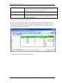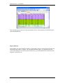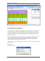
1
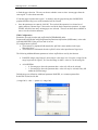
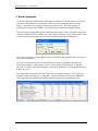
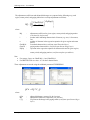
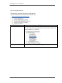
NSS Regressions – User Manual January 2009 ESRI 380 New York St., Redlands, CA 92373-8100, USA • TEL 909-793-2853 • FAX 909-793-5953 • E-MAIL [email protected] • WEB www.esri.com NSS Regressions – User Manual Copyright © 2009 ESRI All rights reserved. Printed in the United States of America. The information contained in this document is the exclusive property of ESRI. This work is protected under United States copyright law and other international copyright treaties and conventions. No part of this work may be reproduced or transmitted in any form or by any means, electronic or mechanical, including photocopying and recording, or by any information storage or retrieval system, except as expressly permitted in writing by ESRI. All requests should be sent to Attention: Contracts Manager, ESRI, 380 New York Street, Redlands, CA 92373-8100, USA. The information contained in this document is subject to change without notice. January 2009 i NSS Regressions – User Manual Table of Contents Introduction......................................................................................................................................1 Getting Started .................................................................................................................................1 NSS Menu........................................................................................................................................3 1. NSS Layer Management ....................................................................................................3 2. Remove User Selected Watershed .....................................................................................4 3. Compute NSS Parameters ..................................................................................................5 4. Calculate Regression..........................................................................................................8 5. LP Gage Extrapolation.....................................................................................................11 6. Similar Gage Selection.....................................................................................................13 7. Basin Comparison ............................................................................................................16 8. Batch Regression Computation........................................................................................22 7. Recalculate 1085 Slope....................................................................................................23 8. Flood Frequency ..............................................................................................................24 January 2009 ii NSS Regressions – User Manual Introduction The purpose of this document is to illustrate, step-by-step, how to use the NSS Regressions tools. This document is targeted to an experienced water resources ArcGIS user who wants to learn how to use the tools. The NSS Regressions tools are installed as a separate toolbar by the Arc Hydro tools setup program. Refer to the document Arc Hydro Tools 1.3 – Tutorial.pdf for installation instructions. Getting Started Once the Arc Hydro tools are installed, follow the steps described below: • Open ArcMap. Create a new empty map, and save it as NSSTest.mxd (or any other name). • Right click on the menu bar to pop up the context menu showing available tools. • If the NSS Regressions toolbar does not appear in the list, click on “Customize”. • In the Customize dialog that appears, click on the “Add from file” button. • Navigate to WshpTools9.dll (installed by default under c:\Program Files\ESRI\ArcHydro9\bin), and click “Open” to select the file. January 2009 1 NSS Regressions – User Manual • A dialog box will appear informing you that the tools have been added to ArcMap. Click “OK”. • Check the box next to NSS Regressions 9 to turn the toolbar on. Click on “Close” button. You should now see the NSS Regressions tools in ArcMap. January 2009 2 NSS Regressions – User Manual NSS Menu NSS Menu provides access to the functionality needed to support regression discharge computations. The following options are available. 1. NSS Layer Management The NSS Layer Management function allows specifying the layers used by the functions in the NSS Menu. The list of layers that can be set/reset is retrieved from the 3 following nodes located under the node FrameworkConfig/HydroConfig/ProgParams/ApFunctions/ApFunction(NSSParams) in the XML associated to the map document: ApLayers(CONTROLLAYERS): ApFields(NSSFields): Layers required for the computation of the NSS parameters. LPGAGEEXTR_PARAMS: • Select NSS Menu | NSS Layer Management A window with the list of the main tags used in regression will appear on the screen. A tag is an alternative name uniquely identifying the role of a layer in a map for that application/function. The user can select the appropriate layer for a tag in the pull down menu next to the tag name. The selected layers are tagged for use by the applications. The pull down menu will offer for selection only those layers in the map that match the required layer type, e.g. only the line features will be made available if the tag needs to be pointing to a line layer. A "NULL" option will also be available in the list. Selection of "NULL" will remove that tag from any of the layers in the map. Only one primary tag can exist per layer. In most cases the user does not need to be concerned about tag assignment as the process of tagging layers is automatically performed by the application. The NSS Layer Management option can be used to set up the relevant layers when some of the preprocessing has already been performed and for setting/resetting the input layers (such as snowfall grid or landuse layer). January 2009 3 NSS Regressions – User Manual 2. Remove User Selected Watershed This function allows removing the selected watershed features from the input Watershed layer as well as associated features stored in predefined related layers (e.g. Longest Flow Path feature for the watershed). • Select NSS Menu | Remove User Selected Watershed. The parameters for this function are defined in the XML in the ApLayer(FORUSERREMOVE) defined under the node FrameworkConfig/HydroConfig/ProgParams/ApFunctions/ApFunction(NSSParams). January 2009 4 NSS Regressions – User Manual ApLayer(FORUSERREMOVE) defines the layer to use as the Watershed layer to remove. The name of this layer defaults to Watershed, i.e. if there is a Watershed feature class in the Table of Contents of ArcMap, it will be automatically used as the layer containing the watershed features to delete and the form shown below will not be displayed. The ApLayer node has 2 child nodes, ApFields and ApLayers. ApFields contains a list of fields for the Watershed layer that are used to find related features in other layers. The ApLayers node defines the related layers containing features linked to the watershed features that should be removed whenever the associated watersheds are deleted. The XML shown above as an example lists 3 related layers: LongestFlowPath3D, SLP1085Point and WatershedPoint. The link between the related layers and the watershed layer is established through the FROMKEY/TOKEY parameters defined as additional parameters. If these parameters are not set, they default to DrainID/HydroID, i.e. the DrainID in the related layers stores the HydroID of the related watershed feature. The function deletes the selected watersheds and the related features. 3. Compute NSS Parameters This function allows computing the spatial/hydrologic parameters required to compute regression discharges for the selected watersheds. • Select one of several watersheds of interest. • Select NSS Menu | Compute NSS Parameters. January 2009 5 NSS Regressions – User Manual The function will prompt for the input layers if they are not already set. Note that the layers may be reset with the NSS Layer Management function. Select the input layers and click OK. The Flow Regions layer must contain the field REGIONID The function intersects the selected watersheds with the regions to retrieve the IDs of the regions overlaid. The function retrieves from the GIS Parameters table the list of GIS parameters defined for these regions. The function prompts the user for the parameters to compute based on the definition in the XML. The only required fields in the GISParameter table are the RegionID field (name set in XML as REGIONIDFIELD) and the GISParameter field. The names in the GISParameter field must match the tags of the ApFields(NSSFIELDS) in the XML. Only the parameters belonging to the selected regions are checked by default if PROCESSALLFIELDS is set to 0. If the parameter is set to 1, all fields are selected by default. January 2009 6 NSS Regressions – User Manual • Check the parameters to compute and click OK. The function computes the selected parameters based on the method associated to the NSSFields in the XML document and stores them in the Attributes table of Watershed. The function also populates the fields Hyd_Area with the region flow associated to the watershed point by subtracting the REGIONBASEID from the REGIONID stored in the Flow Region table (e.g. 5 (Hyd_Area = 491 (REGIONID) – 486 (REGIONIDBASE). It populates the fields A1 to A5 in the Watershed feature class with the percent of the area in each hydrologic region (1-5). If the selected watershed falls in more than one hydrologic region, and the percent of the area residing in one region is less that 5% (default threshold – may be modified in the XML) of the total watershed area, then this hydrologic region will be ignored and its area percentage will be added to the largest of the remaining regions. XML Configuration XML Parameter REGIONIDFIELD REGIONIDBASE PROCESSALLFIELDS ApFields(NSSFIELDS) RegionThresholdPct January 2009 Definition Name of the field storing the NSS Region ID in the GISParameters table and in the Flow Regions feature class. Number to subtract to the lower region NSS ID to yield 1 – used to find the name of the regions as A1 – A5. • 0 – Only parameters from overlaying regions are selected by default • 1 – All GIS parameters defined in XML are selected by default except IMPERV2MI (Default setting). List of GIS parameters available for computation with their associated computation method. If the percent of the area of the watershed within a region is strictly less than this threshold, this region will be removed and its area added to the area of the biggest region. Must be less than 50%. Will be set to 0 (i.e. region never removed) if it is set to a value greater or equal to 50. 7 NSS Regressions – User Manual 4. Calculate Regression This function allows exporting the parameters for one and only one selected watershed in the Watershed layer to a Regression Calculator in an Excel spreadsheet. The parameters to export are defined in the XML under the node ApFields(EXCELFIELDS). Each ApField defines one field to export from the Watershed layer. The target cell in the Excel spreadsheet is defined as AdditionalParams. For example, R=7;C=2 in the example below means that the AREA2MI parameter will be exported into the row 7 and column 2 in the spreadsheet XML Parameter EXCELDOCLOCATION EXCELDOCNAME EXCELWORKSHEET SAVEASRC ApFields(EXCELFIELDS) January 2009 Definition Path to the Regression Calculator Excel Spreadsheet template. Default to install\ArcHydro9\bin if not set. Name of the Regression Calculator Excel Spreadsheet template. Default to RegressionCalculator.xls if not set. Name of Excel Worksheet where the parameters will be exported. Default to “DATA” if not set. Root for the name of the exported file. Default to “FF”. The file name will be constructed by appending the year, month, hour and minutes of the time when the file was created. List of fields from input Watershed layer, whose values will be exported into the Excel spreadsheet. The AdditionalParams attributes defines the target cell location in the Excel Spreadsheet as R=row number;C=column number. 8 NSS Regressions – User Manual • Select the Watershed feature of interest. The function works on one and only one watershed feature at the time. Click OK. • Select NSS Menu | Calculate Regression. The following window will be displayed only if the Watershed feature class has not yet been set. • Select the Watershed feature class and click OK. The function copies the template Regression Calculator spreadsheet to create a file named RC_W_BasinID_yyyymmddhhmmss, where “RC” is the default value for the parameter SAVEASRC. The required data consist of: • Watershed ID (field HydroID). • Watershed Name (field Name). • Percent area in each hydrologic region (fields A1-A5). • Hydrologic region the outlet resides in (field Hyd_Area). • Area in square miles (field AREA2MI) • 10-85 slope in feet per mile (field SLP1085FM). • Average annual snowfall in inches (field SNOWFALL). • 25-year, 24-hour precipitation intensity in inches (field PRECIP25YR). • Percent forested area (field FORESTPCT). • Percent storage area (field STORAGEPCT). • Area-weighted average of mean soil permeability in in/hr (field PERMEAB). January 2009 9 NSS Regressions – User Manual The Regression Calculator application (developed in Microsoft Excel) allows the user to change all the parameters extracted from GIS if necessary and compute the discharges based on the regression equations. Once the discharges are computed, they can be returned back to GIS and stored in the database (including the modified regression parameters). Refer to the following figure for a description of the elements of the Regression Calculator. The ‘Input Data’ and ‘Area contribution (%)’ are populated from what was computed in ArcMap. The numbers in the valid range will turn red if any of the parameters fall out of the range for which the equations were developed (otherwise the numbers are green). Numbers in pink indicate the parameter is not used for the region. The user can change any of the input data. The spreadsheet will automatically update the design discharges when any of the parameters are changed. If the watershed crosses the boundary of more than one region, the final discharges are computed as an area-weighted average of discharges computed for each region. If necessary, changes to the input data can be made again and the discharges recomputed. The range check for the input parameters will be updated automatically when the parameter is changed. The discharges will be computed regardless whether the input parameters are out of range or not. The invalid boundary will be turned red and that will be the indication that the parameter is not within the boundaries. It is up to the user to accept or reject the computed discharges. An Excel macro allows writing the updated values into the Attributes table of the Watershed layer. The macros need to be updated if the parameters are modified. January 2009 10 NSS Regressions – User Manual Once the satisfactory results are obtained, use the "Regression Export" button to return the results back to GIS. The following thirteen fields are added or updated in the Watershed layer: • C_AREA2MI, CFORESTCPT, C_SLP1085FM, C_PRECIP25YR, CSNOWFALL, CSTORAGEPCT, CPERMEAB fields contain the input parameters defined in the Regression Calculator application that were used in the regression equations. • C_Q2, C_Q5, C_Q10, C_Q25, C_Q50, C_Q100 fields contain the 2 through 100-year return period discharges (cfs) computed using the regression equations. Regression Export Macros CreateWDNRToolbar() WriteOutData() SaveWorksheet() 5. LP Gage Extrapolation The Log Pearson (LP) Gage Extrapolation function allows computing the adjusted discharge (Q_mod) for a watershed based on the flood frequency computed at the nearest gaging station that is within 50% of the area of interest. It requires that the watersheds for gaging stations have been determined and that the Qg/Qr ratios have been computed (see ‘Gage Qg/Qr Ratios’ below – this has already been done in the standard WDNR Streamgages layer). The function operates on a selected set of watersheds in the Watershed layer, which may be created by using the Point Delineation tool. If no watershed has been selected, the function processes all the watersheds. The function requires three input layers: • Watershed layer (“Watershed”). • Gage stations layer ("Stream Gages"). • Required fields: Q2, Q5, Q10, Q25, Q50, Q100 (populated) Required fields: STA_NUM , DA, R2, R5, R10, R25, R50, R100 (populated) Gage stations watershed layer (“Gage Station Polygon”). Required fields: WSHID or PNTID (=STA_NUM of associated gage station) The gage selection procedure is as follows: Step A) Select all the gaging stations that contain the watershed of interest. That will identify all the gaging stations downstream of the point of interest. Find the station that drains the least area and see if it is within 50% of the watershed area. January 2009 11 NSS Regressions – User Manual Step B) Select all the gaging stations contained in the watershed. That will identify all the gaging stations upstream of the point of interest. Find if any of these stations drains an area closer to the watershed area than the station identified in step A). If there is one and is within 50% (or the specified area fraction in the XML) of the watershed area, that is the closest area, if not, the one (if any) determined in step A) is the closest one. If a viable gaging station is found, it is used for discharge adjustment. The following computations are performed: r _ mod = r − 2 Aw − Ag ⎛ ⎜ r −1⎞⎟ ⎝ ⎠ Ag where: r_mod r Aw Ag - - adjustment coefficient for given watershed, return period, and gaging station adjustment coefficient for the closest gaging station (ratio of Log-Pearson discharge at the gaging station and discharge obtained using regression equation at gaging station, obtained by using the Gage Qg/Qr Ratios function) watershed area gaging station area and (for watershed, return period, and gaging station): Q_mod = r_mod * C_Q where:Q_mod r_mod C_Q - adjusted discharge for the watershed adjustment coefficient discharge for the watershed computed by regression The following fields are added or updated in the Watershed layer: • Sta_num: Number of the station used for discharge adjustment. Set to ‘-9’ if no nearby station can be found. • r2_mod through r100_mod: Adjustment coefficients for year 2 through 100 discharges (the number by which to multiply the regression discharge to get the adjusted discharge). Set to ‘1’ if no nearby gaging station can be found. • Q2_mod through Q100_mod: Adjusted 2 through 100-year return period discharges. Equal to the non adjusted regression discharges if no nearby station can be found. January 2009 12 NSS Regressions – User Manual XML Configuration XML Parameter LPGAGEEXTR_PARAMS Definition AREAFRACTION=0.5;KEYFROM=WSHID; KEYTO=STA_NUM Where: AREAFRACTION: gage area must be within this area fraction of the watershed area to be considered (Default to 0.5 – 50%. KEYFROM: identifier of the gage station in the Gage Station Polygon feature class. Link to the KEYTO field in the Gage Station layer. STA_NUM: identifier of the gage station in the Stream Gages layer. Link to the KEYFROM field in the Gage Station Polygon layer. Input layers used by the function. 6. Similar Gage Selection This function allows selecting gaging stations ("Stream Gages") that have similar physical characteristics as the watershed of interest. May be or not in the same hydrologic region. Only one watershed can be processed. The function requires two input layers: Watershed layer (“Watershed”). Required fields Hyd_area: Hydrologic Area for the watershed (1-5) be populated (use 1 for Region if not found). Parameters field(s): AREA2MI, FORESTPCT, SLP1085FM, PRECIP25YR, SNOWFALL, STORAGEPCT, PERMEAB Gage stations layer ("Stream Gages"). Required fields Region (hardcoded): Hydrologic region where the gage is located (1-5). Related to Hyd_Area field of the Watershed. Parameters field(s): DA, FOREST, SLOPE, PRECIP, SNOW, STORAGE, SOIL_PRM January 2009 13 NSS Regressions – User Manual • Select NSS Menu | Similar Gage Selection. • Specify the input Watershed and Stream Gages feature class. The function retrieves the value of the Hyd_area field defining the hydrologic region of the watershed. It then retrieves the ApFields node to get the names of the parameters to consider and their associated additional parameters, in particular: RANGES=range1,range2,range3 where range1 is the range in % for region 1, range2 is the range in percent for region 2, etc. Note that range is either a value in % or the string NA. ALLOWZERO: o 0 – Stream gages where the parameter have the value 0 will not be selected o 1 – Stream gages where the parameter has the value 0 may be selected if they fall within the specified range The function displays the following window, which is populated with the values of the parameters from the input watershed and the default ranges for those parameters for the hydrologic area of the watershed. If Hyd_Area is not correct (1-5), then the ranges will all be set to NA. The user can define the similarity parameters in this form as a percent of the original parameter for that watershed. Default value is 50%. Depending on the region, some of the parameters will have a "NA" in their input fields. This indicates that this parameter is not used in the regression equation for this region and is thus not a significant parameter and will not be used in the discharge adjustment. If the user enters a number in those fields, they will be used in the gage selection (but not for discharge adjustment). If "NA" is entered in any field, then that parameter will not be used January 2009 14 NSS Regressions – User Manual to limit the gage selection. The user can choose whether or not to select “stream gages from the same region” or select them statewide. If “Stream gages from the same region.” is checked, only the gages having the field REGION populated with the Hyd_Area of the watershed will be selected. • Once the parameters are entered, click OK. The result of this operation is a selected set of gaging stations ("Stream Gages”) that can be used in the basin comparison operation. A popup window will show how many stream gages were selected. The user can then choose whether or not to view the selection statement. XML Configuration Parameters are read from the node ApFields(GAGEPARAMS) under FrameworkConfig/HydroConfig/ProgParams/ApFunctions/ApFunction (NSSParams), or the node ApFields(NSSFields) if the previous node is not set. For each parameter ApField: There must be a populated field named after ApField’s name attribute in the input Watershed layer. There must be a field named after the ApField’s alias in the input Stream Gages layer. The following AdditionalParams parameters in these ApFields are used by the function: RANGES=range1,range2,range3 where range1 is the range in % for region 1, range2 is the range in percent for region 2, etc. Note that range is either a value in % or the string NA. ALLOWZERO: o 0 – Stream gages where the parameter has a value of 0 will not be selected o 1 – Stream gages where the parameter has a value of 0 may be selected if they fall within the specified range Default ranges are defined as Additional parameter RANGES, as a comma separated list: RANGES=50,NA,NA,NA,NA (1-range/100) * value <= param<=(1+range/100) January 2009 15 NSS Regressions – User Manual 7. Basin Comparison The Basin Comparison function allows performing a comparison of the discharges for a selected watershed in Watershed layer (“Watershed”) and a set of selected gaging stations ("Stream Gages"). One and only one watershed can be processed at a time. The basin comparison methodology is based on the WDNR’s "Flood Hydrology and Hydraulics Manual" (2000). The function uses as input Watershed and a Stream Gages feature classes. The Stream Gages must contain the REGION field. If available, the values in the fields Name (or Sta_Name) and Sta_Num will copied from the stations into the fields Name and FeatureID in the resulting table. The function generates as output a Basin comparison table, BComp_HydroID, that is stored in the target project geodatabase. The first row of this table stores the original data for the selected watershed (parameters and regression discharges, C_Q2 through C_Q100). All the adjusted discharges (QCA2 through QCA100) are equal to the original discharges, while all the adjustment coefficients (RQ2 through RQ100) are set to 1. Each following row in the table describes one of the selected gaging stations. Their regression parameters and LP discharges (C_Q2 through C_Q100) are presented as well as the adjustment coefficients (RQ2 through RQ100) and the adjusted discharges (QCA2 through QCA100). January 2009 16 NSS Regressions – User Manual The adjustment coefficients and adjusted discharges are computed in the following way (each region, return period, and gaging station have a unique adjustment coefficient): ⎛ ^ EqExp(i) ⎞⎟ ⎜ ⎛ ⎞ CharWsh ( i ) ⎟ RQ = ∏ ⎜⎜ ⎜⎜ ⎟⎟ ⎟ i =1 ⎟⎟ ⎜⎜ ⎝ CharGS (i) ⎠ ⎠ ⎝ n where: RQ - i - n - CharWsh CharGS EqExp - adjustment coefficient for given region, return period, and gaging station (calculated by the function) product index indicating characteristic of interest (e.g. area, % forest area, etc.) number of elements in the regression equation for given region and return period watershed characteristic (read from input Watershed layer) gaging station characteristic (read from input Stream Gages layer) exponent in the regression equation for characteristic and for given region, return period, and gaging station (read from template spreadsheet) Note For storage, forest: use CharWsh(i) +1 and CharGS(i)+1 For PRECIP25YR: use value – 4.2 for the 2 characteristics These adjustments are stored using the additional parameter EXPRESSION. QCA = RQ * C_Q where: QCA RQ C_Q January 2009 - adjusted discharge (computed by the function) adjustment coefficient (computed by the function) Log-Pearson discharge at the gaging station (read from input Stream Gages layer) 17 NSS Regressions – User Manual How to setup the function The parameters used by the function are setup under the ApFunction(NSSParams)>BASINCOMPARISON node. XML Parameter ApFields(NSSFIELDS) Definition List of parameter fields from input Watershed layer. The alias of the parameter must match the name used to name the cell in the spreadsheet (e.g. PRECIP). ApFields(BASINFIELDS) Fields definition for the output BComp_HydroID table. January 2009 18 NSS Regressions – User Manual ApFields(STREAMGAGES) Fields definition for the input stream gages layer. TBLPREFIX January 2009 Prefix for the output table name. Default to “BComp”. The HydroID of the watershed will be appended if it is a number greater or equal to 0. Otherwise the suffix “_cmp” will be appended. 19 NSS Regressions – User Manual TBLDESC EXCELDOCLOCATION EXCELDOCNAME Default to “Basin comparison for basin:”. The HydroID of the watershed will be appended if it is a number greater or equal to 0. Otherwise the suffix “cmp” will be appended. Path to the Regression Calculator Excel Spreadsheet template. Default to install\ArcHydro9\bin if not set. Name of the Regression Calculator Excel Spreadsheet template. Default to RegressionCalculator.xls if not set. Must contain the worksheet “Parameters”. EqExp are set in the “Parameters” worksheet. Index of the column storing the EqExp for a given parameter are read from the spreadsheet – the index for a given parameter is stored in a cell named after the parameter. For example, the cell named “Precip” with the value 4 indicates that the coefficients used for the Precip parameter are stored in the column 4 in the spreadsheet. Column 4 contains the coefficient for precipitations. January 2009 20 NSS Regressions – User Manual Note: the name used to name the cells must match the aliases of the parameters in the XML for the ApFields(NSSFIELDS). Region definition In spreadsheet, the region identifier is built by concatenating “Region” and the Region ID read from the Stream Gages table (i.e. Region). The cells named after the region (e.g. Region2) stores the value of the starting row for retrieving the coefficients (e.g. 9 means that the first coefficient for the Region2 is stored in row 9). January 2009 21 NSS Regressions – User Manual 8. Batch Regression Computation The Batch Regression Computation function applies the regression equations to compute Q2-Q100 for the selected set of watersheds in the Watershed layer. These watersheds may be created by using the Point Delineation tool. If no watershed has been selected, the function processes all the watersheds. The function uses the NSS (National Stream Statistics) application by USGS to compute the discharges. The parameters needed for regression computation have to be computed/extracted first. The user has no interaction with the process, that is, no change in parameters can be made during the process. If some of the basins had the discharges already computed, the discharges will be recomputed and the existing values will be overwritten. The function takes as input the Watershed layer ("Watershed"), the Flow Regions layer and the GIS Parameters table. Required fields Flow Regions - Region January 2009 22 NSS Regressions – User Manual It creates/updates the following fields in the Watershed layer: • Q2 – Q100: 2 through 100-year return period discharge computed with the regression equations. The function also displays in the NSS Computation Results window the data sent to NSS as a pseudo XML and the results returned by NSS. How to setup the function XML Parameter RegionThresholdPct Definition If the percent of the area of the watershed within a region is strictly less than this threshold, this region will be removed and its area added to the area of the biggest region. Must be less than 50%. Will be set to 0 (i.e. region never removed) if it is set to a value greater or equal to 50. REGIONIDFIELD Name of the RegionID field in the Region layer. ApFields(NSSFIELDS) Definition of the GIS parameters that can be computed and of their computation methods. ApLayers(CONTROLLAYERS) Definition of the input layers required by the function. NFFDATABASEPATH Path to the StreamstatsDB.mdb database used by the NSS application. Default to install/ArcHydro9/bin/StreamstatsDB.mdb if not set or if correctly set. This DB must be available on the computer – it is not installed with Arc Hydro. NFFPWD Password used for opening the StreamstatsDB.mdb database. 7. Recalculate 1085 Slope The function Recalculate 1085 Slope allows recalculating the slope parameters after moving manually the location of the 10 and 85 % points. These points may be moved for example when there are issues with extracting the correct elevation due to the stream burning process, or when performing the sensitivity analysis. The function takes as input the four following layers: January 2009 23 NSS Regressions – User Manual • Watershed layer ("Watershed”). Required field: HydroID • 3D Longest flow path layer ("Longest Flow Path 3D"). Required field: DrainID • Slope Points layer ("Slope 1085 Point"). Required field: DrainID • Raw DEM Grid ("Raw DEM”). The function updates the following fields in the 3D longest flow path layer ("Longest Flow Path 3D"): • Elev10: Elevation in DEM vertical units of the point located at 10 percent of the river length. • Elev85: Elevation in DEM vertical units of the point located at 85 percent of the river length. • Slp1085FM: Slope based on the 10%-85% extent of the longest flow path in feet per mile. • Slp1085: Dimensionless slope of the river considering the points at 10 and 85 percent of the river length for slope computation. • Elev10FT: Elevation in feet of the point located at 10 percent of the river length. • Elev85FT: Elevation in feet of the point located at 85 percent of the river length. The function updates the following fields in the Slope Points layer ("Slope 1085 Point"): • Elev: Elevation in DEM vertical units of the point located at 10 or 85 percent of the river length. The function updates the following fields in the Watershed layer ("Watershed"): • SLP1085FM: Slope based on the 10%-85% extent of the longest flow path in feet per mile. • SLP1085: Dimensionless slope of the river considering the points at 10 and 85 percent of the river length for slope computation. 8. Flood Frequency The function Flood Frequency allows exporting the HydroID, Name and computed flows from the selected input watershed feature into an Excel spreadsheet and displaying the associated flood frequency in a graph. The exported spreadsheet will be created from a template and saved into the directory XLSFiles created if needed in the directory of the map document. January 2009 24 NSS Regressions – User Manual The name and location of the spreadsheet used as template as well as the name of the worksheet to use, and the parameters to export, are specified in the XML under the node ApFunctions(NSSParams) as follows: XML Parameter FLOWDOCLOCATION FLOWDOCNAMEFF FLOWWORKSHEET SAVEASFF ApFields(FLOWFIELDS) Definition Path to the Flood Frequency template spreadsheet. Default to ArcHydro9\bin if not set. Name of the Flood Frequency template spreadsheet. Default to FF.xls if not set. Name of the Excel Worksheet to use in the Flood Frequency template spreadsheet. Default to “FFLOW” if not set. Root for the name of the exported file. Default to “FF”. The file name will be constructed by appending the HydroID, year, month, hour and minutes of the time when the file was created. List of fields from input Watershed layer, whose values will be exported into the Excel spreadsheet. The AdditionalParams attributes defines the target cell location in the Excel Spreadsheet as R=line number;C=column number. • Select the watershed feature whose frequency you want to display. • Select NSS Menu | Flood Frequency. • Specify the Watershed layer if prompted and click OK. The function locates the template Flood Frequency spreadsheet and saves a new copy into the XLSFiles directory under the directory of the map document. The function exports the predefined fields (Name, HydroID, flows) into the spreadsheet to populate the table linked to the flood frequency graph. January 2009 25 NSS Regressions – User Manual January 2009 26