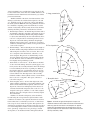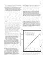
1
National Flood Frequency Program The National Flood Frequency Program (NFF) has been developed in cooperation by the USGS, FHWA, and FEMA and is maintained and updated primarily by the USGS. There is no longer a single document that describes the background of the program and the individual state regression equations. All of this information is now maintained by the USGS on their websites. The USGS distributes a Windows version of the NFF program. You can download this program, and the accompanying database from the USGS website. The USGS program differs significantly from the user interface in WMS in that there is no capability to delineate watersheds and compute basin parameters. With the USGS program all of the parameter calculations must be performed outside of the program and then manually entered. With WMS the parameters computed in the basin delineation module are automatically assigned to the NFF interface. WMS uses the same functions (DLL’s) and the exact same Microsoft Access Database (NFFv3.mdb) as the USGS program to perform the regression equation calculations. As the database is updated on the USGS website to incorporate new/modified studies it can be downloaded directly and substituted for the existing version distributed with the WMS software. Some of the key websites containing documentation, the database of equations, etc. are listed below. Overview: http://water.usgs.gov/osw/programs/nffp.html Software, Database, General Documentation, and state-by-state equation documention: http://water.usgs.gov/software/nff.html The National Flood Frequency Program, Version 3: A Computer Program for Estimating Magnitude and Frequency of Floods for Ungaged Sites Compiled by K.G. Ries III and M.Y. Crouse Abstract For many years, the U.S. Geological Survey (USGS) has been developing regional regression equations for estimat ing flood magnitude and frequency at ungaged sites. These regression equations are used to transfer flood characteristics from gaged to ungaged sites through the use of watershed and climatic characteristics as explanatory or predictor variables. Generally, these equations have been developed on a Statewide or metropolitan-area basis as part of cooperative study programs with specific State Departments of Transportation. In 1994, the USGS released a computer program titled the National Flood Frequency Program (NFF), which com piled all the USGS available regression equations for estimat ing the magnitude and frequency of floods in the United States and Puerto Rico. NFF was developed in cooperation with the Federal Highway Administration and the Federal Emergency Management Agency. Since the initial release of NFF, the USGS has produced new equations for many areas of the Nation. A new version of NFF has been developed that incor porates these new equations and provides additional function ality and ease of use. NFF version 3 provides regression-equation estimates of flood-peak discharges for unregulated rural and urban watersheds, flood-frequency plots, and plots of typical flood hydrographs for selected recurrence intervals. The Program also provides weighting techniques to improve estimates of flood-peak discharges for gaging stations and ungaged sites. The information provided by NFF should be useful to engi neers and hydrologists for planning and design applications. This report describes the flood-regionalization techniques used in NFF and provides guidance on the applicability and limitations of the techniques. The NFF software and the docu mentation for the regression equations included in NFF are available at http://water.usgs.gov/software/nff.html. INTRODUCTION By W.O. Thomas, Jr., M.E. Jennings, and K.G. Ries III Estimates of the magnitude and frequency of flood-peak discharges and flood hydrographs are used for a variety of pur poses, such as the design of bridges and culverts, flood-control structures, and flood-plain management. These estimates are often needed at ungaged sites where no observed flood data are available for frequency analysis. One method commonly used for estimating the magnitude and frequency of floodpeak discharges and flood hydrographs at ungaged sites is use of regression equations. Regression equations are developed by statistically relating the flood characteristics to the physi cal and climatic characteristics of the watersheds for a group of gaging stations within a region that have virtually natural streamflow conditions. Regression equations enable the trans fer of flood characteristics from gaging stations to ungaged sites simply by determining the watershed and climatic charac teristics needed for the ungaged site. The USGS has been developing regression equations for estimating the magnitude and frequency of floods at ungaged sites since at least the early 1960’s. Support and justification for the applicability of these equations for estimating floodpeak discharges for rural watersheds is given by the U.S. Water Resources Council (1981) and by Newton and Herrin (1982). These reports summarize a test of nine different sta tistical and deterministic procedures for estimating flood-peak discharges for rural watersheds. The results of this test indicate that USGS-developed regression equations are unbiased, reproducible, and easy to apply. By 1993, reports that contained regression equations for estimating flood-peak discharges for rural, unregulated watersheds had been published by the USGS, at least once, for every State and for the Commonwealth of Puerto Rico. The Statewide flood-frequency reports were prepared generally in cooperation with individual State Departments of Transpor tation, and were published either by the USGS or the State Departments of Transportation. In 1993, regression equations were available for estimating urban flood-peak discharges for metropolitan areas in at least 13 States, and a set of national urban equations also was available. The USGS, in cooperation with the Federal Highway Administration and the Federal Emergency Management Agency, compiled all USGS-developed regional regression equations available, as of September 1993, in the National Flood Frequency (NFF) Program (Jennings and others, 1994). NFF was a MS-DOS computer program that provided engi neers and hydrologists a practical tool for computing estimates of flood-peak discharges at selected recurrence intervals used for planning and design applications. NFF also provided the ability to generate flood-frequency plots and plots of typical flood hydrographs corresponding to a given rural and (or) urban peak discharge. Since the original release of the NFF Program, new or updated equations have been developed by the USGS for all or parts of 36 States. Longer periods of record, and improved 2 methods for measuring basin characteristics and regression analysis, have generally led to improved precision of the updated equations over those equations they have replaced. The new and updated equations have been compiled and incorporated into a new, user-friendly Microsoft Windows version of the NFF Program. Purpose The purpose of this report is to document and describe the flood-regionalization techniques and procedures used in version 3 of the NFF Program. The report provides guid ance on the applicability and limitations of the techniques, and describes how to obtain and use the program. The report also describes how to obtain information needed to solve the regression equations for the individual States. Report Format The main body of this report provides an overview of flood regionalization methods, summarizes the characteristics of the estimating techniques, and describes their applicability and limitations. Much of the material was taken verbatim from the previous NFF Program report (Jennings and others, 1994). Additions and revisions have been made where there have been additions to the capabilities of the software and changes in regionalization methods. In addition, a section that summa rizes the documentation for State flood-frequency techniques is included. This report contains two appendices. Appendix A is a Users’ Manual that explains in detail how to install and use the program. Appendix B is a summary of methods for estimating basin lag time. Many people contributed to the development of the computer program and this associated documentation. Persons responsible for preparing each section of this report are so noted. How to Obtain the NFF Software and Documentation USGS hydrologic analysis software is available for electronic retrieval through the World Wide Web (Web) at http://water.usgs.gov/software/ and through anonymous File Transfer Protocol (FTP) from water.usgs.gov (directory: /pub/software). The Web page from which the NFF software and documentation can be retrieved is http://water.usgs.gov/ software/nff.html and the anonymous FTP directory is /pub/ software/surface_water/nff. The documentation includes a digital copy of this report and information for each State, the Commonwealth of Puerto Rico, and American Samoa that contain the applicable regression equations and much of the reference information needed to solve them. This information is provided through Web links to fact sheets, online reports, and pages from the original NFF report. A help facility also is included with the software. New equations are developed for several areas of the Nation each year. As new equations become available, it is planned that the NFF software and documentation will be updated to include them. Frequent users of the NFF program should check the Web or FTP site often for updates. Acknowledgments Version 3 of NFF was developed by Aqua Terra Consul tants, Inc., through a contract with the USGS. Robert Mason, Jr., USGS, played a pivotal role in coordinating the develop ment of the new version of the software, and in writing several of the fact sheets that describe the new equations. Several hydrologists from the USGS Washington District office coau thored many of the USGS fact sheets that describe the regres sion equations. Scientists from the Mississippi and Washington USGS District offices created many of the graphics used in this report and in the supporting fact sheets. 3 HISTORY AND OVERVIEW OF FLOOD REGIONALIZATION METHODS By W.O. Thomas, Jr., and K.G. Ries III INTRODUCTION The USGS has been involved in the development of flood-regionalization procedures for over 50 years. These regionalization procedures are used to transfer flood character istics, such as the 100-year flood-peak discharge, from gaged to ungaged sites. The USGS has traditionally used regionalization procedures that relate flood characteristics to watershed and climatic characteristics through the use of correlation or regres sion techniques. Herein, flood characteristics are defined as flood-peak discharges for a selected T-year recurrence interval (such as the 100-year flood). Because these flood characteris tics may vary substantially between regions due to differences in climate, topography, and geology, tests of regional homoge neity form an integral part of flood regionalization procedures. The evolution of flood-peak discharge regionalization pro cedures within USGS is described by discussing the following five procedures: (1) the index-flood procedure used from the late 1940s to the 1960s, (2) the ordinary-least-squares regres sion procedure used in the 1970s and 1980s, (3) the weightedand (4) generalized-least-squares regression procedures, first used in the late 1980s and are still used today (2002), and (5) the region-of-influence procedure, first used in the 1990s, and is still somewhat experimental. INDEX-FLOOD PROCEDURES The index-flood procedure consisted of two major parts: (1) the development of basic, dimensionless frequency curves representing the ratio of flood discharges at selected recurrence intervals to an index flood — the mean annual flood, and (2) the development of a relation between watershed and climatic characteristics and the mean annual flood to enable the mean annual flood to be predicted at any point in the region. The combination of the mean annual flood with the basic frequency curve, expressed as a ratio of the mean annual flood, provided a frequency curve for any location (Dalrymple, 1960). The determination of the dimensionless frequency curve involved: (1) graphical determination of the frequency curve for each station using the Weibull plotting position, (2) deter mination of homogeneous regions using a homogeneity test on the slopes of the frequency curves, and (3) computation of the regional dimensionless frequency curve based on the median flood ratios for each recurrence interval for each station in the region. The homogeneity test used the ratio of the 10-year flood to the mean annual flood to determine whether the differences in slopes of frequency curves for all stations in a given region are greater than those attributed to chance. The 10-year flood discharge was first estimated from the regional dimensionless frequency curve. The 95-percent confidence interval for the recurrence interval of this discharge, as determined from the individual station frequency curves, was then determined as a function of record length. If the recurrence interval for a given station was within the 95-percent confidence bands, then the sta tion was considered part of the homogeneous region. Otherwise, the station was assumed to be in another region. The mean annual flood, as used in the index-flood proce dure, was determined from the graphical frequency curve to have a recurrence interval of 2.33 years. The mean annual flood for an ungaged location was estimated from a relation that was determined by relating the mean annual flood at gaging stations to measurable watershed characteristics, such as drainage area, area of lakes and swamps, and mean altitude. The index-flood procedure described above was used to develop a nationwide series of flood-frequency reports entitled “Magnitude and Frequency of Floods in the United States.” Each report provided techniques for estimating flood magnitude and frequency for a major drainage basin or subbasin, such as the Lower Mississippi River Basin. These reports were pub lished as USGS Water-Supply Papers 1671-1689 during the period 1964-68. ORDINARY-LEAST-SQUARES REGRESSION Studies by Benson (1962a, 1962b, 1964) suggested that T-year flood-peak discharges could be estimated directly using watershed and climatic characteristics based on multiple regression techniques. As noted by Benson (1962a), the direct estimation of T-year floodpeak discharges avoided the following deficiencies in the index-flood procedure: (1) the flood ratios for comparable streams may differ because of large differences in the index flood; (2) homogeneity of frequency-curve slope can be established at the 10-year level, but individual frequency curves commonly show wide and sometimes systematic differ ences at the higher recurrence levels; and (3) the slopes of the frequency curves generally vary inversely with drainage area. Benson (1962b and 1964) also showed that the flood ratios vary not only with drainage area but with main-channel slope and climatic characteristics as well. On the basis of this early work of Benson and later work by Thomas and Benson (1970), direct regression on the T-year flood became the standard approach of the USGS for regionalizing flood characteristics in the 1970s. The T-year flood-peak discharges for each gaging station were estimated by fitting the Pearson Type III distribution to the logarithms of the annual peak discharges using guidelines in Bulletin 15 (U.S. Water Resources Council, 1967) or some ver sion of Bulletin 17 (U.S. Water Resources Council, 1976, 1977, 1981; Interagency Advisory Committee on Water Data, 1982). 4 The regression equations that related the T-year flood-peak discharges to watershed and climatic characteristics were com puted using ordinary-least-squares techniques. In ordinaryleast-squares regression, equal weight is given to all stations in the analysis, regardless of record length and the possible correlation of flood estimates among stations. In most Statewide flood-frequency reports, the analysts divided their States into separate hydrologic regions. Regions of homogeneous flood characteristics were generally defined on the basis of major watershed boundaries and an analysis of the areal distribution of regression residuals to identify regions of residuals whose magnitude and algebraic sign were similar within and dissimilar between regions. In several instances, the hydrologic regions also were defined as areas above or below a specified elevation. Although this procedure may improve the accuracy of the estimating technique, it is somewhat subjective. More objective procedures are now being used for defining hydrologic regions. others (1986) showed that generalized-least-squares proce dures provided a smaller average variance of prediction than ordinary-least-squares procedures for the regional 100-year flood for streams in Pima County, Arizona. Stedinger and Tasker (1985) found that the weighted-least-squares pro cedure, which accounts for differences in record length but neglects cross correlations among concurrent flows, performs nearly as well as the generalized-least-squares procedure when the cross correlations are modest (less than about 0.3) and (or) when model errors are high (model standard errors greater than about 70 percent). Equations included in the NFF Program for several of the States are based on weighted- or generalized-least-squares regression, although the general ized-least-squares procedure is the more popular of the two techniques. The estimation of T-year flood-peak discharges at gaging stations is still accomplished through the use of Bulletin 17B procedures (Interagency Advisory Committee on Water Data, 1982). WEIGHTED- AND GENERALIZEDLEAST-SQUARES REGRESSION REGION-OF-INFLUENCE REGRESSION Research on regionalization of flood characteristics beginning in the 1980s centered on accounting for deficiencies in the assumptions of ordinary-least-squares regression and on developing more accurate and objective tests of regional homogeneity. Ordinary-least-squares regression procedures do not account for variable errors in flood characteristics caused by unequal record lengths at gaging stations. Tasker (1980) proposed the use of weighted-least-squares regression for flood characteristics where the variance of the observed flood characteristics was estimated as an inverse function of record length. Tasker and Stedinger (1986) used weighted-leastsquares regression to estimate regional skew of annual peak discharges with greater accuracy than results obtained using ordinary-least-squares regression. Both ordinary-least-squares and weighted-least-squares regression do not account for the possible correlation of concurrent annual peak-flow records between sites. This cross correlation of streamflows causes bias in the estimated coef ficients of the parameters and in the estimated variance of the regression equations. The problem may be particularly signifi cant where gages are located on the same stream, on similar and adjacent watersheds, or where flood-frequency estimates have been determined from a rainfall-runoff model using the same long-term rainfall record. Generalized-least-squares regression was proposed by Stedinger and Tasker (1985, 1986) to account for both the unequal reliability and the correlation of flood characteristics between sites. In a Monte Carlo simulation, Stedinger and Tasker (1985) showed that generalized-least-squares regres sion procedures provided more accurate estimates of regres sion coefficients, better estimates of the accuracy of the regres sion coefficients, and better estimates of the model error than did ordinary-least-squares procedures. In addition, Tasker and The region-of-influence regression procedure was first suggested by Acreman and Wiltshire (1987) and was subse quently evaluated by Burn (1990a, 1990b). The procedure was first used within the USGS by Tasker and Slade (1994). Region-of-influence regression determines a new equation each time an estimate is desired for a new ungaged site. The new equation is determined from a unique subset of streamgaging stations, referred to as the region of influence, and comprised of the set of stations nearest to the ungaged site, with nearness determined by the similarity of climatic and physical characteristics rather than the physical distance between the sites. Once the region of influence is determined for the ungaged site, the generalized-least-squares regression procedure is used to develop the unique set of flood-frequency equations for the site. Predictions obtained by use of the region-of-influence regression method generally are closer to the center of the data used to develop the equation than predic tions obtained by use of more traditional regression meth ods. Thus, extrapolation errors and problems resulting from assumption of linearity are reduced (Ensminger, 1998). Region-of-influence regression is still considered somewhat experimental. Results from studies that have used the procedure (Hodge and Tasker, 1995; Ensminger, 1998; Pope and Tasker, 1999; and Eash, 2000) indicate that errors obtained by use of the procedure usually (but not always) are lower than errors obtained by use of the generalized-leastsquares regression procedure. None of the authors of the studies has recommended exclusive use of the region-of-influ ence regression procedure in preference to the generalizedleast-squares regression procedure. Because the computations are mathematically complex, computer programs accompany each of the reports for the studies so that users can solve the equations. The current version of NFF does not contain the algorithms and databases needed to perform the region-ofinfluence regression procedure. 5 RURAL FLOOD-FREQUENCY ESTIMATING TECHNIQUES By K.G. Ries III, W.O. Thomas, Jr., and J.B. Atkins INTRODUCTION The National Flood Frequency (NFF) Program provides equations for estimating the magnitude and frequency of flood characteristics for rural, unregulated watersheds in the 50 States, the Commonwealth of Puerto Rico, and American Samoa. These equations are taken from USGS reports that were published between 1973 and 2002. The purpose of this section is to provide a brief overview of the rural regression equations that are presented in NFF. A summary of informa tion needed to solve the regression equations for each State is provided in the section “Summary of State Flood-Frequency Techniques.” WATERSHED AND CLIMATIC CHARACTERISTICS The rural equations in NFF are based on watershed and climatic characteristics that can be obtained from topographic maps, rainfall reports and atlases, or digital map data derived from those sources. Drainage area or contributing drainage area appears in nearly all of the Statewide rural regression equations given in NFF. The other most frequently used watershed and climatic characteristics are main-channel slope and mean annual precipitation. The regression equations are generally reported in the following form: RQT= aXbYc Zd, where RQT is the T-year rural flood-peak discharge, X, Y, Z are watershed or climatic characteristics, and a,b,c,d are regression coefficients. The regression coefficients are normally computed by taking the logarithms of the variables and using linear multiple-regression techniques. In instances where a variable could equal zero (such as percentage of drainage area covered by lakes and ponds), a constant is added to the variable before taking the logarithms. Drainage area is the only explanatory variable in the regression equations for several States, but it is more common to have up to four explanatory variables in the equations. The USGS has published regression equations in many States based on channel-geometry characteristics, such as channel width; however, these equations are not provided in NFF because a site visit is required to obtain the explana tory variables. Different names and symbols are often given to the same basin and climatic characteristics in reports that describe the regression equations for different States. For example, there are 10 different names in NFF for one of the most commonly used characteristics, the precipitation amount that occurs dur ing 24 hours, on average, once in 2 years. In addition, mainchannel slope is also referred to as channel slope or streambed slope, and is identified by symbols such as S, SL, Sc, Sb, and Sm. All of these symbols represent the slope between two points on the main channel, 85 percent and 10 percent of the channel length upstream from the gage or outlet of the watershed. NFF uses the names given to the characteristics in the original State reports to avoid differences between the program and the State documentation. Source data (maps, atlases, GIS data layers, and graphi cal relations) used to measure the characteristics may vary from State to State, although the name used may be the same. It is important to use the same source data and methods to measure the characteristics for input to NFF as those that were used to develop the regression equations. Use of differ ent source data and methods will result in flood-peak esti mates with unknown errors. In most cases, the data sources were the best-available topographic maps or digital represen tations of the features on those maps. In some cases, digital map data used in the studies are available from the authors of the State reports. Percentages, such as the percentage of the watershed in forests or lakes and ponds (when not determined by use of a GIS) are generally determined by a grid-sampling method using 20-80 points in the watershed. A transparent grid is overlain on the outline of the watershed on the most appro priate topographic map. The grid should have from 20-80 nodes within the respective watershed boundary, the number of nodes overlying green (forest) or blue (lakes and ponds) is determined, and the percentage of forest or lakes and ponds is computed as the number of node intersections (with green or blue) divided by the total nodes within the watershed. Mean basin elevation is also generally determined by the same gridsampling method averaging elevations for 20-80 points in the watershed. The documentation for the individual States often contain maps of variables, such as mean annual precipita tion, the 2-year 24-hour rainfall, average annual snowfall, and minimum mean January temperature. HYDROLOGIC FLOOD REGIONS In most Statewide flood-frequency reports, the analysts divided their States into multiple hydrologic regions that rep resent areas of relatively homogeneous flood characteristics. The regions were generally determined by using major watershed boundaries and an analysis of the areal distribution of the regression residuals (differences between regression and station (observed) T-year estimates). In some instances, the hydrologic regions were also defined by the mean elevation of the watershed or by statistical tests, such as the Wilcoxon 6 signed-rank test. On average, there are about four hydrologic regions per State; however, some States have inadequate data to define flood-frequency relations in some regions. For example, Florida, Georgia, and South Carolina have regions of undefined flood frequency, and regression equations are provided only for the Island of Oahu, Hawaii. Regression equations for estimating flood-peak discharges for the other islands were computed as part of a nationwide network analy sis (Yamanaga, 1972) but those equations are not included in NFF because that study was not specifically oriented to floodfrequency analysis. Regression equations are provided only for the Island of Tutuila, American Samoa. MEASURES OF ACCURACY Every USGS regional flood report provides some measure of accuracy of the regression equations. The stan dard error of estimate, usually in percent, was used as the primary measure of accuracy in many of the reports that are more than about 15 years old. The standard error of estimate is a measure of the variation between the regression esti mates and the station data for those stations used to derive the regression equations. About two-thirds of the regression estimates for the stations have errors less than the standard error of estimate. The standard error of prediction, usually in percent, is used as the primary measure of accuracy in most recent reports. It is preferred over use of the standard error of estimate because the standard error of prediction is a measure of the accuracy of the regression equations when predicting values for watersheds not used in the analysis — the condi tion under which regression equations are most often applied. The standard error of prediction is usually a few percent larger than the standard error of estimate. About two-thirds of the regression estimates for ungaged sites will have errors less than the standard errors of prediction given for the equations. NFF provides standard errors of estimate only when the stan dard errors of prediction were not provided in the individual Statewide reports. Often, the standard errors of estimate or prediction are converted to equivalent years of record. The equivalent years of record are defined as the number of years of actual streamflow record needed to achieve the same accu racy as the regional regression equations. The standard errors of estimate or prediction range from 30-60 percent for most of the equations; however, some equa tions have standard errors near 15 percent, and some equa tions have standard errors greater than 100 percent. The larg est standard errors generally are for equations developed for the western part of the Nation where the at-site variability of the flood records is greater, where the network of unregulated gaging stations is less dense and there are more difficulties in regionalizing flood characteristics, and the flood records are generally shorter than in other areas of the country. The smallest standard errors are generally for equations developed for the eastern part of the Nation where the converse of the above conditions is generally true. TECHNIQUES FOR WATERSHEDS THAT SPAN REGIONAL/STATE BOUNDARIES NFF allows flood-frequency computations for basins that span more than one hydrologic region within the same State. This is accomplished on the basis of percentage of drainage area in each region. The user should verify that the resultant computations reflect the flood characteristics of the regions by consulting the respective State flood-frequency report and by examining plots of the computed frequency curves. Regional flood-frequency computations for watersheds that span State boundaries may give different results depend ing on which State’s equations are used. Currently, NFF does not allow the user the option to weight frequency computa tions by drainage area for basins that cross State boundar ies. Because of this limitation, the user must perform this procedure manually, which can be accomplished by applying NFF for each State using the basin’s full drainage area. Next, the user must manually weight the frequency computations based on the percentage of the basin’s drainage area in each State. For example, two sets of frequency computations were obtained for the Sucarnoochee River at Livingston, Alabama; 320 square miles of the basin’s total area of 606 square miles is in Mississippi, and 286 square miles of the basin is in Alabama. Table 1 shows the frequency computations using the full drainage area in the application of each State’s equation and the weighted frequency computations. Table 1. Frequency computations for Sucamoochee River at Livingston, Alabama [Q: discharge; ft3/s: cubic feet per second] Recurrence interval (years) Computed Peak Q in Mississippi (ft3/s) Computed Peak Q in Alabama (ft3/s) Weighted frequency estimates (ft3/s) 2 5 10 25 50 100 200 500 16,000 27,900 36,100 47,400 58,200 63,800 74,500 85,700 8,750 15,400 20,700 28,800 35,700 43,400 51,500 64,100 12,600 22,000 28,800 38,600 47,600 55,200 63,600 75,500 The weighted frequency computations were obtained by using the following equation: QT(w)= 320 QT(MS) + 286 QT(AL) , 606 606 where QT(MS) and QT(AL) are the computed T-year peak discharges, in cubic feet per second, using the Mississippi and Alabama regression equations, respectively; and QT(w) is the weighted T-year peak discharge, in cubic feet per second. Differences between the Mississippi and the Alabama esti mates are substantial. For example, the 100-year flood discharge for the Sucarnoochee River would be about 63,800 cubic feet 7 per second if the basin was entirely within Mississippi, but only about 43,400 cubic feet per second if the basin was entirely within Alabama. The weighted estimate for the site, obtained from the equation above, is 55,200 cubic feet per second. WEIGHTING OF INDEPENDENT ESTIMATES OF RURAL FLOOD FREQUENCY NFF includes weighting algorithms that can produce improved flood-frequency estimates for streamgaging sta tions and ungaged sites. Improved estimates are determined for streamgaging stations by weighting regression-derived estimates with estimates determined from the systematic peakflow record at the station. Improved estimates are determined for ungaged sites by weighting the regression-derived esti mates of flood frequency for an ungaged site with estimates determined based on the flow per unit area of an upstream or downstream streamgaging station. Some researchers have recommended different weight ing methods in reports that describe the regression equations for individual States. Before using the weighting algorithms in NFF, users should refer to the State reports to determine if different weighting methods are recommended. Weighting for Streamgaging Stations NFF includes the weighting procedure for streamgaging stations presented by the Interagency Advisory Committee on Water Data (1982). The procedure requires the assumption that flood-frequency estimates determined from the systematic annual peaks for a streamgaging station are independent from estimates obtained for the station from regression equations. Weighted flood-frequency estimates can be computed as logQT(G) w = NlogQT(G) s + EQlogQT(G) r N + EQ where QT(G) w is the weighted estimate of flood-peak discharge Q for recurrence interval T at the streamgaging station, QT(G) s is the estimate of QT derived from the systematic flood peaks, QT(G) r is the estimate of QT derived from the regression equation, N is the number of years of gaged record, and EQ is the equivalent years of record determined for the regression equation. The accuracy of the weighted estimate, in equivalent years of record, is equal to the N + EQ. NFF cannot compute weighted estimates for streamgaging stations if the equivalent years of record are not available for the regression equations. In these cases, if NFF is used to calculate weighted estimates, the results will be identical to the estimates from the system atic flood peaks. Weighting for Ungaged Sites NFF includes the weighting procedure for ungaged sites presented by Guimaraes and Bohman (1992) and Stamey and Hess (1993). The procedure improves flood-frequency esti mates determined for a rural ungaged site with a drainage area that is between 50 and 150 percent of the drainage area of a streamgaging station that is on the same stream. The weighted estimate for the ungaged site is computed as: ( ) QT(U) w = 2∆Α QT(U) r + 1 – 2∆Α QT(U) g , Ag Ag where QT(U) w is the weighted estimate of discharge Q for recur T rence interval T at the ungaged site, ∆A is the absolute value of the difference between the drainage areas of the streamgaging station, (Ag), and the ungaged site, (Au), |Ag – Au|, QT(U) r is the peak-flow estimate for recurrence interval T at the ungaged site derived from the applicable regional equation (table 1), QT(U) g is the peak-flow estimate for recurrence interval T at the ungaged site derived from the weighted estimate of peak discharge at the streamgaging station, QT(G)w, by adjust ing for the effect of the difference in drainage area between the streamgaging station and the ungaged site. QT(U) g is computed as: Au b . Q QT(U) g = A , T(G) w g where, depending on the State, b may be the exponent of drainage area from the appropriate regression equation, a value determined by the author of the State report, or 1 where not defined in the reports. NFF applies the appropriate b values automatically. This weighting procedure should not be applied when the drainage area for the ungaged site is not within 50– 150 percent of the drainage area of the streamgaging station. ( ) 8 URBAN FLOOD-FREQUENCY ESTIMATING TECHNIQUES By V.B. Sauer INTRODUCTION The National Flood Frequency (NFF) Program provides equations for estimating the magnitude and recurrence inter vals for floods in urbanized areas throughout the conterminous United States and Hawaii. The seven-parameter nationwide equations described in USGS Water-Supply Paper (WSP) 2207, by Sauer and others (1983), are based on urban runoff data from 199 basins in 56 cities and 31 States. These equa tions have been thoroughly tested and proven to give reasonable estimates for floods having recurrence intervals between 2 and 500 years. A later study by Sauer (1985) of urban data at 78 additional sites in the southeastern United States verified the seven-parameter equations as unbiased and having stan dard errors equal to or better than those reported in WSP 2207. Additional equations for urban areas in some States have been included in the NFF program as optional methods to estimate and compare urban flood frequency. These equations were developed for local use within their designated urban area and should not be used for other urban areas. NATIONWIDE URBAN EQUATIONS The following seven-parameter equations and definitions are excerpted from Sauer and others (1983). The equations are based on multiple regression analysis of urban flood-frequency data from 199 urbanized basins, where UQ2, UQ5,... UQ500 are the urban peak discharges, in cubic feet per second (ft3/s), for the 2-, 5-, ... 500-year recurrence intervals; A is the contributing drainage area, in square miles, as determined from the best available topographic maps; in urban areas, drainage systems sometimes cross topographic divides. Such drainage changes should be accounted for when computing A; SL is the main channel slope, in feet per mile (ft/mi), mea sured between points that are 10 percent and 85 percent of the main channel length upstream from the study site (for sites where SL is greater than 70 ft/mi, 70 ft/mi is used in the equations); RI2 is the rainfall, in inches (in) for the 2-hour, 2-year recurrence interval, determined from U.S. Weather Bureau (USWB) Technical Paper 40 (1961) (eastern USA), or from NOAA Atlas 2 (Miller and others, 1973) (western USA); ST is basin storage, the percentage of the drainage basin occupied by lakes, reservoirs, swamps, and wetlands; in-channel storage of a temporary nature, resulting from detention ponds or roadway embankments, should not be included in the computation of ST; BDF is the basin development factor, an index of the preva lence of the urban drainage improvements; UQ2 = 2.35 A.41 SL.17 (RI2+3)2.04 (ST+8)–.65 (13-BDF)–.32 IA.15 RQ2.47 standard error of estimate is 38 percent IA is the percentage of the drainage basin occupied by impervious surfaces, such as houses, buildings, streets, and parking lots; and UQ5 = 2.70 A.35 SL.16 (RI2+3)1.86 (ST+8)–.59 (13-BDF)–.31 IA.11 RQ5.54 standard error of estimate is 37 percent RQT, are the peak discharges, in cubic feet per second, for an equivalent rural drainage basin in the same hydrologic area as the urban basin, for a recurrence interval of T years; equivalent rural peak discharges are computed from the rural equations for the appropriate State, in the NFF program, and are automatically transferred to the urban computations. UQ10 = 2.99 A.32 SL.15 (RI2+3)1.75 (ST+8)–.57 (13-BDF)–.30 IA.09 RQ10.58 standard error of estimate is 38 percent UQ25 = 2.78 A.31 SL.15 (RI2+3)1.76 (ST+8)–.55 (13-BDF)–.29 IA.07 RQ25.60 standard error of estimate is 40 percent UQ50 = 2.67 A.29 SL.15 (RI2+3)1.74 (ST+8)–.53 (13-BDF)–.28 IA.06 RQ50.62 standard error of estimate is 42 percent UQ100 = 2 .50 A.29 SL.15 (RI2+3)1.76 (ST+8)–.52 (13-BDF)–.28 IA.06 RQ100.63 standard error of estimate is 44 percent UQ500 = 2 .27 A.29 SL.16 (RI2+3)1.86 (ST+8)–.54 (13-BDF)–.27 IA.05 RQ500 .63 standard error of estimate is 49 percent The basin development factor (BDF) is a highly signifi cant variable in the equations, and provides a measure of the efficiency of the drainage basin. It can easily be determined from drainage maps and field inspections of the drainage basin. The basin is first divided into upper, middle, and lower thirds on a drainage map, as shown in figure 1A-C. Each third should contain about one-third of the contributing drainage area, and stream lengths of two or more streams should be approximately the same in each third. However, stream lengths of different thirds can be different. For instance, in figure 1C, the stream distances of the lower third are all about equal, but are longer than those in the middle third. Precise definition 9 D rai of the basin thirds is not considered necessary because it will not have much effect on the final value of BDF. Therefore, the A Long, narrow basin boundaries between basin thirds can be drawn by eye without Upper precise measurements. Third Within each third of the basin, four characteristics of the e drainage system must be evaluated and assigned a code of 0 or 1. Summation of the 12 codes (four codes in each third of the basin) yields the BDF. The following guidelines should not Middle be considered as requiring precise measurements. A certain Third amount of subjectivity will necessarily be involved, and field checking should be performed to obtain the best estimates. 1. Channel improvements.—If channel improvements such as straightening, enlarging, deepening, and clearing are preva Lower lent for the main drainage channels and principal tributar Third ies (those that drain directly into the main channel), then a code of 1 is assigned. To be considered prevalent, at least 50 percent of the main drainage channels and principal Outlet tributaries must be improved to some degree over natural conditions. If channel improvements are not prevalent, then Drain B Fan-shaped basin a code of 0 is assigned. age Di 2. Channel linings.—If more than 50 percent of the length of vi d Upper the main channels and principal tributaries has been lined Third with an impervious surface, such as concrete, then a code of 1 is assigned to this characteristic; otherwise, a code of 0 is assigned. The presence of channel linings would obviously indicate the presence of channel improvements as well. Therefore, this is an added factor and indicates a more highly developed drainage system. Middle Third 3. Storm drains or storm sewers.—Storm drains are defined Lower as those enclosed drainage structures (usually pipes), com Third monly used on the secondary tributaries where the drainage is received directly from streets or parking lots. Many of these drains empty into open channels; however, in some Outlet basins they empty into channels enclosed as box and pipe culverts. Where more than 50 percent of the secondary tributaries within a subarea (third) consists of storm drains, then a code of 1 is assigned to this aspect; otherwise, a C Short,wide basin Drainag e Divide code of 0 is assigned. 4. Curb-and-gutter streets.—If more than 50 percent of the Middle Upper subarea (third) is urbanized (covered with residential, com Third Third mercial, and/or industrial development), and if more than 50 percent of the streets and highways in the subarea are constructed with curbs and gutters, then a code of 1 is be assigned to this aspect; otherwise, a code of 0 is assigned. Drainage from curb- and-gutter streets commonly empties Lower into storm drains. Third Estimates of urban flood-frequency values should not be made using the seven-parameter equations under certain Outlet conditions. For instance, the equations should not be used for basins where flow is controlled by reservoirs, or where deten Figure 1. Schematic of typical drainage basin shapes and tion storage is used to reduce flood peaks. The equations also subdivision into basin thirds. Note that stream-channel distances should not be used if the rural equations for the region of inter within any given third of a basin in the examples are approxi est contain independent variables, such as basin development mately equal, but between basin thirds the distances are not factor, percentage of impervious area, percentage of urban equal, to compensate for relative basin width of the thirds (from development, or an urbanization index. Though classified in Jennings and others, 1994). na g de vi Di e 10 NFF as rural equations, estimates obtained from equations that contain these types of variables already reflect the effects of urbanization. The urban equations should not be used if any of the values of the seven parameters are outside the range of values used in the original regression study (except for SL, which is limited to 70 ft/mi). These ranges are provided in the NFF Program, and the user is warned by the program anytime a variable value exceeds the range. The program will compute urban estimates even though a parameter may be outside the range; however, the standard error of estimate may be greater than the value given for each equation. LOCAL URBAN EQUATIONS The NFF Program includes additional equations for some cities and metropolitan areas that were developed for local use in those designated areas only. These local urban equa tions can be used in lieu of the nationwide urban equations, or they can be used for comparative purposes. It would be highly coincidental for the local equations and the nationwide equations to give identical results. Therefore, the user should compare results of the two (or more) sets of urban equations, and compare the urban results to the equivalent rural results. Ultimately, it is the user’s decision as to which urban results to use. The local urban equations are described in this report in the individual summaries of State flood-frequency techniques for States that use the same equations as those that appeared in the previous version of NFF. The local urban equations are described in fact sheets for States that have updated either their rural or urban equations since the previous version of NFF was released (Jennings and others, 1994). In addition, some of the rural reports contain estima tion techniques for urban watersheds. Several of the rural reports suggest the use of the nationwide equations given by Sauer and others (1983) and described above. 11 FLOOD HYDROGRAPH ESTIMATION By V.B. Sauer The NFF Program contains a procedure for comput ing a typical hydrograph that represents average runoff for a specified peak discharge. It should be emphasized that this is an average hydrograph, and is not necessarily representative of any particular rainfall distribution. The average, or typical, hydrograph could be considered a design hydrograph for some applications. The procedure used in NFF to compute the average hydrograph is known as the dimensionless-hydrograph method. Stricker and Sauer (1982) developed the method for urban basins using theoretical techniques. Inman (1987) used actual streamflow data for both urban and rural streams in Georgia, and confirmed the theoretical, dimensionless hydrograph developed by Stricker and Sauer. Other investigators have since developed similar dimensionless hydrographs for numerous other States (Sauer, 1989). Except in some rela tively flat-topography, slow-runoff areas, the same dimensionless hydrograph seems to apply with reasonable accuracy. The dimensionless-hydrograph approach, however, is not applicable to snowmelt runoff or for estimating more complex double-peaked hydrographs. The dimensionless-hydrograph method has three essen tial parts: (1) the peak discharge for which a hydrograph is desired, (2) the basin lag time, and (3) the dimensionless hydrograph ordinates. In order to compute the average, or design hydrograph using the NFF procedures, the user selects the peak discharge from the NFF frequency output. The user must also provide an estimate of the basin lag time. The NFF Program then computes the hydrograph using the dimensionless ordinates of the hydrograph developed by Inman (1987), which are stored in the program. Basin lag time (LT) is defined as the elapsed time, in hours, from the center of mass of rainfall excess to the center of mass of the resultant runoff hydrograph. This is the most difficult estimate to make for the hydrograph computations. For rural basins, the user must make an estimate of lag time, independent of the NFF Program, because there are no lag time equations currently available in NFF for rural watersheds. However, Sauer (1989) summarized basin lag time equations that have been developed for rural and urban watersheds in several States. The following Statewide equations computed for rural Georgia streams by Inman (1987) are an example: LT = 4.64 A.49 SL–.21 (North of fall line) LT = 13.6 A.43 SL–.31 (South of fall line) where A is drainage area, in square miles, and SL is channel slope, in feet per mile, as defined earlier. Appendix B provides a summary of equations for esti mating basin lag time as given by Sauer (1989), plus a few other known studies. The following generalized equation was developed by Sauer and others (1983) for urban basins for use on a nationwide basis: LT = 0.003L.71 (13–BDF).34 (ST+10)2.53 R–.44 IA–.20 SL–.14 where LT is basin lag time, in hours, L is the length, in miles, of the main channel from the point of interest to the extension of the main channel to the basin divide, and BDF, ST, RI2, IA, and SL, are described in the section “Urban Flood Frequency.” The standard error for the above lag time equation is +/– 61 percent, based on regression analysis for 170 stations on a nationwide basis. For urban basins, the user has a choice of using the nationwide lag time equation given above, or of inputting an independent estimate of lag time. 12 ESTIMATION OF EXTREME FLOODS By W.O. Thomas, Jr. and W.H. Kirby MEASURES OF EXTREME FLOODS Very large or extreme floods can be characterized in sev eral ways. Some examples are the Probable Maximum Flood (PMF), envelope curve values based on maximum observed floods (Crippen and Bue, 1977; Crippen, 1982), and probabi listic floods, such as the 500-year flood, which has only a 0.2 percent chance of being exceeded in any given year. The PMF is defined as the most severe flood that is considered reasonably possible at a site as a result of hydrologic and meteorologic conditions (Cudworth, 1989; Hansen and others, 1982). The estimation of the PMF involves three steps: (1) determination of the Probable Maximum Precipita tion (PMP) from reports published by the National Weather Service (e.g., Hansen and others, 1982), (2) determination of infiltration and other losses, and (3) the conversion of the excess precipitation to runoff. In step (2), it is general practice to assume that an antecedent storm of sufficient magnitude has reduced water losses, such as interception, evaporation, and surface depression storage, to negligible levels. In step (3), the conversion of precipitation excess to runoff is accomplished by one of a number of techniques or models ranging from detailed watershed models to a less detailed unit-hydrograph approach. Most Federal construction and regulatory agencies use the less detailed unit-hydrograph approach that is based on the principle of linear superposition of hydrographs as originally described by Sherman (1932). The words “probable” and “likely” in the definition of the PMF and PMP do not refer to any specific quantitative measures of probability or likelihood of occurrence. Moreover, an interagency work group of the Hydrology Subcommittee of the IACWD decided “It is not within the state of the art to calculate the probability of PMF-scale floods within definable confidence or error bounds” (Interagency Advisory Committee on Water Data, 1986). The definition of another type of large or extreme flood is based on the maximum observed flood for a given size watershed. Crippen and Bue (1977) and Crippen (1982) developed flood-envelope curves by plotting the maximum known flood discharges against drainage area for 17 flood regions of the conterminous United States. These flood-envelope curves approximate the maximum flood-peak discharge that has been regionally experienced for a given size watershed. Like the PMF, these flood-envelope values do not have an associated probability of exceedance. In general, the largest flood having a defined probability of exceedance that is used for planning, management, and design is the 500-year flood. This flood discharge has a 0.2 percent chance of being exceeded in any given year or, stated another way, will be exceeded at intervals of time averaging 500 years in length. The 500-year flood is the most extreme flood discharge computed in flood-frequency programs of the U.S. Geological Survey (Kirby, 1981) and of the U.S. Army Corps of Engineers (U.S. Army Corps of Engineers, 1982) that implement Federal Interagency Bulletin 17B guidelines for flood frequency (Interagency Advisory Committee on Water Data, 1982). These two computer programs are the ones most frequently used by the hydrologic community. Estimates of 500-year flood discharges are used in defin ing floodplains for the flood insurance studies of the Federal Emergency Management Agency (FEMA), as well as by the National Park Service for defining floodplains in National Parks. Floodplain boundaries based on the 500-year flood are used mostly for planning purposes to identify areas that would be inundated by an extreme flood. Beginning in the late 1980’s, a number of bridge failures resulting from excessive scour have prompted the Federal Highway Administration (FHWA) to develop procedures for evaluating scour at bridges. As part of this program, the FHWA advised the State Depart ments of Transportation nationwide to evaluate the risk of their bridges being subjected to scour damage during floods on the order of 100- to 500-year or greater average return periods. Therefore, there is a defined need for estimates of flood dis charges having return periods on the order of 500 years. EXTRAPOLATION FOR THE 500-YEAR FLOOD Before 1989, the USGS policy prohibited publication of at-site estimates of the 500-year flood and regional regres sion equations for estimating the 500-year flood at ungaged sites. Therefore, only USGS Statewide reports published since 1989 contain regression equations or at-site estimates for the 500-year flood. A procedure is given in the NFF Program for extrapolating the regional regression equations in any State to the 500-year flood. The extrapolation procedure basically consists of fitting a log-Pearson Type III curve to the 2- to 100-year flood discharges given by NFF and extrapolating this curve to the 500-year flood discharge. The procedure consists of the following steps for a given watershed. 1. Determine the flood-peak discharges for selected return periods from the appropriate regional regression equations given in NFF. At least three points are needed to define the skew coefficient required in a subsequent step. Use of additional points improves the definition of the frequency curve that is defined by the regional equations, and helps to average out any minor irregularities that may exist in the relations among the regional equations. The NFF program 13 published. The difference between the two 500-year values is 11.3 percent. This is typical of several comparisons of extrapolated 500-year floods to published regional equations made by Jennings and others (1994), which mostly agree within plus or minus 15 percent. For comparison with and evaluation of extrapolated 500-year flood values, the NFF Program can display the maximum flood-envelope curve values given by Crippen and Bue (1977) and Crippen (1982). Because there is no frequency of occurrence associated with envelope-curve estimates, the comparison of these values to the extrapolated 500-year floods is merely a qualitative evaluation. In general, one would expect the extrapolated 500-year flood-peak dis charges to be less than the envelope-curve values, assuming that several watersheds in a given region have experienced at least one flood exceeding the 500-year value during the period of data collection. For the Fenholloway River at Foley, Florida, estimates of the 500-year flood range from 11,500 to 12,800 cubic feet per second. The envelope-curve value from Crippen and Bue (1977) and Crippen (1982) is 101,000 cubic feet per second given that the watershed is in Region 3 as defined by Crippen and Bue (1977) and Crippen (1982). Figure 3, from Crippen and Bue (1977), can be dis played within NFF so the user can determine the appropriate flood region for a site of interest. uses all available regional equations for selected return periods to define the frequency curve. 2. Fit a quadratic curve to the selected points on log-prob ability paper using least-squares regression computa tions. The variables used in the regression computations are the logarithms of the selected discharges and the standard normal deviates associated with the corre sponding probabilities. The purpose of this quadratic curve is to obtain a smooth curve through the selected flood-peak discharges from step 1 above. The quadratic curve is an approximation of the log-Pearson Type III curve that will be computed. 3. Determine the skew coefficient of the log-Pearson Type III frequency curve that passes through the 2-, 10-, and 100-year floods defined by the quadratic curve. The skew coefficient is defined approximately by the for mula (Interagency Advisory Committee on Water Data, 1982): G = –2.50 + 3.12 log (Q100/Q10) / log (Q10/Q2) . 5. Fit a straight line by least-squares regression to the points plotted in step 4, and extrapolate this line to the 500-year flood-peak discharge. The variables used in the least-squares computation are the logarithms of the selected discharges and the Pearson Type III K values associated with the corresponding probabilities. Figure 2 is an example of a flood-frequency curve computed by this procedure for the Fenhol loway River at Foley, Florida. The solid triangles are the regional flood-frequency values as estimated by the equations given by Bridges (1982), which are incorporated in the NFF Program. The 500-year value, shown as a solid circle (12,800 cubic feet per second), is estimated using the extrapolation procedure described above. Note that the extrapo lated 500-year value is a reasonable extension (see dashed line) of the regional frequency curve. The solid triangle (fig. 2) (11,500 cubic feet per second) for the 500-year value is the regional value as obtained directly from the 500-year equa tion given in Bridges (1982). The 500-year flood for the Fenholloway River can be estimated without extrapolation since Florida is one of the States for which 500-year regression equations have been DISCHARGE, IN CUBIC FEET PER SECOND 4. Replot (conceptually) the selected discharges and return periods using a Pearson Type III probability scale defined such that a frequency curve with the computed skew plots as a straight line. This scale is defined by plotting probability values p at positions x on the probability axis, where x is defined by the standard ized Pearson Type III deviate (K values) for the 20,000 given skew and probability. A Wilson-Hilferty approximation (Kirby, 1972) is used to compute the K value. Regional values of the 2- to 500-year flood discharges Extrapolated value of the 500-year flood discharge 10,000 5000 2000 0 2 5 10 25 50 100 500 RECURRENCE INTERVAL, IN YEARS Figure 2. Regional flood-frequency curve for the Fenholloway River at Foley, Florida (from Jennings and others, 1994). 14 1 15 11 13 17 4 12 16 6 14 9 8 7 5 2 3 10 0 0 250 250 500 500 750 MILES EXPLANATION Regional boundry 750 KILOMETERS Digital base from U.S. Geological Survey 1:2,000,000, 1970 10 Region Albers equal-area projection based on standard parallels 29.5 and 45.5 degrees Figure 3. Map of the conterminous United States showing flood-region boundaries (from Crippen and Bue, 1977). 15 TESTING AND VALIDATION OF TECHNIQUES By K.G. Ries III The algorithms in the National Flood Frequency (NFF) Program were tested extensively before the release of the initial version of the software. Flood-frequency estimates were obtained using the software for three to five gaged sites from each hydrologic region in each State, using watershed and climatic data obtained for the sites from published flood-fre quency reports or provided by local USGS District offices. These estimates were compared to the published regional regression-equation estimates for the sites to confirm the reliability of the software. Particular emphasis was placed on testing the accuracy of the 500-year extrapolation proce dure described in an earlier section of this report. The testing process indicated that the extrapolation procedure for the 500-year flood was reasonable and gave estimates similar to those based on station data and regional equations developed by regression analysis. Jennings and others (1994) described the tests and results in detail. Though the operating environment has changed from MS-DOS for the previous version of the software to MS Windows for the present version, most of the underlying algorithms have not changed. Because of this, rigorous testing of the algorithms was not done before releasing the present version. Instead, emphasis was placed on assuring that the equations for each region in each State were correct, and that estimates obtained from NFF for tested gaged sites agreed with the regional regression-equation estimates for the sites that were published in the State reports. At least one test was made of the equations for each region in each State. These tests were primarily done by personnel from the USGS offices in which the State reports originated. Any use of trade, product, or firm names in this publication is for descriptive purposes only and does not imply endorsement by the U.S. Government. 16 APPLICABILITY AND LIMITATIONS By J.B. Atkins and K.G. Ries III The regression equations in the National Flood Frequency (NFF) Program are applicable and representative of the data used to derive them. Because the user of NFF is responsible for the assessment and interpretation of the computed fre quency results, the following limitations of NFF should be observed. 1. The rural equations in NFF should be used only for rural areas and should not be used in urban areas unless the effects of urbanization are insignificant, or if the rural equations contain independent variables, such as basin development factor, percentage of impervious area, per centage of urban development, or an urbanization index that account for the effects of urbanization. 2. NFF should not be used where dams, flood-detention struc tures, and other man-made works have a significant effect on peak discharges. 3. The user is cautioned that the magnitude of the standard errors will be larger than the reported errors if the equa tions in NFF are used to estimate flood magnitudes for streams with explanatory variables near or beyond the ranges identified in NFF. 4. Drainage area must always be determined, as NFF requires a value. Although a hydrologic region may not include drainage area as a variable in the prediction equation to compute a frequency curve, NFF requires the use of a watershed’s drainage area for other computations, such as determining the maximum flood-envelope discharge from Crippen and Bue (1977) and (or) Crippen (1982), and weighting of flood-frequency curves for watersheds in more than one region. 5. Frequency curves for watersheds contained in more than one region cannot be computed if the regions involved do not have corresponding T-year equations. Failure to observe this limitation of NFF will lead to erroneous results. Frequency curves are weighted by the percentage of drainage area in each region within a given State. No provision is provided in the software for weighting frequency curves for watersheds in different States. 6. In some instances, the maximum flood-envelope value might be less than some T-year computed peak discharges for a given watershed. The T-year peak discharge is the discharge that will be exceeded as an annual maximum peak discharge, on average, every T years. The user should carefully determine which maximum flood region contains the watershed being analyzed (fig. 3), and is encouraged to consult Crippen and Bue (1977) and (or) Crippen (1982) for guidance and interpretation. 7. The NFF Program allows the weighting of the loga rithms of the estimated and observed peak discharges for streamgaging stations using the equivalent years of record of the regression estimate and the number of years of observed record as the weighting factors. If NFF has determined the 500-year flood for the site of interest by extrapo lation, then the equivalent years of record of the 100-year regression equation and the extrapolated 500-year flood are used in the weighting calculation. If the equivalent years of record are not available for the 2- through 200-year floods, NFF cannot compute weighted estimates, and it uses the observed peak discharges as the final estimates. 8. The NFF Program allows the weighting of regression estimates for ungaged sites with estimates based on the flow per unit area of an upstream or downstream streamgaging station to determine improved estimates for the ungaged site. The drainage area for the ungaged site should be within 0.5 and 1.5 times the drainage area for the streamgaging station; otherwise, only the regression estimates should be used. 9. Some hydrologic regions do not have prediction equa tions for peak discharges as large as the 100-year peak discharge. The user is responsible for the assessment and interpretation of any interpolated or any extrapolated Tyear peak discharges. Examination of plots of the fre quency curves computed by NFF is highly desirable. 10. Hydrographs of flood flows, computed by procedures in NFF, are not applicable to watersheds whose flood hydrographs are typically derived from snowmelt runoff, or to watersheds that typically exhibit double-peaked hydrographs. Furthermore, the flood-hydrograph estimation procedure might not be applicable to watersheds in the semiarid/arid regions of the Nation because the procedure is based on data from Georgia (Inman, 1987). 17 SUMMARY OF STATE FLOOD-FREQUENCY TECHNIQUES By K.G. Ries III, H.C. Riggs, and W.O. Thomas, Jr. Full documentation of the equations and information necessary to solve them is provided in the individual reports for each State. Many of the State reports published since the previous release of NFF are available for download from the Web. In addition, USGS fact sheets are available that sum marize the reports for 20 States with new or corrected equa tions developed since the release of the previous version of NFF. Summaries from the original NFF report (Jennings and others, 1994) are available online for the States that have not developed new equations since the previous software release. The NFF Web (http://water.usgs.gov/software/nff.html) and FTP (water.usgs.gov, directory /pub/software/surface_ water/nff) sites provide links to the online reports, the fact sheets, and the State summaries that document the equations in NFF. These sites will be updated as new equations become available. Specific documentation on the State equations is not provided in this report because about five new sets of equations are developed each year, and the documentation would quickly become obsolete. It is recommended that users check the NFF Web or FTP sites periodically to determine if new equations have been developed for areas that will require obtaining an updated version of the database and new documentation. Figures and maps needed to determine the input variables are included in the fact sheets and State summaries when they could be easily digitized, though often they are of smaller scale than the maps provided in the Statewide flood-frequency reports. In some cases, the user will need to consult the original reports to obtain some of the input variables for the regression equations. The regression equations are provided in the same format in the fact sheets and summaries as in the original reports. In the application of these equations, it is often necessary to add constants to input variables that might equal zero. These constants are not always shown in the equations. The user should enter the actual value of the variable and the necessary constants will be applied in the computer program. Brief descriptions of each variable used in the regression equations is provided in the documentation. It is assumed that the user is knowledgeable with regard to determination of many of the routine watershed characteristics, such as drainage area and channel length, from topographic maps. The appli cable range of all variables is given in the NFF Program so the user will know if estimates are being made outside the range of data used in developing the regression equations. Users should exercise caution when extrapolating the flood estimates beyond the data used to develop the equations. 18 REFERENCES Acreman, W.C., and Wiltshire, S.E., 1987, Identification of regions for regional flood frequency analysis [abs.], EOS, v. 68, no. 44. Benson, M.A., 1962a, Evolution of methods for evaluating the occurrence of floods: U.S. Geological Survey Water-Supply Paper 1580-A, 30 p. ______1962b, Factors influencing the occurrence of floods in a humid region of diverse terrain: U.S. Geological Survey Water-Supply Paper 1580-B, 62 p. ______1964, Factors affecting the occurrence of floods in the Southwest: U.S. Geological Survey Water-Supply Paper 1580-D, 72 p. Bridges, W.C., 1982, Technique for estimating magnitude and frequency of floods on natural-flow streams in Florida: U.S. Geological Survey Water-Resources Investigations Report 82-4012, 45 p. Burn, D.H., 1990a, An appraisal of the “region of influence” approach to flood frequency analysis: Hydrological Sci ences Journal, v. 35, no. 2,4, p. 149-165. ______1990b, Evaluation of regional flood frequency analy sis with a region of influence approach: Water Resources Research, v. 26, no. 10, p. 2257-2265. Crippen, J.R., 1982, Envelope curves for extreme flood events: American Society of Civil Engineers, v. 108, no. HY10, p.1,208-1,212. Crippen, J.R., and Bue, C.D., 1977, Maximum floodflows in the conterminous United States: U.S. Geological Survey Water-Supply Paper 1887, 52 p. Cudworth, A.G., Jr., 1989, Flood Hydrology Manual: A Water Resources Technical Publication, U.S. Department of the Interior, Bureau of Reclamation, Denver, Colorado. Dalrymple, T., 1949, Regional flood frequency: Presenta tion at the 29th Annual Meeting of the Highway Research Board, Washington, D.C., December 13, 1949, 22 p. ______1960, Flood-frequency analyses: U.S. Geological Survey Water-Supply Paper 1543-A, 80 p. Guimaraes, W.B., and Bohman, L.R., 1992, Techniques for estimating magnitude and frequency of floods in South Carolina: U.S. Geological Survey Water-Resources Investi gations Report 92- 4040, 174 p. Hansen, E.M., Miller, J.R., and Schreiner, L.C., 1982, Applica tion of probable maximum precipitation estimates—United States East of the 105th Meridian: Hydrometeorological Report no. 52, National Weather Service, U.S. Department of Commerce, Silver Spring, Maryland, 166 p. Hodge, S.A., and Tasker, G.D., 1995, Magnitude and fre quency of floods in Arkansas: U.S. Geological Survey Water-Resources Investigations Report 95-4224, 52 p. Inman, E.J., 1987, Simulation of flood hydrographs for Geor gia streams: U.S. Geological Survey Water-Supply Paper 2317. Interagency Advisory Committee on Water Data, 1982, Guidelines for determining flood flow frequency: Bulletin 17B of the Hydrology Subcommittee, Office of Water Data Coordi nation, U.S. Geological Survey, Reston, Virginia. ______1986, Feasibility of assigning a probability to the prob able maximum flood: Report of the Hydrology Subcom mittee, Office of Water Data Coordination, U.S. Geological Survey, 79 p. Jennings, M.E. and Cookmeyer, E.N., 1989, Plans for national flood frequency by microcomputer: Proceedings of the American Society of Civil Engineers 1989 National Confer ence on Hydraulic Engineering, August 14-18, 1989, New Orleans, Louisiana, p. 386-391. Jennings, M.E., Thomas, W.O., Jr., and Riggs, H.C., 1994, Nationwide summary of U.S. Geological Survey regional regression equations for estimating magnitude and fre quency of floods for ungaged sites, 1993: U.S. Geological Survey Water-Resources Investigations Report 94-4002, 196 p., floppy disk. Kirby, W.H., 1972, Computer-oriented Wilson-Hilferty transformation that preserves the first three moments and the lower bound of the Pearson Type 3 distribution: Water Resources Research, v. 8, no. 5, p. 1,251-1,254. Eash, D.A., 2000, Techniques for estimating flood-frequency discharges for Iowa: U.S. Geological Survey WaterResources Investigations Report 00-4233, 94 p. ______1981, Annual flood frequency analysis using U.S. Water Resources Council guidelines (program J407): U.S. Geological Survey Open-File Report 79-1336-I, WAT STORE User’s Guide, v. 4, Chapter I, Section C, 56 p. (Report was updated in 1981.) Ensminger, P.A., 1998, Floods in Louisiana, Magnitude and Frequency: Louisiana Department of Transportation and Development Water Resources Technical Report no. 60, 333 p. Miller, J.F., Frederick, R.H., and Tracey, R., 1973, Precipita tion-frequency atlas of the western United States (11 vols.): U.S. Department of Commerce, National Oceanic and Atmospheric Administration Atlas 2. 19 Newton, D.W., and Herrin, J.C., 1982, Assessment of com monly used methods of estimating flood frequency: Trans portation Research Board 896, National Research Council, Washington, D.C., p. 10-30. Tasker, G.D., and Stedinger, J.R., 1986, Regional skew with weighted LS regression: American Society of Civil Engi neers Journal of Water Resources Planning and Manage ment, v. 112, no. 2, p. 225-237. Pope, B.F., and Tasker, G.D., 1999, Estimating the magnitude and frequency of floods in rural basins of North Carolina: U.S. Geological Survey Water-Resources Investigations Report 99- 4114, 44 p. Tasker, G.D., Eychaner, J.H., and Stedinger, J.R., 1986, Appli cation of generalized least squares in regional hydrologic regression analysis: in Selected Papers in the Hydrologic Sciences 1986, U.S. Geological Survey Water-Supply Paper 2310, p. 107-115. Sauer, V.B., Thomas, W.O., Jr., Stricker, V.A., and Wilson, K.V., 1983, Flood characteristics of urban watersheds in the United States: U.S. Geological Survey Water-Supply Paper 2207, 63 p. Sauer, V.B., 1985, New studies of urban flood frequency in the southeastern United States: in International Symposium Proceedings on Urban Hydrology, Hydraulic Infrastructures and Water Quality Control, July 22-25, 1985, University of Kentucky. Thomas, B.E., Hjalmarson, H.W., and Waltemeyer, S.D., 1993, Methods for estimating magnitude and frequency of floods in the southwestern United States: U.S. Geological Survey Open-File Report 93-419, 193 p. Thomas, D.M., and Benson, M.A., 1970, Generalization of stream-flow characteristics from drainage-basin character istics: U.S. Geological Survey Water-Supply Paper 1975, 55 p. ______1989, Dimensionless hydrograph method of simulat ing flood hydrographs: in Transportation Research Record 1224, Transportation Research Board, National Research Council, Washington, D.C., p. 67-78. U.S. Army Corps of Engineers, 1982, Generalized Computer Program 723-X6-L7550 Flood Flow Frequency Analysis, Users Manual, The Hydrologic Engineering Center, Davis, California. Sherman, L.K., 1932, The relation of hydrographs of runoff to size and character of drainage basins: Transactions of the American Geophysical Union, p. 332-339. U.S. Water Resources Council, 1967, A uniform technique for determining flood flow frequencies: Bulletin 15 of the Hydrology Committee, Water Resources Council, Washington, D.C. Stamey, T.C., and Hess, G.W., 1993, Techniques for estimating magnitude and frequency of floods in rural basins of Geor gia: U.S. Geological Survey Water-Resources Investigations Report 93-4002, 75 p. Stedinger, J.R., and Tasker, G.D., 1985, Regional hydrologic analysis—ordinary, weighted, and generalized least squares compared: Water Resources Research, v. 21, no. 9, p. 1,4211,432. ______1986, Regional hydrologic analysis 2, model-error estimators, estimation of sigma and log- Pearson type 3 distributions: Water Resources Research, v. 22, no. 10, p. 1,487-1,499. Stricker, V.A., and Sauer, V.B., 1982, Techniques for esti mating flood hydrographs for ungaged urban watersheds: U.S.Geological Survey Open-File Report 82-365. Tasker, G.D., 1980, Hydrologic regression with weighted least squares: Water Resources Research, v. 16, no. 6, p. 1,1071,113. Tasker, G.D., and Slade, R.M., 1994 An interactive regional regression approach to estimating flood quantiles: in Fon tane, D.G. and Tuvel, H.N., Water Policy and Management: Solving Problems, American Society of Civil Engineers proceedings of the 21st annual conference of the Water Resources Planning and Management Division, p. 782-785. ______1976, Guidelines for determining flood flow fre quency: Bulletin 17 of the Hydrology Committee, Water Resources Council, Washington, D.C. ______1977, Guidelines for determining flood flow fre quency: Bulletin 17A of the Hydrology Committee, Water Resources Council, Washington, D.C. ______1981, Guidelines for determining flood flow fre quency: Bulletin 17B of the Hydrology Committee, Water Resources Council, Washington, D.C. U.S. Weather Bureau, 1961, Rainfall frequency atlas of the United States: U.S. Department of Commerce Technical Paper no. 40, 61 p. Yamanaga, G., 1972, Evaluation of the streamflow-data program in Hawaii: U.S. Geological Suvey Open-File Report 72-0453, 37 p., 5 sheets. 20 21 APPENDIX A – NATIONAL FLOOD FREQUENCY PROGRAM USERS’ MANUAL By R. Dusenbury1, M. Gray1, and K.G. Ries III2 Version 3 of the National Flood Frequency (NFF) computer program evaluates regression equations for estimating T-year flood-peak discharges for rural and urban watersheds. As many as seven multiple regression equations (2-, 5-, 10-, 25-, 50-, 100-, and 500-year) are defined for each of more than 280 flood regions. Methods also are available for (1) plotting flood-frequency curves, (2) estimating a typical flood hydrograph corresponding to a given T-year peak discharge, and (3) weighting flood-peak estimates obtained from regression equations for streamgaging stations and ungaged sites with estimates determined by other means. The NFF computer program has four components—a user interface, a calculation routine, a Microsoft Access database named StreamstatsDB, and a help facility. The NFF user interface allows users to control the operation of the software and presents results. The calculation routine calculates rural and urban flood characteristics using basin and climatic characteristics entered by the user and provides tabling and graphing capabilities. StreamstatsDB contains the regression coefficients, stan dard errors, etc., for about 2,050 multiple regression equations. This database is shared by another computer program and it contains additional data used by that program. The help facility contains an electronic copy of this report, a link to the NFF Web page, and version information. The NFF program is written in the Visual Basic programming language. This users manual provides instructions for downloading, installing, and using NFF. The provided instructions assume a general basic knowledge of the Windows operating systems. In the discussion that follows, the names of windows that appear on the users’ desktop are shown in italics, and the names of text boxes, menu items, and command buttons are shown in bold. DOWNLOADING AND INSTALLING THE PROGRAM NFF can be run on a variety of personal computers (PCs). It requires a computer running Win dows 98/NT version 4.0 or higher with service pack 5 or higher. For optimal performance, a proces sor running at 400 megahertz or faster with at least 64 megabytes of memory is recommended. A VGA or better color monitor also is recommended. NFF can be downloaded through the Web at http://water.usgs.gov/software/nff.html or by annonymous FTP at water.usgs.gov (directory /pub/software/surface_water/nff). Users will need to download two files— NFFv3.exe, which contains the NFF Setup Wizard and the NFF computer program (about 7.5 Mb), and NFFv3.mdb, which is the database (about 1.2 Mb). To download and install NFF by either facility, users should follow these steps: 1. Double click with the left mouse button on the file names or icons for the files shown in the Web browser window. 2. Specify a directory and save both files to the local hard drive. 3. Locate NFFv3.exe on the hard drive using Windows Explorer or My Computer. 4. Double click with the left mouse button on the file name (NFFv3.exe) to start the NFF Setup Wizard. 5. Click on the Next button in the Setup Wizard Welcome window. 1 2 Aqua Terra Consultants, Inc. U.S. Geological Survey 22 6. At the prompt, specify the directory in which NFF will be installed. A default path name, C:\Program Files\NFF, will be displayed, and is recommended. Alternately, the user can browse to select a different directory or type in the path name. 7. At the prompt, select the Start menu folder in which to place the program’s shortcut. The default folder name is USGS. It is suggested that this folder name be used if other USGS software is or will be installed on the user’s PC. If not, the user may wish to name the folder NFF or to select another folder that is already available. 8. Choose whether or not to create a desktop icon for the program. 9. Click on the Install button. 10. When the Wizard provides notification that the installation is complete, click on the Finish button to close the Wizard. 11. Copy the NFFv3.mdb file to the NFF directory. (The default location is C:\Program Files\NFF) 12. When installation is complete, start NFF to assure that the installation was successful and the program works. 13. If NFF works correctly, delete the downloaded file, NFFv3.exe, from its original saved location. The NFF directory should contain six files: (1) current.nff, which is a text file that contains instructions provided to NFF by the user during the previous and current sessions, (2 and 3) unin000.dat and unins000.exe, which are used to uninstall the program, (4) NFF.exe, which is the executable program file, (5) NFF.chm, which is the help facility, and (6) NFFv3.mdb, which is the database. To run NFF, double click on NFF.exe. To run the help facility, double click on NFF.chm. The help facility may also be started by clicking on the Manual menu item of the Help menu in the NFF user interface. To uninstall NFF, double click on unins0000.exe. STARTING THE PROGRAM NFF can be started by double-clicking on the desktop icon, if one was created during instal lation, by clicking on the NFF listing in the Start menu (by default under USGS), or by doubleclicking on NFF.exe in the NFF directory. Starting the program will cause a small NFF window to appear. Buttons in this window allow the user to choose whether English or Metric units will be used during the session (fig. A-1). If users enter their name in the User text box, their name will be included in any reports generated during the session. The Project text box specifies the path and file name to a project status file, which saves the selections made during a previ ous session of NFF. The default NFF status file name is ’current.nff’, Units for display: which is saved in the root direc tory of the application. This Metric English file will reset the user selec tions to those made during the User: Joe Consultant most recent session of NFF. Alternatively, the user may type Project: D:\Program Files\NFF\current.nff in a pathname or click on the Browse button to locate differ ent status file that was saved Run Browse Quit during an older session of NFF. Once the desired entries have been made in the NFF startup Figure A-1. View of the National Flood Frequency Program window, press the Run button startup window, which allows selection of the system of units to begin the session. Clicking on for input and output, specification of a user name, and selec the Quit button will terminate tion of a project status file. the session. 23 MAIN WINDOW After the Run button is pressed in the NFF startup window, that window will disappear and the National Flood Frequency Program (NFF) main window will appear. This window (fig. A-2) features pull-down menus, small input text boxes, two large frames with large text boxes for dis play of input parameters and output, and several command buttons. National Flood Frequency Program (NFF) File Graph X Help State: Alabama Site Name: Urban Rural New Frequency Plot Hydrograph Edit Delete New Edit Delete Weight Figure A-2. The main window of the National Flood Frequency Program at start up. The File, Graph, and Help pull-down menus are at the top left of the main window. These menus provide additional utilities to the user, and are described later. Immediately below the pulldown menus are a pair of boxes that allow the user to select the State in which the site of interest is located, and to name the site. A State must be chosen before estimates can be obtained. Selection is accomplished by clicking on the downward-pointing arrow at the right side of the State box. Clicking will cause a list of State names to appear along with a scroll bar at the right of the list that allows moving to a State of interest (fig. A-3). Clicking on an individual State will cause its name to appear in the box. Alternately, users may type the first letter of the State name to select their State of interest. When more than one State has the same first letter, typing the first letter again will advance to the next one in alphabetical order. When selecting a new State, any results from the current State will be cleared, so care should be taken to save any desired results before selecting a new State. Use of the Site Name text box is optional. If a name is entered in the box, the name will appear in saved reports for the site. If no name is entered, the site name “Unnamed” will be used by default. 24 National Flood Frequency Program (NFF) File Graph Help State: Alabama Alabama Rural Alaska Arizona Arkansas California Colorado Connecticut Delaware Frequency Plot Site Name: Urban New Hydrograph Edit Delete New Edit Delete Weight Figure A-3. The main window of the National Flood Frequency Program showing the State selection scroll-down list. Two large frames, one for rural estimates and the other for urban estimates, fill the center of the main window. A box at the top left of each frame shows the name of the current scenario (a scenario is a set of input parameters and estimates for a site). To the right of the boxes are the New, Edit, and Delete buttons that allow the user to create, edit, or delete scenarios, respectively. When multiple scenarios have been created for a selected State, the scenarios can be selected from the scroll-down list for viewing, editing, and deleting. 25 Below the buttons are a pair of text boxes. The top box shows input parameters used to solve the regression equations for the selected rural or urban scenario (fig. A-4). The bottom box shows the output, including the recurrence intervals, the estimated peak flows, the standard errors of estimate or prediction, and the equivalent years of record for the estimates. When both rural and urban estimates have been computed, input and output for both types of estimates are shown at the same time. National Flood Frequency Program (NFF) File Graph Help State: Illinois Site Name: Example Computation Urban Rural New Rural 1 Edit Delete Frequency Plot Peak, cfs 5120 9270 12400 16500 19900 23200 31000 Standard Error, % 35 33 35 38 41 43 50 Hydrograph New Edit Delete Urban 1 Basin Drainage Area: 50.000 mi2 1 Region Region: National Urban Drainage_Area = 50.000 mi2 Channel_Slope = 70.000 ft/mi 2-hour_2-year_Rainfall_Intensity = 2.700 in Basin_Storage = 6.000% Basin_Development_factor = 6.000 Rural 1 Basin Drainage Area: 50.000 mi2 1 Region Region: Region_1 Drainage_Area = 50.000 mi2 Slope = 70.000 ft/mi Rainfall_Intensity = 3.100 in Recurrence Interval, yrs 2 5 10 25 50 100 500 Urban 1 Equivalent Years 3 5 5 6 7 7 7 Recurrence Interval, yrs 2 5 10 25 50 100 500 Peak, cfs 7260 12200 16300 21400 26100 31600 40000 Standard Error, % Weight Figure A-4. The main window of the National Flood Frequency Program showing results of rural and urban computations for an example site in Illinois. When a rural or urban scenario has been computed, the parameters used in the computation are displayed in the top text box and the computed peak flows and the standard errors of estimate are displayed in the bottom text box. When estimates have been computed for both types (rural or urban), both estimates are displayed at the same time. The Frequency Plot and Hydrograph command buttons at the bottom of the main window can be used to create these types of graphs for the displayed scenarios. The Weight button at the bottom of the main window allows users to obtain improved estimates for streamgaging stations and ungaged sites. The plotting and weighting functions are described in separate sections. 26 Menu Items The File, Graph, and Help menus at the top left of the main window provide additional utili ties to the user. The menus are accessed by clicking on their titles. The menu items that appear can be selected by clicking on them. File menu The File menu has four options: Open, Save As…, Report, and Exit. Selecting the Open, Save As..., and Report menu items causes a file dialogue form to appear that allows users to browse their PC, select, and name files. Clicking on the Open command button in the Open Status File window causes the selected file to be used. Clicking on the Save command button in the Save Status File or the Save Report window causes the selected file to be saved. Clicking on the Cancel command button in any of these windows causes no changes to be made. The Open option allows users to open an NFF status file, which contains information on results of previous work (fig. A-5). Open Status File Look in: Nff current.nff File name: Files of type: Open NFF Status Files (*.nff) Open as read-only Figure A-5. The Open Status File window of the National Flood Frequency Program. Cancel 27 The Save As… option allows the user to save work in a new status file (fig. A-6). Save NFF Status File Nff Save in: current.nff File name: Save as type: Save NFF Status Files (*.nff) Cancel Open as read-only Figure A-6. The Save Status File window of the National Flood Frequency Program. The Report option is used to create reports that can be saved and printed (fig. A-7). Save NFF Report Save in: Nff Save File name: Save as type: NFF Report (*.txt) Open as read-only Figure A-7. The Save Report File window of the National Flood Frequency Program. Cancel 28 The Exit option lets the user exit the program. Reports are saved as text files. Below (fig. A-8) is an example report for an ungaged site in Illinois for which both rural and urban estimates have been obtained. National Flood Frequency Program Version 3.0 Based on Water-Resources Investigations Report 02-4168 Equations from database C:\Program Files\NFF\NFFv3.mdb Updated by Paul Hummel 9/19/2002 at 3:47:14 PM Final Version 3.0 Updates Equations for Illinois developed using English units Site: Unamed, Illinois User: Joe Consultant Date: Tuesday, October 29, 2002 02:34 PM Rural Estimate: Rural 1 Basin Drainage Area: 50 mi2 1 Region Region: Region_1 Drainage_Area = 50 mi2 Slope = 70 ft/mi Rainfall_Intensity = 3.1 in Urban Estimate: Urban 1 Basin Drainage Area: 50 mi2 1 Region Region: National Urban Drainage_Area = 50 mi2 Channel_Slope = 70 ft/mi 2-hour_2-year_Rainfall_Intensity = 2.7 in Basin_Storage = 6 % Basin_Development_Factor = 6 dimensionless Impervious_Surfaces = 25 % Rural Scenario = Rural 1 Flood Peak Discharges, in cubic feet per second Recurrence Estimate Interval, yrs ____________________ _____________ Peak, cfs _____ Rural 1 2 5 10 25 50 100 500 5120 9270 12400 16500 19900 23200 31000 35 33 35 38 41 43 50 Urban 1 2 5 10 25 50 100 500 7260 12200 16300 21400 26100 31600 40000 38 37 38 40 42 44 49 Figure A-8. Example report file output. Standard Error, % ________ Equivalent Years __________ 3.4 4.5 5.4 6.2 6.6 6.8 7.1 29 Graph menu The Graph menu allows users to create frequency plots and hydrographs. These functions are duplicated by the Frequency Plot and Hydrograph command buttons at the bottom of the NFF main window. The functions are discussed in the Frequency Plots and Hydrographs sections. Help menu The Help menu contains three items: Manual, Web Site, and About. The Manual item is used to bring up a window for accessing the NFF help file. The Web Site item provides access to the NFF Web site. The About item provides information about the NFF program. Manual The NFF help file contains all of the information in this report. The user can move through the help file by navigating the hierarchical structure (fig. A-9), by navigating the index of help top ics (fig. A-10), or by use of the search facility (fig. A-11). To navigate the help file using the hierarchical structure, click on the Contents tab to bring it to the front in the left frame of the window. When this is done, the headings from this report will appear in the frame. Double-click on a heading to make the information for that heading appear in the right frame of the window. nff Manual€ Hide Back Print Options Contents History and Overview of Flo Rural Flood-Frequency Estim Urban Flood-Frequency Esti Flood Hydrograph Estimation Estimation of Extreme Flood Testing and Validation of Tec Applicability and Limitations References User's Manual Startup Window Main Window Menu Items File Open Save As Report Exit Graph Help Contents Web Site About Contents The Contents item is used to bring up a window accessing the NFF online help file. The user can move through the help file by navigating the hierarchical structure. Hide Print Contents Index Options Search History and Overview of Flood Regionalization Rural Flood-Frequency Estimating Techniques Urban Flood-Frequency Estimating Technique Flood Hydrograph Estimation Estimation of Extreme Floods Testing and Validation of Techniques Applicability and Limitations Figure A-9. The National Flood Frequency Program Users’ Manual window showing navigation by hierarchical structure. To navigate the help file using the index of help topics, click on the Index tab to bring it to the front in the left frame of the window. When this is done, an alphabetical list of subjects will be displayed in the frame. Double-click on any of the subjects to make the information for that subject appear in the right frame of the window. 30 nff Manual€ Hide Back Contents Index Print Options Search Type in the keyword to find: Frequency Window Frequency Window About Applicability and Limitations Apply Browse Cancel Compute Window Contents Crippen Bue Delete Edit Estimation of Extreme Floods Exit File Flood Hydrograph Estimation Frequency Frequency Window Graph Help History and Overview of Flood Rec Hydrograph When the Frequency button is clicked or the Frequency item is selected from the Graph menu in the main window, the following window is opened. Frequency€ R 1 - Area 1, Area 3€ U 1 - National Urban Equations (R1)€ Plot Select the estimates to include on the graph, then press the Plot button to create a frequency plot. Display Figure A-10. The National Flood Frequency Program Users’ Manual window showing navigation by use of the index of help topics. To navigate the Help file using the search facility, click on the Search tab to bring it to the front in the left frame of the window. When this is done, a text box will appear in which the user can type in the keyword to be used for searching. After the keyword is typed in, the user should click on the List Topics command button immediately below the text box. This will cause a list of topics to appear in the frame below the button. Double-click on a topic to make information for the topic to appear in the right frame of the window. The keywords will be highlighted in blue in the right frame. 31 nff nffManual Manual Hide Back Contents Index Print Options Search Type in the keyword to find: frequency List Topics Applicability and Limitations Select Topics to display: Applicability and Limitations Estimation of Extreme Floods Flood Hydrograph Estimation Frequency Window Graph History and Overview of Flood Reg... Main Window References Rural Flood-Frequency Estimating... Testing and Validation of Techniq... Urban Flood-Frequency Estimating... User's Manual By J.B. Atkins The regression equations in the National Flood (NFF) Program are applicable and representative of data used to derive them. Because the user of NFF is responsible for the assessment and interpretation of the computed results, the following limitations of NFF should be observed: 1. The rural equations in NFF should only be used for rural areas and should not be used in urban areas unless the effects of urbanization are insignificant. 2. NFF should not be used where dams, flood detention structures, and other man-made works have a significant effect on peak discharges. Display 3. The user is cautioned that the magnitude ofthe standard errors can be Figure A-11. The National Flood Frequency Program Users’ Manual window showing navigation by use of the search facility. Web site Clicking on the Web Site item allows users to access the NFF Web site, which contains a brief description of NFF, links for downloading the software and database, and links to the documentation, including documentation for the individual States. An Internet connection must be available to connect to the Web site. Users should access the Web site often to check whether an updated version of the database is available for downloading. 32 About Clicking on the About item causes a small window to open that displays the version informa tion for the program (fig. A-12). Clicking the System info … command button causes the Microsoft System Information window to appear. This window allows users to obtain information on the availability and configuration of hardware and software installed on their PCs. Clicking on OK closes the window. About NFF NFF 3.0 Database H:\NFF\DB\NFFv3.mdb Updated by Paul Hummel 9/19/2002 at 3:47:14 PM Final Version 3.0 Updates OK System Info... Figure A-12. The National Flood Frequency Program About NFF window. 33 EDIT SCENARIO WINDOW When a rural or urban New button is pressed in the NFF main window, the Edit Scenario win dow opens (fig. A-13). A name for the scenario can be specified in the Scenario text box. If a name is not specified, NFF will name the scenario “Rural X”, where X is a one more than the previous number of rural scenarios that have been created. Available regions are listed in the Regions box on the left side of the window. When a region is selected by clicking on a region name or number in the Regions box, the variables for thatre gion appear in the table to the right. Note that the variables in the Edit Scenario window will vary depending on the state and region selected. Edit Scenario Scenario Edit Figure A-13. The National Flood Frequency Program Edit Scenario window showing the variables that need to be entered to solve the equations for the selected Region B. Values for each variable are entered in the data entry boxes to the right of the variable names. Values that are not yet entered or are outside the recommended range for a variable are highlighted in yellow. When values within the recommended range are entered, the yellow highlighting is removed. The recommended range for the current variable is displayed beneath the table of values and in a text box that appears when users click on a data entry box. For rural computations, it is possible to select more than one region for cases where the drainage area for the site of interest spans regional boundaries (fig. A-14). Recommended value ranges for the same variable are often different for different regions, so it is important to continually refer ence the suggested values if more than one region is selected. Edit Edit Scenario EditScenario Scenario Figure A-14. The National Flood Frequency Program Edit Scenario window showing the variables that need to be entered to solve the equations for a site with drainage area in both selected Regions A and B. 34 Probable maximum flood estimates determined by the Crippen and Bue (1977) method can be obtained for the current scenario by selecting one of the seventeen flood regions from the dropdown list near the bottom of the window. Users can view the map showing the Crippen and Bue regions (fig. 3 in the main body of the report) by clicking on the Map button. When an urban estimate is being computed (fig. A-15), only one regional or national equation can be selected. Some urban equations depend on the results of rural calculations. These equations will only be available if a rural estimate was computed before the urban New button is pressed. Edit Edit Scenario Edit Scenario EditScenario Scenario Regions National Urban Scenario: Total Basin Drainage Area: Urban 1 22 mi Variable Drainage_Area (mi2) Channel_Slope (ft/mi) 2-hour_2-year_Rainfall_Intensity (in) Basin_Storage (%) Basin_Development_Factor (dimensionless) Impervious_Surfaces (%) 2 National Urban 22 34 2.1 4.2 6 17 Range for Impervious_Surfaces in National Urban: 3 to 50 Crippen & Bue (1977) flood region: Ok None Map... Cancel Figure A-15. The National Flood Frequency Program Edit Scenario window showing the variables that need to be entered to solve the national urban equations. When all of the selections and data entry are complete, click the Ok button to calculate the new estimates and display the results on the main window. Click the Cancel button at any time to close the compute window without calculating a new estimate. FREQUENCY WINDOW The Frequency window (fig. A-16) is used to create graphs showing the relation between flood-peak discharge and recurrence interval. The window opens when the Frequency command button is clicked or the Frequency item is selected from the Graph menu in the main window (fig A-4). The Frequency window allows creation of peak-flow frequency plots for any scenarios that have been created. Select the scenarios to include on the graph by clicking in the boxes that appear to the left of the scenario names, then press the Plot button to create a frequency plot (fig. A-17). Frequency Rural 1 Urban 1 Plot Close Figure A-16. The National Flood Frequency Program Frequency window with a rural and an urban scenario selected for plotting. 35 x Peak Discharge, in cubic feet per second Frequency Plot 100000 Rural 1 Urban 1 10000 1000 1.01 1.05 1.25 1.5 2 2 5 10 20 50 200 Recurrence Interval, in years Flood Frequency Plot Figure A-17. The National Flood Frequency Program Frequency Plot window showing rural and urban frequency plots for a sample site. The Frequency Plot window (fig. A-17) contains File, Edit, and View pull-down menus. The File menu contains Print, Save, Open Specification, and Close items. The Print item allows users to send the plot to a printer. The Save item allows users to save the plot as a Windows bitmap (.bmp) file and to save selected specifications for the current graph, such as curve and axis properties, and legend locations, in a Windows metafile (.grf) file. Saving the specifications allows users to create a series of graphs with the same specifications. The Open Specification item allows users to select a saved specifications file for use in the plots. The Close item clears the plot from the desktop. The Edit menu contains the Axes, Titles, Curves, Lines, General, Font, and Copy to Clipboard items. Clicking on any of the first five items causes the Graph Edit window (fig. A-18) to open, with the selected item tab shown in the front. The Axes tab allows specifying arithmetic or logarithmic scales, minimum and maximum axis values, and for arithmetic scales the number of tics.. The Titles tab allows specifying the plot title and the axis titles. The Curves tab allows specifying the placement of the scale (left, right, auxiliary, bottom), the curve thickness, the point markers, the curve colors, and the name for the curve that appears in the legend. The Lines tab is not used. The General tab allows specifying the legend location and entry and placement of any additional text desired by the user. Clicking the Apply command button at the bottom of the Graph Edit window applies any selected changes to the plot. Clicking the Ok command button closes the window with any applied changes saved. Clicking the Cancel command button closes the window without saving the changes. The Font menu item opens the Font window (fig. A-19), which allows changes to the font type, style, and size of the text that appears in the plot. The Copy to Clipboard menu item copies the plot to the Windows clipboard, from which the plot can be pasted into other Windows applications. 36 Graph Edit x Figure A-18. The National Flood Frequency Program Graph Edit window showing the Axes tab on top. Font x Figure A-19. The National Flood Frequency Program Font window. The View menu appears in gray rather than black letters in the Frequency Plot window. This menu normally is used to list data shown in a plot, but it has been disabled in NFF because its list ing features are duplicated elsewhere in the program. 37 HYDROGRAPH WINDOW The Hydrograph window (fig. A-20) is used to create graphs showing how discharge changes over time during an average flood of specified recurrence interval and basin lag time for the userselected hydrologic region. The Hydrograph window opens when the Hydrograph command button is clicked or when the Hydrograph item is selected from the Graph menu in the main window (fig. A-4). The Hydrograph window allows creation of hydrographs for any scenarios that have been created. A recurrence interval must be selected from the scroll-down list near the top left of the window. The scenarios to include on the graph are selected by clicking in the boxes that appear to the left of the scenario names. If the national urban equations have been used to create an urban scenario, basin lag time can be computed by NFF if the basin length is known. Click on the check box at the top left of the Hydrograph window and enter the basin length in the box at the top right of the window to automatically calculate lag time for the urban estimates. If the national urban equations were not used for the scenarios, lag times determined by the user must be entered for each scenario in the boxes to the right of the scenario names. Appendix B provides a summary of available equations for manually estimating basin lag time. Hydrograph X Figure A-20. The National Flood Frequency Program Hydrograph window with a recurrence interval of 10 years and rural and urban scenarios selected for plotting. After the scenarios have been selected and the lag times have been entered, clicking on the Plot command button will cause the hydrographs to appear in the Hydrograph Plot window (fig. A-21). Clicking on the List command button will cause the Hydrograph List window to appear (fig. A-22). Clicking on the Close command button will cause the window to disappear. The Hydrograph Plot window has File, Edit, and View pull-down menus with exactly the same func tions as those for the pull-down menus in the Frequency Plot window. 38 Discharge (n cubic feet per second) x 20000 Rural 1 Urban 1 16000 12000 8000 4000 0 0 1 2 3 4 5 6 7 Time (hours) Hydrograph for 10-yr interval 8 9 10 Figure A-21. The National Flood Frequency Program Hydrograph Plot window showing rural and urban hydrograph plots for a sample site, with the lag time set at 5 hours for the rural hydrograph and at 4 hours for the urban hydrograph. x Hydrograph listing for 10-year interval Discharge (cubic feet per second) Time (hours) 1.0 1.2 1.4 1.6 1.8 2.0 2.2 2.4 2.6 2.8 3.0 3.2 3.4 3.6 Rural 1 1480. 1980. 2600. 3210. 4080. 4950. 6060. 7170. 8280. 9400. 10400. 11100. 11700. 12100. Time (hours) 0.9 1.1 1.2 1.4 1.6 1.8 1.9 2.1 2.3 2.5 2.6 2.8 3.0 3.2 Urban 1 1950. 2600. 3420. 4230. 5370. 6510. 7970. 9440. 10900. 12400. 13700. 14600. 15500. 15900. Figure A-22. The National Flood Frequency Program Hydrograph List window showing rural and urban hydrograph lists for a sample site. 39 WEIGHT WINDOW The Weight window allows users to produce improved flood-frequency estimates for rural streamgaging stations and ungaged sites. The user must compute rural estimates for a streamgag ing station and have the appropriate scenario selected in the NFF main window before weighted estimates can be obtained for the station. For an ungaged site, the user must first compute weighted estimates for an upstream or downstream streamgaging station to be used in the weighting, and then the user must compute rural estimates for the ungaged site before weighted estimates can be obtained for the ungaged site. After the required rural scenarios have been computed, clicking the Weight command button at the bottom of the main NFF window will cause the Weight window to open (fig. A-23). Editing weight for "Rural 1 (weighted)" x Figure A-23. The National Flood Frequency Program Weight window showing weighting for a streamgaging station. Upon opening the form, the button to Weight for gaged site using observed data is selected by default. A text box near the top of the form is used for entering the Years of observed data, which is used by NFF as the weight for the estimates obtained from the observed data. The equivalent years of record, which are stored in the database, are used by NFF as the weights for the estimates obtained from the applicable regression equations. The user must manually enter the Observed Flow for each recurrence interval. As the Observed Flow values are entered, the Weighted Flow val ues shown in the right-hand column of the form change automatically from being the same as the Estimated Flow values to values somewhere between the observed and estimated flows. However, if the equivalent years of record are not available for the regression estimates, the weighted esti mates will equal the observed estimates. Click on the Apply command button to save the weighted estimates as a scenario. This scenario will have the same name as the original scenario, except that weighted will be appended to it, in parentheses (i.e. “Rural 1 (weighted)”). Click on the Cancel button to return to the main form without creating a new scenario. 40 To obtain weighted estimates for an ungaged site, click on the Weight command button in the main NFF window, then click on the radio button in the top right of the form to Weight for ungaged site using weighted gaged values (fig. A-24). Choose the scenario containing the weighted gaged values from the Select scenario containing weighted gaged values drop-down list beneath the radio button. The regression-based estimates for the ungaged site, the weighted estimates for the streamgaging station, and the weighted estimates for the ungaged site will auto matically appear on the form. Click on the Apply button to save the weighted estimates for the ungaged site as a scenario. This scenario will have the same name as the original scenario, except that weighted will be appended to it, in parentheses (i.e. Rural 2 (weighted)). Click on the Cancel button to return to the main form without creating a new scenario. Editing weight for "Rural 2 (weighted)" Rural 1 (weighted) Figure A-24. The National Flood Frequency Program Weight window showing weighting for an ungaged site. x 41 APPENDIX B — SUMMARY OF EQUATIONS FOR ESTIMATING BASIN LAGTIME [LT, basin lag time, in hours] Standard error, in percent State/Area/Region Equation ALABAMA North of fall line South of fall line Statewide, urban LT = 2.66A.46S-.08 LT = 5.06A.50S-.20 LT = 2.85A.295S-.183IA-.122 32 31 31 ARKANSAS Rural Memphis Urban LT = 256A.90(P-30).61Q100-.65Qp-.16S-.25 LT = 2.05A.35C-.87IA-.22 33 24 GEORGIA North of fall line South of fall line Atlanta, urban Regions 1,2, and 3, urban Region 3, urban LT = 4.64A.49S-.21 LT = 13.6A.43S-.231 LT = 161A.22S-.66IA-.67 LT = 7.86A.35TIA-.22S-.31 LT = 6.10A.35TIA-.22S-.31 31 25 19 30 30 MISSOURI RURAL Equation 1 Equation 2 LT = 2.79L.39S-.195 LT = 1.46A.27 26 26 MISSOURI URBAN Equation 1 Equation 2 LT = 0.87L.60S-.30(13-BDF).45 LT = 0.32A.50(13-BDF).37 23 22 MONTANA Statewide rural LT = 0.393A.58 40 NATIONWIDE URBAN Equation 1 Equation 2 LT = 0.85L.67S-.31(13-BDF).47 LT = 0.003L.71(13-BDF).34(ST+10)2.53RI2-.44IA-.20S-.14 76 22 NEW MEXICO Statewide rural LT = 0.04L.606Sh.253 56 OHIO Small rural Small urban LT = 16.4S-.78(F+10).38(ST+1).31 LT = 1.13(L/SL0.5).57(13-BDF).46 35 53 OKLAHOMA Statewide rural LT = 0.206A.239S-.280RI242.54 40 42 State/Area/Region SOUTH CAROLINA (average basin LT) Blue Ridge Piedmont Inner Coastal Plain Lower Coastal Plain Region 1 Region 2 Statewide, urban SOUTH CAROLINA (Qp adjusted LT) Blue Ridge Piedmont Inner Coastal Plain Lower Coastal Plain Region 1 Region 2 TENNESSEE East Central Central, urban West West, urban A S L Qp F ST Sh P Q100 IA BDF RI2 RI24 TIA C SL = = = = = = = = = = = = = = = = Equation Standard error, in percent LT = 3.71A.265 LT = 2.66A.460 LT = 6.10A.417 7 26 34 LT = 6.62A.341 LT = 10.88A.341 LT = 20.2(L/S0.5).623TIA-.919RI21.129 26 26 24 LT = 7.21A.322Qp-.112 LT = 3.30A.614Qp-.120 LT = 7.03A.375Qp-.010 — — — LT = 6.95A.348Qp-.022 LT = 11.7A.348Qp-.022 — — LT = 1.26A.825 LT = 0.94A.868 LT = 1.64A.49IA-.16 LT = 0.707A.73 LT = 2.65A.348IA-.357 47 39 16 43 39 drainage area, in square miles main channel slope, in feet per mile main channel length, in miles peak discharge, in cubic feet per second percent forest area percent of surface storage in basin basin width per stream length, in feet per mile mean annual precipitation, in inches 100-year recurrence interval peak discharge, in cubic feet per second percent of basin covered by impervious surfaces basin development factor 2-year 2-hour rainfall intensity 2-year 24-hour rainfall total percentage of basin covered by impervious area channel condition (unpaved 1, full paved 2) main channnel slope, in feet per mile, determined as the difference in elevation between points 10 percent and 85 percent along the stream from the site of interest to the basin boundary, divided by the distance between the points 43 44 45