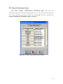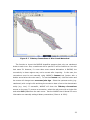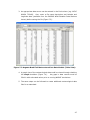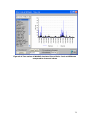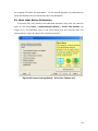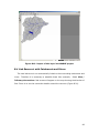
1
Creating a WARMF v. 6.0 Application
Using a BASINS 3.1 Delineation
A User’s Guide
Prepared by:
Systech Engineering, Inc
3180 Crow Canyon Place • Suite 260 • San Ramon, CA 94583
925-355-1780
January 2005
1
Table of Contents
1. INTRODUCTION......................................................................................................... 4
2. BUILD A BASINS 3.1 PROJECT............................................................................... 6
2.1 PROJECT SETUP .......................................................................................................... 6
2.2 DATA DOWNLOAD ..................................................................................................... 7
2.2.1 Default Data....................................................................................................... 7
2.2.2 BASINS Web Data Download............................................................................ 8
2.2.3 River Network Data ........................................................................................... 9
2.2.4 DEM Data........................................................................................................ 10
2.2.5 Land Use Data ................................................................................................. 12
2.2.6 Timeseries Data ............................................................................................... 16
3. WATERSHED DELINEATION ............................................................................... 18
3.1 BASINS AUTOMATIC DELINEATION ....................................................................... 18
3.2 GENERATING ASPECT DATA .................................................................................... 22
4. UNPROJECT AND EXPORT SHAPEFILES......................................................... 24
4.1 UNPROJECT USING THE PROJECTOR! EXTENSION ..................................................... 24
4.2 EXPORTING BASINS THEMES ................................................................................. 25
5. CREATE WARMF PROJECT ................................................................................. 26
5.1 INSTALL WARMF ................................................................................................... 26
5.2 CREATE PROJECT DIRECTORY .................................................................................. 26
5.3 IMPORT CATCHMENT LAYER.................................................................................... 28
5.4 IMPORT RIVER LAYER .............................................................................................. 30
5.5 LINK CATCHMENTS AND RIVERS TOGETHER ........................................................... 32
5.6 DEFINE SUBWATERSHEDS ........................................................................................ 34
5.7 SAVE WARMF PROJECT FILE (WSM FILE) ............................................................. 35
6. IMPORT LAND USE DATA..................................................................................... 36
7. IMPORT TIME SERIES DATA............................................................................... 42
7.1 METEOROLOGICAL DATA ......................................................................................... 44
7.1.1 Data sources .................................................................................................... 44
7.1.2 Importing data into WARMF ........................................................................... 46
7.2 AIR QUALITY DATA.................................................................................................. 50
7.2.1 Data sources .................................................................................................... 50
7.2.2 Importing data into WARMF ........................................................................... 51
7.3 OBSERVED HYDROLOGY .......................................................................................... 53
7.3.1 Data sources .................................................................................................... 53
7.3.2 Importing data into WARMF ........................................................................... 54
7.4 OBSERVED WATER QUALITY ................................................................................... 58
7.4.1 Data sources .................................................................................................... 58
7.4.2 Importing data into WARMF ........................................................................... 58
7.5 MANAGED FLOW...................................................................................................... 60
2
7.5.1 Data sources .................................................................................................... 60
7.5.2 Importing data into WARMF ........................................................................... 61
7.6 POINT SOURCE DATA................................................................................................ 63
7.6.1 Data sources .................................................................................................... 63
7.2.2 Importing data into WARMF ........................................................................... 64
7.9 SOILS DATA ............................................................................................................. 67
8. WARMF SIMULATIONS ......................................................................................... 68
8.1 RUN A SIMULATION ................................................................................................. 68
8.2 VIEW TIME SERIES OUTPUT ..................................................................................... 71
8.3 ADDITIONAL WARMF OUTPUT ............................................................................... 77
8.4 ADDITIONAL RESOURCES ......................................................................................... 79
REFERENCES................................................................................................................ 81
APPENDIX A. IMPORT MULTIPLE HUC AREAS................................................. 82
APPENDIX B. IMPORT LAKE/RESERVOIR LAYERS ......................................... 83
B.1 MASK LAKES BEFORE DELINEATION ...................................................................... 84
B.2 MASK LAKES AFTER DELINEATION......................................................................... 91
B.3 IMPORTING THE LAKE/RESERVOIR LAYER INTO WARMF........................................ 95
B.4 LINK RESERVOIR WITH CATCHMENTS AND RIVERS ................................................. 96
APPENDIX C. IMPORT SEPTIC SYSTEM DATA .................................................. 99
C.1 OBTAIN 1990 CENSUS BLOCK GIS DATA ................................................................ 99
C.2 OBTAIN 1990 CENSUS BLOCK DATA FOR SEPTIC SYSTEMS ..................................... 99
C.3. COMBINE GIS BLOCK DATA AND SEPTIC SYSTEM DATA ....................................... 99
C.4. IMPORT DATA INTO WARMF ................................................................................. 99
APPENDIX D: CORRECTING DELINEATION PROBLEMS ............................. 101
D.1 ROUGH EDGES AT WATERSHED BOUNDARIES ........................................................ 101
D.2 STREAM DISCONNECT PROBLEM ............................................................................ 103
D.3 ADDITIONAL EDITING OF WARMF CATCHMENTS ................................................ 103
3
1. Introduction
The Watershed Analysis Risk Management Framework (WARMF) is a generalized
watershed modeling and analysis tool which can be applied to various watersheds. It
can be used for short and long term predictions of water quality, watershed
management, and calculating Total Maximum Daily Loads (TMDL) (Chen et. al 2001).
Using
five
integrated
modules
(Engineering,
Consensus,
TMDL,
Data,
and
Knowledge), WARMF guides stakeholders to calculate TMDLs and evaluate water
quality management alternatives for a river basin. In addition to simulating flow, the
water quality constituents simulated include temperature, total suspended solids,
coliform bacteria, biochemical oxygen demand (BOD), dissolved oxygen (DO),
nutrients (phosphorus and nitrogen species), chlorophyll, and others. Formulations
of WARMF have been documented and updated (Chen et al. 2001).
Several
publications have documented the decision support capabilities of WARMF (Chen et.
al 1997, Chen et. al 1999, Chen et. al 2000, Weintraub et. al 2001, Herr et. al
2002). The model has been peer reviewed by independent experts (Keller 2000 and
2001).
The Engineering module of WARMF contains a dynamic watershed simulation
model that calculates daily surface runoff, ground water flow, non-point source
loads, hydrology, and water quality of river segments and stratified reservoirs. In
WARMF, a watershed is divided into a network of land catchments, river segments,
and reservoir layers. Land catchments are further divided into land surface and soil
layers. These watershed compartments are seamlessly connected for hydrologic and
water quality simulations.
The land surface is characterized by its land uses and
cover, which may include forested areas, agriculture lands, or urbanized cities. Daily
precipitation, which includes rain and snow, is deposited on the land catchments.
WARMF performs daily simulations of snow and soil hydrology to calculate surface
runoff and groundwater accretion to river segments. The water is then routed from
one river segment to the next downstream river segment until it reaches the
terminus of the watershed. The associated point and nonpoint loads are also routed
through the system. Heat budget and mass balance calculations are performed to
calculate the temperature and concentrations of various water quality constituents in
each soil layer, river segment, and lake layer.
The first step in applying WARMF is to create a map of the delineated watershed
using the graphical user interface (GUI), to which users can input data, and prepare
4
and view simulation results. Although WARMF itself has the functionality for
watershed delineation, it also accepts a delineation generated through other software
such as USEPA BASINS 3.1 framework (USEPA 2004) or AVSWAT-2000, ArcView
extension and a graphical user interface for the SWAT model. This manual will guide
users through the procedure of importing a watershed delineation from BASINS 3.1
and the basic data needed to create a WARMF application. For demonstration
purposes, the Brier Creek Watershed in Georgia (HUC 03060108) is used as an
example. The following steps will be described:
1. Build a BASINS 3.1 Project
2. Create a Watershed Delineation in BASINS 3.1
3. Project Delineation to Decimal Degrees
4. Create a WARMF Project
5. Import Land Use Data
6. Import Time Series Data
7. Run a WARMF Simulation
In addition, appendices are provided which describe how to import multiple HUC
watersheds, import lakes and reservoirs in a watershed, import septic system data,
reclassify land use data, and correct watershed delineation problems.
5
2. Build a BASINS 3.1 Project
2.1 Project Setup
In this tutorial, the Brier Creek Watershed in Georgia (HUC 03060108) will be
used to demonstrate how to build a project in BASINS 3.1 and proceed to watershed
delineation:
1.
Upon opening BASINS 3.1, choose “build_new_project.apr” from the
Open Project dialog.
2.
Select your watershed. For this example, zoom to the state of Georgia,
and select the watershed highlighted in Figure 2.1. The identify tool can
be used to check the watershed name and HUC number.
Figure 2.1 Selection of Brier Creek Watershed (HUC 03060108) in BASINS
3.1 project set up.
3.
Go to Data menu, and select data download.
6
Then, BASINS will download some basic coverages and create a new project with
the downloaded data for you.
Since BASINS 3.1 data is typically unprojected (in
decimal-degrees), the user is prompted to project the data upon creating a new
project. For the purposes of importing a BASINS delineation into WARMF, it is not
important which projection is selected at this stage. However, after the delineation
step, the resulting shape files need to be un-projected back into decimal degrees for
importing into WARMF (Section 4). Therefore, it is important to make note of the
projection that was selected during the BASINS 3.1 project setup.
2.2 Data Download
2.2.1 Default Data
Default data included in a new BASINS 3.1 project includes:
• A V1 Reach File
• Boundaries for EPA Regions, States, Counties, Accounting Units and
Cataloging Units
• Station location coverages for point sources (permit compliance system),
water quality stations, bacteria stations, USGS gage stations, and WDM
Weather Stations
• State Soil Coverage
• Land Use Index Coverage
Figure 2.2 shows the Brier Creek Watershed BASINS project with several default
data coverages selected.
7
Figure 2.2 Default BASINS 3.1 project data for Brier Creek Watershed.
2.2.2 BASINS Web Data Download
To delineate a watershed in BASINS 3.1, additional data (i.e. DEM and river
network data) need to be downloaded using the BASINS data download tool (Figure
2.3). For a WARMF application, land use data is also required. From the data menu,
select data download, and check the boxes for:
• BASINS DEM, DEMG, NED, GIRAS landuse, Legacy Storet
• National Hydrography Dataset (NHD)
• National Landcover Database (NLCD) [Optional]
On the next pop-up dialog (Specify NLCD to download), select the correct
State where the watershed is located.
For the next dialog (BASINS Web Data
Download), select DEM, DEMG and GIRAS Landuse. BASINS will then proceed
through the data download and then provide a log file describing the locations of the
DEM and NLCD data.
8
Figure 2.3 BASINS Data Download Tool
2.2.3 River Network Data
After the Web Data Download step described in 2.2.2, the NHD data should be
automatically imported into BASINS as a new coverage (Figure 2.4).
This is the
recommended river network file and provides much higher accuracy than the default
V1 Reach File.
NHD data can also be downloaded directly from the internet
(http://nhd.usgs.gov/). If downloaded from the USGS website, the shapefile is
unprojected (decimal degrees, AND 1983), and must be projected into the same
projection as the rest of the BASINS 3.1 project.
9
Figure 2.4 NHD and Default DEM Data Displayed in BASINS 3.1
2.2.4 DEM Data
BASINS automatically imports the default DEM shapefile into the project when
the project is first created (Figure 2.4). For watershed delineation in BASINS 3.1,
data in Grid format is required (e.g. DEMG data downloaded in Section 2.2.2). The
DEMG data need to be projected using the GRID Projector and then added to the
project.
The Grid projector is accessible under the data menu. Then navigate to
c:\basins\data\03060108\grids\DEM\DD\03060108\
and
select
the
file
03060108. A Grid Projector dialog will pop up (Figure 2.5).
10
Figure 2.5 BASINS Grid Projector dialog.
In the Grid Projector dialog, click in the box beside Add Projected Grid to a
View. Click on Input Grid Projection and click OK. Notice that the units change
from ‘meters’ to ‘decimal degrees’. Next click on Output Grid Projection and set
values to BASINS View projection being used. Click OK in the Grid Projector dialog
to project the grid data. When prompted, make sure that BASINS View is selected
as the view to which the projected grid will be added.
A dialog will then pop up
indicating whether or not the grid projection was successful.
If successful, the
theme will be added to the BASINS project (Figure 2.6).
11
Figure 2.6 BASINS DEMG data projected in the BASINS View.
2.2.5 Land Use Data
WARMF requires land use data in a shape file format. Section 6 of this document
describes the process of importing land use data into WARMF. This section describes
the pre-processing of land use data before importing into WARMF. There are many
possible sources for land use data. After the BASINS Web Data Download, a theme
containing the EPA GIRAS LULC landuse data will appear in the BASINS project
(Figure 2.7).
This data is relatively coarse and dated but can be a good starting
point for most projects. For this example, we used the LULC landuse data.
12
Figure 2.7 EPA GIRAS LULC Data for Brier Creek Watershed.
If multiple GIRAS land use themes are needed to cover the watershed, it is
recommended to merge them into a single shapefile before importing into WARMF.
This can be done using the Geoprocessing Wizard extension.
Under File /
Extensions make sure the Geoprocessing extension is selected. If you do not find
this as one of the possible extensions then you must copy this extension file
(geoproc.avx) into ArcView's extension's directory. For a typical ArcView 3.x setup
you
should
copy
the
geoproc.avx
C:\ESRI\AV_gis30\ArcView\samples\ext
to
file
found
in
the
C:\ESRI\AV_gis30\ArcView\Ext32
directory.
From the main menu, select View / Geoprocessing Wizard, and a new dialog
will appear (Figure 2.8). Select Merge Themes Together and click on Next. In
item 1, select the multiple land use themes to be merged and which shape file to use
fields from. Specify an output file name (e.g. landuseall.shp) and location and click
Finish. After the merge is complete a new theme included all merged land use
themes will be added to the project. It may be necessary to reset the legend of the
13
new theme. Double click on the theme to open the Legend Editor. Click on the
Load button and open the file c:\BASINS\etc\legend.avl. Select Lucode as the field
and click OK. Click on Apply to update the theme’s legend in the view.
Figure 2.8 Geoprocessing Wizard Dialog.
It is also helpful to clip the land use data based on the watershed boundary. This
could also be done using the Geoprocessing Wizard extension.
From the main
menu, select View / Geoprocessing Wizard, and a new dialog will appear. Select
Clip one theme based on another and click on Next. In item 1, select the land
use theme to be clipped (e.g. landuseall.shp).
Then select the polygon overlay
theme (e.g. Cataloging Unit Boundaries). Specify the output file name and location
and click Finish. After the clip is complete a new theme will appear which contains
land use only within the watershed boundary (Figure 2.9). It may be necessary to
reset the legend of the new theme. Double click on the theme to open the Legend
Editor.
Click on the Load button and open the file c:\BASINS\etc\legend.avl.
Select Lucode as the field and click OK.
Click on Apply to update the theme’s
legend in the view.
14
Figure 2.9 Clipped GIRAS Land Use for Brier Creek Watershed.
Another source of land use data available through BASINS is the National Land
Cover Database (NLCD).
This data has higher resolution and was collected in the
1990s. After downloading NLCD data in BASINS using the Data / Data Download
feature, a text message describing the location of the data will appear (Figure 2.10).
Figure 2.10 BASINS download instructions after NLCD import.
15
To use the NLCD land use in a WARMF application, users should first follow the
instructions in Figure 2.10 to convert the image into a grid and reproject the data,
and then convert the grid data into shapefile and clip to the watershed boundary
before importing to WARMF. ERDAS IMAGINE provides the function of converting the
image directly into shapefile.
Figure 2.11 NLCD Land Use theme for the State of Georgia
2.2.6 Timeseries Data
Other useful data available through the BASINS Data Download tool data
includes:
• PCS discharge (point sources)
• STORET (water quality)
• USGS Daily Streamflow
• USGS Water Quality
16
The PCS discharge data supplies flow and loading data for major point sources in
the watershed. Streamflow and water quality data from USGS and STORET is used
during calibration to compare simulated results with observed.
Section 7 of this
document describes how to import the time series data into WARMF.
17
3. Watershed Delineation
3.1 BASINS Automatic Delineation
BASINS provides several tools for watershed delineation including the Manual
Delineation Tool and Automatic Delineation Tool. For this example, we
demonstrated the use of Automatic Delineation Tool.
To create a watershed
delineation in BASINS, first load the BASINS 3.1 extensions, by going to the File
menu, selecting BASINS 3.1 Extensions, and then from the pop-up menu select
the Delineate extension category. Make sure the Automatic Delineation box is
checked.
The following steps briefly summarize the process. Please refer to the
BASINS 3.1 manual for more detailed instructions.
1. Activate the Cataloging Unit Boundaries theme and select the Brier
Creek watershed.
2. From the Delineate menu, select Automatic.
The main watershed
delineation dialog will appear (Figure 3.1)
18
Figure 3.1 Automatic Delineation Tool Dialog with Brier Creek Watershed
Cataloging Unit Selected.
3. Click the open file icon beside the DEM grid text box and select the DEM
grid. Make sure Select from BASINS View is highlighted and click OK.
Then select the grid theme (030601080) from the list and click OK. As
instructed, click the Properties button, check the units, and click OK.
4. Check the box Focusing watershed area option.
In the next dialog,
highlight Select boundary theme from BASINS View and click OK. For
this example, select Cataloging Unit Boundaries and click OK.
5. Click the box beside Burn_in Option. Select National Hydrography
Dataset (NHD) from the list and click OK. Highlight Select from
BASINS View and then select 03060108NHD from the list. Click Apply
at the bottom of the DEM Set Up frame. When asked Do you want the
19
cells on the edge of the “focused area” to flow toward the inner cells?,
reply No. In the next dialog, click OK to end DEM processing.
6. In the Stream Definition frame, enter 4100 as the Threshold Area and
click Apply at the bottom of the Stream Definition section. Notice that
outlets have been added as part of the view. Note: A smaller threshold
area will yield more outlets and smaller subbasins. Likewise a larger
threshold area will yield fewer outlets and larger subbasins.
7. Outlets may be added or removed using the Add and Remove tools in
the Outlet and Inlet Definition section. WARMF has no limit on the
number of subcatchments however with greater resolution, computation
time will increase. It is recommended to base a delineation on available
data such as USGS gaging stations, STORET water quality stations and
land use.
These layers can be turned on during the BASINS 3.1
delineation step and additional outlet points can be placed at key sampling
locations. In this example, we added several USGS gaging stations as
additional outlets.
8. After adding and removing desired outlet points, click on the Select tool
in the Main Watershed Outlet(s) section of the Watershed Delineation
dialog.
Select all of the outlets within the watershed by drawing a box
around them with the pointer.
Click OK in the small Main Watershed
Outlet(s) dialog that popped up. A dialog will pop up showing how many
outlets have been selected. If satisfied with the number of outlets, click
Yes. If not, click No and add or remove outlet points.
9. Click Apply under Calculation of subbasin parameters: in the Main
watershed outlet(s) section of the dialog. This step may take several
minutes.
When complete, click OK and the subwatershed delineation
should look similar to Figure 3.2. Be sure to select Save Project under
the File menu.
20
Figure 3.2 BASINS Delineation for Brier Creek Watershed
Figure 3.2 displays the results of the example delineation of the Brier Creek
watershed into 22 subcatchments. To import a larger watershed encompassing more
than one 8-digit hydraulic cataloging unit (HUC), it is recommended to perform the
BASINS 3.1 delineation separately for each HUC and then import the resulting shape
files successively into WARMF (see Appendix A).
1
For most accurate results, it is
very useful to burn in the river network, preferably from the National Hydrography
Dataset (NHD) (Step 5 above).
Depending on data quality, several problems can
arise during the delineation step which may result in incorrect stream connectivity or
watershed boundaries.
Suggestions on how to correct problems are provided in
Appendix D.
After the delineation is complete, BASINS 3.1 will generate two themes,
Subbasins and Streams, which contain geometric and geographic information of
the delineated watershed and stream, respectively. They will be imported to WARMF
in later steps (Section 5).
1
WARMF-Public Domain currently allows a maximum of 100 catchments in each project.
WARMF with more than 100 catchments, please contact Systech Engineering.
To set up
21
3.2 Generating Aspect Data
One type of data that is not automatically included in BASINS 3.1 but is a needed
input in WARMF is catchment aspect.
This section describes the procedure to
generate catchment aspect data within ArcView and add them to the delineated
subbasin theme for importing into WARMF.
1. In BASINS 3.1 view, activate the DEM Grid file and then select
Surface/Derive Aspect (To do this, make sure you have loaded in
Spatial Analysis Extension).
A new theme with Aspect (Aspect of
DEM) will appear.
2. Activate the Subbasins theme and select Analysis/Summarize Zones.
Choose Gridcode as the field that defines zones, and pick the new aspect
theme (Aspect of DEM) as the theme containing variable to
summarize.
ArcView will produce a table (Figure 3.3) with a row for
each subbasin and summary statistics of aspect.
Figure 3.3 Table of Calculated Aspects
3. Next, open the corresponding attribute table of the Subbasins theme.
Add a new field. First select Table / Start Editing. Then select Edit /
22
Add Field and name the field Aspt_mean. The new field should have a
type of number, width of 16, and decimal places of 2. Click OK and then
Table / Stop Editing and the table will now have an additional column
for Aspect filled with zeros.
4. Join the Stats of Aspect of DEM table with the Subbasins theme table.
Make both tables visible. Make the Subbasins table active and click on
the Gridcode header so it is highlighted. Switch to make the Aspect of
DEM table active and click on the Gridcode header. Switch back to the
Subbasins table and select Table / Join from the main menu or use the
Join shortcut button below the menu. The Aspect of DEM data should
now be joined into the Subbasins table.
5. With the Subbasins table active, select Table / Start Editing. Select
the header of the recently added Aspt_mean column and select Field /
Calculate from the main menu. The Field Calculator dialog will appear.
Scroll down the list of fields and double click on [Mean]. It should now
appear in the box below. Click OK and the mean aspect values should
now fill the Aspt_mean column.
6. Select Table / Remove All Joins to remove the joined Aspect of DEM
data.
Then click on Table / Stop Editing to save results in the
Subbasins theme. The revised Subbasins theme table is shown in Figure
3.4.
Figure 3.4 Revised Subbasins Theme Including Aspect Data
23
4. Unproject and Export Shapefiles
To import the BASINS-delineated watershed into WARMF, all shapefiles must first
be converted to decimal degrees. Thus, the projected layers must be unprojected
before data importing. Note that using unprojected data in the delineation can cause
significant differences in the delineation results. Several tools are available to
unproject the data such as the Projector! or ArcView Projection Utility
extensions in ArcView 3.2 or the ArcToolBox / Data Management / Projections in
ArcGIS. In the next section an example using the Projector! extension is provided.
4.1 Unproject using the Projector! Extension
To unproject using the Projector! extension, first turn on the extension under File
/ Extensions. If you do not find this as one of the possible extensions then you
need to copy this extension file (prjctr.avx) into ArcView's extension's directory. For
a typical ArcView 3.x setup you should copy the prjctr.avx file found in the
C:\ESRI\AV_gis30\ArcView\samples\ext to C:\ESRI\AV_gis30\ArcView\Ext32. If you
have successfully loaded the extension then in your View GUI you should see an icon
like this:
1. In your BASINS project with the BASINS View active, select the
Streams theme and click the click the Projector! button. You will be
prompted by a series of menus.
2. First, enter the current projection of the shapefile. This is the projection
you selected when setting up your BASINS 3.1 project.
3. Next, enter the output projection information and decimal degrees
should be selected.
4. When asked whether to “recalculate area, perimeter and length fields
using decimal degrees”, select No to maintain the data needed for
WARMF input.
5. Add the shape file to a New View and then give the new shapefile a
name (e.g. streams_dd). ArcView will now create a new shapefile in the
new projection.
The name of the new view can be edited under View /
Properties.
24
6. Repeat the above procedure for the Subbasins theme and the preferred
land use theme and save the new themes (e.g. as subbasins_dd and
landuseall_dd).
4.2 Exporting BASINS Themes
The three key shapefiles needed for import into WARMF are the subbasins_dd,
streams_dd, and landuseall_dd themes.
To keep things organized it may be
useful to save these themes to a folder that can be easily accessed. Activate the
Subbasins_dd theme by clicking its icon in the theme list. In Theme menu, select
Convert to Shapefiles, and then specify a folder (e.g. C:\BrierCreek) to store this
layer. Give this layer a new name (e.g. catchment). The Streams_dd and landuse
layer
can
be
saved
in
the
same
way
(e.g.
C:\BrierCreek\stream
and
c:\BrierCreek\landuse).
25
5. Create WARMF Project
After generating the BASINS 3.1 delineation files and converting them to decimal
degrees, a WARMF project can be created.
The following steps will guide you
through importing files into WARMF. If the watershed contains one or more lakes or
reservoirs, additional modification of the subbasins shape file is required before
import (see Appendix B).
5.1 Install WARMF
WARMF requires an IBM PC compatible system, at a minimum a Pentium
processor and 64 MB of RAM. WARMF will run on the following Windows platforms:
98, NT, 2000, ME, or XP. A computer with a faster processor and additional RAM will
provide better performance. To install WARMF:
1. Insert the CD into the CD ROM drive.
2. From Windows Explorer, go to the CD ROM drive and double-click
Setup.exe.
3. The setup program will guide you through the installation process.
default,
the
program
will
install
WARMF
in
the
By
C:\Program
Files\Systech\WARMF directory.
4. Run WARMF by selecting StartÆProgramsÆWARMF
5. Select the WARMF icon from the WARMF Program Group
5.2 Create Project Directory
When the initial window for WARMF is showing, open a WARMF watershed project
by clicking File / New. A blank window will appear.
Watershed
Select File / Import /
/ Create Project Directory. Navigate to the desired root directory
(e.g. c:\program files\systech\warmf), enter the name of a new project directory
(e.g. BrierCreek), and click Save.
A message will appear stating the project
directory that was created (Figure 5.2) and the files untitled.coe, untitled.con,
warmf.hlp and model.exe will be copied from the WARMF directory into this
directory.
NOTE:
Do NOT use the New Folder quick button in the standard
windows Save As dialog that pops up. You must instead type in the name of the
26
directory and click Save. If the quick button is used the appropriate files will not be
copied to the new project directory.
Figure 5.1 Create Project Directory Function in WARMF.
Figure 5.2 Dialog Stating Creation of Project Directory.
27
5.3 Import Catchment Layer
Select File / Import / Watershed / Catchment Layer, and choose the
catchment shapefile (C:\BrierCreek\catchment.shp). In the pop-up window (Figure
5.3), match the fields according to Table 5.1 and click OK. The four variables that
must be matched are highlighted in bold in Table 5.1.
Figure 5.3 Import Catchment Layer Dialog
28
Table 5.1. Key for Catchment DBF Fields
GIS Shapefile Fields
Model Coefficients
ID
None Selected
GRIDCODE
Catchment ID
SUBBASIN
None Selected
AREA
Catchment Area
LEN
None Selected
SLO1
Catchment Slope
SLL
None Selected
CSL
None Selected
WID1
None Selected
DEP1
None Selected
LATITUDE
None Selected
ELEV
None Selected
BNAME
None Selected
ASPT_MEAN
Catchment Aspect
WARMF will import the catchment layer, convert all entities to catchments and
populate each catchment with the data from the DBF file (e.g. catchment.dbf). When
finished, the catchment layer will appear on the map (Figure 5.4). When a catchment
is double clicked, it should contain the same coefficient values as in the original
shapefile.
If data is unavailable for any of the specified fields in the Model
Coefficients column of Table 5.1, WARMF will populate the catchments with default
coefficients for those model inputs. 2
2
WARMF-Public Domain currently allows a maximum of 100 catchments in each project.
WARMF with more than 100 catchments, please contact Systech Engineering.
To set up
29
Figure 5.4 Import of Catchments for Brier Creek Watershed
5.4 Import River layer
To import the river layer, the procedure is similar as above. Select File / Import
/
Watershed
/
River
Layer,
and
choose
the
river
shapefile
(C:\BrierCreek\stream.shp). In the pop-up window (Figure 5.5), match the fields
according to Table 5.2 and click OK. The ten (10) variables that must be matched
are highlighted in bold in Table 5.2.
30
Figure 5.5 Import River Layer Dialog
Click OK and WARMF will import the river layer, convert all entities to river and
populate each river with the data from the DBF file. When finished, the river layer
should appear on the map (Figure 5.6).
Table 5.2 Key for River DBF Fields
GIS Shapefile Fields
Model Coefficients
ARCID
None Selected
GRID_CODE
River ID
FROM NODE
None Selected
TO NODE
None Selected
SUBBASIN
Upstream Catchment
SUBBASINR
Downstream River ID
NUMIN
None Selected
AREAC
None Selected
LEN2
River Length
SLO2
River Slope
WID2
River Width
DEP2
River Depth
MINEL
River Min Elevation
MAXEL
River Max Elevation
SNAME
River Name
31
Figure 5.6 Import of Rivers for Brier Creek Watershed
5.5 Link Catchments And Rivers Together
Based on connectivity specified in the BASINS streams shapefile, WARMF
automatically links catchments and rivers. To see this, select View / Tributary
Connections, and red arrows will appear on the map showing the direction of flow
(Figure 5.7). Selecting Tributary Connections again removes the arrows from the
Map.
32
Figure 5.7 Tributary Connections of Brier Creek Watershed
The function to import the BASINS shapefiles assumes that only one catchment
drains to each river. Also, a catchment with a specific ID will be linked to a river with
that same ID. However, if a user does some manual delineation in BASINS, the
connectivity in these regions may not be correct after importing. In this case, the
connections must be set manually using WARMF’s Connect tool (button with a
double arrow below the main menu). To use the Connect tool, click the button and
the mouse will change to an arrow and plus sign. Select the upstream entity (e.g.
catchment) with a single click and drag the mouse to draw a line to the downstream
entity (e.g. river). If successful, WARMF will show the Tributary Connections
arrows on the map. To remove a connection, select the red arrow with a single click
and select Edit / Cut from the main menu. See the WARMF User’s Manual for more
information on manually setting tributary connections (Chen et. al 2000).
33
5.6 Define Subwatersheds
In WARMF, one or more subwatersheds can be defined to break the watershed
into several large groups of catchments. Instead of simulating all the catchments at
one time, WARMF will simulate the watershed group by group (i.e. subwateshed by
subwatershed).
This is desirable for large, complex watersheds where calibration
may be performed in sections moving from upstream to downstream. Initially the
entire watershed is considered as one subwatershed3.
To define a subwatershed, select View / Subwatersheds, and all the
catchments in the map will turn white. To create a subwatershed boundary at a river
segment, click on that river segment and then click Yes in the pop-up window. After
doing this, the watershed will be divided into two subwatersheds from the boundary,
and the downstream subwatershed will be colored. In this example, we divided the
BrierCreek into 3 subwatersheds as shown in Figure 5.8.
Logical locations for
subwatershed breakpoints include major gaging or water quality sampling stations.
The subwatershed will be named based on the name of the most downstream river
or reservoir segment in the subwatershed4. To view the names, select View /
Labels.
To remove a subwatershed breakpoint, make sure WARMF is in View /
Subwatershed mode (colored map) and select the most downstream river of the
subwatershed.
A dialog will pop up to ask if you want to remove the subwatershed
boundary.
3
4
If reservoirs exist in the watershed, all reservoirs are the downstream boundary of subwatersheds.
Make sure that the river or reservoir segment has a name. If not, input the name manually.
34
Figure 5.8 Subwatershed Regions for Brier Creek Watershed
5.7 Save WARMF Project File (WSM file)
The model is set up once catchment and river data are properly imported and
linked. Users can save the project file by selecting File / Save As5. For example,
you can save the Brier Creek project as
C:\Program Files\WARMF\BrierCreek\BrierCreek.WSM.
5
Ues Save As rather than Save.
35
6. Import Land Use Data
BASINS 3.1 provides landuse data (see Section 2.2.5). Note that some of the
BASINS landuse data (EPA GIRAS LU/LC) is from the 1980s. Users may have their
own sources of land use data, which can also be directly imported into WARMF as a
shapefile. As discussed in Section 4, the land use shape file must be unprojected to
decimal degrees before import into WARMF.
The following example describes the
import of the EPA GIRAS LU/LC data into WARMF.
Table 6.1 shows the default land use categories in WARMF. Table 6.2 shows the
land use codes for the EPA GIRAS LU/LC data.
Most of the GIRAS LU/LC land uses
are represented in the 14 default WARMF land uses.
Table 6.1 Default land use categories in WARMF
WARMF Land use
WARMF Land Use Code
0
Ignored
1
Deciduous
2
Coniferous
3
Mixed Forest
4
Orchard
5
Cropland / Pasture
6
Confined Feeding
7
Rangeland
8
Forested Wetland
9
Non-forested Wetland
10
Tundra
11
Barren
12
Residential
13
Comm./Industrial
14
Water
36
Level 1
Code
1
2
3
4
5
6
7
8
9
Table 6.2 EPA GIRAS LU/LC Data Codes
Level 2
Description
Code
Urban or built-up land
11
Residential
12
Commercial and services
13
Industrial
14
Transportation, communication, utilities
15
Industrial and commercial complexes
16
Mixed urban or built-up land
17
Other urban or built-up land
Agricultural land
21
Cropland and pasture
22
Orchards, groves, vineyards, nurseries, and ornamental horticultural
23
Confined feeeding operations
24
Other agricultural land
Rangeland
31
Herbaceous rangeland
32
Shrub and brush rangeland
33
Mixed rangeland
Forest land
41
Deciduous forest land
42
Evergreen forest land
43
Mixed forest land
Water
51
Streams and canals
52
Lakes
53
Reservoirs
54
Bays and estuaries
Wetland
61
Forested wetland
62
Nonforested wetland
Barren land
71
Dry salt flats
72
Beaches
73
Sandy areas not beaches
74
Bare exposed rock
75
Strip mines, quarries, gravel pits
76
Transitional areas
Tundra
81
Shrub and brush tundra
82
Herbaceous tundra
83
Bare ground
84
Wet tundra
85
Mixed tundra
Perennial snow or ice
91
Perennial snowfields
92
Glaciers
37
The classifications of original source land use data and WARMF are different. The
way of matching land uses between two systems could be case-dependent. If one or
more of the WARMF land uses are not present in the watershed (e.g. no Tundra
present in Brier Creek), it is recommended to remove this from the list of land uses
in WARMF prior to data import. To remove a land use category, double click on the
white space outside of the watershed map to open the System Coefficients dialog.
Select the Land Uses tab and click on Edit List (Figure 6.1). Select Tundra from
the list and click Remove.
Then click OK and Tundra will be removed from the land
use list. Likewise, if additional land use categories are to be added prior to importing
data, this should be done before using the same procedure before importing land use
data. While adding new categories, it is required to input all parameter values
associated with the new land use. See WARMF’s User’s Guide for details. Note that
the numbering of the list shown in Table 6.1 will change as land uses are added or
deleted.
Figure 6.1 Edit Land Use List Dialog
38
Once land use categories are set, the next step is to import the land use shape
file. Go to File / Import / Land Use and select the land use shapefile
(C:\BrierCreek\lu_dd). A window (Figure 6.2) will pop up.
Figure 6.2 WARMF Land Use Import Dialog
Select Land Use Code for the appropriate field that represents the land use code
(e.g. LUCODE).
Keep other rows unchanged as None Selected.
Click OK and a
new window (Figure 6.3) will pop up. For each Code (defined in the original
shapefile), users should input an appropriate Land Uses number from the list on the
right side.
A suggested match for Brier Creek watershed is provided in Table 6.3.
The numbers to enter in the spreadsheet are italicized and highlighted in red.
39
Figure 6.3 Match Land Uses Dialog
Table 6.3 Matching Land Use Codes in WARMF Input Dialog
Code
Land Uses
WARMF Land Use
0
0
Undefined
11
11
Residential
12
12
Commercial /Industrial
13
12
Commercial /Industrial
14
12
Commercial /Industrial
16
11
Residential
17
11
Residential
21
5
Cropland / Pasture
22
4
Orchard
23
6
Confined Feeding
24
5
Cropland / Pasture
32
7
Rangeland
41
1
Deciduous
42
2
Coniferous
43
3
Mixed Forest
51
13
Water
52
13
Water
53
13
Water
61
8
Forested Wetland
62
9
Non-forested Wetland
75
10
Barren
76
10
Barren
After clicking OK, the polygons of a land use shapefile are overlayed with the
WARMF catchment boundaries to determine the fraction of each land use in each
catchment. Depending on the size of the shapefile and watershed, it may take from a
few seconds to an hour or so to complete.
40
Once finished, all catchments should contain the land use information. To view
the information, double click on a catchment and go to the Land Uses tab (Figure
6.4).
It is recommended to do a Scenario / Save after this step to retain all
changes.
Figure 6.4 Catchment Land Use Data
41
7. Import Time Series Data
Once the watershed map is imported into WARMF, several time-series data files
must be created in order to start a simulation. For hydrology simulation, required
data includes meteorology, and managed flow (reservoir releases) if a lake or
reservoir is present. For water quality simulation, an air quality file is required and
point
sources
dischargers.
files
are
recommended
if
the
watershed
contains
significant
For calibration, observed hydrology (USGS gaging and reservoir
elevation) and observed water quality files should be created. These files can all be
created through the WARMF Data Module (Figure 7.1).
To switch to the Data
module, select Module / Data from the main menu. Under Type of Data, the files
can be viewed for each category.
As described in Section 2.2.6, BASINS provides an automatic data download
menu to download several types of time series data. Other data is available over the
internet from various sources. Table 7.1 summarizes the data and possible sources.
The following sections provide examples and information for importing each data
type into WARMF.
Figure 7.1 Data Module in WARMF
42
Type of Data
Table 7.1 Time series data input files in WARMF.
Description
Meteorology
File
Extension
*.met
Air Quality
*.air
Daily precipitation, min/max air
temperature, cloud cover, dew
point temperature, air pressure,
windspeed
Wet deposition concentrations
Observed
Hydrology
Observed
Water Quality
*.orh (rivers),
*.olh (lakes)
*.orc (rivers),
*.olc (lakes)
River flow, lake elevation and
storage
River and lake temperature and
concentrations
Managed Flow
*.flo
Point Sources
*.pts
Reservoir releases, river
diversions
Point source flow and loading
Data Sources
1. BASINS/Data Download/Meteorological WDM
2. http://www.ncdc.noaa.gov/oa/climate/onlineprod/drought/xmgr.ht
3. http://cdo.ncdc.noaa.gov/CDO/mapproduct (map-based download)
http://cdo.ncdc.noaa.gov/CDO/dataproduct (regular download)
1. http://www.epa.gov/castnet/data.html
2. http://nadp.sws.uiuc.edu/
1. BASINS/Data Download/ USGS Daily Streamflow
2. http://waterdata.usgs.gov/nwis/sw
1. BASINS/Data Download/ STORET (water quality)
2. BASINS/Data Download/ USGS Water Quality
3. http://www.epa.gov/storet/
1. Available from reservoir operators
1. BASINS/Data Download/PCS discharge (point sources)
2. http://www.epa.gov/enviro/html/pcs/adhoc.html
43
7.1 Meteorological data
7.1.1 Data sources
WARMF generally runs on daily time step and requires daily records of
precipitation, minimum and maximum temperature, cloud cover, dew point
temperature, air pressure and wind speed. As shown in Table 7.1, there are several
data sources available to obtain these records:
1. WDM data from BASINS, which is on hourly time step. To utilize this data
source, the users could use the WDMUtil tool in BASINS to convert the
hourly records into daily records. Note the WDM data in BASINS are
generally available only through 1996 and for major airport stations.
2. Free data for major airports from NCDC which contain daily records of
precipitation, min/max temperature, wind speed, dew point temperature,
cloud cover and air pressure.
(http://www.ncdc.noaa.gov/oa/climate/onlineprod/drought/xmgr.html)
3. For better hydrology simulations, it is recommended to purchase NCDC
cooperative station data (min/max temp, precipitation only) for higher
density of stations and more complete and current data records and use
the airport data to fill out the missing records (e.g. wind, pressure, etc.).
Prices range from $20, hundreds of dollars depending number of stations,
and period of record. (http://cdo.ncdc.noaa.gov/CDO/mapproduct [mapbased download], http://cdo.ncdc.noaa.gov/CDO/dataproduct [regular
download] )
For this example, we download the meteorological data for a NCDC station using
data source #2.
1. From the hyperlink in data source #2, click on Global Summary of the
Day. Agree to the conditions and select Display One Parameter For a
Specified Time Frame. Click on the United States and then select
Georgia from the list of states.
2. For Brier Creek Watershed, download data for Augusta Bush Field Station
(WMO# 722180) for the record period of 1994 to 2004 from the NCDC
Website. Note that the website requires that the data be downloaded in 8
44
year blocks. Data must also be download one parameter at a time. The
parameters download from this site included:
(A) Maximum Temperature (°C)
(B) Minimum Temperature (°C)
(D) Precipitation (cm)
(F) Mean Dew Point (°C)
(H) Mean Station Pressure (mbar)
(J) Mean Wind Speed (m/s)
3. Data was processed in an Excel spreadsheet and units were converted to
those parameters listed in Step 2. Cloud cover was unavailable for this
station so it was calculated using the following approach:
⎡ (T + Tmzx )
⎤
dT = ABS ⎢ min
− Tdew ⎥
2
⎣
⎦
(7.1)
AND
IF Precip = 0 THEN
IF dT < 4 THEN
Cloud = 0.6
ELSE IF dT < 6 THEN
Cloud = 0.3
ELSE
Cloud = 0.
ELSE IF Precip > 2 THEN
Cloud = 1
ELSE IF Precip > 1 THEN
Cloud = 0.9
ELSE
Cloud = 0.8
ENDIF
Where
Tmin
=
minimum
Temperature
(°C),
Tmax
=
maximum
Temperature (°C), Tdew = dewpoint temperature (°C), Precip =
precipitation (cm), and Cloud = cloud cover (unitless fraction).
45
7.1.2 Importing data into WARMF
The time series data file created in Excel was then imported into WARMF.
1. From the Data Module, first select the file type (in this case
meteorology) from the Type of Data list and then select File / New
from the menu. WARMF will create a blank meteorology file. Then name
the
file
and
save
it
with
the
appropriate
extension
(e.g.
AugustaBush.met). Switch the file from Graph mode into Table mode
(Figure 7.2).
Figure 7.2 New meteorological file created in Data Module
2. Using the Add Blank Rows to End of File button in the upper right
corner, add the necessary number of rows to the end of the file. Data can
be copied from an Excel spreadsheet using the Ctrl-C (copy) and Ctrl-V
(paste)
commands.
The
date
field
must
be
in
the
format
of
dd/mm/yyyy. Due to a limitation in WARMF, it may also be necessary
to copy and paste data one column at a time.
46
3. An appropriate data source can be entered in the final column (e.g. NCDC
WMO# 722180).
Also, enter a file name description and latitude and
longitude data (available from the BASINS WDM Weather Data Stations
theme) before saving the file (Figure 7.3).
Figure 7.3 Augusta Bush Field data entered into Data Module (Table View).
4. A graph view of the meteorological data could be viewed through checking
the Graph checkbox (Figure 7.4).
Any gaps in data records must be
filled in with estimated values prior to running WARMF simulations.
5. The same steps can be followed to create additional meteorological data
files for a watershed.
47
Figure 7.4 Graphical view of Augusta Bush Field meteorological data.
6. After necessary files have been created, the stations can be automatically
assigned to watershed locations within WARMF.
From the Engineering
Module, select File / Import / Meteorology Stations from the WARMF
main menu. A dialog will popup showing all of the meteorology stations
created for this project (Figure 7.5). Select which stations from the list
(you would like to import for this example only one data station was
created) and click OK. Then, every catchment and reservoir is assigned a
meteorology station used to drive the simulation.
48
Figure 7.5 Import Data Files dialog
To translate conditions at the meteorology station to the catchments and
reservoirs, a precipitation weighting factor and temperature lapse are used.
The
weighting factor is a multiplier applied to the precipitation from the assigned station
and the temperature lapse shifts the station’s temperature downward. WARMF uses a
simple method to automatically calculate the precipitation weighting factor (WP) and
temperature lapse (TL) for each catchment and reservoir.
For a catchment (or
reservoir), WARMF first calculates the center of its extents and then uses its
coordinates to assign it the nearest meteorological station (A). It then calculates WP
and TL according to Equations 7.2 and 7.3.
TL = T A
∑T / D
−
∑1 / D
n
n
n
n
n
∑P /D
=
∑1 / D
n
WP
n
n
n
x
1
PA
(7.2)
(7.3)
n
49
where TL is temperature lapse, TA is the average temperature at the assigned
station, and n is the number of meteorological stations including the assigned station
and neighboring stations.
Dn is the distance from station n to the center of the
catchment (or reservoir), WP is the precipitation weighting factor, Pn is the average
precipitation at station n, and PA is the average precipitation at the assigned station.
To view the meteorological data station assigned and the associated weighting
factors, double click on a catchment while in input mode and select the
Meteorology tab.
7.2 Air Quality data
7.2.1 Data sources
The air quality data required by WARMF are the concentrations (weekly or
monthly) of main constituents in rain water (in mg/L) and in the air (in µg/m3). As
stated in Table 7.1, these data are generally available from the following sources:
1. USEPA Clean Air Status and Trends Network (CASTNET) measures the dry
deposition of particles at 55 site locations mostly in the Eastern United
States. http://www.epa.gov/castnet/data.html
2. The National Atmospheric Deposition Program (NADP) collects data for
over 200 sites in the United States, Puerto Rico, and the Virgin Islands.
The data includes wet deposition concentrations.
http://nadp.sws.uiuc.edu/
For this example, we downloaded data from both sources.
1. From the CASTNET website, we downloaded two files (drychem.xls and
velwk.xls) which contain weekly measurements of concentrations in the
air for all the 55 monitoring locations. We then extracted records for the
active station in GA (GAS153) from these files. Concentrations of base
cations (i.e. Calcium, Magnesium, Potassium, and Sodium) and Chloride
were exacted from the drychem.xls and were available for only several
years of 1988-89 and 2000-2004. We filled the data gaps by repeating
records of 1988-89. Concentrations of NOx, SOx, Sulfate, Nitrate and
Ammonia were extracted from the velwk.xls. These data were mostly
available for the period of 1988-2002.
2. Wet deposition data for a monitoring station near the Brier Creek
Watershed (Bellville, GA20 Station) were directly downloaded from the
50
NADP website. The downloaded data were weekly concentrations (in
mg/L) of the main constituents in rain water (i.e. Ammonia, Calcium,
Magnesium, Potassium, Sodium, Sulfate, Nitrate and Chloride) at Bellville
station measured during 1983-2004. For wet deposition, only data from
1988-2004 were used.
3. Because dry and wet deposition data are combined into one file, WARMF
requires that the wet and dry deposition records have the same starting
date and time intervals.
If the dates of the two data sets are not
identical, it may be necessary to make some adjustments to one of the
data sets so that a uniform series of dates is used. For this example, the
resulting air quality file has a starting date of July 5th, 1988. Also, any
missing data gaps should be filled in with an estimated value (e.g.
previous data point).
7.2.2 Importing data into WARMF
The time series data file created in Excel was then imported into WARMF.
1. An Air Quality data file (*.air), was creating using an approach similar to
the steps described in the meteorology data section.
Select the Air
Quality data type from the Type of Data list and then select File / New
from the menu. A blank spreadsheet will be created. Then click the Edit /
Columns from the menu. In the pop-window (Figure 7.6), select the
constituents that have data available (in this case, SOx, NOx, Ammonia,
Calcium, Magnesium, Potassium, Sodium, Sulfate, Nitrate and Chloride).
Click OK and WARMF will add column headers.
2. Add rows to the file using the Add Blank Rows to End of File button.
With the Air button selected, copy (ctrl-C) and paste (ctrl-V) the dry
deposition data records from the spreadsheet into WARMF.
The dates
must be in the format of mm/dd/yyyy.
3. Then switch to the wet deposition records by selecting Rain at the top of
the file. Copy and paste the wet deposition records. Save the file (e.g.
Brier.air) and enter a file description, latitude and longitude, data source
information. The resulting Air Quality data file should look like Figure 7.7.
Data can also be viewed in Graph mode. Switch between Rain and Air to
view both data sets.
51
Figure 7.6 Add Columns to Air Quality File
Figure 7.7 Brier Creek Watershed Air Quality File
52
4. Similar to meterology data, air quality stations can be imported into
WARMF using the File / Import Air Quality Stations function in the
main menu.
A dialog will popup showing all of the air quality stations
created for this project (Figure 7.8). Using the same procedure discussed
above in meteorological data section, WARMF automatically assigns an air
and rain chemistry station to each catchment and reservoir based on
distance. No adjustment factors are applied to the data.
Figure 7.8 Import Air Quality File
7.3 Observed Hydrology
7.3.1 Data sources
The observed hydrology data used for hydrology calibration in WARMF are
typically the USGS daily stream flow data.
In some watersheds, additional flow
records are available from various stakeholders. USGS flow data is available from
two sources:
53
1. BASINS 3.1 provides data download tool to download the stream flow data
automatically for each HUC (see Section 2.2.6).
Select BASINS/Data
Download/ USGS Daily Streamflow from the BASINS main menu.
2. USGS flow data can also be obtained directly from the USGS at no cost via
the following website: http://waterdata.usgs.gov/nwis/sw
7.3.2 Importing data into WARMF
WARMF provides a tool to easily import USGS stream flow data. For this example,
we used BASINS 3.1 data download tool to download the stream flow data for all the
USGS gaging stations within the Brier Creek watershed (i.e. USGS 02197520,
02197550, 02197600, 02197830, 02198000 and 02198100) and imported them into
WARMF.
1. Copy
the
stream
flow
files
from
BASINS
directory
(c:\BASINS\data\BrierCreek\USGSflow\) to WARMF directory (c:\program
files\WARMF\BrierCreek\. Then, from the WARMF Data module, select
Observed Hydrology from Type of Data list, and select File / Import
from the menu.
2. In the pop-up window, select the text file to import and click open (e.g.
02197520_dv.txt). In the next pop-up window, save the file as observed
hydrology file (e.g. 02197520_dv.orh). WARMF will automatically import
the station location description (into Name), the latitude and longitude
and the data source.
The resulting observed hydrology file is shown in
table view (Figure 7.9) and graph view (Figure 7.10).
54
Figure 7.9 Table View of Observed Hydrology File
55
Figure 7.10 Graph View of Observed Hydrology File
3. Repeat the above steps to create observed hydrology files for the rest of
the USGS gaging stations.
Additional *.orh files may be created with
streamflow data available from other sources as well.
4. When *.orh files have been created for all stations, the function File /
Import Gaging Stations in the Engineering Module can be used to
import the files. A dialog will pop-up showing all the observed hydrology
files created for the project (Figure 7.11). Based on latitude and longitude
coordinates specified in the data file, the gaging station files are assigned
to the river segment or reservoir at the station’s coordinates. If there is
no match, the station is left unassigned and must be set manually.
5. To view the gaging stations in WARMF, select View / Gaging Stations
from the main menu and the gaging stations are shown in white dots
(Figure 7.12).
Double clicking on a white dot will open the file from
within the Data Module.
56
Figure 7.11 Import Gaging Stations dialog
Figure 7.12 View Gaging Stations for Brier Creek Watershed.
57
7.4 Observed Water Quality
7.4.1 Data sources
Observed time series of water chemistry data (e.g. nutrient concentrations, DO,
BOD) are required for water quality calibration in WARMF.
These data are available
from several sources.
1. BASINS 3.1 provides a data download tool to download STORET data
automatically for each HUC (see Section 2.2.6).
Select BASINS/Data
Download/ STORET (water quality)
2. BASINS 3.1 provides a data download tool to download USGS Water
Quality data automatically for each HUC (see Section 2.2.6).
Select
BASINS/Data Download/ STORET (water quality) / USGS Water
Quality.
3. STORET data can also be obtained directly from EPA at the following via
the following website: http://www.epa.gov/storet/
4. In
many
watersheds,
sampling
programs
conducted
by
various
stakeholder groups will yield ambient water quality data useful in WARMF.
In this example we download legacy STORET water quality data directly from the
EPA STORET website. The downloaded data were processed in Excel spreadsheet.
WARMF accepts water quality concentration data in units of mg/L.
It is not
necessary to have a uniform frequency of data records.
7.4.2 Importing data into WARMF
The time series data file created in Excel was then imported into WARMF.
1. To create an observed water quality file, first select Water Quality from
the Type of Data list and then select File / New from the menu. WARMF
will create a blank spreadsheet. Select Edit / Columns from the menu
and in the pop-up window select the constituents that have data available
(Figure 7.13). Copy the data records of each constituent into the WARMF
spreadsheet.
2. Specify the latitude and longitude and specify an appropriate file name
(e.g. BCSR17.ORC). The latitude and longitude of each station is available
58
in the file downloaded from STORET website. The users might want to
refer to the attribute table of the Water Quality Observation Stations
coverage (Wqobs.shp) in the BASINS project for description and latitude
and longitude of the station. The resulted water quality file should look
like Figure 7.14. Additional *.orc (rivers) or *.olc (lakes) can be created
with other data sets.
Figure 7.13 Edit Columns for Observed Water Quality File
Figure 7.14 Observed Water Quality file in WARMF.
59
6. When observed water quality files have been created for all stations, the
function File / Import Water Quality Stations in the Engineering
Module can be used to import the files. A dialog will pop-up showing all
the observed hydrology files created for the project (Figure 7.15). Based
on latitude and longitude coordinates specified in the data file, the
observed water quality files are assigned to the river segment or reservoir
at the station’s coordinates.
If there is no match, the station is left
unassigned and must be set manually.
Figure 7.15 Import Observed Water Quality Files
7. To view the water quality stations in WARMF, select View / Water
Quality Stations from the main menu and the gaging stations are shown
in white dots.
Double clicking on a white dot will open the file from within
the Data Module.
7.5 Managed Flow
7.5.1 Data sources
Managed flow data in WARMF includes water diversions and reservoir releases.
This data is very site specific and is not often available from national databases via
60
the Internet.
Reservoir release records can be obtained from the stakeholder
operating the reservoir (e.g. USBR or utility company).
Water diversions for
agricultural uses can generally be obtained from a State Engineer’s Water Master.
Municipal and Industrial (M&I) diversion records must be obtained from the
stakeholder who uses the diverted water (e.g. a city or a power plant).
7.5.2 Importing data into WARMF
Managed flow records are specified in WARMF as files with a .FLO extension and
flow units of m3/s. Once data available data records are processed, managed flow
files can be created for the WARMF project. Note, since actual M&I diversion data
was not obtained for Brier Creek watershed, hypothetical data is used in the
following example.
1. From the Data Module, select Managed Flow in Type of data list and
then File / New in the menu. When prompted, save the file as a
managed flow file (e.g. CityM&I.flo). Specify the name and latitude and
longitude. There will be columns for Date, Flow and Data Source.
2. Add blank rows to the file using the Add Blank Rows to End of File
function. Copy (ctrl-C) and paste (ctrl-V) the processed data from the
spreadsheet into the WARMF file. The date records must have a format of
mm/dd/yyyy. Also, although the data records do not have to have a
uniform frequency, there must not be any empty records in the file.
Therefore, fill in any data gaps with estimated values.
The managed flow
file is shown in Figure 7.16.
61
Figure 7.16 Example Managed Flow File
3. When all managed flow files have been created for the watershed, the
user must assign each one to the appropriate river segment or reservoir.
From the Engineering Module, identify the location of the diversion or
release on the WARMF map (latitude/longitude coordinates are displayed
in the lower right corner of the WARMF main window). Double click on the
appropriate river segment or reservoir and select the Diversions tab.
Under Diversions From, click on Add and navigate to the desired
location for the point source data file (Figure 7.17). Note the targeted
receiving river segment is highlighted in yellow in Figure 7.17.
62
Figure 7.19 Assigning a Diversion file to a River Segment
4. Likewise, the Diversions To column can be used to specify if the river
segment receives water diverted from another river or reservoir segment.
See the WARMF User’s Guide and Technical Documentation for more
information on setting up agricultural diversions and irrigation as well as
setting reservoir releases.
7.6 Point Source data
7.6.1 Data sources
63
The point source flow and loading data used in WARMF are generally obtained
from the EPA Permit Compliance System (PCS).
PCS data is available from two
sources:
1. BASINS 3.1 provides a data download tool to download PCS data
automatically for each HUC (see Section 2.2.6).
Select BASINS/Data
Download/PCS discharge (point sources).
2. PCS
can
be
downloaded
directly
from
the
following
website:
http://www.epa.gov/enviro/html/pcs/adhoc.html.
More detailed discharge monitoring report (DMR) data may be available directly
from regulatory agencies or stakeholder groups. The Permit Compliance System
theme in BASINS 3.1 was used to identify the NPDES stations within the Brier Creek
Watershed (i.e. GA0002542, GA0020231, GA0020893, GA0020974, GA0021857,
GA0047309, and GA 0048101).
1. A search on the PCS website showed that, only station GA0020974
contains data.
This data was downloaded and processed in a
spreadsheet.
2. WARMF accepts flow (m3/s), temperature (°C) and constituent loading
(kg/day) records. Data must be converted to appropriate units prior to
import. The frequency of point source data records can vary and does not
need to be specified at equal time intervals. The model uses a step
function approach, in which the discharge values at one time remain the
same until the values for the next time become available. If a yearly value
is provided in the input file, the model will discharge the same amount
every day for that year. If monthly values are provided, the model will
change the daily discharge month by month. Likewise, if daily values are
provided in the input file, the model will change the daily discharge day by
day.
7.2.2 Importing data into WARMF
The time series data file created in Excel was then imported into WARMF.
1. Once data available data records are processed, point source files can be
created for the WARMF project.
From the Data Module, select Point
Sources in Type of data list and then File / New in the menu. When
prompted, save the file as a point source file (e.g. GA0020974.pts).
64
Specify the discharger name and latitude and longitude. The users might
want to refer to the attribute table of the Permit Compliance System
coverage (pcs3.shp) in the BASINS project for a description and latitude
and longitude of the station.
2. Add columns and rows to the file using the Edit / Columns and Add
Blank Rows to End of File functions. Copy (ctrl-C) and paste (ctrl-V)
the processed data from the spreadsheet into the WARMF file. The date
records must have a format of mm/dd/yyyy. Also, although the data
records do not have to have a uniform frequency, there must not be any
empty records in the file. Therefore, fill in any data gaps with estimated
values.
The resulting point source file is shown in Figure 7.18.
Figure 7.18 Point Source File for Brier Creek Watershed
3. When all point source files have been created for the watershed, the user
must assign the receiving river segment or reservoir manually for each
discharger at this time.
From the Engineering Module, identify the
location of the point source on the WARMF map (latitude/longitude
65
coordinates are displayed in the lower right corner of the WARMF main
window). Double click on the appropriate river segment or reservoir and
select the Point Sources tab. Click on Add and navigate to the desired
location for the point source data file (Figure 7.19). Note the targeted
receiving river segment is highlighted in yellow in Figure 7.19.
Figure 7.19 Assigning a Point Source data file to a River Segment
4. By default, the point source will be set to External Water Source and
Unspecified Constituents with Zero concentration.
The setting for
Internal Water Source is generally used for cooling water point sources
where water is removed, the temperature is raised and then the water is
returned to the stream or reservoir.
In this case, a delta T (instead
66
measured temperature) is specified in the *.pts file and unspecified
constituents will have ambient concentrations.
See WARMF’s technical
documentation for more details.
7.9 Soils Data
The National Resources Conservation Service (NRCS) has soils databases
including soil erosivity, depth to soil horizons, and depth to bedrock. This data is not
in a format amenable for automatic importation into WARMF.
It may be useful
during model calibrations to set each catchment’s erosivity, the number of soil
layers, and the thickness of each soil layer for individual catchments by hand.
67
8. WARMF Simulations
After completing all of the setup and data import steps outlined in the previous
sections, the WARMF application is ready for preliminary simulations. Additional data
such as soils, site specific rate coefficients, surveyed channel bathymetry, septic
system
locations,
best
management
practices,
land
application
(fertilizer),
diversion/irrigation activity may be imported if available. Please refer to the WARMF
Technical Documentation
and User’s
Guide for more information
on
model
coefficients and running simulations.
8.1 Run a Simulation
To start a simulation, in the WARMF Engineering module, select Scenario / Run
from the main menu. Then, the simulation control dialog will pop-up (Figure 8.1).
The first item is the beginning and ending simulation dates. To change a date,
use the up and down arrows to change the value. The day, month, or year can also
be entered directly with the keyboard. The simulation time period should encompass
a time period with good data record. WARMF will restrict the acceptable time period
based on available records for meteorology, air quality and managed flow. In this
example, we specify the simulation time period to be from 10/1/1994 to 10/1/1999.
The second item is the time step in hours. The default time step is 24 hours or daily.
To change the time step, click in the box and enter a new number. Please note that
the program will expect meteorology and reservoir release data for each time step.
In the next section of the dialog, the simulation components (e.g. water quality,
point source) can be specified.
Hydrology is always simulated, but water quality
constituents are optional. Optional items may be turned on and off by toggling with
the mouse on the check box.
Simulations of hydrology alone run very fast.
Simulations for the complete suite of water quality may take five times as long. The
sediment, pesticides, fertilizers, and point sources options do not have a large impact
on simulation time. They should be checked if input data is available.
Under Subwatersheds:, the regions of the river basin to include in the
simulation are set. It is not required to simulate the entire watershed every time.
However, the entire watershed must be simulated at least once for WARMF to
generate the boundary conditions between regions. WARMF will automatically save
the results for the interface points. After that, any subwatersheds can be turned off
68
to save time by unselecting subwatersheds from the list. To see the subwatershed
boundaries, select Subwatersheds from the View menu. Please read the Section
5.6 for more details.
WARMF provides an autocalibrator for hydrologic simulation. There is no
autocalibrator for water quality simulation.
Hydrology Autocalibration can be
activated by clicking on the check box. This dialog only allows the users to specify
the number of loops to iterate. For the autocalibrator to work, the user must have
already set the autocalibration coefficients under the Edit / Autocalibration
Coefficients menu item. The users can select which regions of the watershed and
which variables to adjust during the autocalibration.
Another option is Generate Loading Data. If this option is selected, point and
nonpoint loading for each constituent are calculated for display in GIS maps. If this
option is not selected, WARMF will still simulate hydrology and water quality for each
catchment, river, and reservoir.
An additional feature of WARMF, Warm Start, allows the user to run a set of
simulations in succession with linked initial conditions. For example, to account for
future growth in the TMDL process, WARMF can run under one land use scenario for
a few years (i. e. scenario A) and then run under a new projected land use for a few
years (i. e. scenario B). This is possible with the Warm Start option. For scenario A,
WARMF saves the final results in a warm start file with a WST extension. This file
provides the initial conditions for scenario B. When making run for scenario B, turn
the Warm Start option on and select the name of the warm start file from scenario
A. For the program to work, it is important that the ending date of the first scenario
is exactly one day prior to the starting date of the second scenario.
After all options in the simulation control dialog are selected, click OK to start the
run. Then, a simulation window will appear (Figure 8.2).
69
Figure 8.1 WARMF Simulation Control Window
Figure 8.2 WARMF Model Simulation Window
70
The simulation window is a DOS-based window showing the progress of the
simulation (e.g. how many subwateresheds in the simulation, % of simulation
finished, and days of the simulation period). WARMF will perform the simulation in
the background, so the user is free to perform other tasks with the computer. Care
should be taken, however, to avoid opening files in use by the simulation. When a
simulation finished successfully, a message will appear as “WARMF simulation
completed successfully” in the simulation window (Figure 8.3). Close the window by
clicking on the ”X” in the upper right corner.
Figure 8.3 WARMF model simulation window showing simulation completion
8.2 View Time Series Output
The simulation results can be viewed as time series plots through the WARMF
Engineering module. Select Mode / Output from the main menu. Double click on
the stream segment at Millhaven (not the watershed), and an output window will
appear (Figure 8.4) with a graph showing the model simulated flow compared to the
observed values.
The legend of the plot is shown below the X-axis.
Black circles represent
observed data points. Observed data can be shown or hidden by toggling the Show
Observed button in the lower left corner of the dialog. If no black circles are visible
with Show Observed checked, it means that there is no observed data from the
71
simulated time period.
The output parameters are listed on the left side of the
dialog. To view a parameter, simply click on its name on the list.
The output can be exported to a text file for external processing. This is done by
clicking on Create Text File. There are two options for the text file.
This
constituent, all scenarios option will create a text file with a column for day, a
column for each scenario showing the simulated results for the highlighted
constituent, and a column for the observed data. The All Constituents option will
create a text file with a column for day and a column for each of the simulated
constituent concentrations for a given scenario (e.g. BrierCreek).
To change
scenarios, click on the down arrow and choose the scenario to be written to the text
file.
A default file name is provided (i.e.
FLOW.DAT), which can be changed by
typing over it.
At the lower left hand corner of the time series plot there is the Statistics button
Click on the Statistics button to view the statistical results for the flow simulation
(Figure 8.5). The default Statistics window shows a scatter plot of the model
simulated vs. observed values and a summary table of the statistical measures of the
simulation (i.e. mean, minimum, maximum, relative error, absolute error, RMS error
and r square). Click on the Cumulative Quantity checkbox to view the cumulative
distributions of the model simulations and the observed values (Screen 8.6). The
model appears to underpredict the flow and this represents the preliminary results
without any calibration. The WARMF Help System, User’s Guide and Technical
Documentation provide more information on model calibration and statistical output.
Also, information on viewing profile output, mass output, and spatial output
through the Engineering module is provided in these documents.
Close the Statistics window. In the time series output window, click on different
variables to view the simulation results for other variables. The results for the
temperature and dissolved oxygen should look similar to Figures 8.7 and 8.8.
Several output plots can be viewed simultaneously in WARMF. The dialogs can be
moved around by dragging. To close the output dialog, click on the “X” in the upper
right corner.
72
Figure 8.4 Time series of WARMF simulated flow of Brier Creek at Millhaven
compared to observed values
73
Figure 8.5 Scatter plot of WARMF simulated and observed flow of Brier
Creek at Millhaven
74
Figure 8.6 Cumulative quantity of WARMF simulated and observed volume of
flow of Brier Creek at Millhaven
75
Figure 8.7 WARMF simulated and observed temperature of Brier Creek at
Millhaven
Figure 8.8 WARMF simulated and observed Dissolved Oxygen of Brier Creek
at Millhaven
76
8.3 Additional WARMF Output
In addition to viewing output through the Engineering Module of WARMF, the
Consensus, TMDL, and Knowledge modules provide model output and other
information of interest to stakeholders (e.g. GIS maps showing bar charts of point
and nonpoint loadings from various regions of the watershed and GIS maps showing
the compliance or noncompliance with water quality criteria in various parts of the
watershed).
The Technical Documentation and User’s Guide for WARMF provide
detailed information about these modules. The following example shows how to view
loading output through the Consensus module.
From the main menu, select Module / Consensus.
The roadmap for the
Consensus module will be displayed (Figure 8.9)
Figure 8.9 Consensus Module roadmap
The first three steps of the Consensus roadmap contain dialogs where
stakeholders can input information about the stakeholder group, watershed goals,
designated uses, and criteria. In step 4, Learning Process, the Simulate button
links back to the simulation control dialog of the Engineering module. Click on the
Loading button to view loading charts for the watershed (Figure 8.10).
Select a
stream segment to add / remove a loading bar. Loading charts can be viewed for
77
various constituents by scrolling through the list in the small dialog that pops up.
The magenta portion of a loading chart represents the point source loading for a
constituent and the green portion of the loading chart represents the nonpoint
source loading.
Double click on a loading chart to view the loading broken down
based on land use (Figure 8.11).
Figure 8.10 Ammonia loading charts for Brier Creek Watershed.
78
Figure 8.11 Ammonia distributed by land use for Brier Creek Watershed.
The remaining steps of the Consensus module provide tools for management
scenario development, Cost / Benefit and Cost Sharing analysis, and
Stakeholder ranking and resolution.
8.4 Additional Resources
The intent of this guide is to provide a tutorial for setting up a WARMF project by
importing a watershed delineation and available data sets from BASINS 3.1.
The
setup is just the first step. To successfully adapt WARMF to a watershed, additional
data import, calibration and analysis is required. It is recommended that these steps
be performed by someone with hydrology and/or water quality expertise. Additional
information on WARMF is available in the accompanying Technical Documentation
79
(Chen et al. 2001) and User’s Guide (Chen et al. 2000).
Also, please contact
Systech Engineering for additional information.
80
References
USEPA 2004. Better Assessment Science Integrating Point and Nonpoint
Sources, Version 3 (BASINS 3.1), U.S. Environmental Protection Agency Report EPA823-F-04-026
Chen, C.W., J. Herr, and L. Weintraub. 2000. “Watershed Analysis Risk
Management Framework (WARMF) User’s Guide” Publication No. 1000729, Electric
Power Research Institute, Palo Alto, CA.
Chen, C.W., J. Herr, and L. Weintraub. 2001. “Watershed Analysis Risk
Management Framework (WARMF): Update One – A Decision Support System for
Watershed Analysis and Total Maximum Daily Load Calculation, Allocation and
Implementation” Publication No. 1005181, Electric Power Research Institute, Palo
Alto, CA.
Herr J., C.W. Chen, R.A. Goldstein, and J. Brogdon. “A Tool for Sediment
TMDL Development on Oostanaula Creek”, a paper accepted for presentation at
Watershed Management to Meet Emerging TMDL Environmental Regulations,
Conference and Exhibits, March 11-13, 2002, Radisson Plaza, Fort Worth, TX.
Keller, A. 2000. “Peer Review of the Watershed Analysis Risk Management
Framework (WARMF) – An evaluation of WARMF for TMDL applications by
independent experts using USEPA guidelines”, Technical Report 2000.1000252,
Electric Power Research Institute, Palo Alto, CA.
Keller, A. 2001. “Peer Review of the Acid Mine Drainage Module of the
Watershed Analysis Risk Management Framework (WARMF) – An evaluation of
WARMF/AMD using USEPA guidelines”, Technical Report 2001.1005182, Electric
Power Research Institute, Palo Alto, CA.
Weintraub, L.H.Z., C.W. Chen, J. Herr. “Demonstration of WARMF: A Decision
Support Tool for TMDL Development”, IN: Proceedings from WEF TMDL Science
Issues Conference, St. Louis, MO, March 4-7, 2001.
81
Appendix A. Import Multiple HUC Areas
It is possible to import large watersheds encompassing more than one 8-digit
HUC.
For this situation, it is recommended to set up a separate BASINS 3.1
delineation for each HUC.
succession.
Then, shape files for each HUC can be imported in
It is very important to import in the order of: subbasin1, streams1,
subasin2, streams2, etc. in order to maintain connectivity. When importing a second
HUC, WARMF will change the ID numbers of the HUC already on the map, by an
increment of the next closest 100. Once all HUCs are imported, it is necessary to
connect them together using the Edit / Connect tool in WARMF.
82
Appendix B. Import Lake/Reservoir Layers
Lakes and reservoirs can be included in WARMF. This section provides the steps
needed to prepare the data for incorporating a lake/reservoir. A typical watershed
with a reservoir in the upper reaches is presented as an example in Figure B.1. The
screen shows the imported catchment and river layers for this watershed. The white
region at the center of the watershed is the reservoir location. The first step is to
obtain a lake/reservoir shape file, bring it into your BASINS 3.1 project and delete
any small bodies of water you don’t want included in your watershed. This shape file
can be imported as a layer from BASINS 3.1 or downloaded directly from the NHD
website (http://nhd.usgs.gov/) as a waterbody shapefile.
Figure B.1 WARMF Import with Lake
Because the Automatic Delineation tool in BASINS 3.1 does not directly generate
the information for the lake/reservoir it is necessary modify the subbasin shapefile to
make space for the lake areas. There are two approaches to masking off the area for
the lakes in the catchment delineation. In the first approach, lake(s) or reservoir(s)
83
are masked off before the delineation.
In the second approach the lake/reservoir
areas are deleted from the catchments after the delineation.
B.1 Mask Lakes Before Delineation
In ArcView GIS, first combine the watershed boundary layer with the reservoir
layer by the using View / Geoprocessing Wizard / Union two themes tool
(Figure B.2). The boundary layer is the input theme and the reservoir layer the
overlay theme. Figure B.3 shows the resulting new layer.
Figure B.2 Geoprocessing Wizard / Union two Themes tool
84
Figure B.3 Unioned Themes in BASINS.
Make this new layer editable by selecting Theme / Start Editing. Use the pointer to
select the reservoir polygon and then hit the Delete key. This creates a watershed
polygon without the reservoir area (Figure B.4).
Figure B.4 Boundary polygon theme with removed lake area
In BASINS 3.1 go through all the steps of delineation using the above mask. This will
result in the delineation shown in Figure B.5.
85
Figure B.5 BASINS delineation with lake area
Note there is a “no data” area around the reservoir, as pointed by the red arrow. We
have to create a polygon for this area and define it as an additional subbasin. The
following steps can be taken:
1) Export the theme Watershed from the BASINS 3.1 delineation as a shape file
and open it in a new View in ArcView. Create a new theme by selecting View
/ New theme and set the feature type as polygon. In this new theme, draw
a rectangle that covers the entire no-data area in theme Watershed, but
does not extend outside of the watershed boundary (Figure B.6).
2) As before, combine the Watershed theme with the rectangle theme using
View / Geoprocessing Wizard / Union two themes, and then combine
the resulting theme with the reservoir theme (Figure B.7).
3) Delete all unwanted polygons to obtain the polygon of the additional
subbasin, as shown by Figure B.8.
86
Figure B.6 Creating new theme around lake
Figure B.7 Union new theme with reservoir theme
87
Figure B.8 Resulting theme with subbasins around lake
4) Then import the Subbasin theme from the BASINS 3.1 view, and merge it
with the additional subbasin in Figure B.8 using Geoprocessing / Merge
two themes together. Figure B.9 shows the final delineation.
88
Figure B.9 Final subbasin them with lake area
5) Note that unlike those subbasins generated automatically in BASINS 3.1, the
manually added subbasin does not have the necessary attributes. Thus, you
need to input its attributes manually later on.
Note: Due to a bug in the extension tools, uniting themes will sometimes cause
duplicate polygons to occur in the modified subbasin shapefile. This will cause
problems upon importing into WARMF. Therefore it is necessary to delete the extra
polygons.
This can be done by making the theme active and opening the theme
table and sorting the table by the header Gridcode. Then arrange the windows so
both the map and the table are visible. Look through the table for duplicate rows.
Click on the rows to see if they are visible on the map. The duplicate rows that do
not show up as a highlighted catchment on the map should be deleted. First select
Table / Start Editing from the table menu. Then with the correct row highlighted,
select Edit / Delete Records. When all duplicate rows are deleted, select Table /
Stop Editing and save changes.
Some river segments will need modification to reflect the real situation around a
lake or reservoir. For this example, we need to extend the segment pointed to by the
89
red arrow (Figure B.10) to the reservoir boundary, and erase the circled segment.
The attributes of the corresponding river segments need manual modification as well.
Figure B.10 River modification in lake area
Figure B.11 shows the river segments after modification. The catchment and river
layers are now ready to be imported into WARMF.
90
Figure B.11 Modified streams theme
B.2 Mask Lakes After Delineation
Another approach is to mask out the lake areas after the catchment and stream
delineation is performed. First go through the regular watershed delineation steps
described in Section 3 (Figure B.12). When deciding the resolution of the watershed,
make sure to add outlet points at locations where the river will enter and exit the
lake (Figure B.13). It may be helpful to have the lakes layer turned on in BASINS
3.1 during the delineation.
When the delineation is complete, the next step is to make a “union” of the lake
shapefile with the subbasins shapefile created by BASINS 3.1 (Figure B.14). Either
the XTools extension or the ArcView Geoprocessing Wizard may be used to
union the themes.
Figure B.12 Initial delineation in BASINS with outlet points where river
enters and exits reservoir
91
Figure B.13 Subbasin and lake theme active in BASINS
Figure B.14 Union of subbasin and lake themes
Next with the united theme active, mask out the lake area.
This is done by
selecting all objects in the theme using the selector tool. Then, holding the shift key,
unselect the lakes in the watershed (Figure B.15). Save this configuration as a new
shapefile using the Theme / Convert to Shapefile menu item. This new shapefile
92
will contain all the original catchments and associated data but contain a space
where the lake is located (Figure B.16).
Use this modified shapefile for importing
catchments into WARMF.
Figure B.15 All shapes in theme select except lake area
Figure B.16 New theme with lake area removed.
93
Note: Due to a bug in the extension tools, uniting themes will sometimes cause
duplicate polygons to occur in the modified subbasin shapefile. This will cause
problems upon importing into WARMF. Therefore it is necessary to delete the extra
polygons.
This can be done by making the theme active and opening the theme
table and sorting the table by the header Gridcode. Then arrange the windows so
both the map and the table are visible. Look through the table for duplicate rows.
Click on the rows to see if they are visible on the map. The duplicate rows that do
not show up as a highlighted catchment on the map should be deleted. First select
Table / Start Editing from the table menu. Then with the correct row highlighted,
select Edit / Delete Records. When all duplicate rows are deleted, select Table /
Stop Editing and save changes.
Now the modified subbasin shapefile and river shape file can be imported into
WARMF as described in Section 5.
Before importing the lakes shapefile, it is
recommended to delete stream segments that will lie underneath the lake (Figure
B.17). To delete these segments, selecting them clicking once (hold down the shift
key to select multiple rivers) (Figure B.18). Then select Edit / Cut from the main
menu and save the project.
Figure B.17 WARMF prior to lake import with extra stream segments
94
Figure B.18 Extra stream segments in lake area removed
B.3 Importing the lake/reservoir layer into WARMF
In WARMF, first import the watershed delineation as indicated in Section 5 and
check for correctness. If the lake areas were masked out prior to delineation, it will
be necessary to add the attributes to any catchments which were modified manually.
If lake areas were masked out after delineation, this step is not necessary.
Then
select File / Import / Watershed / Lake Layer, and choose the lake/reservoir
shapefile created earlier. The hole in the delineation is then filled by a blue area
representing the reservoir (Figure B.19).
95
Figure B.19 Import of lake layer into WARMF project
B.4 Link Reservoir with Catchments and Rivers
The new lake area is not automatically linked to the surrounding catchments and
rivers. Therefore it is necessary to establish these links manually. Select View /
Tributary Connections. Red arrows will appear on the map showing the direction of
flow. Zoom in to see the connection details around the reservoir (Figure B.20).
96
Figure B.20 Connectivity in lake area
Select Edit / connect to connect entities manually (see WARMF’s manual for
details). Figure B.21 presents the reservoir connected with three inflow rivers, one
outflow river and one catchment. The arrows highlighted in light blue are manually
added connections.
Figure B.21 Modified connectivity with lake
97
Model input coefficients for the lake attributes need to be defined manually, since
the BASINS 3.1 data does not provide such information. These data include stagearea table (bathymetry), a stage-flow table (spill), initial surface elevation, reservoir
outlet elevations and a reservoir release file containing flow records.
It is best to
obtain the data from the local agency in charge of managing the lake or reservoir. It
is also important to add or correct the information for river segments that were
modified manually around the reservoir.
98
Appendix C. Import Septic System Data
The following steps describe how to gather spatial septic system data from the
Census database and import the data into a WARMF project.
C.1 Obtain 1990 Census Block GIS Data
From
a
source
such
as
the
following:
http://arcdata.esri.com/data/tiger2000/tiger_download.cfm, download 1990 Census
block data for the watershed.
Firs select the state, then the layer (Block Groups
1990), and finally the counties needed. After downloading, add each county as a
theme to a GIS project.
C.2 Obtain 1990 Census Block Data for Septic Systems
From the U.S. Census website (http://www.census.gov/), download block data
for septic systems. First, select AmericanFactFinder. From the left-hand menu,
select Data Sets, and 1990 Summary Tape File 3 (STF-3) – Sample Data
(bottom of the list).
From the pop-up menu, select Detailed Tables. Under
Geographic Type, select Block Group. Then select the appropriate State, and
County. Select each census tract one by one and add “All Block Groups” to the list
below. When all the block groups are added, select Next and choose table for
Sewage Disposal (H024).
Then, add it to list below and select Show Result.
Under the Print/Download menu item, select download and save as a comma
delimited file. Follow the same procedure for each county in your watershed. Open
the zip file for each county and name the dt_dec_1990_stf3_data1.txt file uniquely.
C.3. Combine GIS Block Data and Septic system Data
From within ArcView, combine the county Block Group shape files with the septic
system tables. This can be done by either joining the tables or copying and pasting
the septic data into the DBF. New columns for “Sewer”, “Septic”, and “Other” must
be added to the Block Data theme table. The common field between the data sets
will be the block group ID.
Themes for each county can be merged using either the
XTools extension or the ArcView Geoprocessing Wizard.
C.4. Import data into WARMF
This new theme can be imported using the File / Import / Septic Systems
menu item. Select the septic systems shape file and then the appropriate field which
99
contains data on the number of septics in each polygon. Then you will be prompted
to enter the average number of people per septic system (2.5 is a typical value).
You may either replace existing septic system population by leaving the checkmark
checked, or uncheck it to only add data in the catchments where the data field is
zero.
Click OK and the septic systems data will be imported as catchment input.
You must also enter additional septic system data in the catchment input dialogs (%
for each treatment type, discharge layer) and in the system coefficients dialog (flow
per capita per day, septic system discharge quality). The help menu in the systems
coefficient dialog provides some guidance on typical values for various types of septic
systems.
100
Appendix D: Correcting Delineation Problems
When delineating a watershed in BASINS 3.1 using the available DEM data and
NHD stream network data, problems may arise due to data quality. The following
section discusses a few suggestions on how to correct such problems.
D.1 Rough edges at watershed boundaries
After delineating a watershed, the outer edges of the catchments may appear
rough and not extend to the full masking area (Figure D.1). This may be partly due
to stream lines hanging over the mask boundary. Editing the NHD stream coverage
prior to delineation will correct at least some of the rough watershed areas. With the
NHD theme active, select Theme / Start Editing. Then with the river segment to
be edited selected, click on the right mouse button and select Shape Properties
(Figure D.2). Use the editing tool to either delete or move points that lie outside or
near the edge of the mask area (Figure D.3). When finished, select Theme / Stop
Editing and be sure to save edits. Then repeat the watershed delineation step to
look for improvement.
Figure D.1 Rough watershed edge in delineation
101
Figure D.2 Edit shape properties function
Figure D.3 Removing extra points in NHD theme
102
D.2 Stream disconnect problem
Another problem that may arise after delineating a watershed in BASINS 3.1 is a
stream disconnect.
If a natural stream path does not connect during delineation,
first check the stream connectivity in the NHD theme. Look at the attributes of the
non-connecting streams and make sure the downstream id # (field = Dsrchid) is
correct. Any errors can be corrected by editing the corresponding DBF file in Excel.
Another solution may be to move the path of the streams slightly using the theme
edit tool discussed above. This may help route the stream around a rough patch in
the DEM.
D.3 Additional editing of WARMF Catchments
It is also possible to perform final edits of the map once the watershed is
imported into WARMF. A catchment hole can be filled in or a river path modified by
moving the individual points of the entity. Figure D.4 shows two catchments with a
gap between them. To edit, zoom in closely and select the catchment to edit. Then
select View / Selected Entities Points. Individual points can be dragged around
on the screen to fill in the whole.
Once edits are complete, unselect View /
Selected Entities Points and save changes to the project (Figure D.5).
River
points can be editing using the same procedure.
Figure D.4 WARMF catchments with gap at boundary
103
Figure D.5 WARMF catchments with repaired boundary
104